US20020128752A1 - Bowing coefficient representation of curvature of geographic features - Google Patents
Bowing coefficient representation of curvature of geographic featuresDownload PDFInfo
- Publication number
- US20020128752A1 US20020128752A1US09/772,587US77258701AUS2002128752A1US 20020128752 A1US20020128752 A1US 20020128752A1US 77258701 AUS77258701 AUS 77258701AUS 2002128752 A1US2002128752 A1US 2002128752A1
- Authority
- US
- United States
- Prior art keywords
- vehicle
- road
- points
- roads
- along
- Prior art date
- Legal status (The legal status is an assumption and is not a legal conclusion. Google has not performed a legal analysis and makes no representation as to the accuracy of the status listed.)
- Granted
Links
Images


Classifications
- G—PHYSICS
- G09—EDUCATION; CRYPTOGRAPHY; DISPLAY; ADVERTISING; SEALS
- G09B—EDUCATIONAL OR DEMONSTRATION APPLIANCES; APPLIANCES FOR TEACHING, OR COMMUNICATING WITH, THE BLIND, DEAF OR MUTE; MODELS; PLANETARIA; GLOBES; MAPS; DIAGRAMS
- G09B29/00—Maps; Plans; Charts; Diagrams, e.g. route diagram
- G09B29/003—Maps
- G—PHYSICS
- G01—MEASURING; TESTING
- G01C—MEASURING DISTANCES, LEVELS OR BEARINGS; SURVEYING; NAVIGATION; GYROSCOPIC INSTRUMENTS; PHOTOGRAMMETRY OR VIDEOGRAMMETRY
- G01C21/00—Navigation; Navigational instruments not provided for in groups G01C1/00 - G01C19/00
- G01C21/38—Electronic maps specially adapted for navigation; Updating thereof
- G01C21/3804—Creation or updating of map data
- G01C21/3807—Creation or updating of map data characterised by the type of data
- G01C21/3815—Road data
- G01C21/3819—Road shape data, e.g. outline of a route
Definitions
- the present inventionrelates to geographic data and more particularly, the present invention relates to a way to represent how much a linearly extending geographic feature (such as a road) curves by using a bowing coefficient.
- Various new vehicle safety systemshave been developed that provide warnings to the vehicle driver or that modify operation of the vehicle (or component thereof) based upon conditions around the vehicle or other factors. Examples of some of these new vehicle safety systems include automatic headlight aiming, automatic (or adaptive) cruise control, obstacle warning, curve warning, intersection warning, lane departure warning, collision warning, and adaptive transmission shift control. Some of these vehicle safety systems use sensor equipment (e.g., radar and cameras) to detect the current state of the roadway and environment around the vehicle. Some of these vehicle safety systems use digital map data as a component. Digital map data are used to identify the location and shape of the road ahead of and around the vehicle. Digital map data can also be used to identify relatively permanent objects or features along the roads.
- sensor equipmente.g., radar and cameras
- the map database used in this type of vehicle safety systemincludes data indicating the positions of points along roads including data indicating the radius of curvature at the various points along the roads.
- curvature valuesare computed using data that identify the coordinates of a series of points (referred to a “shape points”) through which the road passes.
- the computed radius of curvature valuescan be affected by the type of function (e.g., piecewise linear, b-spline, etc.) that is used to approximate the given set of shape points. Furthermore, small changes in the approximating function may produce large changes in the curvature value. Also, small changes in the data point locations themselves may produce a large change in a computed radius of curvature.
- functione.g., piecewise linear, b-spline, etc.
- the present inventioncomprises a way to represent the curvature of a linearly extending feature, such as a road.
- the curvature of a linearly extending feature, such as a roadis represented using a bowing coefficient.
- the bowing coefficient at a given location along a linearly extending featureis determined by comparing the distance along the feature between two points on either side of the given location (or an approximation of the distance) to a straight-line distance between these same two points.
- Bowing coefficient datacan be used by various vehicle systems that require information about the curvature of linearly extending features, such as roads upon which the vehicle is traveling.
- FIG. 1is a diagram used to illustrate some of the terminology in this specification.
- FIG. 2is a diagram used to illustrate the bowing coefficient at different locations along a road.
- FIG. 3is a diagram that illustrates how the bowing coefficient varies with curvature.
- FIG. 5is an enlarged portion of the area encompassed within the dotted circle in FIG. 4.
- FIG. 6is a diagram illustrating operation of an alternative embodiment.
- FIG. 7is a diagram illustrating operation of another alternative embodiment.
- Chordrefers to the straight-line segment joining any two points on a road segment.
- Chord lengthrefers to the length of the straight-line segment joining any two points on a road segment.
- “Arc”refers to the portion of a road segment between any two points on the road segment.
- “Arc length”refers to the length (or approximation thereof) of the portion of a road segment between any two points on the road segment.
- curvaturerefers to the general property of a linearly extending feature being curved and is not restricted to a mathematical definition, except as otherwise indicated.
- curvaturein the phrase “radius of curvature” is understood to have its mathematical meaning.
- FIG. 2shows a road segment 10 .
- Several chords 12have been drawn (in dashed lines) between pairs of points 14 on this segment 10 . From FIG. 2, it can be seen that the portions of the road segment, which are nearly straight, have arc lengths which are nearly equal to the corresponding chord lengths. Conversely, portions of the road segment that are curved have much larger arc lengths than corresponding chord lengths. This means that for relatively straight portions of a road segment, the ratio of arc length to chord length is close to 1, and for relatively curved portions of a road segment, the ratio of arc length to chord length is significantly greater than 1. In other words, the ratio of arc length to chord length is an indication of the local curvature of the road segment.
- Cis the chord length
- Ais the arc length
- ⁇is the curvature (i.e., using the mathematical definition of “curvature”).
- the ratio of A to Cis referred to as the “bowing coefficient.”
- the “bowing coefficient.”is a measure of how much a portion of road segment between two points bends or bows out from the straight line joining these same two points.
- FIG. 3illustrates the variation in the bowing coefficient with curvature.
- FIG. 3shows three alternative paths 30 , 32 , and 34 along a road segment 38 . Each of these different paths represents a different alternative road configuration between the points 40 and 42 . As shown by FIG. 3, the greater the curvature, the greater the bowing coefficient.
- the bowing coefficientcan be used by various vehicle systems and applications that use data that represent road geometry.
- the bowing coefficientcan be used by an automatic cruise control application. Use of the bowing coefficient by an automatic cruise control application is described in connection with FIGS. 4 and 5.
- a vehicle 50 having an automatic cruise control systemtravels along a road segment 52 .
- the automatic cruise control systemobtains data indicating the position of the vehicle with respect to the road as represented by data contained in a map database. This function can be performed using known vehicle positioning technology, such as GPS, dead-reckoning, and so on.
- the automatic cruise control application in the vehicle 50adjusts the speed of the vehicle based on the bowing coefficient of the road.
- the arrows 54indicate the instantaneous positions of the vehicle. The chords 58 corresponding to these positions are also shown.
- the automatic cruise control application in the vehicleselects two points straddling the position at which the vehicle is located.
- the automatic cruise control applicationthen computes the chord length C, the arc length A and the bowing coefficient using the two points.
- the bowing coefficientincreases, and as the vehicle comes out of the curve the bowing coefficient decreases, as is expected.
- the automatic cruise control application in the vehicleuses these computed values of the bowing coefficients to adjust the vehicle speed accordingly.
- the selection of the two points that straddle the position of the vehicleis configurable so that the bowing coefficient derived therefrom is suitable for the application by which it is used.
- the distance (or distance range) of each of the two points from the position of the vehicleis configurable.
- a vehicle safety systemsuch as automatic cruise control
- the values for the bowing coefficient at points along roadsare computed in advance by the database developer and stored in the geographic database.
- the geographic databasewhich includes the computed values for the bowing coefficient for points along roads, is installed in the vehicle and used by vehicle safety systems, such as automatic cruise control.
- An advantage of storing computed values of the bowing coefficient in the map database used by the vehicle safety systemis that it eliminates the need to compute these values in the vehicle.
- FIG. 6shows a portion of a road 60 .
- shape points 62 , 64 , 66 , 68 , and 70are points at which the geographic coordinates of the location of the road are known.
- the geographic coordinates at these locationsmay be determined using various data collection procedures. For example, the geographic coordinates at these positions may be determined using GPS equipment. Alternatively, the geographic coordinates at these positions may be determined from aerial photographs.
- a value of the bowing coefficientis determined for each shape point.
- a value of the bowing coefficient at a given shape pointcan be approximated by comparing the sum of the distances from the given shape point to the two shape points immediately adjacent to the given shape point to the straight-line distance between the two adjacent shape points.
- the arc lengthis approximated by using two “chord lengths.”
- the distance from the shape point 64 to the shape point 66is summed with distance from the shape point 66 to the shape point 68 . Then, this sum is divided by the distance from the shape point 64 to the shape point labeled 68 in order to determine the bowing coefficient at the shape point 66 .
- Bowing coefficients for the rest of the shape pointscan be determined in a similar manner. The values of the bowing coefficients can then be stored with the coordinates of the shape points in a geographic database. Alternatively, using this method, bowing coefficients can be computed on-the-fly, as needed, by an application in the vehicle during runtime.
- an approximation of the bowing coefficient at a given shape pointcan be determined by taking into account the distances to additional shape points beyond those immediately adjacent to the given shape point.
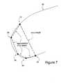
- FIG. 7illustrates this embodiment.
- FIG. 7shows the same portion of road that is shown in FIG. 6.
- the bowing coefficient at the point 66is approximated by first summing the straight-line distances from the point 62 to the point 64 , the point 64 to the point 66 , the point 66 to the point 68 , and the point 68 to the point 70 . The sum of these distances is then divided by the straight-line distance between the point 62 and the point 70 thereby yielding the bowing coefficient at the point 66 .
- the arc lengthis approximated by using four “chord lengths.”
- the distances from the point along a road at which the bowing coefficient is determined to the points adjacent thereto used in determining the bowing coefficientcan be actual distances as-the-vehicle-travels.
- the actual distances as-the-vehicle-travelscan be collected using odometer or speed pulse data or determined from examination of aerial or satellite photographs.
- the values of the bowing coefficientcan be computed on the fly in the vehicle using data representing the road geometry, such as shape point data.
- bowing coefficient datawere used to represent the curvature of roads.
- bowing coefficient datacan be used to represent the curvature of other kinds of linearly extending features, such as rivers, railroad tracks, boundaries, trajectories, ferries, and so on.
- bowing coefficientsto represent curvature of linearly extending geographic features, such as roads.
- using bowing coefficients to represent the curvature of linearly extending featuresis less computationally intensive than using radius of curvature values.
- bowing coefficientscan be derived from data that are stored as a set of shape points (piecewise linear approximation), polynomial spline control points, etc.
Landscapes
- Engineering & Computer Science (AREA)
- Physics & Mathematics (AREA)
- Remote Sensing (AREA)
- Radar, Positioning & Navigation (AREA)
- General Physics & Mathematics (AREA)
- Theoretical Computer Science (AREA)
- Automation & Control Theory (AREA)
- Educational Technology (AREA)
- Educational Administration (AREA)
- Business, Economics & Management (AREA)
- Mathematical Physics (AREA)
- Navigation (AREA)
- Traffic Control Systems (AREA)
- Instructional Devices (AREA)
- Control Of Driving Devices And Active Controlling Of Vehicle (AREA)
- Oscillators With Electromechanical Resonators (AREA)
- Management, Administration, Business Operations System, And Electronic Commerce (AREA)
- Measurement And Recording Of Electrical Phenomena And Electrical Characteristics Of The Living Body (AREA)
- Image Analysis (AREA)
- Image Processing (AREA)
Abstract
Description
- The present invention relates to geographic data and more particularly, the present invention relates to a way to represent how much a linearly extending geographic feature (such as a road) curves by using a bowing coefficient.[0001]
- Various new vehicle safety systems have been developed that provide warnings to the vehicle driver or that modify operation of the vehicle (or component thereof) based upon conditions around the vehicle or other factors. Examples of some of these new vehicle safety systems include automatic headlight aiming, automatic (or adaptive) cruise control, obstacle warning, curve warning, intersection warning, lane departure warning, collision warning, and adaptive transmission shift control. Some of these vehicle safety systems use sensor equipment (e.g., radar and cameras) to detect the current state of the roadway and environment around the vehicle. Some of these vehicle safety systems use digital map data as a component. Digital map data are used to identify the location and shape of the road ahead of and around the vehicle. Digital map data can also be used to identify relatively permanent objects or features along the roads.[0002]
- Included among the types of digital map data used by some of these vehicle systems are data that indicate the curvature of the road. In some digital map databases, the curvature of a road at given location is indicated by a radius of curvature value (or inverse thereof). Some vehicle safety systems use these radius of curvature data to modify operation of the vehicle. For example, an automatic cruise control system in a vehicle uses the data that indicate curvature of a road at the location along the road at which a vehicle is traveling to determine an acceptable speed range for the vehicle. After determining an acceptable speed range, the automatic cruise control application adjusts the speed of the vehicle if necessary.[0003]
- The map database used in this type of vehicle safety system includes data indicating the positions of points along roads including data indicating the radius of curvature at the various points along the roads. When forming this type of map database, curvature values are computed using data that identify the coordinates of a series of points (referred to a “shape points”) through which the road passes.[0004]
- Although using computed values of radius of curvature to represent road shape is satisfactory for some vehicle applications, there is room for improvement. The computed radius of curvature values can be affected by the type of function (e.g., piecewise linear, b-spline, etc.) that is used to approximate the given set of shape points. Furthermore, small changes in the approximating function may produce large changes in the curvature value. Also, small changes in the data point locations themselves may produce a large change in a computed radius of curvature.[0005]
- Accordingly, there is a need for another way to represent road geometry in a geographic database.[0006]
- To address these and other objectives, the present invention comprises a way to represent the curvature of a linearly extending feature, such as a road. The curvature of a linearly extending feature, such as a road, is represented using a bowing coefficient. The bowing coefficient at a given location along a linearly extending feature is determined by comparing the distance along the feature between two points on either side of the given location (or an approximation of the distance) to a straight-line distance between these same two points. Bowing coefficient data can be used by various vehicle systems that require information about the curvature of linearly extending features, such as roads upon which the vehicle is traveling.[0007]
- FIG. 1 is a diagram used to illustrate some of the terminology in this specification.[0008]
- FIG. 2 is a diagram used to illustrate the bowing coefficient at different locations along a road.[0009]
- FIG. 3 is a diagram that illustrates how the bowing coefficient varies with curvature.[0010]
- FIG. 5 is an enlarged portion of the area encompassed within the dotted circle in FIG. 4.[0011]
- FIG. 6 is a diagram illustrating operation of an alternative embodiment.[0012]
- FIG. 7 is a diagram illustrating operation of another alternative embodiment.[0013]
- I. Definitions[0014]
- The following terms are illustrated in FIG. 1.[0015]
- “Chord” refers to the straight-line segment joining any two points on a road segment.[0016]
- “Chord length” refers to the length of the straight-line segment joining any two points on a road segment.[0017]
- “Arc” refers to the portion of a road segment between any two points on the road segment.[0018]
- “Arc length” refers to the length (or approximation thereof) of the portion of a road segment between any two points on the road segment.[0019]
- As used in this specification, the word “curvature” refers to the general property of a linearly extending feature being curved and is not restricted to a mathematical definition, except as otherwise indicated. The word “curvature” in the phrase “radius of curvature” is understood to have its mathematical meaning.[0020]
- II. Overview[0021]
- FIG. 2 shows a[0022]
road segment 10.Several chords 12 have been drawn (in dashed lines) between pairs ofpoints 14 on thissegment 10. From FIG. 2, it can be seen that the portions of the road segment, which are nearly straight, have arc lengths which are nearly equal to the corresponding chord lengths. Conversely, portions of the road segment that are curved have much larger arc lengths than corresponding chord lengths. This means that for relatively straight portions of a road segment, the ratio of arc length to chord length is close to 1, and for relatively curved portions of a road segment, the ratio of arc length to chord length is significantly greater than 1. In other words, the ratio of arc length to chord length is an indication of the local curvature of the road segment. - where C is the chord length, A is the arc length and κ is the curvature (i.e., using the mathematical definition of “curvature”).[0024]
- For purposes of this specification, the ratio of A to C is referred to as the “bowing coefficient.” The “bowing coefficient.” is a measure of how much a portion of road segment between two points bends or bows out from the straight line joining these same two points.[0025]
- FIG. 3 illustrates the variation in the bowing coefficient with curvature. FIG. 3 shows three[0026]
alternative paths road segment 38. Each of these different paths represents a different alternative road configuration between thepoints - III. Implementation[0027]
- The bowing coefficient can be used by various vehicle systems and applications that use data that represent road geometry. For example, the bowing coefficient can be used by an automatic cruise control application. Use of the bowing coefficient by an automatic cruise control application is described in connection with FIGS. 4 and 5.[0028]
- In FIG. 4, a[0029]
vehicle 50 having an automatic cruise control system travels along aroad segment 52. The automatic cruise control system obtains data indicating the position of the vehicle with respect to the road as represented by data contained in a map database. This function can be performed using known vehicle positioning technology, such as GPS, dead-reckoning, and so on. - As the[0030]
vehicle 50 travels along theroad segment 52, the automatic cruise control application in thevehicle 50 adjusts the speed of the vehicle based on the bowing coefficient of the road. In FIG. 4, thearrows 54 indicate the instantaneous positions of the vehicle. Thechords 58 corresponding to these positions are also shown. - According to one embodiment, at each[0031]
position 54, the automatic cruise control application in the vehicle selects two points straddling the position at which the vehicle is located. The automatic cruise control application then computes the chord length C, the arc length A and the bowing coefficient using the two points. As indicated in FIG. 5, as the vehicle moves into the curve, the bowing coefficient increases, and as the vehicle comes out of the curve the bowing coefficient decreases, as is expected. Using these computed values of the bowing coefficients, the automatic cruise control application in the vehicle adjusts the vehicle speed accordingly. - The selection of the two points that straddle the position of the vehicle is configurable so that the bowing coefficient derived therefrom is suitable for the application by which it is used. As an example, the distance (or distance range) of each of the two points from the position of the vehicle is configurable.[0032]
- As illustrated in FIG. 5, some of the arc lengths and chord lengths overlap for successive positions at which the bowing coefficient is determined. As previously indicated, the selection of the points used to determine the bowing coefficient is configurable so that an appropriate measure of the curvature is obtained. There is no constraint that the arc lengths and chord lengths not overlap.[0033]
- IV. Alternative Embodiments[0034]
- A. Using Previously Calculated Bowing Coefficient Data[0035]
- According to one alternative embodiment, a vehicle safety system, such as automatic cruise control, uses a map database that includes bowing coefficients for points along roads. According to this alternative embodiment, the values for the bowing coefficient at points along roads are computed in advance by the database developer and stored in the geographic database. The geographic database, which includes the computed values for the bowing coefficient for points along roads, is installed in the vehicle and used by vehicle safety systems, such as automatic cruise control.[0036]
- An advantage of storing computed values of the bowing coefficient in the map database used by the vehicle safety system is that it eliminates the need to compute these values in the vehicle.[0037]
- B. Calculating Bowing Coefficients[0038]
- There are several different ways that the bowing coefficient can be calculated. One way to calculate a bowing coefficient is described in connection with FIG. 6.[0039]
- FIG. 6 shows a portion of a[0040]
road 60. Along the road areshape points - According to one alternative embodiment, a value of the bowing coefficient is determined for each shape point. According to this alternative embodiment, a value of the bowing coefficient at a given shape point can be approximated by comparing the sum of the distances from the given shape point to the two shape points immediately adjacent to the given shape point to the straight-line distance between the two adjacent shape points. According to this alternative, the arc length is approximated by using two “chord lengths.”[0041]
- For example, to determine the bowing coefficient for the shape point labeled[0042]66, the distance from the
shape point 64 to theshape point 66 is summed with distance from theshape point 66 to theshape point 68. Then, this sum is divided by the distance from theshape point 64 to the shape point labeled68 in order to determine the bowing coefficient at theshape point 66. Bowing coefficients for the rest of the shape points can be determined in a similar manner. The values of the bowing coefficients can then be stored with the coordinates of the shape points in a geographic database. Alternatively, using this method, bowing coefficients can be computed on-the-fly, as needed, by an application in the vehicle during runtime. - According to another alternative, an approximation of the bowing coefficient at a given shape point can be determined by taking into account the distances to additional shape points beyond those immediately adjacent to the given shape point. FIG. 7 illustrates this embodiment. FIG. 7 shows the same portion of road that is shown in FIG. 6. In FIG. 7 the bowing coefficient at the[0043]
point 66 is approximated by first summing the straight-line distances from thepoint 62 to thepoint 64, thepoint 64 to thepoint 66, thepoint 66 to thepoint 68, and thepoint 68 to thepoint 70. The sum of these distances is then divided by the straight-line distance between thepoint 62 and thepoint 70 thereby yielding the bowing coefficient at thepoint 66. According to this alternative, the arc length is approximated by using four “chord lengths.” - In FIG. 7, two points were selected on either side of the point at which the bowing coefficient was determined. Alternatively, any number of points can be selected on either side of the point at which the bowing coefficient is determined.[0044]
- According to still another alternative, the distances from the point along a road at which the bowing coefficient is determined to the points adjacent thereto used in determining the bowing coefficient can be actual distances as-the-vehicle-travels. The actual distances as-the-vehicle-travels can be collected using odometer or speed pulse data or determined from examination of aerial or satellite photographs.[0045]
- C. Other Alternatives[0046]
- In another alternative, the values of the bowing coefficient can be computed on the fly in the vehicle using data representing the road geometry, such as shape point data.[0047]
- The new method described here can be used in combination with the existing radius of curvature approach to improve the robustness and effectiveness of various vehicle applications.[0048]
- In the embodiments described above, bowing coefficient data were used to represent the curvature of roads. In alternative embodiments, bowing coefficient data can be used to represent the curvature of other kinds of linearly extending features, such as rivers, railroad tracks, boundaries, trajectories, ferries, and so on.[0049]
- V. Advantages[0050]
- Several advantages follow from using bowing coefficients to represent curvature. First, using bowing coefficients to represent the curvature of linearly extending geographic features, such as roads, does not involve the computation of radius of curvature values which are prone to large errors. Further, using bowing coefficients to represent the curvature of linearly extending features is less computationally intensive than using radius of curvature values. In addition, bowing coefficients can be derived from data that are stored as a set of shape points (piecewise linear approximation), polynomial spline control points, etc.[0051]
- It is intended that the foregoing detailed description be regarded as illustrative rather than limiting and that it is understood that the following claims including all equivalents are intended to define the scope of the invention.[0052]

Claims (16)
Priority Applications (7)
| Application Number | Priority Date | Filing Date | Title |
|---|---|---|---|
| US09/772,587US6681177B2 (en) | 2001-01-30 | 2001-01-30 | Bowing coefficient representation of curvature of geographic features |
| AT02250249TATE265037T1 (en) | 2001-01-30 | 2002-01-15 | REPRESENTATION OF CURVES OF GEOGRAPHIC FEATURES USING BENDING COEFFICIENTS |
| DE60200382TDE60200382T2 (en) | 2001-01-30 | 2002-01-15 | Presentation of the curvature of geographical features by means of bending coefficients |
| EP02250249AEP1227302B1 (en) | 2001-01-30 | 2002-01-15 | Bowing coefficient representation of curvature of geographic features |
| JP2002021423AJP4293751B2 (en) | 2001-01-30 | 2002-01-30 | Boeing coefficient display for curvature of geographic form |
| US10/714,131US6862523B2 (en) | 2001-01-30 | 2003-11-14 | Bowing coefficient representation of curvature of geographic features |
| JP2007274855AJP5087363B2 (en) | 2001-01-30 | 2007-10-23 | Boeing coefficient display for curvature of geographic form |
Applications Claiming Priority (1)
| Application Number | Priority Date | Filing Date | Title |
|---|---|---|---|
| US09/772,587US6681177B2 (en) | 2001-01-30 | 2001-01-30 | Bowing coefficient representation of curvature of geographic features |
Related Child Applications (1)
| Application Number | Title | Priority Date | Filing Date |
|---|---|---|---|
| US10/714,131ContinuationUS6862523B2 (en) | 2001-01-30 | 2003-11-14 | Bowing coefficient representation of curvature of geographic features |
Publications (2)
| Publication Number | Publication Date |
|---|---|
| US20020128752A1true US20020128752A1 (en) | 2002-09-12 |
| US6681177B2 US6681177B2 (en) | 2004-01-20 |
Family
ID=25095563
Family Applications (2)
| Application Number | Title | Priority Date | Filing Date |
|---|---|---|---|
| US09/772,587Expired - LifetimeUS6681177B2 (en) | 2001-01-30 | 2001-01-30 | Bowing coefficient representation of curvature of geographic features |
| US10/714,131Expired - LifetimeUS6862523B2 (en) | 2001-01-30 | 2003-11-14 | Bowing coefficient representation of curvature of geographic features |
Family Applications After (1)
| Application Number | Title | Priority Date | Filing Date |
|---|---|---|---|
| US10/714,131Expired - LifetimeUS6862523B2 (en) | 2001-01-30 | 2003-11-14 | Bowing coefficient representation of curvature of geographic features |
Country Status (5)
| Country | Link |
|---|---|
| US (2) | US6681177B2 (en) |
| EP (1) | EP1227302B1 (en) |
| JP (2) | JP4293751B2 (en) |
| AT (1) | ATE265037T1 (en) |
| DE (1) | DE60200382T2 (en) |
Cited By (14)
| Publication number | Priority date | Publication date | Assignee | Title |
|---|---|---|---|---|
| US20030069688A1 (en)* | 2000-05-02 | 2003-04-10 | Torsten Mosis | Position determination method and navigation device |
| US20090018767A1 (en)* | 2005-05-28 | 2009-01-15 | Daimler Ag | Method for determining the geometry of a route section |
| US20090300067A1 (en)* | 2008-05-30 | 2009-12-03 | Navteq North America, Llc | Data mining in a digital map database to identify decreasing radius of curvature along roads and enabling precautionary actions in a vehicle |
| US20090299616A1 (en)* | 2008-05-30 | 2009-12-03 | Navteq North America, Llc | Data mining in a digital map database to identify intersections located over hills and enabling precautionary actions in a vehicle |
| US20090299626A1 (en)* | 2008-05-30 | 2009-12-03 | Navteq North America, Llc | Data mining in a digital map database to identify unusually narrow lanes or roads and enabling precautionary actions in a vehicle |
| US20090299622A1 (en)* | 2008-05-30 | 2009-12-03 | Navteq North America, Llc | Data mining to identify locations of potentially hazardous conditions for vehicle operation and use thereof |
| US20090299630A1 (en)* | 2008-05-30 | 2009-12-03 | Navteq North America, Llc | Data mining in a digital map database to identify insufficient superelevation along roads and enabling precautionary actions in a vehicle |
| US20090299625A1 (en)* | 2008-05-30 | 2009-12-03 | Navteq North America, Llc | Data mining in a digital map database to identify blind intersections along roads and enabling precautionary actions in a vehicle |
| US20090299624A1 (en)* | 2008-05-30 | 2009-12-03 | Navteq North America, Llc | Data mining in a digital map database to identify speed changes on upcoming curves along roads and enabling precautionary actions in a vehicle |
| US20090299615A1 (en)* | 2008-05-30 | 2009-12-03 | Navteq North America, Llc | Data mining in a digital map database to identify insufficient merge lanes along roads and enabling precautionary actions in a vehicle |
| US8531318B2 (en) | 2008-05-30 | 2013-09-10 | Navteq B.V. | Data mining in a digital map database to identify intersections located at hill bottoms and enabling precautionary actions in a vehicle |
| EP3026641A1 (en)* | 2014-11-27 | 2016-06-01 | Aktiebolaget SKF | Condition monitoring system and method for monitoring a condition of a bearing unit for a vehicle |
| US20160238405A1 (en)* | 2014-06-30 | 2016-08-18 | Yandex Europe Ag | Method for displaying a position on a map |
| US11243534B2 (en)* | 2017-01-31 | 2022-02-08 | Pioneer Corporation | Information processing device, information processing method, and non-transitory computer readable medium |
Families Citing this family (18)
| Publication number | Priority date | Publication date | Assignee | Title |
|---|---|---|---|---|
| US7805442B1 (en) | 2000-12-05 | 2010-09-28 | Navteq North America, Llc | Method and system for representation of geographical features in a computer-based system |
| US6681177B2 (en)* | 2001-01-30 | 2004-01-20 | Rajashri Joshi | Bowing coefficient representation of curvature of geographic features |
| ATE540289T1 (en)* | 2003-07-16 | 2012-01-15 | Navteq North America Llc | DRIVER ASSISTANCE SYSTEM OF A MOTOR VEHICLE |
| DE102004006686A1 (en)* | 2004-02-11 | 2005-09-01 | Daimlerchrysler Ag | Determination of the curvature of a curve running through one or more points, whereby the curvature of a point is determined using preceding and following points that are as far as possible from it within a given threshold |
| US20060271552A1 (en)* | 2005-05-26 | 2006-11-30 | Venture Capital & Consulting Group, Llc. | Targeted delivery of content |
| US7477988B2 (en)* | 2006-05-16 | 2009-01-13 | Navteq North America, Llc | Dual road geometry representation for position and curvature-heading |
| WO2008078373A1 (en)* | 2006-12-25 | 2008-07-03 | Pioneer Corporation | Display controller, display control method, display control program and recording medium |
| US8204680B1 (en) | 2007-07-05 | 2012-06-19 | Navteq B.V. | Method of operating a navigation system to provide road curvature |
| FR2920240A1 (en)* | 2007-08-24 | 2009-02-27 | Viamichelin Soc Par Actions Si | Road curve determining method for alerting presence of road curve to road vehicle driver, involves verifying if road curve output condition is fulfilled from data obtained from data processing units, and analyzing segments of each curve |
| US20090144030A1 (en)* | 2007-12-04 | 2009-06-04 | Tele Atlas North America, Inc. | Computer readable storage medium storing instructions for applying clothoid curve values to roadways in a geographic data information system |
| JP5446136B2 (en)* | 2008-06-05 | 2014-03-19 | 日本電気株式会社 | Driving support system and driving path curve generation method |
| WO2010050344A1 (en)* | 2008-10-28 | 2010-05-06 | 株式会社アドヴィックス | Device for controlling traveling of vehicle |
| JP5363906B2 (en)* | 2009-08-05 | 2013-12-11 | 株式会社アドヴィックス | Vehicle speed control device |
| US8285485B2 (en)* | 2010-03-18 | 2012-10-09 | Harman International Industries, Incorporated | Vehicle navigation system with route determination based on a measure of sportiness |
| EP2631594B1 (en) | 2012-02-22 | 2015-09-09 | Harman Becker Automotive Systems GmbH | Navigation system and method for navigation |
| US9928572B1 (en) | 2013-12-20 | 2018-03-27 | Amazon Technologies, Inc. | Label orientation |
| DE102016216156B3 (en)* | 2016-08-29 | 2018-02-22 | Audi Ag | Method and control device for operating a motor vehicle |
| IT202000023227A1 (en)* | 2020-10-01 | 2022-04-01 | Laura Quinale | METHOD AND DEVICE FOR DETERMINING A ROUTE |
Family Cites Families (43)
| Publication number | Priority date | Publication date | Assignee | Title |
|---|---|---|---|---|
| US3188380A (en)* | 1962-05-28 | 1965-06-08 | Joy Mfg Co | Wiring device |
| US3437980A (en)* | 1967-12-11 | 1969-04-08 | Westinghouse Electric Corp | Internal,integrally formed cord grip for electrical wiring devices |
| US4781617A (en)* | 1987-04-02 | 1988-11-01 | Alibert Vernon F | Cable connector arrangement to accommodate multiple cable sizes |
| US5374017A (en)* | 1989-02-17 | 1994-12-20 | Martin; William B. | Cable fitting |
| DE68907403T2 (en) | 1989-04-25 | 1993-10-21 | Bosch Gmbh Robert | Vehicle navigation system. |
| US5375059A (en) | 1990-02-05 | 1994-12-20 | Caterpillar Inc. | Vehicle position determination system and method |
| US5307419A (en)* | 1990-11-30 | 1994-04-26 | Honda Giken Kogyo Kabushiki Kaisha | Control device of an autonomously moving body and evaluation method for data thereof |
| DE69220178T2 (en)* | 1991-11-14 | 1997-11-06 | Alsthom Cge Alcatel | Electrical connector assembly |
| JP3227741B2 (en)* | 1991-11-18 | 2001-11-12 | 住友電気工業株式会社 | Overspeed prediction device |
| US5497451A (en) | 1992-01-22 | 1996-03-05 | Holmes; David | Computerized method for decomposing a geometric model of surface or volume into finite elements |
| US5363459A (en)* | 1993-01-15 | 1994-11-08 | The Whitaker Corporation | Optical fiber connector including a biasing means in housing |
| JPH0749239A (en)* | 1993-08-04 | 1995-02-21 | Zanabui Informatics:Kk | On-vehicle navigation system |
| US5661650A (en)* | 1994-02-23 | 1997-08-26 | Honda Giken Kogyo Kabushiki Kaisha | System for controlling a vehicle relative to a judged shape of a travel road |
| US5470233A (en) | 1994-03-17 | 1995-11-28 | Arkenstone, Inc. | System and method for tracking a pedestrian |
| JP3608219B2 (en)* | 1994-05-16 | 2005-01-05 | 株式会社日立製作所 | Vehicle safe driving control system and vehicle safe driving control method |
| AU690693B2 (en) | 1994-05-19 | 1998-04-30 | Geospan Corporation | Method for collecting and processing visual and spatial position information |
| AUPM658794A0 (en)* | 1994-07-04 | 1994-07-28 | Alcatel Components Limited | Electrical connector element |
| US5566288A (en) | 1994-09-02 | 1996-10-15 | Caterpillar Inc. | System and method for automatically fitting a B-spline curve to a set of data points |
| US6023653A (en)* | 1995-11-30 | 2000-02-08 | Fujitsu Ten Limited | Vehicle position detecting apparatus |
| DE19604364A1 (en) | 1996-02-07 | 1997-08-14 | Fraunhofer Ges Forschung | Method for determining a road curvature from digitally stored map information |
| DE69736216T2 (en)* | 1996-04-12 | 2007-05-16 | Equos Research Co. Ltd. | VEHICLE CONTROL |
| DE69732546T2 (en) | 1996-05-16 | 2006-01-12 | Matsushita Electric Industrial Co., Ltd., Kadoma | Road map information reproducing apparatus, recording medium and transmission method |
| JPH10141102A (en) | 1996-11-12 | 1998-05-26 | Honda Motor Co Ltd | Vehicle control device |
| JP3279952B2 (en)* | 1997-04-08 | 2002-04-30 | 本田技研工業株式会社 | Vehicle passability determination device |
| JP3340941B2 (en) | 1997-06-12 | 2002-11-05 | 富士重工業株式会社 | Runway curvature radius detector |
| JP3485239B2 (en)* | 1997-09-10 | 2004-01-13 | 富士重工業株式会社 | Vehicle motion control device |
| US6029173A (en) | 1997-11-26 | 2000-02-22 | Navigation Technologies Corporation | Method and system for representation and use of shape information in geographic databases |
| JP3494395B2 (en)* | 1998-01-29 | 2004-02-09 | 富士重工業株式会社 | Vehicle motion control device |
| US6056586A (en)* | 1998-07-30 | 2000-05-02 | Lucent Technologies Inc. | Anchoring member for a communication cable |
| US6250949B1 (en)* | 1998-12-16 | 2001-06-26 | Lucent Technologies Inc. | Communication cable terminating plug |
| JP3588557B2 (en)* | 1998-12-18 | 2004-11-10 | 株式会社東芝 | Graphic contour point sequence thinning method, electrical characteristic evaluation device using this method, and recording medium recording graphic contour point sequence thinning procedure |
| IL129883A0 (en)* | 1999-05-10 | 2000-02-29 | Rit Techn Ltd | Cable organizer |
| JP3646572B2 (en)* | 1999-07-06 | 2005-05-11 | 三菱ふそうトラック・バス株式会社 | Road condition judgment device |
| DE19941509A1 (en)* | 1999-08-31 | 2001-03-29 | Interconnectron Ges Fuer Ind S | Circular connectors for making electrical line connections |
| US6366851B1 (en)* | 1999-10-25 | 2002-04-02 | Navigation Technologies Corp. | Method and system for automatic centerline adjustment of shape point data for a geographic database |
| US6511230B1 (en)* | 2000-02-04 | 2003-01-28 | Panduit Corp. | Fiber optic connection system |
| US6524128B2 (en)* | 2000-06-02 | 2003-02-25 | Stewart Connector Systems, Inc. | Modular plug wire aligner |
| US6728392B1 (en)* | 2001-01-30 | 2004-04-27 | Navigation Technologies Corp. | Shape comparison using a rotational variation metric and applications thereof |
| US6681177B2 (en)* | 2001-01-30 | 2004-01-20 | Rajashri Joshi | Bowing coefficient representation of curvature of geographic features |
| US6409544B1 (en)* | 2001-05-23 | 2002-06-25 | Lorom Industrial Co., Ltd. | Network data transmission cable connector |
| US6547600B2 (en)* | 2001-07-16 | 2003-04-15 | Chun Chang Yen | Engaging structure for electrical wires of a plug |
| US6582248B2 (en)* | 2001-11-29 | 2003-06-24 | Neutrik Ag | Durable RJ-45 data connector assembly |
| US6811445B2 (en)* | 2002-04-22 | 2004-11-02 | Panduit Corp. | Modular cable termination plug |
- 2001
- 2001-01-30USUS09/772,587patent/US6681177B2/ennot_activeExpired - Lifetime
- 2002
- 2002-01-15ATAT02250249Tpatent/ATE265037T1/ennot_activeIP Right Cessation
- 2002-01-15DEDE60200382Tpatent/DE60200382T2/ennot_activeExpired - Lifetime
- 2002-01-15EPEP02250249Apatent/EP1227302B1/ennot_activeExpired - Lifetime
- 2002-01-30JPJP2002021423Apatent/JP4293751B2/ennot_activeExpired - Lifetime
- 2003
- 2003-11-14USUS10/714,131patent/US6862523B2/ennot_activeExpired - Lifetime
- 2007
- 2007-10-23JPJP2007274855Apatent/JP5087363B2/ennot_activeExpired - Lifetime
Cited By (42)
| Publication number | Priority date | Publication date | Assignee | Title |
|---|---|---|---|---|
| US20030069688A1 (en)* | 2000-05-02 | 2003-04-10 | Torsten Mosis | Position determination method and navigation device |
| US6766247B2 (en)* | 2000-05-02 | 2004-07-20 | Siemens Aktiengesellschaft | Position determination method and navigation device |
| US20090018767A1 (en)* | 2005-05-28 | 2009-01-15 | Daimler Ag | Method for determining the geometry of a route section |
| US9228844B2 (en) | 2008-05-30 | 2016-01-05 | Here Global B.V. | Data mining in a digital map database to identify insufficient merge lanes along roads and enabling precautionary actions in a vehicle |
| US9182241B2 (en) | 2008-05-30 | 2015-11-10 | Here Global B.V. | Data mining in a digital map database to identify unusually narrow lanes or roads and enabling precautionary actions in a vehicle |
| US20090299626A1 (en)* | 2008-05-30 | 2009-12-03 | Navteq North America, Llc | Data mining in a digital map database to identify unusually narrow lanes or roads and enabling precautionary actions in a vehicle |
| US20090299622A1 (en)* | 2008-05-30 | 2009-12-03 | Navteq North America, Llc | Data mining to identify locations of potentially hazardous conditions for vehicle operation and use thereof |
| US20090299630A1 (en)* | 2008-05-30 | 2009-12-03 | Navteq North America, Llc | Data mining in a digital map database to identify insufficient superelevation along roads and enabling precautionary actions in a vehicle |
| US20090299625A1 (en)* | 2008-05-30 | 2009-12-03 | Navteq North America, Llc | Data mining in a digital map database to identify blind intersections along roads and enabling precautionary actions in a vehicle |
| US20090299624A1 (en)* | 2008-05-30 | 2009-12-03 | Navteq North America, Llc | Data mining in a digital map database to identify speed changes on upcoming curves along roads and enabling precautionary actions in a vehicle |
| US20090299615A1 (en)* | 2008-05-30 | 2009-12-03 | Navteq North America, Llc | Data mining in a digital map database to identify insufficient merge lanes along roads and enabling precautionary actions in a vehicle |
| US8531318B2 (en) | 2008-05-30 | 2013-09-10 | Navteq B.V. | Data mining in a digital map database to identify intersections located at hill bottoms and enabling precautionary actions in a vehicle |
| US8688369B2 (en) | 2008-05-30 | 2014-04-01 | Navteq B.V. | Data mining in a digital map database to identify blind intersections along roads and enabling precautionary actions in a vehicle |
| US8698649B2 (en)* | 2008-05-30 | 2014-04-15 | Navteq B.V. | Data mining in a digital map database to identify decreasing radius of curvature along roads and enabling precautionary actions in a vehicle |
| US8775073B2 (en) | 2008-05-30 | 2014-07-08 | Navteq B.V. | Data mining in a digital map database to identify insufficient merge lanes along roads and enabling precautionary actions in a vehicle |
| US9035804B2 (en) | 2008-05-30 | 2015-05-19 | Here Global B.V. | Data mining in a digital map database to identify intersections located at hill bottoms and enabling precautionary actions in a vehicle |
| US9043127B2 (en) | 2008-05-30 | 2015-05-26 | Here Global B.V. | Data mining in a digital map database to identify blind intersections along roads and enabling precautionary actions in a vehicle |
| US9121716B2 (en) | 2008-05-30 | 2015-09-01 | Here Global B.V. | Data mining in a digital map database to identify insufficient superelevation along roads and enabling precautionary actions in a vehicle |
| US9134133B2 (en) | 2008-05-30 | 2015-09-15 | Here Global B.V. | Data mining to identify locations of potentially hazardous conditions for vehicle operation and use thereof |
| US11119493B2 (en) | 2008-05-30 | 2021-09-14 | Here Global B.V. | Data mining in a digital map database to identify unusually narrow lanes or roads and enabling precautionary actions in a vehicle |
| US20090300067A1 (en)* | 2008-05-30 | 2009-12-03 | Navteq North America, Llc | Data mining in a digital map database to identify decreasing radius of curvature along roads and enabling precautionary actions in a vehicle |
| US20090299616A1 (en)* | 2008-05-30 | 2009-12-03 | Navteq North America, Llc | Data mining in a digital map database to identify intersections located over hills and enabling precautionary actions in a vehicle |
| US9279688B2 (en) | 2008-05-30 | 2016-03-08 | Here Global B.V. | Data mining in a digital map database to identify blind intersections along roads and enabling precautionary actions in a vehicle |
| US9733093B2 (en) | 2008-05-30 | 2017-08-15 | Here Global B.V. | Data mining to identify locations of potentially hazardous conditions for vehicle operation and use thereof |
| US10648817B2 (en) | 2008-05-30 | 2020-05-12 | Here Global B.V. | Data mining in a digital map database to identify speed changes on upcoming curves along roads and enabling precautionary actions in a vehicle |
| US10648818B2 (en) | 2008-05-30 | 2020-05-12 | Here Global B.V. | Data mining in a digital map database to identify blind intersections along roads and enabling precautionary actions in a vehicle |
| US9399468B2 (en) | 2008-05-30 | 2016-07-26 | Here Global B.V. | Data mining in a digital map database to identify intersections located at hill bottoms and enabling precautionary actions in a vehicle |
| US9752884B2 (en) | 2008-05-30 | 2017-09-05 | Here Global B.V. | Data mining in a digital map database to identify insufficient merge lanes along roads and enabling precautionary actions in a vehicle |
| US9797735B2 (en) | 2008-05-30 | 2017-10-24 | Here Global B.V. | Data mining in a digital map database to identify blind intersections along roads and enabling precautionary actions in a vehicle |
| US9909881B2 (en) | 2008-05-30 | 2018-03-06 | Here Global B.V. | Data mining in a digital map database to identify insufficient superelevation along roads and enabling precautionary actions in a vehicle |
| US10012510B2 (en) | 2008-05-30 | 2018-07-03 | Here Global B.V. | Data mining in a digital map database to identify decreasing radius of curvature along roads and enabling precautionary actions in a vehicle |
| US10627240B2 (en) | 2008-05-30 | 2020-04-21 | Here Global B.V. | Data mining in a digital map database to identify decreasing radius of curvature along roads and enabling precautionary actions in a vehicle |
| US10323945B2 (en) | 2008-05-30 | 2019-06-18 | Here Global B.V. | Data mining to identify locations of potentially hazardous conditions for vehicle operation and use thereof |
| US10359781B2 (en) | 2008-05-30 | 2019-07-23 | Here Global B.V. | Data mining in a digital map database to identify unusually narrow lanes or roads and enabling precautionary actions in a vehicle |
| US10578442B2 (en) | 2008-05-30 | 2020-03-03 | Here Global B.V. | Data mining to identify locations of potentially hazardous conditions for vehicle operation and use thereof |
| US10612931B2 (en) | 2008-05-30 | 2020-04-07 | Here Global B.V. | Data mining in a digital map database to identify intersections located at hill bottoms and enabling precautionary actions in a vehicle |
| US9581459B2 (en)* | 2014-06-30 | 2017-02-28 | Yandex Europe Ag | Method for displaying a position on a map |
| US20160238405A1 (en)* | 2014-06-30 | 2016-08-18 | Yandex Europe Ag | Method for displaying a position on a map |
| US10053121B2 (en) | 2014-11-27 | 2018-08-21 | Aktiebolaget Skf | Condition monitoring system and method for monitoring a condition of a bearing unit for a vehicle |
| EP3026641A1 (en)* | 2014-11-27 | 2016-06-01 | Aktiebolaget SKF | Condition monitoring system and method for monitoring a condition of a bearing unit for a vehicle |
| US11243534B2 (en)* | 2017-01-31 | 2022-02-08 | Pioneer Corporation | Information processing device, information processing method, and non-transitory computer readable medium |
| US11709492B2 (en) | 2017-01-31 | 2023-07-25 | Pioneer Corporation | Information processing device, information processing method, and non-transitory computer readable medium |
Also Published As
| Publication number | Publication date |
|---|---|
| ATE265037T1 (en) | 2004-05-15 |
| JP2008112162A (en) | 2008-05-15 |
| US6681177B2 (en) | 2004-01-20 |
| DE60200382D1 (en) | 2004-05-27 |
| DE60200382T2 (en) | 2005-05-04 |
| US6862523B2 (en) | 2005-03-01 |
| EP1227302B1 (en) | 2004-04-21 |
| EP1227302A1 (en) | 2002-07-31 |
| JP5087363B2 (en) | 2012-12-05 |
| US20040107047A1 (en) | 2004-06-03 |
| JP2002323851A (en) | 2002-11-08 |
| JP4293751B2 (en) | 2009-07-08 |
Similar Documents
| Publication | Publication Date | Title |
|---|---|---|
| US6681177B2 (en) | Bowing coefficient representation of curvature of geographic features | |
| US11796344B2 (en) | Map information system | |
| US7477988B2 (en) | Dual road geometry representation for position and curvature-heading | |
| EP1559994B1 (en) | Apparatus for predicting road shape by calculating a clothoid curve | |
| US7805442B1 (en) | Method and system for representation of geographical features in a computer-based system | |
| US4999783A (en) | Location detecting method | |
| US6420997B1 (en) | Track map generator | |
| US8055445B2 (en) | Probabilistic lane assignment method | |
| US8558679B2 (en) | Method of analyzing the surroundings of a vehicle | |
| EP2715281B1 (en) | Combined radar and gps localization system | |
| US8005602B2 (en) | Vehicle speed control device, method of determining target speed by using the device, and program executing the method | |
| EP2821751B1 (en) | Bezier curves for advanced driver assistance system applications | |
| US20110098922A1 (en) | Path Predictive System And Method For Vehicles | |
| JP4021027B2 (en) | Travel route recognition device | |
| US20040240710A1 (en) | Method for determining a model roadway | |
| CN109263638A (en) | The section of the prediction of vehicle guides | |
| US6285923B1 (en) | Vehicle running control apparatus | |
| US20030195703A1 (en) | Geometric based path prediction method using moving and stop objects | |
| CN113639741A (en) | A method and device for yaw recognition and navigation route planning | |
| Khosla | Accurate estimation of forward path geometry using two-clothoid road model | |
| US12214803B2 (en) | Travel assistance method and travel assistance device | |
| JP3401997B2 (en) | Vehicle running direction calculation device | |
| US20250131818A1 (en) | Method for detecting a traffic junction | |
| Ito et al. | Deepening method for LeanMAP content based on a virtual trajectory by lateral transcription | |
| WO2024189049A1 (en) | A computer-implemented method for providing steering control for an autonomously driven or semi-autonomously driven vehicle |
Legal Events
| Date | Code | Title | Description |
|---|---|---|---|
| AS | Assignment | Owner name:NAVIGATION TECHNOLOGIES CORPORATION, ILLINOIS Free format text:ASSIGNMENT OF ASSIGNORS INTEREST;ASSIGNOR:JOSHI, RAJASHRI;REEL/FRAME:011530/0308 Effective date:20010130 | |
| STCF | Information on status: patent grant | Free format text:PATENTED CASE | |
| AS | Assignment | Owner name:NAVTEQ CORPORATION, ILLINOIS Free format text:ASSIGNMENT OF ASSIGNORS INTEREST;ASSIGNOR:NAVIGATION TECHNOLOGIES CORPORATION;REEL/FRAME:015293/0400 Effective date:20040203 Owner name:NAVTEQ NORTH AMERICA LLC, ILLINOIS Free format text:ASSIGNMENT OF ASSIGNORS INTEREST;ASSIGNOR:NAVTEQ CORPORATION;REEL/FRAME:015286/0504 Effective date:20040510 Owner name:NAVTEQ NORTH AMERICA LLC,ILLINOIS Free format text:ASSIGNMENT OF ASSIGNORS INTEREST;ASSIGNOR:NAVTEQ CORPORATION;REEL/FRAME:015286/0504 Effective date:20040510 Owner name:NAVTEQ CORPORATION,ILLINOIS Free format text:ASSIGNMENT OF ASSIGNORS INTEREST;ASSIGNOR:NAVIGATION TECHNOLOGIES CORPORATION;REEL/FRAME:015293/0400 Effective date:20040203 | |
| FPAY | Fee payment | Year of fee payment:4 | |
| FPAY | Fee payment | Year of fee payment:8 | |
| AS | Assignment | Owner name:NAVTEQ B.V., NETHERLANDS Free format text:ASSIGNMENT OF ASSIGNORS INTEREST;ASSIGNOR:NAVTEQ NORTH AMERICA, LLC;REEL/FRAME:027588/0051 Effective date:20111229 | |
| AS | Assignment | Owner name:HERE GLOBAL B.V., NETHERLANDS Free format text:CHANGE OF NAME;ASSIGNOR:NAVTEQ B.V.;REEL/FRAME:033830/0681 Effective date:20130423 | |
| FPAY | Fee payment | Year of fee payment:12 |