US20010014185A1 - System and method for manipulating information and map for geographical resource management - Google Patents
System and method for manipulating information and map for geographical resource managementDownload PDFInfo
- Publication number
- US20010014185A1 US20010014185A1US09/771,214US77121401AUS2001014185A1US 20010014185 A1US20010014185 A1US 20010014185A1US 77121401 AUS77121401 AUS 77121401AUS 2001014185 A1US2001014185 A1US 2001014185A1
- Authority
- US
- United States
- Prior art keywords
- map
- information
- geographical
- data
- spatial
- Prior art date
- Legal status (The legal status is an assumption and is not a legal conclusion. Google has not performed a legal analysis and makes no representation as to the accuracy of the status listed.)
- Granted
Links
Images
Classifications
- G—PHYSICS
- G06—COMPUTING OR CALCULATING; COUNTING
- G06F—ELECTRIC DIGITAL DATA PROCESSING
- G06F16/00—Information retrieval; Database structures therefor; File system structures therefor
- G06F16/90—Details of database functions independent of the retrieved data types
- G06F16/95—Retrieval from the web
- G—PHYSICS
- G06—COMPUTING OR CALCULATING; COUNTING
- G06F—ELECTRIC DIGITAL DATA PROCESSING
- G06F16/00—Information retrieval; Database structures therefor; File system structures therefor
- G06F16/20—Information retrieval; Database structures therefor; File system structures therefor of structured data, e.g. relational data
- G06F16/29—Geographical information databases
Definitions
- the present inventionrelates to image compression using wavelet transforms, spatial database, metadata and geographical information system (GIS)
- GIS softwarehas a variety of functionality including panning and zooming of geographic maps, querying information from a database, and performing geographic analysis. Such functionality typically requires a highend computer. Thus, GIS is expensive for organizations with multiple offices since all offices would require both computer and copy of the GIS software. Furthermore, all offices contribute to the maintenance of the central database requiring high network bandwidth. The present invention can reduce this cost and offer partial GIS functionality.
- a single serveris maintained in a central location while remote sites access the server over the World Wide Web. Complex software is not required on the client, only a Java enabled web browser. Thus, typical PC can be used at the remote sites. However, the major problem of transferring the large amount of data in a reasonable time remains to be addressed.
- This problemis minimized by utilizing two different approaches offering multiple resolutions of the image and using data compression.
- GIS userswant to determine different area or same area in different time.
- This inventionhelps this situation by offering the mosaic feature that user can combine different maps to together to form a larger image for comparison or analysis purpose.
- the present inventionoffers a choice of multiresolution images to the user; therefore, high-resolution images are transferred over the internet only when the user requires such detailed images.
- the multiple resolution imagesare created using a wavelet transformation.
- a further benefit of the wavelet transformationis that it reduces the typically high entropy of an image, thus, transforming the image to format highly compressable using typical data compression algorithms.
- the wavelet transformationwill generally be more efficient in entropy reduction than other data transformations, since the localized representation of the data utilized two domains (time and scale) whereas other transformations utilize only one domain.
- This systemcomprises of a server process, a client process, a spatial database and a relational database. It presents the idea of geographical information access over the World Wide Web network using compression technology and data filtering—in the form of queries and metadata—for efficient use of network bandwidth.
- the usercan access or change information using the tools provided inside the client application.
- This present inventionprovides a system that applies the latest technology related to compression, rendering, and geographical data processing to present an interactive interface to users and enables them to efficiently manipulate maps and queries for information over the World Wide Web.
- the methodincludes a World Wide Web application, located on the client, having a capability of decompression and resolution filtering for decreasing the amount of data passing between the server and the client.
- the compression and the resolution filteringare implemented by using wavelet algorithm and compression algorithms.
- the compressed datais sent across the World Wide Web network to the client application.
- the client applicationseparates the data into two types, vector data and raster data.
- the raster datais the base map, which can be overlayed with vector data.
- the useraccesses spatial information stored in the spatial database.
- toolbarsare provided for the user to edit the vector and other types of data on the client side before saving the changes to the database.
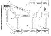
- FIG. 1illustrates an overall system of the present invention including preferred and alternative embodiments of the present invention, in which:
- Part 1Geographical Map Image Storage is an archive to store geographical map images.
- Wavelet Composer Engineis a software component that contains wavelet algorithm used to transform the image into wavelet format. The algorithm is widely used in compression area.
- Compression Engineis a software component to compress data that is implemented using combination of mathematical algorithms.
- the algorithmscomprises of two main algorithm called “Huffman Coding” and “Run Length Encoding” algorithms.
- Decompression Engineis a software component to decompress data that is implemented using combination of mathematical algorithms.
- the algorithmscomprises of two main algorithm called “Huffman Coding” and “Run Length Encoding” algorithms.
- Wavelet Decomposer Engineis a software component that contains wavelet algorithm used to re-transform the wavelet format back to image.
- Spatial Information and Map Data Vieweris a software component to display geographical map and information.
- Spatial Information and Map Editoris a software component to modify geographical map and information.
- Spatial Databaseis a database to store spatial geographical information.
- Management Information Systemis a database for storing management information.
- the Geographical Map Image Storage(Part 1 ) stores geographical map images or satellite images. It stores the original image which is already registered by the satellite or other source of images then it is transformed by the Wavelet Composer Engine (Part 2 ) which separates the image into layers according to various resolutions creating a wavelet data stream. The user can select a range of resolutions that reduces the amount of data transferred over the network.
- the wavelet algorithmuses interpolating technique that calculates using the two equations:
- d 1,1S 0,21+1 ⁇ [9/16( S 0,21 +S 0,21 +2) ⁇ 1/16( S 0,21 ⁇ 2 +S 0,21+4 )+1/2]
- the Compression Enginecompresses the wavelet data stream by using Run Length Encoding and Huffman Coding to obtain the smallest number of bytes before passing the data through the network.
- Run Length Encodecounts on how many continuous data bytes and add an overhead byte to indicate that duplicate number of bytes.
- Huffman Codingcreates a tree of frequent use symbols and map keys to substitute that symbol. The Huffman Coding works differently on the bytes indicating number of continuous and the data bytes.
- the Wavelet Decomposer Engine(Part 5 ) then reassembles the wavelet data stream into the original image of the map.
- the Spatial Information and Map Viewer(Part 6 ) renders the map.
- the vector data stored in the Spatial Database(Part 8 ) is typically data from the GIS and is used to populate the Spatial Database (Part 8 ) synchronized with the MIS (Part 9 ) by using geo-codes, which uniquely identifies each geographic entity and links linking the spatial data to information in the MIS (Part 9 ).
- the Spatial Databaseis a database with features of spatial functions and operators, which help user to calculate basic operation and reduce amount of data passing to the user.
- the MISis an information base using normal database management system. Also metadata is used in the spatial database to provide intelligent searching capabilities.
- SQL Queriesare used to obtain the vector data from the Spatial Database (Part 8 ) and may include geometric operators available in the spatial database to determine which data is required.
- the vector datais then rendered as polygons, paths, or points depending on the nature of the geometric entity being rendered.
- the spatial Information and Map Editor (Part 7 )is similar to the Spatial Information and Map Viewer (Part 6 ) but allows the user to change the vector data.
- Part 1 to Part 3are located in the server machine while Part 8 to Part 9 are located in the appropriate databases on the server.
- Part 4 to Part 7are used to display or edit the result and are located in the client machine.
- the serveris responsible for querying vector data and loading images in response to client application requests. When the server receives a load image request, it will find and load the image from the Geographical Map Image Storage (Part 1 ). To create the multiple resolutions, the image is passed to the Wavelet Composer Engine (Part 2 ), which transforms the image into a wavelet data stream. The wavelet data stream is then sent to the Compression Engine (Part 3 ), which uses a combination of compression algorithms. Each compressed level of resolution is stored in a file for future reference.
- the serverWhen the server receives a query request, it will execute the query in either the spatial database or relational database, depending on the nature of the query.
- the queryis defined by the client and is sent as part of the request to the server.
- a database connection interfaceis used to communicate with the database, which returns the result of the query to the server.
- the resultis filtered and searched faster by using metadata and then it is compressed using compression algorithms before it is sent to the client.
- the clientis composed of several components that not only processes the data communication with the server, but also presents a graphical user interface (GUI) allowing the user to display and manipulate map data from a GIS. For example, it can display a satellite image of a city with additional layers of buildings, roads, and rivers.
- GUIgraphical user interface
- the clienthas two main components, a data processing component, and a GUI component.
- the data processing componentis responsible for submitting requests to the server, and processing the returned results.
- the clientAfter the client sends a load image request, it waits for the result to return and then sends the data to the decompression engine (Part 4 ), to be decompressed.
- the datais a wavelet data stream and is sent to the Wavelet Decomposer Engine (Part 5 ) to reassemble the data into the original image.
- the restored imageis sent to a data cache from which the spatial information and map data viewer (Part 6 ) or the Spatial Information and Data Editor (Part 7 ) can access it.
- the data processing componentFor a query request, the data processing component first forms the query and then sends the request. The returned result is sent to the Decompression Engine (Part 4 ) and then sent to the data cache for access by either the Spatial Information and Map Data Viewer (Part 6 ) or the Spatial Information and Map Data Editor (Part 7 ).
- These query requestsinclude both MIS requests, and Spatial Database (Part 8 ) requests.
- the MIS informationis simply displayed in an appropriate manner.
- the spatial data returned by a requestis typically represented in an individual layer, which contains a set of vectors, or points that have some geographic meaning.
- the GUI componentruns as a java applet on a web browser and is part of both the Spatial Information and a Map Data Viewer (Part 6 ) and the Spatial Information and a Map Data Editor (Part 7 ). It also contains Decompression Engine and Wavelet Decomposor Engine in order to retransform the compressed data back to the original data.
- the GUIhas three windows to view various levels of detail of the image map. A top-left window presents a view of the whole map divided into map cells, the user can click a cell and the area of the map contained in the cell is displayed in the bottom-left window.
- the appletcontains PartThis window is a zoom and pan window in which a user can click the left or right mouse button to zoom in or out respectively. The user can also drag the mouse to pan around the map.
- a detail windowis displayed as a large window on the right showing the map and vector data for the selected area on the zoom and pan window.
- Layersrepresent the data of the detail window, including the map image and the vector data.
- a legend to the right of the detail mapindicates the available layers and categorizes the vector data by color. Checkboxes are included in the legend, which allow the user to toggle each layer's visibility.
- the console areashows the sizes of the full image, the compressed image, and approximate size of the next zoom level. It also displays the UTM coordinates when the user moves the cursor pointer over the detail window. Finally a scale bar indicates the scale of the image in the detail window.
- the raster componentis responsible for displaying the map as well as the information corresponding to the detail inside the map such as UTM coordinates, the date and time that the map was created, and the map resolution. Each level of the map has its own scale that will be displayed on the scale bar to indicate the distance ratio. In addition, users can move the mouse cursor onto the map and see the UTM coordinates of that point.
- the raster mapis the base map with all additional layers being rendered on top of it. However, it can also be toggled on or off.
- the Geographical Map Image Storage(Part 1 ) maintains several images for the various areas available for display. In most cases, a single image does not cover enough area to be useful to users. Therefore, this invention implements a mosaic feature. This feature determines the image files that cover the area being requested and seamlessly joins them together to form a larger image.
- the unique features of the raster componentare the interactive pan and the zoom. This means that when the user pans or zooms, a new web page is not loaded. Instead, only the detailed image in the raster viewer is updated. This not only saves time from downloading all the elements of the web page, but also gives the user a pleasant interface since only the single image changes not the whole page.
- the vector componentis capable of rendering several different types of vector data. These types include polygon data (both filled and outline), path or line data, and point data.
- the vector datais stored in the Spatial Database (Part 8 ), which allows geometric operations to be performed on the vector data. For example, the database can determine if a point is within one of the polygons that are stored in one of its tables. Such capability allows the user to perform simple queries to the database using mouse clicks on the map. Thus, storing the vector data in the Spatial Database is very useful.
- the vector dataare rendered on top of the map using separate layers. For example, the roads for a map would be rendered as a single layer, while the waterways of the map would be rendered in another separate layer.
- the layersare implemented such that each layer queries the Spatial Database (Part 8 ) for the vector data required to be rendered. The data is returned in UTM coordinates that are then transformed to screen coordinates, and finally the vector data is rendered on the map.
- Each layeralso has a state variable that controls the visibility of the layer.
- part of the graphical user interfacecan be a switch that will toggle the visibility of the particular layer of vector data. This gives the user the capability of removing data from the map when the area of interest is too crowded with data.
- the UTM gridcan easily be generated from the bounding box of the map. Furthermore, the gridlines would be different for each level of zoom in the map. Therefore, it is not necessary to store the grid lines (one set for each zoom level) in the Spatial Database (Part 8 ), but generates them as a separate layer.
- the Spatial Information and Map Data Editor(Part 7 ) is similar to the Spatial Information and Map Data Viewer (Part 6 ) except that it has limited zoom capabilities and additional GUI features to implement additions, deletions and modifications to both the Spatial Database (Part 8 ) and MIS (Part 9 ), the Spatial Information and Map Editor (Part 7 ) has a single window that displays the map and vector data in the same resolution as that of the detailed image of the Spatial Information and Map Data Viewer (Part 6 ). The user has the choice of zooming in one extra level for more accurate digitizing.
Landscapes
- Engineering & Computer Science (AREA)
- Databases & Information Systems (AREA)
- Theoretical Computer Science (AREA)
- Data Mining & Analysis (AREA)
- Physics & Mathematics (AREA)
- General Engineering & Computer Science (AREA)
- General Physics & Mathematics (AREA)
- Remote Sensing (AREA)
- Instructional Devices (AREA)
- Processing Or Creating Images (AREA)
Abstract
Description
- 1. Field of the Invention[0001]
- The present invention relates to image compression using wavelet transforms, spatial database, metadata and geographical information system (GIS)[0002]
- 2. Description of the Prior Art[0003]
- GIS software has a variety of functionality including panning and zooming of geographic maps, querying information from a database, and performing geographic analysis. Such functionality typically requires a highend computer. Thus, GIS is expensive for organizations with multiple offices since all offices would require both computer and copy of the GIS software. Furthermore, all offices contribute to the maintenance of the central database requiring high network bandwidth. The present invention can reduce this cost and offer partial GIS functionality. A single server is maintained in a central location while remote sites access the server over the World Wide Web. Complex software is not required on the client, only a Java enabled web browser. Thus, typical PC can be used at the remote sites. However, the major problem of transferring the large amount of data in a reasonable time remains to be addressed. This problem is minimized by utilizing two different approaches offering multiple resolutions of the image and using data compression. In many cases, GIS users want to determine different area or same area in different time. This invention helps this situation by offering the mosaic feature that user can combine different maps to together to form a larger image for comparison or analysis purpose.[0004]
- The present invention offers a choice of multiresolution images to the user; therefore, high-resolution images are transferred over the internet only when the user requires such detailed images. The multiple resolution images are created using a wavelet transformation. A further benefit of the wavelet transformation is that it reduces the typically high entropy of an image, thus, transforming the image to format highly compressable using typical data compression algorithms. The wavelet transformation will generally be more efficient in entropy reduction than other data transformations, since the localized representation of the data utilized two domains (time and scale) whereas other transformations utilize only one domain. Once the data is transformed into a wavelet data stream and compressed, the amount of data being transferred over World Wide Web is minimized.[0005]
- This system comprises of a server process, a client process, a spatial database and a relational database. It presents the idea of geographical information access over the World Wide Web network using compression technology and data filtering—in the form of queries and metadata—for efficient use of network bandwidth. In addition, the user can access or change information using the tools provided inside the client application.[0006]
- General GIS features and capabilities can be provided with the client application without loading the client machine. Commands are passed to the server, which accesses the spatial and relational databases to process the commands. The server retrieves the data and the result is sent to the client application. Therefore, users can access and use the features of the GIS server and its corresponding databases using a standard PC.[0007]
- This present invention provides a system that applies the latest technology related to compression, rendering, and geographical data processing to present an interactive interface to users and enables them to efficiently manipulate maps and queries for information over the World Wide Web.[0008]
- The method includes a World Wide Web application, located on the client, having a capability of decompression and resolution filtering for decreasing the amount of data passing between the server and the client. On the server side, the compression and the resolution filtering are implemented by using wavelet algorithm and compression algorithms. The compressed data is sent across the World Wide Web network to the client application.[0009]
- The client application separates the data into two types, vector data and raster data. The raster data is the base map, which can be overlayed with vector data. In order to easily manipulate the geographical data elements from the map, the user accesses spatial information stored in the spatial database. Within the application, toolbars are provided for the user to edit the vector and other types of data on the client side before saving the changes to the database.[0010]
- The objects and features of the present invention will become more apparent and the invention itself will be best understood from the following detailed description of the preferred embodiment when read with reference to the accompanying drawing, wherein:[0011]
- FIG. 1 illustrates an overall system of the present invention including preferred and alternative embodiments of the present invention, in which:[0012]
- Part[0013]1. Geographical Map Image Storage is an archive to store geographical map images.
- Part[0014]2. Wavelet Composer Engine is a software component that contains wavelet algorithm used to transform the image into wavelet format. The algorithm is widely used in compression area.
- [0015]
Part 3. Compression Engine is a software component to compress data that is implemented using combination of mathematical algorithms. The algorithms comprises of two main algorithm called “Huffman Coding” and “Run Length Encoding” algorithms. - Part[0016]4. Decompression Engine is a software component to decompress data that is implemented using combination of mathematical algorithms. The algorithms comprises of two main algorithm called “Huffman Coding” and “Run Length Encoding” algorithms.
- [0017]
Part 5. Wavelet Decomposer Engine is a software component that contains wavelet algorithm used to re-transform the wavelet format back to image. - [0018]
Part 6. Spatial Information and Map Data Viewer is a software component to display geographical map and information. - Part[0019]7. Spatial Information and Map Editor is a software component to modify geographical map and information.
- Part[0020]8. Spatial Database is a database to store spatial geographical information.
- Part[0021]9. Management Information System is a database for storing management information.
- Referring to FIG. 1, the Geographical Map Image Storage (Part[0022]1) stores geographical map images or satellite images. It stores the original image which is already registered by the satellite or other source of images then it is transformed by the Wavelet Composer Engine (Part2) which separates the image into layers according to various resolutions creating a wavelet data stream. The user can select a range of resolutions that reduces the amount of data transferred over the network. The wavelet algorithm uses interpolating technique that calculates using the two equations:
- d1,1=S0,21+1−[9/16(S0,21+S0,21+2)−1/16(S0,21−2+S0,21+4)+1/2]
- S1,1=S0,21+[9/32(d1,1−1+d1,1)−1/32(d1,1−2+d1,1+1)+1/2]
- In addition, the Compression Engine (Part[0023]3) compresses the wavelet data stream by using Run Length Encoding and Huffman Coding to obtain the smallest number of bytes before passing the data through the network. Run Length Encode counts on how many continuous data bytes and add an overhead byte to indicate that duplicate number of bytes. Huffman Coding creates a tree of frequent use symbols and map keys to substitute that symbol. The Huffman Coding works differently on the bytes indicating number of continuous and the data bytes. When a client process receives the compressed data stream from the network, the Decompression Engine (Part4) decompresses the data, converting it back to a wavelet data stream. The Wavelet Decomposer Engine (Part5) then reassembles the wavelet data stream into the original image of the map. Next, the Spatial Information and Map Viewer (Part6) renders the map. The vector data stored in the Spatial Database (Part8) is typically data from the GIS and is used to populate the Spatial Database (Part8) synchronized with the MIS (Part9) by using geo-codes, which uniquely identifies each geographic entity and links linking the spatial data to information in the MIS (Part9). The Spatial Database is a database with features of spatial functions and operators, which help user to calculate basic operation and reduce amount of data passing to the user. The MIS is an information base using normal database management system. Also metadata is used in the spatial database to provide intelligent searching capabilities. SQL Queries are used to obtain the vector data from the Spatial Database (Part8) and may include geometric operators available in the spatial database to determine which data is required. The vector data is then rendered as polygons, paths, or points depending on the nature of the geometric entity being rendered. The spatial Information and Map Editor (Part7) is similar to the Spatial Information and Map Viewer (Part6) but allows the user to change the vector data.
- Part[0024]1 to
Part 3 are located in the server machine while Part8 to Part9 are located in the appropriate databases on the server. Part4 to Part7 are used to display or edit the result and are located in the client machine. The server is responsible for querying vector data and loading images in response to client application requests. When the server receives a load image request, it will find and load the image from the Geographical Map Image Storage (Part1). To create the multiple resolutions, the image is passed to the Wavelet Composer Engine (Part2), which transforms the image into a wavelet data stream. The wavelet data stream is then sent to the Compression Engine (Part3), which uses a combination of compression algorithms. Each compressed level of resolution is stored in a file for future reference. - When the server receives a query request, it will execute the query in either the spatial database or relational database, depending on the nature of the query. The query is defined by the client and is sent as part of the request to the server. A database connection interface is used to communicate with the database, which returns the result of the query to the server. The result is filtered and searched faster by using metadata and then it is compressed using compression algorithms before it is sent to the client.[0025]
- The client is composed of several components that not only processes the data communication with the server, but also presents a graphical user interface (GUI) allowing the user to display and manipulate map data from a GIS. For example, it can display a satellite image of a city with additional layers of buildings, roads, and rivers.[0026]
- The client has two main components, a data processing component, and a GUI component. The data processing component is responsible for submitting requests to the server, and processing the returned results. After the client sends a load image request, it waits for the result to return and then sends the data to the decompression engine (Part[0027]4), to be decompressed. At this stage, the data is a wavelet data stream and is sent to the Wavelet Decomposer Engine (Part5) to reassemble the data into the original image. Finally the restored image is sent to a data cache from which the spatial information and map data viewer (Part6) or the Spatial Information and Data Editor (Part7) can access it.
- For a query request, the data processing component first forms the query and then sends the request. The returned result is sent to the Decompression Engine (Part[0028]4) and then sent to the data cache for access by either the Spatial Information and Map Data Viewer (Part6) or the Spatial Information and Map Data Editor (Part7).
- These query requests include both MIS requests, and Spatial Database (Part[0029]8) requests. The MIS information is simply displayed in an appropriate manner. The spatial data returned by a request is typically represented in an individual layer, which contains a set of vectors, or points that have some geographic meaning.
- The GUI component runs as a java applet on a web browser and is part of both the Spatial Information and a Map Data Viewer (Part[0030]6) and the Spatial Information and a Map Data Editor (Part7). It also contains Decompression Engine and Wavelet Decomposor Engine in order to retransform the compressed data back to the original data. The GUI has three windows to view various levels of detail of the image map. A top-left window presents a view of the whole map divided into map cells, the user can click a cell and the area of the map contained in the cell is displayed in the bottom-left window. The applet contains PartThis window is a zoom and pan window in which a user can click the left or right mouse button to zoom in or out respectively. The user can also drag the mouse to pan around the map. A detail window is displayed as a large window on the right showing the map and vector data for the selected area on the zoom and pan window.
- Layers represent the data of the detail window, including the map image and the vector data. A legend to the right of the detail map indicates the available layers and categorizes the vector data by color. Checkboxes are included in the legend, which allow the user to toggle each layer's visibility.[0031]
- The console area shows the sizes of the full image, the compressed image, and approximate size of the next zoom level. It also displays the UTM coordinates when the user moves the cursor pointer over the detail window. Finally a scale bar indicates the scale of the image in the detail window.[0032]
- The two most important components of the Spatial Information and Map Data Viewer (Part[0033]6) and the Spatial Information and Map Data Editor (Part7) are the raster component and the vector component.
- The raster component is responsible for displaying the map as well as the information corresponding to the detail inside the map such as UTM coordinates, the date and time that the map was created, and the map resolution. Each level of the map has its own scale that will be displayed on the scale bar to indicate the distance ratio. In addition, users can move the mouse cursor onto the map and see the UTM coordinates of that point. The raster map is the base map with all additional layers being rendered on top of it. However, it can also be toggled on or off.[0034]
- The Geographical Map Image Storage (Part[0035]1) maintains several images for the various areas available for display. In most cases, a single image does not cover enough area to be useful to users. Therefore, this invention implements a mosaic feature. This feature determines the image files that cover the area being requested and seamlessly joins them together to form a larger image.
- The unique features of the raster component are the interactive pan and the zoom. This means that when the user pans or zooms, a new web page is not loaded. Instead, only the detailed image in the raster viewer is updated. This not only saves time from downloading all the elements of the web page, but also gives the user a pleasant interface since only the single image changes not the whole page.[0036]
- The vector component is capable of rendering several different types of vector data. These types include polygon data (both filled and outline), path or line data, and point data. The vector data is stored in the Spatial Database (Part[0037]8), which allows geometric operations to be performed on the vector data. For example, the database can determine if a point is within one of the polygons that are stored in one of its tables. Such capability allows the user to perform simple queries to the database using mouse clicks on the map. Thus, storing the vector data in the Spatial Database is very useful.
- The vector data are rendered on top of the map using separate layers. For example, the roads for a map would be rendered as a single layer, while the waterways of the map would be rendered in another separate layer. The layers are implemented such that each layer queries the Spatial Database (Part[0038]8) for the vector data required to be rendered. The data is returned in UTM coordinates that are then transformed to screen coordinates, and finally the vector data is rendered on the map.
- Each layer also has a state variable that controls the visibility of the layer. With this feature, part of the graphical user interface can be a switch that will toggle the visibility of the particular layer of vector data. This gives the user the capability of removing data from the map when the area of interest is too crowded with data.[0039]
- It should be noted that some vector data is not stored in the Spatial Database (Part[0040]8). For example, the UTM grid can easily be generated from the bounding box of the map. Furthermore, the gridlines would be different for each level of zoom in the map. Therefore, it is not necessary to store the grid lines (one set for each zoom level) in the Spatial Database (Part8), but generates them as a separate layer.
- The Spatial Information and Map Data Editor (Part[0041]7) is similar to the Spatial Information and Map Data Viewer (Part6) except that it has limited zoom capabilities and additional GUI features to implement additions, deletions and modifications to both the Spatial Database (Part8) and MIS (Part9), the Spatial Information and Map Editor (Part7) has a single window that displays the map and vector data in the same resolution as that of the detailed image of the Spatial Information and Map Data Viewer (Part6). The user has the choice of zooming in one extra level for more accurate digitizing.
- While the particular embodiments of this invention have been shown in the drawings and described above, it will be apparent that many changes may be made in the form, arrangement and positioning of the various elements of the combination. In consideration thereof, it should be understood that preferred embodiments of this invention disclosed herein are intended to be illustrative only and not intended to limit the scope of the invention.[0042]
Claims (28)
Applications Claiming Priority (2)
| Application Number | Priority Date | Filing Date | Title |
|---|---|---|---|
| TH055604 | 2000-02-04 | ||
| TH055604 | 2000-02-04 |
Publications (2)
| Publication Number | Publication Date |
|---|---|
| US20010014185A1true US20010014185A1 (en) | 2001-08-16 |
| US7308117B2 US7308117B2 (en) | 2007-12-11 |
Family
ID=21617929
Family Applications (1)
| Application Number | Title | Priority Date | Filing Date |
|---|---|---|---|
| US09/771,214Expired - Fee RelatedUS7308117B2 (en) | 2000-02-04 | 2001-01-26 | System and method for manipulating information and map for geographical resource management |
Country Status (1)
| Country | Link |
|---|---|
| US (1) | US7308117B2 (en) |
Cited By (41)
| Publication number | Priority date | Publication date | Assignee | Title |
|---|---|---|---|---|
| WO2002086770A1 (en)* | 2001-04-24 | 2002-10-31 | Geodata Information Systems Pty Limited | Parcel networks |
| US6658567B1 (en) | 1999-06-25 | 2003-12-02 | Geomechanics International, Inc. | Method and logic for locking geological data and an analyzer program that analyzes the geological data |
| US20040085319A1 (en)* | 2002-11-04 | 2004-05-06 | Gannon Aaron J. | Methods and apparatus for displaying multiple data categories |
| EP1426876A1 (en)* | 2002-12-04 | 2004-06-09 | H.W.S.- Hardware Solution Limited | Geographical information system |
| AU2002248967B2 (en)* | 2001-04-24 | 2004-08-05 | Geodata Australia Pty Limited | Parcel networks |
| US20060020431A1 (en)* | 2004-05-11 | 2006-01-26 | Peter Gipps | Path determination system for transport system |
| US20060020430A1 (en)* | 2004-05-11 | 2006-01-26 | Peter Gipps | Path analysis system with client and server-side applications |
| US20060206623A1 (en)* | 2005-03-10 | 2006-09-14 | Peter Gipps | Path determination system for vehicle infrastructure paths |
| US20060238379A1 (en)* | 2005-04-21 | 2006-10-26 | Microsoft Corporation | Obtaining and displaying virtual earth images |
| US20070210937A1 (en)* | 2005-04-21 | 2007-09-13 | Microsoft Corporation | Dynamic rendering of map information |
| CN100347701C (en)* | 2003-12-30 | 2007-11-07 | 大唐软件技术有限责任公司 | Method for quick implementing graphic service resource management system |
| US20070273558A1 (en)* | 2005-04-21 | 2007-11-29 | Microsoft Corporation | Dynamic map rendering as a function of a user parameter |
| WO2008086314A1 (en)* | 2007-01-08 | 2008-07-17 | Microsoft Corporation | Mode information displayed in a mapping application |
| US20090073191A1 (en)* | 2005-04-21 | 2009-03-19 | Microsoft Corporation | Virtual earth rooftop overlay and bounding |
| US20090198505A1 (en)* | 2008-02-05 | 2009-08-06 | Peter Gipps | Interactive path planning with dynamic costing |
| EP1939837A3 (en)* | 2006-12-20 | 2010-04-28 | AT&T Corp. | Lossless real-time compression of geographic data |
| US20100295971A1 (en)* | 2009-05-21 | 2010-11-25 | Google Inc. | Image zooming using pre-existing imaging information |
| US20110007094A1 (en)* | 2008-08-28 | 2011-01-13 | Google Inc. | Architectures and methods for creating and representing time-dependent imagery |
| US7971143B2 (en) | 2006-10-31 | 2011-06-28 | Microsoft Corporation | Senseweb |
| CN102230968A (en)* | 2011-04-01 | 2011-11-02 | 搜船(北京)网络技术有限公司 | System and method for updating and displaying dynamic object mark position in real time |
| US20130254670A1 (en)* | 2004-06-16 | 2013-09-26 | Redfin Corporation | User Interfaces for Displaying Geographic Information |
| US20130335411A1 (en)* | 2008-08-28 | 2013-12-19 | Google Inc. | Architectures and methods for creating and representing time-dependent imagery |
| US9165339B2 (en) | 2013-11-22 | 2015-10-20 | Google Inc. | Blending map data with additional imagery |
| US9286404B2 (en) | 2006-06-28 | 2016-03-15 | Nokia Technologies Oy | Methods of systems using geographic meta-metadata in information retrieval and document displays |
| US9411896B2 (en) | 2006-02-10 | 2016-08-09 | Nokia Technologies Oy | Systems and methods for spatial thumbnails and companion maps for media objects |
| USD780211S1 (en) | 2014-04-22 | 2017-02-28 | Google Inc. | Display screen with graphical user interface or portion thereof |
| USD780210S1 (en) | 2014-04-22 | 2017-02-28 | Google Inc. | Display screen with graphical user interface or portion thereof |
| USD780797S1 (en) | 2014-04-22 | 2017-03-07 | Google Inc. | Display screen with graphical user interface or portion thereof |
| US9721157B2 (en) | 2006-08-04 | 2017-08-01 | Nokia Technologies Oy | Systems and methods for obtaining and using information from map images |
| US9934222B2 (en) | 2014-04-22 | 2018-04-03 | Google Llc | Providing a thumbnail image that follows a main image |
| US9972121B2 (en) | 2014-04-22 | 2018-05-15 | Google Llc | Selecting time-distributed panoramic images for display |
| US10078866B1 (en) | 2004-06-16 | 2018-09-18 | Redfin Corporation | Collaborative system for online search |
| CN109710219A (en)* | 2018-12-10 | 2019-05-03 | 武汉烽火众智智慧之星科技有限公司 | A processing method for fast loading of data of different orders of magnitude based on Openlayers |
| CN110413721A (en)* | 2019-07-30 | 2019-11-05 | 武汉光庭信息技术股份有限公司 | A kind of generation method and device of map vector |
| CN111488103A (en)* | 2020-04-16 | 2020-08-04 | 北京思特奇信息技术股份有限公司 | Method and device for adsorbing graphic elements of Web page, storage medium and equipment |
| CN111914042A (en)* | 2019-05-10 | 2020-11-10 | 中国电力科学研究院有限公司 | A Method for Processing Vector and Raster Slice Data in Electric Power GIS |
| CN112000729A (en)* | 2019-05-10 | 2020-11-27 | 中国电力科学研究院有限公司 | Electric power engineering GIS system |
| CN112860834A (en)* | 2021-02-05 | 2021-05-28 | 深圳力维智联技术有限公司 | WeBGIS-based third-party map docking device and method |
| CN115292433A (en)* | 2022-08-12 | 2022-11-04 | 南京三万零壹信息科技有限公司 | Geometric algebraic coding method for converting GIS unified data based on camera shooting metadata |
| CN116431964A (en)* | 2023-04-20 | 2023-07-14 | 浙江省水利河口研究院(浙江省海洋规划设计研究院) | A Run-length Stripping Method for Skeleton Line Generation of Complicated River Network |
| USD1098175S1 (en) | 2023-10-04 | 2025-10-14 | Google Llc | Display screen with graphical user interface or portion thereof |
Families Citing this family (12)
| Publication number | Priority date | Publication date | Assignee | Title |
|---|---|---|---|---|
| JP2004126036A (en)* | 2002-09-30 | 2004-04-22 | Xanavi Informatics Corp | Distribution map data structure, distribution map data preparation method, distribution map data preparation device, and terminal equipment |
| US7853988B2 (en)* | 2006-05-16 | 2010-12-14 | Waterstone Environmental Hydrology & Engineering, Inc. | State saver/restorer for a geospatial decision management system |
| US20080307498A1 (en)* | 2006-12-27 | 2008-12-11 | Waterstone Environmental Hydrology & Engineering, Inc. | Access control for server-based geographic information system |
| US8868479B2 (en)* | 2007-09-28 | 2014-10-21 | Telogis, Inc. | Natural language parsers to normalize addresses for geocoding |
| US8291086B2 (en)* | 2008-01-18 | 2012-10-16 | General Electric Company | Method and system for accessing data in an enterprise information system |
| US8681176B1 (en) | 2011-09-20 | 2014-03-25 | Google Inc. | Rendering a map using style identifiers |
| US8928691B2 (en) | 2011-09-26 | 2015-01-06 | Google Inc. | Rendering map images using modifications of non-raster map data |
| US8560600B2 (en) | 2011-09-26 | 2013-10-15 | Google Inc. | Managing map elements using aggregate feature identifiers |
| CN103207875A (en)* | 2012-01-17 | 2013-07-17 | 北京四维图新科技股份有限公司 | Map data processing method and device |
| US8937627B1 (en) | 2012-03-28 | 2015-01-20 | Google Inc. | Seamless vector map tiles across multiple zoom levels |
| US9396508B2 (en) | 2013-05-15 | 2016-07-19 | Google Inc. | Use of map data difference tiles to iteratively provide map data to a client device |
| US10007677B1 (en) | 2014-12-04 | 2018-06-26 | Google Llc | System and method for geospatial indexing |
Citations (8)
| Publication number | Priority date | Publication date | Assignee | Title |
|---|---|---|---|---|
| US5864632A (en)* | 1995-10-05 | 1999-01-26 | Hitachi, Ltd. | Map editing device for assisting updating of a three-dimensional digital map |
| US6278432B1 (en)* | 1998-06-11 | 2001-08-21 | Seiko Epson Corporation | Image delivery and display system |
| US6307573B1 (en)* | 1999-07-22 | 2001-10-23 | Barbara L. Barros | Graphic-information flow method and system for visually analyzing patterns and relationships |
| US20020080408A1 (en)* | 1999-12-17 | 2002-06-27 | Budge Scott E. | Method for image coding by rate-distortion adaptive zerotree-based residual vector quantization and system for effecting same |
| US6430498B1 (en)* | 1999-07-12 | 2002-08-06 | Hitachi, Ltd. | Portable terminal with the function of walking navigation |
| US6512857B1 (en)* | 1997-05-09 | 2003-01-28 | Sarnoff Corporation | Method and apparatus for performing geo-spatial registration |
| US6542191B1 (en)* | 1996-04-23 | 2003-04-01 | Canon Kabushiki Kaisha | Image display apparatus, camera control apparatus and method |
| US6563529B1 (en)* | 1999-10-08 | 2003-05-13 | Jerry Jongerius | Interactive system for displaying detailed view and direction in panoramic images |
- 2001
- 2001-01-26USUS09/771,214patent/US7308117B2/ennot_activeExpired - Fee Related
Patent Citations (8)
| Publication number | Priority date | Publication date | Assignee | Title |
|---|---|---|---|---|
| US5864632A (en)* | 1995-10-05 | 1999-01-26 | Hitachi, Ltd. | Map editing device for assisting updating of a three-dimensional digital map |
| US6542191B1 (en)* | 1996-04-23 | 2003-04-01 | Canon Kabushiki Kaisha | Image display apparatus, camera control apparatus and method |
| US6512857B1 (en)* | 1997-05-09 | 2003-01-28 | Sarnoff Corporation | Method and apparatus for performing geo-spatial registration |
| US6278432B1 (en)* | 1998-06-11 | 2001-08-21 | Seiko Epson Corporation | Image delivery and display system |
| US6430498B1 (en)* | 1999-07-12 | 2002-08-06 | Hitachi, Ltd. | Portable terminal with the function of walking navigation |
| US6307573B1 (en)* | 1999-07-22 | 2001-10-23 | Barbara L. Barros | Graphic-information flow method and system for visually analyzing patterns and relationships |
| US6563529B1 (en)* | 1999-10-08 | 2003-05-13 | Jerry Jongerius | Interactive system for displaying detailed view and direction in panoramic images |
| US20020080408A1 (en)* | 1999-12-17 | 2002-06-27 | Budge Scott E. | Method for image coding by rate-distortion adaptive zerotree-based residual vector quantization and system for effecting same |
Cited By (98)
| Publication number | Priority date | Publication date | Assignee | Title |
|---|---|---|---|---|
| US20050008153A1 (en)* | 1999-06-25 | 2005-01-13 | Barton Colleen A. | Method and logic for capturing and analyzing conduit data |
| US6941464B1 (en) | 1999-06-25 | 2005-09-06 | Geomechanics International | Method and logic for capturing and analyzing conduit data |
| US6658567B1 (en) | 1999-06-25 | 2003-12-02 | Geomechanics International, Inc. | Method and logic for locking geological data and an analyzer program that analyzes the geological data |
| WO2002086770A1 (en)* | 2001-04-24 | 2002-10-31 | Geodata Information Systems Pty Limited | Parcel networks |
| AU2002248967B2 (en)* | 2001-04-24 | 2004-08-05 | Geodata Australia Pty Limited | Parcel networks |
| US20040172264A1 (en)* | 2001-04-24 | 2004-09-02 | Fletcher Michael James | Parcel networks |
| US7574302B2 (en) | 2001-04-24 | 2009-08-11 | Geodata Information Systems Pty Limited | Parcel networks |
| US7158136B2 (en) | 2002-11-04 | 2007-01-02 | Honeywell International, Inc. | Methods and apparatus for displaying multiple data categories |
| US20040085319A1 (en)* | 2002-11-04 | 2004-05-06 | Gannon Aaron J. | Methods and apparatus for displaying multiple data categories |
| WO2004042686A3 (en)* | 2002-11-04 | 2004-12-16 | Honeywell Int Inc | Methods and apparatus for displaying mutiple data categories |
| EP1426876A1 (en)* | 2002-12-04 | 2004-06-09 | H.W.S.- Hardware Solution Limited | Geographical information system |
| CN100347701C (en)* | 2003-12-30 | 2007-11-07 | 大唐软件技术有限责任公司 | Method for quick implementing graphic service resource management system |
| US20060020431A1 (en)* | 2004-05-11 | 2006-01-26 | Peter Gipps | Path determination system for transport system |
| US20060020430A1 (en)* | 2004-05-11 | 2006-01-26 | Peter Gipps | Path analysis system with client and server-side applications |
| US20130254670A1 (en)* | 2004-06-16 | 2013-09-26 | Redfin Corporation | User Interfaces for Displaying Geographic Information |
| US9760237B2 (en)* | 2004-06-16 | 2017-09-12 | Redfin Corporation | User interfaces for displaying geographic information |
| US10078866B1 (en) | 2004-06-16 | 2018-09-18 | Redfin Corporation | Collaborative system for online search |
| US20060206623A1 (en)* | 2005-03-10 | 2006-09-14 | Peter Gipps | Path determination system for vehicle infrastructure paths |
| US20090073191A1 (en)* | 2005-04-21 | 2009-03-19 | Microsoft Corporation | Virtual earth rooftop overlay and bounding |
| US20060241860A1 (en)* | 2005-04-21 | 2006-10-26 | Microsoft Corporation | Virtual earth mapping |
| US20060238379A1 (en)* | 2005-04-21 | 2006-10-26 | Microsoft Corporation | Obtaining and displaying virtual earth images |
| US20070273558A1 (en)* | 2005-04-21 | 2007-11-29 | Microsoft Corporation | Dynamic map rendering as a function of a user parameter |
| US10182108B2 (en) | 2005-04-21 | 2019-01-15 | Microsoft Technology Licensing, Llc | Obtaining and displaying virtual earth images |
| US20060238382A1 (en)* | 2005-04-21 | 2006-10-26 | Microsoft Corporation | Real-time virtual earth driving information |
| US7564377B2 (en) | 2005-04-21 | 2009-07-21 | Microsoft Corporation | Real-time virtual earth driving information |
| US20060238381A1 (en)* | 2005-04-21 | 2006-10-26 | Microsoft Corporation | Virtual earth community based recommendations |
| US20060238380A1 (en)* | 2005-04-21 | 2006-10-26 | Microsoft Corporation | Maintaining user privacy in a virtual earth environment |
| US20070210937A1 (en)* | 2005-04-21 | 2007-09-13 | Microsoft Corporation | Dynamic rendering of map information |
| US20100118025A1 (en)* | 2005-04-21 | 2010-05-13 | Microsoft Corporation | Mode information displayed in a mapping application |
| US7777648B2 (en) | 2005-04-21 | 2010-08-17 | Microsoft Corporation | Mode information displayed in a mapping application |
| US8103445B2 (en) | 2005-04-21 | 2012-01-24 | Microsoft Corporation | Dynamic map rendering as a function of a user parameter |
| US9383206B2 (en) | 2005-04-21 | 2016-07-05 | Microsoft Technology Licensing, Llc | Obtaining and displaying virtual earth images |
| US8850011B2 (en) | 2005-04-21 | 2014-09-30 | Microsoft Corporation | Obtaining and displaying virtual earth images |
| US7920072B2 (en) | 2005-04-21 | 2011-04-05 | Microsoft Corporation | Virtual earth rooftop overlay and bounding |
| US8843309B2 (en) | 2005-04-21 | 2014-09-23 | Microsoft Corporation | Virtual earth mapping |
| US20060241859A1 (en)* | 2005-04-21 | 2006-10-26 | Microsoft Corporation | Virtual earth real-time advertising |
| US9411896B2 (en) | 2006-02-10 | 2016-08-09 | Nokia Technologies Oy | Systems and methods for spatial thumbnails and companion maps for media objects |
| US9684655B2 (en) | 2006-02-10 | 2017-06-20 | Nokia Technologies Oy | Systems and methods for spatial thumbnails and companion maps for media objects |
| US10810251B2 (en) | 2006-02-10 | 2020-10-20 | Nokia Technologies Oy | Systems and methods for spatial thumbnails and companion maps for media objects |
| US11645325B2 (en) | 2006-02-10 | 2023-05-09 | Nokia Technologies Oy | Systems and methods for spatial thumbnails and companion maps for media objects |
| US9286404B2 (en) | 2006-06-28 | 2016-03-15 | Nokia Technologies Oy | Methods of systems using geographic meta-metadata in information retrieval and document displays |
| US9721157B2 (en) | 2006-08-04 | 2017-08-01 | Nokia Technologies Oy | Systems and methods for obtaining and using information from map images |
| US7971143B2 (en) | 2006-10-31 | 2011-06-28 | Microsoft Corporation | Senseweb |
| EP1939837A3 (en)* | 2006-12-20 | 2010-04-28 | AT&T Corp. | Lossless real-time compression of geographic data |
| WO2008086314A1 (en)* | 2007-01-08 | 2008-07-17 | Microsoft Corporation | Mode information displayed in a mapping application |
| US20090198505A1 (en)* | 2008-02-05 | 2009-08-06 | Peter Gipps | Interactive path planning with dynamic costing |
| US20110007094A1 (en)* | 2008-08-28 | 2011-01-13 | Google Inc. | Architectures and methods for creating and representing time-dependent imagery |
| US9542723B2 (en) | 2008-08-28 | 2017-01-10 | Google Inc. | Architectures and methods for creating and representing time-dependent imagery |
| US9099057B2 (en) | 2008-08-28 | 2015-08-04 | Google Inc. | Architectures and methods for creating and representing time-dependent imagery |
| US8872847B2 (en)* | 2008-08-28 | 2014-10-28 | Google Inc. | Architectures and methods for creating and representing time-dependent imagery |
| US8737683B2 (en)* | 2008-08-28 | 2014-05-27 | Google Inc. | Architectures and methods for creating and representing time-dependent imagery |
| US9916070B1 (en) | 2008-08-28 | 2018-03-13 | Google Llc | Architectures and methods for creating and representing time-dependent imagery |
| US20130335411A1 (en)* | 2008-08-28 | 2013-12-19 | Google Inc. | Architectures and methods for creating and representing time-dependent imagery |
| WO2010135129A1 (en)* | 2009-05-21 | 2010-11-25 | Google Inc. | Image zooming using pre-existing imaging information |
| US20100295971A1 (en)* | 2009-05-21 | 2010-11-25 | Google Inc. | Image zooming using pre-existing imaging information |
| US8274571B2 (en) | 2009-05-21 | 2012-09-25 | Google Inc. | Image zooming using pre-existing imaging information |
| CN102230968A (en)* | 2011-04-01 | 2011-11-02 | 搜船(北京)网络技术有限公司 | System and method for updating and displaying dynamic object mark position in real time |
| US9165339B2 (en) | 2013-11-22 | 2015-10-20 | Google Inc. | Blending map data with additional imagery |
| US9934222B2 (en) | 2014-04-22 | 2018-04-03 | Google Llc | Providing a thumbnail image that follows a main image |
| USD868093S1 (en) | 2014-04-22 | 2019-11-26 | Google Llc | Display screen with graphical user interface or portion thereof |
| USD781337S1 (en) | 2014-04-22 | 2017-03-14 | Google Inc. | Display screen with graphical user interface or portion thereof |
| USD791813S1 (en) | 2014-04-22 | 2017-07-11 | Google Inc. | Display screen with graphical user interface or portion thereof |
| USD791811S1 (en) | 2014-04-22 | 2017-07-11 | Google Inc. | Display screen with graphical user interface or portion thereof |
| USD792460S1 (en) | 2014-04-22 | 2017-07-18 | Google Inc. | Display screen with graphical user interface or portion thereof |
| USD781317S1 (en) | 2014-04-22 | 2017-03-14 | Google Inc. | Display screen with graphical user interface or portion thereof |
| USD780796S1 (en) | 2014-04-22 | 2017-03-07 | Google Inc. | Display screen with graphical user interface or portion thereof |
| USD780777S1 (en) | 2014-04-22 | 2017-03-07 | Google Inc. | Display screen with graphical user interface or portion thereof |
| USD780797S1 (en) | 2014-04-22 | 2017-03-07 | Google Inc. | Display screen with graphical user interface or portion thereof |
| US9972121B2 (en) | 2014-04-22 | 2018-05-15 | Google Llc | Selecting time-distributed panoramic images for display |
| USD780794S1 (en) | 2014-04-22 | 2017-03-07 | Google Inc. | Display screen with graphical user interface or portion thereof |
| USD829737S1 (en) | 2014-04-22 | 2018-10-02 | Google Llc | Display screen with graphical user interface or portion thereof |
| USD830407S1 (en) | 2014-04-22 | 2018-10-09 | Google Llc | Display screen with graphical user interface or portion thereof |
| USD830399S1 (en) | 2014-04-22 | 2018-10-09 | Google Llc | Display screen with graphical user interface or portion thereof |
| USD835147S1 (en) | 2014-04-22 | 2018-12-04 | Google Llc | Display screen with graphical user interface or portion thereof |
| USD780795S1 (en) | 2014-04-22 | 2017-03-07 | Google Inc. | Display screen with graphical user interface or portion thereof |
| US11860923B2 (en) | 2014-04-22 | 2024-01-02 | Google Llc | Providing a thumbnail image that follows a main image |
| USD1008302S1 (en) | 2014-04-22 | 2023-12-19 | Google Llc | Display screen with graphical user interface or portion thereof |
| USD781318S1 (en) | 2014-04-22 | 2017-03-14 | Google Inc. | Display screen with graphical user interface or portion thereof |
| USD868092S1 (en) | 2014-04-22 | 2019-11-26 | Google Llc | Display screen with graphical user interface or portion thereof |
| US10540804B2 (en) | 2014-04-22 | 2020-01-21 | Google Llc | Selecting time-distributed panoramic images for display |
| USD877765S1 (en) | 2014-04-22 | 2020-03-10 | Google Llc | Display screen with graphical user interface or portion thereof |
| USD1006046S1 (en) | 2014-04-22 | 2023-11-28 | Google Llc | Display screen with graphical user interface or portion thereof |
| USD780210S1 (en) | 2014-04-22 | 2017-02-28 | Google Inc. | Display screen with graphical user interface or portion thereof |
| USD994696S1 (en) | 2014-04-22 | 2023-08-08 | Google Llc | Display screen with graphical user interface or portion thereof |
| USD780211S1 (en) | 2014-04-22 | 2017-02-28 | Google Inc. | Display screen with graphical user interface or portion thereof |
| US11163813B2 (en) | 2014-04-22 | 2021-11-02 | Google Llc | Providing a thumbnail image that follows a main image |
| USD933691S1 (en) | 2014-04-22 | 2021-10-19 | Google Llc | Display screen with graphical user interface or portion thereof |
| USD934281S1 (en) | 2014-04-22 | 2021-10-26 | Google Llc | Display screen with graphical user interface or portion thereof |
| CN109710219A (en)* | 2018-12-10 | 2019-05-03 | 武汉烽火众智智慧之星科技有限公司 | A processing method for fast loading of data of different orders of magnitude based on Openlayers |
| CN112000729A (en)* | 2019-05-10 | 2020-11-27 | 中国电力科学研究院有限公司 | Electric power engineering GIS system |
| CN111914042A (en)* | 2019-05-10 | 2020-11-10 | 中国电力科学研究院有限公司 | A Method for Processing Vector and Raster Slice Data in Electric Power GIS |
| CN110413721A (en)* | 2019-07-30 | 2019-11-05 | 武汉光庭信息技术股份有限公司 | A kind of generation method and device of map vector |
| CN111488103A (en)* | 2020-04-16 | 2020-08-04 | 北京思特奇信息技术股份有限公司 | Method and device for adsorbing graphic elements of Web page, storage medium and equipment |
| CN112860834A (en)* | 2021-02-05 | 2021-05-28 | 深圳力维智联技术有限公司 | WeBGIS-based third-party map docking device and method |
| CN115292433A (en)* | 2022-08-12 | 2022-11-04 | 南京三万零壹信息科技有限公司 | Geometric algebraic coding method for converting GIS unified data based on camera shooting metadata |
| CN116431964A (en)* | 2023-04-20 | 2023-07-14 | 浙江省水利河口研究院(浙江省海洋规划设计研究院) | A Run-length Stripping Method for Skeleton Line Generation of Complicated River Network |
| US12211126B2 (en) | 2023-04-20 | 2025-01-28 | Zhejiang Institute Of Hydraulics & Estuary (zhejiang Institute Of Marine Planning And Design) | Run-length stripping method for generating skeleton lines of complex plain river networks |
| USD1098175S1 (en) | 2023-10-04 | 2025-10-14 | Google Llc | Display screen with graphical user interface or portion thereof |
Also Published As
| Publication number | Publication date |
|---|---|
| US7308117B2 (en) | 2007-12-11 |
Similar Documents
| Publication | Publication Date | Title |
|---|---|---|
| US7308117B2 (en) | System and method for manipulating information and map for geographical resource management | |
| US20240031568A1 (en) | Transferring system for huge and high quality images on network and method thereof | |
| US6674445B1 (en) | Generalized, differentially encoded, indexed raster vector data and schema for maps on a personal digital assistant | |
| US7236173B2 (en) | Method and apparatus for providing access to maps on a thin client | |
| US9916070B1 (en) | Architectures and methods for creating and representing time-dependent imagery | |
| US7439969B2 (en) | Single gesture map navigation graphical user interface for a thin client | |
| EP1247209B1 (en) | Geographic maps on a personal digital assistant (pda) and server | |
| CA2735326C (en) | Architectures and methods for creating and representing time-dependent imagery | |
| US8405660B2 (en) | Method and system for streaming documents, E-mail attachments and maps to wireless devices | |
| KR100531675B1 (en) | Data file conversion method, data file browsing method and system | |
| US20020039108A1 (en) | Vector-based geographic data | |
| WO2003079162A2 (en) | Methods and systems for downloading and viewing maps | |
| US20050116966A1 (en) | Web imaging serving technology | |
| US20020188669A1 (en) | Integrated method for disseminating large spatial data sets in a distributed form via the internet | |
| CA2456033A1 (en) | Network image server | |
| CN111914042B (en) | A method for processing vector and raster tile data in power GIS | |
| EP1939837A2 (en) | Lossless real-time compression of geographic data | |
| KR20040051266A (en) | Geographic information system for client/server-system and the method | |
| Franti et al. | Dynamic use of map images in mobile environment | |
| Yap et al. | Responsive scalable thinwire visualization: application to large geographic datasets | |
| Zhao et al. | Image-based highly interactive Web mapping for geo-referenced data publishing | |
| Ying et al. | Dynamic visualization of geospatial data on small screen mobile devices | |
| Hildebrandt et al. | CLUSTER RAPTOR: Dynamic geospatial imagery visualisation using backend repositories | |
| Zhao et al. | Image-Based Highly Interactive Web Mapping for Geo-Referenced Data Publishing (2002) | |
| Hildebrandt et al. | Dynamic geospatial image mosaics using JAVA, JAI, RMI and CORBA |
Legal Events
| Date | Code | Title | Description |
|---|---|---|---|
| AS | Assignment | Owner name:NATIONAL SCIENCE AND TECHNOLOGY DEVELOPMENT AGENCY Free format text:ASSIGNMENT OF ASSIGNORS INTEREST;ASSIGNORS:CHITRADON, ROYOL;LAOVEERAKUL, SITTHICHAI;HICKEY, JUSTIN A.;REEL/FRAME:011689/0607 Effective date:20010314 | |
| AS | Assignment | Owner name:HYDRO AND AGRO INFORMATICS INSTITUTE, THAILAND Free format text:ASSIGNMENT OF ASSIGNORS INTEREST;ASSIGNOR:NATIONAL SCIENCE AND TECHNOLOGY DEVELOPMENT AGENCY;REEL/FRAME:023768/0595 Effective date:20091230 Owner name:HYDRO AND AGRO INFORMATICS INSTITUTE,THAILAND Free format text:ASSIGNMENT OF ASSIGNORS INTEREST;ASSIGNOR:NATIONAL SCIENCE AND TECHNOLOGY DEVELOPMENT AGENCY;REEL/FRAME:023768/0595 Effective date:20091230 | |
| REMI | Maintenance fee reminder mailed | ||
| LAPS | Lapse for failure to pay maintenance fees | ||
| STCH | Information on status: patent discontinuation | Free format text:PATENT EXPIRED DUE TO NONPAYMENT OF MAINTENANCE FEES UNDER 37 CFR 1.362 | |
| FP | Lapsed due to failure to pay maintenance fee | Effective date:20111211 |