US12198237B2 - Dynamic data tiling - Google Patents
Dynamic data tilingDownload PDFInfo
- Publication number
- US12198237B2 US12198237B2US18/051,789US202218051789AUS12198237B2US 12198237 B2US12198237 B2US 12198237B2US 202218051789 AUS202218051789 AUS 202218051789AUS 12198237 B2US12198237 B2US 12198237B2
- Authority
- US
- United States
- Prior art keywords
- source tiles
- proxy
- request
- tiles
- tile
- Prior art date
- Legal status (The legal status is an assumption and is not a legal conclusion. Google has not performed a legal analysis and makes no representation as to the accuracy of the status listed.)
- Active, expires
Links
Images


Classifications
- G—PHYSICS
- G06—COMPUTING OR CALCULATING; COUNTING
- G06T—IMAGE DATA PROCESSING OR GENERATION, IN GENERAL
- G06T1/00—General purpose image data processing
- G06T1/20—Processor architectures; Processor configuration, e.g. pipelining
- G—PHYSICS
- G06—COMPUTING OR CALCULATING; COUNTING
- G06T—IMAGE DATA PROCESSING OR GENERATION, IN GENERAL
- G06T11/00—2D [Two Dimensional] image generation
- G06T11/40—Filling a planar surface by adding surface attributes, e.g. colour or texture
- G—PHYSICS
- G06—COMPUTING OR CALCULATING; COUNTING
- G06F—ELECTRIC DIGITAL DATA PROCESSING
- G06F16/00—Information retrieval; Database structures therefor; File system structures therefor
- G06F16/50—Information retrieval; Database structures therefor; File system structures therefor of still image data
- G06F16/58—Retrieval characterised by using metadata, e.g. metadata not derived from the content or metadata generated manually
- G06F16/587—Retrieval characterised by using metadata, e.g. metadata not derived from the content or metadata generated manually using geographical or spatial information, e.g. location
- H—ELECTRICITY
- H04—ELECTRIC COMMUNICATION TECHNIQUE
- H04L—TRANSMISSION OF DIGITAL INFORMATION, e.g. TELEGRAPHIC COMMUNICATION
- H04L67/00—Network arrangements or protocols for supporting network services or applications
- H04L67/50—Network services
- H04L67/56—Provisioning of proxy services
- H04L67/567—Integrating service provisioning from a plurality of service providers
Definitions
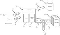
- constructing the requested tile of geographic datacomprises constructing a mosaic of the one or more source tiles. In some embodiments, constructing the requested tile of geographic data comprises masking, scaling, and/or applying a color map. In some embodiments, the request comprises one or more configuration parameters, the one or more configuration parameters specifying the masking, scaling, and or application of a color map. In some embodiments, constructing the requested tile of geographic data comprises generating an image file.
- the requested tile of geographic datais cached for future requests.
Landscapes
- Engineering & Computer Science (AREA)
- Theoretical Computer Science (AREA)
- Physics & Mathematics (AREA)
- General Physics & Mathematics (AREA)
- Library & Information Science (AREA)
- Data Mining & Analysis (AREA)
- Databases & Information Systems (AREA)
- General Engineering & Computer Science (AREA)
- Computer Networks & Wireless Communication (AREA)
- Signal Processing (AREA)
- Processing Or Creating Images (AREA)
- Information Retrieval, Db Structures And Fs Structures Therefor (AREA)
Abstract
Description
| TABLE 1 | |||
| # Tiles | |||
| 0 | 1 | ||
| 1 | 4 | ||
| 2 | 16 | ||
| 8 | 65,536 | ||
| 12 | 16,777,216 | ||
| 15 | 1,073,741,824 | ||
Claims (27)
Priority Applications (1)
| Application Number | Priority Date | Filing Date | Title |
|---|---|---|---|
| US18/051,789US12198237B2 (en) | 2020-05-01 | 2022-11-01 | Dynamic data tiling |
Applications Claiming Priority (4)
| Application Number | Priority Date | Filing Date | Title |
|---|---|---|---|
| US202063019071P | 2020-05-01 | 2020-05-01 | |
| US202063074319P | 2020-09-03 | 2020-09-03 | |
| PCT/US2021/030196WO2021222763A1 (en) | 2020-05-01 | 2021-04-30 | Dynamic data tiling |
| US18/051,789US12198237B2 (en) | 2020-05-01 | 2022-11-01 | Dynamic data tiling |
Related Parent Applications (1)
| Application Number | Title | Priority Date | Filing Date |
|---|---|---|---|
| PCT/US2021/030196ContinuationWO2021222763A1 (en) | 2020-05-01 | 2021-04-30 | Dynamic data tiling |
Publications (2)
| Publication Number | Publication Date |
|---|---|
| US20230092057A1 US20230092057A1 (en) | 2023-03-23 |
| US12198237B2true US12198237B2 (en) | 2025-01-14 |
Family
ID=78373979
Family Applications (1)
| Application Number | Title | Priority Date | Filing Date |
|---|---|---|---|
| US18/051,789Active2041-06-17US12198237B2 (en) | 2020-05-01 | 2022-11-01 | Dynamic data tiling |
Country Status (5)
| Country | Link |
|---|---|
| US (1) | US12198237B2 (en) |
| EP (1) | EP4143816A4 (en) |
| BR (1) | BR112022021184A2 (en) |
| CA (1) | CA3177357A1 (en) |
| WO (1) | WO2021222763A1 (en) |
Families Citing this family (4)
| Publication number | Priority date | Publication date | Assignee | Title |
|---|---|---|---|---|
| WO2019209947A1 (en) | 2018-04-24 | 2019-10-31 | Indigo Ag, Inc. | Interaction management in an online agricultural system |
| WO2021041666A1 (en) | 2019-08-27 | 2021-03-04 | Indigo Ag, Inc. | Imagery-based boundary identification for agricultural fields |
| CA3177357A1 (en) | 2020-05-01 | 2021-11-04 | Christopher Edward Holden | Dynamic data tiling |
| BR112023000950A2 (en) | 2020-07-21 | 2023-03-28 | Indigo Ag Inc | REMOTE SENSING ALGORITHMS FOR MAPPING REGENERATIVE AGRICULTURE |
Citations (98)
| Publication number | Priority date | Publication date | Assignee | Title |
|---|---|---|---|---|
| US6422508B1 (en) | 2000-04-05 | 2002-07-23 | Galileo Group, Inc. | System for robotic control of imaging data having a steerable gimbal mounted spectral sensor and methods |
| US20030019408A1 (en) | 2001-02-28 | 2003-01-30 | Clyde Fraisse | Method for prescribing site-specific fertilizer application in agricultural fields |
| US20050234691A1 (en) | 2004-04-20 | 2005-10-20 | Singh Ramesh P | Crop yield prediction |
| US20070014488A1 (en) | 2004-07-09 | 2007-01-18 | Ching-Chien Chen | Automatically and accurately conflating road vector data, street maps, and orthoimagery |
| US7212670B1 (en) | 2002-05-03 | 2007-05-01 | Imagetree Corp. | Method of feature identification and analysis |
| US20070229524A1 (en) | 2006-02-13 | 2007-10-04 | Geoffrey Hendrey | Draggable maps |
| US20080174593A1 (en) | 2007-01-18 | 2008-07-24 | Harris Corporation, Corporation Of The State Of Delaware. | System and method for processing map images |
| US20090037441A1 (en) | 2007-07-31 | 2009-02-05 | Microsoft Corporation | Tiled packaging of vector image data |
| US20090259709A1 (en) | 2002-10-07 | 2009-10-15 | Nikitin Alexei V | Method and apparatus for adaptive real-time signal conditioning, processing, analysis, quantification, comparison, and control |
| US7675549B1 (en) | 2006-12-08 | 2010-03-09 | Itt Manufacturing Enterprises, Inc. | Imaging architecture for region and time of interest collection and dissemination |
| US20100082564A1 (en)* | 2008-10-01 | 2010-04-01 | Navteq North America, Llc | Spatial Index for Locating Geographic Data Parcels Stored on Physical Storage Media |
| US20100321399A1 (en) | 2009-06-18 | 2010-12-23 | Patrik Ellren | Maps from Sparse Geospatial Data Tiles |
| US20100332430A1 (en) | 2009-06-30 | 2010-12-30 | Dow Agrosciences Llc | Application of machine learning methods for mining association rules in plant and animal data sets containing molecular genetic markers, followed by classification or prediction utilizing features created from these association rules |
| US20120143504A1 (en)* | 2010-12-07 | 2012-06-07 | Google Inc. | Method and apparatus of route guidance |
| US20120191773A1 (en) | 2011-01-26 | 2012-07-26 | Google Inc. | Caching resources |
| AU2012101249A4 (en) | 2012-08-17 | 2012-09-20 | Beijing Normal University | Method for Generating High Spatial Resolution NDVI Time Series Data |
| US20130332205A1 (en) | 2012-06-06 | 2013-12-12 | David Friedberg | System and method for establishing an insurance policy based on various farming risks |
| US20140039967A1 (en) | 2006-11-07 | 2014-02-06 | The Curators Of The University Of Missouri | Method of predicting crop yield loss due to n-deficiency |
| US20140095261A1 (en) | 2012-09-27 | 2014-04-03 | FI2 Solutions, LLC | Methods, apparatus and systems for determining stand population, stand consistency and stand quality in an agricultural crop and alerting users |
| US20140222374A1 (en) | 2011-09-20 | 2014-08-07 | Monford Ag Systems Limited | System and Method for Measuring Parameters Relating to Agriculture |
| US20140263822A1 (en) | 2013-03-18 | 2014-09-18 | Chester Charles Malveaux | Vertical take off and landing autonomous/semiautonomous/remote controlled aerial agricultural sensor platform |
| US8965812B2 (en) | 2007-10-09 | 2015-02-24 | Archer Daniels Midland Company | Evaluating commodity conditions using aerial image data |
| US9113590B2 (en) | 2012-08-06 | 2015-08-25 | Superior Edge, Inc. | Methods, apparatus, and systems for determining in-season crop status in an agricultural crop and alerting users |
| US20160050840A1 (en) | 2014-08-22 | 2016-02-25 | The Climate Corporation | Methods for agronomic and agricultural monitoring using unmanned aerial systems |
| US20160071410A1 (en) | 2014-09-05 | 2016-03-10 | The Climate Corporation | Updating execution of tasks of an agricultural prescription |
| US20160073573A1 (en) | 2014-09-12 | 2016-03-17 | The Climate Corporation | Methods and systems for managing agricultural activities |
| US20160157414A1 (en) | 2014-12-05 | 2016-06-09 | Deere & Company | Scouting systems |
| US20160171680A1 (en) | 2014-12-16 | 2016-06-16 | The Board of Trustees of the Land Stanford Junior University | Systems and Methods for Satellite Image Processing to Estimate Crop Yield |
| US20160180473A1 (en) | 2011-05-13 | 2016-06-23 | Hydrobio, Inc. | Systems to prescribe and deliver fertilizer over agricultural fields and related methods |
| US9381646B1 (en) | 2012-07-05 | 2016-07-05 | Bernard Fryshman | Insect and other small object image recognition and instant active response with enhanced application and utility |
| US20160216245A1 (en) | 2012-11-07 | 2016-07-28 | Brian Harold Sutton | Infrared aerial thermography for use in monitoring plant health and growth |
| US20160232621A1 (en) | 2015-02-06 | 2016-08-11 | The Climate Corporation | Methods and systems for recommending agricultural activities |
| US20160302351A1 (en) | 2015-04-17 | 2016-10-20 | 360 Yield Center, Llc | Agronomic systems, methods and apparatuses |
| US20160309646A1 (en) | 2015-04-24 | 2016-10-27 | 360 Yield Center, Llc | Agronomic systems, methods and apparatuses |
| US9489576B2 (en) | 2014-03-26 | 2016-11-08 | F12 Solutions, LLC. | Crop stand analysis |
| US9519861B1 (en) | 2014-09-12 | 2016-12-13 | The Climate Corporation | Generating digital models of nutrients available to a crop over the course of the crop's development based on weather and soil data |
| KR101703442B1 (en) | 2015-09-17 | 2017-02-06 | 한국항공우주연구원 | Apparatus and method of extrcting a seamline for mosaicking of satellite images |
| US9563945B2 (en) | 2012-07-05 | 2017-02-07 | Bernard Fryshman | Object image recognition and instant active response with enhanced application and utility |
| US20170041407A1 (en) | 2015-04-20 | 2017-02-09 | Agverdict, Inc. | Systems and Methods for Efficiently Generating a Geospatial Data Map for Use in Agricultural Operations |
| US9582873B2 (en) | 2014-06-30 | 2017-02-28 | Trimble Inc. | Active imaging systems for plant growth monitoring |
| US9582002B2 (en) | 2013-11-20 | 2017-02-28 | Rowbot Systems Llc | Robotic platform and method for performing multiple functions in agricultural systems |
| US20170083747A1 (en) | 2015-09-21 | 2017-03-23 | The Climate Corporation | Ponding water detection on satellite imagery |
| US20170089761A1 (en) | 2014-06-18 | 2017-03-30 | Gary L. McQuilkin | Spectral imaging system for remote and noninvasive detection of target substances using spectral filter arrays and image capture arrays |
| US20170090068A1 (en) | 2014-09-12 | 2017-03-30 | The Climate Corporation | Estimating soil properties within a field using hyperspectral remote sensing |
| US20170109395A1 (en) | 2015-10-14 | 2017-04-20 | The Climate Corporation | Computer-generated accurate yield map data using expert filters and spatial outlier detection |
| US20170105335A1 (en) | 2015-10-16 | 2017-04-20 | The Climate Corporation | Method for recommending seeding rate for corn seed using seed type and sowing row width |
| US9629306B2 (en) | 2012-12-17 | 2017-04-25 | The Climate Corporation | Plot placement systems and methods |
| US20170112043A1 (en) | 2015-10-23 | 2017-04-27 | Deere & Company | System and method for residue detection and implement control |
| US20170124463A1 (en) | 2015-10-28 | 2017-05-04 | The Climate Corporation | Computer-implemented calculation of corn harvest recommendations |
| US9658201B2 (en) | 2013-03-07 | 2017-05-23 | Blue River Technology Inc. | Method for automatic phenotype measurement and selection |
| US20170161627A1 (en) | 2015-12-02 | 2017-06-08 | The Climate Corporation | Forecasting field level crop yield during a growing season |
| US20170168157A1 (en) | 2015-12-10 | 2017-06-15 | The Climate Corporation | Generating estimates of uncertainty for radar based precipitation estimates |
| US20170169523A1 (en) | 2015-12-14 | 2017-06-15 | The Climate Corporation | Generating digital models of relative yield of a crop based on nitrate values in the soil |
| US20170177938A1 (en) | 2015-12-16 | 2017-06-22 | Regents Of The University Of Minnesota | Automated detection of nitrogen deficiency in crop |
| US20170199528A1 (en) | 2015-09-04 | 2017-07-13 | Nutech Ventures | Crop height estimation with unmanned aerial vehicles |
| US20170196171A1 (en) | 2016-01-07 | 2017-07-13 | The Climate Corporation | Generating digital models of crop yield based on crop planting dates and relative maturity values |
| US20170206415A1 (en) | 2016-01-15 | 2017-07-20 | Blue River Technology Inc. | Plant feature detection using captured images |
| US20170213141A1 (en) | 2016-01-22 | 2017-07-27 | The Climate Corporation | Forecasting national crop yield during the growing season using weather indices |
| US20170228475A1 (en) | 2016-02-05 | 2017-08-10 | The Climate Corporation | Modeling trends in crop yields |
| US20170231213A1 (en) | 2016-02-17 | 2017-08-17 | International Business Machines Corporation | Pest abatement utilizing an aerial drone |
| US9745060B2 (en) | 2015-07-17 | 2017-08-29 | Topcon Positioning Systems, Inc. | Agricultural crop analysis drone |
| US20170257426A1 (en) | 2015-04-20 | 2017-09-07 | Agverdict, Inc. | Systems and Methods for Cloud-Based Agricultural Data Processing and Management |
| US9756844B2 (en) | 2011-05-13 | 2017-09-12 | The Climate Corporation | Method and system to map biological pests in agricultural fields using remotely-sensed data for field scouting and targeted chemical application |
| US20170258005A1 (en) | 2016-03-14 | 2017-09-14 | Cutter Technologies, LLC | Field monitoring, analysis, and treatment system |
| US20170270446A1 (en) | 2015-05-01 | 2017-09-21 | 360 Yield Center, Llc | Agronomic systems, methods and apparatuses for determining yield limits |
| US20170287436A1 (en)* | 2016-04-04 | 2017-10-05 | Yandex Europe Ag | Method and system of downloading image tiles onto a client device |
| US20170287437A1 (en)* | 2016-04-04 | 2017-10-05 | Yandex Europe Ag | Method and system of downloading image tiles onto a client device |
| US9880140B2 (en) | 2014-08-19 | 2018-01-30 | Clearag, Inc. | Continual crop development profiling using dynamical extended range weather forecasting with routine remotely-sensed validation imagery |
| US20180049043A1 (en) | 2005-10-04 | 2018-02-15 | Steven M. Hoffberg | Multifactorial optimization system and method |
| US20180070527A1 (en) | 2016-09-09 | 2018-03-15 | Cibo Technologies, Inc. | Systems for learning farmable zones, and related methods and apparatus |
| US20180075545A1 (en) | 2016-09-09 | 2018-03-15 | Cibo Technologies, Inc. | Systems for adjusting agronomic inputs using remote sensing, and related apparatus and methods |
| US9928578B1 (en) | 2016-03-30 | 2018-03-27 | Descartes Labs, Inc. | Using boundary maps to refine imagery |
| US20180137675A1 (en)* | 2016-11-16 | 2018-05-17 | Here Global B.V. | Method for determining polygons that overlap with a candidate polygon or point |
| US20180211156A1 (en) | 2017-01-26 | 2018-07-26 | The Climate Corporation | Crop yield estimation using agronomic neural network |
| US20190050948A1 (en) | 2017-08-08 | 2019-02-14 | Indigo Ag, Inc. | Machine learning in agricultural planting, growing, and harvesting contexts |
| CN109360117A (en) | 2018-10-08 | 2019-02-19 | 西充恒河农牧业开发有限公司 | A kind of crop growing mode recognition methods |
| CN109685081A (en) | 2018-12-27 | 2019-04-26 | 中国土地勘测规划院 | A kind of joint change detecting method of Remotely sensed acquisition black fallow |
| CN106529451B (en) | 2016-10-28 | 2019-06-18 | 山东省农业可持续发展研究所 | Winter wheat-summer corn planting mode remote sensing identification method |
| CN110287869A (en) | 2019-06-25 | 2019-09-27 | 吉林大学 | Crop classification method for high-resolution remote sensing images based on deep learning |
| US10445877B2 (en) | 2016-12-30 | 2019-10-15 | International Business Machines Corporation | Method and system for crop recognition and boundary delineation |
| US20200008371A1 (en) | 2016-11-16 | 2020-01-09 | The Climate Corporation | Identifying management zones in agricultural fields and generating planting plans for the zones |
| WO2020055950A1 (en) | 2018-09-11 | 2020-03-19 | The Climate Corporation | Risk-adjusted hybrid seed selection and crop yield optimization by field |
| CN110909679A (en) | 2019-11-22 | 2020-03-24 | 中国气象科学研究院 | Remote sensing identification method and system for fallow crop rotation information of winter wheat historical planting area |
| WO2021007352A1 (en) | 2019-07-08 | 2021-01-14 | Indigo Ag, Inc. | Crop yield forecasting models |
| US10902655B1 (en)* | 2016-02-01 | 2021-01-26 | United Parcel Service Of America, Inc. | Editing cached map titles |
| WO2021041666A1 (en) | 2019-08-27 | 2021-03-04 | Indigo Ag, Inc. | Imagery-based boundary identification for agricultural fields |
| WO2021062147A1 (en) | 2019-09-27 | 2021-04-01 | Indigo Ag, Inc. | Modeling field irrigation with remote sensing imagery |
| WO2021062177A1 (en) | 2019-09-27 | 2021-04-01 | Indigo Ag, Inc. | Imputation of remote sensing time series for low-latency agricultural applications |
| US11100579B1 (en) | 2017-08-09 | 2021-08-24 | Bushel, Inc. | Commodity tracking system and method |
| WO2021222763A1 (en) | 2020-05-01 | 2021-11-04 | Indigo Ag, Inc. | Dynamic data tiling |
| CN108764688B (en) | 2018-05-21 | 2021-11-23 | 浙江大学 | Remote sensing monitoring method for wet water damage in winter wheat based on fusion of satellite-ground multi-source precipitation data |
| WO2022020448A1 (en) | 2020-07-21 | 2022-01-27 | Indigo Ag, Inc. | Remote sensing algorithms for mapping regenerative agriculture |
| US20220067614A1 (en) | 2018-12-19 | 2022-03-03 | The Board Of Trustees Of The University Of Illinois | Apparatus and method for crop yield prediction |
| US20220138767A1 (en) | 2020-10-30 | 2022-05-05 | Cibo Technologies, Inc. | Method and system for carbon footprint monitoring based on regenerative practice implementation |
| US20220237888A1 (en) | 2021-01-27 | 2022-07-28 | Tata Consultancy Services Limited | Method and system for providing generalized approach for crop mapping across regions with varying characteristics |
| US20220343229A1 (en) | 2021-04-27 | 2022-10-27 | Gevo, Inc. | Systems and methods for automatic carbon intensity calculation and tracking |
| US20220342536A1 (en) | 2021-04-26 | 2022-10-27 | Bushel, Inc. | User interface for adjusting component proportions |
| US11762125B2 (en) | 2014-09-12 | 2023-09-19 | Climate Llc | Forecasting national crop yield during the growing season |
- 2021
- 2021-04-30CACA3177357Apatent/CA3177357A1/enactivePending
- 2021-04-30EPEP21796375.0Apatent/EP4143816A4/enactivePending
- 2021-04-30WOPCT/US2021/030196patent/WO2021222763A1/ennot_activeCeased
- 2021-04-30BRBR112022021184Apatent/BR112022021184A2/enunknown
- 2022
- 2022-11-01USUS18/051,789patent/US12198237B2/enactiveActive
Patent Citations (109)
| Publication number | Priority date | Publication date | Assignee | Title |
|---|---|---|---|---|
| US6422508B1 (en) | 2000-04-05 | 2002-07-23 | Galileo Group, Inc. | System for robotic control of imaging data having a steerable gimbal mounted spectral sensor and methods |
| US20030019408A1 (en) | 2001-02-28 | 2003-01-30 | Clyde Fraisse | Method for prescribing site-specific fertilizer application in agricultural fields |
| US7212670B1 (en) | 2002-05-03 | 2007-05-01 | Imagetree Corp. | Method of feature identification and analysis |
| US20090259709A1 (en) | 2002-10-07 | 2009-10-15 | Nikitin Alexei V | Method and apparatus for adaptive real-time signal conditioning, processing, analysis, quantification, comparison, and control |
| US20050234691A1 (en) | 2004-04-20 | 2005-10-20 | Singh Ramesh P | Crop yield prediction |
| US20070014488A1 (en) | 2004-07-09 | 2007-01-18 | Ching-Chien Chen | Automatically and accurately conflating road vector data, street maps, and orthoimagery |
| US20180049043A1 (en) | 2005-10-04 | 2018-02-15 | Steven M. Hoffberg | Multifactorial optimization system and method |
| US20070229524A1 (en) | 2006-02-13 | 2007-10-04 | Geoffrey Hendrey | Draggable maps |
| US20140039967A1 (en) | 2006-11-07 | 2014-02-06 | The Curators Of The University Of Missouri | Method of predicting crop yield loss due to n-deficiency |
| US7675549B1 (en) | 2006-12-08 | 2010-03-09 | Itt Manufacturing Enterprises, Inc. | Imaging architecture for region and time of interest collection and dissemination |
| US20080174593A1 (en) | 2007-01-18 | 2008-07-24 | Harris Corporation, Corporation Of The State Of Delaware. | System and method for processing map images |
| US20090037441A1 (en) | 2007-07-31 | 2009-02-05 | Microsoft Corporation | Tiled packaging of vector image data |
| USRE47742E1 (en) | 2007-10-09 | 2019-11-26 | Archer Daniels Midland Company (ADM) | Evaluating commodity conditions using aerial image data |
| USRE46968E1 (en) | 2007-10-09 | 2018-07-24 | Archer Daniels Midland Company | Evaluating commodity conditions using aerial image data |
| US8965812B2 (en) | 2007-10-09 | 2015-02-24 | Archer Daniels Midland Company | Evaluating commodity conditions using aerial image data |
| US20100082564A1 (en)* | 2008-10-01 | 2010-04-01 | Navteq North America, Llc | Spatial Index for Locating Geographic Data Parcels Stored on Physical Storage Media |
| US20100321399A1 (en) | 2009-06-18 | 2010-12-23 | Patrik Ellren | Maps from Sparse Geospatial Data Tiles |
| US20100332430A1 (en) | 2009-06-30 | 2010-12-30 | Dow Agrosciences Llc | Application of machine learning methods for mining association rules in plant and animal data sets containing molecular genetic markers, followed by classification or prediction utilizing features created from these association rules |
| US20120143504A1 (en)* | 2010-12-07 | 2012-06-07 | Google Inc. | Method and apparatus of route guidance |
| US20120191773A1 (en) | 2011-01-26 | 2012-07-26 | Google Inc. | Caching resources |
| US9756844B2 (en) | 2011-05-13 | 2017-09-12 | The Climate Corporation | Method and system to map biological pests in agricultural fields using remotely-sensed data for field scouting and targeted chemical application |
| US20160180473A1 (en) | 2011-05-13 | 2016-06-23 | Hydrobio, Inc. | Systems to prescribe and deliver fertilizer over agricultural fields and related methods |
| US20140222374A1 (en) | 2011-09-20 | 2014-08-07 | Monford Ag Systems Limited | System and Method for Measuring Parameters Relating to Agriculture |
| US20130332205A1 (en) | 2012-06-06 | 2013-12-12 | David Friedberg | System and method for establishing an insurance policy based on various farming risks |
| US9563945B2 (en) | 2012-07-05 | 2017-02-07 | Bernard Fryshman | Object image recognition and instant active response with enhanced application and utility |
| US9381646B1 (en) | 2012-07-05 | 2016-07-05 | Bernard Fryshman | Insect and other small object image recognition and instant active response with enhanced application and utility |
| US9113590B2 (en) | 2012-08-06 | 2015-08-25 | Superior Edge, Inc. | Methods, apparatus, and systems for determining in-season crop status in an agricultural crop and alerting users |
| AU2012101249A4 (en) | 2012-08-17 | 2012-09-20 | Beijing Normal University | Method for Generating High Spatial Resolution NDVI Time Series Data |
| US20140095261A1 (en) | 2012-09-27 | 2014-04-03 | FI2 Solutions, LLC | Methods, apparatus and systems for determining stand population, stand consistency and stand quality in an agricultural crop and alerting users |
| US20160216245A1 (en) | 2012-11-07 | 2016-07-28 | Brian Harold Sutton | Infrared aerial thermography for use in monitoring plant health and growth |
| US9629306B2 (en) | 2012-12-17 | 2017-04-25 | The Climate Corporation | Plot placement systems and methods |
| US9658201B2 (en) | 2013-03-07 | 2017-05-23 | Blue River Technology Inc. | Method for automatic phenotype measurement and selection |
| US20140263822A1 (en) | 2013-03-18 | 2014-09-18 | Chester Charles Malveaux | Vertical take off and landing autonomous/semiautonomous/remote controlled aerial agricultural sensor platform |
| US9582002B2 (en) | 2013-11-20 | 2017-02-28 | Rowbot Systems Llc | Robotic platform and method for performing multiple functions in agricultural systems |
| US9489576B2 (en) | 2014-03-26 | 2016-11-08 | F12 Solutions, LLC. | Crop stand analysis |
| US20170089761A1 (en) | 2014-06-18 | 2017-03-30 | Gary L. McQuilkin | Spectral imaging system for remote and noninvasive detection of target substances using spectral filter arrays and image capture arrays |
| US9582873B2 (en) | 2014-06-30 | 2017-02-28 | Trimble Inc. | Active imaging systems for plant growth monitoring |
| US9880140B2 (en) | 2014-08-19 | 2018-01-30 | Clearag, Inc. | Continual crop development profiling using dynamical extended range weather forecasting with routine remotely-sensed validation imagery |
| US20160050840A1 (en) | 2014-08-22 | 2016-02-25 | The Climate Corporation | Methods for agronomic and agricultural monitoring using unmanned aerial systems |
| US20160071410A1 (en) | 2014-09-05 | 2016-03-10 | The Climate Corporation | Updating execution of tasks of an agricultural prescription |
| US9519861B1 (en) | 2014-09-12 | 2016-12-13 | The Climate Corporation | Generating digital models of nutrients available to a crop over the course of the crop's development based on weather and soil data |
| US20160073573A1 (en) | 2014-09-12 | 2016-03-17 | The Climate Corporation | Methods and systems for managing agricultural activities |
| US20170090068A1 (en) | 2014-09-12 | 2017-03-30 | The Climate Corporation | Estimating soil properties within a field using hyperspectral remote sensing |
| US10564316B2 (en) | 2014-09-12 | 2020-02-18 | The Climate Corporation | Forecasting national crop yield during the growing season |
| US11762125B2 (en) | 2014-09-12 | 2023-09-19 | Climate Llc | Forecasting national crop yield during the growing season |
| US20160157414A1 (en) | 2014-12-05 | 2016-06-09 | Deere & Company | Scouting systems |
| US20160171680A1 (en) | 2014-12-16 | 2016-06-16 | The Board of Trustees of the Land Stanford Junior University | Systems and Methods for Satellite Image Processing to Estimate Crop Yield |
| US20160232621A1 (en) | 2015-02-06 | 2016-08-11 | The Climate Corporation | Methods and systems for recommending agricultural activities |
| US20160302351A1 (en) | 2015-04-17 | 2016-10-20 | 360 Yield Center, Llc | Agronomic systems, methods and apparatuses |
| US20170041407A1 (en) | 2015-04-20 | 2017-02-09 | Agverdict, Inc. | Systems and Methods for Efficiently Generating a Geospatial Data Map for Use in Agricultural Operations |
| US20170257426A1 (en) | 2015-04-20 | 2017-09-07 | Agverdict, Inc. | Systems and Methods for Cloud-Based Agricultural Data Processing and Management |
| US20160309646A1 (en) | 2015-04-24 | 2016-10-27 | 360 Yield Center, Llc | Agronomic systems, methods and apparatuses |
| US20170270446A1 (en) | 2015-05-01 | 2017-09-21 | 360 Yield Center, Llc | Agronomic systems, methods and apparatuses for determining yield limits |
| US9745060B2 (en) | 2015-07-17 | 2017-08-29 | Topcon Positioning Systems, Inc. | Agricultural crop analysis drone |
| US20170199528A1 (en) | 2015-09-04 | 2017-07-13 | Nutech Ventures | Crop height estimation with unmanned aerial vehicles |
| KR101703442B1 (en) | 2015-09-17 | 2017-02-06 | 한국항공우주연구원 | Apparatus and method of extrcting a seamline for mosaicking of satellite images |
| US20170083747A1 (en) | 2015-09-21 | 2017-03-23 | The Climate Corporation | Ponding water detection on satellite imagery |
| US20190019008A1 (en) | 2015-09-21 | 2019-01-17 | The Climate Corporation | Ponding water detection on satellite imagery |
| US20170109395A1 (en) | 2015-10-14 | 2017-04-20 | The Climate Corporation | Computer-generated accurate yield map data using expert filters and spatial outlier detection |
| US20170105335A1 (en) | 2015-10-16 | 2017-04-20 | The Climate Corporation | Method for recommending seeding rate for corn seed using seed type and sowing row width |
| US20170112043A1 (en) | 2015-10-23 | 2017-04-27 | Deere & Company | System and method for residue detection and implement control |
| US20170124463A1 (en) | 2015-10-28 | 2017-05-04 | The Climate Corporation | Computer-implemented calculation of corn harvest recommendations |
| US20170161627A1 (en) | 2015-12-02 | 2017-06-08 | The Climate Corporation | Forecasting field level crop yield during a growing season |
| US20170168157A1 (en) | 2015-12-10 | 2017-06-15 | The Climate Corporation | Generating estimates of uncertainty for radar based precipitation estimates |
| US20170169523A1 (en) | 2015-12-14 | 2017-06-15 | The Climate Corporation | Generating digital models of relative yield of a crop based on nitrate values in the soil |
| US20170177938A1 (en) | 2015-12-16 | 2017-06-22 | Regents Of The University Of Minnesota | Automated detection of nitrogen deficiency in crop |
| US20170196171A1 (en) | 2016-01-07 | 2017-07-13 | The Climate Corporation | Generating digital models of crop yield based on crop planting dates and relative maturity values |
| US20170206415A1 (en) | 2016-01-15 | 2017-07-20 | Blue River Technology Inc. | Plant feature detection using captured images |
| US20170213141A1 (en) | 2016-01-22 | 2017-07-27 | The Climate Corporation | Forecasting national crop yield during the growing season using weather indices |
| US10902655B1 (en)* | 2016-02-01 | 2021-01-26 | United Parcel Service Of America, Inc. | Editing cached map titles |
| US20170228475A1 (en) | 2016-02-05 | 2017-08-10 | The Climate Corporation | Modeling trends in crop yields |
| US20170231213A1 (en) | 2016-02-17 | 2017-08-17 | International Business Machines Corporation | Pest abatement utilizing an aerial drone |
| US20170258005A1 (en) | 2016-03-14 | 2017-09-14 | Cutter Technologies, LLC | Field monitoring, analysis, and treatment system |
| US9928578B1 (en) | 2016-03-30 | 2018-03-27 | Descartes Labs, Inc. | Using boundary maps to refine imagery |
| US20170287437A1 (en)* | 2016-04-04 | 2017-10-05 | Yandex Europe Ag | Method and system of downloading image tiles onto a client device |
| US20170287436A1 (en)* | 2016-04-04 | 2017-10-05 | Yandex Europe Ag | Method and system of downloading image tiles onto a client device |
| US20180075545A1 (en) | 2016-09-09 | 2018-03-15 | Cibo Technologies, Inc. | Systems for adjusting agronomic inputs using remote sensing, and related apparatus and methods |
| US20180070527A1 (en) | 2016-09-09 | 2018-03-15 | Cibo Technologies, Inc. | Systems for learning farmable zones, and related methods and apparatus |
| CN106529451B (en) | 2016-10-28 | 2019-06-18 | 山东省农业可持续发展研究所 | Winter wheat-summer corn planting mode remote sensing identification method |
| US20180137675A1 (en)* | 2016-11-16 | 2018-05-17 | Here Global B.V. | Method for determining polygons that overlap with a candidate polygon or point |
| US20200008371A1 (en) | 2016-11-16 | 2020-01-09 | The Climate Corporation | Identifying management zones in agricultural fields and generating planting plans for the zones |
| US10445877B2 (en) | 2016-12-30 | 2019-10-15 | International Business Machines Corporation | Method and system for crop recognition and boundary delineation |
| US20180211156A1 (en) | 2017-01-26 | 2018-07-26 | The Climate Corporation | Crop yield estimation using agronomic neural network |
| US20190050948A1 (en) | 2017-08-08 | 2019-02-14 | Indigo Ag, Inc. | Machine learning in agricultural planting, growing, and harvesting contexts |
| US11100579B1 (en) | 2017-08-09 | 2021-08-24 | Bushel, Inc. | Commodity tracking system and method |
| CN108764688B (en) | 2018-05-21 | 2021-11-23 | 浙江大学 | Remote sensing monitoring method for wet water damage in winter wheat based on fusion of satellite-ground multi-source precipitation data |
| WO2020055950A1 (en) | 2018-09-11 | 2020-03-19 | The Climate Corporation | Risk-adjusted hybrid seed selection and crop yield optimization by field |
| CN109360117A (en) | 2018-10-08 | 2019-02-19 | 西充恒河农牧业开发有限公司 | A kind of crop growing mode recognition methods |
| US20220067614A1 (en) | 2018-12-19 | 2022-03-03 | The Board Of Trustees Of The University Of Illinois | Apparatus and method for crop yield prediction |
| CN109685081A (en) | 2018-12-27 | 2019-04-26 | 中国土地勘测规划院 | A kind of joint change detecting method of Remotely sensed acquisition black fallow |
| CN110287869A (en) | 2019-06-25 | 2019-09-27 | 吉林大学 | Crop classification method for high-resolution remote sensing images based on deep learning |
| WO2021007352A1 (en) | 2019-07-08 | 2021-01-14 | Indigo Ag, Inc. | Crop yield forecasting models |
| WO2021007352A8 (en) | 2019-07-08 | 2021-08-12 | Indigo Ag, Inc. | Crop yield forecasting models |
| US20220261928A1 (en) | 2019-07-08 | 2022-08-18 | Indigo Ag, Inc. | Crop yield forecasting models |
| WO2021041666A1 (en) | 2019-08-27 | 2021-03-04 | Indigo Ag, Inc. | Imagery-based boundary identification for agricultural fields |
| US20220180526A1 (en) | 2019-08-27 | 2022-06-09 | Indigo Ag, Inc. | Imagery-based boundary identification for agricultural fields |
| WO2021062177A1 (en) | 2019-09-27 | 2021-04-01 | Indigo Ag, Inc. | Imputation of remote sensing time series for low-latency agricultural applications |
| US20220215659A1 (en) | 2019-09-27 | 2022-07-07 | Indigo Ag, Inc. | Imputation of remote sensing time series for low-latency agricultural applications |
| WO2021062147A1 (en) | 2019-09-27 | 2021-04-01 | Indigo Ag, Inc. | Modeling field irrigation with remote sensing imagery |
| US20220210987A1 (en) | 2019-09-27 | 2022-07-07 | Indigo Ag, Inc. | Modeling field irrigation with remote sensing imagery |
| CN110909679A (en) | 2019-11-22 | 2020-03-24 | 中国气象科学研究院 | Remote sensing identification method and system for fallow crop rotation information of winter wheat historical planting area |
| US20230092057A1 (en) | 2020-05-01 | 2023-03-23 | Indigo Ag, Inc. | Dynamic data tiling |
| WO2021222763A1 (en) | 2020-05-01 | 2021-11-04 | Indigo Ag, Inc. | Dynamic data tiling |
| WO2022020448A1 (en) | 2020-07-21 | 2022-01-27 | Indigo Ag, Inc. | Remote sensing algorithms for mapping regenerative agriculture |
| US11978251B2 (en) | 2020-07-21 | 2024-05-07 | Indigo Ag, Inc. | Remote sensing algorithms for mapping regenerative agriculture |
| US20220138767A1 (en) | 2020-10-30 | 2022-05-05 | Cibo Technologies, Inc. | Method and system for carbon footprint monitoring based on regenerative practice implementation |
| US20220237888A1 (en) | 2021-01-27 | 2022-07-28 | Tata Consultancy Services Limited | Method and system for providing generalized approach for crop mapping across regions with varying characteristics |
| US20220342536A1 (en) | 2021-04-26 | 2022-10-27 | Bushel, Inc. | User interface for adjusting component proportions |
| US20220343229A1 (en) | 2021-04-27 | 2022-10-27 | Gevo, Inc. | Systems and methods for automatic carbon intensity calculation and tracking |
Non-Patent Citations (31)
| Title |
|---|
| Aji et al., "Hadoop-GIS: A High Performance Spatial Data Warehousing System over MapReduce," Proceedings VLDB Endowment, 6(11) (33 pages) (2013). |
| Becker-Reshef, I. et al., "Prior Season Crop Type Masks for Winter Wheat Yield Forecasting: A US Case Study," Remote Sensing, 10: 1659, Oct. 19, 2018, pp. 1-20. |
| Bermudez, C., "Development of a remote sensing protocol for inventorying cover crop adoptions," lowa State University Master of Science Thesis, 2016, pp. 1-80. |
| Bratten, J., "Landsatlinkr 0.1.4 User Guide," Guide version 0.1.4a draft, Mar. 5, 2015, pp. 1-42. |
| European Patent Office, Extended European Search Report, EP Patent Application No. 20836088.3, Jun. 14, 2023, ten pages. |
| European Patent Office, Extended European Search Report, EP Patent Application No. 21796375.0, Dec. 19, 2023, nine pages. |
| Gao, F. et al., "A within-season approach for detecting early growth stages in corn and soybean using high temporal and spatial resolution imagery," Remote Sens Environ, vol. 242: 111752, Mar. 2020, pp. 1-19. |
| Github, "cogeo-mosaic," Jun. 13, 2019, pp. 1-11, [Online] Retrieved from the Internet <URL: https://github.com/developmentseed/mosaicjson-spec>. |
| Github, "Marblecutter,"Jul. 31, 2017 pp. 1-4, [Online] Retrieved from the Internet <URL:https://github.com/mojodna/marblecutter>. |
| Github, "rio-tiler," Oct. 14, 2020, pp. 1-14, [Online] Retrieved from the Internet <URL:https://github.com/cogeotiff/rio-tiler>. |
| Github, "Terracotta," Mar. 6, 2018, pp. 1-5, [Online] Retrieved from the Internet <URL:https://github.com/DHI/terracotta>. |
| Htitiou, A. et al., "The performance of random forest classification based on phenological metrics derived from Sentinel-2 and Landsat 8 to map crop cover in an irrigated semi-arid region," Remote Sensing in Earth Systems Sciences 2.4, Oct. 29, 2019, pp. 208-224. |
| International Search Report and Written Opinion for International Application No. PCT/US2021/030196 mailed Aug. 4, 2021. |
| Kuzyakova, I.F. et al., "Time series analysis and mixed models for studying the dynamics of net N mineralization in a soil catena at Gondelsheim (S-W Germany)," Geoderma, vol. 136, Sep. 7, 2006, pp. 803-818. |
| Lin, X. et al., "Carbon Emissions Estimation and Spatiotemporal Analysis of China at City Level Based on Multi-Dimensional Data and Machine Learning," Remote Sensing 14(13), 3014, Jun. 23, 2022, pp. 1-18. |
| Luo, D. et al., "Integrated Carbon Footprint and Economic Performance of Five Types of Dominant Cropping Systems in China's Semiarid Zone," Sustainability 14(10), 5844, May 11, 2022, pp. 1-17. |
| PCT International Search Report and Written Opinion, PCT Application No. PCT/US2021/042542, Oct. 24, 2021, nine pages. |
| PCT International Search Report and Written Opinion, PCT Application No. PCT/US2023/078118, Feb. 22, 2024, 11 pages. |
| PCT International Search Report and Written Opinion, PCT Application No. PCT/US2023/085208, Apr. 29, 2024, eight pages. |
| PCT International Search Report and Written Opinion, PCT International Application No. PCT/US2020/041256, Oct. 5, 2020, 13 pages. |
| PCT International Search Report and Written Opinion, PCT International Application No. PCT/US2020/048188, Nov. 13, 2020, nine pages. |
| PCT International Search Report and Written Opinion, PCT International Application No. PCT/US2020/052706, Dec. 7, 2020, eight pages. |
| PCT International Search Report and Written Opinion, PCT International Application No. PCT/US2020/052755, Feb. 11, 2021, eight pages. |
| Ritchie, G.L. et al., "Sensitivities of Normalized Difference Vegetation Index and a Green/Red Ratio Index to Cotton Ground Cover Fraction," Crop science, vol. 50, May 2010, pp. 1000-1010. |
| United States Office Action, U.S. Appl. No. 17/681,126, filed Apr. 25, 2024, 16 pages. |
| Vorobiova, N.S. et al., "NOVI time series modeling in the problem of crop identification by satellite images," Information Technology and Nanotechnology, 2016, pp. 428-436. |
| Wang, "A Large-scale Dynamic Vector and Raster Data Visualization Geographic Information System Based on Parallel Map Tiling," FIU Electronic Theses and Dissertations, (54 pages) (2011). |
| Wardlow et al., "Discriminating cropping patterns in the US Central Great Plains region using time-series MODIS 250-meter NOVI data-Preliminary Results," In Proceedings, Pecora 15 and Land Satellite Information IV Conference, 2002, pp. 1-12. |
| Wu, X., "Variation and Causal Factors of Planting Area and Phenological Events of Winter Wheat in the North China Plain," Doctoral dissertation, Chiba University, Feb. 2020, pp. 1-154. |
| Xie, Y. et al., "Mapping irrigated cropland extent across the conterminous United States at 30 m resolution using a semi-automatic training approach on Google Earth Engine," ISPRS Journal of Photogrammetry and Remote Sensing, vol. 155, Sep. 2019, pp. 136-149. |
| Zhang, G. et al., "Mapping paddy rice planting areas through time series analysis of MODIS land surface temperature and vegetation index data," ISPRS Journal of Photogrammetry and Remote Sensing, vol. 106, Aug. 2015, pp. 157-171. |
Also Published As
| Publication number | Publication date |
|---|---|
| WO2021222763A1 (en) | 2021-11-04 |
| BR112022021184A2 (en) | 2022-12-06 |
| CA3177357A1 (en) | 2021-11-04 |
| EP4143816A4 (en) | 2024-01-17 |
| EP4143816A1 (en) | 2023-03-08 |
| US20230092057A1 (en) | 2023-03-23 |
Similar Documents
| Publication | Publication Date | Title |
|---|---|---|
| US12198237B2 (en) | Dynamic data tiling | |
| US10424111B2 (en) | Split tile map rendering | |
| US10127634B2 (en) | Image editing and repair | |
| US10121074B2 (en) | System and methods for semi-automated editing of ortho-mosaics built from remotely-sensed imagery | |
| US8446411B2 (en) | Adaptive image rendering and use of imposter | |
| US20110242126A1 (en) | Capturing image structure detail from a first image and color from a second image | |
| US10049425B2 (en) | Merging filters for a graphic processing unit | |
| US20140267439A1 (en) | Image Delivery Architecture | |
| WO2011126774A2 (en) | Generation of multi-resolution image pyramids | |
| US20090079766A1 (en) | Method and Apparatus for Displaying Overlapping Markers | |
| US12373915B2 (en) | Generating modified digital images utilizing nearest neighbor fields from patch matching operations of alternate digital images | |
| US11257290B2 (en) | Decimating a three-dimensional mesh via successive self-parameterization | |
| US10818083B1 (en) | Pyramid generation via depth-first walk | |
| CN116737852A (en) | Vector tile data-based vector drawing method and device and electronic equipment | |
| CN113516697A (en) | Method, apparatus, electronic device, and computer-readable storage medium for image registration | |
| US8913073B2 (en) | Interpolation according to a function represented using unevenly spaced samples of the function | |
| CN114565768A (en) | Image segmentation method and device | |
| US12211168B2 (en) | Generating a representation of a spherical image | |
| US20150154784A1 (en) | Use of Photo Animation Transitions to Mask Latency | |
| CN115408406A (en) | High-density ship position dynamic rendering system based on map service | |
| US20160379402A1 (en) | Apparatus and Method for Rendering a Source Pixel Mesh Image | |
| US20250322486A1 (en) | Neural radiance fields for orthographic imagery | |
| US11847723B1 (en) | Polygon edge matching with geometric operations | |
| US20250265675A1 (en) | Neural radiance fields for orthographic imagery | |
| US11682149B2 (en) | Editing digital images utilizing edge aware transformations based on vector splines and meshes for multiple image regions |
Legal Events
| Date | Code | Title | Description |
|---|---|---|---|
| FEPP | Fee payment procedure | Free format text:ENTITY STATUS SET TO UNDISCOUNTED (ORIGINAL EVENT CODE: BIG.); ENTITY STATUS OF PATENT OWNER: LARGE ENTITY | |
| STPP | Information on status: patent application and granting procedure in general | Free format text:DOCKETED NEW CASE - READY FOR EXAMINATION | |
| AS | Assignment | Owner name:INDIGO AG, INC., MASSACHUSETTS Free format text:ASSIGNMENT OF ASSIGNORS INTEREST;ASSIGNORS:HOLDEN, CHRISTOPHER EDWARD;MA, KEITH FREDERICK;MCDONALD, JACOB SAMUEL;SIGNING DATES FROM 20200821 TO 20201021;REEL/FRAME:063320/0037 | |
| AS | Assignment | Owner name:CORTLAND CAPITAL MARKET SERVICES LLC, AS AGENT, ILLINOIS Free format text:SECURITY INTEREST;ASSIGNORS:INDIGO AGRICULTURE, INC.;INDIGO AG, INC.;REEL/FRAME:064559/0438 Effective date:20230809 | |
| AS | Assignment | Owner name:INDIGO AGRICULTURE, INC., MASSACHUSETTS Free format text:RELEASE BY SECURED PARTY;ASSIGNOR:CORTLAND CAPITAL MARKET SERVICES LLC;REEL/FRAME:065344/0780 Effective date:20231020 Owner name:INDIGO AG, INC., MASSACHUSETTS Free format text:RELEASE BY SECURED PARTY;ASSIGNOR:CORTLAND CAPITAL MARKET SERVICES LLC;REEL/FRAME:065344/0780 Effective date:20231020 | |
| STPP | Information on status: patent application and granting procedure in general | Free format text:NON FINAL ACTION MAILED | |
| STPP | Information on status: patent application and granting procedure in general | Free format text:RESPONSE TO NON-FINAL OFFICE ACTION ENTERED AND FORWARDED TO EXAMINER | |
| STPP | Information on status: patent application and granting procedure in general | Free format text:NOTICE OF ALLOWANCE MAILED -- APPLICATION RECEIVED IN OFFICE OF PUBLICATIONS | |
| STPP | Information on status: patent application and granting procedure in general | Free format text:NOTICE OF ALLOWANCE MAILED -- APPLICATION RECEIVED IN OFFICE OF PUBLICATIONS | |
| STPP | Information on status: patent application and granting procedure in general | Free format text:PUBLICATIONS -- ISSUE FEE PAYMENT VERIFIED | |
| STCF | Information on status: patent grant | Free format text:PATENTED CASE |