US12168457B2 - Autonomous driving apparatus and method for generating precise map - Google Patents
Autonomous driving apparatus and method for generating precise mapDownload PDFInfo
- Publication number
- US12168457B2 US12168457B2US17/496,179US202117496179AUS12168457B2US 12168457 B2US12168457 B2US 12168457B2US 202117496179 AUS202117496179 AUS 202117496179AUS 12168457 B2US12168457 B2US 12168457B2
- Authority
- US
- United States
- Prior art keywords
- map data
- host vehicle
- autonomous driving
- accident
- precise map
- Prior art date
- Legal status (The legal status is an assumption and is not a legal conclusion. Google has not performed a legal analysis and makes no representation as to the accuracy of the status listed.)
- Active, expires
Links
Images


Classifications
- B—PERFORMING OPERATIONS; TRANSPORTING
- B60—VEHICLES IN GENERAL
- B60W—CONJOINT CONTROL OF VEHICLE SUB-UNITS OF DIFFERENT TYPE OR DIFFERENT FUNCTION; CONTROL SYSTEMS SPECIALLY ADAPTED FOR HYBRID VEHICLES; ROAD VEHICLE DRIVE CONTROL SYSTEMS FOR PURPOSES NOT RELATED TO THE CONTROL OF A PARTICULAR SUB-UNIT
- B60W60/00—Drive control systems specially adapted for autonomous road vehicles
- B60W60/001—Planning or execution of driving tasks
- B60W60/0015—Planning or execution of driving tasks specially adapted for safety
- B—PERFORMING OPERATIONS; TRANSPORTING
- B60—VEHICLES IN GENERAL
- B60W—CONJOINT CONTROL OF VEHICLE SUB-UNITS OF DIFFERENT TYPE OR DIFFERENT FUNCTION; CONTROL SYSTEMS SPECIALLY ADAPTED FOR HYBRID VEHICLES; ROAD VEHICLE DRIVE CONTROL SYSTEMS FOR PURPOSES NOT RELATED TO THE CONTROL OF A PARTICULAR SUB-UNIT
- B60W30/00—Purposes of road vehicle drive control systems not related to the control of a particular sub-unit, e.g. of systems using conjoint control of vehicle sub-units
- B60W30/08—Active safety systems predicting or avoiding probable or impending collision or attempting to minimise its consequences
- B—PERFORMING OPERATIONS; TRANSPORTING
- B60—VEHICLES IN GENERAL
- B60W—CONJOINT CONTROL OF VEHICLE SUB-UNITS OF DIFFERENT TYPE OR DIFFERENT FUNCTION; CONTROL SYSTEMS SPECIALLY ADAPTED FOR HYBRID VEHICLES; ROAD VEHICLE DRIVE CONTROL SYSTEMS FOR PURPOSES NOT RELATED TO THE CONTROL OF A PARTICULAR SUB-UNIT
- B60W40/00—Estimation or calculation of non-directly measurable driving parameters for road vehicle drive control systems not related to the control of a particular sub unit, e.g. by using mathematical models
- B60W40/02—Estimation or calculation of non-directly measurable driving parameters for road vehicle drive control systems not related to the control of a particular sub unit, e.g. by using mathematical models related to ambient conditions
- B—PERFORMING OPERATIONS; TRANSPORTING
- B60—VEHICLES IN GENERAL
- B60W—CONJOINT CONTROL OF VEHICLE SUB-UNITS OF DIFFERENT TYPE OR DIFFERENT FUNCTION; CONTROL SYSTEMS SPECIALLY ADAPTED FOR HYBRID VEHICLES; ROAD VEHICLE DRIVE CONTROL SYSTEMS FOR PURPOSES NOT RELATED TO THE CONTROL OF A PARTICULAR SUB-UNIT
- B60W50/00—Details of control systems for road vehicle drive control not related to the control of a particular sub-unit, e.g. process diagnostic or vehicle driver interfaces
- B60W50/0098—Details of control systems ensuring comfort, safety or stability not otherwise provided for
- G—PHYSICS
- G01—MEASURING; TESTING
- G01C—MEASURING DISTANCES, LEVELS OR BEARINGS; SURVEYING; NAVIGATION; GYROSCOPIC INSTRUMENTS; PHOTOGRAMMETRY OR VIDEOGRAMMETRY
- G01C21/00—Navigation; Navigational instruments not provided for in groups G01C1/00 - G01C19/00
- G01C21/26—Navigation; Navigational instruments not provided for in groups G01C1/00 - G01C19/00 specially adapted for navigation in a road network
- G01C21/34—Route searching; Route guidance
- G01C21/3453—Special cost functions, i.e. other than distance or default speed limit of road segments
- G01C21/3461—Preferred or disfavoured areas, e.g. dangerous zones, toll or emission zones, intersections, manoeuvre types or segments such as motorways, toll roads or ferries
- G—PHYSICS
- G01—MEASURING; TESTING
- G01C—MEASURING DISTANCES, LEVELS OR BEARINGS; SURVEYING; NAVIGATION; GYROSCOPIC INSTRUMENTS; PHOTOGRAMMETRY OR VIDEOGRAMMETRY
- G01C21/00—Navigation; Navigational instruments not provided for in groups G01C1/00 - G01C19/00
- G01C21/38—Electronic maps specially adapted for navigation; Updating thereof
- G01C21/3804—Creation or updating of map data
- G01C21/3807—Creation or updating of map data characterised by the type of data
- G01C21/3815—Road data
- G01C21/3822—Road feature data, e.g. slope data
- G—PHYSICS
- G01—MEASURING; TESTING
- G01C—MEASURING DISTANCES, LEVELS OR BEARINGS; SURVEYING; NAVIGATION; GYROSCOPIC INSTRUMENTS; PHOTOGRAMMETRY OR VIDEOGRAMMETRY
- G01C21/00—Navigation; Navigational instruments not provided for in groups G01C1/00 - G01C19/00
- G01C21/38—Electronic maps specially adapted for navigation; Updating thereof
- G01C21/3804—Creation or updating of map data
- G01C21/3833—Creation or updating of map data characterised by the source of data
- G01C21/3841—Data obtained from two or more sources, e.g. probe vehicles
- G—PHYSICS
- G01—MEASURING; TESTING
- G01C—MEASURING DISTANCES, LEVELS OR BEARINGS; SURVEYING; NAVIGATION; GYROSCOPIC INSTRUMENTS; PHOTOGRAMMETRY OR VIDEOGRAMMETRY
- G01C21/00—Navigation; Navigational instruments not provided for in groups G01C1/00 - G01C19/00
- G01C21/38—Electronic maps specially adapted for navigation; Updating thereof
- G01C21/3804—Creation or updating of map data
- G01C21/3859—Differential updating map data
- G—PHYSICS
- G06—COMPUTING OR CALCULATING; COUNTING
- G06F—ELECTRIC DIGITAL DATA PROCESSING
- G06F16/00—Information retrieval; Database structures therefor; File system structures therefor
- G06F16/20—Information retrieval; Database structures therefor; File system structures therefor of structured data, e.g. relational data
- G06F16/28—Databases characterised by their database models, e.g. relational or object models
- G06F16/284—Relational databases
- G06F16/285—Clustering or classification
- G—PHYSICS
- G06—COMPUTING OR CALCULATING; COUNTING
- G06F—ELECTRIC DIGITAL DATA PROCESSING
- G06F16/00—Information retrieval; Database structures therefor; File system structures therefor
- G06F16/20—Information retrieval; Database structures therefor; File system structures therefor of structured data, e.g. relational data
- G06F16/29—Geographical information databases
- G—PHYSICS
- G06—COMPUTING OR CALCULATING; COUNTING
- G06Q—INFORMATION AND COMMUNICATION TECHNOLOGY [ICT] SPECIALLY ADAPTED FOR ADMINISTRATIVE, COMMERCIAL, FINANCIAL, MANAGERIAL OR SUPERVISORY PURPOSES; SYSTEMS OR METHODS SPECIALLY ADAPTED FOR ADMINISTRATIVE, COMMERCIAL, FINANCIAL, MANAGERIAL OR SUPERVISORY PURPOSES, NOT OTHERWISE PROVIDED FOR
- G06Q50/00—Information and communication technology [ICT] specially adapted for implementation of business processes of specific business sectors, e.g. utilities or tourism
- G06Q50/10—Services
- G06Q50/26—Government or public services
- G06Q50/265—Personal security, identity or safety
- B—PERFORMING OPERATIONS; TRANSPORTING
- B60—VEHICLES IN GENERAL
- B60W—CONJOINT CONTROL OF VEHICLE SUB-UNITS OF DIFFERENT TYPE OR DIFFERENT FUNCTION; CONTROL SYSTEMS SPECIALLY ADAPTED FOR HYBRID VEHICLES; ROAD VEHICLE DRIVE CONTROL SYSTEMS FOR PURPOSES NOT RELATED TO THE CONTROL OF A PARTICULAR SUB-UNIT
- B60W50/00—Details of control systems for road vehicle drive control not related to the control of a particular sub-unit, e.g. process diagnostic or vehicle driver interfaces
- B60W2050/0001—Details of the control system
- B60W2050/0002—Automatic control, details of type of controller or control system architecture
- B—PERFORMING OPERATIONS; TRANSPORTING
- B60—VEHICLES IN GENERAL
- B60W—CONJOINT CONTROL OF VEHICLE SUB-UNITS OF DIFFERENT TYPE OR DIFFERENT FUNCTION; CONTROL SYSTEMS SPECIALLY ADAPTED FOR HYBRID VEHICLES; ROAD VEHICLE DRIVE CONTROL SYSTEMS FOR PURPOSES NOT RELATED TO THE CONTROL OF A PARTICULAR SUB-UNIT
- B60W50/00—Details of control systems for road vehicle drive control not related to the control of a particular sub-unit, e.g. process diagnostic or vehicle driver interfaces
- B60W2050/0001—Details of the control system
- B60W2050/0043—Signal treatments, identification of variables or parameters, parameter estimation or state estimation
- B60W2050/006—Interpolation; Extrapolation
- B—PERFORMING OPERATIONS; TRANSPORTING
- B60—VEHICLES IN GENERAL
- B60W—CONJOINT CONTROL OF VEHICLE SUB-UNITS OF DIFFERENT TYPE OR DIFFERENT FUNCTION; CONTROL SYSTEMS SPECIALLY ADAPTED FOR HYBRID VEHICLES; ROAD VEHICLE DRIVE CONTROL SYSTEMS FOR PURPOSES NOT RELATED TO THE CONTROL OF A PARTICULAR SUB-UNIT
- B60W2554/00—Input parameters relating to objects
- B60W2554/40—Dynamic objects, e.g. animals, windblown objects
- B60W2554/402—Type
- B—PERFORMING OPERATIONS; TRANSPORTING
- B60—VEHICLES IN GENERAL
- B60W—CONJOINT CONTROL OF VEHICLE SUB-UNITS OF DIFFERENT TYPE OR DIFFERENT FUNCTION; CONTROL SYSTEMS SPECIALLY ADAPTED FOR HYBRID VEHICLES; ROAD VEHICLE DRIVE CONTROL SYSTEMS FOR PURPOSES NOT RELATED TO THE CONTROL OF A PARTICULAR SUB-UNIT
- B60W2554/00—Input parameters relating to objects
- B60W2554/80—Spatial relation or speed relative to objects
- B60W2554/801—Lateral distance
- B—PERFORMING OPERATIONS; TRANSPORTING
- B60—VEHICLES IN GENERAL
- B60W—CONJOINT CONTROL OF VEHICLE SUB-UNITS OF DIFFERENT TYPE OR DIFFERENT FUNCTION; CONTROL SYSTEMS SPECIALLY ADAPTED FOR HYBRID VEHICLES; ROAD VEHICLE DRIVE CONTROL SYSTEMS FOR PURPOSES NOT RELATED TO THE CONTROL OF A PARTICULAR SUB-UNIT
- B60W2554/00—Input parameters relating to objects
- B60W2554/80—Spatial relation or speed relative to objects
- B60W2554/802—Longitudinal distance
- B—PERFORMING OPERATIONS; TRANSPORTING
- B60—VEHICLES IN GENERAL
- B60W—CONJOINT CONTROL OF VEHICLE SUB-UNITS OF DIFFERENT TYPE OR DIFFERENT FUNCTION; CONTROL SYSTEMS SPECIALLY ADAPTED FOR HYBRID VEHICLES; ROAD VEHICLE DRIVE CONTROL SYSTEMS FOR PURPOSES NOT RELATED TO THE CONTROL OF A PARTICULAR SUB-UNIT
- B60W2556/00—Input parameters relating to data
- B60W2556/10—Historical data
- B—PERFORMING OPERATIONS; TRANSPORTING
- B60—VEHICLES IN GENERAL
- B60W—CONJOINT CONTROL OF VEHICLE SUB-UNITS OF DIFFERENT TYPE OR DIFFERENT FUNCTION; CONTROL SYSTEMS SPECIALLY ADAPTED FOR HYBRID VEHICLES; ROAD VEHICLE DRIVE CONTROL SYSTEMS FOR PURPOSES NOT RELATED TO THE CONTROL OF A PARTICULAR SUB-UNIT
- B60W2556/00—Input parameters relating to data
- B60W2556/40—High definition maps
- B—PERFORMING OPERATIONS; TRANSPORTING
- B60—VEHICLES IN GENERAL
- B60W—CONJOINT CONTROL OF VEHICLE SUB-UNITS OF DIFFERENT TYPE OR DIFFERENT FUNCTION; CONTROL SYSTEMS SPECIALLY ADAPTED FOR HYBRID VEHICLES; ROAD VEHICLE DRIVE CONTROL SYSTEMS FOR PURPOSES NOT RELATED TO THE CONTROL OF A PARTICULAR SUB-UNIT
- B60W2556/00—Input parameters relating to data
- B60W2556/45—External transmission of data to or from the vehicle
- B60W2556/50—External transmission of data to or from the vehicle of positioning data, e.g. GPS [Global Positioning System] data
Definitions
- the present disclosurerelates to an autonomous driving apparatus which generates a precise map during driving of a host vehicle and a method for generating the precise map using the same, more particularly, to the autonomous driving apparatus configured to vary an application ratio of interpolation to data and whether or not to store the data acquired by applying interpolation to the data depending on an accident risk on a corresponding road and a distance from the host vehicle during driving so as to minimize power required to generate precise map data and a storage space required to store the precise map data, and a method for generating a precise map using the same.
- VSSAVoluntary Safety Self-Assessment
- NHTSANational Highway Traffic Safety Administration
- datamay be stored not only when an accident occurs during autonomous driving but also when autonomous driving is normally performed.
- causes of the accidentmay be determined or circumstances of the accident may be reconstructed through the stored data.
- precise map information around the vehicle driving before and after the accidentmay be regarded as environmental information, and may provide assistance in analyzing the accident and investigating the causes of the accident.
- the precise maptypically includes lane information (or a lane model) regarding lanes, and localization information (or a localization model) regarding facilities (curbs, guardrails, median strips, crosswalks, speed bumps, stop lines, traffic signs, traffic lights, etc.) around the lanes.
- the lane informationis information indicating geometric points, and expresses the shapes of roads while including attribute information of the roads.
- the localization informationis information mainly used in location determination, and accuracy in the position of a host vehicle may be increased, peripheral vehicles may be accurately mapped on the map through precise location determination and a path may be accurately generated, based on the localization information.
- interpolationmay be applied to data.
- the amount of data to be storedmay be reduced, but the precise map data employing interpolation may cause performance degradation in location determination and control.
- the present disclosureis directed to an autonomous driving apparatus which generates a precise map during driving of a host vehicle and a method for generating the precise map using the same.
- An object of the present disclosureis to provide an autonomous driving apparatus which may vary an application ratio of interpolation to precise map data to be stored depending on an accident risk on a corresponding road and a distance from a host vehicle during driving so as to optimize the precise map data to be stored.
- an autonomous driving apparatusincludes an accident risk classification unit and an autonomous driving controller.
- the accident risk classification unitclassifies roads into respective groups (i.e., a plurality of groups) depending on accident risks of the roads, and generates classification criteria to determine at least one of distances of the respective groups from a host vehicle, application ratios of interpolation to the respective groups, or whether or not to store data acquired by applying the interpolation to the respective groups.
- the autonomous driving controllertransmits current position information of the host vehicle to an external apparatus using map data received from a navigation system, and generates precise map data depending on the classification criteria and accident risks of the roads collected from the external apparatus.
- the precise map datais generated depending on previously set classification criteria upon determining that no event occurs, or the precise map data is generated depending on the accident risk of the road when the accident risk of the road is changed, and then the generated precise map data is stored.
- a non-transitory computer readable recording medium containing program instructions executed by a processorincludes: program instructions that transmit current position information of a host vehicle to an external apparatus; program instructions that receive accident risk information of a road on which the host vehicle is currently driving from the external apparatus; program instructions that determine whether or not an event occurs during driving of the host vehicle on the road; program instructions that change an accident risk of the road on which the event occurs upon determining that the event occurs; and program instructions that generate precise map data depending on previously set classification criteria upon determining that no event occurs, or generating the precise map data depending on the accident risk of the road when the accident risk of the road is changed, and then storing the generated precise map data.
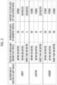
- FIG. 2is a table representing one example of classification criteria generated by an accident risk classification unit.
- FIG. 3is a flowchart illustrating a method for generating a precise map stored in an event data recorder (EDR) according to one embodiment of the present disclosure.
- EDRevent data recorder
- vehicleor “vehicular” or other similar term as used herein is inclusive of motor vehicles in general such as passenger automobiles including sports utility vehicles (SUV), buses, trucks, various commercial vehicles, watercraft including a variety of boats and ships, aircraft, and the like, and includes hybrid vehicles, electric vehicles, plug-in hybrid electric vehicles, hydrogen-powered vehicles and other alternative fuel vehicles (e.g., fuels derived from resources other than petroleum).
- a hybrid vehicleis a vehicle that has two or more sources of power, for example both gasoline-powered and electric-powered vehicles.
- control logic of the present disclosuremay be embodied as non-transitory computer readable media on a computer readable medium containing executable program instructions executed by a processor, controller or the like.
- Examples of computer readable mediainclude, but are not limited to, ROM, RAM, compact disc (CD)-ROMs, magnetic tapes, floppy disks, flash drives, smart cards and optical data storage devices.
- the computer readable mediumcan also be distributed in network coupled computer systems so that the computer readable media is stored and executed in a distributed fashion, e.g., by a telematics server or a Controller Area Network (CAN).
- a telematics serveror a Controller Area Network (CAN).
- CANController Area Network
- an autonomous driving system 100 including an autonomous driving apparatus 110includes the autonomous driving apparatus 110 mounted in a host vehicle, and external apparatuses 180 and 190 configured to transceive information with the autonomous driving apparatus 110 .
- the external apparatuses 180 and 190may include an accident database (DB) 181 of a police agency (e.g., the National Police Agency 180 ) and an accident DB 191 of an insurance company 190 .
- DBaccident database
- the autonomous driving apparatus 110includes a navigation system 120 , a communication unit 30 , an accident risk integration unit 140 , an accident risk classification unit 150 , an autonomous driving controller 160 , and an event data recorder (EDR) 170 .
- a navigation system 120includes a navigation system 120 , a communication unit 30 , an accident risk integration unit 140 , an accident risk classification unit 150 , an autonomous driving controller 160 , and an event data recorder (EDR) 170 .
- EDRevent data recorder
- the navigation system 120transmits map data of a road on which the host vehicle is currently driving to the autonomous driving controller 160 , and in some embodiments, may store information regarding the accident risk of the road on which the host vehicle is currently driving.
- the accident risk classification unit 150classifies roads into respective groups depending on the accident risks of the roads, and generates classification criteria including detailed classification items to the respective groups. Although it is described that the accident risk classification unit 150 generates the classification criteria for convenience of description, the autonomous driving controller 160 may generate the classification criteria or a transportation-related agency may generate the classification criteria and then provide the classification criteria to the autonomous driving controller 160 in some embodiments.
- FIG. 2is a table representing one example of classification criteria generated by the accident risk classification unit.
- roadsare classified into three groups, i.e., a safety group, a caution group and a danger group, depending on accident risks of the roads.
- a road belonging to the safety groupis a road determined as having a low accident risk
- a road belonging to the caution groupis a road determined as not having a high accident risk but requiring cautious driving
- a road belonging to the danger groupis a road determined as having a considerably high accident risk and thus requiring extremely cautious driving.
- each of the three groups classified in the first stageis classified into three sub-groups based on a distance 100 m and a distance 300 m from a road on which the host vehicle is driving, in the three stage, the application ratios of interpolation (interpolation ratios (%)) applied to a total of nine sub-groups classified in the second stage are set, and in the final stage, i.e., the fourth stage, whether or not to store precise map data belonging to the nine sub-groups in the EDR 170 is determined.
- interpolation ratios (%)interpolation ratios (%)
- precise map data including a localization modelacquired by applying interpolation to precise map data located within a distance of 100 m from the host vehicle by 100%, is stored in the EDR 170 .
- Interpolationis applied to precise map data located within a distance of 300 m from the host vehicle by 50%, interpolation is not applied to precise map data located at a distance equal to or greater than 300 m from the host vehicle, and precise map data including a localization model acquired thereby are not stored in the EDR 170 .
- precise map data including a localization modelacquired by applying interpolation to precise map data located within a distance of 100 m from the host vehicle by 100%
- precise map data including a localization modelacquired by applying interpolation to precise map data located within a distance of 300 m from the host vehicle by 80%
- precise map data including a localization modelacquired by applying interpolation to precise map data located at a distance equal to or greater than 300 m from the host vehicle by 50%
- interpolationis applied to precise map data located within a distance of 100 m from the host vehicle, precise map data located within a distance of 300 m from the host vehicle, and precise map data located at a distance equal to or greater than 300 m from the host vehicle by 100%, and all precise map data including a localization model acquired thereby is stored in the EDR 170 .
- interpolationis selectively applied and the application ratio of the interpolation varies depending on the classification group of data.
- the geographical range of precise map data which may be received from the navigation system 120is 1-3 km in case of a main path, and is 0.3-1 km in case of a sub-path.
- the geographical range of precise map data used in location determination and controlis 100 m centered on the host vehicle, and precise map data within a distance of 800 m in front of the host vehicle is used in a logic circuit configured to generate a driving path.
- 100 mcorresponds to the recognition distance of a LiDAR.
- 100 m and 300 m used in the second state of FIG. 2are set for the above-described reasons, and other reference distances may be set for other reasons in other embodiments.
- the number of geometric points located behind the distance of 100 m from the host vehiclehas less influence on location determination and control performance, and there is no logic circuit using localization model data behind the distance of 100 m from the host vehicle.
- the event data recorder (EDR) 170is equipment which records various vehicle information for about five seconds at a point in time when a vehicle collision occurs, and is a kind of black box for recording data, which is installed in an air bag or an engine electronic control unit (ECU) of a vehicle.
- the EDR 170may store various accident and collision information, such as a vehicle speed, whether or not a brake is operated, the RPM of an engine, whether or not a driver or a passenger wears a seat belt, seriousness of impact, the position of an accelerator pedal, a steering angle, tire pressure, the position of a transmission gear, deployment information of air bags, etc., except for image and voice records.
- the ADRincludes a black box for vehicles, and stores and records a plurality of pieces of image data (front and rear images, AVM images, etc.) and a plurality of pieces of sensor data measured by vehicle sensors including a radar sensor and a LiDAR sensor.
- the autonomous driving controller 160processes the precise map data depending on the groups classified by the accident risk classification unit 150 , and stores the processed precise map data in the EDR 170 .
- the precise map datamay include the lane information (or the lane model) and the localization information (or the localization model).
- the lane information(or the lane model) includes information ROAD-LINK regarding a representative line indicating a lane, information LANE_SIDE regarding two lane sides indicating boundary lines of the lane, and information LANE_LINK indicating the central line of the lane, i.e., a middle line between the two lane sides.
- the localization information(or the localization model) includes information ROAD_SIDE indicating curbs, guardrails, median strips, pedestrian overpasses, information ROAD_MARK indicating crosswalks, speed bumps, stop lines, arrows, information TRAFFIC_SIGN indicating traffic signs, and information TRAFFIC_LIGHT indicating traffic lights.
- FIG. 3is a flowchart illustrating a method for generating a precise map stored in the EDR according to one embodiment of the present disclosure.
- a method 300 for generating a precise mapmay be performed using the autonomous driving system 100 shown in FIG. 1 , and may include generating classification criteria (step 310 ), receiving map data (step 320 ), transmitting position information of the host vehicle (step 330 ), receiving accident risk information (step 340 ), determining whether or not an event occurs (step 350 ), changing an accident risk (step 360 ), and generating and storing precise map data (step 370 ).
- Step 310Generation of the classification criteria is performed by the accident risk classification unit 150 , and in generation of the classification criteria (step 310 ), the accident risk classification unit 150 classifies roads into respective groups depending on the accident risks of the roads, and generates classification criteria including detailed classification items to the respective groups.
- the autonomous driving controller 160In reception of the map data (step 320 ), the autonomous driving controller 160 receives map data of a road on which the host vehicle is currently driving from the navigation system 120 .
- Transmission of the position information of the host vehicleis performed by the autonomous driving controller 160 , and in transmission of the position information of the host vehicle (step 330 ), the autonomous driving controller 160 transmits the current position of the host vehicle to the external apparatuses 180 and 190 through the communication unit 130 using the map data received from the navigation system 120 .
- step 340In reception of the accident risk information (step 340 ), information regarding the accident risk of the road on which the host vehicle is currently driving is received from the accident DB 181 of the National Police Agency 180 and the accident DB 191 of the insurance company 190 through the communication unit 130 , and is transmitted to one of the accident risk integration unit 140 and the autonomous driving controller 160 .
- Determination as to whether or not the event occursis performed by the autonomous driving controller 160 , and in determination as to whether or not the event occurs (step 350 ), the autonomous driving controller 160 determines whether or not the event occurs.
- the eventincludes at least one of an accident between vehicles, an accident between a vehicle and a road facility, an accident between a vehicle and an animal, or a landslide.
- a change in the accident riskis performed by the autonomous driving controller 160 upon determining that the event occurs (Yes in step 350 ), and in changing the accident risk (step 360 ), the autonomous driving controller 160 changes the accident risk of the road on which the event occurs.
- an accident risk higher than the accident risk previously allocated to the roadis reallocated to the road, and in this case, although the accident risk is changed into an accident risk improved by one level, the accident risk may be changed into the highest accident risk.
- step 370upon determining that no event occurs in determination as to whether or not the event occurs (No in step 350 ), the precise map data is generated depending on the previously allocated classification items and is stored in the EDR 170 , and when the accident risk is changed (step 360 ), the precise map data is generated depending on the changed accident risk and is stored in the EDR 170 .
- the remaining operationsi.e., receiving map data (step 320 ), transmitting position information of the host vehicle (step 330 ), receiving accident risk information (step 340 ), determining whether or not an event occurs (step 350 ), changing an accident risk (step 360 ) and generating and storing precise map data (step 370 ), other than generating classification criteria (step 310 ) are continuously performed.
- the precise map datais stored every 100 milliseconds, about 500 MB of radar, LiDAR and camera information per minute is stored, and this amount of the information does not include raw data received by a LiDAR and a camera.
- the amount of information to be storedmay exceed about 1 GB per minute.
- the amount of precise map data located within a distance of 1 km in front of the host vehicle and a distance of 300 m around the host vehicleis about 5 MB, and when the precise map data is continuously stored every 100 milliseconds, the amount of the precise map data may be 3 GB per minute.
- the precise map data of a main pathmay be reduced by about 80%, and the precise map data within a distance 300 m around the host vehicle may be reduced by about 45%.
- the reduction ratio of the precise map data of the road around the host vehiclemay be varied depending on the shape of the road.
- an application ratio of interpolation to data and whether or not to store data acquired by applying interpolation to the dataare varied depending on an accident risk on a corresponding road and a distance from a host vehicle, so as to allow precise map data around the host vehicle important in accident reenactment to be stored in more detail and to allow precise map data regarded as less important to be stored with a reduced amount thereof or not to be stored as long as an event does not occur, thereby being capable of reducing the load of a CPU required to store the data and thus reducing power consumption.
Landscapes
- Engineering & Computer Science (AREA)
- Remote Sensing (AREA)
- Radar, Positioning & Navigation (AREA)
- Physics & Mathematics (AREA)
- Automation & Control Theory (AREA)
- General Physics & Mathematics (AREA)
- Business, Economics & Management (AREA)
- Theoretical Computer Science (AREA)
- Databases & Information Systems (AREA)
- Transportation (AREA)
- Mechanical Engineering (AREA)
- Tourism & Hospitality (AREA)
- General Engineering & Computer Science (AREA)
- Data Mining & Analysis (AREA)
- Human Computer Interaction (AREA)
- Health & Medical Sciences (AREA)
- Development Economics (AREA)
- Primary Health Care (AREA)
- General Health & Medical Sciences (AREA)
- General Business, Economics & Management (AREA)
- Human Resources & Organizations (AREA)
- Educational Administration (AREA)
- Marketing (AREA)
- Strategic Management (AREA)
- Computer Security & Cryptography (AREA)
- Economics (AREA)
- Mathematical Physics (AREA)
- Traffic Control Systems (AREA)
- Aviation & Aerospace Engineering (AREA)
- Artificial Intelligence (AREA)
- Evolutionary Computation (AREA)
- Game Theory and Decision Science (AREA)
- Medical Informatics (AREA)
- Navigation (AREA)
Abstract
Description
Claims (14)
Applications Claiming Priority (2)
| Application Number | Priority Date | Filing Date | Title |
|---|---|---|---|
| KR1020200129480AKR20220046731A (en) | 2020-10-07 | 2020-10-07 | Automatic driving device and a generation method for detailed map |
| KR10-2020-0129480 | 2020-10-07 |
Publications (2)
| Publication Number | Publication Date |
|---|---|
| US20220105958A1 US20220105958A1 (en) | 2022-04-07 |
| US12168457B2true US12168457B2 (en) | 2024-12-17 |
Family
ID=80931039
Family Applications (1)
| Application Number | Title | Priority Date | Filing Date |
|---|---|---|---|
| US17/496,179Active2042-11-22US12168457B2 (en) | 2020-10-07 | 2021-10-07 | Autonomous driving apparatus and method for generating precise map |
Country Status (2)
| Country | Link |
|---|---|
| US (1) | US12168457B2 (en) |
| KR (1) | KR20220046731A (en) |
Cited By (1)
| Publication number | Priority date | Publication date | Assignee | Title |
|---|---|---|---|---|
| US12396610B2 (en)* | 2022-09-28 | 2025-08-26 | Yunjing Intelligence (Shenzhen) Co., Ltd. | Method and apparatus for exploring substance contour on ground, and cleaning device |
Families Citing this family (1)
| Publication number | Priority date | Publication date | Assignee | Title |
|---|---|---|---|---|
| CN118836850A (en)* | 2024-06-27 | 2024-10-25 | 深圳市迪派乐智图科技有限公司 | Map data determination method, storage medium, electronic device, and program product |
Citations (92)
| Publication number | Priority date | Publication date | Assignee | Title |
|---|---|---|---|---|
| US5541590A (en)* | 1992-08-04 | 1996-07-30 | Takata Corporation | Vehicle crash predictive and evasive operation system by neural networks |
| US6009359A (en)* | 1996-09-18 | 1999-12-28 | National Research Council Of Canada | Mobile system for indoor 3-D mapping and creating virtual environments |
| US6084510A (en)* | 1997-04-18 | 2000-07-04 | Lemelson; Jerome H. | Danger warning and emergency response system and method |
| US6161071A (en)* | 1999-03-12 | 2000-12-12 | Navigation Technologies Corporation | Method and system for an in-vehicle computing architecture |
| US6223125B1 (en)* | 1999-02-05 | 2001-04-24 | Brett O. Hall | Collision avoidance system |
| US20010001133A1 (en)* | 1999-05-25 | 2001-05-10 | Kazuyuki Hotta | Map generation device |
| US6356839B1 (en)* | 1999-04-07 | 2002-03-12 | Mitsubishi Denki Kabushiki Kaisha | Navigation system |
| US6363161B2 (en)* | 1998-10-23 | 2002-03-26 | Facet Technology Corp. | System for automatically generating database of objects of interest by analysis of images recorded by moving vehicle |
| US6405132B1 (en)* | 1997-10-22 | 2002-06-11 | Intelligent Technologies International, Inc. | Accident avoidance system |
| US6415226B1 (en)* | 1999-12-20 | 2002-07-02 | Navigation Technologies Corp. | Method and system for providing safe routes using a navigation system |
| US6480783B1 (en)* | 2000-03-17 | 2002-11-12 | Makor Issues And Rights Ltd. | Real time vehicle guidance and forecasting system under traffic jam conditions |
| US20020198632A1 (en)* | 1997-10-22 | 2002-12-26 | Breed David S. | Method and arrangement for communicating between vehicles |
| US20030016146A1 (en)* | 2001-07-18 | 2003-01-23 | International Business Machines Corporation | Enhanced vehicle hazard warning and safety features integrated with an onboard navigation system |
| US6526352B1 (en)* | 2001-07-19 | 2003-02-25 | Intelligent Technologies International, Inc. | Method and arrangement for mapping a road |
| US20030191568A1 (en)* | 2002-04-09 | 2003-10-09 | Breed David S. | Method and system for controlling a vehicle |
| US20040022416A1 (en)* | 1993-08-11 | 2004-02-05 | Lemelson Jerome H. | Motor vehicle warning and control system and method |
| US20040107042A1 (en)* | 2002-12-03 | 2004-06-03 | Seick Ryan E. | Road hazard data collection system and method |
| US20040139049A1 (en)* | 1996-08-22 | 2004-07-15 | Wgrs Licensing Company, Llc | Unified geographic database and method of creating, maintaining and using the same |
| US20040267455A1 (en)* | 2003-06-30 | 2004-12-30 | Kabushiki Kaisha Toshiba | Data analyzing apparatus, data analyzing program, and mobile terminal |
| US20050060069A1 (en)* | 1997-10-22 | 2005-03-17 | Breed David S. | Method and system for controlling a vehicle |
| US20050134440A1 (en)* | 1997-10-22 | 2005-06-23 | Intelligent Technolgies Int'l, Inc. | Method and system for detecting objects external to a vehicle |
| US6917893B2 (en)* | 2002-03-14 | 2005-07-12 | Activmedia Robotics, Llc | Spatial data collection apparatus and method |
| US20060114123A1 (en)* | 2002-09-03 | 2006-06-01 | Daimlerchrysler | Device and method for radio-based danger warning |
| US7069124B1 (en)* | 2002-10-28 | 2006-06-27 | Workhorse Technologies, Llc | Robotic modeling of voids |
| US20070005228A1 (en)* | 2005-06-30 | 2007-01-04 | Sehat Sutardja | GPS-based traffic monitoring system |
| US7194347B2 (en)* | 2003-03-26 | 2007-03-20 | Fujitsu Ten Limited | Vehicle control apparatus, vehicle control method, and computer program |
| US20070088490A1 (en)* | 2005-06-30 | 2007-04-19 | Sehat Sutardja | GPS-based trafic monitoring system |
| US20070296574A1 (en)* | 2003-03-01 | 2007-12-27 | User-Centric Ip, L.P. | User-Centric Event Reporting with Follow-Up Information |
| US20080243380A1 (en)* | 2007-03-29 | 2008-10-02 | Maung Han | Hidden point detection and warning method and apparatus for navigation system |
| US20090140887A1 (en)* | 2007-11-29 | 2009-06-04 | Breed David S | Mapping Techniques Using Probe Vehicles |
| US7602404B1 (en)* | 1998-04-17 | 2009-10-13 | Adobe Systems, Incorporated | Method and apparatus for image assisted modeling of three-dimensional scenes |
| US20090289812A1 (en)* | 2005-11-18 | 2009-11-26 | Min-Soo Kim | System and Method for Providing Real-Time Dangerous Road Information Based on USN |
| US20090300067A1 (en)* | 2008-05-30 | 2009-12-03 | Navteq North America, Llc | Data mining in a digital map database to identify decreasing radius of curvature along roads and enabling precautionary actions in a vehicle |
| US20090300053A1 (en)* | 2008-05-30 | 2009-12-03 | Navteq North America, Llc | Data mining in a digital map database to identify intersections located at hill bottoms and enabling precautionary actions in a vehicle |
| US20090299617A1 (en)* | 2008-05-30 | 2009-12-03 | Navteq North America, Llc | Data mining in a digital map database to identify curves along downhill roads and enabling precautionary actions in a vehicle |
| US20090299630A1 (en)* | 2008-05-30 | 2009-12-03 | Navteq North America, Llc | Data mining in a digital map database to identify insufficient superelevation along roads and enabling precautionary actions in a vehicle |
| US20090299626A1 (en)* | 2008-05-30 | 2009-12-03 | Navteq North America, Llc | Data mining in a digital map database to identify unusually narrow lanes or roads and enabling precautionary actions in a vehicle |
| US20090299624A1 (en)* | 2008-05-30 | 2009-12-03 | Navteq North America, Llc | Data mining in a digital map database to identify speed changes on upcoming curves along roads and enabling precautionary actions in a vehicle |
| US20090299622A1 (en)* | 2008-05-30 | 2009-12-03 | Navteq North America, Llc | Data mining to identify locations of potentially hazardous conditions for vehicle operation and use thereof |
| US20090295598A1 (en)* | 2008-05-30 | 2009-12-03 | Navteq North America, Llc | Data mining for traffic signals or signs along road curves and enabling precautionary actions in a vehicle |
| US20090299616A1 (en)* | 2008-05-30 | 2009-12-03 | Navteq North America, Llc | Data mining in a digital map database to identify intersections located over hills and enabling precautionary actions in a vehicle |
| US20090295604A1 (en)* | 2008-05-30 | 2009-12-03 | Navteq North America, Llc | Data mining in a digital map database to identify traffic signals, stop signs and yield signs at bottoms of hills and enabling precautionary actions in a vehicle |
| US20090299625A1 (en)* | 2008-05-30 | 2009-12-03 | Navteq North America, Llc | Data mining in a digital map database to identify blind intersections along roads and enabling precautionary actions in a vehicle |
| US20090300035A1 (en)* | 2008-05-30 | 2009-12-03 | Navteq North America, Llc | Data mining in a digital map database to identify community reported driving hazards along roads and enabling precautionary actions in a vehicle |
| US20090299615A1 (en)* | 2008-05-30 | 2009-12-03 | Navteq North America, Llc | Data mining in a digital map database to identify insufficient merge lanes along roads and enabling precautionary actions in a vehicle |
| US20100052944A1 (en)* | 2006-10-13 | 2010-03-04 | Continental Teves Ag & Co. Ohg | Vehicle and Method for Identifying Vehicles Located in the Surroundings of the Vehicle |
| US7680749B1 (en)* | 2006-11-02 | 2010-03-16 | Google Inc. | Generating attribute models for use in adaptive navigation systems |
| US7698055B2 (en)* | 2004-11-16 | 2010-04-13 | Microsoft Corporation | Traffic forecasting employing modeling and analysis of probabilistic interdependencies and contextual data |
| US7853372B2 (en)* | 2006-06-01 | 2010-12-14 | Samsung Electronics Co., Ltd. | System, apparatus, and method of preventing collision of remote-controlled mobile robot |
| US20100332266A1 (en)* | 2003-07-07 | 2010-12-30 | Sensomatix Ltd. | Traffic information system |
| US20100332131A1 (en)* | 2009-06-26 | 2010-12-30 | Microsoft Corporation | Routing, alerting, and transportation guidance based on preferences and learned or inferred risks and desirabilities |
| US7912633B1 (en)* | 2005-12-01 | 2011-03-22 | Adept Mobilerobots Llc | Mobile autonomous updating of GIS maps |
| US20110210867A1 (en)* | 2008-11-13 | 2011-09-01 | Aser Rich Limited | System And Method For Improved Vehicle Safety Through Enhanced Situation Awareness Of A Driver Of A Vehicle |
| US8521424B2 (en)* | 2010-09-29 | 2013-08-27 | Ford Global Technologies, Llc | Advanced map information delivery, processing and updating |
| US8527199B1 (en)* | 2012-05-17 | 2013-09-03 | Google Inc. | Automatic collection of quality control statistics for maps used in autonomous driving |
| US9218003B2 (en)* | 2011-09-30 | 2015-12-22 | Irobot Corporation | Adaptive mapping with spatial summaries of sensor data |
| US20160061625A1 (en)* | 2014-12-02 | 2016-03-03 | Kevin Sunlin Wang | Method and system for avoidance of accidents |
| US9286793B2 (en)* | 2012-10-23 | 2016-03-15 | University Of Southern California | Traffic prediction using real-world transportation data |
| US9367065B2 (en)* | 2013-01-25 | 2016-06-14 | Google Inc. | Modifying behavior of autonomous vehicles based on sensor blind spots and limitations |
| US9389085B2 (en)* | 2010-01-22 | 2016-07-12 | Qualcomm Incorporated | Map handling for location based services in conjunction with localized environments |
| US9430944B2 (en)* | 2014-11-12 | 2016-08-30 | GM Global Technology Operations LLC | Method and apparatus for determining traffic safety events using vehicular participative sensing systems |
| US20160275801A1 (en)* | 2013-12-19 | 2016-09-22 | USA as Represented by the Administrator of the National Aeronautics & Space Administration (NASA) | Unmanned Aerial Systems Traffic Management |
| US9528834B2 (en)* | 2013-11-01 | 2016-12-27 | Intelligent Technologies International, Inc. | Mapping techniques using probe vehicles |
| US20170017734A1 (en)* | 2015-07-15 | 2017-01-19 | Ford Global Technologies, Llc | Crowdsourced Event Reporting and Reconstruction |
| US9567077B2 (en)* | 2014-02-14 | 2017-02-14 | Accenture Global Services Limited | Unmanned vehicle (UV) control system |
| US20170210323A1 (en)* | 2016-01-26 | 2017-07-27 | Truemotion, Inc. | Systems and methods for sensor-based vehicle crash prediction, detection, and reconstruction |
| US20180075747A1 (en)* | 2014-10-31 | 2018-03-15 | Nodal Inc. | Systems, apparatus, and methods for improving safety related to movable/ moving objects |
| US9919648B1 (en)* | 2016-09-27 | 2018-03-20 | Robert D. Pedersen | Motor vehicle artificial intelligence expert system dangerous driving warning and control system and method |
| US10001380B2 (en)* | 2013-03-14 | 2018-06-19 | Qualcomm Incorporated | Navigation using crowdsourcing data |
| US10035259B1 (en)* | 2017-03-24 | 2018-07-31 | International Business Machines Corporation | Self-assembling robotics for disaster applications |
| US20180218619A1 (en)* | 2015-07-17 | 2018-08-02 | Relmatech Limited | An aircraft controlled by a secure integrated airspace management system |
| US20180322783A1 (en)* | 2017-05-05 | 2018-11-08 | Toyota Motor Engineering & Manufacturing North America, Inc. | Systems and methods for visualizing potential risks |
| US20190139403A1 (en)* | 2018-12-28 | 2019-05-09 | S M Iftekharul Alam | Crowdsourced detection, identification and sharing of hazardous road objects in hd maps |
| US20190137622A1 (en)* | 2017-11-09 | 2019-05-09 | Brennan Lopez-Hinojosa | Method and System for Gauging External Object Movement and Conditions for Connected and Autonomous Vehicle Safety |
| US20190162549A1 (en)* | 2010-06-07 | 2019-05-30 | Affectiva, Inc. | Cognitive state vehicle navigation based on image processing |
| US10311736B2 (en)* | 2015-01-15 | 2019-06-04 | Denso Corporation | Road shape information generator, road shape information distribution system and road shape information generation program |
| US10334412B1 (en)* | 2018-01-09 | 2019-06-25 | Boaz Kenane | Autonomous vehicle assistance systems |
| US20190197330A1 (en)* | 2010-06-07 | 2019-06-27 | Affectiva, Inc. | Cognitive state based vehicle manipulation using near-infrared image processing |
| US20190220011A1 (en)* | 2018-01-16 | 2019-07-18 | Nio Usa, Inc. | Event data recordation to identify and resolve anomalies associated with control of driverless vehicles |
| US20190287394A1 (en)* | 2018-03-19 | 2019-09-19 | Derq Inc. | Early warning and collision avoidance |
| US20190303686A1 (en)* | 2018-03-29 | 2019-10-03 | Toyota Jidosha Kabushiki Kaisha | Real-Time Detection of Traffic Situation |
| US20200017049A1 (en)* | 2016-12-20 | 2020-01-16 | Pioneer Corporation | Accident determination device |
| US20200066158A1 (en)* | 2017-04-06 | 2020-02-27 | Samsung Electronics Co., Ltd. | Electronic device, warning message providing method therefor, and non-transitory computer-readable recording medium |
| US10579070B1 (en)* | 2016-01-22 | 2020-03-03 | State Farm Mutual Automobile Insurance Company | Method and system for repairing a malfunctioning autonomous vehicle |
| US20200225673A1 (en)* | 2016-02-29 | 2020-07-16 | AI Incorporated | Obstacle recognition method for autonomous robots |
| US20200226853A1 (en)* | 2019-01-11 | 2020-07-16 | Toyota Motor North America, Inc. | Automated accident logging and reporting |
| US20210049908A1 (en)* | 2019-08-12 | 2021-02-18 | Toyota Motor North America, Inc. | Utilizing sensors to detect hazard from other vehicle while driving |
| US20210089040A1 (en)* | 2016-02-29 | 2021-03-25 | AI Incorporated | Obstacle recognition method for autonomous robots |
| US11199853B1 (en)* | 2018-07-11 | 2021-12-14 | AI Incorporated | Versatile mobile platform |
| US20220066456A1 (en)* | 2016-02-29 | 2022-03-03 | AI Incorporated | Obstacle recognition method for autonomous robots |
| US11274929B1 (en)* | 2017-10-17 | 2022-03-15 | AI Incorporated | Method for constructing a map while performing work |
| US11351999B2 (en)* | 2020-09-16 | 2022-06-07 | Xuan Binh Luu | Traffic collision warning device |
Family Cites Families (2)
| Publication number | Priority date | Publication date | Assignee | Title |
|---|---|---|---|---|
| KR101995892B1 (en) | 2017-02-10 | 2019-07-04 | 주식회사 더로카 | Method for displaying driving information of autonomous vehicle capable of providing customized user interface, therminal for the vehicle, and therminal for manager |
| KR102396731B1 (en) | 2018-02-27 | 2022-05-11 | 삼성전자주식회사 | Method of providing detailed map data and system therefor |
- 2020
- 2020-10-07KRKR1020200129480Apatent/KR20220046731A/enactivePending
- 2021
- 2021-10-07USUS17/496,179patent/US12168457B2/enactiveActive
Patent Citations (110)
| Publication number | Priority date | Publication date | Assignee | Title |
|---|---|---|---|---|
| US5541590A (en)* | 1992-08-04 | 1996-07-30 | Takata Corporation | Vehicle crash predictive and evasive operation system by neural networks |
| US20040022416A1 (en)* | 1993-08-11 | 2004-02-05 | Lemelson Jerome H. | Motor vehicle warning and control system and method |
| US20040139049A1 (en)* | 1996-08-22 | 2004-07-15 | Wgrs Licensing Company, Llc | Unified geographic database and method of creating, maintaining and using the same |
| US6009359A (en)* | 1996-09-18 | 1999-12-28 | National Research Council Of Canada | Mobile system for indoor 3-D mapping and creating virtual environments |
| US6084510A (en)* | 1997-04-18 | 2000-07-04 | Lemelson; Jerome H. | Danger warning and emergency response system and method |
| US7202776B2 (en)* | 1997-10-22 | 2007-04-10 | Intelligent Technologies International, Inc. | Method and system for detecting objects external to a vehicle |
| US6405132B1 (en)* | 1997-10-22 | 2002-06-11 | Intelligent Technologies International, Inc. | Accident avoidance system |
| US20020198632A1 (en)* | 1997-10-22 | 2002-12-26 | Breed David S. | Method and arrangement for communicating between vehicles |
| US7085637B2 (en)* | 1997-10-22 | 2006-08-01 | Intelligent Technologies International, Inc. | Method and system for controlling a vehicle |
| US20050134440A1 (en)* | 1997-10-22 | 2005-06-23 | Intelligent Technolgies Int'l, Inc. | Method and system for detecting objects external to a vehicle |
| US6720920B2 (en)* | 1997-10-22 | 2004-04-13 | Intelligent Technologies International Inc. | Method and arrangement for communicating between vehicles |
| US20050060069A1 (en)* | 1997-10-22 | 2005-03-17 | Breed David S. | Method and system for controlling a vehicle |
| US7602404B1 (en)* | 1998-04-17 | 2009-10-13 | Adobe Systems, Incorporated | Method and apparatus for image assisted modeling of three-dimensional scenes |
| US6363161B2 (en)* | 1998-10-23 | 2002-03-26 | Facet Technology Corp. | System for automatically generating database of objects of interest by analysis of images recorded by moving vehicle |
| US6223125B1 (en)* | 1999-02-05 | 2001-04-24 | Brett O. Hall | Collision avoidance system |
| US6161071A (en)* | 1999-03-12 | 2000-12-12 | Navigation Technologies Corporation | Method and system for an in-vehicle computing architecture |
| US6356839B1 (en)* | 1999-04-07 | 2002-03-12 | Mitsubishi Denki Kabushiki Kaisha | Navigation system |
| US20010001133A1 (en)* | 1999-05-25 | 2001-05-10 | Kazuyuki Hotta | Map generation device |
| US6415226B1 (en)* | 1999-12-20 | 2002-07-02 | Navigation Technologies Corp. | Method and system for providing safe routes using a navigation system |
| US6480783B1 (en)* | 2000-03-17 | 2002-11-12 | Makor Issues And Rights Ltd. | Real time vehicle guidance and forecasting system under traffic jam conditions |
| US20030016146A1 (en)* | 2001-07-18 | 2003-01-23 | International Business Machines Corporation | Enhanced vehicle hazard warning and safety features integrated with an onboard navigation system |
| US6526352B1 (en)* | 2001-07-19 | 2003-02-25 | Intelligent Technologies International, Inc. | Method and arrangement for mapping a road |
| US6917893B2 (en)* | 2002-03-14 | 2005-07-12 | Activmedia Robotics, Llc | Spatial data collection apparatus and method |
| US20030191568A1 (en)* | 2002-04-09 | 2003-10-09 | Breed David S. | Method and system for controlling a vehicle |
| US6768944B2 (en)* | 2002-04-09 | 2004-07-27 | Intelligent Technologies International, Inc. | Method and system for controlling a vehicle |
| US20060114123A1 (en)* | 2002-09-03 | 2006-06-01 | Daimlerchrysler | Device and method for radio-based danger warning |
| US7069124B1 (en)* | 2002-10-28 | 2006-06-27 | Workhorse Technologies, Llc | Robotic modeling of voids |
| US20040107042A1 (en)* | 2002-12-03 | 2004-06-03 | Seick Ryan E. | Road hazard data collection system and method |
| US20070296574A1 (en)* | 2003-03-01 | 2007-12-27 | User-Centric Ip, L.P. | User-Centric Event Reporting with Follow-Up Information |
| US7194347B2 (en)* | 2003-03-26 | 2007-03-20 | Fujitsu Ten Limited | Vehicle control apparatus, vehicle control method, and computer program |
| US20040267455A1 (en)* | 2003-06-30 | 2004-12-30 | Kabushiki Kaisha Toshiba | Data analyzing apparatus, data analyzing program, and mobile terminal |
| US20100332266A1 (en)* | 2003-07-07 | 2010-12-30 | Sensomatix Ltd. | Traffic information system |
| US7698055B2 (en)* | 2004-11-16 | 2010-04-13 | Microsoft Corporation | Traffic forecasting employing modeling and analysis of probabilistic interdependencies and contextual data |
| US20070088490A1 (en)* | 2005-06-30 | 2007-04-19 | Sehat Sutardja | GPS-based trafic monitoring system |
| US20070005228A1 (en)* | 2005-06-30 | 2007-01-04 | Sehat Sutardja | GPS-based traffic monitoring system |
| US20090289812A1 (en)* | 2005-11-18 | 2009-11-26 | Min-Soo Kim | System and Method for Providing Real-Time Dangerous Road Information Based on USN |
| US7912633B1 (en)* | 2005-12-01 | 2011-03-22 | Adept Mobilerobots Llc | Mobile autonomous updating of GIS maps |
| US7853372B2 (en)* | 2006-06-01 | 2010-12-14 | Samsung Electronics Co., Ltd. | System, apparatus, and method of preventing collision of remote-controlled mobile robot |
| US20100052944A1 (en)* | 2006-10-13 | 2010-03-04 | Continental Teves Ag & Co. Ohg | Vehicle and Method for Identifying Vehicles Located in the Surroundings of the Vehicle |
| US7680749B1 (en)* | 2006-11-02 | 2010-03-16 | Google Inc. | Generating attribute models for use in adaptive navigation systems |
| US20080243380A1 (en)* | 2007-03-29 | 2008-10-02 | Maung Han | Hidden point detection and warning method and apparatus for navigation system |
| US20090140887A1 (en)* | 2007-11-29 | 2009-06-04 | Breed David S | Mapping Techniques Using Probe Vehicles |
| US20090295604A1 (en)* | 2008-05-30 | 2009-12-03 | Navteq North America, Llc | Data mining in a digital map database to identify traffic signals, stop signs and yield signs at bottoms of hills and enabling precautionary actions in a vehicle |
| US20090300067A1 (en)* | 2008-05-30 | 2009-12-03 | Navteq North America, Llc | Data mining in a digital map database to identify decreasing radius of curvature along roads and enabling precautionary actions in a vehicle |
| US20090299616A1 (en)* | 2008-05-30 | 2009-12-03 | Navteq North America, Llc | Data mining in a digital map database to identify intersections located over hills and enabling precautionary actions in a vehicle |
| US20090300053A1 (en)* | 2008-05-30 | 2009-12-03 | Navteq North America, Llc | Data mining in a digital map database to identify intersections located at hill bottoms and enabling precautionary actions in a vehicle |
| US20090299625A1 (en)* | 2008-05-30 | 2009-12-03 | Navteq North America, Llc | Data mining in a digital map database to identify blind intersections along roads and enabling precautionary actions in a vehicle |
| US20090300035A1 (en)* | 2008-05-30 | 2009-12-03 | Navteq North America, Llc | Data mining in a digital map database to identify community reported driving hazards along roads and enabling precautionary actions in a vehicle |
| US20090299615A1 (en)* | 2008-05-30 | 2009-12-03 | Navteq North America, Llc | Data mining in a digital map database to identify insufficient merge lanes along roads and enabling precautionary actions in a vehicle |
| US20090299622A1 (en)* | 2008-05-30 | 2009-12-03 | Navteq North America, Llc | Data mining to identify locations of potentially hazardous conditions for vehicle operation and use thereof |
| US20090299624A1 (en)* | 2008-05-30 | 2009-12-03 | Navteq North America, Llc | Data mining in a digital map database to identify speed changes on upcoming curves along roads and enabling precautionary actions in a vehicle |
| US9134133B2 (en)* | 2008-05-30 | 2015-09-15 | Here Global B.V. | Data mining to identify locations of potentially hazardous conditions for vehicle operation and use thereof |
| US20090299626A1 (en)* | 2008-05-30 | 2009-12-03 | Navteq North America, Llc | Data mining in a digital map database to identify unusually narrow lanes or roads and enabling precautionary actions in a vehicle |
| US20090299630A1 (en)* | 2008-05-30 | 2009-12-03 | Navteq North America, Llc | Data mining in a digital map database to identify insufficient superelevation along roads and enabling precautionary actions in a vehicle |
| US20090295598A1 (en)* | 2008-05-30 | 2009-12-03 | Navteq North America, Llc | Data mining for traffic signals or signs along road curves and enabling precautionary actions in a vehicle |
| US20090299617A1 (en)* | 2008-05-30 | 2009-12-03 | Navteq North America, Llc | Data mining in a digital map database to identify curves along downhill roads and enabling precautionary actions in a vehicle |
| US20110210867A1 (en)* | 2008-11-13 | 2011-09-01 | Aser Rich Limited | System And Method For Improved Vehicle Safety Through Enhanced Situation Awareness Of A Driver Of A Vehicle |
| US20100332131A1 (en)* | 2009-06-26 | 2010-12-30 | Microsoft Corporation | Routing, alerting, and transportation guidance based on preferences and learned or inferred risks and desirabilities |
| US9086292B2 (en)* | 2009-06-26 | 2015-07-21 | Microsoft Technology Licensing, Llc | Routing, alerting, and transportation guidance based on preferences and learned or inferred risks and desirabilities |
| US9389085B2 (en)* | 2010-01-22 | 2016-07-12 | Qualcomm Incorporated | Map handling for location based services in conjunction with localized environments |
| US20190162549A1 (en)* | 2010-06-07 | 2019-05-30 | Affectiva, Inc. | Cognitive state vehicle navigation based on image processing |
| US20190197330A1 (en)* | 2010-06-07 | 2019-06-27 | Affectiva, Inc. | Cognitive state based vehicle manipulation using near-infrared image processing |
| US8521424B2 (en)* | 2010-09-29 | 2013-08-27 | Ford Global Technologies, Llc | Advanced map information delivery, processing and updating |
| US9218003B2 (en)* | 2011-09-30 | 2015-12-22 | Irobot Corporation | Adaptive mapping with spatial summaries of sensor data |
| US8527199B1 (en)* | 2012-05-17 | 2013-09-03 | Google Inc. | Automatic collection of quality control statistics for maps used in autonomous driving |
| US9286793B2 (en)* | 2012-10-23 | 2016-03-15 | University Of Southern California | Traffic prediction using real-world transportation data |
| US9367065B2 (en)* | 2013-01-25 | 2016-06-14 | Google Inc. | Modifying behavior of autonomous vehicles based on sensor blind spots and limitations |
| US10001380B2 (en)* | 2013-03-14 | 2018-06-19 | Qualcomm Incorporated | Navigation using crowdsourcing data |
| US9528834B2 (en)* | 2013-11-01 | 2016-12-27 | Intelligent Technologies International, Inc. | Mapping techniques using probe vehicles |
| US20160275801A1 (en)* | 2013-12-19 | 2016-09-22 | USA as Represented by the Administrator of the National Aeronautics & Space Administration (NASA) | Unmanned Aerial Systems Traffic Management |
| US9567077B2 (en)* | 2014-02-14 | 2017-02-14 | Accenture Global Services Limited | Unmanned vehicle (UV) control system |
| US20180075747A1 (en)* | 2014-10-31 | 2018-03-15 | Nodal Inc. | Systems, apparatus, and methods for improving safety related to movable/ moving objects |
| US9430944B2 (en)* | 2014-11-12 | 2016-08-30 | GM Global Technology Operations LLC | Method and apparatus for determining traffic safety events using vehicular participative sensing systems |
| US10024684B2 (en)* | 2014-12-02 | 2018-07-17 | Operr Technologies, Inc. | Method and system for avoidance of accidents |
| US20160061625A1 (en)* | 2014-12-02 | 2016-03-03 | Kevin Sunlin Wang | Method and system for avoidance of accidents |
| US10311736B2 (en)* | 2015-01-15 | 2019-06-04 | Denso Corporation | Road shape information generator, road shape information distribution system and road shape information generation program |
| US20170017734A1 (en)* | 2015-07-15 | 2017-01-19 | Ford Global Technologies, Llc | Crowdsourced Event Reporting and Reconstruction |
| US20210043096A1 (en)* | 2015-07-17 | 2021-02-11 | Relmatech Limited | Aircraft controlled by a secure integrated airspace management system |
| US20180218619A1 (en)* | 2015-07-17 | 2018-08-02 | Relmatech Limited | An aircraft controlled by a secure integrated airspace management system |
| US10579070B1 (en)* | 2016-01-22 | 2020-03-03 | State Farm Mutual Automobile Insurance Company | Method and system for repairing a malfunctioning autonomous vehicle |
| US20170210323A1 (en)* | 2016-01-26 | 2017-07-27 | Truemotion, Inc. | Systems and methods for sensor-based vehicle crash prediction, detection, and reconstruction |
| US11467587B2 (en)* | 2016-02-29 | 2022-10-11 | AI Incorporated | Obstacle recognition method for autonomous robots |
| US20210089040A1 (en)* | 2016-02-29 | 2021-03-25 | AI Incorporated | Obstacle recognition method for autonomous robots |
| US11899463B1 (en)* | 2016-02-29 | 2024-02-13 | AI Incorporated | Obstacle recognition method for autonomous robots |
| US11435746B1 (en)* | 2016-02-29 | 2022-09-06 | AI Incorporated | Obstacle recognition method for autonomous robots |
| US10788836B2 (en)* | 2016-02-29 | 2020-09-29 | AI Incorporated | Obstacle recognition method for autonomous robots |
| US11449061B2 (en)* | 2016-02-29 | 2022-09-20 | AI Incorporated | Obstacle recognition method for autonomous robots |
| US20220066456A1 (en)* | 2016-02-29 | 2022-03-03 | AI Incorporated | Obstacle recognition method for autonomous robots |
| US20200409376A1 (en)* | 2016-02-29 | 2020-12-31 | AI Incorporated | Obstacle recognition method for autonomous robots |
| US20240126265A1 (en)* | 2016-02-29 | 2024-04-18 | Al Incorporated | Obstacle recognition method for autonomous robots |
| US20200225673A1 (en)* | 2016-02-29 | 2020-07-16 | AI Incorporated | Obstacle recognition method for autonomous robots |
| US11449063B1 (en)* | 2016-02-29 | 2022-09-20 | AI Incorporated | Obstacle recognition method for autonomous robots |
| US9919648B1 (en)* | 2016-09-27 | 2018-03-20 | Robert D. Pedersen | Motor vehicle artificial intelligence expert system dangerous driving warning and control system and method |
| US20200017049A1 (en)* | 2016-12-20 | 2020-01-16 | Pioneer Corporation | Accident determination device |
| US10035259B1 (en)* | 2017-03-24 | 2018-07-31 | International Business Machines Corporation | Self-assembling robotics for disaster applications |
| US20200066158A1 (en)* | 2017-04-06 | 2020-02-27 | Samsung Electronics Co., Ltd. | Electronic device, warning message providing method therefor, and non-transitory computer-readable recording medium |
| US11475770B2 (en)* | 2017-04-06 | 2022-10-18 | Samsung Electronics Co., Ltd. | Electronic device, warning message providing method therefor, and non-transitory computer-readable recording medium |
| US20180322783A1 (en)* | 2017-05-05 | 2018-11-08 | Toyota Motor Engineering & Manufacturing North America, Inc. | Systems and methods for visualizing potential risks |
| US11274929B1 (en)* | 2017-10-17 | 2022-03-15 | AI Incorporated | Method for constructing a map while performing work |
| US20190137622A1 (en)* | 2017-11-09 | 2019-05-09 | Brennan Lopez-Hinojosa | Method and System for Gauging External Object Movement and Conditions for Connected and Autonomous Vehicle Safety |
| US10334412B1 (en)* | 2018-01-09 | 2019-06-25 | Boaz Kenane | Autonomous vehicle assistance systems |
| US20190220011A1 (en)* | 2018-01-16 | 2019-07-18 | Nio Usa, Inc. | Event data recordation to identify and resolve anomalies associated with control of driverless vehicles |
| US20190287394A1 (en)* | 2018-03-19 | 2019-09-19 | Derq Inc. | Early warning and collision avoidance |
| US20190303686A1 (en)* | 2018-03-29 | 2019-10-03 | Toyota Jidosha Kabushiki Kaisha | Real-Time Detection of Traffic Situation |
| US11199853B1 (en)* | 2018-07-11 | 2021-12-14 | AI Incorporated | Versatile mobile platform |
| US20190139403A1 (en)* | 2018-12-28 | 2019-05-09 | S M Iftekharul Alam | Crowdsourced detection, identification and sharing of hazardous road objects in hd maps |
| US20200226853A1 (en)* | 2019-01-11 | 2020-07-16 | Toyota Motor North America, Inc. | Automated accident logging and reporting |
| US11100801B2 (en)* | 2019-08-12 | 2021-08-24 | Toyota Motor North America, Inc. | Utilizing sensors to detect hazard from other vehicle while driving |
| US20210049908A1 (en)* | 2019-08-12 | 2021-02-18 | Toyota Motor North America, Inc. | Utilizing sensors to detect hazard from other vehicle while driving |
| US11351999B2 (en)* | 2020-09-16 | 2022-06-07 | Xuan Binh Luu | Traffic collision warning device |
Cited By (1)
| Publication number | Priority date | Publication date | Assignee | Title |
|---|---|---|---|---|
| US12396610B2 (en)* | 2022-09-28 | 2025-08-26 | Yunjing Intelligence (Shenzhen) Co., Ltd. | Method and apparatus for exploring substance contour on ground, and cleaning device |
Also Published As
| Publication number | Publication date |
|---|---|
| US20220105958A1 (en) | 2022-04-07 |
| KR20220046731A (en) | 2022-04-15 |
Similar Documents
| Publication | Publication Date | Title |
|---|---|---|
| US11645189B2 (en) | Software validation for autonomous vehicles | |
| US9111448B2 (en) | Warning system for a motor vehicle determining an estimated intersection control | |
| US9797735B2 (en) | Data mining in a digital map database to identify blind intersections along roads and enabling precautionary actions in a vehicle | |
| US20250313177A1 (en) | Emergency braking for autonomous vehicles | |
| US20170314933A1 (en) | Data Mining to Identify Locations of Potentially Hazardous Conditions for Vehicle Operation and Use Thereof | |
| WO2020040943A2 (en) | Using divergence to conduct log-based simulations | |
| US8009061B2 (en) | Data mining for traffic signals or signs along road curves and enabling precautionary actions in a vehicle | |
| US11845431B2 (en) | Enhanced vehicle operation | |
| US12168457B2 (en) | Autonomous driving apparatus and method for generating precise map | |
| US11608065B2 (en) | Method for advanced inertia drive control of vehicle | |
| EP4209805A1 (en) | Radar multipath filter with track priors | |
| CN114842455B (en) | Obstacle detection method, device, equipment, medium, chip and vehicle | |
| US20230399008A1 (en) | Multistatic radar point cloud formation using a sensor waveform encoding schema | |
| US12090988B2 (en) | Connected vehicle road-safety infrastructure insights | |
| CN117912289B (en) | Vehicle group driving early warning method, device and system based on image recognition | |
| US20230339517A1 (en) | Autonomous driving evaluation system | |
| CN119142248A (en) | Vehicle control method, apparatus, computer device, storage medium, and computer program product | |
| Carlsson | A system for the provision and management of route characteristic information to facilitate predictive driving strategies | |
| JP2024162110A (en) | Sensor state estimation device and sensor state estimation system | |
| WO2024144436A1 (en) | Device and method for detecting objects | |
| Ference | Rear-end collision warning system field operational test~ Status report | |
| CN117826774A (en) | Autopilot system, device and method for autopilot system and vehicle | |
| CN119659673A (en) | Intelligent driving decision planning method and device, electronic equipment and readable storage medium | |
| Singhal et al. | A Novel Forward Vehicle Collision Avoidance Methodology through Integration of Information and Communication Technologies at Intersections | |
| HK40004101A (en) | Autonomous or partially autonomous motor vehicles with automated risk-controlled systems and corresponding method thereof |
Legal Events
| Date | Code | Title | Description |
|---|---|---|---|
| AS | Assignment | Owner name:KIA CORPORATION, KOREA, REPUBLIC OF Free format text:ASSIGNMENT OF ASSIGNORS INTEREST;ASSIGNORS:KIM, JEONG HUN;YOON, SUNG WON;REEL/FRAME:057730/0435 Effective date:20211005 Owner name:HYUNDAI MOTOR COMPANY, KOREA, REPUBLIC OF Free format text:ASSIGNMENT OF ASSIGNORS INTEREST;ASSIGNORS:KIM, JEONG HUN;YOON, SUNG WON;REEL/FRAME:057730/0435 Effective date:20211005 | |
| FEPP | Fee payment procedure | Free format text:ENTITY STATUS SET TO UNDISCOUNTED (ORIGINAL EVENT CODE: BIG.); ENTITY STATUS OF PATENT OWNER: LARGE ENTITY | |
| STPP | Information on status: patent application and granting procedure in general | Free format text:DOCKETED NEW CASE - READY FOR EXAMINATION | |
| STPP | Information on status: patent application and granting procedure in general | Free format text:NON FINAL ACTION MAILED | |
| STPP | Information on status: patent application and granting procedure in general | Free format text:RESPONSE TO NON-FINAL OFFICE ACTION ENTERED AND FORWARDED TO EXAMINER | |
| STPP | Information on status: patent application and granting procedure in general | Free format text:NOTICE OF ALLOWANCE MAILED -- APPLICATION RECEIVED IN OFFICE OF PUBLICATIONS | |
| STPP | Information on status: patent application and granting procedure in general | Free format text:PUBLICATIONS -- ISSUE FEE PAYMENT VERIFIED | |
| STCF | Information on status: patent grant | Free format text:PATENTED CASE |