US12008727B2 - Digital mapping system - Google Patents
Digital mapping systemDownload PDFInfo
- Publication number
- US12008727B2 US12008727B2US16/680,220US201916680220AUS12008727B2US 12008727 B2US12008727 B2US 12008727B2US 201916680220 AUS201916680220 AUS 201916680220AUS 12008727 B2US12008727 B2US 12008727B2
- Authority
- US
- United States
- Prior art keywords
- user
- map
- location
- tile
- map image
- Prior art date
- Legal status (The legal status is an assumption and is not a legal conclusion. Google has not performed a legal analysis and makes no representation as to the accuracy of the status listed.)
- Active, expires
Links
Images


Classifications
- G—PHYSICS
- G06—COMPUTING OR CALCULATING; COUNTING
- G06T—IMAGE DATA PROCESSING OR GENERATION, IN GENERAL
- G06T3/00—Geometric image transformations in the plane of the image
- G06T3/40—Scaling of whole images or parts thereof, e.g. expanding or contracting
- G—PHYSICS
- G01—MEASURING; TESTING
- G01C—MEASURING DISTANCES, LEVELS OR BEARINGS; SURVEYING; NAVIGATION; GYROSCOPIC INSTRUMENTS; PHOTOGRAMMETRY OR VIDEOGRAMMETRY
- G01C21/00—Navigation; Navigational instruments not provided for in groups G01C1/00 - G01C19/00
- G01C21/26—Navigation; Navigational instruments not provided for in groups G01C1/00 - G01C19/00 specially adapted for navigation in a road network
- G01C21/34—Route searching; Route guidance
- G01C21/36—Input/output arrangements for on-board computers
- G01C21/3667—Display of a road map
- G01C21/367—Details, e.g. road map scale, orientation, zooming, illumination, level of detail, scrolling of road map or positioning of current position marker
- G—PHYSICS
- G01—MEASURING; TESTING
- G01C—MEASURING DISTANCES, LEVELS OR BEARINGS; SURVEYING; NAVIGATION; GYROSCOPIC INSTRUMENTS; PHOTOGRAMMETRY OR VIDEOGRAMMETRY
- G01C21/00—Navigation; Navigational instruments not provided for in groups G01C1/00 - G01C19/00
- G01C21/38—Electronic maps specially adapted for navigation; Updating thereof
- G01C21/3863—Structures of map data
- G01C21/387—Organisation of map data, e.g. version management or database structures
- G01C21/3881—Tile-based structures
- G—PHYSICS
- G06—COMPUTING OR CALCULATING; COUNTING
- G06F—ELECTRIC DIGITAL DATA PROCESSING
- G06F16/00—Information retrieval; Database structures therefor; File system structures therefor
- G06F16/90—Details of database functions independent of the retrieved data types
- G06F16/95—Retrieval from the web
- G06F16/953—Querying, e.g. by the use of web search engines
- G06F16/9537—Spatial or temporal dependent retrieval, e.g. spatiotemporal queries
- G—PHYSICS
- G06—COMPUTING OR CALCULATING; COUNTING
- G06Q—INFORMATION AND COMMUNICATION TECHNOLOGY [ICT] SPECIALLY ADAPTED FOR ADMINISTRATIVE, COMMERCIAL, FINANCIAL, MANAGERIAL OR SUPERVISORY PURPOSES; SYSTEMS OR METHODS SPECIALLY ADAPTED FOR ADMINISTRATIVE, COMMERCIAL, FINANCIAL, MANAGERIAL OR SUPERVISORY PURPOSES, NOT OTHERWISE PROVIDED FOR
- G06Q40/00—Finance; Insurance; Tax strategies; Processing of corporate or income taxes
- G06Q40/12—Accounting
- G—PHYSICS
- G06—COMPUTING OR CALCULATING; COUNTING
- G06T—IMAGE DATA PROCESSING OR GENERATION, IN GENERAL
- G06T11/00—2D [Two Dimensional] image generation
- G06T11/40—Filling a planar surface by adding surface attributes, e.g. colour or texture
- G—PHYSICS
- G06—COMPUTING OR CALCULATING; COUNTING
- G06T—IMAGE DATA PROCESSING OR GENERATION, IN GENERAL
- G06T17/00—Three dimensional [3D] modelling, e.g. data description of 3D objects
- G06T17/05—Geographic models
- G—PHYSICS
- G09—EDUCATION; CRYPTOGRAPHY; DISPLAY; ADVERTISING; SEALS
- G09B—EDUCATIONAL OR DEMONSTRATION APPLIANCES; APPLIANCES FOR TEACHING, OR COMMUNICATING WITH, THE BLIND, DEAF OR MUTE; MODELS; PLANETARIA; GLOBES; MAPS; DIAGRAMS
- G09B29/00—Maps; Plans; Charts; Diagrams, e.g. route diagram
- G09B29/003—Maps
- G09B29/004—Map manufacture or repair; Tear or ink or water resistant maps; Long-life maps
- G—PHYSICS
- G09—EDUCATION; CRYPTOGRAPHY; DISPLAY; ADVERTISING; SEALS
- G09B—EDUCATIONAL OR DEMONSTRATION APPLIANCES; APPLIANCES FOR TEACHING, OR COMMUNICATING WITH, THE BLIND, DEAF OR MUTE; MODELS; PLANETARIA; GLOBES; MAPS; DIAGRAMS
- G09B29/00—Maps; Plans; Charts; Diagrams, e.g. route diagram
- G09B29/10—Map spot or coordinate position indicators; Map reading aids
- Y—GENERAL TAGGING OF NEW TECHNOLOGICAL DEVELOPMENTS; GENERAL TAGGING OF CROSS-SECTIONAL TECHNOLOGIES SPANNING OVER SEVERAL SECTIONS OF THE IPC; TECHNICAL SUBJECTS COVERED BY FORMER USPC CROSS-REFERENCE ART COLLECTIONS [XRACs] AND DIGESTS
- Y02—TECHNOLOGIES OR APPLICATIONS FOR MITIGATION OR ADAPTATION AGAINST CLIMATE CHANGE
- Y02A—TECHNOLOGIES FOR ADAPTATION TO CLIMATE CHANGE
- Y02A90/00—Technologies having an indirect contribution to adaptation to climate change
- Y02A90/10—Information and communication technologies [ICT] supporting adaptation to climate change, e.g. for weather forecasting or climate simulation
Definitions
- Implementations consistent with the principles of the inventionrelate generally to mapping systems, and more specifically, to mapping systems in a digital environment.
- Computerized mapping systemshave been developed for facilitating travel planning.
- travel-planning Internet websitesare commercially available and well-known. Such websites typically permit a user to input a query with a requested location so that a map associated with the requested location may be provided to the user.
- well-known websitesallow the user to enter a start point and an end point for travel, which are then used to calculate and provide travel directions to the user.
- FIGS. 1 - 4depict certain aspects of an exemplary conventional digital mapping system.
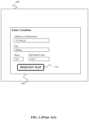
- FIG. 1illustrates a web browser user interface 100 that displays a map request entry web page 105 .
- a userhas entered a desired location of 353 Main St., Billings, Mont. 45619.
- the userrequests a map (typically from a remote server) by selecting a “Request Map” button 110 .
- a map imageis then typically generated at the remote server, transmitted to the user's computing device, and eventually displayed on the web browser user interface 100 in a map display web page.
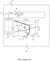
- FIG. 2illustrates an exemplary map display web page 200 on a web browser user interface 100 .
- a map display webpage 200displays the results of the map request from FIG. 1 .
- the displayed informationgenerally consists of a map image 205 , which depicts the requested location and surrounding area.
- the requested locationis identified on the map image 205 by an address icon 208
- the address icon 208is typically located in the center of map image 205 .
- the requested location and address icon 208may also be displayed on a map legend window 210 within map display web page 200 .
- the address icon 208is typically a simple two-dimensional image which, if displayed within map image 205 in close proximity with other such icons, may create visual clutter and confuse or mislead the user as to where each icon is actually pointing within map image 205 .
- the map webpage 200may also display buttons or other user interface objects that may be selected to control the manner in which map image 205 is displayed.
- zoom control objects 220are generally provided to allow the user to “zoom in” or “zoom out” and thereby affect the displayed scale of map image 205 accordingly, typically while retaining the desired location marked by address icon 208 at the center of the image.
- direction buttons or other similar user interface objectssuch as “down arrow” direction button 215 , may be provided to allow the user to “pan” the image, such as by displaying more of the map information that was previously hidden because it was beyond the “southern” boundary of map image 205 , while shifting and hiding a corresponding portion of the previously displayed “northern” portion of the map information.
- image control objectsare conventionally displayed outside the boundary area of the map image 205 , reducing the amount of space available for the map image 205 within the map display web page 200 .
- image control objectssuch as zoom control objects 200 or direction button 215 shown in FIG. 2
- HTTP requestis transmitted to a server, which then transmits a new image containing the new map information to be displayed at the selected zoom level.
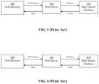
- a web browser 300sends an HTTP request containing location information for a requested map image to a web server 305 .
- the HTTP requestmay consist of location data received via a web browser user interface 100 through a data entry web page 105 , as illustrated in FIG. 1 .
- a usermay enter the following desired location to be mapped: 353 Main St., Billings, Mont., 45619.
- the userrequests the directions by selecting a “Request Map” button 110 , and this selection event eventually causes the HTTP Request shown in FIG. 3 to be transmitted (directly or indirectly) from web browser 300 to web server 305 .
- the web server 305sends a database query (“DB Query”) to a map vectors database 310 .
- the map vectors database 310typically determines the corresponding vectors for the desired location data and transmits these vectors to the web server 305 .
- the web server 305then typically generates a bitmap image of the desired map using the received vectors, and converts the bitmap into an image format that is supported by the web browser 300 (e.g., GIF, PNG, JPEG, and the like).
- the web server 305then transmits the image to the web browser 300 , generally embedding it within Hypertext Markup Language (HTML) code.
- HTMLHypertext Markup Language
- the web browser 300when the user requests a new map view, e.g., by entering a postal address, or by clicking a navigation link next to a current map view, the web browser 300 sends to a web server 305 a request indicating the boundaries of the new map view.
- the web server 305extracts the corresponding vector-based map data from a database, and draws a bitmap image of the map.
- the web server 305then converts the bitmap image to an image format supported by the web browser 300 and returns the image, sometimes embedded in HTML, to the web browser 300 for display to the user.
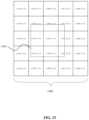
- FIG. 4illustrates a second exemplary system used for providing map data to a web browser.
- a web browser 300transmits an HTTP request to a web server 305 in the same manner that was described earlier with respect to FIG. 3 .
- the web server 305 shown in FIG. 4transmits a database query (“DB Query”) containing the requested location data to a map raster database 410 .
- DB Querydatabase query
- the map raster database 410extracts the appropriate image based on the database query from among a larger pre-rendered map image.
- the requested imageis then transmitted to the web server 305 , which then transmits the image to the web browser 300 as described earlier.
- DB Querydatabase query
- FIG. 4illustrates a second exemplary system used for providing map data to a web browser.
- One such methodincludes sending a location request from a client-side computing device to a map tile server, receiving a set of map tiles in response to the location request, assembling said received map tiles into a tile grid, aligning the tile grid relative to a clipping shape, and displaying the result as a map image.
- One apparatus according to aspects of the present inventionincludes means for sending a location request from a client-side computing device to a map tile server, means for receiving a set of map tiles in response to the location request, means for assembling said received map tiles into a tile grid, means for aligning the tile grid relative to a clipping shape, and means for displaying the result as a map image.
- Such an apparatusmay further include direction control or zoom control objects as interactive overlays on the displayed map image, and may also include route or location overlays on the map tile image.
- FIG. 1illustrates an exemplary web browser displaying a map request entry web page.
- FIG. 2illustrates an exemplary map display on a web browser.
- FIG. 3illustrates an exemplary conventional vector-based digital mapping system architecture.
- FIG. 4illustrates an exemplary conventional raster-based digital mapping system architecture.
- FIG. 5illustrates a distributed network system according to aspects of the present invention.
- FIG. 6is an exemplary block diagram of a client-side or server-side computing device according to aspects of the present invention.
- FIG. 7illustrates an exemplary tile-based digital mapping system architecture according to aspects of the present invention.
- FIG. 8illustrates an exemplary combined map request entry and map display web page according to aspects of the present invention.
- FIG. 9illustrates an exemplary server-side architecture according to aspects of the present invention.
- FIG. 10illustrates further aspects of an exemplary server-side architecture consistent with principles of the present invention.
- FIG. 11illustrates an exemplary map image tile grid and clipping rectangle according to aspects of the present invention.
- FIG. 12depicts a resulting map image after comparing an exemplary tile grid with a clipping rectangle according to aspects of the present invention.
- FIG. 13illustrates the underlying tile grid coordinates and clipping shape corresponding to an exemplary set of displayed images according to aspects of the present invention.
- FIG. 14illustrates a flowchart of one embodiment for transmitting map tiles to a web browser and caching the tiles locally at the web browser according to aspects of the present invention.
- FIG. 15illustrates a flowchart that may be used according to one embodiment for displaying driving directions as an overlay onto a map image.
- FIG. 16depicts a flow chart for performing a map image panning operation according to one embodiment of the present invention.
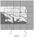
- FIGS. 17 through 21illustrate an exemplary process of panning west by 1 ⁇ 3 of the clipping shape's width according to one embodiment of the present invention.
- FIG. 22depicts an exemplary flow chart for implementing a zooming operation according to one embodiment of the present invention.
- FIG. 23depicts an exemplary flow chart for overlaying a set of location markers onto a map image according to one embodiment of the present invention.
- FIG. 24depicts an exemplary map display web page with multiple overlaid location markers according to aspects of the present invention.
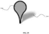
- FIG. 25depicts exemplary details of a location marker according to aspects of the present invention.
- FIG. 26 Adepicts exemplary details of an information window according to aspects of the present invention.
- FIG. 26 Bdepicts additional exemplary details of an information window according to aspects of the present invention.
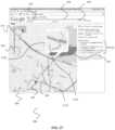
- FIG. 27depicts an exemplary map display web page with an overlaid driving direction route trace according to aspects of the present invention.
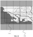
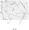
- FIG. 28depicts an exemplary map display web page with an overlaid area boundary trace according to aspects of the present invention.
- FIG. 29depicts an exemplary flow chart for overlaying a set of information windows onto a map image according to one embodiment of the present invention.
- FIG. 30depicts an exemplary flow chart for resizing a map image display window according to one embodiment of the present invention.
- FIG. 31depicts an exemplary set of map image tiles of different resolutions for high-quality printing of map images according to one embodiment of the present invention.
- any number of computer programming languagessuch as the Java language, JavaScript, Java Applet technology, C, C++, Perl, Pascal, Smalltalk, FORTRAN, assembly language, HTML (i.e., Hypertext Markup Language), DHTML (i.e., Dynamic Hypertext Markup Language), XML (i.e., eXtensible Markup Language), XLS (i.e., eXtensible Style Language), SVG (i.e., Scalable Vector Graphics), VML (i.e., Vector Markup Language), Macromedia's Flash technology, and the like, may be used to implement aspects of the present invention.
- various programming approachessuch as procedural, object-oriented or artificial intelligence techniques may be employed, depending on the requirements of each particular implementation.
- the computer program instructionsmay also be loaded onto a computer or other programmable apparatus to cause a series of operational steps to be performed on the computer or other programmable apparatus to produce a computer implemented process such that the instructions which execute on the computer or other programmable apparatus provide steps for implementing the functions specified in the flow chart block or blocks.
- blocks of the flow chartssupport combinations of structures for performing the specified functions and combinations of steps for performing the specified functions. It will also be understood that each block of the flow charts, and combinations of blocks in the flow charts, can be implemented by special purpose hardware-based computer systems which perform the specified functions or steps, or combinations of special purpose hardware and computer instructions.
- FIG. 5illustrates a distributed network system 500 according to aspects of the present invention.
- a computing device 503is shown, connected to a network 505 .
- Various serversare also connected to the network 505 .
- a web server 510a tile server 515 , and a location data server 520 are all shown as being in communication with the network 505 , although other servers (not shown) may also be connected to the network 505 .
- the computing device 503may be any type of device configured for computing, such as a personal computer, a mobile phone, a personal digital assistant, a navigation system located in a vehicle, and so on.
- the servers 510 , 515 and 520may each be any device capable of hosting services over the network 505 , such as a network server or a web server.
- the servers 510 , 515 , and 520may also be capable of determining and/or obtaining some or all mapping information based on user input.
- the computing device 503may be equipped with the capability to determine and/or obtain travel directions.
- the computing device and the servers (or various portions thereof)may be co-located in one or more machines.
- the network 505may be any type of distributed network, such as a local area network, wide area network, switched telephone network, Intranet, Internet or World Wide Web network.
- the network 505may be a direct connection between the computing device 503 and the servers 510 , 515 , and 520 .
- the computing device 503 , network 505 and/or servers 510 , 515 , and 520may be in communication via any type of wired or wireless connection.
- the computing device 503 , the servers 510 , 515 , and 520 , and other computing devices (not shown), and/or other servers (not shown) in communication with the network 505may be used to perform any or all functions described herein.
- FIG. 6is an exemplary diagram of a computing device 503 , or of servers 510 , 515 , and 520 .
- Computing device/servers 503 / 510 / 515 / 520may include a bus 600 , one or more processors 605 , a main memory 610 , a read-only memory (ROM) 615 , a storage device 620 , one or more input devices 625 , one or more output devices 630 , and a communication interface 635 .
- Bus 600may include one or more conductors that permit communication among the components of computing device/server 503 / 510 / 515 / 520 .
- Processor 605may include any type of conventional processor, microprocessor, or processing logic that interprets and executes instructions.
- Main memory 610may include a random-access memory (RAM) or another type of dynamic storage device that stores information and instructions for execution by processor 605 .
- ROM 615may include a conventional ROM device or another type of static storage device that stores static information and instructions for use by processor 605 .
- Storage device 620may include a magnetic and/or optical recording medium and its corresponding drive.
- Input device(s) 625may include one or more conventional mechanisms that permit a user to input information to computing device/server 503 / 510 / 515 / 520 , such as a keyboard, a mouse, a pen, a stylus, handwriting recognition, voice recognition, biometric mechanisms, and the like.
- Output device(s) 630may include one or more conventional mechanisms that output information to the user, including a display, a printer, a speaker, and the like.
- Communication interface 635may include any transceiver-like mechanism that enables computing device/server 503 / 510 / 515 / 520 to communicate with other devices and/or systems.
- communication interface 635may include mechanisms for communicating with another device or system via a network, such as network 505 .
- computing device 503 and/or servers 510 , 515 , and 520may perform operations based on software instructions that may be read into memory 610 from another computer-readable medium, such as data storage device 620 , or from another device via communication interface 635 .
- the software instructions contained in memory 610cause processor 605 to perform processes that will be described later.
- hardwired circuitrymay be used in place of or in combination with software instructions to implement processes consistent with the present invention.
- various implementationsare not limited to any specific combination of hardware circuitry and software.
- a web browser(such as web browser 300 shown in FIGS. 3 and 4 ) comprising a web browser user interface (such as web browser interface 100 shown in FIGS. 1 and 2 ) may be used to display information (such as textual and graphical information) on the computing device 503 .
- the web browser 300may comprise any type of visual display capable of displaying information received via the network 505 shown in FIG. 5 , such as Microsoft's Internet Explorer browser, Netscape's Navigator browser, Mozilla's Firefox browser, PalmSource's Web Browser, or any other browsing or other application software capable of communicating with network 405 .
- the computing device 503may also include a browser assistant.
- the browser assistantmay include a plug-in, an applet, a dynamic link library (DLL), or a similar executable object or process.
- the browser assistantmay be a toolbar, software button, or menu that provides an extension to the web browser 300 .
- the browser assistantmay be a part of the web browser 300 , in which case the browser 300 would implement the functionality of the
- the browser 300 and/or the browser assistantmay act as an intermediary between the user and the computing device 503 and/or the network 505 .
- source documents or other information received from devices connected to the network 505may be output to the user via the browser 300 .
- both the browser 300 and the browser assistantare capable of performing operations on the received source documents prior to outputting the source documents to the user.
- the browser 300 and/or the browser assistantmay receive user input and transmit the inputted data to servers 505 / 515 / 520 or other devices connected to the network 505 .
- certain aspects of one embodimentassume the existence of large (e.g., on the scale of the entire United States), contiguous map raster images at each of an appropriate set of discrete zoom-levels.
- the systemgenerates and cuts these large raster images into segments (e.g., rectangular tiles) of a size generally an order of magnitude smaller than the desired map view, and stores these tiles in a format supported by web browsers in a server-side database.
- HTTP requestsare sent to a server 710 only for the smallest set of tiles needed in conjunction with the tiles that are already present in the web browser (or in the web browser's cache, shown as Local Memory 705 in FIG. 7 (which, without limitation, could be implemented as Main Memory 610 , ROM 615 , and/or Storage Device 620 as shown in FIG. 6 ) to produce the new view.
- the format of the responses to these HTTP tile requestscontains information in the header fields that encourages the web browser to cache the tiles locally.
- the web browserBy executing a set of scripts, the web browser then seamlessly assembles the combined set of tiles into the new map view for presentation to the user. Since the old map view in general is still present in the browser, additional scripts may be used to smoothly animate the transition from the old to the new map view, either as part of a panning and/or zooming operation. Moreover, location markers and routes can be overlaid on top of the pre-rendered map tiles, for example in response to user requests for driving directions, local search, yellow page look-ups, and the like. In addition, similar techniques can be used to highlight areas and streets on the map image, for example.
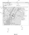
- FIG. 8depicts one embodiment of a combined map request and map display page 800 according to aspects of the present invention.
- page 800includes a map image 805 , overlaid directional map control objects 815 , overlaid zoom control objects 820 , location request text entry field 825 , search button 830 , information window 840 , location marker 845 , location marker shadow 850 , and information window shadow 855 .
- map image 805is actually generated by aligning a tile grid relative to a clipping shape having approximately the same size and shape as the map image 805 .
- the tile gridin one embodiment comprises a number of smaller individual map tiles that are seamlessly arranged into a larger image for display.
- directional map control objects 815 and zoom control objects 820may actually be located within map image 805 itself, thereby increasing the area within display page 800 that is available for the map image 805 .
- an arbitrary size for map image 805may be implemented, which is not limited to a whole number of map tiles.
- any arbitrary pointmay be located at the center of map image 805 .
- location query text entry field 825is implemented as a single text field, such that the various components of the desired location to be mapped (such as its street address, city, state, or zip code) do not need to be specified using multiple fields.
- FIG. 8also includes billing point 860 at the center of the map image (although billing point 860 is typically not a visible feature on map image 805 ).
- map image 805is generated and displayed (by means of the detailed into entry field 825 may also be repeated and displayed as the map title 840 , either in its original or in its parsed form.
- the desired location to be mappedis graphically identified within map image 805 by location marker 845 and its shadow 850 .
- map image 805is minimized, especially when multiple location markers are located in close proximity to each other, and the actual location on the map corresponding to the location marker may be more easily identified as a point.
- directional map control objects 815may be implemented as a set of arrow-labeled pan buttons that cause the map to pan, say, by 25% of the clipping shape size in the direction of the arrow. These buttons could also be labeled by compass orientation, such as “west,” “north,” or “north-west.”
- zoom control objects 820may include buttons labeled “+” and “ ⁇ ” that cause the map to zoom in and out by a single level, respectively. These buttons may also be labeled by the main geographic abstraction of the corresponding zoom level, e.g., “street,” “city,” “county,” “state,” “country,” and the like.
- zoom control objects 820may also include a slider with a discrete position for each zoom level. From the user's perspective, moving the slider to a specific zoom level may have the same effect as selecting the corresponding zoom level.
- “clicking on” or otherwise selecting a specific portion of map image 805causes the selected location to pan to the center of the map image 805
- “double-clicking” or otherwise emphatically selecting a specific portion of map image 805causes the selected location to pan to the center of the map image 805 and the zoom level to simultaneously increase.
- “double-clicking” or otherwise emphatically selecting a specific portion of map image 805causes the selected location to pan to the center of the map image 805 , while clicking on or otherwise selecting a location marker (either a marker within map image 805 or a marker adjacent to map image 805 ) causes an information window associated with the marker to open, and subsequently clicking on or otherwise selecting any portion of the map image causes the information window to close.
- Dynamic resizing of mapsis also supported in one embodiment.
- the map image 805 inside the windowis re-centered (so as to preserve the location that was the center in the previous window size), and the map is resized (so that it shows a smaller area if the new window is smaller, or a larger area if the new window is larger), without changing the zoom level or generally requiring the re-transmission of image information to the user's web browser.
- the usercan “grab” a corner or other portion of the map image 805 (e.g., by holding down a mouse button while a mouse icon is pointing to the selected corner) and “drag” it to resize the map image (e.g., by holding the mouse button down while moving the mouse to a selected location and then releasing the mouse button).
- One embodimentimplements mouse dragging functionality, whereby a map view may be smoothly shifted, for example, by holding down the user's mouse button, dragging the mouse to a new location until the desired map view is effected, and then releasing the mouse button.
- map scrolling functionalityis also implemented in one embodiment, whereby a map view may be shifted (or “panned”) simply through activation of the arrow keys on a user's keyboard, or via a similar user action.
- entering a whole or partial postal address into text entry field 825causes the map image 805 to pan to the corresponding location and zoom to a level that depends on the completeness of the address that was entered. For example, entering “6936 Bristol Dr., Berkeley Calif.” pans to the corresponding location and sets the zoom level to be close to street level, whereas simply entering “Berkeley, Calif.” without more specific address information would pan to the center of the city of Berkeley and set the zoom level to city level.
- location outlinesare implemented in one embodiment, such that if a user specifies a general area (e.g., a city, state, or zip code) instead of a specific address, an outline can be drawn around the general area to highlight it (as illustrated, for example, by location outline 2810 in FIG. 28 ).
- This functionalitycan assist a user to gauge distances and focus on areas of interest.
- the usermay define a set of shortcuts (such as “home,” “work,” or “grandmother's house”), which when entered or otherwise selected cause a “jump” action in the map image to the desired shortcut location (or a “zoom/pan” action if the requested location is sufficiently close to the current location).
- one embodimentalso implements “information window” functionality, whereby clicking on or otherwise selecting a location marker such as marker 845 opens an interactive window 840 and its shadow 855 overlaid within map image 805 that contains more information about the location represented by the marker.
- usersmay execute combined searches in one embodiment, whereby users may specify items to search for and locations to map all within a single text box (e.g., “movies in San Francisco” or “pizza near Mountain View”).
- userscan give names to specific locations (e.g., “home”, “work”) (which may or may not be associated with an address book or similar database or utility on the user's computing device), and then employ the shortcut names when entering searches into text entry field 825 (e.g., when searching for “bars near work”).
- One embodimentalso implements driving direction functionality, either by means of a single text entry field 825 as shown in FIG. 8 , or alternatively, by means of one text entry field for the starting location and a second text entry field for the end location (as illustrated by text entry fields 825 and 828 shown in FIG. 27 ).
- driving direction functionalitymay also be implemented by two sets of specific text entry fields, one set for the starting location fields (e.g., starting street address, starting city, starting state, etc.), and a second set for the end location fields.
- the servertransmits the turn-by-turn textual directions to the client computing device, along with the vector information for the graphical depiction of the entire route.
- the graphical driving directionsare then rendered by the client as an overlay on top of the previously rendered map image.
- the clientcomputes the graphical definition of the route overlay image and then transmits a request to the server to supply the actual overlay image.
- textual driving direction maneuvers 2730e.g., “Take the Moffett Blvd. exit” may be displayed on the web page 800 near the map image 805 . Clicking on or otherwise selecting one of the textual driving directions opens an information window pointing to the corresponding section of the map image 805 (e.g., the freeway off-ramp from southbound US-101 to Moffett Blvd.). As shown in FIG. 27 , the information window displays a blow-up of the corresponding section of the map image 805 .
- the information windowadditionally contains a “satellite” button or similar user interface object that, when clicked or otherwise selected, replaces the graphical blow-up of the map with a corresponding satellite photograph of the same area.
- the graphical driving directionsi.e., the traces depicting the route
- a “satellite” button or similar user interface objectmay also be included within (or associated with) the main map image 805 such that, when clicked or otherwise selected, the “satellite” button replaces the pictorial type of map image 805 depicted in FIG. 8 with a corresponding satellite photograph of the same area.
- mapsare displayed by stitching together in the browser a set of pre-rendered “tiles” of map image.
- These map tilesare produced during an off-line phase by drawing very large maps of the entire geographic area covered in each of a predetermined number discrete zoom-levels (e.g., 15 ), then cutting those maps into tiles, and encoding the tiles into an appropriate image format (e.g., GIF).
- the pre-rendered tilesare served as static images from a set of servers. For example, to cover the entire continental United States, hundreds of millions of tiles are required, with a total file size for the tiles in the order of hundreds of Gigabytes of data.
- a set of large, contiguous, pre-rendered raster images of the entire area covered by the map systemare generated.
- One such set of raster imagesis provided for each zoom-level, ranging from street to country level, for example.
- Each map image 805(as shown in FIG. 8 ) that is eventually assembled and displayed at a user's web browser matches a sub-area (typically shaped as a rectangle) of one of these large pre-determined raster images.
- the map image boundarymay be changed to appear as a different shape (e.g., a rectangle with rounded corners as shown in FIG. 8 ) by overlying images onto the map image boundary that match or blend with the background surrounding the map image.
- the zoom levelsare numbered 0 thru Z, where 0 represents the level closest to street level, and Z the level the furthest away from street level.
- An arbitrary latitude/longitude (“lat/lon”) point within the area of interestis designated and defined as the origin, or origo (for example the geographic center of the contiguous United States). Then, at each zoom level z, the coordinate triplet (0, 0, z) is assigned to the pixel of the z-level raster image containing this origin.
- a unique coordinate triplet(x, y, z) is assigned to each pixel of each of the raster images.
- a coordinate conversion routinegiven a zoom-level z, converts a lat/lon coordinate pair to the appropriate (x, y, z) pixel coordinate, and vice versa.
- the details of this conversiondepend on the map projection that was used in producing the raster images in the first instance.
- each of the large raster imagesare “cut” into rectangular tiles.
- the process of generating and cutting the large raster images into map tilesis cooperatively performed by tile maker 905 in conjunction with map painter library 910 , and a commercially available RME (“rich map engine”) library 915 .
- the tile maker 905ensures that adjacent sub-image tiles line up closely along their common border, in particular where label-placement is concerned. Given map projection issues well known to persons skilled in the art, it may be necessary to divide the area covered by the map system into smaller areas, and deal with each separately.
- the underlying map datais stored in map data storage area 920 .
- the stored map datacomprises commercially available NavTech data that has been compiled by Telcontar (a commercial provider of digital map and navigation information) into RMF (Rich Map Format) files.
- Telcontara commercial provider of digital map and navigation information
- RMFich Map Format
- RMFis a format compact, binary format optimized for spatial query processing.
- one embodiment of the present inventiontakes advantage of this format to generate map images and create route information.
- RMFis a spatial format that organizes data in a multi-dimension fashion, such that features near each other in reality are stored close together in the database. This means that once an item in a spatially formatted dataset is found, other items close by can also be found with relative ease.
- the tile maker 905communicates with the map painter library 910 to request map data for making tiles.
- the map painter library 910in turn communicates with the commercially available RME library 915 to access information from map data storage 920 .
- the RME librarysupports spatial queries that request information involving the geographic relation of two or more items. Examples are “What map features fall within a given area?” or “What map features fall within a given area that have a priority level higher than a certain threshold?.”
- the result of the spatial queryis transmitted to the tile maker 905 via the map painter library 905 and is used to generate map tiles.
- the resulting map tiles of the tile making processare stored in map tile storage area 900 .
- browser-side scriptsrequire only the smallest set of tiles that together completely covers the desired view.
- the size of the tilescan be determined heuristically, given the following trade-off: (1) Larger tiles tend to increase the total size (in both pixels and bytes) of the tiles needed to produce a given view; while (2) Smaller tiles tend to increase the number of separate HTTP requests needed to produce a given view.
- a tile size of 128.times.128 pixelsis used, stored in the GIF format.
- tile sizeof 256.times.256 pixels, stored either in the GIF, JPEG, or PNG formats.
- Other tile sizes and image storage formatsmay be used, depending on the requirements of each particular implementation. These tiles thus form a regular, square grid, and this property facilitates system implementation in one embodiment.
- persons skilled in the artwill recognize that any other division of the large raster images into tiles of any shapes and sizes that allows for seamless assembly on the client-side may also be used to achieve the effect of the present invention.
- each tilemay simply be stored in a separate file, accessible using unique URLs such as http:// ⁇ domain>/7/-18/1/-145.sub.--12.sub.--7.gif, where the directory path 7/-18/1 in this example depends solely on the tile coordinates, in this exemplary case equal to ( ⁇ 145, 12, 7).
- each zoom-level zis located such that the tile's upper-left pixel has coordinates (0, 0, z).
- This rulefacilitates assignment of a unique coordinate triplet to each tile by integer-dividing the pixel x and y coordinates of the tile's upper-left pixel by the width and height of the tile, respectively.
- a total of three coordinate systemsare utilized: lat/lon coordinates, pixel (x, y, z) coordinates and tile (x, y, z) coordinates.
- this particular choice of coordinate systemsis arbitrary, and chosen simply to aid in describing the algorithms used in one embodiment. In general, any consistent coordinate system will suffice.
- each pixelbelongs to a unique tile, the coordinates of which are easily computed.
- a front-end server(such as server 710 depicted in FIG. 7 or web server 510 in FIG. 5 ) responds to each query submitted by a user by returning a web page to a hidden frame that contains data accessed by client-side code implemented in JavaScript.
- the front-end server 710 / 510interacts with a JavaScript-based set of programs running on the user's browser to generate dynamic HTML (“DHTML”) code.
- DHTMLdynamic HTML
- user interface functionality described earliersuch as panning and zooming the map view 805 shown in FIG. 8 , can be implemented within the client computing device 503 without interaction with the front-end server 710 / 510 .
- the client computing device 503merely has to request and display tiles as needed from the tile server 520 , which serves tile sets that have been previously generated as described above with reference to FIG. 9 .
- the basic mode of operation of front-end server 710 / 510is to provide a response to a user's query entered into the text entry field (such as field 825 shown in FIG. 8 ) in the map display page 800 .
- the client-side JavaScript codeforms a HTTP request that contains the contents of the query as well as the current state of the map view and submits that information to front-end server 710 / 510 , directing the resultant page to appear in a hidden iframe (or “virtual page”).
- This mechanismallows the client to receive data required to implement the mapping system (including various features of the mapping system, such as, for example, overlays for driving directions and other items, without having to reload the main/visible web page, but while still enabling the browser's history and/backward/forward buttons to work as expected, so that the user may do a local search, for example, then get directions, and click back to get back to local search results.
- various features of the mapping systemsuch as, for example, overlays for driving directions and other items
- JavaScript on the main pagemay pull the data from the virtual page and adjust the main page accordingly, by: (1) changing the HTML title; (2) changing the search form; (3) replacing the HTML IMG references in the tile grid with the URLs of the tiles to be displayed in the map image; (4) panning and/or zooming the map display; and/or (5) adding or replacing one or more overlays on the map.
- Location queriese.g. “Berkeley”. These are queries that contain a single geographic location.
- the front-end server 710 / 510directs the client to pan and/or zoom the map to that location and to mark the boundaries of that location on the display.
- a “point” querye.g., for a specific address, as shown in FIG.
- a “line” querye.g., for a specific street in a specific city, without specifying the street number
- an “area” querye.g., for a specific city such as “Anytown” results in a display where the requested area is highlighted on the map image as an overlay (as shown in FIG. 28 ).
- the front-end server 710 / 510searches for businesses matching the query within (or near) the current map view based on the user's navigation of the map or the positioning resulting from querying for a location, and directs the client computing device 503 to display the results as a set of location markers 845 / 850 on the map image 805 , optionally along with a legend associated with the map image 805 describing the search result that each marker symbolizes.
- Qualified local search queriese.g. “pizza in Palo Alto”, “single malt scotch near San Francisco”). These are queries that contain both search terms and a geographic location.
- the front-end server 710 / 510directs the client computing device 503 to pan and/or zoom to the indicated location and to display the search results found within or around that location.
- the geographic information contained in the queryis converted to lat/lon points, a local search is conducted with respect to this set of lat/lon points, and subsequently the zoom level is set to ensure that all of the locations in the result of the local search are displayed on the map image (see FIG. 24 for a resulting display, given a search for “great sushi in New York”).
- Driving directions queriese.g., “from San Francisco to New York,” “from home to work,” or “from 123 Main St. Los Angeles, Calif. to 801 University Ave. Palo Alto, Calif.”). These are queries that contain two distinct geographic locations.
- front-end server 710 / 510can transmit the route information, along with textual turn-by-turn directions, to the client, which may then display the route as a highlighted overlaid path in the map image 805 .
- the usermay interact with these textual directions by zooming into portions of the route (e.g., by clicking on or otherwise selecting specific driving maneuvers) to obtain additional textual or graphical details.
- the front end server 710 / 510can be implemented as a number of different logical control flows which are selected based on a query classifier.
- a query classifierincludes a location extractor that takes a set of templates defining how a query string may be broken down into constituent parts including search terms, geographic location identifiers, and literal text. For example, a template such as “ ⁇ QUERY ⁇ ⁇ STANDALONE_CITY ⁇ ” would match a query entered by a user simply as “pizza palo alto” and result in a search for “pizza” near the centroid of Palo Alto, Calif.
- the location extractorhas access to a relatively large database consisting of a set of location names of various types, such as street names, city names, and the like.
- the front end server 710 / 510also includes a geocoding/geomap server 1010 that converts an unstructured location into a structured location plus a geographic point/line/area that can be marked on the map image 805 of FIG. 8 .
- Geomap server 1010cooperatively communicates with drill-down server 1015 , map data storage area 920 , location data server 1000 , and local search server 1010 to process geographic features such as street addresses, streets, intersections, points of interest, cities, neighborhoods, ZIP codes, counties, metropolitan areas, states, and the like (as well as their international equivalents). For point features such as street addresses, the result of the conversion is a single (latitude, longitude) point.
- the result of the conversionis either a polyline (e.g., for a street) or a polygon (e.g., for a city), that defines each of those features.
- the result of the conversionmay simply be an axis-aligned bounding box.
- the front end server 710 / 510also includes a local search server 1005 for finding search results in or around a given geographic location.
- the local search server 1005may wait to receive the results of the geocoding/geomap server 1010 before executing.
- implementing a local search scoring algorithm within local search server 1010that has a flexible definition of location restriction and a notion of distance flattening is desirable.
- the usershould advantageously be able to search for businesses within the current map view that match a given set of query terms. This requires that the local search code allow restrictions that have the form of minimum and maximum latitude and longitude coordinates, instead of just centerpoint and radius.
- results at the exact center of the map displayshould not be scored higher than results elsewhere in the display view. For example, searching for “pizza in palo alto” should not score two Palo Alto pizza parlors differently because one happens to be closer to the centroid of Palo Alto than the other.
- the front-end server 510 / 710when a “driving directions” query is recognized by front-end server 510 / 710 , the front-end server converts the source and destination addresses to a set of simple turn-by-turn directions, as well as a polyline specifying the (latitude, longitude) coordinates along the route.
- the front-end server 510 / 710may then transmit the turn-by-turn directions to the client computing device using XML (e.g., in a vPage), along with a set of polylines that contains the vector information along the entire route.
- the front-end serverbefore transmitting the set of polylines to the client, reduces the total number of graphical data points that are transmitted to the client (e.g., using geometrical operations well known to persons skilled in the art to eliminate from the set of polylines any data point that, when eliminated, results in an error with respect to the full set of polylines no higher than a certain predetermined threshold, such as one or two pixels), and assigns each non-eliminated data point to a “group” that defines the zoom level at which the point becomes visually relevant (e.g., data points in group “A” may be required to be displayed at every zoom level, while data points in group “B” are not required to be displayed until the zoom level has increased past the zoom level corresponding to a city-level view or finer, etc.).
- a certain predetermined thresholdsuch as one or two pixels
- the map image 805displays an overview of the entire selected route. The user may then zoom in to parts of the route to get more detailed views.
- a billing mechanismis implemented for keeping track of the number of map views requested by a user, e.g., for keeping track of how much total map area a user has visited in relation to the map view.
- a billing point 860is defined at the center of the map image (although billing point 860 is typically not a visible feature on map image 805 ).
- map image 805comprises an area defined as 400 pixels wide and 400 pixels high
- other billing pointsare defined in the horizontal and vertical directions at intervals of 400 pixels (thereby creating a billing point grid).
- every map viewincludes at least one transaction.
- the billing point grid“moves” along with the map, triggering additional billing transactions whenever a new billing point enters into the map view. For example, if the user pans the map image by 200 pixels to the right, a new billing point will come into view and trigger a new transaction. In one embodiment, a new transaction would also be triggered as a result of a zooming operation to display a previously unviewed map area at a given zoom level. Transactions are reported by the client to the front-end server 710 / 510 in one embodiment, which collects the transaction information from all users and uses is for contractual purposes with commercial providers of map information.
- Embodiments of the present inventionmay be implemented using a wide range of technologies available in modern web browsers.
- a common graphical feature of certain embodimentsis the ability to assemble a set of map tiles behind a “clipping shape.”
- the host technology at the user's computing device 503should allow for a reasonably efficient, dynamic change to the display layout.
- the client's web browsershould perform such dynamic changes using a double-buffered (or similar) display to avoid flickering.
- DHTMLuses a double-buffered display engine.
- the browserexecutes script functions in response to events such as user input, HTTP completions and timeouts. All changes made to the web page during script execution are, at least logically, recorded in an off-screen buffer, which is displayed when the script yields control back to the browser.
- client-side algorithmsproceed in general by making a set of changes to the map tile layout, and then requesting the host system to display the new frame defined by those changes.
- map display functionality at the client sidemay implemented in HTML code as follows:
- JavaScript code on the sitepans and zooms the map by placing appropriate map tiles in the ⁇ img> elements of mapTable, and by moving mapDiv relative to mapView.
- the client-side algorithm in this embodimentimplements two primary graphical elements.
- the first elementis a “clipping shape” (typically a rectangle) through which the user will see the map image 805 , and which defines the shape of the user's map view.
- an arbitrary pixel of the clipping shapeis assigned as its origin (for example the upper-left pixel in the case of a rectangular clipping shape).
- the second elementis a grid of tiles larger than and placed behind the clipping shape, such that only the part of the grid that intersects the clipping shape is visible to the user.
- this gridis rectangular, and that it only changes size if and when the clipping shape does. Persons skilled in the art will recognize that variations of the algorithms discussed herein exist where this property would not hold true.
- FIG. 11illustrates these two graphical elements
- FIG. 12depicts the result of processing the tile grid through the clipping shape for display on a web page.
- a square 5-by-5 tile grid array 1100comprises 25 individual tiles (each of which is defined by red boundary lines).
- a square clipping shape 1110(shown as a black rectangle) defines the subset of the tile grid that will be displayed as a map image on the client's web browser.
- the “clipped” tile grid array 1200is displayed with boundaries that are contiguous with the boundaries of the clipping shape.
- the map image 805 shown in FIG. 8is also the result of a larger tile grid array that has been compared with a clipping shape.
- FIG. 13illustrates the underlying tile grid coordinates and clipping shape 1305 that may correspond with a set of displayed images, such as those shown in FIGS. 11 and 12 .
- each of the 25 tiles within 5-by-5 tile grid array 1300is represented by a unique set of tile coordinates.
- the clipping shapeis a rectangle of fixed size 300.times.300 pixels, and positioned at the center of the web page 800 as shown in FIG. 8 .
- the clipping shapeis implemented in one embodiment as a DIV element with style “overflow:hidden; position:relative” and id “mapView.”
- the tile gridis of fixed size 5-by-5 tiles. It is implemented as a TABLE element with id “mapTable.” Each of mapTable's 25 TD children contains a single IMG element, such that placing a tile simply entails appropriately changing the SRC attribute of the IMG element.
- the POSITION styles of mapView and mapDivmakes it possible to move the tile grid relative to the clipping shape simply by changing the LEFT and TOP styles of the mapDiv.
- the size of the tile grid relative to the size of the clipping shapemay depend on various implementation factors described below. Roughly speaking, the smallest grid of tiles that is at least twice the size (in both the width and height) of the clipping shape (in pixels) may be used. Again depending on implementation choices, it may be necessary to dynamically change the size of the tile grid when the user changes the size or shape of the clipping shape.
- a and Brepresent the width and height, respectively, (in term of tiles) of the tile grid.
- Each position in the tile gridis assigned a coordinate pair (a, b) with the upper-left position having coordinates (0, 0), and the lower-right position having coordinate (A-1, B-1).
- referencemay be made to positions (a, b) that fall outside the tile grid, i.e., where a ⁇ 0 or A.ltoreq.a, or b ⁇ 0 or B.ltoreq.b.
- intersection conditionIn each map image produced in one embodiment, the intersection between the clipping shape and the tile grid will equal the full clipping shape, such that only map tiles are exposed to the user by the clipping shape. In the remainder of this document, this fact is denominated as the “intersection condition.”
- the client-side scriptsproceed as follows. First, the tile grid is placed relative to the clipping shape in any manner that does not violate the intersection condition. Second, (a, b) is defined as the position of the tile grid now containing the clipping shape origin. Third, for each position (a+a′, b+b′) in the tile grid intersecting the clipping shape, the tile (xx+a′, yy+b′, z) is placed. Fourth, and finally, the resulting frame is displayed.
- placing a tile in a tile grid positionin general will cause the browser to first check if the tile is present in its cache, and, if it is not, to issue the appropriate HTTP request for the needed tile.
- this HTTP requestmay be performed synchronously or asynchronously.
- Embodiments of the present inventionimprove performance by encouraging web browsers to cache individual tiles locally.
- the browser-side scriptsinstruct the browser to display a particular tile
- the browserwill request the tile from an HTTP server only when the tile is not already present in the browser's cache.
- embodiments of the present inventionbenefit from separate map views containing overlapping imagery, even if those separate views belong to different browser sessions. Indeed, once a user has viewed an area while on-line, the user may view that same area while off-line, so long as only tiles already cached by the user's browser are needed.
- URLuniversal resource locator
- web browsersmanage their caches by using an expiration time contained in the HTTP response containing each tile, and/or by comparing a last modified time of the tile in the browser's cache with that of the tile on the server side.
- the HTTP server transmitting the tilesmay be configured to report a lengthy expiration period, determined heuristically given the following trade-off: On one hand, a longer expiration period tends to minimize the number of HTTP requests needed for correctly cached tiles. On the other hand, a shorter expiration period makes it faster to promulgate new tiles to the web browsers when the large map input rasters change (which in practice could occur to compensate for new road construction, or to take advantage of an improvement to the map drawing system that produces the rasters).
- This alternative systemminimizes the HTTP requests issued by the browser for tiles already correctly cached, while giving full control of when new tiles should be used in place of old cached ones.
- This alternativedoes tend to use more disk-space on the browser-side, as new tiles would not replace old ones in the browser's cache.
- embodiments of the present inventiondo not depend on the use in particular of HTTP to transport the tiles from a server to the web browser.
- Other transport protocols supported by the browsercan be used instead, such as HTTPS or FTP.
- each transport protocolmay require a slightly different approach to caching tiles.
- Embodiments of the present inventionmay also implement heuristic algorithms, based on recent pan and zoom operations, to predict which tiles are likely to be needed in the near future, and to use idle time and/or bandwidth to transfer those tiles into the browser's cache.
- idle time and/or bandwidthmay be dedicated to updating positions in the tile grid that are not currently visible, and/or to request tiles that would be needed if the user were to requests single-level zoom transitions.
- FIG. 14illustrates a flowchart of one embodiment for transmitting map tiles to the web browser and caching the tiles locally at the web browser.
- the clientreceives a location candidate (e.g., the user may have entered a location to be mapped into text entry field 825 shown in FIG. 8 and then selected search button 830 in FIG. 8 ).
- the client computing devicetransmits the location candidate to a location server (e.g. location data server 1000 shown in FIG. 10 , location data server 520 shown in FIG. 5 , or server 710 shown in FIG. 7 ).
- the location serverparses the location candidate at step 1410 , resulting in the generation of location data.
- the clientreceives this location data from the location server, and at step 1420 the client uses the received location data to create a tile request. For each tile in the tile request, the client determines whether the requested tile is already stored locally. Specifically, at step 1425 , the client determines whether the requested tile is already stored locally.
- step 1435the client retrieves the tile from its local memory. Alternatively, if the tile is not already stored locally, at step 1430 the client retrieves the tile from a tile server (such as tile server 515 shown in FIG. 5 ). At step 1440 , once it has been retrieved from either local or remote tile storage, the requested tile is displayed. Next, at step 1445 , the next tile request is determined. If more tiles remain in the request (a determination that is made at step 1450 ), the process loops back to step 1425 , where a determination is made as to whether the newly requested tile is already stored locally. Alternatively, if no more tiles remain in the request, the process ends at step 1455 .
- a tile serversuch as tile server 515 shown in FIG. 5 .
- all additional information beyond the fundamental map imagecan be drawn as overlays and placed on top of a map on the client side.
- This approachcan be used for all additional information, which means that the server does not need to draw any maps with specific additional information on demand.
- Overlayscan be used, for example, to display location markers and routes, and to highlight streets and particular areas.
- overlaysmay be implemented in various ways (e.g., through images or vectors).
- client-side JavaScriptmay place HTML elements on top of the map display.
- all overlay elementsmay be placed in mapDiv, such that they move automatically with the map when mapDiv is moved.
- FIG. 15illustrates a flowchart that may be used according to one embodiment for displaying driving directions as an overlay onto a map image.
- the clientreceives a request for driving directions from a user in the manner that has already been described.
- the clienttransmits the requested travel direction information to a location server.
- the location serverparses the travel direction information, as described earlier in reference to the description of the functionality of the front end server.
- the clientreceives textual and geographical travel direction data from the location server, as described earlier.
- the clientdetermines the vectors required to display an overlay driving directions route trace onto a map image.
- the clientrenders the fundamental map image (if this step has not already been done) in accordance with the flowchart of FIG. 14 , as described earlier.
- the clientthen renders the driving directions route trace as an overlay onto the fundamental map image.
- the clientinstead of proceeding to step 1528 , at step 1530 the client requests a travel direction image overlay from the location server, based on the vector information that was calculated by the client at step 1520 .
- the location servercreates a travel direction image and transmits it to the client.
- the clientoverlays the final travel direction image onto the map image.
- An exemplary displayed map image with an overlay driving directions imageis shown in FIG. 26 .
- a resourcesuch as geomap server 1010 shown in FIG. 10 may generate an overlay bitmap image (e.g., for a polyline associated with a set of driving directions), and then the browser may composite this transparent image onto the map image. Because the browser requests this image directly from the geomap server 1010 in this example, the request is via a URL instead of a protocol buffer. The width and color of the line may be specified as command-line options to the geomap server 1010 .
- ‘rotation down’ of the tile gridis defined as taking the bottom row and making it the top row, and then placing the resulting grid such that the remaining positions retain their old location relative to the clipping shape.
- ‘rotating up’is defined as making the top row the bottom one, ‘rotating left’ as making the left column the right one, and finally ‘rotating right’ as making the right column the left one.
- FIG. 16depicts a flow chart for performing a map image panning operating according to one embodiment.
- the clientreceives a command from the user indicating a pan event (e.g., by activation of a directional control object 815 as shown in FIG. 8 ).
- the clientvirtually moves the clipping viewer relative to the underlying map tiles.
- the clientdetermines the location of newly needed tiles as a result of the pan operation. Once this has been determined, at step 1615 the client uses this location data to create a tile request.
- the clientobtains any required tiles in accordance to the process illustrated in FIG. 14 and described earlier.
- FIGS. 17 through 21illustrate an exemplary process of panning west by 1 ⁇ 3 of the clipping shape's width according to one embodiment.
- FIG. 17depicts the state of the map image and tile grid before the tiles are updated in the second step of the process described earlier, while FIG. 18 depicts the state after this updating step has been completed.
- FIG. 19depicts the state after one “rotate right” operation has been performed according to the third step described earlier, while FIG. 20 depicts the state after a few frames have been displayed in the fourth step.
- FIG. 21depicts the final state after the panning process is complete.
- a larger gridin general allows for longer pans to be presented smoothly using the above process.
- the implementation choice of using a grid slightly more than twice the size of the clipping shapeallows for smooth pans of up to the size of the current map view.
- the entire pan operationmay simply be divided into a series of smaller pan operations, although this approach may result in a slightly less smooth presentation.
- the above exemplary panning operation algorithmupdates all necessary tiles before presenting even the first frame of the animation.
- This approachmay introduce a small latency between the time that the user makes a request and time that the map actually starts.
- an implementationmay choose to divide an n-frame pan into, say, n separate 1-frame pans. This technique alone, however, may result in a less smooth presentation, as the amount of work to produce each frame may vary significantly with the number of tiles requiring update.
- a more sophisticated implementationovercomes this problem by predictively updating tiles needed for future frames to even out the number of tiles requiring update among the frames.
- zoomingrefers to the transition between two views (x, y, z) and (x′, y′, z′), where z.noteq.z′, and where the lat/lon values corresponding to the two views are close relative to the size of the clipping rectangle.
- zoom operationsthat are “vertical” around a lat/lon “anchor” in the sense that the pixel containing the anchor occupies in each of the two views the same pixel of the clipping shape.
- the anchor of a zoom operationmight be the center of the clipping shape, but it could also be the lat/lon of a location marker (such as marker 845 shown in FIG. 8 ), the lat/lon corresponding to a pixel selected by the user, or any other location within a map image.
- location markersuch as marker 845 shown in FIG. 8
- zoomingis a more expensive operation than panning in terms of tile updates, as every tile intersecting the clipping shape must be updated. For this reason, and because a smoothly animated zoom requires costly image scaling operations, one embodiment performs all zooming in a single frame, simply by performing the initialization steps that were described earlier.
- one embodiment of a zooming algorithmproceeds as follows. First, the final frame is assembled (but not displayed). Second, for i between 1 and n ⁇ 1: (a) the tiles needed for the final frame are scaled by a factor of s (n-i); (b) the scaled tiles are placed such that the anchor is correctly located; and (c), the resulting frame is displayed, and a pause is included if appropriate. Third, the final frame is displayed.
- the tiles of the current viewmay be scaled instead of the tiles of the final view, as follows. First, as above, the final frame is assembled (but not displayed). Second, for i between 1 and n ⁇ 1: (a) the tiles of the current view are scaled by a factor of s (i); (b) the scaled tiles are placed such that the anchor is correctly located; and (c), the final frame is displayed, and a pause is included if appropriate.
- FIG. 22depicts an exemplary flow chart for implementing a zooming operation according to one embodiment.
- the clientreceives a zoom action event (e.g., by activation of a zoom control object 820 , as shown in FIG. 8 ).
- the clientdetermines the center of the zoomed display.
- the clientuses the determined center location data to create a tile request with the new zoom level.
- the clientrenders the zoomed map according to the process described earlier, with reference to FIG. 14 .
- a current map viewmay display a street in Berkeley, Calif., but the user may select a navigation shortcut or request a view of a street in downtown Manhattan, N.Y.
- Two exemplary approaches to this situationare presented, denominated as “sliding” and “jumping.”
- client-side scriptsassemble the final view and (typically utilizing a separate tile grid) smoothly slide it onto the current view from the direction of the new view relative to the old view.
- client-side scriptsfirst zoom out, then pan, and finally zoom back down the target view.
- the client-side scriptszoom out to and conduct the pan at the lowest zoom level that makes the pan short enough (in pixels) for the requirements of each particular implementation.
- a more sophisticated embodimentconverts this “box-shaped” motion (i.e., zoom up, pan, zoom down) into a smoother, curve shaped motion.
- the “jumping” approachrequires a much greater number of tiles and more computing resources than does the “sliding” approach.
- a usermay request that the map view change size and/or shape.
- this requestin turn may necessitate resizing the tile grid.
- this operationincluding but not limited to the following. Assume that the current view is (x, y, z), that the corresponding pixel belongs to tile (xx, yy, z), and that the resizing of the clipping shape should take place around its origin. Then, the first step is to resize/reshape the clipping shape.
- the size of the tile gridis moved and increased (e.g., by adding a row to the bottom and/or columns to the right) to the smallest size necessary so as not to violate the intersection condition.
- (a, b)be the position of the tile grid now containing the clipping shape origin.
- the frameis displayed.
- the size of the tile gridis increased (e.g., by adding rows to the bottom and/or columns to the right) such that the tile grid is again at least twice the size of the clipping shape.
- the resizing transitioncan be animated using the same techniques as animating pan transitions, as described earlier. Also, note that, if desired for a particular implementation, the final step of increasing the tile grid may be combined into the initial step of moving and increasing the size of the tile grid. Persons skilled in the art will recognize that the origin has been chosen arbitrarily in the above discussion, and that one cannot count on this condition being true in general. However, the steps described above may be easily adjusted by persons skilled in the art to account for this additional complexity.
- location markerscan be overlaid onto the map image with corresponding shadows, which makes it easier to identify their relative locations.
- the shadowscan be drawn to appear as if the location markers are standing vertically on a map that is tilted at a 45.degree. angle, stretched by a factor of the square root of two, and projected back onto a vertical plane.
- Such shadowscan make location the markers appear to have been placed on the map in a three-dimensional manner, a feature that helps users to identify the locations pointed to by the location markers in a more precise manner, and also helps to prevent multiple markers from interfering with each other.
- location markersmay be represented by PNG files with an alpha channel containing anti-aliased markers overlaid onto the map image.
- FIG. 23depicts an exemplary flow chart for overlaying a set of location markers onto a map image according to one embodiment of the present invention.
- the clientreceives a request from the user for location-based information. Then, at step 2305 , the client transmits the request to a location server in the manner that has been described previously.
- the location serverparses the request.
- the clientreceives location-based information from the location server.
- the clienttranslates this information to a set of pixel information.
- the clientretrieves marker and shadow images (either locally or from the remote location server) to be overlaid or otherwise placed onto the map image.
- the clientplaces shadows and markers, respectively, onto the map image (e.g., by overlaying them onto the map image).
- FIG. 24depicts an exemplary map display web page with multiple overlaid location markers (denominated as “A” through “J”), displaying the results of an exemplary request in text field 825 for “great sushi in New York”) according to aspects of the present invention.
- FIG. 27depicts an exemplary map display web page with an overlaid driving direction route trace according to aspects of the present invention.
- FIG. 27includes a first text entry field 825 for indicating the desired the start address, a second text entry field 828 for indicating the end start address, a highlighted overlaid route trace 2710 corresponding to the desired driving directions, a corresponding set of textual driving directions 2730 , a location marker 845 and its shadow 855 indicating the end point of the driving directions, a similar location marker and its shadow 855 indicating the start point of the driving directions, and an information window 2720 and its shadow 855 displaying a detailed map view 2725 for a specific selected maneuver (e.g., “Take the Moffett Blvd.” exit”) along the route.
- FIG. 28depicts an exemplary map display web page with an overlaid area boundary trace according to aspects of the present invention.
- FIG. 29depicts an exemplary flow chart for overlaying a set of information windows (such as information window 840 and its shadow 855 shown in FIG. 8 ) onto a map image according to one embodiment of the present invention.
- the clientreceives a user selection of location information (e.g., if a user selects a driving maneuver that was generated as a result of a driving direction query).
- the clientcreates corresponding HTML code based on the location information.
- the HTML codemay be created by using XSLT (a common script language available in Internet Explorer or other commercially available web browsers) to convert XML code containing the location information into HTML.
- the created HTML codemay then be inserted into a table, such as HTML table 2605 shown in FIG.
- the clientobtains a set of pre-rendered pieces (e.g., a first corner piece 2610 , a second corner piece 2612 , a third corner piece 2614 , a fourth corner piece 2615 , and a pointing piece 2622 as shown in FIG. 26 A ) for the fixed portions of the boundary of the HTML window that will subsequently be overlaid onto the map image.
- the clientconnects these pre-rendered pieces to create the non-fixed portions of the boundaries of the information window.
- the exterior boundary of the information windowmay be determined by generating a line between the pre-rendered pieces, such as, e.g., via connected line 2620 , as shown in FIG.
- the clientdetermines and obtains a set of pre-rendered pieces that will subsequently be overlaid onto the map image to generate the fixed portion of the information window shadow image.
- the clientconnects the pre-rendered pieces to fill in the rest of the information window shadow image.
- FIG. 26 Bshows an example of an information window shadow 2625 (also shown as element 855 in FIGS. 8 and 27 ) for use with an information window, along with its elementary components.
- the shadow image 2625may be dynamically created such that it corresponds proportionately to the dynamic size of the information window 2600 created as described above.
- An exemplary method for dynamically creating a shadow image 2625may proceed as follows, with reference to FIG. 26 B .
- the height of the shadow image 2625may be set as one-half the height of the information window 2600 .
- the size of HTML table shadow 2625is determined such that it can contain the shadow at half the height, including the blurred outline of the shadow (if present).
- the angled vertical lines of the information windowmay be created by skewing them at a predetermined angle, e.g., a 45-degree angle, to match the isometric view.
- a predetermined anglee.g., a 45-degree angle
- off-set line 2635is set at a 45-degree angle.
- These angled linesmay be created, either at the client or at the server, by using a clipping rectangle to display only the required portion of a pre-rendered angled shadow line.
- the clientalso determines a set of pre-rendered pieces for the corners of the shadow image and the pointing piece.
- an information window shadow box corner piece 2640 and an information window shadow pointing piece 2645may be obtained, either from a server or locally. After determining the boundaries of the shadow image based on the size of the information window 2600 , and after obtaining and clipping the appropriate pre-rendered pieces, then the rest of the connecting lines may be determined and drawn in.
- the shadow imagemay also be filled to create a shadow-like appearance, such as shown in FIG. 26 B .
- the portion of the shadow image closest to the bottom of the information windowmay be the darkest and/or sharpest, while gradually lightening and/or blurring the fill the farther away the portion of the shadow image is located from the bottom of the information window.
- this methodproduces an information window that, when displayed on a digital map along with its shadow, appears to be three-dimensional in its entirety.
- the three-dimensional appearancemay be enhanced by placing multiple tile windows such that information windows are placed starting from North to South, such that a sense of depth is also provided. Other options are available, such as placing the information windows from East to West. This method may also be used when placing more than one marker on the map.
- a similar techniquemay be employed to generate the angled shadow 2505 for a location marker 2500 .
- FIG. 30depicts an exemplary flow chart for resizing a map image display window according to one embodiment of the present invention.
- the clientreceives a notification of a change in the map image display window size (e.g., as a result of a window resizing action by the user).
- the clientdetermines the center of the map image window.
- the clientdetermines whether the window size has been increased. If so, at step 3025 , the client determines the identity of any new map tiles that may be required to fill the new additional space, and at step 3030 the client requests these new tiles, either from its local cache or from a remote server.
- the clientplaces the new tiles in a tile table array and displays the new map image.
- the clientdetermines that the window size has been decreased, then at step 3015 the client proportionately reduces the size of the clipping shape window.
- the clientre-centers the clipping shape window on the map image center.
- map viewscan be re-assembled using print resolution tiles.
- FIG. 31depicts an exemplary set of map image tiles of different resolutions for high-quality printing of map images according to one embodiment of the present invention.
- the third image shown in FIG. 31appears as a high-resolution version of the first image.
- Software and/or hardware for implementing the steps of the flowcharts described and illustrated in this documentmay be implemented on the computing device 503 and/or any combination with the servers 510 , 515 , and 520 or other computing devices or servers that are not shown, such as by an Internet service provider server that is connected between the computing device 503 and the network 505 .
- the blocks illustratedmay be performed in different orders and are not required to be performed in the exact sequence illustrated.
- non-dependent actsmay be implemented in parallel.
Landscapes
- Engineering & Computer Science (AREA)
- Physics & Mathematics (AREA)
- Theoretical Computer Science (AREA)
- General Physics & Mathematics (AREA)
- Remote Sensing (AREA)
- Radar, Positioning & Navigation (AREA)
- Business, Economics & Management (AREA)
- Databases & Information Systems (AREA)
- Mathematical Physics (AREA)
- Educational Administration (AREA)
- Educational Technology (AREA)
- Accounting & Taxation (AREA)
- Finance (AREA)
- Automation & Control Theory (AREA)
- Geometry (AREA)
- Software Systems (AREA)
- Computer Graphics (AREA)
- Development Economics (AREA)
- Economics (AREA)
- Marketing (AREA)
- Strategic Management (AREA)
- Technology Law (AREA)
- General Business, Economics & Management (AREA)
- Data Mining & Analysis (AREA)
- General Engineering & Computer Science (AREA)
- Processing Or Creating Images (AREA)
- Instructional Devices (AREA)
- Image Processing (AREA)
- Controls And Circuits For Display Device (AREA)
- User Interface Of Digital Computer (AREA)
- Information Transfer Between Computers (AREA)
- Image Generation (AREA)
- Digital Computer Display Output (AREA)
Abstract
Description
Claims (15)
Priority Applications (1)
| Application Number | Priority Date | Filing Date | Title |
|---|---|---|---|
| US16/680,220US12008727B2 (en) | 2004-03-23 | 2019-11-11 | Digital mapping system |
Applications Claiming Priority (11)
| Application Number | Priority Date | Filing Date | Title |
|---|---|---|---|
| US55550104P | 2004-03-23 | 2004-03-23 | |
| US56794604P | 2004-05-03 | 2004-05-03 | |
| US11/051,534US7158878B2 (en) | 2004-03-23 | 2005-02-05 | Digital mapping system |
| US11/567,054US7379811B2 (en) | 2004-03-23 | 2006-12-05 | Digital mapping system |
| US12/127,815US20080291205A1 (en) | 2004-03-23 | 2008-05-27 | Digital Mapping System |
| US12/766,077US7894984B2 (en) | 2004-03-23 | 2010-04-23 | Digital mapping system |
| US13/027,984US8014946B2 (en) | 2004-03-23 | 2011-02-15 | Digital mapping system |
| US13/222,592US9842380B2 (en) | 2004-03-23 | 2011-08-31 | Digital mapping system |
| US15/838,210US10152770B2 (en) | 2004-03-23 | 2017-12-11 | Digital mapping system |
| US16/215,624US10475157B2 (en) | 2004-03-23 | 2018-12-10 | Digital mapping system |
| US16/680,220US12008727B2 (en) | 2004-03-23 | 2019-11-11 | Digital mapping system |
Related Parent Applications (1)
| Application Number | Title | Priority Date | Filing Date |
|---|---|---|---|
| US16/215,624ContinuationUS10475157B2 (en) | 2004-03-23 | 2018-12-10 | Digital mapping system |
Publications (2)
| Publication Number | Publication Date |
|---|---|
| US20200082501A1 US20200082501A1 (en) | 2020-03-12 |
| US12008727B2true US12008727B2 (en) | 2024-06-11 |
Family
ID=35064376
Family Applications (12)
| Application Number | Title | Priority Date | Filing Date |
|---|---|---|---|
| US11/051,534Expired - LifetimeUS7158878B2 (en) | 2004-03-23 | 2005-02-05 | Digital mapping system |
| US11/088,677Active2025-11-30US7209148B2 (en) | 2004-03-23 | 2005-03-23 | Generating, storing, and displaying graphics using sub-pixel bitmaps |
| US11/567,054Expired - LifetimeUS7379811B2 (en) | 2004-03-23 | 2006-12-05 | Digital mapping system |
| US11/687,168Expired - LifetimeUS7570828B2 (en) | 2004-03-23 | 2007-03-16 | Generating, storing, and displaying graphics using sub-pixel bitmaps |
| US12/127,815AbandonedUS20080291205A1 (en) | 2004-03-23 | 2008-05-27 | Digital Mapping System |
| US12/511,842Expired - LifetimeUS8005613B2 (en) | 2004-03-23 | 2009-07-29 | Generating, storing, and displaying graphics using sub-pixel bitmaps |
| US12/766,077Expired - LifetimeUS7894984B2 (en) | 2004-03-23 | 2010-04-23 | Digital mapping system |
| US13/027,984Expired - LifetimeUS8014946B2 (en) | 2004-03-23 | 2011-02-15 | Digital mapping system |
| US13/222,592Active2025-12-07US9842380B2 (en) | 2004-03-23 | 2011-08-31 | Digital mapping system |
| US15/838,210Expired - LifetimeUS10152770B2 (en) | 2004-03-23 | 2017-12-11 | Digital mapping system |
| US16/215,624Expired - LifetimeUS10475157B2 (en) | 2004-03-23 | 2018-12-10 | Digital mapping system |
| US16/680,220Active2026-03-16US12008727B2 (en) | 2004-03-23 | 2019-11-11 | Digital mapping system |
Family Applications Before (11)
| Application Number | Title | Priority Date | Filing Date |
|---|---|---|---|
| US11/051,534Expired - LifetimeUS7158878B2 (en) | 2004-03-23 | 2005-02-05 | Digital mapping system |
| US11/088,677Active2025-11-30US7209148B2 (en) | 2004-03-23 | 2005-03-23 | Generating, storing, and displaying graphics using sub-pixel bitmaps |
| US11/567,054Expired - LifetimeUS7379811B2 (en) | 2004-03-23 | 2006-12-05 | Digital mapping system |
| US11/687,168Expired - LifetimeUS7570828B2 (en) | 2004-03-23 | 2007-03-16 | Generating, storing, and displaying graphics using sub-pixel bitmaps |
| US12/127,815AbandonedUS20080291205A1 (en) | 2004-03-23 | 2008-05-27 | Digital Mapping System |
| US12/511,842Expired - LifetimeUS8005613B2 (en) | 2004-03-23 | 2009-07-29 | Generating, storing, and displaying graphics using sub-pixel bitmaps |
| US12/766,077Expired - LifetimeUS7894984B2 (en) | 2004-03-23 | 2010-04-23 | Digital mapping system |
| US13/027,984Expired - LifetimeUS8014946B2 (en) | 2004-03-23 | 2011-02-15 | Digital mapping system |
| US13/222,592Active2025-12-07US9842380B2 (en) | 2004-03-23 | 2011-08-31 | Digital mapping system |
| US15/838,210Expired - LifetimeUS10152770B2 (en) | 2004-03-23 | 2017-12-11 | Digital mapping system |
| US16/215,624Expired - LifetimeUS10475157B2 (en) | 2004-03-23 | 2018-12-10 | Digital mapping system |
Country Status (6)
| Country | Link |
|---|---|
| US (12) | US7158878B2 (en) |
| EP (7) | EP1741064A4 (en) |
| JP (3) | JP5592594B2 (en) |
| CN (2) | CN103398719B (en) |
| CA (5) | CA2820249C (en) |
| WO (2) | WO2005104039A2 (en) |
Families Citing this family (950)
| Publication number | Priority date | Publication date | Assignee | Title |
|---|---|---|---|---|
| EP1129417A4 (en)* | 1998-12-04 | 2004-06-30 | Technology Enabling Company Ll | Systems and methods for organizing data |
| US20090077020A9 (en)* | 1998-12-04 | 2009-03-19 | Toong Hoo-Min | Systems and methods of searching databases |
| US6711146B2 (en)* | 1999-02-22 | 2004-03-23 | Genesys Telecommunications Laboratories, Inc. | Telecommunication system for automatically locating by network connection and selectively delivering calls to mobile client devices |
| CA2400161C (en)* | 2000-02-22 | 2015-11-24 | Metacarta, Inc. | Spatially coding and displaying information |
| CA2328795A1 (en) | 2000-12-19 | 2002-06-19 | Advanced Numerical Methods Ltd. | Applications and performance enhancements for detail-in-context viewing technology |
| CA2345803A1 (en)* | 2001-05-03 | 2002-11-03 | Idelix Software Inc. | User interface elements for pliable display technology implementations |
| US8416266B2 (en) | 2001-05-03 | 2013-04-09 | Noregin Assetts N.V., L.L.C. | Interacting with detail-in-context presentations |
| US7084886B2 (en) | 2002-07-16 | 2006-08-01 | Idelix Software Inc. | Using detail-in-context lenses for accurate digital image cropping and measurement |
| WO2002101534A1 (en)* | 2001-06-12 | 2002-12-19 | Idelix Software Inc. | Graphical user interface with zoom for detail-in-context presentations |
| US9760235B2 (en)* | 2001-06-12 | 2017-09-12 | Callahan Cellular L.L.C. | Lens-defined adjustment of displays |
| CA2361341A1 (en) | 2001-11-07 | 2003-05-07 | Idelix Software Inc. | Use of detail-in-context presentation on stereoscopically paired images |
| CA2370752A1 (en)* | 2002-02-05 | 2003-08-05 | Idelix Software Inc. | Fast rendering of pyramid lens distorted raster images |
| US8120624B2 (en) | 2002-07-16 | 2012-02-21 | Noregin Assets N.V. L.L.C. | Detail-in-context lenses for digital image cropping, measurement and online maps |
| US20070064018A1 (en)* | 2005-06-24 | 2007-03-22 | Idelix Software Inc. | Detail-in-context lenses for online maps |
| CA2393887A1 (en) | 2002-07-17 | 2004-01-17 | Idelix Software Inc. | Enhancements to user interface for detail-in-context data presentation |
| US20060224976A1 (en)* | 2005-04-01 | 2006-10-05 | Paul Albrecht | Graphical application interface product |
| US20060224972A1 (en)* | 2005-04-01 | 2006-10-05 | Paul Albrecht | Graphical application interface with a browser |
| US20060224977A1 (en)* | 2005-04-01 | 2006-10-05 | Paul Albrecht | Graphical application interface |
| US8316001B1 (en) | 2002-07-22 | 2012-11-20 | Ipvision, Inc. | Apparatus and method for performing analyses on data derived from a web-based search engine |
| US20060224975A1 (en)* | 2005-04-01 | 2006-10-05 | Paul Albrecht | System for creating a graphical application interface with a browser |
| US20060225000A1 (en)* | 2005-04-01 | 2006-10-05 | Paul Albrecht | Graphical application interface using browser |
| US20060224980A1 (en)* | 2005-04-01 | 2006-10-05 | Paul Albrecht | Method of creating graphical visualizations of data with a browser |
| US20060224979A1 (en)* | 2005-04-01 | 2006-10-05 | Paul Albrecht | Apparatus for creating graphical application interface |
| US20060224978A1 (en)* | 2005-04-01 | 2006-10-05 | Paul Albrecht | System for creating a graphical application interface |
| US20060224983A1 (en)* | 2005-04-01 | 2006-10-05 | Paul Albrecht | Graphical visualization of data using browser |
| US20060224973A1 (en)* | 2005-04-01 | 2006-10-05 | Paul Albrecht | Method of using a browser |
| US20060224974A1 (en)* | 2005-04-01 | 2006-10-05 | Paul Albrecht | Method of creating graphical application interface with a browser |
| CA2406131A1 (en)* | 2002-09-30 | 2004-03-30 | Idelix Software Inc. | A graphical user interface using detail-in-context folding |
| CA2449888A1 (en) | 2003-11-17 | 2005-05-17 | Idelix Software Inc. | Navigating large images using detail-in-context fisheye rendering techniques |
| US20070097109A1 (en)* | 2005-10-18 | 2007-05-03 | Idelix Software Inc. | Method and system for generating detail-in-context presentations in client/server systems |
| CA2407383A1 (en)* | 2002-10-10 | 2004-04-10 | Idelix Software Inc. | Editing multiple layers of a presentation using detail-in-context lenses |
| CA2411898A1 (en) | 2002-11-15 | 2004-05-15 | Idelix Software Inc. | A method and system for controlling access to detail-in-context presentations |
| US8229766B2 (en)* | 2004-07-30 | 2012-07-24 | Risk Management Solutions, Inc. | System and method for producing a flexible geographical grid |
| US7707050B2 (en) | 2004-03-11 | 2010-04-27 | Risk Management Solutions, Inc. | Systems and methods for determining concentrations of exposure |
| WO2005104039A2 (en)* | 2004-03-23 | 2005-11-03 | Google, Inc. | A digital mapping system |
| US7865301B2 (en)* | 2004-03-23 | 2011-01-04 | Google Inc. | Secondary map in digital mapping system |
| US7599790B2 (en)* | 2004-03-23 | 2009-10-06 | Google Inc. | Generating and serving tiles in a digital mapping system |
| US7831387B2 (en) | 2004-03-23 | 2010-11-09 | Google Inc. | Visually-oriented driving directions in digital mapping system |
| US7486302B2 (en)* | 2004-04-14 | 2009-02-03 | Noregin Assets N.V., L.L.C. | Fisheye lens graphical user interfaces |
| US7469182B2 (en)* | 2004-05-20 | 2008-12-23 | Motorola, Inc. | Intelligent geocoding of location information |
| US8106927B2 (en)* | 2004-05-28 | 2012-01-31 | Noregin Assets N.V., L.L.C. | Graphical user interfaces and occlusion prevention for fisheye lenses with line segment foci |
| JP3842799B2 (en)* | 2004-06-15 | 2006-11-08 | 株式会社ザナヴィ・インフォマティクス | Map data providing device |
| US9317945B2 (en)* | 2004-06-23 | 2016-04-19 | Callahan Cellular L.L.C. | Detail-in-context lenses for navigation |
| US8751156B2 (en) | 2004-06-30 | 2014-06-10 | HERE North America LLC | Method of operating a navigation system using images |
| KR100697098B1 (en)* | 2004-06-30 | 2007-03-20 | 에스케이 주식회사 | Telematics service providing system and method using guide map |
| US7460953B2 (en)* | 2004-06-30 | 2008-12-02 | Navteq North America, Llc | Method of operating a navigation system using images |
| US7274378B2 (en)* | 2004-07-29 | 2007-09-25 | Rand Mcnally & Company | Customized wall map printing system |
| US7379063B2 (en)* | 2004-07-29 | 2008-05-27 | Raytheon Company | Mapping application for rendering pixel imagery |
| US7714859B2 (en) | 2004-09-03 | 2010-05-11 | Shoemaker Garth B D | Occlusion reduction and magnification for multidimensional data presentations |
| US8538393B1 (en) | 2004-09-21 | 2013-09-17 | Advanced Ground Information Systems, Inc. | Method to provide ad hoc and password protected digital and voice networks |
| US10645562B2 (en) | 2004-09-21 | 2020-05-05 | Agis Software Development Llc | Method to provide ad hoc and password protected digital and voice networks |
| US7995078B2 (en) | 2004-09-29 | 2011-08-09 | Noregin Assets, N.V., L.L.C. | Compound lenses for multi-source data presentation |
| US20060089793A1 (en)* | 2004-10-22 | 2006-04-27 | Richard Rudow | Systems, methods and devices for trip management functions |
| US7868901B1 (en) | 2004-11-02 | 2011-01-11 | Nvidia Corporation | Method and system for reducing memory bandwidth requirements in an anti-aliasing operation |
| TWI268432B (en)* | 2004-11-02 | 2006-12-11 | Mitac Int Corp | Multi-function navigation system and its method wherein the coordinates of traveling spots can be directly passed to the navigation system from the related electronic book |
| JP2006132132A (en)* | 2004-11-04 | 2006-05-25 | Hitachi Constr Mach Co Ltd | Work management device and working machine equipped therewith |
| US20060107205A1 (en)* | 2004-11-12 | 2006-05-18 | Nokia Corporation | Determining a main content area of a page |
| US20060109144A1 (en)* | 2004-11-23 | 2006-05-25 | Tony Xu | A method and device for customizing a local map with a grid that can be rotated and zoomed |
| US20060118636A1 (en)* | 2004-12-07 | 2006-06-08 | Planready, Inc. | System and method for coordinating movement of personnel |
| US8682919B1 (en)* | 2004-12-23 | 2014-03-25 | Google Inc. | System and method for navigating related data |
| US8819569B2 (en) | 2005-02-18 | 2014-08-26 | Zumobi, Inc | Single-handed approach for navigation of application tiles using panning and zooming |
| US7583273B2 (en)* | 2005-03-02 | 2009-09-01 | Avenza Systems, Inc. | Method and system for transforming spatial data |
| US20060200308A1 (en)* | 2005-03-03 | 2006-09-07 | Arutunian Ethan B | Server-based interactive enhanced map imagery engine |
| US20060200311A1 (en)* | 2005-03-03 | 2006-09-07 | Arutunian Ethan B | Enhanced imagery, such as for lead generation for service providers who provide services associated with real estate |
| US20060197781A1 (en)* | 2005-03-03 | 2006-09-07 | Arutunian Ethan B | System and method utilizing enhanced imagery and associated overlays |
| BRPI0607818A2 (en)* | 2005-03-07 | 2009-10-06 | Networks In Motion Inc | method and system for identifying and defining virtual geographic fences |
| US7353034B2 (en) | 2005-04-04 | 2008-04-01 | X One, Inc. | Location sharing and tracking using mobile phones or other wireless devices |
| US20060230056A1 (en)* | 2005-04-06 | 2006-10-12 | Nokia Corporation | Method and a device for visual management of metadata |
| US7580036B2 (en)* | 2005-04-13 | 2009-08-25 | Catherine Montagnese | Detail-in-context terrain displacement algorithm with optimizations |
| US20070210937A1 (en)* | 2005-04-21 | 2007-09-13 | Microsoft Corporation | Dynamic rendering of map information |
| US20060241859A1 (en) | 2005-04-21 | 2006-10-26 | Microsoft Corporation | Virtual earth real-time advertising |
| US7466244B2 (en)* | 2005-04-21 | 2008-12-16 | Microsoft Corporation | Virtual earth rooftop overlay and bounding |
| US7777648B2 (en)* | 2005-04-21 | 2010-08-17 | Microsoft Corporation | Mode information displayed in a mapping application |
| FI117576B (en)* | 2005-04-29 | 2006-11-30 | Tracker Oy | Procedure for displaying objects to be positioned on a positioning equipment display box, positioning equipment and application |
| US7587671B2 (en)* | 2005-05-17 | 2009-09-08 | Palm, Inc. | Image repositioning, storage and retrieval |
| US20060274088A1 (en)* | 2005-06-04 | 2006-12-07 | Network I/O, Inc. | Method for drawing graphics in a web browser or web application |
| US8239535B2 (en)* | 2005-06-06 | 2012-08-07 | Adobe Systems Incorporated | Network architecture with load balancing, fault tolerance and distributed querying |
| US20060293847A1 (en)* | 2005-06-22 | 2006-12-28 | Marriott Graham H | Interactive scaling feature having scalability in three dimensional space |
| US10198521B2 (en) | 2005-06-27 | 2019-02-05 | Google Llc | Processing ambiguous search requests in a geographic information system |
| AU2006263703A1 (en)* | 2005-06-28 | 2007-01-04 | Nokia Corporation | User interface for geographic search |
| US20070005558A1 (en)* | 2005-07-01 | 2007-01-04 | Comcast Cable Holdings, Llc | Asset management system |
| WO2007008248A2 (en)* | 2005-07-11 | 2007-01-18 | Voicedemand, Inc. | Voice control of a media player |
| US9041744B2 (en)* | 2005-07-14 | 2015-05-26 | Telecommunication Systems, Inc. | Tiled map display on a wireless device |
| US7626595B2 (en)* | 2005-08-01 | 2009-12-01 | Microsoft Corporation | Resolution independent image resource |
| USD621413S1 (en)* | 2005-08-05 | 2010-08-10 | Google Inc. | Display screen of a communications terminal with teardrop-shaped marker icon |
| USD566716S1 (en)* | 2005-08-05 | 2008-04-15 | Google Inc. | Display screen with graphical user interface |
| US7557736B1 (en)* | 2005-08-31 | 2009-07-07 | Hrl Laboratories, Llc | Handheld virtual overlay system |
| EP1920423A2 (en)* | 2005-09-01 | 2008-05-14 | GeoSim Systems Ltd. | System and method for cost-effective, high-fidelity 3d-modeling of large-scale urban environments |
| US7933632B2 (en) | 2005-09-16 | 2011-04-26 | Microsoft Corporation | Tile space user interface for mobile devices |
| US20070067726A1 (en)* | 2005-09-16 | 2007-03-22 | Microsoft Corporation | Content sharing user interface for mobile devices |
| US7873356B2 (en)* | 2005-09-16 | 2011-01-18 | Microsoft Corporation | Search interface for mobile devices |
| US7574428B2 (en)* | 2005-10-11 | 2009-08-11 | Telmap Ltd | Geometry-based search engine for navigation systems |
| US8031206B2 (en)* | 2005-10-12 | 2011-10-04 | Noregin Assets N.V., L.L.C. | Method and system for generating pyramid fisheye lens detail-in-context presentations |
| US7933897B2 (en) | 2005-10-12 | 2011-04-26 | Google Inc. | Entity display priority in a distributed geographic information system |
| USD553627S1 (en)* | 2005-10-13 | 2007-10-23 | Arg Soft Intellectual Property Holdings, Limited | Computer network monitoring supermaps interface for a computer screen |
| CN101288076B (en)* | 2005-10-14 | 2013-04-10 | 雅虎公司 | Interactive drawing method and system |
| US7640100B2 (en)* | 2005-10-14 | 2009-12-29 | Omnitek Partners Llc | Software based driving directions |
| US7945546B2 (en) | 2005-11-07 | 2011-05-17 | Google Inc. | Local search and mapping for mobile devices |
| US7532979B2 (en)* | 2005-11-10 | 2009-05-12 | Tele Atlas North America, Inc. | Method and system for creating universal location referencing objects |
| US20070260628A1 (en)* | 2006-05-02 | 2007-11-08 | Tele Atlas North America, Inc. | System and method for providing a virtual database environment and generating digital map information |
| US20070129954A1 (en)* | 2005-12-01 | 2007-06-07 | Benoit Dessureault | Mapping and quality control system and method for the distribution of flyers, circulars and the like |
| US20070130153A1 (en)* | 2005-12-02 | 2007-06-07 | Palm, Inc. | Techniques to communicate and process location information from communications networks on a mobile computing device |
| US7917286B2 (en) | 2005-12-16 | 2011-03-29 | Google Inc. | Database assisted OCR for street scenes and other images |
| US20070218900A1 (en)* | 2006-03-17 | 2007-09-20 | Raj Vasant Abhyanker | Map based neighborhood search and community contribution |
| US8874489B2 (en)* | 2006-03-17 | 2014-10-28 | Fatdoor, Inc. | Short-term residential spaces in a geo-spatial environment |
| US9459622B2 (en) | 2007-01-12 | 2016-10-04 | Legalforce, Inc. | Driverless vehicle commerce network and community |
| US20070153017A1 (en)* | 2006-01-03 | 2007-07-05 | Microsoft Corporation | Semantics-guided non-photorealistic rendering of images |
| JP2007183110A (en)* | 2006-01-04 | 2007-07-19 | Xanavi Informatics Corp | Information output control method and program for in-vehicle terminal apparatus |
| US7644373B2 (en) | 2006-01-23 | 2010-01-05 | Microsoft Corporation | User interface for viewing clusters of images |
| US7836050B2 (en)* | 2006-01-25 | 2010-11-16 | Microsoft Corporation | Ranking content based on relevance and quality |
| US7814040B1 (en) | 2006-01-31 | 2010-10-12 | The Research Foundation Of State University Of New York | System and method for image annotation and multi-modal image retrieval using probabilistic semantic models |
| US7542846B2 (en)* | 2006-02-07 | 2009-06-02 | Alpine Electronics, Inc. | Navigation system utilizing XML/SVG map data converted from geographic map data and layered structure of XML/SVG map data based on administrative regions |
| EP1994478A2 (en) | 2006-02-10 | 2008-11-26 | Metacarta, Inc. | Systems and methods for spatial thumbnails and companion maps for media objects |
| CN101553778B (en)* | 2006-02-13 | 2011-11-23 | 德卡尔塔公司 | Method for reappearring numerical map and tile therein |
| JP2007219615A (en)* | 2006-02-14 | 2007-08-30 | Sony Corp | Retrieval device, retrieval method, program |
| US7664739B2 (en)* | 2006-02-14 | 2010-02-16 | Microsoft Corporation | Object search ui and dragging object results |
| TW200734893A (en)* | 2006-03-09 | 2007-09-16 | Mitac Int Corp | A method for telephone number selecting |
| US7609678B2 (en)* | 2006-03-13 | 2009-10-27 | Alcatel-Lucent Usa Inc. | Providing information on wireless service coverage along routes being considered for a journey |
| US20070212669A1 (en)* | 2006-03-13 | 2007-09-13 | Counts Media, Inc. | System and method for generating and providing access to a deep map |
| US8732091B1 (en) | 2006-03-17 | 2014-05-20 | Raj Abhyanker | Security in a geo-spatial environment |
| US9037516B2 (en) | 2006-03-17 | 2015-05-19 | Fatdoor, Inc. | Direct mailing in a geo-spatial environment |
| US9002754B2 (en) | 2006-03-17 | 2015-04-07 | Fatdoor, Inc. | Campaign in a geo-spatial environment |
| US8190357B2 (en)* | 2006-03-17 | 2012-05-29 | Google Inc. | Multi-occupant structure in a geo-spatial environment |
| US9071367B2 (en)* | 2006-03-17 | 2015-06-30 | Fatdoor, Inc. | Emergency including crime broadcast in a neighborhood social network |
| US9098545B2 (en)* | 2007-07-10 | 2015-08-04 | Raj Abhyanker | Hot news neighborhood banter in a geo-spatial social network |
| US9070101B2 (en) | 2007-01-12 | 2015-06-30 | Fatdoor, Inc. | Peer-to-peer neighborhood delivery multi-copter and method |
| US8738545B2 (en)* | 2006-11-22 | 2014-05-27 | Raj Abhyanker | Map based neighborhood search and community contribution |
| US20140337938A1 (en)* | 2006-03-17 | 2014-11-13 | Raj Abhyanker | Bookmarking and lassoing in a geo-spatial environment |
| US8965409B2 (en) | 2006-03-17 | 2015-02-24 | Fatdoor, Inc. | User-generated community publication in an online neighborhood social network |
| US20070220174A1 (en)* | 2006-03-17 | 2007-09-20 | Fatdoor, Inc. | Marker placement in a mapping environment |
| US9064288B2 (en) | 2006-03-17 | 2015-06-23 | Fatdoor, Inc. | Government structures and neighborhood leads in a geo-spatial environment |
| US9373149B2 (en) | 2006-03-17 | 2016-06-21 | Fatdoor, Inc. | Autonomous neighborhood vehicle commerce network and community |
| US20080301565A1 (en)* | 2007-06-01 | 2008-12-04 | Fatdoor, Inc. | Bookmarking and lassoing in a geo-spatial environment |
| US20070226314A1 (en)* | 2006-03-22 | 2007-09-27 | Sss Research Inc. | Server-based systems and methods for enabling interactive, collabortive thin- and no-client image-based applications |
| US8700308B2 (en)* | 2006-03-31 | 2014-04-15 | Volkswagen Ag | Navigation system for a motor vehicle |
| US8554463B2 (en)* | 2006-03-31 | 2013-10-08 | Volkswagen Ag | Navigation system for a motor vehicle |
| US20070233371A1 (en)* | 2006-03-31 | 2007-10-04 | Arne Stoschek | Navigation system for a motor vehicle |
| US8397171B2 (en)* | 2006-03-31 | 2013-03-12 | Reaearch In Motion Limited | User interface methods and apparatus for controlling the visual display of maps having selectable map elements in mobile communication devices |
| US20070229538A1 (en)* | 2006-03-31 | 2007-10-04 | Research In Motion Limited | Methods and apparatus for dynamically labeling map objects in visually displayed maps of mobile communication devices |
| EP1840512B1 (en) | 2006-03-31 | 2013-03-06 | Research In Motion Limited | Method and apparatus for providing map locations in user applications using URL strings |
| US9478133B2 (en)* | 2006-03-31 | 2016-10-25 | Volkswagen Ag | Motor vehicle and navigation arrangement for a motor vehicle |
| US9052214B2 (en)* | 2006-05-22 | 2015-06-09 | Volkswagen Ag | Navigation system for a motor vehicle, method for operating a navigation system and motor vehicle including a navigation system |
| US8121610B2 (en) | 2006-03-31 | 2012-02-21 | Research In Motion Limited | Methods and apparatus for associating mapping functionality and information in contact lists of mobile communication devices |
| EP1840511B1 (en)* | 2006-03-31 | 2016-03-02 | BlackBerry Limited | Methods and apparatus for retrieving and displaying map-related data for visually displayed maps of mobile communication devices |
| US20070233375A1 (en)* | 2006-03-31 | 2007-10-04 | Ashutosh Garg | Providing advertising in aerial imagery |
| US7983473B2 (en) | 2006-04-11 | 2011-07-19 | Noregin Assets, N.V., L.L.C. | Transparency adjustment of a presentation |
| TWI309800B (en)* | 2006-04-12 | 2009-05-11 | High Tech Comp Corp | Electronic device having a fuction for magnifying/reducing images in-situ adn the method of the same |
| US8712192B2 (en)* | 2006-04-20 | 2014-04-29 | Microsoft Corporation | Geo-coding images |
| KR100852615B1 (en)* | 2006-04-27 | 2008-08-18 | 팅크웨어(주) | System and method for expressing map according to change season and topography |
| JP4796435B2 (en)* | 2006-04-28 | 2011-10-19 | 富士フイルム株式会社 | Image viewer |
| US10133928B2 (en)* | 2006-05-02 | 2018-11-20 | Digitalglobe, Inc. | Advanced semi-automated vector editing in two and three dimensions |
| US10223828B2 (en)* | 2006-05-02 | 2019-03-05 | Digitalglobe, Inc. | Automated registration of three-dimensional vectors to three-dimensional linear features in remotely-sensed data |
| US9600740B2 (en)* | 2006-05-02 | 2017-03-21 | Digitalglobe, Inc. | System and methods for semi-automated editing of ortho-mosaics built from remotely-sensed imagery |
| JP2007298850A (en)* | 2006-05-02 | 2007-11-15 | Nissan Motor Co Ltd | Map data processing apparatus, map data processing method, and map data processing system |
| US7912296B1 (en) | 2006-05-02 | 2011-03-22 | Google Inc. | Coverage mask generation for large images |
| EP2021731A4 (en) | 2006-05-08 | 2010-07-21 | Telecomm Systems Inc | Location input mistake correction |
| CN101072286A (en)* | 2006-05-08 | 2007-11-14 | 宏达国际电子股份有限公司 | Electronic device capable of zooming images in situ and application method thereof |
| US7477988B2 (en)* | 2006-05-16 | 2009-01-13 | Navteq North America, Llc | Dual road geometry representation for position and curvature-heading |
| US7945852B1 (en)* | 2006-05-19 | 2011-05-17 | Washington State University Research Foundation | Strategies for annotating digital maps |
| US7965902B1 (en) | 2006-05-19 | 2011-06-21 | Google Inc. | Large-scale image processing using mass parallelization techniques |
| JP4360381B2 (en)* | 2006-06-05 | 2009-11-11 | ソニー株式会社 | Information processing apparatus, information processing method, and computer program |
| US20080010273A1 (en)* | 2006-06-12 | 2008-01-10 | Metacarta, Inc. | Systems and methods for hierarchical organization and presentation of geographic search results |
| US20080010014A1 (en)* | 2006-06-16 | 2008-01-10 | Navigon Ag | Modular navigation system for media player |
| US8122341B1 (en)* | 2006-06-17 | 2012-02-21 | Google Inc. | Sharing geographical information between users |
| US8762493B1 (en) | 2006-06-22 | 2014-06-24 | Google Inc. | Hierarchical spatial data structure and 3D index data versioning for generating packet data |
| TWI309948B (en)* | 2006-06-27 | 2009-05-11 | Realtek Semiconductor Corp | Method of generating video driving signal and apparatus thereof |
| US9721157B2 (en) | 2006-08-04 | 2017-08-01 | Nokia Technologies Oy | Systems and methods for obtaining and using information from map images |
| US10614513B2 (en) | 2006-07-07 | 2020-04-07 | Joseph R. Dollens | Method and system for managing and displaying product images with progressive resolution display |
| US12373883B2 (en) | 2006-07-07 | 2025-07-29 | Joseph R. Dollens | Method and system for managing and displaying images with progressive resolution display throughout artificial realities |
| US8260689B2 (en)* | 2006-07-07 | 2012-09-04 | Dollens Joseph R | Method and system for managing and displaying product images |
| US11481834B2 (en) | 2006-07-07 | 2022-10-25 | Joseph R. Dollens | Method and system for managing and displaying product images with progressive resolution display with artificial realities |
| US9691098B2 (en) | 2006-07-07 | 2017-06-27 | Joseph R. Dollens | Method and system for managing and displaying product images with cloud computing |
| US8554639B2 (en)* | 2006-07-07 | 2013-10-08 | Joseph R. Dollens | Method and system for managing and displaying product images |
| US11049175B2 (en) | 2006-07-07 | 2021-06-29 | Joseph R. Dollens | Method and system for managing and displaying product images with progressive resolution display with audio commands and responses |
| US8290943B2 (en)* | 2006-07-14 | 2012-10-16 | Raytheon Company | Geographical information display system and method |
| JP4883615B2 (en)* | 2006-07-28 | 2012-02-22 | 株式会社ナビタイムジャパン | MAP DISPLAY SYSTEM, MAP DISPLAY DEVICE, MAP INFORMATION DISTRIBUTION SERVER, PROGRAM, AND MAP DISPLAY METHOD |
| JP4891691B2 (en)* | 2006-07-31 | 2012-03-07 | ヤフー株式会社 | Method and system for retrieving data with location information added |
| US8325356B2 (en)* | 2006-07-31 | 2012-12-04 | Fujifilm North America Corporation | Method of sending a photograph electronically from a self-service digital photograph processing station to a remote printing facility |
| US20080033652A1 (en)* | 2006-08-05 | 2008-02-07 | Patrick Hensley | Determining and displaying the geographic location of articles |
| US9031777B2 (en)* | 2006-08-08 | 2015-05-12 | Verizon Patent And Licensing Inc. | Driving directions with selective printing |
| US8577328B2 (en) | 2006-08-21 | 2013-11-05 | Telecommunication Systems, Inc. | Associating metro street address guide (MSAG) validated addresses with geographic map data |
| US8453060B2 (en)* | 2006-08-25 | 2013-05-28 | Microsoft Corporation | Panoramic ring user interface |
| US20080051994A1 (en)* | 2006-08-28 | 2008-02-28 | Microsoft Corporation | Representation and display of geographical popularity data |
| US7925982B2 (en)* | 2006-09-01 | 2011-04-12 | Cheryl Parker | System and method of overlaying and integrating data with geographic mapping applications |
| EP2070006B1 (en)* | 2006-09-08 | 2015-07-01 | FortiusOne, Inc. | System and method for web enabled geo-analytics and image processing |
| US20080074423A1 (en)* | 2006-09-25 | 2008-03-27 | Raytheon Company | Method and System for Displaying Graphical Objects on a Digital Map |
| CN100452049C (en)* | 2006-09-28 | 2009-01-14 | 江苏天泽信息产业有限公司 | Map data collecting and updating method based on interconnected network mode |
| CN100452050C (en)* | 2006-09-28 | 2009-01-14 | 江苏天泽信息产业有限公司 | Method of generating and organizing source data of grid electron map and method of generating target data |
| US20080109756A1 (en)* | 2006-09-29 | 2008-05-08 | Stambaugh Thomas M | Spatial organization and display of real-estate information |
| US20080109761A1 (en)* | 2006-09-29 | 2008-05-08 | Stambaugh Thomas M | Spatial organization and display of travel and entertainment information |
| US20080109757A1 (en)* | 2006-09-29 | 2008-05-08 | Stambaugh Thomas M | Spatial organization and display of hyperlocal publishing information |
| US20080172632A1 (en)* | 2006-09-29 | 2008-07-17 | Stambaugh Thomas M | Distributed web-based processing, spatial organization and display of information |
| US20090300528A1 (en)* | 2006-09-29 | 2009-12-03 | Stambaugh Thomas M | Browser event tracking for distributed web-based processing, spatial organization and display of information |
| US20080104531A1 (en)* | 2006-09-29 | 2008-05-01 | Stambaugh Thomas M | Spatial organization and display of enterprise operational integration information |
| US20080109759A1 (en)* | 2006-09-29 | 2008-05-08 | Stambaugh Thomas M | Spatial organization and display of organizational research information |
| US20080109758A1 (en)* | 2006-09-29 | 2008-05-08 | Stambaugh Thomas M | Spatial organization and display of event ticketing information |
| US7657504B2 (en)* | 2006-10-10 | 2010-02-02 | Microsoft Corporation | User interface for displaying images of sights |
| US7707208B2 (en)* | 2006-10-10 | 2010-04-27 | Microsoft Corporation | Identifying sight for a location |
| US7769894B2 (en)* | 2006-10-13 | 2010-08-03 | At&T Intellectual Property I, L.P. | Determining and presenting communication device proximity information |
| US8863245B1 (en) | 2006-10-19 | 2014-10-14 | Fatdoor, Inc. | Nextdoor neighborhood social network method, apparatus, and system |
| US8020089B1 (en) | 2006-10-23 | 2011-09-13 | Adobe Systems Incorporated | Rendering hypertext markup language content |
| US7614003B2 (en)* | 2006-10-23 | 2009-11-03 | Adobe Systems Incorporated | Rendering hypertext markup language content |
| US8490117B1 (en) | 2006-10-23 | 2013-07-16 | Adobe Systems Incorporated | Bridging script engines |
| US8533217B2 (en)* | 2006-11-01 | 2013-09-10 | Yahoo! Inc. | System and method for dynamically retrieving data specific to a region of a layer |
| US8233004B1 (en)* | 2006-11-06 | 2012-07-31 | Nvidia Corporation | Color-compression using automatic reduction of multi-sampled pixels |
| US7692659B1 (en) | 2006-11-06 | 2010-04-06 | Nvidia Corporation | Color-compression using automatic reduction of multi-sampled pixels |
| US8010407B1 (en)* | 2006-11-14 | 2011-08-30 | Google Inc. | Business finder for locating local businesses to contact |
| EP2097836A4 (en)* | 2006-11-27 | 2010-02-17 | Brightqube Inc | Methods of creating and displaying images in a dynamic mosaic |
| US20080133599A1 (en)* | 2006-12-05 | 2008-06-05 | Palm, Inc. | System and method for providing address-related location-based data |
| US20080134030A1 (en)* | 2006-12-05 | 2008-06-05 | Palm, Inc. | Device for providing location-based data |
| US20080134088A1 (en)* | 2006-12-05 | 2008-06-05 | Palm, Inc. | Device for saving results of location based searches |
| US8745041B1 (en)* | 2006-12-12 | 2014-06-03 | Google Inc. | Ranking of geographic information |
| US8578292B2 (en)* | 2006-12-14 | 2013-11-05 | Microsoft Corporation | Simultaneous document zoom and centering adjustment |
| US8744758B2 (en)* | 2006-12-19 | 2014-06-03 | Verizon Patent And Licensing Inc. | Driving directions printed text scaling |
| WO2009075689A2 (en)* | 2006-12-21 | 2009-06-18 | Metacarta, Inc. | Methods of systems of using geographic meta-metadata in information retrieval and document displays |
| US8364689B2 (en)* | 2006-12-22 | 2013-01-29 | Verizon Patent And Licensing Inc. | Methods and apparatus for providing a location based search |
| US8136044B2 (en) | 2006-12-29 | 2012-03-13 | Core Wireless Licensing S.A.R.L. | Method, network server and computer program for determining advertisement information relating to map information |
| US8607167B2 (en)* | 2007-01-07 | 2013-12-10 | Apple Inc. | Portable multifunction device, method, and graphical user interface for providing maps and directions |
| US20080165207A1 (en)* | 2007-01-08 | 2008-07-10 | Raytheon Company | Method and System for Manipulating Graphical Images |
| US8914224B2 (en) | 2007-01-10 | 2014-12-16 | Tomtom International B.V. | Navigation device and method |
| US20080294332A1 (en)* | 2007-01-17 | 2008-11-27 | 3-D-V-U Israel (2000) Ltd. | Method for Image Based Navigation Route Corridor For 3D View on Mobile Platforms for Mobile Users |
| US8130245B2 (en)* | 2007-01-18 | 2012-03-06 | Harris Corporation | System and method for processing map images |
| US8368695B2 (en)* | 2007-02-08 | 2013-02-05 | Microsoft Corporation | Transforming offline maps into interactive online maps |
| US20080201434A1 (en)* | 2007-02-16 | 2008-08-21 | Microsoft Corporation | Context-Sensitive Searches and Functionality for Instant Messaging Applications |
| US8930331B2 (en) | 2007-02-21 | 2015-01-06 | Palantir Technologies | Providing unique views of data based on changes or rules |
| US20080208463A1 (en)* | 2007-02-22 | 2008-08-28 | Reed William E | Map interface with path locations that can be reordered |
| US20080209331A1 (en)* | 2007-02-22 | 2008-08-28 | Gary Chevsky | Map interface with a movable map |
| US20080208465A1 (en)* | 2007-02-22 | 2008-08-28 | Jouline Anton V | Map interface with enhanced driving directions |
| US20080208464A1 (en)* | 2007-02-22 | 2008-08-28 | Reed William E | Map interface with location-specific executable instructions |
| US7912634B2 (en)* | 2007-02-22 | 2011-03-22 | Iac Search & Media, Inc. | Map interface with placeable marker |
| US7920963B2 (en)* | 2007-02-22 | 2011-04-05 | Iac Search & Media, Inc. | Map interface with a movable marker |
| US20080208443A1 (en)* | 2007-02-22 | 2008-08-28 | Ryan Massie | Map interface with directions for alternate mode of transportation |
| US20080209332A1 (en)* | 2007-02-22 | 2008-08-28 | Gary Chevsky | Map interface with directional navigation |
| US7639162B2 (en)* | 2007-02-22 | 2009-12-29 | Iac Search & Media, Inc. | Map interface with removable path locations |
| US20080208458A1 (en)* | 2007-02-23 | 2008-08-28 | Archer Wireless Co., Ltd. | Multi-functional map displayer |
| WO2008107913A1 (en)* | 2007-03-07 | 2008-09-12 | Rao Mysore Sathyanarayana Nage | Real estate management system |
| US8471862B2 (en)* | 2007-03-09 | 2013-06-25 | Ati Technologies Ulc | Offset tiles in vector graphics |
| KR100826897B1 (en)* | 2007-03-09 | 2008-05-06 | 엔에이치엔(주) | Mashup Map Permalink Generation System and Method |
| US20080228719A1 (en)* | 2007-03-13 | 2008-09-18 | Fatdoor, Inc. | People and business search result optimization |
| WO2008111939A1 (en)* | 2007-03-13 | 2008-09-18 | Center'd Corporation | People and business search result optimization |
| US20080231643A1 (en)* | 2007-03-21 | 2008-09-25 | Nick Fletcher | Method and apparatus for controlling the size or opacity of map elements rendered in an interactive map view |
| US8914786B2 (en) | 2007-03-23 | 2014-12-16 | Zumobi, Inc. | Systems and methods for controlling application updates across a wireless interface |
| US8749585B2 (en)* | 2007-03-29 | 2014-06-10 | Microsoft Corporation | Adding custom content to mapping applications |
| US20080250337A1 (en)* | 2007-04-05 | 2008-10-09 | Nokia Corporation | Identifying interesting locations based on commonalities in location based postings |
| US20080255759A1 (en)* | 2007-04-11 | 2008-10-16 | Fatdoor, Inc. | Travel arrangements through buddy lists in a geosocial environment |
| US7877202B1 (en) | 2007-04-16 | 2011-01-25 | AT&T Intellectual Property, II LP | Method and system for automated ticket geocoding and estimating positional errors |
| US8483947B2 (en)* | 2007-04-25 | 2013-07-09 | Research In Motion Limited | Bitmap array for optimally distributing map data content to wireless communications devices |
| US7810044B2 (en)* | 2007-04-30 | 2010-10-05 | Hewlett-Packard Development Company, L.P. | Electronic device display adjustment interface |
| US9037409B2 (en)* | 2007-05-04 | 2015-05-19 | Ian Cummings | Navigator database search methods |
| US8478515B1 (en) | 2007-05-23 | 2013-07-02 | Google Inc. | Collaborative driving directions |
| DE202008018628U1 (en) | 2007-05-25 | 2017-01-13 | Google Inc. | System for playback, viewing and annotation of panoramic images and related applications |
| US7843451B2 (en)* | 2007-05-25 | 2010-11-30 | Google Inc. | Efficient rendering of panoramic images, and applications thereof |
| US7990394B2 (en) | 2007-05-25 | 2011-08-02 | Google Inc. | Viewing and navigating within panoramic images, and applications thereof |
| US8515207B2 (en)* | 2007-05-25 | 2013-08-20 | Google Inc. | Annotations in panoramic images, and applications thereof |
| US8739123B2 (en)* | 2007-05-28 | 2014-05-27 | Google Inc. | Incorporating gadget functionality on webpages |
| US8626789B2 (en) | 2007-06-01 | 2014-01-07 | Microsoft Corporation | Geocoding using information retrieval |
| US8412452B2 (en)* | 2007-06-05 | 2013-04-02 | General Motors Llc | System serving a remotely accessible page and method for requesting navigation related information |
| US8171432B2 (en)* | 2008-01-06 | 2012-05-01 | Apple Inc. | Touch screen device, method, and graphical user interface for displaying and selecting application options |
| US8302033B2 (en) | 2007-06-22 | 2012-10-30 | Apple Inc. | Touch screen device, method, and graphical user interface for providing maps, directions, and location-based information |
| US7912637B2 (en) | 2007-06-25 | 2011-03-22 | Microsoft Corporation | Landmark-based routing |
| US20090015592A1 (en)* | 2007-07-11 | 2009-01-15 | Lsi Corporation | Display with efficient memory usage |
| US20090019382A1 (en)* | 2007-07-13 | 2009-01-15 | Honeywell International Inc. | Systems and methods for side angle radar training and simulation |
| US20090027418A1 (en)* | 2007-07-24 | 2009-01-29 | Maru Nimit H | Map-based interfaces for storing and locating information about geographical areas |
| US9026938B2 (en)* | 2007-07-26 | 2015-05-05 | Noregin Assets N.V., L.L.C. | Dynamic detail-in-context user interface for application access and content access on electronic displays |
| US20090027421A1 (en)* | 2007-07-27 | 2009-01-29 | Franklin Servan-Schreiber | Computer system with a zooming capability and method |
| CA2694200C (en)* | 2007-07-27 | 2015-06-16 | Intertrust Technologies Corporation | Content publishing systems and methods |
| US7925100B2 (en)* | 2007-07-31 | 2011-04-12 | Microsoft Corporation | Tiled packaging of vector image data |
| US20100122208A1 (en)* | 2007-08-07 | 2010-05-13 | Adam Herr | Panoramic Mapping Display |
| US20090055087A1 (en)* | 2007-08-07 | 2009-02-26 | Brandon Graham Beacher | Methods and systems for displaying and automatic dynamic re-displaying of points of interest with graphic image |
| US8060535B2 (en) | 2007-08-08 | 2011-11-15 | Siemens Enterprise Communications, Inc. | Method and apparatus for information and document management |
| US10318110B2 (en)* | 2007-08-13 | 2019-06-11 | Oath Inc. | Location-based visualization of geo-referenced context |
| US8601392B2 (en)* | 2007-08-22 | 2013-12-03 | 9224-5489 Quebec Inc. | Timeline for presenting information |
| DE102007042038A1 (en)* | 2007-09-05 | 2009-03-12 | Navigon Gmbh | Navigation device and method for operating a navigation device |
| US10657314B2 (en) | 2007-09-11 | 2020-05-19 | E-Plan, Inc. | System and method for dynamic linking between graphic documents and comment data bases |
| US20090083275A1 (en)* | 2007-09-24 | 2009-03-26 | Nokia Corporation | Method, Apparatus and Computer Program Product for Performing a Visual Search Using Grid-Based Feature Organization |
| US8244770B2 (en)* | 2007-09-26 | 2012-08-14 | Telecommunication Systems, Inc. | Image tile server |
| US20100194783A1 (en)* | 2007-09-26 | 2010-08-05 | Panasonic Corporation | Map display device |
| US20090183083A1 (en)* | 2007-10-01 | 2009-07-16 | Hedges Jason D | Method and system for displaying information on a map |
| US20090100018A1 (en)* | 2007-10-12 | 2009-04-16 | Jonathan Roberts | System and method for capturing, integrating, discovering, and using geo-temporal data |
| US20090106681A1 (en)* | 2007-10-19 | 2009-04-23 | Abhinav Gupta | Method and apparatus for geographic specific search results including a map-based display |
| US20090112461A1 (en)* | 2007-10-31 | 2009-04-30 | John Murphy | Mapping system and method |
| US8326823B2 (en)* | 2007-11-01 | 2012-12-04 | Ebay Inc. | Navigation for large scale graphs |
| US8732155B2 (en)* | 2007-11-16 | 2014-05-20 | Iac Search & Media, Inc. | Categorization in a system and method for conducting a search |
| US20090132967A1 (en)* | 2007-11-16 | 2009-05-21 | Microsoft Corporation | Linked-media narrative learning system |
| US20090132486A1 (en)* | 2007-11-16 | 2009-05-21 | Iac Search & Media, Inc. | User interface and method in local search system with results that can be reproduced |
| US20090132643A1 (en)* | 2007-11-16 | 2009-05-21 | Iac Search & Media, Inc. | Persistent local search interface and method |
| US7921108B2 (en) | 2007-11-16 | 2011-04-05 | Iac Search & Media, Inc. | User interface and method in a local search system with automatic expansion |
| US20090132485A1 (en)* | 2007-11-16 | 2009-05-21 | Iac Search & Media, Inc. | User interface and method in a local search system that calculates driving directions without losing search results |
| US8584044B2 (en)* | 2007-11-16 | 2013-11-12 | Microsoft Corporation | Localized thumbnail preview of related content during spatial browsing |
| US8081186B2 (en)* | 2007-11-16 | 2011-12-20 | Microsoft Corporation | Spatial exploration field of view preview mechanism |
| US20090132929A1 (en)* | 2007-11-16 | 2009-05-21 | Iac Search & Media, Inc. | User interface and method for a boundary display on a map |
| US20090132236A1 (en)* | 2007-11-16 | 2009-05-21 | Iac Search & Media, Inc. | Selection or reliable key words from unreliable sources in a system and method for conducting a search |
| US20090132572A1 (en)* | 2007-11-16 | 2009-05-21 | Iac Search & Media, Inc. | User interface and method in a local search system with profile page |
| US8090714B2 (en)* | 2007-11-16 | 2012-01-03 | Iac Search & Media, Inc. | User interface and method in a local search system with location identification in a request |
| US20090132505A1 (en)* | 2007-11-16 | 2009-05-21 | Iac Search & Media, Inc. | Transformation in a system and method for conducting a search |
| US20090132573A1 (en)* | 2007-11-16 | 2009-05-21 | Iac Search & Media, Inc. | User interface and method in a local search system with search results restricted by drawn figure elements |
| US7809721B2 (en)* | 2007-11-16 | 2010-10-05 | Iac Search & Media, Inc. | Ranking of objects using semantic and nonsemantic features in a system and method for conducting a search |
| US20090132645A1 (en)* | 2007-11-16 | 2009-05-21 | Iac Search & Media, Inc. | User interface and method in a local search system with multiple-field comparison |
| US20090132484A1 (en)* | 2007-11-16 | 2009-05-21 | Iac Search & Media, Inc. | User interface and method in a local search system having vertical context |
| US20090132927A1 (en)* | 2007-11-16 | 2009-05-21 | Iac Search & Media, Inc. | User interface and method for making additions to a map |
| US8145703B2 (en)* | 2007-11-16 | 2012-03-27 | Iac Search & Media, Inc. | User interface and method in a local search system with related search results |
| US20090132513A1 (en)* | 2007-11-16 | 2009-05-21 | Iac Search & Media, Inc. | Correlation of data in a system and method for conducting a search |
| US20090132514A1 (en)* | 2007-11-16 | 2009-05-21 | Iac Search & Media, Inc. | method and system for building text descriptions in a search database |
| US20090132512A1 (en)* | 2007-11-16 | 2009-05-21 | Iac Search & Media, Inc. | Search system and method for conducting a local search |
| US8031209B2 (en)* | 2007-12-11 | 2011-10-04 | The Boeing Company | Graphical display system and method |
| US20090158185A1 (en)* | 2007-12-17 | 2009-06-18 | Socialexplorer, Inc. | Adaptive map layer visibility control |
| US8327272B2 (en) | 2008-01-06 | 2012-12-04 | Apple Inc. | Portable multifunction device, method, and graphical user interface for viewing and managing electronic calendars |
| US8072448B2 (en) | 2008-01-15 | 2011-12-06 | Google Inc. | Three-dimensional annotations for street view data |
| US8117242B1 (en) | 2008-01-18 | 2012-02-14 | Boadin Technology, LLC | System, method, and computer program product for performing a search in conjunction with use of an online application |
| US8117225B1 (en) | 2008-01-18 | 2012-02-14 | Boadin Technology, LLC | Drill-down system, method, and computer program product for focusing a search |
| US8532342B2 (en)* | 2008-02-12 | 2013-09-10 | Certusview Technologies, Llc | Electronic manifest of underground facility locate marks |
| US20100167256A1 (en)* | 2008-02-14 | 2010-07-01 | Douglas Michael Blash | System and method for global historical database |
| WO2009107166A1 (en)* | 2008-02-27 | 2009-09-03 | 三菱電機株式会社 | Map display device |
| WO2009120303A1 (en)* | 2008-03-24 | 2009-10-01 | Google Inc. | Panoramic images within driving directions |
| US20110025683A1 (en)* | 2008-04-04 | 2011-02-03 | Clarion Co., Ltd. | Map Display Device |
| US9103693B2 (en)* | 2008-04-07 | 2015-08-11 | Clarion Co., Ltd. | Map display device |
| US8335996B2 (en)* | 2008-04-10 | 2012-12-18 | Perceptive Pixel Inc. | Methods of interfacing with multi-input devices and multi-input display systems employing interfacing techniques |
| US8745514B1 (en) | 2008-04-11 | 2014-06-03 | Perceptive Pixel, Inc. | Pressure-sensitive layering of displayed objects |
| WO2009128539A1 (en)* | 2008-04-18 | 2009-10-22 | リバース株式会社 | On-electronic-map registration data display system, display data creation method, and display data creation device |
| US8775071B2 (en)* | 2008-05-02 | 2014-07-08 | Tomtom International B.V. | Navigation device and method for displaying map information |
| US9798807B2 (en)* | 2008-05-06 | 2017-10-24 | Excalibur Ip, Llc | Algorithmically generated topic pages |
| US8126930B2 (en)* | 2008-05-06 | 2012-02-28 | Yahoo! Inc. | Micro-bucket testing for page optimization |
| US20090288035A1 (en)* | 2008-05-15 | 2009-11-19 | Microsoft Corporation | Scrollable views in a client/server application |
| US8595609B2 (en)* | 2008-05-16 | 2013-11-26 | Parata Systems, Llc | Methods, systems and computer program products for creating and modifying labels used by pharmaceutical dispensing systems |
| US20090292464A1 (en)* | 2008-05-23 | 2009-11-26 | Tele Atlas North America, Inc. | System and method for providing geographic markers on electronic objects and real-world objects |
| US20090303251A1 (en)* | 2008-06-10 | 2009-12-10 | Andras Balogh | Displaying, processing and storing geo-located information |
| JP4623144B2 (en)* | 2008-06-13 | 2011-02-02 | コニカミノルタビジネステクノロジーズ株式会社 | Image forming apparatus, printing method, and printing program |
| JP4561882B2 (en)* | 2008-06-18 | 2010-10-13 | コニカミノルタビジネステクノロジーズ株式会社 | Image forming apparatus and image forming method |
| US20100011104A1 (en)* | 2008-06-20 | 2010-01-14 | Leostream Corp | Management layer method and apparatus for dynamic assignment of users to computer resources |
| US7933473B2 (en)* | 2008-06-24 | 2011-04-26 | Microsoft Corporation | Multiple resolution image storage |
| US8064733B2 (en)* | 2008-06-24 | 2011-11-22 | Microsoft Corporation | Variable resolution images |
| US8364462B2 (en)* | 2008-06-25 | 2013-01-29 | Microsoft Corporation | Cross lingual location search |
| US8457441B2 (en)* | 2008-06-25 | 2013-06-04 | Microsoft Corporation | Fast approximate spatial representations for informal retrieval |
| US8103441B2 (en) | 2008-06-26 | 2012-01-24 | Microsoft Corporation | Caching navigation content for intermittently connected devices |
| US8139872B2 (en)* | 2008-06-27 | 2012-03-20 | Microsoft Corporation | Splitting file types within partitioned images |
| US20090322753A1 (en)* | 2008-06-30 | 2009-12-31 | Honeywell International Inc. | Method of automatically selecting degree of zoom when switching from one map to another |
| EP2297692A4 (en) | 2008-07-03 | 2015-04-15 | Blackberry Ltd | Method and system for fast clipping of polygons |
| EP2297724A4 (en)* | 2008-07-03 | 2014-10-08 | Blackberry Ltd | Method and system for fast clipping of line segments |
| WO2010002416A1 (en)* | 2008-07-03 | 2010-01-07 | Zkimmer Inc. | System and method for displaying digital editions of pictorial periodicals or publications |
| US8332535B2 (en)* | 2008-07-09 | 2012-12-11 | International Business Machines Corporation | System and method for providing privacy and limited exposure services for location based services |
| US8843384B2 (en)* | 2008-07-10 | 2014-09-23 | Avinoam Eden | Method for selecting a spatial allocation |
| US8180771B2 (en) | 2008-07-18 | 2012-05-15 | Iac Search & Media, Inc. | Search activity eraser |
| US9128981B1 (en) | 2008-07-29 | 2015-09-08 | James L. Geer | Phone assisted ‘photographic memory’ |
| US8108777B2 (en) | 2008-08-11 | 2012-01-31 | Microsoft Corporation | Sections of a presentation having user-definable properties |
| US10332226B2 (en) | 2008-08-13 | 2019-06-25 | Greentire Energy Llc | Techniques for locating and operating gasification plant having predominately scrap tire rubber as feedstock |
| US8250480B2 (en)* | 2008-08-14 | 2012-08-21 | Mastercard International, Inc. | Interactive navigation of a dataflow process image |
| US8073590B1 (en) | 2008-08-22 | 2011-12-06 | Boadin Technology, LLC | System, method, and computer program product for utilizing a communication channel of a mobile device by a vehicular assembly |
| US8078397B1 (en) | 2008-08-22 | 2011-12-13 | Boadin Technology, LLC | System, method, and computer program product for social networking utilizing a vehicular assembly |
| US8265862B1 (en) | 2008-08-22 | 2012-09-11 | Boadin Technology, LLC | System, method, and computer program product for communicating location-related information |
| US8190692B1 (en) | 2008-08-22 | 2012-05-29 | Boadin Technology, LLC | Location-based messaging system, method, and computer program product |
| US8131458B1 (en) | 2008-08-22 | 2012-03-06 | Boadin Technology, LLC | System, method, and computer program product for instant messaging utilizing a vehicular assembly |
| US8077918B2 (en) | 2008-08-28 | 2011-12-13 | Google, Inc. | Architectures and methods for creating and representing time-dependent imagery |
| US8872847B2 (en) | 2008-08-28 | 2014-10-28 | Google Inc. | Architectures and methods for creating and representing time-dependent imagery |
| JP4393565B1 (en)* | 2008-08-28 | 2010-01-06 | 株式会社東芝 | Display processing apparatus, display processing method, and program |
| US20100057337A1 (en)* | 2008-09-02 | 2010-03-04 | Tele Atlas North America, Inc. | System and method for providing digital map, routing, or navigation information with need-based routing |
| US8965681B2 (en)* | 2008-09-03 | 2015-02-24 | Global Relief Technologies, Inc. | Field device communications |
| CN101672648A (en)* | 2008-09-12 | 2010-03-17 | 富士通天株式会社 | Information processing device and image processing device |
| AU2009213090B2 (en)* | 2008-09-15 | 2012-01-12 | Playtech Software Limited | A gaming system and a method of gaming |
| US8984390B2 (en) | 2008-09-15 | 2015-03-17 | Palantir Technologies, Inc. | One-click sharing for screenshots and related documents |
| US20100082594A1 (en)* | 2008-09-25 | 2010-04-01 | Yahoo!, Inc. | Building a topic based webpage based on algorithmic and community interactions |
| US8626430B2 (en)* | 2008-09-26 | 2014-01-07 | Blackberry Limited | System and method of path point reduction |
| US8594627B2 (en) | 2008-10-06 | 2013-11-26 | Telecommunications Systems, Inc. | Remotely provisioned wirelessly proxy |
| EP2338028A4 (en) | 2008-10-06 | 2012-11-14 | Telecomm Systems Inc | Probabilistic reverse geocoding |
| US9395867B2 (en)* | 2008-10-08 | 2016-07-19 | Blackberry Limited | Method and system for displaying an image on an electronic device |
| US9336695B2 (en)* | 2008-10-13 | 2016-05-10 | Yahoo! Inc. | Method and system for providing customized regional maps |
| WO2010045718A1 (en)* | 2008-10-20 | 2010-04-29 | Research In Motion Limited | Method and system for anti-aliasing clipped polygons and polylines |
| TW201017122A (en)* | 2008-10-31 | 2010-05-01 | Quantum Digital Comm Technology Corp | Intelligent navigation device and control method thereof |
| US8606928B2 (en)* | 2008-11-07 | 2013-12-10 | Rockwell Automation Technologies, Inc. | Diverse network relative addressing resolution |
| EP2370956A4 (en)* | 2008-11-26 | 2013-03-06 | Lila Aps Ahead | Dynamic level of detail |
| US20100131481A1 (en)* | 2008-11-26 | 2010-05-27 | Honeywell International Inc. | Methods for locating an item when a search mode is not selected |
| JP5185793B2 (en)* | 2008-12-01 | 2013-04-17 | ヤフー株式会社 | Map search system |
| US20100145602A1 (en)* | 2008-12-04 | 2010-06-10 | Morris Robert P | Methods, Systems, And Computer Program Products For Associating Resources Of A First Geospace With A Second Geospace |
| CN102246189B (en)* | 2008-12-11 | 2014-06-25 | 皇家飞利浦电子股份有限公司 | A method silhouette image representation |
| US20100162091A1 (en)* | 2008-12-22 | 2010-06-24 | Ncr Corporation | Methods and Apparatus for Internet Browsing and Searching Employing Geographic Location Information |
| US20100162126A1 (en)* | 2008-12-23 | 2010-06-24 | Palm, Inc. | Predictive cache techniques |
| CN101762998B (en)* | 2008-12-24 | 2012-10-31 | 京瓷办公信息系统株式会社 | Image forming device and preview display method |
| US8601401B2 (en)* | 2009-01-30 | 2013-12-03 | Navico Holding As | Method, apparatus and computer program product for synchronizing cursor events |
| US8587617B2 (en)* | 2009-02-04 | 2013-11-19 | Raytheon Company | Apparatus and method for map zooming |
| US8060510B2 (en)* | 2009-02-13 | 2011-11-15 | Yahoo! Inc. | Best fit map searching |
| US8812615B2 (en)* | 2009-02-17 | 2014-08-19 | Canon Kabushiki Kaisha | Remote control of a host computer |
| US8700630B2 (en)* | 2009-02-24 | 2014-04-15 | Yahoo! Inc. | Algorithmically generated topic pages with interactive advertisements |
| US8261206B2 (en)* | 2009-02-27 | 2012-09-04 | International Business Machines Corporation | Digital map having user-defined zoom areas |
| JP5464875B2 (en)* | 2009-03-10 | 2014-04-09 | アルパイン株式会社 | Navigation device and traffic line display method |
| US7970538B2 (en)* | 2009-03-16 | 2011-06-28 | Masaaki Miyagi | Accurate global positioning system for deliveries |
| US9477368B1 (en) | 2009-03-31 | 2016-10-25 | Google Inc. | System and method of indicating the distance or the surface of an image of a geographical object |
| TWI463863B (en)* | 2009-04-13 | 2014-12-01 | Chunghwa Picture Tubes Ltd | Image processing method |
| JP5120326B2 (en)* | 2009-04-17 | 2013-01-16 | 富士通モバイルコミュニケーションズ株式会社 | Mobile device |
| US20130066881A1 (en)* | 2009-05-15 | 2013-03-14 | Hyundai Motor Company | Indexing system of spatial information for combined soi object and content |
| JP5193969B2 (en)* | 2009-05-21 | 2013-05-08 | ヤフー株式会社 | Map display apparatus and method for simultaneously displaying different maps |
| US10127524B2 (en) | 2009-05-26 | 2018-11-13 | Microsoft Technology Licensing, Llc | Shared collaboration canvas |
| US20100302176A1 (en)* | 2009-05-29 | 2010-12-02 | Nokia Corporation | Zoom-in functionality |
| KR101566353B1 (en)* | 2009-06-02 | 2015-11-05 | 엘지전자 주식회사 | Information display method of mobile terminal and mobile terminal |
| US8190645B1 (en) | 2009-06-04 | 2012-05-29 | Matthew Charles Bashaw | Method and system for storing, retrieving, and sharing data using a field-accessed database system comprising a mobile unit |
| US20100309140A1 (en)* | 2009-06-05 | 2010-12-09 | Microsoft Corporation | Controlling touch input modes |
| US8464182B2 (en) | 2009-06-07 | 2013-06-11 | Apple Inc. | Device, method, and graphical user interface for providing maps, directions, and location-based information |
| US20100321399A1 (en)* | 2009-06-18 | 2010-12-23 | Patrik Ellren | Maps from Sparse Geospatial Data Tiles |
| US9104695B1 (en) | 2009-07-27 | 2015-08-11 | Palantir Technologies, Inc. | Geotagging structured data |
| KR101672742B1 (en)* | 2009-07-27 | 2016-11-16 | 삼성전자주식회사 | Method and apparatus for displaying of search item of portable terminal |
| US8269797B2 (en)* | 2009-08-03 | 2012-09-18 | Ricoh Company, Ltd. | Appropriately scaled map display with superposed information |
| US20110138286A1 (en)* | 2009-08-07 | 2011-06-09 | Viktor Kaptelinin | Voice assisted visual search |
| US20110047055A1 (en)* | 2009-08-24 | 2011-02-24 | Maximillian Funk | Dynamic Computer-Based Information Management System |
| US8935095B2 (en)* | 2009-09-16 | 2015-01-13 | Utc Fire & Security Americas Corporation, Inc. | Safety system and device and methods of operating |
| US8619100B2 (en)* | 2009-09-25 | 2013-12-31 | Apple Inc. | Device, method, and graphical user interface for touch-based gestural input on an electronic canvas |
| US20110074811A1 (en)* | 2009-09-25 | 2011-03-31 | Apple Inc. | Map Layout for Print Production |
| US8281246B2 (en)* | 2009-09-29 | 2012-10-02 | Microsoft Corporation | Travelogue-based contextual map generation |
| US8977632B2 (en)* | 2009-09-29 | 2015-03-10 | Microsoft Technology Licensing, Llc | Travelogue locating mining for travel suggestion |
| US8275546B2 (en)* | 2009-09-29 | 2012-09-25 | Microsoft Corporation | Travelogue-based travel route planning |
| US8175794B1 (en)* | 2009-10-06 | 2012-05-08 | Google Inc. | Switching between best views of a place |
| US8471867B2 (en)* | 2009-10-16 | 2013-06-25 | Research In Motion Limited | Method and system for anti-aliasing clipped polygons and polylines |
| JP2011091571A (en)* | 2009-10-21 | 2011-05-06 | Olympus Imaging Corp | Moving image creation device and moving image creation method |
| US20110099525A1 (en)* | 2009-10-28 | 2011-04-28 | Marek Krysiuk | Method and apparatus for generating a data enriched visual component |
| JP5388243B2 (en)* | 2009-10-30 | 2014-01-15 | 株式会社Nttドコモ | Management server, population information calculation management server, absent area management method, and population information calculation method |
| JP4759081B2 (en)* | 2009-11-11 | 2011-08-31 | 1stホールディングス株式会社 | Chart drawing apparatus and chart drawing method |
| KR20110052124A (en)* | 2009-11-12 | 2011-05-18 | 삼성전자주식회사 | Panorama image generation and inquiry method and mobile terminal using the same |
| KR101585692B1 (en)* | 2009-11-17 | 2016-01-14 | 엘지전자 주식회사 | How to display content information |
| KR101650948B1 (en)* | 2009-11-17 | 2016-08-24 | 엘지전자 주식회사 | Method for displaying time information and display apparatus thereof |
| KR101714781B1 (en)* | 2009-11-17 | 2017-03-22 | 엘지전자 주식회사 | Method for playing contents |
| ITPI20090152A1 (en)* | 2009-11-30 | 2011-06-01 | Luca Marchettoni | CUSTOMIZABLE TOPOGRAPHIC MAP. |
| US8856115B1 (en) | 2009-12-07 | 2014-10-07 | Google Inc. | Framework for suggesting search terms |
| EP2534445B1 (en)* | 2009-12-14 | 2015-07-29 | Tomtom Polska SP.Z.O.O. | Method and apparatus for evaluating an attribute of a point of interest |
| WO2011081193A1 (en) | 2009-12-28 | 2011-07-07 | サイバーアイ・エンタテインメント株式会社 | Image display system |
| US8862576B2 (en) | 2010-01-06 | 2014-10-14 | Apple Inc. | Device, method, and graphical user interface for mapping directions between search results |
| US8456297B2 (en) | 2010-01-06 | 2013-06-04 | Apple Inc. | Device, method, and graphical user interface for tracking movement on a map |
| US10084993B2 (en) | 2010-01-14 | 2018-09-25 | Verint Systems Ltd. | Systems and methods for managing and displaying video sources |
| JP5440219B2 (en)* | 2010-01-29 | 2014-03-12 | 株式会社デンソー | Map data and map data creation method |
| US8611646B1 (en)* | 2010-03-04 | 2013-12-17 | Google Inc. | Composition of text and translucent graphical components over a background |
| US9792368B1 (en)* | 2010-03-04 | 2017-10-17 | A9.Com, Inc. | Dynamic map synchronization |
| US9697751B2 (en) | 2010-03-09 | 2017-07-04 | Microsoft Technology Licensing, Llc | Interactive representation of clusters of geographical entities |
| US20110225546A1 (en)* | 2010-03-09 | 2011-09-15 | Ramos Gonzalo A | Map spotlights |
| JP5366866B2 (en)* | 2010-03-25 | 2013-12-11 | 株式会社日立ソリューションズ | Map distribution system |
| US20110242271A1 (en) | 2010-03-31 | 2011-10-06 | Google Inc. | Synthesizing Panoramic Three-Dimensional Images |
| US8768067B2 (en)* | 2010-04-15 | 2014-07-01 | Microsoft Corporation | Accelerating bitmap remoting by identifying and extracting patterns from source bitmaps through parallel processing techniques |
| US20110258575A1 (en)* | 2010-04-16 | 2011-10-20 | Microsoft Corporation | Displaying large datasets in a browser environment |
| JP5812576B2 (en) | 2010-04-16 | 2015-11-17 | ソニー株式会社 | Information processing apparatus and program thereof |
| US9633121B2 (en) | 2010-04-19 | 2017-04-25 | Facebook, Inc. | Personalizing default search queries on online social networks |
| US8572076B2 (en) | 2010-04-22 | 2013-10-29 | Microsoft Corporation | Location context mining |
| US8676807B2 (en) | 2010-04-22 | 2014-03-18 | Microsoft Corporation | Identifying location names within document text |
| US8489331B2 (en)* | 2010-04-29 | 2013-07-16 | Microsoft Corporation | Destination maps user interface |
| US8392394B1 (en)* | 2010-05-04 | 2013-03-05 | Google Inc. | Merging search results |
| US8312365B2 (en)* | 2010-06-11 | 2012-11-13 | Microsoft Corporation | Rendering web content with a brush |
| GB201010744D0 (en)* | 2010-06-25 | 2010-08-11 | Turner Andrew | A method for enabling a person to find a location within an area of space |
| US20120010765A1 (en)* | 2010-07-07 | 2012-01-12 | Honeywell International Inc. | System for displaying a procedure to an aircraft operator during a flight of an aircraft |
| US8428866B1 (en)* | 2010-07-12 | 2013-04-23 | Google Inc. | System and method of providing turn-by-turn directions to non-specific destinations |
| US20120016952A1 (en)* | 2010-07-15 | 2012-01-19 | Research In Motion Limited | Efficient Generation Of Static Bitmaps |
| US8319772B2 (en) | 2010-07-23 | 2012-11-27 | Microsoft Corporation | 3D layering of map metadata |
| US20120050332A1 (en)* | 2010-08-25 | 2012-03-01 | Nokia Corporation | Methods and apparatuses for facilitating content navigation |
| JP5614173B2 (en) | 2010-08-25 | 2014-10-29 | ソニー株式会社 | Information processing apparatus, information processing method, and program |
| US8902219B1 (en) | 2010-09-22 | 2014-12-02 | Trimble Navigation Limited | Maintaining connection to embedded content using graphical elements |
| US8606922B1 (en) | 2010-09-27 | 2013-12-10 | Amazon Technologies, Inc. | Dynamic resource zone mapping |
| EP2444134A1 (en)* | 2010-10-19 | 2012-04-25 | Travian Games GmbH | Methods, server system and browser clients for providing a game map of a browser-based online multi-player game |
| KR101045252B1 (en)* | 2010-11-12 | 2011-06-29 | 록앤올 주식회사 | How to provide customized map by information block |
| US9342998B2 (en)* | 2010-11-16 | 2016-05-17 | Microsoft Technology Licensing, Llc | Techniques to annotate street view images with contextual information |
| KR20120087225A (en) | 2010-11-29 | 2012-08-07 | 한국전자통신연구원 | Method for tile-map service using solid compression, and system for the same |
| US8839132B2 (en)* | 2010-12-02 | 2014-09-16 | Tecsys, Inc. | Method and system for providing visual instructions to warehouse operators |
| KR20120087233A (en)* | 2010-12-03 | 2012-08-07 | 한국전자통신연구원 | Method for tile-map service using image fusion, and system for the same |
| US9383888B2 (en) | 2010-12-15 | 2016-07-05 | Microsoft Technology Licensing, Llc | Optimized joint document review |
| US9118612B2 (en) | 2010-12-15 | 2015-08-25 | Microsoft Technology Licensing, Llc | Meeting-specific state indicators |
| US9436685B2 (en) | 2010-12-23 | 2016-09-06 | Microsoft Technology Licensing, Llc | Techniques for electronic aggregation of information |
| US9864612B2 (en) | 2010-12-23 | 2018-01-09 | Microsoft Technology Licensing, Llc | Techniques to customize a user interface for different displays |
| US9679404B2 (en) | 2010-12-23 | 2017-06-13 | Microsoft Technology Licensing, Llc | Techniques for dynamic layout of presentation tiles on a grid |
| US8988468B2 (en) | 2011-01-21 | 2015-03-24 | Wishabi Inc. | Interactive flyer system |
| WO2012097438A2 (en)* | 2011-01-21 | 2012-07-26 | Wishabi Inc. | Interactive digital flyer system |
| KR101397710B1 (en)* | 2011-02-08 | 2014-05-23 | 주식회사 팬택 | Apparatus and Method for Providing Data based Location |
| CA2732301A1 (en)* | 2011-02-18 | 2012-08-18 | Doleweerd Consulting Inc. | Browser based mapping region builder |
| US11763212B2 (en) | 2011-03-14 | 2023-09-19 | Amgine Technologies (Us), Inc. | Artificially intelligent computing engine for travel itinerary resolutions |
| US9286629B2 (en) | 2011-03-14 | 2016-03-15 | Amgine Technologies (Us), Inc. | Methods and systems for transacting travel-related goods and services |
| US9659099B2 (en) | 2011-03-14 | 2017-05-23 | Amgine Technologies (Us), Inc. | Translation of user requests into itinerary solutions |
| JP5761556B2 (en)* | 2011-03-22 | 2015-08-12 | ソニー株式会社 | Information processing terminal, information processing method, and program |
| US9715485B2 (en) | 2011-03-28 | 2017-07-25 | Microsoft Technology Licensing, Llc | Techniques for electronic aggregation of information |
| US20120253988A1 (en)* | 2011-04-01 | 2012-10-04 | David Pyrzenski | Methods and systems for providing interactive storefronts |
| US8538679B1 (en)* | 2011-04-08 | 2013-09-17 | Oberweis Dairy, Inc. | Enhanced geocoding |
| US8810598B2 (en) | 2011-04-08 | 2014-08-19 | Nant Holdings Ip, Llc | Interference based augmented reality hosting platforms |
| US8280410B1 (en) | 2011-04-27 | 2012-10-02 | Thomas Andrew Buechel | Virtual recycling system |
| US8788203B2 (en) | 2011-05-23 | 2014-07-22 | Microsoft Corporation | User-driven navigation in a map navigation tool |
| US9041860B2 (en)* | 2011-05-31 | 2015-05-26 | Brian K. Buchheit | Simultaneously presenting an enhanced and primary stream associated with a digital television broadcast |
| US9438937B1 (en)* | 2011-05-31 | 2016-09-06 | Brian K. Buchheit | Video server that provides a user tailored video stream consistent with user input using content of a primary stream and an enhanced stream |
| JP2014520283A (en)* | 2011-06-03 | 2014-08-21 | アップル インコーポレイテッド | System and method for printing maps and instructions |
| US9146133B2 (en) | 2011-06-06 | 2015-09-29 | Honeywell International Inc. | Methods and systems for displaying procedure information on an aircraft display |
| US9207096B2 (en)* | 2011-06-09 | 2015-12-08 | Blackberry Limited | Map magnifier |
| US8799240B2 (en) | 2011-06-23 | 2014-08-05 | Palantir Technologies, Inc. | System and method for investigating large amounts of data |
| US9092482B2 (en) | 2013-03-14 | 2015-07-28 | Palantir Technologies, Inc. | Fair scheduling for mixed-query loads |
| US9547693B1 (en) | 2011-06-23 | 2017-01-17 | Palantir Technologies Inc. | Periodic database search manager for multiple data sources |
| US20130007575A1 (en)* | 2011-06-29 | 2013-01-03 | Google Inc. | Managing Map Data in a Composite Document |
| US9411901B2 (en)* | 2011-06-29 | 2016-08-09 | Trimble Navigation Limited | Managing satellite and aerial image data in a composite document |
| US9076244B2 (en) | 2011-06-29 | 2015-07-07 | Trimble Navigation Limited | Managing web page data in a composite document |
| EP2543963B1 (en)* | 2011-07-08 | 2020-05-13 | Harman Becker Automotive Systems GmbH | Method of updating a database of a navigation device and navigation device associated thereto |
| USD717814S1 (en) | 2011-07-25 | 2014-11-18 | Facebook, Inc. | Display panel of a programmed computer system with a graphical user interface |
| US8683008B1 (en) | 2011-08-04 | 2014-03-25 | Google Inc. | Management of pre-fetched mapping data incorporating user-specified locations |
| EP2556868A1 (en)* | 2011-08-08 | 2013-02-13 | Xpec Entertainment Inc. | Virtual map fragment generating method, virtual map generating method, and virtual map generator |
| US9058401B2 (en)* | 2011-08-16 | 2015-06-16 | Fabebook, Inc. | Aggregating plug-in requests for improved client performance |
| KR101253283B1 (en)* | 2011-08-16 | 2013-04-10 | 한국과학기술연구원 | Method and system for reconstructing zoom-in image having high resolution |
| US8732574B2 (en) | 2011-08-25 | 2014-05-20 | Palantir Technologies, Inc. | System and method for parameterizing documents for automatic workflow generation |
| US9594729B2 (en)* | 2011-08-30 | 2017-03-14 | Microsoft Technology Licensing, Llc | Content navigation and zooming on a mobile device |
| US8504542B2 (en) | 2011-09-02 | 2013-08-06 | Palantir Technologies, Inc. | Multi-row transactions |
| US9682315B1 (en)* | 2011-09-07 | 2017-06-20 | Zynga Inc. | Social surfacing and messaging interactions |
| JP5766076B2 (en)* | 2011-09-13 | 2015-08-19 | アルパイン株式会社 | Map display device using direction distance mark |
| US8681176B1 (en) | 2011-09-20 | 2014-03-25 | Google Inc. | Rendering a map using style identifiers |
| US9734167B2 (en) | 2011-09-21 | 2017-08-15 | Horsetooth Ventures, LLC | Interactive image display and selection system |
| US11068532B2 (en) | 2011-09-21 | 2021-07-20 | Horsetooth Ventures, LLC | Interactive image display and selection system |
| US8204966B1 (en) | 2011-09-26 | 2012-06-19 | Google Inc. | Map tile data pre-fetching based on user activity analysis |
| US8928691B2 (en) | 2011-09-26 | 2015-01-06 | Google Inc. | Rendering map images using modifications of non-raster map data |
| US8560600B2 (en) | 2011-09-26 | 2013-10-15 | Google Inc. | Managing map elements using aggregate feature identifiers |
| US8280414B1 (en) | 2011-09-26 | 2012-10-02 | Google Inc. | Map tile data pre-fetching based on mobile device generated event analysis |
| US8922584B2 (en)* | 2011-09-30 | 2014-12-30 | Frederic Sigal | Method of creating, displaying, and interfacing an infinite navigable media wall |
| US9544158B2 (en) | 2011-10-05 | 2017-01-10 | Microsoft Technology Licensing, Llc | Workspace collaboration via a wall-type computing device |
| US8682973B2 (en) | 2011-10-05 | 2014-03-25 | Microsoft Corporation | Multi-user and multi-device collaboration |
| US9347791B2 (en)* | 2011-10-07 | 2016-05-24 | The Boeing Company | Methods and systems for operating a touch screen display |
| US9996241B2 (en) | 2011-10-11 | 2018-06-12 | Microsoft Technology Licensing, Llc | Interactive visualization of multiple software functionality content items |
| US20130093750A1 (en)* | 2011-10-12 | 2013-04-18 | Google Inc. | Use of banding to optimize map rendering in a three-dimensional tilt view |
| US10198485B2 (en)* | 2011-10-13 | 2019-02-05 | Microsoft Technology Licensing, Llc | Authoring of data visualizations and maps |
| US20130104025A1 (en)* | 2011-10-20 | 2013-04-25 | Microsoft Corporation | Enabling immersive search engine home pages |
| US20130103726A1 (en)* | 2011-10-25 | 2013-04-25 | Nokia Corporation | Method and apparatus for providing offline binary data in a web environment |
| US8612491B2 (en) | 2011-10-25 | 2013-12-17 | The United States Of America, As Represented By The Secretary Of The Navy | System and method for storing a dataset of image tiles |
| US10013474B2 (en) | 2011-10-25 | 2018-07-03 | The United States Of America, As Represented By The Secretary Of The Navy | System and method for hierarchical synchronization of a dataset of image tiles |
| US9275374B1 (en) | 2011-11-15 | 2016-03-01 | Google Inc. | Method and apparatus for pre-fetching place page data based upon analysis of user activities |
| US9063951B1 (en) | 2011-11-16 | 2015-06-23 | Google Inc. | Pre-fetching map data based on a tile budget |
| US8886715B1 (en) | 2011-11-16 | 2014-11-11 | Google Inc. | Dynamically determining a tile budget when pre-fetching data in a client device |
| US8711181B1 (en)* | 2011-11-16 | 2014-04-29 | Google Inc. | Pre-fetching map data using variable map tile radius |
| EP2783340A4 (en) | 2011-11-21 | 2015-03-25 | Nant Holdings Ip Llc | Subscription bill service, systems and methods |
| US8612414B2 (en)* | 2011-11-21 | 2013-12-17 | Google Inc. | Grouped search query refinements |
| US9305107B2 (en) | 2011-12-08 | 2016-04-05 | Google Inc. | Method and apparatus for pre-fetching place page data for subsequent display on a mobile computing device |
| US9197713B2 (en) | 2011-12-09 | 2015-11-24 | Google Inc. | Method and apparatus for pre-fetching remote resources for subsequent display on a mobile computing device |
| US8803920B2 (en) | 2011-12-12 | 2014-08-12 | Google Inc. | Pre-fetching map tile data along a route |
| US9389088B2 (en)* | 2011-12-12 | 2016-07-12 | Google Inc. | Method of pre-fetching map data for rendering and offline routing |
| US8930141B2 (en) | 2011-12-30 | 2015-01-06 | Nokia Corporation | Apparatus, method and computer program for displaying points of interest |
| US20130173156A1 (en)* | 2011-12-30 | 2013-07-04 | Nokia Corporation | Apparatus, Method and Computer Program for Displaying Points of Interest |
| US9633458B2 (en)* | 2012-01-23 | 2017-04-25 | Nvidia Corporation | Method and system for reducing a polygon bounding box |
| CA2863426C (en)* | 2012-02-02 | 2022-06-14 | Wishabi Inc. | Dynamic digital flyer system |
| US9189852B2 (en)* | 2012-02-02 | 2015-11-17 | Google Inc. | Method for manually aligning two digital images on mobile devices |
| US20150170386A1 (en)* | 2012-02-10 | 2015-06-18 | Google Inc. | Managing updates to map tiles |
| US9558574B2 (en)* | 2012-02-20 | 2017-01-31 | Autodesk, Inc. | Method and system for conflating raster and vector data |
| US8935606B2 (en) | 2012-02-29 | 2015-01-13 | Ebay Inc. | Systems and methods for providing a user interface with grid view |
| JP5957986B2 (en)* | 2012-03-14 | 2016-07-27 | 日本電気株式会社 | Drawing support apparatus, drawing support method, and drawing support program |
| US9552129B2 (en) | 2012-03-23 | 2017-01-24 | Microsoft Technology Licensing, Llc | Interactive visual representation of points of interest data |
| US8937627B1 (en)* | 2012-03-28 | 2015-01-20 | Google Inc. | Seamless vector map tiles across multiple zoom levels |
| US9064009B2 (en) | 2012-03-28 | 2015-06-23 | Hewlett-Packard Development Company, L.P. | Attribute cloud |
| US9087143B2 (en) | 2012-03-30 | 2015-07-21 | Hewlett-Packard Development Company, L.P. | Overlaying transparency images including pixels corresponding to different heirarchical levels over a geographic map |
| US20130268834A1 (en)* | 2012-04-04 | 2013-10-10 | Rolf Krane | Creating interactive forms from applications' user interface |
| US8954890B2 (en)* | 2012-04-12 | 2015-02-10 | Supercell Oy | System, method and graphical user interface for controlling a game |
| GB2511668A (en) | 2012-04-12 | 2014-09-10 | Supercell Oy | System and method for controlling technical processes |
| US8814674B2 (en) | 2012-05-24 | 2014-08-26 | Supercell Oy | Graphical user interface for a gaming system |
| US9081079B2 (en) | 2012-05-02 | 2015-07-14 | Qualcomm Incorporated | Adaptive updating of indoor navigation assistance data for use by a mobile device |
| US9332387B2 (en) | 2012-05-02 | 2016-05-03 | Google Inc. | Prefetching and caching map data based on mobile network coverage |
| US8635021B2 (en) | 2012-05-04 | 2014-01-21 | Google Inc. | Indicators for off-screen content |
| US10345108B2 (en) | 2012-05-16 | 2019-07-09 | Polaris Industries Inc. | System and method for multi-plane routing |
| US8671106B1 (en) | 2012-05-23 | 2014-03-11 | Google Inc. | Indicators for entities corresponding to search suggestions |
| US9135751B2 (en)* | 2012-06-05 | 2015-09-15 | Apple Inc. | Displaying location preview |
| US9269178B2 (en) | 2012-06-05 | 2016-02-23 | Apple Inc. | Virtual camera for 3D maps |
| WO2013184528A2 (en) | 2012-06-05 | 2013-12-12 | Apple Inc. | Interactive map |
| US9069440B2 (en)* | 2012-06-05 | 2015-06-30 | Apple Inc. | Method, system and apparatus for providing a three-dimensional transition animation for a map view change |
| US10176633B2 (en) | 2012-06-05 | 2019-01-08 | Apple Inc. | Integrated mapping and navigation application |
| US9886794B2 (en) | 2012-06-05 | 2018-02-06 | Apple Inc. | Problem reporting in maps |
| US9482296B2 (en) | 2012-06-05 | 2016-11-01 | Apple Inc. | Rendering road signs during navigation |
| US9453734B2 (en)* | 2012-06-05 | 2016-09-27 | Apple Inc. | Smart loading of map tiles |
| US8965696B2 (en) | 2012-06-05 | 2015-02-24 | Apple Inc. | Providing navigation instructions while operating navigation application in background |
| US8983778B2 (en) | 2012-06-05 | 2015-03-17 | Apple Inc. | Generation of intersection information by a mapping service |
| US9230556B2 (en) | 2012-06-05 | 2016-01-05 | Apple Inc. | Voice instructions during navigation |
| US9218685B2 (en) | 2012-06-05 | 2015-12-22 | Apple Inc. | System and method for highlighting a feature in a 3D map while preserving depth |
| US9997069B2 (en) | 2012-06-05 | 2018-06-12 | Apple Inc. | Context-aware voice guidance |
| US9418672B2 (en) | 2012-06-05 | 2016-08-16 | Apple Inc. | Navigation application with adaptive instruction text |
| US9418466B2 (en) | 2012-06-06 | 2016-08-16 | Apple Inc. | Geospatial representation of data-less map areas |
| USD712421S1 (en)* | 2012-06-06 | 2014-09-02 | Apple Inc. | Display screen or portion thereof with graphical user interface |
| US10042035B2 (en)* | 2012-06-08 | 2018-08-07 | Apple, Inc. | System and method for tile-based reduction of access point location information |
| US20130332476A1 (en)* | 2012-06-08 | 2013-12-12 | Apple Inc. | Vector road network simplification |
| US9235906B2 (en) | 2012-06-10 | 2016-01-12 | Apple Inc. | Scalable processing for associating geometries with map tiles |
| US9395193B2 (en) | 2012-06-10 | 2016-07-19 | Apple Inc. | Scalable and efficient cutting of map tiles |
| US11935190B2 (en) | 2012-06-10 | 2024-03-19 | Apple Inc. | Representing traffic along a route |
| US10119831B2 (en) | 2012-06-10 | 2018-11-06 | Apple Inc. | Representing traffic along a route |
| US9043722B1 (en) | 2012-06-19 | 2015-05-26 | Surfwax, Inc. | User interfaces for displaying relationships between cells in a grid |
| US20130346855A1 (en)* | 2012-06-22 | 2013-12-26 | Google Inc. | Providing differentiated display of a map feature |
| US9286021B2 (en)* | 2012-06-22 | 2016-03-15 | Google Inc. | Displaying map layers in order |
| US8977488B2 (en)* | 2012-06-27 | 2015-03-10 | Toyota Motor Engineering & Manufacturing North America, Inc. | Systems, methods and vehicles for providing route guidance |
| US20150154784A1 (en)* | 2012-07-20 | 2015-06-04 | Google Inc. | Use of Photo Animation Transitions to Mask Latency |
| US9135602B2 (en) | 2012-07-25 | 2015-09-15 | E-Plan, Inc. | Management of building plan documents utilizing comments and a correction list |
| US8935255B2 (en) | 2012-07-27 | 2015-01-13 | Facebook, Inc. | Social static ranking for search |
| US8849942B1 (en) | 2012-07-31 | 2014-09-30 | Google Inc. | Application programming interface for prefetching map data |
| US9094788B2 (en)* | 2012-08-03 | 2015-07-28 | Blackberry Limited | Centralized data store for providing all place-related data to applications on a mobile device |
| US9173055B2 (en) | 2012-08-03 | 2015-10-27 | Blackberry Limited | Managing of application access to centrally stored place-related data on a mobile device |
| GB2505403A (en)* | 2012-08-06 | 2014-03-05 | Ibm | Efficient usage of screen real estate on the electronic device |
| US20140046923A1 (en)* | 2012-08-10 | 2014-02-13 | Microsoft Corporation | Generating queries based upon data points in a spreadsheet application |
| US9754560B2 (en)* | 2012-08-20 | 2017-09-05 | Open Invention Network, Llc | Pooling and tiling data images from memory to draw windows on a display device |
| US9313242B2 (en) | 2012-08-21 | 2016-04-12 | Skybox Imaging, Inc. | Multi-resolution pyramid for georeferenced video |
| US9049547B2 (en) | 2012-08-31 | 2015-06-02 | Blackberry Limited | Displaying place-related content on a mobile device |
| EP2704460B1 (en)* | 2012-08-31 | 2021-03-03 | BlackBerry Limited | Method, apparatus and computer readable medium for displaying Place-Related Content On A Mobile Device |
| US20140074871A1 (en)* | 2012-09-07 | 2014-03-13 | Research In Motion Limited | Device, Method and Computer-Readable Medium For Recognizing Places |
| USD691632S1 (en)* | 2012-10-12 | 2013-10-15 | Microsoft Corporation | Display screen with icon |
| USD689091S1 (en)* | 2012-10-12 | 2013-09-03 | Microsoft Corporation | Display screen with animated graphical user interface |
| USD689090S1 (en)* | 2012-10-12 | 2013-09-03 | Microsoft Corporation | Display screen with animated graphical user interface |
| USD689089S1 (en)* | 2012-10-12 | 2013-09-03 | Microsoft Corporation | Display screen with animated graphical user interface |
| US9528847B2 (en)* | 2012-10-15 | 2016-12-27 | Microsoft Technology Licensing, Llc | Pictures from sketches |
| US9348677B2 (en) | 2012-10-22 | 2016-05-24 | Palantir Technologies Inc. | System and method for batch evaluation programs |
| USD692457S1 (en)* | 2012-11-09 | 2013-10-29 | Blackberry Limited | Display screen with icon |
| USD692023S1 (en)* | 2012-11-09 | 2013-10-22 | Blackberry Limited | Display screen with icon |
| TW201421266A (en)* | 2012-11-21 | 2014-06-01 | Inst Information Industry | Information search server and information search method thereof |
| US8914393B2 (en) | 2012-11-26 | 2014-12-16 | Facebook, Inc. | Search results using density-based map tiles |
| US9398104B2 (en) | 2012-12-20 | 2016-07-19 | Facebook, Inc. | Ranking test framework for search results on an online social network |
| US9501507B1 (en) | 2012-12-27 | 2016-11-22 | Palantir Technologies Inc. | Geo-temporal indexing and searching |
| CN103903288B (en)* | 2012-12-30 | 2017-10-24 | 厦门高德软件有限公司 | A kind of shadows on the road method for drafting and device |
| US9123086B1 (en) | 2013-01-31 | 2015-09-01 | Palantir Technologies, Inc. | Automatically generating event objects from images |
| US20140218400A1 (en)* | 2013-02-05 | 2014-08-07 | PropertyRadar, Inc. | Method for Providing Real Estate Data on an Interactive Map |
| US9767121B2 (en)* | 2013-02-12 | 2017-09-19 | C/O Vmobo, Inc. | Location-based mobile search |
| US9223826B2 (en) | 2013-02-25 | 2015-12-29 | Facebook, Inc. | Pushing suggested search queries to mobile devices |
| CN103164517B (en)* | 2013-03-05 | 2018-11-09 | 北京超图软件股份有限公司 | The method of quality control and system of electronic map slice library |
| US10037314B2 (en) | 2013-03-14 | 2018-07-31 | Palantir Technologies, Inc. | Mobile reports |
| US9074892B2 (en) | 2013-03-15 | 2015-07-07 | Ian Michael Fink | System and method of determining a position of a remote object |
| US8868486B2 (en) | 2013-03-15 | 2014-10-21 | Palantir Technologies Inc. | Time-sensitive cube |
| US10222222B2 (en) | 2013-03-15 | 2019-03-05 | Abalta Technologies, Inc. | Roundtrip range projection |
| WO2014145405A2 (en)* | 2013-03-15 | 2014-09-18 | Gaiter Felix R | Three-dimensional layered map |
| US9317813B2 (en) | 2013-03-15 | 2016-04-19 | Apple Inc. | Mobile device with predictive routing engine |
| US8917274B2 (en) | 2013-03-15 | 2014-12-23 | Palantir Technologies Inc. | Event matrix based on integrated data |
| US9303997B2 (en) | 2013-03-15 | 2016-04-05 | Apple Inc. | Prediction engine |
| US10275778B1 (en) | 2013-03-15 | 2019-04-30 | Palantir Technologies Inc. | Systems and user interfaces for dynamic and interactive investigation based on automatic malfeasance clustering of related data in various data structures |
| US9305374B2 (en)* | 2013-03-15 | 2016-04-05 | Apple Inc. | Device, method, and graphical user interface for adjusting the appearance of a control |
| US9121719B2 (en)* | 2013-03-15 | 2015-09-01 | Abalta Technologies, Inc. | Vehicle range projection |
| US8909656B2 (en) | 2013-03-15 | 2014-12-09 | Palantir Technologies Inc. | Filter chains with associated multipath views for exploring large data sets |
| US8818892B1 (en) | 2013-03-15 | 2014-08-26 | Palantir Technologies, Inc. | Prioritizing data clusters with customizable scoring strategies |
| US9965937B2 (en) | 2013-03-15 | 2018-05-08 | Palantir Technologies Inc. | External malware data item clustering and analysis |
| US9200915B2 (en)* | 2013-06-08 | 2015-12-01 | Apple Inc. | Mapping application with several user interfaces |
| US8937619B2 (en) | 2013-03-15 | 2015-01-20 | Palantir Technologies Inc. | Generating an object time series from data objects |
| US8913088B2 (en)* | 2013-04-15 | 2014-12-16 | Google Inc. | Adjusting displayed content length as a function of map scale |
| US9910887B2 (en) | 2013-04-25 | 2018-03-06 | Facebook, Inc. | Variable search query vertical access |
| US8799799B1 (en)* | 2013-05-07 | 2014-08-05 | Palantir Technologies Inc. | Interactive geospatial map |
| US9223898B2 (en) | 2013-05-08 | 2015-12-29 | Facebook, Inc. | Filtering suggested structured queries on online social networks |
| US9330183B2 (en) | 2013-05-08 | 2016-05-03 | Facebook, Inc. | Approximate privacy indexing for search queries on online social networks |
| US11481091B2 (en) | 2013-05-15 | 2022-10-25 | Google Llc | Method and apparatus for supporting user interactions with non- designated locations on a digital map |
| US9201898B2 (en) | 2013-05-15 | 2015-12-01 | Google Inc. | Efficient fetching of map tile data |
| US9396508B2 (en) | 2013-05-15 | 2016-07-19 | Google Inc. | Use of map data difference tiles to iteratively provide map data to a client device |
| JP5879008B2 (en)* | 2013-05-24 | 2016-03-08 | 楽天株式会社 | Information processing apparatus, information processing method, and information processing program |
| US20140365459A1 (en) | 2013-06-08 | 2014-12-11 | Apple Inc. | Harvesting Addresses |
| US9170122B2 (en) | 2013-06-09 | 2015-10-27 | Apple Inc. | Direction list |
| JP6242090B2 (en)* | 2013-06-12 | 2017-12-06 | 三菱電機株式会社 | MAP UPDATE DEVICE, MAP UPDATE SYSTEM, AND MAP UPDATE MANAGEMENT METHOD |
| CA2820305A1 (en)* | 2013-07-04 | 2015-01-04 | University Of New Brunswick | Systems and methods for generating and displaying stereoscopic image pairs of geographical areas |
| US20150019409A1 (en)* | 2013-07-11 | 2015-01-15 | Anvesh Yah Vagiri | Systems and methods for location-based transaction information capturing |
| US10198158B2 (en)* | 2013-07-19 | 2019-02-05 | Entit Software Llc | Map with different degrees of overlapping geocoded pixels |
| AU2014295814B2 (en)* | 2013-07-23 | 2019-07-11 | Ayvri Holdings Pty Ltd | Geo-located activity visualisation, editing and sharing |
| US9305322B2 (en) | 2013-07-23 | 2016-04-05 | Facebook, Inc. | Native application testing |
| US9335897B2 (en) | 2013-08-08 | 2016-05-10 | Palantir Technologies Inc. | Long click display of a context menu |
| US9223773B2 (en) | 2013-08-08 | 2015-12-29 | Palatir Technologies Inc. | Template system for custom document generation |
| US8713467B1 (en) | 2013-08-09 | 2014-04-29 | Palantir Technologies, Inc. | Context-sensitive views |
| US9310987B2 (en) | 2013-08-19 | 2016-04-12 | Google Inc. | Projections to fix pose of panoramic photos |
| EP2846277B1 (en)* | 2013-09-05 | 2020-04-22 | Facebook, Inc. | Techniques for server-controlled tiling of location-based information |
| US9241240B2 (en)* | 2013-09-05 | 2016-01-19 | Facebook, Inc | Techniques for server-controlled tiling of location-based information |
| US20150073700A1 (en)* | 2013-09-12 | 2015-03-12 | PopWorld Inc. | Data processing system and method for generating guiding information |
| US9785317B2 (en) | 2013-09-24 | 2017-10-10 | Palantir Technologies Inc. | Presentation and analysis of user interaction data |
| US11002554B2 (en)* | 2013-09-26 | 2021-05-11 | Telenav, Inc. | Navigation system with customization mechanism and method of operation thereof |
| US8938686B1 (en) | 2013-10-03 | 2015-01-20 | Palantir Technologies Inc. | Systems and methods for analyzing performance of an entity |
| US8812960B1 (en) | 2013-10-07 | 2014-08-19 | Palantir Technologies Inc. | Cohort-based presentation of user interaction data |
| US9582516B2 (en) | 2013-10-17 | 2017-02-28 | Nant Holdings Ip, Llc | Wide area augmented reality location-based services |
| US8924872B1 (en) | 2013-10-18 | 2014-12-30 | Palantir Technologies Inc. | Overview user interface of emergency call data of a law enforcement agency |
| US9116975B2 (en) | 2013-10-18 | 2015-08-25 | Palantir Technologies Inc. | Systems and user interfaces for dynamic and interactive simultaneous querying of multiple data stores |
| USD745046S1 (en) | 2013-10-25 | 2015-12-08 | Microsoft Corporation | Display screen with animated graphical user interface |
| US9804748B2 (en)* | 2013-11-01 | 2017-10-31 | Google Inc. | Scale sensitive treatment of features in a geographic information system |
| US9021384B1 (en) | 2013-11-04 | 2015-04-28 | Palantir Technologies Inc. | Interactive vehicle information map |
| US8868537B1 (en) | 2013-11-11 | 2014-10-21 | Palantir Technologies, Inc. | Simple web search |
| US20150135116A1 (en)* | 2013-11-14 | 2015-05-14 | Microsoft Corporation | Control user interface element for continuous variable |
| USD753716S1 (en) | 2013-11-21 | 2016-04-12 | Microsoft Corporation | Display screen with icon |
| EP3074883A4 (en)* | 2013-11-27 | 2017-06-21 | Intel Corporation | High level of detail news maps and image overlays |
| EP3077985B1 (en)* | 2013-12-04 | 2020-05-27 | Urthecast Corp. | Systems and methods for processing distributing earth observation images |
| US9105000B1 (en) | 2013-12-10 | 2015-08-11 | Palantir Technologies Inc. | Aggregating data from a plurality of data sources |
| USD760287S1 (en)* | 2013-12-16 | 2016-06-28 | Tencent Technology (Shenzhen) Company Limited | Display screen with animated graphical user interface |
| USD760293S1 (en)* | 2013-12-16 | 2016-06-28 | Tencent Technology (Shenzhen) Company Limited | Display screen with graphical user interface |
| US10025834B2 (en) | 2013-12-16 | 2018-07-17 | Palantir Technologies Inc. | Methods and systems for analyzing entity performance |
| US9552615B2 (en) | 2013-12-20 | 2017-01-24 | Palantir Technologies Inc. | Automated database analysis to detect malfeasance |
| US10356032B2 (en) | 2013-12-26 | 2019-07-16 | Palantir Technologies Inc. | System and method for detecting confidential information emails |
| CN103712628B (en)* | 2014-01-03 | 2016-09-21 | 宇龙计算机通信科技(深圳)有限公司 | Guidance path plotting method and terminal |
| US9043696B1 (en) | 2014-01-03 | 2015-05-26 | Palantir Technologies Inc. | Systems and methods for visual definition of data associations |
| US8832832B1 (en) | 2014-01-03 | 2014-09-09 | Palantir Technologies Inc. | IP reputation |
| US9336300B2 (en) | 2014-01-17 | 2016-05-10 | Facebook, Inc. | Client-side search templates for online social networks |
| US9439367B2 (en) | 2014-02-07 | 2016-09-13 | Arthi Abhyanker | Network enabled gardening with a remotely controllable positioning extension |
| US9009827B1 (en) | 2014-02-20 | 2015-04-14 | Palantir Technologies Inc. | Security sharing system |
| US9483162B2 (en) | 2014-02-20 | 2016-11-01 | Palantir Technologies Inc. | Relationship visualizations |
| US9718558B2 (en) | 2014-02-26 | 2017-08-01 | Honeywell International Inc. | Pilot centered system and method for decluttering aircraft displays |
| US9727376B1 (en) | 2014-03-04 | 2017-08-08 | Palantir Technologies, Inc. | Mobile tasks |
| US8924429B1 (en) | 2014-03-18 | 2014-12-30 | Palantir Technologies Inc. | Determining and extracting changed data from a data source |
| US11586680B2 (en) | 2014-03-31 | 2023-02-21 | International Business Machines Corporation | Fast and accurate geomapping |
| CA2944652C (en) | 2014-04-01 | 2024-05-21 | Amgine Technologies (Us), Inc. | Inference model for traveler classification |
| US9709673B2 (en)* | 2014-04-14 | 2017-07-18 | Vricon Systems Ab | Method and system for rendering a synthetic aperture radar image |
| US9457901B2 (en) | 2014-04-22 | 2016-10-04 | Fatdoor, Inc. | Quadcopter with a printable payload extension system and method |
| USD781317S1 (en) | 2014-04-22 | 2017-03-14 | Google Inc. | Display screen with graphical user interface or portion thereof |
| US9934222B2 (en) | 2014-04-22 | 2018-04-03 | Google Llc | Providing a thumbnail image that follows a main image |
| USD781318S1 (en)* | 2014-04-22 | 2017-03-14 | Google Inc. | Display screen with graphical user interface or portion thereof |
| US9972121B2 (en) | 2014-04-22 | 2018-05-15 | Google Llc | Selecting time-distributed panoramic images for display |
| USD780777S1 (en) | 2014-04-22 | 2017-03-07 | Google Inc. | Display screen with graphical user interface or portion thereof |
| US9004396B1 (en) | 2014-04-24 | 2015-04-14 | Fatdoor, Inc. | Skyteboard quadcopter and method |
| US9189839B1 (en) | 2014-04-24 | 2015-11-17 | Google Inc. | Automatically generating panorama tours |
| US9857958B2 (en) | 2014-04-28 | 2018-01-02 | Palantir Technologies Inc. | Systems and user interfaces for dynamic and interactive access of, investigation of, and analysis of data objects stored in one or more databases |
| US9009171B1 (en) | 2014-05-02 | 2015-04-14 | Palantir Technologies Inc. | Systems and methods for active column filtering |
| US9022324B1 (en) | 2014-05-05 | 2015-05-05 | Fatdoor, Inc. | Coordination of aerial vehicles through a central server |
| KR101595797B1 (en)* | 2014-05-12 | 2016-02-22 | 네이버 주식회사 | Method, system and recording medium for providing map service, and file distribution system |
| US8886622B1 (en)* | 2014-06-03 | 2014-11-11 | Conduce Inc. | Interactive visualization of multiple data sources across multiple computers |
| US9727784B2 (en) | 2014-06-03 | 2017-08-08 | Digitalglobe, Inc. | Some automated and semi-automated tools for linear feature extraction in two and three dimensions |
| KR20150141419A (en) | 2014-06-10 | 2015-12-18 | 삼성전자주식회사 | Method for utilizing image based on location information of the image in electronic device and the electronic device thereof |
| US10230925B2 (en) | 2014-06-13 | 2019-03-12 | Urthecast Corp. | Systems and methods for processing and providing terrestrial and/or space-based earth observation video |
| US20150371430A1 (en)* | 2014-06-20 | 2015-12-24 | Google Inc. | Identifying Imagery Views Using Geolocated Text |
| US9441981B2 (en) | 2014-06-20 | 2016-09-13 | Fatdoor, Inc. | Variable bus stops across a bus route in a regional transportation network |
| US9971985B2 (en) | 2014-06-20 | 2018-05-15 | Raj Abhyanker | Train based community |
| US9002647B1 (en) | 2014-06-27 | 2015-04-07 | Google Inc. | Generating turn-by-turn direction previews |
| US9535974B1 (en) | 2014-06-30 | 2017-01-03 | Palantir Technologies Inc. | Systems and methods for identifying key phrase clusters within documents |
| US9619557B2 (en) | 2014-06-30 | 2017-04-11 | Palantir Technologies, Inc. | Systems and methods for key phrase characterization of documents |
| US9129219B1 (en) | 2014-06-30 | 2015-09-08 | Palantir Technologies, Inc. | Crime risk forecasting |
| US9202249B1 (en) | 2014-07-03 | 2015-12-01 | Palantir Technologies Inc. | Data item clustering and analysis |
| US9256664B2 (en) | 2014-07-03 | 2016-02-09 | Palantir Technologies Inc. | System and method for news events detection and visualization |
| US10572496B1 (en) | 2014-07-03 | 2020-02-25 | Palantir Technologies Inc. | Distributed workflow system and database with access controls for city resiliency |
| US9021260B1 (en) | 2014-07-03 | 2015-04-28 | Palantir Technologies Inc. | Malware data item analysis |
| US9785773B2 (en) | 2014-07-03 | 2017-10-10 | Palantir Technologies Inc. | Malware data item analysis |
| US9418472B2 (en)* | 2014-07-17 | 2016-08-16 | Google Inc. | Blending between street view and earth view |
| US9451020B2 (en) | 2014-07-18 | 2016-09-20 | Legalforce, Inc. | Distributed communication of independent autonomous vehicles to provide redundancy and performance |
| WO2016015229A1 (en)* | 2014-07-29 | 2016-02-04 | Google Inc. | Presenting hierarchies of map data at different zoom levels |
| US9454281B2 (en) | 2014-09-03 | 2016-09-27 | Palantir Technologies Inc. | System for providing dynamic linked panels in user interface |
| JP6220323B2 (en)* | 2014-09-05 | 2017-10-25 | 株式会社東芝 | Object search device and search method thereof |
| US9501851B2 (en) | 2014-10-03 | 2016-11-22 | Palantir Technologies Inc. | Time-series analysis system |
| US9767172B2 (en) | 2014-10-03 | 2017-09-19 | Palantir Technologies Inc. | Data aggregation and analysis system |
| US9785328B2 (en) | 2014-10-06 | 2017-10-10 | Palantir Technologies Inc. | Presentation of multivariate data on a graphical user interface of a computing system |
| US9984133B2 (en) | 2014-10-16 | 2018-05-29 | Palantir Technologies Inc. | Schematic and database linking system |
| US9229952B1 (en) | 2014-11-05 | 2016-01-05 | Palantir Technologies, Inc. | History preserving data pipeline system and method |
| US9043894B1 (en) | 2014-11-06 | 2015-05-26 | Palantir Technologies Inc. | Malicious software detection in a computing system |
| US10409873B2 (en) | 2014-11-26 | 2019-09-10 | Facebook, Inc. | Searching for content by key-authors on online social networks |
| US9679024B2 (en) | 2014-12-01 | 2017-06-13 | Facebook, Inc. | Social-based spelling correction for online social networks |
| US10552759B2 (en) | 2014-12-01 | 2020-02-04 | Facebook, Inc. | Iterative classifier training on online social networks |
| US10007677B1 (en) | 2014-12-04 | 2018-06-26 | Google Llc | System and method for geospatial indexing |
| US9990441B2 (en) | 2014-12-05 | 2018-06-05 | Facebook, Inc. | Suggested keywords for searching content on online social networks |
| US9367872B1 (en) | 2014-12-22 | 2016-06-14 | Palantir Technologies Inc. | Systems and user interfaces for dynamic and interactive investigation of bad actor behavior based on automatic clustering of related data in various data structures |
| US10552994B2 (en) | 2014-12-22 | 2020-02-04 | Palantir Technologies Inc. | Systems and interactive user interfaces for dynamic retrieval, analysis, and triage of data items |
| US9348920B1 (en) | 2014-12-22 | 2016-05-24 | Palantir Technologies Inc. | Concept indexing among database of documents using machine learning techniques |
| US10362133B1 (en) | 2014-12-22 | 2019-07-23 | Palantir Technologies Inc. | Communication data processing architecture |
| US9817563B1 (en) | 2014-12-29 | 2017-11-14 | Palantir Technologies Inc. | System and method of generating data points from one or more data stores of data items for chart creation and manipulation |
| US9335911B1 (en) | 2014-12-29 | 2016-05-10 | Palantir Technologies Inc. | Interactive user interface for dynamic data analysis exploration and query processing |
| US9870205B1 (en) | 2014-12-29 | 2018-01-16 | Palantir Technologies Inc. | Storing logical units of program code generated using a dynamic programming notebook user interface |
| US10102273B2 (en) | 2014-12-30 | 2018-10-16 | Facebook, Inc. | Suggested queries for locating posts on online social networks |
| US10372879B2 (en) | 2014-12-31 | 2019-08-06 | Palantir Technologies Inc. | Medical claims lead summary report generation |
| US10387834B2 (en) | 2015-01-21 | 2019-08-20 | Palantir Technologies Inc. | Systems and methods for accessing and storing snapshots of a remote application in a document |
| US10061856B2 (en)* | 2015-01-29 | 2018-08-28 | Facebook, Inc. | Multimedia search using reshare text on online social networks |
| US10997257B2 (en) | 2015-02-06 | 2021-05-04 | Facebook, Inc. | Aggregating news events on online social networks |
| US10410398B2 (en)* | 2015-02-20 | 2019-09-10 | Qualcomm Incorporated | Systems and methods for reducing memory bandwidth using low quality tiles |
| US9727560B2 (en) | 2015-02-25 | 2017-08-08 | Palantir Technologies Inc. | Systems and methods for organizing and identifying documents via hierarchies and dimensions of tags |
| US11204946B2 (en) | 2015-02-26 | 2021-12-21 | Red Hat, Inc. | Finding objects in a key-based data structure by their approximate location |
| EP3611632A1 (en) | 2015-03-16 | 2020-02-19 | Palantir Technologies Inc. | Displaying attribute and event data along paths |
| US10002156B2 (en)* | 2015-03-16 | 2018-06-19 | Here Global B.V. | Version management for incrementally compiled map data |
| US9886467B2 (en) | 2015-03-19 | 2018-02-06 | Plantir Technologies Inc. | System and method for comparing and visualizing data entities and data entity series |
| WO2016153914A1 (en) | 2015-03-25 | 2016-09-29 | King Abdulaziz City Of Science And Technology | Apparatus and methods for synthetic aperture radar with digital beamforming |
| US9986060B2 (en)* | 2015-03-30 | 2018-05-29 | General Electric Company | Persistent caching of map imagery and data |
| KR101755785B1 (en)* | 2015-03-31 | 2017-07-10 | 네이버 주식회사 | Method and system for providing a route map or map zoom control performed |
| CN106605180A (en) | 2015-03-31 | 2017-04-26 | 深圳市大疆创新科技有限公司 | System and method for monitoring flight |
| US10942961B2 (en)* | 2015-04-06 | 2021-03-09 | Aravind Musuluri | System and method for enhancing user experience in a search environment |
| US10095683B2 (en) | 2015-04-10 | 2018-10-09 | Facebook, Inc. | Contextual speller models on online social networks |
| US10049099B2 (en) | 2015-04-10 | 2018-08-14 | Facebook, Inc. | Spell correction with hidden markov models on online social networks |
| US10628636B2 (en) | 2015-04-24 | 2020-04-21 | Facebook, Inc. | Live-conversation modules on online social networks |
| JP6546440B2 (en)* | 2015-04-28 | 2019-07-17 | 株式会社日立製作所 | Data processing support method, data processing server and program |
| US10298535B2 (en) | 2015-05-19 | 2019-05-21 | Facebook, Inc. | Civic issues platforms on online social networks |
| US20160343266A1 (en)* | 2015-05-22 | 2016-11-24 | Toyota Motor Engineering & Manufacturing North America, Inc. | Location-based suggestions for attaining health goals |
| US9460175B1 (en)* | 2015-06-03 | 2016-10-04 | Palantir Technologies Inc. | Server implemented geographic information system with graphical interface |
| US10514271B2 (en) | 2015-06-06 | 2019-12-24 | Apple Inc. | Mapping application with transit mode |
| US9702724B2 (en) | 2015-06-06 | 2017-07-11 | Apple Inc. | Mapping application with transit mode |
| US10302442B2 (en) | 2015-06-07 | 2019-05-28 | Apple Inc. | Transit incident reporting |
| US20160356603A1 (en) | 2015-06-07 | 2016-12-08 | Apple Inc. | Map application with transit navigation mode |
| US9891065B2 (en) | 2015-06-07 | 2018-02-13 | Apple Inc. | Transit incidents |
| US11049047B2 (en) | 2015-06-25 | 2021-06-29 | Amgine Technologies (Us), Inc. | Multiattribute travel booking platform |
| WO2017044168A2 (en) | 2015-06-16 | 2017-03-16 | King Abdulaziz City Of Science And Technology | Efficient planar phased array antenna assembly |
| WO2016205076A1 (en) | 2015-06-18 | 2016-12-22 | Amgine Technologies (Us), Inc. | Scoring system for travel planning |
| US10397167B2 (en) | 2015-06-19 | 2019-08-27 | Facebook, Inc. | Live social modules on online social networks |
| US11941552B2 (en) | 2015-06-25 | 2024-03-26 | Amgine Technologies (Us), Inc. | Travel booking platform with multiattribute portfolio evaluation |
| US10509832B2 (en) | 2015-07-13 | 2019-12-17 | Facebook, Inc. | Generating snippet modules on online social networks |
| FR3038995B1 (en) | 2015-07-15 | 2018-05-11 | F4 | INTERACTIVE DEVICE WITH CUSTOMIZABLE DISPLAY |
| US9454785B1 (en) | 2015-07-30 | 2016-09-27 | Palantir Technologies Inc. | Systems and user interfaces for holistic, data-driven investigation of bad actor behavior based on clustering and scoring of related data |
| US9996595B2 (en) | 2015-08-03 | 2018-06-12 | Palantir Technologies, Inc. | Providing full data provenance visualization for versioned datasets |
| US9456000B1 (en) | 2015-08-06 | 2016-09-27 | Palantir Technologies Inc. | Systems, methods, user interfaces, and computer-readable media for investigating potential malicious communications |
| US9600146B2 (en) | 2015-08-17 | 2017-03-21 | Palantir Technologies Inc. | Interactive geospatial map |
| US10540408B2 (en)* | 2015-08-17 | 2020-01-21 | Harshini Musuluri | System and method for constructing search results |
| US10897490B2 (en) | 2015-08-17 | 2021-01-19 | E-Plan, Inc. | Systems and methods for augmenting electronic content |
| US10489391B1 (en) | 2015-08-17 | 2019-11-26 | Palantir Technologies Inc. | Systems and methods for grouping and enriching data items accessed from one or more databases for presentation in a user interface |
| US10102369B2 (en) | 2015-08-19 | 2018-10-16 | Palantir Technologies Inc. | Checkout system executable code monitoring, and user account compromise determination system |
| US10853378B1 (en) | 2015-08-25 | 2020-12-01 | Palantir Technologies Inc. | Electronic note management via a connected entity graph |
| US10268664B2 (en) | 2015-08-25 | 2019-04-23 | Facebook, Inc. | Embedding links in user-created content on online social networks |
| US11150917B2 (en) | 2015-08-26 | 2021-10-19 | Palantir Technologies Inc. | System for data aggregation and analysis of data from a plurality of data sources |
| US9485265B1 (en) | 2015-08-28 | 2016-11-01 | Palantir Technologies Inc. | Malicious activity detection system capable of efficiently processing data accessed from databases and generating alerts for display in interactive user interfaces |
| US10706434B1 (en) | 2015-09-01 | 2020-07-07 | Palantir Technologies Inc. | Methods and systems for determining location information |
| US9639580B1 (en) | 2015-09-04 | 2017-05-02 | Palantir Technologies, Inc. | Computer-implemented systems and methods for data management and visualization |
| US9576015B1 (en) | 2015-09-09 | 2017-02-21 | Palantir Technologies, Inc. | Domain-specific language for dataset transformations |
| US10386191B2 (en)* | 2015-09-22 | 2019-08-20 | Clever Devices Ltd. | Synthetic data collection for vehicle controller |
| DE102015218348A1 (en)* | 2015-09-24 | 2017-03-30 | Siemens Aktiengesellschaft | Method, computer program and system for visualizing data |
| US20170097922A1 (en)* | 2015-10-01 | 2017-04-06 | Sap Se | Optimizing software application user interface performance using interactive images |
| US10296617B1 (en) | 2015-10-05 | 2019-05-21 | Palantir Technologies Inc. | Searches of highly structured data |
| US10810217B2 (en) | 2015-10-07 | 2020-10-20 | Facebook, Inc. | Optionalization and fuzzy search on online social networks |
| FR3042620B1 (en)* | 2015-10-16 | 2017-12-08 | F4 | INTERACTIVE WEB DEVICE WITH CUSTOMIZABLE DISPLAY |
| US10664570B1 (en) | 2015-10-27 | 2020-05-26 | Blue Cross Blue Shield Institute, Inc. | Geographic population health information system |
| US10270868B2 (en) | 2015-11-06 | 2019-04-23 | Facebook, Inc. | Ranking of place-entities on online social networks |
| US9602965B1 (en) | 2015-11-06 | 2017-03-21 | Facebook, Inc. | Location-based place determination using online social networks |
| US10795936B2 (en) | 2015-11-06 | 2020-10-06 | Facebook, Inc. | Suppressing entity suggestions on online social networks |
| US10534814B2 (en) | 2015-11-11 | 2020-01-14 | Facebook, Inc. | Generating snippets on online social networks |
| US10264238B2 (en)* | 2015-11-12 | 2019-04-16 | Bitanimate, Inc. | Stereoscopic mapping |
| US10387511B2 (en) | 2015-11-25 | 2019-08-20 | Facebook, Inc. | Text-to-media indexes on online social networks |
| CA3044806A1 (en) | 2015-11-25 | 2017-06-01 | Urthecast Corp. | Synthetic aperture radar imaging apparatus and methods |
| US9972125B2 (en) | 2015-12-16 | 2018-05-15 | Google Inc. | Split tile map rendering |
| US9542446B1 (en) | 2015-12-17 | 2017-01-10 | Palantir Technologies, Inc. | Automatic generation of composite datasets based on hierarchical fields |
| US10217283B2 (en) | 2015-12-17 | 2019-02-26 | Google Llc | Navigation through multidimensional images spaces |
| US10109094B2 (en) | 2015-12-21 | 2018-10-23 | Palantir Technologies Inc. | Interface to index and display geospatial data |
| US9823818B1 (en) | 2015-12-29 | 2017-11-21 | Palantir Technologies Inc. | Systems and interactive user interfaces for automatic generation of temporal representation of data objects |
| US10740368B2 (en) | 2015-12-29 | 2020-08-11 | Facebook, Inc. | Query-composition platforms on online social networks |
| US10089289B2 (en) | 2015-12-29 | 2018-10-02 | Palantir Technologies Inc. | Real-time document annotation |
| US11086640B2 (en)* | 2015-12-30 | 2021-08-10 | Palantir Technologies Inc. | Composite graphical interface with shareable data-objects |
| US9612723B1 (en) | 2015-12-30 | 2017-04-04 | Palantir Technologies Inc. | Composite graphical interface with shareable data-objects |
| US9858697B2 (en)* | 2016-01-07 | 2018-01-02 | Livio, Inc. | Methods and systems for communicating a video image |
| US10853335B2 (en) | 2016-01-11 | 2020-12-01 | Facebook, Inc. | Identification of real-best-pages on online social networks |
| US10162899B2 (en) | 2016-01-15 | 2018-12-25 | Facebook, Inc. | Typeahead intent icons and snippets on online social networks |
| US10262039B1 (en) | 2016-01-15 | 2019-04-16 | Facebook, Inc. | Proximity-based searching on online social networks |
| US10740375B2 (en) | 2016-01-20 | 2020-08-11 | Facebook, Inc. | Generating answers to questions using information posted by users on online social networks |
| US10157224B2 (en) | 2016-02-03 | 2018-12-18 | Facebook, Inc. | Quotations-modules on online social networks |
| US10216850B2 (en) | 2016-02-03 | 2019-02-26 | Facebook, Inc. | Sentiment-modules on online social networks |
| US10242074B2 (en) | 2016-02-03 | 2019-03-26 | Facebook, Inc. | Search-results interfaces for content-item-specific modules on online social networks |
| US10270882B2 (en) | 2016-02-03 | 2019-04-23 | Facebook, Inc. | Mentions-modules on online social networks |
| US10593074B1 (en)* | 2016-03-16 | 2020-03-17 | Liberty Mutual Insurance Company | Interactive user interface for displaying geographic boundaries |
| US10698938B2 (en) | 2016-03-18 | 2020-06-30 | Palantir Technologies Inc. | Systems and methods for organizing and identifying documents via hierarchies and dimensions of tags |
| RU2632150C1 (en)* | 2016-04-04 | 2017-10-02 | Общество С Ограниченной Ответственностью "Яндекс" | Method and system of downloading the image to the customer's device |
| RU2632128C1 (en) | 2016-04-04 | 2017-10-02 | Общество С Ограниченной Ответственностью "Яндекс" | Method and system of downloading image fragments to client device |
| JP6696273B2 (en)* | 2016-04-08 | 2020-05-20 | 株式会社デンソー | Map data providing device |
| US10452671B2 (en) | 2016-04-26 | 2019-10-22 | Facebook, Inc. | Recommendations from comments on online social networks |
| US9984578B2 (en) | 2016-05-03 | 2018-05-29 | Rockwell Collins, Inc. | Digital map enabled boundary search pattern |
| US10068199B1 (en) | 2016-05-13 | 2018-09-04 | Palantir Technologies Inc. | System to catalogue tracking data |
| US10635661B2 (en) | 2016-07-11 | 2020-04-28 | Facebook, Inc. | Keyboard-based corrections for search queries on online social networks |
| US10719188B2 (en) | 2016-07-21 | 2020-07-21 | Palantir Technologies Inc. | Cached database and synchronization system for providing dynamic linked panels in user interface |
| KR20190069384A (en)* | 2016-07-21 | 2019-06-19 | 모빌아이 비젼 테크놀로지스 엘티디. | Crowd sourcing and distribution and lane measurement of sparse maps for autonomous driving |
| US12204845B2 (en) | 2016-07-21 | 2025-01-21 | Palantir Technologies Inc. | Cached database and synchronization system for providing dynamic linked panels in user interface |
| US10324609B2 (en) | 2016-07-21 | 2019-06-18 | Palantir Technologies Inc. | System for providing dynamic linked panels in user interface |
| US10365658B2 (en)* | 2016-07-21 | 2019-07-30 | Mobileye Vision Technologies Ltd. | Systems and methods for aligning crowdsourced sparse map data |
| US9686357B1 (en) | 2016-08-02 | 2017-06-20 | Palantir Technologies Inc. | Mapping content delivery |
| US10223464B2 (en) | 2016-08-04 | 2019-03-05 | Facebook, Inc. | Suggesting filters for search on online social networks |
| US10282483B2 (en) | 2016-08-04 | 2019-05-07 | Facebook, Inc. | Client-side caching of search keywords for online social networks |
| US11176500B2 (en) | 2016-08-16 | 2021-11-16 | Teleport Mobility, Inc. | Interactive real time system and real time method of use thereof in conveyance industry segments |
| US11182709B2 (en) | 2016-08-16 | 2021-11-23 | Teleport Mobility, Inc. | Interactive real time system and real time method of use thereof in conveyance industry segments |
| US11087252B2 (en) | 2016-08-16 | 2021-08-10 | Teleport Mobility, Inc. | Interactive real time system and real time method of use thereof in conveyance industry segments |
| US10437840B1 (en) | 2016-08-19 | 2019-10-08 | Palantir Technologies Inc. | Focused probabilistic entity resolution from multiple data sources |
| US10726022B2 (en) | 2016-08-26 | 2020-07-28 | Facebook, Inc. | Classifying search queries on online social networks |
| US10534815B2 (en) | 2016-08-30 | 2020-01-14 | Facebook, Inc. | Customized keyword query suggestions on online social networks |
| US10102255B2 (en) | 2016-09-08 | 2018-10-16 | Facebook, Inc. | Categorizing objects for queries on online social networks |
| US10274331B2 (en) | 2016-09-16 | 2019-04-30 | Polaris Industries Inc. | Device and method for improving route planning computing devices |
| US10645142B2 (en) | 2016-09-20 | 2020-05-05 | Facebook, Inc. | Video keyframes display on online social networks |
| US10026021B2 (en) | 2016-09-27 | 2018-07-17 | Facebook, Inc. | Training image-recognition systems using a joint embedding model on online social networks |
| US10083379B2 (en) | 2016-09-27 | 2018-09-25 | Facebook, Inc. | Training image-recognition systems based on search queries on online social networks |
| US10579688B2 (en) | 2016-10-05 | 2020-03-03 | Facebook, Inc. | Search ranking and recommendations for online social networks based on reconstructed embeddings |
| US10168173B2 (en) | 2016-10-26 | 2019-01-01 | Google Llc | Systems and methods for using visual landmarks in initial navigation |
| EP3322149B1 (en)* | 2016-11-10 | 2023-09-13 | Tata Consultancy Services Limited | Customized map generation with real time messages and locations from concurrent users |
| US10869026B2 (en)* | 2016-11-18 | 2020-12-15 | Amitabha Gupta | Apparatus for augmenting vision |
| US10311117B2 (en) | 2016-11-18 | 2019-06-04 | Facebook, Inc. | Entity linking to query terms on online social networks |
| US10318630B1 (en) | 2016-11-21 | 2019-06-11 | Palantir Technologies Inc. | Analysis of large bodies of textual data |
| US10650009B2 (en) | 2016-11-22 | 2020-05-12 | Facebook, Inc. | Generating news headlines on online social networks |
| US10162886B2 (en) | 2016-11-30 | 2018-12-25 | Facebook, Inc. | Embedding-based parsing of search queries on online social networks |
| US10313456B2 (en) | 2016-11-30 | 2019-06-04 | Facebook, Inc. | Multi-stage filtering for recommended user connections on online social networks |
| US10185763B2 (en) | 2016-11-30 | 2019-01-22 | Facebook, Inc. | Syntactic models for parsing search queries on online social networks |
| US10235469B2 (en) | 2016-11-30 | 2019-03-19 | Facebook, Inc. | Searching for posts by related entities on online social networks |
| US10515433B1 (en) | 2016-12-13 | 2019-12-24 | Palantir Technologies Inc. | Zoom-adaptive data granularity to achieve a flexible high-performance interface for a geospatial mapping system |
| US10270727B2 (en) | 2016-12-20 | 2019-04-23 | Palantir Technologies, Inc. | Short message communication within a mobile graphical map |
| US10607148B1 (en) | 2016-12-21 | 2020-03-31 | Facebook, Inc. | User identification with voiceprints on online social networks |
| US11223699B1 (en) | 2016-12-21 | 2022-01-11 | Facebook, Inc. | Multiple user recognition with voiceprints on online social networks |
| US20180181576A1 (en)* | 2016-12-22 | 2018-06-28 | Mapbox, Inc. | Real-Time Transmittal Of Optimized Map Vector Tile Data |
| US10535106B2 (en) | 2016-12-28 | 2020-01-14 | Facebook, Inc. | Selecting user posts related to trending topics on online social networks |
| US10460602B1 (en) | 2016-12-28 | 2019-10-29 | Palantir Technologies Inc. | Interactive vehicle information mapping system |
| US11442967B2 (en)* | 2016-12-29 | 2022-09-13 | Sap Se | Geo-enriched data based on shapes for visualizations |
| US10554766B2 (en) | 2016-12-29 | 2020-02-04 | Sap Se | Geo-enrichment of data based on shapes |
| CN110914777B (en) | 2016-12-30 | 2023-05-26 | 辉达公司 | High definition map for autonomous vehicle and route storage management system |
| US10489472B2 (en) | 2017-02-13 | 2019-11-26 | Facebook, Inc. | Context-based search suggestions on online social networks |
| US10614141B2 (en) | 2017-03-15 | 2020-04-07 | Facebook, Inc. | Vital author snippets on online social networks |
| US10769222B2 (en) | 2017-03-20 | 2020-09-08 | Facebook, Inc. | Search result ranking based on post classifiers on online social networks |
| US10678842B2 (en) | 2017-03-21 | 2020-06-09 | EarthX, Inc. | Geostory method and apparatus |
| US10579239B1 (en) | 2017-03-23 | 2020-03-03 | Palantir Technologies Inc. | Systems and methods for production and display of dynamically linked slide presentations |
| US20180330325A1 (en) | 2017-05-12 | 2018-11-15 | Zippy Inc. | Method for indicating delivery location and software for same |
| US11379861B2 (en) | 2017-05-16 | 2022-07-05 | Meta Platforms, Inc. | Classifying post types on online social networks |
| US11378682B2 (en) | 2017-05-23 | 2022-07-05 | Spacealpha Insights Corp. | Synthetic aperture radar imaging apparatus and methods for moving targets |
| CA3064735C (en) | 2017-05-23 | 2022-06-21 | Urthecast Corp. | Synthetic aperture radar imaging apparatus and methods |
| US10895946B2 (en) | 2017-05-30 | 2021-01-19 | Palantir Technologies Inc. | Systems and methods for using tiled data |
| US10248645B2 (en) | 2017-05-30 | 2019-04-02 | Facebook, Inc. | Measuring phrase association on online social networks |
| US11334216B2 (en) | 2017-05-30 | 2022-05-17 | Palantir Technologies Inc. | Systems and methods for visually presenting geospatial information |
| US10151824B1 (en) | 2017-06-02 | 2018-12-11 | Apple Inc. | Compressing radio maps |
| US10545231B2 (en) | 2017-06-02 | 2020-01-28 | Apple Inc. | Compressing radio maps using different compression models |
| US10373290B2 (en)* | 2017-06-05 | 2019-08-06 | Sap Se | Zoomable digital images |
| US10268646B2 (en) | 2017-06-06 | 2019-04-23 | Facebook, Inc. | Tensor-based deep relevance model for search on online social networks |
| US10956406B2 (en) | 2017-06-12 | 2021-03-23 | Palantir Technologies Inc. | Propagated deletion of database records and derived data |
| US10746556B2 (en)* | 2017-06-16 | 2020-08-18 | Walkspan, Inc. | Recommendation system and method to evaluate the quality of sidewalks and other pedestrian flow zones as a means to operationalize walkability |
| US20190005574A1 (en)* | 2017-06-28 | 2019-01-03 | Odvest 157 (Pty) Ltd | System and method for matching a service provider to a service requestor |
| KR102012361B1 (en)* | 2017-07-05 | 2019-08-20 | 그리드스페이스(주) | Method and apparatus for providing digital moving map service for safe navigation of unmanned aerial vehicle |
| US11561109B2 (en) | 2017-07-17 | 2023-01-24 | International Business Machines Corporation | Route accessibility for users of mobility assistive technology |
| US10403011B1 (en) | 2017-07-18 | 2019-09-03 | Palantir Technologies Inc. | Passing system with an interactive user interface |
| US10489468B2 (en) | 2017-08-22 | 2019-11-26 | Facebook, Inc. | Similarity search using progressive inner products and bounds |
| CN107564058B (en)* | 2017-08-30 | 2019-12-31 | 网易(杭州)网络有限公司 | Object position display method and device |
| CN107689083B (en)* | 2017-09-01 | 2020-09-15 | 武大吉奥信息技术有限公司 | Self-adaptive geometric surface information labeling method and device for geographic information system |
| US10776437B2 (en) | 2017-09-12 | 2020-09-15 | Facebook, Inc. | Time-window counters for search results on online social networks |
| US10678786B2 (en) | 2017-10-09 | 2020-06-09 | Facebook, Inc. | Translating search queries on online social networks |
| CA3083033A1 (en) | 2017-11-22 | 2019-11-28 | Urthecast Corp. | Synthetic aperture radar apparatus and methods |
| US10810214B2 (en) | 2017-11-22 | 2020-10-20 | Facebook, Inc. | Determining related query terms through query-post associations on online social networks |
| US10371537B1 (en) | 2017-11-29 | 2019-08-06 | Palantir Technologies Inc. | Systems and methods for flexible route planning |
| US10963514B2 (en) | 2017-11-30 | 2021-03-30 | Facebook, Inc. | Using related mentions to enhance link probability on online social networks |
| US11599706B1 (en) | 2017-12-06 | 2023-03-07 | Palantir Technologies Inc. | Systems and methods for providing a view of geospatial information |
| US10129705B1 (en) | 2017-12-11 | 2018-11-13 | Facebook, Inc. | Location prediction using wireless signals on online social networks |
| US11604968B2 (en) | 2017-12-11 | 2023-03-14 | Meta Platforms, Inc. | Prediction of next place visits on online social networks |
| US20190180205A1 (en)* | 2017-12-12 | 2019-06-13 | Common Areas, LLC | Interactive location plan overlay system |
| US10698756B1 (en) | 2017-12-15 | 2020-06-30 | Palantir Technologies Inc. | Linking related events for various devices and services in computer log files on a centralized server |
| US11054270B1 (en)* | 2018-02-01 | 2021-07-06 | Facebook, Inc. | Generating catalogs of navigation information |
| US10907983B1 (en) | 2018-02-01 | 2021-02-02 | Facebook, Inc. | Navigation information on an online system |
| US11029170B1 (en) | 2018-02-01 | 2021-06-08 | Facebook, Inc. | Predicting user intent in navigation information |
| US11599369B1 (en) | 2018-03-08 | 2023-03-07 | Palantir Technologies Inc. | Graphical user interface configuration system |
| US11456057B2 (en) | 2018-03-29 | 2022-09-27 | International Business Machines Corporation | Biological sequence distance explorer system providing user visualization of genomic distance between a set of genomes in a dynamic zoomable fashion |
| US10896234B2 (en) | 2018-03-29 | 2021-01-19 | Palantir Technologies Inc. | Interactive geographical map |
| US10830599B2 (en) | 2018-04-03 | 2020-11-10 | Palantir Technologies Inc. | Systems and methods for alternative projections of geographical information |
| US11585672B1 (en) | 2018-04-11 | 2023-02-21 | Palantir Technologies Inc. | Three-dimensional representations of routes |
| US10754822B1 (en) | 2018-04-18 | 2020-08-25 | Palantir Technologies Inc. | Systems and methods for ontology migration |
| US10885021B1 (en) | 2018-05-02 | 2021-01-05 | Palantir Technologies Inc. | Interactive interpreter and graphical user interface |
| US10429197B1 (en) | 2018-05-29 | 2019-10-01 | Palantir Technologies Inc. | Terrain analysis for automatic route determination |
| US11119630B1 (en) | 2018-06-19 | 2021-09-14 | Palantir Technologies Inc. | Artificial intelligence assisted evaluations and user interface for same |
| CN109285197B (en)* | 2018-08-14 | 2023-05-12 | 四川虹美智能科技有限公司 | GIF image processing method and mobile terminal |
| CN109359380B (en)* | 2018-10-16 | 2020-06-09 | 上海莉莉丝科技股份有限公司 | Scaling method, apparatus, device and medium |
| US10467435B1 (en) | 2018-10-24 | 2019-11-05 | Palantir Technologies Inc. | Approaches for managing restrictions for middleware applications |
| US11025672B2 (en) | 2018-10-25 | 2021-06-01 | Palantir Technologies Inc. | Approaches for securing middleware data access |
| CN109741397B (en)* | 2019-01-04 | 2022-06-07 | 京东方科技集团股份有限公司 | Picture marking method, apparatus, computer equipment and readable storage medium |
| US10635906B1 (en)* | 2019-02-21 | 2020-04-28 | Motorola Solutions, Inc. | Video annotation |
| US11016643B2 (en) | 2019-04-15 | 2021-05-25 | Apple Inc. | Movement of user interface object with user-specified content |
| JP2020177345A (en)* | 2019-04-16 | 2020-10-29 | 古野電気株式会社 | Information display device, information display method, and program |
| US10885796B2 (en) | 2019-05-02 | 2021-01-05 | Honeywell International Inc. | Ground traffic aircraft management |
| USD949159S1 (en) | 2019-06-02 | 2022-04-19 | Apple Inc. | Display screen or portion thereof with graphical user interface |
| US11525243B2 (en)* | 2019-09-16 | 2022-12-13 | Caterpillar Inc. | Image-based productivity tracking system |
| US12353678B2 (en) | 2019-10-17 | 2025-07-08 | Palantir Technologies Inc. | Object-centric data analysis system and associated graphical user interfaces |
| EP3809231B1 (en) | 2019-10-17 | 2023-10-18 | Nokia Solutions and Networks Oy | Controlling movement of a device |
| CN110823228B (en)* | 2019-11-18 | 2021-04-02 | 中国人民解放军国防科技大学 | Path generation method and device |
| US11977723B2 (en) | 2019-12-17 | 2024-05-07 | Palantir Technologies Inc. | Image tiling and distributive modification |
| US11269479B2 (en)* | 2019-12-31 | 2022-03-08 | Google Llc | Automatic focus detection with relative threshold-aware cell visibility for a scrolling cell collection |
| JP6979141B1 (en) | 2020-01-31 | 2021-12-08 | 株式会社 ミックウェア | Display device and control program |
| US11475206B1 (en)* | 2020-03-20 | 2022-10-18 | Lead Symphony, Inc. | Tool for the creation and editing of web page content |
| WO2021236684A1 (en) | 2020-05-18 | 2021-11-25 | Apple Inc. | User interfaces for viewing and refining the current location of an electronic device |
| EP4114299A1 (en)* | 2020-06-03 | 2023-01-11 | Covidien LP | Surgical robotic system user interfaces |
| USD986921S1 (en)* | 2020-06-15 | 2023-05-23 | Nec Solution Innovators, Ltd. | Display panel or portion thereof with a transitional graphical user interface |
| US10877948B1 (en) | 2020-07-01 | 2020-12-29 | Tamr, Inc. | Method and computer program product for geospatial binning |
| US11586825B2 (en)* | 2020-07-22 | 2023-02-21 | Pandemic Insights, Inc. | Geolocation pathogen-risk assessment with pandemic-bio-surveillance multi pathogen systems |
| AU2021324971A1 (en) | 2020-08-11 | 2023-04-06 | PAIGE.AI, Inc. | Systems and methods to process electronic images to provide improved visualization and rendering of histopathology slides |
| CN111967052B (en)* | 2020-09-21 | 2023-04-28 | 北京市测绘设计研究院 | Method and system for realizing distribution of topographic map |
| JP7297169B2 (en)* | 2020-10-23 | 2023-06-23 | 三菱電機株式会社 | Map data management device and map data management method |
| US11356801B1 (en)* | 2020-12-25 | 2022-06-07 | Mapsted Corp. | Method and system for targeted calibration |
| US11461945B2 (en)* | 2020-12-28 | 2022-10-04 | Mapbox, Inc. | Multi-phase label placement process for rendering map tiles |
| US11422679B2 (en)* | 2021-01-21 | 2022-08-23 | Ford Global Technologies, Llc | Systems and methods for navigating pages of a digital map |
| JP2022132983A (en)* | 2021-03-01 | 2022-09-13 | 株式会社トーラス | Information processing device, map data creation method, map data creation system, program, and map data |
| US12154674B2 (en) | 2021-03-31 | 2024-11-26 | Blue Cross And Blue Shield Association | Interactive visualization of health information |
| USD980270S1 (en)* | 2021-07-20 | 2023-03-07 | Salesforce, Inc. | Display screen or portion thereof with animated graphical user interface |
| CN113420108A (en)* | 2021-07-20 | 2021-09-21 | 广州小鹏自动驾驶科技有限公司 | Map data access method and device and electronic equipment |
| US12031228B2 (en) | 2021-07-21 | 2024-07-09 | Meta Platforms Technologies, Llc | Organic solid crystal—method and structure |
| US11816318B2 (en)* | 2021-07-28 | 2023-11-14 | Google Llc | Application compatibility on a computing device |
| US20230081861A1 (en)* | 2021-09-10 | 2023-03-16 | Bindu Rama Rao | Mapping system displaying maps with video data layers and multiview video displays |
| US20230109923A1 (en)* | 2021-10-12 | 2023-04-13 | cultureNow, Inc. | Systems and methods for electronic information presentation |
| WO2023239677A1 (en)* | 2022-06-05 | 2023-12-14 | Apple Inc. | Searching for stops in multistop routes |
| CN115526996B (en)* | 2022-09-15 | 2025-09-23 | 国网安徽省电力有限公司经济技术研究院 | A method and system for drawing geological distribution maps of power transmission and transformation projects based on multi-source data |
| US12260664B2 (en)* | 2022-10-04 | 2025-03-25 | United States Of America As Represented By The Secretary Of The Navy | Method for generating regions of interest based on data extracted from navigational charts |
| US12436996B2 (en)* | 2023-06-09 | 2025-10-07 | Adeia Guides Inc. | Systems and methods for retrieving personalized ratings of content items from a preferred service |
| US20250037325A1 (en)* | 2023-07-24 | 2025-01-30 | Adobe Inc. | Environment map upscaling for digital image generation |
| GB2634764A (en)* | 2023-10-19 | 2025-04-23 | Amini Tech Ltd | Satellite data processing method |
Citations (67)
| Publication number | Priority date | Publication date | Assignee | Title |
|---|---|---|---|---|
| JPS61135270A (en) | 1984-12-06 | 1986-06-23 | Fujitsu Ltd | Picture display system |
| JPH0346728A (en) | 1989-07-13 | 1991-02-28 | Omron Corp | Electromagnetic relay |
| JPH03137686A (en) | 1989-10-24 | 1991-06-12 | Mazda Motor Corp | touch panel device |
| US5398188A (en) | 1991-12-09 | 1995-03-14 | Mitsubishi Denki Kabushiki Kaisha | Navigation apparatus and method for a vehicle for displaying positional information of the same |
| JPH07280577A (en) | 1994-04-05 | 1995-10-27 | Sumitomo Electric Ind Ltd | Map scroll method in navigation device |
| US5559707A (en) | 1994-06-24 | 1996-09-24 | Delorme Publishing Company | Computer aided routing system |
| JPH0981031A (en) | 1995-09-11 | 1997-03-28 | Hitachi Software Eng Co Ltd | Map processor and map display method |
| JPH09304106A (en) | 1996-05-21 | 1997-11-28 | Mitsubishi Electric Corp | Navigation system |
| US5737533A (en) | 1995-10-26 | 1998-04-07 | Wegener Internet Projects Bv | System for generating a virtual reality scene in response to a database search |
| CN1190480A (en) | 1994-11-04 | 1998-08-12 | 洛克系德·马丁有限公司 | Apparatus and method for constructing mosaic of data |
| JPH10333552A (en) | 1997-05-28 | 1998-12-18 | Sony Corp | Method and device for displaying movement of digital map and storage medium storing movement display program of digital map |
| JPH1183504A (en) | 1997-09-11 | 1999-03-26 | Alpine Electron Inc | Navigator |
| US5902347A (en) | 1996-11-19 | 1999-05-11 | American Navigation Systems, Inc. | Hand-held GPS-mapping device |
| JPH11132777A (en) | 1997-10-24 | 1999-05-21 | Aisin Aw Co Ltd | Navigation device for vehicle and storage medium recording program for the device |
| US5948040A (en) | 1994-06-24 | 1999-09-07 | Delorme Publishing Co. | Travel reservation information and planning system |
| JPH11271069A (en) | 1998-03-20 | 1999-10-05 | Sony Corp | Navigator |
| JPH11305658A (en) | 1998-04-16 | 1999-11-05 | Matsushita Electric Ind Co Ltd | Navigation device |
| EP0967556A2 (en) | 1998-06-26 | 1999-12-29 | Hewlett-Packard Company | Flat image delivery server |
| JP2000029448A (en) | 1998-07-13 | 2000-01-28 | Toshiba Corp | Image information providing system, image information display terminal, and server device |
| JP2000112346A (en) | 1998-10-07 | 2000-04-21 | Aisin Aw Co Ltd | Vehicle navigation device, and storage medium |
| WO2000039755A2 (en) | 1998-12-23 | 2000-07-06 | Silicon Graphics, Inc. | Method, system, and computer program product for modified blending between clip-map tiles |
| US6167382A (en) | 1998-06-01 | 2000-12-26 | F.A.C. Services Group, L.P. | Design and production of print advertising and commercial display materials over the Internet |
| US6252608B1 (en) | 1995-08-04 | 2001-06-26 | Microsoft Corporation | Method and system for improving shadowing in a graphics rendering system |
| US6282362B1 (en)* | 1995-11-07 | 2001-08-28 | Trimble Navigation Limited | Geographical position/image digital recording and display system |
| US20010034661A1 (en) | 2000-02-14 | 2001-10-25 | Virtuacities, Inc. | Methods and systems for presenting a virtual representation of a real city |
| US6321158B1 (en) | 1994-06-24 | 2001-11-20 | Delorme Publishing Company | Integrated routing/mapping information |
| US20010044837A1 (en) | 2000-03-30 | 2001-11-22 | Iqbal Talib | Methods and systems for searching an information directory |
| JP2002032280A (en) | 2000-07-13 | 2002-01-31 | Ism Consulting Firm Kk | Service system and method for distributing contents and software via distributed server and information storage medium |
| EP1193626A1 (en) | 1999-10-14 | 2002-04-03 | Yamaha Hatsudoki Kabushiki Kaisha | Trip planning system |
| US20020067353A1 (en) | 2000-12-04 | 2002-06-06 | Kenyon Jeremy A. | Method and apparatus for distributing and displaying maps electronically |
| JP2002197476A (en) | 1996-01-11 | 2002-07-12 | Sony Corp | Method and device for registering information, method and device for providing information, and method and device for display |
| US20020143462A1 (en)* | 2001-03-23 | 2002-10-03 | David Warren | Method and apparatus for providing location based data services |
| JP2002311823A (en) | 2001-04-16 | 2002-10-25 | Kenwood Corp | Navigation system |
| US20020163654A1 (en) | 2001-03-23 | 2002-11-07 | Oak Technology, Inc. | System and method of simulated increase in image resolution |
| JP2002328040A (en) | 2001-05-01 | 2002-11-15 | Sony Corp | Navigation system, information displaying device, method for changing scale of image, recording medium and program |
| US6504571B1 (en)* | 1998-05-18 | 2003-01-07 | International Business Machines Corporation | System and methods for querying digital image archives using recorded parameters |
| JP2003005632A (en) | 2001-06-20 | 2003-01-08 | Pasuko:Kk | Map and photograph image delivery system and its client system |
| US20030024975A1 (en)* | 2001-07-18 | 2003-02-06 | Rajasekharan Ajit V. | System and method for authoring and providing information relevant to the physical world |
| US20030038845A1 (en) | 2001-08-24 | 2003-02-27 | Pioneer Corporation | System and method of displaying map image |
| JP2003098956A (en) | 2001-09-20 | 2003-04-04 | Mitsubishi Electric Corp | Map data distribution device, map data reception device, map data distribution method, and map data reception method |
| US20030095135A1 (en) | 2001-05-02 | 2003-05-22 | Kaasila Sampo J. | Methods, systems, and programming for computer display of images, text, and/or digital content |
| JP2003208597A (en) | 2002-01-11 | 2003-07-25 | Dream Technologies Kk | Image converter and image conversion method |
| JP2003280518A (en) | 2002-03-22 | 2003-10-02 | Toshiba Corp | Map presentation device and map presentation method |
| US20030220734A1 (en) | 2002-02-11 | 2003-11-27 | Harrison Craig D. | Land software tool |
| JP2004502263A (en) | 2000-06-29 | 2004-01-22 | イーエムシー コーポレーション | Data storage system with point-to-point configuration |
| JP2004054771A (en) | 2002-07-23 | 2004-02-19 | Mazda Motor Corp | Information providing apparatus and method, and computer program |
| US20040078750A1 (en) | 2002-08-05 | 2004-04-22 | Metacarta, Inc. | Desktop client interaction with a geographical text search system |
| US6772142B1 (en) | 2000-10-31 | 2004-08-03 | Cornell Research Foundation, Inc. | Method and apparatus for collecting and expressing geographically-referenced data |
| US20040153434A1 (en) | 2001-05-08 | 2004-08-05 | Cogen Jeffrey Morris | Method and apparatus for documenting use of a trademark or service mark |
| US20040204832A1 (en) | 2002-08-10 | 2004-10-14 | Han Maung W. | Display method and apparatus for navigation system |
| US20040204833A1 (en) | 2002-08-13 | 2004-10-14 | Tatsuo Yokota | Display method and apparatus for navigation system |
| CN1568486A (en) | 2001-10-11 | 2005-01-19 | 株式会社亚派 | Web 3D image display system |
| US20050065856A1 (en) | 2003-09-19 | 2005-03-24 | Timothy Roberts | Self-service catalog manager for stores implemented on a communications network |
| US6906643B2 (en)* | 2003-04-30 | 2005-06-14 | Hewlett-Packard Development Company, L.P. | Systems and methods of viewing, modifying, and interacting with “path-enhanced” multimedia |
| US20050216287A1 (en) | 2004-03-29 | 2005-09-29 | Crosby Michael W | Method for integrating an entrepreneur's web site and a store front web site |
| US20050246627A1 (en) | 2004-02-17 | 2005-11-03 | Sayed Omar F | System and method for creating and maintaining a web site |
| US20050246487A1 (en) | 2004-05-03 | 2005-11-03 | Microsoft Corporation | Non-volatile memory cache performance improvement |
| US20060123053A1 (en) | 2004-12-02 | 2006-06-08 | Insignio Technologies, Inc. | Personalized content processing and delivery system and media |
| US7158878B2 (en) | 2004-03-23 | 2007-01-02 | Google Inc. | Digital mapping system |
| US20070022007A1 (en) | 2005-06-14 | 2007-01-25 | Mystorecredit.Com | System and method for a customer loyalty reward system utilizing a shopping search portal, a payment transfer agent and email marketing |
| US20070073583A1 (en) | 2005-08-26 | 2007-03-29 | Spot Runner, Inc., A Delaware Corporation | Systems and Methods For Media Planning, Ad Production, and Ad Placement |
| US20070179867A1 (en) | 2004-03-11 | 2007-08-02 | American Express Travel Related Services Company, Inc. | Virtual reality shopping experience |
| US20080052150A1 (en) | 2005-08-26 | 2008-02-28 | Spot Runner, Inc., A Delaware Corporation | Systems and Methods For Media Planning, Ad Production, and Ad Placement For Radio |
| US7483881B2 (en)* | 2004-12-30 | 2009-01-27 | Google Inc. | Determining unambiguous geographic references |
| US7737951B2 (en) | 2003-02-26 | 2010-06-15 | Tomtom International B.V. | Navigation device with touch screen |
| US7747598B2 (en)* | 2006-01-27 | 2010-06-29 | Google Inc. | Geographic coding for location search queries |
| US8909629B2 (en)* | 2010-03-22 | 2014-12-09 | Google Inc. | Personalized location tags |
Family Cites Families (105)
| Publication number | Priority date | Publication date | Assignee | Title |
|---|---|---|---|---|
| US4972319A (en) | 1987-09-25 | 1990-11-20 | Delorme David M | Electronic global map generating system |
| US5051928A (en)* | 1987-12-28 | 1991-09-24 | Dubner Computer Systems, Inc. | Color correction for video graphics system |
| JP2609744B2 (en)* | 1989-07-14 | 1997-05-14 | 株式会社日立製作所 | Image display method and image display device |
| JPH04174890A (en) | 1990-11-08 | 1992-06-23 | Sanden Corp | Position recognition system and position coordinates converting device |
| US5263136A (en) | 1991-04-30 | 1993-11-16 | Optigraphics Corporation | System for managing tiled images using multiple resolutions |
| JP2530582Y2 (en)* | 1991-06-21 | 1997-03-26 | 住友電気工業株式会社 | Map display device |
| US6002809A (en)* | 1993-04-15 | 1999-12-14 | International Business Machines Corporation | Digital image processor for image scaling |
| US5822123A (en) | 1993-09-09 | 1998-10-13 | Davis; Bruce | Electronic television program guide schedule system and method with pop-up hints |
| US5848373A (en) | 1994-06-24 | 1998-12-08 | Delorme Publishing Company | Computer aided map location system |
| US5802492A (en)* | 1994-06-24 | 1998-09-01 | Delorme Publishing Company, Inc. | Computer aided routing and positioning system |
| US5613051A (en)* | 1994-12-21 | 1997-03-18 | Harris Corp. | Remote image exploitation display system and method |
| CA2168641C (en)* | 1995-02-03 | 2000-03-28 | Tetsuya Kitamura | Image information encoding/decoding system |
| IL117053A0 (en) | 1995-05-01 | 1996-06-18 | Motorola Inc | A display method for data images |
| US5646751A (en)* | 1995-05-25 | 1997-07-08 | Xerox Corporation | Encoding method for deferred anti-aliasing |
| US5760783A (en)* | 1995-11-06 | 1998-06-02 | Silicon Graphics, Inc. | Method and system for providing texture using a selected portion of a texture map |
| US5710835A (en) | 1995-11-14 | 1998-01-20 | The Regents Of The University Of California, Office Of Technology Transfer | Storage and retrieval of large digital images |
| DE19549306A1 (en)* | 1995-12-22 | 1997-07-03 | Art & Com Medientechnologie Un | Method and device for the visual representation of spatial data |
| US5910805A (en)* | 1996-01-11 | 1999-06-08 | Oclc Online Computer Library Center | Method for displaying bitmap derived text at a display having limited pixel-to-pixel spacing resolution |
| US6577714B1 (en)* | 1996-03-11 | 2003-06-10 | At&T Corp. | Map-based directory system |
| US6650998B1 (en)* | 1996-03-11 | 2003-11-18 | At&T Corp. | Information Search System for enabling a user of a user terminal to search a data source |
| EP0803705B1 (en)* | 1996-04-23 | 2004-11-17 | Aisin Aw Co., Ltd. | Navigation system for vehicles |
| US6331869B1 (en) | 1998-08-07 | 2001-12-18 | Be Here Corporation | Method and apparatus for electronically distributing motion panoramic images |
| US6054990A (en)* | 1996-07-05 | 2000-04-25 | Tran; Bao Q. | Computer system with handwriting annotation |
| KR100278972B1 (en)* | 1996-08-21 | 2001-01-15 | 모리 하루오 | Navigation device |
| US6404906B2 (en) | 1997-03-03 | 2002-06-11 | Bacus Research Laboratories,Inc. | Method and apparatus for acquiring and reconstructing magnified specimen images from a computer-controlled microscope |
| US5938709A (en)* | 1996-11-22 | 1999-08-17 | Case Corporation | Panning display of GPS field maps |
| EP0852268B1 (en)* | 1996-12-04 | 2002-08-21 | Fibertech Group, Inc. | Absorbent articles having improved separator layer |
| JP3644473B2 (en)* | 1997-08-07 | 2005-04-27 | アイシン・エィ・ダブリュ株式会社 | Map display device and recording medium |
| US6385644B1 (en)* | 1997-09-26 | 2002-05-07 | Mci Worldcom, Inc. | Multi-threaded web based user inbox for report management |
| US6496189B1 (en)* | 1997-09-29 | 2002-12-17 | Skyline Software Systems Ltd. | Remote landscape display and pilot training |
| US6111583A (en)* | 1997-09-29 | 2000-08-29 | Skyline Software Systems Ltd. | Apparatus and method for three-dimensional terrain rendering |
| DE19743705C1 (en) | 1997-10-02 | 1998-12-17 | Ibs Integrierte Business Syste | Method of collecting and combining positioning data from satellite location systems and other data |
| US6522336B1 (en)* | 1997-10-31 | 2003-02-18 | Hewlett-Packard Company | Three-dimensional graphics rendering apparatus and method |
| US6199014B1 (en) | 1997-12-23 | 2001-03-06 | Walker Digital, Llc | System for providing driving directions with visual cues |
| US6266614B1 (en)* | 1997-12-24 | 2001-07-24 | Wendell Alumbaugh | Travel guide |
| US6262741B1 (en)* | 1998-03-17 | 2001-07-17 | Prc Public Sector, Inc. | Tiling of object-based geographic information system (GIS) |
| US6144338A (en)* | 1998-03-17 | 2000-11-07 | Prc Public Sector. Inc. | Predictive drop and load algorithm for an object-based geographical information system |
| US6247019B1 (en)* | 1998-03-17 | 2001-06-12 | Prc Public Sector, Inc. | Object-based geographic information system (GIS) |
| US6278432B1 (en) | 1998-06-11 | 2001-08-21 | Seiko Epson Corporation | Image delivery and display system |
| US6266442B1 (en)* | 1998-10-23 | 2001-07-24 | Facet Technology Corp. | Method and apparatus for identifying objects depicted in a videostream |
| US6573905B1 (en)* | 1999-11-09 | 2003-06-03 | Broadcom Corporation | Video and graphics system with parallel processing of graphics windows |
| US6208934B1 (en)* | 1999-01-19 | 2001-03-27 | Navigation Technologies Corp. | Method and system for providing walking instructions with route guidance in a navigation program |
| US6182010B1 (en) | 1999-01-28 | 2001-01-30 | International Business Machines Corporation | Method and apparatus for displaying real-time visual information on an automobile pervasive computing client |
| US6346938B1 (en)* | 1999-04-27 | 2002-02-12 | Harris Corporation | Computer-resident mechanism for manipulating, navigating through and mensurating displayed image of three-dimensional geometric model |
| US6421053B1 (en)* | 1999-05-24 | 2002-07-16 | International Business Machines Corporation | Block rendering method for a graphics subsystem |
| US6307573B1 (en)* | 1999-07-22 | 2001-10-23 | Barbara L. Barros | Graphic-information flow method and system for visually analyzing patterns and relationships |
| US6538656B1 (en)* | 1999-11-09 | 2003-03-25 | Broadcom Corporation | Video and graphics system with a data transport processor |
| US6826472B1 (en)* | 1999-12-10 | 2004-11-30 | Tele Atlas North America, Inc. | Method and apparatus to generate driving guides |
| DE19963766A1 (en)* | 1999-12-30 | 2001-07-05 | Bosch Gmbh Robert | Method for operating a navigation system |
| US7136915B2 (en) | 2000-03-14 | 2006-11-14 | Rieger Iii Charles J | System for communicating through maps |
| WO2001071485A1 (en)* | 2000-03-17 | 2001-09-27 | Vicinity Corp. | System and method for abstracting and visualizing a route map |
| US7210119B2 (en) | 2000-03-31 | 2007-04-24 | @Road, Ltd. | Handling unscheduled tasks in a scheduling process |
| US7082605B2 (en) | 2000-03-31 | 2006-07-25 | Vidus Limited | Contingency planning in a scheduling process |
| US20020002478A1 (en) | 2000-06-14 | 2002-01-03 | Garret Swart | Methods for managing yields of engaged services created from reservable services available in a database-driven transaction system |
| AU2001273111A1 (en) | 2000-06-30 | 2002-01-14 | Anthony Romito | Method and apparatus for a GIS based search engine utilizing real time advertising |
| US6714196B2 (en)* | 2000-08-18 | 2004-03-30 | Hewlett-Packard Development Company L.P | Method and apparatus for tiled polygon traversal |
| US7640204B2 (en) | 2000-10-23 | 2009-12-29 | Costar Group, Inc. | System and method for collection, distribution, and use of information in connection with commercial real estate |
| US7174301B2 (en) | 2000-10-23 | 2007-02-06 | Costar Group, Inc. | System and method for accessing geographic-based data |
| US20020067374A1 (en)* | 2000-12-04 | 2002-06-06 | Kenyon Jeremy A. | Method and apparatus for distributing and displaying maps electronically |
| US20020067378A1 (en)* | 2000-12-04 | 2002-06-06 | International Business Machines Corporation | Computer controlled user interactive display interfaces with three-dimensional control buttons |
| US20020067379A1 (en)* | 2000-12-04 | 2002-06-06 | Kenyon Jeremy A. | Method and apparatus for distributing and displaying maps electronically |
| JP3463673B2 (en)* | 2001-04-11 | 2003-11-05 | 日産自動車株式会社 | Map data distribution device and map data distribution method |
| US20020159657A1 (en)* | 2001-04-27 | 2002-10-31 | Delorme Publishing Company | Folding holder for maps and related travel information printouts |
| US6803916B2 (en)* | 2001-05-18 | 2004-10-12 | Sun Microsystems, Inc. | Rasterization using two-dimensional tiles and alternating bins for improved rendering utilization |
| US7389181B2 (en)* | 2004-08-31 | 2008-06-17 | Visre, Inc. | Apparatus and method for producing video drive-by data corresponding to a geographic location |
| US7107285B2 (en) | 2002-03-16 | 2006-09-12 | Questerra Corporation | Method, system, and program for an improved enterprise spatial system |
| CN101840687B (en)* | 2002-04-11 | 2013-09-18 | 格诺色彩技术有限公司 | Color display device with enhanced attributes and method thereof |
| JP2003322537A (en)* | 2002-05-07 | 2003-11-14 | Fujitsu Ten Ltd | Information transmission/reception system for on-vehicle terminal and transmission/reception method |
| JP2004037839A (en)* | 2002-07-03 | 2004-02-05 | Seiko Epson Corp | Map image distribution apparatus and distribution method thereof |
| US6891540B2 (en)* | 2002-10-17 | 2005-05-10 | Silicon Integrated Systems Corp. | Apparatus and method for line drawing |
| JP4005904B2 (en)* | 2002-11-27 | 2007-11-14 | 松下電器産業株式会社 | Display device and display method |
| GB0303888D0 (en) | 2003-02-19 | 2003-03-26 | Sec Dep Acting Through Ordnanc | Image streaming |
| US7081902B1 (en)* | 2003-09-24 | 2006-07-25 | Nvidia Corporation | Apparatus, system, and method for gamma correction of smoothed primitives |
| US7050068B1 (en)* | 2003-12-02 | 2006-05-23 | Nvidia Corporation | Generation of jittered sub-pixel samples using programmable sub-pixel offsets |
| US8452526B2 (en)* | 2003-12-15 | 2013-05-28 | Gary Ignatin | Estimation of roadway travel information based on historical travel data |
| US20050171686A1 (en)* | 2004-01-30 | 2005-08-04 | Davis Scott B. | Method and apparatus for obtaining and providing information related to a point-of-interest |
| US7599790B2 (en) | 2004-03-23 | 2009-10-06 | Google Inc. | Generating and serving tiles in a digital mapping system |
| US7373244B2 (en) | 2004-04-20 | 2008-05-13 | Keith Kreft | Information mapping approaches |
| US7558595B2 (en)* | 2004-06-25 | 2009-07-07 | Sony Ericsson Mobile Communications Ab | Mobile terminals, methods, and program products that generate communication information based on characters recognized in image data |
| US20060017562A1 (en)* | 2004-07-20 | 2006-01-26 | Bachelder Aaron D | Distributed, roadside-based real-time ID recognition system and method |
| US20060041375A1 (en)* | 2004-08-19 | 2006-02-23 | Geographic Data Technology, Inc. | Automated georeferencing of digitized map images |
| US7272498B2 (en)* | 2004-09-30 | 2007-09-18 | Scenera Technologies, Llc | Method for incorporating images with a user perspective in navigation |
| US7831384B2 (en)* | 2004-10-29 | 2010-11-09 | Aol Inc. | Determining a route to destination based on partially completed route |
| US7835859B2 (en)* | 2004-10-29 | 2010-11-16 | Aol Inc. | Determining a route to a destination based on partially completed route |
| JP4156584B2 (en)* | 2004-11-30 | 2008-09-24 | 株式会社ケンウッド | Navigation device, method and program |
| US7260474B1 (en)* | 2005-02-08 | 2007-08-21 | Cellco Partnership | GIS point-to-point routing for directions |
| US7826472B2 (en)* | 2005-02-18 | 2010-11-02 | Avaya Inc. | Methods and systems for providing priority access to 802.11 endpoints using DCF protocol |
| US20060200383A1 (en)* | 2005-03-03 | 2006-09-07 | Arutunian Ethan B | Enhanced maps, such as for lead generation |
| US7353034B2 (en) | 2005-04-04 | 2008-04-01 | X One, Inc. | Location sharing and tracking using mobile phones or other wireless devices |
| US20060241859A1 (en)* | 2005-04-21 | 2006-10-26 | Microsoft Corporation | Virtual earth real-time advertising |
| US7617296B2 (en) | 2005-04-22 | 2009-11-10 | Realnetworks, Inc. | Data compilation system and method |
| US7451041B2 (en) | 2005-05-06 | 2008-11-11 | Facet Technology Corporation | Network-based navigation system having virtual drive-thru advertisements integrated with actual imagery from along a physical route |
| US20060271286A1 (en)* | 2005-05-27 | 2006-11-30 | Outland Research, Llc | Image-enhanced vehicle navigation systems and methods |
| US20070011171A1 (en)* | 2005-07-08 | 2007-01-11 | Nurminen Jukka K | System and method for operation control functionality |
| US7315259B2 (en) | 2005-08-11 | 2008-01-01 | Google Inc. | Techniques for displaying and caching tiled map data on constrained-resource services |
| US20070100801A1 (en) | 2005-10-31 | 2007-05-03 | Celik Aytek E | System for selecting categories in accordance with advertising |
| US8595633B2 (en) | 2005-10-31 | 2013-11-26 | Yahoo! Inc. | Method and system for displaying contextual rotating advertisements |
| US8700586B2 (en) | 2005-10-31 | 2014-04-15 | Yahoo! Inc. | Clickable map interface |
| US20070106468A1 (en)* | 2005-11-07 | 2007-05-10 | France Telecom | Product, service and activity based interactive trip mapping system, method, and computer program product |
| WO2007056742A2 (en) | 2005-11-09 | 2007-05-18 | Micro Target Media Holdings Inc. | Advertising display for a portable structure |
| US7640104B2 (en)* | 2006-02-27 | 2009-12-29 | Xanavi Informatics Corporation | Vehicle navigation system and method for displaying waypoint information |
| US8224695B2 (en) | 2006-03-31 | 2012-07-17 | Google Inc. | Monetizing service calls through advertising |
| US7693652B2 (en)* | 2006-04-05 | 2010-04-06 | Microsoft Corporation | Waypoint adjustment and advertisement for flexible routing |
| AU2007269159A1 (en) | 2006-06-30 | 2008-01-10 | Tele Atlas North America, Inc. | Method and system for collecting user update requests regarding geographic data to support automated analysis, processing and geographic data updates |
| US8666821B2 (en) | 2006-08-28 | 2014-03-04 | Microsoft Corporation | Selecting advertisements based on serving area and map area |
- 2005
- 2005-02-05WOPCT/US2005/003832patent/WO2005104039A2/enactiveApplication Filing
- 2005-02-05CACA2820249Apatent/CA2820249C/ennot_activeExpired - Lifetime
- 2005-02-05USUS11/051,534patent/US7158878B2/ennot_activeExpired - Lifetime
- 2005-02-05JPJP2007504954Apatent/JP5592594B2/ennot_activeExpired - Lifetime
- 2005-02-05CNCN201310302294.9Apatent/CN103398719B/ennot_activeExpired - Fee Related
- 2005-02-05CACA2560386Apatent/CA2560386C/ennot_activeExpired - Lifetime
- 2005-02-05CNCN201310295921.0Apatent/CN103398718B/ennot_activeExpired - Fee Related
- 2005-02-05EPEP05713028Apatent/EP1741064A4/ennot_activeWithdrawn
- 2005-03-23WOPCT/US2005/009533patent/WO2005094462A2/enactiveApplication Filing
- 2005-03-23CACA2560558Apatent/CA2560558C/ennot_activeExpired - Lifetime
- 2005-03-23USUS11/088,677patent/US7209148B2/enactiveActive
- 2005-03-23EPEP12166701.8Apatent/EP2498218B1/ennot_activeExpired - Lifetime
- 2005-03-23CACA2811138Apatent/CA2811138C/ennot_activeExpired - Lifetime
- 2005-03-23EPEP12189140.2Apatent/EP2560142B1/ennot_activeExpired - Lifetime
- 2005-03-23EPEP20172965.4Apatent/EP3716219A1/ennot_activeWithdrawn
- 2005-03-23EPEP12189141.0Apatent/EP2560143B1/ennot_activeExpired - Lifetime
- 2005-03-23CACA2756598Apatent/CA2756598C/ennot_activeExpired - Lifetime
- 2005-03-23EPEP12189142.8Apatent/EP2560144B1/ennot_activeExpired - Lifetime
- 2005-03-23EPEP05726046.5Apatent/EP1738328B1/ennot_activeExpired - Lifetime
- 2006
- 2006-12-05USUS11/567,054patent/US7379811B2/ennot_activeExpired - Lifetime
- 2007
- 2007-03-16USUS11/687,168patent/US7570828B2/ennot_activeExpired - Lifetime
- 2008
- 2008-05-27USUS12/127,815patent/US20080291205A1/ennot_activeAbandoned
- 2009
- 2009-07-29USUS12/511,842patent/US8005613B2/ennot_activeExpired - Lifetime
- 2010
- 2010-04-23USUS12/766,077patent/US7894984B2/ennot_activeExpired - Lifetime
- 2011
- 2011-02-15USUS13/027,984patent/US8014946B2/ennot_activeExpired - Lifetime
- 2011-08-31USUS13/222,592patent/US9842380B2/enactiveActive
- 2013
- 2013-11-04JPJP2013228901Apatent/JP6125406B2/ennot_activeExpired - Fee Related
- 2014
- 2014-05-23JPJP2014107601Apatent/JP6033812B2/ennot_activeExpired - Lifetime
- 2017
- 2017-12-11USUS15/838,210patent/US10152770B2/ennot_activeExpired - Lifetime
- 2018
- 2018-12-10USUS16/215,624patent/US10475157B2/ennot_activeExpired - Lifetime
- 2019
- 2019-11-11USUS16/680,220patent/US12008727B2/enactiveActive
Patent Citations (77)
| Publication number | Priority date | Publication date | Assignee | Title |
|---|---|---|---|---|
| JPS61135270A (en) | 1984-12-06 | 1986-06-23 | Fujitsu Ltd | Picture display system |
| JPH0346728A (en) | 1989-07-13 | 1991-02-28 | Omron Corp | Electromagnetic relay |
| JPH03137686A (en) | 1989-10-24 | 1991-06-12 | Mazda Motor Corp | touch panel device |
| US5398188A (en) | 1991-12-09 | 1995-03-14 | Mitsubishi Denki Kabushiki Kaisha | Navigation apparatus and method for a vehicle for displaying positional information of the same |
| JPH07280577A (en) | 1994-04-05 | 1995-10-27 | Sumitomo Electric Ind Ltd | Map scroll method in navigation device |
| US5948040A (en) | 1994-06-24 | 1999-09-07 | Delorme Publishing Co. | Travel reservation information and planning system |
| US5559707A (en) | 1994-06-24 | 1996-09-24 | Delorme Publishing Company | Computer aided routing system |
| US6321158B1 (en) | 1994-06-24 | 2001-11-20 | Delorme Publishing Company | Integrated routing/mapping information |
| CN1190480A (en) | 1994-11-04 | 1998-08-12 | 洛克系德·马丁有限公司 | Apparatus and method for constructing mosaic of data |
| US6252608B1 (en) | 1995-08-04 | 2001-06-26 | Microsoft Corporation | Method and system for improving shadowing in a graphics rendering system |
| JPH0981031A (en) | 1995-09-11 | 1997-03-28 | Hitachi Software Eng Co Ltd | Map processor and map display method |
| US5737533A (en) | 1995-10-26 | 1998-04-07 | Wegener Internet Projects Bv | System for generating a virtual reality scene in response to a database search |
| US6282362B1 (en)* | 1995-11-07 | 2001-08-28 | Trimble Navigation Limited | Geographical position/image digital recording and display system |
| JP2002197476A (en) | 1996-01-11 | 2002-07-12 | Sony Corp | Method and device for registering information, method and device for providing information, and method and device for display |
| JPH09304106A (en) | 1996-05-21 | 1997-11-28 | Mitsubishi Electric Corp | Navigation system |
| US5902347A (en) | 1996-11-19 | 1999-05-11 | American Navigation Systems, Inc. | Hand-held GPS-mapping device |
| JPH10333552A (en) | 1997-05-28 | 1998-12-18 | Sony Corp | Method and device for displaying movement of digital map and storage medium storing movement display program of digital map |
| JPH1183504A (en) | 1997-09-11 | 1999-03-26 | Alpine Electron Inc | Navigator |
| JPH11132777A (en) | 1997-10-24 | 1999-05-21 | Aisin Aw Co Ltd | Navigation device for vehicle and storage medium recording program for the device |
| JPH11271069A (en) | 1998-03-20 | 1999-10-05 | Sony Corp | Navigator |
| JPH11305658A (en) | 1998-04-16 | 1999-11-05 | Matsushita Electric Ind Co Ltd | Navigation device |
| US6504571B1 (en)* | 1998-05-18 | 2003-01-07 | International Business Machines Corporation | System and methods for querying digital image archives using recorded parameters |
| US6167382A (en) | 1998-06-01 | 2000-12-26 | F.A.C. Services Group, L.P. | Design and production of print advertising and commercial display materials over the Internet |
| EP0967556A2 (en) | 1998-06-26 | 1999-12-29 | Hewlett-Packard Company | Flat image delivery server |
| JP2000029448A (en) | 1998-07-13 | 2000-01-28 | Toshiba Corp | Image information providing system, image information display terminal, and server device |
| JP2000112346A (en) | 1998-10-07 | 2000-04-21 | Aisin Aw Co Ltd | Vehicle navigation device, and storage medium |
| WO2000039755A2 (en) | 1998-12-23 | 2000-07-06 | Silicon Graphics, Inc. | Method, system, and computer program product for modified blending between clip-map tiles |
| EP1193626A1 (en) | 1999-10-14 | 2002-04-03 | Yamaha Hatsudoki Kabushiki Kaisha | Trip planning system |
| US20010034661A1 (en) | 2000-02-14 | 2001-10-25 | Virtuacities, Inc. | Methods and systems for presenting a virtual representation of a real city |
| US20010044837A1 (en) | 2000-03-30 | 2001-11-22 | Iqbal Talib | Methods and systems for searching an information directory |
| US20050216448A1 (en) | 2000-03-30 | 2005-09-29 | Iqbal Talib | Methods and systems for searching an information directory |
| JP2004502263A (en) | 2000-06-29 | 2004-01-22 | イーエムシー コーポレーション | Data storage system with point-to-point configuration |
| JP2002032280A (en) | 2000-07-13 | 2002-01-31 | Ism Consulting Firm Kk | Service system and method for distributing contents and software via distributed server and information storage medium |
| US6772142B1 (en) | 2000-10-31 | 2004-08-03 | Cornell Research Foundation, Inc. | Method and apparatus for collecting and expressing geographically-referenced data |
| US20020067353A1 (en) | 2000-12-04 | 2002-06-06 | Kenyon Jeremy A. | Method and apparatus for distributing and displaying maps electronically |
| US20020163654A1 (en) | 2001-03-23 | 2002-11-07 | Oak Technology, Inc. | System and method of simulated increase in image resolution |
| US20020143462A1 (en)* | 2001-03-23 | 2002-10-03 | David Warren | Method and apparatus for providing location based data services |
| JP2002311823A (en) | 2001-04-16 | 2002-10-25 | Kenwood Corp | Navigation system |
| JP2002328040A (en) | 2001-05-01 | 2002-11-15 | Sony Corp | Navigation system, information displaying device, method for changing scale of image, recording medium and program |
| US20030095135A1 (en) | 2001-05-02 | 2003-05-22 | Kaasila Sampo J. | Methods, systems, and programming for computer display of images, text, and/or digital content |
| US20040153434A1 (en) | 2001-05-08 | 2004-08-05 | Cogen Jeffrey Morris | Method and apparatus for documenting use of a trademark or service mark |
| JP2003005632A (en) | 2001-06-20 | 2003-01-08 | Pasuko:Kk | Map and photograph image delivery system and its client system |
| US20030024975A1 (en)* | 2001-07-18 | 2003-02-06 | Rajasekharan Ajit V. | System and method for authoring and providing information relevant to the physical world |
| US20030038845A1 (en) | 2001-08-24 | 2003-02-27 | Pioneer Corporation | System and method of displaying map image |
| JP2003067721A (en) | 2001-08-24 | 2003-03-07 | Pioneer Electronic Corp | Map image display system and method |
| JP2003098956A (en) | 2001-09-20 | 2003-04-04 | Mitsubishi Electric Corp | Map data distribution device, map data reception device, map data distribution method, and map data reception method |
| CN1568486A (en) | 2001-10-11 | 2005-01-19 | 株式会社亚派 | Web 3D image display system |
| JP2003208597A (en) | 2002-01-11 | 2003-07-25 | Dream Technologies Kk | Image converter and image conversion method |
| US7054741B2 (en) | 2002-02-11 | 2006-05-30 | Landnet Corporation | Land software tool |
| US20030220734A1 (en) | 2002-02-11 | 2003-11-27 | Harrison Craig D. | Land software tool |
| JP2003280518A (en) | 2002-03-22 | 2003-10-02 | Toshiba Corp | Map presentation device and map presentation method |
| JP2004054771A (en) | 2002-07-23 | 2004-02-19 | Mazda Motor Corp | Information providing apparatus and method, and computer program |
| US20040078750A1 (en) | 2002-08-05 | 2004-04-22 | Metacarta, Inc. | Desktop client interaction with a geographical text search system |
| US20040204832A1 (en) | 2002-08-10 | 2004-10-14 | Han Maung W. | Display method and apparatus for navigation system |
| US20040204833A1 (en) | 2002-08-13 | 2004-10-14 | Tatsuo Yokota | Display method and apparatus for navigation system |
| US7737951B2 (en) | 2003-02-26 | 2010-06-15 | Tomtom International B.V. | Navigation device with touch screen |
| US6906643B2 (en)* | 2003-04-30 | 2005-06-14 | Hewlett-Packard Development Company, L.P. | Systems and methods of viewing, modifying, and interacting with “path-enhanced” multimedia |
| US20050065856A1 (en) | 2003-09-19 | 2005-03-24 | Timothy Roberts | Self-service catalog manager for stores implemented on a communications network |
| US20050246627A1 (en) | 2004-02-17 | 2005-11-03 | Sayed Omar F | System and method for creating and maintaining a web site |
| US7610219B2 (en) | 2004-02-17 | 2009-10-27 | Omar Farooq Sayed | System and methods for assembly of a web site for an online store by a seller |
| US20070179867A1 (en) | 2004-03-11 | 2007-08-02 | American Express Travel Related Services Company, Inc. | Virtual reality shopping experience |
| US20100185514A1 (en) | 2004-03-11 | 2010-07-22 | American Express Travel Related Services Company, Inc. | Virtual reality shopping experience |
| US7158878B2 (en) | 2004-03-23 | 2007-01-02 | Google Inc. | Digital mapping system |
| US7379811B2 (en) | 2004-03-23 | 2008-05-27 | Google Inc. | Digital mapping system |
| US20050216287A1 (en) | 2004-03-29 | 2005-09-29 | Crosby Michael W | Method for integrating an entrepreneur's web site and a store front web site |
| US20050246487A1 (en) | 2004-05-03 | 2005-11-03 | Microsoft Corporation | Non-volatile memory cache performance improvement |
| US20060123053A1 (en) | 2004-12-02 | 2006-06-08 | Insignio Technologies, Inc. | Personalized content processing and delivery system and media |
| US7483881B2 (en)* | 2004-12-30 | 2009-01-27 | Google Inc. | Determining unambiguous geographic references |
| US20070022007A1 (en) | 2005-06-14 | 2007-01-25 | Mystorecredit.Com | System and method for a customer loyalty reward system utilizing a shopping search portal, a payment transfer agent and email marketing |
| US20070156525A1 (en) | 2005-08-26 | 2007-07-05 | Spot Runner, Inc., A Delaware Corporation, Small Business Concern | Systems and Methods For Media Planning, Ad Production, and Ad Placement For Television |
| US20080040212A1 (en) | 2005-08-26 | 2008-02-14 | Spot Runner, Inc., A Delaware Corporation, Small Bussiness Concern | Systems and Methods For Media Planning, Ad Production, and Ad Placement For Out-Of-Home Media |
| US20080052150A1 (en) | 2005-08-26 | 2008-02-28 | Spot Runner, Inc., A Delaware Corporation | Systems and Methods For Media Planning, Ad Production, and Ad Placement For Radio |
| US20070156524A1 (en) | 2005-08-26 | 2007-07-05 | Spot Runner, Inc., A Delware Corporation | Systems and Methods For Content Customization |
| US20070073584A1 (en) | 2005-08-26 | 2007-03-29 | Spot Runner, Inc., A Delaware Corporation, Small Business Concern | Systems and Methods For Media Planning, Ad Production, and Ad Placement For Internet |
| US20070073583A1 (en) | 2005-08-26 | 2007-03-29 | Spot Runner, Inc., A Delaware Corporation | Systems and Methods For Media Planning, Ad Production, and Ad Placement |
| US7747598B2 (en)* | 2006-01-27 | 2010-06-29 | Google Inc. | Geographic coding for location search queries |
| US8909629B2 (en)* | 2010-03-22 | 2014-12-09 | Google Inc. | Personalized location tags |
Non-Patent Citations (35)
| Title |
|---|
| "Paid Search" Webopedia, 2010, 1 page, can be retrieved online at URL:www.webopedia.com/TERM/P/pald_search.html. |
| Communication Pursuant to Article 94(3) EPC, dated Oct. 8, 2010, for European Patent Application No. EP 05729642.8, 6 pages. |
| Decision of Rejection dated May 24, 2011, for Chinese Patent Application No. CN 200580013912.1, 10 pages. |
| Decision of Rejection for Japanese Application No. 2007-504954, dated Jun. 18, 2013. |
| Decision of Rejection for Japanese Application No. 2013-228901, dated Nov. 9, 2015. |
| Decision of Rejection for Japanese Patent Application No. JP 2007-505107 dated Dec. 21, 2010, 4 Pages. |
| European Examination Report for Application No. 05713028.8, dated Aug. 6, 2012. |
| Fraser, B., et al., "Usability of Geospatial Metadata for Space-Time Matters," Bulletin of American Socity for Information Science and Technology, Aug. 1999, pp. 24-28, vol. 25, No. 6. |
| Meeks, W., et al., "Geospatial information utility: an estimation of the relevance of geospatial information to users," Decision Support Systems, 2003, pp. 1-17. |
| Notice of Grounds for Rejection for Japanese Application No. 2007-504954, dated Jun. 6, 2012. |
| Notice of Grounds for Rejection for Japanese Application No. P2013-228901, dated Apr. 21, 2015. |
| Notice of Grounds for Rejection for Japanese Application No. P2013-228901, dated Sep. 30, 2014. |
| Notice of Grounds for Rejection for Japanese Application No. P2014-107601, dated Jul. 21, 2015. |
| Notice of Grounds for Rejection for Japanese Patent Application No. JP 2007-504954 dated Feb. 25, 2014. |
| Notice of Grounds for Rejection for Japanese Patent Application No. JP 2007-504954 dated Mar. 8, 2011, 10 Pages. |
| Notice of Grounds for Rejection for Japanese Patent Application No. JP 2007-505107 dated Feb. 7, 2012, 4 Pages. |
| Notice of Reasons for Rejection for Japanese Application No. 20163-228901, dated Oct. 13, 2016. |
| Notice of Reasons for Rejection for Japanese Application No. P2014-107601, dated May 30, 2015. |
| Notification of First Office Action for Chinese Application No. 201310295921.0, dated May 19, 2015. |
| Notification of First Office Action for Chinese Application No. 201310302294.9, dated May 22, 2015. |
| Notification of Second Office Action for Chinese Application No. 201310295921.0, dated Dec. 22, 2015. |
| Notification of Second Office Action for Chinese Application No. 201310302294.9, dated Mar. 8, 2016. |
| Notification of Third Office Action for Chinese Application No. 201310295921.0, dated Aug. 18, 2016. |
| Notification of Third Office Action for Chinese Application No. 201310302294.9, dated Aug. 9, 2016. |
| Office Action for Canadian Patent Application No. CA 2,560,386 dated Feb. 21, 2011, 2 pages. |
| Office Action for Canadian Patent Application No. CA 2,756,598 dated Dec. 19, 2011, 3 Pages. |
| Office Action for Canadian Patent Application No. CA 2,820,299 dated Aug. 6, 2015. |
| Office Action for Canadian Patent Application No. CA 2,820,299 dated Sep. 3, 2014. |
| Office Action for Canadian Patent Application No. CA 3,021,979, dated Oct. 15, 2019. |
| Ootsu et al., "Suggestion of 3D GIS for School Education," Lecture Collected Papers of Geographic Information System Institute, Geographic Information System Institute, vol. 12, pp. 217-220 (2003). |
| Second Office Action of China State Intellectual Property Office, dated Nov. 22, 2010, for Chinese Patent Application No. CN 200580013912.1, 8 pages. |
| Summons to attend oral proceedings pursuant to Rule 115(1) EPC, for European Patent Application No. EP 06826074.4, dated Oct. 27, 2010, 6 pages. |
| Supplementary European Search dated Sep. 6, 2010, for European Patent Application No. EP 05713028.8, 3 pages. |
| Third Office Action of China State Intellectual Property Office, dated Jan. 23, 2013, for Chinese Patent Application No. CN 200580013912.1. |
| Yamaichi, R., "We can see web business models of the Windows 2000 era! Backside of Exchange2000 (Café www.exchange2000j.com)", BackOffice World, Oct. 1, 2000, pp. 91-97 vol. 3, IDG Japan. (With English Summary). |
Also Published As
Similar Documents
| Publication | Publication Date | Title |
|---|---|---|
| US12008727B2 (en) | Digital mapping system | |
| CA2820299C (en) | A digital mapping system | |
| US10795958B2 (en) | Intelligent distributed geographic information system |
Legal Events
| Date | Code | Title | Description |
|---|---|---|---|
| FEPP | Fee payment procedure | Free format text:ENTITY STATUS SET TO UNDISCOUNTED (ORIGINAL EVENT CODE: BIG.); ENTITY STATUS OF PATENT OWNER: LARGE ENTITY | |
| AS | Assignment | Owner name:GOOGLE INC., CALIFORNIA Free format text:ASSIGNMENT OF ASSIGNORS INTEREST;ASSIGNORS:RASMUSSEN, JENS EILSTRUP;RASMUSSEN, LARS EILSTRUP;TAYLOR, BRET STEVEN;AND OTHERS;SIGNING DATES FROM 20050727 TO 20050810;REEL/FRAME:051672/0220 Owner name:GOOGLE LLC, CALIFORNIA Free format text:CHANGE OF NAME;ASSIGNOR:GOOGLE INC.;REEL/FRAME:051973/0007 Effective date:20170929 | |
| STPP | Information on status: patent application and granting procedure in general | Free format text:DOCKETED NEW CASE - READY FOR EXAMINATION | |
| STPP | Information on status: patent application and granting procedure in general | Free format text:NON FINAL ACTION MAILED | |
| STPP | Information on status: patent application and granting procedure in general | Free format text:RESPONSE TO NON-FINAL OFFICE ACTION ENTERED AND FORWARDED TO EXAMINER | |
| STPP | Information on status: patent application and granting procedure in general | Free format text:FINAL REJECTION MAILED | |
| STPP | Information on status: patent application and granting procedure in general | Free format text:DOCKETED NEW CASE - READY FOR EXAMINATION | |
| STPP | Information on status: patent application and granting procedure in general | Free format text:NON FINAL ACTION MAILED | |
| STPP | Information on status: patent application and granting procedure in general | Free format text:RESPONSE TO NON-FINAL OFFICE ACTION ENTERED AND FORWARDED TO EXAMINER | |
| STPP | Information on status: patent application and granting procedure in general | Free format text:FINAL REJECTION MAILED | |
| STPP | Information on status: patent application and granting procedure in general | Free format text:NOTICE OF ALLOWANCE MAILED -- APPLICATION RECEIVED IN OFFICE OF PUBLICATIONS | |
| STPP | Information on status: patent application and granting procedure in general | Free format text:PUBLICATIONS -- ISSUE FEE PAYMENT VERIFIED | |
| STCF | Information on status: patent grant | Free format text:PATENTED CASE |