US12000277B2 - Water detection for geosteering in directional drilling - Google Patents
Water detection for geosteering in directional drillingDownload PDFInfo
- Publication number
- US12000277B2 US12000277B2US17/290,051US202017290051AUS12000277B2US 12000277 B2US12000277 B2US 12000277B2US 202017290051 AUS202017290051 AUS 202017290051AUS 12000277 B2US12000277 B2US 12000277B2
- Authority
- US
- United States
- Prior art keywords
- geosteering
- bottom hole
- hole assembly
- water
- mandrel
- Prior art date
- Legal status (The legal status is an assumption and is not a legal conclusion. Google has not performed a legal analysis and makes no representation as to the accuracy of the status listed.)
- Active, expires
Links
Images


Classifications
- E—FIXED CONSTRUCTIONS
- E21—EARTH OR ROCK DRILLING; MINING
- E21B—EARTH OR ROCK DRILLING; OBTAINING OIL, GAS, WATER, SOLUBLE OR MELTABLE MATERIALS OR A SLURRY OF MINERALS FROM WELLS
- E21B47/00—Survey of boreholes or wells
- E21B47/02—Determining slope or direction
- E21B47/026—Determining slope or direction of penetrated ground layers
- E—FIXED CONSTRUCTIONS
- E21—EARTH OR ROCK DRILLING; MINING
- E21B—EARTH OR ROCK DRILLING; OBTAINING OIL, GAS, WATER, SOLUBLE OR MELTABLE MATERIALS OR A SLURRY OF MINERALS FROM WELLS
- E21B49/00—Testing the nature of borehole walls; Formation testing; Methods or apparatus for obtaining samples of soil or well fluids, specially adapted to earth drilling or wells
- E21B49/08—Obtaining fluid samples or testing fluids, in boreholes or wells
- E21B49/087—Well testing, e.g. testing for reservoir productivity or formation parameters
- E—FIXED CONSTRUCTIONS
- E21—EARTH OR ROCK DRILLING; MINING
- E21B—EARTH OR ROCK DRILLING; OBTAINING OIL, GAS, WATER, SOLUBLE OR MELTABLE MATERIALS OR A SLURRY OF MINERALS FROM WELLS
- E21B21/00—Methods or apparatus for flushing boreholes, e.g. by use of exhaust air from motor
- E21B21/08—Controlling or monitoring pressure or flow of drilling fluid, e.g. automatic filling of boreholes, automatic control of bottom pressure
- E21B21/085—Underbalanced techniques, i.e. where borehole fluid pressure is below formation pressure
- E—FIXED CONSTRUCTIONS
- E21—EARTH OR ROCK DRILLING; MINING
- E21B—EARTH OR ROCK DRILLING; OBTAINING OIL, GAS, WATER, SOLUBLE OR MELTABLE MATERIALS OR A SLURRY OF MINERALS FROM WELLS
- E21B44/00—Automatic control systems specially adapted for drilling operations, i.e. self-operating systems which function to carry out or modify a drilling operation without intervention of a human operator, e.g. computer-controlled drilling systems; Systems specially adapted for monitoring a plurality of drilling variables or conditions
- E—FIXED CONSTRUCTIONS
- E21—EARTH OR ROCK DRILLING; MINING
- E21B—EARTH OR ROCK DRILLING; OBTAINING OIL, GAS, WATER, SOLUBLE OR MELTABLE MATERIALS OR A SLURRY OF MINERALS FROM WELLS
- E21B47/00—Survey of boreholes or wells
- E21B47/06—Measuring temperature or pressure
- E21B47/07—Temperature
- E—FIXED CONSTRUCTIONS
- E21—EARTH OR ROCK DRILLING; MINING
- E21B—EARTH OR ROCK DRILLING; OBTAINING OIL, GAS, WATER, SOLUBLE OR MELTABLE MATERIALS OR A SLURRY OF MINERALS FROM WELLS
- E21B47/00—Survey of boreholes or wells
- E21B47/10—Locating fluid leaks, intrusions or movements
- E—FIXED CONSTRUCTIONS
- E21—EARTH OR ROCK DRILLING; MINING
- E21B—EARTH OR ROCK DRILLING; OBTAINING OIL, GAS, WATER, SOLUBLE OR MELTABLE MATERIALS OR A SLURRY OF MINERALS FROM WELLS
- E21B7/00—Special methods or apparatus for drilling
- E21B7/04—Directional drilling
- G—PHYSICS
- G01—MEASURING; TESTING
- G01V—GEOPHYSICS; GRAVITATIONAL MEASUREMENTS; DETECTING MASSES OR OBJECTS; TAGS
- G01V3/00—Electric or magnetic prospecting or detecting; Measuring magnetic field characteristics of the earth, e.g. declination, deviation
- G01V3/08—Electric or magnetic prospecting or detecting; Measuring magnetic field characteristics of the earth, e.g. declination, deviation operating with magnetic or electric fields produced or modified by objects or geological structures or by detecting devices
- E—FIXED CONSTRUCTIONS
- E21—EARTH OR ROCK DRILLING; MINING
- E21B—EARTH OR ROCK DRILLING; OBTAINING OIL, GAS, WATER, SOLUBLE OR MELTABLE MATERIALS OR A SLURRY OF MINERALS FROM WELLS
- E21B2200/00—Special features related to earth drilling for obtaining oil, gas or water
- E21B2200/20—Computer models or simulations, e.g. for reservoirs under production, drill bits
- E—FIXED CONSTRUCTIONS
- E21—EARTH OR ROCK DRILLING; MINING
- E21B—EARTH OR ROCK DRILLING; OBTAINING OIL, GAS, WATER, SOLUBLE OR MELTABLE MATERIALS OR A SLURRY OF MINERALS FROM WELLS
- E21B47/00—Survey of boreholes or wells
- E21B47/12—Means for transmitting measuring-signals or control signals from the well to the surface, or from the surface to the well, e.g. for logging while drilling
- E21B47/13—Means for transmitting measuring-signals or control signals from the well to the surface, or from the surface to the well, e.g. for logging while drilling by electromagnetic energy, e.g. radio frequency
- E—FIXED CONSTRUCTIONS
- E21—EARTH OR ROCK DRILLING; MINING
- E21B—EARTH OR ROCK DRILLING; OBTAINING OIL, GAS, WATER, SOLUBLE OR MELTABLE MATERIALS OR A SLURRY OF MINERALS FROM WELLS
- E21B47/00—Survey of boreholes or wells
- E21B47/26—Storing data down-hole, e.g. in a memory or on a record carrier
- Y—GENERAL TAGGING OF NEW TECHNOLOGICAL DEVELOPMENTS; GENERAL TAGGING OF CROSS-SECTIONAL TECHNOLOGIES SPANNING OVER SEVERAL SECTIONS OF THE IPC; TECHNICAL SUBJECTS COVERED BY FORMER USPC CROSS-REFERENCE ART COLLECTIONS [XRACs] AND DIGESTS
- Y02—TECHNOLOGIES OR APPLICATIONS FOR MITIGATION OR ADAPTATION AGAINST CLIMATE CHANGE
- Y02A—TECHNOLOGIES FOR ADAPTATION TO CLIMATE CHANGE
- Y02A90/00—Technologies having an indirect contribution to adaptation to climate change
- Y02A90/30—Assessment of water resources
Definitions
- hydrocarbon reservoiris a narrow layer of material in the subterranean environment, making efficient targeting of the wellbore important for productivity. Accordingly, directional drilling is often used to direct a drill bit to form a wellbore in the reservoir layer.
- Drillingmay be performed by a rotating drill string, which uses the rotation of the drill string to power a bit to cut through subterranean layers.
- Changing the orientation of the bit for directional drillingmay be performed using a mud motor, for example, by stopping the rotation of the drill string and activating the mud motor to power the drill bit while the drill string is slid forward down the well, while a bent section of the bottom hole assembly orients the drill string in a new direction. Any number of other techniques have been developed to perform directional drilling.
- Directional drilling using coiled tubingmay be performed by a mud motor used with hydraulic actuators to change the direction of the bit.
- Controlling the direction of the drill string in directional drillingmay be done using any number of techniques.
- drillingwas halted and downhole instrumentation, coupled to the surface by a wireline, was lowered into the wellbore.
- the wireline instrumentationwas used to collect information on the inclination of the end of the wellbore and a magnetic azimuth of the end of the wellbore. This information was used in concert with the depth of the end of the wellbore, for example, measured by the length of the wireline or drill string, to determine the location of the end of the wellbore at a point in time, termed a survey. Collection of a number of surveys was needed to determine the changes needed in drilling operations for geosteering a wellbore to a reservoir layer.
- An embodiment described hereinprovides a method for geosteering in directional drilling.
- the methodincludes determining a signal-to-noise ratio (SNR) for an electromagnetic communication between devices on a bottom hole assembly, and determining a distance to water based, at least in part, on the SNR. Adjustments to geosteering vectors for the bottom hole assembly are determined based, at least in part, on the distance to water.
- SNRsignal-to-noise ratio
- the bottom hole assemblyincludes a coiled tubing drilling apparatus and at least two mandrels mounted on the coiled tubing drilling apparatus, wherein each mandrel comprises an electromagnetic communication device.
- a controlleris included to determine a distance to a water layer based, at least in part, on electromagnetic communications between the at least two mandrels.
- the systemincludes a drill bit.
- FIG. 1is a schematic drawing of a method for geosteering a well during directional drilling using electromagnetic (EM) communication to determine proximity to a water layer.
- EMelectromagnetic
- FIG. 2is a drawing of an instrumented bottom hole assembly (BHA) that may be used for geo-steering in directional drilling in coiled tubing drilling (CTD) using gas parameter measurements.
- BHAinstrumented bottom hole assembly
- FIG. 3is a schematic drawing of fluid flow through a sensor equipped mandrel.
- FIG. 4is a schematic drawing of geosteering in a well.
- FIG. 5is a process flow diagram of a method for using EM communication between mandrels for geosteering in coiled tubing drilling.
- FIG. 6is a block diagram of a system that may be used for geosteering the BHA based, at least in part, on data from gas parameters measured by sensors deployed on the BHA.
- Production Loggingis one of the key technologies to measure fluid properties in the oil industry. If this is done while drilling, termed logging while drilling (LWD) herein, the measured data can be used in to support drilling operations.
- LWDlogging while drilling
- the data collected in the LWDmay be retrieved from the well by pulling the coiled tubing from the well and removing memory chips that have stored the data. In other examples the data may be sent to the surface through but pulse telemetry, wireline connections, or other techniques. This is termed measurement while drilling (MWD) herein.
- MWDmeasurement while drilling
- LWDis used to describe both concepts herein.
- the datamay be used to geosteer the wells, e.g., direct the drilling trajectory using hydrocarbon production information. This may allow the well to be targeted inside the most prolific reservoir layers.
- the log data from the LWDmay be used to change the trajectory of the wells once it is analyzed.
- the data collected in real time from the MWDmay be used to either automate the trajectory control, or to provide information to an operator to change the trajectory if needed.
- Coiled tubingmay be used to drill wellbores in an underbalanced condition, in which the pressure in the formation is lower than the pressure in the wellbore. This may be performed by using a sealed surface system that allows the coiled tubing to pass through while sealing around it and diverting fluids flowing into the wellbore. Drilling in an underbalanced condition protects the reservoir from damage due to drilling fluids, leak off, and other conditions, as fluids, including gas are flowing into the wellbore during the drilling process. In drilling of gas wells in underbalanced conditions, gas from the formation is flowing in the annulus, i.e., the region in the wellbore between the coiled tubing and the rock formation. This allows the use of the LWD/MWD techniques described herein.
- LWD/MWD techniquesthat allow the measurement and evaluation of the proximity of a bottom hole assembly to water, such as in a water layer below a reservoir. This is preformed using a tool that includes at least two mandrels that are in radio communication with each other. The presence of water may be detected by the determination of the effects of the water on the communication between the two mandrels.
- one mandrelis operated as a RF EM emitter while the second mandrel is operated as a receiver.
- the RF EM waveis reflected at layer boundaries where conductivity and dielectric properties vary.
- a water table planeis a strong reflector for the RF EM wave which is detected by the receiver antenna.
- the detectionmay be either in the time domain, similar to a pulse echo or continuous wave radar principle, or in the amplitude domain, wherein the conductive plane attenuates the EM energy transfer between spaced mandrels.
- the straight line distance to the water table from the well boreis derived from acquired signals and known distance between mandrels.
- an amplitude domain determinationAs an example of an amplitude domain determination, as a mandrel moves closer to a water layer, the signal-to-noise ratio of the radio communication from that mandrel will decrease. The changes in the signal to noise ratio may be used to determine the proximity to the water layer. Other communication techniques may be used for directionality, such as multiple antennae placed around the mandrel, wherein the antennae are communicating at different frequencies. The different frequencies may change the susceptibility to water interference, allowing a determination of distance to the water layer.
- the mandrelsmay also include other sensors for determining location by seismic and sound sensing, determining gas parameters, and determining hydrocarbon composition, among others.
- the data collectedsupports geosteering in more productive gas or oil layers of a reservoir.
- the techniquesalso relate to measurements of multiphasic flows in oil and gas wells at downhole conditions.
- Production Logging (PL)including LWD and MWD of oil and gas wells has numerous challenges related to the complexity of multiphasic flow conditions and severity of downhole environment.
- gas, oil, water, mixtures flowing in wellswill present bubbles, droplets, mist, segregated wavy, slugs, and other structures depending on relative proportions of phases, their velocities, densities, viscosities, as well as pipe dimensions and well deviations. Accordingly, in order to achieve good understanding of individual phases a number of gas parameters must be measured, including, for example, flowrates, bubble contents, water content, and the like. Further, detection of the proximity to water, such as in a water layer below the reservoir, and a determination of the distance to the water layer is useful for understanding the well environment and adjusting the trajectory of the wellbore.
- the wellboresprovide an aggressive environment that may include high pressures, for example, up to 2000 bars, high temperature, for example, up to 200° C., corrosivity from H 2 S and CO 2 , and high impacts. These environmental conditions place constraints on sensors and tool mechanics. Further, solids present in flowing streams, such as cuttings and produced sand, can damage equipment. In particular, sand entrained from reservoir rocks will erode parts facing flow. Solids precipitated from produced fluids due to pressure and temperature changes, such as asphalthenes, paraffins or scales, create deposits that can contaminate sensors or blocking moving parts, such as spinners. Cost is also an important parameter in order to provide an economically viable solution to well construction optimization.
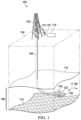
- FIG. 1is a schematic drawing of a method 100 for geosteering a well during directional drilling using electromagnetic (EM) communication to determine proximity to a water layer.
- EMelectromagnetic
- a drilling rig 102 at the surface 104is used to drill a wellbore 106 to a reservoir layer 108 .
- the reservoir layer 108is bounded by an upper layer 110 , such as a layer of cap rock, and a lower layer 112 , such as a layer containing water.
- the drilling rig 102is coupled to a roll of coiled tubing 114 , which is used for the drilling.
- a control shack 116may be coupled to the roll of coiled tubing 114 by a cable 118 that includes transducer power lines and other control lines.
- the cable 118may pass through the coiled tubing 114 , or alongside the coiled tubing 114 , to the end 120 of the wellbore 106 , where it couples to the BHA used for drilling the wellbore 106 .
- a cableis not used as the sensor packages and controllers are powered by batteries and communicate with the surface through other techniques, such as mud pulse telemetry (MPT), through drilling mud or other incompressible fluids flowing through the wellbore.
- MPTmud pulse telemetry
- EM communicators on the mandrelsallow communication of data from a first mandrel, closer to the drillbit at the end 120 of the wellbore, to pass data to a second mandrel farther from the drillbit.
- the first mandrelemits EM signals 122 that may be received by the second mandrel.
- the second mandrelemits EM signals 124 that may be received by the first mandrel.
- the second mandrelmay record the measurements in a local data store, relay the measurements to the surface, or both.
- a local controllermay calculate adjustments to the trajectory of the wellbore, and make the trajectory adjustments locally.
- Additional sensorsmay be used to measure the components and velocity of materials passing through the outer annulus of the wellbore 106 , for example, measuring velocity, phases, and the like. The trend of these measurements may be used to determine whether the BHA is within a producing zone of the reservoir layer 108 , has left the producing zone, or is approaching the lower layer 112 . This information, along with the information on the structure of the layers 110 and 112 , is used to adjust the vectors 126 to steer the wellbore 106 in the reservoir layer 108 back towards a product zone.
- the BHAmay be approaching the lower layer 112 .
- Other sensorssuch as EM sensors, may be used to confirm that. Accordingly, the vectors 126 may be adjusted to direct the BHA back towards a gas zone in the reservoir layer 108 .
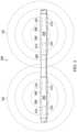
- FIG. 2is a drawing of an instrumented bottom hole assembly (BHA) 200 that may be used for geo-steering in directional drilling in coiled tubing drilling (CTD) using gas parameter measurements. Like numbered items are as described with respect to FIG. 1 .
- the BHA 200has two instrumented mandrels. A first mandrel 202 is located near a drillbit (not shown), and a second mandrel 204 is located further away from the drillbit, separated from the first mandrel 202 by a spacer pipe 206 . Although two instrumented mandrels are shown in FIG. 2 , more instrumented mandrel may be used.
- the two mandrels 202 and 204may communicate with each other, for example, through EM signals 122 and 124 linking EM antennae 208 on each of the mandrels 202 and 204 .
- Thisenables the communication system with the surface to be installed in only one of the mandrels.
- the second mandrel 204may be located farther from the drillbit, and may handle communication with the surface, using a mud pulse telemetry system.
- the first mandrel 202may be located closer to the drill bit, and send data to the second mandrel 204 to be sent to the surface.
- the use of two mandrelsallows determination of differences in location as the wellbore is being drilled.
- Sensor packages 210are mounted along each of the mandrels 202 and 204 , for example, in embedded slots formed in the outer surface of the mandrels 202 and 204 .
- the sensor packages 210may include multiple sensors assembled into a strings, or packets, of sensors, which are mounted in recesses along the mandrels.
- the sensorsmay include micro electro mechanical systems (MEMS) pressure sensors, temperature sensors, optical sensors, ultrasonic sensors, conductivity sensors, and the like.
- MEMSmicro electro mechanical systems
- the sensorsare available from OpenField Technologies of Paris, France (https://www.openfield-technology.com/).
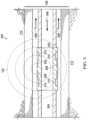
- FIG. 3is a schematic drawing 300 of fluid flow through a sensor equipped mandrel 302 . Like numbered items are as described with respect to FIG. 2 .
- drilling fluid 306 from the surfaceflows through the coil tubing line 304 in the direction of the drill bit.
- a mixture 308 of drilling fluid 306 and produced fluidsis returned to the surface through the annulus.
- the produced fluidsmay include gas, oil, and reservoir water.
- the EM antennae 208allow for communication with other mandrels, but also provide a detection system for determining the proximity of the mandrel 302 to a lower layer 112 containing water.
- the EM signals 122are blocked from entering the conductive water of the lower layer 112 , decreasing the signal to noise ratio of the communication. Locating multiple EM antennae 208 around the mandrel 302 may provide information on the distance to the water layer, as the antenna located on an opposite surface of the mandrel 302 from the lower layer 112 may not experience as large a decrease in signal to noise ratio.
- Sensor packages 210 along the mandrel 302may include an ultrasonic Doppler system to measure the velocity of fluid flow.
- an ultrasonic transduceris oriented to emit an ultrasonic wave into the fluid flow, which is reflected off bubbles or particles in the fluid flow.
- An ultrasonic detectorpicks up the reflected sound, and can be used to calculate the velocity from the frequency shift as particles or bubbles approach the detector.
- the ultrasonic Doppler systemcan also provide the information to determine the gas content of the two-phase stream in the annulus of the wellbore, for example, by quantitating the bubbles of an internal phase, and determining their size.
- a micro spinneris included to measure the flow velocity instead of, or in addition to, the Doppler measurement.
- the micro spinnermay use an electrical coil or a magnet to detect spinning rate, which is proportional to the flow rate.
- the sensor packages 210may include a MEMS pressure transducer to measure pressure outside of the mandrel 202 or 204 .
- a conductivity probemay be included to measure fluid conductivity at a high frequency, allowing a determination of hydrocarbon to water phase in a two-phase stream.
- the information from the sensor packages 210is combined with information from other geophysical measurements to assist in geosteering.
- seismic measurementsmay be used to determine probable locations of boundary layers 110 and 112 .
- geophysical modelsmay be generated and used with the data from the gas sensors.
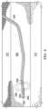
- FIG. 4is a schematic drawing of geosteering in a well. Like numbered items are as described with respect to FIGS. 1 - 3 .
- the separations of the sensors in the sensor packages 210 between the first mandrel 202 and the second mandrel 204provide a separation of measurements in space, allowing targeting to be performed based on the differences in the measurements between the mandrels 202 and 204 . For example, if the water measured in the mixture 308 at the first mandrel 202 , closer to the drillbit 402 , are higher than the water measured at the second mandrel 204 , it may indicate that the drillbit 402 is leaving the reservoir layer 108 . Accordingly, the trajectory of the well may be adjusted to bring the drillbit 402 back into the productive zone.
- the EM signals 406 that allow communication between the first mandrel 202 and the second mandrel 204are used for the determination of proximity to water layers. As shown in FIG. 4 , the EM signals 406 are blocked by the water in the lower layer 112 .
- the determination of the proximity of the mandrels 202 and 204 to the lower layer 112may be used as a sensor reading for geosteering the trajectory of the wellbore, as described herein. For example, if a mandrel 202 is determined to be too close to a water layer, the drillbit 402 may be steered away from the water layer.
- Trends over time of sensor readings at the mandrels 202 and 204may also be used for geosteering. For example, if the water measured at the first mandrel 202 increases, this may indicate that the drillbit 402 is nearing lower layer and the leaving the reservoir layer 108 .
- a telemetry package 404may also be located directly behind the drillbit 402 to provide further information about the location of the drillbit 402 . This may include seismic detectors and transducers that can locate the drillbit 402 in three-dimensional space.
- the telemetry datamay be transferred back to the surface directly from the telemetry package 404 , through mud pulse telemetry, fiber optical cables, or through other communications techniques.
- the telemetry package 404may communicate with the second mandrel 204 through electromagnetic waves and the second mandrel 204 may communicate the telemetry data to the surface, for example through mud pulse telemetry.
- FIG. 5is a process flow diagram of a method 500 for using EM communication between mandrels for geosteering in coiled tubing drilling.
- the methodbegins at block 502 , with communication with another mandrel.
- the communicationmay include the transfer of data relating to measurements of pressure, temperature, flow velocity, the amount of gas in the liquid fraction of the produced fluids, and the presence of conductive fluids, among others.
- the datamay be transferred to a single mandrel for storage or to be transferred to the surface.
- the signal-to-noise ratio in the EM signalsare determined.
- the change in the signal-to-noise ratiois used to determine a distance to a water layer.
- the distance to the water tableis calculated by sending a signal from a first antenna, for example, on a first mandrel, and detecting reflections at a second antenna, for example, at a second mandrel. The reflections may allow the determination of the distance to a water layer.
- the trend in the signal-to-noiseis determined.
- the analysis of the data during the trajectory of the drilling of the wellboreprovides the information that can be used to determine if the wellbore is being drilled in the targeted structural layer of the reservoir or is approaching a water layer.
- the signal-to-noise measurements and the trends in the signal-to-noise measurementsare integrated with other measurements from sensors mounted along the mandrels and a priori information of the area, including, for example, geological structural models and dynamic models of the area.
- Other measurements that may be used along with the signal-to-noise measurementsinclude acoustic measurements, measurements from cuttings, or flow measurements at the surface, to assess if the wellbore is still being drilled into an economically productive reservoir layer.
- adjustments to geosteering vectorsare determined.
- the information obtained from the combination of the signal-to-noise measurements, and the parameters measured by other sensors, along with trends and modeling parameters,may be used to determine adjustments to the geosteering vectors.
- the informationmay indicate that the wellbore needs to be steered to the right, left, up, or down.
- a mud motorcan be used to change the direction of the drillbit, thus changing the trajectory of the wellbore.
- the determination of the direction to steer the drillbitis based on the tool measurements and the knowledge of the geological setting.
- the signal-to-noise measurements of the EM communicationindicate the presence of water around the tool, this indicates that the BHA is proximate to the lower layer 112 , or water aquifer, and that steering the drillbit upward away from the water will increase the percentage of the hydrocarbon produced.
- the informationmay indicate that the wellbore has left the productive zone.
- the coiled tubingis removed to allow a completely different direction to be drilled.
- leaving the productive zoneindicates that the drilling is completed and further well completion activities may be performed to begin production, such as fracturing the rock around the well environment, installing casing, cementing the casing in place, perforating the casing, or positioning of production tubing in the wellbore, and the like, depending on the application and well environment.
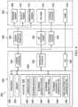
- FIG. 6is a block diagram of a system 600 that may be used for geosteering the BHA based, at least in part, on data from EM communication devices and sensors deployed on the BHA.
- the system 600includes a controller 602 and BHA sensors/actuators 604 that are coupled to the controller 602 through a number of sensor interfaces 606 .
- the BHA sensors/actuators 604include a pressure sensor 608 , a velocity sensor 610 , and a temperature sensor 612 .
- the pressure sensor 608may be a MEMS sensor.
- the velocity sensor 610may be an ultrasonic based Doppler sensor.
- the BHA sensors/actuators 604may include an electromagnetic (EM) communication device 614 , for example, used to communicate between mandrels.
- the EM communication device 614may also be used for sensing the presence of water proximate to the BHA, for example, by detecting a decrease in signal-to-noise ratio at the receiving mandrel from the broadcasting mandrel.
- multiple antennasmay be spaced around the mandrels providing directional determination of the water proximate to the BHA.
- a steering actuator 616may be a mud motor, hydraulic actuator, or other device used to redirect the drillbit.
- a communicator 618may be included in the BHA 604 to allow communication with the surface. The communicator 618 may be based on mud pulse telemetry. In some embodiments, the drilling fluid is compressed gas. In these embodiments, the communicator 618 may not be present as the compressibility of the drilling fluid prevents communication through mud pulse telemetry. In other embodiments, the communicator 618 is a digital interface to a wireline or optical line coupled to equipment at the surface through the coiled tubing line.
- the BHA sensors/actuators 604are coupled to the controller 602 through a number of different sensor interfaces 606 .
- a sensor interface and power bus 620may couple the pressure sensor 608 , the velocity sensor 610 , and the temperature sensor 612 to the controller 602 .
- the sensor interfaces 606generally provide power to the individual sensors, such as from a battery or a power line to the surface.
- the sensor interfaces 606may include an electromagnetic (EM) interface and power system 622 that provides power for the EM communication device 614 .
- the EM communication device 614may be located in a last mandrel, e.g., farthest from the drillbit along the BHA, allowing the last mandrel to provide communication through the communicator 618 to the surface.
- the steering actuator 616is powered by hydraulic lines or electric lines, for example, from the surface.
- a steering control unit 624provides the power or hydraulic actuation for the steering actuator 616 .
- the geo-steeringis performed by other techniques, such as the inclusion of bent subs in the BHA.
- the coiled tubing drilling apparatusis pulled from the wellbore to obtain log data from the controller 602 , and determine the trajectory changes to make.
- the controller 602may be a separate unit mounted in the control shack 116 ( FIG. 1 ), for example, as part of a programmable logic controller (PLC), a distributed control system (DCS), or another computer control unit used for controlling the drilling.
- the controller 602may be a virtual controller running on a processor in a DCS, on a virtual processor in a cloud server, or using other real or virtual processors.
- the controller 602is included in an instrument package attached to the BHA, for example, in a mandrel along with sensors. This embodiment may be used with gas as the drilling fluid, as communication to the surface may be limited. Further, embedding the controller 602 in the BHA may be used for LWD, in which the coiled tubing is pulled from the wellbore to retrieve the data.
- the controller 602includes a processor 626 .
- the processor 626may be a microprocessor, a multi-core processor, a multithreaded processor, an ultra-low-voltage processor, an embedded processor, or a virtual processor.
- the processor 626may be part of a system-on-a-chip (SoC) in which the processor 626 and the other components of the controller 602 are formed into a single integrated electronics package.
- SoCsystem-on-a-chip
- the processor 626may include processors from Intel® Corporation of Santa Clara, California, from Advanced Micro Devices, Inc. (AMD) of Sunnyvale, California, or from ARM Holdings, LTD., Of Cambridge, England. Any number of other processors from other suppliers may also be used.
- the processor 626may communicate with other components of the controller 602 over a bus 628 .
- the bus 628may include any number of technologies, such as industry standard architecture (ISA), extended ISA (EISA), peripheral component interconnect (PCI), peripheral component interconnect extended (PCIx), PCI express (PCIe), or any number of other technologies.
- ISAindustry standard architecture
- EISAextended ISA
- PCIperipheral component interconnect
- PCIxperipheral component interconnect extended
- PCIePCI express
- the bus 628may be a proprietary bus, for example, used in an SoC based system.
- Other bus technologiesmay be used, in addition to, or instead of, the technologies above.
- the interface systemsmay include I 2 C buses, serial peripheral interface (SPI) buses, Fieldbus, and the like.
- the bus 628may couple the processor 626 to a memory 630 , such as RAM, ROM, and the like.
- the memory 630is integrated with a data store 632 used for long-term storage of programs and data.
- the memory 630includes any number of volatile and nonvolatile memory devices, such as volatile random-access memory (RAM), static random-access memory (SRAM), flash memory, and the like.
- RAMvolatile random-access memory
- SRAMstatic random-access memory
- flash memoryand the like.
- the memory 630may include registers associated with the processor 626 itself.
- the data store 632is used for the persistent storage of information, such as data, applications, operating systems, and so forth.
- the data store 632may be a nonvolatile RAM, a solid-state disk drive, or a flash drive, among others.
- the data store 632will include a hard disk drive, such as a micro hard disk drive, a regular hard disk drive, or an array of hard disk drives, for example, associated with a DCS or a cloud server.
- the bus 628couples the processor 626 to a sensor interface 634 .
- the sensor interface 634is a data interface that couples the controller 602 to the sensor interface and power bus 620 .
- the sensor interface 634 and the sensor interface and power bus 620are combined into a single unit, such as in a universal serial bus (USB).
- USBuniversal serial bus
- the bus 628also couples the processor 626 to a controller interface 636 .
- the controller interface 636may be an interface to a plant bus, such as a Fieldbus, an I 2 C bus, an SPI bus, and the like.
- the controller interface 636may provide the data interface to the electromagnetic interface and power system 622 and the steering control unit 624 .
- the bus 628couples the processor 626 to a network interface controller (NIC) 638 .
- NICnetwork interface controller
- the NIC 638couples the controller 602 to the communicator 618 , for example, if the controller 602 is located in the BHA 604 .
- the data store 632includes a number of blocks of code that include instructions that, when executed, direct the processor to carry out the functions described herein.
- the data store 632includes a code block 640 to instruct the processor to control communication, for example, between mandrels with the EM communication device 614 , or between the controller and a surface device using the communication device 618 .
- the data store 632includes a code block 642 to instruct the processor 626 to determine the signal-to-noise ratio of the communication received by the EM communication device.
- a code block 644instructs the processor 626 to determine the distance to water proximate to the BHA. This may be performed by comparing the signal-to-noise ratio of communication performed over the EM communication device 614 to standards or trends. As described herein, at block 646 , the trends in the distance to water are determined.
- the data store 632includes a code block 648 to instruct the processor 626 to determine adjustments to the steering vector based on the measurements, including the distance to water and other measurements, trends in the measurements, and geophysical data or models.
- a code block 650may be included to direct the processor 626 to automatically make the adjustments to the steering vector, for example, if the drilling fluid is a gas that makes communication to the surface difficult by mud pulse telemetry.
- the code blocks described abovemay be in different combinations of code to implement the functions described herein. Further, the data store 632 may include other code blocks to add additional functionality. For example, a code block may be included to instruct the processor to measure sensor responses, for example, from the pressure sensor 608 , the velocity sensor 610 , and the temperature sensor 612 . A code block may be included to instruct the processor 626 to determine gas parameters from the measurements. As described herein, the gas parameters may include hydrocarbon content of flowing fluids, gas content in flowing fluids, flow velocity, and the like. The determination is made for each mandrel and a difference between the measurements for the mandrels is calculated. A code block may be included to instruct the processor 626 to determine trends in the gas parameters.
- An embodiment described hereinprovides a method for geosteering in directional drilling.
- the methodincludes determining a signal-to-noise ratio (SNR) for an electromagnetic communication between devices on a bottom hole assembly, and determining a distance to water based, at least in part, on the SNR. Adjustments to geosteering vectors for the bottom hole assembly are determined based, at least in part, on the distance to water.
- SNRsignal-to-noise ratio
- the electromagnetic communicationis performed between instrumented mandrels on the bottom hole assembly.
- the methodincludes determining a trend in the distance to water. In an aspect, the method includes determining the adjustments to the geosteering vectors for the bottom hole assembly based, at least in part, on the trend in the distance to water.
- the methodincludes determining the adjustments to the geosteering vectors for the bottom hole assembly based, at least in part, on a geophysical model.
- the methodincludes communicating measurements from a first mandrel to a second mandrel and logging the measurements in a data store in the second mandrel. In an aspect, the method includes transmitting the measurements to a surface facility from the second mandrel.
- the methodincludes drilling a wellbore in an underbalanced condition using a coiled tubing drilling apparatus.
- the methodincludes making the adjustments to the geosteering vectors to change a trajectory of a wellbore. In an aspect, the method includes making the adjustments to the geosteering vectors in a controller in the bottom hole assembly.
- the methodincludes measuring temperature. In an aspect, the method includes measuring a hydrocarbon content in a two phase stream. In an aspect, the method includes measuring a gas content in a two-phase stream. In an aspect, the method includes measuring flow velocity. In an aspect, the method includes measuring pressure.
- the bottom hole assemblyincludes a coiled tubing drilling apparatus and at least two mandrels mounted on the coiled tubing drilling apparatus, wherein each mandrel comprises an electromagnetic communication device.
- a controlleris included to determine a distance to a water layer based, at least in part, on electromagnetic communications between the at least two mandrels.
- the systemincludes a drill bit.
- the controllerdetermines the distance based on a reflection of the electromagnetic communication from a water layer. In an aspect, the controller determines the distance based on a reflection of the electromagnetic communication from a water layer. In an aspect, the system includes a sealed surface system to allow the coiled tubing drilling apparatus to drill in an underbalanced configuration.
- the systemincludes a pressure sensor. In an aspect, the system includes a velocity sensor. In an aspect, the system includes a temperature sensor. In an aspect, the system includes a conductivity probe. In an aspect, the system includes a mud pulse telemetry system.
- the systemincludes a steering actuator to change a direction of the bottom hole assembly.
- the controllerincludes a processor and a data store, wherein the data store comprises instructions that, when executed, direct the processor to determine a signal-to-noise ratio (SNR) for an electromagnetic communication between devices on a bottom hole assembly.
- the data storealso comprises instructions that, when executed, direct the processor to determine a distance to water-based, at least in part, on the SNR, and determine adjustments to geosteering vectors for the bottom hole assembly based, at least in part, on the distance to water.
- the data storecomprises instructions that, when executed, direct the processor to make adjustments to the geosteering vectors.
Landscapes
- Engineering & Computer Science (AREA)
- Life Sciences & Earth Sciences (AREA)
- Geology (AREA)
- Mining & Mineral Resources (AREA)
- Physics & Mathematics (AREA)
- General Life Sciences & Earth Sciences (AREA)
- Environmental & Geological Engineering (AREA)
- Fluid Mechanics (AREA)
- Geochemistry & Mineralogy (AREA)
- Geophysics (AREA)
- Remote Sensing (AREA)
- Mechanical Engineering (AREA)
- Electromagnetism (AREA)
- General Physics & Mathematics (AREA)
- Earth Drilling (AREA)
- Geophysics And Detection Of Objects (AREA)
Abstract
Description
Claims (25)
Applications Claiming Priority (1)
| Application Number | Priority Date | Filing Date | Title |
|---|---|---|---|
| PCT/IB2020/000529WO2021240196A1 (en) | 2020-05-26 | 2020-05-26 | Water detection for geosteering in directional drilling |
Publications (2)
| Publication Number | Publication Date |
|---|---|
| US20220307372A1 US20220307372A1 (en) | 2022-09-29 |
| US12000277B2true US12000277B2 (en) | 2024-06-04 |
Family
ID=71662127
Family Applications (1)
| Application Number | Title | Priority Date | Filing Date |
|---|---|---|---|
| US17/290,051Active2041-05-15US12000277B2 (en) | 2020-05-26 | 2020-05-26 | Water detection for geosteering in directional drilling |
Country Status (4)
| Country | Link |
|---|---|
| US (1) | US12000277B2 (en) |
| EP (1) | EP4158154A1 (en) |
| SA (1) | SA522441435B1 (en) |
| WO (1) | WO2021240196A1 (en) |
Families Citing this family (1)
| Publication number | Priority date | Publication date | Assignee | Title |
|---|---|---|---|---|
| EP4158144A1 (en) | 2020-05-26 | 2023-04-05 | Saudi Arabian Oil Company | Geosteering in directional drilling |
Citations (152)
| Publication number | Priority date | Publication date | Assignee | Title |
|---|---|---|---|---|
| US3292143A (en) | 1963-03-08 | 1966-12-13 | William L Russell | Method and apparatus for geophysical exploration utilizing variation in amplitude attenuation of different frequencies |
| US4676313A (en) | 1985-10-30 | 1987-06-30 | Rinaldi Roger E | Controlled reservoir production |
| US5128901A (en) | 1988-04-21 | 1992-07-07 | Teleco Oilfield Services Inc. | Acoustic data transmission through a drillstring |
| US5151658A (en) | 1989-12-29 | 1992-09-29 | Chinetsu Gijutsu Kaihatsu Kabushiki Kaisha | Three-dimensional detection system for detecting fractures and their distributions in the earth crust utilizing an artificial magnetic field and magnetic particle tracer |
| US5176207A (en) | 1989-08-30 | 1993-01-05 | Science & Engineering, Inc. | Underground instrumentation emplacement system |
| US5753812A (en) | 1995-12-07 | 1998-05-19 | Schlumberger Technology Corporation | Transducer for sonic logging-while-drilling |
| US5854991A (en) | 1996-07-26 | 1998-12-29 | Western Atlas International, Inc. | Method for inversion processing of transverse electromagnetic induction well logging measurements |
| US5876645A (en) | 1995-06-17 | 1999-03-02 | Applied Felts Limited | Impregnation of liners |
| US5877995A (en) | 1991-05-06 | 1999-03-02 | Exxon Production Research Company | Geophysical prospecting |
| US5886303A (en) | 1997-10-20 | 1999-03-23 | Dresser Industries, Inc. | Method and apparatus for cancellation of unwanted signals in MWD acoustic tools |
| US6026900A (en) | 1998-06-15 | 2000-02-22 | Keller; Carl E. | Multiple liner method for borehole access |
| US20010017163A1 (en) | 2000-10-05 | 2001-08-30 | Penza G. Gregory | Communications conduit installation and conduit-containing product suitable for use therein |
| US6283209B1 (en) | 1999-02-16 | 2001-09-04 | Carl E. Keller | Flexible liner system for borehole instrumentation and sampling |
| US20020029907A1 (en)* | 1999-12-06 | 2002-03-14 | Precision Drilling Corporation | Coiled tubing drilling rig |
| US6739165B1 (en) | 2003-02-05 | 2004-05-25 | Kjt Enterprises, Inc. | Combined surface and wellbore electromagnetic measurement system and method for determining formation fluid properties |
| US6740141B2 (en) | 2001-02-23 | 2004-05-25 | Intevep, S.A. | Method for removing H2S and CO2 from above ground hydrocarbon streams |
| US20040108110A1 (en) | 1998-11-20 | 2004-06-10 | Zupanick Joseph A. | Method and system for accessing subterranean deposits from the surface and tools therefor |
| US20040246141A1 (en) | 2003-06-03 | 2004-12-09 | Tubel Paulo S. | Methods and apparatus for through tubing deployment, monitoring and operation of wireless systems |
| US20050034917A1 (en) | 2003-08-14 | 2005-02-17 | Baker Hughes Incorporated | Apparatus and method for acoustic position logging ahead-of-the-bit |
| US20050078555A1 (en) | 2000-11-13 | 2005-04-14 | Baker Hughes Incorporated | Method and apparatus for LWD shear velocity measurement |
| US20050252286A1 (en) | 2004-05-12 | 2005-11-17 | Ibrahim Emad B | Method and system for reservoir characterization in connection with drilling operations |
| WO2005119303A1 (en) | 2004-05-28 | 2005-12-15 | Baker Hughes Incorporated | Method for determining formation porosity and gas saturation in a gas reservoir |
| US20060044940A1 (en) | 2004-09-01 | 2006-03-02 | Hall David R | High-speed, downhole, seismic measurement system |
| US20060104578A1 (en) | 2004-11-13 | 2006-05-18 | Alcoa Inc. | Fiber optic cable with miniature bend incorporated |
| WO2006059057A1 (en) | 2004-12-02 | 2006-06-08 | Halliburton Energy Services, Inc | Hydrocarbon sweep into horizontal transverse fractured wells |
| US7093672B2 (en) | 2003-02-11 | 2006-08-22 | Schlumberger Technology Corporation | Systems for deep resistivity while drilling for proactive geosteering |
| EP1803001A1 (en) | 2004-10-13 | 2007-07-04 | Geocontrast AS | Method for hydrocarbon reservoir monitoring |
| US20070246649A1 (en) | 2006-04-19 | 2007-10-25 | Baker Hughes Incorporated | Methods for quantitative lithological and mineralogical evaluation of subsurface formations |
| US20070256832A1 (en) | 2006-05-04 | 2007-11-08 | Teruhiko Hagiwara | Method of analyzing a subterranean formation and method of producing a mineral hydrocarbon fluid from the formation |
| US20080066960A1 (en) | 2006-09-15 | 2008-03-20 | Baker Hughes Incorporated | Fiber Optic Sensors in MWD Applications |
| US7376517B2 (en) | 2005-05-13 | 2008-05-20 | Chevron U.S.A. Inc. | Method for estimation of interval seismic quality factor |
| US20080257546A1 (en) | 2006-09-20 | 2008-10-23 | Baker Hughes Incorporated | Autonomous Downhole Control Methods and Devices |
| US20080290874A1 (en) | 2007-05-25 | 2008-11-27 | Schlumberger Technology Corporation | Applications of wideband em measurements for determining reservoir formation properties |
| US20090087911A1 (en) | 2007-09-28 | 2009-04-02 | Schlumberger Technology Corporation | Coded optical emission particles for subsurface use |
| US20090164188A1 (en) | 2007-12-21 | 2009-06-25 | Tarek Habashy | Method for upscaling a reservoir model using deep reading measurements |
| US7595737B2 (en) | 2006-07-24 | 2009-09-29 | Halliburton Energy Services, Inc. | Shear coupled acoustic telemetry system |
| US20090288820A1 (en) | 2008-05-20 | 2009-11-26 | Oxane Materials, Inc. | Method Of Manufacture And The Use Of A Functional Proppant For Determination Of Subterranean Fracture Geometries |
| US20100025110A1 (en)* | 2008-07-31 | 2010-02-04 | Baker Hughes Incorporated | System and method for controlling the integrity of a drilling system |
| US20100109672A1 (en) | 2008-11-03 | 2010-05-06 | Baker Hughes Incorporated | Transient EM for Geosteering and LWD/Wireline Formation Evaluation |
| US7721803B2 (en) | 2007-10-31 | 2010-05-25 | Baker Hughes Incorporated | Nano-sized particle-coated proppants for formation fines fixation in proppant packs |
| US20100132448A1 (en) | 2008-12-02 | 2010-06-03 | Schlumberger Technology Corporation | Method of determining saturations in a reservoir |
| US20100198519A1 (en) | 2009-02-05 | 2010-08-05 | Schlumberger Technology Corporation | Deep-reading electromagnetic data acquisition method |
| US20100200248A1 (en) | 2007-10-23 | 2010-08-12 | Petrus Cornelis Kriesels | Method of radially expanding a tubular element in a wellbore provided with a control line |
| US20100296100A1 (en) | 2009-05-21 | 2010-11-25 | Celekt, Inc. | Fiber optic gyroscope arrangements and methods |
| WO2010135584A2 (en) | 2009-05-20 | 2010-11-25 | Halliburton Energy Services, Inc. | Downhole sensor tool with a sealed sensor outsert |
| US20110042083A1 (en) | 2009-08-20 | 2011-02-24 | Halliburton Energy Services, Inc. | Method of improving waterflood performance using barrier fractures and inflow control devices |
| US7913806B2 (en) | 2005-05-10 | 2011-03-29 | Schlumberger Technology Corporation | Enclosures for containing transducers and electronics on a downhole tool |
| US20110088895A1 (en) | 2008-05-22 | 2011-04-21 | Pop Julian J | Downhole measurement of formation characteristics while drilling |
| US7991555B2 (en) | 2008-07-30 | 2011-08-02 | Schlumberger Technology Corporation | Electromagnetic directional measurements for non-parallel bed formations |
| WO2011129828A1 (en) | 2010-04-15 | 2011-10-20 | Halliburton Energy Services, Inc. | Processing and geosteering with a rotating tool |
| US8069913B2 (en) | 2008-03-26 | 2011-12-06 | Schlumberger Technology Corporation | Method and apparatus for detecting acoustic activity in a subsurface formation |
| US20110309835A1 (en) | 2010-06-17 | 2011-12-22 | Barber Thomas D | Method for determining spatial distribution of fluid injected into subsurface rock formations |
| US8090538B2 (en) | 2008-05-01 | 2012-01-03 | Chevron U.S.A. Inc | System and method for interpretation of well data |
| US20120016649A1 (en) | 2010-07-16 | 2012-01-19 | Schlumberger Technology Corporation | System and method for controlling an advancing fluid front of a reservoir |
| US20120062886A1 (en) | 2009-05-18 | 2012-03-15 | Cabot Security Materials Inc. | Thermally Stable SERS Taggants |
| US20120111561A1 (en) | 2010-10-06 | 2012-05-10 | Frey Mark T | Systems and Methods for Detecting Phases in Multiphase Borehole Fluids |
| US8215384B2 (en) | 2008-11-10 | 2012-07-10 | Baker Hughes Incorporated | Bit based formation evaluation and drill bit and drill string analysis using an acoustic sensor |
| US20120178653A1 (en) | 2010-10-28 | 2012-07-12 | Mcclung Iii Guy L | Fraccing fluid with unique signature identifier and fluids and flow streams with identifier |
| US8230918B2 (en) | 2007-05-24 | 2012-07-31 | Saudi Arabian Oil Company | Method of characterizing hydrocarbon reservoir fractures in situ with artificially enhanced magnetic anisotropy |
| US8253417B2 (en) | 2008-04-11 | 2012-08-28 | Baker Hughes Incorporated | Electrolocation apparatus and methods for mapping from a subterranean well |
| WO2012115717A2 (en) | 2011-02-24 | 2012-08-30 | Mcclung Guy L Iii | Nanotag indentification systems and methods |
| US8269501B2 (en) | 2008-01-08 | 2012-09-18 | William Marsh Rice University | Methods for magnetic imaging of geological structures |
| US20120253680A1 (en) | 2011-03-30 | 2012-10-04 | Hunt Energy Enterprises, Llc | Method and System for Passive Electroseismic Surveying |
| GB2489714A (en) | 2011-04-05 | 2012-10-10 | Tracesa Ltd | Fluid identification system comprising encapsulated DNA |
| US20120268135A1 (en) | 2011-04-20 | 2012-10-25 | BGP Arabia Co., Ltd. | Borehole to Surface Electromagnetic Transmitter |
| US20120325465A1 (en) | 2011-06-23 | 2012-12-27 | Baker Hughes Incorporated | Estimating drill cutting origination depth using marking agents |
| US8347985B2 (en) | 2008-04-25 | 2013-01-08 | Halliburton Energy Services, Inc. | Mulitmodal geosteering systems and methods |
| US20130091941A1 (en) | 2009-11-17 | 2013-04-18 | Board Of Regents, The University Of Texas System | Determination of oil saturation in reservoir rock using paramagnetic nanoparticles and magnetic field |
| US8424377B2 (en) | 2009-06-17 | 2013-04-23 | Carl E. Keller | Monitoring the water tables in multi-level ground water sampling systems |
| CA2851237A1 (en) | 2011-10-31 | 2013-05-10 | Halliburton Energy Services, Inc. | Nanoparticle smart tags in subterranean applications |
| CA2856274A1 (en) | 2011-11-21 | 2013-05-30 | The Gates Corporation | Transmission belt |
| US20130284434A1 (en)* | 2012-04-30 | 2013-10-31 | Halliburton Energy Services, Inc. | System and Method of Coiled Tubing Depth Determination |
| US20140041862A1 (en) | 2012-08-07 | 2014-02-13 | Halliburton Energy Services, Inc. | Use of Magnetic Liquids for Imaging and Mapping Porous Subterranean Formations |
| US8664586B2 (en) | 2011-12-08 | 2014-03-04 | Saudi Arabian Oil Company | Super-resolution formation fluid imaging |
| WO2014051789A1 (en) | 2012-09-28 | 2014-04-03 | Intel Corporation | Mobile device based ultra-violet (uv) radiation sensing |
| WO2014058425A1 (en) | 2012-10-11 | 2014-04-17 | Halliburton Energy Services, Inc. | Fracture sensing system and method |
| WO2014060562A1 (en) | 2012-10-17 | 2014-04-24 | Cathx Research Ltd | Improvements in relation to underwater imaging for underwater surveys |
| US8726983B2 (en) | 2008-03-19 | 2014-05-20 | Schlumberger Technology Corporation | Method and apparatus for performing wireline logging operations in an under-balanced well |
| US20140180658A1 (en) | 2012-09-04 | 2014-06-26 | Schlumberger Technology Corporation | Model-driven surveillance and diagnostics |
| US20140180592A1 (en) | 2012-12-22 | 2014-06-26 | Halliburton Energy Services, Inc. ("HESI") | Downhole Fluid Tracking With Distributed Acoustic Sensing |
| US20140208843A1 (en) | 2011-08-26 | 2014-07-31 | Optasense Holdings Limited | Determining Perforation Orientation |
| US20140239957A1 (en) | 2011-07-19 | 2014-08-28 | Schlumberger Technology Corporation | Using Low Frequency For Detecting Formation Structures Filled With Magnetic Fluid |
| WO2014144917A1 (en) | 2013-03-15 | 2014-09-18 | Board Of Regents, The University Of Texas System | Reservoir characterization and hydraulic fracture evaluation |
| US20140361777A1 (en) | 2013-06-10 | 2014-12-11 | Groundmetrics, Inc. | Sensor for measuring the electromagnetic fields on land and underwater |
| WO2014207075A2 (en) | 2013-06-26 | 2014-12-31 | Cgg Services Sa | Doping of drilling mud with a mineralogical compound |
| US8931347B2 (en) | 2011-12-09 | 2015-01-13 | Openfield Sas | Fluid pressure sensor and measurement probe |
| WO2015016932A1 (en) | 2013-08-01 | 2015-02-05 | Landmark Graphics Corporation | Algorithm for optimal icd configuration using a coupled wellbore-reservoir model |
| WO2015027084A1 (en) | 2013-08-22 | 2015-02-26 | Baker Hughes Incorporated | Aqueous downhole fluids having charged nano-particles and polymers |
| US20150061684A1 (en) | 2013-08-29 | 2015-03-05 | Groundmetrics, Inc. | Borehole electric field survey with improved discrimination of subsurface features |
| US20150061683A1 (en) | 2013-08-29 | 2015-03-05 | Groundmetrics, Inc. | Mapping resistivity distribution within the earth |
| US8976625B2 (en) | 2010-10-28 | 2015-03-10 | Baker Hughes Incorporated | Optimization approach to Q-factor estimation from VSP data |
| US8997868B2 (en) | 2012-06-21 | 2015-04-07 | Halliburton Energy Services, Inc. | Methods of using nanoparticle suspension aids in subterranean operations |
| US9002649B2 (en) | 2010-07-16 | 2015-04-07 | Halliburton Energy Services, Inc. | Efficient inversion systems and methods for directionally-sensitive resistivity logging tools |
| US20150132543A1 (en) | 2011-11-30 | 2015-05-14 | Sicpa Holding Sa | Marked coating composition and method for its authentication |
| US9080097B2 (en) | 2010-05-28 | 2015-07-14 | Baker Hughes Incorporated | Well servicing fluid |
| US20150204993A1 (en) | 2014-01-09 | 2015-07-23 | Baker Hughes Incorporated | Devices and methods for downhole acoustic imaging |
| US20150232748A1 (en) | 2011-05-13 | 2015-08-20 | Saudi Arabian Oil Company | Carbon-based fluorescent tracers as oil reservoir nano-agents |
| US9128203B2 (en) | 2011-09-28 | 2015-09-08 | Saudi Arabian Oil Company | Reservoir properties prediction with least square support vector machine |
| WO2015167935A1 (en) | 2014-05-01 | 2015-11-05 | Halliburton Energy Services, Inc. | Multilateral production control methods and systems employing a casing segment with at least one transmission crossover arrangement |
| WO2015187142A1 (en) | 2014-06-04 | 2015-12-10 | Halliburton Energy Services, Inc. | Using seismic data to determine wellbore location while drilling |
| WO2015192226A1 (en) | 2014-06-18 | 2015-12-23 | Evolution Engineering Inc. | Measuring while drilling systems, method and apparatus |
| US20150370934A1 (en) | 2014-06-24 | 2015-12-24 | Schlumberger Technology Corporation | Completion design based on logging while drilling (lwd) data |
| EP2966257A1 (en) | 2008-05-22 | 2016-01-13 | Schlumberger Holdings Limited | Method and system to form a well |
| US20160041296A1 (en) | 2014-08-08 | 2016-02-11 | Halliburton Energy Services, Inc. | Ranging measurement apparatus, methods, and systems |
| US9260957B2 (en) | 2009-12-24 | 2016-02-16 | Total Sa | Use of nanoparticles for labelling oil field injection waters |
| US9274249B2 (en) | 2012-06-05 | 2016-03-01 | Chevron U.S.A. Inc. | System and method for facies classification |
| US20160138390A1 (en) | 2013-06-06 | 2016-05-19 | Norwegian University Of Science And Technology (Ntnu) | Drilling Method and Apparatus |
| US20160259079A1 (en) | 2013-12-17 | 2016-09-08 | Halliburton Energy Services Inc. | Distributed Acoustic Sensing for Passive Ranging |
| US20160282881A1 (en) | 2013-11-15 | 2016-09-29 | Landmark Graphics Corporation | Optimizing flow control device properties on both producer and injector wells in coupled injector-producer liquid flooding systems |
| US20160291194A1 (en) | 2015-03-30 | 2016-10-06 | Saudi Arabian Oil Company | Monitoring hydrocarbon reservoirs using induced polarization effect |
| US9494033B2 (en) | 2012-06-22 | 2016-11-15 | Intelliserv, Llc | Apparatus and method for kick detection using acoustic sensors |
| WO2016200374A1 (en) | 2015-06-09 | 2016-12-15 | Halliburton Energy Services, Inc. | Watermelon mill |
| US9557434B2 (en) | 2012-12-19 | 2017-01-31 | Exxonmobil Upstream Research Company | Apparatus and method for detecting fracture geometry using acoustic telemetry |
| US20170059668A1 (en) | 2015-08-31 | 2017-03-02 | Ching-Ray Chang | Single bridge magnetic field sensor |
| US9644472B2 (en) | 2014-01-21 | 2017-05-09 | Baker Hughes Incorporated | Remote pressure readout while deploying and undeploying coiled tubing and other well tools |
| US9689253B2 (en) | 2013-02-21 | 2017-06-27 | Schlumberger Technology Corporation | Use of nanotracers for imaging and/or monitoring fluid flow and improved oil recovery |
| US9733191B2 (en) | 2011-11-15 | 2017-08-15 | Halliburton Energy Services, Inc. | Directing a drilling operation using an optical computation element |
| US20170314385A1 (en) | 2016-04-28 | 2017-11-02 | Schlumberger Technology Corporation | System and methodology for acoustic measurement driven geo-steering |
| US20170351000A1 (en) | 2011-04-20 | 2017-12-07 | Saudi Arabian Oil Company | Computer processing of borehole to surface electromagnetic transmitter survey data |
| US9863244B2 (en) | 2016-01-08 | 2018-01-09 | Openfield | Downhole fluid properties analysis probe, tool and method |
| US20180066515A1 (en) | 2016-09-02 | 2018-03-08 | Saudi Arabian Oil Company | Controlling Hydrocarbon Production |
| US9952192B2 (en) | 2014-03-28 | 2018-04-24 | Openfield SA | Probe, sonde and method for producing signals indicative of local phase composition of a fluid |
| US20180128937A1 (en) | 2016-11-08 | 2018-05-10 | Openfield SA | Downhole optical chemical compound monitoring device, bottom hole assembly and measurements-while-drilling tool comprising the same, and method of optically monitoring chemical compound downhole during drilling |
| WO2018085504A1 (en) | 2016-11-07 | 2018-05-11 | Saudi Arabian Oil Company | Polymeric tracers and method of detection using pyrolysis |
| US10030486B1 (en) | 2015-06-22 | 2018-07-24 | Carl E. Keller | Method for installation or removal of flexible liners from boreholes |
| US10095983B1 (en) | 2013-11-13 | 2018-10-09 | DataInfoCom USA, Inc. | System and method for well trace analysis |
| US20180320514A1 (en) | 2016-08-18 | 2018-11-08 | Seismos Inc. | Method for evaluating and monitoring formation fracture treatment using fluid pressure waves |
| US10125546B2 (en) | 2013-05-02 | 2018-11-13 | Halliburton Energy Services, Inc. | Apparatus and methods for geosteering |
| US20180347349A1 (en) | 2017-05-31 | 2018-12-06 | Saudi Arabian Oil Company | Acoustic coupler for downhole logging while drilling applications |
| GB2563739A (en) | 2017-06-20 | 2018-12-26 | Halliburton Energy Services Inc | Methods and systems with downhole synchronization based on a direct digital synthesizer (DDS) |
| WO2018234431A1 (en) | 2017-06-21 | 2018-12-27 | Universite De Strasbourg | FLUORESCENT POLYMERIC NANOPARTICLES CHARGED WITH DYES AS NANO-ANTENNA |
| US20190003303A1 (en) | 2017-06-29 | 2019-01-03 | Openfield SA | Downhole local solid particles counting probe, production logging tool comprising the same and sand entry investigation method for hydrocarbon wells |
| US10254430B2 (en) | 2016-03-17 | 2019-04-09 | Baker Hughes, A Ge Company, Llc | Downhole deep transient measurements with improved sensors |
| US20190107643A1 (en) | 2017-10-11 | 2019-04-11 | Beyond Limits, Inc. | Static engine and neural network for a cognitive reservoir system |
| US10288755B2 (en) | 2017-03-28 | 2019-05-14 | Saudi Arabian Oil Company | Seismic processing workflow for broadband single-sensor single-source land seismic data |
| US10294771B2 (en) | 2016-07-02 | 2019-05-21 | Openfield | Production logging tool and downhole fluid analysis probes deploying method, in particular for deviated and horizontal hydrocarbon well |
| US20190169975A1 (en) | 2017-12-01 | 2019-06-06 | Saudi Arabian Oil Company | Ring assembly for measurement while drilling, logging while drilling and well intervention |
| US20190266501A1 (en) | 2018-02-27 | 2019-08-29 | Cgg Services Sas | System and method for predicting mineralogical, textural, petrophysical and elastic properties at locations without rock samples |
| US20190293814A1 (en) | 2018-03-20 | 2019-09-26 | Chevron U.S.A. Inc. | Determining anisotropy for a build section of a wellbore |
| US20190339408A1 (en) | 2018-05-04 | 2019-11-07 | Chevron U.S.A. Inc. | Correcting a digital seismic image using a function of speed of sound in water derived from fiber optic sensing |
| US10472951B2 (en) | 2015-07-13 | 2019-11-12 | Openfield | Downhole acoustic transducer, downhole probe and tool comprising such a transducer |
| US20190368336A1 (en) | 2016-10-21 | 2019-12-05 | Schlumberger Technology Corporation | Method and system for determining depths of drill cuttings |
| US20190376821A1 (en) | 2018-06-07 | 2019-12-12 | Openfield | Mini-spinner flowmeter and downhole tool comprising an array of mini-spinner flowmeters for operation in hydrocarbon well |
| US20190391034A1 (en) | 2018-06-21 | 2019-12-26 | Saudi Arabian Oil Company | Industrial gas detection |
| US10527751B2 (en) | 2016-02-01 | 2020-01-07 | Openfield | Downhole fluid properties optical analysis probe having a removable optical tip |
| US20200030777A1 (en) | 2018-07-30 | 2020-01-30 | Saudi Arabian Oil Company | Catalysts that include iron, cobalt, and copper, and methods for making the same |
| US20200031738A1 (en) | 2018-07-30 | 2020-01-30 | Saudi Arabian Oil Company | Methods for forming ethylbenzene from polystyrene |
| US20200032148A1 (en) | 2018-07-30 | 2020-01-30 | Saudi Arabian Oil Company | Methods for catalytically converting petroleum hydrocarbons |
| US20200034711A1 (en) | 2018-07-23 | 2020-01-30 | The Board Of Regents Of The University Of Oklahoma | Synthesis of Sequential, Spectral, and Time-Series Data |
| US20200116019A1 (en) | 2018-10-15 | 2020-04-16 | Saudi Arabian Oil Company | Surface logging wells using depth-tagging of cuttings |
| US20200208513A1 (en) | 2018-12-28 | 2020-07-02 | Saudi Arabian Oil Company | Systems and methods for logging while treating |
| US20220307337A1 (en) | 2020-05-26 | 2022-09-29 | Saudi Arabian Oil Company | Geosteering in directional drilling |
- 2020
- 2020-05-26WOPCT/IB2020/000529patent/WO2021240196A1/ennot_activeCeased
- 2020-05-26EPEP20742434.2Apatent/EP4158154A1/ennot_activeWithdrawn
- 2020-05-26USUS17/290,051patent/US12000277B2/enactiveActive
- 2022
- 2022-11-24SASA522441435Apatent/SA522441435B1/enunknown
Patent Citations (186)
| Publication number | Priority date | Publication date | Assignee | Title |
|---|---|---|---|---|
| US3292143A (en) | 1963-03-08 | 1966-12-13 | William L Russell | Method and apparatus for geophysical exploration utilizing variation in amplitude attenuation of different frequencies |
| US4676313A (en) | 1985-10-30 | 1987-06-30 | Rinaldi Roger E | Controlled reservoir production |
| US5128901A (en) | 1988-04-21 | 1992-07-07 | Teleco Oilfield Services Inc. | Acoustic data transmission through a drillstring |
| US5176207A (en) | 1989-08-30 | 1993-01-05 | Science & Engineering, Inc. | Underground instrumentation emplacement system |
| US5151658A (en) | 1989-12-29 | 1992-09-29 | Chinetsu Gijutsu Kaihatsu Kabushiki Kaisha | Three-dimensional detection system for detecting fractures and their distributions in the earth crust utilizing an artificial magnetic field and magnetic particle tracer |
| US5877995A (en) | 1991-05-06 | 1999-03-02 | Exxon Production Research Company | Geophysical prospecting |
| US5876645A (en) | 1995-06-17 | 1999-03-02 | Applied Felts Limited | Impregnation of liners |
| US5753812A (en) | 1995-12-07 | 1998-05-19 | Schlumberger Technology Corporation | Transducer for sonic logging-while-drilling |
| US5854991A (en) | 1996-07-26 | 1998-12-29 | Western Atlas International, Inc. | Method for inversion processing of transverse electromagnetic induction well logging measurements |
| US5886303A (en) | 1997-10-20 | 1999-03-23 | Dresser Industries, Inc. | Method and apparatus for cancellation of unwanted signals in MWD acoustic tools |
| US6026900A (en) | 1998-06-15 | 2000-02-22 | Keller; Carl E. | Multiple liner method for borehole access |
| US20040108110A1 (en) | 1998-11-20 | 2004-06-10 | Zupanick Joseph A. | Method and system for accessing subterranean deposits from the surface and tools therefor |
| US6283209B1 (en) | 1999-02-16 | 2001-09-04 | Carl E. Keller | Flexible liner system for borehole instrumentation and sampling |
| US20020029907A1 (en)* | 1999-12-06 | 2002-03-14 | Precision Drilling Corporation | Coiled tubing drilling rig |
| US20010017163A1 (en) | 2000-10-05 | 2001-08-30 | Penza G. Gregory | Communications conduit installation and conduit-containing product suitable for use therein |
| US20050078555A1 (en) | 2000-11-13 | 2005-04-14 | Baker Hughes Incorporated | Method and apparatus for LWD shear velocity measurement |
| US6740141B2 (en) | 2001-02-23 | 2004-05-25 | Intevep, S.A. | Method for removing H2S and CO2 from above ground hydrocarbon streams |
| US6739165B1 (en) | 2003-02-05 | 2004-05-25 | Kjt Enterprises, Inc. | Combined surface and wellbore electromagnetic measurement system and method for determining formation fluid properties |
| US7093672B2 (en) | 2003-02-11 | 2006-08-22 | Schlumberger Technology Corporation | Systems for deep resistivity while drilling for proactive geosteering |
| US20040246141A1 (en) | 2003-06-03 | 2004-12-09 | Tubel Paulo S. | Methods and apparatus for through tubing deployment, monitoring and operation of wireless systems |
| US20050034917A1 (en) | 2003-08-14 | 2005-02-17 | Baker Hughes Incorporated | Apparatus and method for acoustic position logging ahead-of-the-bit |
| US20050252286A1 (en) | 2004-05-12 | 2005-11-17 | Ibrahim Emad B | Method and system for reservoir characterization in connection with drilling operations |
| WO2005119303A1 (en) | 2004-05-28 | 2005-12-15 | Baker Hughes Incorporated | Method for determining formation porosity and gas saturation in a gas reservoir |
| US20060044940A1 (en) | 2004-09-01 | 2006-03-02 | Hall David R | High-speed, downhole, seismic measurement system |
| EP1803001A1 (en) | 2004-10-13 | 2007-07-04 | Geocontrast AS | Method for hydrocarbon reservoir monitoring |
| US20060104578A1 (en) | 2004-11-13 | 2006-05-18 | Alcoa Inc. | Fiber optic cable with miniature bend incorporated |
| WO2006059057A1 (en) | 2004-12-02 | 2006-06-08 | Halliburton Energy Services, Inc | Hydrocarbon sweep into horizontal transverse fractured wells |
| US7913806B2 (en) | 2005-05-10 | 2011-03-29 | Schlumberger Technology Corporation | Enclosures for containing transducers and electronics on a downhole tool |
| US7376517B2 (en) | 2005-05-13 | 2008-05-20 | Chevron U.S.A. Inc. | Method for estimation of interval seismic quality factor |
| US20070246649A1 (en) | 2006-04-19 | 2007-10-25 | Baker Hughes Incorporated | Methods for quantitative lithological and mineralogical evaluation of subsurface formations |
| US8101907B2 (en) | 2006-04-19 | 2012-01-24 | Baker Hughes Incorporated | Methods for quantitative lithological and mineralogical evaluation of subsurface formations |
| US20070256832A1 (en) | 2006-05-04 | 2007-11-08 | Teruhiko Hagiwara | Method of analyzing a subterranean formation and method of producing a mineral hydrocarbon fluid from the formation |
| US7595737B2 (en) | 2006-07-24 | 2009-09-29 | Halliburton Energy Services, Inc. | Shear coupled acoustic telemetry system |
| US20080066960A1 (en) | 2006-09-15 | 2008-03-20 | Baker Hughes Incorporated | Fiber Optic Sensors in MWD Applications |
| US20080257546A1 (en) | 2006-09-20 | 2008-10-23 | Baker Hughes Incorporated | Autonomous Downhole Control Methods and Devices |
| US8230918B2 (en) | 2007-05-24 | 2012-07-31 | Saudi Arabian Oil Company | Method of characterizing hydrocarbon reservoir fractures in situ with artificially enhanced magnetic anisotropy |
| US20080290874A1 (en) | 2007-05-25 | 2008-11-27 | Schlumberger Technology Corporation | Applications of wideband em measurements for determining reservoir formation properties |
| US20090087911A1 (en) | 2007-09-28 | 2009-04-02 | Schlumberger Technology Corporation | Coded optical emission particles for subsurface use |
| US20100200248A1 (en) | 2007-10-23 | 2010-08-12 | Petrus Cornelis Kriesels | Method of radially expanding a tubular element in a wellbore provided with a control line |
| US7721803B2 (en) | 2007-10-31 | 2010-05-25 | Baker Hughes Incorporated | Nano-sized particle-coated proppants for formation fines fixation in proppant packs |
| US20090164188A1 (en) | 2007-12-21 | 2009-06-25 | Tarek Habashy | Method for upscaling a reservoir model using deep reading measurements |
| US8269501B2 (en) | 2008-01-08 | 2012-09-18 | William Marsh Rice University | Methods for magnetic imaging of geological structures |
| US8726983B2 (en) | 2008-03-19 | 2014-05-20 | Schlumberger Technology Corporation | Method and apparatus for performing wireline logging operations in an under-balanced well |
| US8069913B2 (en) | 2008-03-26 | 2011-12-06 | Schlumberger Technology Corporation | Method and apparatus for detecting acoustic activity in a subsurface formation |
| US8253417B2 (en) | 2008-04-11 | 2012-08-28 | Baker Hughes Incorporated | Electrolocation apparatus and methods for mapping from a subterranean well |
| US8347985B2 (en) | 2008-04-25 | 2013-01-08 | Halliburton Energy Services, Inc. | Mulitmodal geosteering systems and methods |
| US8090538B2 (en) | 2008-05-01 | 2012-01-03 | Chevron U.S.A. Inc | System and method for interpretation of well data |
| US8168570B2 (en) | 2008-05-20 | 2012-05-01 | Oxane Materials, Inc. | Method of manufacture and the use of a functional proppant for determination of subterranean fracture geometries |
| US20090288820A1 (en) | 2008-05-20 | 2009-11-26 | Oxane Materials, Inc. | Method Of Manufacture And The Use Of A Functional Proppant For Determination Of Subterranean Fracture Geometries |
| US20110088895A1 (en) | 2008-05-22 | 2011-04-21 | Pop Julian J | Downhole measurement of formation characteristics while drilling |
| EP2966257A1 (en) | 2008-05-22 | 2016-01-13 | Schlumberger Holdings Limited | Method and system to form a well |
| US20140238670A1 (en) | 2008-05-22 | 2014-08-28 | Schlumberger Technology Corporation | Downhole Measurement Of Formation Characteristics While Drilling |
| US8714246B2 (en) | 2008-05-22 | 2014-05-06 | Schlumberger Technology Corporation | Downhole measurement of formation characteristics while drilling |
| US7991555B2 (en) | 2008-07-30 | 2011-08-02 | Schlumberger Technology Corporation | Electromagnetic directional measurements for non-parallel bed formations |
| US20100025110A1 (en)* | 2008-07-31 | 2010-02-04 | Baker Hughes Incorporated | System and method for controlling the integrity of a drilling system |
| US20100109672A1 (en) | 2008-11-03 | 2010-05-06 | Baker Hughes Incorporated | Transient EM for Geosteering and LWD/Wireline Formation Evaluation |
| US8215384B2 (en) | 2008-11-10 | 2012-07-10 | Baker Hughes Incorporated | Bit based formation evaluation and drill bit and drill string analysis using an acoustic sensor |
| US7937222B2 (en) | 2008-12-02 | 2011-05-03 | Schlumberger Technology Corporation | Method of determining saturations in a reservoir |
| US20100132448A1 (en) | 2008-12-02 | 2010-06-03 | Schlumberger Technology Corporation | Method of determining saturations in a reservoir |
| US8812237B2 (en) | 2009-02-05 | 2014-08-19 | Schlumberger Technology Corporation | Deep-reading electromagnetic data acquisition method |
| US20100198519A1 (en) | 2009-02-05 | 2010-08-05 | Schlumberger Technology Corporation | Deep-reading electromagnetic data acquisition method |
| US20120062886A1 (en) | 2009-05-18 | 2012-03-15 | Cabot Security Materials Inc. | Thermally Stable SERS Taggants |
| WO2010135584A2 (en) | 2009-05-20 | 2010-11-25 | Halliburton Energy Services, Inc. | Downhole sensor tool with a sealed sensor outsert |
| US20100296100A1 (en) | 2009-05-21 | 2010-11-25 | Celekt, Inc. | Fiber optic gyroscope arrangements and methods |
| US8424377B2 (en) | 2009-06-17 | 2013-04-23 | Carl E. Keller | Monitoring the water tables in multi-level ground water sampling systems |
| US20110042083A1 (en) | 2009-08-20 | 2011-02-24 | Halliburton Energy Services, Inc. | Method of improving waterflood performance using barrier fractures and inflow control devices |
| US20130091941A1 (en) | 2009-11-17 | 2013-04-18 | Board Of Regents, The University Of Texas System | Determination of oil saturation in reservoir rock using paramagnetic nanoparticles and magnetic field |
| US9260957B2 (en) | 2009-12-24 | 2016-02-16 | Total Sa | Use of nanoparticles for labelling oil field injection waters |
| WO2011129828A1 (en) | 2010-04-15 | 2011-10-20 | Halliburton Energy Services, Inc. | Processing and geosteering with a rotating tool |
| US9080097B2 (en) | 2010-05-28 | 2015-07-14 | Baker Hughes Incorporated | Well servicing fluid |
| US20110309835A1 (en) | 2010-06-17 | 2011-12-22 | Barber Thomas D | Method for determining spatial distribution of fluid injected into subsurface rock formations |
| US20120016649A1 (en) | 2010-07-16 | 2012-01-19 | Schlumberger Technology Corporation | System and method for controlling an advancing fluid front of a reservoir |
| US9002649B2 (en) | 2010-07-16 | 2015-04-07 | Halliburton Energy Services, Inc. | Efficient inversion systems and methods for directionally-sensitive resistivity logging tools |
| US20120111561A1 (en) | 2010-10-06 | 2012-05-10 | Frey Mark T | Systems and Methods for Detecting Phases in Multiphase Borehole Fluids |
| US8976625B2 (en) | 2010-10-28 | 2015-03-10 | Baker Hughes Incorporated | Optimization approach to Q-factor estimation from VSP data |
| US20120178653A1 (en) | 2010-10-28 | 2012-07-12 | Mcclung Iii Guy L | Fraccing fluid with unique signature identifier and fluids and flow streams with identifier |
| WO2012115717A2 (en) | 2011-02-24 | 2012-08-30 | Mcclung Guy L Iii | Nanotag indentification systems and methods |
| US20120253680A1 (en) | 2011-03-30 | 2012-10-04 | Hunt Energy Enterprises, Llc | Method and System for Passive Electroseismic Surveying |
| GB2489714A (en) | 2011-04-05 | 2012-10-10 | Tracesa Ltd | Fluid identification system comprising encapsulated DNA |
| US9405033B2 (en) | 2011-04-20 | 2016-08-02 | Saudi Arabian Oil Company | Induced polarization mapping with borehole to surface electromagnetic transmitter data |
| US8680866B2 (en) | 2011-04-20 | 2014-03-25 | Saudi Arabian Oil Company | Borehole to surface electromagnetic transmitter |
| US20120268135A1 (en) | 2011-04-20 | 2012-10-25 | BGP Arabia Co., Ltd. | Borehole to Surface Electromagnetic Transmitter |
| US10145975B2 (en) | 2011-04-20 | 2018-12-04 | Saudi Arabian Oil Company | Computer processing of borehole to surface electromagnetic transmitter survey data |
| US20140203811A1 (en) | 2011-04-20 | 2014-07-24 | BGP Arabia Co., Ltd. | Induced polarization mapping with borehole to surface electromagnetic transmitter data |
| US20140203810A1 (en) | 2011-04-20 | 2014-07-24 | Bgp Arabia Co. Ltd. | Induced polarization logging with borehole to surface electromagnetic transmitter |
| US9696450B2 (en) | 2011-04-20 | 2017-07-04 | Saudi Arabian Oil Company | Induced polarization logging with borehole to surface electromagnetic transmitter |
| US20170351000A1 (en) | 2011-04-20 | 2017-12-07 | Saudi Arabian Oil Company | Computer processing of borehole to surface electromagnetic transmitter survey data |
| US20150232748A1 (en) | 2011-05-13 | 2015-08-20 | Saudi Arabian Oil Company | Carbon-based fluorescent tracers as oil reservoir nano-agents |
| US20120325465A1 (en) | 2011-06-23 | 2012-12-27 | Baker Hughes Incorporated | Estimating drill cutting origination depth using marking agents |
| US8627902B2 (en) | 2011-06-23 | 2014-01-14 | Baker Hughes Incorporated | Estimating drill cutting origination depth using marking agents |
| US20140239957A1 (en) | 2011-07-19 | 2014-08-28 | Schlumberger Technology Corporation | Using Low Frequency For Detecting Formation Structures Filled With Magnetic Fluid |
| US20140208843A1 (en) | 2011-08-26 | 2014-07-31 | Optasense Holdings Limited | Determining Perforation Orientation |
| US9128203B2 (en) | 2011-09-28 | 2015-09-08 | Saudi Arabian Oil Company | Reservoir properties prediction with least square support vector machine |
| CA2851237A1 (en) | 2011-10-31 | 2013-05-10 | Halliburton Energy Services, Inc. | Nanoparticle smart tags in subterranean applications |
| US9733191B2 (en) | 2011-11-15 | 2017-08-15 | Halliburton Energy Services, Inc. | Directing a drilling operation using an optical computation element |
| CA2856274A1 (en) | 2011-11-21 | 2013-05-30 | The Gates Corporation | Transmission belt |
| US20150132543A1 (en) | 2011-11-30 | 2015-05-14 | Sicpa Holding Sa | Marked coating composition and method for its authentication |
| US8803077B2 (en) | 2011-12-08 | 2014-08-12 | Saudi Arabian Oil Company | Super-resolution formation fluid imaging data acquisition and processing |
| US8664586B2 (en) | 2011-12-08 | 2014-03-04 | Saudi Arabian Oil Company | Super-resolution formation fluid imaging |
| US8931347B2 (en) | 2011-12-09 | 2015-01-13 | Openfield Sas | Fluid pressure sensor and measurement probe |
| US20130284434A1 (en)* | 2012-04-30 | 2013-10-31 | Halliburton Energy Services, Inc. | System and Method of Coiled Tubing Depth Determination |
| US9274249B2 (en) | 2012-06-05 | 2016-03-01 | Chevron U.S.A. Inc. | System and method for facies classification |
| US8997868B2 (en) | 2012-06-21 | 2015-04-07 | Halliburton Energy Services, Inc. | Methods of using nanoparticle suspension aids in subterranean operations |
| US9494033B2 (en) | 2012-06-22 | 2016-11-15 | Intelliserv, Llc | Apparatus and method for kick detection using acoustic sensors |
| US20140041862A1 (en) | 2012-08-07 | 2014-02-13 | Halliburton Energy Services, Inc. | Use of Magnetic Liquids for Imaging and Mapping Porous Subterranean Formations |
| US20140180658A1 (en) | 2012-09-04 | 2014-06-26 | Schlumberger Technology Corporation | Model-driven surveillance and diagnostics |
| WO2014051789A1 (en) | 2012-09-28 | 2014-04-03 | Intel Corporation | Mobile device based ultra-violet (uv) radiation sensing |
| WO2014058425A1 (en) | 2012-10-11 | 2014-04-17 | Halliburton Energy Services, Inc. | Fracture sensing system and method |
| WO2014060562A1 (en) | 2012-10-17 | 2014-04-24 | Cathx Research Ltd | Improvements in relation to underwater imaging for underwater surveys |
| US9557434B2 (en) | 2012-12-19 | 2017-01-31 | Exxonmobil Upstream Research Company | Apparatus and method for detecting fracture geometry using acoustic telemetry |
| US20140180592A1 (en) | 2012-12-22 | 2014-06-26 | Halliburton Energy Services, Inc. ("HESI") | Downhole Fluid Tracking With Distributed Acoustic Sensing |
| US9689253B2 (en) | 2013-02-21 | 2017-06-27 | Schlumberger Technology Corporation | Use of nanotracers for imaging and/or monitoring fluid flow and improved oil recovery |
| WO2014144917A1 (en) | 2013-03-15 | 2014-09-18 | Board Of Regents, The University Of Texas System | Reservoir characterization and hydraulic fracture evaluation |
| US10125546B2 (en) | 2013-05-02 | 2018-11-13 | Halliburton Energy Services, Inc. | Apparatus and methods for geosteering |
| US20160138390A1 (en) | 2013-06-06 | 2016-05-19 | Norwegian University Of Science And Technology (Ntnu) | Drilling Method and Apparatus |
| US10132952B2 (en) | 2013-06-10 | 2018-11-20 | Saudi Arabian Oil Company | Sensor for measuring the electromagnetic fields on land and underwater |
| US20140361777A1 (en) | 2013-06-10 | 2014-12-11 | Groundmetrics, Inc. | Sensor for measuring the electromagnetic fields on land and underwater |
| US9366099B2 (en) | 2013-06-26 | 2016-06-14 | Cgg Services Sa | Doping of drilling mud with a mineralogical compound |
| WO2014207075A2 (en) | 2013-06-26 | 2014-12-31 | Cgg Services Sa | Doping of drilling mud with a mineralogical compound |
| WO2015016932A1 (en) | 2013-08-01 | 2015-02-05 | Landmark Graphics Corporation | Algorithm for optimal icd configuration using a coupled wellbore-reservoir model |
| WO2015027084A1 (en) | 2013-08-22 | 2015-02-26 | Baker Hughes Incorporated | Aqueous downhole fluids having charged nano-particles and polymers |
| US9611736B2 (en) | 2013-08-29 | 2017-04-04 | Saudi Arabian Oil Company | Borehole electric field survey with improved discrimination of subsurface features |
| US20150061683A1 (en) | 2013-08-29 | 2015-03-05 | Groundmetrics, Inc. | Mapping resistivity distribution within the earth |
| US20150061684A1 (en) | 2013-08-29 | 2015-03-05 | Groundmetrics, Inc. | Borehole electric field survey with improved discrimination of subsurface features |
| US9651700B2 (en) | 2013-08-29 | 2017-05-16 | Saudi Arabian Oil Company | Mapping resistivity distribution within the earth |
| US10095983B1 (en) | 2013-11-13 | 2018-10-09 | DataInfoCom USA, Inc. | System and method for well trace analysis |
| US20160282881A1 (en) | 2013-11-15 | 2016-09-29 | Landmark Graphics Corporation | Optimizing flow control device properties on both producer and injector wells in coupled injector-producer liquid flooding systems |
| US20160259079A1 (en) | 2013-12-17 | 2016-09-08 | Halliburton Energy Services Inc. | Distributed Acoustic Sensing for Passive Ranging |
| US20150204993A1 (en) | 2014-01-09 | 2015-07-23 | Baker Hughes Incorporated | Devices and methods for downhole acoustic imaging |
| US9644472B2 (en) | 2014-01-21 | 2017-05-09 | Baker Hughes Incorporated | Remote pressure readout while deploying and undeploying coiled tubing and other well tools |
| US9952192B2 (en) | 2014-03-28 | 2018-04-24 | Openfield SA | Probe, sonde and method for producing signals indicative of local phase composition of a fluid |
| WO2015167935A1 (en) | 2014-05-01 | 2015-11-05 | Halliburton Energy Services, Inc. | Multilateral production control methods and systems employing a casing segment with at least one transmission crossover arrangement |
| WO2015187142A1 (en) | 2014-06-04 | 2015-12-10 | Halliburton Energy Services, Inc. | Using seismic data to determine wellbore location while drilling |
| WO2015192226A1 (en) | 2014-06-18 | 2015-12-23 | Evolution Engineering Inc. | Measuring while drilling systems, method and apparatus |
| US20150370934A1 (en) | 2014-06-24 | 2015-12-24 | Schlumberger Technology Corporation | Completion design based on logging while drilling (lwd) data |
| US20160041296A1 (en) | 2014-08-08 | 2016-02-11 | Halliburton Energy Services, Inc. | Ranging measurement apparatus, methods, and systems |
| US9983328B2 (en) | 2015-03-30 | 2018-05-29 | Saudi Arabian Oil Company | Monitoring hydrocarbon reservoirs using induced polarization effect |
| US10267943B2 (en) | 2015-03-30 | 2019-04-23 | Saudi Arabian Oil Company | Monitoring hydrocarbon reservoirs using induced polarization effect |
| US10156654B2 (en) | 2015-03-30 | 2018-12-18 | Saudi Arabian Oil Company | Monitoring hydrocarbon reservoirs using induced polarization effect |
| US20160291194A1 (en) | 2015-03-30 | 2016-10-06 | Saudi Arabian Oil Company | Monitoring hydrocarbon reservoirs using induced polarization effect |
| US20190011593A1 (en) | 2015-03-30 | 2019-01-10 | Saudi Arabian Oil Company | Monitoring hydrocarbon reservoirs using induced polarization effect |
| US20180275306A1 (en) | 2015-03-30 | 2018-09-27 | Saudi Arabian Oil Company | Monitoring hydrocarbon reservoirs using induced polarization effect |
| WO2016200374A1 (en) | 2015-06-09 | 2016-12-15 | Halliburton Energy Services, Inc. | Watermelon mill |
| US10030486B1 (en) | 2015-06-22 | 2018-07-24 | Carl E. Keller | Method for installation or removal of flexible liners from boreholes |
| US10472951B2 (en) | 2015-07-13 | 2019-11-12 | Openfield | Downhole acoustic transducer, downhole probe and tool comprising such a transducer |
| US20170059668A1 (en) | 2015-08-31 | 2017-03-02 | Ching-Ray Chang | Single bridge magnetic field sensor |
| US9863244B2 (en) | 2016-01-08 | 2018-01-09 | Openfield | Downhole fluid properties analysis probe, tool and method |
| US10527751B2 (en) | 2016-02-01 | 2020-01-07 | Openfield | Downhole fluid properties optical analysis probe having a removable optical tip |
| US10254430B2 (en) | 2016-03-17 | 2019-04-09 | Baker Hughes, A Ge Company, Llc | Downhole deep transient measurements with improved sensors |
| US20170314385A1 (en) | 2016-04-28 | 2017-11-02 | Schlumberger Technology Corporation | System and methodology for acoustic measurement driven geo-steering |
| US10294771B2 (en) | 2016-07-02 | 2019-05-21 | Openfield | Production logging tool and downhole fluid analysis probes deploying method, in particular for deviated and horizontal hydrocarbon well |
| US20180320514A1 (en) | 2016-08-18 | 2018-11-08 | Seismos Inc. | Method for evaluating and monitoring formation fracture treatment using fluid pressure waves |
| US20180066515A1 (en) | 2016-09-02 | 2018-03-08 | Saudi Arabian Oil Company | Controlling Hydrocarbon Production |
| US10677034B2 (en) | 2016-09-02 | 2020-06-09 | Saudi Arabian Oil Company | Controlling hydrocarbon production |
| US10570716B2 (en) | 2016-09-02 | 2020-02-25 | Saudi Arabian Oil Company | Controlling hydrocarbon production |
| US20190003292A1 (en) | 2016-09-02 | 2019-01-03 | Saudi Arabian Oil Company | Controlling hydrocarbon production |
| US20190003291A1 (en) | 2016-09-02 | 2019-01-03 | Saudi Arabian Oil Company | Controlling hydrocarbon production |
| US10677035B2 (en) | 2016-09-02 | 2020-06-09 | Saudi Arabian Oil Company | Controlling hydrocarbon production |
| US10125586B2 (en) | 2016-09-02 | 2018-11-13 | Saudi Arabian Oil Company | Controlling hydrocarbon production |
| US20180298752A1 (en) | 2016-09-02 | 2018-10-18 | Saudi Arabian Oil Company | Controlling hydrocarbon production |
| US20190368336A1 (en) | 2016-10-21 | 2019-12-05 | Schlumberger Technology Corporation | Method and system for determining depths of drill cuttings |
| WO2018085504A1 (en) | 2016-11-07 | 2018-05-11 | Saudi Arabian Oil Company | Polymeric tracers and method of detection using pyrolysis |
| US20180128937A1 (en) | 2016-11-08 | 2018-05-10 | Openfield SA | Downhole optical chemical compound monitoring device, bottom hole assembly and measurements-while-drilling tool comprising the same, and method of optically monitoring chemical compound downhole during drilling |
| US10288755B2 (en) | 2017-03-28 | 2019-05-14 | Saudi Arabian Oil Company | Seismic processing workflow for broadband single-sensor single-source land seismic data |
| US10968737B2 (en) | 2017-05-31 | 2021-04-06 | Saudi Arabian Oil Company | Acoustic coupler for downhole logging while drilling applications |
| US20180347349A1 (en) | 2017-05-31 | 2018-12-06 | Saudi Arabian Oil Company | Acoustic coupler for downhole logging while drilling applications |
| GB2563739A (en) | 2017-06-20 | 2018-12-26 | Halliburton Energy Services Inc | Methods and systems with downhole synchronization based on a direct digital synthesizer (DDS) |
| WO2018234431A1 (en) | 2017-06-21 | 2018-12-27 | Universite De Strasbourg | FLUORESCENT POLYMERIC NANOPARTICLES CHARGED WITH DYES AS NANO-ANTENNA |
| US20190003303A1 (en) | 2017-06-29 | 2019-01-03 | Openfield SA | Downhole local solid particles counting probe, production logging tool comprising the same and sand entry investigation method for hydrocarbon wells |
| US20190107643A1 (en) | 2017-10-11 | 2019-04-11 | Beyond Limits, Inc. | Static engine and neural network for a cognitive reservoir system |
| US10612360B2 (en) | 2017-12-01 | 2020-04-07 | Saudi Arabian Oil Company | Ring assembly for measurement while drilling, logging while drilling and well intervention |
| US20190169975A1 (en) | 2017-12-01 | 2019-06-06 | Saudi Arabian Oil Company | Ring assembly for measurement while drilling, logging while drilling and well intervention |
| US20190266501A1 (en) | 2018-02-27 | 2019-08-29 | Cgg Services Sas | System and method for predicting mineralogical, textural, petrophysical and elastic properties at locations without rock samples |
| US20190293814A1 (en) | 2018-03-20 | 2019-09-26 | Chevron U.S.A. Inc. | Determining anisotropy for a build section of a wellbore |
| US20190339408A1 (en) | 2018-05-04 | 2019-11-07 | Chevron U.S.A. Inc. | Correcting a digital seismic image using a function of speed of sound in water derived from fiber optic sensing |
| US20190376821A1 (en) | 2018-06-07 | 2019-12-12 | Openfield | Mini-spinner flowmeter and downhole tool comprising an array of mini-spinner flowmeters for operation in hydrocarbon well |
| US20190391034A1 (en) | 2018-06-21 | 2019-12-26 | Saudi Arabian Oil Company | Industrial gas detection |
| US20200034711A1 (en) | 2018-07-23 | 2020-01-30 | The Board Of Regents Of The University Of Oklahoma | Synthesis of Sequential, Spectral, and Time-Series Data |
| US20200032148A1 (en) | 2018-07-30 | 2020-01-30 | Saudi Arabian Oil Company | Methods for catalytically converting petroleum hydrocarbons |
| US20200031738A1 (en) | 2018-07-30 | 2020-01-30 | Saudi Arabian Oil Company | Methods for forming ethylbenzene from polystyrene |
| US20200030777A1 (en) | 2018-07-30 | 2020-01-30 | Saudi Arabian Oil Company | Catalysts that include iron, cobalt, and copper, and methods for making the same |
| US20200116019A1 (en) | 2018-10-15 | 2020-04-16 | Saudi Arabian Oil Company | Surface logging wells using depth-tagging of cuttings |
| US10808529B2 (en) | 2018-10-15 | 2020-10-20 | Saudi Arabian Oil Company | Surface logging wells using depth-tagging of cuttings |
| US20200408089A1 (en) | 2018-10-15 | 2020-12-31 | Saudi Arabian Oil Company | Surface logging wells using depth-tagging of cuttings |
| US20200208513A1 (en) | 2018-12-28 | 2020-07-02 | Saudi Arabian Oil Company | Systems and methods for logging while treating |
| US20220307337A1 (en) | 2020-05-26 | 2022-09-29 | Saudi Arabian Oil Company | Geosteering in directional drilling |
Non-Patent Citations (58)
| Title |
|---|
| Abbassi et al., "Efficiency Improvements in Production Profiling Using Ultracompact Flow Array Sensing Technology," Petrophysics, Aug. 2018, 59:4 (457-488), 32 pages. |
| aflglobal.com′ [online], "MiniBend Fiber Optic Component for Downhole Double-Ended Systems and Optical Connectivity," available on or before Jun. 8, 2012, retrieved on Jun. 12, 2018, retrieved from URL: <https://www.aflglobal.com/productlist/Product-Lines/Fiber-Optic-Cable/MiniBend_for_Downhole_Double-Ended_Systems__Optic/doc/MiniBend.aspx>, 1 page. |
| Ali et al., "Constraining Interwell Water Flood Imaging with Geology and Petrophysics: An Example from the Middle East," Paper presented at the 2009 SPE Middle East Oil & Gas Show and Conference, Bahrain, Mar. 15-18, 2009, SPE 120558; 11 pages. |
| Alinejad and Rezaee, "Depositional Environment Interpretation of Lar Formation (Upper Jurassic) Based on Study of Clay Mineralogy and Microfacies in East Azarbaijan (North Western of Iran)," Asian Journal of Earth Sciences, 2014, 7(1): 17-26. |
| Alkhatib et al., "Robust Quantification of Uncertainty in Heterogeneity for Chemical EOR Processes: Applying the Multi-Level Monte Carlo Method," SPE-172635-MS, Society of Petroleum Engineers (SPE), presented at the SPE Middle East Oil & Gas Show and Conference, Bahrain, Mar. 8-11, 2015, 13 pages. |
| Allard et al., "Core-shell type dually fluorescent polymer nanoparticles for ratiometric pH-sensing," J. Polym. Sci., Part A: Polym. Chem., 2008, 46(18):6206-6213, 8 pages. |
| Alsaif et al., "Petrophysical Joint Inversion for Reservoir Saturation Mapping: A Case Study," SPE-188143-MS, Society of Petroleum Engineers (SPE), presented at the SPE Kingdom of Saudi Arabia Annual Technical Symposium and Exhibition held in Dammam, Saudi Arabia, Apr. 24-27, 2017, 7 pages. |
| Al-Shehri et al., "Illuminating the Reservoir: Magnetic NanoMappers," SPE 164461, Society of Petroleum Engineers (SPE), presented at the SPE Middle East Oil and Gas Show and Exhibition on Mar. 10-13, 2013, 10 pages. |
| Bakulin et al., "Smart DAS upholes for near surface model building and deep imaging with vertical arrays," International Conference on Engineering Geophysics, Oct. 2017, 5 pages. |
| Behnke et al., "Encapsulation of Hydrophobic Dyes in Polystyrene Micro- and Nanoparticles via Swelling Procedures," J. Fluoresc., 2011, 21(3):937-944, 8 pages. |
| Bennetzen et al., "Novel Applications of Nanoparticles for Future Enhanced Oil Recovery", IPTC-17857-MS, presented at the International Petroleum Technology Conference (IPTC), Dec. 10-12, 2014, 14 pages. |
| Brie et al., "Shear Sonic Interpretation in Gas-Bearing Sands," SPE 30595, Society of Petroleum Engineers (SPE), presented at the SPE Annual Technical Conference and Exhibition, Oct. 22-25, 1995, 10 pages. |
| Burtman et al, "Experimental Study of Induced Polarization Effect in Unconventional Reservoir Rocks," Geomaterials 04:04, Jan. 1, 2014, 13 pages. |
| Carey et al., "Analysis of water hammer signatures for fracture diagnostics," Presented at the SPE Annual Technical Conference and Exhibition, Society of Petroleum Engineers, Jan. 2015, 26 pages. |
| Chaki et al., "Well Tops Guided Prediction of Reservoir Properties using Modular Neural Network Concept: A Case Study from Western Onshore, India," Indian Institute of Technology, 24 pages. |
| Cheng et al., "Comparison of Q-estimation methods: an update," Q-estimation, Crewes Research Report, vol. 25, 2013, 38 pages. |
| Cheng et al., "Estimation of Q: a comparison of different computational methods," Integration geoConvention 2013, Geoscience Engineering Partnership, 4 pages. |
| Danuor et al., "Determination of the Source and Depositional Environment of Sediments of Lake Bosumtwi using X-Ray Diffraction (XRD) Techniques," International Research Journal of Geology and Mining (IRJGM), Sep. 2012, 2(7): 186-198. |
| Davydycheva et al, "Electrical-Prospecting Method for Hydrocarbon Search Using the Induced-Polarization Effect," Geophysics, Society of Exploration Geophysicists, 71:4, Jul. 1, 2006, 11 pages. |
| Deschamps et al., "Drilling to the Extreme: the Micro-Coring Bit Concept," IADC/SPE 115187, International Association of Drilling Contractors (IADC), Society of Petroleum Engineers (SPE), presented at the IADC/SPE Asia Pacific Drilling Technology Conference and Exhibition, Aug. 25-27, 2008, 12 pages. |
| Desmette et al., "Drilling Hard and Abrasive Rock Efficiently, or Generating Quality Cuttings? You No Longer Have to Choose . . . ," SPE 116554, Society of Petroleum Engineers (SPE), 2008 SPE Annual Technical Conference and Exhibition, Sep. 21-24, 2008, 19 pages. |
| Dunham et al., "Hydraulic fracture conductivity inferred from tube wave reflections," In SEG Technical Program Expanded Abstracts 2017 (pp. 947-952). Society of Exploration Geophysicists, 6 pages. |
| Georgi, et al., "Advances in Cuttings Collection and Analysis," SPWLA 34th Annual Logging Symposium, Jun. 13-16, 1993, 20 pages. |
| Giles, "Multilevel Monte Carlo path simulation," Operations Research, 56:3 (607-617), May-Jun. 2008. |
| gpxsurveys.com.au′ [online], "Ground Geophysics Induced Polarisation", available on or before Mar. 10, 2015, [retrieved Mar. 10, 2015], retrieved from URL: <http://www.gpxsurveys.com.au/Ground-Geophysics/Induced-Polarisation>, 2 pages. |
| Hillier, "Accurate quantitative analysis of clay and other minerals in sandstones by XRD: comparison of a Rietveld and a reference intensity ratio (RIR) method and the importance of sample preparation," Clay Minerals, 2000, 35: 291-302, 12 pages. |
| Kumar et al., "Petrophysical evaluation of well log data and rock physics modeling for characterization of Eocene reservoir in Chandmari oil field of Assam-Arakan basin, India," J Petrol Explor Prod Technol, 2018, 8: 323-340. |
| Li et al., "A Comparative Study of the Probabilistic-Collocation and Experimental-Design Methods for Petroleum-Reservoir Uncertainty Quantification," SPE Journal, 16:2 (429-439), Jun. 2011. |
| Liang et al., "Crosswell Electromagnetic Inversion Constrained by the Fluid-Flow Simulator," Paper presented at the SPE Annual Technical Conference and Exhibition, Florence, Italy, Sep. 19-22, 2010; 11 pages. |
| Liang et al., "Hydraulic fracture diagnostics from Krauklis-wave resonance and tube-wave reflections," Geophysics, 82(3): D171-D186, May-Jun. 2017, 16 pages. |
| Marsala et al., "3D inversion practice for crosswell electromagnetic surveys in horizontal wells in Saudi Arabia," 85th Annual International Meeting, SEG, 2015; 4 pages. |
| Marsala et al., "Crosswell electromagnetic induction between two widely spaced horizontal wells: Coiled-tubing conveyed data collection and 3D inversion from a carbonate reservoir in Saudi Arabia," 85th Annual International Meeting, SEG, 2015; 4 pages. |
| Marsala et al., "Crosswell Electromagnetic Tomography: from Resistivity Mapping to Interwall Fluid Distribution", IPTC 12229-PP, presented at the International Petroleum Technology Conference (IPTC) on Dec. 3-5, 2008, 6 pages. |
| Marsala et al., "First Borehole to Surface Electromagnetic Survey in KSA: reservoir mapping & monitoring at a new scale", Spe 146348-PP, Society of Petroleum Engineers (SPE), presented at the SPE Annual Technical Conference and Exhibition, Oct. 30-Nov. 2, 2011, 10 pages. |
| Marsala et al., "Fluid Distribution Inter-Well Mapping in Multiple Reservoirs by Innovative Borehole to Surface Electromagnetic: Survey Design and Field Acquisition," IPTC-17045, presented at the International Petroleum Technology Conference (IPTC), Beijing, China, Mar. 26-28, 2013; 4 pages. |
| Mohaghegh et al., "A Methodological Approach for Reservoir Heterogeneity Characterization Using Artificial Neural Networks," SPE 28394, Society of Petroleum Engineers (SPE), presented at the SPE Annual Technical Conference & Exhibition held in New Orleans, LA, U.S.A., Sep. 25-28, 1994; Society of Petroleum Engineers, 1994, 5 pages. |
| Munn et al., "Novel cable coupling technique for improved shallow distributed acoustic sensor VSPs," Journal of Applied Geophysics 138, Mar. 2017, 8 pages. |
| Musyanovych et al., "Preparation of Biodegradable Polymer Nanoparticles by Miniemulsion Technique and Their Cell Interactions," Macromolecular Bioscience, Feb. 2008, 8(2):127-139, 13 pages. |
| openfield-technology.com [online] "Micro instruments for harsh environments" OpenField Technologies of Paris, France, available on or before Apr. 17, 2020, retrieved from <https://www.openfield-technology.com/>. |
| PCT International Search Report and Written Opinion in International Appln. No. PCT/IB2020/000529, dated Feb. 24, 2021, 14 pages. |
| Poitzsch et al., "Nanoparticle Tags for Improved Depth Correlation," IPTC-19785, International Petroleum Technology Conference (IPTC), IPTC Conference 2020, 2 pages (abstract only). |
| Rafik et al., "Prediction of permeability and porosity from well log data using the nonparametric regression with multivariate analysis and neural network, Hassi R'Mel Field, Algeria," Egyptian Journal of Petroleum, 2017, 26: 763-778, 16 pages. |
| Rahmani et al., "Characterizing Reservoir Heterogeneities Using Magnetic Nanoparticles", SPE-173195-MS, Society of Petroleum Engineers (SPE), presented at the SPE Reservoir Simulation Symposium on Feb. 23-26, 2015, 29 pages. |
| Reisch et al., "Fluorescent Polymer Nanoparticles Based on Dyes: Seeking Brighter Tools for Bioimaging," Small, Apr. 2016, 12(15): 1968-1992, 48 pages. |
| Rovetta et al., "Petrophysical Inversion of Resistivity Logging Data," SPE-184030-MS, Society of Petroleum Engineers (SPE), presented at the SPE Middle East Oil and Gas Show and Conference, Manama, Bahrain, Mar. 6-9, 2017, 13 pages. |
| Salehi et al., "Estimation of the non-records logs from existing logs using artificial neural networks," Egyptian Journal of Petroleum, 2017, 26: 957-968, 12 pages. |
| Santarelli et al., "Formation Evaluation From Logging on Cuttings," SPE Reservoir Evaluation and Engineering, presented at the 1996 SPE Permian Basin Oil and Gas Recovery Conference, Mar. 27-29, 1996, 7 pages. |
| Tang and Cheng, "A dynamic model for fluid flow in open borehole fractures," Journal of Geophysical Research: Solid Earth, 94, 7567-7576, Jun. 10, 1989, 10 pages. |
| Tatang et al., "An efficient method for parametric uncertainty analysis of numerical geophysical models," Journal of Geophysical Research, 102:D18 (925-21, 932), Sep. 27, 1997; pp. 21. |
| Till and Spears, "The determination of quartz in sedimentary rocks using an x-ray diffraction method," Clays and Clay Minerals, 1969, 17: 323-327. |
| Tonn, "The determination of the seismic quality factor Q from VSP data: a comparison of different computational methods," Geophysical Prospecting, 39, 1991, 27 pages. |
| U.S. Appl. No. 62/513,822, Bakulin et al., Detecting Sub-Terranean Structures, filed Jun. 1, 2017, 34 pages. |
| Vandamme et al., "How the Invasion Zone Can Contribute to the Estimation of Petrophysical Properties from Log Inversion at Well Scale?" SPWLA 58th Annual Logging Symposium, SPWLA-2017-JJJ, Jun. 17-21, 2017, 16 pages. |
| Verma et al., "Porosity and Permeability Estimation using Neural Network Approach from Well Log Data," GeoConvention 2012: Vision, 2012, 6 pages. |
| Vollrath et al., "Fluorescence imaging of cancer tissue based on metal-free polymeric nanoparticles—a review," J. Mater. Chem. B, Mar. 2013, 1(15):1994-2007, 15 pages. |
| Wilt et al., "Monitoring a Water Flood of Moderate Saturation Changes with Crosswell Electromagnetics (EM): A Case Study from Dom Joao Brazil," Paper presented at the SEG Las Vegas 2012 Annual Meeting, 2012; 4 pages. |
| Zhang et al., "Petrophysical Inversion of Resistivity Logging Data," SPE-63285-MS, Society of Petroleum Engineers (SPE), presented at the 2000 SPE Annual Technical Conference and Exhibition, Dallas, Texas, Oct. 1-4, 2000, 8 pages. |
| Zhdanov et al., "Carbonate Reservoir Rocks Show Induced Polarization Effects, Based on Generalized Effective Medium Theory", 75th EAGE Conference & Exhibition, Jun. 2013, 5 pages. |
Also Published As
| Publication number | Publication date |
|---|---|
| US20220307372A1 (en) | 2022-09-29 |
| WO2021240196A1 (en) | 2021-12-02 |
| SA522441435B1 (en) | 2024-08-18 |
| EP4158154A1 (en) | 2023-04-05 |
Similar Documents
| Publication | Publication Date | Title |
|---|---|---|
| AU2010310816B2 (en) | Methods for characterization of formations, navigating drill paths, and placing wells in earth boreholes | |
| US9909414B2 (en) | Fracture characterization using directional electromagnetic resistivity measurements | |
| US6181138B1 (en) | Directional resistivity measurements for azimuthal proximity detection of bed boundaries | |
| US20070205000A1 (en) | Instrumentation for a downhole deployment valve | |
| WO2016014381A2 (en) | Reflection-only sensor at multiple angles for near real-time determination of acoustic properties of a fluid downhole | |
| EP3097263B1 (en) | Reflection-only sensor for fluid acoustic impedance, sound speed, and density | |
| US12000277B2 (en) | Water detection for geosteering in directional drilling | |
| NO20250164A1 (en) | Fracture characterization while drilling | |
| US12000223B2 (en) | Geosteering in directional drilling | |
| CA2952873C (en) | Mixed-mode telemetry systems and methods | |
| US12104480B2 (en) | Wellbore collision avoidance or intersection ranging | |
| NO20230951A1 (en) | System and methods for evaluating a formation using pixelated solutions of formation data | |
| US11781419B2 (en) | Instrumented mandrel for coiled tubing drilling | |
| AU2015258215B2 (en) | Methods for characterization of formations, navigating drill paths, and placing wells in earth boreholes | |
| US12410704B2 (en) | Predicting wellbore diameters | |
| US12371985B2 (en) | Surface tracking systems and methods for downhole wellbore position and trajectory determination | |
| GB2443374A (en) | Instrumentation for downhole deployment valve |
Legal Events
| Date | Code | Title | Description |
|---|---|---|---|
| FEPP | Fee payment procedure | Free format text:ENTITY STATUS SET TO UNDISCOUNTED (ORIGINAL EVENT CODE: BIG.); ENTITY STATUS OF PATENT OWNER: LARGE ENTITY | |
| AS | Assignment | Owner name:OPENFIELD TECHNOLOGY, FRANCE Free format text:ASSIGNMENT OF ASSIGNORS INTEREST;ASSIGNOR:DONZIER, ERIC;REEL/FRAME:056091/0551 Effective date:20200515 Owner name:SAUDI ARABIAN OIL COMPANY, SAUDI ARABIA Free format text:ASSIGNMENT OF ASSIGNORS INTEREST;ASSIGNOR:MARSALA, ALBERTO F.;REEL/FRAME:056091/0500 Effective date:20200514 | |
| STPP | Information on status: patent application and granting procedure in general | Free format text:DOCKETED NEW CASE - READY FOR EXAMINATION | |
| STPP | Information on status: patent application and granting procedure in general | Free format text:NON FINAL ACTION MAILED | |
| STPP | Information on status: patent application and granting procedure in general | Free format text:RESPONSE TO NON-FINAL OFFICE ACTION ENTERED AND FORWARDED TO EXAMINER | |
| STPP | Information on status: patent application and granting procedure in general | Free format text:NOTICE OF ALLOWANCE MAILED -- APPLICATION RECEIVED IN OFFICE OF PUBLICATIONS | |
| STPP | Information on status: patent application and granting procedure in general | Free format text:PUBLICATIONS -- ISSUE FEE PAYMENT VERIFIED | |
| STCF | Information on status: patent grant | Free format text:PATENTED CASE |