US11830136B2 - Methods and systems for auto-leveling of point clouds and 3D models - Google Patents
Methods and systems for auto-leveling of point clouds and 3D modelsDownload PDFInfo
- Publication number
- US11830136B2 US11830136B2US17/070,228US202017070228AUS11830136B2US 11830136 B2US11830136 B2US 11830136B2US 202017070228 AUS202017070228 AUS 202017070228AUS 11830136 B2US11830136 B2US 11830136B2
- Authority
- US
- United States
- Prior art keywords
- point cloud
- floor
- cloud model
- applying
- filter
- Prior art date
- Legal status (The legal status is an assumption and is not a legal conclusion. Google has not performed a legal analysis and makes no representation as to the accuracy of the status listed.)
- Active, expires
Links
Images


Classifications
- G—PHYSICS
- G06—COMPUTING OR CALCULATING; COUNTING
- G06T—IMAGE DATA PROCESSING OR GENERATION, IN GENERAL
- G06T17/00—Three dimensional [3D] modelling, e.g. data description of 3D objects
- G06T17/10—Constructive solid geometry [CSG] using solid primitives, e.g. cylinders, cubes
- G—PHYSICS
- G06—COMPUTING OR CALCULATING; COUNTING
- G06T—IMAGE DATA PROCESSING OR GENERATION, IN GENERAL
- G06T3/00—Geometric image transformations in the plane of the image
- G06T3/40—Scaling of whole images or parts thereof, e.g. expanding or contracting
- G06T3/4023—Scaling of whole images or parts thereof, e.g. expanding or contracting based on decimating pixels or lines of pixels; based on inserting pixels or lines of pixels
- G—PHYSICS
- G06—COMPUTING OR CALCULATING; COUNTING
- G06T—IMAGE DATA PROCESSING OR GENERATION, IN GENERAL
- G06T2207/00—Indexing scheme for image analysis or image enhancement
- G06T2207/10—Image acquisition modality
- G06T2207/10028—Range image; Depth image; 3D point clouds
- G—PHYSICS
- G06—COMPUTING OR CALCULATING; COUNTING
- G06T—IMAGE DATA PROCESSING OR GENERATION, IN GENERAL
- G06T2207/00—Indexing scheme for image analysis or image enhancement
- G06T2207/20—Special algorithmic details
- G06T2207/20024—Filtering details
- G—PHYSICS
- G06—COMPUTING OR CALCULATING; COUNTING
- G06T—IMAGE DATA PROCESSING OR GENERATION, IN GENERAL
- G06T2207/00—Indexing scheme for image analysis or image enhancement
- G06T2207/20—Special algorithmic details
- G06T2207/20068—Projection on vertical or horizontal image axis
- G—PHYSICS
- G06—COMPUTING OR CALCULATING; COUNTING
- G06T—IMAGE DATA PROCESSING OR GENERATION, IN GENERAL
- G06T2210/00—Indexing scheme for image generation or computer graphics
- G06T2210/56—Particle system, point based geometry or rendering
- G—PHYSICS
- G06—COMPUTING OR CALCULATING; COUNTING
- G06T—IMAGE DATA PROCESSING OR GENERATION, IN GENERAL
- G06T7/00—Image analysis
- G06T7/30—Determination of transform parameters for the alignment of images, i.e. image registration
- G06T7/35—Determination of transform parameters for the alignment of images, i.e. image registration using statistical methods
Definitions
- PCT/US19/38688claims priority to U.S. Provisional Patent Application Ser. No. 62/694,327, entitled “METHODS AND SYSTEMS FOR AUTO-LEVELING OF POINT CLOUDS AND 3D MODELS,” filed on Jul. 5, 2018.
- PCT/US19/38688also claims priority to U.S. Provisional Patent Application Ser. No. 62/696,568, entitled “METHODS AND SYSTEMS FOR AUTO-LEVELING OF POINT CLOUDS AND 3D MODELS,” filed on Jul. 11, 2018.
- PCT/US18/42346Publication No. WO 2019/018315
- ALIGNING MEASURED SIGNAL DATA WITH SLAM LOCALIZATION DATA AND USES THEREOFfiled on Jul. 16, 2018, is incorporated herein by reference in its entirety and for all purposes.
- the methods and systems described hereingenerally relate to filtering map data to enhance the efficacy with which newly acquired scan frame data may be localized.
- Man-made structuresfrequently consist of one or multiple horizontal stories or levels.
- a mobile device with sensors with no absolute position knowledge from an external sourcesuch as beacons or Global Navigation Satellite System (GNSS)
- GNSSGlobal Navigation Satellite System
- a model with truly horizontal floorsmakes generating information such as floor plans or building information models more accurate. For example, a floor plan generated from a slice of a non-level point cloud could be off angle and generate a warped perspective of the dimensions of a building.
- buildingsgenerally have multiple horizontal stories, these tend to have flat, level and planar floors and small transitions between stories, such as stairwells. These transitions often introduce a pitch or roll uncertainty between the floors. The result is a model with multiple floors each having a varying small tilt relative to gravity.
- a methodcomprises creating a point cloud model of an environment; applying at least one filter to the point cloud model to produce a filtered model of the environment and defining a plane in the filtered model corresponding to a horizontal expanse associated with a floor of the environment.
- a methodcomprises operating a scanning device to collect point cloud data comprising a point cloud model of an environment, applying in real time at least one filter to the point cloud model to produce a filtered model of the environment, defining in real time a plane in the filtered model corresponding to a horizontal expanse associated with a floor of the environment and utilizing the defined plane to correct point cloud data as it is collected.
- a systemcomprises a camera unit, a laser scanning unit, an inertial measurement unit (IMU) and a computing system in communication with the camera unit and the laser scanning unit, wherein the computing system comprises at least one processor adapted execute to software that when executed causes the system to create a point cloud model of an environment, apply at least one filter to the point cloud model to produce a filtered model of the environment and define a plane in the filtered model corresponding to a horizontal expanse associated with a floor of the environment.
- IMUinertial measurement unit
- a systemcomprises a camera unit, a laser scanning unit and a computing system in communication with the camera unit and the laser scanning unit, wherein the computing system comprises at least one processor adapted execute to software that when executed causes the system to collect point cloud data comprising a point cloud model of an environment, apply in real time at least one filter to the point cloud model to produce a filtered model of the environment, define in real time a plane in the filtered model corresponding to a horizontal expanse associated with a floor of the environment and utilize the defined plane to correct point cloud data as it is collected.
- FIG. 1illustrates a flow chart of an exemplary and non-limiting embodiment.
- FIG. 2illustrates a flow chart of an exemplary and non-limiting embodiment.
- FIGS. 3 A- 3 Billustrate an exemplary and non-limiting embodiment of applying filtering and a RANSAC method to a point cloud.
- Man-made structuresfrequently consist of one or multiple horizontal stories or levels. 3D models made of these structures by mobile devices can be improved by leveraging this assumption.
- a mobile device with sensorssuch as a simultaneous localization and mapping (SLAM) system, with no absolute position knowledge from an external source such as beacons or Global Navigation Satellite System (GNSS), has only an approximation of absolute gravity direction with which to orient a model.
- SLAMsimultaneous localization and mapping
- GNSSGlobal Navigation Satellite System
- a model with truly horizontal floorsmakes generating information such as floor plans or building information models more accurate. For example, a floor plan generated from a slice of a non-level point cloud may be off angle. In such instances, a non-level point cloud may result in the generation of a warped perspective of the dimensions of a building's floor plan.
- buildingsare generally comprised of multiple horizontal stories, wherein each discreet story tends to be comprised of flat floors and small transitions between stories, such as stairwells. These transitions often introduce a pitch or roll uncertainty between the floors. The result is a model with multiple floors each having a varying small tilt relative to gravity.
- a point cloud model of an environmentis created.
- at least one filteris applied to the point cloud model to produce a filtered model of the environment.
- a planeis defined in the filtered model corresponding to a horizontal expanse associated with a floor of the environment.
- a scanning deviceis operated to collect point cloud data comprising a point cloud model of an environment.
- at least one filteris applied to the point cloud model to produce a filtered model of the environment.
- at step 204there is defined in real time a plane in the filtered model corresponding to a horizontal expanse associated with a floor of the environment.
- the defined planeis utilized to correct point cloud data as it is collected.
- Random Sample Consensus RANSACmay be utilized to find horizontal planes in point cloud data and determine relative pitch and roll rotations to level large planar surfaces.
- a point cloud formed from a single-story buildingmay be leveled.
- RANSACRANSAC
- Increased likelihood of a best possible solutioncan be achieved by either increasing the number of iterations or, more interestingly, reducing the number of points that are considered by RANSAC to the most likely candidates.
- a first element of this processinvolves, with respect to an individual floor, identifying candidates for what might be a floor so as to enable computing the pitch, roll and height of the floor.
- onemay detect where a scanning device was operated on a floor in order to perform a first order floor estimation and acquire a starting point for looking for the floor. For example, one may presume that a floor will be below where a device is held. Further, knowing the approximate height above a floor from which individuals typically operate such a device may serve to further constrain the parameters for evaluating a floor surface within a point cloud. For example, such an assumption may serve to eliminate the consideration of table tops as possible floor surfaces.
- Further exemplary embodimentsmay employ normal vector filtering. For example, after computing normals for points in a point cloud, the surface normal vectors for a floor should generally be pointing straight up within a few degrees of vertical, depending upon the accuracy of the IMU gravity vector prediction and the laser mapping quality. One may therefore filter the dataset to contain only those points with approximately vertical normals.
- Curvatureis a good predictor of floors as points on a floor have low curvature unless they are near a wall or object on the floor, these floor edge points are not needed in the prediction and can be more subject to noise and error. Therefore, filtering out subsets of points indicative of a fitted curved surface may enhance the accuracy of identifying floor surfaces.
- the RANSAC methodpicks three points at random and fits a plane to those points. A pitch and roll of this fitted plane may then be calculated to determine if it is within the expected error for the floor plane inclination. If it is, the plane is kept. If not, the plane is discarded and the next set of 3 random points is selected. If the plane is kept, the next step computes how well the plane so described fits the surrounding data by counting the number of points within an inlier distance of the plane. After numerous iterations, the plane with the most inliers is determined.
- the planeis then refined by fitting all inliers in this randomly generated plane to a plane of best fit to the inliers by a distance minimization optimization to provide a more accurate floor plane. This can be iterated to refine selected inliers by distance and plane parameters of best fit to refine further. Once a refined floor plane is determined the pitch and roll of the plane are calculated. This pitch and roll may then be used to rotate the point cloud so as to create a level point cloud.
- floor plane findingmay use surface normal directions on points to either 1) pre-filter point cloud data to points with normal directions close to Z+, or 2) to use selection of a single random point with normal direction to define planes in the iterative plane fitting.
- This processmay then be repeated for multiple floor levels.
- onemay proceed through the data from time zero until the end and adjust the data from a present floor to subsequent floors. For example, if one scans three floors, the full dataset will first be leveled to the first floor. One may then level the second and third floors to the second floor. Finally one may level the third floor to itself, assuming there are no more floors.
- this methodcorrects problems arising from a progressive buildup of errors. For example, if each of three floors were perceived as tilting 1 degree progressively in the same direction, this method would help to eliminate the artifact. The result is a reduction in error stack up and discontinuities between floors.
- the planar parameterscan be used to determine a relative pitch, roll and z-value of the detected floor.
- Each point within the point cloudcan then be adjusted based on these to generate a model with a level floor at a set height.
- Another common exemplary applicationis a model of a multi-story building. In this case it cannot be assumed that each story in the model is tilted in the same direction. This is amplified by the degree of modeling challenges in floor transition environments, like stairwells. SLAM systems commonly exhibit high errors in these environments and small angular errors introduced in floor transitions can produce models that are visibly errant between stories, potentially with one story running into another or drifting away. Correcting this manually can be difficult and time consuming.
- An implementation of floor transition detection for automatic multi-story levelingtracks the z-height over time of the trajectory to provide a first indication of floor transitions. This may be done by moving through the trajectory in time order and maintaining a continuous average of the z-height and looking for situations where that average have low variability for a time then the next trajectory points consistently deviate from that average in one direction, indicating a stairwell or other transition. This provides a time range for a single floor within both the trajectory and point cloud model.
- a predetermined threshold for surface anglesuch as, for example, five degrees, may be used to differentiate between a flat surface and a true incline.
- looking at the laser mapping results in the region of a change in local surface anglemay indicate the difference between the start of a ramp and a local tilt error in the point cloud. For example, in an open parking garage, if one were to examine the laser matching covariance matrices between data before and after the start of a new ramp, one would see that the laser mapping was very confident in the change in pitch and roll for flat to inclined and a potential leveling operation could be rejected.
- a multi-story leveling techniquemay be restricted to use only within a multi-storied building wherein floor levels are transitioned via stairwells or similar modes of transition rather than a heavily sloped environment where differentiating what should be level can introduce error.
- a usermight first scan segments of the building that fit this assumption, perform a leveling correction, and then scan the remaining parts of the building with this corrected model as a prior map.
- Another method for avoiding such situationsmay involve fitting a plane to the trajectory points and observing outliers to the plane indicating a reduced spread in the x and y directions. Because there are many fewer trajectory points compared to point cloud point data, one may quickly determine time periods wherein data was collected in environments not having a flat floor and remove point cloud data matching such periods from consideration.
- RANSACmay operate on the trajectory segment to see if the values fit a plane with sufficient x-y variation and minimal z variation to suggest a high probability that the data indicates scanning of a story of a building and to determine a typical held-height of the device during that time range.
- the point cloud datacan now be filtered by time collected and height range based on the calculated held-height and an assumed range of held-heights above the floor. Data can then be filtered by similar means the single floor implementation (such as spatial sub-sampling, normal direction, and curvature). RANSAC is then performed on this subset of data for a planar fit with associated pitch and roll corrections.
- correctionsmay then be applied to all point cloud and trajectory data from the start of this time range onward (for the first correction all data starting from time 0 is corrected), including after leaving the current floor, i.e., the second and third floors scanned are first leveled to the first floor scanned.
- the processcontinues moving through the data by time looking for the next time the z-value stabilizes, indicating a new floor. Data from the start time of this new floor onward is then leveled. This continues through the data looking for any number of distinguishable building levels or stories in the data.
- An important remaining issueis adjusting the z-height of the new floor after pitch and roll corrections.
- An implementation of this“hinges” the rotation about the first observed trajectory point on the new level such that after transformation, that first point after ascending the stairs remains in the same x-y-z location. This prevents a discontinuity in the data and means that the floor to floor height in the resulting data is based on the observed height change in the stairwell.
- measuring the height of stairwellsmay aid in establishing ceiling heights on each floor. For example, if the user scans two connecting stairwells each with a predicted height, the average could be taken to improve the estimate. Potentially further refined by weighting the average by the value of the scanning confidence level in each stairwell.
- Another common situationinvolves revisiting a previously scanned floor.
- the systemmay not have placed the two time segments of the data at the same z-height. This can be adjusted by determining potential floor revisits by checking against prior floor heights and, if there is a close enough match, shifting the detected revisit to the prior floor level as noted above.
- this techniqueworks by moving forward through the data in time, it may be implemented in real-time during SLAM processing to provide better modeling results. For example, if the floor is leveled in real-time, the IMU estimates of gravity vector may more appropriately match the map that is being built and lead to better scan to map matching. Additionally, if building stories are revisited, adjusting the new data to the correct level may improve the alignment of revisited parts of the story preventing double registration of these regions.
- live scanningmay allow one to use an established floor level while scanning to improve the process of scanning in difficult environments. For example, if, instead of waiting until one leaves a floor to detect a floor level and adjust the data, one adjusts the data in real time as soon as there is enough data to establish such an adjustment, one might use the floor level as a step in an optimization process to align new scan data. For example, if one had a model of a large room on one level having a well defined floor level and one walks through a doorway to a new space, it is possible that the new data might be introduced with a pitch and roll relative to the previous defined floor level. If one identifies this scenario in real time, one may lock the subsequent floor data to the height of the floor in the previous room.
- Another exemplary and non-limiting embodimentencompasses the extension of floor level detection and tracking used as a constraint to assist in scan matching while on a single floor. For example, once enough data is captured on a building story, the floor plane may be detected, then floor planes in new frames of scan data may be calculated and corrections may be applied to bring this data into level with the existing floor either to refine the initial guess of fit before scan matching or as a constraint in the scan matching optimization function.
- a solution that iterates from MU data, to visual odometry data, to laser odometry data, to laser mapping with each step providing an initial guess into the following stepcould insert a step between laser odometry and mapping that levels a detected floor, if size and spread checks were met. That would allow laser mapping to override this correction if the rest of the data does not support this level floor assumption, as would happen if ascending a ramp.
- the locally level constraintsmay be combined with laser mapping results in a batch optimization method that takes into account individual scan to scan matches to refine the overall model iteratively. Applying a weighting to the “floor smoothness” may serve to adjust how this optimization would weigh conflicting scan matching and floor smoothness constraints depending on environmental assumptions and desired results.
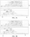
- FIGS. 3 A- 3 Bthere is illustrated an exemplary and non-limiting embodiment of a side view of a point cloud model of a four story building to which the above described have been applied.
- FIG. 3 Ais an illustration of the point cloud prior to filtering and the application of a RANSAC method.
- Floor indicator 301identifies an exemplary ideal floor level. Note that portions of the point cloud forming the first floor 302 and the second floor 302 ′ dip below the corresponding floor indicators 301 .
- FIG. 3 Bis an illustration of the point cloud post the application of filtering and the application of a RANSAC method. Note that portions of the point cloud forming the first floor 302 and the second floor 302 ′ are significantly mote in correspondence to floor indicators 301 . This correspondence is indicative of the correction of the point cloud to map portions of the point cloud corresponding to flat floors to flat planes.
- SLAMSimultaneous Localization and Mapping
- the methods and systems described hereinmay be deployed in part or in whole through a machine that executes computer software, program codes, and/or instructions on a processor.
- the present disclosuremay be implemented as a method on the machine, as a system or apparatus as part of or in relation to the machine, or as a computer program product embodied in a computer readable medium executing on one or more of the machines.
- the processormay be part of a server, cloud server, client, network infrastructure, mobile computing platform, stationary computing platform, or other computing platform.
- a processormay be any kind of computational or processing device capable of executing program instructions, codes, binary instructions and the like.
- the processormay be or may include a signal processor, digital processor, embedded processor, microprocessor or any variant such as a co-processor (math co-processor, graphic co-processor, communication co-processor and the like) and the like that may directly or indirectly facilitate execution of program code or program instructions stored thereon.
- the processormay enable execution of multiple programs, threads, and codes. The threads may be executed simultaneously to enhance the performance of the processor and to facilitate simultaneous operations of the application.
- methods, program codes, program instructions and the like described hereinmay be implemented in one or more thread.
- the threadmay spawn other threads that may have assigned priorities associated with them; the processor may execute these threads based on priority or any other order based on instructions provided in the program code.
- the processormay include non-transitory memory that stores methods, codes, instructions and programs as described herein and elsewhere.
- the processormay access a non-transitory storage medium through an interface that may store methods, codes, and instructions as described herein and elsewhere.
- the storage medium associated with the processor for storing methods, programs, codes, program instructions or other type of instructions capable of being executed by the computing or processing devicemay include but may not be limited to one or more of a CD-ROM, DVD, memory, hard disk, flash drive, RAM, ROM, cache and the like.
- a processormay include one or more cores that may enhance speed and performance of a multiprocessor.
- the processmay be a dual core processor, quad core processors, other chip-level multiprocessor and the like that combine two or more independent cores to provide speed improvements.
- the methods and systems described hereinmay be deployed in part or in whole through a machine that executes computer software on a server, client, firewall, gateway, hub, router, or other such computer and/or networking hardware.
- the software programmay be associated with a server that may include a file server, print server, domain server, internet server, intranet server, cloud server, and other variants such as secondary server, host server, distributed server and the like.
- the servermay include one or more of memories, processors, computer readable media, storage media, ports (physical and virtual), communication devices, and interfaces capable of accessing other servers, clients, machines, and devices through a wired or a wireless medium, and the like.
- the methods, programs, or codes as described herein and elsewheremay be executed by the server.
- other devices required for execution of methods as described in this applicationmay be considered as a part of the infrastructure associated with the server.
- the servermay provide an interface to other devices including, without limitation, clients, other servers, printers, database servers, print servers, file servers, communication servers, distributed servers, social networks, and the like. Additionally, this coupling and/or connection may facilitate remote execution of program across the network. The networking of some or all of these devices may facilitate parallel processing of a program or method at one or more location without deviating from the scope of the disclosure.
- any of the devices attached to the server through an interfacemay include at least one storage medium capable of storing methods, programs, code and/or instructions.
- a central repositorymay provide program instructions to be executed on different devices.
- the remote repositorymay act as a storage medium for program code, instructions, and programs.
- the software programmay be associated with a client that may include a file client, print client, domain client, internet client, intranet client and other variants such as secondary client, host client, distributed client and the like.
- the clientmay include one or more of memories, processors, computer readable media, storage media, ports (physical and virtual), communication devices, and interfaces capable of accessing other clients, servers, machines, and devices through a wired or a wireless medium, and the like.
- the methods, programs, or codes as described herein and elsewheremay be executed by the client.
- other devices required for execution of methods as described in this applicationmay be considered as a part of the infrastructure associated with the client.
- the clientmay provide an interface to other devices including, without limitation, servers, other clients, printers, database servers, print servers, file servers, communication servers, distributed servers and the like. Additionally, this coupling and/or connection may facilitate remote execution of program across the network. The networking of some or all of these devices may facilitate parallel processing of a program or method at one or more location without deviating from the scope of the disclosure.
- any of the devices attached to the client through an interfacemay include at least one storage medium capable of storing methods, programs, applications, code and/or instructions.
- a central repositorymay provide program instructions to be executed on different devices.
- the remote repositorymay act as a storage medium for program code, instructions, and programs.
- the methods and systems described hereinmay be deployed in part or in whole through network infrastructures.
- the network infrastructuremay include elements such as computing devices, servers, routers, hubs, firewalls, clients, personal computers, communication devices, routing devices and other active and passive devices, modules and/or components as known in the art.
- the computing and/or non-computing device(s) associated with the network infrastructuremay include, apart from other components, a storage medium such as flash memory, buffer, stack, RAM, ROM and the like.
- the processes, methods, program codes, instructions described herein and elsewheremay be executed by one or more of the network infrastructural elements.
- SaaSsoftware as a service
- PaaSplatform as a service
- IaaSinfrastructure as a service
- the methods, program codes, and instructions described herein and elsewheremay be implemented on a cellular network has sender-controlled contact media content item multiple cells.
- the cellular networkmay either be frequency division multiple access (FDMA) network or code division multiple access (CDMA) network.
- FDMAfrequency division multiple access
- CDMAcode division multiple access
- the cellular networkmay include mobile devices, cell sites, base stations, repeaters, antennas, towers, and the like.
- the cell networkmay be a GSM, GPRS, 3G, EVDO, mesh, or other networks types.
- the mobile devicesmay include navigation devices, cell phones, mobile phones, mobile personal digital assistants, laptops, palmtops, netbooks, pagers, electronic books readers, music players and the like. These devices may include, apart from other components, a storage medium such as a flash memory, buffer, RAM, ROM and one or more computing devices.
- the computing devices associated with mobile devicesmay be enabled to execute program codes, methods, and instructions stored thereon. Alternatively, the mobile devices may be configured to execute instructions in collaboration with other devices.
- the mobile devicesmay communicate with base stations interfaced with servers and configured to execute program codes.
- the mobile devicesmay communicate on a peer-to-peer network, mesh network, or other communications network.
- the program codemay be stored on the storage medium associated with the server and executed by a computing device embedded within the server.
- the base stationmay include a computing device and a storage medium.
- the storage devicemay store program codes and instructions executed by the computing devices associated with the base station.
- the computer software, program codes, and/or instructionsmay be stored and/or accessed on machine readable media that may include: computer components, devices, and recording media that retain digital data used for computing for some interval of time; semiconductor storage known as random access memory (RAM); mass storage typically for more permanent storage, such as optical discs, forms of magnetic storage like hard disks, tapes, drums, cards and other types; processor registers, cache memory, volatile memory, non-volatile memory; optical storage such as CD, DVD; removable media such as flash memory (e.g.
- RAMrandom access memory
- mass storagetypically for more permanent storage, such as optical discs, forms of magnetic storage like hard disks, tapes, drums, cards and other types
- processor registerscache memory, volatile memory, non-volatile memory
- optical storagesuch as CD, DVD
- removable mediasuch as flash memory (e.g.
- USB sticks or keysfloppy disks, magnetic tape, paper tape, punch cards, standalone RAM disks, Zip drives, removable mass storage, off-line, and the like; other computer memory such as dynamic memory, static memory, read/write storage, mutable storage, read only, random access, sequential access, location addressable, file addressable, content addressable, network attached storage, storage area network, bar codes, magnetic ink, and the like.
- the methods and systems described hereinmay transform physical and/or or intangible items from one state to another.
- the methods and systems described hereinmay also transform data representing physical and/or intangible items from one state to another.
- machinesmay include, but may not be limited to, personal digital assistants, laptops, personal computers, mobile phones, other handheld computing devices, medical equipment, wired or wireless communication devices, transducers, chips, calculators, satellites, tablet PCs, electronic books, gadgets, electronic devices, devices has sender-controlled contact media content item artificial intelligence, computing devices, networking equipment, servers, routers and the like.
- the elements depicted in the flow chart and block diagrams or any other logical componentmay be implemented on a machine capable of executing program instructions.
- the methods and/or processes described above, and steps associated therewith,may be realized in hardware, software or any combination of hardware and software suitable for a particular application.
- the hardwaremay include a general-purpose computer and/or dedicated computing device or specific computing device or particular aspect or component of a specific computing device.
- the processesmay be realized in one or more microprocessors, microcontrollers, embedded microcontrollers, programmable digital signal processors or other programmable device, along with internal and/or external memory.
- the processesmay also, or instead, be embodied in an application specific integrated circuit, a programmable gate array, programmable array logic, or any other device or combination of devices that may be configured to process electronic signals. It will further be appreciated that one or more of the processes may be realized as a computer executable code capable of being executed on a machine-readable medium.
- the computer executable codemay be created using a structured programming language such as C, an object oriented programming language such as C++, or any other high-level or low-level programming language (including assembly languages, hardware description languages, and database programming languages and technologies) that may be stored, compiled or interpreted to run on one of the above devices, as well as heterogeneous combinations of processors, processor architectures, or combinations of different hardware and software, or any other machine capable of executing program instructions.
- a structured programming languagesuch as C
- an object oriented programming languagesuch as C++
- any other high-level or low-level programming languageincluding assembly languages, hardware description languages, and database programming languages and technologies
- methods described above and combinations thereofmay be embodied in computer executable code that, when executing on one or more computing devices, performs the steps thereof.
- the methodsmay be embodied in systems that perform the steps thereof, and may be distributed across devices in a number of ways, or all of the functionality may be integrated into a dedicated, standalone device or other hardware.
- the means for performing the steps associated with the processes described abovemay include any of the hardware and/or software described above. All such permutations and combinations are intended to fall within the scope of the present disclosure.
Landscapes
- Physics & Mathematics (AREA)
- Engineering & Computer Science (AREA)
- Geometry (AREA)
- General Physics & Mathematics (AREA)
- Theoretical Computer Science (AREA)
- Computer Graphics (AREA)
- Software Systems (AREA)
- Control Of Position, Course, Altitude, Or Attitude Of Moving Bodies (AREA)
- Life Sciences & Earth Sciences (AREA)
- Bioinformatics & Cheminformatics (AREA)
- Bioinformatics & Computational Biology (AREA)
- Evolutionary Biology (AREA)
- Probability & Statistics with Applications (AREA)
- Computer Vision & Pattern Recognition (AREA)
- Image Processing (AREA)
Abstract
Description
- 1. Down-sampling the point cloud data spatially, such as by minimum distance between points to even out density, sensor noise, and fine features that are not important in large plane detection.
- 2. Filtering by local curvature by small values, which indicate a point is part of a locally planar surface.
- 3. Filtering by point normal direction to only points with a normal that is close to vertical and upward (indicating it is part of a vertical surface viewed from above).
- 4. Filtering based on z height. This may be done by assuming a range of possible scanner heights off the floor if the scanner locations within the map are known.
- 5. Reducing search through the assumption that walls, floors, and ceilings are typically parallel or orthogonal to each other. That is, floor to ceiling to next floor helps constrain the search.
Claims (19)
Priority Applications (1)
| Application Number | Priority Date | Filing Date | Title |
|---|---|---|---|
| US17/070,228US11830136B2 (en) | 2018-07-05 | 2020-10-14 | Methods and systems for auto-leveling of point clouds and 3D models |
Applications Claiming Priority (4)
| Application Number | Priority Date | Filing Date | Title |
|---|---|---|---|
| US201862694327P | 2018-07-05 | 2018-07-05 | |
| US201862696568P | 2018-07-11 | 2018-07-11 | |
| PCT/US2019/038688WO2020009826A1 (en) | 2018-07-05 | 2019-06-24 | Methods and systems for auto-leveling of point clouds and 3d models |
| US17/070,228US11830136B2 (en) | 2018-07-05 | 2020-10-14 | Methods and systems for auto-leveling of point clouds and 3D models |
Related Parent Applications (1)
| Application Number | Title | Priority Date | Filing Date |
|---|---|---|---|
| PCT/US2019/038688ContinuationWO2020009826A1 (en) | 2018-07-05 | 2019-06-24 | Methods and systems for auto-leveling of point clouds and 3d models |
Publications (2)
| Publication Number | Publication Date |
|---|---|
| US20210027477A1 US20210027477A1 (en) | 2021-01-28 |
| US11830136B2true US11830136B2 (en) | 2023-11-28 |
Family
ID=69059953
Family Applications (1)
| Application Number | Title | Priority Date | Filing Date |
|---|---|---|---|
| US17/070,228Active2039-06-27US11830136B2 (en) | 2018-07-05 | 2020-10-14 | Methods and systems for auto-leveling of point clouds and 3D models |
Country Status (2)
| Country | Link |
|---|---|
| US (1) | US11830136B2 (en) |
| WO (1) | WO2020009826A1 (en) |
Cited By (2)
| Publication number | Priority date | Publication date | Assignee | Title |
|---|---|---|---|---|
| US20230114231A1 (en)* | 2020-03-23 | 2023-04-13 | Otolift Trapliften B.V. | Method, computer device and computer programme for extracting information about staircase |
| US20230135965A1 (en)* | 2021-11-01 | 2023-05-04 | GM Global Technology Operations LLC | Virtual beams for identification of edge and planar points in lidar point cloud obtained with vehicle lidar system |
Families Citing this family (14)
| Publication number | Priority date | Publication date | Assignee | Title |
|---|---|---|---|---|
| US11567201B2 (en) | 2016-03-11 | 2023-01-31 | Kaarta, Inc. | Laser scanner with real-time, online ego-motion estimation |
| EP3427008B1 (en) | 2016-03-11 | 2022-09-07 | Kaarta, Inc. | Laser scanner with real-time, online ego-motion estimation |
| US11573325B2 (en) | 2016-03-11 | 2023-02-07 | Kaarta, Inc. | Systems and methods for improvements in scanning and mapping |
| US10989542B2 (en) | 2016-03-11 | 2021-04-27 | Kaarta, Inc. | Aligning measured signal data with slam localization data and uses thereof |
| WO2019099605A1 (en) | 2017-11-17 | 2019-05-23 | Kaarta, Inc. | Methods and systems for geo-referencing mapping systems |
| WO2019165194A1 (en) | 2018-02-23 | 2019-08-29 | Kaarta, Inc. | Methods and systems for processing and colorizing point clouds and meshes |
| WO2019195270A1 (en) | 2018-04-03 | 2019-10-10 | Kaarta, Inc. | Methods and systems for real or near real-time point cloud map data confidence evaluation |
| WO2020009826A1 (en) | 2018-07-05 | 2020-01-09 | Kaarta, Inc. | Methods and systems for auto-leveling of point clouds and 3d models |
| CN111694903B (en)* | 2019-03-11 | 2023-09-12 | 北京地平线机器人技术研发有限公司 | Map construction method, device, equipment and readable storage medium |
| CN111311684B (en)* | 2020-04-01 | 2021-02-05 | 亮风台(上海)信息科技有限公司 | Method and equipment for initializing SLAM |
| CN111915724A (en)* | 2020-08-21 | 2020-11-10 | 青岛联合创智科技有限公司 | Point cloud model slice shape calculation method |
| CN115494533B (en)* | 2022-09-23 | 2025-06-24 | 潍柴动力股份有限公司 | Vehicle positioning method, device, storage medium and positioning system |
| US20240328792A1 (en)* | 2023-03-30 | 2024-10-03 | Deka Products Limited Partnership | System and method for localizing an autonomous vehicle |
| CN116619753A (en)* | 2023-05-26 | 2023-08-22 | 深圳市创想三维科技股份有限公司 | Automatic leveling method, electronic equipment and computer readable storage medium |
Citations (141)
| Publication number | Priority date | Publication date | Assignee | Title |
|---|---|---|---|---|
| JPH09142236A (en) | 1995-11-17 | 1997-06-03 | Mitsubishi Electric Corp | Vehicle periphery monitoring method, periphery monitoring device, periphery monitoring device failure determination method, and periphery monitoring device failure determination device |
| US5988862A (en) | 1996-04-24 | 1999-11-23 | Cyra Technologies, Inc. | Integrated system for quickly and accurately imaging and modeling three dimensional objects |
| US6009188A (en) | 1996-02-16 | 1999-12-28 | Microsoft Corporation | Method and system for digital plenoptic imaging |
| US6111582A (en) | 1996-12-20 | 2000-08-29 | Jenkins; Barry L. | System and method of image generation and encoding using primitive reprojection |
| USD432930S (en) | 1999-10-05 | 2000-10-31 | Solar Wide Industrial Ltd. | Distance measuring device |
| US6208347B1 (en) | 1997-06-23 | 2001-03-27 | Real-Time Geometry Corporation | System and method for computer modeling of 3D objects and 2D images by mesh constructions that incorporate non-spatial data such as color or texture |
| US20030160785A1 (en) | 2002-02-28 | 2003-08-28 | Canon Europa N.V. | Texture map editing |
| US6771840B1 (en) | 2000-05-18 | 2004-08-03 | Leica Geosystems Hds, Inc. | Apparatus and method for identifying the points that lie on a surface of interest |
| JP2004348575A (en) | 2003-05-23 | 2004-12-09 | Foundation For The Promotion Of Industrial Science | Three-dimensional model construction system and its program |
| US20050168437A1 (en) | 2004-01-30 | 2005-08-04 | Carl Stewart R. | Processing pose data derived from the pose of an elongate object |
| US20050203930A1 (en) | 2004-03-10 | 2005-09-15 | Bukowski Richard W. | System and method for efficient storage and manipulation of extremely large amounts of scan data |
| US20050286757A1 (en) | 2004-06-28 | 2005-12-29 | Microsoft Corporation | Color segmentation-based stereo 3D reconstruction system and process |
| US20060188143A1 (en)* | 2002-07-10 | 2006-08-24 | Marek Strassenburg-Kleciak | Scanning system for three-dimensional objects |
| JP2006276012A (en) | 2005-03-29 | 2006-10-12 | Leica Geosystems Ag | Measurement system for determining the six degrees of freedom of an object |
| US20070097120A1 (en) | 2005-10-31 | 2007-05-03 | Wheeler Mark D | Determining appearance of points in point cloud based on normal vectors of points |
| JP2007298332A (en) | 2006-04-28 | 2007-11-15 | Mitsubishi Electric Corp | Topographic data correction apparatus and topographic data correction method |
| US20070262988A1 (en) | 2006-05-09 | 2007-11-15 | Pixar Animation Studios | Method and apparatus for using voxel mip maps and brick maps as geometric primitives in image rendering process |
| US20070291233A1 (en) | 2006-06-16 | 2007-12-20 | Culbertson W Bruce | Mesh for rendering an image frame |
| US20080033645A1 (en) | 2006-08-03 | 2008-02-07 | Jesse Sol Levinson | Pobabilistic methods for mapping and localization in arbitrary outdoor environments |
| US20080112610A1 (en) | 2006-11-14 | 2008-05-15 | S2, Inc. | System and method for 3d model generation |
| US20080243426A1 (en)* | 2007-03-26 | 2008-10-02 | The Boeing Company | Attitude detection system and method |
| US20090043439A1 (en) | 2005-07-26 | 2009-02-12 | Macdonald, Dettwiler & Associates, Inc. | Guidance, Navigation, and Control System for a Vehicle |
| US7567731B2 (en) | 2004-07-15 | 2009-07-28 | Harris Corporation | Method and system for simultaneously registering multi-dimensional topographical points |
| US20090237297A1 (en) | 2008-02-06 | 2009-09-24 | Halliburton Energy Services, Inc. | Geodesy Via GPS and INSAR Integration |
| US20090262974A1 (en) | 2008-04-18 | 2009-10-22 | Erik Lithopoulos | System and method for obtaining georeferenced mapping data |
| WO2010004911A1 (en) | 2008-07-10 | 2010-01-14 | 三菱電機株式会社 | Train-of-vehicle travel support device |
| US20100090899A1 (en) | 2008-10-09 | 2010-04-15 | Nec (China) Co., Ltd. | Method and system for positioning object with adaptive resolution |
| US20100111370A1 (en) | 2008-08-15 | 2010-05-06 | Black Michael J | Method and apparatus for estimating body shape |
| US7752483B1 (en) | 2006-12-13 | 2010-07-06 | Science Applications International Corporation | Process and system for three-dimensional urban modeling |
| JP2010175423A (en) | 2009-01-30 | 2010-08-12 | Mitsubishi Electric Corp | Measuring device, method for correcting position and posture value of laser in measuring device, and laser position/posture value correcting program |
| JP2010533307A (en) | 2007-06-27 | 2010-10-21 | プリズム インコーポレイテッド | Servo feedback control based on a scanning servo beam specified when scanning a beam display system with a luminescent screen |
| US20100286905A1 (en) | 2002-12-17 | 2010-11-11 | Evolution Robotics, Inc. | Systems and methods for filtering potentially unreliable visual data for visual simultaneous localization and mapping |
| US20110134225A1 (en) | 2008-08-06 | 2011-06-09 | Saint-Pierre Eric | System for adaptive three-dimensional scanning of surface characteristics |
| US20110178708A1 (en) | 2010-01-18 | 2011-07-21 | Qualcomm Incorporated | Using object to align and calibrate inertial navigation system |
| US20110282622A1 (en) | 2010-02-05 | 2011-11-17 | Peter Canter | Systems and methods for processing mapping and modeling data |
| JP2011529569A (en) | 2008-07-31 | 2011-12-08 | テレ アトラス ベスローテン フエンノートシャップ | Computer apparatus and method for displaying navigation data in three dimensions |
| US20110301786A1 (en) | 2010-05-12 | 2011-12-08 | Daniel Allis | Remote Vehicle Control System and Method |
| US20110300929A1 (en) | 2010-06-03 | 2011-12-08 | Microsoft Corporation | Synthesis of information from multiple audiovisual sources |
| EP2133662B1 (en) | 2008-06-09 | 2012-02-01 | Honeywell International Inc. | Methods and system of navigation using terrain features |
| JP3173419U (en) | 2011-06-21 | 2012-02-09 | 光男 植村 | Surveying equipment |
| JP2012507011A (en) | 2008-10-28 | 2012-03-22 | ザ・ボーイング・カンパニー | Handheld positioning interface for spatial query |
| JP2012063173A (en) | 2010-09-14 | 2012-03-29 | Konica Minolta Opto Inc | Laser distance measurement equipment |
| US8180107B2 (en) | 2009-02-13 | 2012-05-15 | Sri International | Active coordinated tracking for multi-camera systems |
| US20120123615A1 (en) | 2009-05-15 | 2012-05-17 | Mbda France | Method and a system for estimating a trajectory of a moving body |
| CN102508258A (en) | 2011-11-29 | 2012-06-20 | 中国电子科技集团公司第二十七研究所 | Three-dimensional imaging laser radar for obtaining surveying and mapping information |
| CN102607526A (en)* | 2012-01-03 | 2012-07-25 | 西安电子科技大学 | Target posture measuring method based on binocular vision under double mediums |
| CN102819863A (en) | 2012-07-31 | 2012-12-12 | 中国科学院计算技术研究所 | Method and system for acquiring three-dimensional human body motion in real time on line |
| JP2013054660A (en) | 2011-09-06 | 2013-03-21 | Asia Air Survey Co Ltd | Vegetation map creation device and vegetation map creation program |
| US8406994B1 (en) | 2008-11-07 | 2013-03-26 | Infogation Corporation | Electronically generated realistic-like map |
| US20130085378A1 (en) | 2009-03-04 | 2013-04-04 | Imricor Medical Systems, Inc. | Combined field location and mri tracking |
| JP2013093738A (en) | 2011-10-26 | 2013-05-16 | Nippon Hoso Kyokai <Nhk> | Moving distance measuring device and photographing camera |
| US20130135305A1 (en) | 2010-08-05 | 2013-05-30 | Koninklijke Philips Electronics N.V. | In-plane and interactive surface mesh adaptation |
| US20130176305A1 (en) | 2010-08-11 | 2013-07-11 | Kabushiki Kaisha Topcon | Point cloud position data processing device, point cloud position data processing system, point cloud position data processing method, and point cloud position data processing program |
| US20130181983A1 (en) | 2010-06-25 | 2013-07-18 | Kabushiki Kaisha Topcon | Point cloud data processing device, point cloud data processing system, point cloud data processing method, and point cloud data processing program |
| US20130321418A1 (en) | 2012-05-31 | 2013-12-05 | Microsoft Corporation | Interpolating oriented disks in 3d space for constructing high fidelity geometric proxies from point clouds |
| US20130325244A1 (en) | 2011-01-28 | 2013-12-05 | Intouch Health | Time-dependent navigation of telepresence robots |
| US20140043436A1 (en) | 2012-02-24 | 2014-02-13 | Matterport, Inc. | Capturing and Aligning Three-Dimensional Scenes |
| US8676498B2 (en) | 2010-09-24 | 2014-03-18 | Honeywell International Inc. | Camera and inertial measurement unit integration with navigation data feedback for feature tracking |
| WO2014048475A1 (en) | 2012-09-27 | 2014-04-03 | Metaio Gmbh | Method of determining a position and orientation of a device associated with a capturing device for capturing at least one image |
| US20140180914A1 (en) | 2007-01-12 | 2014-06-26 | Raj Abhyanker | Peer-to-peer neighborhood delivery multi-copter and method |
| US20140180579A1 (en) | 2012-12-20 | 2014-06-26 | Caterpillar Inc. | Machine positioning system utilizing position error checking |
| US20140193040A1 (en) | 2013-01-09 | 2014-07-10 | Omiimii Ltd. | Method and apparatus for determining location |
| US20140214255A1 (en) | 2013-01-25 | 2014-07-31 | Google Inc. | Modifying behavior of autonomous vehicles based on sensor blind spots and limitations |
| WO2014120613A1 (en) | 2013-01-30 | 2014-08-07 | Qualcomm Incorporated | Real-time 3d reconstruction with power efficient depth sensor usage |
| WO2014130854A1 (en) | 2013-02-21 | 2014-08-28 | Regents Of The Univesity Of Minnesota | Extrinsic parameter calibration of a vision-aided inertial navigation system |
| US20140278570A1 (en) | 2013-03-15 | 2014-09-18 | State Farm Mutual Automobile Insurance Company | System and methods for assessing a roof |
| US20140297092A1 (en) | 2013-03-26 | 2014-10-02 | Toyota Motor Engineering & Manufacturing North America, Inc. | Intensity map-based localization with adaptive thresholding |
| US20140300885A1 (en) | 2013-04-05 | 2014-10-09 | Lockheed Martin Corporation | Underwater platform with lidar and related methods |
| US20140300886A1 (en) | 2013-04-05 | 2014-10-09 | Leica Geosystems Ag | Geodetic referencing of point clouds |
| US20140301633A1 (en) | 2013-04-09 | 2014-10-09 | Google Inc. | System and Method for Floorplan Reconstruction and Three-Dimensional Modeling |
| US20140333741A1 (en) | 2013-05-08 | 2014-11-13 | Regents Of The University Of Minnesota | Constrained key frame localization and mapping for vision-aided inertial navigation |
| US20140350836A1 (en) | 2013-05-24 | 2014-11-27 | Advance Scientific Concepts, Inc. | Automotive auxiliary ladar sensor |
| US20140379256A1 (en) | 2013-05-02 | 2014-12-25 | The Johns Hopkins University | Mapping and Positioning System |
| US20150015602A1 (en) | 2013-07-10 | 2015-01-15 | Cognex Corporation | System and method for selective determination of point clouds |
| US20150063707A1 (en) | 2010-06-10 | 2015-03-05 | Autodesk, Inc. | Outline approximation for point cloud of building |
| US20150063683A1 (en) | 2013-08-28 | 2015-03-05 | Autodesk, Inc. | Building datum extraction from laser scanning data |
| US8996228B1 (en) | 2012-09-05 | 2015-03-31 | Google Inc. | Construction zone object detection using light detection and ranging |
| US9031809B1 (en) | 2010-07-14 | 2015-05-12 | Sri International | Method and apparatus for generating three-dimensional pose using multi-modal sensor fusion |
| US20150142378A1 (en) | 2012-07-18 | 2015-05-21 | Creaform Inc. | 3-d scanning and positioning interface |
| US9043069B1 (en) | 2012-11-07 | 2015-05-26 | Google Inc. | Methods and systems for scan matching approaches for vehicle heading estimation |
| WO2015105597A2 (en) | 2013-11-27 | 2015-07-16 | The Trustees Of The University Of Pennsylvania | Multi-sensor fusion for robust autonomous flight in indoor and outdoor environments with a rotorcraft micro-aerial vehicle (mav) |
| US20150243080A1 (en) | 2012-09-21 | 2015-08-27 | Navvis Gmbh | Visual localisation |
| CN104913763A (en) | 2014-03-14 | 2015-09-16 | 莱卡地球系统公开股份有限公司 | Method for generating a spatial model and handheld distance measuring device |
| US9143413B1 (en) | 2014-10-22 | 2015-09-22 | Cognitive Systems Corp. | Presenting wireless-spectrum usage information |
| US20150317832A1 (en) | 2014-05-01 | 2015-11-05 | Michael John Ebstyne | World-locked display quality feedback |
| JP2015200615A (en) | 2014-04-10 | 2015-11-12 | 国際航業株式会社 | Laser measurement result analysis system |
| US20150331111A1 (en) | 2012-04-02 | 2015-11-19 | The Chancellor Masters And Scholars Of The University Of Oxford | Method For Localizing A Vehicle Equipped With Two Lidar Systems |
| JP2015210186A (en) | 2014-04-25 | 2015-11-24 | 東芝プラントシステム株式会社 | 3D data display device, 3D data display method, and 3D data display program |
| US20150350378A1 (en) | 2014-05-28 | 2015-12-03 | Alexander Hertel | Platform for Constructing and Consuming Realm and Object Feature Clouds |
| CN105164494A (en) | 2013-03-15 | 2015-12-16 | 都灵理工学院 | Device and system for three-dimensional scanning, and method thereof |
| US20160070265A1 (en) | 2014-09-05 | 2016-03-10 | SZ DJI Technology Co., Ltd | Multi-sensor environmental mapping |
| US20160086336A1 (en) | 2014-09-19 | 2016-03-24 | Qualcomm Incorporated | System and method of pose estimation |
| US9315192B1 (en) | 2013-09-30 | 2016-04-19 | Google Inc. | Methods and systems for pedestrian avoidance using LIDAR |
| US20160125226A1 (en) | 2013-09-17 | 2016-05-05 | Shenzhen Institutes Of Advanced Technology Chinese Academy Of Sciences | Method and system for automatically optimizing quality of point cloud data |
| JP2016080572A (en) | 2014-10-20 | 2016-05-16 | 朝日航洋株式会社 | Laser measurement system |
| US20160140757A1 (en) | 2014-11-18 | 2016-05-19 | St. Jude Medical, Cardiology Division, Inc. | Methods and systems for generating a patch surface model of a geometric structure |
| DE102014019671A1 (en) | 2014-12-30 | 2016-06-30 | Faro Technologies, Inc. | Method for optically scanning and measuring an environment with a 3D measuring device and auto-calibration by means of a 2D camera |
| US20160234476A1 (en) | 2012-09-10 | 2016-08-11 | Marshall Reed Millett | Multi-dimensional data capture of an environment using plural devices |
| US20160260250A1 (en) | 2015-03-05 | 2016-09-08 | Dejan Jovanovic | Method and system for 3d capture based on structure from motion with pose detection tool |
| US20160266256A1 (en) | 2015-03-11 | 2016-09-15 | The Boeing Company | Real Time Multi Dimensional Image Fusing |
| US20160274589A1 (en) | 2012-09-26 | 2016-09-22 | Google Inc. | Wide-View LIDAR With Areas of Special Attention |
| US20160349746A1 (en) | 2015-05-29 | 2016-12-01 | Faro Technologies, Inc. | Unmanned aerial vehicle having a projector and being tracked by a laser tracker |
| CN106204611A (en)* | 2016-07-19 | 2016-12-07 | 中国科学院地理科学与资源研究所 | A kind of LiDAR point cloud data processing method based on HASM model and device |
| EP3109589A1 (en) | 2015-06-23 | 2016-12-28 | Volvo Car Corporation | A unit and method for improving positioning accuracy |
| US20160379366A1 (en) | 2015-06-25 | 2016-12-29 | Microsoft Technology Licensing, Llc | Aligning 3d point clouds using loop closures |
| WO2017009923A1 (en) | 2015-07-13 | 2017-01-19 | 日産自動車株式会社 | Own-position estimating device and own-position estimating method |
| US20170116781A1 (en) | 2015-10-21 | 2017-04-27 | Nokia Technologies Oy | 3d scene rendering |
| US20170123066A1 (en) | 2011-12-21 | 2017-05-04 | Robotic paradigm Systems LLC | Apparatus, Systems and Methods for Point Cloud Generation and Constantly Tracking Position |
| US20170122736A1 (en) | 2015-11-03 | 2017-05-04 | Leica Geosystems Ag | Surface surveying device for determining 3d coordinates of a surface |
| US20170186221A1 (en) | 2015-12-28 | 2017-06-29 | VOLKSWAGEN AG et al. | Multiple light source simulation in computer graphics |
| US20170191826A1 (en) | 2016-01-05 | 2017-07-06 | Texas Instruments Incorporated | Ground Plane Estimation in a Computer Vision System |
| US20170208251A1 (en) | 2014-07-17 | 2017-07-20 | Elbit Systems Ltd. | Stabilization and display of remote images |
| WO2017155970A1 (en) | 2016-03-11 | 2017-09-14 | Kaarta, Inc. | Laser scanner with real-time, online ego-motion estimation |
| US20180038694A1 (en) | 2016-02-09 | 2018-02-08 | 5D Robotics, Inc. | Ultra wide band radar localization |
| US20180075648A1 (en) | 2015-03-05 | 2018-03-15 | Commonwealth Scientific And Industria Research Organisation | Structure modelling |
| WO2018071416A1 (en) | 2016-10-11 | 2018-04-19 | Kaarta, Inc. | Laser scanner with real-time, online ego-motion estimation |
| USD823920S1 (en) | 2016-11-23 | 2018-07-24 | Kaarta, Inc. | Simultaneous localization and mapping (SLAM) device |
| WO2018140701A1 (en) | 2017-01-27 | 2018-08-02 | Kaarta, Inc. | Laser scanner with real-time, online ego-motion estimation |
| US20180260613A1 (en) | 2017-03-08 | 2018-09-13 | GM Global Technology Operations LLC | Object tracking |
| US20180342080A1 (en) | 2014-11-21 | 2018-11-29 | The Chancellor Masters And Scholars Of The University Of Oxford | Localising portable apparatus |
| WO2019006289A1 (en) | 2017-06-30 | 2019-01-03 | Kaarta, Inc. | Systems and methods for improvements in scanning and mapping |
| WO2019018315A1 (en) | 2017-07-17 | 2019-01-24 | Kaarta, Inc. | Aligning measured signal data with slam localization data and uses thereof |
| US20190052844A1 (en) | 2017-08-08 | 2019-02-14 | Waymo Llc | Rotating LIDAR with Co-Aligned Imager |
| EP2913796B1 (en) | 2014-02-26 | 2019-03-27 | NavVis GmbH | Method of generating panorama views on a mobile mapping system |
| US10296828B2 (en) | 2017-04-05 | 2019-05-21 | Here Global B.V. | Learning a similarity measure for vision-based localization on a high definition (HD) map |
| WO2019099605A1 (en) | 2017-11-17 | 2019-05-23 | Kaarta, Inc. | Methods and systems for geo-referencing mapping systems |
| US20190235083A1 (en) | 2016-03-11 | 2019-08-01 | Kaarta, Inc. | Laser scanner with real-time, online ego-motion estimation |
| WO2019165194A1 (en) | 2018-02-23 | 2019-08-29 | Kaarta, Inc. | Methods and systems for processing and colorizing point clouds and meshes |
| WO2019178429A1 (en) | 2018-03-15 | 2019-09-19 | Kaarta, Inc. | Methods and systems for filtering point cloud map data for use with acquired scan frame data |
| WO2019195270A1 (en) | 2018-04-03 | 2019-10-10 | Kaarta, Inc. | Methods and systems for real or near real-time point cloud map data confidence evaluation |
| US10442431B2 (en) | 2017-02-17 | 2019-10-15 | Fca Us Llc | Automatic speed limiter set speed adjustment |
| US20190346271A1 (en) | 2016-03-11 | 2019-11-14 | Kaarta, Inc. | Laser scanner with real-time, online ego-motion estimation |
| HK1261850A1 (en) | 2016-03-11 | 2020-01-03 | Carnegie Mellon University | Laser scanner with real-time, online ego-motion estimation |
| WO2020009826A1 (en) | 2018-07-05 | 2020-01-09 | Kaarta, Inc. | Methods and systems for auto-leveling of point clouds and 3d models |
| US10551850B2 (en) | 2018-01-03 | 2020-02-04 | Uatc, Llc | Low quality pose |
| US20200142074A1 (en) | 2016-03-11 | 2020-05-07 | Kaarta, Inc. | Systems and methods for improvements in scanning and mapping |
| US20200217666A1 (en) | 2016-03-11 | 2020-07-09 | Kaarta, Inc. | Aligning measured signal data with slam localization data and uses thereof |
| US20200265562A1 (en)* | 2017-09-08 | 2020-08-20 | Nec Corporation | Image processing device, image processing method and storage medium |
| US11009884B2 (en) | 2017-09-29 | 2021-05-18 | Direct Current Capital LLC | Method for calculating nominal vehicle paths for lanes within a geographic region |
| US11194938B2 (en) | 2020-01-28 | 2021-12-07 | Middle Chart, LLC | Methods and apparatus for persistent location based digital content |
| US11237563B2 (en) | 2019-11-20 | 2022-02-01 | FarmWise Labs, Inc. | Method for analyzing individual plants in an agricultural field |
- 2019
- 2019-06-24WOPCT/US2019/038688patent/WO2020009826A1/ennot_activeCeased
- 2020
- 2020-10-14USUS17/070,228patent/US11830136B2/enactiveActive
Patent Citations (171)
| Publication number | Priority date | Publication date | Assignee | Title |
|---|---|---|---|---|
| JPH09142236A (en) | 1995-11-17 | 1997-06-03 | Mitsubishi Electric Corp | Vehicle periphery monitoring method, periphery monitoring device, periphery monitoring device failure determination method, and periphery monitoring device failure determination device |
| US6009188A (en) | 1996-02-16 | 1999-12-28 | Microsoft Corporation | Method and system for digital plenoptic imaging |
| US5988862A (en) | 1996-04-24 | 1999-11-23 | Cyra Technologies, Inc. | Integrated system for quickly and accurately imaging and modeling three dimensional objects |
| US20030001835A1 (en) | 1996-04-24 | 2003-01-02 | Jerry Dimsdale | Integrated system for quickly and accurately imaging and modeling three-dimensional objects |
| US6111582A (en) | 1996-12-20 | 2000-08-29 | Jenkins; Barry L. | System and method of image generation and encoding using primitive reprojection |
| US6208347B1 (en) | 1997-06-23 | 2001-03-27 | Real-Time Geometry Corporation | System and method for computer modeling of 3D objects and 2D images by mesh constructions that incorporate non-spatial data such as color or texture |
| USD432930S (en) | 1999-10-05 | 2000-10-31 | Solar Wide Industrial Ltd. | Distance measuring device |
| US6771840B1 (en) | 2000-05-18 | 2004-08-03 | Leica Geosystems Hds, Inc. | Apparatus and method for identifying the points that lie on a surface of interest |
| US20030160785A1 (en) | 2002-02-28 | 2003-08-28 | Canon Europa N.V. | Texture map editing |
| US20060188143A1 (en)* | 2002-07-10 | 2006-08-24 | Marek Strassenburg-Kleciak | Scanning system for three-dimensional objects |
| US20100286905A1 (en) | 2002-12-17 | 2010-11-11 | Evolution Robotics, Inc. | Systems and methods for filtering potentially unreliable visual data for visual simultaneous localization and mapping |
| JP2004348575A (en) | 2003-05-23 | 2004-12-09 | Foundation For The Promotion Of Industrial Science | Three-dimensional model construction system and its program |
| US20050168437A1 (en) | 2004-01-30 | 2005-08-04 | Carl Stewart R. | Processing pose data derived from the pose of an elongate object |
| US20050203930A1 (en) | 2004-03-10 | 2005-09-15 | Bukowski Richard W. | System and method for efficient storage and manipulation of extremely large amounts of scan data |
| US20050286757A1 (en) | 2004-06-28 | 2005-12-29 | Microsoft Corporation | Color segmentation-based stereo 3D reconstruction system and process |
| US7567731B2 (en) | 2004-07-15 | 2009-07-28 | Harris Corporation | Method and system for simultaneously registering multi-dimensional topographical points |
| JP2006276012A (en) | 2005-03-29 | 2006-10-12 | Leica Geosystems Ag | Measurement system for determining the six degrees of freedom of an object |
| US20090043439A1 (en) | 2005-07-26 | 2009-02-12 | Macdonald, Dettwiler & Associates, Inc. | Guidance, Navigation, and Control System for a Vehicle |
| US20070097120A1 (en) | 2005-10-31 | 2007-05-03 | Wheeler Mark D | Determining appearance of points in point cloud based on normal vectors of points |
| JP2007298332A (en) | 2006-04-28 | 2007-11-15 | Mitsubishi Electric Corp | Topographic data correction apparatus and topographic data correction method |
| US20070262988A1 (en) | 2006-05-09 | 2007-11-15 | Pixar Animation Studios | Method and apparatus for using voxel mip maps and brick maps as geometric primitives in image rendering process |
| US20070291233A1 (en) | 2006-06-16 | 2007-12-20 | Culbertson W Bruce | Mesh for rendering an image frame |
| US20080033645A1 (en) | 2006-08-03 | 2008-02-07 | Jesse Sol Levinson | Pobabilistic methods for mapping and localization in arbitrary outdoor environments |
| US20080112610A1 (en) | 2006-11-14 | 2008-05-15 | S2, Inc. | System and method for 3d model generation |
| US7752483B1 (en) | 2006-12-13 | 2010-07-06 | Science Applications International Corporation | Process and system for three-dimensional urban modeling |
| US20140180914A1 (en) | 2007-01-12 | 2014-06-26 | Raj Abhyanker | Peer-to-peer neighborhood delivery multi-copter and method |
| US20080243426A1 (en)* | 2007-03-26 | 2008-10-02 | The Boeing Company | Attitude detection system and method |
| JP2010533307A (en) | 2007-06-27 | 2010-10-21 | プリズム インコーポレイテッド | Servo feedback control based on a scanning servo beam specified when scanning a beam display system with a luminescent screen |
| US20090237297A1 (en) | 2008-02-06 | 2009-09-24 | Halliburton Energy Services, Inc. | Geodesy Via GPS and INSAR Integration |
| US20090262974A1 (en) | 2008-04-18 | 2009-10-22 | Erik Lithopoulos | System and method for obtaining georeferenced mapping data |
| EP2133662B1 (en) | 2008-06-09 | 2012-02-01 | Honeywell International Inc. | Methods and system of navigation using terrain features |
| WO2010004911A1 (en) | 2008-07-10 | 2010-01-14 | 三菱電機株式会社 | Train-of-vehicle travel support device |
| JP2011529569A (en) | 2008-07-31 | 2011-12-08 | テレ アトラス ベスローテン フエンノートシャップ | Computer apparatus and method for displaying navigation data in three dimensions |
| US20110134225A1 (en) | 2008-08-06 | 2011-06-09 | Saint-Pierre Eric | System for adaptive three-dimensional scanning of surface characteristics |
| US20100111370A1 (en) | 2008-08-15 | 2010-05-06 | Black Michael J | Method and apparatus for estimating body shape |
| US20100090899A1 (en) | 2008-10-09 | 2010-04-15 | Nec (China) Co., Ltd. | Method and system for positioning object with adaptive resolution |
| JP2012507011A (en) | 2008-10-28 | 2012-03-22 | ザ・ボーイング・カンパニー | Handheld positioning interface for spatial query |
| US8406994B1 (en) | 2008-11-07 | 2013-03-26 | Infogation Corporation | Electronically generated realistic-like map |
| JP2010175423A (en) | 2009-01-30 | 2010-08-12 | Mitsubishi Electric Corp | Measuring device, method for correcting position and posture value of laser in measuring device, and laser position/posture value correcting program |
| US8180107B2 (en) | 2009-02-13 | 2012-05-15 | Sri International | Active coordinated tracking for multi-camera systems |
| US20130085378A1 (en) | 2009-03-04 | 2013-04-04 | Imricor Medical Systems, Inc. | Combined field location and mri tracking |
| US20120123615A1 (en) | 2009-05-15 | 2012-05-17 | Mbda France | Method and a system for estimating a trajectory of a moving body |
| US20110178708A1 (en) | 2010-01-18 | 2011-07-21 | Qualcomm Incorporated | Using object to align and calibrate inertial navigation system |
| JP2013517483A (en) | 2010-01-18 | 2013-05-16 | クアルコム,インコーポレイテッド | Alignment and calibration of inertial navigation systems using objects |
| US20110282622A1 (en) | 2010-02-05 | 2011-11-17 | Peter Canter | Systems and methods for processing mapping and modeling data |
| US20160189348A1 (en) | 2010-02-05 | 2016-06-30 | Trimble Navigation Limited | Systems and methods for processing mapping and modeling data |
| US20110301786A1 (en) | 2010-05-12 | 2011-12-08 | Daniel Allis | Remote Vehicle Control System and Method |
| US20110300929A1 (en) | 2010-06-03 | 2011-12-08 | Microsoft Corporation | Synthesis of information from multiple audiovisual sources |
| US20150063707A1 (en) | 2010-06-10 | 2015-03-05 | Autodesk, Inc. | Outline approximation for point cloud of building |
| US20130181983A1 (en) | 2010-06-25 | 2013-07-18 | Kabushiki Kaisha Topcon | Point cloud data processing device, point cloud data processing system, point cloud data processing method, and point cloud data processing program |
| US9031809B1 (en) | 2010-07-14 | 2015-05-12 | Sri International | Method and apparatus for generating three-dimensional pose using multi-modal sensor fusion |
| US20130135305A1 (en) | 2010-08-05 | 2013-05-30 | Koninklijke Philips Electronics N.V. | In-plane and interactive surface mesh adaptation |
| US20130176305A1 (en) | 2010-08-11 | 2013-07-11 | Kabushiki Kaisha Topcon | Point cloud position data processing device, point cloud position data processing system, point cloud position data processing method, and point cloud position data processing program |
| JP2012063173A (en) | 2010-09-14 | 2012-03-29 | Konica Minolta Opto Inc | Laser distance measurement equipment |
| US8676498B2 (en) | 2010-09-24 | 2014-03-18 | Honeywell International Inc. | Camera and inertial measurement unit integration with navigation data feedback for feature tracking |
| US20130325244A1 (en) | 2011-01-28 | 2013-12-05 | Intouch Health | Time-dependent navigation of telepresence robots |
| JP3173419U (en) | 2011-06-21 | 2012-02-09 | 光男 植村 | Surveying equipment |
| JP2013054660A (en) | 2011-09-06 | 2013-03-21 | Asia Air Survey Co Ltd | Vegetation map creation device and vegetation map creation program |
| JP2013093738A (en) | 2011-10-26 | 2013-05-16 | Nippon Hoso Kyokai <Nhk> | Moving distance measuring device and photographing camera |
| CN102508258A (en) | 2011-11-29 | 2012-06-20 | 中国电子科技集团公司第二十七研究所 | Three-dimensional imaging laser radar for obtaining surveying and mapping information |
| US20170123066A1 (en) | 2011-12-21 | 2017-05-04 | Robotic paradigm Systems LLC | Apparatus, Systems and Methods for Point Cloud Generation and Constantly Tracking Position |
| CN102607526A (en)* | 2012-01-03 | 2012-07-25 | 西安电子科技大学 | Target posture measuring method based on binocular vision under double mediums |
| US20140043436A1 (en) | 2012-02-24 | 2014-02-13 | Matterport, Inc. | Capturing and Aligning Three-Dimensional Scenes |
| US20140125768A1 (en) | 2012-02-24 | 2014-05-08 | Matterport, Inc. | Capturing and aligning three-dimensional scenes |
| US20150331111A1 (en) | 2012-04-02 | 2015-11-19 | The Chancellor Masters And Scholars Of The University Of Oxford | Method For Localizing A Vehicle Equipped With Two Lidar Systems |
| US20130321418A1 (en) | 2012-05-31 | 2013-12-05 | Microsoft Corporation | Interpolating oriented disks in 3d space for constructing high fidelity geometric proxies from point clouds |
| US20150142378A1 (en) | 2012-07-18 | 2015-05-21 | Creaform Inc. | 3-d scanning and positioning interface |
| CN102819863A (en) | 2012-07-31 | 2012-12-12 | 中国科学院计算技术研究所 | Method and system for acquiring three-dimensional human body motion in real time on line |
| US8996228B1 (en) | 2012-09-05 | 2015-03-31 | Google Inc. | Construction zone object detection using light detection and ranging |
| US20160234476A1 (en) | 2012-09-10 | 2016-08-11 | Marshall Reed Millett | Multi-dimensional data capture of an environment using plural devices |
| US20150243080A1 (en) | 2012-09-21 | 2015-08-27 | Navvis Gmbh | Visual localisation |
| US20160274589A1 (en) | 2012-09-26 | 2016-09-22 | Google Inc. | Wide-View LIDAR With Areas of Special Attention |
| WO2014048475A1 (en) | 2012-09-27 | 2014-04-03 | Metaio Gmbh | Method of determining a position and orientation of a device associated with a capturing device for capturing at least one image |
| US9043069B1 (en) | 2012-11-07 | 2015-05-26 | Google Inc. | Methods and systems for scan matching approaches for vehicle heading estimation |
| US20140180579A1 (en) | 2012-12-20 | 2014-06-26 | Caterpillar Inc. | Machine positioning system utilizing position error checking |
| US20140193040A1 (en) | 2013-01-09 | 2014-07-10 | Omiimii Ltd. | Method and apparatus for determining location |
| US20140214255A1 (en) | 2013-01-25 | 2014-07-31 | Google Inc. | Modifying behavior of autonomous vehicles based on sensor blind spots and limitations |
| WO2014120613A1 (en) | 2013-01-30 | 2014-08-07 | Qualcomm Incorporated | Real-time 3d reconstruction with power efficient depth sensor usage |
| US20140316698A1 (en) | 2013-02-21 | 2014-10-23 | Regents Of The University Of Minnesota | Observability-constrained vision-aided inertial navigation |
| WO2014130854A1 (en) | 2013-02-21 | 2014-08-28 | Regents Of The Univesity Of Minnesota | Extrinsic parameter calibration of a vision-aided inertial navigation system |
| CN105164494A (en) | 2013-03-15 | 2015-12-16 | 都灵理工学院 | Device and system for three-dimensional scanning, and method thereof |
| US20140278570A1 (en) | 2013-03-15 | 2014-09-18 | State Farm Mutual Automobile Insurance Company | System and methods for assessing a roof |
| US20140297092A1 (en) | 2013-03-26 | 2014-10-02 | Toyota Motor Engineering & Manufacturing North America, Inc. | Intensity map-based localization with adaptive thresholding |
| US20140300886A1 (en) | 2013-04-05 | 2014-10-09 | Leica Geosystems Ag | Geodetic referencing of point clouds |
| US20140300885A1 (en) | 2013-04-05 | 2014-10-09 | Lockheed Martin Corporation | Underwater platform with lidar and related methods |
| US20140301633A1 (en) | 2013-04-09 | 2014-10-09 | Google Inc. | System and Method for Floorplan Reconstruction and Three-Dimensional Modeling |
| US20140379256A1 (en) | 2013-05-02 | 2014-12-25 | The Johns Hopkins University | Mapping and Positioning System |
| US20140333741A1 (en) | 2013-05-08 | 2014-11-13 | Regents Of The University Of Minnesota | Constrained key frame localization and mapping for vision-aided inertial navigation |
| US20140350836A1 (en) | 2013-05-24 | 2014-11-27 | Advance Scientific Concepts, Inc. | Automotive auxiliary ladar sensor |
| US20150015602A1 (en) | 2013-07-10 | 2015-01-15 | Cognex Corporation | System and method for selective determination of point clouds |
| US20150063683A1 (en) | 2013-08-28 | 2015-03-05 | Autodesk, Inc. | Building datum extraction from laser scanning data |
| US20160125226A1 (en) | 2013-09-17 | 2016-05-05 | Shenzhen Institutes Of Advanced Technology Chinese Academy Of Sciences | Method and system for automatically optimizing quality of point cloud data |
| US9315192B1 (en) | 2013-09-30 | 2016-04-19 | Google Inc. | Methods and systems for pedestrian avoidance using LIDAR |
| WO2015105597A2 (en) | 2013-11-27 | 2015-07-16 | The Trustees Of The University Of Pennsylvania | Multi-sensor fusion for robust autonomous flight in indoor and outdoor environments with a rotorcraft micro-aerial vehicle (mav) |
| US20170212529A1 (en) | 2013-11-27 | 2017-07-27 | The Trustees Of The University Of Pennsylvania | Multi-sensor fusion for robust autonomous flight in indoor and outdoor environments with a rotorcraft micro-aerial vehicle (mav) |
| EP2913796B1 (en) | 2014-02-26 | 2019-03-27 | NavVis GmbH | Method of generating panorama views on a mobile mapping system |
| CN104913763A (en) | 2014-03-14 | 2015-09-16 | 莱卡地球系统公开股份有限公司 | Method for generating a spatial model and handheld distance measuring device |
| JP2015200615A (en) | 2014-04-10 | 2015-11-12 | 国際航業株式会社 | Laser measurement result analysis system |
| JP2015210186A (en) | 2014-04-25 | 2015-11-24 | 東芝プラントシステム株式会社 | 3D data display device, 3D data display method, and 3D data display program |
| US20150317832A1 (en) | 2014-05-01 | 2015-11-05 | Michael John Ebstyne | World-locked display quality feedback |
| US20150350378A1 (en) | 2014-05-28 | 2015-12-03 | Alexander Hertel | Platform for Constructing and Consuming Realm and Object Feature Clouds |
| US20170208251A1 (en) | 2014-07-17 | 2017-07-20 | Elbit Systems Ltd. | Stabilization and display of remote images |
| US20160070265A1 (en) | 2014-09-05 | 2016-03-10 | SZ DJI Technology Co., Ltd | Multi-sensor environmental mapping |
| US20160086336A1 (en) | 2014-09-19 | 2016-03-24 | Qualcomm Incorporated | System and method of pose estimation |
| JP2016080572A (en) | 2014-10-20 | 2016-05-16 | 朝日航洋株式会社 | Laser measurement system |
| US9143413B1 (en) | 2014-10-22 | 2015-09-22 | Cognitive Systems Corp. | Presenting wireless-spectrum usage information |
| US20160140757A1 (en) | 2014-11-18 | 2016-05-19 | St. Jude Medical, Cardiology Division, Inc. | Methods and systems for generating a patch surface model of a geometric structure |
| US20180342080A1 (en) | 2014-11-21 | 2018-11-29 | The Chancellor Masters And Scholars Of The University Of Oxford | Localising portable apparatus |
| DE102014019671A1 (en) | 2014-12-30 | 2016-06-30 | Faro Technologies, Inc. | Method for optically scanning and measuring an environment with a 3D measuring device and auto-calibration by means of a 2D camera |
| US20160260250A1 (en) | 2015-03-05 | 2016-09-08 | Dejan Jovanovic | Method and system for 3d capture based on structure from motion with pose detection tool |
| US20180075648A1 (en) | 2015-03-05 | 2018-03-15 | Commonwealth Scientific And Industria Research Organisation | Structure modelling |
| US20160266256A1 (en) | 2015-03-11 | 2016-09-15 | The Boeing Company | Real Time Multi Dimensional Image Fusing |
| US20160349746A1 (en) | 2015-05-29 | 2016-12-01 | Faro Technologies, Inc. | Unmanned aerial vehicle having a projector and being tracked by a laser tracker |
| EP3109589A1 (en) | 2015-06-23 | 2016-12-28 | Volvo Car Corporation | A unit and method for improving positioning accuracy |
| US20160379366A1 (en) | 2015-06-25 | 2016-12-29 | Microsoft Technology Licensing, Llc | Aligning 3d point clouds using loop closures |
| WO2017009923A1 (en) | 2015-07-13 | 2017-01-19 | 日産自動車株式会社 | Own-position estimating device and own-position estimating method |
| US20170116781A1 (en) | 2015-10-21 | 2017-04-27 | Nokia Technologies Oy | 3d scene rendering |
| US20170122736A1 (en) | 2015-11-03 | 2017-05-04 | Leica Geosystems Ag | Surface surveying device for determining 3d coordinates of a surface |
| US20170186221A1 (en) | 2015-12-28 | 2017-06-29 | VOLKSWAGEN AG et al. | Multiple light source simulation in computer graphics |
| US20170191826A1 (en) | 2016-01-05 | 2017-07-06 | Texas Instruments Incorporated | Ground Plane Estimation in a Computer Vision System |
| US20180038694A1 (en) | 2016-02-09 | 2018-02-08 | 5D Robotics, Inc. | Ultra wide band radar localization |
| US11567201B2 (en) | 2016-03-11 | 2023-01-31 | Kaarta, Inc. | Laser scanner with real-time, online ego-motion estimation |
| CN109313024A (en) | 2016-03-11 | 2019-02-05 | 卡尔塔股份有限公司 | Laser scanner with real-time online self-motion estimation |
| US20230130320A1 (en) | 2016-03-11 | 2023-04-27 | Kaarta, Inc. | Laser scanner with real-time, online ego-motion estimation |
| US11585662B2 (en) | 2016-03-11 | 2023-02-21 | Kaarta, Inc. | Laser scanner with real-time, online ego-motion estimation |
| HK1261850A1 (en) | 2016-03-11 | 2020-01-03 | Carnegie Mellon University | Laser scanner with real-time, online ego-motion estimation |
| US11573325B2 (en) | 2016-03-11 | 2023-02-07 | Kaarta, Inc. | Systems and methods for improvements in scanning and mapping |
| US20190003836A1 (en) | 2016-03-11 | 2019-01-03 | Kaarta,Inc. | Laser scanner with real-time, online ego-motion estimation |
| EP3427008A1 (en) | 2016-03-11 | 2019-01-16 | Kaarta, Inc. | Laser scanner with real-time, online ego-motion estimation |
| WO2017155970A1 (en) | 2016-03-11 | 2017-09-14 | Kaarta, Inc. | Laser scanner with real-time, online ego-motion estimation |
| US20200217666A1 (en) | 2016-03-11 | 2020-07-09 | Kaarta, Inc. | Aligning measured signal data with slam localization data and uses thereof |
| US11506500B2 (en) | 2016-03-11 | 2022-11-22 | Kaarta, Inc. | Aligning measured signal data with SLAM localization data and uses thereof |
| US20200142074A1 (en) | 2016-03-11 | 2020-05-07 | Kaarta, Inc. | Systems and methods for improvements in scanning and mapping |
| JP6987797B2 (en) | 2016-03-11 | 2022-01-05 | カールタ インコーポレイテッド | Laser scanner with real-time online egomotion estimation |
| US20210293544A1 (en) | 2016-03-11 | 2021-09-23 | Kaarta, Inc. | Laser scanner with real-time, online ego-motion estimation |
| JP2019518222A (en) | 2016-03-11 | 2019-06-27 | カールタ インコーポレイテッド | Laser scanner with real-time on-line egomotion estimation |
| US20190235083A1 (en) | 2016-03-11 | 2019-08-01 | Kaarta, Inc. | Laser scanner with real-time, online ego-motion estimation |
| US20190346271A1 (en) | 2016-03-11 | 2019-11-14 | Kaarta, Inc. | Laser scanner with real-time, online ego-motion estimation |
| US20210293546A1 (en) | 2016-03-11 | 2021-09-23 | Kaarta, Inc. | Aligning measured signal data with slam localization data and uses thereof |
| US10989542B2 (en) | 2016-03-11 | 2021-04-27 | Kaarta, Inc. | Aligning measured signal data with slam localization data and uses thereof |
| US10962370B2 (en) | 2016-03-11 | 2021-03-30 | Kaarta, Inc. | Laser scanner with real-time, online ego-motion estimation |
| CN106204611A (en)* | 2016-07-19 | 2016-12-07 | 中国科学院地理科学与资源研究所 | A kind of LiDAR point cloud data processing method based on HASM model and device |
| JP2019532433A (en) | 2016-10-11 | 2019-11-07 | カールタ インコーポレイテッド | Laser scanner with real-time online egomotion estimation |
| EP3526626A1 (en) | 2016-10-11 | 2019-08-21 | Kaarta, Inc. | Laser scanner with real-time, online ego-motion estimation |
| WO2018071416A1 (en) | 2016-10-11 | 2018-04-19 | Kaarta, Inc. | Laser scanner with real-time, online ego-motion estimation |
| USD823920S1 (en) | 2016-11-23 | 2018-07-24 | Kaarta, Inc. | Simultaneous localization and mapping (SLAM) device |
| WO2018140701A1 (en) | 2017-01-27 | 2018-08-02 | Kaarta, Inc. | Laser scanner with real-time, online ego-motion estimation |
| EP3574285A1 (en) | 2017-01-27 | 2019-12-04 | Kaarta, Inc. | Laser scanner with real-time, online ego-motion estimation |
| US10442431B2 (en) | 2017-02-17 | 2019-10-15 | Fca Us Llc | Automatic speed limiter set speed adjustment |
| US20180260613A1 (en) | 2017-03-08 | 2018-09-13 | GM Global Technology Operations LLC | Object tracking |
| US10296828B2 (en) | 2017-04-05 | 2019-05-21 | Here Global B.V. | Learning a similarity measure for vision-based localization on a high definition (HD) map |
| EP3646058A1 (en) | 2017-06-30 | 2020-05-06 | Kaarta, Inc. | Systems and methods for improvements in scanning and mapping |
| WO2019006289A1 (en) | 2017-06-30 | 2019-01-03 | Kaarta, Inc. | Systems and methods for improvements in scanning and mapping |
| WO2019018315A1 (en) | 2017-07-17 | 2019-01-24 | Kaarta, Inc. | Aligning measured signal data with slam localization data and uses thereof |
| EP3656138A1 (en) | 2017-07-17 | 2020-05-27 | Kaarta, Inc. | Aligning measured signal data with slam localization data and uses thereof |
| US20190052844A1 (en) | 2017-08-08 | 2019-02-14 | Waymo Llc | Rotating LIDAR with Co-Aligned Imager |
| US20200265562A1 (en)* | 2017-09-08 | 2020-08-20 | Nec Corporation | Image processing device, image processing method and storage medium |
| US11009884B2 (en) | 2017-09-29 | 2021-05-18 | Direct Current Capital LLC | Method for calculating nominal vehicle paths for lanes within a geographic region |
| US20200233085A1 (en) | 2017-11-17 | 2020-07-23 | Kaarta, Inc. | Methods and systems for geo-referencing mapping systems |
| WO2019099605A1 (en) | 2017-11-17 | 2019-05-23 | Kaarta, Inc. | Methods and systems for geo-referencing mapping systems |
| US10551850B2 (en) | 2018-01-03 | 2020-02-04 | Uatc, Llc | Low quality pose |
| US20200349761A1 (en) | 2018-02-23 | 2020-11-05 | Kaarta, Inc. | Methods and systems for processing and colorizing point clouds and meshes |
| US11398075B2 (en) | 2018-02-23 | 2022-07-26 | Kaarta, Inc. | Methods and systems for processing and colorizing point clouds and meshes |
| WO2019165194A1 (en) | 2018-02-23 | 2019-08-29 | Kaarta, Inc. | Methods and systems for processing and colorizing point clouds and meshes |
| WO2019178429A1 (en) | 2018-03-15 | 2019-09-19 | Kaarta, Inc. | Methods and systems for filtering point cloud map data for use with acquired scan frame data |
| US20200400442A1 (en) | 2018-03-15 | 2020-12-24 | Kaarta, Inc. | Methods and systems for filtering point cloud map data for use with acquired scan frame data |
| WO2019195270A1 (en) | 2018-04-03 | 2019-10-10 | Kaarta, Inc. | Methods and systems for real or near real-time point cloud map data confidence evaluation |
| US20210025998A1 (en) | 2018-04-03 | 2021-01-28 | Kaarta, Inc. | Methods and systems for real or near real-time point cloud map data confidence evaluation |
| WO2020009826A1 (en) | 2018-07-05 | 2020-01-09 | Kaarta, Inc. | Methods and systems for auto-leveling of point clouds and 3d models |
| US11237563B2 (en) | 2019-11-20 | 2022-02-01 | FarmWise Labs, Inc. | Method for analyzing individual plants in an agricultural field |
| US11194938B2 (en) | 2020-01-28 | 2021-12-07 | Middle Chart, LLC | Methods and apparatus for persistent location based digital content |
Non-Patent Citations (58)
Cited By (4)
| Publication number | Priority date | Publication date | Assignee | Title |
|---|---|---|---|---|
| US20230114231A1 (en)* | 2020-03-23 | 2023-04-13 | Otolift Trapliften B.V. | Method, computer device and computer programme for extracting information about staircase |
| US12340531B2 (en)* | 2020-03-23 | 2025-06-24 | Otolift Trapliften B.V. | Method for extracting information about a staircase for designing a stair lift |
| US20230135965A1 (en)* | 2021-11-01 | 2023-05-04 | GM Global Technology Operations LLC | Virtual beams for identification of edge and planar points in lidar point cloud obtained with vehicle lidar system |
| US12270908B2 (en)* | 2021-11-01 | 2025-04-08 | GM Global Technology Operations LLC | Virtual beams for identification of edge and planar points in lidar point cloud obtained with vehicle lidar system |
Also Published As
| Publication number | Publication date |
|---|---|
| US20210027477A1 (en) | 2021-01-28 |
| WO2020009826A1 (en) | 2020-01-09 |
Similar Documents
| Publication | Publication Date | Title |
|---|---|---|
| US11830136B2 (en) | Methods and systems for auto-leveling of point clouds and 3D models | |
| US11585662B2 (en) | Laser scanner with real-time, online ego-motion estimation | |
| US20230130320A1 (en) | Laser scanner with real-time, online ego-motion estimation | |
| US12014533B2 (en) | Methods and systems for real or near real-time point cloud map data confidence evaluation | |
| US12217380B2 (en) | 3-D reconstruction using augmented reality frameworks | |
| US12315101B2 (en) | Selecting exterior images of a structure based on capture positions of indoor images associated with the structure | |
| US20200400442A1 (en) | Methods and systems for filtering point cloud map data for use with acquired scan frame data | |
| KR102526542B1 (en) | 2d vehicle localizing using geoarcs | |
| WO2016205980A1 (en) | Mobile device locator | |
| JP2020532734A (en) | Methods and systems to use when performing localization | |
| US9918203B2 (en) | Correcting in-venue location estimation using structural information | |
| WO2018071416A1 (en) | Laser scanner with real-time, online ego-motion estimation | |
| KR20180004151A (en) | Apparatus and method for real-time mapping and localization | |
| WO2019099605A1 (en) | Methods and systems for geo-referencing mapping systems | |
| CN106471338A (en) | Determine the location of a mobile device within a geographic area | |
| US10089417B2 (en) | Structure determination in a geographic area | |
| WO2019152084A1 (en) | System and method for calibrating light intensity | |
| CN119445010A (en) | Three-dimensional modeling method and system for rural infrastructure based on laser point cloud | |
| US11915449B2 (en) | Method and apparatus for estimating user pose using three-dimensional virtual space model | |
| US20160077207A1 (en) | Tracking subjects using ranging sensors | |
| US20250207940A1 (en) | Method and System for Localising a Robot Using a Scale Plan of a Designated Environment | |
| RU2759773C1 (en) | Method and system for determining the location of the user | |
| US11860278B1 (en) | Physical models for hierarchical clustering and symbolic inference | |
| de la Puente et al. | Combining vision and range sensors for AMCL localization in corridor environments with rectangular signs | |
| Jaisawal et al. | Particle Filter-Based Indoor Localization with Learning Based PDR and Monocular Depth-Aided BIM Matching |
Legal Events
| Date | Code | Title | Description |
|---|---|---|---|
| FEPP | Fee payment procedure | Free format text:ENTITY STATUS SET TO UNDISCOUNTED (ORIGINAL EVENT CODE: BIG.); ENTITY STATUS OF PATENT OWNER: SMALL ENTITY | |
| FEPP | Fee payment procedure | Free format text:ENTITY STATUS SET TO SMALL (ORIGINAL EVENT CODE: SMAL); ENTITY STATUS OF PATENT OWNER: SMALL ENTITY | |
| STPP | Information on status: patent application and granting procedure in general | Free format text:APPLICATION DISPATCHED FROM PREEXAM, NOT YET DOCKETED | |
| AS | Assignment | Owner name:KAARTA, INC., PENNSYLVANIA Free format text:ASSIGNMENT OF ASSIGNORS INTEREST;ASSIGNOR:HUBER, STEVEN;REEL/FRAME:055239/0071 Effective date:20191125 | |
| STPP | Information on status: patent application and granting procedure in general | Free format text:DOCKETED NEW CASE - READY FOR EXAMINATION | |
| STPP | Information on status: patent application and granting procedure in general | Free format text:NON FINAL ACTION MAILED | |
| STPP | Information on status: patent application and granting procedure in general | Free format text:RESPONSE TO NON-FINAL OFFICE ACTION ENTERED AND FORWARDED TO EXAMINER | |
| STPP | Information on status: patent application and granting procedure in general | Free format text:FINAL REJECTION MAILED | |
| STPP | Information on status: patent application and granting procedure in general | Free format text:DOCKETED NEW CASE - READY FOR EXAMINATION | |
| STPP | Information on status: patent application and granting procedure in general | Free format text:NOTICE OF ALLOWANCE MAILED -- APPLICATION RECEIVED IN OFFICE OF PUBLICATIONS | |
| AS | Assignment | Owner name:CARNEGIE MELLON UNIVERSITY, PENNSYLVANIA Free format text:ASSIGNMENT OF ASSIGNORS INTEREST;ASSIGNOR:KAARTA, INC.;REEL/FRAME:064603/0891 Effective date:20230808 | |
| STPP | Information on status: patent application and granting procedure in general | Free format text:PUBLICATIONS -- ISSUE FEE PAYMENT RECEIVED | |
| STPP | Information on status: patent application and granting procedure in general | Free format text:PUBLICATIONS -- ISSUE FEE PAYMENT VERIFIED | |
| STCF | Information on status: patent grant | Free format text:PATENTED CASE |