US11726475B2 - Autonomous aerial vehicle airspace claiming and announcing - Google Patents
Autonomous aerial vehicle airspace claiming and announcingDownload PDFInfo
- Publication number
- US11726475B2 US11726475B2US17/107,776US202017107776AUS11726475B2US 11726475 B2US11726475 B2US 11726475B2US 202017107776 AUS202017107776 AUS 202017107776AUS 11726475 B2US11726475 B2US 11726475B2
- Authority
- US
- United States
- Prior art keywords
- space
- aav
- processing system
- reserved zone
- facility
- Prior art date
- Legal status (The legal status is an assumption and is not a legal conclusion. Google has not performed a legal analysis and makes no representation as to the accuracy of the status listed.)
- Active, expires
Links
Images


Classifications
- G—PHYSICS
- G05—CONTROLLING; REGULATING
- G05D—SYSTEMS FOR CONTROLLING OR REGULATING NON-ELECTRIC VARIABLES
- G05D1/00—Control of position, course, altitude or attitude of land, water, air or space vehicles, e.g. using automatic pilots
- G05D1/0088—Control of position, course, altitude or attitude of land, water, air or space vehicles, e.g. using automatic pilots characterized by the autonomous decision making process, e.g. artificial intelligence, predefined behaviours
- B—PERFORMING OPERATIONS; TRANSPORTING
- B64—AIRCRAFT; AVIATION; COSMONAUTICS
- B64C—AEROPLANES; HELICOPTERS
- B64C39/00—Aircraft not otherwise provided for
- B64C39/02—Aircraft not otherwise provided for characterised by special use
- B—PERFORMING OPERATIONS; TRANSPORTING
- B64—AIRCRAFT; AVIATION; COSMONAUTICS
- B64D—EQUIPMENT FOR FITTING IN OR TO AIRCRAFT; FLIGHT SUITS; PARACHUTES; ARRANGEMENT OR MOUNTING OF POWER PLANTS OR PROPULSION TRANSMISSIONS IN AIRCRAFT
- B64D1/00—Dropping, ejecting, releasing or receiving articles, liquids, or the like, in flight
- B64D1/02—Dropping, ejecting, or releasing articles
- B64D1/08—Dropping, ejecting, or releasing articles the articles being load-carrying devices
- B—PERFORMING OPERATIONS; TRANSPORTING
- B64—AIRCRAFT; AVIATION; COSMONAUTICS
- B64D—EQUIPMENT FOR FITTING IN OR TO AIRCRAFT; FLIGHT SUITS; PARACHUTES; ARRANGEMENT OR MOUNTING OF POWER PLANTS OR PROPULSION TRANSMISSIONS IN AIRCRAFT
- B64D1/00—Dropping, ejecting, releasing or receiving articles, liquids, or the like, in flight
- B64D1/22—Taking-up articles from earth's surface
- B—PERFORMING OPERATIONS; TRANSPORTING
- B64—AIRCRAFT; AVIATION; COSMONAUTICS
- B64D—EQUIPMENT FOR FITTING IN OR TO AIRCRAFT; FLIGHT SUITS; PARACHUTES; ARRANGEMENT OR MOUNTING OF POWER PLANTS OR PROPULSION TRANSMISSIONS IN AIRCRAFT
- B64D47/00—Equipment not otherwise provided for
- B64D47/02—Arrangements or adaptations of signal or lighting devices
- B64D47/06—Arrangements or adaptations of signal or lighting devices for indicating aircraft presence
- B—PERFORMING OPERATIONS; TRANSPORTING
- B64—AIRCRAFT; AVIATION; COSMONAUTICS
- B64D—EQUIPMENT FOR FITTING IN OR TO AIRCRAFT; FLIGHT SUITS; PARACHUTES; ARRANGEMENT OR MOUNTING OF POWER PLANTS OR PROPULSION TRANSMISSIONS IN AIRCRAFT
- B64D47/00—Equipment not otherwise provided for
- B64D47/08—Arrangements of cameras
- G—PHYSICS
- G01—MEASURING; TESTING
- G01C—MEASURING DISTANCES, LEVELS OR BEARINGS; SURVEYING; NAVIGATION; GYROSCOPIC INSTRUMENTS; PHOTOGRAMMETRY OR VIDEOGRAMMETRY
- G01C21/00—Navigation; Navigational instruments not provided for in groups G01C1/00 - G01C19/00
- G01C21/005—Navigation; Navigational instruments not provided for in groups G01C1/00 - G01C19/00 with correlation of navigation data from several sources, e.g. map or contour matching
- G—PHYSICS
- G01—MEASURING; TESTING
- G01C—MEASURING DISTANCES, LEVELS OR BEARINGS; SURVEYING; NAVIGATION; GYROSCOPIC INSTRUMENTS; PHOTOGRAMMETRY OR VIDEOGRAMMETRY
- G01C21/00—Navigation; Navigational instruments not provided for in groups G01C1/00 - G01C19/00
- G01C21/20—Instruments for performing navigational calculations
- G01C21/206—Instruments for performing navigational calculations specially adapted for indoor navigation
- G—PHYSICS
- G01—MEASURING; TESTING
- G01C—MEASURING DISTANCES, LEVELS OR BEARINGS; SURVEYING; NAVIGATION; GYROSCOPIC INSTRUMENTS; PHOTOGRAMMETRY OR VIDEOGRAMMETRY
- G01C21/00—Navigation; Navigational instruments not provided for in groups G01C1/00 - G01C19/00
- G01C21/38—Electronic maps specially adapted for navigation; Updating thereof
- G01C21/3804—Creation or updating of map data
- G01C21/3859—Differential updating map data
- G—PHYSICS
- G05—CONTROLLING; REGULATING
- G05D—SYSTEMS FOR CONTROLLING OR REGULATING NON-ELECTRIC VARIABLES
- G05D1/00—Control of position, course, altitude or attitude of land, water, air or space vehicles, e.g. using automatic pilots
- G05D1/0094—Control of position, course, altitude or attitude of land, water, air or space vehicles, e.g. using automatic pilots involving pointing a payload, e.g. camera, weapon, sensor, towards a fixed or moving target
- G—PHYSICS
- G05—CONTROLLING; REGULATING
- G05D—SYSTEMS FOR CONTROLLING OR REGULATING NON-ELECTRIC VARIABLES
- G05D1/00—Control of position, course, altitude or attitude of land, water, air or space vehicles, e.g. using automatic pilots
- G05D1/10—Simultaneous control of position or course in three dimensions
- G05D1/101—Simultaneous control of position or course in three dimensions specially adapted for aircraft
- G05D1/104—Simultaneous control of position or course in three dimensions specially adapted for aircraft involving a plurality of aircrafts, e.g. formation flying
- G—PHYSICS
- G06—COMPUTING OR CALCULATING; COUNTING
- G06Q—INFORMATION AND COMMUNICATION TECHNOLOGY [ICT] SPECIALLY ADAPTED FOR ADMINISTRATIVE, COMMERCIAL, FINANCIAL, MANAGERIAL OR SUPERVISORY PURPOSES; SYSTEMS OR METHODS SPECIALLY ADAPTED FOR ADMINISTRATIVE, COMMERCIAL, FINANCIAL, MANAGERIAL OR SUPERVISORY PURPOSES, NOT OTHERWISE PROVIDED FOR
- G06Q10/00—Administration; Management
- G06Q10/02—Reservations, e.g. for tickets, services or events
- B—PERFORMING OPERATIONS; TRANSPORTING
- B64—AIRCRAFT; AVIATION; COSMONAUTICS
- B64U—UNMANNED AERIAL VEHICLES [UAV]; EQUIPMENT THEREFOR
- B64U2101/00—UAVs specially adapted for particular uses or applications
- B64U2101/30—UAVs specially adapted for particular uses or applications for imaging, photography or videography
- B—PERFORMING OPERATIONS; TRANSPORTING
- B64—AIRCRAFT; AVIATION; COSMONAUTICS
- B64U—UNMANNED AERIAL VEHICLES [UAV]; EQUIPMENT THEREFOR
- B64U2101/00—UAVs specially adapted for particular uses or applications
- B64U2101/60—UAVs specially adapted for particular uses or applications for transporting passengers; for transporting goods other than weapons
- B64U2101/64—UAVs specially adapted for particular uses or applications for transporting passengers; for transporting goods other than weapons for parcel delivery or retrieval
- B—PERFORMING OPERATIONS; TRANSPORTING
- B64—AIRCRAFT; AVIATION; COSMONAUTICS
- B64U—UNMANNED AERIAL VEHICLES [UAV]; EQUIPMENT THEREFOR
- B64U2201/00—UAVs characterised by their flight controls
- B64U2201/10—UAVs characterised by their flight controls autonomous, i.e. by navigating independently from ground or air stations, e.g. by using inertial navigation systems [INS]
- B64U2201/102—UAVs characterised by their flight controls autonomous, i.e. by navigating independently from ground or air stations, e.g. by using inertial navigation systems [INS] adapted for flying in formations
Definitions
- the present disclosurerelates generally to autonomous vehicle operations, and more particularly to methods, computer-readable media, and apparatuses for an autonomous aerial vehicle to define a reserved zone within a space to perform an assigned task, based upon at least one object that is detected, and to present an announcement of the reserved zone.
- the present disclosuredescribes a method, computer-readable medium, and apparatus for an autonomous aerial vehicle to define a reserved zone within a space to perform an assigned task, based upon at least one object that is detected, and to present an announcement of the reserved zone.
- a processing system of an autonomous aerial vehicleincluding at least one processor may obtain mapping data describing at least a portion of a facility, navigate, via the mapping data, to a space within the facility to perform an assigned task, and collect spatial sensor data within the space.
- the processing systemmay then detect, from the spatial sensor data, at least one object within the space, define a reserved zone within the space to perform the assigned task, based upon the at least one object that is detected, and present at least one of an audible announcement or a visual announcement of the reserved zone.
- FIG. 1illustrates an example system related to the present disclosure
- FIG. 2illustrates example scenes of an autonomous aerial vehicle defining a reserved zone within a space to perform an assigned task, based upon at least one object that is detected, and presenting an announcement of the reserved zone, in accordance with the present disclosure
- FIG. 3illustrates a flowchart of an example method for an autonomous aerial vehicle to define a reserved zone within a space to perform an assigned task, based upon at least one object that is detected, and to present an announcement of the reserved zone;
- FIG. 4illustrates an example high-level block diagram of a computing device specifically programmed to perform the steps, functions, blocks, and/or operations described herein.
- Examples of the present disclosuredescribe methods, computer-readable media, and apparatuses for an autonomous aerial vehicle to define a reserved zone within a space to perform an assigned task, based upon at least one object that is detected, and to present an announcement of the reserved zone.
- examples of the present disclosurerelate to an autonomous aerial vehicle (AAV) identifying and claiming an area of space for a period of time in order to accomplish a task.
- the AAVmay also announce its use of the airspace to other AAVs or people nearby.
- An AAVmay be employed to perform periodic tasks within an airspace.
- the airspace in which the AAV operatesmay overlap with areas of space, or may be near areas of space that may be used by other AAVs, machinery, and people.
- examples of the present disclosuredescribe an AAV obtaining an assigned task, identifying an airspace needed to perform the task, claiming/reserving the airspace for a temporary period of time, announcing the AAV's use of the airspace in an audible and/or visual format for human consumption, and releasing the claim/reservation to the airspace when the task is completed.
- an AAVmay be equipped with sensors such as a visible light camera, an infrared camera, a light projection system, image analysis software, such as a bar code or quick response (QR) code reader, a light detection and ranging (LiDAR) unit, and other sensors.
- the AAVmay traverse an area of space of a facility (e.g., an enclosed facility like a warehouse or an open or unenclosed facility like a storage yard), such as the interior of a warehouse, for the purpose of generating a three-dimensional (3D) map of the facility, e.g., via LiDAR imaging/rendering. This mapping may be performed when the area of space of the facility is empty of other mobile objects such as people, machinery, and other AAVs.
- 3Dthree-dimensional
- the 3D map of the area of spacemay be stored in a mapping database (e.g., maintained by a fleet management system, or command center) and/or onboard the AAV.
- the AAVmay subsequently receive a command from a fleet management system to perform a task within the area of space.
- the commandmay be to retrieve an item from an upper shelf, to check inventory via a code scanner, capture a video or still image, lead a customer to an area of the warehouse, interact with a person, etc.
- the commandmay contain a location for the assigned task to be performed.
- the commandmay instruct the AAV to take inventory in an aisle of the warehouse.
- the AAVmay navigate to the aisle using the established mapping of the area.
- the AAVmay use its onboard LIDAR, video, motion, heat, infrared, and other sensors to detect other objects within the area of space that are not present in the current mapping database.
- the AAVmay capture new LiDAR readings and update the mapping database by sensing semifixed items (or “moveable fixtures”) that have been moved within the area of space, such as a new shelf.
- the AAVmay also sense the presence and location of other non-permanent objects in the area of space, such as people, machinery, products on or near the shelves, and other AAVs. This data may be used by the AAV to calculate an available airspace to claim temporarily for performing the assigned task, e.g., a “reserved zone.”
- the AAVmay determine that no other AAVs are in the aisle via its own sensors. Further, the AAV may gather data from other AAVs and other machines, such as smart forklifts, via the fleet management system and/or via local sensing. For instance, moveable fixtures, vehicles, other equipment, personnel, etc. may have radio frequency identification (RFID) tags and/or transponders that may be sensed by the AAV using an on-board RFID reader/scanner.
- RFIDradio frequency identification
- the AAVmay communicate with other AAVs or other non-aerial autonomous vehicles (AVs) via direct/peer-to-peer communications, such as via Institute of Electrical and Electronics Engineers (IEEE) 802.11 based communications (e.g., Wi-Fi Direct) Long Term Evolution (LTE) Direct, a 5G device-to-device (D2D) sidelink, such as over a P5 interface, and so forth), via Dedicated Short Range Communications (DSRC), e.g., in the 5.9 MHz band, or the like, and so on.
- IEEEInstitute of Electrical and Electronics Engineers
- 802.11 based communicationse.g., Wi-Fi Direct
- LTELong Term Evolution
- D2D5G device-to-device
- DSRCDedicated Short Range Communications
- other planned routes of machinery and AAVsmay be maintained and controlled by the fleet management system.
- the AAVmay obtain information of these other planned routes to anticipate a potential conflict.
- the AAVmay claim the entire x-y-z coordinates of the aisle as its temporary airspace (e.g., “reserved zone”) and report these coordinates to the fleet management system. If any other machines, AAVs, or people are detected within the area, the AAV may detect an unoccupied area that is represented by x-y-z coordinates that are a subset of the entire aisle to temporarily claim as its reserved zone and likewise report these coordinates to the fleet management system. For instance, the AAV may calculate the tallest person or forklift in the aisle and temporarily claim all airspace above that height or an area slightly above that height (e.g., 5, 10 or 15 feet above) as the reserved zone.
- the AAVmay calculate the tallest person or forklift in the aisle and temporarily claim all airspace above that height or an area slightly above that height (e.g., 5, 10 or 15 feet above) as the reserved zone.
- the AAVmay also communicate these coordinates directly to other AAVs or non-aerial autonomous vehicles (AVs) nearby (e.g., via direct, peer-to-peer wireless communications, or via notification via the fleet management system and/or one or more components of a communication network).
- AVsnon-aerial autonomous vehicles
- the AAVmay use the mapping data to translate the x-y-z claimed airspace coordinates into human-friendly terms that it may use to audibly announce its airspace plans to any nearby person.
- the AAVmay optionally calculate an estimated time of completion of the task and notify the fleet management system and nearby people.
- the AAVmay also use an onboard projector or other light source(s) to project an image that demarks the reserved space in which the AAV is performing the task. For instance, the AAV may project visible light to be seen by people in the immediate area.
- the AAVmay also display information for human consumption regarding the reserved zone. For instance, the AAV may cause a projector to display warning information, such as: “AAV in operation—aisle closed for “x” minutes,” or other informational data of the same or a similar nature on the ground or other surfaces near the reserved zone.
- the AAVmay also project infrared light to be sensed by other AAVs or machines.
- other AAVs or AVsmay be notified via direct, peer-to-peer wireless communications or via the fleet management system.
- additional airspacemay become available for the AAV to claim.
- the AAVmay analyze its surroundings on an ongoing basis to make adjustments to the reserved zone. Likewise, once the AAV has completed the portion of the task within the reserved zone, it may relinquish that portion of the airspace that it had reserved if it is no longer needed for the remainder of the task.
- the AAVmay continuously announce a revised set of x-y-z coordinates that represent the airspace that the AAV need as its reserved zone, and that the AAV has determined is available for it to occupy to complete the remainder of the task.
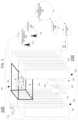
- FIG. 1illustrates an example system 100 , related to the present disclosure.
- the system 100connects user device 141 , server(s) 112 , server(s) 125 , and autonomous aerial vehicles (AAVs 160 - 161 ), with one another and with various other devices via a core network, e.g., a telecommunication network 110 , a wireless access network 115 (e.g., a cellular network), and Internet 130 .
- a core networke.g., a telecommunication network 110
- a wireless access network 115e.g., a cellular network
- Internet 130e.g., a cellular network
- the server(s) 125may each comprise a computing device or processing system, such as computing system 400 depicted in FIG. 4 , and may be configured to perform one or more steps, functions, or operations for an autonomous aerial vehicle to define a reserved zone within a space to perform an assigned task, based upon at least one object that is detected, and to present an announcement of the reserved zone.
- a computing device or processing systemsuch as computing system 400 depicted in FIG. 4
- the server(s) 125may each comprise a computing device or processing system, such as computing system 400 depicted in FIG. 4 , and may be configured to perform one or more steps, functions, or operations for an autonomous aerial vehicle to define a reserved zone within a space to perform an assigned task, based upon at least one object that is detected, and to present an announcement of the reserved zone.
- the terms “configure,” and “reconfigure”may refer to programming or loading a processing system with computer-readable/computer-executable instructions, code, and/or programs, e.g., in a distributed or non-distributed memory, which when executed by a processor, or processors, of the processing system within a same device or within distributed devices, may cause the processing system to perform various functions.
- Such termsmay also encompass providing variables, data values, tables, objects, or other data structures or the like which may cause a processing system executing computer-readable instructions, code, and/or programs to function differently depending upon the values of the variables or other data structures that are provided.
- a “processing system”may comprise a computing device, or computing system, including one or more processors, or cores (e.g., as illustrated in FIG. 4 and discussed below) or multiple computing devices collectively configured to perform various steps, functions, and/or operations in accordance with the present disclosure.
- server(s) 125may comprise an AAV fleet management system or a network-based AAV support service.
- server(s) 125may receive and store information regarding AAVs, such as (for each AAV): an identifier of the AAV, a maximum operational range of the AAV, a current operational range of the AAV, capabilities or features of the AAV, such as maneuvering capabilities, payload/lift capabilities (e.g., including maximum weight, volume, etc.), sensor and recording capabilities, lighting capabilities, visual projection capabilities, sound broadcast capabilities, and so forth.
- server(s) 125may manage or support AAVs that are deployed for performing tasks within or at a facility 190 .
- server(s) 125may obtain requests to perform tasks from personnel of the facility 190 , other automated systems, etc., may assign AAVs to particular tasks, may track task completions, and so forth.
- Server(s) 125may also store a map or mapping data of facility 190 , and provide the map or mapping data to AAVs or other non-aerial autonomous vehicles (AVs), may update the map or mapping data as new information is collected form AAVs, and so forth.
- AVsnon-aerial autonomous vehicles
- server(s) 125may store detection models that may be applied to sensor data from AAVs, e.g., in order to detect items or objects (which may include humans or animals).
- AAVsmay include on-board processing systems with one or more detection models for detecting items or objects.
- AAVsmay transmit sensor data to server(s) 125 , which may apply detection models to the sensor data in order to similarly detect items or objects.
- the MLMs, or signaturesmay be specific to particular types of visual/image and/or spatial sensor data, or may take multiple types of sensor data as inputs.
- the input sensor datamay include low-level invariant image data, such as colors (e.g., RGB (red-green-blue) or CYM (cyan-yellow-magenta) raw data (luminance values) from a CCD/photo-sensor array), shapes, color moments, color histograms, edge distribution histograms, etc.
- Visual featuresmay also relate to movement in a video and may include changes within images and between images in a sequence (e.g., video frames or a sequence of still image shots), such as color histogram differences or a change in color distribution, edge change ratios, standard deviation of pixel intensities, contrast, average brightness, and the like. For instance, these features could be used to help quantify and distinguish shimmering water, a flag on a flagpole, etc. from other types of images/object and/or other features.
- MLMsmay take multiple types of sensor data as inputs.
- MLMs or signaturesmay also be provided for detecting particular items based upon LiDAR input data, infrared camera input data, and so on.
- a detection modelmay comprise a machine learning model (MLM) that is trained based upon the plurality of features available to the system (e.g., a “feature space”).
- MLMmachine learning model
- a feature spacee.g., a “feature space”.
- MLMmachine learning algorithm
- the MLMmay comprise the average features representing the positive examples for an item in a feature space.
- one or more negative examplesmay also be applied to the MLA to train the MLM.
- the machine learning algorithm or the machine learning model trained via the MLAmay comprise, for example, a deep learning neural network, or deep neural network (DNN), a generative adversarial network (GAN), a support vector machine (SVM), e.g., a binary, non-binary, or multi-class classifier, a linear or non-linear classifier, and so forth.
- the MLAmay incorporate an exponential smoothing algorithm (such as double exponential smoothing, triple exponential smoothing, e.g., Holt-Winters smoothing, and so forth), reinforcement learning (e.g., using positive and negative examples after deployment as a MLM), and so forth.
- MLAs and/or MLMsmay be implemented in examples of the present disclosure, such as k-means clustering and/or k-nearest neighbor (KNN) predictive models, support vector machine (SVM)-based classifiers, e.g., a binary classifier and/or a linear binary classifier, a multi-class classifier, a kernel-based SVM, etc., a distance-based classifier, e.g., a Euclidean distance-based classifier, or the like, and so on.
- KNNk-means clustering and/or k-nearest neighbor
- SVMsupport vector machine
- classifierse.g., a binary classifier and/or a linear binary classifier, a multi-class classifier, a kernel-based SVM, etc.
- a distance-based classifiere.g., a Euclidean distance-based classifier, or the like, and so on.
- a trained detection modelmay be configured to process those features which are determined to be the most distinguishing features of the associated item, e.g., those features which are quantitatively the most different from what is considered statistically normal or average from other items that may be detected via a same system, e.g., the top 20 features, the top 50 features, etc.
- detection modelsmay be deployed in AAVs, and/or in a network-based processing system to process sensor data from one or more AAV sensor sources (e.g., cameras, LiDAR, and/or other sensors of AAVs), and to identify patterns in the features of the sensor data that match the detection model(s) for the respective item(s).
- AAV sensor sourcese.g., cameras, LiDAR, and/or other sensors of AAVs
- a matchmay be determined using any of the visual features mentioned above, e.g., and further depending upon the weights, coefficients, etc. of the particular type of MLM. For instance, a match may be determined when there is a threshold measure of similarity among the features of the sensor data streams(s) and an item signature.
- the system 100includes a telecommunication network 110 .
- telecommunication network 110may comprise a core network, a backbone network or transport network, such as an Internet Protocol (IP)/multi-protocol label switching (MPLS) network, where label switched routes (LSRs) can be assigned for routing Transmission Control Protocol (TCP)/IP packets, User Datagram Protocol (UDP)/IP packets, and other types of protocol data units (PDUs), and so forth.
- IPInternet Protocol
- MPLSmulti-protocol label switching
- LSRslabel switched routes
- TCPTransmission Control Protocol
- UDPUser Datagram Protocol
- PDUsprotocol data units
- the telecommunication network 110uses a network function virtualization infrastructure (NFVI), e.g., host devices or servers that are available as host devices to host virtual machines comprising virtual network functions (VNFs).
- NFVInetwork function virtualization infrastructure
- VNFsvirtual network functions
- at least a portion of the telecommunication network 110may incorporate software-defined network (SDN) components.
- SDNsoftware-defined network
- one or more wireless access networks 115may each comprise a radio access network implementing such technologies as: global system for mobile communication (GSM), e.g., a base station subsystem (BSS), or IS-95, a universal mobile telecommunications system (UMTS) network employing wideband code division multiple access (WCDMA), or a CDMA3000 network, among others.
- GSMglobal system for mobile communication
- BSSbase station subsystem
- UMTSuniversal mobile telecommunications system
- WCDMAwideband code division multiple access
- CDMA3000CDMA3000 network
- wireless access network(s) 115may each comprise an access network in accordance with any “second generation” (2G), “third generation” (3G), “fourth generation” (4G), Long Term Evolution (LTE), “fifth generation” (5G), or any other existing or yet to be developed future wireless/cellular network technology.
- base stations 117 and 118may each comprise a Node B, evolved Node B (eNodeB), or gNodeB (gNB), or any combination thereof providing a multi-generational/multi-technology-capable base station.
- user device 141 , AAV 160 , and AAV 161may be in communication with base stations 117 and 118 , which provide connectivity between user device, 141 , AAVs 160 - 161 , and other endpoint devices within the system 100 , various network-based devices, such as server(s) 112 , server(s) 125 , and so forth.
- wireless access network(s) 115may be operated by the same service provider that is operating telecommunication network 110 , or one or more other service providers.
- wireless access network(s) 115may also include one or more servers 112 , e.g., edge servers at or near the network edge.
- each of the server(s) 112may comprise a computing device or processing system, such as computing system 400 depicted in FIG. 4 and may be configured to provide one or more functions in support of examples of the present disclosure for an autonomous aerial vehicle to define a reserved zone within a space to perform an assigned task, based upon at least one object that is detected, and to present an announcement of the reserved zone.
- one or more of the server(s) 112may be configured to perform one or more steps, functions, or operations in connection with the example method 300 described below.
- server(s) 112may perform the same or similar functions as server(s) 125 .
- telecommunication network 110may provide a fleet management system, e.g., as a service to one or more subscribers/customers, in addition to telephony services, data communication services, television services, etc.
- server(s) 112may operate in conjunction with server(s) 125 to provide an AAV fleet management system and/or a network-based AAV support service.
- server(s) 125may provide more centralized services, such as AAV authorization and tracking, maintaining user accounts, creating new accounts, tracking account balances, accepting payments for services, etc.
- server(s) 112may provide more operational support to AAVs, such as deploying MLMs/detection models for detecting objects, for obtaining location information of user devices (e.g., from a cellular/wireless network service provider, such as an operator of telecommunication network 110 and wireless access network(s) 115 ), and providing such information to AAVs, and so on.
- a cellular/wireless network service providersuch as an operator of telecommunication network 110 and wireless access network(s) 115
- thisis just one example of a possible distributed architecture for an AAV fleet management system and/or a network-based AAV support service.
- various other configurationsincluding various data centers, public and/or private cloud servers, and so forth may be deployed.
- various additional elements of wireless access network(s) 115are omitted from FIG. 1 .
- user device 141may comprise, for example, a wireless enabled wristwatch.
- user device 141may comprise a cellular telephone, a smartphone, a tablet computing device, a laptop computer, a head-mounted computing device (e.g., smart glasses), or any other wireless and/or cellular-capable mobile telephony and computing devices (broadly, a “mobile device” or “mobile endpoint device”).
- user device 141may be equipped for cellular and non-cellular wireless communication.
- user device 141may include components which support peer-to-peer and/or short range wireless communications.
- user device 141may include one or more radio frequency (RF) transceivers, e.g., for cellular communications and/or for non-cellular wireless communications, such as for IEEE 802.11 based communications (e.g., Wi-Fi, Wi-Fi Direct), IEEE 802.15 based communications (e.g., Bluetooth, Bluetooth Low Energy (BLE), and/or ZigBee communications), and so forth.
- RFradio frequency
- user device 141may instead comprise a radio frequency identification (RFID) tag that may be detected by AAVs.
- RFIDradio frequency identification
- AAV 160may include a camera 162 and one or more radio frequency (RF) transceivers 166 for cellular communications and/or for non-cellular wireless communications.
- AAV 160may also include one or more module(s) 164 with one or more additional controllable components, such as one or more: microphones, loudspeakers, infrared, ultraviolet, and/or visible spectrum light sources, projectors, light detection and ranging (LiDAR) unit(s), temperature sensors (e.g., thermometers), and so forth.
- AAV 160may include a cargo handling element 167 .
- cargo handling element 167may comprise a lift hook or clamp for engaging a cargo carrier, e.g., a basket and the like.
- cargo handling element 167may alternatively or additionally comprise an internal cargo compartment in which to receive and transport an item or object.
- AAV 161may be similarly equipped. However, for ease of illustration, specific labels for such components of AAV 161 are omitted from FIG. 1 .
- each of the AAVs 160 and 161may include on-board processing systems to perform steps, functions, and/or operations for an autonomous aerial vehicle to define a reserved zone within a space to perform an assigned task, based upon at least one object that is detected, and to present an announcement of the reserved zone, and for controlling various components of the respective AAVs.
- AAVs 160 and 161may each comprise all or a portion of a computing device or processing system, such as computing system 400 as described in connection with FIG. 4 below, specifically configured to perform various steps, functions, and/or operations for an autonomous aerial vehicle to define a reserved zone within a space to perform an assigned task, based upon at least one object that is detected, and to present an announcement of the reserved zone.
- an example method 300 for an autonomous aerial vehicle to define a reserved zone within a space to perform an assigned task, based upon at least one object that is detected, and to present an announcement of the reserved zoneis illustrated in FIG. 3 and described in greater detail below.
- the facility 190may comprise a warehouse or a large box store that may have various aisles, such as aisle 192 , with rows of shelves 195 holding various items or products. As further illustrated in FIG. 1 , there may be two people 140 within the aisle, one of whom may possess a user device 141 . Continuing with the present example, the facility 190 may utilize AAVs to perform various tasks therein, such as retrieving items, placing items on shelves 195 , taking inventory, for instance, reading barcodes or QR codes from various items, from boxes containing various items, etc., capturing images of various areas within the facility 190 , and so forth.
- AAVsto perform various tasks therein, such as retrieving items, placing items on shelves 195 , taking inventory, for instance, reading barcodes or QR codes from various items, from boxes containing various items, etc., capturing images of various areas within the facility 190 , and so forth.
- the assignment of task to AAVs and the management of the airspace of the facility 190may be provided by a fleet management system, which may comprise server(s) 125 and/or server(s) 112 .
- the fleet management systemmay assign to AAV 160 a task of retrieving an item from one of the shelves 195 .
- AAV 160may already have navigated through the facility 190 and captured imagery of the facility 190 from various vantages in order to generate a spatial map of the facility 190 .
- AAV 160may have captured LiDAR sensor data to generate images/renderings of the space of the facility 190 .
- AAVmay obtain mapping data (e.g., a spatial map) from the fleet management system (e.g., server(s) 125 and/or server(s) 112 ).
- other AAVsmay have similarly captured LiDAR sensor data and/or generated LiDAR images/rendering of the facility 190 , respective portions of the facility 190 , etc., and provided such data to server(s) 125 and/or server(s) 112 for storage, aggregation, updating, distribution, etc.
- server(s) 125 and/or server(s) 112may update the stored mapping data to reflect the more recently captured data.
- AAV 160upon being assigned the task, may begin navigating toward the area associated with the task, e.g., aisle 192 .
- the AAV 160may navigate by using the previously captured and/or obtained map, or mapping data from a current location toward the aisle 192 .
- AAV 160may anticipate claiming a space 150 as a reserved zone in which it may need to work on the task.
- AAV 160may obtain information from server(s) 125 and/or server(s) 112 regarding plans of other AAVs (or non-aerial AVs) that may possibly be within the same space (e.g., aisle 192 ) at the anticipated time for AAV 160 to arrive and engage in the task.
- AAV 160may arrive at the aisle 192 . As AAV 160 approaches the area, AAV 160 may continue to scan its surroundings to detect that the current status matches with the map and/or mapping data, or to discover a discrepancy between the map and/or mapping data, and the current sensor readings.
- the people 140may be present in the aisle 192 .
- AAV 160may detect the people by capturing one or more images via at least one imaging sensor.
- the at least one imaging sensormay comprise an optical camera of the AAV, a LiDAR unit, or the like.
- the at least one imagemay comprise one or more images captured via the camera, a 3D rendering captured via the LiDAR unit, and so forth.
- the at least one imagemay comprise two or more images captured via at least two different types of imaging sensors (e.g., combining the collection of one or more optical images with one or more LiDAR images/renderings).
- AAV 160may detect the presence of obstructions, items, or objects not contained with the prior map and/or mapping data.
- AAV 160may identify the people 140 , e.g., by identifying the people 140 specifically as “people” or each individually as a “person.”
- AAV 160may apply one or more detection models (e.g., MLMs) to the captured image(s) for detecting various types of items (e.g., people, service animals, vehicles, shelves, ladders, tables, etc.).
- MLMsdetection models
- the AAVmay simply identify visual/spatial features that stand out from the surrounding environment that may be considered as new and/or altered spatial data as compared to the prior map and/or mapping data.
- AAV 160may detect at least one of the people 140 via the user device 141 , e.g., via direct/peer-to-peer wireless communication and/or sensing announcements/broadcasts by user device 141 , or in the case where user device 141 may comprise an RFID tag or transponder, via RFID sensing/detection.
- AAV 160may also detect other items, such as moveable fixtures, equipment, etc., or other people via RFID tags/transponders if such people or items are so equipped. For instance, the facility 190 may require that all personnel or visitors carry RFID tags that may be sensed by AAVs operating therein.
- AAV 160may record any changes to the map and/or mapping data that it detects. In one example, AAV 160 may also notify server(s) 125 and/or server(s) 112 of the change(s) so that server(s) 125 and/or server(s) 112 may update the stored map and/or mapping data with the most recent information. It should be noted that in one example, AAV 160 may omit notification to server(s) 125 and/or server(s) 112 of certain changes that may be detected. For instance, in the case of people 140 being detected, AAV 160 may note their presence in its own mapping data, but may maintain this data as temporary information (e.g., expiring after a certain period of time to protect privacy of the detected people).
- AAV 160may omit forwarding such data to server(s) 125 and/or server(s) 112 , or may forward to server(s) 125 and/or server(s) 112 with an indication that such data is temporary in nature and should be deleted within a predefined time.
- server(s) 125 and/or server(s) 112may simply receive the notification and determine that the data is temporary in nature since it relates to the presence of people.
- AAV 160may notify server(s) 125 and/or server(s) 112 for recording these changes in the map/mapping data that may be shared among a fleet of a plurality of AAVs.
- semi-permanent itemse.g., moveable fixtures
- AAV 160may notify server(s) 125 and/or server(s) 112 for recording these changes in the map/mapping data that may be shared among a fleet of a plurality of AAVs.
- AAV 160may determine that it needs to pick-up an item from the 5 th level of one of the shelves 195 . If the aisle 192 is completely unoccupied, the AAV 160 may be configured to claim a reserved zone of the entire aisle 192 . For instance, it may be faster and easier for AAV 160 to navigate and complete the task if it has a wide buffer and does not need to worry about incursions into the reserved zone by people or other AAVs, etc. However, in this case, because people 140 are present, AAV 160 may determine that it cannot claim the entire aisle 192 . As described above, AAV 160 may then evaluate how much space it can reserve, given the items or other changes in the space that are detected.
- AAV 160may reserve the space 150 which includes the 5th level from which AAV 160 needs to retrieve the item and which extends below while remaining above the head of the tallest one of the people 140 (e.g., with additional space as a buffer zone such as 5, 10 or 15 feet).
- AAV 160may seek permission from server(s) 125 and/or server(s) 112 to claim the reserved zone (e.g., space 150 ). In another example, AAV 160 may claim the space 150 and may simply notify server(s) 125 and/or server(s) 112 . For instance, the permission may be implied insofar as server(s) 125 and/or server(s) 112 may have dispatched AAV 160 to aisle 192 specifically for the purpose of completing the assigned task. If permission is specifically requested, for illustrative purpose it may be assumed that server(s) 125 and/or server(s) 112 may reply with a positive affirmation.
- AAV 160may then announce the reservation of space 150 (e.g., as its “reserved zone”).
- the facility 190may include a plurality of fixed reference points 199 which may comprise reflectors, RIFD beacons or tags, or the like from which AAV 160 may determine its position within the facility 190 with respect to a reference coordinate system via RF sensing/triangulation, optical or LiDAR ranging, etc.
- the AAV 160may determine coordinates to define the boundary of the space 150 .
- AAV 160may transmit a set of coordinates (e.g., x-y-z coordinates) to the fleet management system (e.g., server(s) 125 and/or server(s) 112 ) to indicate the space 150 that is being reserved.
- AAV 160may also communicate these coordinates directly to other AAVs or non-aerial AVs nearby (e.g., via direct, peer-to-peer wireless communications, which in one example may include broadcasts announcements that do not necessarily involve establishing a communication session).
- server(s) 125 and/or server(s) 112may obtain notification of the reservation of the space 150 (e.g., the coordinates, the time and/or duration of the reservation, the identify of AAV 160 claiming the space 150 , etc.) via communications from server(s) 125 and/or server(s) 112 .
- AAV 160may define the claimed space 150 in human-perceptible terms and announce the claiming/reservation of the space 150 .
- AAV 160may audibly announce the claim of space 150 via a loudspeaker that can be heard by any nearby person (e.g., people 140 ).
- the announcementmay state information such as “AAV working above you picking up an item from level 5.”
- AAV 160may generate a more detailed message that is tailored to the positions of any detected people (e.g., people 140 ) and the space 150 . For instance, the AAV 160 may determine that the people are located directly below the space 150 .
- AAV 160may announce “AAV working in reserved space, reserved space begins 15 feet from your position starting at a height of 10 feet off the ground.” AAV 160 may optionally calculate an estimated time of completion of the task and notify the fleet management system (e.g., server(s) 125 and/or server(s) 112 ) and nearby people (e.g., people 140 ) via an audible announcement.
- the fleet management systeme.g., server(s) 125 and/or server(s) 112
- nearby peoplee.g., people 140
- AAV 160may alternatively or additionally notify any present humans of the claim to space 150 using an onboard projector or other light source(s) to project an image that demarks the reserved space 150 in which the AAV 160 is performing the task. For instance, the AAV 160 may project visible light to be seen by people 140 (as indicated by the highlighted delineation of the space 150 around the AAV 160 in FIG. 1 ). Upon completion of the task, AAV 160 may announce the relinquishment of the space 150 via audible announcement and/or by ceasing the visual notification.
- AAV 160may also transmit a notification to server(s) 125 and/or server(s) 112 , and/or broadcast via wireless communication to other AAVs and/or non-aerial AVs indicating that the space 150 has been released by AAV 160 . Additional operations that may be provided by AAV 160 and/or AAV 160 in conjunction with AAV 161 , server(s) 125 and/or server(s) 112 , etc. will be described below in connection with the examples of FIG. 2 .
- system 100has been simplified. In other words, the system 100 may be implemented in a different form than that illustrated in FIG. 1 .
- the system 100may be expanded to include additional networks, and additional network elements (not shown) such as wireless transceivers and/or base stations, border elements, routers, switches, policy servers, security devices, gateways, a network operations center (NOC), a content distribution network (CDN) and the like, without altering the scope of the present disclosure.
- NOCnetwork operations center
- CDNcontent distribution network
- system 100may be altered to omit various elements, substitute elements for devices that perform the same or similar functions and/or combine elements that are illustrated as separate devices.
- server(s) 125may alternatively or additionally be performed by server(s) 112 , and vice versa.
- server(s) 112 and 125are illustrated in the example of FIG. 1 , in other, further, and different examples, the same or similar functions may be distributed among multiple other devices and/or systems within the telecommunication network 110 , wireless access network(s) 115 , and/or the system 100 in general that may collectively provide various services in connection with examples of the present disclosure for an autonomous aerial vehicle to define a reserved zone within a space to perform an assigned task, based upon at least one object that is detected, and to present an announcement of the reserved zone.
- severs(s) 112may reside in telecommunication network 110 , e.g., at or near an ingress node coupling wireless access network(s) 115 to telecommunication network 110 , in a data center of telecommunication network 110 , or distributed at a plurality of data centers of telecommunication network 110 , etc.
- devices that are illustrated and/or described as using one form of communicationmay alternatively or additionally utilize one or more other forms of communication.
- server(s) 125may communicate with AAV 160 , such as for assigning tasks to AAV 160 , monitoring for task completion, etc. via a wireless access point (AP) 122 .
- APwireless access point
- server(s) 125may be owned or operated by the same entity owning or controlling the facility 190 , and may have one or more wireless access points, such as AP 122 , deployed throughout the facility 190 .
- AP 122 and AAV 160may establish a session via Wi-Fi Direct, LTE Direct, a 5G D2D sidelink, a DSRC session/pairing, etc.
- FIG. 2illustrates example scenes of an AAV defining a reserved zone within a space to perform an assigned task, based upon at least one object that is detected, and presenting an announcement of the reserved zone, in accordance with the present disclosure.
- the examples of FIG. 2may relate to the same components as illustrated in FIG. 1 and discussed above.
- AAV 160may be retrieving or placing an item on one of the upper levels of shelves 195 in aisle 192 .
- AAV 160may utilize on-board sensors (e.g., a LiDAR unit, an optical camera, etc.) to capture one or more images of aisle 192 and to detect any changes to a previously stored and/or obtained map, which may include temporary obstacles, permanent or semi-permanent fixtures, etc., as well as any humans or animals present, other AAVs or non-aerial AVs, etc.
- on-board sensorse.g., a LiDAR unit, an optical camera, etc.
- the people 140 in scene 210may be detected by collecting sensor data, such as camera images and/or video, LiDAR measurements, etc. and inputting the sensor data to one or more trained detection models (e.g., MLMs) such as described above.
- MLMsmay be stored and applied by an on-board processing system of AAV 160 .
- AAV 160may transmit collected sensor data to server(s) 112 and/or server(s) 125 of FIG. 1 , which may apply the sensor data as inputs to one or more detection models, and which may respond to AAV 160 with any detected items or objects.
- one or more detection modelsmay be possessed by AAV 160 and applied locally, while other detection models may remain in the network-based system components (e.g., server(s) 112 and/or server(s) 125 ) and may be applied in the network.
- AAV 160may detect people 140 via one or more detection models. Accordingly, AAV 160 may claim space 150 as a reserved zone, specifically excluding space within the aisle 192 that is closer to the floor (e.g., within 10 feet of the floor, 15 feet of the floor, etc., depending upon the heights of the people 140 , the ceiling height (if any), the height of the shelf level to be accessed, etc.). AAV 160 may also provide a visual projection of the space 150 it is occupying or intends to occupy. In addition, AAV 160 may also present audible warnings to people 140 , or others nearby, of the claim to space 150 and to indicate that AAV 160 will be operating therein.
- scene 220may be similar to scene 210 , but in this case, the people 140 may not be present in the aisle 192 .
- AAV 160may arrive in aisle 192 to engage in the assigned task, may capture one or more images to detect any changes from a prior map, and may detect that the aisle 192 appears to be unchanged.
- AAV 160may reserve space 150 which may extend from the floor to the ceiling of aisle 192 and may provide a visual projection of the space 150 that it is occupying (e.g., via one or more projectors or lighting units).
- people 140 approach and attempt to enter aisle 192they may see the visual projection of the space 150 and be informed that AAV 160 has reserved space 150 .
- AAV 160may also present audible warnings to people 140 , or others nearby, of the claim to space 150 and to indicate that AAV 160 will be operating therein.
- the third scene 230may be similar to the previous scene. However, scene 230 illustrates that AAV 160 may reserve a space and release portions thereof as it competes portions of a task and no longer needs certain portions of the space. For instance, AAV 160 may have claimed/reserved a space of aisle 192 that extends floor to ceiling, but may have finished a portion of the task on the right lower side of the aisle. AAV 160 may then complete an additional portion of the task on the lower left side of the aisle. As such, AAV 160 may next release the portion 152 of the reserved space. AAV 160 may be finishing the task within the portion 150 , which it may release last as the final portion of the task is completed.
- people 140 seeking to enter aisle 192may first utilize at least the right side of the aisle. As AAV 160 completes the next portion of the task, the people 140 may then use the entire lower space of the aisle (e.g., the entire space where a human walking on the ground could conceivable occupy).
- the entire lower space of the aislee.g., the entire space where a human walking on the ground could conceivable occupy.
- AAV 160may claim space 150 in aisle 192 between shelves 195 .
- AAV 160may also seek assistance from another AAV 161 , or a fleet management system (such as server(s) 125 and/or server(s) 112 of FIG. 1 ) may instruct AAV 161 to accompany AAV 160 to provide additional notification of the reservation of space 150 to any nearby people, such as people 140 .
- AAV 160may be engaging in a task that may be more dangerous, such as lifting a large or bulky item, such that it may be desirable to have additional precautions to keep people away.
- AAV 161may be instructed by AAV 160 and/or by a fleet management system to post itself at the end of aisle 192 and to project visual information such as a warning, e.g., “aisle will be closed for 5 minutes,” or the like.
- the instructionmay be via a communication session in accordance with Wi-Fi Direct, LTE Direct, DSRC, 5G D2D or V2V, etc.).
- AAV 160may itself project visual information, e.g., as an alternative or in addition to an illumination of the space 150 , and/or as an alternative or in addition to an audible announcement.
- AAV 160may arrive at aisle 192 to perform a task, may capture one or more images to detect any changes from a prior map, and may detect that the aisle 192 appears to include a new object, e.g., a seasonal display 197 .
- AAV 160may apply the captured image(s) as inputs to one or more detection models to detect objects or items (e.g., shelves, people, vehicles, etc.), or may provide the captured images to a network-based processing system to similarly apply the captured image(s) to one or more detection models.
- AAV 160may not identify the particular type of item or object, but may simply detect a change from the prior map and/or mapping data.
- AAV 160may, at a minimum, identify any people who are present in the aisle 192 and/or animals that are present, while other objects may simply be detected as “non-human” or “non-animate.”
- AAV 160may detect the new seasonal display 197 and may reserve space 150 , which may comprise an upper portion of aisle 192 near the shelves 195 on the opposite side from the seasonal display 197 .
- AAV 160may provide a visual projection of the space 150 that it is occupying (e.g., via one or more projectors or lighting units) to inform people nearby, such as people 140 .
- people 140may see from the visual projection of the space 150 that the lower portion of the aisle 192 is open.
- the people 140may proceed to the seasonal display 197 or elsewhere in the aisle 192 without interfering with the reserved space 150 .
- AAV 160may also present audible warnings to people 140 , or others nearby, of the claim to space 150 and to indicate that AAV 160 will be operating therein. This may be particularly useful when the space 150 may be more challenging to delineate using lighting and/or visual projection. For example, at least one side of the space 150 is not bounded by a surface upon which light may be projected. Thus, the bounds of space 150 in this direction may be less clear via illumination. However, an audible warning of the reservation of space 150 may clarify the bounds.
- AAV 160may arrive at aisle 192 to perform a task, may capture one or more images to detect any changes from a prior map, and may detect that the aisle 192 appears to include new objects, specifically people 140 .
- AAV 160may not be permitted to simply occupy the aisle 192 (e.g., when customers such as people 140 are present). Accordingly, AAV 160 may need to wait until the aisle 192 is clear.
- AAV 160may present an audible message for the people 140 indicating that AAV 160 is waiting and intends to occupy aisle 192 when the people 140 are finished.
- AAV 160may present an audible message, such as “please finish your selections,” or “please do not enter aisle 192 due to pending AAV operation” for other people who are about to enter aisle 192 , and the like.
- AAV 160may then enter, claim a space, and perform the assigned task within the space that is claimed/reserved.
- AAV 160may broadcast messages to listening augmented reality (AR) devices of any people in the vicinity.
- the broadcast messagesmay contain coordinates of the bounds of space 150 , such that the AR devices may depict the space 150 with a particular visual indication, e.g., highlighting in a transparent or semi-transparent way of the space 150 using a particular color, or colors, flashing lights, displaying boundary lines, etc.
- AAV 160may broadcast an audible announcement of a reserved space, or “reserved zone,” via a wireless broadcast to be detected by user devices and presented via speakers or attached headsets of such user devices. It should also be noted that an audible announcement may be ongoing for the duration of AAV 160 performing a task, such as repeating an audible message every five seconds, every 10 seconds, or the like. Similarly, audible announcements and/or visible announcements of a claimed space may change as the task progresses (e.g., “this aisle will be occupied for the next five minutes,” “this aisle will be occupied for the next four minutes,” etc. as the task moves closer to completion).
- FIG. 3illustrates a flowchart of an example method 300 for an autonomous aerial vehicle to define a reserved zone within a space to perform an assigned task, based upon at least one object that is detected, and to present an announcement of the reserved zone.
- steps, functions and/or operations of the method 300may be performed by an AAV, such as AAV 160 or any one or more components thereof, or by AAV 160 , and/or any one or more components thereof in conjunction with one or more other components of the system 100 , such as server(s) 125 , server(s) 112 , elements of wireless access network 115 , telecommunication network 110 , one or more other AAVs (such as AAV 161 ), and so forth.
- the steps, functions, or operations of method 300may be performed by a computing device or processing system, such as computing system 400 and/or hardware processor element 402 as described in connection with FIG. 4 below.
- the computing system 400may represent any one or more components of the system 100 (e.g., AAV 160 ) that is/are configured to perform the steps, functions and/or operations of the method 300 .
- the steps, functions, or operations of the method 300may be performed by a processing system comprising one or more computing devices collectively configured to perform various steps, functions, and/or operations of the method 300 .
- multiple instances of the computing system 400may collectively function as a processing system.
- the method 300is described in greater detail below in connection with an example performed by a processing system. The method 300 begins in step 305 and may proceed to step 310 .
- the processing system(e.g., of an autonomous aerial vehicle (AAV)) obtains mapping data describing at least a portion of a facility.
- the mapping datamay be obtained from a LiDAR unit of the AAV and may be stored by the processing system.
- the AAVmay obtain the mapping data by first traversing the facility.
- the mapping datamay be obtained from a fleet management system, as described above.
- the processing systemmay obtain an assigned task from a fleet management system.
- the taskmay comprise, for example: a delivery of at least one item, a retrieval of at least one item, a mapping task, an imaging task, a sensor reading task, a visual projection task, a lighting projection task, a search task, or a security surveillance task, a combination of any of the foregoing, and so on.
- the assigned taskmay be for performance within a facility having a defined bounds, such as a warehouse, a retail store, a refinery, a shipyard, a marine terminal, a lumber yard, a quarry, a construction site, an apartment building, an event venue, such as a stadium, an arena, a theater, etc.
- the assigned taskmay be retrieving an item from an aisle or placing an item in the aisle (e.g., of a store, a warehouse, etc.). In one example, the assigned task may involve placing one item and retrieving another in the same aisle (e.g., for efficiency purposes).
- the aislemay comprise a plurality of shelves, where the assigned task may comprise retrieving at least one item from at least one of the plurality of shelves. In one example, the assigned task may comprise performing an inventory of at least a portion of the aisle.
- the assigned taskmay comprise a delivery of at least one item to a person or to another AAV.
- the facilitymay comprise an event venue, where the delivery may be of food or drink, or can be a worksite where the AAV delivers a tool, a piece of equipment, an item to install, etc., to a worker, or delivers the item halfway to another AV to complete.
- the assigned taskmay comprise an imaging task, such as performing an aerial survey of equipment and comparing to one or more prior surveys to detect changes, defects, etc. For instance, at a refinery, a port, etc. there may be a task of surveying towers, cranes, ship hulls, etc. for cracks, missing bolts, etc.
- a skyscraper or a tunnelthere may be a task of surveying for safety rail integrity (via collection of images or other sensor data) which may involve entering confined spaces of a facility that may be used by humans but which is temporarily claimed by the AAV to perform the survey, etc.
- the processing systemnavigates, via the mapping data, to a space within the facility to perform the assigned task.
- the processing systemmay guide the AAV to the space using the previously captured and/or obtained mapping data to avoid collisions with stationary obstructions, to fly an efficient route from a current location to the space to perform the task, etc.
- the processing systemcollects spatial sensor data within the space.
- the spatial sensor datamay comprise LiDAR images/renderings, images captured via an optical camera of the AAV, RFID reader/sensor data, etc.
- the processing systemdetects, from the spatial sensor data, at least one object within the space.
- the at least one objectmay comprise a person/human, an animal, equipment, such as a forklift, a picker, a truck, stacked pipes, lumber, etc., a pile of grain, stones, etc., boxes, ladders, moveable stairs, a store display, and so on.
- the at least one objectmay be an object that is not previously contained in the mapping data of the space of the facility.
- the processing systemmay specifically identify items or objects as being of a particular type of category (e.g., people, animal, vehicles, shelves, ladders, tables, etc.).
- the processing systemmay apply one or more detection models (e.g., MLMs) to the captured image(s) for detecting various types of items.
- MLMsdetection models
- the AAVmay simply identify visual/spatial features that stand out from the surrounding environment and may be considered as new and/or altered spatial data as compared to the prior map and/or mapping data.
- the processing systemmay, at a minimum, identify any people who are present and/or animals that are present, while other objects may simply be noted as “non-human” or “non-animate.”
- the at least one objectmay be detected from optical images and/or LiDAR images/renderings.
- equipment, personnel, or other humans present at the facility(such as a refinery, a lumberyard, a shipyard, etc.) may be RFID tagged and may be detectable by the processing system via an RFID reader of the AAV.
- step 330may include detecting one or more fixed reference points which may comprise reflectors, RIFD beacons or tags, or the like from which the processing system may determine the position of the AAV within the facility with respect to a reference coordinate system. This may include RF sensing/triangulation, optical or LiDAR ranging, etc. Using the same reference coordinate system in conjunction with LiDAR ranging and imaging/rendering, the processing system may determine coordinates to define the boundary of the at least one object within the space.
- a reference coordinate systemmay include RF sensing/triangulation, optical or LiDAR ranging, etc.
- the processing systemdefines a reserved zone within the space to perform the assigned task, based upon the at least one object that is detected. For example, the processing system may claim as much of the space as is available, up to a maximum limit, while accounting for the presence of the at least one object that is occupying at least a portion of a desired space. For instance, the processing system may be configured to attempt to claim a reserved zone with a maximum radius, maximum length, width, height, etc. (e.g., up to 10 meter radius, a space with a volume of 100 cubic meters, etc.).
- the processing systemmay then reduce the size of the reserved zone to account for the size of a room being less than these dimensions, an aisle being less than these dimensions, etc., while at the same time also excluding a claim to the space occupied by the at least one object.
- the at least one objectmay comprise a person such that the processing system may not claim the space occupied by the person (e.g., including a buffer of at least several feet or meters above the person to maintain a safe margin).
- the defining of the reserved zone based upon the at least one object that is detectedmay result in the reserved zone accommodating/excluding the at least one object that is detected (e.g., it provides space to a detected human, it does not claim space that is already occupied by a movable fixtures, a vehicle, such as a forklift, picker, etc., another AAV or non-aerial AV, equipment such as a tent or tarp (which could be covering a stack of piping, beams, lumber, etc. stored at a facility), and so on).
- a vehiclesuch as a forklift, picker, etc.
- equipmentsuch as a tent or tarp (which could be covering a stack of piping, beams, lumber, etc. stored at a facility), and so on).
- the processing systemmay notify the fleet management system of a reservation of the reserved zone.
- the processing systemmay define the bounds of the reserved zone, or space, using the same reference coordinate system mentioned above in conjunction with LiDAR ranging and imaging/rendering.
- the processing systemmay determine coordinates (e.g., x-y-z coordinates) to define the boundary of the reserved zone, and transmit the set coordinates to a fleet management system to indicate the reserved zone that is being claimed/reserved.
- the processing systemmay also communicate these coordinates directly to other AAVs or non-aerial AVs nearby (e.g., via direct, peer-to-peer wireless communications, such as Wi-Fi Direct, LTE Direct, a 5G D2D sidelink, a DSRC session/pairing, etc.).
- the processing systemmay transmit one or more broadcasts announcements that do not necessarily involve establishing a communication session.
- the processing systemmay request a reservation of the reserved zone from a fleet management system.
- optional step 345may be similar to optional step 340 .
- the processing systemmay not cause the AAV to occupy the space/reserved zone unless an affirmation is provided by the fleet management system.
- the processing systemmay obtain the reservation of the reserved zone (e.g., receiving an affirmation of the request), when the fleet management system determines that the reservation does not conflict with a prior reservation of another entity.
- the other entitycan be another AV or a human personnel of the facility, for example. It should be noted that in an example in which optional steps 345 and 350 are included, optional step 340 may be excluded, and vice versa.
- the processing systempresents at least one of an audible announcement or a visual announcement of the reserved zone.
- audible and/or visual announcementsare discussed above in connection with the illustrations of FIGS. 1 and 2 .
- the visual announcementmay comprise a projection via at least one lighting unit or at least one projector of visible light indicating a boundary of the reserved zone.
- the visual announcementmay alternatively include an audible announcement.
- the AAVmay simply provide the audible announcement without any visual announcement, e.g., in scenarios where the visual announcement may be ineffective or impractical, e.g., in situations where the reserved zone is already very bright or the reserved zone has mirrors that may reflect the visual announcement to other areas of the facility unintentionally.
- the processing systemmay detect at least one discrepancy between the spatial sensor data that is collected and the mapping data.
- the discrepancymay comprise the at least one object that is detected at step 330 .
- the at least one objectmay comprise a moveable fixture, such as a seasonal display, scaffolding, a food cart, a tent, an equipment trailer, and so on.
- the at least one discrepancymay comprise a detection of a wall where there was none previously, fixed shelving in a different position or different configuration than in the previous mapping data, and so on.
- the processing systemmay update the mapping data in accordance with the spatial sensor data. For instance, the processing system may update a map stored locally on-board the AAV, or may transmit a notification to a fleet management system to update a shared map, or mapping data.
- the processing systemmay perform at least a part of the assigned task, such as retrieving an item from an aisle or placing an item in an aisle, e.g., retrieving an item from a shelf or placing the item on a shelf, performing an inventory of at least a portion of the aisle, delivering an item to a person or to another AAV, assisting another AAV, etc.
- the processing systemmay relinquish at least a first portion of the reserved space as at least a part of the assigned task is completed.
- the relinquishingmay include generating a new audible announcement and/or altering the visual announcement to conform to a second portion of the reserved space that remains under reservation after the relinquishing of the at least the first portion.
- the processing systemmay determine whether to continue. For example, if there are additional parts of the task to be completed, the processing system may return to optional step 340 , step 355 , or optional step 370 , e.g., depending upon the particular configuration of the processing system, whether the fleet management system requires AAVs to update reserved zones, whether there are currently any people detected near the reserved zone, etc. Otherwise, the processing system may proceed to step 395 .
- step 355the method 300 may proceed to step 395 .
- step 395the method 300 ends.
- the method 300may be expanded to include additional steps, or may be modified to replace steps with different steps, to combine steps, to omit steps, to perform steps in a different order, and so forth.
- the processing systemmay repeat one or more steps of the method 300 for additional tasks.
- optional steps 360 and 365may precede step 335 .
- the method 300may include summoning another AAV or non-aerial AV to provide additional notification of the occupancy of the reserved zone.
- one or more steps of the method 300may include a storing, displaying and/or outputting step as required for a particular application.
- any data, records, fields, and/or intermediate results discussed in the methodcan be stored, displayed and/or outputted to another device as required for a particular application.
- operations, steps, or blocks in FIG. 3 that recite a determining operation or involve a decisiondo not necessarily require that both branches of the determining operation be practiced. In other words, one of the branches of the determining operation can be deemed as an optional step.
- FIG. 4depicts a high-level block diagram of a computing system 400 (e.g., a computing device or processing system) specifically programmed to perform the functions described herein.
- a computing system 400e.g., a computing device or processing system
- any one or more components, devices, and/or systems illustrated in FIG. 1 or described in connection with FIG. 2 or 3may be implemented as the computing system 400 .
- FIG. 4depicts a high-level block diagram of a computing system 400 (e.g., a computing device or processing system) specifically programmed to perform the functions described herein.
- a computing system 400e.g., a computing device or processing system
- the computing system 400comprises a hardware processor element 402 (e.g., comprising one or more hardware processors, which may include one or more microprocessor(s), one or more central processing units (CPUs), and/or the like, where the hardware processor element 402 may also represent one example of a “processing system” as referred to herein), a memory 404 , (e.g., random access memory (RAM), read only memory (ROM), a disk drive, an optical drive, a magnetic drive, and/or a Universal Serial Bus (USB) drive), a module 405 for an autonomous aerial vehicle to define a reserved zone within a space to perform an assigned task, based upon at least one object that is detected, and to present an announcement of the reserved zone, and various input/output devices 406 , e.g., a camera, a video camera, storage devices, including but not limited to, a tape drive, a floppy drive, a hard disk drive or a compact disk drive, a receiver, a transmitter, a hardware processor
- the computing system 400may employ a plurality of hardware processor elements.
- the computing system 400may represent each of those multiple or parallel computing devices.
- one or more hardware processor elementse.g., hardware processor element 402
- the virtualized computing environmentmay support one or more virtual machines which may be configured to operate as computers, servers, or other computing devices.
- hardware componentssuch as hardware processors and computer-readable storage devices may be virtualized or logically represented.
- the hardware processor element 402can also be configured or programmed to cause other devices to perform one or more operations as discussed above. In other words, the hardware processor element 402 may serve the function of a central controller directing other devices to perform the one or more operations as discussed above.
- the present disclosurecan be implemented in software and/or in a combination of software and hardware, e.g., using application specific integrated circuits (ASIC), a programmable logic array (PLA), including a field-programmable gate array (FPGA), or a state machine deployed on a hardware device, a computing device, or any other hardware equivalents, e.g., computer-readable instructions pertaining to the method(s) discussed above can be used to configure one or more hardware processor elements to perform the steps, functions and/or operations of the above disclosed method(s).
- ASICapplication specific integrated circuits
- PDAprogrammable logic array
- FPGAfield-programmable gate array
- instructions and data for the present module 405 for an autonomous aerial vehicle to define a reserved zone within a space to perform an assigned task, based upon at least one object that is detected, and to present an announcement of the reserved zonecan be loaded into memory 404 and executed by hardware processor element 402 to implement the steps, functions or operations as discussed above in connection with the example method(s).
- a hardware processor elementexecutes instructions to perform operations, this could include the hardware processor element performing the operations directly and/or facilitating, directing, or cooperating with one or more additional hardware devices or components (e.g., a co-processor and the like) to perform the operations.
- the processore.g., hardware processor element 402
- executing the computer-readable instructions relating to the above described method(s)can be perceived as a programmed processor or a specialized processor.
- the present module 405 for an autonomous aerial vehicle to define a reserved zone within a space to perform an assigned task, based upon at least one object that is detected, and to present an announcement of the reserved zone (including associated data structures) of the present disclosurecan be stored on a tangible or physical (broadly non-transitory) computer-readable storage device or medium, e.g., volatile memory, non-volatile memory, ROM memory, RAM memory, magnetic or optical drive, device or diskette and the like.
- a “tangible” computer-readable storage device or mediummay comprise a physical device, a hardware device, or a device that is discernible by the touch. More specifically, the computer-readable storage device or medium may comprise any physical devices that provide the ability to store information such as instructions and/or data to be accessed by a processor or a computing device such as a computer or an application server.
Landscapes
- Engineering & Computer Science (AREA)
- Radar, Positioning & Navigation (AREA)
- Remote Sensing (AREA)
- Aviation & Aerospace Engineering (AREA)
- Physics & Mathematics (AREA)
- General Physics & Mathematics (AREA)
- Automation & Control Theory (AREA)
- Business, Economics & Management (AREA)
- Tourism & Hospitality (AREA)
- Marketing (AREA)
- Entrepreneurship & Innovation (AREA)
- Theoretical Computer Science (AREA)
- General Business, Economics & Management (AREA)
- Development Economics (AREA)
- Strategic Management (AREA)
- Economics (AREA)
- Quality & Reliability (AREA)
- Human Resources & Organizations (AREA)
- Operations Research (AREA)
- Health & Medical Sciences (AREA)
- Evolutionary Computation (AREA)
- Artificial Intelligence (AREA)
- Medical Informatics (AREA)
- Game Theory and Decision Science (AREA)
- Traffic Control Systems (AREA)
Abstract
Description
Claims (20)
Priority Applications (1)
| Application Number | Priority Date | Filing Date | Title |
|---|---|---|---|
| US17/107,776US11726475B2 (en) | 2020-11-30 | 2020-11-30 | Autonomous aerial vehicle airspace claiming and announcing |
Applications Claiming Priority (1)
| Application Number | Priority Date | Filing Date | Title |
|---|---|---|---|
| US17/107,776US11726475B2 (en) | 2020-11-30 | 2020-11-30 | Autonomous aerial vehicle airspace claiming and announcing |
Publications (2)
| Publication Number | Publication Date |
|---|---|
| US20220171387A1 US20220171387A1 (en) | 2022-06-02 |
| US11726475B2true US11726475B2 (en) | 2023-08-15 |
Family
ID=81751323
Family Applications (1)
| Application Number | Title | Priority Date | Filing Date |
|---|---|---|---|
| US17/107,776Active2041-08-06US11726475B2 (en) | 2020-11-30 | 2020-11-30 | Autonomous aerial vehicle airspace claiming and announcing |
Country Status (1)
| Country | Link |
|---|---|
| US (1) | US11726475B2 (en) |
Citations (147)
| Publication number | Priority date | Publication date | Assignee | Title |
|---|---|---|---|---|
| US5295551A (en) | 1986-03-06 | 1994-03-22 | Josef Sukonick | System for the cooperative driving of two or more vehicles |
| US5636123A (en) | 1994-07-15 | 1997-06-03 | Rich; Richard S. | Traffic alert and collision avoidance coding system |
| US20050259150A1 (en) | 2004-05-24 | 2005-11-24 | Yoshiyuki Furumi | Air-floating image display apparatus |
| US20070288132A1 (en) | 2006-06-07 | 2007-12-13 | Raytheon Company | Cooperative swarm of unmanned vehicles |
| US20080129544A1 (en)* | 2006-10-26 | 2008-06-05 | Bayerische Motoren Werke Aktiengesellschaft | Method of Controlling A Driving Maneuver |
| US7415331B2 (en) | 2005-07-25 | 2008-08-19 | Lockheed Martin Corporation | System for controlling unmanned vehicles |
| US7451023B2 (en) | 2005-07-25 | 2008-11-11 | Lockheed Martin Corporation | Collaborative system for a team of unmanned vehicles |
| US7737878B2 (en) | 2007-07-09 | 2010-06-15 | Eads Deutschland Gmbh | Collision and conflict avoidance system for autonomous unmanned air vehicles (UAVs) |
| US8914182B2 (en) | 2012-03-30 | 2014-12-16 | The Boeing Company | Network of unmanned vehicles |
| US8948935B1 (en) | 2013-01-02 | 2015-02-03 | Google Inc. | Providing a medical support device via an unmanned aerial vehicle |
| US20150202770A1 (en) | 2014-01-17 | 2015-07-23 | Anthony Patron | Sidewalk messaging of an autonomous robot |
| US20150269258A1 (en) | 2011-12-23 | 2015-09-24 | Prioria Robotics, Inc. | Automated Self-Censoring of Remotely-Sensed Data Based on Automated ROI Awareness and People Detection Using a Prioritized Contact Transport Stream |
| US9169030B2 (en) | 2013-02-15 | 2015-10-27 | Disney Enterprises, Inc. | Aerial display system with floating pixels |
| US20150350614A1 (en) | 2012-08-31 | 2015-12-03 | Brain Corporation | Apparatus and methods for tracking using aerial video |
| CN105278759A (en) | 2014-07-18 | 2016-01-27 | 深圳市大疆创新科技有限公司 | Image projecting method based on aircraft, image projecting device based on aircraft and aircraft |
| US9317034B2 (en) | 2011-10-19 | 2016-04-19 | Amazon Technologies, Inc. | System and method for inventory management using mobile drive units |
| US20160214717A1 (en) | 2013-10-08 | 2016-07-28 | Shelton Gamini De Silva | Combination of unmanned aerial vehicles and the method and system to engage in multiple applications |
| US9405181B2 (en) | 2014-07-31 | 2016-08-02 | Disney Enterprises, Inc. | Projection assemblies for use with unmanned aerial vehicles |
| US20160246297A1 (en) | 2015-02-24 | 2016-08-25 | Siemens Corporation | Cloud-based control system for unmanned aerial vehicles |
| US9464907B1 (en) | 2016-01-08 | 2016-10-11 | International Business Machines Corporation | Dynamically establishing a temporary safe route via a network of unmanned vehicles |
| US20160327956A1 (en)* | 2014-12-31 | 2016-11-10 | SZ DJI Technology Co., Ltd. | Vehicle altitude restrictions and control |
| US9523986B1 (en) | 2015-12-04 | 2016-12-20 | International Business Machines Corporation | System and method for secure, privacy-aware and contextualised package delivery using autonomous vehicles |
| US20160373699A1 (en) | 2013-10-18 | 2016-12-22 | Aerovironment, Inc. | Privacy Shield for Unmanned Aerial Systems |
| WO2016210156A1 (en) | 2015-06-23 | 2016-12-29 | Archon Technologies S.R.L. | System for autonomous operation of multiple hybrid unmanned aerial vehicles supported by recharging stations to perform services |
| US9567077B2 (en) | 2014-02-14 | 2017-02-14 | Accenture Global Services Limited | Unmanned vehicle (UV) control system |
| US20170081026A1 (en) | 2014-09-03 | 2017-03-23 | Infatics, Inc. (DBA DroneDeploy) | System and methods for hosting missions with unmanned aerial vehicles |
| WO2017055080A1 (en) | 2015-09-28 | 2017-04-06 | Koninklijke Philips N.V. | System and method for supporting physical exercises |
| WO2017065107A1 (en) | 2015-10-16 | 2017-04-20 | 株式会社プロドローン | Information transmission device |
| WO2017068224A1 (en) | 2015-10-23 | 2017-04-27 | Consejo Superior De Investigaciones Científicas | Biomimetic and zoosemiotic unmanned aircraft guided by automatic pilot for precision and/or pursuit flights |
| US9691285B2 (en) | 2014-07-14 | 2017-06-27 | John A. Jarrell | Unmanned aerial vehicle communication, monitoring, and traffic management |
| US9713675B2 (en) | 2012-07-17 | 2017-07-25 | Elwha Llc | Unmanned device interaction methods and systems |
| US9720519B2 (en) | 2014-07-30 | 2017-08-01 | Pramod Kumar Verma | Flying user interface |
| US9754496B2 (en) | 2014-09-30 | 2017-09-05 | Elwha Llc | System and method for management of airspace for unmanned aircraft |
| US9760087B2 (en) | 2015-01-16 | 2017-09-12 | International Business Machines Corporation | Distributed, unmanned aerial vehicle package transport network |
| WO2017157863A1 (en) | 2016-03-15 | 2017-09-21 | Jaguar Land Rover Limited | System for providing land vehicle support operations using an unmanned autonomous vehicle |
| US20170278409A1 (en) | 2016-03-25 | 2017-09-28 | Unmanned Innovation Inc. (dba Airware) | Unmanned aerial vehicle airspace reservation and allocation system |
| US20170291608A1 (en) | 2016-04-11 | 2017-10-12 | Volkswagen Ag | Method for the autonomous or partly autonomous execution of a cooperative driving maneuver |
| US9798329B2 (en) | 2015-07-27 | 2017-10-24 | Genghiscomm Holdings, LLC | Airborne relays in cooperative-MIMO systems |
| US9835709B2 (en) | 2016-02-02 | 2017-12-05 | Bao Tran | Systems and methods for permission based control of robots |
| US9848459B2 (en) | 2016-04-06 | 2017-12-19 | Cisco Technology, Inc. | Dynamic network connectivity using unmanned aerial vehicles |
| US9854206B1 (en) | 2016-12-22 | 2017-12-26 | TCL Research America Inc. | Privacy-aware indoor drone exploration and communication framework |
| US20170368413A1 (en) | 2016-03-12 | 2017-12-28 | Arie Shavit | Training system and methods for designing, monitoring and providing feedback of training |
| US9861075B2 (en) | 2014-10-31 | 2018-01-09 | SZ DJI Technology Co., Ltd. | Systems and methods for walking pets |
| US20180009547A1 (en)* | 2016-07-06 | 2018-01-11 | The Boeing Company | Laser Projected Engine Hazard Zone Systems And Methods |
| US20180035606A1 (en) | 2016-08-05 | 2018-02-08 | Romello Burdoucci | Smart Interactive and Autonomous Robotic Property Maintenance Apparatus, System, and Method |
| US9896202B2 (en) | 2014-12-03 | 2018-02-20 | X Development Llc | Systems and methods for reliable relative navigation and autonomous following between unmanned aerial vehicle and a target object |
| US20180072416A1 (en) | 2016-09-09 | 2018-03-15 | Wal-Mart Stores, Inc. | Geographic area monitoring systems and methods of cooperatively utilizing multiple unmanned vehicles |
| WO2018052352A1 (en) | 2016-12-23 | 2018-03-22 | Telefonaktiebolaget Lm Ericsson (Publ) | Unmanned aerial vehicle in controlled airspace |
| US9940525B2 (en) | 2012-11-19 | 2018-04-10 | Mace Wolf | Image capture with privacy protection |
| US9943965B2 (en) | 2012-08-03 | 2018-04-17 | Toyota Motor Engineering & Manufacturing North America, Inc. | Robots comprising projectors for projecting images on identified projection surfaces |
| CN107945103A (en) | 2017-11-14 | 2018-04-20 | 上海歌尔泰克机器人有限公司 | The privacy screen method, apparatus and unmanned plane of unmanned plane image |
| US20180136659A1 (en) | 2016-11-15 | 2018-05-17 | Rooftop Group International Pte. Ltd. | Motion activated flying camera systems |
| US9977428B2 (en) | 2016-04-26 | 2018-05-22 | At&T Intellectual Property I, L.P. | Augmentative control of drones |
| US9984579B1 (en) | 2016-06-28 | 2018-05-29 | Amazon Technologies, Inc. | Unmanned aerial vehicle approach notification |
| US9986378B2 (en) | 2014-07-29 | 2018-05-29 | GeoFrenzy, Inc. | Systems and methods for defining and implementing rules for three dimensional geofences |
| US20180162504A1 (en) | 2016-12-13 | 2018-06-14 | Oceaneering International, Inc. | System and Method For Using A Combination Of Multiple Autonomous Vehicles With Different Abilities, Working Together As A System For Subsea Oil and Gas Exploration |
| US10050760B2 (en) | 2015-12-08 | 2018-08-14 | Uber Technologies, Inc. | Backend communications system for a fleet of autonomous vehicles |
| US20180239343A1 (en)* | 2016-04-25 | 2018-08-23 | Invia Robotics, Inc. | Optimizing robotic movements based on an autonomous coordination of resources amongst robots |
| US10073336B2 (en) | 2012-09-11 | 2018-09-11 | Barco N.V. | Projection system with safety detection |
| US20180259960A1 (en) | 2015-08-20 | 2018-09-13 | Motionloft, Inc. | Object detection and analysis via unmanned aerial vehicle |
| US20180267601A1 (en)* | 2017-03-15 | 2018-09-20 | Oculus Vr, Llc | Light Projection for Guiding a User within a Physical User Area During Virtual Reality Operations |
| US20180308130A1 (en) | 2017-04-19 | 2018-10-25 | Usman Hafeez | System and Method for UAV Based Mobile Messaging |
| US20180330316A1 (en)* | 2017-05-11 | 2018-11-15 | Walmart Apollo, Llc | Systems and Methods for Fulfilment Design & Optimization |
| US10155166B1 (en) | 2017-09-08 | 2018-12-18 | Sony Interactive Entertainment Inc. | Spatially and user aware second screen projection from a companion robot or device |
| WO2019006769A1 (en) | 2017-07-06 | 2019-01-10 | 杨顺伟 | Following-photographing method and device for unmanned aerial vehicle |
| US20190035128A1 (en) | 2017-07-31 | 2019-01-31 | Iain Matthew Russell | Unmanned aerial vehicles |
| US10203701B2 (en) | 2015-11-06 | 2019-02-12 | Massachusetts Institute Of Technology | Dynamic task allocation in an autonomous multi-UAV mission |
| US20190052852A1 (en) | 2018-09-27 | 2019-02-14 | Intel Corporation | Unmanned aerial vehicle surface projection |
| US20190051224A1 (en) | 2017-12-28 | 2019-02-14 | Intel Corporation | Systems, methods and apparatus for self-coordinated drone based digital signage |
| US20190061942A1 (en) | 2017-07-03 | 2019-02-28 | George A. Miller | Method and system from controlling an unmanned aerial vehicle |
| US10254766B2 (en) | 2016-11-09 | 2019-04-09 | Walmart Apollo, Llc | Autonomous ganged vehicles |
| US20190112048A1 (en) | 2016-03-30 | 2019-04-18 | Matthew CULVER | Systems and methods for unmanned aerial vehicles |
| US10269257B1 (en) | 2015-08-11 | 2019-04-23 | Gopro, Inc. | Systems and methods for vehicle guidance |
| US10274952B2 (en) | 2016-09-09 | 2019-04-30 | Walmart Apollo, Llc | Geographic area monitoring systems and methods through interchanging tool systems between unmanned vehicles |
| US20190135450A1 (en) | 2016-07-04 | 2019-05-09 | SZ DJI Technology Co., Ltd. | System and method for automated tracking and navigation |
| US10313638B1 (en) | 2015-06-12 | 2019-06-04 | Amazon Technologies, Inc. | Image creation using geo-fence data |
| US10308430B1 (en) | 2016-12-23 | 2019-06-04 | Amazon Technologies, Inc. | Distribution and retrieval of inventory and materials using autonomous vehicles |
| US10325506B2 (en) | 2014-04-08 | 2019-06-18 | Technische Universität Dortmund | Method for monitoring airspace |
| US20190185158A1 (en) | 2017-12-20 | 2019-06-20 | Wing Aviation Llc | Methods and Systems for Self-Deployment of Operational Infrastructure by an Unmanned Aerial Vehicle (UAV) |
| US10331124B2 (en) | 2017-07-20 | 2019-06-25 | Nuro, Inc. | Autonomous vehicle repositioning |
| US10332394B2 (en) | 2017-11-07 | 2019-06-25 | Intel Corporation | Unmanned aerial vehicles and related methods and systems |
| US20190197254A1 (en) | 2017-12-27 | 2019-06-27 | Honeywell International Inc. | Systems and methods for dynamically masking video and images captured a drone device camera |
| US10354537B2 (en) | 2017-05-02 | 2019-07-16 | Here Global B.V. | Method and apparatus for privacy-sensitive routing of an aerial drone |
| US20190227557A1 (en) | 2016-08-12 | 2019-07-25 | 4Dream Co., Ltd. | Unmanned aerial vehicle including flight and photographing control device |
| US20190238338A1 (en) | 2018-01-31 | 2019-08-01 | Walmart Apollo, Llc | Cloning drones using blockchain |
| US10372122B2 (en) | 2015-02-04 | 2019-08-06 | LogiCom & Wireless Ltd. | Flight management system for UAVs |
| EP3525157A1 (en) | 2018-02-09 | 2019-08-14 | Volkswagen Aktiengesellschaft | Method and system for cooperative operation |
| US20190302791A1 (en)* | 2018-03-30 | 2019-10-03 | Brain Corporation | Systems and methods for robust robotic mapping |
| US10440229B2 (en) | 2017-11-15 | 2019-10-08 | Dean Drako | Aerial imaging privacy enhancement system |
| US10438494B1 (en)* | 2016-10-10 | 2019-10-08 | Amazon Technologies, Inc. | Generation of flight plans for aerial vehicles |
| US10441020B1 (en) | 2018-05-31 | 2019-10-15 | Nike, Inc. | Intelligent electronic footwear and control logic for executing automated footwear features |
| US10453345B2 (en) | 2017-01-30 | 2019-10-22 | International Business Machines Corporation | Autonomous presentation of a self-driving vehicle |
| US20190324456A1 (en) | 2018-04-19 | 2019-10-24 | Aurora Flight Sciences Corporation | Adaptive Autonomy System Architecture |
| US10467885B2 (en) | 2015-09-30 | 2019-11-05 | Alarm.Com Incorporated | Drone-augmented emergency response services |
| US20190339712A1 (en) | 2017-02-28 | 2019-11-07 | Wayfarer, Inc. | Transportation system |
| US10481600B2 (en) | 2017-09-15 | 2019-11-19 | GM Global Technology Operations LLC | Systems and methods for collaboration between autonomous vehicles |
| US20190369641A1 (en) | 2018-05-31 | 2019-12-05 | Carla R. Gillett | Robot and drone array |
| US10501180B2 (en) | 2017-10-04 | 2019-12-10 | Simon Siu-Chi Yu | Multifunction firefighting infrasound, hailstone, plant pollination drone apparatus and method |
| WO2019235667A1 (en) | 2018-06-08 | 2019-12-12 | Kim Jeong Sook | Indoor guide drone and method for controlling same |
| US20190377345A1 (en) | 2018-06-12 | 2019-12-12 | Skydio, Inc. | Fitness and sports applications for an autonomous unmanned aerial vehicle |
| US20200014759A1 (en) | 2018-07-09 | 2020-01-09 | Noblis, Inc. | Systems and methods for optimizing cooperative actions among heterogeneous autonomous connected machines |
| US20200012284A1 (en)* | 2018-07-03 | 2020-01-09 | Panasonic Intellectual Property Management Co., Ltd. | Mover control system, mover system, mover control method, and non-transitory storage medium |
| US20200032484A1 (en) | 2018-07-26 | 2020-01-30 | Caterpillar Paving Products Inc. | Managing work area reservations for autonomous vehicles |
| US20200042013A1 (en) | 2018-07-31 | 2020-02-06 | Honda Motor Co., Ltd. | System and method for shared autonomy through cooperative sensing |
| US20200043347A1 (en) | 2018-08-01 | 2020-02-06 | Potomac Aviation Technology Corp. | Automated Air-Traffic Advisory System and Method |
| US10565395B2 (en) | 2016-01-29 | 2020-02-18 | Kiwi Security Software GmbH | Methods and apparatus for using video analytics to detect regions for privacy protection within images from moving cameras |
| US20200066163A1 (en) | 2018-08-21 | 2020-02-27 | The Boeing Company | Restricted airspace monitoring systems and methods |
| US20200066147A1 (en) | 2018-08-24 | 2020-02-27 | The Boeing Company | Method, system and emergency control device for traffic management of autonomous vehicles in emergency situations |
| US10586464B2 (en) | 2015-07-29 | 2020-03-10 | Warren F. LeBlanc | Unmanned aerial vehicles |
| US20200082731A1 (en) | 2017-07-17 | 2020-03-12 | Aurora Flight Sciences Corporation | System and Method for Detecting Obstacles in Aerial Systems |
| US10600326B2 (en) | 2016-09-15 | 2020-03-24 | International Business Machines Corporation | Method for guiding an emergency vehicle using an unmanned aerial vehicle |
| WO2020057887A1 (en) | 2018-09-18 | 2020-03-26 | Wabco Gmbh | Method for coordinating a vehicle group, evaluation unit, vehicle and vehicle group |
| US20200094964A1 (en) | 2014-02-28 | 2020-03-26 | Lucas J. Myslinski | Drone device |
| US10607462B2 (en) | 2017-11-15 | 2020-03-31 | Eagle Eye Networks, Inc. | Aerial imaging privacy enhancement system |
| US20200103882A1 (en) | 2018-09-28 | 2020-04-02 | Autoguide LLC | Collaborative automation logistics facility |
| WO2020072387A1 (en) | 2018-10-03 | 2020-04-09 | T-Mobile Usa, Inc. | Mobile aerial drone early warning privacy breach detect, intercept, and defend systems and methods |
| US10636297B2 (en) | 2017-08-11 | 2020-04-28 | Fujitsu Limited | Cooperative autonomous driving for traffic congestion avoidance |
| US20200130827A1 (en) | 2018-10-26 | 2020-04-30 | Here Global B.V. | Method and apparatus for utilizing an unmanned air vehicle to define or provide guidance along a route |
| US10643406B2 (en) | 2016-04-20 | 2020-05-05 | Gopro, Inc. | Data logging in aerial platform |
| US20200145619A1 (en) | 2017-11-15 | 2020-05-07 | Dean Drako | Aerial Imaging Privacy Enhancement System |
| US10654482B2 (en) | 2015-01-19 | 2020-05-19 | Toyota Jidosha Kabushiki Kaisha | Autonomous driving vehicle system |
| US10655968B2 (en) | 2017-01-10 | 2020-05-19 | Alarm.Com Incorporated | Emergency drone guidance device |
| TWI693959B (en) | 2017-06-27 | 2020-05-21 | 日商歐姆龍股份有限公司 | Control device, flying body and recording medium |
| US10672278B2 (en) | 2016-07-29 | 2020-06-02 | International Business Machines Corporation | Unmanned aerial vehicle ad-hoc clustering and collaboration via shared intent and operator discovery |
| US10676022B2 (en) | 2017-12-27 | 2020-06-09 | X Development Llc | Visually indicating vehicle caution regions |
| US20200183384A1 (en) | 2018-12-10 | 2020-06-11 | Hyundai Motor Company | Autonomous driving system and method for vehicles and vehicle including the same |
| US10683088B2 (en) | 2016-05-27 | 2020-06-16 | International Business Machines Corporation | Unmanned aerial vehicle for crowd visual feedback |
| EP3667451A1 (en) | 2018-12-11 | 2020-06-17 | Seat, S.A. | Method and system for controlling a plurality of autonomous vehicles |
| US20200207371A1 (en) | 2019-01-02 | 2020-07-02 | Qualcomm Incorporated | Methods And Systems For Establishing Cooperative Driving Engagements With Vehicles Having Varying Levels Of Autonomy |
| US10706634B1 (en) | 2019-07-16 | 2020-07-07 | Disney Enterprises, Inc. | System for generating augmented reality content from a perspective view of an unmanned aerial vehicle |
| US20200250848A1 (en) | 2019-01-31 | 2020-08-06 | StradVision, Inc. | Method and device for short-term path planning of autonomous driving through information fusion by using v2x communication and image processing |
| US10748429B2 (en) | 2018-01-23 | 2020-08-18 | Textron Innovations Inc. | Aircraft node of a decentralized airspace management system |
| US20200265723A1 (en) | 2016-03-28 | 2020-08-20 | International Business Machines Corporation | Operation of an aerial drone inside an exclusion zone |
| US20200265701A1 (en) | 2017-10-31 | 2020-08-20 | Eran Schenker | Systems and methods for detecting and monitoring hazardous obstacles |
| US20200262450A1 (en) | 2019-02-19 | 2020-08-20 | Baidu Online Network Technology (Beijing) Co., Ltd. | Interaction method and apparatus between vehicles |
| US20200273353A1 (en) | 2019-02-22 | 2020-08-27 | International Business Machines Corporation | Emulating unmanned aerial vehicle (uav) |
| US10761544B2 (en) | 2017-10-13 | 2020-09-01 | Deere & Company | Unmanned aerial vehicle (UAV)-assisted worksite operations |
| US10762797B2 (en) | 2014-06-25 | 2020-09-01 | Amazon Technologies, Inc. | Object avoidance methods for automated aerial vehicles |
| US10762795B2 (en) | 2016-02-08 | 2020-09-01 | Skydio, Inc. | Unmanned aerial vehicle privacy controls |
| US10765378B2 (en) | 2016-02-24 | 2020-09-08 | Preaction Technology Corporation | Method and system for determining physiological status of users based on marker-less motion capture and generating appropriate remediation plans |
| KR102160722B1 (en) | 2018-10-04 | 2020-09-29 | 세종대학교산학협력단 | Outdoor advertising system using movable hologram |
| US10818187B2 (en) | 2017-07-17 | 2020-10-27 | Uatc, Llc | Systems and methods for deploying an autonomous vehicle to oversee autonomous navigation |
| US20200341471A1 (en) | 2019-04-23 | 2020-10-29 | Here Global B.V. | Drone-based collection of location-related data |
| US20200357288A1 (en) | 2018-02-13 | 2020-11-12 | General Electric Company | Apparatus, system and method for managing airspace for unmanned aerial vehicles |
| US20200356115A1 (en) | 2019-05-10 | 2020-11-12 | Wing Aviation Llc | Real-time optimization of autonomous vehicle routes |
| US20200380876A1 (en)* | 2019-05-31 | 2020-12-03 | Cognizant Technology Solutions India Pvt. Ltd. | System and method for optimizing unmanned aerial vehicle based warehouse management |
| US10954067B1 (en)* | 2018-07-13 | 2021-03-23 | Vecna Robotics, Inc. | System and method of providing delivery of items from one container to another container in a hybrid environment |
- 2020
- 2020-11-30USUS17/107,776patent/US11726475B2/enactiveActive
Patent Citations (150)
| Publication number | Priority date | Publication date | Assignee | Title |
|---|---|---|---|---|
| US5295551A (en) | 1986-03-06 | 1994-03-22 | Josef Sukonick | System for the cooperative driving of two or more vehicles |
| US5636123A (en) | 1994-07-15 | 1997-06-03 | Rich; Richard S. | Traffic alert and collision avoidance coding system |
| US20050259150A1 (en) | 2004-05-24 | 2005-11-24 | Yoshiyuki Furumi | Air-floating image display apparatus |
| US7415331B2 (en) | 2005-07-25 | 2008-08-19 | Lockheed Martin Corporation | System for controlling unmanned vehicles |
| US7451023B2 (en) | 2005-07-25 | 2008-11-11 | Lockheed Martin Corporation | Collaborative system for a team of unmanned vehicles |
| US20070288132A1 (en) | 2006-06-07 | 2007-12-13 | Raytheon Company | Cooperative swarm of unmanned vehicles |
| US20080129544A1 (en)* | 2006-10-26 | 2008-06-05 | Bayerische Motoren Werke Aktiengesellschaft | Method of Controlling A Driving Maneuver |
| US7737878B2 (en) | 2007-07-09 | 2010-06-15 | Eads Deutschland Gmbh | Collision and conflict avoidance system for autonomous unmanned air vehicles (UAVs) |
| US9317034B2 (en) | 2011-10-19 | 2016-04-19 | Amazon Technologies, Inc. | System and method for inventory management using mobile drive units |
| US20150269258A1 (en) | 2011-12-23 | 2015-09-24 | Prioria Robotics, Inc. | Automated Self-Censoring of Remotely-Sensed Data Based on Automated ROI Awareness and People Detection Using a Prioritized Contact Transport Stream |
| US8914182B2 (en) | 2012-03-30 | 2014-12-16 | The Boeing Company | Network of unmanned vehicles |
| US9713675B2 (en) | 2012-07-17 | 2017-07-25 | Elwha Llc | Unmanned device interaction methods and systems |
| US9943965B2 (en) | 2012-08-03 | 2018-04-17 | Toyota Motor Engineering & Manufacturing North America, Inc. | Robots comprising projectors for projecting images on identified projection surfaces |
| US20150350614A1 (en) | 2012-08-31 | 2015-12-03 | Brain Corporation | Apparatus and methods for tracking using aerial video |
| US10073336B2 (en) | 2012-09-11 | 2018-09-11 | Barco N.V. | Projection system with safety detection |
| US20180232580A1 (en) | 2012-11-19 | 2018-08-16 | Mace Wolf | Image capture with privacy protection |
| US9940525B2 (en) | 2012-11-19 | 2018-04-10 | Mace Wolf | Image capture with privacy protection |
| US8948935B1 (en) | 2013-01-02 | 2015-02-03 | Google Inc. | Providing a medical support device via an unmanned aerial vehicle |
| US9169030B2 (en) | 2013-02-15 | 2015-10-27 | Disney Enterprises, Inc. | Aerial display system with floating pixels |
| US20160214717A1 (en) | 2013-10-08 | 2016-07-28 | Shelton Gamini De Silva | Combination of unmanned aerial vehicles and the method and system to engage in multiple applications |
| US20160373699A1 (en) | 2013-10-18 | 2016-12-22 | Aerovironment, Inc. | Privacy Shield for Unmanned Aerial Systems |
| US20150202770A1 (en) | 2014-01-17 | 2015-07-23 | Anthony Patron | Sidewalk messaging of an autonomous robot |
| US9567077B2 (en) | 2014-02-14 | 2017-02-14 | Accenture Global Services Limited | Unmanned vehicle (UV) control system |
| US20200094964A1 (en) | 2014-02-28 | 2020-03-26 | Lucas J. Myslinski | Drone device |
| US10325506B2 (en) | 2014-04-08 | 2019-06-18 | Technische Universität Dortmund | Method for monitoring airspace |
| US10762797B2 (en) | 2014-06-25 | 2020-09-01 | Amazon Technologies, Inc. | Object avoidance methods for automated aerial vehicles |
| US9691285B2 (en) | 2014-07-14 | 2017-06-27 | John A. Jarrell | Unmanned aerial vehicle communication, monitoring, and traffic management |
| CN105278759B (en) | 2014-07-18 | 2019-08-13 | 深圳市大疆创新科技有限公司 | A kind of image projecting method based on aircraft, device and aircraft |
| CN105278759A (en) | 2014-07-18 | 2016-01-27 | 深圳市大疆创新科技有限公司 | Image projecting method based on aircraft, image projecting device based on aircraft and aircraft |
| US9986378B2 (en) | 2014-07-29 | 2018-05-29 | GeoFrenzy, Inc. | Systems and methods for defining and implementing rules for three dimensional geofences |
| US9720519B2 (en) | 2014-07-30 | 2017-08-01 | Pramod Kumar Verma | Flying user interface |
| US9405181B2 (en) | 2014-07-31 | 2016-08-02 | Disney Enterprises, Inc. | Projection assemblies for use with unmanned aerial vehicles |
| US20170081026A1 (en) | 2014-09-03 | 2017-03-23 | Infatics, Inc. (DBA DroneDeploy) | System and methods for hosting missions with unmanned aerial vehicles |
| US9754496B2 (en) | 2014-09-30 | 2017-09-05 | Elwha Llc | System and method for management of airspace for unmanned aircraft |
| US9861075B2 (en) | 2014-10-31 | 2018-01-09 | SZ DJI Technology Co., Ltd. | Systems and methods for walking pets |
| US10159218B2 (en) | 2014-10-31 | 2018-12-25 | SZ DJI Technology Co., Ltd. | Systems and methods for walking pets |
| US9896202B2 (en) | 2014-12-03 | 2018-02-20 | X Development Llc | Systems and methods for reliable relative navigation and autonomous following between unmanned aerial vehicle and a target object |
| US20160327956A1 (en)* | 2014-12-31 | 2016-11-10 | SZ DJI Technology Co., Ltd. | Vehicle altitude restrictions and control |
| US9760087B2 (en) | 2015-01-16 | 2017-09-12 | International Business Machines Corporation | Distributed, unmanned aerial vehicle package transport network |
| US10654482B2 (en) | 2015-01-19 | 2020-05-19 | Toyota Jidosha Kabushiki Kaisha | Autonomous driving vehicle system |
| US10372122B2 (en) | 2015-02-04 | 2019-08-06 | LogiCom & Wireless Ltd. | Flight management system for UAVs |
| US20160246297A1 (en) | 2015-02-24 | 2016-08-25 | Siemens Corporation | Cloud-based control system for unmanned aerial vehicles |
| US10313638B1 (en) | 2015-06-12 | 2019-06-04 | Amazon Technologies, Inc. | Image creation using geo-fence data |
| WO2016210156A1 (en) | 2015-06-23 | 2016-12-29 | Archon Technologies S.R.L. | System for autonomous operation of multiple hybrid unmanned aerial vehicles supported by recharging stations to perform services |
| US9798329B2 (en) | 2015-07-27 | 2017-10-24 | Genghiscomm Holdings, LLC | Airborne relays in cooperative-MIMO systems |
| US10586464B2 (en) | 2015-07-29 | 2020-03-10 | Warren F. LeBlanc | Unmanned aerial vehicles |
| US10269257B1 (en) | 2015-08-11 | 2019-04-23 | Gopro, Inc. | Systems and methods for vehicle guidance |
| US20180259960A1 (en) | 2015-08-20 | 2018-09-13 | Motionloft, Inc. | Object detection and analysis via unmanned aerial vehicle |
| WO2017055080A1 (en) | 2015-09-28 | 2017-04-06 | Koninklijke Philips N.V. | System and method for supporting physical exercises |
| US10467885B2 (en) | 2015-09-30 | 2019-11-05 | Alarm.Com Incorporated | Drone-augmented emergency response services |
| WO2017065107A1 (en) | 2015-10-16 | 2017-04-20 | 株式会社プロドローン | Information transmission device |
| WO2017068224A1 (en) | 2015-10-23 | 2017-04-27 | Consejo Superior De Investigaciones Científicas | Biomimetic and zoosemiotic unmanned aircraft guided by automatic pilot for precision and/or pursuit flights |
| US10203701B2 (en) | 2015-11-06 | 2019-02-12 | Massachusetts Institute Of Technology | Dynamic task allocation in an autonomous multi-UAV mission |
| US9523986B1 (en) | 2015-12-04 | 2016-12-20 | International Business Machines Corporation | System and method for secure, privacy-aware and contextualised package delivery using autonomous vehicles |
| US10050760B2 (en) | 2015-12-08 | 2018-08-14 | Uber Technologies, Inc. | Backend communications system for a fleet of autonomous vehicles |
| US9464907B1 (en) | 2016-01-08 | 2016-10-11 | International Business Machines Corporation | Dynamically establishing a temporary safe route via a network of unmanned vehicles |
| US10565395B2 (en) | 2016-01-29 | 2020-02-18 | Kiwi Security Software GmbH | Methods and apparatus for using video analytics to detect regions for privacy protection within images from moving cameras |
| US9835709B2 (en) | 2016-02-02 | 2017-12-05 | Bao Tran | Systems and methods for permission based control of robots |
| US10762795B2 (en) | 2016-02-08 | 2020-09-01 | Skydio, Inc. | Unmanned aerial vehicle privacy controls |
| US10765378B2 (en) | 2016-02-24 | 2020-09-08 | Preaction Technology Corporation | Method and system for determining physiological status of users based on marker-less motion capture and generating appropriate remediation plans |
| US20170368413A1 (en) | 2016-03-12 | 2017-12-28 | Arie Shavit | Training system and methods for designing, monitoring and providing feedback of training |
| WO2017157863A1 (en) | 2016-03-15 | 2017-09-21 | Jaguar Land Rover Limited | System for providing land vehicle support operations using an unmanned autonomous vehicle |
| US20170278409A1 (en) | 2016-03-25 | 2017-09-28 | Unmanned Innovation Inc. (dba Airware) | Unmanned aerial vehicle airspace reservation and allocation system |
| US20200265723A1 (en) | 2016-03-28 | 2020-08-20 | International Business Machines Corporation | Operation of an aerial drone inside an exclusion zone |
| US20190112048A1 (en) | 2016-03-30 | 2019-04-18 | Matthew CULVER | Systems and methods for unmanned aerial vehicles |
| US9848459B2 (en) | 2016-04-06 | 2017-12-19 | Cisco Technology, Inc. | Dynamic network connectivity using unmanned aerial vehicles |
| US20170291608A1 (en) | 2016-04-11 | 2017-10-12 | Volkswagen Ag | Method for the autonomous or partly autonomous execution of a cooperative driving maneuver |
| US10643406B2 (en) | 2016-04-20 | 2020-05-05 | Gopro, Inc. | Data logging in aerial platform |
| US20180239343A1 (en)* | 2016-04-25 | 2018-08-23 | Invia Robotics, Inc. | Optimizing robotic movements based on an autonomous coordination of resources amongst robots |
| US9977428B2 (en) | 2016-04-26 | 2018-05-22 | At&T Intellectual Property I, L.P. | Augmentative control of drones |
| US10683088B2 (en) | 2016-05-27 | 2020-06-16 | International Business Machines Corporation | Unmanned aerial vehicle for crowd visual feedback |
| US9984579B1 (en) | 2016-06-28 | 2018-05-29 | Amazon Technologies, Inc. | Unmanned aerial vehicle approach notification |
| US20190135450A1 (en) | 2016-07-04 | 2019-05-09 | SZ DJI Technology Co., Ltd. | System and method for automated tracking and navigation |
| US20180009547A1 (en)* | 2016-07-06 | 2018-01-11 | The Boeing Company | Laser Projected Engine Hazard Zone Systems And Methods |
| US10672278B2 (en) | 2016-07-29 | 2020-06-02 | International Business Machines Corporation | Unmanned aerial vehicle ad-hoc clustering and collaboration via shared intent and operator discovery |
| US20180035606A1 (en) | 2016-08-05 | 2018-02-08 | Romello Burdoucci | Smart Interactive and Autonomous Robotic Property Maintenance Apparatus, System, and Method |
| US20190227557A1 (en) | 2016-08-12 | 2019-07-25 | 4Dream Co., Ltd. | Unmanned aerial vehicle including flight and photographing control device |
| US10274952B2 (en) | 2016-09-09 | 2019-04-30 | Walmart Apollo, Llc | Geographic area monitoring systems and methods through interchanging tool systems between unmanned vehicles |
| US20180072416A1 (en) | 2016-09-09 | 2018-03-15 | Wal-Mart Stores, Inc. | Geographic area monitoring systems and methods of cooperatively utilizing multiple unmanned vehicles |
| US10600326B2 (en) | 2016-09-15 | 2020-03-24 | International Business Machines Corporation | Method for guiding an emergency vehicle using an unmanned aerial vehicle |
| US10438494B1 (en)* | 2016-10-10 | 2019-10-08 | Amazon Technologies, Inc. | Generation of flight plans for aerial vehicles |
| US10254766B2 (en) | 2016-11-09 | 2019-04-09 | Walmart Apollo, Llc | Autonomous ganged vehicles |
| US20180136659A1 (en) | 2016-11-15 | 2018-05-17 | Rooftop Group International Pte. Ltd. | Motion activated flying camera systems |
| US20180162504A1 (en) | 2016-12-13 | 2018-06-14 | Oceaneering International, Inc. | System and Method For Using A Combination Of Multiple Autonomous Vehicles With Different Abilities, Working Together As A System For Subsea Oil and Gas Exploration |
| US9854206B1 (en) | 2016-12-22 | 2017-12-26 | TCL Research America Inc. | Privacy-aware indoor drone exploration and communication framework |
| WO2018052352A1 (en) | 2016-12-23 | 2018-03-22 | Telefonaktiebolaget Lm Ericsson (Publ) | Unmanned aerial vehicle in controlled airspace |
| US10308430B1 (en) | 2016-12-23 | 2019-06-04 | Amazon Technologies, Inc. | Distribution and retrieval of inventory and materials using autonomous vehicles |
| US10655968B2 (en) | 2017-01-10 | 2020-05-19 | Alarm.Com Incorporated | Emergency drone guidance device |
| US10453345B2 (en) | 2017-01-30 | 2019-10-22 | International Business Machines Corporation | Autonomous presentation of a self-driving vehicle |
| US20190339712A1 (en) | 2017-02-28 | 2019-11-07 | Wayfarer, Inc. | Transportation system |
| US20180267601A1 (en)* | 2017-03-15 | 2018-09-20 | Oculus Vr, Llc | Light Projection for Guiding a User within a Physical User Area During Virtual Reality Operations |
| US20180308130A1 (en) | 2017-04-19 | 2018-10-25 | Usman Hafeez | System and Method for UAV Based Mobile Messaging |
| US10354537B2 (en) | 2017-05-02 | 2019-07-16 | Here Global B.V. | Method and apparatus for privacy-sensitive routing of an aerial drone |
| US20180330316A1 (en)* | 2017-05-11 | 2018-11-15 | Walmart Apollo, Llc | Systems and Methods for Fulfilment Design & Optimization |
| TWI693959B (en) | 2017-06-27 | 2020-05-21 | 日商歐姆龍股份有限公司 | Control device, flying body and recording medium |
| US20190061942A1 (en) | 2017-07-03 | 2019-02-28 | George A. Miller | Method and system from controlling an unmanned aerial vehicle |
| WO2019006769A1 (en) | 2017-07-06 | 2019-01-10 | 杨顺伟 | Following-photographing method and device for unmanned aerial vehicle |
| US10818187B2 (en) | 2017-07-17 | 2020-10-27 | Uatc, Llc | Systems and methods for deploying an autonomous vehicle to oversee autonomous navigation |
| US20200082731A1 (en) | 2017-07-17 | 2020-03-12 | Aurora Flight Sciences Corporation | System and Method for Detecting Obstacles in Aerial Systems |
| US10331124B2 (en) | 2017-07-20 | 2019-06-25 | Nuro, Inc. | Autonomous vehicle repositioning |
| US20190035128A1 (en) | 2017-07-31 | 2019-01-31 | Iain Matthew Russell | Unmanned aerial vehicles |
| US10636297B2 (en) | 2017-08-11 | 2020-04-28 | Fujitsu Limited | Cooperative autonomous driving for traffic congestion avoidance |
| US10155166B1 (en) | 2017-09-08 | 2018-12-18 | Sony Interactive Entertainment Inc. | Spatially and user aware second screen projection from a companion robot or device |
| US10481600B2 (en) | 2017-09-15 | 2019-11-19 | GM Global Technology Operations LLC | Systems and methods for collaboration between autonomous vehicles |
| US10501180B2 (en) | 2017-10-04 | 2019-12-10 | Simon Siu-Chi Yu | Multifunction firefighting infrasound, hailstone, plant pollination drone apparatus and method |
| US10761544B2 (en) | 2017-10-13 | 2020-09-01 | Deere & Company | Unmanned aerial vehicle (UAV)-assisted worksite operations |
| US20200265701A1 (en) | 2017-10-31 | 2020-08-20 | Eran Schenker | Systems and methods for detecting and monitoring hazardous obstacles |
| US10332394B2 (en) | 2017-11-07 | 2019-06-25 | Intel Corporation | Unmanned aerial vehicles and related methods and systems |
| CN107945103A (en) | 2017-11-14 | 2018-04-20 | 上海歌尔泰克机器人有限公司 | The privacy screen method, apparatus and unmanned plane of unmanned plane image |
| US20200145619A1 (en) | 2017-11-15 | 2020-05-07 | Dean Drako | Aerial Imaging Privacy Enhancement System |
| US10607462B2 (en) | 2017-11-15 | 2020-03-31 | Eagle Eye Networks, Inc. | Aerial imaging privacy enhancement system |
| US10440229B2 (en) | 2017-11-15 | 2019-10-08 | Dean Drako | Aerial imaging privacy enhancement system |
| US20190185158A1 (en) | 2017-12-20 | 2019-06-20 | Wing Aviation Llc | Methods and Systems for Self-Deployment of Operational Infrastructure by an Unmanned Aerial Vehicle (UAV) |
| US10676022B2 (en) | 2017-12-27 | 2020-06-09 | X Development Llc | Visually indicating vehicle caution regions |
| US20190197254A1 (en) | 2017-12-27 | 2019-06-27 | Honeywell International Inc. | Systems and methods for dynamically masking video and images captured a drone device camera |
| US20190051224A1 (en) | 2017-12-28 | 2019-02-14 | Intel Corporation | Systems, methods and apparatus for self-coordinated drone based digital signage |
| US10748429B2 (en) | 2018-01-23 | 2020-08-18 | Textron Innovations Inc. | Aircraft node of a decentralized airspace management system |
| US20190238338A1 (en) | 2018-01-31 | 2019-08-01 | Walmart Apollo, Llc | Cloning drones using blockchain |
| EP3525157A1 (en) | 2018-02-09 | 2019-08-14 | Volkswagen Aktiengesellschaft | Method and system for cooperative operation |
| US20200357288A1 (en) | 2018-02-13 | 2020-11-12 | General Electric Company | Apparatus, system and method for managing airspace for unmanned aerial vehicles |
| US20190302791A1 (en)* | 2018-03-30 | 2019-10-03 | Brain Corporation | Systems and methods for robust robotic mapping |
| US20190324456A1 (en) | 2018-04-19 | 2019-10-24 | Aurora Flight Sciences Corporation | Adaptive Autonomy System Architecture |
| US10441020B1 (en) | 2018-05-31 | 2019-10-15 | Nike, Inc. | Intelligent electronic footwear and control logic for executing automated footwear features |
| US20190369641A1 (en) | 2018-05-31 | 2019-12-05 | Carla R. Gillett | Robot and drone array |
| WO2019235667A1 (en) | 2018-06-08 | 2019-12-12 | Kim Jeong Sook | Indoor guide drone and method for controlling same |
| US20190377345A1 (en) | 2018-06-12 | 2019-12-12 | Skydio, Inc. | Fitness and sports applications for an autonomous unmanned aerial vehicle |
| US20200012284A1 (en)* | 2018-07-03 | 2020-01-09 | Panasonic Intellectual Property Management Co., Ltd. | Mover control system, mover system, mover control method, and non-transitory storage medium |
| US20200014759A1 (en) | 2018-07-09 | 2020-01-09 | Noblis, Inc. | Systems and methods for optimizing cooperative actions among heterogeneous autonomous connected machines |
| US10954067B1 (en)* | 2018-07-13 | 2021-03-23 | Vecna Robotics, Inc. | System and method of providing delivery of items from one container to another container in a hybrid environment |
| US20200032484A1 (en) | 2018-07-26 | 2020-01-30 | Caterpillar Paving Products Inc. | Managing work area reservations for autonomous vehicles |
| US20200042013A1 (en) | 2018-07-31 | 2020-02-06 | Honda Motor Co., Ltd. | System and method for shared autonomy through cooperative sensing |
| US20200043347A1 (en) | 2018-08-01 | 2020-02-06 | Potomac Aviation Technology Corp. | Automated Air-Traffic Advisory System and Method |
| US20200066163A1 (en) | 2018-08-21 | 2020-02-27 | The Boeing Company | Restricted airspace monitoring systems and methods |
| US20200066147A1 (en) | 2018-08-24 | 2020-02-27 | The Boeing Company | Method, system and emergency control device for traffic management of autonomous vehicles in emergency situations |
| WO2020057887A1 (en) | 2018-09-18 | 2020-03-26 | Wabco Gmbh | Method for coordinating a vehicle group, evaluation unit, vehicle and vehicle group |
| US20190052852A1 (en) | 2018-09-27 | 2019-02-14 | Intel Corporation | Unmanned aerial vehicle surface projection |
| US20200103882A1 (en) | 2018-09-28 | 2020-04-02 | Autoguide LLC | Collaborative automation logistics facility |
| WO2020072387A1 (en) | 2018-10-03 | 2020-04-09 | T-Mobile Usa, Inc. | Mobile aerial drone early warning privacy breach detect, intercept, and defend systems and methods |
| KR102160722B1 (en) | 2018-10-04 | 2020-09-29 | 세종대학교산학협력단 | Outdoor advertising system using movable hologram |
| US20200130827A1 (en) | 2018-10-26 | 2020-04-30 | Here Global B.V. | Method and apparatus for utilizing an unmanned air vehicle to define or provide guidance along a route |
| US20200183384A1 (en) | 2018-12-10 | 2020-06-11 | Hyundai Motor Company | Autonomous driving system and method for vehicles and vehicle including the same |
| EP3667451A1 (en) | 2018-12-11 | 2020-06-17 | Seat, S.A. | Method and system for controlling a plurality of autonomous vehicles |
| US20200207371A1 (en) | 2019-01-02 | 2020-07-02 | Qualcomm Incorporated | Methods And Systems For Establishing Cooperative Driving Engagements With Vehicles Having Varying Levels Of Autonomy |
| US20200250848A1 (en) | 2019-01-31 | 2020-08-06 | StradVision, Inc. | Method and device for short-term path planning of autonomous driving through information fusion by using v2x communication and image processing |
| US20200262450A1 (en) | 2019-02-19 | 2020-08-20 | Baidu Online Network Technology (Beijing) Co., Ltd. | Interaction method and apparatus between vehicles |
| US20200273353A1 (en) | 2019-02-22 | 2020-08-27 | International Business Machines Corporation | Emulating unmanned aerial vehicle (uav) |
| US20200341471A1 (en) | 2019-04-23 | 2020-10-29 | Here Global B.V. | Drone-based collection of location-related data |
| US20200356115A1 (en) | 2019-05-10 | 2020-11-12 | Wing Aviation Llc | Real-time optimization of autonomous vehicle routes |
| US20200380876A1 (en)* | 2019-05-31 | 2020-12-03 | Cognizant Technology Solutions India Pvt. Ltd. | System and method for optimizing unmanned aerial vehicle based warehouse management |
| US10706634B1 (en) | 2019-07-16 | 2020-07-07 | Disney Enterprises, Inc. | System for generating augmented reality content from a perspective view of an unmanned aerial vehicle |
Non-Patent Citations (30)
| Title |
|---|
| Al Zayer, Majed, et al. "Exploring the Use of a Drone to Guide Blind Runners", Proceedings of the 18th International ACM SIGACCESS Conference on Computers and Accessibility, 2016, downloaded from https://rrl.cse.unr.edu/media/documents/2016/p263-al-zayer.pdf. |
| Alshareef, Hazzaa N., and Dan Grigoras "An adaptive task scheduler for a cloud of drones", 2018 4th International Conference on Cloud Computing Technologies and Applications (Cloudtech), IEEE, Nov. 2018, 9 pages. |
| Altawy, Riham and Youssef, Amr. M., "Security, Privacy, and Safety Aspects of Civilian Drones: A Survey", researchgate.net, ACM Transactions on Cyber-Physical Systems, Nov. 2016, 25 pages. |
| Amato, Andrew, "Projector Drone Turns Any Surface Into a Video Screen," DRONELIFE.com, dronelife.com, Jun. 26, 2014, 2 pages, downloaded from https://web.archive.org/web/20140804122610/https://dronelife.com/2014/06/26/projector-drone-turns-surface-video-screen/. |
| Bertram, Joshua R., Peng Wei, and Joseph Zambreno. "Scalable FastMDP for Pre-departure Airspace Reservation and Strategic De-conflict." arXiv preprint arXiv:2008.03518 (2020). |
| Blank, Peter; Kirrane, Sabrina; and Spiekerman, Sarah. "Privacy-Aware Restricted Areas for Unmanned Aerial Systems", computer.org. IEEE Computer and Reliability Societies, Mar./Apr. 2018, vol. 16, pp. 70-79. |
| Brock, Anke M., et al. "FlyMap: Interacting with Maps Projected from a Drone", Proceedings of the 7th ACM International Symposium on Pervasive Displays. 2018, 9 pages. |
| Bui, Khac-Hoai Nam, and Jason J. Jung, "Internet of agents framework for connected vehicles: A case study on distributed traffic control system", J. Parallel Distrib. Comput., (2017), 26 pages. |
| Cameron, Lori, "Building a Framework to Protect Your Privacy from Drones," computer.org. Accessed, Nov. 10, 2020, IEEE Computer Society, (2020), 2 pages. |
| Choi, Han-Lim, Luc Brunet, and Jonathan P. How, "Consensus-Based Decentralized Auctions for Robust Task Allocation", Robotics, IEEE Transactions on Robotics 25.4 (2009): 912-926. |
| Colley, Ashley, et al. "Investigating Drone Motion as Pedestrian Guidance", Proceedings of the 16th International Conference on Mobile and Ubiquitous Multimedia, 2017, 9 pages. |
| Frias-Martinez, Vanessa, Elizabeth Sklar, and Simon Parsons, "Exploring auction mechanisms for role assignment in teams of autonomous robots," Robot Soccer World Cup. Springer, Berlin, Heidelberg, 2004,12 pages. |
| Graether, et al., Joggobot: A Flying Robot as Jogging Companion, CHI 2012, May 5, 2012, exertiongameslab.org downloaded from https://exertiongameslab.org/wp-content/uploads/2011/07/joggobot_chi2012.pdf, pp. 263-264. |
| Irfan, Muhammad, and Adil Farooq, "Auction-based Task Allocation Scheme for Dynamic Coalition Formations in Limited Robotic Swarms with Heterogeneous Capabilities," 2016 International Conference on Intelligent Systems Engineering(ICISE). IEEE, 2016. |
| Isop, W., Pestana, J., Ermacora, G., Fraundorfer, F. & Schmalstieg, D., "Micro Aerial Projector—Stabilizing Projected Images Of An Airborne Robotics Projection Platform", 2016 IEEE/RSJ International conference on Intelligent Robots and Systems (IROS), Daejeon convention Center, Oct. 2016, pp. 5618-5625. |
| Kamali, Maryam, et al. "Formal verification of autonomous vehicle platooning", Science of Computer Programming 148 (2017), 88-106 19 pages. |
| Lee, Eun-Kyu, et al., "Internet of Vehicles: From intelligent grid to autonomous cars and vehicular fogs", International Journal of Distributed Sensor Networks, vol. 12, No. 9, (2016), 14 pages. |
| Lucien, Laurent, et al., "A Proposition of Data Organization and Exchanges to Collaborate in an Autonomous Agent context", 2016 IEEE Intl Conference on Computational Science and Engineering (CSE) and IEEE Intl Conference on Embedded and Ubiquitous Computing (EUC) and 15th Intl Symposium on Distributed Computing and Applications for Business Engineering (DCABES), IEEE, 2016, 8 pages. |
| Minaeian, S., Liu, J., & Son, Y. (2018). "Effective and Efficient Detection of Moving Targets From a UAVs Camera", IEEE Transactions on Intelligent Transportation Systems, vol. 19, No. 2, Feb. 2018, pp. 497-506. |
| Mueller, et al., "Jogging with a Quadcopter", CHI 2015, Apr. 18, 2015, exertiongameslab.org, downloaded from http://exertiongameslab.org/wp-content/uploads/2011/07/quadcopter_chi2015.pdf, 10 pages. |
| Pongpunwattana, Anawat, and Rolf Rysdyk. "Real-time planning for multiple autonomous vehicles in dynamic uncertain environments", Journal of Aerospace Computing, Information, and Communication 1.12 (2004): 580-604. |
| Porfiri, Maurizio, D. Gray Roberson, and Daniel J. Stilwell, "Tracking and Formation Control of Multiple Autonomous Agents: A two-level consensus approach", Automatica vol. 43, No. 8 (2007), pp. 1318-1328. |
| Raboin, Eric, et al. "Model-predictive asset guarding by team of autonomous surface vehicles in environment with civilian boats", Autonomous Robots 38.3 (2015), pp. 261-282. |
| Scheible, J. Funk, M. (2016). "In-Situ-DisplayDrone: Facilitating Co-located Interactive Experiences via A Flying Screen", In Proceedings of the 5th ACM International Symposium on Pervasive Displays (PerDis '16). Association for Computing Machinery, 251-252. |
| Scheible, Jurgen, et al. "Displaydrone: A Flying Robot Based Interactive Display", Proceedings of the 2nd ACM International Symposium on Pervasive Displays, 2013, 6 pages. |
| Schneider, Eric, et al. "Auction-based task allocation for multi-robot teams in dynamic environments." Conference Towards Autonomous Robotic Systems. Springer, Cham, 2015. |
| Xiang, Xianbo, Bruno Jouvencel, and Olivier Parodi, "Coordinated Formation Control of Multiple Autonomous Underwater Vehicles for Pipeline Inspection", International Journal of Advanced Robotic Systems, vol. 7, No. 1 (2010), pp. 075-084. |
| Yaacoub, Jean-Paul et al.,"Security analysis of drones systems: Attacks, limitations, and recommendations", Internet of Things 11, 2020, 40 pages. |
| Yu, Jun, et al. "iPrivacy: image privacy protection by identifying sensitive objects via deep multi-task learning." IEEE Transactions on Information Forensics and Security, vol. 12, No. 5, (2017): 1005-1016. |
| Zhu, Guodong, and Peng Wei. "Pre-Departure Planning for Urban Air Mobility Flights with Dynamic Airspace Reservation", AIAA Aviation 2019 Forum, 2019, 11 pages, downloaded from https://cpb-us-W2.wpmucdn.com/web.seas.gwu.edu/dist/9/15/files/2019/07/aviation19_PredeparturePlanning.pdf. |
Also Published As
| Publication number | Publication date |
|---|---|
| US20220171387A1 (en) | 2022-06-02 |
Similar Documents
| Publication | Publication Date | Title |
|---|---|---|
| JP6865268B2 (en) | AGV traffic management system | |
| US20230222435A1 (en) | Package delivery sharing systems and methods | |
| US20240296414A1 (en) | Video for real-time confirmation in package tracking systems | |
| US10824863B2 (en) | Systems for searching for persons using autonomous vehicles | |
| US10191495B2 (en) | Distributed ceiling-mounted smart cameras for multi-unmanned ground vehicle routing and coordination | |
| US10148918B1 (en) | Modular shelving systems for package tracking | |
| US9829333B1 (en) | Robotic traffic density based guidance | |
| US9875503B2 (en) | Method and apparatus for transporting a plurality of stacked motorized transport units | |
| US10424130B2 (en) | System and methods for drone-based vehicle status determination | |
| US20180099846A1 (en) | Method and apparatus for transporting a plurality of stacked motorized transport units | |
| US10528061B2 (en) | Robotic ad hoc network | |
| US20220171412A1 (en) | Autonomous aerial vehicle outdoor exercise companion | |
| US20250131763A1 (en) | Autonomous aerial vehicle projection zone selection | |
| US11126944B1 (en) | Techniques for obstacle detection and avoidance | |
| US20230005270A1 (en) | Uncrewed aerial vehicle shared environment privacy and security | |
| US11416805B1 (en) | Light-based guidance for package tracking systems | |
| CN110858452A (en) | Parking management system and method | |
| US12348908B2 (en) | Enhanced video system | |
| KR102667846B1 (en) | Apparatus and method for managing a store using a drone | |
| JP2020522030A (en) | Systems and equipment for resource management | |
| US12236715B1 (en) | Associating an event with an agent | |
| US12271210B2 (en) | Thin object detection and avoidance in aerial robots | |
| CA2936393A1 (en) | Shopping facility assistance systems, devices, and methods to dispatch and recover motorized transport units that effect remote deliveries | |
| US11726475B2 (en) | Autonomous aerial vehicle airspace claiming and announcing | |
| CA2938075A1 (en) | Shopping space mapping systems, devices and methods |
Legal Events
| Date | Code | Title | Description |
|---|---|---|---|
| FEPP | Fee payment procedure | Free format text:ENTITY STATUS SET TO UNDISCOUNTED (ORIGINAL EVENT CODE: BIG.); ENTITY STATUS OF PATENT OWNER: LARGE ENTITY | |
| AS | Assignment | Owner name:AT&T INTELLECTUAL PROPERTY I, L.P., GEORGIA Free format text:ASSIGNMENT OF ASSIGNORS INTEREST;ASSIGNORS:CUI, ZHI;KHAN, SAMEENA;CRAINE, ARI;AND OTHERS;SIGNING DATES FROM 20201120 TO 20201125;REEL/FRAME:056283/0238 Owner name:AT&T MOBILITY II LLC, GEORGIA Free format text:ASSIGNMENT OF ASSIGNORS INTEREST;ASSIGNOR:DOWLATKHAH, SANGAR;REEL/FRAME:056283/0193 Effective date:20201204 | |
| STPP | Information on status: patent application and granting procedure in general | Free format text:DOCKETED NEW CASE - READY FOR EXAMINATION | |
| AS | Assignment | Owner name:AT&T INTELLECTUAL PROPERTY I, L.P., GEORGIA Free format text:ASSIGNMENT OF ASSIGNORS INTEREST;ASSIGNOR:PAIGE, TROY;REEL/FRAME:061009/0966 Effective date:20201130 | |
| STPP | Information on status: patent application and granting procedure in general | Free format text:NON FINAL ACTION MAILED | |
| STPP | Information on status: patent application and granting procedure in general | Free format text:PUBLICATIONS -- ISSUE FEE PAYMENT VERIFIED | |
| STCF | Information on status: patent grant | Free format text:PATENTED CASE |