US11454503B2 - Updating a digital map - Google Patents
Updating a digital mapDownload PDFInfo
- Publication number
- US11454503B2 US11454503B2US16/436,261US201916436261AUS11454503B2US 11454503 B2US11454503 B2US 11454503B2US 201916436261 AUS201916436261 AUS 201916436261AUS 11454503 B2US11454503 B2US 11454503B2
- Authority
- US
- United States
- Prior art keywords
- region
- navigation system
- boundary line
- determining
- response
- Prior art date
- Legal status (The legal status is an assumption and is not a legal conclusion. Google has not performed a legal analysis and makes no representation as to the accuracy of the status listed.)
- Active, expires
Links
Images


Classifications
- G—PHYSICS
- G01—MEASURING; TESTING
- G01C—MEASURING DISTANCES, LEVELS OR BEARINGS; SURVEYING; NAVIGATION; GYROSCOPIC INSTRUMENTS; PHOTOGRAMMETRY OR VIDEOGRAMMETRY
- G01C21/00—Navigation; Navigational instruments not provided for in groups G01C1/00 - G01C19/00
- G01C21/26—Navigation; Navigational instruments not provided for in groups G01C1/00 - G01C19/00 specially adapted for navigation in a road network
- G01C21/28—Navigation; Navigational instruments not provided for in groups G01C1/00 - G01C19/00 specially adapted for navigation in a road network with correlation of data from several navigational instruments
- G01C21/30—Map- or contour-matching
- G01C21/32—Structuring or formatting of map data
- G—PHYSICS
- G01—MEASURING; TESTING
- G01C—MEASURING DISTANCES, LEVELS OR BEARINGS; SURVEYING; NAVIGATION; GYROSCOPIC INSTRUMENTS; PHOTOGRAMMETRY OR VIDEOGRAMMETRY
- G01C21/00—Navigation; Navigational instruments not provided for in groups G01C1/00 - G01C19/00
- G01C21/38—Electronic maps specially adapted for navigation; Updating thereof
- G01C21/3885—Transmission of map data to client devices; Reception of map data by client devices
- G01C21/3896—Transmission of map data from central databases
- G—PHYSICS
- G06—COMPUTING OR CALCULATING; COUNTING
- G06F—ELECTRIC DIGITAL DATA PROCESSING
- G06F16/00—Information retrieval; Database structures therefor; File system structures therefor
- G06F16/20—Information retrieval; Database structures therefor; File system structures therefor of structured data, e.g. relational data
- G06F16/29—Geographical information databases
- G—PHYSICS
- G08—SIGNALLING
- G08G—TRAFFIC CONTROL SYSTEMS
- G08G1/00—Traffic control systems for road vehicles
- G08G1/01—Detecting movement of traffic to be counted or controlled
- G08G1/0104—Measuring and analyzing of parameters relative to traffic conditions
- G08G1/0108—Measuring and analyzing of parameters relative to traffic conditions based on the source of data
- G08G1/0112—Measuring and analyzing of parameters relative to traffic conditions based on the source of data from the vehicle, e.g. floating car data [FCD]
- G—PHYSICS
- G08—SIGNALLING
- G08G—TRAFFIC CONTROL SYSTEMS
- G08G1/00—Traffic control systems for road vehicles
- G08G1/09—Arrangements for giving variable traffic instructions
- G08G1/0962—Arrangements for giving variable traffic instructions having an indicator mounted inside the vehicle, e.g. giving voice messages
- G08G1/0967—Systems involving transmission of highway information, e.g. weather, speed limits
- G08G1/096766—Systems involving transmission of highway information, e.g. weather, speed limits where the system is characterised by the origin of the information transmission
- G08G1/096775—Systems involving transmission of highway information, e.g. weather, speed limits where the system is characterised by the origin of the information transmission where the origin of the information is a central station
Definitions
- the present inventionrelates to a method for updating a digital map of a mobile navigation system, and to a mobile navigation system and to a motor vehicle having such a navigation system.
- navigation systemswhich are popular in particular in the form of a fixed component or retrofittable special accessory for motor vehicles, it is possible to determine the current geographical position and to calculate a route to a destination.
- navigation systemshave digital maps stored in a data memory of the navigation system.
- digital mapsare always as up-to-date as possible, there is the need to update a digital map as often and as extensively as possible.
- a data carrierfor example a CD, a USB flash drive or the like
- Such a data carriermay either remain in the navigation system, that is to say replace the previous data carrier for the digital map, or its content may be copied to the data carrier for the digital map that is already situated in the navigation system.
- Modern vehiclesoften have devices for wireless data communication with communication participants external to the vehicle.
- vehiclesmay be configured so as to exchange data with the Internet via mobile radio networks.
- Such data communication devicesopen up a further possibility for updating a digital map stored in the vehicle, specifically by obtaining the updated map data via the mobile radio connection. Since the volume of data that is able to be transmitted via such a mobile radio connection is generally limited for technical and economic reasons, updating the entire digital map via a mobile radio connection is problematic.
- each European countrymay constitute a region.
- the regionsmay however also be selected so as to be significantly more fragmented.
- the map data for this regionmay be updated via the wireless data connection.
- Thismay comprise both loading the map data—not previously present in the navigation system—for the region for the first time, that is to say that map data for the region that are already present are also overwritten by more current map data for the region.
- the disadvantage of this procedureis that the updating procedure—depending on the volume of data to be transmitted and the data transmission rate—lasts a relatively long time, during which the updated map data are not yet available.
- DE 10 2015 203 929 A1proposes a method for updating map data in which the map data are divided into map tiles. Depending on a position of the vehicle, an update boundary and a trigger boundary are determined. It is checked whether all of the map tiles within the update boundary are current; if this is not the case, then the map data are updated. This method is performed again when the vehicle reaches the trigger boundary.
- a method for updating a digital map of a mobile navigation systemis proposed.
- Thismay in particular be a navigation system of a motor vehicle. It may also however be for example a navigation system configured as an independent device or a smartphone having a navigation functionality.
- a geographical area contained within the digital mapis divided into a multiplicity of regions, wherein respective map data of the digital map each depict one of the regions.
- the regionsmay be geographical areas that are selected as desired. By way of example, regions may be formed by countries, districts or other political boundaries. Likewise, the size and shape of the regions may be selected independently of geographical possibilities, for example in the form of grid squares. It is possible but in no way necessary for various regions to have the same shape and/or size. It may even be advantageous to depict areas with a high density of map objects (for example urban areas) as regions having a relatively small surface area and areas with a low density of map objects (for example rural areas) as regions having a relatively large surface area.
- At least one of the regionshas a first boundary line directly surrounding the region. If the first boundary line is a closed line, then the area enclosed by the first boundary line forms the region. It is noted that the first boundary line does not necessarily have to be a closed line, even though this will advantageously be the case. If for example a region lies at the edge of a geographical area depicted by the digital map, then the boundary of the region may also result implicitly from the border of the geographical area depicted by the digital map.
- the regionhas at least one further boundary line that at least sectionally surrounds the region at a greater distance than the first boundary line.
- the further boundary linein other words defines an area that is larger than the region but contains same.
- the excess areamay also be referred to as a buffer zone.
- the buffer zonesurrounds the region.
- the methodmakes provision for a geographical position of the navigation system to be determined in a first step. It is then checked whether the position of the navigation system lies on or within the further boundary line. In other words, it is checked whether the navigation system is situated on or within the border with respect to the buffer zone. If this first condition is satisfied, the map data for the region are updated. This is performed in a known manner.
- the map datamay for this purpose be requested and then received from a data server, for example an Internet server, via a mobile radio connection of the navigation system or of the motor vehicle.
- a data serverfor example an Internet server
- the inventionthus makes it possible for the map data for a region to be requested and transmitted only if the navigation system is already situated in the region.
- the digital mapis rather already updated when the border with respect to the buffer zone is crossed. There is then specifically a sufficient likelihood of the navigation system being situated on the way into the region. It therefore makes sense to update the map data for the region.
- the journey that the navigation system still has to cover through the buffer zone before reaching the regionmay be used in order to transmit the current map data.
- Embodiments of the inventionmay make provision for the further boundary line to be a predetermined item of information contained in the digital map.
- the further boundary linemay be a static item of information that may be predefined for example by the map producer or the producer of the navigation system.
- Alternative embodiments of the inventionmay advantageously make provision for the further boundary line to be able to be determined by the navigation system.
- the further boundary linemay be determined depending on at least one property of the mobile data connection, in particular of the available data rate and/or of the navigation system (and/or of the motor vehicle).
- the further boundary linemay in particular be determined such that the update is concluded at the expected time of reaching the first boundary line of the region. To determine this time, it is possible to take into account:
- the regionhas a second boundary line that at least sectionally surrounds the region at a greater distance than the first boundary line.
- the regionadditionally has a third boundary line that at least sectionally surrounds the region at a greater distance than the second boundary line.
- the second and the third boundary lineform two adjacent buffer zones around the region.
- route guidanceis in this case understood to mean that function of the navigation system in which a destination is set and a route has been determined or is determined on the basis thereof.
- the first conditionis checked with respect to the third boundary line. In other words, it is thus checked whether the position of the navigation system lies on or within the third boundary line.
- the navigation systemis currently being used for route guidance. If this is the case, then the update is started earlier, specifically already when reaching the third boundary line (which indeed lies further from the region than the second boundary line). Since, in the case of activated route guidance, it is more likely that the navigation system is actually moving into the region, the updating may be started earlier, without the likelihood of an unnecessary update (unnecessary due to the navigation system not subsequently entering the region) being greatly increased. On the other hand, the fact that the update is started earlier increases the likelihood of the update having concluded upon reaching the first boundary line of the region.
- the updateis started only at the time of reaching the third boundary line and not for instance already at an earlier time, even in the case of activated route guidance. This is also the case if the planned route lies in the buffer zone and/or in the region. A situation is thereby avoided whereby the map data for a region are unnecessarily updated, for example if the user of the navigation system (in particular the driver of the motor vehicle) deviates from the planned route.
- a third conditionis checked as to whether a planned journey route runs at least partly within the region. The step of updating the map data for the region is executed only if this is satisfied, and otherwise it is not.
- route guidanceis activated, the travel route expected to be covered in the future by the navigation system is known. This knowledge may advantageously be used to perform the update of the digital map only if this is also necessary. If the planned journey route however leads into the buffer zone of the region but not into the region itself, then the map data for the region do not have to be updated.
- a fourth conditionmay be checked as to whether the position of the navigation system lies on or within the first boundary line. If the fourth condition is satisfied, the step of updating the map data for the region is executed. In this case, the user of the navigation system has deviated from the planned journey route, since the third condition has not been satisfied and the planned journey route accordingly does not run at least partly within the region. It makes sense to update the map data for the region at the latest when the first boundary line is crossed, that is to say when the navigation system is already situated in the region.
- FIG. 1shows a schematic illustration of a digital map divided into regions according to the prior art.
- FIG. 2shows a schematic illustration of a region of a digital map according to one embodiment of the invention.
- FIG. 3shows a schematic illustration of a region of a digital map according to one embodiment of the invention with various movement trajectories of a navigation system according to one embodiment of the invention
- FIG. 4shows a flowchart of one embodiment of the method according to the invention.
- FIG. 1shows a digital map 1 known in the prior art.
- the geographical area depicted by the digital map 1is divided into adjacent regions 10 , which may for example be individual countries.
- regions 10are configured in a rectangular shape in the schematic illustration of FIG. 1 , but this is in no way mandatory. It is likewise not mandatory for the regions 10 to have the same size.
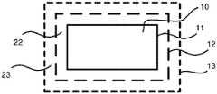
- Each region 10is surrounded by a first boundary line 11 that forms the edge of the region 10 . The surface area of the region 10 thus lies within the first boundary line 11 .
- FIG. 2shows a schematic illustration of a region 10 of a digital map according to one embodiment of the invention.
- the illustrated region 10may be a region 10 of the digital map 1 illustrated in FIG. 1 .
- further adjacent regions 10may adjoin the region 10 shown in FIG. 2 , this however not being illustrated in FIG. 2 for the sake of clarity.
- the region 10has a first boundary line 11 .
- the region 10additionally has a second boundary line 12 that surrounds the region 10 at a greater distance than the first boundary line 11 .
- An inner buffer zone 22lies in the region between the boundary lines 11 and 12 .
- the region 10furthermore has a third boundary line 13 that surrounds the region 10 at a greater distance than the second boundary line 12 .
- An outer buffer zone 23lies in the region between the boundary lines 12 and 13 .
- the region 10is thus surrounded by two buffer zones 22 , 23 .
- a plurality of regions 10 of the digital map 1may directly adjoin one another.
- the first boundary line 11 of a region 10partly also forms the first boundary line 11 of an adjacent region 10 .
- the buffer zones 22 , 23formed by the second boundary line 12 and third boundary line 13 , of a region 10 lie within an adjacent region 10 or a plurality of adjacent regions 10 .
- FIG. 3adopts the illustration of the region 10 of the digital map 1 shown in FIG. 2 .
- Three exemplary movement trajectories 2 , 3 , 4 of a navigation system according to one embodiment of the inventionare additionally illustrated.
- the direction of movement of the trajectories 2 , 3 , 4 shown in FIG. 3is identified by illustrations of arrows. This direction of movement may be checked as an additional condition when performing the method. However, this is not mandatory, because the requirement to update the digital map 1 also results from the further conditions without an explicit check of the direction of movement of the mobile navigation system.
- step 100the geographical position of the navigation system is determined.
- step 200it is checked whether route guidance of the navigation system is active. This is not the case (branch 200 n ).
- step 310the first condition is checked as to whether the position of the navigation system lies on or within the second boundary line 12 . This is not the case (branch 310 n ), and so the method ends. In the present example, there is provision to continue to execute the method, and so step 100 is then executed in the same way.
- the navigation systemOn its movement along the trajectory 2 , reaches the third boundary line 13 (position 2 - 13 ). However, due to route guidance not being activated in this example, this has no effect.
- the navigation systemOn its movement along the trajectory 2 , reaches the second boundary line 12 (position 2 - 12 ).
- the positionis again determined in step 100 and the activation of route guidance is checked (step 200 , branch 200 n ).
- step 600in which the map data for the region 10 are updated.
- the movement trajectory 2leads past the region 10 , as a result of which an update of the map data for the region 10 would not have been necessary. However, in the present example, this was not foreseeably the case due to route guidance not being activated. Reaching the inner buffer zone 22 defined by the second boundary line 12 constitutes an indicator that the navigation system will have a high likelihood of moving into the region 10 . For this reason, it makes sense to update the map data for the region 10 .
- step 100the geographical position of the navigation system is determined.
- step 200it is checked whether route guidance of the navigation system is active. This is the case (branch 200 j ).
- step 320the first condition is checked as to whether the position of the navigation system lies on or within the third boundary line 13 . This is not the case (branch 320 n ), and so the method ends. In the present example, there is provision to continue to execute the method, and so step 100 is then executed in the same way.
- the navigation systemOn its movement along the trajectory 2 , reaches the third boundary line 13 (position 2 - 13 ).
- the positionis again determined in step 100 and the activation of route guidance is checked (step 200 , branch 200 j ).
- the check 320 of the first condition as to whether the position 2 - 13 of the navigation system lies on or within the third boundary line 13now has a positive result (branch 320 j ).
- step 400the third condition is checked as to whether the planned journey route 2 runs at least partly within the region 10 . This is not satisfied (branch 400 n ), and so, next, in step 500 , the fourth condition is checked as to whether the position of the navigation system lies on or within the first boundary line 11 . This is not the case here (branch 500 n ), and so the method ends and restarts with step 100 .
- the check 500 as to the fourth conditionwould have a positive result (branch 500 j ) upon reaching the first boundary line 11 .
- An update 600 of the map datawould then be performed.
- the map data for the region 10are updated 600 upon reaching the position 3 - 12 when route guidance is not activated.
- the methodruns through the steps and branches having the following reference signs: 100 , 200 , 200 n , 310 , 310 j , 600 .
- the map data for the region 10are updated 600 upon reaching the position 3 - 13 when route guidance is activated.
- the methodinitially runs through the already-described steps and branches having the following reference signs: 100 , 200 , 200 j , 320 , 320 j.
- step 400the third condition is checked as to whether the planned journey route 3 runs at least partly within the region 10 . This is satisfied (branch 400 j ), and so, next, in step 600 , the map data are updated.
- the map data for the region 10are not updated 600 when route guidance is not activated.
- the methodrepeatedly runs through the steps and branches having the following reference signs: 100 , 200 , 200 n , 310 , 310 n.
- the map data for the region 10are not updated 600 when route guidance is activated.
- the methoduntil the position 4 - 13 is reached, runs through the already-described steps and branches having the following reference signs: 100 , 200 , 200 j , 320 , 320 n.
- the methodUpon (and after) reaching the position 4 - 13 , the method runs through the already-described steps and branches having the following reference signs: 100 , 200 , 200 j , 320 , 320 j , 400 , 400 n , 500 , 500 n.
- the check 500 as to the fourth conditionwould have a positive result (branch 500 j ) upon reaching the first boundary line 11 .
- An update 600 of the map datawould then be performed.
Landscapes
- Engineering & Computer Science (AREA)
- Remote Sensing (AREA)
- Radar, Positioning & Navigation (AREA)
- Physics & Mathematics (AREA)
- General Physics & Mathematics (AREA)
- Databases & Information Systems (AREA)
- Theoretical Computer Science (AREA)
- Automation & Control Theory (AREA)
- Analytical Chemistry (AREA)
- General Engineering & Computer Science (AREA)
- Life Sciences & Earth Sciences (AREA)
- Atmospheric Sciences (AREA)
- Chemical & Material Sciences (AREA)
- Data Mining & Analysis (AREA)
- Navigation (AREA)
- Instructional Devices (AREA)
Abstract
Description
- the volume of data to be transmitted,
- the available data rate and
- the remaining time until reaching the first boundary line of the region,
wherein this remaining time is able to be calculated in particular from a remaining journey length and an expected and/or previous average speed.
- 1 digital map
- 10 regions of the digital map
- 11 boundary line of the region of the digital map
- 12 boundary line of the inner buffer zone of the region of the digital map
- 13 boundary line of the outer buffer zone of the region of the digital map
- 22 inner buffer zone of the region of the digital map
- 23 outer buffer zone of the region of the digital map
- 2,3,4 movement trajectories
- x-y intersection of the journey trajectory x with the boundary line y
- 100-600 method steps
Claims (14)
Applications Claiming Priority (3)
| Application Number | Priority Date | Filing Date | Title |
|---|---|---|---|
| DE102016224845.6 | 2016-12-13 | ||
| DE102016224845 | 2016-12-13 | ||
| PCT/EP2017/081521WO2018108632A1 (en) | 2016-12-13 | 2017-12-05 | Updating a digital map |
Related Parent Applications (1)
| Application Number | Title | Priority Date | Filing Date |
|---|---|---|---|
| PCT/EP2017/081521ContinuationWO2018108632A1 (en) | 2016-12-13 | 2017-12-05 | Updating a digital map |
Publications (2)
| Publication Number | Publication Date |
|---|---|
| US20190293436A1 US20190293436A1 (en) | 2019-09-26 |
| US11454503B2true US11454503B2 (en) | 2022-09-27 |
Family
ID=60654955
Family Applications (1)
| Application Number | Title | Priority Date | Filing Date |
|---|---|---|---|
| US16/436,261Active2038-05-09US11454503B2 (en) | 2016-12-13 | 2019-06-10 | Updating a digital map |
Country Status (4)
| Country | Link |
|---|---|
| US (1) | US11454503B2 (en) |
| EP (1) | EP3555567B1 (en) |
| CN (1) | CN110023717B (en) |
| WO (1) | WO2018108632A1 (en) |
Families Citing this family (9)
| Publication number | Priority date | Publication date | Assignee | Title |
|---|---|---|---|---|
| KR102626251B1 (en)* | 2018-09-04 | 2024-01-17 | 현대자동차주식회사 | Navigation apparatus for vehicle and method for updating map data thereof and vehicle using the same |
| DE102019120705B3 (en)* | 2019-07-31 | 2020-08-06 | Bayerische Motoren Werke Aktiengesellschaft | System and method for dynamic and robust updating of a digital map |
| CN110849379B (en)* | 2019-10-23 | 2023-04-25 | 南通大学 | Entrance and exit traffic state symbol expression method for navigation map |
| CN113133317B (en)* | 2019-11-14 | 2024-10-18 | 谷歌有限责任公司 | Priority provision and retrieval of offline map data |
| CN113008251B (en)* | 2021-02-22 | 2022-11-25 | 湖南大学 | Digital map updating method for unstructured roads in closed area |
| CN113656420B (en)* | 2021-08-05 | 2023-09-12 | 湖南大学 | A method and device for map updating |
| CN114136307B (en)* | 2021-12-07 | 2024-01-26 | 上汽大众汽车有限公司 | A fully automatic map update method for vehicle navigation systems |
| CN116086474A (en)* | 2023-02-06 | 2023-05-09 | 阿里巴巴(中国)有限公司 | Method for mining access points of interest area, processing map data and processing navigation request |
| CN116358572B (en)* | 2023-03-30 | 2025-09-30 | 高德软件有限公司 | Method, device and storage medium for generating contour lines of intersection area |
Citations (28)
| Publication number | Priority date | Publication date | Assignee | Title |
|---|---|---|---|---|
| US6643584B1 (en) | 2002-08-21 | 2003-11-04 | Mitsubishi Denki Kabushiki Kaisha | Map information processing apparatus and map information transmission center |
| US20030220735A1 (en)* | 2002-04-25 | 2003-11-27 | Aisin Aw Co., Ltd. | Navigation system |
| US20060074547A1 (en)* | 2004-09-30 | 2006-04-06 | Kaufman Michael L | Method of operating a navigation system to report effects of updated portions of a geographic database |
| US20070126605A1 (en)* | 2003-08-16 | 2007-06-07 | Daimlerchrysler Ag | Method for updating a digital map |
| US20070168121A1 (en) | 2004-04-13 | 2007-07-19 | Keisuke Adachi | Map depiction device, navigation apparatus, file renewing method, file renewing program, and information recording medium for file renewing program |
| US20090281718A1 (en)* | 2008-05-09 | 2009-11-12 | Christophe Gibran | Predictive downloading of map data |
| US20090326810A1 (en)* | 2008-06-26 | 2009-12-31 | Microsoft Corporation | Caching navigation content for intermittently connected devices |
| US20110191285A1 (en)* | 2010-01-29 | 2011-08-04 | Aisin Aw Co., Ltd. | Map update data supply device and method |
| US20120078493A1 (en)* | 2010-09-29 | 2012-03-29 | Ford Global Technologies, Llc | Advanced map information delivery, processing and updating |
| US20120130944A1 (en)* | 2009-10-21 | 2012-05-24 | Hisanobu Masuda | Map information processing device |
| EP2498057A1 (en) | 2011-03-10 | 2012-09-12 | Technisat Digital Gmbh | Method for updating the map data of a navigation device and navigation device |
| US20130325317A1 (en)* | 2012-06-05 | 2013-12-05 | Apple Inc. | Smart loading of map tiles |
| US20130325326A1 (en)* | 2012-06-05 | 2013-12-05 | Christopher Blumenberg | System And Method For Acquiring Map Portions Based On Expected Signal Strength Of Route Segments |
| US8803920B2 (en)* | 2011-12-12 | 2014-08-12 | Google Inc. | Pre-fetching map tile data along a route |
| US8849942B1 (en)* | 2012-07-31 | 2014-09-30 | Google Inc. | Application programming interface for prefetching map data |
| US8886715B1 (en)* | 2011-11-16 | 2014-11-11 | Google Inc. | Dynamically determining a tile budget when pre-fetching data in a client device |
| US20150156609A1 (en)* | 2012-05-02 | 2015-06-04 | Google Inc. | Prefetching and caching map data based on mobile network coverage |
| US20150221216A1 (en)* | 2014-01-31 | 2015-08-06 | Here Global B.V. | Differentiation of Probe Reports based on Quality |
| WO2015186025A1 (en) | 2014-06-03 | 2015-12-10 | Here Global B.V. | Updating single regions of a navigational database |
| US20160025497A1 (en)* | 2014-07-24 | 2016-01-28 | Harman International Industries, Incorporated | Pre-caching of navigation content based on cellular network coverage |
| US9389088B2 (en)* | 2011-12-12 | 2016-07-12 | Google Inc. | Method of pre-fetching map data for rendering and offline routing |
| DE102015203929A1 (en) | 2015-03-05 | 2016-09-08 | Bayerische Motoren Werke Aktiengesellschaft | Updating of map data of a navigation device for vehicles |
| DE102015206519A1 (en) | 2015-04-13 | 2016-10-13 | Bayerische Motoren Werke Aktiengesellschaft | Updating of map data of a navigation device for vehicles |
| US20160371326A1 (en)* | 2015-06-19 | 2016-12-22 | International Business Machines Corporation | Geographic space management |
| US20160371801A1 (en)* | 2015-06-18 | 2016-12-22 | Richard Dawson | Real estate analysis systems |
| US20170122749A1 (en)* | 2015-11-04 | 2017-05-04 | Toyota Jidosha Kabushiki Kaisha | Map update determination system |
| US20170307383A1 (en)* | 2014-12-08 | 2017-10-26 | Clarion Co., Ltd. | In-vehicle apparatus and map data management system |
| US20210003405A1 (en)* | 2019-07-05 | 2021-01-07 | Lg Electronics Inc. | Moving robot and control method thereof |
Family Cites Families (6)
| Publication number | Priority date | Publication date | Assignee | Title |
|---|---|---|---|---|
| DE102005053125A1 (en)* | 2005-11-08 | 2007-05-10 | Bayerische Motoren Werke Ag | Method for updating map data of a navigation system and system for updating map data of a navigation system |
| JP4995499B2 (en)* | 2006-06-23 | 2012-08-08 | アイシン・エィ・ダブリュ株式会社 | Map information distribution system |
| US20090177390A1 (en)* | 2008-01-07 | 2009-07-09 | Lubos Mikusiak | Navigation device and method for updating a digital map |
| JP4905483B2 (en)* | 2009-03-05 | 2012-03-28 | 株式会社デンソー | Map data update device and map data update program |
| JP5699771B2 (en)* | 2011-04-14 | 2015-04-15 | アイシン・エィ・ダブリュ株式会社 | MAP IMAGE DISPLAY SYSTEM, MAP IMAGE DISPLAY DEVICE, MAP IMAGE DISPLAY METHOD, AND COMPUTER PROGRAM |
| JP6246316B2 (en)* | 2014-02-21 | 2017-12-13 | 三菱電機株式会社 | Map information processing apparatus, map information processing method, and update data adjustment method |
- 2017
- 2017-12-05WOPCT/EP2017/081521patent/WO2018108632A1/ennot_activeCeased
- 2017-12-05CNCN201780074025.8Apatent/CN110023717B/enactiveActive
- 2017-12-05EPEP17811918.6Apatent/EP3555567B1/enactiveActive
- 2019
- 2019-06-10USUS16/436,261patent/US11454503B2/enactiveActive
Patent Citations (29)
| Publication number | Priority date | Publication date | Assignee | Title |
|---|---|---|---|---|
| US20030220735A1 (en)* | 2002-04-25 | 2003-11-27 | Aisin Aw Co., Ltd. | Navigation system |
| US6643584B1 (en) | 2002-08-21 | 2003-11-04 | Mitsubishi Denki Kabushiki Kaisha | Map information processing apparatus and map information transmission center |
| DE10318179A1 (en) | 2002-08-21 | 2004-03-11 | Mitsubishi Denki K.K. | Map information processing device and map information transmission center |
| US20070126605A1 (en)* | 2003-08-16 | 2007-06-07 | Daimlerchrysler Ag | Method for updating a digital map |
| US20070168121A1 (en) | 2004-04-13 | 2007-07-19 | Keisuke Adachi | Map depiction device, navigation apparatus, file renewing method, file renewing program, and information recording medium for file renewing program |
| US20060074547A1 (en)* | 2004-09-30 | 2006-04-06 | Kaufman Michael L | Method of operating a navigation system to report effects of updated portions of a geographic database |
| US20090281718A1 (en)* | 2008-05-09 | 2009-11-12 | Christophe Gibran | Predictive downloading of map data |
| US20090326810A1 (en)* | 2008-06-26 | 2009-12-31 | Microsoft Corporation | Caching navigation content for intermittently connected devices |
| US20120130944A1 (en)* | 2009-10-21 | 2012-05-24 | Hisanobu Masuda | Map information processing device |
| US20110191285A1 (en)* | 2010-01-29 | 2011-08-04 | Aisin Aw Co., Ltd. | Map update data supply device and method |
| US20120078493A1 (en)* | 2010-09-29 | 2012-03-29 | Ford Global Technologies, Llc | Advanced map information delivery, processing and updating |
| EP2498057A1 (en) | 2011-03-10 | 2012-09-12 | Technisat Digital Gmbh | Method for updating the map data of a navigation device and navigation device |
| US8886715B1 (en)* | 2011-11-16 | 2014-11-11 | Google Inc. | Dynamically determining a tile budget when pre-fetching data in a client device |
| US8803920B2 (en)* | 2011-12-12 | 2014-08-12 | Google Inc. | Pre-fetching map tile data along a route |
| US9389088B2 (en)* | 2011-12-12 | 2016-07-12 | Google Inc. | Method of pre-fetching map data for rendering and offline routing |
| US20150156609A1 (en)* | 2012-05-02 | 2015-06-04 | Google Inc. | Prefetching and caching map data based on mobile network coverage |
| US20130325317A1 (en)* | 2012-06-05 | 2013-12-05 | Apple Inc. | Smart loading of map tiles |
| US20130325326A1 (en)* | 2012-06-05 | 2013-12-05 | Christopher Blumenberg | System And Method For Acquiring Map Portions Based On Expected Signal Strength Of Route Segments |
| US8849942B1 (en)* | 2012-07-31 | 2014-09-30 | Google Inc. | Application programming interface for prefetching map data |
| US20150221216A1 (en)* | 2014-01-31 | 2015-08-06 | Here Global B.V. | Differentiation of Probe Reports based on Quality |
| WO2015186025A1 (en) | 2014-06-03 | 2015-12-10 | Here Global B.V. | Updating single regions of a navigational database |
| US20160025497A1 (en)* | 2014-07-24 | 2016-01-28 | Harman International Industries, Incorporated | Pre-caching of navigation content based on cellular network coverage |
| US20170307383A1 (en)* | 2014-12-08 | 2017-10-26 | Clarion Co., Ltd. | In-vehicle apparatus and map data management system |
| DE102015203929A1 (en) | 2015-03-05 | 2016-09-08 | Bayerische Motoren Werke Aktiengesellschaft | Updating of map data of a navigation device for vehicles |
| DE102015206519A1 (en) | 2015-04-13 | 2016-10-13 | Bayerische Motoren Werke Aktiengesellschaft | Updating of map data of a navigation device for vehicles |
| US20160371801A1 (en)* | 2015-06-18 | 2016-12-22 | Richard Dawson | Real estate analysis systems |
| US20160371326A1 (en)* | 2015-06-19 | 2016-12-22 | International Business Machines Corporation | Geographic space management |
| US20170122749A1 (en)* | 2015-11-04 | 2017-05-04 | Toyota Jidosha Kabushiki Kaisha | Map update determination system |
| US20210003405A1 (en)* | 2019-07-05 | 2021-01-07 | Lg Electronics Inc. | Moving robot and control method thereof |
Non-Patent Citations (2)
| Title |
|---|
| German Search Report issued in German counterpart application No. 10 2016 224 845.6 dated Jul. 13, 2017, with Statement of Relevancy (Nine (9) pages). |
| PCT/EP2017/081521, International Search Report dated Feb. 26, 2018 (Two (2) pages). |
Also Published As
| Publication number | Publication date |
|---|---|
| CN110023717A (en) | 2019-07-16 |
| EP3555567B1 (en) | 2020-10-28 |
| CN110023717B (en) | 2023-05-12 |
| EP3555567A1 (en) | 2019-10-23 |
| US20190293436A1 (en) | 2019-09-26 |
| WO2018108632A1 (en) | 2018-06-21 |
Similar Documents
| Publication | Publication Date | Title |
|---|---|---|
| US11454503B2 (en) | Updating a digital map | |
| US10479297B2 (en) | Control apparatus, program updating method, and computer program | |
| CN108062094B (en) | Autonomous system and method for realizing vehicle driving track planning based on processor | |
| JP6524892B2 (en) | Roadway information generation system for vehicles | |
| CN108303075B (en) | Track generation method and system | |
| EP2543963A1 (en) | Method of updating a database of a navigation device and navigation device associated thereto | |
| CN104678414B (en) | Vehicle location, which makes corrections, control device and possesses its system and method | |
| KR20150092883A (en) | Method for updating software in vehicle | |
| US10890449B2 (en) | Navigation system | |
| WO2019007437A1 (en) | Systems and methods for determining a position of a terminal device | |
| CN110873569B (en) | Navigation device for vehicle, method for updating map data thereof, and vehicle using the navigation device | |
| US20200201899A1 (en) | Dynamic graphic information classification device and method | |
| CN110632626A (en) | Positioning method and system based on Internet of vehicles | |
| KR102804917B1 (en) | Apparatus and method for updating software of electronic control unit of vehicle | |
| CN113574920A (en) | GPS-Assisted Collaboration and Signaling-Assisted WLAN DFS Operation | |
| CN103185583A (en) | Vehicle position sharing method and vehicle position sharing system | |
| EP3904830B1 (en) | Apparatus and method for managing maps | |
| JP7318576B2 (en) | Information processing device, information processing system, program, and vehicle | |
| CN111031087A (en) | Scheduling simplification via geofence time zone resolution | |
| WO2022085173A1 (en) | Map data management device and map data management method | |
| WO2012056576A1 (en) | Vehicle information processing device | |
| JP2020021269A (en) | Driving lane judgment device | |
| CN101526358A (en) | Touch-controlled navigation device and method thereof | |
| US20180328749A1 (en) | Method of generating a navigation-based route for a vehicle | |
| CN106032983A (en) | Vehicle navigation system based on interconnection between vehicle and mobile phone |
Legal Events
| Date | Code | Title | Description |
|---|---|---|---|
| AS | Assignment | Owner name:BAYERISCHE MOTOREN WERKE AKTIENGESELLSCHAFT, GERMANY Free format text:ASSIGNMENT OF ASSIGNORS INTEREST;ASSIGNORS:FLOSSBACH, SASCHA;LEISTNER, DIRK;RICHTER, WERNER;AND OTHERS;SIGNING DATES FROM 20190529 TO 20190603;REEL/FRAME:049422/0944 Owner name:BAYERISCHE MOTOREN WERKE AKTIENGESELLSCHAFT, GERMA Free format text:ASSIGNMENT OF ASSIGNORS INTEREST;ASSIGNORS:FLOSSBACH, SASCHA;LEISTNER, DIRK;RICHTER, WERNER;AND OTHERS;SIGNING DATES FROM 20190529 TO 20190603;REEL/FRAME:049422/0944 | |
| FEPP | Fee payment procedure | Free format text:ENTITY STATUS SET TO UNDISCOUNTED (ORIGINAL EVENT CODE: BIG.); ENTITY STATUS OF PATENT OWNER: LARGE ENTITY | |
| STPP | Information on status: patent application and granting procedure in general | Free format text:DOCKETED NEW CASE - READY FOR EXAMINATION | |
| STPP | Information on status: patent application and granting procedure in general | Free format text:NON FINAL ACTION MAILED | |
| STPP | Information on status: patent application and granting procedure in general | Free format text:RESPONSE TO NON-FINAL OFFICE ACTION ENTERED AND FORWARDED TO EXAMINER | |
| STPP | Information on status: patent application and granting procedure in general | Free format text:FINAL REJECTION MAILED | |
| STPP | Information on status: patent application and granting procedure in general | Free format text:RESPONSE AFTER FINAL ACTION FORWARDED TO EXAMINER | |
| STPP | Information on status: patent application and granting procedure in general | Free format text:ADVISORY ACTION MAILED | |
| STCV | Information on status: appeal procedure | Free format text:NOTICE OF APPEAL FILED | |
| STCV | Information on status: appeal procedure | Free format text:APPEAL BRIEF (OR SUPPLEMENTAL BRIEF) ENTERED AND FORWARDED TO EXAMINER | |
| STPP | Information on status: patent application and granting procedure in general | Free format text:NOTICE OF ALLOWANCE MAILED -- APPLICATION RECEIVED IN OFFICE OF PUBLICATIONS | |
| STPP | Information on status: patent application and granting procedure in general | Free format text:PUBLICATIONS -- ISSUE FEE PAYMENT VERIFIED | |
| STCF | Information on status: patent grant | Free format text:PATENTED CASE |