US11334216B2 - Systems and methods for visually presenting geospatial information - Google Patents
Systems and methods for visually presenting geospatial informationDownload PDFInfo
- Publication number
- US11334216B2 US11334216B2US15/788,043US201715788043AUS11334216B2US 11334216 B2US11334216 B2US 11334216B2US 201715788043 AUS201715788043 AUS 201715788043AUS 11334216 B2US11334216 B2US 11334216B2
- Authority
- US
- United States
- Prior art keywords
- information
- sub
- regions
- predefined
- region
- Prior art date
- Legal status (The legal status is an assumption and is not a legal conclusion. Google has not performed a legal analysis and makes no representation as to the accuracy of the status listed.)
- Active
Links
Images


Classifications
- G—PHYSICS
- G06—COMPUTING OR CALCULATING; COUNTING
- G06F—ELECTRIC DIGITAL DATA PROCESSING
- G06F3/00—Input arrangements for transferring data to be processed into a form capable of being handled by the computer; Output arrangements for transferring data from processing unit to output unit, e.g. interface arrangements
- G06F3/01—Input arrangements or combined input and output arrangements for interaction between user and computer
- G06F3/048—Interaction techniques based on graphical user interfaces [GUI]
- G06F3/0481—Interaction techniques based on graphical user interfaces [GUI] based on specific properties of the displayed interaction object or a metaphor-based environment, e.g. interaction with desktop elements like windows or icons, or assisted by a cursor's changing behaviour or appearance
- G06F3/04817—Interaction techniques based on graphical user interfaces [GUI] based on specific properties of the displayed interaction object or a metaphor-based environment, e.g. interaction with desktop elements like windows or icons, or assisted by a cursor's changing behaviour or appearance using icons
- G—PHYSICS
- G06—COMPUTING OR CALCULATING; COUNTING
- G06F—ELECTRIC DIGITAL DATA PROCESSING
- G06F16/00—Information retrieval; Database structures therefor; File system structures therefor
- G06F16/20—Information retrieval; Database structures therefor; File system structures therefor of structured data, e.g. relational data
- G06F16/29—Geographical information databases
- G—PHYSICS
- G06—COMPUTING OR CALCULATING; COUNTING
- G06F—ELECTRIC DIGITAL DATA PROCESSING
- G06F16/00—Information retrieval; Database structures therefor; File system structures therefor
- G06F16/90—Details of database functions independent of the retrieved data types
- G06F16/95—Retrieval from the web
- G06F16/953—Querying, e.g. by the use of web search engines
- G06F16/9537—Spatial or temporal dependent retrieval, e.g. spatiotemporal queries
- G—PHYSICS
- G06—COMPUTING OR CALCULATING; COUNTING
- G06F—ELECTRIC DIGITAL DATA PROCESSING
- G06F3/00—Input arrangements for transferring data to be processed into a form capable of being handled by the computer; Output arrangements for transferring data from processing unit to output unit, e.g. interface arrangements
- G06F3/01—Input arrangements or combined input and output arrangements for interaction between user and computer
- G06F3/048—Interaction techniques based on graphical user interfaces [GUI]
- G06F3/0484—Interaction techniques based on graphical user interfaces [GUI] for the control of specific functions or operations, e.g. selecting or manipulating an object, an image or a displayed text element, setting a parameter value or selecting a range
- G06F3/04847—Interaction techniques to control parameter settings, e.g. interaction with sliders or dials
- G—PHYSICS
- G06—COMPUTING OR CALCULATING; COUNTING
- G06T—IMAGE DATA PROCESSING OR GENERATION, IN GENERAL
- G06T11/00—2D [Two Dimensional] image generation
- G06T11/20—Drawing from basic elements, e.g. lines or circles
- G06T11/206—Drawing of charts or graphs
Definitions
- This disclosurerelates to approaches for visually presenting geospatial information for correlation analysis.
- databasesmay include geospatial information.
- the geospatial informationmay be processed to provide information about particular area(s) in tabular form. Reviewing information in tabular form may not be intuitive or provide for ease in determining correlations for the geospatial information.
- Various embodiments of the present disclosuremay include systems, methods, and non-transitory computer readable media configured to visually present geospatial information.
- Various embodiments of the present disclosuremay include systems, methods, and non-transitory computer readable media configured to receive an information request for an area.
- the areamay include one or more predefined regions.
- the predefined region(s)may be subdivided into one or more levels of predefined sub-regions.
- Information for the areamay be accessed.
- the information for the areamay include region information for the predefined region(s) or sub-region information for the predefined sub-regions.
- a response to the information requestmay be determined based on the region information or the sub-region information.
- the responsemay enable a visual presentation of (1) the information for the area, and (2) one or more geographical boundaries corresponding to the area.
- the geographical boundaries of the predefined region(s) and the predefined sub-regionsmay be precomputed. In some embodiments, the predefined regions/predefined sub-regions may have one or more irregular polygon boundaries.
- recursive relationshipsmay exist between the predefined region(s) and the level(s) of predefined sub-regions.
- the level(s) of predefined sub-regionsmay include one or more levels corresponding to at least one of country, state, county, city, or zip code.
- individual levels of predefined sub-regionsmay correspond to individual zoom levels of a user interface.
- the information for the areamay be obtained from two or more data sources.
- the data sourcesmay include disparate data.
- the systems, methods, and non-transitory computer readable mediamay be configured to normalize the disparate data.
- FIG. 1illustrates an example environment for visually presenting geospatial information, in accordance with various embodiments.
- FIG. 2Aillustrate example boundaries of an area and predefined regions, in accordance with various embodiments.
- FIG. 2Billustrate example boundaries of a predefined region and predefined sub-regions, in accordance with various embodiments.
- FIG. 3illustrates an example process for merging information, in accordance with various embodiments.
- FIG. 4illustrates an example interface for visually presenting geospatial information, in accordance with various embodiments.
- FIG. 5illustrates a flowchart of an example method, in accordance with various embodiments.
- FIG. 6illustrates a block diagram of an example computer system in which any of the embodiments described herein may be implemented.
- a computing systemmay receive an information request for an area.
- the requestmay be received, for example, via a user's selection of the area through a user interface (e.g., via bounding box, change in zoom level, selection of particular information regarding the area).
- the areamay include one or more predefined regions.
- the predefined regionsmay be subdivided into one or more levels of predefined sub-regions. Recursive relationships may exist between the predefined regions and the level(s) of predefined sub-regions.
- the level(s) of predefined sub-regionsmay include one or more levels corresponding to country, state, county, city, and/or zip code.
- Geographical boundaries of the predefined regions and predefined sub-regionsmay be shaped as regular or irregular polygons.
- the geographical boundaries of the predefined regions and predefined sub-regionsmay be precomputed. Boundaries of different regions may be precomputed while the information within the boundaries (e.g., represented by colors, patterns, locations of interest, stamping) may be computed on the fly. For example, a vectorized tile set representing the geometries of the regions/sub-regions may be computed and cached for reuse, and information about the regions (e.g., metadata for a given feature) may be computed/re-computed as needed.
- the computing systemmay access information for the area.
- the information for the areamay be obtained from two or more data sources (e.g., general data sources, user-specific data sources).
- the data sourcesmay include disparate data, and the computing system may normalize the disparate data.
- the information for the areamay include region information for the predefined region(s) or sub-region information for the predefined sub-regions.
- the computing systemmay determine a response to the information request based on the region information or the sub-region information.
- the responsemay enable a visual presentation of (1) the information for the area and (2) one or more geographical boundaries corresponding to the area.
- the use of precomputed geographical boundariesmay enable the computing system to quickly provide/render information regarding the area requested by a user.
- the use of visual presentation of the geographical boundaries along with the information for the areamay enable the user to better understand the context of the information and obtain correlations for the information.
- an areamay refer to a definable extent.
- An areamay refer to an extent definable in the physical world (e.g., geographical area) or an extent definable for information (e.g., grouping of information).
- an areamay refer to a particular geographical area of the world, a country, a state, or other regions.
- An areamay refer to a particular grouping of information (conceptually projected onto a plane) based on type, subject, topic, and/or other grouping of information. While the disclosure is described herein with respect to information relating to geographical areas (e.g., displayed on a map), there is merely for illustrative purposes and is not meant to be limiting.
- the approach disclosed hereinenables visual presentation of geospatial information to facilitate a user's understanding of context of the geospatial information and the user's correlation analysis of the geospatial information.
- the use of predefined regions/sub-regionsallows the computing system to quickly customize views of the regions/sub-regions on a map with customer-specific geospatial information and other (e.g., general, public) geospatial information.
- the mapmay be updated based on changes in the geospatial information without re-computation of the boundaries for the predefined regions/sub-regions.
- the mapmay be visually augmented with particular customer-specific and other geospatial information to provide context for the customer-specific geospatial information, and to provide for a geo-specific correlations of the geospatial information.
- the use of visual presentation of the geographical boundaries of the regions/sub-regions along with the geospatial information for the predefined regions/sub-regionsmay enable a user to better understand the context of the geospatial information and obtain correlations for the geospatial information.
- Rendering views of the geospatial information on the mapmay be accelerated by using precomputed/cached information for individual predefined regions/sub-regions.
- Precomputed/cached information for different predefined regions/sub-regionsmay form a hierarchy of precomputed/cached information, with the structure of the hierarchy corresponding to recursive relationships between the predefined regions and predefined sub-regions.
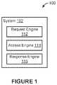
- FIG. 1illustrates an example environment 100 for visually presenting geospatial information, in accordance with various embodiments.
- the example environment 100may include a computing system 102 .
- the computing system 102may include one or more processors and memory.
- the processor(s)may be configured to perform various operations by interpreting machine-readable instructions stored in the memory.
- the computing device 102may include a request engine 112 , an access engine 114 , a response engine 116 , and/or other engines.
- the request engine 112is configured to receive an information request for an area.
- the information requestmay be received directly at the computing system 102 (e.g., received from a user using the computing system 102 ) or received from another computing device (e.g., received from a user using a computing device that communicates with the computing system 102 ).
- the information request for an areamay specify one or more particular areas and one or more desired information for the area(s).
- an information requestmay specify a particular geographical region and the desired information about the geographical region.
- An information requestmay be received at once or in multiple parts.
- the request engine 112may receive an information request specifying both the area and the desired information in a single communication.
- the request engine 112may receive an information request in parts—for example, a first communication may specify a particular area and a second communication may specify the desired information for the particular area. Other arrangements/structures of information requests are contemplated.
- An areamay include one or more predefined regions.
- Predefined region(s)may be subdivided into one or more levels of predefined sub-regions.
- Predefined regions and predefined sub-regionsmay be defined by boundaries (e.g., geographical boundaries). The boundaries of the predefined regions/predefined sub-regions may be shaped as regular polygons and/or irregular polygons. Recursive relationships may exist between the predefined region(s) and the level(s) of predefined sub-regions. That is, two or more predefined sub-regions of a particular level may make up a predefined sub-region of a higher level or a predefined region. For example, two of more predefined sub-regions of a second level may make up a predefined sub-region of a first level.
- Two or more predefined sub-regions of the first levelmay make up a predefined region.
- the level(s) of predefined sub-regionsmay include one or more levels corresponding to at least one of country, state, county, city, or zip code.
- an areamay include a particular country
- predefined regionsmay correspond to the different states of the country
- predefined sub-regions of a first levelmay correspond to the different counties of the various states
- predefined sub-regions of a second levelmay correspond to the different zip codes of the various counties, and so forth.
- one or more predefined regions/predefined sub-regionsmay be defined by one or more arbitrary boundaries.
- a usermay set as a predefined region/predefined sub-region an arbitrary combinations of zip codes/cities to facilitate viewing of information for the arbitrary region (e.g., creating a combination of zip codes/cities as a sales region to facilitate viewing of sales information for the particular zip codes/cities).
- one or more arbitrary regionsmay be composed of sub-regions (e.g., zip codes/cities), and may themselves exist as children of an existing pre-defined region (e.g., states).
- Such hierarchical relationships between regions/sub-regionsmay allow for defining one or more regions based on non-geographic criteria, with such regions being parent/children of geographic regions.
- a user/companymay define sales regions at the same level as counties (e.g., individual sales regions including one or more counties), with sales regions being children of states (e.g., multiple sales regions make up a state) and parents of zip codes (e.g., multiple zip codes make up a sale region).
- statese.g., individual sales regions including one or more counties
- statese.g., multiple sales regions make up a state
- zip codese.g., multiple zip codes make up a sale region
- Geospatial informationmay refer to information that is associated with one or more particular locations. Geospatial information may be static (e.g., does not change with time) or variable (e.g., changes with time). For example, a user may have geospatial information which may be reviewed as text/number, and/or in a tabular form. The presentation of information in text/number/tabular form may not facilitate the user's understanding of the context of the information and/or the user's correlation analysis of the information.
- the computing system 102may enable the user to tie geospatial information to particular predefined regions/sub-regions, and enable the user to review the geospatial information along with the boundaries of the regions/sub-regions (e.g., visualize custom data for an area on a map of the area). Such visual presentation of the geospatial information may facilitate the user's understanding of the context of the information and/or the user's correlation analysis of the information.
- the use of predefined regions and predefined sub-regionsmay enable a user to integrate geospatial information into a model defined by the predefined regions and predefined sub-regions for analysis and operation.
- predefined regions and predefined sub-regionsmay enable a user to combine two or more geospatial information for visual presentation.
- a usermay use the predefined regions/sub-regions to join user-specific geospatial information with other (e.g., general, public) geospatial information to provide additional context/layers to be viewed with the user-specific geospatial information.
- a usermay use the predefined regions/sub-regions to join sales information about an area with population information for the area, and visualize the sale information in addition to/along with the population information for the predefined regions/sub-regions within the area.
- Other combinations of geospatial informationare contemplated.
- an information request for an areamay be received through a user interface.
- the user interfacemay display a map of a geographic area and may enable a user to select a particular region within the map as the area for which information is desired.
- the user interfacemay display one or more options from which a user may select particular information desired for the selected area.
- the user interfacemay enable a user to select (e.g., via a drawing tool, via a mouse click, via a key entry) the area for which information is desired.
- a user's selection of a particular region within the mapmay include the user's selection of the extent of the map presented within the user interface.
- a usermay change the extent of the map represented within the user interface based on changes in zoom and/or latitude/longitude of the area presented within the user interface.
- the portion of the map presented in the user interfacemay correspond to the area selected by the user.
- a user's selection of a particular region within the mapmay include the user's selection of particular datasets.
- a usermay select a particular dataset that includes information regarding one or more portions within the map and those portions may correspond to the area selected by the user.
- the user interfacemay enable changes in zoom levels.
- Zoom levelsmay define the extent of the map/area/regions/sub-regions shown in the user interface.
- predefined regions and levels of predefined sub-regionsmay correspond to individual zoom levels of the user interface.
- Zoom levelsmay define whether the user interface displays boundaries of the predefined regions and/or boundaries of a certain level of predefined sub-regions. For example, when using the zoom level with the smallest magnification (showing the largest extent of the map), the user interface may display the boundaries of predefined regions. When using the zoom level with the largest magnification (showing the smallest extent of the map), the user interface may display the boundaries of the lowest level of predefined sub-regions.
- the user interfacemay also provide the user with a choice between multiple different sets of sub-regions for a given zoom level. Other correspondence between zoom levels and boundaries of predefined regions/sub-regions are contemplated.
- Tying the type of boundaries shown in the user interface to zoom levelsmay allow the user to change the type (e.g., amount of details) of the information retrieved relating to an area based on the zoom level used to view the area. For example, a user using the user interface to view a zoomed-out view of the map may be shown information aggregated for larger portions of the map than the user using the user interface to view a zoomed-in view of the map. In some embodiments, a user may manually change the type of boundaries shown in the user interface without changes in the zoom level.
- the typee.g., amount of details
- a usermay, while staying at the same zoom level, prompt the user interface to show (1) a more detailed version of the map (e.g., showing boundaries of lower levels of predefined sub-regions) or (2) a less detailed version of the map (e.g., showing boundaries of higher levels of predefined sub-regions/predefined regions).
- a more detailed version of the mape.g., showing boundaries of lower levels of predefined sub-regions
- a less detailed version of the mape.g., showing boundaries of higher levels of predefined sub-regions/predefined regions.
- the access engine 114is configured to access information for an area.
- Information for the areamay be accessed from one or more storage locations.
- a storage locationmay refer to electronic storage located within the computing system 102 (e.g., integral and/or removable memory of the computing system 102 ), electronic storage coupled to the computing system 102 , and/or electronic storage located remotely from the computing system 102 (e.g., electronic storage accessible to the computing system 102 through a network).
- the information for the areamay be stored in one or more databases.
- the information for the areamay be stored within a single file or across multiple files.
- the information for the areamay include region information for the predefined region(s) or sub-region information for the predefined sub-regions. Recursive relationships may exist between region information and sub-region information. That is, sub-region information for two or more predefined sub-regions may be used to determine region information for a particular predefined region. For example, a predefined region may correspond to a state and predefined sub-regions may correspond to different counties within the state. The sub-region information for the counties may be used to determine the region information for the state.
- Information determined for a given predefined region/sub-regionmay be stored (e.g., cached) as precomputed information for the given predefined region/sub-region.
- a predefined regionmay include two predefined sub-regions.
- Precomputed information for the predefined regionmay be cached for the predefined region and precomputed information for the individual predefined sub-regions may be cached for the individual sub-regions.
- the information cached for the relevant region/sub-regionmay be accessed.
- Caching precomputing informationmay accelerate rendering views of the region information/sub-region information.
- Information for an areamay include geospatial information for the area, the predefined regions, and/or the predefined sub-regions. Information for the area may be generated based on merging of multiple data (e.g., data tables) based on relationships among the data. Individual data may include/be combined with location data to form geospatial information for the area. For example, information for an area may be generated based on merging of multiple data relating to vehicles within the area. Data relating to different types of vehicles may be stored in separate databases/tables, and the data may be merged to form the vehicle data for the area. Individual data within the vehicle data may include/be combined with location data for specific vehicles (e.g., obtained from GPS) to form geospatial information for the area. Location data may define a specific location in the world (e.g., specific latitude and longitude at a given time) or may define a particular predefined region/sub-region.
- location datamay define a specific location in the world (e.g., specific latitude and longitude at a given
- Information for an areamay include user-specific geospatial information and other (e.g., general, public) geospatial information.
- user-specific geospatial informationmay include sales information for an area while other geospatial information may include population information for the area.
- Other combinations of geospatial informationare contemplated. Combination of other geospatial information with user-specific geospatial information may provide additional context/layers to be viewed with the user-specific geospatial information.
- the information for the areamay be obtained from two or more data sources.
- the data sourcesmay include disparate data.
- the access engine 114may be configured to normalize the disparate data. Normalizing the data may include modifying one or multiple disparate data to make them compatible for comparison. Normalizing the data may include smoothing datasets to use different datasets together. For example, census information for an area may be obtained from two organizations that track the population differently (e.g., via different sized regions, via different demographics). The access engine 114 may normalize the census information so that the information may be visually presented together.
- the response engine 116is configured to determine a response to the information request based on the region information, the sub-region information, and/or other information. Determining responses to information requests may include one or more operations on the region information and/or the sub-region information. Operations on the region/sub-region information may include aggregating, joining, determining maximum/minimum, filtering, determining distribution, determining average, and/or other operations on the region/sub-region information.
- the response engine 116may be configured to change the accuracy of the response based on the levels of information used to determine the response. For example, the response engine 116 may use region information for a large area to provide a more approximated response. The response engine 116 may use sub-region information for small areas to provide a more accurate response.
- the response engine 116may enable users to choose different levels of accuracy and/or sizes of areas for information. Changing the levels of accuracy/sizes of areas may result in different amounts of resource consumption (e.g., processing power, memory usage, duration of processing) to determine responses to information requests. For example, the response regime 116 may enable users to see slower responses with higher accuracy for a larger area or to see quicker responses with lower accuracy for a smaller area.
- the response engine 116may recursively determine a response to an information request for an area based on the region information and the sub-region information. For example, desired information for an area may be determined by (1) determining the desired region information based on the sub-region information, and (2) determining the desired information for the area based on the region information.
- the region information and the sub-region information to determine the responsemay enable the response engine 116 to focus on the necessary data. For example, if the information request is for a particular county (a predefined sub-region) of a particular state (e.g., a predefined region), the response engine 116 may access the sub-region information for the particular county to determine the response, rather than accessing and shifting through the region information for the state to determine the response.
- a predefined sub-regione.g., a predefined region
- the region information and the sub-region information to determine the responsemay enable the response engine 116 to approximate a response when the necessary data is not available. For example, if the information request is for a particular county (a predefined sub-region) of a particular state (e.g., a predefined region), the response engine 116 may attempt to access the sub-region information for the particular county. The sub-region information for the particular county may not exist. In some embodiments, the response engine 116 may use null data to provide a response to the information request. In some embodiments, the response engine 116 may use the region information for the particular state and modify the response to approximate the response for the particular county.
- the responsemay enable a visual presentation of (1) the information for the area, and (2) one or more geographical boundaries corresponding to the area.
- the response engine 116may use the geographical boundaries of the predefined regions and predefined sub-regions (e.g., shaped as regular or irregular polygons) to determine the response to the information request.
- the responsemay be determined by the response engine 116 as different visuals (e.g., different colors, patterns, locations of interest, stamping).
- the geographical boundaries of the predefined regions/sub-regionsmay be precomputed and the visuals determined based on the information request may be used to augment the view of the area defined by the geographical boundaries.
- the response engine 116may use the region information/sub-region information to determine in what color to shade a particular region/sub-region defined by precomputed geographical boundaries. Other uses of visuals are contemplated.
- precomputed geographical boundariesmay enable quick/efficient visual presentation of (1) the information for the area, and (2) the geographical boundaries corresponding to the area.
- Drawing boundaries of a region/sub-regionmay be computationally much more expensive than visually augmenting (e.g., coloring) the drawn region.
- drawing boundaries of different regions/sub-regions within a mapmay be the main cost of presenting the map while visually augmenting the drawn map may be accomplished at little cost.
- the response engine 116may use precomputed geographical boundaries (e.g., cached vectorized tile set representing the geometries of the regions/sub-regions) to quickly present the boundaries of the area while using the region/sub-region information to determine visual augmentations for the area.
- the boundaries of an areamay be computed and cached for reuse, and information about the area (e.g., metadata for a given feature) may be computed/re-computed as needed.
- an initial information requestmay request information regarding a particular state including a number of counties.
- a usermay zoom into the map to request information regarding a particular county divided into smaller sub-regions (e.g., by cities, by zip codes).
- the response engine 116may use the precomputed geographical boundaries to provide a map view of the relevant area while computing the visual augmentation on the fly based on the relevant region/sub-region information.
- the use of precomputed geographical boundariesmay enable the response engine 116 to quickly provide/render information regarding the area requested by the user.
- the use of visual presentation of the geographical boundaries along with the information for the areamay enable the user to better understand the context of the information and obtain correlations for the information.
- the response engine 116may use the region information/sub-region information to provide visual augmentations that are correlated to the region information/sub-region information.
- one form of visual augmentationmay include stamping.
- Stampingmay refer to placing visuals (e.g., icons) representing a particular object/characteristic within a map to represent the location of the particular object/characteristic. For example, locations of a certain type of store may be stamped on a map to provide a visual presentation of the stores.
- the number of stampings possible on a mapis limited by the number of pixels used to display the map, and the number of stores within a given area may be too numerous to stamp every single store location on the map. The number of stamps may be reduced by providing an approximated view of the locations.
- a simple method of reducing the number of stampsmay be to randomly choose which stamps will be shown on the map. For example, the stamps may be generated at random. Between overlapping stamps (overlaps caused by proximity of store locations), the later generated stamps may be chosen to be displayed on the map. However, such a simplification of stamps may result in loss of information pertinent to a user.
- the response engine 116may provide for reducing the number of stamps based on the region information/sub-region information. Rather than reducing the number of stamps randomly, the response engine 116 may choose which stamps to be presented as part of the response based on the pertinent information. Returning to the store stamping example, the response engine 116 may use the region information/sub-region information to choose which stamps to include in the response based on the user-specific information and/or other (e.g., general, public) information. For example, using the user-specific information, the response engine 116 may choose to present stamps for stores with the high sales/popularity, or to present stamps for stores in locations with high population/high income. Other combinations of user-specific information and other information for visual augmentation are contemplated.
- the use of visual presentation of the geographical boundaries along with the information for the areamay enable the user to better understand the context of the information and obtain correlations for the information. For example, providing geospatial information relating to health costs with geographical boundaries of areas (e.g., geographical boundaries corresponding to different hospital service areas) may enable a user to detect anomalous spending by particular hospitals, for particular treatments, and/or for particular patients. As another example, providing geospatial information relating to shipping costs by geographical boundaries of areas (e.g., geographical boundaries corresponding to zip codes, different distribution centers) may enable a user to determine which future distribution center location may have the greatest impact on reducing the costs of distribution. Other provision of content/correlations for information are contemplated.
- FIG. 2Aillustrate example boundaries of an area 200 and predefined regions within the area 200 , in accordance with various embodiments.
- the area 200may include a country (e.g., USA), and the predefined regions may correspond to different states of the country. Recursive relationships may exist between the area 200 and the predefined regions within the area 200 . Other types/boundaries of the area and predefined regions are contemplated.
- Information for the area 200may include geospatial information for the area (e.g., USA), the predefined regions (e.g., states), and/or predefined sub-regions.
- Information for the area 200may include user-specific geospatial information and other (e.g., general, public) geospatial information.
- the boundaries of the area 200 and the predefined regions within the area 200may be computed and cached for reuse. Information about the area 200 /predefined regions may be computed/re-computed as needed.
- the use of precomputed geographical boundaries of the area 200 and the predefined regionsmay enable faster provision/rendering of information regarding the area 200 requested by the user. Provision/rendering of views of geospatial information for the area 200 may be accelerated by using precomputed/cached information for the area 200 /predefined regions.
- Precomputed/cached information for the area 200 /predefined regionsmay form a hierarchy of precomputed/cached information, with the structure of the hierarchy corresponding to recursive relationships between the area 200 and the predefined regions.
- FIG. 2Billustrate example boundaries of a predefined region 260 and predefined sub-regions within the predefined region 260 , in accordance with various embodiments.
- the predefined region 260may include a state (e.g., California), and the predefined sub-regions may correspond to different counties of the state. Recursive relationships may exist between the predefined region 260 and the predefined sub-regions within the predefined region 260 . Other types/boundaries of the predefined region and predefined sub-regions are contemplated.
- Information for the predefined region 260may include geospatial information for the predefined region 260 (e.g., California), the predefined sub-regions (e.g., counties), and/or other predefined sub-regions (e.g., cities, zip codes).
- Information for the predefined region 260may include user-specific geospatial information and other (e.g., general, public) geospatial information.
- the boundaries of the predefined region 260 and the predefined sub-regions within the predefined region 260may be computed and cached for reuse. Information about the predefined region 260 /predefined sub-regions may be computed/re-computed as needed.
- the use of precomputed geographical boundaries of the predefined region 260 and the predefined sub-regionsmay enable faster provision/rendering of information regarding the predefined region 260 requested by the user. Provision/rendering of views of geospatial information for predefined region 260 may be accelerated by using precomputed/cached information for the predefined region 260 /predefined sub-regions.
- Precomputed/cached information for the predefined region 260 /predefined sub-regionsmay form a hierarchy of precomputed/cached information, with the structure of the hierarchy corresponding to recursive relationships between the predefined region 260 and the predefined sub-regions.
- FIG. 3illustrates an example process 300 for merging information, in accordance with various embodiments.
- Informatione.g., for an area/predefined region/predefined sub-region
- Informationmay be generated based on merging of multiple data 302 , 304 .
- the data 302 , 304may be merged based on relationships among the data 302 , 304 .
- the merged datamay be combined with location data 306 to form geospatial information 308 for an area/predefined region/predefined sub-region.
- data 302 , 304may include data relating to vehicles within an area.
- the data 302 , 304may be stored in separate databases/tables, and the data 302 , 304 may be merged to form the vehicle data for the area.
- Location data 306may define a specific location in the world (e.g., specific latitude and longitude at a given time) or may define a particular predefined region/sub-region.
- the data 302 , 304may include disparate data, and the data 302 , 304 may be normalized to make them compatible for comparison. Normalizing the data 302 , 304 may include smoothing datasets within the data 302 , 304 to use different datasets together.
- FIG. 4illustrates an example interface 400 for visually presenting geospatial information, in accordance with various embodiments.
- the user interface 400may be accessed through a software application running on a computing device (e.g., computers, mobile phones, tablets, etc.) that includes one or more processors and memory.
- the user interface 400may be accessible through a web browser.
- the user interface 400may be provided through a data analysis application.
- the user interface 400may be provided as a service over a network (e.g., software as a service).
- the usermay be able to interact with the user interface 400 using various input devices (e.g., keyboard, mouse, etc.) and/or touch gestures.
- the user interface 400is provided merely as an example and, naturally, the arrangement and configuration of such user interfaces can vary depending on the implementation. Thus, depending on the implementation, the user interface 400 may include additional features and/or alternative features.
- the user interface 400may include a title field 402 , a tool set field 404 , an information region 406 , a display region 408 , zoom options 410 , and/or other fields, regions, options.
- the title field 402may display the title of the information (e.g., map type) being displayed in the user interface 400 .
- the tool set field 404may include one or more tools to use and/or change the information displayed in the interface user 400 .
- the tool set field 404may include a search field that enables a user to search for particular features, data addition/removal field that enables a user to add/remove data from the map, export field that enables a user to export a given map/given display of a map, and/or other fields.
- the information region 406may display one or more types of information (e.g., histograms, information selection, area selection) relating to one or more areas/predefined regions/predefined sub-regions within the display region 408 .
- the display region 408may display one or more portions of a map (including one or more areas/predefined regions/predefined sub-regions) and/or other information.
- the display region 408may display one or more particular information about the map (e.g., icons representing numbers/locations of particular objects within the map, heat map, color shading, other visual augmentations).
- a usermay use the zoom option 410 to change (e.g., increase, decrease) the level of zoom for the map/information displayed within the display region 408 .
- Zoom levelsmay correspond to a particular type of predefined regions/predefined sub-regions displayed within the display region 408 . For example, increasing the zoom level (more magnified view of the map) may enable a user to view predefined sub-regions (e.g., corresponding to counties, zip codes).
- Information for the areamay be subdivided into region information (for individual predefined regions) and sub-region information (for individual predefined sub-regions).
- a response to an information requestmay be determined recursively based on the region information and the sub-region information.
- a response to an information requestmay be determined based on precomputed information cached for particular predefined regions/predefined sub-regions.
- the determined responsemay be presented within the information region 406 and/or the display region 408 .
- the determined responsemay be presented as visual augmentation (e.g., as colors, patterns, locations of interest, stamping) of the map presented within the display region 408 .
- an information requestmay seek information relating to store locations within the area shown within the display region 408 .
- the responsemay be shown as circles within the display region 408 , with the location of the circles corresponding to the location of certain stores, and the size of the circle corresponding to particular information (e.g., sales number for the stores, population being served by the store) about the stores.
- the information region 406 , the display region 408 , and/or other regionsmay provide information about the types of information available for view within the user interface 400 .
- the information region 406may display a listing of types of information available for viewing within the display region 408
- the display region 408may display bounding boxes representing the regions for which the information is available. Selection of a particular type of information in the information region 406 and/or a particular bounding box within the display region 408 may automatically switch the view within the display region 408 to display the selected region/information.
- FIG. 5illustrates a flowchart of an example method 500 , according to various embodiments of the present disclosure.
- the method 500may be implemented in various environments including, for example, the environment 100 of FIG. 1 .
- the operations of method 500 presented beloware intended to be illustrative. Depending on the implementation, the example method 500 may include additional, fewer, or alternative steps performed in various orders or in parallel.
- the example method 500may be implemented in various computing systems or devices including one or more processors.
- an information request for an areamay be received.
- the areamay include one or more predefined regions and one or more levels of predefined sub-regions.
- information for the areamay be accessed.
- the information for the areamay include region information for the predefined region(s) or sub-region information for the predefined sub-region(s).
- a response to the information requestmay be determined based on the region information or the sub-region information. The response may enable a visual presentation of (1) the information for the area, and (2) one or more geographical boundaries corresponding to the area.
- the techniques described hereinare implemented by one or more special-purpose computing devices.
- the special-purpose computing devicesmay be hard-wired to perform the techniques, or may include circuitry or digital electronic devices such as one or more application-specific integrated circuits (ASICs) or field programmable gate arrays (FPGAs) that are persistently programmed to perform the techniques, or may include one or more hardware processors programmed to perform the techniques pursuant to program instructions in firmware, memory, other storage, or a combination.
- ASICsapplication-specific integrated circuits
- FPGAsfield programmable gate arrays
- Such special-purpose computing devicesmay also combine custom hard-wired logic, ASICs, or FPGAs with custom programming to accomplish the techniques.
- the special-purpose computing devicesmay be desktop computer systems, server computer systems, portable computer systems, handheld devices, networking devices or any other device or combination of devices that incorporate hard-wired and/or program logic to implement the techniques.
- Computing device(s)are generally controlled and coordinated by operating system software, such as iOS, Android, Chrome OS, Windows XP, Windows Vista, Windows 7, Windows 8, Windows Server, Windows CE, Unix, Linux, SunOS, Solaris, iOS, Blackberry OS, VxWorks, or other compatible operating systems.
- operating system softwaresuch as iOS, Android, Chrome OS, Windows XP, Windows Vista, Windows 7, Windows 8, Windows Server, Windows CE, Unix, Linux, SunOS, Solaris, iOS, Blackberry OS, VxWorks, or other compatible operating systems.
- the computing devicemay be controlled by a proprietary operating system.
- Conventional operating systemscontrol and schedule computer processes for execution, perform memory management, provide file system, networking, I/O services, and provide a user interface functionality, such as a graphical user interface (“GUI”), among other things.
- GUIgraphical user interface
- FIG. 6is a block diagram that illustrates a computer system 600 upon which any of the embodiments described herein may be implemented.
- the computer system 600includes a bus 602 or other communication mechanism for communicating information, one or more hardware processors 604 coupled with bus 602 for processing information.
- Hardware processor(s) 604may be, for example, one or more general purpose microprocessors.
- the computer system 600also includes a main memory 606 , such as a random access memory (RAM), cache and/or other dynamic storage devices, coupled to bus 602 for storing information and instructions to be executed by processor 604 .
- Main memory 606also may be used for storing temporary variables or other intermediate information during execution of instructions to be executed by processor 604 .
- Such instructionswhen stored in storage media accessible to processor 604 , render computer system 600 into a special-purpose machine that is customized to perform the operations specified in the instructions.
- the computer system 600further includes a read only memory (ROM) 608 or other static storage device coupled to bus 602 for storing static information and instructions for processor 604 .
- ROMread only memory
- a storage device 610such as a magnetic disk, optical disk, or USB thumb drive (Flash drive), etc., is provided and coupled to bus 602 for storing information and instructions.
- the computer system 600may be coupled via bus 602 to a display 612 , such as a cathode ray tube (CRT) or LCD display (or touch screen), for displaying information to a computer user.
- a display 612such as a cathode ray tube (CRT) or LCD display (or touch screen)
- An input device 614is coupled to bus 602 for communicating information and command selections to processor 604 .
- cursor control 616is Another type of user input device, such as a mouse, a trackball, or cursor direction keys for communicating direction information and command selections to processor 604 and for controlling cursor movement on display 612 .
- This input devicetypically has two degrees of freedom in two axes, a first axis (e.g., x) and a second axis (e.g., y), that allows the device to specify positions in a plane.
- a first axise.g., x
- a second axise.g., y
- the same direction information and command selections as cursor controlmay be implemented via receiving touches on a touch screen without a cursor.
- modulerefers to logic embodied in hardware or firmware, or to a collection of software instructions, possibly having entry and exit points, written in a programming language, such as, for example, Java, C or C++.
- a software modulemay be compiled and linked into an executable program, installed in a dynamic link library, or may be written in an interpreted programming language such as, for example, BASIC, Perl, or Python. It will be appreciated that software modules may be callable from other modules or from themselves, and/or may be invoked in response to detected events or interrupts.
- Software modules configured for execution on computing devicesmay be provided on a computer readable medium, such as a compact disc, digital video disc, flash drive, magnetic disc, or any other tangible medium, or as a digital download (and may be originally stored in a compressed or installable format that requires installation, decompression or decryption prior to execution).
- Such software codemay be stored, partially or fully, on a memory device of the executing computing device, for execution by the computing device.
- Software instructionsmay be embedded in firmware, such as an EPROM.
- hardware modulesmay be comprised of connected logic units, such as gates and flip-flops, and/or may be comprised of programmable units, such as programmable gate arrays or processors.
- the modules or computing device functionality described hereinare preferably implemented as software modules, but may be represented in hardware or firmware. Generally, the modules described herein refer to logical modules that may be combined with other modules or divided into sub-modules despite their physical organization or storage.
- the computer system 600may implement the techniques described herein using customized hard-wired logic, one or more ASICs or FPGAs, firmware and/or program logic which in combination with the computer system causes or programs computer system 600 to be a special-purpose machine. According to one embodiment, the techniques herein are performed by computer system 600 in response to processor(s) 604 executing one or more sequences of one or more instructions contained in main memory 606 . Such instructions may be read into main memory 606 from another storage medium, such as storage device 610 . Execution of the sequences of instructions contained in main memory 606 causes processor(s) 604 to perform the process steps described herein. In alternative embodiments, hard-wired circuitry may be used in place of or in combination with software instructions.
- non-transitory mediarefers to any media that store data and/or instructions that cause a machine to operate in a specific fashion. Such non-transitory media may comprise non-volatile media and/or volatile media.
- Non-volatile mediaincludes, for example, optical or magnetic disks, such as storage device 610 .
- Volatile mediaincludes dynamic memory, such as main memory 606 .
- non-transitory mediainclude, for example, a floppy disk, a flexible disk, hard disk, solid state drive, magnetic tape, or any other magnetic data storage medium, a CD-ROM, any other optical data storage medium, any physical medium with patterns of holes, a RAM, a PROM, and EPROM, a FLASH-EPROM, NVRAM, any other memory chip or cartridge, and networked versions of the same.
- Non-transitory mediais distinct from but may be used in conjunction with transmission media.
- Transmission mediaparticipates in transferring information between non-transitory media.
- transmission mediaincludes coaxial cables, copper wire and fiber optics, including the wires that comprise bus 602 .
- transmission mediacan also take the form of acoustic or light waves, such as those generated during radio-wave and infra-red data communications.
- Various forms of mediamay be involved in carrying one or more sequences of one or more instructions to processor 604 for execution.
- the instructionsmay initially be carried on a magnetic disk or solid state drive of a remote computer.
- the remote computercan load the instructions into its dynamic memory and send the instructions over a telephone line using a modem.
- a modem local to computer system 600can receive the data on the telephone line and use an infra-red transmitter to convert the data to an infra-red signal.
- An infra-red detectorcan receive the data carried in the infra-red signal and appropriate circuitry can place the data on bus 602 .
- Bus 602carries the data to main memory 606 , from which processor 604 retrieves and executes the instructions.
- the instructions received by main memory 606may retrieves and executes the instructions.
- the instructions received by main memory 606may optionally be stored on storage device 610 either before or after execution by processor 604 .
- the computer system 600also includes a communication interface 618 coupled to bus 602 .
- Communication interface 618provides a two-way data communication coupling to one or more network links that are connected to one or more local networks.
- communication interface 618may be an integrated services digital network (ISDN) card, cable modem, satellite modem, or a modem to provide a data communication connection to a corresponding type of telephone line.
- ISDNintegrated services digital network
- communication interface 618may be a local area network (LAN) card to provide a data communication connection to a compatible LAN (or WAN component to communicated with a WAN).
- LANlocal area network
- Wireless linksmay also be implemented.
- communication interface 618sends and receives electrical, electromagnetic or optical signals that carry digital data streams representing various types of information.
- a network linktypically provides data communication through one or more networks to other data devices.
- a network linkmay provide a connection through local network to a host computer or to data equipment operated by an Internet Service Provider (ISP).
- ISPInternet Service Provider
- the ISPin turn provides data communication services through the world wide packet data communication network now commonly referred to as the “Internet”.
- InternetInternet
- Local network and Internetboth use electrical, electromagnetic or optical signals that carry digital data streams.
- the signals through the various networks and the signals on network link and through communication interface 618which carry the digital data to and from computer system 600 , are example forms of transmission media.
- the computer system 600can send messages and receive data, including program code, through the network(s), network link and communication interface 618 .
- a servermight transmit a requested code for an application program through the Internet, the ISP, the local network and the communication interface 618 .
- the received codemay be executed by processor 604 as it is received, and/or stored in storage device 610 , or other non-volatile storage for later execution.
- Conditional languagesuch as, among others, “can,” “could,” “might,” or “may,” unless specifically stated otherwise, or otherwise understood within the context as used, is generally intended to convey that certain embodiments include, while other embodiments do not include, certain features, elements and/or steps. Thus, such conditional language is not generally intended to imply that features, elements and/or steps are in any way required for one or more embodiments or that one or more embodiments necessarily include logic for deciding, with or without user input or prompting, whether these features, elements and/or steps are included or are to be performed in any particular embodiment.
- Enginesmay constitute either software engines (e.g., code embodied on a machine-readable medium) or hardware engines.
- a “hardware engine”is a tangible unit capable of performing certain operations and may be configured or arranged in a certain physical manner.
- one or more computer systemse.g., a standalone computer system, a client computer system, or a server computer system
- one or more hardware engines of a computer systeme.g., a processor or a group of processors
- softwaree.g., an application or application portion
- a hardware enginemay be implemented mechanically, electronically, or any suitable combination thereof.
- a hardware enginemay include dedicated circuitry or logic that is permanently configured to perform certain operations.
- a hardware enginemay be a special-purpose processor, such as a Field-Programmable Gate Array (FPGA) or an Application Specific Integrated Circuit (ASIC).
- a hardware enginemay also include programmable logic or circuitry that is temporarily configured by software to perform certain operations.
- a hardware enginemay include software executed by a general-purpose processor or other programmable processor. Once configured by such software, hardware engines become specific machines (or specific components of a machine) uniquely tailored to perform the configured functions and are no longer general-purpose processors. It will be appreciated that the decision to implement a hardware engine mechanically, in dedicated and permanently configured circuitry, or in temporarily configured circuitry (e.g., configured by software) may be driven by cost and time considerations.
- hardware engineshould be understood to encompass a tangible entity, be that an entity that is physically constructed, permanently configured (e.g., hardwired), or temporarily configured (e.g., programmed) to operate in a certain manner or to perform certain operations described herein.
- “hardware-implemented engine”refers to a hardware engine. Considering embodiments in which hardware engines are temporarily configured (e.g., programmed), each of the hardware engines need not be configured or instantiated at any one instance in time. For example, where a hardware engine comprises a general-purpose processor configured by software to become a special-purpose processor, the general-purpose processor may be configured as respectively different special-purpose processors (e.g., comprising different hardware engines) at different times. Software accordingly configures a particular processor or processors, for example, to constitute a particular hardware engine at one instance of time and to constitute a different hardware engine at a different instance of time.
- Hardware enginescan provide information to, and receive information from, other hardware engines. Accordingly, the described hardware engines may be regarded as being communicatively coupled. Where multiple hardware engines exist contemporaneously, communications may be achieved through signal transmission (e.g., over appropriate circuits and buses) between or among two or more of the hardware engines. In embodiments in which multiple hardware engines are configured or instantiated at different times, communications between such hardware engines may be achieved, for example, through the storage and retrieval of information in memory structures to which the multiple hardware engines have access. For example, one hardware engine may perform an operation and store the output of that operation in a memory device to which it is communicatively coupled. A further hardware engine may then, at a later time, access the memory device to retrieve and process the stored output. Hardware engines may also initiate communications with input or output devices, and can operate on a resource (e.g., a collection of information).
- a resourcee.g., a collection of information
- processorsmay be temporarily configured (e.g., by software) or permanently configured to perform the relevant operations. Whether temporarily or permanently configured, such processors may constitute processor-implemented engines that operate to perform one or more operations or functions described herein.
- processor-implemented enginerefers to a hardware engine implemented using one or more processors.
- the methods described hereinmay be at least partially processor-implemented, with a particular processor or processors being an example of hardware.
- a particular processor or processorsbeing an example of hardware.
- the operations of a methodmay be performed by one or more processors or processor-implemented engines.
- the one or more processorsmay also operate to support performance of the relevant operations in a “cloud computing” environment or as a “software as a service” (SaaS).
- SaaSsoftware as a service
- at least some of the operationsmay be performed by a group of computers (as examples of machines including processors), with these operations being accessible via a network (e.g., the Internet) and via one or more appropriate interfaces (e.g., an Application Program Interface (API)).
- APIApplication Program Interface
- processors or processor-implemented enginesmay be located in a single geographic location (e.g., within a home environment, an office environment, or a server farm). In other example embodiments, the processors or processor-implemented engines may be distributed across a number of geographic locations.
- an “engine,” “system,” “data store,” and/or “database”may comprise software, hardware, firmware, and/or circuitry.
- one or more software programs comprising instructions capable of being executable by a processormay perform one or more of the functions of the engines, data stores, databases, or systems described herein.
- circuitrymay perform the same or similar functions.
- Alternative embodimentsmay comprise more, less, or functionally equivalent engines, systems, data stores, or databases, and still be within the scope of present embodiments.
- the functionality of the various systems, engines, data stores, and/or databasesmay be combined or divided differently.
- Open source softwareis defined herein to be source code that allows distribution as source code as well as compiled form, with a well-publicized and indexed means of obtaining the source, optionally with a license that allows modifications and derived works.
- the data stores described hereinmay be any suitable structure (e.g., an active database, a relational database, a self-referential database, a table, a matrix, an array, a flat file, a documented-oriented storage system, a non-relational No-SQL system, and the like), and may be cloud-based or otherwise.
- suitable structuree.g., an active database, a relational database, a self-referential database, a table, a matrix, an array, a flat file, a documented-oriented storage system, a non-relational No-SQL system, and the like
- cloud-based or otherwisee.g., an active database, a relational database, a self-referential database, a table, a matrix, an array, a flat file, a documented-oriented storage system, a non-relational No-SQL system, and the like
- the term “or”may be construed in either an inclusive or exclusive sense. Moreover, plural instances may be provided for resources, operations, or structures described herein as a single instance. Additionally, boundaries between various resources, operations, engines, engines, and data stores are somewhat arbitrary, and particular operations are illustrated in a context of specific illustrative configurations. Other allocations of functionality are envisioned and may fall within a scope of various embodiments of the present disclosure. In general, structures and functionality presented as separate resources in the example configurations may be implemented as a combined structure or resource. Similarly, structures and functionality presented as a single resource may be implemented as separate resources. These and other variations, modifications, additions, and improvements fall within a scope of embodiments of the present disclosure as represented by the appended claims. The specification and drawings are, accordingly, to be regarded in an illustrative rather than a restrictive sense.
- Conditional languagesuch as, among others, “can,” “could,” “might,” or “may,” unless specifically stated otherwise, or otherwise understood within the context as used, is generally intended to convey that certain embodiments include, while other embodiments do not include, certain features, elements and/or steps. Thus, such conditional language is not generally intended to imply that features, elements and/or steps are in any way required for one or more embodiments or that one or more embodiments necessarily include logic for deciding, with or without user input or prompting, whether these features, elements and/or steps are included or are to be performed in any particular embodiment.
Landscapes
- Engineering & Computer Science (AREA)
- Theoretical Computer Science (AREA)
- Databases & Information Systems (AREA)
- General Engineering & Computer Science (AREA)
- Physics & Mathematics (AREA)
- General Physics & Mathematics (AREA)
- Data Mining & Analysis (AREA)
- Human Computer Interaction (AREA)
- Remote Sensing (AREA)
- User Interface Of Digital Computer (AREA)
- Instructional Devices (AREA)
Abstract
Description
Claims (19)
Priority Applications (3)
| Application Number | Priority Date | Filing Date | Title |
|---|---|---|---|
| US15/788,043US11334216B2 (en) | 2017-05-30 | 2017-10-19 | Systems and methods for visually presenting geospatial information |
| EP18174839.3AEP3410316A1 (en) | 2017-05-30 | 2018-05-29 | Systems and methods for visually presenting geospatial information |
| US17/737,890US11809682B2 (en) | 2017-05-30 | 2022-05-05 | Systems and methods for visually presenting geospatial information |
Applications Claiming Priority (2)
| Application Number | Priority Date | Filing Date | Title |
|---|---|---|---|
| US201762512638P | 2017-05-30 | 2017-05-30 | |
| US15/788,043US11334216B2 (en) | 2017-05-30 | 2017-10-19 | Systems and methods for visually presenting geospatial information |
Related Child Applications (1)
| Application Number | Title | Priority Date | Filing Date |
|---|---|---|---|
| US17/737,890ContinuationUS11809682B2 (en) | 2017-05-30 | 2022-05-05 | Systems and methods for visually presenting geospatial information |
Publications (2)
| Publication Number | Publication Date |
|---|---|
| US20180348991A1 US20180348991A1 (en) | 2018-12-06 |
| US11334216B2true US11334216B2 (en) | 2022-05-17 |
Family
ID=62635972
Family Applications (2)
| Application Number | Title | Priority Date | Filing Date |
|---|---|---|---|
| US15/788,043ActiveUS11334216B2 (en) | 2017-05-30 | 2017-10-19 | Systems and methods for visually presenting geospatial information |
| US17/737,890ActiveUS11809682B2 (en) | 2017-05-30 | 2022-05-05 | Systems and methods for visually presenting geospatial information |
Family Applications After (1)
| Application Number | Title | Priority Date | Filing Date |
|---|---|---|---|
| US17/737,890ActiveUS11809682B2 (en) | 2017-05-30 | 2022-05-05 | Systems and methods for visually presenting geospatial information |
Country Status (2)
| Country | Link |
|---|---|
| US (2) | US11334216B2 (en) |
| EP (1) | EP3410316A1 (en) |
Cited By (1)
| Publication number | Priority date | Publication date | Assignee | Title |
|---|---|---|---|---|
| US11809682B2 (en) | 2017-05-30 | 2023-11-07 | Palantir Technologies Inc. | Systems and methods for visually presenting geospatial information |
Families Citing this family (4)
| Publication number | Priority date | Publication date | Assignee | Title |
|---|---|---|---|---|
| US20220277408A1 (en)* | 2019-03-25 | 2022-09-01 | Garrett John Kurtt | System and method for the collection of United States of America nationwide building code for all jurisdictions having authority to adopt and enforce building code for the determination of the jurisdiction with authority for building code adoption and enforcement at the location of real property and the supplying of the building code for real property to the user |
| US10805374B1 (en) | 2019-08-19 | 2020-10-13 | Palantir Technologies Inc. | Systems and methods for providing real-time streaming data processing at edge servers |
| CN113094535A (en)* | 2021-04-01 | 2021-07-09 | 国网电力科学研究院有限公司 | Power grid graph browsing method, system, device, computer equipment and storage medium |
| CN119155712A (en)* | 2023-06-16 | 2024-12-17 | 中兴通讯股份有限公司 | Network operation and maintenance method, computing device and computer readable storage medium |
Citations (232)
| Publication number | Priority date | Publication date | Assignee | Title |
|---|---|---|---|---|
| US4899161A (en) | 1988-07-21 | 1990-02-06 | International Business Machines Corporation | High accuracy coordinate conversion method for air traffic control applications |
| US4958305A (en) | 1987-11-04 | 1990-09-18 | General Electric Company | Polygon edge clipping |
| US5329108A (en) | 1991-11-22 | 1994-07-12 | Cherloc | Map with indexes for a geographical information system and system for applying same |
| WO1995032424A1 (en) | 1994-05-23 | 1995-11-30 | Coulter Corporation | Detection of reticulocytes |
| US5754182A (en) | 1994-11-09 | 1998-05-19 | Matsushita Electric Industrial Co., Ltd. | Shape model generation device for generating shape models with a reduced number of polygons while maintaining quality of the two-dimensional image of the generated shape models |
| US5781195A (en) | 1996-04-16 | 1998-07-14 | Microsoft Corporation | Method and system for rendering two-dimensional views of a three-dimensional surface |
| US5781704A (en) | 1996-10-11 | 1998-07-14 | Environmental Criminology Research, Inc. | Expert system method of performing crime site analysis |
| WO2000009529A2 (en) | 1998-08-14 | 2000-02-24 | I2 Technologies, Inc. | System and method for visually representing a supply chain |
| US6091956A (en) | 1997-06-12 | 2000-07-18 | Hollenberg; Dennis D. | Situation information system |
| US6100897A (en) | 1995-12-22 | 2000-08-08 | Art +Com Medientechnologie Und Gestaltung Gmbh | Method and device for pictorial representation of space-related data |
| US6157747A (en) | 1997-08-01 | 2000-12-05 | Microsoft Corporation | 3-dimensional image rotation method and apparatus for producing image mosaics |
| US6169552B1 (en) | 1996-04-16 | 2001-01-02 | Xanavi Informatics Corporation | Map display device, navigation device and map display method |
| US6173067B1 (en) | 1998-04-07 | 2001-01-09 | Hughes Electronics Corporation | System and method for rapid determination of visibility-based terrain properties over broad regions |
| US6178432B1 (en) | 1996-09-30 | 2001-01-23 | Informative Graphics Corp. | Method and apparatus for creating interactive web page objects |
| US6247019B1 (en) | 1998-03-17 | 2001-06-12 | Prc Public Sector, Inc. | Object-based geographic information system (GIS) |
| WO2001098925A2 (en) | 2000-06-20 | 2001-12-27 | Globexplorer, Inc. | Method, system and computer program product for delivering spatially referenced information in a global computer network |
| US20020003539A1 (en) | 1999-12-27 | 2002-01-10 | Yoshihisa Abe | Method and apparatus for reducing three-dimensional shape data |
| US20020033848A1 (en) | 2000-04-21 | 2002-03-21 | Sciammarella Eduardo Agusto | System for managing data objects |
| US6389289B1 (en) | 1998-05-07 | 2002-05-14 | Hughes Electronics Corporation | Earth tiling system for providing regional based service in a mobile satellite communication network |
| US6414683B1 (en) | 1996-11-01 | 2002-07-02 | International Business Machines Corporation | Surface simplification preserving a solid volume |
| US20020116120A1 (en) | 2001-02-16 | 2002-08-22 | Patrick Ruiz | Bundled map guide |
| US20020130867A1 (en) | 2001-03-14 | 2002-09-19 | Kai-Shu Yang | Method of constructing progressive mesh |
| US20020130906A1 (en) | 2001-03-16 | 2002-09-19 | Ken Miyaki | Point-of interest icon and point-of- interest mark display method |
| US6483509B1 (en) | 1999-04-09 | 2002-11-19 | International Business Machines Corp. | Curve contour smoothing |
| US6529900B1 (en) | 1999-01-14 | 2003-03-04 | International Business Machines Corporation | Method and apparatus for data visualization |
| US20030052896A1 (en) | 2000-03-29 | 2003-03-20 | Higgins Darin Wayne | System and method for synchronizing map images |
| US20030103049A1 (en) | 2001-11-30 | 2003-06-05 | Caterpillar Inc. | Cuts removal system for triangulated CAD models |
| US20030144868A1 (en) | 2001-10-11 | 2003-07-31 | Macintyre James W. | System, method, and computer program product for processing and visualization of information |
| US20030163352A1 (en) | 2002-01-17 | 2003-08-28 | Jo Surpin | Method and system for gainsharing of physician services |
| US6631496B1 (en) | 1999-03-22 | 2003-10-07 | Nec Corporation | System for personalizing, organizing and managing web information |
| US20030225755A1 (en) | 2002-05-28 | 2003-12-04 | Hitachi, Ltd. | Document search method and system, and document search result display system |
| US6662103B1 (en) | 1999-03-22 | 2003-12-09 | Arc Second Inc. | Method and system for creating a user-selectable arbitrary coordinate frame |
| US20040030492A1 (en) | 2002-08-07 | 2004-02-12 | Hrl Laboratories, Llc | Method and apparatus for geographic shape preservation for identification |
| US20040039498A1 (en) | 2002-08-23 | 2004-02-26 | Mark Ollis | System and method for the creation of a terrain density model |
| US20040098236A1 (en) | 2002-07-19 | 2004-05-20 | Evans & Sutherland Computer Corporation | System and method for modeling a spheroid world database |
| US6757445B1 (en) | 2000-10-04 | 2004-06-29 | Pixxures, Inc. | Method and apparatus for producing digital orthophotos using sparse stereo configurations and external models |
| WO2004057268A2 (en) | 2002-12-19 | 2004-07-08 | Rafael-Armament Development Authority Ltd. | A method and system for processing and analyzing digital terrain data |
| US6828920B2 (en) | 2001-06-04 | 2004-12-07 | Lockheed Martin Orincon Corporation | System and method for classifying vehicles |
| US20050034062A1 (en) | 2003-06-18 | 2005-02-10 | Bufkin Michael P. | Methods and systems for encoding geographic coordinates and features in a portable document format file |
| WO2005013200A1 (en) | 2003-08-01 | 2005-02-10 | Perry Peterson | Close-packed, uniformly adjacent, multiresolutional, overlapping spatial data ordering |
| US20050080769A1 (en) | 2003-10-14 | 2005-04-14 | Microsoft Corporation | System and process for presenting search results in a histogram/cluster format |
| US20050143602A1 (en) | 2001-12-06 | 2005-06-30 | Mitsubishi Chemical Corporation | Oxidation reactor, process for producing (meth) acrylic acids, and method for analyzing easily-polymerizable compounds |
| US20050162523A1 (en) | 2004-01-22 | 2005-07-28 | Darrell Trevor J. | Photo-based mobile deixis system and related techniques |
| US20050182793A1 (en) | 2004-02-18 | 2005-08-18 | Keenan Viktor M. | Map structure and method for producing |
| US20050182502A1 (en) | 2004-02-12 | 2005-08-18 | International Business Machines Corporation | System and method for detecting generalized space-time clusters |
| US20050223044A1 (en) | 2004-04-06 | 2005-10-06 | International Business Machines Corporation | Method, system and program for managing geographic data stored in a database |
| US20050267652A1 (en) | 2004-05-28 | 2005-12-01 | Lockheed Martin Corporation | Intervisibility determination |
| US6983203B1 (en) | 2000-07-28 | 2006-01-03 | Alpine Electronics, Inc. | POI icon display method and navigation system |
| US6985950B1 (en) | 2001-03-06 | 2006-01-10 | Microsoft Corporation | System for creating a space-efficient document categorizer for training and testing of automatic categorization engines |
| US20060026170A1 (en) | 2003-05-20 | 2006-02-02 | Jeremy Kreitler | Mapping method and system |
| US7036085B2 (en) | 1999-07-22 | 2006-04-25 | Barbara L. Barros | Graphic-information flow method and system for visually analyzing patterns and relationships |
| US20060139375A1 (en) | 2004-03-23 | 2006-06-29 | Rasmussen Jens E | Secondary map in digital mapping system |
| US20060149596A1 (en) | 2002-01-17 | 2006-07-06 | Jo Surpin | Method and system for evaluating a physician's economic performance and gainsharing of physician services |
| US20060146050A1 (en) | 2005-01-05 | 2006-07-06 | Hideaki Yamauchi | Vertex reduction graphic drawing method and device |
| US20060200384A1 (en) | 2005-03-03 | 2006-09-07 | Arutunian Ethan B | Enhanced map imagery, such as for location-based advertising and location-based reporting |
| US20060197837A1 (en) | 2005-02-09 | 2006-09-07 | The Regents Of The University Of California. | Real-time geo-registration of imagery using cots graphics processors |
| US20060241974A1 (en) | 2005-04-26 | 2006-10-26 | Chao David Y | System and method for peer-profiling individual performance |
| US20060251307A1 (en) | 2005-04-13 | 2006-11-09 | Charles Florin | Method and apparatus for generating a 2D image having pixels corresponding to voxels of a 3D image |
| US20060259527A1 (en) | 2005-05-13 | 2006-11-16 | Devarakonda Murthy V | Changed files list with time buckets for efficient storage management |
| US20060271277A1 (en) | 2005-05-27 | 2006-11-30 | Jianing Hu | Interactive map-based travel guide |
| US20060279630A1 (en) | 2004-07-28 | 2006-12-14 | Manoj Aggarwal | Method and apparatus for total situational awareness and monitoring |
| US7158878B2 (en) | 2004-03-23 | 2007-01-02 | Google Inc. | Digital mapping system |
| US20070011150A1 (en) | 2005-06-28 | 2007-01-11 | Metacarta, Inc. | User Interface For Geographic Search |
| US20070016363A1 (en) | 2005-07-15 | 2007-01-18 | Oracle International Corporation | Interactive map-based user interface for transportation planning |
| US20070024620A1 (en) | 2005-08-01 | 2007-02-01 | Muller-Fischer Matthias H | Method of generating surface defined by boundary of three-dimensional point cloud |
| US20070057966A1 (en) | 2005-09-09 | 2007-03-15 | Canon Kabushiki Kaisha | Information processing apparatus, information processing method, program, and storage medium |
| US20070078832A1 (en) | 2005-09-30 | 2007-04-05 | Yahoo! Inc. | Method and system for using smart tags and a recommendation engine using smart tags |
| US20070115373A1 (en) | 2005-11-22 | 2007-05-24 | Eastman Kodak Company | Location based image classification with map segmentation |
| US20070188516A1 (en) | 2006-02-10 | 2007-08-16 | Ioup Elias Z K | Method for Efficiently Transforming a raster image from one map projection to another map projection |
| US20070208498A1 (en) | 2006-03-03 | 2007-09-06 | Inrix, Inc. | Displaying road traffic condition information and user controls |
| US20070208497A1 (en) | 2006-03-03 | 2007-09-06 | Inrix, Inc. | Detecting anomalous road traffic conditions |
| US20070258642A1 (en) | 2006-04-20 | 2007-11-08 | Microsoft Corporation | Geo-coding images |
| US20070294643A1 (en) | 2004-03-30 | 2007-12-20 | Kyle Henry M | System for managing the navigational usability of an interactive map |
| US20080010273A1 (en) | 2006-06-12 | 2008-01-10 | Metacarta, Inc. | Systems and methods for hierarchical organization and presentation of geographic search results |
| US20080040684A1 (en) | 2006-08-14 | 2008-02-14 | Richard Crump | Intelligent Pop-Up Window Method and Apparatus |
| US20080051994A1 (en)* | 2006-08-28 | 2008-02-28 | Microsoft Corporation | Representation and display of geographical popularity data |
| US20080077642A1 (en) | 2006-07-14 | 2008-03-27 | Carbone John N | Geographical Information Display System and Method |
| US20080082578A1 (en) | 2006-09-29 | 2008-04-03 | Andrew Hogue | Displaying search results on a one or two dimensional graph |
| US20080098085A1 (en) | 2006-10-20 | 2008-04-24 | Sap Ag | Service enabled tagged user interfaces |
| US20080104019A1 (en) | 2006-10-26 | 2008-05-01 | Microsoft Corporation | Associating Geographic-Related Information with Objects |
| US7375732B2 (en) | 2004-03-17 | 2008-05-20 | Microsoft Corporation | Methods and apparatus for navigating an image |
| WO2008064207A2 (en) | 2006-11-20 | 2008-05-29 | Palantir Technologies, Inc. | Creating data in a data store using a dynamic ontology |
| US20080133579A1 (en) | 2006-11-17 | 2008-06-05 | Nhn Corporation | Map service system and method |
| US20080163073A1 (en) | 2006-11-13 | 2008-07-03 | Tele Atlas North America, Inc. | System and method for providing multiple participants with a central access portal to geographic point of interest data |
| US20080192053A1 (en) | 2007-02-08 | 2008-08-14 | Microsoft Corporation | Transforming Offline Maps into Interactive Online Maps |
| US20080223834A1 (en) | 2007-03-16 | 2008-09-18 | Eggfusion, Inc. | Method and apparatus for laser marking objects |
| US20080229056A1 (en) | 2007-03-12 | 2008-09-18 | Broadcom Corporation | Method and apparatus for dual-hashing tables |
| WO2008128133A1 (en) | 2007-04-13 | 2008-10-23 | Pelago, Inc. | Location-based information determination |
| US20080263468A1 (en) | 2007-04-17 | 2008-10-23 | Guava Technologies, Inc. | Graphical User Interface for Analysis and Comparison of Location-Specific Multiparameter Data Sets |
| US20080270468A1 (en) | 2007-04-25 | 2008-10-30 | Magellan Navigation, Inc. | Adjusting spatial operations based on map density |
| US20080267107A1 (en) | 2007-04-27 | 2008-10-30 | Outland Research, Llc | Attraction wait-time inquiry apparatus, system and method |
| US20080278311A1 (en) | 2006-08-10 | 2008-11-13 | Loma Linda University Medical Center | Advanced Emergency Geographical Information System |
| US7457706B2 (en) | 2000-08-16 | 2008-11-25 | Harris Corporation | 3-dimensional interactive image modeling system |
| US20080294678A1 (en) | 2007-02-13 | 2008-11-27 | Sean Gorman | Method and system for integrating a social network and data repository to enable map creation |
| US20080301643A1 (en) | 2007-05-28 | 2008-12-04 | Google Inc. | Map Gadgets |
| US20090002492A1 (en) | 2006-06-16 | 2009-01-01 | Senem Velipasalar | Method and system for spatio-temporal event detection using composite definitions for camera systems |
| US20090027418A1 (en) | 2007-07-24 | 2009-01-29 | Maru Nimit H | Map-based interfaces for storing and locating information about geographical areas |
| US7502786B2 (en) | 2006-01-12 | 2009-03-10 | International Business Machines Corporation | Visual method and apparatus for enhancing search result navigation |
| US20090088964A1 (en) | 2007-09-28 | 2009-04-02 | Dave Schaaf | Map scrolling method and apparatus for navigation system for selectively displaying icons |
| US7519470B2 (en) | 2006-03-15 | 2009-04-14 | Microsoft Corporation | Location-based caching for mobile devices |
| US20090100018A1 (en) | 2007-10-12 | 2009-04-16 | Jonathan Roberts | System and method for capturing, integrating, discovering, and using geo-temporal data |
| US7529195B2 (en) | 2004-07-30 | 2009-05-05 | Fortiusone, Inc. | System and method of mapping and analyzing vulnerabilities in networks |
| US20090115786A1 (en) | 2006-04-24 | 2009-05-07 | Takamasa Shimasaki | Drawing device, and drawing method |
| WO2009061501A1 (en) | 2007-11-09 | 2009-05-14 | Telecommunication Systems, Inc. | Points-of-interest panning on a displayed map with a persistent search on a wireless phone |
| US20090132921A1 (en) | 2007-11-16 | 2009-05-21 | Samsung Electronics Co., Ltd. | User interface for displaying and playing multimedia contents, apparatus comprising the same, and control method thereof |
| US20090132953A1 (en) | 2007-11-16 | 2009-05-21 | Iac Search & Media, Inc. | User interface and method in local search system with vertical search results and an interactive map |
| US20090144262A1 (en) | 2007-12-04 | 2009-06-04 | Microsoft Corporation | Search query transformation using direct manipulation |
| US20090158185A1 (en) | 2007-12-17 | 2009-06-18 | Socialexplorer, Inc. | Adaptive map layer visibility control |
| US20090172511A1 (en) | 2007-12-26 | 2009-07-02 | Alexander Decherd | Analysis of time-based geospatial mashups using AD HOC visual queries |
| US20090171939A1 (en) | 2007-12-28 | 2009-07-02 | Yahoo! Inc. | User-generated activity maps |
| US7558677B2 (en) | 2005-08-23 | 2009-07-07 | R.A. Smith National, Inc. | High accuracy survey-grade GIS system |
| US20090179892A1 (en) | 2006-08-30 | 2009-07-16 | Sony Computer Entertainment Inc. | Image viewer, image displaying method and information storage medium |
| US20090187447A1 (en) | 2008-01-08 | 2009-07-23 | Honesty Young Cheng | Checking the correctness of gis data |
| US20090187464A1 (en) | 2008-01-22 | 2009-07-23 | International Business Machines Corporation | Method and apparatus for end-to-end retail store site optimization |
| US7574428B2 (en) | 2005-10-11 | 2009-08-11 | Telmap Ltd | Geometry-based search engine for navigation systems |
| US7579965B2 (en) | 2006-03-03 | 2009-08-25 | Andrew Bucholz | Vehicle data collection and processing system |
| US20090222400A1 (en) | 2005-12-16 | 2009-09-03 | Nextbio | Categorization and filtering of scientific data |
| WO2009123975A1 (en) | 2008-03-31 | 2009-10-08 | The Boeing Company | System and method for forming optimized perimeter surveillance |
| US7617314B1 (en) | 2005-05-20 | 2009-11-10 | Network General Technology | HyperLock technique for high-speed network data monitoring |
| US7620628B2 (en) | 2004-12-06 | 2009-11-17 | Yahoo! Inc. | Search processing with automatic categorization of queries |
| US20090292626A1 (en) | 2008-04-22 | 2009-11-26 | Oxford J Craig | System and method for interactive map, database, and social networking engine |
| US20090303251A1 (en)* | 2008-06-10 | 2009-12-10 | Andras Balogh | Displaying, processing and storing geo-located information |
| US7663621B1 (en) | 2006-11-03 | 2010-02-16 | Nvidia Corporation | Cylindrical wrapping using shader hardware |
| US20100057716A1 (en) | 2008-08-28 | 2010-03-04 | Stefik Mark J | System And Method For Providing A Topic-Directed Search |
| US20100063961A1 (en) | 2008-09-05 | 2010-03-11 | Fotonauts, Inc. | Reverse Tagging of Images in System for Managing and Sharing Digital Images |
| US20100070523A1 (en) | 2008-07-11 | 2010-03-18 | Lior Delgo | Apparatus and software system for and method of performing a visual-relevance-rank subsequent search |
| US20100076968A1 (en) | 2008-05-27 | 2010-03-25 | Boyns Mark R | Method and apparatus for aggregating and presenting data associated with geographic locations |
| US20100162176A1 (en) | 2008-12-23 | 2010-06-24 | Dunton Randy R | Reduced complexity user interface |
| US20100199225A1 (en) | 2009-01-30 | 2010-08-05 | Navico Holdings As | Method, apparatus and computer program product for synchronizing cursor events |
| US20100198684A1 (en) | 2005-02-01 | 2010-08-05 | Redfin Corporation | Interactive map-based search and advertising |
| US7805457B1 (en) | 2008-02-14 | 2010-09-28 | Securus Technologies, Inc. | System and method for identifying members of a gang or security threat group |
| US7809703B2 (en) | 2006-12-22 | 2010-10-05 | International Business Machines Corporation | Usage of development context in search operations |
| US20100277611A1 (en) | 2009-05-01 | 2010-11-04 | Adam Holt | Automatic content tagging, such as tagging digital images via a wireless cellular network using metadata and facial recognition |
| US20100293174A1 (en) | 2009-05-12 | 2010-11-18 | Microsoft Corporation | Query classification |
| US20100305851A1 (en)* | 2007-09-21 | 2010-12-02 | Fraunhofer-Gesellschaft Zur Foerderung Der Angewandten Forschung E.V. | Device and method for updating cartographic data |
| US20100321399A1 (en) | 2009-06-18 | 2010-12-23 | Patrik Ellren | Maps from Sparse Geospatial Data Tiles |
| US20110022312A1 (en) | 2009-07-23 | 2011-01-27 | Fmr Llc | Generating and Tracking Activity Patterns for Mobile Devices |
| US20110072020A1 (en)* | 2009-09-18 | 2011-03-24 | Research In Motion Limited | Expediting Reverse Geocoding With A Bounding Region |
| US7920963B2 (en) | 2007-02-22 | 2011-04-05 | Iac Search & Media, Inc. | Map interface with a movable marker |
| US20110090254A1 (en) | 2009-10-20 | 2011-04-21 | John Antonio Carrino | Techniques for drawing geodetic polygons |
| US7945852B1 (en) | 2006-05-19 | 2011-05-17 | Washington State University Research Foundation | Strategies for annotating digital maps |
| US20110117878A1 (en) | 2009-11-13 | 2011-05-19 | David Barash | Community-Based Response System |
| WO2011058507A1 (en) | 2009-11-11 | 2011-05-19 | Dror Nadam | Apparatus, system and method for self orientation |
| US7962281B2 (en) | 2004-03-23 | 2011-06-14 | Google Inc. | Generating and serving tiles in a digital mapping system |
| US20110145228A1 (en)* | 2009-12-15 | 2011-06-16 | Mapquest, Inc. | Computer-implemented methods and systems for multi-level geographic query |
| US20110153368A1 (en) | 2009-12-17 | 2011-06-23 | XtremeGIS, Inc. | User Interactive Reinsurance Risk Analysis Application |
| US7970240B1 (en) | 2001-12-17 | 2011-06-28 | Google Inc. | Method and apparatus for archiving and visualizing digital images |
| US20110161096A1 (en) | 2009-12-28 | 2011-06-30 | General Electric Company | Methods and systems for mapping healthcare services analytics for volume and trends |
| US20110170799A1 (en) | 2010-01-12 | 2011-07-14 | John Antonio Carrino | Techniques for density mapping |
| US20110208724A1 (en) | 2005-10-12 | 2011-08-25 | Google Inc. | Entity Display Priority In A Distributed Geographic Information System |
| US20110218934A1 (en) | 2010-03-03 | 2011-09-08 | Jeremy Elser | System and methods for comparing real properties for purchase and for generating heat maps to aid in identifying price anomalies of such real properties |
| US20110225198A1 (en) | 2005-11-21 | 2011-09-15 | Edwards Rocky L | System and Methods for Linking Multiple Events Involving Firearms and Gang Related Activities |
| US20110238690A1 (en) | 2010-03-26 | 2011-09-29 | Nokia Corporation | Method and Apparatus for Multi-Item Searching |
| US8036632B1 (en) | 2007-02-02 | 2011-10-11 | Resource Consortium Limited | Access of information using a situational network |
| US20110270705A1 (en) | 2010-04-29 | 2011-11-03 | Cheryl Parker | System and Method for Geographic Based Data Visualization and Extraction |
| US8065080B2 (en) | 2006-10-31 | 2011-11-22 | At&T Intellectual Property I, Lp | Location stamping and logging of electronic events and habitat generation |
| US20120066296A1 (en) | 2007-05-28 | 2012-03-15 | Google Inc. | Inter-Domain Communication |
| US8145703B2 (en) | 2007-11-16 | 2012-03-27 | Iac Search & Media, Inc. | User interface and method in a local search system with related search results |
| US20120084118A1 (en) | 2010-09-30 | 2012-04-05 | International Business Machines Corporation | Sales predication for a new store based on on-site market survey data and high resolution geographical information |
| US20120106801A1 (en) | 2010-11-03 | 2012-05-03 | Jackson Scott A | Vehicle tracking and locating system |
| US20120144335A1 (en) | 2010-12-02 | 2012-06-07 | Microsoft Corporation | Data visualizations including interactive time line representations |
| US20120159363A1 (en) | 2010-12-16 | 2012-06-21 | Microsoft Corporation | Z-order bands |
| US20120158527A1 (en) | 2010-12-21 | 2012-06-21 | Class6Ix, Llc | Systems, Methods and/or Computer Readable Storage Media Facilitating Aggregation and/or Personalized Sequencing of News Video Content |
| US8214361B1 (en) | 2008-09-30 | 2012-07-03 | Google Inc. | Organizing search results in a topic hierarchy |
| US20120173985A1 (en) | 2010-12-29 | 2012-07-05 | Tyler Peppel | Multi-dimensional visualization of temporal information |
| US20120178473A1 (en)* | 2011-01-12 | 2012-07-12 | Wiren Torbjoern | Nodes and methods for positioning |
| US8229947B2 (en) | 2007-03-30 | 2012-07-24 | Canon Kabushiki Kaisha | Image processing apparatus and method for controlling image processing apparatus |
| US20120208636A1 (en) | 2010-10-19 | 2012-08-16 | Oliver Feige | Methods, Server System and Browser Clients for Providing a Game Map of a Browser-Based Online Multi-Player Game |
| US20120206469A1 (en) | 2011-02-15 | 2012-08-16 | Tudor Hulubei | Efficient pre-computing of simplified vector data for rendering at multiple zoom levels |
| US20120221580A1 (en) | 2005-09-27 | 2012-08-30 | Patentratings, Llc | Method and system for probabilistically quantifying and visualizing relevance between two or more citationally or contextually related data objects |
| US8301464B1 (en) | 2008-07-18 | 2012-10-30 | Cave Consulting Group, Inc. | Method and system for producing statistical analysis of medical care information |
| US8325178B1 (en) | 2007-12-05 | 2012-12-04 | The United States Of America, As Represented By The Secretary Of The Navy | Lines-of-sight and viewsheds determination system |
| US20120323888A1 (en) | 2011-06-17 | 2012-12-20 | Osann Jr Robert | Automatic Webpage Characterization and Search Results Annotation |
| US20130006725A1 (en) | 2011-06-30 | 2013-01-03 | Accenture Global Services Limited | Tolling integration technology |
| US20130021445A1 (en) | 2010-04-12 | 2013-01-24 | Alexandre Cossette-Pacheco | Camera Projection Meshes |
| US20130060786A1 (en) | 2011-09-02 | 2013-03-07 | Xerox Corporation | Text-based searching of image data |
| US20130057551A1 (en) | 2007-10-01 | 2013-03-07 | David S. Ebert | Visual Analytics Law Enforcement Tools |
| US8397171B2 (en) | 2006-03-31 | 2013-03-12 | Reaearch In Motion Limited | User interface methods and apparatus for controlling the visual display of maps having selectable map elements in mobile communication devices |
| US8400448B1 (en) | 2007-12-05 | 2013-03-19 | The United States Of America, As Represented By The Secretary Of The Navy | Real-time lines-of-sight and viewsheds determination system |
| US20130073377A1 (en) | 2011-09-15 | 2013-03-21 | Stephan HEATH | Mobile device system and method providing 3d geo-target location-based mobile commerce searching/purchases, discounts/coupons products, goods, and services, and social networking |
| US8407180B1 (en) | 2010-11-29 | 2013-03-26 | Teradata Us, Inc. | Eliminating inner joins based on a temporal relationship constraint |
| US20130076732A1 (en) | 2011-09-28 | 2013-03-28 | Clearwater International, Llc | Simplifying a polygon |
| US8412234B1 (en) | 2011-12-07 | 2013-04-02 | Sprint Communications Company L.P. | Clustering location and time for location prediction |
| US8412707B1 (en) | 2008-06-13 | 2013-04-02 | Ustringer LLC | Method and apparatus for distributing content |
| US8422825B1 (en) | 2008-11-05 | 2013-04-16 | Hover Inc. | Method and system for geometry extraction, 3D visualization and analysis using arbitrary oblique imagery |
| US20130101159A1 (en) | 2011-10-21 | 2013-04-25 | Qualcomm Incorporated | Image and video based pedestrian traffic estimation |
| US8463036B1 (en) | 2010-09-30 | 2013-06-11 | A9.Com, Inc. | Shape-based search of a collection of content |
| US20130150004A1 (en) | 2006-08-11 | 2013-06-13 | Michael Rosen | Method and apparatus for reducing mobile phone usage while driving |
| US20130176321A1 (en) | 2012-01-06 | 2013-07-11 | Google Inc. | System and method for displaying information local to a selected area |
| US20130179420A1 (en) | 2012-01-09 | 2013-07-11 | Brightedge Technologies, Inc. | Search engine optimization for category specific search results |
| US8489331B2 (en) | 2010-04-29 | 2013-07-16 | Microsoft Corporation | Destination maps user interface |
| US8489641B1 (en) | 2010-07-08 | 2013-07-16 | Google Inc. | Displaying layers of search results on a map |
| US8498984B1 (en) | 2011-11-21 | 2013-07-30 | Google Inc. | Categorization of search results |
| US8515207B2 (en)* | 2007-05-25 | 2013-08-20 | Google Inc. | Annotations in panoramic images, and applications thereof |
| US20130254900A1 (en) | 2010-08-13 | 2013-09-26 | Nokia Corporation | Method and apparatus for secure shared personal map layer |
| US20130268520A1 (en) | 2012-04-04 | 2013-10-10 | Microsoft Corporation | Incremental Visualization for Structured Data in an Enterprise-level Data Store |
| US20130279757A1 (en) | 2012-04-19 | 2013-10-24 | Intelligence Based Integrated Security Systems, In | Large venue security method |
| US20130282723A1 (en) | 2009-02-02 | 2013-10-24 | Waldeck Technology, Llc | Maintaining A Historical Record Of Anonymized User Profile Data By Location For Users In A Mobile Environment |
| US20130339891A1 (en) | 2012-06-05 | 2013-12-19 | Apple Inc. | Interactive Map |
| US20140011522A1 (en)* | 2012-07-03 | 2014-01-09 | Uber Technologies, Inc. | System and method for providing dynamic supply positioning for on-demand services |
| US8742934B1 (en) | 2012-04-29 | 2014-06-03 | Intel-Based Solutions, LLC | System and method for facilitating the execution of law enforcement duties and enhancing anti-terrorism and counter-terrorism capabilities |
| US20140176606A1 (en) | 2012-12-20 | 2014-06-26 | Analytical Graphics Inc. | Recording and visualizing images using augmented image data |
| US8799799B1 (en)* | 2013-05-07 | 2014-08-05 | Palantir Technologies Inc. | Interactive geospatial map |
| US20140218400A1 (en) | 2013-02-05 | 2014-08-07 | PropertyRadar, Inc. | Method for Providing Real Estate Data on an Interactive Map |
| US8830322B2 (en) | 2012-08-06 | 2014-09-09 | Cloudparc, Inc. | Controlling use of a single multi-vehicle parking space and a restricted location within the single multi-vehicle parking space using multiple cameras |
| US20140361899A1 (en) | 2012-01-06 | 2014-12-11 | 3M Innovative Properties Company | Released offender geospatial location information trend analysis |
| US20140379850A1 (en)* | 2013-06-24 | 2014-12-25 | Google Inc. | System and Method for Providing Geospatial Assets |
| GB2516155A (en) | 2013-05-07 | 2015-01-14 | Palantir Technologies Inc | Interactive geospatial map |
| US8938686B1 (en) | 2013-10-03 | 2015-01-20 | Palantir Technologies Inc. | Systems and methods for analyzing performance of an entity |
| DE102013222023A1 (en) | 2013-07-23 | 2015-01-29 | Palantir Technologies, Inc. | Multiple viewing area analysis |
| US8949164B1 (en) | 2011-09-08 | 2015-02-03 | George O. Mohler | Event forecasting system |
| US20150095355A1 (en)* | 2012-11-15 | 2015-04-02 | Banjo, Inc. | Systems and methods for dynamic event content curation |
| US9009610B2 (en) | 2012-06-07 | 2015-04-14 | Costar Group, Inc. | Method and apparatus for managing real estate data |
| US9009177B2 (en) | 2009-09-25 | 2015-04-14 | Microsoft Corporation | Recommending points of interests in a region |
| US20150106170A1 (en) | 2013-10-11 | 2015-04-16 | Adam BONICA | Interface and methods for tracking and analyzing political ideology and interests |
| US9021384B1 (en) | 2013-11-04 | 2015-04-28 | Palantir Technologies Inc. | Interactive vehicle information map |
| US20150187036A1 (en) | 2014-01-02 | 2015-07-02 | Palantir Technologies Inc. | Computer-implemented methods and systems for analyzing healthcare data |
| US20150187100A1 (en) | 2013-03-07 | 2015-07-02 | Alex Berry | Presenting multiple map results with on-map labels |
| US9104293B1 (en) | 2012-12-19 | 2015-08-11 | Amazon Technologies, Inc. | User interface points of interest approaches for mapping applications |
| US9104695B1 (en) | 2009-07-27 | 2015-08-11 | Palantir Technologies, Inc. | Geotagging structured data |
| US9111380B2 (en) | 2012-06-05 | 2015-08-18 | Apple Inc. | Rendering maps |
| US9129219B1 (en) | 2014-06-30 | 2015-09-08 | Palantir Technologies, Inc. | Crime risk forecasting |
| US9146125B2 (en) | 2012-06-05 | 2015-09-29 | Apple Inc. | Navigation application with adaptive display of graphical directional indicators |
| US20150312323A1 (en) | 2014-04-25 | 2015-10-29 | Google Inc. | System and method for providing individualized portable asset applications |
| US20150347457A1 (en) | 2014-05-28 | 2015-12-03 | Oracle International Corporation | Automatic update for map cache |
| US20150356088A1 (en) | 2014-06-06 | 2015-12-10 | Microsoft Corporation | Tile-based geocoder |
| US20150370828A1 (en) | 2014-06-21 | 2015-12-24 | Google Inc. | Tile-Based Distribution of Searchable Geospatial Data to Client Devices |
| US20150371430A1 (en)* | 2014-06-20 | 2015-12-24 | Google Inc. | Identifying Imagery Views Using Geolocated Text |
| US20160180060A1 (en)* | 2013-07-17 | 2016-06-23 | Timothy Nelson | Systems and methods for monitoring movement of disease field |
| US9460175B1 (en) | 2015-06-03 | 2016-10-04 | Palantir Technologies Inc. | Server implemented geographic information system with graphical interface |
| US20170076227A1 (en)* | 2014-03-03 | 2017-03-16 | Inrix Inc., | Traffic obstruction detection |
| US20170091627A1 (en)* | 2015-09-25 | 2017-03-30 | The Nielsen Company (Us), Llc | Methods and apparatus to profile geographic areas of interest |
Family Cites Families (7)
| Publication number | Priority date | Publication date | Assignee | Title |
|---|---|---|---|---|
| JP5029874B2 (en)* | 2006-12-28 | 2012-09-19 | 富士通株式会社 | Information processing apparatus, information processing method, and information processing program |
| JP5415749B2 (en) | 2008-11-26 | 2014-02-12 | 京セラ株式会社 | Portable electronic devices |
| JP2015158900A (en)* | 2014-01-27 | 2015-09-03 | 株式会社リコー | Information processing device, information processing method and information processing program |
| US11138217B2 (en)* | 2015-06-22 | 2021-10-05 | YouMap, Inc. | System and method for aggregation and graduated visualization of user generated social post on a social mapping network |
| US11589193B2 (en)* | 2015-06-22 | 2023-02-21 | You Map Inc. | Creating and utilizing services associated with maps |
| US11334216B2 (en) | 2017-05-30 | 2022-05-17 | Palantir Technologies Inc. | Systems and methods for visually presenting geospatial information |
| US11175157B1 (en)* | 2018-10-24 | 2021-11-16 | Palantir Technologies Inc. | Dynamic scaling of geospatial data on maps |
- 2017
- 2017-10-19USUS15/788,043patent/US11334216B2/enactiveActive
- 2018
- 2018-05-29EPEP18174839.3Apatent/EP3410316A1/ennot_activeWithdrawn
- 2022
- 2022-05-05USUS17/737,890patent/US11809682B2/enactiveActive
Patent Citations (275)
| Publication number | Priority date | Publication date | Assignee | Title |
|---|---|---|---|---|
| US4958305A (en) | 1987-11-04 | 1990-09-18 | General Electric Company | Polygon edge clipping |
| US4899161A (en) | 1988-07-21 | 1990-02-06 | International Business Machines Corporation | High accuracy coordinate conversion method for air traffic control applications |
| US5329108A (en) | 1991-11-22 | 1994-07-12 | Cherloc | Map with indexes for a geographical information system and system for applying same |
| WO1995032424A1 (en) | 1994-05-23 | 1995-11-30 | Coulter Corporation | Detection of reticulocytes |
| EP0763201A1 (en) | 1994-05-23 | 1997-03-19 | Coulter Corporation | Detection of reticulocytes |
| US5754182A (en) | 1994-11-09 | 1998-05-19 | Matsushita Electric Industrial Co., Ltd. | Shape model generation device for generating shape models with a reduced number of polygons while maintaining quality of the two-dimensional image of the generated shape models |
| US6100897A (en) | 1995-12-22 | 2000-08-08 | Art +Com Medientechnologie Und Gestaltung Gmbh | Method and device for pictorial representation of space-related data |
| US5781195A (en) | 1996-04-16 | 1998-07-14 | Microsoft Corporation | Method and system for rendering two-dimensional views of a three-dimensional surface |
| US6169552B1 (en) | 1996-04-16 | 2001-01-02 | Xanavi Informatics Corporation | Map display device, navigation device and map display method |
| US6178432B1 (en) | 1996-09-30 | 2001-01-23 | Informative Graphics Corp. | Method and apparatus for creating interactive web page objects |
| US5781704A (en) | 1996-10-11 | 1998-07-14 | Environmental Criminology Research, Inc. | Expert system method of performing crime site analysis |
| US5781704C1 (en) | 1996-10-11 | 2002-07-16 | Environmental Criminology Res | Expert system method of performing crime site analysis |
| US6414683B1 (en) | 1996-11-01 | 2002-07-02 | International Business Machines Corporation | Surface simplification preserving a solid volume |
| US6091956A (en) | 1997-06-12 | 2000-07-18 | Hollenberg; Dennis D. | Situation information system |
| US6157747A (en) | 1997-08-01 | 2000-12-05 | Microsoft Corporation | 3-dimensional image rotation method and apparatus for producing image mosaics |
| US6247019B1 (en) | 1998-03-17 | 2001-06-12 | Prc Public Sector, Inc. | Object-based geographic information system (GIS) |
| US6173067B1 (en) | 1998-04-07 | 2001-01-09 | Hughes Electronics Corporation | System and method for rapid determination of visibility-based terrain properties over broad regions |
| US6389289B1 (en) | 1998-05-07 | 2002-05-14 | Hughes Electronics Corporation | Earth tiling system for providing regional based service in a mobile satellite communication network |
| WO2000009529A2 (en) | 1998-08-14 | 2000-02-24 | I2 Technologies, Inc. | System and method for visually representing a supply chain |
| US6529900B1 (en) | 1999-01-14 | 2003-03-04 | International Business Machines Corporation | Method and apparatus for data visualization |
| US6662103B1 (en) | 1999-03-22 | 2003-12-09 | Arc Second Inc. | Method and system for creating a user-selectable arbitrary coordinate frame |
| US6631496B1 (en) | 1999-03-22 | 2003-10-07 | Nec Corporation | System for personalizing, organizing and managing web information |
| US6483509B1 (en) | 1999-04-09 | 2002-11-19 | International Business Machines Corp. | Curve contour smoothing |
| US7036085B2 (en) | 1999-07-22 | 2006-04-25 | Barbara L. Barros | Graphic-information flow method and system for visually analyzing patterns and relationships |
| US20020003539A1 (en) | 1999-12-27 | 2002-01-10 | Yoshihisa Abe | Method and apparatus for reducing three-dimensional shape data |
| US20030052896A1 (en) | 2000-03-29 | 2003-03-20 | Higgins Darin Wayne | System and method for synchronizing map images |
| US20020033848A1 (en) | 2000-04-21 | 2002-03-21 | Sciammarella Eduardo Agusto | System for managing data objects |
| WO2001098925A2 (en) | 2000-06-20 | 2001-12-27 | Globexplorer, Inc. | Method, system and computer program product for delivering spatially referenced information in a global computer network |
| US6983203B1 (en) | 2000-07-28 | 2006-01-03 | Alpine Electronics, Inc. | POI icon display method and navigation system |
| US7457706B2 (en) | 2000-08-16 | 2008-11-25 | Harris Corporation | 3-dimensional interactive image modeling system |
| US6757445B1 (en) | 2000-10-04 | 2004-06-29 | Pixxures, Inc. | Method and apparatus for producing digital orthophotos using sparse stereo configurations and external models |
| US20050031197A1 (en) | 2000-10-04 | 2005-02-10 | Knopp David E. | Method and apparatus for producing digital orthophotos using sparse stereo configurations and external models |
| US20020116120A1 (en) | 2001-02-16 | 2002-08-22 | Patrick Ruiz | Bundled map guide |
| US6985950B1 (en) | 2001-03-06 | 2006-01-10 | Microsoft Corporation | System for creating a space-efficient document categorizer for training and testing of automatic categorization engines |
| US20020130867A1 (en) | 2001-03-14 | 2002-09-19 | Kai-Shu Yang | Method of constructing progressive mesh |
| US20020130906A1 (en) | 2001-03-16 | 2002-09-19 | Ken Miyaki | Point-of interest icon and point-of- interest mark display method |
| US6828920B2 (en) | 2001-06-04 | 2004-12-07 | Lockheed Martin Orincon Corporation | System and method for classifying vehicles |
| US20080288306A1 (en) | 2001-10-11 | 2008-11-20 | Visual Sciences Technologies, Llc | System, method and computer program product for processing and visualization of information |
| US20030144868A1 (en) | 2001-10-11 | 2003-07-31 | Macintyre James W. | System, method, and computer program product for processing and visualization of information |
| US20030103049A1 (en) | 2001-11-30 | 2003-06-05 | Caterpillar Inc. | Cuts removal system for triangulated CAD models |
| US20050143602A1 (en) | 2001-12-06 | 2005-06-30 | Mitsubishi Chemical Corporation | Oxidation reactor, process for producing (meth) acrylic acids, and method for analyzing easily-polymerizable compounds |
| US7970240B1 (en) | 2001-12-17 | 2011-06-28 | Google Inc. | Method and apparatus for archiving and visualizing digital images |
| US20080195417A1 (en) | 2002-01-17 | 2008-08-14 | Jo Surpin | Method and system for evaluating a physician's economic performance and gainsharing of physician services |
| US20030163352A1 (en) | 2002-01-17 | 2003-08-28 | Jo Surpin | Method and system for gainsharing of physician services |
| US20060149596A1 (en) | 2002-01-17 | 2006-07-06 | Jo Surpin | Method and system for evaluating a physician's economic performance and gainsharing of physician services |
| US20030225755A1 (en) | 2002-05-28 | 2003-12-04 | Hitachi, Ltd. | Document search method and system, and document search result display system |
| US20040098236A1 (en) | 2002-07-19 | 2004-05-20 | Evans & Sutherland Computer Corporation | System and method for modeling a spheroid world database |
| US7872647B2 (en) | 2002-07-19 | 2011-01-18 | Rockwell Collins Simulation And Training Solutions Llc | System and method for modeling a spheroid world database |
| US20040030492A1 (en) | 2002-08-07 | 2004-02-12 | Hrl Laboratories, Llc | Method and apparatus for geographic shape preservation for identification |
| US20040039498A1 (en) | 2002-08-23 | 2004-02-26 | Mark Ollis | System and method for the creation of a terrain density model |
| WO2004057268A2 (en) | 2002-12-19 | 2004-07-08 | Rafael-Armament Development Authority Ltd. | A method and system for processing and analyzing digital terrain data |
| US20060026170A1 (en) | 2003-05-20 | 2006-02-02 | Jeremy Kreitler | Mapping method and system |
| US20050034062A1 (en) | 2003-06-18 | 2005-02-10 | Bufkin Michael P. | Methods and systems for encoding geographic coordinates and features in a portable document format file |
| WO2005013200A1 (en) | 2003-08-01 | 2005-02-10 | Perry Peterson | Close-packed, uniformly adjacent, multiresolutional, overlapping spatial data ordering |
| US20050080769A1 (en) | 2003-10-14 | 2005-04-14 | Microsoft Corporation | System and process for presenting search results in a histogram/cluster format |
| US8214764B2 (en) | 2003-10-14 | 2012-07-03 | Microsoft Corporation | System and process for presenting search results in a histogram/cluster format |
| US20050162523A1 (en) | 2004-01-22 | 2005-07-28 | Darrell Trevor J. | Photo-based mobile deixis system and related techniques |
| US20050182502A1 (en) | 2004-02-12 | 2005-08-18 | International Business Machines Corporation | System and method for detecting generalized space-time clusters |
| US20050182793A1 (en) | 2004-02-18 | 2005-08-18 | Keenan Viktor M. | Map structure and method for producing |
| US7375732B2 (en) | 2004-03-17 | 2008-05-20 | Microsoft Corporation | Methods and apparatus for navigating an image |
| US20110137766A1 (en) | 2004-03-23 | 2011-06-09 | Google Inc. | Digital Mapping System |
| US7379811B2 (en) | 2004-03-23 | 2008-05-27 | Google Inc. | Digital mapping system |
| US7158878B2 (en) | 2004-03-23 | 2007-01-02 | Google Inc. | Digital mapping system |
| US20060139375A1 (en) | 2004-03-23 | 2006-06-29 | Rasmussen Jens E | Secondary map in digital mapping system |
| US7962281B2 (en) | 2004-03-23 | 2011-06-14 | Google Inc. | Generating and serving tiles in a digital mapping system |
| US7894984B2 (en) | 2004-03-23 | 2011-02-22 | Google Inc. | Digital mapping system |
| US20070294643A1 (en) | 2004-03-30 | 2007-12-20 | Kyle Henry M | System for managing the navigational usability of an interactive map |
| US20050223044A1 (en) | 2004-04-06 | 2005-10-06 | International Business Machines Corporation | Method, system and program for managing geographic data stored in a database |
| US7539666B2 (en) | 2004-04-06 | 2009-05-26 | International Business Machines Corporation | Method, system and program for managing geographic data stored in a database |
| US20050267652A1 (en) | 2004-05-28 | 2005-12-01 | Lockheed Martin Corporation | Intervisibility determination |
| US20060279630A1 (en) | 2004-07-28 | 2006-12-14 | Manoj Aggarwal | Method and apparatus for total situational awareness and monitoring |
| US7529195B2 (en) | 2004-07-30 | 2009-05-05 | Fortiusone, Inc. | System and method of mapping and analyzing vulnerabilities in networks |
| US7620628B2 (en) | 2004-12-06 | 2009-11-17 | Yahoo! Inc. | Search processing with automatic categorization of queries |
| US20060146050A1 (en) | 2005-01-05 | 2006-07-06 | Hideaki Yamauchi | Vertex reduction graphic drawing method and device |
| US20100198684A1 (en) | 2005-02-01 | 2010-08-05 | Redfin Corporation | Interactive map-based search and advertising |
| US20060197837A1 (en) | 2005-02-09 | 2006-09-07 | The Regents Of The University Of California. | Real-time geo-registration of imagery using cots graphics processors |
| US20060200384A1 (en) | 2005-03-03 | 2006-09-07 | Arutunian Ethan B | Enhanced map imagery, such as for location-based advertising and location-based reporting |
| US20060251307A1 (en) | 2005-04-13 | 2006-11-09 | Charles Florin | Method and apparatus for generating a 2D image having pixels corresponding to voxels of a 3D image |
| US20060241974A1 (en) | 2005-04-26 | 2006-10-26 | Chao David Y | System and method for peer-profiling individual performance |
| US20060259527A1 (en) | 2005-05-13 | 2006-11-16 | Devarakonda Murthy V | Changed files list with time buckets for efficient storage management |
| US7617314B1 (en) | 2005-05-20 | 2009-11-10 | Network General Technology | HyperLock technique for high-speed network data monitoring |
| US20060271277A1 (en) | 2005-05-27 | 2006-11-30 | Jianing Hu | Interactive map-based travel guide |
| US8200676B2 (en) | 2005-06-28 | 2012-06-12 | Nokia Corporation | User interface for geographic search |
| US20070011150A1 (en) | 2005-06-28 | 2007-01-11 | Metacarta, Inc. | User Interface For Geographic Search |
| US20070016363A1 (en) | 2005-07-15 | 2007-01-18 | Oracle International Corporation | Interactive map-based user interface for transportation planning |
| US20070024620A1 (en) | 2005-08-01 | 2007-02-01 | Muller-Fischer Matthias H | Method of generating surface defined by boundary of three-dimensional point cloud |
| US7558677B2 (en) | 2005-08-23 | 2009-07-07 | R.A. Smith National, Inc. | High accuracy survey-grade GIS system |
| US20070057966A1 (en) | 2005-09-09 | 2007-03-15 | Canon Kabushiki Kaisha | Information processing apparatus, information processing method, program, and storage medium |
| US20120221580A1 (en) | 2005-09-27 | 2012-08-30 | Patentratings, Llc | Method and system for probabilistically quantifying and visualizing relevance between two or more citationally or contextually related data objects |
| US20070078832A1 (en) | 2005-09-30 | 2007-04-05 | Yahoo! Inc. | Method and system for using smart tags and a recommendation engine using smart tags |
| US7574428B2 (en) | 2005-10-11 | 2009-08-11 | Telmap Ltd | Geometry-based search engine for navigation systems |
| US20110208724A1 (en) | 2005-10-12 | 2011-08-25 | Google Inc. | Entity Display Priority In A Distributed Geographic Information System |
| US8290942B2 (en) | 2005-10-12 | 2012-10-16 | Google Inc. | Entity display priority in a distributed geographic information system |
| US20110225198A1 (en) | 2005-11-21 | 2011-09-15 | Edwards Rocky L | System and Methods for Linking Multiple Events Involving Firearms and Gang Related Activities |
| US20070115373A1 (en) | 2005-11-22 | 2007-05-24 | Eastman Kodak Company | Location based image classification with map segmentation |
| US20090222400A1 (en) | 2005-12-16 | 2009-09-03 | Nextbio | Categorization and filtering of scientific data |
| US7502786B2 (en) | 2006-01-12 | 2009-03-10 | International Business Machines Corporation | Visual method and apparatus for enhancing search result navigation |
| US7791616B2 (en) | 2006-02-10 | 2010-09-07 | The United States Of America As Represented By The Secretary Of The Navy | Method for efficiently transforming a raster image from one map projection to another map projection |
| US20070188516A1 (en) | 2006-02-10 | 2007-08-16 | Ioup Elias Z K | Method for Efficiently Transforming a raster image from one map projection to another map projection |
| US20070208498A1 (en) | 2006-03-03 | 2007-09-06 | Inrix, Inc. | Displaying road traffic condition information and user controls |
| US7579965B2 (en) | 2006-03-03 | 2009-08-25 | Andrew Bucholz | Vehicle data collection and processing system |
| US7899611B2 (en) | 2006-03-03 | 2011-03-01 | Inrix, Inc. | Detecting anomalous road traffic conditions |
| US20070208497A1 (en) | 2006-03-03 | 2007-09-06 | Inrix, Inc. | Detecting anomalous road traffic conditions |
| US7519470B2 (en) | 2006-03-15 | 2009-04-14 | Microsoft Corporation | Location-based caching for mobile devices |
| US8397171B2 (en) | 2006-03-31 | 2013-03-12 | Reaearch In Motion Limited | User interface methods and apparatus for controlling the visual display of maps having selectable map elements in mobile communication devices |
| US20070258642A1 (en) | 2006-04-20 | 2007-11-08 | Microsoft Corporation | Geo-coding images |
| US20090115786A1 (en) | 2006-04-24 | 2009-05-07 | Takamasa Shimasaki | Drawing device, and drawing method |
| US7945852B1 (en) | 2006-05-19 | 2011-05-17 | Washington State University Research Foundation | Strategies for annotating digital maps |
| US20080010273A1 (en) | 2006-06-12 | 2008-01-10 | Metacarta, Inc. | Systems and methods for hierarchical organization and presentation of geographic search results |
| US20080010605A1 (en) | 2006-06-12 | 2008-01-10 | Metacarta, Inc. | Systems and methods for generating and correcting location references extracted from text |
| US20090002492A1 (en) | 2006-06-16 | 2009-01-01 | Senem Velipasalar | Method and system for spatio-temporal event detection using composite definitions for camera systems |
| US8134457B2 (en) | 2006-06-16 | 2012-03-13 | International Business Machines Corporation | Method and system for spatio-temporal event detection using composite definitions for camera systems |
| US20080077642A1 (en) | 2006-07-14 | 2008-03-27 | Carbone John N | Geographical Information Display System and Method |
| US8290943B2 (en) | 2006-07-14 | 2012-10-16 | Raytheon Company | Geographical information display system and method |
| US20080278311A1 (en) | 2006-08-10 | 2008-11-13 | Loma Linda University Medical Center | Advanced Emergency Geographical Information System |
| US20130150004A1 (en) | 2006-08-11 | 2013-06-13 | Michael Rosen | Method and apparatus for reducing mobile phone usage while driving |
| US20080040684A1 (en) | 2006-08-14 | 2008-02-14 | Richard Crump | Intelligent Pop-Up Window Method and Apparatus |
| US20080051994A1 (en)* | 2006-08-28 | 2008-02-28 | Microsoft Corporation | Representation and display of geographical popularity data |
| US20090179892A1 (en) | 2006-08-30 | 2009-07-16 | Sony Computer Entertainment Inc. | Image viewer, image displaying method and information storage medium |
| US20080082578A1 (en) | 2006-09-29 | 2008-04-03 | Andrew Hogue | Displaying search results on a one or two dimensional graph |
| US20080098085A1 (en) | 2006-10-20 | 2008-04-24 | Sap Ag | Service enabled tagged user interfaces |
| US20080104019A1 (en) | 2006-10-26 | 2008-05-01 | Microsoft Corporation | Associating Geographic-Related Information with Objects |
| US8065080B2 (en) | 2006-10-31 | 2011-11-22 | At&T Intellectual Property I, Lp | Location stamping and logging of electronic events and habitat generation |
| US7663621B1 (en) | 2006-11-03 | 2010-02-16 | Nvidia Corporation | Cylindrical wrapping using shader hardware |
| US20080163073A1 (en) | 2006-11-13 | 2008-07-03 | Tele Atlas North America, Inc. | System and method for providing multiple participants with a central access portal to geographic point of interest data |
| US20080133579A1 (en) | 2006-11-17 | 2008-06-05 | Nhn Corporation | Map service system and method |
| WO2008064207A2 (en) | 2006-11-20 | 2008-05-29 | Palantir Technologies, Inc. | Creating data in a data store using a dynamic ontology |
| US7809703B2 (en) | 2006-12-22 | 2010-10-05 | International Business Machines Corporation | Usage of development context in search operations |
| US8036632B1 (en) | 2007-02-02 | 2011-10-11 | Resource Consortium Limited | Access of information using a situational network |
| US20080192053A1 (en) | 2007-02-08 | 2008-08-14 | Microsoft Corporation | Transforming Offline Maps into Interactive Online Maps |
| US8368695B2 (en) | 2007-02-08 | 2013-02-05 | Microsoft Corporation | Transforming offline maps into interactive online maps |
| US20080294678A1 (en) | 2007-02-13 | 2008-11-27 | Sean Gorman | Method and system for integrating a social network and data repository to enable map creation |
| US7920963B2 (en) | 2007-02-22 | 2011-04-05 | Iac Search & Media, Inc. | Map interface with a movable marker |
| US20080229056A1 (en) | 2007-03-12 | 2008-09-18 | Broadcom Corporation | Method and apparatus for dual-hashing tables |
| US20080223834A1 (en) | 2007-03-16 | 2008-09-18 | Eggfusion, Inc. | Method and apparatus for laser marking objects |
| US8229947B2 (en) | 2007-03-30 | 2012-07-24 | Canon Kabushiki Kaisha | Image processing apparatus and method for controlling image processing apparatus |
| WO2008128133A1 (en) | 2007-04-13 | 2008-10-23 | Pelago, Inc. | Location-based information determination |
| US20080263468A1 (en) | 2007-04-17 | 2008-10-23 | Guava Technologies, Inc. | Graphical User Interface for Analysis and Comparison of Location-Specific Multiparameter Data Sets |
| US20080270468A1 (en) | 2007-04-25 | 2008-10-30 | Magellan Navigation, Inc. | Adjusting spatial operations based on map density |
| US20080267107A1 (en) | 2007-04-27 | 2008-10-30 | Outland Research, Llc | Attraction wait-time inquiry apparatus, system and method |
| US8515207B2 (en)* | 2007-05-25 | 2013-08-20 | Google Inc. | Annotations in panoramic images, and applications thereof |
| US20080301643A1 (en) | 2007-05-28 | 2008-12-04 | Google Inc. | Map Gadgets |
| US20120066296A1 (en) | 2007-05-28 | 2012-03-15 | Google Inc. | Inter-Domain Communication |
| US20090027418A1 (en) | 2007-07-24 | 2009-01-29 | Maru Nimit H | Map-based interfaces for storing and locating information about geographical areas |
| US20100305851A1 (en)* | 2007-09-21 | 2010-12-02 | Fraunhofer-Gesellschaft Zur Foerderung Der Angewandten Forschung E.V. | Device and method for updating cartographic data |
| US20090088964A1 (en) | 2007-09-28 | 2009-04-02 | Dave Schaaf | Map scrolling method and apparatus for navigation system for selectively displaying icons |
| US20130057551A1 (en) | 2007-10-01 | 2013-03-07 | David S. Ebert | Visual Analytics Law Enforcement Tools |
| US20090100018A1 (en) | 2007-10-12 | 2009-04-16 | Jonathan Roberts | System and method for capturing, integrating, discovering, and using geo-temporal data |
| WO2009061501A1 (en) | 2007-11-09 | 2009-05-14 | Telecommunication Systems, Inc. | Points-of-interest panning on a displayed map with a persistent search on a wireless phone |
| US8145703B2 (en) | 2007-11-16 | 2012-03-27 | Iac Search & Media, Inc. | User interface and method in a local search system with related search results |
| US20090132921A1 (en) | 2007-11-16 | 2009-05-21 | Samsung Electronics Co., Ltd. | User interface for displaying and playing multimedia contents, apparatus comprising the same, and control method thereof |
| US20090132953A1 (en) | 2007-11-16 | 2009-05-21 | Iac Search & Media, Inc. | User interface and method in local search system with vertical search results and an interactive map |
| US20090144262A1 (en) | 2007-12-04 | 2009-06-04 | Microsoft Corporation | Search query transformation using direct manipulation |
| US8400448B1 (en) | 2007-12-05 | 2013-03-19 | The United States Of America, As Represented By The Secretary Of The Navy | Real-time lines-of-sight and viewsheds determination system |
| US8325178B1 (en) | 2007-12-05 | 2012-12-04 | The United States Of America, As Represented By The Secretary Of The Navy | Lines-of-sight and viewsheds determination system |
| US20090158185A1 (en) | 2007-12-17 | 2009-06-18 | Socialexplorer, Inc. | Adaptive map layer visibility control |
| US20090172511A1 (en) | 2007-12-26 | 2009-07-02 | Alexander Decherd | Analysis of time-based geospatial mashups using AD HOC visual queries |
| US8230333B2 (en) | 2007-12-26 | 2012-07-24 | Vistracks, Inc. | Analysis of time-based geospatial mashups using AD HOC visual queries |
| US20090171939A1 (en) | 2007-12-28 | 2009-07-02 | Yahoo! Inc. | User-generated activity maps |
| US20090187447A1 (en) | 2008-01-08 | 2009-07-23 | Honesty Young Cheng | Checking the correctness of gis data |
| US20090187464A1 (en) | 2008-01-22 | 2009-07-23 | International Business Machines Corporation | Method and apparatus for end-to-end retail store site optimization |
| US7805457B1 (en) | 2008-02-14 | 2010-09-28 | Securus Technologies, Inc. | System and method for identifying members of a gang or security threat group |
| WO2009123975A1 (en) | 2008-03-31 | 2009-10-08 | The Boeing Company | System and method for forming optimized perimeter surveillance |
| US20100106420A1 (en) | 2008-03-31 | 2010-04-29 | The Boeing Company | System and method for forming optimized perimeter surveillance |
| US20090292626A1 (en) | 2008-04-22 | 2009-11-26 | Oxford J Craig | System and method for interactive map, database, and social networking engine |
| US20100076968A1 (en) | 2008-05-27 | 2010-03-25 | Boyns Mark R | Method and apparatus for aggregating and presenting data associated with geographic locations |
| US20090303251A1 (en)* | 2008-06-10 | 2009-12-10 | Andras Balogh | Displaying, processing and storing geo-located information |
| US8452790B1 (en) | 2008-06-13 | 2013-05-28 | Ustringer LLC | Method and apparatus for distributing content |
| US8412707B1 (en) | 2008-06-13 | 2013-04-02 | Ustringer LLC | Method and apparatus for distributing content |
| US20100070523A1 (en) | 2008-07-11 | 2010-03-18 | Lior Delgo | Apparatus and software system for and method of performing a visual-relevance-rank subsequent search |
| US8301464B1 (en) | 2008-07-18 | 2012-10-30 | Cave Consulting Group, Inc. | Method and system for producing statistical analysis of medical care information |
| US8010545B2 (en) | 2008-08-28 | 2011-08-30 | Palo Alto Research Center Incorporated | System and method for providing a topic-directed search |
| US20100057716A1 (en) | 2008-08-28 | 2010-03-04 | Stefik Mark J | System And Method For Providing A Topic-Directed Search |
| US20100063961A1 (en) | 2008-09-05 | 2010-03-11 | Fotonauts, Inc. | Reverse Tagging of Images in System for Managing and Sharing Digital Images |
| US8214361B1 (en) | 2008-09-30 | 2012-07-03 | Google Inc. | Organizing search results in a topic hierarchy |
| US8422825B1 (en) | 2008-11-05 | 2013-04-16 | Hover Inc. | Method and system for geometry extraction, 3D visualization and analysis using arbitrary oblique imagery |
| US20100162176A1 (en) | 2008-12-23 | 2010-06-24 | Dunton Randy R | Reduced complexity user interface |
| US20100199225A1 (en) | 2009-01-30 | 2010-08-05 | Navico Holdings As | Method, apparatus and computer program product for synchronizing cursor events |
| US20130282723A1 (en) | 2009-02-02 | 2013-10-24 | Waldeck Technology, Llc | Maintaining A Historical Record Of Anonymized User Profile Data By Location For Users In A Mobile Environment |
| US20100277611A1 (en) | 2009-05-01 | 2010-11-04 | Adam Holt | Automatic content tagging, such as tagging digital images via a wireless cellular network using metadata and facial recognition |
| US20100293174A1 (en) | 2009-05-12 | 2010-11-18 | Microsoft Corporation | Query classification |
| US20100321399A1 (en) | 2009-06-18 | 2010-12-23 | Patrik Ellren | Maps from Sparse Geospatial Data Tiles |
| US20110022312A1 (en) | 2009-07-23 | 2011-01-27 | Fmr Llc | Generating and Tracking Activity Patterns for Mobile Devices |
| US20150338233A1 (en) | 2009-07-27 | 2015-11-26 | Palantir Technologies, Inc. | Geotagging Structured Data |
| US9104695B1 (en) | 2009-07-27 | 2015-08-11 | Palantir Technologies, Inc. | Geotagging structured data |
| US20110072020A1 (en)* | 2009-09-18 | 2011-03-24 | Research In Motion Limited | Expediting Reverse Geocoding With A Bounding Region |
| US9009177B2 (en) | 2009-09-25 | 2015-04-14 | Microsoft Corporation | Recommending points of interests in a region |
| US8085268B2 (en) | 2009-10-20 | 2011-12-27 | Palantir Technologies, Inc. | Techniques for drawing geodetic polygons |
| US20110090254A1 (en) | 2009-10-20 | 2011-04-21 | John Antonio Carrino | Techniques for drawing geodetic polygons |
| WO2011058507A1 (en) | 2009-11-11 | 2011-05-19 | Dror Nadam | Apparatus, system and method for self orientation |
| US20110117878A1 (en) | 2009-11-13 | 2011-05-19 | David Barash | Community-Based Response System |
| US20110145228A1 (en)* | 2009-12-15 | 2011-06-16 | Mapquest, Inc. | Computer-implemented methods and systems for multi-level geographic query |
| US20110153368A1 (en) | 2009-12-17 | 2011-06-23 | XtremeGIS, Inc. | User Interactive Reinsurance Risk Analysis Application |
| US20110161096A1 (en) | 2009-12-28 | 2011-06-30 | General Electric Company | Methods and systems for mapping healthcare services analytics for volume and trends |
| US20110170799A1 (en) | 2010-01-12 | 2011-07-14 | John Antonio Carrino | Techniques for density mapping |
| US8564596B2 (en) | 2010-01-12 | 2013-10-22 | Palantir Technologies, Inc. | Techniques for density mapping |
| US20110218934A1 (en) | 2010-03-03 | 2011-09-08 | Jeremy Elser | System and methods for comparing real properties for purchase and for generating heat maps to aid in identifying price anomalies of such real properties |
| US20110238690A1 (en) | 2010-03-26 | 2011-09-29 | Nokia Corporation | Method and Apparatus for Multi-Item Searching |
| US20130021445A1 (en) | 2010-04-12 | 2013-01-24 | Alexandre Cossette-Pacheco | Camera Projection Meshes |
| US8489331B2 (en) | 2010-04-29 | 2013-07-16 | Microsoft Corporation | Destination maps user interface |
| US20110270705A1 (en) | 2010-04-29 | 2011-11-03 | Cheryl Parker | System and Method for Geographic Based Data Visualization and Extraction |
| US8489641B1 (en) | 2010-07-08 | 2013-07-16 | Google Inc. | Displaying layers of search results on a map |
| US20130254900A1 (en) | 2010-08-13 | 2013-09-26 | Nokia Corporation | Method and apparatus for secure shared personal map layer |
| US8463036B1 (en) | 2010-09-30 | 2013-06-11 | A9.Com, Inc. | Shape-based search of a collection of content |
| US20120084118A1 (en) | 2010-09-30 | 2012-04-05 | International Business Machines Corporation | Sales predication for a new store based on on-site market survey data and high resolution geographical information |
| US20120208636A1 (en) | 2010-10-19 | 2012-08-16 | Oliver Feige | Methods, Server System and Browser Clients for Providing a Game Map of a Browser-Based Online Multi-Player Game |
| US8781169B2 (en) | 2010-11-03 | 2014-07-15 | Endeavoring, Llc | Vehicle tracking and locating system |
| US20120106801A1 (en) | 2010-11-03 | 2012-05-03 | Jackson Scott A | Vehicle tracking and locating system |
| US8407180B1 (en) | 2010-11-29 | 2013-03-26 | Teradata Us, Inc. | Eliminating inner joins based on a temporal relationship constraint |
| US20120144335A1 (en) | 2010-12-02 | 2012-06-07 | Microsoft Corporation | Data visualizations including interactive time line representations |
| US20120159363A1 (en) | 2010-12-16 | 2012-06-21 | Microsoft Corporation | Z-order bands |
| US20120158527A1 (en) | 2010-12-21 | 2012-06-21 | Class6Ix, Llc | Systems, Methods and/or Computer Readable Storage Media Facilitating Aggregation and/or Personalized Sequencing of News Video Content |
| US20120173985A1 (en) | 2010-12-29 | 2012-07-05 | Tyler Peppel | Multi-dimensional visualization of temporal information |
| US20120178473A1 (en)* | 2011-01-12 | 2012-07-12 | Wiren Torbjoern | Nodes and methods for positioning |
| US20120206469A1 (en) | 2011-02-15 | 2012-08-16 | Tudor Hulubei | Efficient pre-computing of simplified vector data for rendering at multiple zoom levels |
| US20120323888A1 (en) | 2011-06-17 | 2012-12-20 | Osann Jr Robert | Automatic Webpage Characterization and Search Results Annotation |
| US20130006725A1 (en) | 2011-06-30 | 2013-01-03 | Accenture Global Services Limited | Tolling integration technology |
| US20130060786A1 (en) | 2011-09-02 | 2013-03-07 | Xerox Corporation | Text-based searching of image data |
| US8949164B1 (en) | 2011-09-08 | 2015-02-03 | George O. Mohler | Event forecasting system |
| US20130073377A1 (en) | 2011-09-15 | 2013-03-21 | Stephan HEATH | Mobile device system and method providing 3d geo-target location-based mobile commerce searching/purchases, discounts/coupons products, goods, and services, and social networking |
| US8508533B2 (en) | 2011-09-28 | 2013-08-13 | Palantir Technologies, Inc. | Simplifying a polygon |
| US8514229B2 (en) | 2011-09-28 | 2013-08-20 | Palantir Technologies, Inc. | Simplifying a polygon |
| US20130100134A1 (en) | 2011-09-28 | 2013-04-25 | Palantir Technologies, Inc. | Simplifying a polygon |
| AU2012216622A1 (en) | 2011-09-28 | 2013-04-11 | Palantir Technologies, Inc. | Simplifying a polygon |
| EP2575107A2 (en) | 2011-09-28 | 2013-04-03 | Palantir Technologies, Inc. | Simplifying a polygon |
| US20130076732A1 (en) | 2011-09-28 | 2013-03-28 | Clearwater International, Llc | Simplifying a polygon |
| US20130101159A1 (en) | 2011-10-21 | 2013-04-25 | Qualcomm Incorporated | Image and video based pedestrian traffic estimation |
| US8498984B1 (en) | 2011-11-21 | 2013-07-30 | Google Inc. | Categorization of search results |
| US8412234B1 (en) | 2011-12-07 | 2013-04-02 | Sprint Communications Company L.P. | Clustering location and time for location prediction |
| US20130176321A1 (en) | 2012-01-06 | 2013-07-11 | Google Inc. | System and method for displaying information local to a selected area |
| US20140361899A1 (en) | 2012-01-06 | 2014-12-11 | 3M Innovative Properties Company | Released offender geospatial location information trend analysis |
| US20130179420A1 (en) | 2012-01-09 | 2013-07-11 | Brightedge Technologies, Inc. | Search engine optimization for category specific search results |
| US20130268520A1 (en) | 2012-04-04 | 2013-10-10 | Microsoft Corporation | Incremental Visualization for Structured Data in an Enterprise-level Data Store |
| US20130279757A1 (en) | 2012-04-19 | 2013-10-24 | Intelligence Based Integrated Security Systems, In | Large venue security method |
| US8742934B1 (en) | 2012-04-29 | 2014-06-03 | Intel-Based Solutions, LLC | System and method for facilitating the execution of law enforcement duties and enhancing anti-terrorism and counter-terrorism capabilities |
| US9111380B2 (en) | 2012-06-05 | 2015-08-18 | Apple Inc. | Rendering maps |
| US9146125B2 (en) | 2012-06-05 | 2015-09-29 | Apple Inc. | Navigation application with adaptive display of graphical directional indicators |
| US20130339891A1 (en) | 2012-06-05 | 2013-12-19 | Apple Inc. | Interactive Map |
| US9009610B2 (en) | 2012-06-07 | 2015-04-14 | Costar Group, Inc. | Method and apparatus for managing real estate data |
| US20140011522A1 (en)* | 2012-07-03 | 2014-01-09 | Uber Technologies, Inc. | System and method for providing dynamic supply positioning for on-demand services |
| US8830322B2 (en) | 2012-08-06 | 2014-09-09 | Cloudparc, Inc. | Controlling use of a single multi-vehicle parking space and a restricted location within the single multi-vehicle parking space using multiple cameras |
| US20150095355A1 (en)* | 2012-11-15 | 2015-04-02 | Banjo, Inc. | Systems and methods for dynamic event content curation |
| US9104293B1 (en) | 2012-12-19 | 2015-08-11 | Amazon Technologies, Inc. | User interface points of interest approaches for mapping applications |
| US20140176606A1 (en) | 2012-12-20 | 2014-06-26 | Analytical Graphics Inc. | Recording and visualizing images using augmented image data |
| US20140218400A1 (en) | 2013-02-05 | 2014-08-07 | PropertyRadar, Inc. | Method for Providing Real Estate Data on an Interactive Map |
| US20150187100A1 (en) | 2013-03-07 | 2015-07-02 | Alex Berry | Presenting multiple map results with on-map labels |
| US8799799B1 (en)* | 2013-05-07 | 2014-08-05 | Palantir Technologies Inc. | Interactive geospatial map |
| GB2516155A (en) | 2013-05-07 | 2015-01-14 | Palantir Technologies Inc | Interactive geospatial map |
| US20140337772A1 (en) | 2013-05-07 | 2014-11-13 | Palantir Technologies Inc. | Interactive data object map |
| US20140333651A1 (en) | 2013-05-07 | 2014-11-13 | Palantir Technologies Inc. | Interactive data object map |
| NL2012778A (en) | 2013-05-07 | 2014-11-10 | Palantir Technologies | Interactive geospatial map. |
| NZ624557A (en) | 2013-05-07 | 2014-08-29 | Palantir Technologies Inc | Interactive geospatial map |
| US20140379850A1 (en)* | 2013-06-24 | 2014-12-25 | Google Inc. | System and Method for Providing Geospatial Assets |
| US20160180060A1 (en)* | 2013-07-17 | 2016-06-23 | Timothy Nelson | Systems and methods for monitoring movement of disease field |
| US20150029176A1 (en) | 2013-07-23 | 2015-01-29 | Palantir Technologies, Inc. | Multiple viewshed analysis |
| DE102013222023A1 (en) | 2013-07-23 | 2015-01-29 | Palantir Technologies, Inc. | Multiple viewing area analysis |
| US8938686B1 (en) | 2013-10-03 | 2015-01-20 | Palantir Technologies Inc. | Systems and methods for analyzing performance of an entity |
| EP2858014A2 (en) | 2013-10-03 | 2015-04-08 | Palantir Technologies, Inc. | User interfaces relating to performance |
| US20150100907A1 (en) | 2013-10-03 | 2015-04-09 | Palantir Technologies Inc. | Systems and methods for analyzing performance of an entity |
| US20150106170A1 (en) | 2013-10-11 | 2015-04-16 | Adam BONICA | Interface and methods for tracking and analyzing political ideology and interests |
| US9021384B1 (en) | 2013-11-04 | 2015-04-28 | Palantir Technologies Inc. | Interactive vehicle information map |
| US20150187036A1 (en) | 2014-01-02 | 2015-07-02 | Palantir Technologies Inc. | Computer-implemented methods and systems for analyzing healthcare data |
| US20150186821A1 (en) | 2014-01-02 | 2015-07-02 | Palantir Technologies Inc. | Computer-implemented methods and systems for analyzing healthcare data |
| US20170076227A1 (en)* | 2014-03-03 | 2017-03-16 | Inrix Inc., | Traffic obstruction detection |
| US20150312323A1 (en) | 2014-04-25 | 2015-10-29 | Google Inc. | System and method for providing individualized portable asset applications |
| US20150347457A1 (en) | 2014-05-28 | 2015-12-03 | Oracle International Corporation | Automatic update for map cache |
| US20150356088A1 (en) | 2014-06-06 | 2015-12-10 | Microsoft Corporation | Tile-based geocoder |
| US20150371430A1 (en)* | 2014-06-20 | 2015-12-24 | Google Inc. | Identifying Imagery Views Using Geolocated Text |
| US20150370828A1 (en) | 2014-06-21 | 2015-12-24 | Google Inc. | Tile-Based Distribution of Searchable Geospatial Data to Client Devices |
| US20150379413A1 (en) | 2014-06-30 | 2015-12-31 | Palantir Technologies, Inc. | Crime risk forecasting |
| EP2963595A1 (en) | 2014-06-30 | 2016-01-06 | Palantir Technologies, Inc. | Crime risk forecasting |
| US9129219B1 (en) | 2014-06-30 | 2015-09-08 | Palantir Technologies, Inc. | Crime risk forecasting |
| US9460175B1 (en) | 2015-06-03 | 2016-10-04 | Palantir Technologies Inc. | Server implemented geographic information system with graphical interface |
| EP3101559A1 (en) | 2015-06-03 | 2016-12-07 | Palantir Technologies, Inc. | Server implemented geographic information system with graphical interface |
| US20170091627A1 (en)* | 2015-09-25 | 2017-03-30 | The Nielsen Company (Us), Llc | Methods and apparatus to profile geographic areas of interest |
Non-Patent Citations (48)
| Title |
|---|
| "A First Look: Predicting Market Demand for Food Retail using a Huff Analysis," TRF Policy Solutions, Jul. 2012, pp. 30. |
| "Andy Turner's GISRUK 2012 Notes" <https://docs.google.com/document/d/1cTmxg7mVx5gd89lqblCYvCEnHA4QAivH4l4WpyPsqE4/edit?pli=l> printed Sep. 16, 2013 in 15 pages. |
| "How to Georectify an Image in ArcMap 10," dated Feb. 23, 2014, 8 pages, retrieved from http://web.archive.org/web/20140223140531/gis.unc.edu/data/geog370/GeoreferencingLabGEOG37Q_Spring2013.pdf. |
| "HunchLab: Heat Map and Kernel Density Calculation for Crime Analysis," Azavea Journal, printed from www.azavea.com/blogs/newsletter/v4i4/kernel-density-capabilities-added-to-hunchlab/ on Sep. 9, 2014, 2 pages. |
| Barnes et al., "Viewshed Analysis", GIS-ARC/INFO 2001, <www.evsc.virginia.edu/˜jhp7e/evsc466/student_pres/Rounds.pdf>. |
| Carver et al., "Real-Time Visibility Analysis and Rapid Viewshed Calculation Using a Voxel-Based Modelling Approach," GISRUK 2012 Conference, April 11-13, Lancaster UK, Apr. 13, 2012, pp. 6. |
| Chen et al., "Bringing Order to the Web: Automatically Categorizing Search Results," CHI 2000, Proceedings of the SIGCHI conference on Human Factors in Computing Systems, Apr. 1-6, 2000, The Hague, The Netherlands, pp. 145-152. |
| Definition "Identify", downloaded Jan. 22, 2015, 1 page. |
| Definition "Overlay", downloaded Jan. 22, 2015, 1 page. |
| Dramowicz, Ela, "Retail Trade Area Analysis Using the Huff Model," Directions Magazine, Jul. 2, 2005 in 10 pages, http://www.directionsmag.com/articles/retail-trade-area-analysis-using-the-huff-model/123411. |
| Ghosh, P., "A Solution of Polygon Containment, Spatial Planning, and Other Related Problems Using Minkowski Operations," Computer Vision, Graphics, and Image Processing, 1990, vol. 49, pp. 1-35. |
| GIS-NET 3 Public _ Department of Regional Planning. Planning & Zoning Information for Unincorporated LA County. Retrieved Oct. 2, 2013 from http://gis.planning.lacounty.gov/GIS-NET3_Public/Viewer.html. |
| Gorr et al., "Crime Hot Spot Forecasting: Modeling and Comparative Evaluation", Grant 98-IJ-CX-K005, May 6, 2002, 37 pages. |
| Griffith, Daniel A., "A Generalized Huff Model," Geographical Analysis, Apr. 1982, vol. 14, No. 2, pp. 135-144. |
| Haralick et al., "Image Analysis Using Mathematical Morphology," Pattern Analysis and Machine Intelligence, IEEE Transactions, Jul. 1987, vol. PAMI-9, No. 4, pp. 532-550. |
| Hibbert et al., "Prediction of Shopping Behavior Using a Huff Model Within a GIS Framework," Healthy Eating in Context, Mar. 18, 2011, pp. 16. |
| Huang et al., "Systematic and Integrative Analysis of Large Gene Lists Using DAVID Bioinformatics Resources," Nature Protocols, 4.1, 2008, 44-57. |
| Huff et al., "Calibrating the Huff Model Using ArcGIS Business Analyst," ESRI, Sep. 2008, pp. 33. |
| Huff, David L., "Parameter Estimation in the Huff Model," ESRI, ArcUser, Oct.-Dec. 2003, pp. 34-36. |
| Ipbucker, C., "Inverse Transformation for Several Pseudo-cylindrical Map Projections Using Jacobian Matrix," ICCSA 2009, Part 1 LNCS 5592, pp. 553-564. |
| Levine, N., "Crime Mapping and the Crimestat Program," Geographical Analysis, 2006, vol. 38, pp. 41-56. |
| Liu, Tianshun, "Combining GIS and the Huff Model to Analyze Suitable Locations for a New Asian Supermarket in the Minneapolis and St. Paul, Minnesota USA," Papers in Resource Analysis, 2012, vol. 14, pp. 8. |
| Mandagere, Nagapramod, "Buffer Operations in GIS," <http://www-users.cs.umn.edu/˜npramod/enc_pdf.pdf> retrieved Jan. 28, 2010, pp. 7. |
| Map Builder, "Rapid Mashup Development Tool for Google and Yahoo Maps!" <http://web.archive.org/web/20090626224734/http://www.mapbuilder.net/> printed Jul. 20, 2012 in 2 pages. |
| Map of San Jose, CA. Retrieved Oct. 2, 2013 from http://maps.bing.com. |
| Map of San Jose, CA. Retrieved Oct. 2, 2013 from http://maps.google.com. |
| Map of San Jose, CA. Retrieved Oct. 2, 2013 from http://maps.yahoo.com. |
| Murray, C., Oracle Spatial Developer's Guide—6 Coordinate Systems (Spatial Reference Systems), <http://docs.oracle.com/cd/B28359_01/appdev.111/b28400.pdf>, Jun. 2009. |
| Official Communication for EP Appln. No. 18174839.3 dated Aug. 28, 2019, 6 pages. |
| Open Street Map, "Amm's Diary:Unconnected ways and other data quality issues," http://www.openstreetmap.org/user/amm/diary printed Jul. 23, 2012 in 3 pages. |
| POI Editor, "How To: Create Your Own Points of Interest," <http://www.poieditor.com/articles/how_to_create_your_own_points_of_interest/> printed Jul. 22, 2012 in 4 pages. |
| Pozzi et al., "Vegetation and Population Density in Urban and Suburban Areas in the U.S.A." Third International Symposium of Remote Sensing of Urban Areas Istanbul, Turkey, Jun. 2002, pp. 8. |
| Qiu, Fang, "3d Analysis and Surface Modeling", <http://web.archive.org/web/20091202221925/http://www.utsa.edu/lrsg/Teaching/EES6513/08-3D.pdf> printed Sep. 16, 2013 in 26 pages. |
| Reddy et al., "Under the hood of GeoVRML 1.0," SRI International, Proceedings of the fifth symposium on Vurtual Reality Modeling Language (Web3D—VRML), New York, NY, Feb. 2000, pp. 23-28. <http://pdf.aminer.org/000/648/038/under_the_hood_of_geovrml.pdf>. |
| Reibel et al., "Areal Interpolation of Population Counts Using Pre-classi_ed Land Cover Data," Population Research and Policy Review, 2007, vol. 26, pp. 619-633. |
| Reibel, M., "Geographic Information Systems and Spatial Data Processing in Demography: a Review," Population Research and Policy Review, 2007, vol. 26, pp. 601-618. |
| Rizzardi et al., "Interfacing U.S. Census Map Files with Statistical Graphics Software: Application and Use in Epidemiology," Statistics in Medicine, Oct. 1993, vol. 12, No. 19-20, pp. 1953-1964. |
| Snyder, "Map Projections—A Working Manual," U.S. Geological Survey Professional paper 1395, United States Government Printing Office, Washington: 1987, pp. 11-21 and 60-70. |
| Sonris, "Using the Area of Interest Tools," <http://web.archive.org/web/20061001053327/http://sonris-www.dnr.state.la.us/gis/instruct_files/tutslide12> printed Jan. 3, 2013 in 1 page. |
| Tangelder et al., "Freeform Shape Matching Using Minkowski Operations," The Netherlands, Jun. 1996, pp. 12. |
| Thompson, Mick, "Getting Started with GEO,"Getting Started with GEO, Jul. 26, 2011. |
| Valentini et al., "Ensembles of Learning Machines", M. Marinaro and R. Tagliaferri (Eds.): WIRN VIETRI 2002, LNCS 2486, pp. 3-20. |
| VB Forums, "Buffer A Polygon," Internet Citation, <http://www.vbforums.com/showthread.php?198436-Buffer-a-Polygon>, Specifically Thread #1, #5 & #11 retrieved on May 2, 2013, pp. 8. |
| Vivid Solutions, "JTS Topology Suite: Technical Specifications," <http://www.vividsolutions.com/jts/bin/JTS%20Technical%20Specs.pdf> Version 1.4, 2003, pp. 36. |
| Wikipedia, "Douglas_Peucker-Algorithms," <http://de.wikipedia.org/w/index.php?title=Douglas-Peucker-Algorithmus&oldid=91846042> printed Jul. 2011, pp. 2. |
| Wikipedia, "Ramer_Douglas_Peucker Algorithm," <http://en.wikipedia.org/wiki/Ramer%E2%80%93Douglas%E2%80%93Peucker_algorithm> printed Jul. 2011, pp. 3. |
| Wongsuphasawat et al., "Visual Analytics for Transportation Incident Data Sets," Transportation Research Record 2138, 2009, pp. 135-145. |
| Woodbridge, Stephen, "[geos-devel] Polygon simplification," <http://lists.osgeo.org/pipermail/geos-devel/2011-May/005210.html> dated May 8, 2011, pp. 3. |
Cited By (1)
| Publication number | Priority date | Publication date | Assignee | Title |
|---|---|---|---|---|
| US11809682B2 (en) | 2017-05-30 | 2023-11-07 | Palantir Technologies Inc. | Systems and methods for visually presenting geospatial information |
Also Published As
| Publication number | Publication date |
|---|---|
| EP3410316A1 (en) | 2018-12-05 |
| US20180348991A1 (en) | 2018-12-06 |
| US11809682B2 (en) | 2023-11-07 |
| US20220276766A1 (en) | 2022-09-01 |
Similar Documents
| Publication | Publication Date | Title |
|---|---|---|
| US11809682B2 (en) | Systems and methods for visually presenting geospatial information | |
| US10776382B2 (en) | Systems and methods for facilitating data transformation | |
| US9710430B2 (en) | Representation of datasets using view-specific visual bundlers | |
| US10895946B2 (en) | Systems and methods for using tiled data | |
| US12333237B2 (en) | Systems and methods for providing a view of geospatial information | |
| US20230015068A1 (en) | Unified data model and interface for databases storing disparate types of data | |
| US10089372B2 (en) | Data visualization using level of detail magnification | |
| US11797627B2 (en) | Systems and methods for context-based keyword searching | |
| US11487414B2 (en) | Systems and methods for production and display of dynamically linked slide presentations | |
| US20210365428A1 (en) | Integrated data analysis | |
| US11282246B2 (en) | Multidimensional arc chart for visual comparison | |
| US9959268B2 (en) | Semantic modeling of geographic information in business intelligence | |
| US11720609B2 (en) | Graph analysis of geo-temporal information | |
| US9854397B1 (en) | Systems and user interfaces for dynamic and interactive person and event data access and analysis | |
| US10599762B1 (en) | Systems and methods for creating a dynamic electronic form | |
| US11586802B2 (en) | Parameterized states for customized views of resources |
Legal Events
| Date | Code | Title | Description |
|---|---|---|---|
| FEPP | Fee payment procedure | Free format text:ENTITY STATUS SET TO UNDISCOUNTED (ORIGINAL EVENT CODE: BIG.); ENTITY STATUS OF PATENT OWNER: LARGE ENTITY | |
| AS | Assignment | Owner name:PALANTIR TECHNOLOGIES INC., CALIFORNIA Free format text:ASSIGNMENT OF ASSIGNORS INTEREST;ASSIGNORS:WILCZYNSKI, PETER;ELDER, ANDREW;BAGDIS, JEFFREY;AND OTHERS;SIGNING DATES FROM 20180118 TO 20180205;REEL/FRAME:044860/0605 | |
| STPP | Information on status: patent application and granting procedure in general | Free format text:FINAL REJECTION MAILED | |
| STPP | Information on status: patent application and granting procedure in general | Free format text:DOCKETED NEW CASE - READY FOR EXAMINATION | |
| STPP | Information on status: patent application and granting procedure in general | Free format text:NON FINAL ACTION MAILED | |
| AS | Assignment | Owner name:MORGAN STANLEY SENIOR FUNDING, INC., AS ADMINISTRATIVE AGENT, NEW YORK Free format text:SECURITY INTEREST;ASSIGNOR:PALANTIR TECHNOLOGIES INC.;REEL/FRAME:051713/0149 Effective date:20200127 Owner name:ROYAL BANK OF CANADA, AS ADMINISTRATIVE AGENT, CANADA Free format text:SECURITY INTEREST;ASSIGNOR:PALANTIR TECHNOLOGIES INC.;REEL/FRAME:051709/0471 Effective date:20200127 | |
| STPP | Information on status: patent application and granting procedure in general | Free format text:RESPONSE TO NON-FINAL OFFICE ACTION ENTERED AND FORWARDED TO EXAMINER | |
| STPP | Information on status: patent application and granting procedure in general | Free format text:FINAL REJECTION MAILED | |
| AS | Assignment | Owner name:PALANTIR TECHNOLOGIES INC., CALIFORNIA Free format text:RELEASE BY SECURED PARTY;ASSIGNOR:ROYAL BANK OF CANADA;REEL/FRAME:052856/0382 Effective date:20200604 Owner name:MORGAN STANLEY SENIOR FUNDING, INC., NEW YORK Free format text:SECURITY INTEREST;ASSIGNOR:PALANTIR TECHNOLOGIES INC.;REEL/FRAME:052856/0817 Effective date:20200604 | |
| STPP | Information on status: patent application and granting procedure in general | Free format text:RESPONSE AFTER FINAL ACTION FORWARDED TO EXAMINER | |
| STPP | Information on status: patent application and granting procedure in general | Free format text:ADVISORY ACTION MAILED | |
| STPP | Information on status: patent application and granting procedure in general | Free format text:RESPONSE TO NON-FINAL OFFICE ACTION ENTERED AND FORWARDED TO EXAMINER | |
| STPP | Information on status: patent application and granting procedure in general | Free format text:FINAL REJECTION MAILED | |
| STPP | Information on status: patent application and granting procedure in general | Free format text:RESPONSE AFTER FINAL ACTION FORWARDED TO EXAMINER | |
| STPP | Information on status: patent application and granting procedure in general | Free format text:ADVISORY ACTION MAILED | |
| STPP | Information on status: patent application and granting procedure in general | Free format text:DOCKETED NEW CASE - READY FOR EXAMINATION | |
| AS | Assignment | Owner name:PALANTIR TECHNOLOGIES INC., CALIFORNIA Free format text:CORRECTIVE ASSIGNMENT TO CORRECT THE ERRONEOUSLY LISTED PATENT BY REMOVING APPLICATION NO. 16/832267 FROM THE RELEASE OF SECURITY INTEREST PREVIOUSLY RECORDED ON REEL 052856 FRAME 0382. ASSIGNOR(S) HEREBY CONFIRMS THE RELEASE OF SECURITY INTEREST;ASSIGNOR:ROYAL BANK OF CANADA;REEL/FRAME:057335/0753 Effective date:20200604 | |
| STPP | Information on status: patent application and granting procedure in general | Free format text:NOTICE OF ALLOWANCE MAILED -- APPLICATION RECEIVED IN OFFICE OF PUBLICATIONS | |
| STPP | Information on status: patent application and granting procedure in general | Free format text:NOTICE OF ALLOWANCE MAILED -- APPLICATION RECEIVED IN OFFICE OF PUBLICATIONS | |
| STPP | Information on status: patent application and granting procedure in general | Free format text:PUBLICATIONS -- ISSUE FEE PAYMENT VERIFIED | |
| STCF | Information on status: patent grant | Free format text:PATENTED CASE | |
| AS | Assignment | Owner name:WELLS FARGO BANK, N.A., NORTH CAROLINA Free format text:ASSIGNMENT OF INTELLECTUAL PROPERTY SECURITY AGREEMENTS;ASSIGNOR:MORGAN STANLEY SENIOR FUNDING, INC.;REEL/FRAME:060572/0640 Effective date:20220701 Owner name:WELLS FARGO BANK, N.A., NORTH CAROLINA Free format text:SECURITY INTEREST;ASSIGNOR:PALANTIR TECHNOLOGIES INC.;REEL/FRAME:060572/0506 Effective date:20220701 |