US11314715B2 - Refining location estimates and reverse geocoding based on a user profile - Google Patents
Refining location estimates and reverse geocoding based on a user profileDownload PDFInfo
- Publication number
- US11314715B2 US11314715B2US15/908,934US201815908934AUS11314715B2US 11314715 B2US11314715 B2US 11314715B2US 201815908934 AUS201815908934 AUS 201815908934AUS 11314715 B2US11314715 B2US 11314715B2
- Authority
- US
- United States
- Prior art keywords
- specific physical
- information
- physical locations
- corresponding time
- user
- Prior art date
- Legal status (The legal status is an assumption and is not a legal conclusion. Google has not performed a legal analysis and makes no representation as to the accuracy of the status listed.)
- Active, expires
Links
Images


Classifications
- H—ELECTRICITY
- H04—ELECTRIC COMMUNICATION TECHNIQUE
- H04W—WIRELESS COMMUNICATION NETWORKS
- H04W4/00—Services specially adapted for wireless communication networks; Facilities therefor
- H04W4/02—Services making use of location information
- G—PHYSICS
- G01—MEASURING; TESTING
- G01S—RADIO DIRECTION-FINDING; RADIO NAVIGATION; DETERMINING DISTANCE OR VELOCITY BY USE OF RADIO WAVES; LOCATING OR PRESENCE-DETECTING BY USE OF THE REFLECTION OR RERADIATION OF RADIO WAVES; ANALOGOUS ARRANGEMENTS USING OTHER WAVES
- G01S5/00—Position-fixing by co-ordinating two or more direction or position line determinations; Position-fixing by co-ordinating two or more distance determinations
- G01S5/02—Position-fixing by co-ordinating two or more direction or position line determinations; Position-fixing by co-ordinating two or more distance determinations using radio waves
- G01S5/0205—Details
- G01S5/021—Calibration, monitoring or correction
- G—PHYSICS
- G01—MEASURING; TESTING
- G01S—RADIO DIRECTION-FINDING; RADIO NAVIGATION; DETERMINING DISTANCE OR VELOCITY BY USE OF RADIO WAVES; LOCATING OR PRESENCE-DETECTING BY USE OF THE REFLECTION OR RERADIATION OF RADIO WAVES; ANALOGOUS ARRANGEMENTS USING OTHER WAVES
- G01S5/00—Position-fixing by co-ordinating two or more direction or position line determinations; Position-fixing by co-ordinating two or more distance determinations
- G01S5/02—Position-fixing by co-ordinating two or more direction or position line determinations; Position-fixing by co-ordinating two or more distance determinations using radio waves
- G01S5/0205—Details
- G01S5/0244—Accuracy or reliability of position solution or of measurements contributing thereto
- G—PHYSICS
- G01—MEASURING; TESTING
- G01S—RADIO DIRECTION-FINDING; RADIO NAVIGATION; DETERMINING DISTANCE OR VELOCITY BY USE OF RADIO WAVES; LOCATING OR PRESENCE-DETECTING BY USE OF THE REFLECTION OR RERADIATION OF RADIO WAVES; ANALOGOUS ARRANGEMENTS USING OTHER WAVES
- G01S5/00—Position-fixing by co-ordinating two or more direction or position line determinations; Position-fixing by co-ordinating two or more distance determinations
- G01S5/02—Position-fixing by co-ordinating two or more direction or position line determinations; Position-fixing by co-ordinating two or more distance determinations using radio waves
- G01S5/0257—Hybrid positioning
- G—PHYSICS
- G06—COMPUTING OR CALCULATING; COUNTING
- G06F—ELECTRIC DIGITAL DATA PROCESSING
- G06F16/00—Information retrieval; Database structures therefor; File system structures therefor
- G06F16/20—Information retrieval; Database structures therefor; File system structures therefor of structured data, e.g. relational data
- G06F16/22—Indexing; Data structures therefor; Storage structures
- G06F16/2228—Indexing structures
- G—PHYSICS
- G06—COMPUTING OR CALCULATING; COUNTING
- G06F—ELECTRIC DIGITAL DATA PROCESSING
- G06F16/00—Information retrieval; Database structures therefor; File system structures therefor
- G06F16/20—Information retrieval; Database structures therefor; File system structures therefor of structured data, e.g. relational data
- G06F16/23—Updating
- G—PHYSICS
- G06—COMPUTING OR CALCULATING; COUNTING
- G06F—ELECTRIC DIGITAL DATA PROCESSING
- G06F16/00—Information retrieval; Database structures therefor; File system structures therefor
- G06F16/20—Information retrieval; Database structures therefor; File system structures therefor of structured data, e.g. relational data
- G06F16/29—Geographical information databases
- G—PHYSICS
- G06—COMPUTING OR CALCULATING; COUNTING
- G06F—ELECTRIC DIGITAL DATA PROCESSING
- G06F16/00—Information retrieval; Database structures therefor; File system structures therefor
- G06F16/90—Details of database functions independent of the retrieved data types
- G06F16/95—Retrieval from the web
- G06F16/953—Querying, e.g. by the use of web search engines
- G06F16/9537—Spatial or temporal dependent retrieval, e.g. spatiotemporal queries
- G—PHYSICS
- G06—COMPUTING OR CALCULATING; COUNTING
- G06F—ELECTRIC DIGITAL DATA PROCESSING
- G06F16/00—Information retrieval; Database structures therefor; File system structures therefor
- G06F16/90—Details of database functions independent of the retrieved data types
- G06F16/95—Retrieval from the web
- G06F16/955—Retrieval from the web using information identifiers, e.g. uniform resource locators [URL]
- G—PHYSICS
- G06—COMPUTING OR CALCULATING; COUNTING
- G06Q—INFORMATION AND COMMUNICATION TECHNOLOGY [ICT] SPECIALLY ADAPTED FOR ADMINISTRATIVE, COMMERCIAL, FINANCIAL, MANAGERIAL OR SUPERVISORY PURPOSES; SYSTEMS OR METHODS SPECIALLY ADAPTED FOR ADMINISTRATIVE, COMMERCIAL, FINANCIAL, MANAGERIAL OR SUPERVISORY PURPOSES, NOT OTHERWISE PROVIDED FOR
- G06Q30/00—Commerce
- G06Q30/02—Marketing; Price estimation or determination; Fundraising
- H04L67/18—
- H—ELECTRICITY
- H04—ELECTRIC COMMUNICATION TECHNIQUE
- H04L—TRANSMISSION OF DIGITAL INFORMATION, e.g. TELEGRAPHIC COMMUNICATION
- H04L67/00—Network arrangements or protocols for supporting network services or applications
- H04L67/2866—Architectures; Arrangements
- H04L67/30—Profiles
- H04L67/306—User profiles
- H—ELECTRICITY
- H04—ELECTRIC COMMUNICATION TECHNIQUE
- H04L—TRANSMISSION OF DIGITAL INFORMATION, e.g. TELEGRAPHIC COMMUNICATION
- H04L67/00—Network arrangements or protocols for supporting network services or applications
- H04L67/50—Network services
- H04L67/52—Network services specially adapted for the location of the user terminal
- H—ELECTRICITY
- H04—ELECTRIC COMMUNICATION TECHNIQUE
- H04W—WIRELESS COMMUNICATION NETWORKS
- H04W4/00—Services specially adapted for wireless communication networks; Facilities therefor
- H04W4/02—Services making use of location information
- H04W4/029—Location-based management or tracking services
- H—ELECTRICITY
- H04—ELECTRIC COMMUNICATION TECHNIQUE
- H04W—WIRELESS COMMUNICATION NETWORKS
- H04W4/00—Services specially adapted for wireless communication networks; Facilities therefor
- H04W4/18—Information format or content conversion, e.g. adaptation by the network of the transmitted or received information for the purpose of wireless delivery to users or terminals
- G—PHYSICS
- G01—MEASURING; TESTING
- G01C—MEASURING DISTANCES, LEVELS OR BEARINGS; SURVEYING; NAVIGATION; GYROSCOPIC INSTRUMENTS; PHOTOGRAMMETRY OR VIDEOGRAMMETRY
- G01C21/00—Navigation; Navigational instruments not provided for in groups G01C1/00 - G01C19/00
- G01C21/26—Navigation; Navigational instruments not provided for in groups G01C1/00 - G01C19/00 specially adapted for navigation in a road network
- G01C21/34—Route searching; Route guidance
- G01C21/36—Input/output arrangements for on-board computers
- G01C21/3679—Retrieval, searching and output of POI information, e.g. hotels, restaurants, shops, filling stations, parking facilities
- G01C21/3682—Retrieval, searching and output of POI information, e.g. hotels, restaurants, shops, filling stations, parking facilities output of POI information on a road map
Definitions
- the present inventionrelates generally to location-based services and applications for mobile and desktop users. More particularly, the present invention relates to refining locations or positions in view of user-specific information.
- GPSGlobal Positioning System
- IP geocodingIn this technique, a device's IP address may be mapped to a physical location.
- IP geocodingmay provide a very coarse location estimate. Depending upon signal strength, tower placement, interference and other factors, triangulation errors may be on the order of hundreds of feet or even miles. IP geocoding may be even more unreliable, with errors of hundreds of miles possible. Even GPS, which may be accurate to 10-20 feet or better, may be unusable in indoor environments such as shopping plazas, office building, subways and the like.
- aspects of the present inventionaddress these and other problems to provide refined or enhanced positioning information based upon user-specific information.
- a method for refining physical location information for a place of interestcomprises analyzing at least one electronic database containing information about a selected user to determine whether the at least one electronic database includes geographical information; extracting a result set from the at least one electronic database, the result set including the geographical information; performing geopoint extraction on the result set to obtain specific physical locations for each item of geographical information in the result set; constructing a spatial index containing the specific physical locations and time information for one or more of the specific physical locations; creating at least one heat map containing selected ones of the specific physical locations based upon the time information.
- the methodfurther comprises ranking results in the spatial index to indicate a confidence in the specific physical locations.
- the confidencemay be determined by accuracy of the geopoint extraction.
- the time informationmay indicate at least one of a time an event occurred and a time that selected information about the event expired.
- different heat mapsmay display different ones of the selected specific physical locations based upon the ranked results in the spatial index and the method may further comprise presenting at least one of the heat maps on a display device.
- a processing system for processing geographical informationcomprises at least one processor, a geolocation module associated with the at least one processor, and memory for storing data.
- the memoryis electrically coupled to the at least one processor.
- the geolocation moduleis configured to analyze at least one electronic database containing information about a selected user to determine whether the at least one electronic database includes geographical information, to extract a result set from the at least one electronic database (the result set including the geographical information) to perform geopoint extraction on the result set to obtain specific physical locations for each item of geographical information in the result set, to construct a spatial index containing the specific physical locations and time information for one or more of the specific physical locations, to store the spatial index in the memory of the processing system, and to create at least one heat map containing selected ones of the specific physical locations based upon the time information.
- the geolocation moduleis further configured to transmit the at least one heat map to an authorized user for presentation on a display of a user device.
- the geolocation moduleincludes a protected data fetcher for communicating with the at least one electronic database. The protected data fetcher is configured to search the at least one electronic database for geographical data contained in web pages and search histories.
- each heat mappresents the selected ones of the specific physical locations displays as ranked points of interest based upon the time information.
- a method for refining a location estimate of a user's physical locationcomprises estimating a current location of the user; comparing the estimated current location with one or more heat maps identifying specific physical locations in a predetermined geographical area, the one or more heat maps containing time information associated with one or more of the specific physical locations associated with the user, each heat map being derived from at least one electronic database containing information about the user; determining a set of relevant matching addresses from a selected one of the heat maps; analyzing the set of relevant matching addresses of the selected heat map that are within a preset distance of the estimated current location; determining whether a given one of the relevant matching addresses provides a more accurate location than the estimated current location; and if the given one of the relevant matching addresses provides a more accurate location than the estimated current location, selecting the given address as a refined position of the user.
- the user's current locationis estimated from historical user information stored in the at least one electronic database.
- at least one of the relevant matching addressesis selected based upon a frequency ranking representing how often the at least one relevant matching address appears in the at least one electronic database.
- at least one of the relevant matching addressesis selected based upon a timeliness ranking representing how often the at least one relevant matching address appears in the at least one electronic database at a given point in time.
- a location estimation systemcomprises a processor; a geolocation module associated with the at least one processor for executing operations; and memory for storing data, with the memory electrically coupled to the processor.
- the geolocation moduleis configured to estimate a current location of the user; compare the estimated current location with one or more heat maps identifying specific physical locations in a predetermined geographical area, the one or more heat maps containing time information associated with one or more of the specific physical locations associated with the user, each heat map being derived from at least one electronic database containing information about the user; determine a set of relevant matching addresses from a selected one of the heat maps; analyze the set of relevant matching addresses of the selected heat map that are within a preset distance of the estimated current location; determine whether a given one of the relevant matching addresses provides a more accurate location than the estimated current location; and if the given one of the relevant matching addresses provides a more accurate location than the estimated current location, select the given address as a refined position of the user.
- the processoris configured to prefetch data associated with the user's estimated current location from a remote database and to store the prefetched data in the memory.
- the processormay be operable to present the refined position in the selected heat map on a display device.
- at least one of the relevant matching addressesis selected based upon a frequency ranking representing how often the at least one relevant matching address appears in the at least one electronic database.
- at least one of the relevant matching addressesis selected based upon a timeliness ranking representing how often the at least one relevant matching address appears in the at least one electronic database at a given point in time.
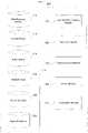
- FIGS. 1A-Billustrate a computer network architecture in accordance with aspects of the present invention.
- FIG. 2illustrates a user device architecture in accordance with aspects of the present invention.
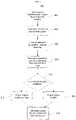
- FIG. 3is a flow diagram of a location augmentation application in accordance with aspects of the present invention.
- FIG. 4illustrates operation of a geolocation module in accordance with aspects of the present invention.
- FIG. 5is a flow diagram of a location refinement application in accordance with aspects of the present invention.
- FIG. 6illustrates additional operation of a geolocation module in accordance with aspects of the present invention.
- location informationis coupled/linked to a precise street address or other specific location.
- geographical informationmay be extracted from a number of sources associated with a user. These include the user's web browser's history, search history, address book, etc. Such information may be used in a number of ways to enhance location accuracy.
- Systems and methodsare used to create a time sensitive heat map of physical locations of interest to a given user.
- physical locationsare used to more accurately estimate the user's location. For instance, a coarse cell tower triangulation is refined in view of the user's home address.
- user-associated geographic informationis employed to provide enhanced detail during a reverse geocoding process.
- FIG. 1this illustration presents a schematic diagram of a computer system depicting various computing devices that can be used alone or in a networked configuration in accordance with aspects of the present invention.
- this figureillustrates a computer network 100 having a plurality of computers 102 , 104 , 106 and 108 as well as other types of devices such as portable electronic devices such as a mobile phone 110 and a PDA 112 .
- Various elements in the computer network 100may be interconnected via a local or direct connection 114 and/or may be coupled via a communications network 116 such as a local area network (“LAN”) such as a WiFi network, a wide area network (“WAN”), the Internet, etc. and which may be wired or wireless.
- LANlocal area network
- WANwide area network
- the Internetetc.
- Each computer apparatuscan include, for example, one or more computing devices having user inputs such as a keyboard 118 and mouse 120 and/or various other types of input devices such as pen-inputs, joysticks, buttons, touch screens, etc., as well as a display 122 , which could include, for instance, a CRT, LCD, plasma screen monitor, TV, projector, etc.
- Each computer 102 , 104 , 106 and 108may be a personal computer, server, etc.
- computers 102 and 106may be personal computers while computer 104 may be a server and computer 108 may be a laptop/palmtop.
- each computersuch as computers 102 and 104 contains a processor 124 , memory 126 and other components typically present in a computer.
- Memory 126stores information accessible by processor 124 , including instructions 128 that may be executed by the processor 124 and data 130 that may be retrieved, manipulated or stored by the processor.
- the memorymay be of any type capable of storing information accessible by the processor, such as a hard-drive, ROM, RAM, CD-ROM, flash memories, write-capable or read-only memories.
- the processor 324may comprise any number of well-known processors, such as processors from Intel Corporation. Alternatively, the processor may be a dedicated controller for executing operations, such as an ASIC.
- the instructions 128may comprise any set of instructions to be executed directly (such as machine code) or indirectly (such as scripts) by the processor.
- the terms “instructions,” “steps” and “programs”may be used interchangeably herein.
- the instructionsmay be stored in any computer language or format, such as in object code or modules of source code. The functions, methods and routines of instructions in accordance with the present invention are explained in more detail below.
- Data 130may be retrieved, stored or modified by processor 124 in accordance with the instructions 128 .
- the datamay be stored as a collection of data.
- the datamay be stored in computer registers, in a relational database as a table having a plurality of different fields and records, XML documents, or flat files.
- Map-type image datamay be stored in flat files such as keyhole flat files (“KFF”).
- the datamay also be formatted in any computer readable format such as, but not limited to, binary values, ASCII etc.
- the datamay include images stored in a variety of formats such as vector-based images or bitmap images using lossless (e.g., BMP) or lossy (e.g., JPEG) encoding.
- the datamay include any information sufficient to identify the relevant information, such as descriptive text, proprietary codes, pointers, references to data stored in other memories (including other network locations) or information which is used by a function to calculate the relevant data.
- processors 124 and memory 126are functionally illustrated in FIG. 1B as being within the same block, it will be understood that the processor and memory may actually comprise multiple processors and memories that may or may not be stored within the same physical housing or location. For example, some or all of the instructions and data may be stored on a removable CD-ROM or DVD. Alternatively, such information may be stored within a read-only computer chip. Some or all of the instructions and data may be stored in a location physically remote from, yet still accessible by, the processor. Similarly, the processor may actually comprise a collection of processors which may or may not operate in parallel. Data may be distributed and stored across multiple memories 126 such as hard drives, server farms or the like.
- server 104communicates with one or more client computers 102 , 106 and/or 108 , as well as devices such as mobile phone 110 and PDA 112 .
- Each client computer or other client devicemay be configured similarly to the server 104 , with a processor, memory and instructions, as well as one or more user input devices 118 , 120 and a user output device, such as display 122 .
- Each client computermay be a general purpose computer, intended for use by a person, having all the components normally found in a personal computer such as a central processing unit (“CPU”), display, CD-ROM or DVD drive, hard-drive, mouse, keyboard, touch-sensitive screen, speakers, microphone, modem and/or router (telephone, cable or otherwise) and all of the components used for connecting these elements to one another.
- CPUcentral processing unit
- displayCD-ROM or DVD drive
- hard-drivekeyboard
- keyboardkeyboard
- touch-sensitive screenkeyboard
- speakersmicrophone
- modem and/or routertelephone, cable or otherwise
- the server 104 and client computers and other devicesare capable of direct and indirect communication with other computers, such as over network 116 .
- network 116may comprise various configurations and protocols including the Internet, intranets, virtual private networks, wide area networks, local networks, private networks using communication protocols proprietary to one or more companies, Ethernet, WiFi, Bluetooth and HTTP.
- Server 104may be a web server.
- the informationmay be sent via a medium such as a disk, tape, CD-ROM, DVD, or directly between two computer systems via a dial-up modem.
- the informationmay be transmitted in a non-electronic format and manually entered into the system.
- computers and client devices in accordance with the systems and methods described hereinmay comprise any device capable of processing instructions and transmitting data to and from humans and other computers, including network computers lacking local storage capability, PDA's with modems such as PDA 112 and Internet-capable wireless phones such as mobile phone 110 .
- the network 100also includes a database 132 .
- the database 132may be directly or indirectly coupled to server 104 .
- the database 132may be part of or otherwise logically associated with the server 104 .
- the database 132may include different sets or types of data.
- the database 132may maintain location and/or map-related data, which may be stored in one or more KFFs.
- the database 132may store data 130 in one or more KFFs. Assets and other information, including satellite data, aerial photographs, digital maps, elevation data, GPS coordinates, etc. may be obtained from one or more sources (not shown).
- the database 132may alternatively maintain information concerning one or more users/customers, as will be explained in detail below.
- User devicessuch as laptop/palmtop 108 , PDA 112 and mobile phone 110 may also include or store information in a database 134 .
- informationmay include, for instance, a web browsing history, a website searching history, map data, the user's address book, e-mail archives and/or calendar entries.
- the database 134should securely store the data to prevent unauthorized access.
- the datamay be encrypted for storage.
- the database 134is maintained on network 100 separate from the user devices.
- the database 134may be locally stored on one or more of the user devices, for example in memory 126 thereof.
- the database 134comprises multiple databases as shown in FIG. 2 .
- the database 134may be part of the user device's architecture 200 , which includes a processor module 202 , a user interface/display module 204 , a communication module 206 , a power module 208 and a memory module 210 .
- the processor module 202may include a processor such as processor 124 or a controller and its attendant circuitry (e.g., local memory, floating point and/or integer processing elements, DMA unit).
- the user interface/display module 204includes user inputs and outputs such as inputs 118 and 120 and display 122 of FIGS. 1A and 1B .
- the communication module 206contains a protocol stack and attendant circuitry for communicating across a network such as network 116 or for direct device to device communication.
- the power module 208provides power to the various modules of the architecture 200 , and may include a rechargeable battery and/or power cable.
- the memory module 210desirably includes the database 134 .
- the memory module 210comprises a plurality of sub-databases focusing on different applications and/or user attributes.
- the memory module 210may include a web browsing history database 212 , a search history database 214 , a maps history database 216 , an address book database 218 , an e-mail archive database 220 , and a calendar entries database 222 .
- Other informationsuch as credit card transaction information, may be stored in other sub-databases.
- the information stored in each of these sub-databasesmay be associated with specific programs or types of applications, or with the user's overall operation of the device.
- the web browsing history and search history databasesmay be associated with one or more web browsers such as the Internet Explorer, Safari, Firefox or Chrome web browsers.
- the maps history databasemay also be associated with the web browsers or other applications such as Google Earth.
- the address book and e-mail archive databasesmay be linked to the user's messaging application, such as Google's Gmail or Microsoft Outlook.
- the calendar entries databasemay similarly be linked to the messaging application or other application such as Google Calendar. While a number of different sub-databases have been identified above, other sub-databases which may contain location-related information may also be employed, such as the database associated with Google Latitude, a tool which lets users share their current location with friends.
- location-related informationmay be mined/extracted from the sub-databases on a regular basis or in response to a request.
- FIG. 3illustrates one such scenario.
- FIG. 3provides a flow diagram of an opt-in location augmentation application 300 .
- a usersigns up for location augmentation. This may include the user providing authorization to use one or more of the sub-databases in memory module 210 of his/her user device.
- the usermay select specific sub-databases to which the application is granted access. For instance, the user may grant access to the address book database 218 but not to the e-mail archives database 220 .
- the user databasemay include an index where each extracted location signal may be associated with a set of information including some or all of geographical tags or “geotags” (which could be items such as “my home” or a search term such as “coffee shop”), temporal information (e.g., time an event occurred, optional time that certain information may expire, and/or a degradation factor), and a score to suggest the confidence in that location. For example, a latitude/longitude location may have a higher confidence than a location that is extracted from an email message. In a spatial index, a single location may have aggregate information from multiple databases. In this case, the system may compute an aggregate confidence and score for that location.
- geographical tags or “geotags”which could be items such as “my home” or a search term such as “coffee shop”
- temporal informatione.g., time an event occurred, optional time that certain information may expire, and/or a degradation factor
- a scoree.g., time an event occurred, optional time that certain information may expir
- a geolocation modulebuilds a spatial index which may provide location corrections and reverse geocoding.
- the geolocation modulemay gain access to the various sub-databases previously authorized by the user and use certain information to create one or more “heat maps” of specific physical locations at different times for a given user, as shown in block 308 .
- the heat mapsmay be presented on the user device's display.
- FIG. 4illustrates an example of how the geolocation module may perform a location correction process or augmentation.
- the modulemay include an application operating on server 104 of FIG. 1A .
- the geolocation modulemay be part of the user device architecture 200 .
- the geolocation modulemay operate locally, on the server-side, or as a distributed module both locally and on the server.
- a server-only implementationmay be more efficient and accurate because it would be able to use the entire corpus of data available in the databases 132 and 134 .
- a geolocation module 136may be associated with or otherwise incorporated into the server 104 .
- a local implementationmay involve prefetching of data which is most applicable to the user's current location and applying the same inference algorithm locally.
- FIG. 2illustrates a geolocation module 224 as part of the user device's architecture 200 .
- a cachecould be incorporated on the user's device which mirrors the most relevant server-side profile. In this case, there would be little difference between the server-side and local implementations, just the amount of input data available.
- a secure central server gatewaymay be employed to fetch the data from relevant sub-databases, and transfer the data to the client. In other words, the client device would not need to directly make fetch requests to different server-side databases.
- the geolocation moduleincludes a protected data fetcher 400 that is configured to communicate with the sub-databases.
- the protected data fetcher 400extracts a result set 402 from the sub-databases. It may require authentication of the user or authorization by the sub-databases.
- the protected data fetcher 400searches for any geographical information associated with the sub-databases. For instance, it may search web pages and search histories for geographical data.
- Each resultmay correspond to a given physical location, person, activity and/or time.
- mining of the web browsing history database 212may result in a location (“City Hall, New York”) and a time (t 1 ).
- Mining of the search history database 214may also result in a location (“Lorie's Café”) and a time (t 2 ).
- mining of the maps history database 216may result in a location (“79 Ninth Ave 10011”) and a time (t 3 ).
- Examination of the address book database 218may result in a name (“Michael Bloomberg”), while examination of the e-mail archives database 220 may result in an activity (“Movie ticket receipts”) and a time (t 5 ).
- examination of the calendar entries database 222may result in an activity (“Work lunch with Mike”) and a time (t 6 ).
- the geolocation moduleperforms a geopoint extraction process on the result set 402 , creating a geocoded result set 404 .
- the geocoded result set 404contains references to specific physical locations in latitude/longitude format.
- a forward geocodermay be used to convert an address into the latitude/longitude format.
- a spatial indexis constructed which contains the latitudes and longitudes.
- the spatial indexmay contain a properly formatted version of a physical address, such as a street address, corresponding to the latitude and longitude.
- the spatial indexmay also include time information, such as the time a web page was accessed or a search query was performed. Similar timing information may be collected for the other sub-databases.
- any information in the sub-databases which corresponds to geographical informationsuch as locations of known friends that a user travels with or is scheduled to meet, may be processed by the geolocation module.
- the spatial indexmay include image tiles and associated data which are stored in a “quadtree” structure.
- the nodes of a quadtree data structureare referred to herein as “quadnodes.”
- a quadnode plus one or more levels of descendentsare referred to herein a “quadset.”
- Data pertaining to quadtrees, quadnodes and quadsetsmay be stored in a database such as a KFF database, which may be maintained as database 132 of FIG. 1A .
- the KFF or other database containing the spatial indexis used to generate heat maps of particular physical locations as shown in FIG. 4 .
- one or more heat maps of a region of interestare created using the geocoded result set 404 . This may be done in conjunction with other data from result set 402 , such as names of people, actions or events, and times.
- three heat maps 406 a , 406 b and 406 care generated for different times (e.g., times t 1 , t 2 and t 3 ). Some or all of these heat maps may be presented on the display of the user device according to input from the user, such as via the user interface/display module 204 of FIG. 3 .
- the different pushpinsmay represent a ranked list of points of interest for each heat map.
- the points of interestmay change, and also different points of interest may be more or less relevant at different times.
- the pushpins A-Jchange across the various heat maps.
- FIG. 5illustrates another embodiment of the present invention.
- FIG. 5presents a flow diagram 500 for refining a position location estimate.
- a userrequests directions between two locations from a mapping application, such as Google Maps, as shown in block 502 .
- a mapping applicationsuch as Google Maps
- the usermay not know his/her specific position, and the request is for directions from a current location.
- an estimate of the current locationis then determined, and may be presented to the user on the device's display.
- the current location of the usermay be estimated through a number of techniques. Depending on the particular type of user device and network, GPS, cell tower triangulation, WiFi triangulation, IP geocoding or other techniques may be employed.
- the current locationmay also be inferred from historical information as well. For example, if the user is known to be a certain location at time X every day, then there is a strong chance they'd be in the same location on a given day in the future. This may be determined by calendar or address book entries, e-mail archives, GPS results from prior usage of the user's device, or from other information.
- the initial estimatemay include a position in latitude/longitude coordinates, and may also include an estimate of accuracy.
- the accuracymay depend on a number of factors. For instance, if the user's device is a GPS enabled mobile phone, the accuracy of the GPS position is affected by the number of GPS satellites observed by the mobile phone. In the case of a WiFi network or cellular system, triangulation or other location technique may depend on terrain conditions (e.g., hilly or lots of nearby buildings), signal strength, weather conditions and time of year. The accuracy may be determined by the user's device itself, by the network, or both.
- the estimated latitude and longitudeare looked up in or otherwise compared to a heat map associated with the user.
- a heat map associated with the userThere may be multiple heat maps which have been generated for or otherwise associated with the user. Such heat maps may be for various places and times in the past, present and future.
- the geolocation moduledesirably uses a heat map for the current time when performing the lookup. Based upon the lookup, the geolocation module determines a set of relevant matching address(es) for the selected heat map, as shown in block 508 . This may include one or more addresses.
- the matching addressesmay include frequency and timeliness scores or rankings. Frequency is determined by how often the same location appears in the same databases or across different databases. Timeliness is the frequency of occurrence at a particular time. So location X may appear at time t 1 (e.g., Monday at 1 pm) more often that location Y, and location Y may occur more often at time t 2 (eg., Monday at 11 pm). In this case, based on the current time of the user, either location X or Y may be used.
- Scoresmay be determined by simply adding up the frequencies, or using a metric that assigns a weighted score based on the confidence of the sub-database. Thus, a maps search may be weighted higher than e-mail. A current location from latitude/longitude may be assigned the highest score because the user has been known to be physically present at that location. Another score signal would be how recent the data is. Here, if the data is too old (“stale”), it may receive a lower score or weighting, thereby introducing a degradation factor for time.
- a refined position(“best feature”) is determined, as shown in block 512 .
- the geolocation moduleanalyzes all entries in a spatial index associated with the selected heat map that are within a certain distance of the initial latitude and longitude. This distance may be based on the initial accuracy or the density of the spatial index. From this, the geolocation module determines whether an entry in the spatial index is sufficiently close (e.g., a latitude/longitude pair within x meters of the initial estimate), sufficiently frequent and/or sufficiently recent (e.g., within y days from the date of the request). Preferably, the selection process is optimized for quality. If no suitable entries are found in the spatial index, the original location estimate is returned, as shown in block 514 . Next, as shown in block 516 , routing directions are generated based on the refined or original location and are provided to the user.
- block 600includes the user request to get directions from “Current Location” to Mountain View, Calif.
- an estimate of the user's current positionis determined.
- a latitude/longitude estimatemay be presented on the user device's display.
- the accuracy of the estimatemay be illustrated by the circular region as shown.
- the geolocation modulelooks up the latitude/longitude estimate in a heat map for the current time. The geolocation module returns the matching address(es) or returns a “no confidence” result as discussed above. If multiple matching addresses are provided, the geolocation module determines the best feature, i.e., the feature most likely to correspond with the user's present location. Then, as shown in block 604 , routing directions are provided to the user based on the best feature. If no feature is returned, then block 606 shows that routing directions are provided to the user based on the original location estimate.
- a list of the highest confidence resultsmay be provided to the user so that the user may select between them instead of relying on the original location estimate.
- other usage scenariosinclude seeking a more accurate location when searching around the user's location for businesses, people etc., for more accurately broadcasting the user's location to his/her friends, and for accurately geocoding any photographs a user has taken with his/her cellular phone.
Landscapes
- Engineering & Computer Science (AREA)
- Theoretical Computer Science (AREA)
- Databases & Information Systems (AREA)
- Physics & Mathematics (AREA)
- General Physics & Mathematics (AREA)
- Data Mining & Analysis (AREA)
- General Engineering & Computer Science (AREA)
- Computer Networks & Wireless Communication (AREA)
- Signal Processing (AREA)
- Remote Sensing (AREA)
- Business, Economics & Management (AREA)
- Radar, Positioning & Navigation (AREA)
- Finance (AREA)
- Accounting & Taxation (AREA)
- Development Economics (AREA)
- Strategic Management (AREA)
- Economics (AREA)
- Game Theory and Decision Science (AREA)
- Entrepreneurship & Innovation (AREA)
- Marketing (AREA)
- General Business, Economics & Management (AREA)
- Software Systems (AREA)
- Information Retrieval, Db Structures And Fs Structures Therefor (AREA)
- Telephonic Communication Services (AREA)
- Position Fixing By Use Of Radio Waves (AREA)
- Navigation (AREA)
- Automation & Control Theory (AREA)
Abstract
Description
Claims (18)
Priority Applications (3)
| Application Number | Priority Date | Filing Date | Title |
|---|---|---|---|
| US15/908,934US11314715B2 (en) | 2009-05-08 | 2018-03-01 | Refining location estimates and reverse geocoding based on a user profile |
| US17/720,805US12086127B2 (en) | 2009-05-08 | 2022-04-14 | Refining location estimates and reverse geocoding based on a user profile |
| US18/797,854US20240394240A1 (en) | 2009-05-08 | 2024-08-08 | Refining Location Estimates and Reverse Geocoding Based on a User Profile |
Applications Claiming Priority (3)
| Application Number | Priority Date | Filing Date | Title |
|---|---|---|---|
| US12/437,718US20100287178A1 (en) | 2009-05-08 | 2009-05-08 | Refining location estimates and reverse geocoding based on a user profile |
| US14/545,018US9953047B2 (en) | 2009-05-08 | 2015-03-16 | Refining location estimates and reverse geocoding based on a user profile |
| US15/908,934US11314715B2 (en) | 2009-05-08 | 2018-03-01 | Refining location estimates and reverse geocoding based on a user profile |
Related Parent Applications (1)
| Application Number | Title | Priority Date | Filing Date |
|---|---|---|---|
| US14/545,018ContinuationUS9953047B2 (en) | 2009-05-08 | 2015-03-16 | Refining location estimates and reverse geocoding based on a user profile |
Related Child Applications (1)
| Application Number | Title | Priority Date | Filing Date |
|---|---|---|---|
| US17/720,805ContinuationUS12086127B2 (en) | 2009-05-08 | 2022-04-14 | Refining location estimates and reverse geocoding based on a user profile |
Publications (2)
| Publication Number | Publication Date |
|---|---|
| US20180189341A1 US20180189341A1 (en) | 2018-07-05 |
| US11314715B2true US11314715B2 (en) | 2022-04-26 |
Family
ID=43050467
Family Applications (5)
| Application Number | Title | Priority Date | Filing Date |
|---|---|---|---|
| US12/437,718AbandonedUS20100287178A1 (en) | 2009-05-08 | 2009-05-08 | Refining location estimates and reverse geocoding based on a user profile |
| US14/545,018Active2029-11-01US9953047B2 (en) | 2009-05-08 | 2015-03-16 | Refining location estimates and reverse geocoding based on a user profile |
| US15/908,934Active2030-04-18US11314715B2 (en) | 2009-05-08 | 2018-03-01 | Refining location estimates and reverse geocoding based on a user profile |
| US17/720,805ActiveUS12086127B2 (en) | 2009-05-08 | 2022-04-14 | Refining location estimates and reverse geocoding based on a user profile |
| US18/797,854PendingUS20240394240A1 (en) | 2009-05-08 | 2024-08-08 | Refining Location Estimates and Reverse Geocoding Based on a User Profile |
Family Applications Before (2)
| Application Number | Title | Priority Date | Filing Date |
|---|---|---|---|
| US12/437,718AbandonedUS20100287178A1 (en) | 2009-05-08 | 2009-05-08 | Refining location estimates and reverse geocoding based on a user profile |
| US14/545,018Active2029-11-01US9953047B2 (en) | 2009-05-08 | 2015-03-16 | Refining location estimates and reverse geocoding based on a user profile |
Family Applications After (2)
| Application Number | Title | Priority Date | Filing Date |
|---|---|---|---|
| US17/720,805ActiveUS12086127B2 (en) | 2009-05-08 | 2022-04-14 | Refining location estimates and reverse geocoding based on a user profile |
| US18/797,854PendingUS20240394240A1 (en) | 2009-05-08 | 2024-08-08 | Refining Location Estimates and Reverse Geocoding Based on a User Profile |
Country Status (7)
| Country | Link |
|---|---|
| US (5) | US20100287178A1 (en) |
| EP (3) | EP2428027B1 (en) |
| JP (2) | JP5663563B2 (en) |
| AU (1) | AU2010245847B2 (en) |
| CA (1) | CA2761325C (en) |
| DE (1) | DE202010018500U1 (en) |
| WO (1) | WO2010129766A1 (en) |
Families Citing this family (80)
| Publication number | Priority date | Publication date | Assignee | Title |
|---|---|---|---|---|
| EP2019151B1 (en)* | 2007-07-27 | 2012-09-12 | Nissan Motor Co., Ltd. | Thermally sprayed film forming method and device |
| US11082548B2 (en)* | 2008-06-05 | 2021-08-03 | Movius Interactive Corporation | System and method for providing a pre-populated second line service to a telecommunications device |
| FI20095642A0 (en)* | 2009-06-09 | 2009-06-09 | Dopplr Oy | Identification of a geographical point |
| US9041726B2 (en) | 2009-07-14 | 2015-05-26 | Steve Souza | Analyzing large data sets using digital images |
| US8395624B2 (en)* | 2009-07-14 | 2013-03-12 | Steve Souza | Dynamic generation of images to facilitate information visualization |
| US9563850B2 (en)* | 2010-01-13 | 2017-02-07 | Yahoo! Inc. | Method and interface for displaying locations associated with annotations |
| US9002535B2 (en)* | 2010-05-11 | 2015-04-07 | Irobot Corporation | Navigation portals for a remote vehicle control user interface |
| US9798822B2 (en)* | 2010-06-29 | 2017-10-24 | Apple Inc. | Location based grouping of browsing histories |
| US8825388B2 (en) | 2010-07-13 | 2014-09-02 | Qualcomm Incorporated | Indoor likelihood heatmap |
| US8892118B2 (en) | 2010-07-23 | 2014-11-18 | Qualcomm Incorporated | Methods and apparatuses for use in providing position assistance data to mobile stations |
| US9148763B2 (en)* | 2010-07-30 | 2015-09-29 | Qualcomm Incorporated | Methods and apparatuses for mobile station centric determination of positioning assistance data |
| US8818401B2 (en) | 2010-07-30 | 2014-08-26 | Qualcomm Incorporated | Methods and apparatuses for use in determining that a mobile station is at one or more particular indoor regions |
| US8930391B2 (en) | 2010-12-29 | 2015-01-06 | Microsoft Corporation | Progressive spatial searching using augmented structures |
| US8874713B1 (en)* | 2011-02-18 | 2014-10-28 | Google Inc. | Location correction |
| US9129029B1 (en) | 2011-05-19 | 2015-09-08 | Google Inc. | Ranking content using location-based query log analysis |
| US9247377B2 (en) | 2011-05-23 | 2016-01-26 | Apple Inc. | Setting a reminder that is triggered by a target user device |
| US10715380B2 (en) | 2011-05-23 | 2020-07-14 | Apple Inc. | Setting a reminder that is triggered by a target user device |
| US8971924B2 (en) | 2011-05-23 | 2015-03-03 | Apple Inc. | Identifying and locating users on a mobile network |
| US8736442B2 (en) | 2011-06-08 | 2014-05-27 | Apple Inc. | Automatic identification and storage of frequently visited locations |
| US8473485B2 (en) | 2011-06-29 | 2013-06-25 | Microsoft Corporation | Organizing search history into collections |
| US8706732B1 (en)* | 2011-07-12 | 2014-04-22 | Google Inc. | Managing information about entities using clusters of received observations |
| US8676804B1 (en) | 2011-07-12 | 2014-03-18 | Google Inc. | Managing information about entities using observations generated from user modified values |
| US10453226B1 (en) | 2011-07-26 | 2019-10-22 | Google Llc | Presenting information on a map |
| US8706137B2 (en)* | 2011-08-02 | 2014-04-22 | Qualcomm Incorporated | Likelihood of mobile device portal transition |
| US8983953B2 (en) | 2011-10-18 | 2015-03-17 | Nokia Corporation | Methods and apparatuses for facilitating interaction with a geohash-indexed data set |
| US9143541B1 (en) | 2011-11-17 | 2015-09-22 | Google Inc. | Systems, computer-implemented methods, and computer-readable media to target internet-based services on a geographic location |
| WO2013106856A1 (en)* | 2012-01-13 | 2013-07-18 | Google Inc. | Place heat geometries |
| CN107256329B (en) | 2012-01-19 | 2020-12-15 | 耐克创新有限合伙公司 | Integral apparatus and non-transitory computer readable medium for detecting movement data of a user |
| US9224118B2 (en) | 2012-03-12 | 2015-12-29 | Google Inc. | Dynamic display of content consumption by geographic location |
| US8954524B1 (en)* | 2012-03-14 | 2015-02-10 | Google Inc. | Access to network content |
| US20130268232A1 (en)* | 2012-04-10 | 2013-10-10 | Qualcomm Incorporated | Informative Display for Statistical Positioning System |
| US20130267251A1 (en)* | 2012-04-10 | 2013-10-10 | Qualcomm Incorporated | Personalized position using information correlation and self-sourcing |
| US8914043B2 (en)* | 2012-04-18 | 2014-12-16 | Google Inc. | Creating and sharing private location databases |
| CN110057375B (en)* | 2012-06-05 | 2023-11-14 | 耐克创新有限合伙公司 | Activity monitoring system for providing route information and heatmaps |
| US10430391B2 (en) | 2012-09-28 | 2019-10-01 | Oracle International Corporation | Techniques for activity tracking, data classification, and in database archiving |
| US20140129545A1 (en)* | 2012-11-02 | 2014-05-08 | Google Inc. | Sorting search results |
| EP2731362A1 (en)* | 2012-11-08 | 2014-05-14 | Alcatel Lucent | Configuration of electronic device |
| US9031573B2 (en)* | 2012-12-31 | 2015-05-12 | Qualcomm Incorporated | Context-based parameter maps for position determination |
| US8989773B2 (en) | 2013-01-29 | 2015-03-24 | Apple Inc. | Sharing location information among devices |
| US9553936B2 (en)* | 2013-03-15 | 2017-01-24 | Google Inc. | Targeting of digital content to geographic regions |
| US9672223B2 (en)* | 2013-04-25 | 2017-06-06 | Google Inc. | Geo photo searching based on current conditions at a location |
| US10331733B2 (en) | 2013-04-25 | 2019-06-25 | Google Llc | System and method for presenting condition-specific geographic imagery |
| US9267805B2 (en) | 2013-06-07 | 2016-02-23 | Apple Inc. | Modeling significant locations |
| WO2015035185A1 (en) | 2013-09-06 | 2015-03-12 | Apple Inc. | Providing transit information |
| US9544721B2 (en)* | 2013-07-26 | 2017-01-10 | Apple Inc. | Address point data mining |
| US9420426B2 (en) | 2013-07-30 | 2016-08-16 | Google Inc. | Inferring a current location based on a user location history |
| US9298831B1 (en) | 2013-12-13 | 2016-03-29 | Google Inc. | Approximating a user location |
| WO2015143412A1 (en)* | 2014-03-20 | 2015-09-24 | Geocommerce Inc. | Platform dashboard |
| JP2015190888A (en)* | 2014-03-28 | 2015-11-02 | Kddi株式会社 | providing device, position determination device, control method, and program |
| US9843894B2 (en) | 2014-05-30 | 2017-12-12 | Apple Inc. | Determining a size of a significant user location |
| US10382378B2 (en) | 2014-05-31 | 2019-08-13 | Apple Inc. | Live location sharing |
| US9594808B2 (en) | 2014-06-04 | 2017-03-14 | Google Inc. | Determining relevance of points of interest to a user |
| US9959506B1 (en)* | 2014-06-17 | 2018-05-01 | Amazon Technologies, Inc. | Predictive content retrieval using device movements |
| CN104063469A (en)* | 2014-06-27 | 2014-09-24 | 百度在线网络技术(北京)有限公司 | Search result display method and search result display device |
| US10257679B2 (en) | 2014-10-05 | 2019-04-09 | Lenovo Enterprise Solutions (Singapore) Pte. Ltd. | Relative location determination for auto-configuration of computing systems in a network environment |
| US20160210647A1 (en)* | 2015-01-15 | 2016-07-21 | Hsiao-Tse Chang | Method of determining segmentations of subscribers, network entity using the same, and server using the same |
| US9838837B2 (en) | 2015-04-13 | 2017-12-05 | Google LLP | Power-efficient location estimation |
| CN104931062A (en)* | 2015-04-23 | 2015-09-23 | 骑记(厦门)科技有限公司 | Display method and device of track route map |
| US20160335275A1 (en)* | 2015-05-11 | 2016-11-17 | Google Inc. | Privacy-sensitive query for localization area description file |
| US10033941B2 (en) | 2015-05-11 | 2018-07-24 | Google Llc | Privacy filtering of area description file prior to upload |
| US10310095B2 (en)* | 2015-10-22 | 2019-06-04 | Veniam, Inc. | Using historical data to correct GPS data in a network of moving things |
| CN106991576B (en)* | 2016-01-20 | 2020-10-09 | 阿里巴巴集团控股有限公司 | Method and device for displaying heat of geographic area |
| AU2016397278B2 (en)* | 2016-03-16 | 2019-05-30 | Beijing Didi Infinity Technology And Development Co., Ltd. | System and method for determining location |
| CN107203823B (en)* | 2016-03-16 | 2020-12-25 | 北京嘀嘀无限科技发展有限公司 | User riding address adjusting method and device |
| US10430428B2 (en)* | 2016-03-31 | 2019-10-01 | Experian Health, Inc. | Smart mapping |
| JP6494576B2 (en)* | 2016-09-16 | 2019-04-03 | ヤフー株式会社 | Estimation apparatus, estimation method, and estimation program |
| CN107070961B (en) | 2016-09-30 | 2020-06-23 | 阿里巴巴集团控股有限公司 | Hot spot area determination method and device based on geographic position data |
| CN106713501B (en)* | 2017-02-13 | 2019-11-26 | 四川商通实业有限公司 | The method of locating terminal of ActiveX component based on WEB application |
| US11194829B2 (en) | 2017-03-24 | 2021-12-07 | Experian Health, Inc. | Methods and system for entity matching |
| WO2018201229A1 (en)* | 2017-05-03 | 2018-11-08 | Meemim Inc. | Method, system and computer program product for geospatial calibration |
| CN107315824B (en)* | 2017-07-04 | 2021-01-22 | 百度在线网络技术(北京)有限公司 | Method and device for generating thermodynamic diagram |
| CN110020273B (en)* | 2017-08-16 | 2021-06-29 | 北京京东尚科信息技术有限公司 | Method, device and system for generating thermodynamic diagram |
| US10963530B1 (en)* | 2017-11-17 | 2021-03-30 | Groupon, Inc. | Clustering and coranking of multi-source location data |
| US20190325382A1 (en)* | 2018-04-20 | 2019-10-24 | United States Postal Service | Use of geospatial coordinate systems for tracking item delivery |
| US20200034926A1 (en) | 2018-07-24 | 2020-01-30 | Experian Health, Inc. | Automatic data segmentation system |
| EP3771229A1 (en) | 2019-07-23 | 2021-01-27 | HERE Global B.V. | Positioning based on calendar information |
| CN111413722A (en)* | 2020-03-17 | 2020-07-14 | 新石器慧通(北京)科技有限公司 | Positioning method, positioning device, unmanned vehicle, electronic equipment and storage medium |
| US20230221936A1 (en)* | 2020-06-25 | 2023-07-13 | Hewlett-Packard Development Company, L.P. | Geographic deployment of applications to edge computing nodes |
| US12282505B2 (en)* | 2020-11-24 | 2025-04-22 | Here Global B.V. | Method, apparatus, and system for computing a spatial footprint index |
| CN115086411B (en)* | 2022-06-16 | 2023-12-05 | 京东城市(北京)数字科技有限公司 | IP positioning method, system, storage medium and electronic equipment |
Citations (23)
| Publication number | Priority date | Publication date | Assignee | Title |
|---|---|---|---|---|
| US6138026A (en) | 1998-06-16 | 2000-10-24 | Ericsson Inc. | Method and apparatus for locating a wireless communication device |
| US20030063072A1 (en) | 2000-04-04 | 2003-04-03 | Brandenberg Carl Brock | Method and apparatus for scheduling presentation of digital content on a personal communication device |
| US20030126100A1 (en)* | 2001-12-26 | 2003-07-03 | Autodesk, Inc. | Fuzzy logic reasoning for inferring user location preferences |
| WO2003058928A1 (en) | 2001-12-26 | 2003-07-17 | Autodesk, Inc. | Mobile device locator system |
| US20040003042A1 (en)* | 2001-06-28 | 2004-01-01 | Horvitz Eric J. | Methods and architecture for cross-device activity monitoring, reasoning, and visualization for providing status and forecasts of a users' presence and availability |
| US20040147265A1 (en)* | 2002-07-23 | 2004-07-29 | Mark Kelley | System and method for an adaptive user communications device |
| US20040162090A1 (en) | 2003-02-18 | 2004-08-19 | Lalitha Suryanarayana | Location determination using historical data |
| US20050246334A1 (en) | 2004-04-30 | 2005-11-03 | Hong Kong Applied Science And Technology Research Institute Co., Ltd. | Location determination and location tracking in wireless networks |
| US20060059152A1 (en) | 2004-08-25 | 2006-03-16 | Fujitsu Limited | Browse history presentation system |
| US20060270421A1 (en) | 2005-05-27 | 2006-11-30 | Alan Phillips | Location-based services |
| US20060276201A1 (en) | 1996-09-09 | 2006-12-07 | Tracbeam Llc | Wireless location routing applications and archectiture therefor |
| US20070082677A1 (en) | 2005-10-11 | 2007-04-12 | Cisco Technology, Inc. | Automated configuration of RF WLANs via selected sensors |
| JP2007178271A (en) | 2005-12-28 | 2007-07-12 | Aisin Aw Co Ltd | Own position recognition system |
| US20080121690A1 (en) | 2006-11-27 | 2008-05-29 | Carani Sherry L | Ubiquitous Tracking System and Method |
| US20080205768A1 (en)* | 2007-02-23 | 2008-08-28 | Saama Technologies, Inc. | Method and system for optimizing business location selection |
| US20080214157A1 (en) | 2005-09-14 | 2008-09-04 | Jorey Ramer | Categorization of a Mobile User Profile Based on Browse Behavior |
| JP2008242408A (en) | 2007-02-27 | 2008-10-09 | Yahoo Japan Corp | How to correct position data |
| US20080249983A1 (en) | 2006-03-31 | 2008-10-09 | Aol Llc | Identifying a result responsive to a current location of a client device |
| US20080312942A1 (en)* | 2007-06-15 | 2008-12-18 | Suresh Katta | Method and system for displaying predictions on a spatial map |
| US20090258656A1 (en) | 2008-04-13 | 2009-10-15 | Yin Wang | Method for Exchanging Location-Relevant Information Using a Mobile Device with an Interactive Map Display |
| US7774227B2 (en)* | 2007-02-23 | 2010-08-10 | Saama Technologies, Inc. | Method and system utilizing online analytical processing (OLAP) for making predictions about business locations |
| US8260553B2 (en) | 2008-09-30 | 2012-09-04 | Nokia Corporation | Methods, apparatuses, and computer program products for providing user location information |
| US9497795B1 (en)* | 2008-04-01 | 2016-11-15 | United Services Automobile Association | Systems and methods for a home market alert service |
Family Cites Families (8)
| Publication number | Priority date | Publication date | Assignee | Title |
|---|---|---|---|---|
| US6563532B1 (en)* | 1999-01-05 | 2003-05-13 | Internal Research Corporation | Low attention recording unit for use by vigorously active recorder |
| US6266615B1 (en)* | 1999-09-27 | 2001-07-24 | Televigation, Inc. | Method and system for an interactive and real-time distributed navigation system |
| US7194186B1 (en)* | 2000-04-21 | 2007-03-20 | Vulcan Patents Llc | Flexible marking of recording data by a recording unit |
| JP3961784B2 (en)* | 2001-06-01 | 2007-08-22 | 株式会社エヌ・ティ・ティ・ドコモ | Positioning device, positioning result correcting method, program, and recording medium |
| JP2004287807A (en)* | 2003-03-20 | 2004-10-14 | Nissan Motor Co Ltd | Information presentation device |
| JP2005031068A (en)* | 2003-06-20 | 2005-02-03 | Matsushita Electric Ind Co Ltd | Location guidance device |
| US7925995B2 (en)* | 2005-06-30 | 2011-04-12 | Microsoft Corporation | Integration of location logs, GPS signals, and spatial resources for identifying user activities, goals, and context |
| US20080125965A1 (en)* | 2006-11-27 | 2008-05-29 | Carani Sherry L | Tracking System and Method with Automatic Map Selector and Geo Fence Defining Features |
- 2009
- 2009-05-08USUS12/437,718patent/US20100287178A1/ennot_activeAbandoned
- 2010
- 2010-05-06EPEP10772823.0Apatent/EP2428027B1/enactiveActive
- 2010-05-06AUAU2010245847Apatent/AU2010245847B2/enactiveActive
- 2010-05-06DEDE202010018500.9Upatent/DE202010018500U1/ennot_activeExpired - Lifetime
- 2010-05-06JPJP2012509972Apatent/JP5663563B2/enactiveActive
- 2010-05-06EPEP18166570.4Apatent/EP3379799B1/enactiveActive
- 2010-05-06CACA2761325Apatent/CA2761325C/enactiveActive
- 2010-05-06WOPCT/US2010/033865patent/WO2010129766A1/enactiveApplication Filing
- 2010-05-06EPEP16194716.3Apatent/EP3142331B1/enactiveActive
- 2014
- 2014-04-07JPJP2014078484Apatent/JP5798661B2/enactiveActive
- 2015
- 2015-03-16USUS14/545,018patent/US9953047B2/enactiveActive
- 2018
- 2018-03-01USUS15/908,934patent/US11314715B2/enactiveActive
- 2022
- 2022-04-14USUS17/720,805patent/US12086127B2/enactiveActive
- 2024
- 2024-08-08USUS18/797,854patent/US20240394240A1/enactivePending
Patent Citations (25)
| Publication number | Priority date | Publication date | Assignee | Title |
|---|---|---|---|---|
| US20060276201A1 (en) | 1996-09-09 | 2006-12-07 | Tracbeam Llc | Wireless location routing applications and archectiture therefor |
| US6138026A (en) | 1998-06-16 | 2000-10-24 | Ericsson Inc. | Method and apparatus for locating a wireless communication device |
| US20030063072A1 (en) | 2000-04-04 | 2003-04-03 | Brandenberg Carl Brock | Method and apparatus for scheduling presentation of digital content on a personal communication device |
| US20040003042A1 (en)* | 2001-06-28 | 2004-01-01 | Horvitz Eric J. | Methods and architecture for cross-device activity monitoring, reasoning, and visualization for providing status and forecasts of a users' presence and availability |
| US20030126100A1 (en)* | 2001-12-26 | 2003-07-03 | Autodesk, Inc. | Fuzzy logic reasoning for inferring user location preferences |
| WO2003058928A1 (en) | 2001-12-26 | 2003-07-17 | Autodesk, Inc. | Mobile device locator system |
| US20040147265A1 (en)* | 2002-07-23 | 2004-07-29 | Mark Kelley | System and method for an adaptive user communications device |
| US20040162090A1 (en) | 2003-02-18 | 2004-08-19 | Lalitha Suryanarayana | Location determination using historical data |
| US20050246334A1 (en) | 2004-04-30 | 2005-11-03 | Hong Kong Applied Science And Technology Research Institute Co., Ltd. | Location determination and location tracking in wireless networks |
| US20060059152A1 (en) | 2004-08-25 | 2006-03-16 | Fujitsu Limited | Browse history presentation system |
| US20060270421A1 (en) | 2005-05-27 | 2006-11-30 | Alan Phillips | Location-based services |
| US20080214157A1 (en) | 2005-09-14 | 2008-09-04 | Jorey Ramer | Categorization of a Mobile User Profile Based on Browse Behavior |
| US20070082677A1 (en) | 2005-10-11 | 2007-04-12 | Cisco Technology, Inc. | Automated configuration of RF WLANs via selected sensors |
| JP2007178271A (en) | 2005-12-28 | 2007-07-12 | Aisin Aw Co Ltd | Own position recognition system |
| US20080249983A1 (en) | 2006-03-31 | 2008-10-09 | Aol Llc | Identifying a result responsive to a current location of a client device |
| US7743056B2 (en) | 2006-03-31 | 2010-06-22 | Aol Inc. | Identifying a result responsive to a current location of a client device |
| US20080121690A1 (en) | 2006-11-27 | 2008-05-29 | Carani Sherry L | Ubiquitous Tracking System and Method |
| US20080205768A1 (en)* | 2007-02-23 | 2008-08-28 | Saama Technologies, Inc. | Method and system for optimizing business location selection |
| US7774227B2 (en)* | 2007-02-23 | 2010-08-10 | Saama Technologies, Inc. | Method and system utilizing online analytical processing (OLAP) for making predictions about business locations |
| JP2008242408A (en) | 2007-02-27 | 2008-10-09 | Yahoo Japan Corp | How to correct position data |
| US20080312942A1 (en)* | 2007-06-15 | 2008-12-18 | Suresh Katta | Method and system for displaying predictions on a spatial map |
| US7856370B2 (en)* | 2007-06-15 | 2010-12-21 | Saama Technologies, Inc. | Method and system for displaying predictions on a spatial map |
| US9497795B1 (en)* | 2008-04-01 | 2016-11-15 | United Services Automobile Association | Systems and methods for a home market alert service |
| US20090258656A1 (en) | 2008-04-13 | 2009-10-15 | Yin Wang | Method for Exchanging Location-Relevant Information Using a Mobile Device with an Interactive Map Display |
| US8260553B2 (en) | 2008-09-30 | 2012-09-04 | Nokia Corporation | Methods, apparatuses, and computer program products for providing user location information |
Non-Patent Citations (7)
| Title |
|---|
| Extended European Search Report for EP Patent Application No. 10772823.0, dated Nov. 27, 2015. |
| Extended European Search Report for EP Patent Application No. 16194716.3, dated Feb. 15, 2017. |
| Extended European Search Report for European Patent Application No. 18166570.4, dated Jun. 25, 2018. 8 pages. |
| International Search Report, PCT/US10/33865, dated Jul. 9, 2010. |
| Japanese Office Action for Application No. 2012-509972 dated Dec. 13, 2013. |
| Rekimoto Junichi, Location Awareness Tokusyu, Human Interface Gakkaishi, Nihon, Tokutei Hieiri Katsudou Houjin, Human Interface Gakkai, Feb. 25, 2008, vol. 10, No. 1, pp. 21 to 26. |
| Ronda, Troy et al., "Appono: A Geolocator for the Internet," 6 p., Undated, but retrieved from the Internet on Feb. 10, 2009. |
Also Published As
| Publication number | Publication date |
|---|---|
| AU2010245847B2 (en) | 2014-07-31 |
| US9953047B2 (en) | 2018-04-24 |
| EP3379799B1 (en) | 2019-09-25 |
| US12086127B2 (en) | 2024-09-10 |
| US20150363449A1 (en) | 2015-12-17 |
| AU2010245847A1 (en) | 2011-12-08 |
| EP3142331A1 (en) | 2017-03-15 |
| CA2761325A1 (en) | 2010-11-11 |
| US20220245118A1 (en) | 2022-08-04 |
| JP2012526329A (en) | 2012-10-25 |
| WO2010129766A1 (en) | 2010-11-11 |
| DE202010018500U1 (en) | 2017-01-30 |
| EP2428027A4 (en) | 2015-12-30 |
| US20180189341A1 (en) | 2018-07-05 |
| EP3379799A1 (en) | 2018-09-26 |
| JP5798661B2 (en) | 2015-10-21 |
| JP5663563B2 (en) | 2015-02-04 |
| CA2761325C (en) | 2014-10-14 |
| EP2428027A1 (en) | 2012-03-14 |
| EP2428027B1 (en) | 2016-12-21 |
| JP2014194780A (en) | 2014-10-09 |
| US20100287178A1 (en) | 2010-11-11 |
| US20240394240A1 (en) | 2024-11-28 |
| EP3142331B1 (en) | 2018-04-11 |
Similar Documents
| Publication | Publication Date | Title |
|---|---|---|
| US12086127B2 (en) | Refining location estimates and reverse geocoding based on a user profile | |
| US8909629B2 (en) | Personalized location tags | |
| CN102308184B (en) | Entity-based search results and clusters on the map | |
| US8688519B1 (en) | Targeting mobile applications through search query mining | |
| EP2549233B1 (en) | Method of operating a navigation system to provide geographic location information | |
| US9171011B1 (en) | Building search by contents | |
| US20140258260A1 (en) | Methods for on line dating | |
| US20120246195A1 (en) | Locating system and a method for operating a locating system | |
| US9275147B2 (en) | Providing query suggestions | |
| US20170068902A1 (en) | Modeling of Geospatial Location Over Time | |
| US20100161507A1 (en) | Gps rating system | |
| Drosatos et al. | Pythia: A privacy-enhanced personalized contextual suggestion system for tourism | |
| JP2013089144A (en) | Information retrieval device and program | |
| Patil et al. | A survey on location based services on smart phone: City lense | |
| Shou-xiang et al. | Research on Personalized Recommendation System Based on LBS |
Legal Events
| Date | Code | Title | Description |
|---|---|---|---|
| FEPP | Fee payment procedure | Free format text:ENTITY STATUS SET TO UNDISCOUNTED (ORIGINAL EVENT CODE: BIG.); ENTITY STATUS OF PATENT OWNER: LARGE ENTITY | |
| AS | Assignment | Owner name:GOOGLE INC., CALIFORNIA Free format text:ASSIGNMENT OF ASSIGNORS INTEREST;ASSIGNORS:LAMBERT, CHRISTOPHER;CHU, MIKE;SETH, ROHAN;SIGNING DATES FROM 20090505 TO 20090507;REEL/FRAME:045087/0830 | |
| AS | Assignment | Owner name:GOOGLE LLC, CALIFORNIA Free format text:CHANGE OF NAME;ASSIGNOR:GOOGLE INC.;REEL/FRAME:045488/0465 Effective date:20170929 | |
| STPP | Information on status: patent application and granting procedure in general | Free format text:DOCKETED NEW CASE - READY FOR EXAMINATION | |
| STPP | Information on status: patent application and granting procedure in general | Free format text:RESPONSE TO NON-FINAL OFFICE ACTION ENTERED AND FORWARDED TO EXAMINER | |
| STPP | Information on status: patent application and granting procedure in general | Free format text:FINAL REJECTION MAILED | |
| STPP | Information on status: patent application and granting procedure in general | Free format text:NON FINAL ACTION MAILED | |
| STPP | Information on status: patent application and granting procedure in general | Free format text:RESPONSE TO NON-FINAL OFFICE ACTION ENTERED AND FORWARDED TO EXAMINER | |
| STPP | Information on status: patent application and granting procedure in general | Free format text:FINAL REJECTION MAILED | |
| STPP | Information on status: patent application and granting procedure in general | Free format text:RESPONSE AFTER FINAL ACTION FORWARDED TO EXAMINER | |
| STPP | Information on status: patent application and granting procedure in general | Free format text:ADVISORY ACTION MAILED | |
| STPP | Information on status: patent application and granting procedure in general | Free format text:DOCKETED NEW CASE - READY FOR EXAMINATION | |
| STPP | Information on status: patent application and granting procedure in general | Free format text:NOTICE OF ALLOWANCE MAILED -- APPLICATION RECEIVED IN OFFICE OF PUBLICATIONS | |
| STPP | Information on status: patent application and granting procedure in general | Free format text:PUBLICATIONS -- ISSUE FEE PAYMENT VERIFIED | |
| STCF | Information on status: patent grant | Free format text:PATENTED CASE |