US11256727B2 - Method for transmitting data from a vehicle to a server, and method for updating a map - Google Patents
Method for transmitting data from a vehicle to a server, and method for updating a mapDownload PDFInfo
- Publication number
- US11256727B2 US11256727B2US16/321,300US201716321300AUS11256727B2US 11256727 B2US11256727 B2US 11256727B2US 201716321300 AUS201716321300 AUS 201716321300AUS 11256727 B2US11256727 B2US 11256727B2
- Authority
- US
- United States
- Prior art keywords
- data
- vehicle
- satellite navigation
- server
- raw
- Prior art date
- Legal status (The legal status is an assumption and is not a legal conclusion. Google has not performed a legal analysis and makes no representation as to the accuracy of the status listed.)
- Active, expires
Links
Images

Classifications
- G—PHYSICS
- G06—COMPUTING OR CALCULATING; COUNTING
- G06F—ELECTRIC DIGITAL DATA PROCESSING
- G06F16/00—Information retrieval; Database structures therefor; File system structures therefor
- G06F16/20—Information retrieval; Database structures therefor; File system structures therefor of structured data, e.g. relational data
- G06F16/29—Geographical information databases
- G—PHYSICS
- G01—MEASURING; TESTING
- G01S—RADIO DIRECTION-FINDING; RADIO NAVIGATION; DETERMINING DISTANCE OR VELOCITY BY USE OF RADIO WAVES; LOCATING OR PRESENCE-DETECTING BY USE OF THE REFLECTION OR RERADIATION OF RADIO WAVES; ANALOGOUS ARRANGEMENTS USING OTHER WAVES
- G01S19/00—Satellite radio beacon positioning systems; Determining position, velocity or attitude using signals transmitted by such systems
- G01S19/38—Determining a navigation solution using signals transmitted by a satellite radio beacon positioning system
- G01S19/39—Determining a navigation solution using signals transmitted by a satellite radio beacon positioning system the satellite radio beacon positioning system transmitting time-stamped messages, e.g. GPS [Global Positioning System], GLONASS [Global Orbiting Navigation Satellite System] or GALILEO
- G01S19/396—Determining accuracy or reliability of position or pseudorange measurements
- G—PHYSICS
- G01—MEASURING; TESTING
- G01C—MEASURING DISTANCES, LEVELS OR BEARINGS; SURVEYING; NAVIGATION; GYROSCOPIC INSTRUMENTS; PHOTOGRAMMETRY OR VIDEOGRAMMETRY
- G01C21/00—Navigation; Navigational instruments not provided for in groups G01C1/00 - G01C19/00
- G01C21/10—Navigation; Navigational instruments not provided for in groups G01C1/00 - G01C19/00 by using measurements of speed or acceleration
- G01C21/12—Navigation; Navigational instruments not provided for in groups G01C1/00 - G01C19/00 by using measurements of speed or acceleration executed aboard the object being navigated; Dead reckoning
- G01C21/14—Navigation; Navigational instruments not provided for in groups G01C1/00 - G01C19/00 by using measurements of speed or acceleration executed aboard the object being navigated; Dead reckoning by recording the course traversed by the object
- G—PHYSICS
- G01—MEASURING; TESTING
- G01C—MEASURING DISTANCES, LEVELS OR BEARINGS; SURVEYING; NAVIGATION; GYROSCOPIC INSTRUMENTS; PHOTOGRAMMETRY OR VIDEOGRAMMETRY
- G01C21/00—Navigation; Navigational instruments not provided for in groups G01C1/00 - G01C19/00
- G01C21/26—Navigation; Navigational instruments not provided for in groups G01C1/00 - G01C19/00 specially adapted for navigation in a road network
- G01C21/28—Navigation; Navigational instruments not provided for in groups G01C1/00 - G01C19/00 specially adapted for navigation in a road network with correlation of data from several navigational instruments
- G01C21/30—Map- or contour-matching
- G01C21/32—Structuring or formatting of map data
- G—PHYSICS
- G01—MEASURING; TESTING
- G01C—MEASURING DISTANCES, LEVELS OR BEARINGS; SURVEYING; NAVIGATION; GYROSCOPIC INSTRUMENTS; PHOTOGRAMMETRY OR VIDEOGRAMMETRY
- G01C21/00—Navigation; Navigational instruments not provided for in groups G01C1/00 - G01C19/00
- G01C21/38—Electronic maps specially adapted for navigation; Updating thereof
- G01C21/3804—Creation or updating of map data
- G01C21/3833—Creation or updating of map data characterised by the source of data
- G01C21/3841—Data obtained from two or more sources, e.g. probe vehicles
- G—PHYSICS
- G01—MEASURING; TESTING
- G01S—RADIO DIRECTION-FINDING; RADIO NAVIGATION; DETERMINING DISTANCE OR VELOCITY BY USE OF RADIO WAVES; LOCATING OR PRESENCE-DETECTING BY USE OF THE REFLECTION OR RERADIATION OF RADIO WAVES; ANALOGOUS ARRANGEMENTS USING OTHER WAVES
- G01S19/00—Satellite radio beacon positioning systems; Determining position, velocity or attitude using signals transmitted by such systems
- G01S19/38—Determining a navigation solution using signals transmitted by a satellite radio beacon positioning system
- G01S19/39—Determining a navigation solution using signals transmitted by a satellite radio beacon positioning system the satellite radio beacon positioning system transmitting time-stamped messages, e.g. GPS [Global Positioning System], GLONASS [Global Orbiting Navigation Satellite System] or GALILEO
- G01S19/42—Determining position
- G—PHYSICS
- G01—MEASURING; TESTING
- G01S—RADIO DIRECTION-FINDING; RADIO NAVIGATION; DETERMINING DISTANCE OR VELOCITY BY USE OF RADIO WAVES; LOCATING OR PRESENCE-DETECTING BY USE OF THE REFLECTION OR RERADIATION OF RADIO WAVES; ANALOGOUS ARRANGEMENTS USING OTHER WAVES
- G01S5/00—Position-fixing by co-ordinating two or more direction or position line determinations; Position-fixing by co-ordinating two or more distance determinations
- G01S5/0009—Transmission of position information to remote stations
- G01S5/0018—Transmission from mobile station to base station
- G01S5/0036—Transmission from mobile station to base station of measured values, i.e. measurement on mobile and position calculation on base station
- G—PHYSICS
- G06—COMPUTING OR CALCULATING; COUNTING
- G06F—ELECTRIC DIGITAL DATA PROCESSING
- G06F16/00—Information retrieval; Database structures therefor; File system structures therefor
- G06F16/20—Information retrieval; Database structures therefor; File system structures therefor of structured data, e.g. relational data
- G06F16/23—Updating
- G—PHYSICS
- G07—CHECKING-DEVICES
- G07C—TIME OR ATTENDANCE REGISTERS; REGISTERING OR INDICATING THE WORKING OF MACHINES; GENERATING RANDOM NUMBERS; VOTING OR LOTTERY APPARATUS; ARRANGEMENTS, SYSTEMS OR APPARATUS FOR CHECKING NOT PROVIDED FOR ELSEWHERE
- G07C5/00—Registering or indicating the working of vehicles
- G07C5/008—Registering or indicating the working of vehicles communicating information to a remotely located station
- G—PHYSICS
- G01—MEASURING; TESTING
- G01S—RADIO DIRECTION-FINDING; RADIO NAVIGATION; DETERMINING DISTANCE OR VELOCITY BY USE OF RADIO WAVES; LOCATING OR PRESENCE-DETECTING BY USE OF THE REFLECTION OR RERADIATION OF RADIO WAVES; ANALOGOUS ARRANGEMENTS USING OTHER WAVES
- G01S19/00—Satellite radio beacon positioning systems; Determining position, velocity or attitude using signals transmitted by such systems
- G01S19/01—Satellite radio beacon positioning systems transmitting time-stamped messages, e.g. GPS [Global Positioning System], GLONASS [Global Orbiting Navigation Satellite System] or GALILEO
- G01S19/03—Cooperating elements; Interaction or communication between different cooperating elements or between cooperating elements and receivers
Definitions
- the inventionrelates to a method for transmitting data from a vehicle to a server.
- the inventionalso relates to a method for updating a map via a server.
- GNSSGlobal Navigation Satellite System
- aspects of the inventionare methods that allow the creation of maps with the lowest possible effort/cost.
- An aspect of the inventionrelates to a method for transmitting data from a vehicle to a server, wherein the method has the following steps:
- not only detected positions, but, in particular, also so-called raw dataare directly outputted to a server so that these can be used, for example, to create or update a map.
- a standard satellite navigation receivercan be used for this purpose.
- such a receivershould be capable of outputting the raw data.
- the position datacan but does not have to be co-transmitted to the server (see explanation in further detail below).
- the position dataparticularly serves to perform self-navigation/self-locating of the vehicle that is carrying out the method.
- step of determining position data from the raw datacan be omitted in principle if this is advantageous in a current situation or if the position is not otherwise required in the vehicle.
- the step mentioned hereonly relates to the typical application of the position data.
- a mobile communications connection or vehicle-to-X communicationcan be used to transmit the data packets to the server. It is, however also possible to use other radio techniques or data transmission techniques.
- the raw datapreferably includes one or more f the following types of data:
- This datais typically data which is first determined/calculated in a satellite navigation module or a satellite navigation receiver on the basis of the received, satellite navigation signals. Typically, this raw data is then immediately used again to obtain a position, a velocity or similar data material for use in navigation tasks of the vehicle. It should be understood that, in the context of carrying out the method according to an aspect of the invention, precisely this raw data is not only used for this purpose, but also transmitted to a server that can then use it, in particular to create especially precise maps or to update maps, wherein no particular design of a satellite receiver is required for this purpose. In particular, it is not necessary to design it in the form of a dual-frequency receiver.
- the data packetsat least partially also contain position data, which allows matching against the data determined by the vehicle itself so that, for example, a position that the server determines on the basis of the raw data can be verified with the position determined by the vehicle itself.
- the position datacan indicate a location and/or a velocity and/or a time of the vehicle.
- Thisis typical data used for the navigation of a vehicle. For example, a course of a road can be reconstructed on the basis of several locations when the vehicle follows a road.
- the position datacan be determined by merging the raw data with data of the dynamics of vehicle movement.
- the data of the dynamics of vehicle movementcan come from, for example, inertial sensors, wheel speed sensors, steering-angle sensors, cameras, radar equipment, or other sensors of the vehicle. In this way, it, is possible to obtain particularly high accuracy and reliability.
- an accuracy of the position datais preferably determined, which can be performed, for example, on the basis of the raw data or the satellite navigation signals, thereby obtaining a degree of the accuracy of the position data, wherein it is possible to determine whether the position data is sufficient for determining a course of a road, for example.
- the data packetsare made up depending on a number of parameters. In this way, the data packets can be made up variably so that an optimal compilation of the data packets always takes place.
- one parametercan in particular be the accuracy of the position data.
- Other parameterscan be, for example, the number of visible satellites, a driven lateral and/or longitudinal acceleration, or a deviation from the map in map matching.
- respective absolute or relative threshold valuescan be predetermined for such parameters.
- the precision f the position dataexceeds a threshold value, no raw data will be included in the data packets. In this way, transmitting raw data can be avoided if the accuracy of the position data is already sufficient for creating or updating a map.
- the serveris able to evaluate the raw data by itself and thus determine the position, wherein such a server will be able, for example, to resort to a higher computing power and a longer period of time than the vehicle can do internally.
- the data packetscan at least partially also contain data of the dynamics of vehicle movement and/or correction data. This data can also be used by a server for the improved creation or updating of a map.
- the data packetscan be made up depending on instructions that were received from the server.
- the servercan request, for example, for particular regions or roads, that particular data, such as raw data for particularly accurate self-locating, be transmitted to the server, in particular if no good data is available yet in the respective region.
- the data packets or at least a part of the data packets, in particular raw data and/or data of the dynamics of vehicle movementcan be stored first and transmitted only when a particular communications network, in particular WLAN, is available.
- a particular communications networkin particular WLAN
- data transmission capacity or the volume of mobile communications networks that otherwise can be used to transmit corresponding data to a server, for example,can be spared.
- a vehiclecan simply collect the corresponding data during the day or during the journey and transmit the collected data to the server when an appropriately efficient and cost-effective connection, such as WLAN, is available.
- the datacan also be encrypted in order to preclude any manipulations.
- the datais already encrypted in the vehicle and the encrypted data is transmitted to the server.
- PRSPublic Regulated Services
- Galileosatellite navigation systems
- An aspect of the inventionalso relates to a method for updating p via a server, said method having the following steps:
- the data transmitted according to any of the methods according to an aspect of the invention for transmitting data to a server described abovecan advantageously be used to update a map.
- this mapcan be an electronic road map.
- a serverhas, in particular, a significantly higher computing capacity and also more time available than a vehicle to determine position data from the raw data, and possibly has additional information about the satellite signals used, such as more correction data or information about disturbances (caused by solar storms, for example).
- the servercan determine the position of the vehicle more accurately than the vehicle can do by itself.
- the raw datacan thus be used to update the map better than in the case of an exclusive transmission of position data by the vehicle to the server.
- the methodfurther has the following steps:
- the servercan determine by itself as to which regions it wants to get particular data, for example raw data, from vehicles. If a region is still badly covered, the server can instruct the vehicles to preferably transmit raw data in order to determine by itself a position with the highest possible accuracy and thus courses of roads.
- the threshold values mentioned abovecan be influenced, for example. If, in contrast, a region is already covered particularly well and accurately, the instruction can be used to communicate to the vehicles that only a small amount of data (for example, no raw data) is to be transmitted from this region.
- a standard satellite navigation receivercan be used that can, however, also output the so-called raw data.
- Data of this satellite navigation receivercan be merged with data of the dynamics of vehicle movement and a position can be calculated therefrom. Furthermore, additional data can be calculated.
- the quality of the reception conditions for satellite navigation and the degree of accuracy likely to be achieved with this qualitycan be checked prior to transmitting the data to a server. Depending on the achievable accuracy, different data can be transmitted to the server/a back-end.
- the raw data and the corresponding data of the dynamics of vehicle movementwill advantageously be transmitted, instead of or in addition to the calculated positions, to the server/the back-end.
- a correspondingly more accurate positionwhich can then be used for learning the map, can be determined by means of high-quality algorithms, such as forward-backward calculation, or even with the help of correction data.
- Parts of the correction datacan here also be satellite constellations so that the selection of the satellites to be used for position calculation can be optimized on the basis of this external information.
- the server/the back-endcommunicates to the vehicle in what regions it prefers to get raw data and/or data of the dynamics of vehicle movement, for example, because in a particular region the data corpus in the back-end is sparse or accuracy has been insufficient. Other reasons are also conceivable.
- threshold valuessuch as the number of visible satellites, a driven latera and/or longitudinal acceleration, or a deviation from the map in map matching.
- a solution for preventing the data from being changed on its way to the back-endis encrypting the data in the vehicle directly or signing it with a digital certificate. It is possible to additionally improve the reliability of the data by co-transmitting data from the so-called Public Regulated Services (PRS) in addition to encryption (see description above).
- PRSPublic Regulated Services
- the required accuracy for a learned mapcan be achieved in spite of a reduced use of hardware and, above all, at considerably reduced costs, thereby also being able to expand the base of vehicles that determine data since satellite navigation receivers are now usually installed in almost all vehicles.
- An aspect of the inventionalso relates to a control module and a vehicle that is configured to carry out method according to an aspect of the Invention.
- An aspect of the inventionalso relates to a server that is configured to carry out a method according to an aspect of the invention.
- an aspect of the inventionrelates to a non-volatile machine-readable storage medium on which a program code is stored, wherein a processor will carry out an inventive method when said program code is executed, wherein each case recourse can be made to all embodiments and variants described here with respect to the method according to an aspect of the invention.
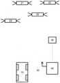
- the FIGUREshows an arrangement for carrying out the method according to an aspect of the invention.
- the FIGUREshows a vehicle 10 that is only shown here schematically.
- the vehicle 10is designed to carry out a method according to invention according to an exemplary embodiment.
- the FIGUREalso shows a server 30 that is likewise designed carry oar method according to an aspect of the invention.
- the vehicle 10is capable of determining its position at any time.
- itcan receive signals from a satellite navigation system, wherein four satellites are shown here by way of example, namely a first satellite 20 , a second satellite 21 , a third satellite 22 and a fourth satellite 23 , which are only shown here schematically and by way of example for a multitude of satellites of a typical satellite navigation system.
- the vehicle 10is configured to generate and store also raw data that is calculated from satellite signals.
- this raw datawill be stored if a calculated accuracy of the determination of the position from satellite navigation falls below a predetermined threshold value.
- the raw datawill be stored in the vehicle 10 until the vehicle comes into the range of a WLAN, which is shown here schematically in the form of a house 40 with a MAN antenna 42 .
- the house 40can be, for example, the house of the owner of the vehicle 10 .
- the vehicle 10When the vehicle 10 is parked next to the house 40 , the vehicle 10 establishes a connection to the worldwide Internet via the WLAN antenna 42 .
- the server 30is connected to the Internet so that the vehicle 10 can subsequently transmit the raw data to the server 30 .
- the server 30can then use this raw data to carry out an especially accurate determination of the position. In this way, the server 30 can update maps, which can then be used for navigation purposes by a multitude of vehicles.
- the data transmitted to the server 30 by the vehicle 10will typically be anonymized so that a personalized tracking of the exact travel route of the vehicle 10 will be impossible. Such an implementation is usually necessary in order to gain users' acceptance of the method according to an aspect of the invention.
- Mentioned steps of the method according to an aspect of the inventioncan be performed in the stated order. However, they can also be performed in a different order. In one of its embodiments, for example, with a particular composition of steps, the method according to an aspect of the invention can be carried out such that no further steps are performed. In principle, however, further steps, even unmentioned ones, can also be performed.
Landscapes
- Engineering & Computer Science (AREA)
- Remote Sensing (AREA)
- Radar, Positioning & Navigation (AREA)
- Physics & Mathematics (AREA)
- General Physics & Mathematics (AREA)
- Theoretical Computer Science (AREA)
- Databases & Information Systems (AREA)
- Computer Networks & Wireless Communication (AREA)
- Automation & Control Theory (AREA)
- General Engineering & Computer Science (AREA)
- Data Mining & Analysis (AREA)
- Navigation (AREA)
- Position Fixing By Use Of Radio Waves (AREA)
Abstract
Description
- receiving satellite navigation signals,
- determining raw data from the satellite navigation signals,
- determining position data from the raw data,
- making up data packets, wherein the data packets at least partially contain raw data, and
- transmitting the data packets to the server.
- pseudoranges,
- Doppler data,
- carrier phase counter,
- measurement signal status,
- signal-to-noise ratio,
- time stamp,
- ephemeris data,
- ionospheric data,
- UTC leap second,
- SBAS (Satellite Based Augmentation System) data.
- receiving a plurality of data packets which are each transmitted from a plurality of vehicles by means of an inventive method,
- calculating map data at least partially on the basis of the raw data and/or data of the dynamics of vehicle movement contained in the data packets, and
- updating the map depending on the map data, and preferably also depending on the position data contained in the data packets.
- determining a number of instructions, wherein the instructions indicate in what regions or under what other conditions raw data or position data is to be transmitted, and
- transmitting the instructions to a number of vehicles, each vehicle carrying out method according to an aspect of the invention for transmitting data.
Claims (13)
Applications Claiming Priority (3)
| Application Number | Priority Date | Filing Date | Title |
|---|---|---|---|
| DE102016214156.2ADE102016214156A1 (en) | 2016-08-01 | 2016-08-01 | A method of sending data from a vehicle to a server and method of updating a map |
| DE102016214156.2 | 2016-08-01 | ||
| PCT/DE2017/200073WO2018024298A1 (en) | 2016-08-01 | 2017-07-25 | Method for transmitting data from a vehicle to a server, and method for updating a map |
Publications (2)
| Publication Number | Publication Date |
|---|---|
| US20190163689A1 US20190163689A1 (en) | 2019-05-30 |
| US11256727B2true US11256727B2 (en) | 2022-02-22 |
Family
ID=60627369
Family Applications (1)
| Application Number | Title | Priority Date | Filing Date |
|---|---|---|---|
| US16/321,300Active2038-04-11US11256727B2 (en) | 2016-08-01 | 2017-07-25 | Method for transmitting data from a vehicle to a server, and method for updating a map |
Country Status (4)
| Country | Link |
|---|---|
| US (1) | US11256727B2 (en) |
| EP (1) | EP3491338B1 (en) |
| DE (2) | DE102016214156A1 (en) |
| WO (1) | WO2018024298A1 (en) |
Cited By (1)
| Publication number | Priority date | Publication date | Assignee | Title |
|---|---|---|---|---|
| US20220351555A1 (en)* | 2020-01-21 | 2022-11-03 | Denso Corporation | Center device and vehicle information communication system |
Families Citing this family (4)
| Publication number | Priority date | Publication date | Assignee | Title |
|---|---|---|---|---|
| JP6485710B2 (en) | 2016-06-14 | 2019-03-20 | パナソニックIpマネジメント株式会社 | Vehicle and wireless device |
| FR3085082B1 (en)* | 2018-08-17 | 2020-07-17 | Continental Automotive France | ESTIMATION OF THE GEOGRAPHICAL POSITION OF A ROAD VEHICLE FOR PARTICIPATORY PRODUCTION OF ROAD DATABASES |
| CN113133317B (en)* | 2019-11-14 | 2024-10-18 | 谷歌有限责任公司 | Priority provision and retrieval of offline map data |
| CN112902912A (en)* | 2021-01-13 | 2021-06-04 | 华东交通大学 | Railway monitoring and early warning system based on Beidou positioning technology |
Citations (34)
| Publication number | Priority date | Publication date | Assignee | Title |
|---|---|---|---|---|
| US20040230373A1 (en)* | 2003-05-12 | 2004-11-18 | Assimakis Tzamaloukas | Hierarchical floating car data network |
| US6823260B1 (en)* | 2001-03-07 | 2004-11-23 | Palm Source, Inc. | Method and apparatus for device and carrier independent location systems for mobile devices |
| US20070219708A1 (en)* | 2006-03-15 | 2007-09-20 | Microsoft Corporation | Location-based caching for mobile devices |
| US20090138188A1 (en) | 2005-07-22 | 2009-05-28 | Andrej Kores | Method, device and system for modeling a road network graph |
| US20090170537A1 (en)* | 2007-12-26 | 2009-07-02 | General Motors Corporation | Vehicle telematics unit data upload deferral |
| US20110131666A1 (en)* | 2008-07-25 | 2011-06-02 | Toyota Jidosha Kabushiki Kaisha | Vehicle data storage system, vehicle data storage apparatus, vehicle data storage server, and vehicle data storage method |
| US20120183023A1 (en)* | 2011-01-14 | 2012-07-19 | Qualcomm Incorporated | Implementations for wireless signal processing |
| US8471763B2 (en) | 2007-06-26 | 2013-06-25 | Nxp B.V. | Processing of satellite navigation system signals and related receive-signal verification |
| US8600661B2 (en) | 2003-11-21 | 2013-12-03 | Global Locate, Inc. | Multi-function appliance for a satellite navigation data distribution system |
| US20140057649A1 (en)* | 2012-08-21 | 2014-02-27 | Samsung Electronics Co. Ltd. | Method and apparatus for providing location information in mobile device |
| US20140221005A1 (en) | 2013-02-07 | 2014-08-07 | Qualcomm Incorporated | Terrestrial positioning system calibration |
| US20140275852A1 (en)* | 2012-06-22 | 2014-09-18 | Fitbit, Inc. | Wearable heart rate monitor |
| US20140273858A1 (en)* | 2012-06-22 | 2014-09-18 | Fitbit,Inc. | Adaptive data transfer using bluetooth |
| US20150127249A1 (en)* | 2012-05-16 | 2015-05-07 | Continental Teves AG & Co, oHGß | Method and system for creating a current situation depiction |
| US20150247928A1 (en)* | 2014-02-28 | 2015-09-03 | Texas Instruments Incorporated | Cooperative location sensor apparatus and system for low complexity geolocation |
| US20150334678A1 (en)* | 2014-05-16 | 2015-11-19 | Apple Inc. | Batch processing for improved georeferencing |
| US20150338221A1 (en)* | 2010-09-16 | 2015-11-26 | United Parcel Service Of America, Inc. | Systems and methods for identifying attributes located along segments of a driving route |
| US20160061614A1 (en)* | 2014-09-02 | 2016-03-03 | Hyundai Mobis Co., Ltd. | Apparatus and method for estimating a position of a vehicle |
| US20160139272A1 (en)* | 2014-11-13 | 2016-05-19 | General Motors Llc | Estimation of precise road grade using time-differenced satellite navigation system signals |
| US20160205653A1 (en)* | 2015-01-13 | 2016-07-14 | Samsung Electronics Co., Ltd. | Electronic device, wireless relay device, and method for providing location information of wireless relay device |
| US20160221818A1 (en)* | 2015-02-02 | 2016-08-04 | Thinxnet Gmbh | Increasing the Throughput of Filling Stations |
| US20160231750A1 (en)* | 2013-10-25 | 2016-08-11 | Hitachi Construction Machinery Co., Ltd. | Operation management system for dump trucks |
| US20160300404A1 (en)* | 2015-04-10 | 2016-10-13 | J. J. Keller & Associates, Inc. | Methods and systems for selectively transmitting vehicle data from an on-board recorder to an external device |
| US20160364919A1 (en)* | 2015-06-10 | 2016-12-15 | International Business Machines Corporation | Accuracy and efficiency of road user charging |
| US20170052260A1 (en)* | 2015-08-19 | 2017-02-23 | Qualcomm Technologies International, Ltd. | Antenna pattern data mining for automotive gnss receivers |
| US20170059715A1 (en)* | 2015-08-31 | 2017-03-02 | Qualcomm Incorporated | Sensor-based gnss view zone selection |
| US20170061790A1 (en)* | 2011-10-20 | 2017-03-02 | At&T Intellectual Property I, L.P | Vehicular communications using a scalable ad hoc geographic routing protocol |
| US20170064727A1 (en)* | 2015-08-24 | 2017-03-02 | Qualcomm Incorporated | Multi-carrier throughput enhancement by opportunistic packet scheduling with sps concurrency |
| US20170070971A1 (en)* | 2015-09-04 | 2017-03-09 | Qualcomm Incorporated | Methods and systems for collaborative global navigation satellite system (gnss) diagnostics |
| US20170219360A1 (en)* | 2016-01-28 | 2017-08-03 | Uber Technologies, Inc. | Simplifying gps data for map building and distance calculation |
| US20170330392A1 (en)* | 2016-05-16 | 2017-11-16 | Wi-Tronix, Llc | Real-Time Data Acquisition and Recording System |
| US20170357009A1 (en)* | 2016-06-08 | 2017-12-14 | The Boeing Company | On-board backup and anti-spoofing gps system |
| US20180357839A1 (en)* | 2015-06-30 | 2018-12-13 | Robert Bosch Gmbh | Method and device for uploading data of a motor vehicle |
| US10861255B1 (en)* | 2011-03-01 | 2020-12-08 | Geotab Inc. | System and method for analyzing and presenting location and location-related data |
Family Cites Families (1)
| Publication number | Priority date | Publication date | Assignee | Title |
|---|---|---|---|---|
| US9091554B2 (en)* | 2007-09-13 | 2015-07-28 | Continental Teves Ag & Co. Ohg | Safety-critical updating of maps via a data channel of a satellite navigation system |
- 2016
- 2016-08-01DEDE102016214156.2Apatent/DE102016214156A1/ennot_activeWithdrawn
- 2017
- 2017-07-25EPEP17811191.0Apatent/EP3491338B1/enactiveActive
- 2017-07-25USUS16/321,300patent/US11256727B2/enactiveActive
- 2017-07-25DEDE112017003166.4Tpatent/DE112017003166A5/ennot_activeWithdrawn
- 2017-07-25WOPCT/DE2017/200073patent/WO2018024298A1/ennot_activeCeased
Patent Citations (35)
| Publication number | Priority date | Publication date | Assignee | Title |
|---|---|---|---|---|
| US6823260B1 (en)* | 2001-03-07 | 2004-11-23 | Palm Source, Inc. | Method and apparatus for device and carrier independent location systems for mobile devices |
| US20040230373A1 (en)* | 2003-05-12 | 2004-11-18 | Assimakis Tzamaloukas | Hierarchical floating car data network |
| US8600661B2 (en) | 2003-11-21 | 2013-12-03 | Global Locate, Inc. | Multi-function appliance for a satellite navigation data distribution system |
| US20090138188A1 (en) | 2005-07-22 | 2009-05-28 | Andrej Kores | Method, device and system for modeling a road network graph |
| US20070219708A1 (en)* | 2006-03-15 | 2007-09-20 | Microsoft Corporation | Location-based caching for mobile devices |
| US8471763B2 (en) | 2007-06-26 | 2013-06-25 | Nxp B.V. | Processing of satellite navigation system signals and related receive-signal verification |
| US20090170537A1 (en)* | 2007-12-26 | 2009-07-02 | General Motors Corporation | Vehicle telematics unit data upload deferral |
| US20110131666A1 (en)* | 2008-07-25 | 2011-06-02 | Toyota Jidosha Kabushiki Kaisha | Vehicle data storage system, vehicle data storage apparatus, vehicle data storage server, and vehicle data storage method |
| US20150338221A1 (en)* | 2010-09-16 | 2015-11-26 | United Parcel Service Of America, Inc. | Systems and methods for identifying attributes located along segments of a driving route |
| US20120183023A1 (en)* | 2011-01-14 | 2012-07-19 | Qualcomm Incorporated | Implementations for wireless signal processing |
| US10861255B1 (en)* | 2011-03-01 | 2020-12-08 | Geotab Inc. | System and method for analyzing and presenting location and location-related data |
| US20170061790A1 (en)* | 2011-10-20 | 2017-03-02 | At&T Intellectual Property I, L.P | Vehicular communications using a scalable ad hoc geographic routing protocol |
| US20150127249A1 (en)* | 2012-05-16 | 2015-05-07 | Continental Teves AG & Co, oHGß | Method and system for creating a current situation depiction |
| US20140275852A1 (en)* | 2012-06-22 | 2014-09-18 | Fitbit, Inc. | Wearable heart rate monitor |
| US20140273858A1 (en)* | 2012-06-22 | 2014-09-18 | Fitbit,Inc. | Adaptive data transfer using bluetooth |
| US20140057649A1 (en)* | 2012-08-21 | 2014-02-27 | Samsung Electronics Co. Ltd. | Method and apparatus for providing location information in mobile device |
| US20140221005A1 (en) | 2013-02-07 | 2014-08-07 | Qualcomm Incorporated | Terrestrial positioning system calibration |
| US20160231750A1 (en)* | 2013-10-25 | 2016-08-11 | Hitachi Construction Machinery Co., Ltd. | Operation management system for dump trucks |
| US20150247928A1 (en)* | 2014-02-28 | 2015-09-03 | Texas Instruments Incorporated | Cooperative location sensor apparatus and system for low complexity geolocation |
| US20150334678A1 (en)* | 2014-05-16 | 2015-11-19 | Apple Inc. | Batch processing for improved georeferencing |
| US20160061614A1 (en)* | 2014-09-02 | 2016-03-03 | Hyundai Mobis Co., Ltd. | Apparatus and method for estimating a position of a vehicle |
| US20160139272A1 (en)* | 2014-11-13 | 2016-05-19 | General Motors Llc | Estimation of precise road grade using time-differenced satellite navigation system signals |
| US20160205653A1 (en)* | 2015-01-13 | 2016-07-14 | Samsung Electronics Co., Ltd. | Electronic device, wireless relay device, and method for providing location information of wireless relay device |
| US20160221818A1 (en)* | 2015-02-02 | 2016-08-04 | Thinxnet Gmbh | Increasing the Throughput of Filling Stations |
| US20160300404A1 (en)* | 2015-04-10 | 2016-10-13 | J. J. Keller & Associates, Inc. | Methods and systems for selectively transmitting vehicle data from an on-board recorder to an external device |
| US20160364919A1 (en)* | 2015-06-10 | 2016-12-15 | International Business Machines Corporation | Accuracy and efficiency of road user charging |
| US20180357839A1 (en)* | 2015-06-30 | 2018-12-13 | Robert Bosch Gmbh | Method and device for uploading data of a motor vehicle |
| US20170052260A1 (en)* | 2015-08-19 | 2017-02-23 | Qualcomm Technologies International, Ltd. | Antenna pattern data mining for automotive gnss receivers |
| US20170064727A1 (en)* | 2015-08-24 | 2017-03-02 | Qualcomm Incorporated | Multi-carrier throughput enhancement by opportunistic packet scheduling with sps concurrency |
| US20170059715A1 (en)* | 2015-08-31 | 2017-03-02 | Qualcomm Incorporated | Sensor-based gnss view zone selection |
| US20170070971A1 (en)* | 2015-09-04 | 2017-03-09 | Qualcomm Incorporated | Methods and systems for collaborative global navigation satellite system (gnss) diagnostics |
| US20170219360A1 (en)* | 2016-01-28 | 2017-08-03 | Uber Technologies, Inc. | Simplifying gps data for map building and distance calculation |
| US20180238691A1 (en)* | 2016-01-28 | 2018-08-23 | Uber Technologies, Inc. | Simplifying gps data for map building and distance calculation |
| US20170330392A1 (en)* | 2016-05-16 | 2017-11-16 | Wi-Tronix, Llc | Real-Time Data Acquisition and Recording System |
| US20170357009A1 (en)* | 2016-06-08 | 2017-12-14 | The Boeing Company | On-board backup and anti-spoofing gps system |
Non-Patent Citations (2)
| Title |
|---|
| European Communication Pursuant to Article 94(3) EPC for European Application No. 17 811 191.0, dated Feb. 17, 2021, 5 pages. |
| International Search Report and Written Opinion for International Application No. PCT/DE2017/200073, dated Jan. 22, 2018—8 pages. |
Cited By (2)
| Publication number | Priority date | Publication date | Assignee | Title |
|---|---|---|---|---|
| US20220351555A1 (en)* | 2020-01-21 | 2022-11-03 | Denso Corporation | Center device and vehicle information communication system |
| US12175817B2 (en)* | 2020-01-21 | 2024-12-24 | Denso Corporation | Center device and vehicle information communication system |
Also Published As
| Publication number | Publication date |
|---|---|
| DE102016214156A1 (en) | 2018-02-01 |
| EP3491338B1 (en) | 2022-04-13 |
| EP3491338A1 (en) | 2019-06-05 |
| DE112017003166A5 (en) | 2019-03-07 |
| US20190163689A1 (en) | 2019-05-30 |
| WO2018024298A1 (en) | 2018-02-08 |
Similar Documents
| Publication | Publication Date | Title |
|---|---|---|
| US12038515B2 (en) | GNSS spoofing detection and recovery | |
| US11256727B2 (en) | Method for transmitting data from a vehicle to a server, and method for updating a map | |
| US11709274B2 (en) | Determining correct location in the presence of GNSS spoofing | |
| US11366194B2 (en) | Method for providing and improving a positional probability distribution for GNSS received data | |
| CN102933937B (en) | Mobile station and method of using inertial sensor data to improve mobile station positioning | |
| US20150198695A1 (en) | Wireless Device for Indoor Positioning | |
| US20210165111A1 (en) | Method for determining the position of a vehicle | |
| US20220283314A1 (en) | Real-time kinematic (rtk) and differential global navigation satellite system (dgnss) corrections using multiple reference stations | |
| CN108885269B (en) | Navigation method, navigation device and navigation system | |
| US10849093B2 (en) | Positioning system and method | |
| US11143763B2 (en) | Method and device for transmitting correction data and for determining a highly accurate position of a mobile unit | |
| JP2021009109A (en) | Positioning method, positioning system, control device, and mobile station | |
| CN107430198B (en) | Car self-organizing real-time dynamic roaming network | |
| CN112904390B (en) | Positioning method, positioning device, computer equipment and storage medium | |
| US20230127310A1 (en) | Method and apparatus for detecting multipath signals from a navigation satellite | |
| US20210109231A1 (en) | Detection of gnss data manipulation based on correctional gnss data | |
| US8638258B2 (en) | Method and system for a virtual wide area GNSS reference network | |
| CN106291647B (en) | Navigation locating method and device | |
| KR100953471B1 (en) | Map information system having a navigation device for providing indoor map information and a driving method thereof | |
| CN110869864A (en) | Method for locating a vehicle with a high degree of automation, and corresponding driver assistance system and computer program | |
| WO2020008791A1 (en) | Positioning system, positioning device and center device | |
| CN113179480A (en) | Method and device for locating a vehicle | |
| US20210356554A1 (en) | Position specifying system for mobile object and mobile object used for the position specifying system | |
| WO2022036614A1 (en) | Dgnss/rtk base station position bias detection and calculation | |
| JP2014149573A (en) | Inter-vehicle distance computation device |
Legal Events
| Date | Code | Title | Description |
|---|---|---|---|
| FEPP | Fee payment procedure | Free format text:ENTITY STATUS SET TO UNDISCOUNTED (ORIGINAL EVENT CODE: BIG.); ENTITY STATUS OF PATENT OWNER: LARGE ENTITY | |
| AS | Assignment | Owner name:CONTINENTAL TEVES AG & CO. OHG, GERMANY Free format text:ASSIGNMENT OF ASSIGNORS INTEREST;ASSIGNOR:STAEHLIN, ULRICH;REEL/FRAME:048657/0557 Effective date:20190123 | |
| STPP | Information on status: patent application and granting procedure in general | Free format text:DOCKETED NEW CASE - READY FOR EXAMINATION | |
| STPP | Information on status: patent application and granting procedure in general | Free format text:NON FINAL ACTION MAILED | |
| STPP | Information on status: patent application and granting procedure in general | Free format text:FINAL REJECTION MAILED | |
| STPP | Information on status: patent application and granting procedure in general | Free format text:RESPONSE AFTER FINAL ACTION FORWARDED TO EXAMINER | |
| STPP | Information on status: patent application and granting procedure in general | Free format text:DOCKETED NEW CASE - READY FOR EXAMINATION | |
| STPP | Information on status: patent application and granting procedure in general | Free format text:NON FINAL ACTION MAILED | |
| STPP | Information on status: patent application and granting procedure in general | Free format text:RESPONSE TO NON-FINAL OFFICE ACTION ENTERED AND FORWARDED TO EXAMINER | |
| STPP | Information on status: patent application and granting procedure in general | Free format text:NOTICE OF ALLOWANCE MAILED -- APPLICATION RECEIVED IN OFFICE OF PUBLICATIONS | |
| STCF | Information on status: patent grant | Free format text:PATENTED CASE | |
| AS | Assignment | Owner name:CONTINENTAL AUTOMOTIVE TECHNOLOGIES GMBH, GERMANY Free format text:MERGER AND CHANGE OF NAME;ASSIGNORS:CONTINENTAL TEVES AG & CO. OHG;CONTINENTAL AUTOMOTIVE TECHNOLOGIES GMBH;REEL/FRAME:068794/0001 Effective date:20220714 | |
| MAFP | Maintenance fee payment | Free format text:PAYMENT OF MAINTENANCE FEE, 4TH YEAR, LARGE ENTITY (ORIGINAL EVENT CODE: M1551); ENTITY STATUS OF PATENT OWNER: LARGE ENTITY Year of fee payment:4 |