US11181382B2 - Generating maps of private spaces using mobile computing device sensors - Google Patents
Generating maps of private spaces using mobile computing device sensorsDownload PDFInfo
- Publication number
- US11181382B2 US11181382B2US15/791,039US201715791039AUS11181382B2US 11181382 B2US11181382 B2US 11181382B2US 201715791039 AUS201715791039 AUS 201715791039AUS 11181382 B2US11181382 B2US 11181382B2
- Authority
- US
- United States
- Prior art keywords
- sensor data
- location
- private space
- mobile computing
- computing device
- Prior art date
- Legal status (The legal status is an assumption and is not a legal conclusion. Google has not performed a legal analysis and makes no representation as to the accuracy of the status listed.)
- Active, expires
Links
Images


Classifications
- G—PHYSICS
- G06—COMPUTING OR CALCULATING; COUNTING
- G06F—ELECTRIC DIGITAL DATA PROCESSING
- G06F17/00—Digital computing or data processing equipment or methods, specially adapted for specific functions
- G06F17/40—Data acquisition and logging
- G—PHYSICS
- G01—MEASURING; TESTING
- G01C—MEASURING DISTANCES, LEVELS OR BEARINGS; SURVEYING; NAVIGATION; GYROSCOPIC INSTRUMENTS; PHOTOGRAMMETRY OR VIDEOGRAMMETRY
- G01C21/00—Navigation; Navigational instruments not provided for in groups G01C1/00 - G01C19/00
- G01C21/20—Instruments for performing navigational calculations
- G01C21/206—Instruments for performing navigational calculations specially adapted for indoor navigation
- G—PHYSICS
- G01—MEASURING; TESTING
- G01C—MEASURING DISTANCES, LEVELS OR BEARINGS; SURVEYING; NAVIGATION; GYROSCOPIC INSTRUMENTS; PHOTOGRAMMETRY OR VIDEOGRAMMETRY
- G01C21/00—Navigation; Navigational instruments not provided for in groups G01C1/00 - G01C19/00
- G01C21/26—Navigation; Navigational instruments not provided for in groups G01C1/00 - G01C19/00 specially adapted for navigation in a road network
- G01C21/28—Navigation; Navigational instruments not provided for in groups G01C1/00 - G01C19/00 specially adapted for navigation in a road network with correlation of data from several navigational instruments
- G01C21/30—Map- or contour-matching
- G01C21/32—Structuring or formatting of map data
- G—PHYSICS
- G01—MEASURING; TESTING
- G01C—MEASURING DISTANCES, LEVELS OR BEARINGS; SURVEYING; NAVIGATION; GYROSCOPIC INSTRUMENTS; PHOTOGRAMMETRY OR VIDEOGRAMMETRY
- G01C21/00—Navigation; Navigational instruments not provided for in groups G01C1/00 - G01C19/00
- G01C21/38—Electronic maps specially adapted for navigation; Updating thereof
- G01C21/3804—Creation or updating of map data
- G01C21/3833—Creation or updating of map data characterised by the source of data
- G01C21/3841—Data obtained from two or more sources, e.g. probe vehicles
- G—PHYSICS
- G09—EDUCATION; CRYPTOGRAPHY; DISPLAY; ADVERTISING; SEALS
- G09B—EDUCATIONAL OR DEMONSTRATION APPLIANCES; APPLIANCES FOR TEACHING, OR COMMUNICATING WITH, THE BLIND, DEAF OR MUTE; MODELS; PLANETARIA; GLOBES; MAPS; DIAGRAMS
- G09B29/00—Maps; Plans; Charts; Diagrams, e.g. route diagram
- G09B29/10—Map spot or coordinate position indicators; Map reading aids
- G09B29/106—Map spot or coordinate position indicators; Map reading aids using electronic means
- G—PHYSICS
- G06—COMPUTING OR CALCULATING; COUNTING
- G06F—ELECTRIC DIGITAL DATA PROCESSING
- G06F16/00—Information retrieval; Database structures therefor; File system structures therefor
- G06F16/90—Details of database functions independent of the retrieved data types
- G06F16/903—Querying
- G06F16/9032—Query formulation
- G06F16/90324—Query formulation using system suggestions
- G06F16/90328—Query formulation using system suggestions using search space presentation or visualization, e.g. category or range presentation and selection
Definitions
- Computer usersmay utilize a number of public online services to map public spaces.
- online current mapping servicesrely on the tedious gathering of data at multiple locations by a centralized service.
- adapting to changes in public spaces requiring the updating of current mapsis often difficult without coordination between a third party and the centralized service to perform tasks such as physically roaming the public spaces with sensors, making note of any changes, and communicating the changes to the centralized service so that the current maps may be rehabilitated. It is with respect to these considerations and others that the various embodiments of the present invention have been made.
- Embodimentsare provided for generating maps of private spaces using mobile computing device sensors.
- Sensor datamay be received from one or more mobile computing devices to determine a digital signature describing a private space.
- Scheduling datamay also be received from the one or more mobile devices.
- the scheduling datamay describe a location associated with the private space to be mapped.
- a digital map of the private spacemay then be generated from the digital signature and the location associated with the private space in the scheduling data.
- FIG. 1is a block diagram illustrating a network architecture for generating maps of private spaces using mobile computing device sensors, in accordance with various embodiments
- FIG. 2is a block diagram illustrating the components of a digital map generated for a private space using mobile computing device sensors, in accordance with various embodiments;
- FIG. 3is a block diagram illustrating server computing environment which may be utilized for generating maps of private spaces using mobile computing device sensors, in accordance with various embodiments;
- FIG. 4is a flow diagram illustrating a routine for gathering sensor data for use in generating maps of private spaces, in accordance with various embodiments.
- FIG. 5is a flow diagram illustrating a routine for the processing of sensor data and the generation of maps of private spaces, in accordance with various embodiments.
- Embodimentsare provided for generating maps of private spaces using mobile computing device sensors.
- Sensor datamay be received from one or more mobile computing devices to determine a digital signature describing a private space.
- Scheduling datamay also be received from the one or more mobile devices.
- the scheduling datamay describe a location associated with the private space to be mapped.
- a digital map of the private spacemay then be generated from the digital signature and the location associated with the private space in the scheduling data.
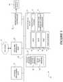
- FIG. 1is a block diagram illustrating a network architecture for generating maps of private spaces using mobile computing device sensors, in accordance with various embodiments.
- the network architectureincludes mobile computing devices 2 A- 2 C which may be in communication with client computing devices 6 A- 6 B and server 70 over a network 4 .
- the network 4may comprise a local network or a wide area network (e.g., the Internet).
- the mobile computing devices 2 A- 2 Cmay include sensors 40 A- 40 C and scheduling data 42 A- 42 C, respectively.
- the mobile computing device 2may comprise a mobile telephone, “smartphone,” tablet or laptop computer which is capable of executing one or more application programs.
- a “smartphone”may comprise a mobile phone having computer functionality and/or which is capable of running operating system software to provide a standardized interface and platform for application developers.
- the sensors 40 A- 40 C(which may be in or connected to) the mobile computing devices 2 A- 2 C may be capable of measuring/detecting a number of types of data associated with the mobile computing devices 2 A- 2 C including, but not limited to, altitude, location, signal strength, orientation and force.
- the sensors 40 A- 40 Cmay also comprise the ability to detect the presence of a wireless network (e.g., a “Wi-Fi” network), Wi-Fi access point or other mobile computing devices (e.g., via BLUETOOTH wireless technology) without actually making a network or a device connection).
- a wireless networke.g., a “Wi-Fi” network
- Wi-Fi access pointe.g., via BLUETOOTH wireless technology
- the sensors 40 A- 40 Cmay include an altimeter, a GPS, a wireless network interface device (for signal strength detection and for detecting and connecting to other wireless networks/devices), a gyroscope, and a force sensor.
- the sensors 40 A- 40 Cmay be utilized to create a “digital signature” for mapping a private space (e.g., a conference room in an office building) in accordance with various embodiments.
- the sensors 40 A- 40 Cmay not necessarily be physically connected to the mobile computing devices 2 A- 2 C but may connected wirelessly for the exchange of data.
- the sensors 40 A- 40 Cmay comprise self-powering (e.g., photovoltaic) sensors that may be attached to a wall and broadcast measurement data (e.g., location information) utilizing any of a number of low power wireless communication technologies known to those skilled in the art.
- the sensors 40 A- 40 Cmay utilize BLUETOOTH wireless technology the suite of low power communication protocols based on the ZIGBEE specification.
- the scheduling data 42 A- 42 Cmay comprise location based information found in the respective schedules of users associated with the mobile computing devices 2 A- 2 C.
- the scheduling data 42 A- 42 Cmay comprise location data compiled by a scheduling service on the server 70 .
- the scheduling data 42 A- 42 Cmay identify a 3 PM meeting in conference room “J” of an office building, for users of the mobile computing devices 2 A- 2 C.
- the location data in the scheduling data 42 A- 42 Cmay be communicated in a payload over a communication channel from the mobile computing devices 2 A- 2 C to the server 70 .
- the communication channelmay comprise the EXCHANGE ACTIVESYNC protocol developed by MICROSOFT CORPORATION of Redmond, Wash.
- the location data in the scheduling data 42 A- 42 Cmay be utilized, in combination with data measured by the sensors 40 A- 40 C, to generate maps of private spaces.
- the generation of maps, as defined hereinincludes enhancing publically available maps with private spaces information.
- the publically available mapsmay be provided by an online web service, such as the BING MAPS web mapping service from MICROSOFT CORPORATION of Redmond, Wash.
- private spacesmay include, but are not limited to, various locations, including individual offices and meeting rooms (e.g., conference rooms and auditoriums) in a building or buildings within the grounds of a business enterprise to which the general public (i.e., public mapping companies) lack physical access and/or access to the names of the various locations contained therein.
- the client computing devices 6 A- 6 Bmay include sensors 40 D- 40 E and scheduling data 42 D- 42 E, respectively, which may be similar to the sensors 40 A- 40 C and the scheduling data 42 A- 42 C in the mobile computing devices 2 A- 2 C (discussed above).
- the client computing devices 2may comprise a desktop or workstation computer which is capable of executing one or more application programs.
- the client computing devices 6 A- 6 Bmay also be utilized as sensor inputs in conjunction with, and in the same manner as, the mobile computing devices 2 A- 2 C, with respect to mapping private spaces.
- the server 70may comprise a mapping and scheduling service application 72 and a map database 74 .
- the server 70may provide both a private mapping service and a private scheduling service for scheduling and mapping private locations associated with users of the mobile computing devices 2 A- 2 C and the client computing devices 6 A- 6 B.
- the private mapping service and the private scheduling servicemay comprise a single combined service or, alternatively, two separate services.
- the server 70may represent services hosted on multiple servers or other complex computer systems.
- the mapping and scheduling service application 72may be configured to generate maps of private spaces using sensor data collected from the mobile sensors 40 A- 40 C (and optionally the sensors 40 D- 40 E) as well as the scheduling data 42 A- 42 C (and optionally the scheduling data 42 D- 42 E).
- the mapping and scheduling service application 72may be configured to gather sensor and location data from the mobile computing devices 2 A- 2 C (and optionally the computing devices 6 A- 6 B) and run a statistical analysis to assign location names (and the electronic definition thereof) with a higher than average degree of certainty.
- mapping and scheduling service application 72may be configured to leverage large numbers of connected mobile devices to “crowd source” the naming of private spaces by using statistics (i.e., density of information at a given time and over a period of time) to determine the actual naming of private spaces.
- the mapping and scheduling service application 72may comprise a collaborative server application such as the EXCHANGE SERVER collaborative application from MICROSOFT CORPORATION of Redmond, Wash. It should be appreciated that other collaborative server applications from other manufacturers may be utilized in accordance with the various embodiments described herein.
- the map database 74may store maps 76 , 78 and 80 .
- the maps 76 , 78 and 80may represent digital maps of private spaces generated by the mapping and scheduling service application 72 using received sensor data collected from the mobile sensors 40 A- 40 C (and optionally the sensors 40 D- 40 E) and location data received from the scheduling data 42 A- 42 C (and optionally the scheduling data 42 D- 42 E). It should be understood that the maps 76 , 78 and 80 may comprise publically available maps (such as those provided by an online mapping service) which are “tagged” or enhanced with private space sensor data and location data determined by the mapping and scheduling service application 72 .
- the “generation” of digital maps of private spacesmay include enhancing or tagging publically available maps with private space information (i.e., the gathered sensor and location data from the mobile computing devices 2 A- 2 C (and optionally the computing devices 6 A- 6 B)). It should further be understood that the enhanced or tagged public maps may not be re-shared with the online mapping service from which they were retrieved or otherwise made public, thereby insuring their privacy.
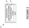
- FIG. 2is a block diagram illustrating the components of a digital map 76 , generated by the mapping and scheduling service application 72 , for a private space using mobile computing device sensors, in accordance with various embodiments.
- the map 76includes sensor data 82 which may represent a digital signature of a private space.
- the sensor data 82may include data collected from the sensors 40 A- 40 C in the mobile computing devices 2 A- 2 C associated with the name of a single location identified as location data 84 which in turn may be collected from the scheduling data 42 A- 42 C.
- the location data 84may include a name for a mapped private space and may be obtained from information contained in the scheduling data 42 A- 42 C (e.g., the name of a conference room for a scheduled meeting) or from nicknames or other colloquialisms for a private space which may be utilized by users of the mobile computing devices 2 A- 2 C.
- FIG. 3the following discussion is intended to provide a brief, general description of a suitable computing environment in which various illustrative embodiments may be implemented. While various embodiments will be described in the general context of program modules that execute in conjunction with program modules that run on an operating system on a computing device, those skilled in the art will recognize that the various embodiments may also be implemented in combination with other types of computer systems and program modules.
- program modulesinclude routines, programs, components, data structures, and other types of structures that perform particular tasks or implement particular abstract data types.
- program modulesmay be located in both local and remote memory storage devices.
- FIG. 3shows the server 70 which may include a computer capable of executing one or more application programs.
- the server 70includes at least one central processing unit 8 (“CPU”), a system memory 12 , including a random access memory 18 (“RAM”) and a read-only memory (“ROM”) 20 , and a system bus 10 that couples the memory to the CPU 8 .
- CPUcentral processing unit
- RAMrandom access memory
- ROMread-only memory
- the server 70may further include a mass storage device 14 for storing an operating system 32 , the mapping and scheduling service application 72 and the map database 74 (including the maps 76 , 78 and 80 ).
- the operating system 32may be suitable for controlling the operation of a networked computer, such as the WINDOWS operating systems from MICROSOFT CORPORATION of Redmond, Wash.
- the mass storage device 14is connected to the CPU 8 through a mass storage controller (not shown) connected to the bus 10 .
- the mass storage device 14 and its associated computer-readable mediaprovide non-volatile storage for the server 70 .
- the term computer-readable media as used hereinmay include computer storage media.
- Computer storage mediamay include volatile and nonvolatile, removable and non-removable media implemented in any method or technology for storage of information, such as computer readable instructions, data structures, program modules, or other data.
- Computer storage mediamay include, but is not limited to, RAM, ROM, electrically erasable read-only memory (EEPROM), flash memory or other memory technology, CD-ROM, digital versatile disks (DVD) or other optical storage, magnetic cassettes, magnetic tape, magnetic disk storage or other magnetic storage devices, or any other medium which can be used to store information and which can be accessed by the server 70 . Any such computer storage media may be part of the server 70 .
- Computer-readable mediamay also include communication media.
- Communication mediamay be embodied by computer readable instructions, data structures, program modules, or other data in a modulated data signal, such as a carrier wave or other transport mechanism, and includes any information delivery media.
- modulated data signalmay describe a signal that has one or more characteristics set or changed in such a manner as to encode information in the signal.
- communication mediamay include wired media such as a wired network or direct-wired connection, and wireless media such as acoustic, radio frequency (RF), infrared, and other wireless media.
- RFradio frequency
- the server 70may operate in a networked environment using logical connections to remote computers through the network 4 .
- the server 70may connect to the network 4 through a network interface unit 16 connected to the bus 10 .
- the network interface unit 16may also be utilized to connect to other types of networks and remote computing systems.
- the availability server 70may also include an input/output controller 22 for receiving and processing input from a number of input types, including a keyboard, mouse, pen, stylus, finger, and/or other means (not shown).
- the input/output controller 22may provide output to a display device 85 as well as a printer, or other type of output device (not shown).
- the mobile computing devices 2 A- 2 C and the client computing devices 6 A- 6 B, shown in FIG. 1may include many of the conventional components shown and discussed above with respect to the availability server 70 .
- the mobile computing devices 2 A- 2 Cmay also include additional conventional components (not shown) such as a wireless radio, a power supply (e.g., a removable or non-removable battery), an array of various sensors and a real-time clock.
- FIG. 4is a flow diagram illustrating a routine 400 for gathering sensor data for use in generating maps of private spaces, in accordance with various embodiments.
- routinesfor gathering sensor data for use in generating maps of private spaces.
- FIG. 4is a flow diagram illustrating a routine 400 for gathering sensor data for use in generating maps of private spaces, in accordance with various embodiments.
- the logical operations of various embodiments of the present inventionare implemented ( 1 ) as a sequence of computer implemented acts or program modules running on a computing system and/or ( 2 ) as interconnected machine logical circuits or circuit modules within the computing system.
- the implementationis a matter of choice dependent on the performance requirements of the computing system implementing the invention. Accordingly, the logical operations illustrated in FIGS. 4-5 and making up the various embodiments described herein are referred to variously as operations, structural devices, acts or modules.
- the routine 400begins at operation 405 , where the mapping and scheduling application 72 (hereinafter referred to as the “application 72 ”), executing on the server 70 , receives mobile device sensor data to determine a digital signature.
- the application 72may receive sensor data measured by the sensors in one or more of the mobile computing devices 2 A- 2 C to determine a digital signature describing a private space.
- the sensor data(as well as location data) may always be sent from the mobile computing devices 2 A- 2 C to the server 70 as sensor data is being detected by the sensors 40 A- 40 C.
- the sensor data(as well as location data) may be sent only after the application 72 prompting the users of the mobile computing devices 2 A- 2 C.
- the sensor datamay be sent at appropriate intervals as determined by the application 72 .
- the application 72may also require a one-time user consent for the sending of the sensor data (as well as location data) from the mobile computing devices 2 A- 2 C to the server 70 for all future interactions, prompt users before every request to send the sensor data (as well as the location data), or require users to trigger the sending of the sensor data (as well as the location data) to the server 70 .
- privacy and legal considerations in different geographical locationsmay be relied upon for determining the collection of the sensor data (as well as the location data) by the application 72 .
- the collection of the sensor and location data, by the application 72may be temporally restricted to a company's business hours and further geographically restricted to be confined within a company's grounds.
- the routine 400continues to operation 410 , where the application 72 determines if the received sensor data is correlated with a known user. In particular, the application 72 may determine if the received sensor data corresponds to a user of one of the mobile computing devices 2 A, 2 B or 2 C whose presence in the network is recognized by the server 70 . If, at operation 410 , the application 72 determines that the received sensor data can be correlated with a known user, then the routine 400 continues to operation 415 . If however, at operation 410 , the application 72 determines that the received sensor data cannot be correlated with a known user, then the routine 400 branches to operation 430 .
- the application 72determines whether the received sensor data can be correlated with user data. For example, the application 72 may compare received sensor data from the mobile computing device 2 A to the sensor data previously received from users of the mobile computing devices 2 B and 2 C to determine if all three devices have the same digital signature. A digital signature may be based on Wi-Fi access point signal strength, altimeter data, GPS data, mobile operator signal strength, etc., as determined by the sensors 40 A- 40 C. If, at operation 415 , the application 72 determines that the received sensor data can be correlated with user data, then the routine 400 continues to operation 420 . If however, at operation 415 , the application 72 determines that the received sensor data cannot be correlated with user data, then the routine 400 branches to operation 430 .
- the application 72receives location data from scheduling data associated with mobile computing device from which the sensor data was received. For example, the application 72 may receive the scheduling data 42 A from the mobile computing device 2 A whose digital signature was previously determined based on the sensor data 40 A.
- the routine 400continues to operation 425 where the application 72 processes the sensor and scheduling data to generate a digital map.
- the application 72may build a digital map of the private space (e.g., a conference room) described by the digital signature determined from the sensor data and named as a location in the scheduling data.
- digital mapsmay be stored in a map database, such as the map database 74 . From operation 425 , the routine 400 then ends.
- the application 72determines whether the received sensor data is relevant. For example, if the sensor data was received from a user at 3:10 PM and it can be further determined, by the application 72 , from scheduling data associated with the same user that the user has a meeting in conference room “J” from 3 PM to 4 PM, then the application 72 may determine that the sensor data is relevant with respect to the location of conference room J. If, at operation 430 , the application 72 determines that the received sensor data is relevant, then the routine 400 returns to operation 425 . If however, at operation 430 , the application 72 determines that the received sensor data is not relevant, then the routine 400 continues to operation 435 where the received sensor data is discarded. From operation 435 , the routine 400 then ends.
- FIG. 5is a flow diagram illustrating a routine 500 for the processing of sensor data and the generation of maps of private spaces, in accordance with various embodiments.
- the routine 500begins at operation 505 , where the application 72 , executing on the server 70 , determines if sensor data received from one or more of the mobile computing devices 2 A- 2 C is completely new data.
- the application 72may be configured to determine if the received sensor data (i.e., the digital signature) matches a digital signature for a map stored in the map database 74 . If, at operation 505 , the application 72 determines that the received sensor data is completely new data, then the routine 500 continues to operation 510 . If however, at operation 505 , the application 72 determines that the received sensor data is not completely new data, then the routine 500 branches to operation 515 .
- the application 72upon determining that the received sensor data is completely new data, creates and stores an entry for the new sensor data in the map database 74 .
- the application 72may determine from scheduling data associated with the mobile computing device from which the new sensor data was received, the name of a location to associate with the new sensor data.
- the application 72may create a new entry for the aforementioned location (i.e., “Stevens auditorium”) and store the received sensor data describing this location in building “K” with the location name “Stevens auditorium.” From operation 510 , the routine 500 then ends.
- the application 72upon determining that the received sensor data is not completely new data, may determine whether the received sensor data can be correlated with a current location at least partially associated with the received sensor data.
- the received sensor datamay include augmented GPS sensor data measured by a mobile computing device which has an augmented GPS sensor for measuring the relative forces acting on the device to determine elevation change and travel within a building.
- the received sensor datamay also include data identical to sensor data measured by other mobile computing devices which are currently located in the same location as the mobile computing device which has the augmented sensor. If, at operation 515 , the application 72 determines that the received sensor data can be correlated with a current location, then the routine 500 continues to operation 520 . If however, at operation 515 , the application 72 determines that the received sensor data cannot be correlated with a current location, then the routine 500 branches to operation 525 .
- the application 72upon determining that the received sensor data can be correlated with a current location, augments the data for the current location.
- the application 72may augment the current location and a stored sensor data set for the location with the augmented sensor data (e.g., the augmented GPS sensor data) discussed above with respect to operation 515 .
- the augmented sensor datae.g., the augmented GPS sensor data
- the application 72upon determining that the received sensor data cannot be correlated with a current location, determines whether the sensor data matches another location.
- the application 72may be configured for “outlier” data detection in which the received sensor data is determined to be irrelevant for a current location. For example, application 72 may determine from the scheduling data 42 A- 42 C for mobile computing devices 2 A- 2 C indicate that the users of these devices are scheduled to be in a meeting in conference room “J” at 3:10 PM but may also determined that the sensor data for the mobile computing device 2 B indicates that the mobile computing device is in another location (such as the user's office) at the scheduled meeting time.
- the received sensor data from the mobile computing device 2 Bis dissimilar to the received sensor data from the mobile computing devices 2 A and 2 C and is irrelevant to the digital definition of conference room “J.”
- the received sensor data from the mobile computing device 2 Bmay correlate to another location stored in the map database 74 , such as the user's office. If, at operation 525 , the application 72 determines that the received sensor data matches another location, then the routine 500 continues to operation 530 . If however, at operation 525 , the application 72 determines that the received sensor data does not match another location, then the routine 500 branches to operation 535 .
- the application 72upon determining that the received sensor data matches another location, augments the data for the other location and may further request feedback from a user of the mobile computing device from which the sensor data was received. For example, the application 72 may augment the other location associated with the user of the mobile computing device 2 B described at operation 525 (above) and a stored sensor data set for the location with augmented sensor data corresponding to the user's office. It should be understood that, in accordance with an embodiment, the application 72 may also be configured to confirm a digital signature by actually querying a user for feedback in order to validate information.
- the application 72may send a message asking the user of the mobile computing device 2 B, who according to the scheduling data 42 B is scheduled to be in conference room “J” at 3:10 PM, is currently attending a meeting in the aforementioned conference room (despite the received contrary sensor data). From operation 530 , the routine 500 then ends.
- the application 72upon determining that the received sensor data does not match another location, determines whether the received sensor data is relevant. In particular, the application 72 may determine that the received sensor data corresponds to a sensor data set stored in the map database 74 , but that the location data (retrieved from user scheduling data) associated with the received sensor data, is not stored in the map database 74 . If, at operation 535 , the application 72 determines that the received sensor data is relevant, then the routine 500 returns to operation 510 . In accordance with an embodiment, the received sensor data may be determined to be relevant if the location data includes information pertaining to a conference room or an office associated with a place of business.
- the aforementioned situationmay occur when a change takes place to a space used by a company's employees.
- a remodeling projectmay have recently been undertaken to breakup conference room “J” (and other surrounding rooms) to create a new auditorium.
- the application 72having not yet been updated, would not immediately know that the conference room is no longer there but would determine over time from scheduling data that the area defined by sensor data as conference room “J” was now being referred to as the “Newton Auditorium.” If, at operation 535 , the application 72 determines that the received sensor data is irrelevant, then the routine 500 continues to operation 540 .
- the application 72upon determining that the received sensor data is irrelevant, may discard the received sensor data. For example, the application 72 may determine that the received sensor data corresponds to a sensor data set in the map database 74 but that the user's scheduling data indicates that the user is on vacation or out of the office. This situation may occur, for example, when the user is at her company work site but merely visiting a colleague on an off-day. From operation 540 , the routine 500 then ends.
- the application 72may be configured, in response to receiving augmented sensor (e.g., GPS) data for a private space, to actively query the user of the mobile computing device which provided the augmented sensor data and to further tag the private space with a more precise location so as to improve building navigation, etc.
- augmented sensore.g., GPS
- users of the mobile computing devices 2 A- 2 C and the client computing devices 6 A- 6 Cmay be able to delete sensor and/or scheduling data gathered from these devices by the application 72 so as to fulfill legal and privacy requirements which may exist in the users' geographical area.
- the application 72may be configured to automatically delete entries from the map database 74 which haven't been accessed, augmented or otherwise updated after a predetermined time period has elapsed.
Landscapes
- Engineering & Computer Science (AREA)
- Remote Sensing (AREA)
- Radar, Positioning & Navigation (AREA)
- Physics & Mathematics (AREA)
- General Physics & Mathematics (AREA)
- Theoretical Computer Science (AREA)
- Automation & Control Theory (AREA)
- Mathematical Physics (AREA)
- Educational Technology (AREA)
- Business, Economics & Management (AREA)
- Educational Administration (AREA)
- General Engineering & Computer Science (AREA)
- Software Systems (AREA)
- Databases & Information Systems (AREA)
- Data Mining & Analysis (AREA)
- Computer Hardware Design (AREA)
- Telephonic Communication Services (AREA)
- Mobile Radio Communication Systems (AREA)
- Navigation (AREA)
- Traffic Control Systems (AREA)
Abstract
Description
Claims (20)
Priority Applications (1)
| Application Number | Priority Date | Filing Date | Title |
|---|---|---|---|
| US15/791,039US11181382B2 (en) | 2010-12-23 | 2017-10-23 | Generating maps of private spaces using mobile computing device sensors |
Applications Claiming Priority (2)
| Application Number | Priority Date | Filing Date | Title |
|---|---|---|---|
| US12/978,098US9823078B2 (en) | 2010-12-23 | 2010-12-23 | Generating maps of private spaces using mobile computing device sensors |
| US15/791,039US11181382B2 (en) | 2010-12-23 | 2017-10-23 | Generating maps of private spaces using mobile computing device sensors |
Related Parent Applications (1)
| Application Number | Title | Priority Date | Filing Date |
|---|---|---|---|
| US12/978,098ContinuationUS9823078B2 (en) | 2010-12-23 | 2010-12-23 | Generating maps of private spaces using mobile computing device sensors |
Publications (2)
| Publication Number | Publication Date |
|---|---|
| US20180058859A1 US20180058859A1 (en) | 2018-03-01 |
| US11181382B2true US11181382B2 (en) | 2021-11-23 |
Family
ID=46314776
Family Applications (2)
| Application Number | Title | Priority Date | Filing Date |
|---|---|---|---|
| US12/978,098ActiveUS9823078B2 (en) | 2010-12-23 | 2010-12-23 | Generating maps of private spaces using mobile computing device sensors |
| US15/791,039Active2032-11-25US11181382B2 (en) | 2010-12-23 | 2017-10-23 | Generating maps of private spaces using mobile computing device sensors |
Family Applications Before (1)
| Application Number | Title | Priority Date | Filing Date |
|---|---|---|---|
| US12/978,098ActiveUS9823078B2 (en) | 2010-12-23 | 2010-12-23 | Generating maps of private spaces using mobile computing device sensors |
Country Status (10)
| Country | Link |
|---|---|
| US (2) | US9823078B2 (en) |
| EP (1) | EP2656251B1 (en) |
| JP (1) | JP5876888B2 (en) |
| KR (1) | KR101940823B1 (en) |
| CN (1) | CN102609610B (en) |
| AU (1) | AU2011349613B2 (en) |
| BR (1) | BR112013016184B1 (en) |
| CA (1) | CA2821404C (en) |
| RU (1) | RU2597511C2 (en) |
| WO (1) | WO2012087810A2 (en) |
Families Citing this family (12)
| Publication number | Priority date | Publication date | Assignee | Title |
|---|---|---|---|---|
| US9823078B2 (en) | 2010-12-23 | 2017-11-21 | Microsoft Technology Licensing, Llc | Generating maps of private spaces using mobile computing device sensors |
| US20130145293A1 (en)* | 2011-12-01 | 2013-06-06 | Avaya Inc. | Methods, apparatuses, and computer-readable media for providing availability metaphor(s) representing communications availability in an interactive map |
| KR102003850B1 (en)* | 2012-06-04 | 2019-07-25 | 삼성전자주식회사 | Method for providing application and terminal thereof |
| US20140201276A1 (en)* | 2013-01-17 | 2014-07-17 | Microsoft Corporation | Accumulation of real-time crowd sourced data for inferring metadata about entities |
| US9307368B1 (en)* | 2013-05-14 | 2016-04-05 | Google Inc. | Automatically generating and maintaining a floor plan |
| US9380425B2 (en) | 2013-12-05 | 2016-06-28 | At&T Mobility Ii Llc | Systems, methods, and computer-readable storage devices for generating and using a radio-frequency map of an area |
| US20150193971A1 (en)* | 2014-01-03 | 2015-07-09 | Motorola Mobility Llc | Methods and Systems for Generating a Map including Sparse and Dense Mapping Information |
| US10803189B2 (en)* | 2016-08-31 | 2020-10-13 | Microsoft Technology Licensing, Llc | Location-based access control of secured resources |
| CN108614852A (en)* | 2018-03-14 | 2018-10-02 | 广州市优普科技有限公司 | A kind of data map generation method based on big data |
| US10887292B2 (en)* | 2018-04-18 | 2021-01-05 | International Business Machines Corporation | Obfuscated haptic interfaces with natural interaction steganography |
| WO2021060894A1 (en)* | 2019-09-24 | 2021-04-01 | Samsung Electronics Co., Ltd. | Method for generating diagrammatic representation of area and electronic device thereof |
| US11778055B2 (en)* | 2020-07-13 | 2023-10-03 | Samsung Electronics Co., Ltd. | Systems and methods for storage-efficient sensors |
Citations (30)
| Publication number | Priority date | Publication date | Assignee | Title |
|---|---|---|---|---|
| JP2004240703A (en) | 2003-02-06 | 2004-08-26 | Hitachi Ltd | Regional facility information collection, management and provision system |
| US20050210131A1 (en) | 2000-09-25 | 2005-09-22 | Tetsuro Motoyama | Method and system of data collection and mapping from a remote position reporting device |
| CN1734481A (en) | 2004-08-09 | 2006-02-15 | 英业达股份有限公司 | Automated office management system and method |
| JP2006113744A (en) | 2004-10-13 | 2006-04-27 | Sony Corp | Information processing apparatus and method, and program |
| US20060271274A1 (en)* | 2003-05-12 | 2006-11-30 | Ilari Saarikivi | Navigation tags |
| US20070001904A1 (en)* | 2005-05-09 | 2007-01-04 | Ehud Mendelson | System and method navigating indoors and outdoors without GPS. utilizing a network of sensors |
| US20070198128A1 (en) | 2005-09-30 | 2007-08-23 | Andrew Ziegler | Companion robot for personal interaction |
| US7323991B1 (en) | 2005-05-12 | 2008-01-29 | Exavera Technologies Incorporated | System and method for locating and communicating with personnel and equipment in a facility |
| WO2008020521A1 (en) | 2006-08-17 | 2008-02-21 | Honda Motor Co., Ltd. | Navigation server, navigation device, and navigation system |
| CN101184126A (en) | 2007-12-19 | 2008-05-21 | 深圳市戴文科技有限公司 | Individual affair management method, system and mobile terminal |
| US20080155453A1 (en) | 2003-08-11 | 2008-06-26 | Core Mobility, Inc. | Systems and methods for displaying location-based maps on communication devices |
| US20080195312A1 (en) | 2007-02-14 | 2008-08-14 | Bellsouth Intellectual Property Corporation | Methods, systems, and computer program products for schedule management based on locations of wireless devices |
| KR20080089148A (en) | 2007-03-30 | 2008-10-06 | 성균관대학교산학협력단 | Central information processing system and method of service robot with hierarchical indoor information according to recognition / inference level |
| US20080256097A1 (en)* | 2007-04-16 | 2008-10-16 | Samsung Electronics Co., Ltd. | Method and system for location identification |
| US20080262721A1 (en) | 2007-04-17 | 2008-10-23 | Hitachi, Ltd. | Map generation system and map generation method by using GPS tracks |
| US20090006994A1 (en)* | 2007-06-28 | 2009-01-01 | Scott Forstall | Integrated calendar and map applications in a mobile device |
| US20090036148A1 (en)* | 2007-08-01 | 2009-02-05 | Research In Motion Limited | Mapping an event location via a calendar application |
| US20090105947A1 (en) | 2006-06-27 | 2009-04-23 | Anna Nachesa | Computer System and Method for Providing Warnings to a User for Completing Tasks From the Task List |
| KR20100005488A (en) | 2008-07-07 | 2010-01-15 | 삼성전자주식회사 | Apparatus and method for building map for mobile robot |
| US20100026906A1 (en) | 2006-12-26 | 2010-02-04 | Sony Corporation | Front end circuit |
| US20100075697A1 (en) | 2008-09-25 | 2010-03-25 | Microsoft Corporation | Wifi and gsm landmarks and neighborhoods for location based services |
| RU2008138720A (en) | 2006-06-27 | 2010-04-10 | Томтом Интернэшнл Б.В. (Nl) | COMPUTING SYSTEM AND METHOD FOR PROVIDING WARNINGS TO THE USER FOR PERFORMING TASKS FROM THE TASK LIST |
| US20100127935A1 (en)* | 2008-11-25 | 2010-05-27 | National Taiwan University | Indoor localization system and method |
| JP2010175504A (en) | 2009-02-02 | 2010-08-12 | Hitachi Ltd | Data-integrating device and data integration method |
| US20100287025A1 (en) | 2009-05-06 | 2010-11-11 | Brian Fletcher | Mobile resource task scheduling |
| US20110060808A1 (en)* | 2009-09-10 | 2011-03-10 | John Jeffrey Martin | System and method for intelligently distributing content to a mobile device based on a detected location of the mobile device and context data defining characteristics of the location at a particular date and time |
| US20110084804A1 (en)* | 2009-10-12 | 2011-04-14 | Qualcomm Incorporated | Method and system for building annotation layers based on location aware user context information |
| US20110153190A1 (en)* | 2009-12-18 | 2011-06-23 | Rolinski Chad C | Method and apparatus for providing navigation support for private premises |
| US20120102409A1 (en)* | 2010-10-25 | 2012-04-26 | At&T Intellectual Property I, L.P. | Providing interactive services to enhance information presentation experiences using wireless technologies |
| US9823078B2 (en) | 2010-12-23 | 2017-11-21 | Microsoft Technology Licensing, Llc | Generating maps of private spaces using mobile computing device sensors |
- 2010
- 2010-12-23USUS12/978,098patent/US9823078B2/enactiveActive
- 2011
- 2011-12-16EPEP11851285.4Apatent/EP2656251B1/enactiveActive
- 2011-12-16WOPCT/US2011/065453patent/WO2012087810A2/enactiveApplication Filing
- 2011-12-16CACA2821404Apatent/CA2821404C/enactiveActive
- 2011-12-16KRKR1020137016211Apatent/KR101940823B1/enactiveActive
- 2011-12-16BRBR112013016184-1Apatent/BR112013016184B1/enactiveIP Right Grant
- 2011-12-16JPJP2013546253Apatent/JP5876888B2/enactiveActive
- 2011-12-16RURU2013128542/08Apatent/RU2597511C2/enactive
- 2011-12-16AUAU2011349613Apatent/AU2011349613B2/ennot_activeCeased
- 2011-12-22CNCN201110435871.2Apatent/CN102609610B/enactiveActive
- 2017
- 2017-10-23USUS15/791,039patent/US11181382B2/enactiveActive
Patent Citations (32)
| Publication number | Priority date | Publication date | Assignee | Title |
|---|---|---|---|---|
| US20050210131A1 (en) | 2000-09-25 | 2005-09-22 | Tetsuro Motoyama | Method and system of data collection and mapping from a remote position reporting device |
| JP2004240703A (en) | 2003-02-06 | 2004-08-26 | Hitachi Ltd | Regional facility information collection, management and provision system |
| US20060271274A1 (en)* | 2003-05-12 | 2006-11-30 | Ilari Saarikivi | Navigation tags |
| US20080155453A1 (en) | 2003-08-11 | 2008-06-26 | Core Mobility, Inc. | Systems and methods for displaying location-based maps on communication devices |
| CN1734481A (en) | 2004-08-09 | 2006-02-15 | 英业达股份有限公司 | Automated office management system and method |
| JP2006113744A (en) | 2004-10-13 | 2006-04-27 | Sony Corp | Information processing apparatus and method, and program |
| US20070001904A1 (en)* | 2005-05-09 | 2007-01-04 | Ehud Mendelson | System and method navigating indoors and outdoors without GPS. utilizing a network of sensors |
| US7323991B1 (en) | 2005-05-12 | 2008-01-29 | Exavera Technologies Incorporated | System and method for locating and communicating with personnel and equipment in a facility |
| US20070198128A1 (en) | 2005-09-30 | 2007-08-23 | Andrew Ziegler | Companion robot for personal interaction |
| RU2008138720A (en) | 2006-06-27 | 2010-04-10 | Томтом Интернэшнл Б.В. (Nl) | COMPUTING SYSTEM AND METHOD FOR PROVIDING WARNINGS TO THE USER FOR PERFORMING TASKS FROM THE TASK LIST |
| US20090105947A1 (en) | 2006-06-27 | 2009-04-23 | Anna Nachesa | Computer System and Method for Providing Warnings to a User for Completing Tasks From the Task List |
| WO2008020521A1 (en) | 2006-08-17 | 2008-02-21 | Honda Motor Co., Ltd. | Navigation server, navigation device, and navigation system |
| RU2009109410A (en) | 2006-08-17 | 2010-09-27 | Хонда Мотор Ко., Лтд. (Jp) | NAVIGATION SERVER, NAVIGATION DEVICE AND NAVIGATION SYSTEM |
| EP2053358A1 (en) | 2006-08-17 | 2009-04-29 | HONDA MOTOR CO., Ltd. | Navigation server, navigation device, and navigation system |
| US20100026906A1 (en) | 2006-12-26 | 2010-02-04 | Sony Corporation | Front end circuit |
| US20080195312A1 (en) | 2007-02-14 | 2008-08-14 | Bellsouth Intellectual Property Corporation | Methods, systems, and computer program products for schedule management based on locations of wireless devices |
| KR20080089148A (en) | 2007-03-30 | 2008-10-06 | 성균관대학교산학협력단 | Central information processing system and method of service robot with hierarchical indoor information according to recognition / inference level |
| US20080256097A1 (en)* | 2007-04-16 | 2008-10-16 | Samsung Electronics Co., Ltd. | Method and system for location identification |
| US20080262721A1 (en) | 2007-04-17 | 2008-10-23 | Hitachi, Ltd. | Map generation system and map generation method by using GPS tracks |
| US20090006994A1 (en)* | 2007-06-28 | 2009-01-01 | Scott Forstall | Integrated calendar and map applications in a mobile device |
| US20090036148A1 (en)* | 2007-08-01 | 2009-02-05 | Research In Motion Limited | Mapping an event location via a calendar application |
| CN101184126A (en) | 2007-12-19 | 2008-05-21 | 深圳市戴文科技有限公司 | Individual affair management method, system and mobile terminal |
| KR20100005488A (en) | 2008-07-07 | 2010-01-15 | 삼성전자주식회사 | Apparatus and method for building map for mobile robot |
| US20100075697A1 (en) | 2008-09-25 | 2010-03-25 | Microsoft Corporation | Wifi and gsm landmarks and neighborhoods for location based services |
| US20100127935A1 (en)* | 2008-11-25 | 2010-05-27 | National Taiwan University | Indoor localization system and method |
| JP2010175504A (en) | 2009-02-02 | 2010-08-12 | Hitachi Ltd | Data-integrating device and data integration method |
| US20100287025A1 (en) | 2009-05-06 | 2010-11-11 | Brian Fletcher | Mobile resource task scheduling |
| US20110060808A1 (en)* | 2009-09-10 | 2011-03-10 | John Jeffrey Martin | System and method for intelligently distributing content to a mobile device based on a detected location of the mobile device and context data defining characteristics of the location at a particular date and time |
| US20110084804A1 (en)* | 2009-10-12 | 2011-04-14 | Qualcomm Incorporated | Method and system for building annotation layers based on location aware user context information |
| US20110153190A1 (en)* | 2009-12-18 | 2011-06-23 | Rolinski Chad C | Method and apparatus for providing navigation support for private premises |
| US20120102409A1 (en)* | 2010-10-25 | 2012-04-26 | At&T Intellectual Property I, L.P. | Providing interactive services to enhance information presentation experiences using wireless technologies |
| US9823078B2 (en) | 2010-12-23 | 2017-11-21 | Microsoft Technology Licensing, Llc | Generating maps of private spaces using mobile computing device sensors |
Non-Patent Citations (46)
| Title |
|---|
| "Notice of Allowance Issued in Korean Patent Application No. 10-2013-7016211", dated Oct. 31, 2018, 5 Pages. |
| "Office Action Issued In Indian Patent Application No. 4610/CHENP/2013", dated Sep. 25, 2019, 7 Pages. |
| "Office Action Issued in Korean Application No. 10-2013-7016211", dated Apr. 30, 2018, 7 Pages. |
| Australian Notice of Allowance in 2011349613, dated Jun. 15, 2016, 2 pages. |
| Australian Office Action in 2011349613, dated Apr. 5, 2016, 2 pages. |
| Canadian Office Action in Patent Application No. 2821404, dated Sep. 6, 2017, 5 Pages. |
| Canadian Office Action Issued in Canadian Patent Application No. 2,821,404, dated Sep. 6, 2017, 5 Pages. |
| Chinese Notice of Allowance in 201110435871.2, dated Mar. 24, 2016, 4 pages. |
| Chinese Office Action in 201110435871.2, dated Aug. 3, 2015, 10 pages. |
| Chinese Office Action in 201110435871.2, dated Feb. 6, 2015, 10 pages. |
| Chinese Office Action in 201110435871.2, dated Jun. 5, 2014, 14 pages. |
| Chinese Office Action in 201110435871.2, dated Nov. 24, 2015, 10 pages. |
| Cristiano Di Flora et al., "Indoor and outdoor location based services for portable wireless devices", available at: http://ieeexplore.ieee.org/stamp/stamp.jsp?tp=&arnumber=1437182, 2005, pp. 1-7. |
| Donald J. Patterson et al, "Nomatic: Location By, For, and Of Crowds", available at: http://research.microsoft.com/en- us/um/people/jckrumm/LoCA2006_papers/1568978627%20Patterson.pdf, Oct. 7, 2010, pp. 1-18. |
| European Extended Search Report in 11851285.4, dated May 8, 2014, 12 pages. |
| European Notice of Allowance in 11851285.4, dated Feb. 10, 2016, 7 pages. |
| European Office Action in 11851285.4, dated Feb. 9, 2015, 4 pages. |
| Japanese Notice of Allowance in 2015546253, dated Jan. 24, 2016, 3 pages. (No English Trans.). |
| Japanese Notice of Allowance Issued in Japanese Patent Application No. 2013-546253, dated Dec. 25, 2015, 4 Pages. |
| Japanese Office Action in 2013546253, dated Sep. 30, 2015, 2 pages. |
| JP Manninen, "Next challenge for location industry: mapping the great indoors", available at: http://venturebeat.com/2010/04/30/king-of-indoor-maps/, Apr. 30, 2010, pp. 1-11. |
| Korean Office Action Issued in Korean Patent Application No. 10-2013-7016211, dated Nov. 13, 2017, 7 Pages. |
| M.R. Malek et al., "Using Smart Map in a Mobile Information Environment for Tourism", available at: http://www.isprs.org/proceedings/XXXVI/5-C53/papers/FP094.pdf, Oct. 7, 2010, pp. 1-4. |
| Miguel Encarnaceo, "The World According to Bing", available at: http://ieeexplore.ieee.org/stamp/stamp.jsp?tp=&arnumber=5492970, 2010, 3 pages. |
| PCT International Preliminary Report on Patentability in PCT/US2011/065453, dated Jun. 25, 2013, 4 pages. |
| PCT International Search Report in PCT/US2011/065453, dated Aug. 27, 2012, 8 pages. |
| Pendleton, Chris, "The World According to Bing", In IEEE Computer Graphics and Applications, vol. 30, Issue 4, Jun. 24, 2010, 3 Pages. |
| Russian Notice of Allowance in 2013128542, dated Apr. 18, 2016, 18 pages. |
| Russian Office Action in 2013128542, dated Nov. 25, 2015, 4 pages. |
| Tomache Delev et al., "Place-Tags, Discovering and Promoting Places Through Mobile Phones and Collaborative Filtering", available at: http://ieeexplore.ieee.org/stamp/stamp.jsp?arnumber=05546399, Jun. 21, 2010, pp. 1-6. |
| U.S. Appl. No. 12/978,098, Amendment and Response filed Jan. 7, 2016, 14 pages. |
| U.S. Appl. No. 12/978,098, Amendment and Response filed Jul. 13, 2015, 14 pages. |
| U.S. Appl. No. 12/978,098, Amendment and Response filed Jul. 25, 2013, 13 pages. |
| U.S. Appl. No. 12/978,098, Amendment and Response filed Jun. 21, 2017, 10 pages. |
| U.S. Appl. No. 12/978,098, Amendment and Response filed Mar. 28, 2013, 13 pages. |
| U.S. Appl. No. 12/978,098, Amendment and Response filed Nov. 23, 2016, 13 pages. |
| U.S. Appl. No. 12/978,098, Amendment and Response filed Oct. 6, 2017, 9 pages. |
| U.S. Appl. No. 12/978,098, Notice of Allowance dated Jul. 6, 2017, 5 pages. |
| U.S. Appl. No. 12/978,098, Office Action dated Apr. 25, 2013, 13 pages. |
| U.S. Appl. No. 12/978,098, Office Action dated Aug. 23, 2016, 19 pages. |
| U.S. Appl. No. 12/978,098, Office Action dated Dec. 22, 2016, 8 pages. |
| U.S. Appl. No. 12/978,098, Office Action dated Dec. 28, 2012, 15 pages. |
| U.S. Appl. No. 12/978,098, Office Action dated Mar. 12, 2015, 17 pages. |
| U.S. Appl. No. 12/978,098, Office Action dated Sep. 17, 2015, 18 pages. |
| U.S. Appl. No. 12/978,098, USPTO Response dated Oct. 17, 2017, 2 pages. |
| Yi-Chao Chen et al., "Sensor-Assisted Wi-Fi Indoor Location System for Adapting to Environmental Dynamics", available at: http://delivery.acm.org/10.1145/1090000/1089466/p118-chen.pdf?key1=1089466&key2=9557246821&coll=GUIDE&dl=GUIDE&CFID=104734134&CFTOKEN=57463337, Oct. 10, 2015, pp. 1-8. |
Also Published As
| Publication number | Publication date |
|---|---|
| JP2014507702A (en) | 2014-03-27 |
| CA2821404A1 (en) | 2012-06-28 |
| BR112013016184B1 (en) | 2022-02-15 |
| WO2012087810A3 (en) | 2012-10-18 |
| HK1171842A1 (en) | 2013-04-05 |
| WO2012087810A2 (en) | 2012-06-28 |
| KR20140014088A (en) | 2014-02-05 |
| US20120166437A1 (en) | 2012-06-28 |
| CN102609610B (en) | 2016-08-03 |
| EP2656251B1 (en) | 2016-08-03 |
| JP5876888B2 (en) | 2016-03-02 |
| RU2597511C2 (en) | 2016-09-10 |
| KR101940823B1 (en) | 2019-04-10 |
| CA2821404C (en) | 2018-10-16 |
| EP2656251A4 (en) | 2014-06-04 |
| BR112013016184A2 (en) | 2021-08-03 |
| EP2656251A2 (en) | 2013-10-30 |
| US9823078B2 (en) | 2017-11-21 |
| CN102609610A (en) | 2012-07-25 |
| AU2011349613A1 (en) | 2013-07-25 |
| US20180058859A1 (en) | 2018-03-01 |
| AU2011349613B2 (en) | 2016-06-30 |
| RU2013128542A (en) | 2014-12-27 |
Similar Documents
| Publication | Publication Date | Title |
|---|---|---|
| US11181382B2 (en) | Generating maps of private spaces using mobile computing device sensors | |
| US20180101822A1 (en) | Cloud-based broker service for digital assistants | |
| US10830592B2 (en) | Indoor navigation path determination system | |
| CN101998629B (en) | Method, device and system for searching for virtual resources | |
| US20190208368A1 (en) | Determination device through clustering analysis of position history data, method, and non-transitory computer readable storage medium | |
| US20140244329A1 (en) | Method and system for automated project management | |
| CN106790131B (en) | Parameter modification method and device and distributed platform | |
| US20140280881A1 (en) | Using latency and route information to estimate location | |
| US8981902B2 (en) | Controlling location information | |
| US11184242B2 (en) | System and method for automating the discovery process | |
| JP2013517683A (en) | Fine positioning of network computers | |
| JP2017054507A (en) | Information providing system and method for providing location information using image on communication session | |
| WO2021218218A1 (en) | Data processing method and apparatus and computer device | |
| US20180124191A1 (en) | Determining Geolocation of IP Addresses Using User Transitions Over Time | |
| CN103685219B (en) | Terminal device and its data communications method | |
| KR101004798B1 (en) | Method and apparatus for creating virtual peer for each sensor node using P2P network | |
| CN106031101B (en) | get atomic communication thread from independently addressable message | |
| HK1171842B (en) | Generating maps of private spaces using mobile computing device sensors | |
| US20250086050A1 (en) | Data reconciliation for a multi-channel pipeline | |
| JP2006245787A (en) | Search system, search server, and search method for positional information | |
| KR20090067810A (en) | Map editing system and method | |
| AU2017201639A1 (en) | A Location System and Method of Location |
Legal Events
| Date | Code | Title | Description |
|---|---|---|---|
| AS | Assignment | Owner name:MICROSOFT CORPORATION, WASHINGTON Free format text:ASSIGNMENT OF ASSIGNORS INTEREST;ASSIGNORS:ESTEVE BALDUCCI, JUAN V.;MILLER, QUENTIN S.;SIGNING DATES FROM 20101220 TO 20101221;REEL/FRAME:043927/0167 Owner name:MICROSOFT TECHNOLOGY LICENSING, LLC, WASHINGTON Free format text:ASSIGNMENT OF ASSIGNORS INTEREST;ASSIGNOR:MICROSOFT CORPORATION;REEL/FRAME:043927/0265 Effective date:20141014 | |
| FEPP | Fee payment procedure | Free format text:ENTITY STATUS SET TO UNDISCOUNTED (ORIGINAL EVENT CODE: BIG.); ENTITY STATUS OF PATENT OWNER: LARGE ENTITY | |
| STPP | Information on status: patent application and granting procedure in general | Free format text:DOCKETED NEW CASE - READY FOR EXAMINATION | |
| STPP | Information on status: patent application and granting procedure in general | Free format text:NON FINAL ACTION MAILED | |
| STPP | Information on status: patent application and granting procedure in general | Free format text:RESPONSE TO NON-FINAL OFFICE ACTION ENTERED AND FORWARDED TO EXAMINER | |
| STPP | Information on status: patent application and granting procedure in general | Free format text:ADVISORY ACTION MAILED | |
| STPP | Information on status: patent application and granting procedure in general | Free format text:DOCKETED NEW CASE - READY FOR EXAMINATION | |
| STPP | Information on status: patent application and granting procedure in general | Free format text:NOTICE OF ALLOWANCE MAILED -- APPLICATION RECEIVED IN OFFICE OF PUBLICATIONS | |
| STPP | Information on status: patent application and granting procedure in general | Free format text:PUBLICATIONS -- ISSUE FEE PAYMENT RECEIVED | |
| STPP | Information on status: patent application and granting procedure in general | Free format text:AWAITING TC RESP, ISSUE FEE PAYMENT VERIFIED | |
| STPP | Information on status: patent application and granting procedure in general | Free format text:PUBLICATIONS -- ISSUE FEE PAYMENT VERIFIED | |
| STCF | Information on status: patent grant | Free format text:PATENTED CASE | |
| MAFP | Maintenance fee payment | Free format text:PAYMENT OF MAINTENANCE FEE, 4TH YEAR, LARGE ENTITY (ORIGINAL EVENT CODE: M1551); ENTITY STATUS OF PATENT OWNER: LARGE ENTITY Year of fee payment:4 |