US11087506B2 - System and process for color-balancing a series of oblique images - Google Patents
System and process for color-balancing a series of oblique imagesDownload PDFInfo
- Publication number
- US11087506B2 US11087506B2US16/806,347US202016806347AUS11087506B2US 11087506 B2US11087506 B2US 11087506B2US 202016806347 AUS202016806347 AUS 202016806347AUS 11087506 B2US11087506 B2US 11087506B2
- Authority
- US
- United States
- Prior art keywords
- color
- section
- aerial image
- image
- oblique
- Prior art date
- Legal status (The legal status is an assumption and is not a legal conclusion. Google has not performed a legal analysis and makes no representation as to the accuracy of the status listed.)
- Active
Links
Images


Classifications
- H—ELECTRICITY
- H04—ELECTRIC COMMUNICATION TECHNIQUE
- H04N—PICTORIAL COMMUNICATION, e.g. TELEVISION
- H04N1/00—Scanning, transmission or reproduction of documents or the like, e.g. facsimile transmission; Details thereof
- H04N1/46—Colour picture communication systems
- H04N1/56—Processing of colour picture signals
- H04N1/60—Colour correction or control
- H04N1/6083—Colour correction or control controlled by factors external to the apparatus
- G06K9/0063—
- G—PHYSICS
- G06—COMPUTING OR CALCULATING; COUNTING
- G06T—IMAGE DATA PROCESSING OR GENERATION, IN GENERAL
- G06T11/00—2D [Two Dimensional] image generation
- G06T11/001—Texturing; Colouring; Generation of texture or colour
- G06T5/001—
- G—PHYSICS
- G06—COMPUTING OR CALCULATING; COUNTING
- G06T—IMAGE DATA PROCESSING OR GENERATION, IN GENERAL
- G06T7/00—Image analysis
- G06T7/90—Determination of colour characteristics
- H—ELECTRICITY
- H04—ELECTRIC COMMUNICATION TECHNIQUE
- H04N—PICTORIAL COMMUNICATION, e.g. TELEVISION
- H04N1/00—Scanning, transmission or reproduction of documents or the like, e.g. facsimile transmission; Details thereof
- H04N1/46—Colour picture communication systems
- H04N1/56—Processing of colour picture signals
- H04N1/60—Colour correction or control
- H04N1/6077—Colour balance, e.g. colour cast correction
- G—PHYSICS
- G06—COMPUTING OR CALCULATING; COUNTING
- G06T—IMAGE DATA PROCESSING OR GENERATION, IN GENERAL
- G06T2207/00—Indexing scheme for image analysis or image enhancement
- G06T2207/10—Image acquisition modality
- G06T2207/10024—Color image
- G—PHYSICS
- G06—COMPUTING OR CALCULATING; COUNTING
- G06T—IMAGE DATA PROCESSING OR GENERATION, IN GENERAL
- G06T2207/00—Indexing scheme for image analysis or image enhancement
- G06T2207/10—Image acquisition modality
- G06T2207/10032—Satellite or aerial image; Remote sensing
Definitions
- imageryis used to capture views of a geographic area and be able to measure objects and structures within the images as well as to be able to determine geographic locations of points within the image.
- Theseare generally referred to as “geo-referenced images” and come in two basic categories:
- Captured Imagerythese images have the appearance as they were captured by the camera or sensor employed.
- the most common form of projected imageryis the ortho-rectified image. This process aligns the image to an orthogonal or rectilinear grid (composed of rectangles).
- the input image used to create an ortho-rectified imageis a nadir image—that is, an image captured with the camera pointing straight down.
- oblique imageIn addition to capturing an image with the camera pointing straight down, it is possible to capture an image with the camera pointing at an oblique angle.
- the resulting imageryis generally referred to as an “oblique image” or as an “oblique aerial image.”
- the capture of oblique aerial imagespresents additional challenges compared to the capture of nadir images, generally due to the introduction of the oblique angle.
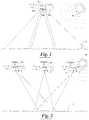
- FIG. 1An example of a system that captures both nadir and oblique images is shown in FIG. 1 .
- Airplane 10is flying over the Earth 12 and capturing images utilizing three cameras 14 a , 14 b and 14 c .
- FIG. 1also illustrates the sun 16 positioned in a northern hemisphere orientation.
- the camera 14 ais shown directed in a southern orientation generally towards the sun 16
- the camera 14 bis shown directed straight down
- the camera 14 cis shown directed in a northern orientation generally away from the sun 16 .
- the cameras 14 a and 14 ccapture “oblique images”, while the camera 14 b captures “nadir images”.
- oblique imagespresent a more natural appearance than a nadir image because they show not just the roofs, as is the case of a nadir image, but also the sides of objects and structures. This is what we are most accustomed to seeing.
- oblique imagesare generally presented without being ortho-rectified and instead left in the natural appearance that the camera captures. This practice makes it very easy for people to look at something in an oblique image and realize what that object is.
- Color balancing nadir aerial imagesis known in the art.
- color balancing oblique aerial imagespresents unique challenges.
- nadir imagesimages captured with camera 14 b pointing straight down
- every imagehas a consistent orientation with respect to the sun 16 .
- oblique imagesimages captured with the cameras 14 a and 14 c pointing at an oblique angle relative to the horizon
- different imageshave different orientations with respect to the sun 16 . For instance, in the northern hemisphere, a camera aimed to the north (camera 14 c ) points away from the sun 16 , while a camera aimed to the south (camera 14 a ) points toward the sun 16 .
- Specular reflectionsbounce off a surface and leave the surface at roughly the same angle with which they hit the surface—like a ball bouncing off a flat surface.
- the camera 14 apicks up specular reflections from the sun 16 and therefore any images captured with that camera pick up a strong yellow/red tint to the captured scene.
- the camera 14 cis pointing away from the sun 16 and picks up specular reflections from the sky and therefore any images captured with that camera pick up a strong blue tint to the scene.
- these two imagesare viewed side by side, the difference can be very noticeable and distracting to the overall image appearance. It is desirable to color balance the oblique images such that they have a substantially consistent color tone.
- FIG. 2Shown in FIG. 2 is a diagrammatic view of the capturing of three different overlapping images of a same scene from three different positions.
- the three different positionsare labeled as Position A, Position B and Position C for purposes of clarity.
- the sceneis positioned in the northern hemisphere, and thus, the image captured from Position A is taken with the camera positioned in a southern orientation toward the sun 16 , while the image captured from Position C is taken with the camera positioned in a northern orientation away from the sun 16 .
- the image captured from Position Bis taken with the camera positioned directly above the scene.
- the image captured from Position Ahas a yellow/reddish tint due to the strong specular reflections from the sun 16
- the image captured from Position Bhas a neutral tint due to roughly equal specular reflections from the sun 16 and sky
- the image captured from Position Chas a bluish tint due to the strong specular reflections from the sky.
- FIG. 3shown therein is a diagrammatic view of the capturing of an oblique image of the Earth 12 where a field of view of the camera is designated with the lines P 1 and P 2 .
- the lines P 1 and P 2represent path lengths, i.e., the distance the light travels from a scene on the Earth 12 to the camera.
- the path lengths P 1 and P 2are significantly different and this presents a second challenge to color balancing oblique images: the top of the image goes through significantly more atmosphere than the bottom of the image.
- path lengththe distance the light must travel from a scene on the Earth 12 to the camera
- lines P 3 and P 4represent the path lengths for a typical camera/lens configuration, the difference between the shortest path length (straight down) and the longest path length (to the far corner) is only about 6%.
- the path lengths P 1 and P 2are very different.
- the path length P 1is infinite—clearly much longer than the path length P 2 at the front of the image.
- the difference between the shortest path length (to the middle front of the image) and the longest path length (to the far back corner of the image)is about 87%—nearly twice as long.
- FIG. 1is a diagrammatic view of an airplane flying over the Earth and capturing images utilizing three cameras.
- FIG. 2is a diagrammatic view of the capturing of three different overlapping images of a same scene from three different positions.
- FIG. 3is a diagrammatic view of the capturing of an oblique image of the Earth 12 where a field of view of an oblique aerial camera is designated utilizing the path lengths P 1 and P 2 , i.e., the distance the light travels from a scene on the Earth to the camera, and a field of view of a nadir aerial camera is designated utilizing path lengths P 3 and P 4 .
- FIG. 4is a schematic view of an image processing system constructed in accordance with the present invention.
- FIG. 5is a schematic view of an oblique image that has been sectioned in accordance with the present invention.
- FIG. 6is a schematic view of another example of an oblique image that has been sectioned in accordance with the present invention.
- FIG. 7is a histogram of a color distribution for a red color band of an oblique image in accordance with the present invention.
- FIG. 8is a histogram of a color distribution of a blue color band of an oblique image in accordance with the present invention.
- FIG. 9is a portion of a color oblique image captured by a camera angled away from the sun.
- FIG. 10is a portion of a color oblique image of the same area depicted in FIG. 9 but captured by a camera angled toward the sun.
- the processes described in this patentprovide a means for color balancing oblique images so that they take on a consistent color tone.
- the principal behind these processesis to select a set of color-balanced images to use as reference images to create color-balance transformations for a series of oblique images so that the resulting color-balanced oblique images will have a color tone similar to the reference images.
- nadir imagesare often the best choice for the reference images; however, this is not required. It is recommended that the reference images be from a consistent sun/sky orientation, so, for instance, instead of the nadir images, the north-looking oblique images could be used as the reference images and the remaining oblique images transformed to match their color tone.
- the consistent color tone for the reference imagescan be achieved in a variety of manners, such as by having images that are naturally balanced, i.e., captured under similar conditions and/or orientations and therefore already have a consistent color tone, or by color-balancing the images to each other after they are captured so that they have a consistent color tone. Or nadir images captured under different conditions can first be color-balanced to each other to produce a consistent color tone.
- color-balancing nadir imagesdescribed in remote sensing textbooks—basically any method that produces a consistent color tone for a set of similar images will work. As these methods for nadir images are known in the art, they are not discussed here.
- the oblique imagescan be color balanced to match. This is accomplished by finding one or more portion(s) of reference image(s) that correspond to the same area of the scene contained within the oblique image—in other words, finding their areas of overlap.
- the reference images and the oblique imagesare geo-referenced so that finding the portions of the references image(s) corresponding to the same area of the scene contained within the oblique images can be accomplished with a computer and thereby automated.
- the logic of the process described hereinis executed by a computer to provide an automated process for color-balancing a series of oblique images.
- the image processing system 20is provided with a computer 22 , and a camera system 24 .
- the image processing system 20is adapted to color balance the series of oblique images captured from one or more positions and from one or more orientations so that such oblique images are provided with a substantially consistent color balance thereby reducing or even eliminating the unwanted yellowish/reddish or bluish tinting described above.
- the computer 22receives a series of reference images, and a series of oblique images from the camera system 24 .
- the reference images and the oblique imagescan be received by the computer system 22 either directly or indirectly from the camera system 24 , and can be passed from the camera system 24 either in batches, in real-time with the capturing of the reference images and/or the oblique images, or at a period of time substantially after the capturing of the reference images and the oblique images.
- the reference images and/or the oblique imagescan be transmitted or transferred from the camera system 24 to the computer system 22 days and/or weeks and/or years after the capturing of the reference images and the oblique images from the camera system 24 .
- the computer 22preferably runs image processing software (or firmware) adapted to perform the functions described herein, and the resulting images and data are stored on one or more computer readable mediums.
- Examples of a computer readable mediuminclude an optical storage device, a magnetic storage device, an electronic storage device or the like.
- the term “Computer” as used hereinmeans a system or systems that are able to embody and/or execute the logic of the processes described herein.
- the logic embodied in the form of software instructions or firmwaremay be executed on any appropriate hardware which may be a dedicated system or systems, or a general purpose computer system, a personal computer system or distributed processing computer system, all of which are well understood in the art, and a detailed description of how to make or use such computer systems is not deemed necessary herein.
- such computer(s) and/or executioncan be conducted at a same geographic location or multiple different geographic locations. Furthermore, the execution of the logic can be conducted continuously or at multiple discrete times. Further, such logic can be performed about simultaneously with the capture of the images, or thereafter or combinations thereof.
- the image capture system 24is typically used for capturing aerial images as shown in FIGS. 1-3 . Suitable image capture systems are shown and described in a provisional patent application identified by U.S. Ser. No. 60/901,444, the entire content of which is hereby incorporated herein by reference. Typically, the image capture system 24 is provided with, one or more image capture devices, one or more monitoring systems, one or more event multiplexer systems, and one or more data storage units or computer systems. In the examples depicted in FIGS. 1-3 of U.S. Ser. No. 60/901,444, the “image capture system 10 ” is provided with four image capture devices mounted in a sweep pattern (see FIG. 1 of U.S. Ser. No.
- 60/901,444five image capture devices mounted in a 360 pattern having image capture devices pointing fore, aft, port, starboard and straight down (see FIG. 2 of U.S. Ser. No. 60/901,444); or four image capture devices mounted in separate directions generally aligned with respective parts of streets (see FIG. 3 of U.S. Ser. No. 60/901,444).
- the image capture devices of the image capture system 24can be mounted to a moving platform such as a manned airplane, an unmanned airplane, a train, an automobile such as a van, a boat, a four wheeler, a motor cycle, a tractor, a robotic device or the like.
- a moving platformsuch as a manned airplane, an unmanned airplane, a train, an automobile such as a van, a boat, a four wheeler, a motor cycle, a tractor, a robotic device or the like.
- the computer 22executes instructions to effect the color-balancing of the series of oblique images captured from one or more positions and from one or more orientations.
- the computer 22is programmed with instructions to locate one or more portions of one or more reference images that overlap the oblique image, and then create a color balancing transformation that approximately matches the color distribution of the oblique image to the color distribution of the overlapping portions of the reference images.
- the computer 22transforms pixels in the oblique image according to the color balancing transformation created for that oblique image, and then preferably stores the transform pixel values in the oblique image or a copy of the oblique image.
- the oblique images having the transformed pixel valuesare referred to herein after as “color-balanced oblique images”.
- the reference imagesare geo-referenced to aid in the location of the overlapping portion(s), and also color-balanced.
- the reference imagescan be color-balanced either naturally because they are captured from a consistent orientation, or they can be color-balanced using well-known practices.
- the reference imagesare nadir images.
- the overlapping portions of the reference images and the oblique imageshave a similar scene because it is expected that the scenes will be somewhat different. For example, assuming that the scene includes a building, the oblique images will show the sides of the building while the nadir images will not. Typically, the closer the scene contents in the overlapping portion(s) match (Leaf-on, leaf off, flooding, snow, or the like) the better the results. Ideally, the reference images and the oblique images will be taken during the same photo shoot to enhance the similarity of the lighting and scene content.
- one or more color balancing transformationis created for each of the oblique images in the series of oblique images.
- the one or more color balancing transformationsdo not have to be made for each of the oblique images in the series. In other words, not all of the oblique images in the series of oblique images must be color-balanced in accordance with the present invention.
- all of the pixels in the oblique imageare preferably transformed according to the one or more color balancing transformation created for that particular oblique image, it should be understood that less than all of the pixels can be transformed. For example, the pixels in the oblique image can be organized into groups, and then a certain percentage of such pixels (such as 60-90%) can be transformed.
- the automated processpreferably (1) divides each oblique image in the series into a plurality of sections, (2) identifies a portion of a reference image overlapping the section, and then (3) creates a color-balancing transformation.
- a color-balancing transformation for each color band in the color spaceis created and for each section in the oblique image approximating the color distribution of the overlapping section in the one or more reference images.
- a histogram of the color distribution for each color bandi.e., red, green and blue in each section of the oblique image and the overlapping portion of the same scene in the nadir image (develop two histograms for each section) is created.
- Exemplary histograms for the red and blue color bandsare shown in FIGS. 7 and 8 .
- the color spacecan be any suitable color space, such as RGB, XYZ, LUV, CMYK, or false color IR.
- the color distribution histogram of an imageshows the number of pixels for each pixel value within the range of the image. If the minimum value of the image is 0 and the maximum value of the image is 255, the histogram of the image shows the number of pixels for each value ranging between and including 0 and 255. Peaks in the histogram represent more common values within the image that usually consist of nearly uniform regions. Valleys in the histogram represent less common values. Empty regions within the histogram indicate that no pixels within the image contain those values.
- FIG. 7 and 8show exemplary values of an aerial oblique image that has not yet been color-balanced while the dashed lines shown in the histograms show exemplary values of the same aerial oblique image that has been color-balanced utilizing the process described herein.
- the solid line in the histogram of FIG. 7shows the color distribution of the red band for an oblique image that was captured by a camera pointing in a generally south direction and that has a reddish tint due to the specular reflections from the sun 16
- the dashed lineshows a reduction in the red pixel values in the color-balanced image
- the solid line in the histogram of FIG. 8shows the color distribution of the blue band for an oblique image that was captured by a camera pointing in a generally north direction and that has a bluish tint due to the specular reflections from the sky.
- the dashed line in FIG. 8shows a reduction in the blue pixel values in the color-balanced image.
- each of the oblique imagesare preferably divided into a plurality of sections.
- an oblique image 30 shown in FIG. 5has been divided into nine sections 32 a - i
- the oblique image 34 shown in FIG. 6has been divided into 6 sections 36 a - f .
- Any number of sectionscan be used, but dividing the oblique image 30 into more sections decreases the likelihood of variability in the image.
- oblique imagescan change color depending upon their orientation and the distance that the scene is away from the camera. Images taken in a direction away from the sun 16 are usually bluer at the top, while images taken in a direction toward the sun 16 have a reddish-orange cast.
- the number, size and location of the sections within the oblique imagescan be predetermined or randomly determined.
- a color-balancing transformationis created that approximately matches the color distribution of the oblique image section to the color distribution of the overlapping reference portion(s).
- Histogram equalizationis a well known algorithm, so no further comments are deemed necessary to teach one skilled in the art how to make and use histogram equalization. For the oblique image 30 that has been divided into nine oblique image sections 32 a - i , this process occurs nine times.
- At least three histogramsare created for each color band in the color space.
- pixel values for each color band in each of the oblique imagesare color-balanced and blended to provide a substantially consistent color tone.
- Thiscan be accomplished by using a combination of the color-balancing transformations (e.g., histograms) for the oblique image.
- the blendingmay be accomplished through bi-linear interpolation, linear interpolation, cubics, splines and/or the like. Alternatively, one transform may be used for the entire image.
- the color-balancing and blendingis accomplished as follows. First, on a pixel by pixel basis, for the oblique image to be color-balanced, one or more oblique image sections are selected which apply to the particular pixel. Then, for each color band, the pixel value is calculated independently (or transformed) using the color balancing transformation for each selected oblique image section yielding a transformed pixel value for each selected oblique image section. Then, the transformed pixel values are blended into a single resulting pixel value using any suitable algorithm, such as bi-linear interpolation, linear interpolation, cubics, splines or the like.
- the resulting pixel valueis stored in the oblique image or a copy (such as a memory copy) of the oblique image.
- This processis preferably repeated for every pixel in the oblique image. However, it should be understood that this process could only be repeated for a subset of the pixels.
- the process described abovemay be performed on a continuous or intermittent basis.
- section color balancing transformationscan be stored, and then applied on a pixel by pixel basis at a later time to color-balance the oblique image.
- the color-balancing transformationscan be stored with the oblique image and then utilized to color-balance the oblique image when it is retrieved or displayed.
- RGB color imagesthe above process is repeated three times, once for each color pixel component, i.e. the red pixels, the green pixels, and the blue pixels, each with its own color-balancing transformation.
Landscapes
- Engineering & Computer Science (AREA)
- Multimedia (AREA)
- Signal Processing (AREA)
- Physics & Mathematics (AREA)
- General Physics & Mathematics (AREA)
- Theoretical Computer Science (AREA)
- Computer Vision & Pattern Recognition (AREA)
- Image Processing (AREA)
Abstract
Description
| Select oblique images to adjust |
| Select reference images |
| For( each image to be color-balanced ){ |
| Divide image into sections | |
| For( each image section used ){ |
| Choose one or more overlapping reference images | |
| If ( only one reference image is chosen ) { |
| Create section color-balancing transformation from chosen | |
| reference image |
| } | |
| Else { |
| Create empty section color-balancing transformation | |
| For ( each chosen reference image ){ |
| Create temporary color-balancing transformation | |
| for this chosen reference image | |
| Combine temporary color-balancing transformation | |
| into section color-balancing transformation |
| } |
| } |
| } | |
| For (each pixel to be transformed){ |
| Create empty final pixel value | |
| For (each image section used){ |
| If (section is applicable to pixel){ |
| Compute transformed pixel value from section color- | |
| balancing transformation | |
| Blend transformed pixel value into final pixel value |
| } |
| } | |
| Store final pixel value |
| } |
| } |
Claims (20)
Priority Applications (1)
| Application Number | Priority Date | Filing Date | Title |
|---|---|---|---|
| US16/806,347US11087506B2 (en) | 2007-10-12 | 2020-03-02 | System and process for color-balancing a series of oblique images |
Applications Claiming Priority (7)
| Application Number | Priority Date | Filing Date | Title |
|---|---|---|---|
| US11/871,740US7991226B2 (en) | 2007-10-12 | 2007-10-12 | System and process for color-balancing a series of oblique images |
| US13/181,259US8649596B2 (en) | 2007-10-12 | 2011-07-12 | System and process for color-balancing a series of oblique images |
| US14/153,772US8971624B2 (en) | 2007-10-12 | 2014-01-13 | System and process for color-balancing a series of oblique images |
| US14/632,732US9503615B2 (en) | 2007-10-12 | 2015-02-26 | System and process for color-balancing a series of oblique images |
| US15/357,490US20170236307A1 (en) | 2007-10-12 | 2016-11-21 | System and process for color-balancing a series of oblique images |
| US16/191,232US10580169B2 (en) | 2007-10-12 | 2018-11-14 | System and process for color-balancing a series of oblique images |
| US16/806,347US11087506B2 (en) | 2007-10-12 | 2020-03-02 | System and process for color-balancing a series of oblique images |
Related Parent Applications (1)
| Application Number | Title | Priority Date | Filing Date |
|---|---|---|---|
| US16/191,232ContinuationUS10580169B2 (en) | 2007-10-12 | 2018-11-14 | System and process for color-balancing a series of oblique images |
Publications (2)
| Publication Number | Publication Date |
|---|---|
| US20200202583A1 US20200202583A1 (en) | 2020-06-25 |
| US11087506B2true US11087506B2 (en) | 2021-08-10 |
Family
ID=40534256
Family Applications (7)
| Application Number | Title | Priority Date | Filing Date |
|---|---|---|---|
| US11/871,740Expired - Fee RelatedUS7991226B2 (en) | 2007-10-12 | 2007-10-12 | System and process for color-balancing a series of oblique images |
| US13/181,259Active2028-04-30US8649596B2 (en) | 2007-10-12 | 2011-07-12 | System and process for color-balancing a series of oblique images |
| US14/153,772ActiveUS8971624B2 (en) | 2007-10-12 | 2014-01-13 | System and process for color-balancing a series of oblique images |
| US14/632,732Active2028-08-18US9503615B2 (en) | 2007-10-12 | 2015-02-26 | System and process for color-balancing a series of oblique images |
| US15/357,490AbandonedUS20170236307A1 (en) | 2007-10-12 | 2016-11-21 | System and process for color-balancing a series of oblique images |
| US16/191,232ActiveUS10580169B2 (en) | 2007-10-12 | 2018-11-14 | System and process for color-balancing a series of oblique images |
| US16/806,347ActiveUS11087506B2 (en) | 2007-10-12 | 2020-03-02 | System and process for color-balancing a series of oblique images |
Family Applications Before (6)
| Application Number | Title | Priority Date | Filing Date |
|---|---|---|---|
| US11/871,740Expired - Fee RelatedUS7991226B2 (en) | 2007-10-12 | 2007-10-12 | System and process for color-balancing a series of oblique images |
| US13/181,259Active2028-04-30US8649596B2 (en) | 2007-10-12 | 2011-07-12 | System and process for color-balancing a series of oblique images |
| US14/153,772ActiveUS8971624B2 (en) | 2007-10-12 | 2014-01-13 | System and process for color-balancing a series of oblique images |
| US14/632,732Active2028-08-18US9503615B2 (en) | 2007-10-12 | 2015-02-26 | System and process for color-balancing a series of oblique images |
| US15/357,490AbandonedUS20170236307A1 (en) | 2007-10-12 | 2016-11-21 | System and process for color-balancing a series of oblique images |
| US16/191,232ActiveUS10580169B2 (en) | 2007-10-12 | 2018-11-14 | System and process for color-balancing a series of oblique images |
Country Status (6)
| Country | Link |
|---|---|
| US (7) | US7991226B2 (en) |
| EP (1) | EP2210212A4 (en) |
| AU (1) | AU2008310726B2 (en) |
| BR (1) | BRPI0818059A2 (en) |
| CA (1) | CA2702258C (en) |
| WO (1) | WO2009049151A1 (en) |
Families Citing this family (49)
| Publication number | Priority date | Publication date | Assignee | Title |
|---|---|---|---|---|
| US8078436B2 (en) | 2007-04-17 | 2011-12-13 | Eagle View Technologies, Inc. | Aerial roof estimation systems and methods |
| US8145578B2 (en)* | 2007-04-17 | 2012-03-27 | Eagel View Technologies, Inc. | Aerial roof estimation system and method |
| EP3056836A3 (en) | 2007-10-04 | 2016-09-14 | Sungevity | System and method for provisioning solar energy systems |
| US7991226B2 (en)* | 2007-10-12 | 2011-08-02 | Pictometry International Corporation | System and process for color-balancing a series of oblique images |
| US8417061B2 (en)* | 2008-02-01 | 2013-04-09 | Sungevity Inc. | Methods and systems for provisioning energy systems |
| US8675068B2 (en) | 2008-04-11 | 2014-03-18 | Nearmap Australia Pty Ltd | Systems and methods of capturing large area images in detail including cascaded cameras and/or calibration features |
| US8497905B2 (en) | 2008-04-11 | 2013-07-30 | nearmap australia pty ltd. | Systems and methods of capturing large area images in detail including cascaded cameras and/or calibration features |
| US8209152B2 (en) | 2008-10-31 | 2012-06-26 | Eagleview Technologies, Inc. | Concurrent display systems and methods for aerial roof estimation |
| US8170840B2 (en) | 2008-10-31 | 2012-05-01 | Eagle View Technologies, Inc. | Pitch determination systems and methods for aerial roof estimation |
| US8731234B1 (en) | 2008-10-31 | 2014-05-20 | Eagle View Technologies, Inc. | Automated roof identification systems and methods |
| JP5288482B2 (en)* | 2009-07-21 | 2013-09-11 | Nec東芝スペースシステム株式会社 | Imaging apparatus, imaging method, imaging circuit, and program |
| AU2011210538B2 (en) | 2010-02-01 | 2015-03-26 | Eagle View Technologies, Inc. | Geometric correction of rough wireframe models derived from photographs |
| US8374428B2 (en)* | 2010-12-05 | 2013-02-12 | Microsoft Corporation | Color balancing for partially overlapping images |
| DE202012013411U1 (en)* | 2011-04-25 | 2016-11-15 | Terra Bella Technologies Inc. | Systems for overhead image and video display |
| JP5882693B2 (en)* | 2011-11-24 | 2016-03-09 | 株式会社トプコン | Aerial photography imaging method and aerial photography imaging apparatus |
| US8970691B2 (en) | 2011-08-26 | 2015-03-03 | Microsoft Technology Licensing, Llc | Removal of rayleigh scattering from images |
| US10663294B2 (en) | 2012-02-03 | 2020-05-26 | Eagle View Technologies, Inc. | Systems and methods for estimation of building wall area and producing a wall estimation report |
| US9599466B2 (en) | 2012-02-03 | 2017-03-21 | Eagle View Technologies, Inc. | Systems and methods for estimation of building wall area |
| US12140419B2 (en) | 2012-02-03 | 2024-11-12 | Eagle View Technologies, Inc. | Systems and methods for estimation of building wall area and producing a wall estimation report |
| US10515414B2 (en) | 2012-02-03 | 2019-12-24 | Eagle View Technologies, Inc. | Systems and methods for performing a risk management assessment of a property |
| US8774525B2 (en) | 2012-02-03 | 2014-07-08 | Eagle View Technologies, Inc. | Systems and methods for estimation of building floor area |
| US9933257B2 (en) | 2012-02-03 | 2018-04-03 | Eagle View Technologies, Inc. | Systems and methods for estimation of building wall area |
| US9501700B2 (en) | 2012-02-15 | 2016-11-22 | Xactware Solutions, Inc. | System and method for construction estimation using aerial images |
| US10909482B2 (en) | 2013-03-15 | 2021-02-02 | Pictometry International Corp. | Building materials estimation |
| US9959581B2 (en) | 2013-03-15 | 2018-05-01 | Eagle View Technologies, Inc. | Property management on a smartphone |
| US11587176B2 (en) | 2013-03-15 | 2023-02-21 | Eagle View Technologies, Inc. | Price estimation model |
| EP2787319A1 (en)* | 2013-04-05 | 2014-10-08 | Leica Geosystems AG | Control of an image triggering system for taking aerial photographs in nadir alignment for an unmanned aircraft |
| US20140300736A1 (en)* | 2013-04-09 | 2014-10-09 | Microsoft Corporation | Multi-sensor camera recalibration |
| WO2014184244A1 (en)* | 2013-05-16 | 2014-11-20 | Thomson Licensing | Method for transfering the chromaticity of an example-image to the chromaticity of an image |
| EP3028464B1 (en) | 2013-08-02 | 2019-05-01 | Xactware Solutions Inc. | System and method for detecting features in aerial images using disparity mapping and segmentation techniques |
| WO2015031593A1 (en) | 2013-08-29 | 2015-03-05 | Sungevity, Inc. | Improving designing and installation quoting for solar energy systems |
| US10230925B2 (en) | 2014-06-13 | 2019-03-12 | Urthecast Corp. | Systems and methods for processing and providing terrestrial and/or space-based earth observation video |
| US9734599B2 (en) | 2014-10-08 | 2017-08-15 | Microsoft Technology Licensing, Llc | Cross-level image blending |
| US9460517B2 (en) | 2014-10-22 | 2016-10-04 | Pointivo, Inc | Photogrammetric methods and devices related thereto |
| WO2016153914A1 (en) | 2015-03-25 | 2016-09-29 | King Abdulaziz City Of Science And Technology | Apparatus and methods for synthetic aperture radar with digital beamforming |
| AU2016201867B2 (en)* | 2015-03-27 | 2017-09-28 | Konica Minolta Laboratory U.S.A., Inc. | Method and system to avoid plant shadows for vegetation and soil imaging |
| WO2017044168A2 (en) | 2015-06-16 | 2017-03-16 | King Abdulaziz City Of Science And Technology | Efficient planar phased array antenna assembly |
| CA3044806A1 (en) | 2015-11-25 | 2017-06-01 | Urthecast Corp. | Synthetic aperture radar imaging apparatus and methods |
| CN105698762B (en)* | 2016-01-15 | 2018-02-23 | 中国人民解放军国防科学技术大学 | Target method for rapidly positioning based on observation station at different moments on a kind of unit flight path |
| US10628802B2 (en) | 2016-05-19 | 2020-04-21 | Lockheed Martin Corporation | Systems and methods for assessing damage to infrastructure assets |
| US10032267B2 (en) | 2016-06-09 | 2018-07-24 | Lockheed Martin Corporation | Automating the assessment of damage to infrastructure assets |
| CA3064735C (en) | 2017-05-23 | 2022-06-21 | Urthecast Corp. | Synthetic aperture radar imaging apparatus and methods |
| US11378682B2 (en) | 2017-05-23 | 2022-07-05 | Spacealpha Insights Corp. | Synthetic aperture radar imaging apparatus and methods for moving targets |
| CA3083033A1 (en) | 2017-11-22 | 2019-11-28 | Urthecast Corp. | Synthetic aperture radar apparatus and methods |
| US10503843B2 (en) | 2017-12-19 | 2019-12-10 | Eagle View Technologies, Inc. | Supervised automatic roof modeling |
| WO2020106984A1 (en) | 2018-11-21 | 2020-05-28 | Eagle View Technologies, Inc. | Navigating unmanned aircraft using pitch |
| US11094113B2 (en) | 2019-12-04 | 2021-08-17 | Geomni, Inc. | Systems and methods for modeling structures using point clouds derived from stereoscopic image pairs |
| US11915341B2 (en)* | 2022-02-14 | 2024-02-27 | Adobe Inc. | Repeat object blending |
| US20240070975A1 (en)* | 2022-08-24 | 2024-02-29 | Adobe Inc. | Transform aware blend object generation |
Citations (183)
| Publication number | Priority date | Publication date | Assignee | Title |
|---|---|---|---|---|
| US2273876A (en) | 1940-02-12 | 1942-02-24 | Frederick W Lutz | Apparatus for indicating tilt of cameras |
| US3153784A (en) | 1959-12-24 | 1964-10-20 | Us Industries Inc | Photo radar ground contour mapping system |
| US3594556A (en) | 1969-01-08 | 1971-07-20 | Us Navy | Optical sight with electronic image stabilization |
| US3614410A (en) | 1969-06-12 | 1971-10-19 | Knight V Bailey | Image rectifier |
| US3621326A (en) | 1968-09-30 | 1971-11-16 | Itek Corp | Transformation system |
| US3661061A (en) | 1969-05-05 | 1972-05-09 | Atomic Energy Commission | Picture position finder |
| US3716669A (en) | 1971-05-14 | 1973-02-13 | Japan Eng Dev Co | Mapping rectifier for generating polarstereographic maps from satellite scan signals |
| US3725563A (en) | 1971-12-23 | 1973-04-03 | Singer Co | Method of perspective transformation in scanned raster visual display |
| US3864513A (en) | 1972-09-11 | 1975-02-04 | Grumman Aerospace Corp | Computerized polarimetric terrain mapping system |
| US3866602A (en) | 1973-05-29 | 1975-02-18 | Olympus Optical Co | Endoscope camera with orientation indicator |
| US3877799A (en) | 1974-02-06 | 1975-04-15 | United Kingdom Government | Method of recording the first frame in a time index system |
| US4015080A (en) | 1973-04-30 | 1977-03-29 | Elliott Brothers (London) Limited | Display devices |
| US4044879A (en) | 1975-03-07 | 1977-08-30 | Siemens Aktiengesellschaft | Arrangement for recording characters using mosaic recording mechanisms |
| US4184711A (en) | 1977-10-14 | 1980-01-22 | Yasuo Wakimoto | Folding canvas chair |
| US4240108A (en) | 1977-10-03 | 1980-12-16 | Grumman Aerospace Corporation | Vehicle controlled raster display system |
| US4281354A (en) | 1978-05-19 | 1981-07-28 | Raffaele Conte | Apparatus for magnetic recording of casual events relating to movable means |
| US4344683A (en) | 1979-09-29 | 1982-08-17 | Agfa-Gevaert Aktiengesellschaft | Quality control method and apparatus for photographic pictures |
| US4360876A (en) | 1979-07-06 | 1982-11-23 | Thomson-Csf | Cartographic indicator system |
| US4382678A (en) | 1981-06-29 | 1983-05-10 | The United States Of America As Represented By The Secretary Of The Army | Measuring of feature for photo interpretation |
| US4387056A (en) | 1981-04-16 | 1983-06-07 | E. I. Du Pont De Nemours And Company | Process for separating zero-valent nickel species from divalent nickel species |
| US4396942A (en) | 1979-04-19 | 1983-08-02 | Jackson Gates | Video surveys |
| US4463380A (en) | 1981-09-25 | 1984-07-31 | Vought Corporation | Image processing system |
| US4489322A (en) | 1983-01-27 | 1984-12-18 | The United States Of America As Represented By The Secretary Of The Air Force | Radar calibration using direct measurement equipment and oblique photometry |
| US4490742A (en) | 1982-04-23 | 1984-12-25 | Vcs, Incorporated | Encoding apparatus for a closed circuit television system |
| US4491399A (en) | 1982-09-27 | 1985-01-01 | Coherent Communications, Inc. | Method and apparatus for recording a digital signal on motion picture film |
| US4495500A (en) | 1982-01-26 | 1985-01-22 | Sri International | Topographic data gathering method |
| US4527055A (en) | 1982-11-15 | 1985-07-02 | Honeywell Inc. | Apparatus for selectively viewing either of two scenes of interest |
| US4543603A (en) | 1982-11-30 | 1985-09-24 | Societe Nationale Industrielle Et Aerospatiale | Reconnaissance system comprising an air-borne vehicle rotating about its longitudinal axis |
| US4586138A (en) | 1982-07-29 | 1986-04-29 | The United States Of America As Represented By The United States Department Of Energy | Route profile analysis system and method |
| US4635136A (en) | 1984-02-06 | 1987-01-06 | Rochester Institute Of Technology | Method and apparatus for storing a massive inventory of labeled images |
| US4653316A (en) | 1986-03-14 | 1987-03-31 | Kabushiki Kaisha Komatsu Seisakusho | Apparatus mounted on vehicles for detecting road surface conditions |
| US4653136A (en) | 1985-06-21 | 1987-03-31 | Denison James W | Wiper for rear view mirror |
| US4673988A (en) | 1985-04-22 | 1987-06-16 | E.I. Du Pont De Nemours And Company | Electronic mosaic imaging process |
| US4686474A (en) | 1984-04-05 | 1987-08-11 | Deseret Research, Inc. | Survey system for collection and real time processing of geophysical data |
| US4688092A (en) | 1986-05-06 | 1987-08-18 | Ford Aerospace & Communications Corporation | Satellite camera image navigation |
| US4689748A (en) | 1979-10-09 | 1987-08-25 | Messerschmitt-Bolkow-Blohm Gesellschaft Mit Beschrankter Haftung | Device for aircraft and spacecraft for producing a digital terrain representation |
| US4707698A (en) | 1976-03-04 | 1987-11-17 | Constant James N | Coordinate measurement and radar device using image scanner |
| US4758850A (en) | 1985-08-01 | 1988-07-19 | British Aerospace Public Limited Company | Identification of ground targets in airborne surveillance radar returns |
| US4805033A (en) | 1987-02-18 | 1989-02-14 | Olympus Optical Co., Ltd. | Method of forming oblique dot pattern |
| US4807024A (en) | 1987-06-08 | 1989-02-21 | The University Of South Carolina | Three-dimensional display methods and apparatus |
| US4814896A (en) | 1987-03-06 | 1989-03-21 | Heitzman Edward F | Real time video data acquistion systems |
| US4814711A (en) | 1984-04-05 | 1989-03-21 | Deseret Research, Inc. | Survey system and method for real time collection and processing of geophysicals data using signals from a global positioning satellite network |
| US4843463A (en) | 1988-05-23 | 1989-06-27 | Michetti Joseph A | Land vehicle mounted audio-visual trip recorder |
| US4899296A (en) | 1987-11-13 | 1990-02-06 | Khattak Anwar S | Pavement distress survey system |
| US4906198A (en) | 1988-12-12 | 1990-03-06 | International Business Machines Corporation | Circuit board assembly and contact pin for use therein |
| US4953227A (en) | 1986-01-31 | 1990-08-28 | Canon Kabushiki Kaisha | Image mosaic-processing method and apparatus |
| US4956872A (en) | 1986-10-31 | 1990-09-11 | Canon Kabushiki Kaisha | Image processing apparatus capable of random mosaic and/or oil-painting-like processing |
| US5034812A (en) | 1988-11-14 | 1991-07-23 | Smiths Industries Public Limited Company | Image processing utilizing an object data store to determine information about a viewed object |
| US5086314A (en) | 1990-05-21 | 1992-02-04 | Nikon Corporation | Exposure control apparatus for camera |
| US5121222A (en) | 1989-06-14 | 1992-06-09 | Toshiaki Endoh | Method and apparatus for producing binary picture with detection and retention of plural binary picture blocks having a thin line pattern including an oblique line |
| US5138444A (en) | 1991-09-05 | 1992-08-11 | Nec Corporation | Image pickup system capable of producing correct image signals of an object zone |
| US5155597A (en) | 1990-11-28 | 1992-10-13 | Recon/Optical, Inc. | Electro-optical imaging array with motion compensation |
| US5164825A (en) | 1987-03-30 | 1992-11-17 | Canon Kabushiki Kaisha | Image processing method and apparatus for mosaic or similar processing therefor |
| US5166789A (en) | 1989-08-25 | 1992-11-24 | Space Island Products & Services, Inc. | Geographical surveying using cameras in combination with flight computers to obtain images with overlaid geographical coordinates |
| US5191174A (en) | 1990-08-01 | 1993-03-02 | International Business Machines Corporation | High density circuit board and method of making same |
| US5200793A (en) | 1990-10-24 | 1993-04-06 | Kaman Aerospace Corporation | Range finding array camera |
| US5210586A (en) | 1990-06-27 | 1993-05-11 | Siemens Aktiengesellschaft | Arrangement for recognizing obstacles for pilots of low-flying aircraft |
| US5231435A (en) | 1991-07-12 | 1993-07-27 | Blakely Bruce W | Aerial camera mounting apparatus |
| US5247356A (en) | 1992-02-14 | 1993-09-21 | Ciampa John A | Method and apparatus for mapping and measuring land |
| US5251037A (en) | 1992-02-18 | 1993-10-05 | Hughes Training, Inc. | Method and apparatus for generating high resolution CCD camera images |
| US5265173A (en) | 1991-03-20 | 1993-11-23 | Hughes Aircraft Company | Rectilinear object image matcher |
| US5267042A (en) | 1991-01-11 | 1993-11-30 | Pioneer Electronic Corporation | Image pickup device for automatically recording the location where an image is recorded |
| US5270756A (en) | 1992-02-18 | 1993-12-14 | Hughes Training, Inc. | Method and apparatus for generating high resolution vidicon camera images |
| US5296884A (en) | 1990-02-23 | 1994-03-22 | Minolta Camera Kabushiki Kaisha | Camera having a data recording function |
| US5335072A (en) | 1990-05-30 | 1994-08-02 | Minolta Camera Kabushiki Kaisha | Photographic system capable of storing information on photographed image data |
| US5337093A (en) | 1990-12-19 | 1994-08-09 | Mitsubishi Denki Kabushiki Kaisha | Projection television system including a plurality of display elements with corresponding optical axes incident to a screen at different points offset from the screen center |
| US5342999A (en) | 1992-12-21 | 1994-08-30 | Motorola, Inc. | Apparatus for adapting semiconductor die pads and method therefor |
| US5345086A (en) | 1962-11-28 | 1994-09-06 | Eaton Corporation | Automatic map compilation system |
| US5353055A (en) | 1991-04-16 | 1994-10-04 | Nec Corporation | Image pickup system with an image pickup device for control |
| US5363318A (en)* | 1992-03-23 | 1994-11-08 | Eastman Kodak Company | Method and apparatus for adaptive color characterization and calibration |
| US5369443A (en) | 1991-04-12 | 1994-11-29 | Abekas Video Systems, Inc. | Digital video effects generator |
| US5402170A (en) | 1991-12-11 | 1995-03-28 | Eastman Kodak Company | Hand-manipulated electronic camera tethered to a personal computer |
| US5414462A (en) | 1993-02-11 | 1995-05-09 | Veatch; John W. | Method and apparatus for generating a comprehensive survey map |
| US5467271A (en) | 1993-12-17 | 1995-11-14 | Trw, Inc. | Mapping and analysis system for precision farming applications |
| US5481479A (en) | 1992-12-10 | 1996-01-02 | Loral Fairchild Corp. | Nonlinear scanning to optimize sector scan electro-optic reconnaissance system performance |
| US5486948A (en) | 1989-03-24 | 1996-01-23 | Canon Hanbai Kabushiki Kaisha | Stereo image forming apparatus having a light deflection member in each optical path |
| US5506644A (en) | 1992-08-18 | 1996-04-09 | Olympus Optical Co., Ltd. | Camera |
| US5508736A (en) | 1993-05-14 | 1996-04-16 | Cooper; Roger D. | Video signal processing apparatus for producing a composite signal for simultaneous display of data and video information |
| US5555018A (en) | 1991-04-25 | 1996-09-10 | Von Braun; Heiko S. | Large-scale mapping of parameters of multi-dimensional structures in natural environments |
| US5563654A (en) | 1993-12-30 | 1996-10-08 | Goldstar Co., Ltd. | White balancing apparatus utilizing only the achromatic color components in the information for white balance |
| US5604534A (en) | 1995-05-24 | 1997-02-18 | Omni Solutions International, Ltd. | Direct digital airborne panoramic camera system and method |
| US5617224A (en) | 1989-05-08 | 1997-04-01 | Canon Kabushiki Kaisha | Imae processing apparatus having mosaic processing feature that decreases image resolution without changing image size or the number of pixels |
| US5633946A (en) | 1994-05-19 | 1997-05-27 | Geospan Corporation | Method and apparatus for collecting and processing visual and spatial position information from a moving platform |
| US5668593A (en) | 1995-06-07 | 1997-09-16 | Recon/Optical, Inc. | Method and camera system for step frame reconnaissance with motion compensation |
| US5677515A (en) | 1991-10-18 | 1997-10-14 | Trw Inc. | Shielded multilayer printed wiring board, high frequency, high isolation |
| US5798786A (en) | 1996-05-07 | 1998-08-25 | Recon/Optical, Inc. | Electro-optical imaging detector array for a moving vehicle which includes two axis image motion compensation and transfers pixels in row directions and column directions |
| US5835133A (en) | 1996-01-23 | 1998-11-10 | Silicon Graphics, Inc. | Optical system for single camera stereo video |
| US5841574A (en) | 1996-06-28 | 1998-11-24 | Recon/Optical, Inc. | Multi-special decentered catadioptric optical system |
| US5844602A (en) | 1996-05-07 | 1998-12-01 | Recon/Optical, Inc. | Electro-optical imaging array and camera system with pitch rate image motion compensation which can be used in an airplane in a dive bomb maneuver |
| US5852753A (en) | 1997-11-10 | 1998-12-22 | Lo; Allen Kwok Wah | Dual-lens camera with shutters for taking dual or single images |
| US5894323A (en) | 1996-03-22 | 1999-04-13 | Tasc, Inc, | Airborne imaging system using global positioning system (GPS) and inertial measurement unit (IMU) data |
| WO1999018732A1 (en) | 1997-10-06 | 1999-04-15 | Ciampa John A | Digital-image mapping |
| US5899945A (en) | 1995-04-17 | 1999-05-04 | Space Systems/Loral, Inc. | Attitude control and navigation system for high resolution imaging |
| US5963664A (en) | 1995-06-22 | 1999-10-05 | Sarnoff Corporation | Method and system for image combination using a parallax-based technique |
| US6037945A (en) | 1997-12-16 | 2000-03-14 | Xactware, Inc. | Graphical method for modeling and estimating construction costs |
| EP1010966A1 (en) | 1998-12-15 | 2000-06-21 | Aerowest GmbH | Method for generating a three dimensional object description |
| US6094215A (en) | 1998-01-06 | 2000-07-25 | Intel Corporation | Method of determining relative camera orientation position to create 3-D visual images |
| US6097854A (en) | 1997-08-01 | 2000-08-01 | Microsoft Corporation | Image mosaic construction system and apparatus with patch-based alignment, global block adjustment and pair-wise motion-based local warping |
| US6108032A (en) | 1996-11-05 | 2000-08-22 | Lockheed Martin Fairchild Systems | System and method for image motion compensation of a CCD image sensor |
| CA2402234A1 (en) | 1999-03-08 | 2000-09-14 | Tci Incorporated | Electric mammograph |
| US6130705A (en) | 1998-07-10 | 2000-10-10 | Recon/Optical, Inc. | Autonomous electro-optical framing camera system with constant ground resolution, unmanned airborne vehicle therefor, and methods of use |
| US6157747A (en) | 1997-08-01 | 2000-12-05 | Microsoft Corporation | 3-dimensional image rotation method and apparatus for producing image mosaics |
| US6222583B1 (en) | 1997-03-27 | 2001-04-24 | Nippon Telegraph And Telephone Corporation | Device and system for labeling sight images |
| US6236382B1 (en) | 1997-05-19 | 2001-05-22 | Koha Co., Ltd. | Light emitting diode display unit |
| US6236886B1 (en) | 1996-12-11 | 2001-05-22 | Technology Commercialization International | Method for producing a tomographic image of the body and electric impedance tomograph |
| US6249315B1 (en)* | 1997-03-24 | 2001-06-19 | Jack M. Holm | Strategy for pictorial digital image processing |
| US6256004B1 (en) | 1996-12-27 | 2001-07-03 | Sharp Kabushiki Kaisha | Liquid crystal display device and driving method thereof |
| US6256057B1 (en) | 1996-11-05 | 2001-07-03 | Lockhead Martin Corporation | Electro-optical reconnaissance system with forward motion compensation |
| US20020041717A1 (en) | 2000-08-30 | 2002-04-11 | Ricoh Company, Ltd. | Image processing method and apparatus and computer-readable storage medium using improved distortion correction |
| US20020041328A1 (en) | 2000-03-29 | 2002-04-11 | Astrovision International, Inc. | Direct broadcast imaging satellite system apparatus and method for providing real-time, continuous monitoring of earth from geostationary earth orbit and related services |
| US6421610B1 (en) | 2000-09-15 | 2002-07-16 | Ernest A. Carroll | Method of preparing and disseminating digitized geospatial data |
| US6434280B1 (en) | 1997-11-10 | 2002-08-13 | Gentech Corporation | System and method for generating super-resolution-enhanced mosaic images |
| US20020114536A1 (en) | 1998-09-25 | 2002-08-22 | Yalin Xiong | Aligning rectilinear images in 3D through projective registration and calibration |
| US20030014224A1 (en) | 2001-07-06 | 2003-01-16 | Yanlin Guo | Method and apparatus for automatically generating a site model |
| US20030043824A1 (en) | 2001-08-31 | 2003-03-06 | Remboski Donald J. | Vehicle active network and device |
| US20030088362A1 (en) | 2000-08-16 | 2003-05-08 | Imagelinks, Inc. | 3-dimensional interactive image modeling system |
| US6594388B1 (en)* | 2000-05-25 | 2003-07-15 | Eastman Kodak Company | Color image reproduction of scenes with preferential color mapping and scene-dependent tone scaling |
| US6597818B2 (en) | 1997-05-09 | 2003-07-22 | Sarnoff Corporation | Method and apparatus for performing geo-spatial registration of imagery |
| US20030164962A1 (en) | 2002-03-01 | 2003-09-04 | Nims Jerry C. | Multiple angle display produced from remote optical sensing devices |
| US6639596B1 (en) | 1999-09-20 | 2003-10-28 | Microsoft Corporation | Stereo reconstruction from multiperspective panoramas |
| JP2003317089A (en) | 2002-04-24 | 2003-11-07 | Dainippon Printing Co Ltd | Image correction method and system |
| US6650771B1 (en)* | 1999-11-22 | 2003-11-18 | Eastman Kodak Company | Color management system incorporating parameter control channels |
| US20030214585A1 (en) | 2002-01-09 | 2003-11-20 | Bakewell Charles Adams | Mobile enforcement platform with aimable violation identification and documentation system for multiple traffic violation types across all lanes in moving traffic, generating composite display images and data to support citation generation, homeland security, and monitoring |
| US6664973B1 (en)* | 1996-04-28 | 2003-12-16 | Fujitsu Limited | Image processing apparatus, method for processing and image and computer-readable recording medium for causing a computer to process images |
| US6711475B2 (en) | 2000-03-16 | 2004-03-23 | The Johns Hopkins University | Light detection and ranging (LIDAR) mapping system |
| US20040057633A1 (en) | 2002-09-19 | 2004-03-25 | Mai Tuy Vu | System for mosaicing digital ortho-images |
| US6714243B1 (en)* | 1999-03-22 | 2004-03-30 | Biomorphic Vlsi, Inc. | Color filter pattern |
| US6731329B1 (en) | 1999-05-14 | 2004-05-04 | Zsp Geodaetische Systeme Gmbh | Method and an arrangement for determining the spatial coordinates of at least one object point |
| CA2505566A1 (en) | 2002-11-08 | 2004-05-27 | Stephen Schultz | Oblique geolocation and measurement system |
| US6747686B1 (en) | 2001-10-05 | 2004-06-08 | Recon/Optical, Inc. | High aspect stereoscopic mode camera and method |
| US6754279B2 (en)* | 1999-12-20 | 2004-06-22 | Texas Instruments Incorporated | Digital still camera system and method |
| US20040167709A1 (en) | 2002-09-20 | 2004-08-26 | M7 Visual Intelligence, Lp | Vehicle based data collection and processing system |
| US6791711B1 (en)* | 1998-06-24 | 2004-09-14 | Canon Kabushiki Kaisha | Image processing method, image processing apparatus, and recording medium |
| US6810383B1 (en) | 2000-01-21 | 2004-10-26 | Xactware, Inc. | Automated task management and evaluation |
| US6826539B2 (en) | 1999-12-31 | 2004-11-30 | Xactware, Inc. | Virtual structure data repository and directory |
| US6829584B2 (en) | 1999-12-31 | 2004-12-07 | Xactware, Inc. | Virtual home data repository and directory |
| US6834128B1 (en) | 2000-06-16 | 2004-12-21 | Hewlett-Packard Development Company, L.P. | Image mosaicing system and method adapted to mass-market hand-held digital cameras |
| US6876763B2 (en) | 2000-02-03 | 2005-04-05 | Alst Technical Excellence Center | Image resolution improvement using a color mosaic sensor |
| US20050073241A1 (en) | 1999-06-21 | 2005-04-07 | Semiconductor Energy Laboratory Co., Ltd. | EL display device, driving method thereof, and electronic equipment provided with the display device |
| US20050088251A1 (en) | 2003-10-23 | 2005-04-28 | Nihon Dempa Kogyo Co., Ltd. | Crystal oscillator |
| US20050169521A1 (en) | 2004-01-31 | 2005-08-04 | Yacov Hel-Or | Processing of mosaic digital images |
| WO2005088251A1 (en) | 2004-02-27 | 2005-09-22 | Intergraph Software Technologies Company | Forming a single image from overlapping images |
| US20060028550A1 (en) | 2004-08-06 | 2006-02-09 | Palmer Robert G Jr | Surveillance system and method |
| US7009638B2 (en) | 2001-05-04 | 2006-03-07 | Vexcel Imaging Gmbh | Self-calibrating, digital, large format camera with single or multiple detector arrays and single or multiple optical systems |
| US7018050B2 (en) | 2003-09-08 | 2006-03-28 | Hewlett-Packard Development Company, L.P. | System and method for correcting luminance non-uniformity of obliquely projected images |
| US20060080037A1 (en) | 2004-09-15 | 2006-04-13 | Deutsches Zentrum Fur Luft- Und Raumfahrt E.V. | Process of remote sensing data |
| US20060092043A1 (en) | 2004-11-03 | 2006-05-04 | Lagassey Paul J | Advanced automobile accident detection, data recordation and reporting system |
| US7046401B2 (en) | 2001-06-01 | 2006-05-16 | Hewlett-Packard Development Company, L.P. | Camera-based document scanning system using multiple-pass mosaicking |
| US7061650B2 (en) | 1999-05-25 | 2006-06-13 | Silverbrook Research Pty Ltd | Method and apparatus for bayer mosaic image conversion |
| US7065260B2 (en) | 2000-10-27 | 2006-06-20 | Microsoft Corporation | Rebinning methods and arrangements for use in compressing image-based rendering (IBR) data |
| EP1696204A2 (en) | 2002-11-08 | 2006-08-30 | Pictometry International Corp. | Method and apparatus for capturing, geolocating and measuring oblique images |
| US20060195858A1 (en) | 2004-04-15 | 2006-08-31 | Yusuke Takahashi | Video object recognition device and recognition method, video annotation giving device and giving method, and program |
| US20060238383A1 (en) | 2005-04-21 | 2006-10-26 | Microsoft Corporation | Virtual earth rooftop overlay and bounding |
| US7133551B2 (en) | 2002-02-07 | 2006-11-07 | National Central University | Semi-automatic reconstruction method of 3-D building models using building outline segments |
| US20060250515A1 (en) | 1998-09-16 | 2006-11-09 | Olympus Optical Co., Ltd. | Image pickup apparatus |
| US7142984B2 (en) | 2005-02-08 | 2006-11-28 | Harris Corporation | Method and apparatus for enhancing a digital elevation model (DEM) for topographical modeling |
| US20070024612A1 (en) | 2005-07-27 | 2007-02-01 | Balfour Technologies Llc | System for viewing a collection of oblique imagery in a three or four dimensional virtual scene |
| US7184072B1 (en) | 2000-06-15 | 2007-02-27 | Power View Company, L.L.C. | Airborne inventory and inspection system and apparatus |
| US20070046448A1 (en) | 2002-09-20 | 2007-03-01 | M7 Visual Intelligence | Vehicle based data collection and processing system and imaging sensor system and methods thereof |
| US20070050340A1 (en) | 2002-03-16 | 2007-03-01 | Von Kaenel Tim A | Method, system, and program for an improved enterprise spatial system |
| US7233691B2 (en) | 1999-12-29 | 2007-06-19 | Geospan Corporation | Any aspect passive volumetric image processing method |
| US20070237420A1 (en) | 2006-04-10 | 2007-10-11 | Microsoft Corporation | Oblique image stitching |
| WO2008028040A2 (en) | 2006-08-30 | 2008-03-06 | Pictometry International Corp. | Mosaic oblique images and methods of making and using same |
| US20080120031A1 (en) | 2006-11-16 | 2008-05-22 | Daniel Rosenfeld | Tracking method |
| US20080136752A1 (en) | 2005-03-18 | 2008-06-12 | Sharp Kabushiki Kaisha | Image Display Apparatus, Image Display Monitor and Television Receiver |
| US20080158256A1 (en) | 2006-06-26 | 2008-07-03 | Lockheed Martin Corporation | Method and system for providing a perspective view image by intelligent fusion of a plurality of sensor data |
| US7397972B2 (en) | 2000-06-13 | 2008-07-08 | International Business Machines Corporation | Image transform method for obtaining expanded image data, image processing apparatus and image display device therefor |
| US20080273090A1 (en) | 2002-09-20 | 2008-11-06 | Ikuo Niimura | Image Sensing Apparatus |
| US7457458B1 (en) | 1999-11-26 | 2008-11-25 | Inb Vision Ag. | Method and apparatus for defining and correcting image data |
| US20090177458A1 (en) | 2007-06-19 | 2009-07-09 | Ch2M Hill, Inc. | Systems and methods for solar mapping, determining a usable area for solar energy production and/or providing solar information |
| US20090174836A1 (en) | 2005-07-15 | 2009-07-09 | Seung-Hoo Yoo | Liquid crystal display |
| US20090208095A1 (en) | 2008-02-15 | 2009-08-20 | Microsoft Corporation | Site modeling using image data fusion |
| US20090304227A1 (en) | 2008-02-01 | 2009-12-10 | Daniel Ian Kennedy | Methods and Systems for Provisioning Energy Systems |
| US7728833B2 (en) | 2004-08-18 | 2010-06-01 | Sarnoff Corporation | Method for generating a three-dimensional model of a roof structure |
| US7832267B2 (en) | 2007-04-25 | 2010-11-16 | Ecometriks, Llc | Method for determining temporal solar irradiance values |
| US20100296693A1 (en) | 2009-05-22 | 2010-11-25 | Thornberry Dale R | System and process for roof measurement using aerial imagery |
| US7844499B2 (en) | 2005-12-23 | 2010-11-30 | Sharp Electronics Corporation | Integrated solar agent business model |
| US20110033110A1 (en) | 2008-04-23 | 2011-02-10 | Pasco Corporation | Building roof outline recognizing device, building roof outline recognizing method, and building roof outline recognizing program |
| US7991226B2 (en)* | 2007-10-12 | 2011-08-02 | Pictometry International Corporation | System and process for color-balancing a series of oblique images |
| US8078396B2 (en) | 2004-08-31 | 2011-12-13 | Meadow William D | Methods for and apparatus for generating a continuum of three dimensional image data |
| US20130246204A1 (en) | 2012-03-19 | 2013-09-19 | Chris T. Thornberry | Method and System for Quick Square Roof Reporting |
| US8705843B2 (en) | 2006-10-11 | 2014-04-22 | Gta Geoinformatik Gmbh | Method for texturizing virtual three-dimensional objects |
| US20160209716A1 (en)* | 2015-01-19 | 2016-07-21 | Samsung Display Co., Ltd. | Liquid crystal display device |
Family Cites Families (11)
| Publication number | Priority date | Publication date | Assignee | Title |
|---|---|---|---|---|
| US5315691A (en)* | 1992-01-22 | 1994-05-24 | Brother Kogyo Kabushiki Kaisha | Print control apparatus |
| US6151410A (en)* | 1996-11-19 | 2000-11-21 | Seiko Epson Corporation | Image processing apparatus, image processing method and medium for storing image-processing control program |
| JP2000311243A (en)* | 1999-04-28 | 2000-11-07 | Sony Corp | Image color correction method and device |
| US7034862B1 (en)* | 2000-11-14 | 2006-04-25 | Eastman Kodak Company | System and method for processing electronically captured images to emulate film tonescale and color |
| GB2376342A (en) | 2001-06-08 | 2002-12-11 | Ever Ready Ltd | Optimised alkaline electrochemical cells |
| JP4815267B2 (en)* | 2006-05-11 | 2011-11-16 | オリンパスイメージング株式会社 | White balance control method, imaging apparatus, and white balance control program |
| WO2008115547A1 (en)* | 2007-03-19 | 2008-09-25 | Sti Medical Systems, Llc | A method of automated image color calibration |
| US8823726B2 (en)* | 2011-02-16 | 2014-09-02 | Apple Inc. | Color balance |
| US8854370B2 (en)* | 2011-02-16 | 2014-10-07 | Apple Inc. | Color waveform |
| US9460521B2 (en)* | 2012-06-18 | 2016-10-04 | St-Ericsson Sa | Digital image analysis |
| US9465987B1 (en)* | 2015-03-17 | 2016-10-11 | Exelis, Inc. | Monitoring and detecting weather conditions based on images acquired from image sensor aboard mobile platforms |
- 2007
- 2007-10-12USUS11/871,740patent/US7991226B2/ennot_activeExpired - Fee Related
- 2008
- 2008-10-10WOPCT/US2008/079509patent/WO2009049151A1/enactiveApplication Filing
- 2008-10-10AUAU2008310726Apatent/AU2008310726B2/enactiveActive
- 2008-10-10CACA2702258Apatent/CA2702258C/enactiveActive
- 2008-10-10BRBRPI0818059-8Apatent/BRPI0818059A2/ennot_activeIP Right Cessation
- 2008-10-10EPEP08838178.5Apatent/EP2210212A4/ennot_activeCeased
- 2011
- 2011-07-12USUS13/181,259patent/US8649596B2/enactiveActive
- 2014
- 2014-01-13USUS14/153,772patent/US8971624B2/enactiveActive
- 2015
- 2015-02-26USUS14/632,732patent/US9503615B2/enactiveActive
- 2016
- 2016-11-21USUS15/357,490patent/US20170236307A1/ennot_activeAbandoned
- 2018
- 2018-11-14USUS16/191,232patent/US10580169B2/enactiveActive
- 2020
- 2020-03-02USUS16/806,347patent/US11087506B2/enactiveActive
Patent Citations (210)
| Publication number | Priority date | Publication date | Assignee | Title |
|---|---|---|---|---|
| US2273876A (en) | 1940-02-12 | 1942-02-24 | Frederick W Lutz | Apparatus for indicating tilt of cameras |
| US3153784A (en) | 1959-12-24 | 1964-10-20 | Us Industries Inc | Photo radar ground contour mapping system |
| US5345086A (en) | 1962-11-28 | 1994-09-06 | Eaton Corporation | Automatic map compilation system |
| US3621326A (en) | 1968-09-30 | 1971-11-16 | Itek Corp | Transformation system |
| US3594556A (en) | 1969-01-08 | 1971-07-20 | Us Navy | Optical sight with electronic image stabilization |
| US3661061A (en) | 1969-05-05 | 1972-05-09 | Atomic Energy Commission | Picture position finder |
| US3614410A (en) | 1969-06-12 | 1971-10-19 | Knight V Bailey | Image rectifier |
| US3716669A (en) | 1971-05-14 | 1973-02-13 | Japan Eng Dev Co | Mapping rectifier for generating polarstereographic maps from satellite scan signals |
| US3725563A (en) | 1971-12-23 | 1973-04-03 | Singer Co | Method of perspective transformation in scanned raster visual display |
| US3864513A (en) | 1972-09-11 | 1975-02-04 | Grumman Aerospace Corp | Computerized polarimetric terrain mapping system |
| US4015080A (en) | 1973-04-30 | 1977-03-29 | Elliott Brothers (London) Limited | Display devices |
| US3866602A (en) | 1973-05-29 | 1975-02-18 | Olympus Optical Co | Endoscope camera with orientation indicator |
| US3877799A (en) | 1974-02-06 | 1975-04-15 | United Kingdom Government | Method of recording the first frame in a time index system |
| US4044879A (en) | 1975-03-07 | 1977-08-30 | Siemens Aktiengesellschaft | Arrangement for recording characters using mosaic recording mechanisms |
| US4707698A (en) | 1976-03-04 | 1987-11-17 | Constant James N | Coordinate measurement and radar device using image scanner |
| US4240108A (en) | 1977-10-03 | 1980-12-16 | Grumman Aerospace Corporation | Vehicle controlled raster display system |
| US4184711A (en) | 1977-10-14 | 1980-01-22 | Yasuo Wakimoto | Folding canvas chair |
| US4281354A (en) | 1978-05-19 | 1981-07-28 | Raffaele Conte | Apparatus for magnetic recording of casual events relating to movable means |
| US4396942A (en) | 1979-04-19 | 1983-08-02 | Jackson Gates | Video surveys |
| US4360876A (en) | 1979-07-06 | 1982-11-23 | Thomson-Csf | Cartographic indicator system |
| US4344683A (en) | 1979-09-29 | 1982-08-17 | Agfa-Gevaert Aktiengesellschaft | Quality control method and apparatus for photographic pictures |
| US4689748A (en) | 1979-10-09 | 1987-08-25 | Messerschmitt-Bolkow-Blohm Gesellschaft Mit Beschrankter Haftung | Device for aircraft and spacecraft for producing a digital terrain representation |
| US4387056A (en) | 1981-04-16 | 1983-06-07 | E. I. Du Pont De Nemours And Company | Process for separating zero-valent nickel species from divalent nickel species |
| US4382678A (en) | 1981-06-29 | 1983-05-10 | The United States Of America As Represented By The Secretary Of The Army | Measuring of feature for photo interpretation |
| US4463380A (en) | 1981-09-25 | 1984-07-31 | Vought Corporation | Image processing system |
| US4495500A (en) | 1982-01-26 | 1985-01-22 | Sri International | Topographic data gathering method |
| US4490742A (en) | 1982-04-23 | 1984-12-25 | Vcs, Incorporated | Encoding apparatus for a closed circuit television system |
| US4586138A (en) | 1982-07-29 | 1986-04-29 | The United States Of America As Represented By The United States Department Of Energy | Route profile analysis system and method |
| US4491399A (en) | 1982-09-27 | 1985-01-01 | Coherent Communications, Inc. | Method and apparatus for recording a digital signal on motion picture film |
| US4527055A (en) | 1982-11-15 | 1985-07-02 | Honeywell Inc. | Apparatus for selectively viewing either of two scenes of interest |
| US4543603A (en) | 1982-11-30 | 1985-09-24 | Societe Nationale Industrielle Et Aerospatiale | Reconnaissance system comprising an air-borne vehicle rotating about its longitudinal axis |
| US4489322A (en) | 1983-01-27 | 1984-12-18 | The United States Of America As Represented By The Secretary Of The Air Force | Radar calibration using direct measurement equipment and oblique photometry |
| US4635136A (en) | 1984-02-06 | 1987-01-06 | Rochester Institute Of Technology | Method and apparatus for storing a massive inventory of labeled images |
| US4686474A (en) | 1984-04-05 | 1987-08-11 | Deseret Research, Inc. | Survey system for collection and real time processing of geophysical data |
| US4814711A (en) | 1984-04-05 | 1989-03-21 | Deseret Research, Inc. | Survey system and method for real time collection and processing of geophysicals data using signals from a global positioning satellite network |
| US4673988A (en) | 1985-04-22 | 1987-06-16 | E.I. Du Pont De Nemours And Company | Electronic mosaic imaging process |
| US4653136A (en) | 1985-06-21 | 1987-03-31 | Denison James W | Wiper for rear view mirror |
| US4758850A (en) | 1985-08-01 | 1988-07-19 | British Aerospace Public Limited Company | Identification of ground targets in airborne surveillance radar returns |
| US4953227A (en) | 1986-01-31 | 1990-08-28 | Canon Kabushiki Kaisha | Image mosaic-processing method and apparatus |
| US4653316A (en) | 1986-03-14 | 1987-03-31 | Kabushiki Kaisha Komatsu Seisakusho | Apparatus mounted on vehicles for detecting road surface conditions |
| US4688092A (en) | 1986-05-06 | 1987-08-18 | Ford Aerospace & Communications Corporation | Satellite camera image navigation |
| US4956872A (en) | 1986-10-31 | 1990-09-11 | Canon Kabushiki Kaisha | Image processing apparatus capable of random mosaic and/or oil-painting-like processing |
| US4805033A (en) | 1987-02-18 | 1989-02-14 | Olympus Optical Co., Ltd. | Method of forming oblique dot pattern |
| US4814896A (en) | 1987-03-06 | 1989-03-21 | Heitzman Edward F | Real time video data acquistion systems |
| US5164825A (en) | 1987-03-30 | 1992-11-17 | Canon Kabushiki Kaisha | Image processing method and apparatus for mosaic or similar processing therefor |
| US4807024A (en) | 1987-06-08 | 1989-02-21 | The University Of South Carolina | Three-dimensional display methods and apparatus |
| US4899296A (en) | 1987-11-13 | 1990-02-06 | Khattak Anwar S | Pavement distress survey system |
| US4843463A (en) | 1988-05-23 | 1989-06-27 | Michetti Joseph A | Land vehicle mounted audio-visual trip recorder |
| US5034812A (en) | 1988-11-14 | 1991-07-23 | Smiths Industries Public Limited Company | Image processing utilizing an object data store to determine information about a viewed object |
| US4906198A (en) | 1988-12-12 | 1990-03-06 | International Business Machines Corporation | Circuit board assembly and contact pin for use therein |
| US5486948A (en) | 1989-03-24 | 1996-01-23 | Canon Hanbai Kabushiki Kaisha | Stereo image forming apparatus having a light deflection member in each optical path |
| US5617224A (en) | 1989-05-08 | 1997-04-01 | Canon Kabushiki Kaisha | Imae processing apparatus having mosaic processing feature that decreases image resolution without changing image size or the number of pixels |
| US5121222A (en) | 1989-06-14 | 1992-06-09 | Toshiaki Endoh | Method and apparatus for producing binary picture with detection and retention of plural binary picture blocks having a thin line pattern including an oblique line |
| US5166789A (en) | 1989-08-25 | 1992-11-24 | Space Island Products & Services, Inc. | Geographical surveying using cameras in combination with flight computers to obtain images with overlaid geographical coordinates |
| US5296884A (en) | 1990-02-23 | 1994-03-22 | Minolta Camera Kabushiki Kaisha | Camera having a data recording function |
| US5086314A (en) | 1990-05-21 | 1992-02-04 | Nikon Corporation | Exposure control apparatus for camera |
| US5335072A (en) | 1990-05-30 | 1994-08-02 | Minolta Camera Kabushiki Kaisha | Photographic system capable of storing information on photographed image data |
| US5210586A (en) | 1990-06-27 | 1993-05-11 | Siemens Aktiengesellschaft | Arrangement for recognizing obstacles for pilots of low-flying aircraft |
| US5191174A (en) | 1990-08-01 | 1993-03-02 | International Business Machines Corporation | High density circuit board and method of making same |
| US5200793A (en) | 1990-10-24 | 1993-04-06 | Kaman Aerospace Corporation | Range finding array camera |
| US5155597A (en) | 1990-11-28 | 1992-10-13 | Recon/Optical, Inc. | Electro-optical imaging array with motion compensation |
| US5337093A (en) | 1990-12-19 | 1994-08-09 | Mitsubishi Denki Kabushiki Kaisha | Projection television system including a plurality of display elements with corresponding optical axes incident to a screen at different points offset from the screen center |
| US5267042A (en) | 1991-01-11 | 1993-11-30 | Pioneer Electronic Corporation | Image pickup device for automatically recording the location where an image is recorded |
| US5265173A (en) | 1991-03-20 | 1993-11-23 | Hughes Aircraft Company | Rectilinear object image matcher |
| US5369443A (en) | 1991-04-12 | 1994-11-29 | Abekas Video Systems, Inc. | Digital video effects generator |
| US5353055A (en) | 1991-04-16 | 1994-10-04 | Nec Corporation | Image pickup system with an image pickup device for control |
| US5555018A (en) | 1991-04-25 | 1996-09-10 | Von Braun; Heiko S. | Large-scale mapping of parameters of multi-dimensional structures in natural environments |
| US5231435A (en) | 1991-07-12 | 1993-07-27 | Blakely Bruce W | Aerial camera mounting apparatus |
| US5138444A (en) | 1991-09-05 | 1992-08-11 | Nec Corporation | Image pickup system capable of producing correct image signals of an object zone |
| US5677515A (en) | 1991-10-18 | 1997-10-14 | Trw Inc. | Shielded multilayer printed wiring board, high frequency, high isolation |
| US5402170A (en) | 1991-12-11 | 1995-03-28 | Eastman Kodak Company | Hand-manipulated electronic camera tethered to a personal computer |
| US5247356A (en) | 1992-02-14 | 1993-09-21 | Ciampa John A | Method and apparatus for mapping and measuring land |
| US5270756A (en) | 1992-02-18 | 1993-12-14 | Hughes Training, Inc. | Method and apparatus for generating high resolution vidicon camera images |
| US5251037A (en) | 1992-02-18 | 1993-10-05 | Hughes Training, Inc. | Method and apparatus for generating high resolution CCD camera images |
| US5363318A (en)* | 1992-03-23 | 1994-11-08 | Eastman Kodak Company | Method and apparatus for adaptive color characterization and calibration |
| US5506644A (en) | 1992-08-18 | 1996-04-09 | Olympus Optical Co., Ltd. | Camera |
| US5481479A (en) | 1992-12-10 | 1996-01-02 | Loral Fairchild Corp. | Nonlinear scanning to optimize sector scan electro-optic reconnaissance system performance |
| US5342999A (en) | 1992-12-21 | 1994-08-30 | Motorola, Inc. | Apparatus for adapting semiconductor die pads and method therefor |
| US5414462A (en) | 1993-02-11 | 1995-05-09 | Veatch; John W. | Method and apparatus for generating a comprehensive survey map |
| US5508736A (en) | 1993-05-14 | 1996-04-16 | Cooper; Roger D. | Video signal processing apparatus for producing a composite signal for simultaneous display of data and video information |
| US5467271A (en) | 1993-12-17 | 1995-11-14 | Trw, Inc. | Mapping and analysis system for precision farming applications |
| US5563654A (en) | 1993-12-30 | 1996-10-08 | Goldstar Co., Ltd. | White balancing apparatus utilizing only the achromatic color components in the information for white balance |
| US5633946A (en) | 1994-05-19 | 1997-05-27 | Geospan Corporation | Method and apparatus for collecting and processing visual and spatial position information from a moving platform |
| US5899945A (en) | 1995-04-17 | 1999-05-04 | Space Systems/Loral, Inc. | Attitude control and navigation system for high resolution imaging |
| US5604534A (en) | 1995-05-24 | 1997-02-18 | Omni Solutions International, Ltd. | Direct digital airborne panoramic camera system and method |
| US5668593A (en) | 1995-06-07 | 1997-09-16 | Recon/Optical, Inc. | Method and camera system for step frame reconnaissance with motion compensation |
| US5963664A (en) | 1995-06-22 | 1999-10-05 | Sarnoff Corporation | Method and system for image combination using a parallax-based technique |
| US5835133A (en) | 1996-01-23 | 1998-11-10 | Silicon Graphics, Inc. | Optical system for single camera stereo video |
| US5894323A (en) | 1996-03-22 | 1999-04-13 | Tasc, Inc, | Airborne imaging system using global positioning system (GPS) and inertial measurement unit (IMU) data |
| US6664973B1 (en)* | 1996-04-28 | 2003-12-16 | Fujitsu Limited | Image processing apparatus, method for processing and image and computer-readable recording medium for causing a computer to process images |
| US5798786A (en) | 1996-05-07 | 1998-08-25 | Recon/Optical, Inc. | Electro-optical imaging detector array for a moving vehicle which includes two axis image motion compensation and transfers pixels in row directions and column directions |
| US5844602A (en) | 1996-05-07 | 1998-12-01 | Recon/Optical, Inc. | Electro-optical imaging array and camera system with pitch rate image motion compensation which can be used in an airplane in a dive bomb maneuver |
| US6088055A (en) | 1996-05-07 | 2000-07-11 | Recon /Optical, Inc. | Electro-optical imaging array and camera system with pitch rate image motion compensation |
| US5841574A (en) | 1996-06-28 | 1998-11-24 | Recon/Optical, Inc. | Multi-special decentered catadioptric optical system |
| US6373522B2 (en) | 1996-11-05 | 2002-04-16 | Bae Systems Information And Electronic Systems Integration Inc. | Electro-optical reconnaissance system with forward motion compensation |
| US6256057B1 (en) | 1996-11-05 | 2001-07-03 | Lockhead Martin Corporation | Electro-optical reconnaissance system with forward motion compensation |
| US6108032A (en) | 1996-11-05 | 2000-08-22 | Lockheed Martin Fairchild Systems | System and method for image motion compensation of a CCD image sensor |
| US6236886B1 (en) | 1996-12-11 | 2001-05-22 | Technology Commercialization International | Method for producing a tomographic image of the body and electric impedance tomograph |
| US6256004B1 (en) | 1996-12-27 | 2001-07-03 | Sharp Kabushiki Kaisha | Liquid crystal display device and driving method thereof |
| US6249315B1 (en)* | 1997-03-24 | 2001-06-19 | Jack M. Holm | Strategy for pictorial digital image processing |
| US6222583B1 (en) | 1997-03-27 | 2001-04-24 | Nippon Telegraph And Telephone Corporation | Device and system for labeling sight images |
| US6597818B2 (en) | 1997-05-09 | 2003-07-22 | Sarnoff Corporation | Method and apparatus for performing geo-spatial registration of imagery |
| US6236382B1 (en) | 1997-05-19 | 2001-05-22 | Koha Co., Ltd. | Light emitting diode display unit |
| US6157747A (en) | 1997-08-01 | 2000-12-05 | Microsoft Corporation | 3-dimensional image rotation method and apparatus for producing image mosaics |
| US6097854A (en) | 1997-08-01 | 2000-08-01 | Microsoft Corporation | Image mosaic construction system and apparatus with patch-based alignment, global block adjustment and pair-wise motion-based local warping |
| WO1999018732A1 (en) | 1997-10-06 | 1999-04-15 | Ciampa John A | Digital-image mapping |
| US6434280B1 (en) | 1997-11-10 | 2002-08-13 | Gentech Corporation | System and method for generating super-resolution-enhanced mosaic images |
| US5852753A (en) | 1997-11-10 | 1998-12-22 | Lo; Allen Kwok Wah | Dual-lens camera with shutters for taking dual or single images |
| US6037945A (en) | 1997-12-16 | 2000-03-14 | Xactware, Inc. | Graphical method for modeling and estimating construction costs |
| US6816819B1 (en) | 1997-12-16 | 2004-11-09 | Xactware, Inc. | Graphical method and system for modeling and estimating construction parameters |
| US6094215A (en) | 1998-01-06 | 2000-07-25 | Intel Corporation | Method of determining relative camera orientation position to create 3-D visual images |
| US6791711B1 (en)* | 1998-06-24 | 2004-09-14 | Canon Kabushiki Kaisha | Image processing method, image processing apparatus, and recording medium |
| US6130705A (en) | 1998-07-10 | 2000-10-10 | Recon/Optical, Inc. | Autonomous electro-optical framing camera system with constant ground resolution, unmanned airborne vehicle therefor, and methods of use |
| US20060250515A1 (en) | 1998-09-16 | 2006-11-09 | Olympus Optical Co., Ltd. | Image pickup apparatus |
| US20020114536A1 (en) | 1998-09-25 | 2002-08-22 | Yalin Xiong | Aligning rectilinear images in 3D through projective registration and calibration |
| EP1010966A1 (en) | 1998-12-15 | 2000-06-21 | Aerowest GmbH | Method for generating a three dimensional object description |
| US6167300A (en) | 1999-03-08 | 2000-12-26 | Tci Incorporated | Electric mammograph |
| DE60017384T2 (en) | 1999-03-08 | 2006-03-02 | Tci Inc., Albuquerque | ELECTRIC MAMMOGRAPH |
| EP1180967A1 (en) | 1999-03-08 | 2002-02-27 | TCI Incorporated | Electric mammograph |
| CA2402234A1 (en) | 1999-03-08 | 2000-09-14 | Tci Incorporated | Electric mammograph |
| WO2000053090A1 (en) | 1999-03-08 | 2000-09-14 | Tci Incorporated | Electric mammograph |
| US6714243B1 (en)* | 1999-03-22 | 2004-03-30 | Biomorphic Vlsi, Inc. | Color filter pattern |
| US6731329B1 (en) | 1999-05-14 | 2004-05-04 | Zsp Geodaetische Systeme Gmbh | Method and an arrangement for determining the spatial coordinates of at least one object point |
| US7061650B2 (en) | 1999-05-25 | 2006-06-13 | Silverbrook Research Pty Ltd | Method and apparatus for bayer mosaic image conversion |
| US7123382B2 (en) | 1999-05-25 | 2006-10-17 | Silverbrook Research Pty Ltd | Method for bayer mosaic image conversion |
| US20050073241A1 (en) | 1999-06-21 | 2005-04-07 | Semiconductor Energy Laboratory Co., Ltd. | EL display device, driving method thereof, and electronic equipment provided with the display device |
| US6639596B1 (en) | 1999-09-20 | 2003-10-28 | Microsoft Corporation | Stereo reconstruction from multiperspective panoramas |
| US6650771B1 (en)* | 1999-11-22 | 2003-11-18 | Eastman Kodak Company | Color management system incorporating parameter control channels |
| US7457458B1 (en) | 1999-11-26 | 2008-11-25 | Inb Vision Ag. | Method and apparatus for defining and correcting image data |
| US6754279B2 (en)* | 1999-12-20 | 2004-06-22 | Texas Instruments Incorporated | Digital still camera system and method |
| US7233691B2 (en) | 1999-12-29 | 2007-06-19 | Geospan Corporation | Any aspect passive volumetric image processing method |
| US6826539B2 (en) | 1999-12-31 | 2004-11-30 | Xactware, Inc. | Virtual structure data repository and directory |
| US6829584B2 (en) | 1999-12-31 | 2004-12-07 | Xactware, Inc. | Virtual home data repository and directory |
| US6810383B1 (en) | 2000-01-21 | 2004-10-26 | Xactware, Inc. | Automated task management and evaluation |
| US6876763B2 (en) | 2000-02-03 | 2005-04-05 | Alst Technical Excellence Center | Image resolution improvement using a color mosaic sensor |
| US6711475B2 (en) | 2000-03-16 | 2004-03-23 | The Johns Hopkins University | Light detection and ranging (LIDAR) mapping system |
| US20020041328A1 (en) | 2000-03-29 | 2002-04-11 | Astrovision International, Inc. | Direct broadcast imaging satellite system apparatus and method for providing real-time, continuous monitoring of earth from geostationary earth orbit and related services |
| US6594388B1 (en)* | 2000-05-25 | 2003-07-15 | Eastman Kodak Company | Color image reproduction of scenes with preferential color mapping and scene-dependent tone scaling |
| US7397972B2 (en) | 2000-06-13 | 2008-07-08 | International Business Machines Corporation | Image transform method for obtaining expanded image data, image processing apparatus and image display device therefor |
| US7184072B1 (en) | 2000-06-15 | 2007-02-27 | Power View Company, L.L.C. | Airborne inventory and inspection system and apparatus |
| US6834128B1 (en) | 2000-06-16 | 2004-12-21 | Hewlett-Packard Development Company, L.P. | Image mosaicing system and method adapted to mass-market hand-held digital cameras |
| US20030088362A1 (en) | 2000-08-16 | 2003-05-08 | Imagelinks, Inc. | 3-dimensional interactive image modeling system |
| US20020041717A1 (en) | 2000-08-30 | 2002-04-11 | Ricoh Company, Ltd. | Image processing method and apparatus and computer-readable storage medium using improved distortion correction |
| US6421610B1 (en) | 2000-09-15 | 2002-07-16 | Ernest A. Carroll | Method of preparing and disseminating digitized geospatial data |
| US7065260B2 (en) | 2000-10-27 | 2006-06-20 | Microsoft Corporation | Rebinning methods and arrangements for use in compressing image-based rendering (IBR) data |
| US7009638B2 (en) | 2001-05-04 | 2006-03-07 | Vexcel Imaging Gmbh | Self-calibrating, digital, large format camera with single or multiple detector arrays and single or multiple optical systems |
| US7046401B2 (en) | 2001-06-01 | 2006-05-16 | Hewlett-Packard Development Company, L.P. | Camera-based document scanning system using multiple-pass mosaicking |
| US20030014224A1 (en) | 2001-07-06 | 2003-01-16 | Yanlin Guo | Method and apparatus for automatically generating a site model |
| US7509241B2 (en) | 2001-07-06 | 2009-03-24 | Sarnoff Corporation | Method and apparatus for automatically generating a site model |
| US20030043824A1 (en) | 2001-08-31 | 2003-03-06 | Remboski Donald J. | Vehicle active network and device |
| US6747686B1 (en) | 2001-10-05 | 2004-06-08 | Recon/Optical, Inc. | High aspect stereoscopic mode camera and method |
| US7262790B2 (en) | 2002-01-09 | 2007-08-28 | Charles Adams Bakewell | Mobile enforcement platform with aimable violation identification and documentation system for multiple traffic violation types across all lanes in moving traffic, generating composite display images and data to support citation generation, homeland security, and monitoring |
| US20030214585A1 (en) | 2002-01-09 | 2003-11-20 | Bakewell Charles Adams | Mobile enforcement platform with aimable violation identification and documentation system for multiple traffic violation types across all lanes in moving traffic, generating composite display images and data to support citation generation, homeland security, and monitoring |
| US7133551B2 (en) | 2002-02-07 | 2006-11-07 | National Central University | Semi-automatic reconstruction method of 3-D building models using building outline segments |
| US20030164962A1 (en) | 2002-03-01 | 2003-09-04 | Nims Jerry C. | Multiple angle display produced from remote optical sensing devices |
| US20070050340A1 (en) | 2002-03-16 | 2007-03-01 | Von Kaenel Tim A | Method, system, and program for an improved enterprise spatial system |
| JP2003317089A (en) | 2002-04-24 | 2003-11-07 | Dainippon Printing Co Ltd | Image correction method and system |
| US20040057633A1 (en) | 2002-09-19 | 2004-03-25 | Mai Tuy Vu | System for mosaicing digital ortho-images |
| US7127348B2 (en) | 2002-09-20 | 2006-10-24 | M7 Visual Intelligence, Lp | Vehicle based data collection and processing system |
| US20080273090A1 (en) | 2002-09-20 | 2008-11-06 | Ikuo Niimura | Image Sensing Apparatus |
| US20040167709A1 (en) | 2002-09-20 | 2004-08-26 | M7 Visual Intelligence, Lp | Vehicle based data collection and processing system |
| US20070046448A1 (en) | 2002-09-20 | 2007-03-01 | M7 Visual Intelligence | Vehicle based data collection and processing system and imaging sensor system and methods thereof |
| CN1735897A (en) | 2002-11-08 | 2006-02-15 | 皮克托米特里国际公司 | Tilt Geolocation and Measurement System |
| ATE331204T1 (en) | 2002-11-08 | 2006-07-15 | Pictometry Int Corp | METHOD AND DEVICE FOR CAPTURE, GEOLOCALIZATION AND MEASURING OBLIQUELY TAKEN IMAGES |
| EP1696204A2 (en) | 2002-11-08 | 2006-08-30 | Pictometry International Corp. | Method and apparatus for capturing, geolocating and measuring oblique images |
| EP1418402B1 (en) | 2002-11-08 | 2006-06-21 | Pictometry International Corp. | Method and apparatus for capturing, geolocating and measuring oblique images |
| MXPA05004987A (en) | 2002-11-08 | 2006-02-17 | Pictometry Int Corp | Oblique geolocation and measurement system. |
| DK1418402T3 (en) | 2002-11-08 | 2006-10-23 | Pictometry Int Corp | Method and apparatus for recording, geolocating and measuring oblique images |
| BR0316110A (en) | 2002-11-08 | 2005-09-27 | Pictometry Int Corp | Systems for capturing images and geolocation data corresponding to them and for viewing, geolocating and measuring based on oblique captured images and methods for taking measurements within an obliquely viewed image and for capturing oblique images of an area of interest. |
| ES2266704T3 (en) | 2002-11-08 | 2007-03-01 | Pictometry International Corp. | PROCEDURE AND APPARATUS TO CAPTURE, GEOLOCALIZE AND MEASURE OBLIQUE IMAGES. |
| US20040105090A1 (en) | 2002-11-08 | 2004-06-03 | Schultz Stephen L. | Method and apparatus for capturing, geolocating and measuring oblique images |
| WO2004044692A2 (en) | 2002-11-08 | 2004-05-27 | Pictometry International Corp. | Oblique geolocation and measurement system |
| DE60306301T2 (en) | 2002-11-08 | 2006-11-16 | Pictometry International Corp. | Method and device for detecting, geolocating and measuring obliquely recorded images |
| CA2505566A1 (en) | 2002-11-08 | 2004-05-27 | Stephen Schultz | Oblique geolocation and measurement system |
| US7018050B2 (en) | 2003-09-08 | 2006-03-28 | Hewlett-Packard Development Company, L.P. | System and method for correcting luminance non-uniformity of obliquely projected images |
| US20050088251A1 (en) | 2003-10-23 | 2005-04-28 | Nihon Dempa Kogyo Co., Ltd. | Crystal oscillator |
| US20050169521A1 (en) | 2004-01-31 | 2005-08-04 | Yacov Hel-Or | Processing of mosaic digital images |
| WO2005088251A1 (en) | 2004-02-27 | 2005-09-22 | Intergraph Software Technologies Company | Forming a single image from overlapping images |
| US20060195858A1 (en) | 2004-04-15 | 2006-08-31 | Yusuke Takahashi | Video object recognition device and recognition method, video annotation giving device and giving method, and program |
| US20060028550A1 (en) | 2004-08-06 | 2006-02-09 | Palmer Robert G Jr | Surveillance system and method |
| US7728833B2 (en) | 2004-08-18 | 2010-06-01 | Sarnoff Corporation | Method for generating a three-dimensional model of a roof structure |
| US8078396B2 (en) | 2004-08-31 | 2011-12-13 | Meadow William D | Methods for and apparatus for generating a continuum of three dimensional image data |
| US20060080037A1 (en) | 2004-09-15 | 2006-04-13 | Deutsches Zentrum Fur Luft- Und Raumfahrt E.V. | Process of remote sensing data |
| US7348895B2 (en) | 2004-11-03 | 2008-03-25 | Lagassey Paul J | Advanced automobile accident detection, data recordation and reporting system |
| US20060092043A1 (en) | 2004-11-03 | 2006-05-04 | Lagassey Paul J | Advanced automobile accident detection, data recordation and reporting system |
| US7142984B2 (en) | 2005-02-08 | 2006-11-28 | Harris Corporation | Method and apparatus for enhancing a digital elevation model (DEM) for topographical modeling |
| US20080136752A1 (en) | 2005-03-18 | 2008-06-12 | Sharp Kabushiki Kaisha | Image Display Apparatus, Image Display Monitor and Television Receiver |
| US20060238383A1 (en) | 2005-04-21 | 2006-10-26 | Microsoft Corporation | Virtual earth rooftop overlay and bounding |
| US20090174836A1 (en) | 2005-07-15 | 2009-07-09 | Seung-Hoo Yoo | Liquid crystal display |
| US20070024612A1 (en) | 2005-07-27 | 2007-02-01 | Balfour Technologies Llc | System for viewing a collection of oblique imagery in a three or four dimensional virtual scene |
| US7844499B2 (en) | 2005-12-23 | 2010-11-30 | Sharp Electronics Corporation | Integrated solar agent business model |
| US20070237420A1 (en) | 2006-04-10 | 2007-10-11 | Microsoft Corporation | Oblique image stitching |
| US20080158256A1 (en) | 2006-06-26 | 2008-07-03 | Lockheed Martin Corporation | Method and system for providing a perspective view image by intelligent fusion of a plurality of sensor data |
| WO2008028040A2 (en) | 2006-08-30 | 2008-03-06 | Pictometry International Corp. | Mosaic oblique images and methods of making and using same |
| US20080123994A1 (en) | 2006-08-30 | 2008-05-29 | Stephen Schultz | Mosaic Oblique Images and Methods of Making and Using Same |
| US8705843B2 (en) | 2006-10-11 | 2014-04-22 | Gta Geoinformatik Gmbh | Method for texturizing virtual three-dimensional objects |
| US20080120031A1 (en) | 2006-11-16 | 2008-05-22 | Daniel Rosenfeld | Tracking method |
| US7832267B2 (en) | 2007-04-25 | 2010-11-16 | Ecometriks, Llc | Method for determining temporal solar irradiance values |
| US20090177458A1 (en) | 2007-06-19 | 2009-07-09 | Ch2M Hill, Inc. | Systems and methods for solar mapping, determining a usable area for solar energy production and/or providing solar information |
| US7991226B2 (en)* | 2007-10-12 | 2011-08-02 | Pictometry International Corporation | System and process for color-balancing a series of oblique images |
| US10580169B2 (en)* | 2007-10-12 | 2020-03-03 | Pictometry International Corp. | System and process for color-balancing a series of oblique images |
| US8649596B2 (en)* | 2007-10-12 | 2014-02-11 | Pictometry International Corp. | System and process for color-balancing a series of oblique images |
| US9503615B2 (en)* | 2007-10-12 | 2016-11-22 | Pictometry International Corp. | System and process for color-balancing a series of oblique images |
| US8971624B2 (en)* | 2007-10-12 | 2015-03-03 | Pictometry International Corp. | System and process for color-balancing a series of oblique images |
| US20090304227A1 (en) | 2008-02-01 | 2009-12-10 | Daniel Ian Kennedy | Methods and Systems for Provisioning Energy Systems |
| US20090208095A1 (en) | 2008-02-15 | 2009-08-20 | Microsoft Corporation | Site modeling using image data fusion |
| US20110033110A1 (en) | 2008-04-23 | 2011-02-10 | Pasco Corporation | Building roof outline recognizing device, building roof outline recognizing method, and building roof outline recognizing program |
| US20100296693A1 (en) | 2009-05-22 | 2010-11-25 | Thornberry Dale R | System and process for roof measurement using aerial imagery |
| US20130246204A1 (en) | 2012-03-19 | 2013-09-19 | Chris T. Thornberry | Method and System for Quick Square Roof Reporting |
| US20160209716A1 (en)* | 2015-01-19 | 2016-07-21 | Samsung Display Co., Ltd. | Liquid crystal display device |
Non-Patent Citations (127)
| Title |
|---|
| "Airvideo Analysis", MicroImages, Inc., Lincoln, NE, 1 page, Dec. 1992. |
| "Image Measurement and Aerial Photography", Magazine for all branches of Photogrammetry and its fringe areas, Organ of the German Photogrammetry Association, Berlin-Wilmersdorf, No. 1, 1958. |
| "Mobile Mapping Systems Lesson 4", Lesson 4 SURE 382 Geographic Information Systems II, pp. 1-29, Jul. 2, 2006. |
| "POS AV" APPLANIX, Product Outline, airborne@applanix.com, 3 pages, Mar. 28, 2007. |
| "POS AV" georeferenced by APPLANIX aided inertial technology, http://www.applanix.com/products/posav_index.php. |
| "POSTrack V5 Specifications" 2005. |
| "Protecting Natural Resources with Remote Sensing", Proceeding of the Third Forest Service Remote Sensing Applications Conference—Apr. 9-13, 1990. |
| "Remote Sensing for Resource Inventory Planning and Monitoring", Proceeding of the Second Forest Service Remote Sensing Applications Conference—Slidell, Louisiana and NSTL, Mississippi, Apr. 11-15, 1988. |
| "RGB Spectrum Videographics Report, vol. 4, No. 1, McDonnell Douglas Integrates RGB Spectrum Systems in Helicopter Simulators", pp. 1-6, 1995. |
| "Standards for Digital Orthophotos", National Mapping Program Technical Instructions, US Department of the Interior, Dec. 1996. |
| "The First Scan Converter with Digital Video Output", Introducing . . . The RGB/Videolink 1700D-1, RGB Spectrum, 2 pages, 1995. |
| Ackermann, Prospects of Kinematic GPS Aerial Triangulation, ITC Journal, 1992. |
| AeroDach® Online Roof Evaluation Standard Delivery Format and 3D Data File: Document Version 01.00.2002 with publication in 2002, 13 pages. |
| Aerowest Pricelist of Geodata as of Oct. 21, 2005 and translations to English 3 pages. |
| Anonymous, "Live automatic coordinates for aerial images," Advanced Imaging, 12(6):51, Jun. 1997. |
| Anonymous, "Pictometry and US Geological Survey announce—Cooperative Research and Development Agreement," Press Release published Oct. 20, 1999. |
| APPLANIX Corp, Robust, Precise Position and Orientation Solutions, POS/AV & POS/DG Installation & Operation Manual, Redefining the way you survey, May 19, 1999, Ontario, Canada. |
| APPLANIX Corp, Robust, Precise Position and Orientation Solutions, POS/AV V4 Ethernet & Disk Logging ICD, Redefining the way you survey, Revision 3, Apr. 18, 2001, Ontario, Canada. |
| Applicad Online Product Bulletin archive from Jan. 7, 2003, 4 pages. |
| Applicad Reports dated Nov. 25, 1999-Mar. 9, 2005, 50 pages. |
| Applicad Sorcerer Guide, Version 3, Sep. 8, 1999, 142 pages. |
| Applicant; Response to Apr. 23, 2014 Canadian Office Action regarding application 2,702,258; dated Oct. 8, 2014. |
| Applicant; Response to Aug. 8, 2013 Supplementary European search report and European search opinion regarding European Patent Application No. 08838178.5; dated Mar. 6, 2014. |
| Applicant; Response to Nov. 27, 2014 Canadian Office Action regarding application 2,702,258; dated May 27, 2015. |
| Applicant; Response to Sep. 27, 2013 Canadian Office Action regarding application 2,702,258; dated Mar. 26, 2014. |
| Artes F., & Hutton, J., "GPS and Inertial Navigation Delivering", Sep. 2005, GEOconnexion International Magazine, p. 52-53, Sep. 2005. |
| Bignone et al, Automatic Extraction of Generic House Roofs from High Resolution Aerial Imagery, Communication Technology Laboratory, Swiss Federal Institute of Technology ETH, CH-8092 Zurich, Switzerland, 12 pages, 1996. |
| Canadian Patent Office; Canadian Office Action dated Apr. 23, 2014 for application 2,702,258. |
| Canadian Patent Office; Canadian Office Action dated Nov. 27, 2014 for application 2,702,258. |
| Canadian Patent Office; Canadian Office Action dated Sep. 27, 2013 for application 2,702,258. |
| Chandeller, Laure; and Martinoty, Gilles, "A Radiometric Aerial Triangulation for the Equalization of Digital Aerial Images and Orthoimages," Photogrammetric Engineering & Remote Sensing, vol. 75, No. 2, Feb. 2009, pp. 193-200. |
| Ciampa, J. A., Oversee, Presented at Reconstruction After Urban earthquakes, Buffalo, NY, 1989. |
| Ciampa, John A., "Pictometry Digital Video Mapping", SPIE, vol. 2598, pp. 140-148, 1995. |
| Dillow, "Grin, or bare it, for aerial shot," Orange County Register (California), Feb. 25, 200I. |
| Dunford et al., Remote Sensing for Rural Development Planning in Africa, The Journal for the International Institute for Aerial Survey and Earth Sciences, 2:99-108, 1983. |
| ERDAS Field Guide, Version 7.4, A Manual for a commercial image processing system, 1990. |
| European Patent Office, Communication Maintaining Oral Proceedings regarding European Patent Application No. 08838178.5, dated Jun. 12, 2018. |
| European Patent Office, Decision to Refuse European Patent Application No. 08838178.5, dated Jul. 12, 2018. |
| European Patent Office, Examination Report regarding European Patent Application No. 08838178.5, dated Nov. 8, 2016. |
| European Patent Office, Summons to Attend Oral Proceedings regarding European Patent Application No. 08838178.5, dated Feb. 8, 2018. |
| European Patent Office; Supplementary European search report and European search opinion regarding European Patent Application No. 08838178.5 PCT/US200807509; dated Aug. 8, 2013. |
| Gagnon, P.A., Agnard, J. P., Nolette, C., & Boulianne, M., "A Micro-Computer based General Photogrammetric System", Photogrammetric Engineering and Remote Sensing, vol. 56, No. 5., pp. 623-625, 1990. |
| Garrett, "Pictometry: Aerial photography on steroids," Law Enforcement Technology 29(7):114-116, Jul. 2002. |
| Geospan 2007 Job proposal. |
| Graham, Horita TRG-50 SMPTE Time-Code Reader, Generator, Window Inserter, 1990. |
| Graham, Lee A., "Airborne Video for Near-Real-Time Vegetation Mapping", Journal of Forestry, 8:28-32, 1993. |
| Greening et al., Commercial Applications of GPS-Assisted Photogrammetry, Presented at GIS/LIS Annual Conference and Exposition, Phoenix, AZ, Oct. 1994. |
| Heipke, et al, "Test Goals and Test Set Up for the OEEPE Test—Integrated Sensor Orientation", 1999. |
| Hess, L.L, et al., "Geocoded Digital Videography for Validation of Land Cover Mapping in the Amazon Basin", International Journal of Remote Sensing, vol. 23, No. 7, pp. 1527-1555, 2002. |
| Hiatt, "Sensor Integration Aids Mapping at Ground Zero", Photogrammetric Engineering and Remote Sensing, Sep. 2002, p. 877-878. |
| Hinthorne, J., et al., "Image Processing in the Grass GIS", Geoscience and Remote Sensing Symposium, 4:2227-2229, 1991. |
| Imhof, Ralph K., "Mapping from Oblique Photographs", Manual of Photogrammetry, Chapter 18, 1966. |
| International Search Authority—U.S.; International Search Report and Written Opinion regarding PCT/US08/75909; dated Jan. 12, 2009. |
| Jensen, John R., Introductory Digital Image Processing: A Remote Sensing Perspective, Prentice-Hall, 1986; 399 pages. |
| KIM, D.-H. YOON, Y.-I. CHOI, J.-S.: "An efficient method to build panoramic image mosaics", PATTERN RECOGNITION LETTERS., ELSEVIER, AMSTERDAM., NL, vol. 24, no. 14, 1 October 2003 (2003-10-01), NL, pages 2421 - 2429, XP004437193, ISSN: 0167-8655, DOI: 10.1016/S0167-8655(03)00071-0 |
| Kim, D-H, et al., "An Efficient Method to build panoramic image mosaics," Pattern Recognition Letters, Elsevier, vol. 24, No. 14, pp. 2421-2429, Oct. 1, 2003, XP004437193, Technical Fields, ISSN: 0167-8655. |
| Konecny, G., "Analytical Aerial Triangulation with Convergent Photography", Department of Surveying Engineering, University of New Brunswick, pp. 37-57, 1966. |
| Konecny, G., "Interior Orientation and Convergent Photography", Photogrammetric Engineering, pp. 625-634, 1965. |
| Konecny, G., "Issues of Digital Mapping", Leibniz University Hannover, Germany, GIS Ostrava 2008, Ostrava 27.-30.1.2008, pp. 1-8. |
| Konecny, G., "Mechanische Radialtriangulation mit Konvergentaufnahmen", Bildmessung und Luftbildwesen, 1958, Nr. 1. |
| Kumar, et al., "Registration of Video to Georeferenced Imagery", Sarnoff Corporation, CN5300, Princeton, NJ, 1998. |
| Lapine, Lewis A., "Practical Photogrammetric Control by Kinematic GPS", GPS World, 1(3):44-49, 1990. |
| Lapine, Lewis A., Airborne Kinematic GPS Positioning for Photogrammetry—The Determination of the Camera Exposure Station, Silver Spring, MD, 11 pages, at least as early as 2000. |
| Linden et al., Airborne Video Automated Processing, US Forest Service Internal report, Fort Collins, CO, 1993. |
| Luong et al., "Fully Parallel Superconducting Analog-to-Digital Converter", IEEE Transactions on Applied Superconductivity, vol. 3, No. 1, Mar. 1993, pp. 2633-2636. |
| McConnel, Proceedings Aerial Pest Detection and Monitoring Workshop—1994.pdf, USDA Forest Service Forest Pest Management, Northern Region, Intermountain region, Forest Insects and Diseases, Pacific Northwest Region. |
| Miller, "Digital software gives small Arlington the Big Picture," Government Computer NewsState & Local, 7(12), Dec. 2001. |
| MING-SUI LEE, MEIYIN SHEN, AND CHUNG-CHIEH JAY KUO: "Pixel and compressed-domain color matching techniques for video mosaic applications", VISUAL COMMUNICATIONS AND IMAGE PROCESSING; 20-1-2004 - 20-1-2004; SAN JOSE, 20 January 2004 (2004-01-20), XP030081342 |
| Ming-Sui, Lee, et al., "Pixel and Compressed-Domain Color Matching Techniques for Video Mosaic Applications," Visual Communications and Image Processing, Jan. 20, 2004; San Jose, XP030081342, Ch. 2.1. |
| Mostafa, "Camera/IMU Boresight Calibration: New Advances and Performance Analysis", Proceedings of the ASPRS Annual Meeting, Washington, D.C., Apr. 21-26, 2002. |
| Mostafa, "ISAT Direct Exterior Orientation QA/QC Strategy Using POS Data", Proceedings of OEEPE Workshop: Integrated Sensor Orientation, Hanover, Germany, Sep. 17-18, 2001. |
| Mostafa, "Precision Aircraft GPS Positioning Using CORS", Photogrammetric Engineering and Remote Sensing, Nov. 2002, p. 1125-1126. |
| Mostafa, et al., "Airborne DGPS Without Dedicated Base Stations for Mapping Applications", Proceedings of ION-GPS 2001, Salt Lake City, Utah, USA, Sep. 11-14. |
| Mostafa, et al., "Airborne Direct Georeferencing of Frame Imagery: An Error Budget", The 3rd International Symposium on Mobile Mapping Technology, Cairo, Egypt, Jan. 3-5, 2001. |
| Mostafa, et al., "Digital image georeferencing from a multiple camera system by GPS/INS," ISP RS Journal of Photogrammetry & Remote Sensing, 56(I): I-12, Jun. 2001. |
| Mostafa, et al., "Direct Positioning and Orientation Systems How do they Work? What is the Attainable Accuracy?", Proceeding, American Society of Photogrammetry and Remote Sensing Annual Meeting, St. Louis, MO, Apr. 24-27, 2001. |
| Mostafa, et al., "Ground Accuracy from Directly Georeferenced Imagery", Published in GIM International vol. 14 N. Dec. 12, 2000. |
| Mostafa, et al., System Performance Analysis of INS/DGPS Integrated System for Mobile Mapping System (MMS), Department of Geomatics Engineering, University of Calgary, Commission VI, WG VI/4, Mar. 2004. |
| Mostafa, M.R. and Hutton, J., "Airborne Kinematic Positioning and Attitude Determination Without Base Stations", Proceedings, International Symposium on Kinematic Systems in Geodesy, Geomatics, and Navigation (KIS 2001) Banff, Alberta, Canada, Jun. 4-8, 2001. |
| Myhre et al., "Airborne Video Technology", Forest Pest Management/Methods Application Group, Fort Collins, CO, pp. 1-6, at least as early as Jul. 30, 2006. |
| Myhre et al., "Airborne Videography—A Potential Tool for Resource Managers"—Proceedings: Resource Technology 90, 2nd International Symposium on Advanced Technology in Natural Resource Management, 5 pages, 1990. |
| Myhre et al., "An Airborne Video System Developed Within Forest Pest Management—Status and Activities", 10 pages, 1992. |
| Myhre et al., Aerial Photography for Forest Pest Management, Proceedings of Second Forest Service Remote Sensing Applications Conference, Slidell, Louisiana, 153-162, 1988. |
| Myhre, "ASPRS/ACSM/RT 92" Technical papers, Washington, D.C., vol. 5 Resource Technology 92, Aug. 3-8, 1992. |
| Myhre, Dick, "Airborne Video System Users Guide", USDA Forest Service, Forest Pest Management Applications Group, published by Management Assistance Corporation of America, 6 pages, 1992. |
| Noronha et al., "Detection and Modeling of Building from Multiple Aerial Images," Institute for Robotics and Intelligent Systems, University of Southern California, Nov. 27, 2001, 32 pages. |
| Norton-Griffiths et al., "Aerial Point Sampling for Land Use Surveys", Journal of Biogeography, 15:149-156, 1988. |
| Norton-Griffiths et al., 1982. "Sample surveys from light aircraft combining visual observations and very large scale color photography". University of Arizona Remote Sensing Newsletter 82-2:1-4. |
| Novak, Rectification of Digital Imagery, Photogrammetric Engineering and Remote Sensing, 339-344, 1992. |
| Pictometry International Corp., Appeal Grounds regarding European Patent Application No. 08838178.5, dated Nov. 12, 2018. |
| Pictometry International Corp., Response to Examination Report regarding European Patent Application No. 08838178.5, dated Mar. 10, 2017. |
| Pictometry International Corp., Response to Office Action regarding U.S. Appl. No. 12/031,576, dated Jan. 15, 2013. |
| Pictometry International Corp., Response to Office Action regarding U.S. Appl. No. 12/031,576, dated Jun. 21, 2011. |
| Pictometry International Corp., Response to Office Action regarding U.S. Appl. No. 12/031,576, dated Mar. 16, 2012. |
| Pictometry International Corp., Written Submission in Response to Summons to Attend Oral Proceedings regarding European Patent Application No. 08838178.5, dated May 25, 2018. |
| POS AV "Digital Frame Camera Applications", 3001 Inc., Brochure, 2007. |
| POS AV "Digital Scanner Applications", Earthdata Brochure, Mar. 2007. |
| POS AV "Film Camera Applications" AeroMap Brochure, Mar. 2007. |
| POS AV "LIDAR Applications" MD Atlantic Brochure, Mar. 2007. |
| POS AV "OEM System Specifications", 2005. |
| POS AV "Synthetic Aperture Radar Applications", Overview, Orbisat Brochure, Mar. 2007. |
| POSTrack, "Factsheet", APPLANIX, Ontario, Canada, www.applanix.com, Mar. 2007. |
| Rattigan, "Towns get new view from above," The Boston Globe, Sep. 5, 2002. |
| Reed, "Firm gets latitude to map O.C. in 3D," Orange County Register (California), Sep. 27, 2000. |
| Reyes, "Orange County freezes ambitious aerial photography project," Los Angeles Times, Oct. 16, 2000. |
| RGB "Computer Wall", RGB Spectrum, 4 pages, 1995. |
| Rochester Institute of Technology, "Wildfire Airborne Sensor Program (WASP) Project Overview," Chester F. Carlson Center for Imaging Science, Industrial Associates Meeting, May 13, 2003. |
| Slaymaker et al., Mapping Deciduous Forests in Southern New England using Aerial Videography and Hyperclustered Multi-Temporal Landsat TM Imagery, Department of Forestry and Wildlife Management, University of Massachusetts, 1996. |
| Slaymaker, Dana M., "Point Sampling Surveys with GPS-logged Aerial Videography", Gap Bulletin No. 5, University of Idaho, http://www.agp.uidaho.edu/Bulletins/5/PSSwGPS.html, 1996. |
| Slaymaker, et al., "A System for Real-time Generation of Geo-referenced Terrain Models", 4232A-08, SPIE Enabling Technologies for Law Enforcement Boston, MA, ftp://vis-ftp.cs.umass.edu/Papers/schultz/spie2000.pdf, 2000. |
| Slaymaker, et al., "Calculating Forest Biomass With Small Format Aerial Photography, Videography and a Profiling Laser", In Proceedings of the 17th Biennial Workshop on Color Photography and Videography in Resource Assessment, Reno, NV, 1999. |
| Slaymaker, et al., "Cost-effective Determination of Biomass from Aerial Images", Lecture Notes in Computer Science, 1737:67-76, http://portal.acm.org/citation.cfm?id=648004.743267&coll=GUIDE&dl=,1999. |
| Slaymaker, et al., "Integrating Small Format Aerial Photography, Videography, and a Laser Profiler for Environmental Monitoring", In ISPRS WG III/1 Workshop on Integrated Sensor Calibration and Orientation, Portland, Maine, 1999. |
| Slaymaker, et al., "Madagascar Protected Areas Mapped with GPS-logged Aerial Video and 35mm Air Photos", Earth Observation magazine, vol. 9, No. 1, http://www.eomonline.com/Common/Archives/2000jan/00jan_tableofcontents.html, pp. 1-4, 2000. |
| Star et al., "Geographic Information Systems an Introduction", Prentice-Hall, 1990. |
| Tao, "Mobile Mapping Technology for Road Network Data Acquisition", Journal of Geospatial Engineering, vol. 2, No. 2, pp. 1-13, 2000. |
| Tomasi et al., "Shape and Motion from Image Streams: a Factorization Method"—Full Report on the Orthographic Case, pp. 9795-9802, 1992. |
| USPTO, Office Action regarding U.S. Appl. No. 12/031,576, dated Dec. 21, 2010. |
| USPTO, Office Action regarding U.S. Appl. No. 12/031,576, dated Nov. 27, 2012. |
| USPTO, Office Action regarding U.S. Appl. No. 12/031,576, dated Sep. 16, 2011. |
| Warren, Fire Mapping with the Fire Mousetrap, Aviation and Fire Management, Advanced Electronics System Development Group, USDA Forest Service, 1986. |
| Weaver, "County gets an eyeful," The Post-Standard (Syracuse, NY), May 18, 2002. |
| Welch, R., "Desktop Mapping with Personal Computers", Photogrammetric Engineering and Remote Sensing, 1651-1662, 1989. |
| Westervelt, James, "Introduction to GRASS 4", pp. 1-25, 1991. |
| www.archive.org Web site showing archive of German AeroDach Web Site http://www.aerodach.de from Jun. 13, 2004 (retrieved Sep. 20, 2012) and translations to English 4 pages. |
| Xactimate Claims Estimating Software archive from Feb. 12, 2010, 8 pages. |
| Zhu, Zhigang, Hanson, Allen R., "Mosaic-Based 3D Scene Representation and Rendering", Image Processing, 2005, ICIP 2005, IEEE International Conference on 1(2005). |
Also Published As
| Publication number | Publication date |
|---|---|
| US10580169B2 (en) | 2020-03-03 |
| US20200202583A1 (en) | 2020-06-25 |
| US8649596B2 (en) | 2014-02-11 |
| US20190102915A1 (en) | 2019-04-04 |
| US8971624B2 (en) | 2015-03-03 |
| US9503615B2 (en) | 2016-11-22 |
| US20160248944A1 (en) | 2016-08-25 |
| CA2702258C (en) | 2016-02-23 |
| US20170236307A1 (en) | 2017-08-17 |
| US20140126816A1 (en) | 2014-05-08 |
| EP2210212A4 (en) | 2013-09-11 |
| AU2008310726B2 (en) | 2013-02-07 |
| US7991226B2 (en) | 2011-08-02 |
| AU2008310726A1 (en) | 2009-04-16 |
| US20090097744A1 (en) | 2009-04-16 |
| EP2210212A1 (en) | 2010-07-28 |
| CA2702258A1 (en) | 2009-04-16 |
| WO2009049151A1 (en) | 2009-04-16 |
| BRPI0818059A2 (en) | 2015-03-31 |
| US20120183217A1 (en) | 2012-07-19 |
Similar Documents
| Publication | Publication Date | Title |
|---|---|---|
| US11087506B2 (en) | System and process for color-balancing a series of oblique images | |
| US9959653B2 (en) | Mosaic oblique images and methods of making and using same | |
| US10424047B2 (en) | Cut line steering methods for forming a mosaic image of a geographical area | |
| US5187754A (en) | Forming, with the aid of an overview image, a composite image from a mosaic of images | |
| Finlayson et al. | Color homography color correction | |
| Zhao et al. | FOV expansion of bioinspired multiband polarimetric imagers with convolutional neural networks | |
| KR101762475B1 (en) | Image-processing-based digital pan·tilt·zoom·slide camera whereof the principal direction of vision of rectilinear image plane is periodically scanned along a predetermined trace | |
| Szeliski | Image formation |
Legal Events
| Date | Code | Title | Description |
|---|---|---|---|
| AS | Assignment | Owner name:PICTOMETRY INTERNATIONAL CORP., NEW YORK Free format text:ASSIGNMENT OF ASSIGNORS INTEREST;ASSIGNORS:SCHULTZ, STEPHEN L.;GIUFFRIDA, FRANK D.;GRAY, ROBERT L.;SIGNING DATES FROM 20110126 TO 20111226;REEL/FRAME:051980/0297 | |
| FEPP | Fee payment procedure | Free format text:ENTITY STATUS SET TO UNDISCOUNTED (ORIGINAL EVENT CODE: BIG.); ENTITY STATUS OF PATENT OWNER: LARGE ENTITY | |
| STPP | Information on status: patent application and granting procedure in general | Free format text:DOCKETED NEW CASE - READY FOR EXAMINATION | |
| FEPP | Fee payment procedure | Free format text:PETITION RELATED TO MAINTENANCE FEES GRANTED (ORIGINAL EVENT CODE: PTGR); ENTITY STATUS OF PATENT OWNER: LARGE ENTITY | |
| STPP | Information on status: patent application and granting procedure in general | Free format text:NON FINAL ACTION MAILED | |
| STPP | Information on status: patent application and granting procedure in general | Free format text:NOTICE OF ALLOWANCE MAILED -- APPLICATION RECEIVED IN OFFICE OF PUBLICATIONS | |
| STPP | Information on status: patent application and granting procedure in general | Free format text:PUBLICATIONS -- ISSUE FEE PAYMENT RECEIVED | |
| STPP | Information on status: patent application and granting procedure in general | Free format text:PUBLICATIONS -- ISSUE FEE PAYMENT VERIFIED | |
| STCF | Information on status: patent grant | Free format text:PATENTED CASE | |
| MAFP | Maintenance fee payment | Free format text:PAYMENT OF MAINTENANCE FEE, 4TH YEAR, LARGE ENTITY (ORIGINAL EVENT CODE: M1551); ENTITY STATUS OF PATENT OWNER: LARGE ENTITY Year of fee payment:4 | |
| AS | Assignment | Owner name:MORGAN STANLEY SENIOR FUNDING, INC. AS COLLATERAL AGENT, NEW YORK Free format text:FIRST LIEN PATENT SECURITY AGREEMENT SUPPLEMENT;ASSIGNORS:EAGLE VIEW TECHNOLOGIES, INC.;OMNIEARTH, INC.;PICTOMETRY INTERNATIONAL CORP.;REEL/FRAME:070096/0485 Effective date:20210224 | |
| AS | Assignment | Owner name:MORGAN STANLEY SENIOR FUNDING, INC., MARYLAND Free format text:FIRST LIEN SECURITY AGREEMENT;ASSIGNORS:EAGLE VIEW TECHNOLOGIES, INC.;PICTOMETRY INTERNATIONAL CORP.;REEL/FRAME:070671/0078 Effective date:20250327 | |
| AS | Assignment | Owner name:OMNIEARTH, INC., VIRGINIA Free format text:RELEASE OF FIRST LIEN SECURITY INTEREST IN PATENTS;ASSIGNOR:MORGAN STANLEY SENIOR FUNDING, INC.;REEL/FRAME:070786/0022 Effective date:20250407 Owner name:EAGLE VIEW TECHNOLOGIES, INC., WASHINGTON Free format text:RELEASE OF FIRST LIEN SECURITY INTEREST IN PATENTS;ASSIGNOR:MORGAN STANLEY SENIOR FUNDING, INC.;REEL/FRAME:070786/0022 Effective date:20250407 Owner name:PICTOMETRY INTERNATIONAL CORP., NEW YORK Free format text:RELEASE OF FIRST LIEN SECURITY INTEREST IN PATENTS;ASSIGNOR:MORGAN STANLEY SENIOR FUNDING, INC.;REEL/FRAME:070786/0022 Effective date:20250407 |