US10817484B2 - Apparatus, systems, and methods for providing location information - Google Patents
Apparatus, systems, and methods for providing location informationDownload PDFInfo
- Publication number
- US10817484B2 US10817484B2US16/590,312US201916590312AUS10817484B2US 10817484 B2US10817484 B2US 10817484B2US 201916590312 AUS201916590312 AUS 201916590312AUS 10817484 B2US10817484 B2US 10817484B2
- Authority
- US
- United States
- Prior art keywords
- identifier
- region
- bits
- polygon
- sub
- Prior art date
- Legal status (The legal status is an assumption and is not a legal conclusion. Google has not performed a legal analysis and makes no representation as to the accuracy of the status listed.)
- Active
Links
Images


Classifications
- G—PHYSICS
- G06—COMPUTING OR CALCULATING; COUNTING
- G06F—ELECTRIC DIGITAL DATA PROCESSING
- G06F16/00—Information retrieval; Database structures therefor; File system structures therefor
- G06F16/20—Information retrieval; Database structures therefor; File system structures therefor of structured data, e.g. relational data
- G06F16/23—Updating
- G06F16/2379—Updates performed during online database operations; commit processing
- G06F16/2386—Bulk updating operations
- G—PHYSICS
- G05—CONTROLLING; REGULATING
- G05B—CONTROL OR REGULATING SYSTEMS IN GENERAL; FUNCTIONAL ELEMENTS OF SUCH SYSTEMS; MONITORING OR TESTING ARRANGEMENTS FOR SUCH SYSTEMS OR ELEMENTS
- G05B13/00—Adaptive control systems, i.e. systems automatically adjusting themselves to have a performance which is optimum according to some preassigned criterion
- G05B13/02—Adaptive control systems, i.e. systems automatically adjusting themselves to have a performance which is optimum according to some preassigned criterion electric
- G05B13/0265—Adaptive control systems, i.e. systems automatically adjusting themselves to have a performance which is optimum according to some preassigned criterion electric the criterion being a learning criterion
- G—PHYSICS
- G06—COMPUTING OR CALCULATING; COUNTING
- G06F—ELECTRIC DIGITAL DATA PROCESSING
- G06F16/00—Information retrieval; Database structures therefor; File system structures therefor
- G06F16/20—Information retrieval; Database structures therefor; File system structures therefor of structured data, e.g. relational data
- G06F16/21—Design, administration or maintenance of databases
- G—PHYSICS
- G06—COMPUTING OR CALCULATING; COUNTING
- G06F—ELECTRIC DIGITAL DATA PROCESSING
- G06F16/00—Information retrieval; Database structures therefor; File system structures therefor
- G06F16/20—Information retrieval; Database structures therefor; File system structures therefor of structured data, e.g. relational data
- G06F16/23—Updating
- G06F16/235—Update request formulation
- G—PHYSICS
- G06—COMPUTING OR CALCULATING; COUNTING
- G06F—ELECTRIC DIGITAL DATA PROCESSING
- G06F16/00—Information retrieval; Database structures therefor; File system structures therefor
- G06F16/20—Information retrieval; Database structures therefor; File system structures therefor of structured data, e.g. relational data
- G06F16/23—Updating
- G06F16/2379—Updates performed during online database operations; commit processing
- G—PHYSICS
- G06—COMPUTING OR CALCULATING; COUNTING
- G06F—ELECTRIC DIGITAL DATA PROCESSING
- G06F16/00—Information retrieval; Database structures therefor; File system structures therefor
- G06F16/20—Information retrieval; Database structures therefor; File system structures therefor of structured data, e.g. relational data
- G06F16/24—Querying
- G06F16/245—Query processing
- G06F16/2455—Query execution
- G06F16/24564—Applying rules; Deductive queries
- G—PHYSICS
- G06—COMPUTING OR CALCULATING; COUNTING
- G06F—ELECTRIC DIGITAL DATA PROCESSING
- G06F16/00—Information retrieval; Database structures therefor; File system structures therefor
- G06F16/20—Information retrieval; Database structures therefor; File system structures therefor of structured data, e.g. relational data
- G06F16/24—Querying
- G06F16/245—Query processing
- G06F16/2458—Special types of queries, e.g. statistical queries, fuzzy queries or distributed queries
- G06F16/2477—Temporal data queries
- G—PHYSICS
- G06—COMPUTING OR CALCULATING; COUNTING
- G06F—ELECTRIC DIGITAL DATA PROCESSING
- G06F16/00—Information retrieval; Database structures therefor; File system structures therefor
- G06F16/20—Information retrieval; Database structures therefor; File system structures therefor of structured data, e.g. relational data
- G06F16/28—Databases characterised by their database models, e.g. relational or object models
- G06F16/282—Hierarchical databases, e.g. IMS, LDAP data stores or Lotus Notes
- G—PHYSICS
- G06—COMPUTING OR CALCULATING; COUNTING
- G06F—ELECTRIC DIGITAL DATA PROCESSING
- G06F16/00—Information retrieval; Database structures therefor; File system structures therefor
- G06F16/20—Information retrieval; Database structures therefor; File system structures therefor of structured data, e.g. relational data
- G06F16/28—Databases characterised by their database models, e.g. relational or object models
- G06F16/284—Relational databases
- G06F16/285—Clustering or classification
- G—PHYSICS
- G06—COMPUTING OR CALCULATING; COUNTING
- G06F—ELECTRIC DIGITAL DATA PROCESSING
- G06F16/00—Information retrieval; Database structures therefor; File system structures therefor
- G06F16/20—Information retrieval; Database structures therefor; File system structures therefor of structured data, e.g. relational data
- G06F16/29—Geographical information databases
- G—PHYSICS
- G06—COMPUTING OR CALCULATING; COUNTING
- G06F—ELECTRIC DIGITAL DATA PROCESSING
- G06F16/00—Information retrieval; Database structures therefor; File system structures therefor
- G06F16/30—Information retrieval; Database structures therefor; File system structures therefor of unstructured textual data
- G06F16/31—Indexing; Data structures therefor; Storage structures
- G06F16/313—Selection or weighting of terms for indexing
- G—PHYSICS
- G06—COMPUTING OR CALCULATING; COUNTING
- G06F—ELECTRIC DIGITAL DATA PROCESSING
- G06F16/00—Information retrieval; Database structures therefor; File system structures therefor
- G06F16/30—Information retrieval; Database structures therefor; File system structures therefor of unstructured textual data
- G06F16/35—Clustering; Classification
- G—PHYSICS
- G06—COMPUTING OR CALCULATING; COUNTING
- G06F—ELECTRIC DIGITAL DATA PROCESSING
- G06F16/00—Information retrieval; Database structures therefor; File system structures therefor
- G06F16/90—Details of database functions independent of the retrieved data types
- G06F16/95—Retrieval from the web
- G06F16/951—Indexing; Web crawling techniques
- G—PHYSICS
- G06—COMPUTING OR CALCULATING; COUNTING
- G06N—COMPUTING ARRANGEMENTS BASED ON SPECIFIC COMPUTATIONAL MODELS
- G06N20/00—Machine learning
- G—PHYSICS
- G06—COMPUTING OR CALCULATING; COUNTING
- G06N—COMPUTING ARRANGEMENTS BASED ON SPECIFIC COMPUTATIONAL MODELS
- G06N5/00—Computing arrangements using knowledge-based models
- G06N5/02—Knowledge representation; Symbolic representation
- G06N5/022—Knowledge engineering; Knowledge acquisition
- G—PHYSICS
- G06—COMPUTING OR CALCULATING; COUNTING
- G06Q—INFORMATION AND COMMUNICATION TECHNOLOGY [ICT] SPECIALLY ADAPTED FOR ADMINISTRATIVE, COMMERCIAL, FINANCIAL, MANAGERIAL OR SUPERVISORY PURPOSES; SYSTEMS OR METHODS SPECIALLY ADAPTED FOR ADMINISTRATIVE, COMMERCIAL, FINANCIAL, MANAGERIAL OR SUPERVISORY PURPOSES, NOT OTHERWISE PROVIDED FOR
- G06Q10/00—Administration; Management
- G06Q10/10—Office automation; Time management
- G06Q10/101—Collaborative creation, e.g. joint development of products or services
- G—PHYSICS
- G06—COMPUTING OR CALCULATING; COUNTING
- G06Q—INFORMATION AND COMMUNICATION TECHNOLOGY [ICT] SPECIALLY ADAPTED FOR ADMINISTRATIVE, COMMERCIAL, FINANCIAL, MANAGERIAL OR SUPERVISORY PURPOSES; SYSTEMS OR METHODS SPECIALLY ADAPTED FOR ADMINISTRATIVE, COMMERCIAL, FINANCIAL, MANAGERIAL OR SUPERVISORY PURPOSES, NOT OTHERWISE PROVIDED FOR
- G06Q30/00—Commerce
- G06Q30/02—Marketing; Price estimation or determination; Fundraising
- G06Q30/0241—Advertisements
- G06Q30/0251—Targeted advertisements
- G06Q30/0261—Targeted advertisements based on user location
- G—PHYSICS
- G06—COMPUTING OR CALCULATING; COUNTING
- G06Q—INFORMATION AND COMMUNICATION TECHNOLOGY [ICT] SPECIALLY ADAPTED FOR ADMINISTRATIVE, COMMERCIAL, FINANCIAL, MANAGERIAL OR SUPERVISORY PURPOSES; SYSTEMS OR METHODS SPECIALLY ADAPTED FOR ADMINISTRATIVE, COMMERCIAL, FINANCIAL, MANAGERIAL OR SUPERVISORY PURPOSES, NOT OTHERWISE PROVIDED FOR
- G06Q30/00—Commerce
- G06Q30/02—Marketing; Price estimation or determination; Fundraising
- G06Q30/0282—Rating or review of business operators or products
- G—PHYSICS
- G06—COMPUTING OR CALCULATING; COUNTING
- G06Q—INFORMATION AND COMMUNICATION TECHNOLOGY [ICT] SPECIALLY ADAPTED FOR ADMINISTRATIVE, COMMERCIAL, FINANCIAL, MANAGERIAL OR SUPERVISORY PURPOSES; SYSTEMS OR METHODS SPECIALLY ADAPTED FOR ADMINISTRATIVE, COMMERCIAL, FINANCIAL, MANAGERIAL OR SUPERVISORY PURPOSES, NOT OTHERWISE PROVIDED FOR
- G06Q50/00—Information and communication technology [ICT] specially adapted for implementation of business processes of specific business sectors, e.g. utilities or tourism
- G06Q50/01—Social networking
- H—ELECTRICITY
- H04—ELECTRIC COMMUNICATION TECHNIQUE
- H04L—TRANSMISSION OF DIGITAL INFORMATION, e.g. TELEGRAPHIC COMMUNICATION
- H04L41/00—Arrangements for maintenance, administration or management of data switching networks, e.g. of packet switching networks
- H04L41/14—Network analysis or design
- H—ELECTRICITY
- H04—ELECTRIC COMMUNICATION TECHNIQUE
- H04W—WIRELESS COMMUNICATION NETWORKS
- H04W16/00—Network planning, e.g. coverage or traffic planning tools; Network deployment, e.g. resource partitioning or cells structures
- H04W16/24—Cell structures
- H—ELECTRICITY
- H04—ELECTRIC COMMUNICATION TECHNIQUE
- H04W—WIRELESS COMMUNICATION NETWORKS
- H04W4/00—Services specially adapted for wireless communication networks; Facilities therefor
- H04W4/02—Services making use of location information
- H—ELECTRICITY
- H04—ELECTRIC COMMUNICATION TECHNIQUE
- H04W—WIRELESS COMMUNICATION NETWORKS
- H04W4/00—Services specially adapted for wireless communication networks; Facilities therefor
- H04W4/02—Services making use of location information
- H04W4/021—Services related to particular areas, e.g. point of interest [POI] services, venue services or geofences
- H—ELECTRICITY
- H04—ELECTRIC COMMUNICATION TECHNIQUE
- H04W—WIRELESS COMMUNICATION NETWORKS
- H04W4/00—Services specially adapted for wireless communication networks; Facilities therefor
- H04W4/02—Services making use of location information
- H04W4/025—Services making use of location information using location based information parameters
- H—ELECTRICITY
- H04—ELECTRIC COMMUNICATION TECHNIQUE
- H04W—WIRELESS COMMUNICATION NETWORKS
- H04W4/00—Services specially adapted for wireless communication networks; Facilities therefor
- H04W4/02—Services making use of location information
- H04W4/029—Location-based management or tracking services
- H—ELECTRICITY
- H04—ELECTRIC COMMUNICATION TECHNIQUE
- H04W—WIRELESS COMMUNICATION NETWORKS
- H04W4/00—Services specially adapted for wireless communication networks; Facilities therefor
- H04W4/50—Service provisioning or reconfiguring
- H—ELECTRICITY
- H04—ELECTRIC COMMUNICATION TECHNIQUE
- H04W—WIRELESS COMMUNICATION NETWORKS
- H04W64/00—Locating users or terminals or network equipment for network management purposes, e.g. mobility management
- H—ELECTRICITY
- H04—ELECTRIC COMMUNICATION TECHNIQUE
- H04W—WIRELESS COMMUNICATION NETWORKS
- H04W64/00—Locating users or terminals or network equipment for network management purposes, e.g. mobility management
- H04W64/003—Locating users or terminals or network equipment for network management purposes, e.g. mobility management locating network equipment
- H—ELECTRICITY
- H04—ELECTRIC COMMUNICATION TECHNIQUE
- H04W—WIRELESS COMMUNICATION NETWORKS
- H04W76/00—Connection management
- H04W76/30—Connection release
- H04W76/38—Connection release triggered by timers
- H—ELECTRICITY
- H04—ELECTRIC COMMUNICATION TECHNIQUE
- H04W—WIRELESS COMMUNICATION NETWORKS
- H04W8/00—Network data management
- H04W8/02—Processing of mobility data, e.g. registration information at HLR [Home Location Register] or VLR [Visitor Location Register]; Transfer of mobility data, e.g. between HLR, VLR or external networks
- H04W8/08—Mobility data transfer
- H04W8/16—Mobility data transfer selectively restricting mobility data tracking
- H—ELECTRICITY
- H04—ELECTRIC COMMUNICATION TECHNIQUE
- H04W—WIRELESS COMMUNICATION NETWORKS
- H04W8/00—Network data management
- H04W8/18—Processing of user or subscriber data, e.g. subscribed services, user preferences or user profiles; Transfer of user or subscriber data
- H—ELECTRICITY
- H04—ELECTRIC COMMUNICATION TECHNIQUE
- H04W—WIRELESS COMMUNICATION NETWORKS
- H04W88/00—Devices specially adapted for wireless communication networks, e.g. terminals, base stations or access point devices
- H04W88/02—Terminal devices
- G—PHYSICS
- G06—COMPUTING OR CALCULATING; COUNTING
- G06F—ELECTRIC DIGITAL DATA PROCESSING
- G06F16/00—Information retrieval; Database structures therefor; File system structures therefor
- G06F16/30—Information retrieval; Database structures therefor; File system structures therefor of unstructured textual data
- G06F16/33—Querying
- G06F16/335—Filtering based on additional data, e.g. user or group profiles
- G06F16/337—Profile generation, learning or modification
- H—ELECTRICITY
- H04—ELECTRIC COMMUNICATION TECHNIQUE
- H04W—WIRELESS COMMUNICATION NETWORKS
- H04W16/00—Network planning, e.g. coverage or traffic planning tools; Network deployment, e.g. resource partitioning or cells structures
- H—ELECTRICITY
- H04—ELECTRIC COMMUNICATION TECHNIQUE
- H04W—WIRELESS COMMUNICATION NETWORKS
- H04W16/00—Network planning, e.g. coverage or traffic planning tools; Network deployment, e.g. resource partitioning or cells structures
- H04W16/24—Cell structures
- H04W16/30—Special cell shapes, e.g. doughnuts or ring cells
- H—ELECTRICITY
- H04—ELECTRIC COMMUNICATION TECHNIQUE
- H04W—WIRELESS COMMUNICATION NETWORKS
- H04W16/00—Network planning, e.g. coverage or traffic planning tools; Network deployment, e.g. resource partitioning or cells structures
- H04W16/24—Cell structures
- H04W16/32—Hierarchical cell structures
- H—ELECTRICITY
- H04—ELECTRIC COMMUNICATION TECHNIQUE
- H04W—WIRELESS COMMUNICATION NETWORKS
- H04W88/00—Devices specially adapted for wireless communication networks, e.g. terminals, base stations or access point devices
Definitions
- This applicationis also related to:
- the present disclosuregenerally relates to data processing systems, and specifically, to data processing systems that can provide information on geographic location of an entity.
- GPSGlobal Positioning System
- developers of sports-related mobile applicationsmay wish to provide a different interface for users when users are inside a football stadium or tailgating in the stadium parking lot.
- processing data with location information from, for example, user logs, location tagged social network information (e.g. a stream of tweets from twitter), or similar datacan benefit from additional contextual information such as whether the stated location is in a region of interest such as a shopping mall.
- latitude and longitudeis within the region(s) of interest, c) if so, identify the region corresponding to the geographic location point, and d) based on the identified region, if any, determine an action to be performed based on the identified region, such as a particular advertisement, user interface, or other computer logic that should occur based on the location being inside the region of interest.
- embodiments of the disclosed subject mattercan include an apparatus.
- the apparatusincludes a processor configured to run one or more modules stored in memory.
- the one or more modulesare configured to receive one or more polygons associated with a region of interest, determine a plurality of sub-polygons that are contained within the one or more polygons, wherein each of the sub-polygons is associated with a unique code, and generate a first index system based on at least a subset of the plurality of sub-polygons, thereby providing an efficient mechanism to determine whether a particular location is within the region of interest.
- embodiments of the disclosed subject mattercan include a method.
- the methodincludes receiving, at an index generation module of a computing system, one or more polygons associated with the region of interest, determining, at the index generation module, a plurality of sub-polygons that are contained within the one or more polygons, wherein each of the sub-polygons is associated with a unique code, and generating, at the index generation module, a first index system based on at least a subset of the plurality of sub-polygons, thereby providing an efficient mechanism to determine whether a particular location is within the region of interest.
- embodiments of the disclosed subject mattercan include a non-transitory computer readable medium.
- the non-transitory computer readable mediumcan include executable instructions operable to cause a data processing apparatus to receive one or more polygons associated with a region of interest, determine a plurality of sub-polygons that are contained within the one or more polygons, wherein each of the sub-polygons is associated with a unique code, and generate a first index system based on the tree structure, thereby providing an efficient mechanism to search whether a particular location is within the region of interest.
- the unique codecan includes a location identifier based on a hierarchical encoding scheme, such as, for example, a geohash code.
- the indexcan include one of a hash table or a probabilistic data structure.
- the apparatus, the method, or the non-transitory computer readable mediumcan include modules, steps, or executable instructions for determining a difference between the index system and a previously-generated index system, and providing the difference to a computing device to update the previously-generated index system in the computing device.
- the apparatus, the method, or the non-transitory computer readable mediumcan include modules, steps, or executable instructions for identifying a tree structure that models the unique code of the plurality of sub-polygons based on a hierarchy of the unique codes and generating the first index system based on the tree structure.
- the tree structurecan include a branch node and a leaf node, and the branch node is associated with a geographic area that is larger than that of the leaf node, and wherein the apparatus, the method, or the non-transitory computer readable medium further includes modules, steps, or executable instructions for generating indices for the index system by traversing the tree structure from the branch node to the leaf node.
- the apparatus, the method, or the non-transitory computer readable mediumcan include modules, steps, or executable instructions for determining a list of polygons that includes a particular sub-polygon, and associating the list of polygons with a leaf node of the tree structure corresponding to the particular sub-polygon.
- the apparatus, the method, or the non-transitory computer readable mediumcan include modules, steps, or executable instructions for merging the tree structure, corresponding to the region of interest, with a second tree structure corresponding to a second region of interest, thereby providing a single index system modeling both the first tree structure and the second tree structure.
- the apparatus, the method, or the non-transitory computer readable mediumcan include modules, steps, or executable instructions for removing one or more sub-polygons corresponding to a particular polygon from the index system.
- the apparatus, the method, or the non-transitory computer readable mediumcan include modules, steps, or executable instructions for removing one or more sub-polygons from the plurality of sub-polygons to provide a reduced set of sub-polygons and generating the index system from the reduced set of sub-polygons, thereby reducing the size of the index system.
- the apparatus, the method, or the non-transitory computer readable mediumcan include modules, steps, or executable instructions for receiving a second index system from another computing device and merging the first index system and the second index system by considering an overlap of sub-polygons corresponding to the first index system and the second index system.
- the apparatus, the method, or the non-transitory computer readable mediumcan include modules, steps, or executable instructions for providing the index system to a computing device so that the computing device can use the index system to serve location queries.
- embodiments of the disclosed subject mattercan include an apparatus, a method, and a non-transitory computer readable medium.
- the apparatus, the method, or the non-transitory computer readable mediumcan include modules, steps, or executable instructions for receiving a location query from the client device, wherein the location query includes a location identifier associated with the client device, determining a query identifier corresponding to the location identifier, comparing the query identifier with the index system to determine that the location identifier provided by the client device is within the region of interest, and providing a service associated with the region of interest to the client device over the communication network.
- the unique identifiers and the query identifiercan include geohash codes.
- the apparatus, the method, or the non-transitory computer readable mediumcan include modules, steps, or executable instructions for determining that the query identifier is represented in the index system and that the location identifier provided by the client device is within the region of interest
- the apparatus, the method, or the non-transitory computer readable mediumcan include modules, steps, or executable instructions for comparing a first sequence of bits of the query identifier, corresponding to a lower-precision sub-polygon, to the index system before comparing a second sequence of bits of the query identifier, corresponding to a higher-precision sub-polygon.
- the index systemcomprises an index tree
- the apparatus, the method, or the non-transitory computer readable mediumfurther includes modules, steps, or executable instructions for determining that the query identifier is within the region of interest when the first sequence of bits of the query identifier match a first index of the index system corresponding to a leaf node of the index system.
- the apparatus, the method, or the non-transitory computer readable mediumcan include modules, steps, or executable instructions for retrieving, from the index system, a polygon identifier associated with the query identifier, determining a group identifier associated with the polygon identifier, and providing the service associated with the campaign identifier to the client device over the communication network.
- the apparatus, the method, or the non-transitory computer readable mediumcan include modules, steps, or executable instructions for retrieving, from the index system, a polygon identifier associated with the query identifier, and providing data associated with the polygon identifier to the client device over the communication network.
- FIG. 1illustrates a diagram of a location query system in accordance with some embodiments.
- FIGS. 2-3illustrate how location identifiers can be used to represent a region of interest in accordance with some embodiments.
- FIGS. 4A-4Billustrate properties of geohash codes and tiles in accordance with some embodiments.
- FIG. 5illustrates a tree of geohash codes in accordance with some embodiments.
- FIGS. 6A-6Dillustrate two collections of geohash tiles and the associated tree in accordance with some embodiments.
- FIGS. 7A-7Cillustrate a merging of the trees in accordance with some embodiments.
- FIGS. 8A-8Billustrate a mechanism for generating the geohash tile index system in accordance with some embodiments.
- FIG. 9illustrates a process for serving location queries in accordance with some embodiments.
- FIG. 10illustrates a process for comparing a query geohash code to a geohash index system in accordance with some embodiments.
- FIGS. 11A-11Billustrates a process for comparing a geohash code and a geohash index system in accordance with some embodiments.
- FIG. 12illustrates a process for building an index system associated with a set of regions of interest in accordance with some embodiments.
- FIGS. 13A-13Dillustrate a process of building an index tree corresponding to a region in accordance with some embodiments.
- FIG. 14illustrates a process for responding to a location query in accordance with some embodiments.
- the disclosed apparatus, systems, and methodsrelate to a location query mechanism that can efficiently determine whether a target entity is located within a region of interest (ROI).
- the location query mechanismcan be configured to represent a ROI using one or more polygons.
- the location query mechanismcan, in turn, divide (e.g., tessellate) the one or more polygons into sub-polygons. Subsequently, the location query mechanism can use the sub-polygons to build an index system that can efficiently determine whether a particular location is within any of the sub-polygons. Therefore, when a computing device queries whether a particular location is within the region of interest, the location query mechanism can use the index system to determine whether the particular location is within any of the sub-polygons.
- the disclosed location query mechanismcan include three stages.
- the first stageincludes representing the ROI with one or more polygons.
- the second stageincludes the generation of an index system for the one or more polygons.
- the index system generation processcan involve receiving location descriptions of the one or more polygons and generating an efficiently query-able data structure for the location descriptions.
- the index system generation processcan be performed off-line using a single computer or a cluster of computers. Therefore, the index system generation process may not interfere with an on-line (e.g., real-time) or high throughput (e.g. batch or real-time) operation of the location query response mechanism, as disclosed below.
- the third, stageincludes a real-time query response mechanism for responding to location queries. For example, when the query response mechanism receives a location query, including a location identifier, from a client device, the query response mechanism can search the index system to determine whether the location identifier is associated with any of the polygons represented by the index system. If the location identifier is associated with one of the polygons, the query response mechanism can indicate the one or more polygons associated with the location identifier.
- the disclosed location query mechanismis substantially more efficient compared to existing location query mechanisms.
- the disclosed location query mechanismcan enable a server to serve queries in sub milliseconds and theoretically enable the processing of tens of thousands of queries per second per processing core.
- the disclosed location query mechanismcan be useful in the advertisement industry.
- the advertisement display system on a mobile devicecan be configured to update and send the mobile device's geographic location information to an advertisement server.
- the advertisement servercan use the disclosed location query mechanism to identify relevant advertising campaigns related to the device's location, and use this information to serve highly contextual, location sensitive advertisement to the mobile device. Therefore, the query response mechanism can cause an advertisement to be sent to a target entity associated with the location identifier.
- the disclosed location query mechanismcan also be useful in mobile applications services.
- sports-related mobile applicationsmay provide a different interface on a user interface (e.g., a screen) of a mobile device depending on the device's location.
- a mobile devicecan update and send its geographic location information to the mobile application server.
- the mobile application servercan use the disclosed location query mechanism to identify relevant services related to the device's location, and use this information to serve highly contextual, location sensitive service to the mobile device.
- the disclosed location query mechanismcan also be useful in a variety of applications that processes data with location information. For example, processing data with location information from, for example, user logs, location tagged social network information (e.g. a stream of tweets), or similar data can benefit from additional contextual information such as whether the stated location is in a region of interest such as a shopping mall.
- processing data with location information from, for example, user logs, location tagged social network information (e.g. a stream of tweets), or similar datacan benefit from additional contextual information such as whether the stated location is in a region of interest such as a shopping mall.
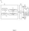
- FIG. 1illustrates a diagram of a location query system in accordance with some embodiments.
- the system 100includes a host server 102 , a communication network 104 , and one or more client devices 106 .
- the host server 102can include a processor 108 , a memory device 110 , an index generation module 112 , and a query response module 114 .
- the host server 102 and the one or more client devices 106can communicate via the communication network 104 .
- the communication network 104can include the Internet, a cellular network, a telephone network, a computer network, a packet switching network, a line switching network, a local area network (LAN), a wide area network (WAN), a global area network, or any number of private networks currently referred to as an Intranet, and/or any other network or combination of networks that can accommodate data communication.
- Such networksmay be implemented with any number of hardware and software components, transmission media and network protocols.
- FIG. 1represents the network 104 as a single network, the network 104 can include multiple interconnected networks listed above.
- a client 106can include a desktop computer, a mobile computer, a tablet computer, a cellular device, or any other computing devices having a processor and memory.
- the client 106can communicate with the host server 102 via the communication network 104 .
- FIG. 1represents the host server 102 as a single server, the host server 102 can include more than one server and can be part of a cloud-computing platform.
- the processor 108 of the host server 102can be implemented in hardware.
- the processor 108can include an application specific integrated circuit (ASIC), programmable logic array (PLA), digital signal processor (DSP), field programmable gate array (FPGA), or any other integrated circuit.
- the processor 108can also include one or more of any other applicable processors, such as a system-on-a-chip that combines one or more of a CPU, an application processor, and flash memory, or a reduced instruction set computing (RISC) processor.
- the memory device 110 of the processor 108can include a computer readable medium, flash memory, a magnetic disk drive, an optical drive, a programmable read-only memory (PROM), and/or a read-only memory (ROM).
- the index generation module 112can be configured to generate an index system for one or more polygons.
- the index generation module 112can maintain the generated index in the memory device 110 or provide the generated index to the query response module 114 .
- the query response module 114can be configured to respond to location queries in real-time. In some cases, the query response module 114 can reside in the host server 102 . In other cases, the query response module 114 can reside in the client device 106 . Also, the index generation module 112 and the query response module 114 need not reside on the same device.
- the index generation module 112 and/or the query response module 114can be implemented in software stored in the memory device 110 .
- the software stored in the memory device 110can run on the processor 108 capable of executing computer instructions or computer code.
- the index generation module 112 and/or the query response module 114can be implemented in hardware using an ASIC, PLA, DSP, FPGA, or any other integrated circuit. In some embodiments, the index generation module 112 and the query response module 114 can both be implemented on the same integrated circuit, such as ASIC, PLA, DSP, or FPGA, thereby forming a system on chip.
- the index generation (“IG”) module 112can be configured to use one or more location identifiers to represent a polygon.
- Location identifierscan be associated with any coordinate systems or hashing systems representing a region. More particularly, a polygon can be tessellated into a set of tiles (also referred to as sub-polygons). Each sub-polygon can cover geographic sub-region based on the desired level of precision, and can be associated with a location identifier.
- a location identifiercan include geohash code associated with a region of a predetermined precision, or size.
- a region associated with a location identifiercan be referred to as a tile or a sub-polygon.
- a region associated with a geohash codecan be referred to as a geohash tile or a geohash sub-polygon.
- location identifierscan be hierarchically organized.
- certain types of location identifierssuch as geohash codes, can use a 32 subdivision system.
- a geohash codecan be associated with a region, that are covered by 32 other geohash codes, and each of the 32 other geohash codes can, in turn, be associated with a region that are covered by a plurality of other geohash codes. Therefore, the geohash codes can be represented as a tree.
- the hierarchy of the location identifierscan be determined based on a variety of factors, for example, a number of bits used to represent a location identifier, a depth of the tree representing the hierarchy of location identifiers, and/or a breadth of the tree representing the hierarchy of location identifiers.
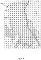
- FIG. 2illustrates how location identifiers can be used to represent a polygon in accordance with some embodiments.
- FIG. 2includes a region of interest, which can include one or more polygons 200 .
- a polygoncan refer a geographic demarcation of an area.
- the polygoncan be represented graphically on a map; in other embodiments, the polygon can be represented by a plurality of subpolygons associated with location identifiers.
- the polygoncan be represented by a plurality of geohash tiles, including a first geohash tile 202 and a second geohash tile 204 , each of which can be associated with a geohash code.
- a geohash tilecan have one of several predetermined sizes.
- the first geohash tile 202is larger than the second geohash tile 204 .
- geohash tilesare used near the periphery of the polygon and larger, lower precision, geohash tiles are used in the interior of the polygon.
- the area of the polygon 200is taken to be the collective area defined by all the tiles that form the polygon.
- FIG. 3also illustrates how location identifiers can be used to represent a polygon in accordance with some embodiments.
- FIG. 3includes a region of interest, which is a polygon 300 having a circular shape surrounding a point of interest at the center of the polygon 300 .
- the polygon 300is represented by a plurality of subpolygons associated with location identifiers.
- the polygon 300is represented by a plurality of geohash tiles, including a first geohash tile 302 and a second geohash tile 304 , and each geohash tile can be associated with one of several predetermined sizes.
- FIG. 3includes a region of interest, which is a polygon 300 having a circular shape surrounding a point of interest at the center of the polygon 300 .
- the polygon 300is represented by a plurality of subpolygons associated with location identifiers.
- the polygon 300is represented by a plurality of geohash tiles, including a first geohash tile 302 and a second
- geohash tilesare used to define the periphery of the polygon 300 and larger, lower resolution, geohash tiles are used in the interior of the polygon 300 .
- the area of the polygon 300is taken to be the collective area defined by all geohash tiles that form the polygon 300 .
- the IG module 112can be configured to identify one or more sub-polygons (e.g., geohash tiles) that collectively represent a region comprising a plurality of polygons.
- the sub-polygon identification for a regioncan involve two steps.
- the first step of the sub-polygon identificationcan include receiving one or more polygons associated with a region.
- These polygonscan be as simple as a coordinate (representing the location of a point-of-interest) enclosed by a circle of a given radius, or more complex shape, like a multi-edged polygon representing a desired geographical area, or a point-of-interest, such as an airport.
- the second step of the sub-polygon identificationcan include generating one or more sub-regions that are enclosed by the region (e.g., assembled polygons).
- a geohash tilecan be defined on a coordinate system, and can be considered a sub-region defined on that coordinate system.
- the IG module 112can be configured to find sub-regions (e.g., geohash tiles), defined on the geohash coordinate system, that are entirely contained within the one of the assembled polygons.
- the IG module 112can be configured to favor a region representation that uses larger sub-regions than smaller sub-regions so that a polygon can be represented with a small number of sub-regions.
- the IG module 112can be configured to identify such sub-polygons in an iterative manner. For example, as a first step, the IG module 112 can be configured to construct a set of geohash tiles having an identical, largest size such that this set of geohash tiles encompasses one or more polygons in the region of interest. Subsequently, the IG module 112 can be configured to test each geohash tile in the set of geohash tiles to determine if the particular geohash tile is completely within the associated polygon (e.g., without crossing the boundary of the associated polygon). If the particular geohash tile is completely within the polygon, the IG module 112 can keep the geohash tile.
- the IG module 112can discard the particular geohash tile. If the particular geohash tile is partially within the polygon (e.g. crossing the boundary of the associated polygon) the IG module 112 can break the particular geohash tile into a plurality of geohash sub-tiles.
- the IG module 112repeats the above process using the geohash sub-tiles. For example, the IG module 112 can determine, for each of the plurality of geohash sub-tiles, whether the sub-tile is completely within the associated polygon. If the sub-tile is completely within the polygon, the IG module 112 can keep the geohash sub-tile. If the sub-tile is completely outside of the polygon, the G1 module 112 can discard the geohash sub-tile. If the sub-tile is partially within the polygon, the IG module 112 can further break the geohash sub-tile into a plurality of smaller tiles and repeat this process.
- the IG module 112can perform this operation iteratively for each geohash tile to see if it ‘fits’ (i.e. does not intersect) the polygon, and if not, it recursively decreases the size of the geohash tile (e.g., increases the precision) to achieve a fit.
- the geohash tilesthere is a maximum level of precision defined for the geohash tiles (e.g., the smallest geohash tile that can be used to model the polygon), thereby providing a proper balance between the number of tiles and the level of fit for producing a good index. If a tile is reduced to the minimum size (e.g., the maximum precision) but still intersects the desired polygon, it is considered to be inside the polygon and included in the index.
- a location identifier associated with a sub-polygoncan include a geohash code (e.g., a geohash code of the type defined in http://geohash.org/).
- a geohash codeis a hierarchical spatial data structure that subdivides a region into tiles.
- a geohash codecan include a sequence of bits that substantially uniquely identifies a location. In some cases, the sequence of bits can be encoded or can represent a sequence of characters.
- An example of a geohash codeis a character sequence, “8z4fg.”
- a set of geohash codescan exhibit hierarchical characteristics.
- shorter geohash codescan be associated with a lower precision (e.g., shorter geohash codes are associated with larger geographic areas) whereas longer geohash codes can be associated with a higher precision (e.g., longer geohash codes are associated with smaller geographic areas).
- nearby locationsare often associated with similar prefixes.
- the geohash codes that begin with the same characterscan refer to the same geographic area.
- Two geohash codes that share a large number of prefix charactersare associated with two locations that are in proximity.
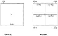
- FIGS. 4A-4Billustrate properties of geohash codes and tiles in accordance with some embodiments.
- FIG. 4Ashows a geohash tile 402 corresponding to a geohash code “8z4fg.”
- FIG. 4Bshows four geohash tiles 404 A- 404 D.
- FIG. 4Balso shows the geohash code associated with each tile (e.g., “8z4fgf” is the geohash code for time 404 A).
- the four geohash tiles 404 A- 404 Dcollectively cover the same area as the geohash tile 402 .
- the four geohash tiles 404 A- 404 Drepresent four sub-divisions of the geohash tile 402 .
- the X at the center of FIG. 4Brepresents the same geographical coordinate as the X
- the geohash codes for the four geohash tiles 404 A- 404 Dcan be longer than the geohash code for the geohash tile 402 , and the geohash codes for the four geohash tiles 404 A- 404 D can share characters with the geohash code for the geohash tile 402 .
- the geohash codes of the geohash tiles 404 A- 404 Dcan be each six characters long, whereas the geohash code the geohash tile 402 can be five characters long.
- geohash codes shown in FIG. 4Bbegin with the five character sequence “8z4fg”, which is identical to the geohash code of the geohash tile 402 .
- the use of hierarchical encoding schemes for location identifierssuch as geohash codes, offer useful properties, such as an arbitrary precision (e.g., by adding as many characters as needed), a locality (e.g., similar prefixes are associated with nearby positions), and the ability to reduce precision (or increase an area coverage) by removing one or more characters from the end of the geohash code while still maintaining the spatial locality.
- useful propertiessuch as an arbitrary precision (e.g., by adding as many characters as needed), a locality (e.g., similar prefixes are associated with nearby positions), and the ability to reduce precision (or increase an area coverage) by removing one or more characters from the end of the geohash code while still maintaining the spatial locality.
- FIG. 5illustrates a tree of geohash codes in accordance with some embodiments.
- the tree of geohash codes (also referred to as a geohash tree) 500relates to the geohash tiles illustrates in FIGS. 4A-4B .
- a geohash tree 500can include branch nodes, such as a node 502 , and leaf nodes, such as a node 504 .
- a nodeis a branch node if it connects to a lower node (either a lower branch node or a leaf node). For example, the branch node 502 connects to another branch node 506 .
- a nodeis a leaf node if it does not connect to any lower nodes.
- the node 504is a leaf node because it does not connect to any lower nodes.
- Some of the nodes in FIG. 5can be associated with a geohash tile in FIG. 4 .
- the node 508can be associated with the geohash tile in FIG. 4A .
- the nodes 510 , 512 , 514 , and 504can be associated with the geohash tiles 404 A, 404 B, 404 C, and 404 D, respectively.
- FIGS. 6A-6Dillustrate two collections of geohash tiles and the associated tree in accordance with some embodiments.
- FIG. 6Ashows a single “large” geohash tile 602
- FIG. 6Bshows a set of smaller geohash tiles, including tiles 604 , 606 .
- the dashed peripheryis the same size as that of the large tile 602 shown in FIG. 6A .
- FIG. 6Brepresents a case in which the large tile 602 does not fit a polygon well and so was split up into smaller tiles, including 604 , 606 , as previously discussed with respect to FIGS. 2-3 .
- the single large tile 602can be represented as a tree structure that includes only one single leaf node 608 , as illustrated in FIG.
- the set of tiles shown in FIG. 6Bcan be represented as a tree structure that includes both branch node 608 and leaf nodes 610 , 612 , 614 , 616 , as illustrated in FIG. 6D .
- the IG module 112can generate one or more tree structures that describe the collection of geohash tiles in the polygon. The IG module 112 can repeat this process for each set of geohash tiles in each polygon of interest.
- the IG module 112can merge multiple geohash trees so that multiple geohash trees can be represented using a compact representation. This feature can be useful when two or more computers are configured to generate multiple geohash trees in a distributed manner, for example, simultaneously.
- a lower precision geohash tile that encompasses other higher precision geohash tilescan be marked as a leaf, while the higher precision geohash tiles are discarded from the geohash tree.
- the net resultis an optimized set of different precision geohash tiles that can be used to represent the set of disjoint polygons that make up a specified geo-targeted advertising campaign.
- This merging operationdoes not necessarily lose precision information because, if regions not covered by the higher precision geohash tiles are within the polygon according to a first geohash tree, there is no need to differentiate regions in the higher precision geohash tiles and regions outside of the higher precision geohash tiles.
- FIGS. 7A-7Cillustrate a merging of the trees in accordance with some embodiments.
- FIGS. 7A-7Billustrate two trees.
- the first tree 702corresponds to a first polygon in the region of interest;
- the second tree 706corresponds to a second polygon in the region of interest.
- the first tree 702includes a geohash tile “4fg” 704
- the second tree 706includes subtiles of the geohash tile 704 . Therefore, the region of interest includes both the geohash tile “4fg” 704 , as indicated by the first tree 702 , and the subtiles of the geohash tile 704 , as indicated by the second tree 706 .
- the IG module 112can merge these two trees to generate a third tree 708 in which the subtiles of the geohash tile 704 is subsumed by the geohash node 704 . Therefore, the third tree 708 can represent the region of interest having both the first polygon and the second polygon with a less number of nodes in the tree compared to the combined number of nodes in the first tree 702 and the second tree 706 .
- the IG module 112can use the merged geohash tree to generate an index system for the geohash tiles.
- the IG module 112can generate the index system by walking down the geohash tree from the top branch node to the leaf nodes in hierarchical order.
- the IG module 112can reduce the resolution of a geohash tree to reduce the size of the geohash tree and to increase the query speed of the index system associated with the geohash tree. For example, referring to FIG. 7B , the IG module 112 can truncate, in the geohash tree 706 , all nodes below the “g” node 704 . This way, the IG module 112 can reduce the size of the geohash tree 706 at the expense of reducing the resolution of the polygon represented by the geohash tree 706 .
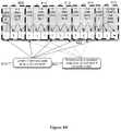
- FIGS. 8A-8Billustrate a mechanism for generating the geohash tile index system in accordance with some embodiments.
- FIG. 8Aillustrates a geohash tree 800 associated with three geohash tiles: a first geohash tile 802 with a geohash code “9q5d”, a second geohash tile 804 with a geohash code “9q5dt”, and a third geohash tile 806 with a geohash code “9q5dw.”
- the IG module 112can walk down the geohash tree 800 recursively to generate the geohash index system, as illustrated in FIG. 8B .
- the IG module 112can start from the top (e.g., the root node) of the tree 800 , and, at each stage (e.g., each level of the tree or a geodesic distance level from the root node), emit an index corresponding to the value of the node at that stage.
- the tope.g., the root node
- each stagee.g., each level of the tree or a geodesic distance level from the root node
- the IG module 112can generate “9” as an index, since “9” is the value of the root node of the tree 800 . Then the IG module 112 can walk down to the next node (e.g., the next level) and generate “q” as an index. Then the IG module 112 can walk down to the next node and generate “5” as an index. Then the IG module 112 can walk down to the next node and generate “d” as an index. Then the G1 module 112 can walk down to the next node and generate “t” and “w” as indices associated with that level. In some embodiments, the IG module 112 can walk the tree in a depth-first-search manner; in other embodiments, the IG module 112 can walk the tree in a breadth-first-search manner.
- FIG. 8Billustrates the generated geohash index system based on the geohash tree of FIG. 8A .
- the geohash index systemcan be represented using a flat hierarchical data representation.
- the flat hierarchical data representationcan include a jump table.
- the jump tableis, in effect, an unrolled representation (e.g., rasterized representation) of the geohash tree 800 .
- the unrolled representationcan be a single-layer data structure that can expedite the search for relevant information.
- the flat hierarchical data representationcan include a skip list.
- the geohash index systemcan be represented as a plurality of data structure nodes 808 - 816 .
- Each data structure nodecan correspond to a set of nodes at the same level (e.g., the same distance from the root node) in the corresponding tree.
- all nodes in level 3can be represented as a data structure node 814 having three values: the length of the geohash nodes in the tree at the current level 818 , the value(s) 822 of the geohash nodes in the tree at the current level 818 , and the number of “jumps” 820 to be performed to reach the data structure corresponding to the geohash nodes in the tree at the next level.
- An alternative approach to encoding the datais to populate a probabilistic data structure, such as a bloom filter. Both approaches have merit and offer different tradeoffs.
- the flattened index approach described abovehas the characteristics of giving a more deterministic answer to the question, but at a potentially increased memory footprint when compared to the bloom filter approach.
- the bloom filteris potentially more compact and would not require merging tree structures but has a probabilistic margin of error and thus can return false positives and also has a greater impact of the processor's ability to prefetch memory pages.
- An alternative approach to encoding the datais to use a hash table.
- the IG module 112can store the geohash index system in the memory device 110 . Subsequently, the query response (“QR”) module 114 can use the stored geohash index system to serve location queries from clients 106 .
- QRquery response
- FIG. 9illustrates a process used by the QR module 114 for serving location queries in accordance with some embodiments.
- the QR module 114can be configured to receive a location query from a client 106 , requesting the QR module 114 to determine whether the client 106 is within a polygon.
- the location querycan include the location identifier of the client 106 , indicating a location of the client 106 .
- the location identifiercan take the form of a coordinate, for example, (longitude, latitude) pair.
- the client 106can determine its location identifier based on a location determination mechanism.
- the location determination mechanismcan include a Global Positioning System (GPS) technique, a cellular tower triangulation technique, an Internet Protocol (IP) address-based location determination technique, and/or any other suitable techniques for determining the location of the client 106 .
- GPSGlobal Positioning System
- IPInternet Protocol
- the QR module 114can be configured to convert the location identifier into a geohash code.
- the QR module 114can be configured to generate the highest-precision query geohash code corresponding to the location identifier (e.g., a geohash code that most precisely identifies a location associated with the location identifier.)
- the precision of the query geohash codecan be higher than the maximum precision level of geohash codes summarized by the geohash index system.
- the QR module 114can compare the query geohash code to the geohash index system, and in step 908 , the QR module 114 can determine, based on the comparison, whether the received location identifier is within a polygon modeled by the geohash index system. If the received location identifier is within the polygon, then in step 910 , the QR module 114 can provide the identifier of the polygon that matched to the location identifier (e.g., so as to match the received location identifier with a particular advertising campaign). If the received location identifier is not within the polygon, then in step 912 , the QR module 114 can indicate that the received location identifier does not correspond to the polygon.
- the host server 102can cause an advertisement associated with that polygon to be sent to the client 106 .
- this systemallows such processing for multiple location identifier received from multiple clients 106 to be performed quickly to determine whether the location identifiers provided by the client devices 106 are in any of the polygons.
- the QR module 114can determine whether the received location identifier is within an polygon modeled by the geohash index system by comparing the query geohash code of the location identifier to the geohash index system.
- the QR module 114can be configured to compare characters corresponding to larger geohash tiles (e.g., lower-precision geohash tiles) before comparing characters corresponding to smaller geohash tiles (e.g., higher-precision geohash tiles.)
- the QR module 114can retrieve the first character of the query geohash code and compare the first character to the root node (e.g., the highest node) in the geohash index system, modeled by the jump table and offsets.
- the QR module 114can determine if the one of the root nodes represents a leaf node. If so, the QR module 114 can indicate that the query geohash code is associated with a polygon modeled by the index system and move to step 910 . If the one of the root nodes does not represent a leaf node, the QR module 114 can move to the next character (e.g., a character adjacent to the first character), and compare the new character with values in one or more nodes coupled to the one of the root nodes (e.g., one or more children of the one of the root nodes.)
- the next charactere.g., a character adjacent to the first character
- the QR module 114does not find a match between a character and a value of the nodes in the level (e.g., the depth level of the geohash tree) corresponding to the character, or (2) the QR module 114 reaches the leaf node. If, at any point in walking down the geohash tree, the QR module 114 reaches a node where the character of the query geohash code does not match the values in the geohash index system, then the QR module 114 can declare a no-match and proceed to step 912 .
- the levele.g., the depth level of the geohash tree
- the QR module 114can indicate a match between the query geohash code and the geohash index system, and proceed to step 910 . If the QR module 114 reaches the leaf node and the value of the leaf node does not match a corresponding character in the query geohash code, then the QR module 114 can indicate a no-match between the query geohash code and the geohash index system and proceed to step 912 .
- FIG. 10illustrates a process for comparing a query geohash code to a geohash index system in accordance with some embodiments.
- the QR module 114can communicate with the geohash index system 1002 to determine whether a query geohash code “9q5f” 1004 is within a polygon modeled by the geohash index system 1002 .
- the QR module 114can take the first character “9” of the query geohash code 1004 and compare it against the root data structure 808 of the geohash index system 1002 . Since the value of the first character “9” matches the value of the root data structure 808 , the QR module 114 can move onto the second data structure 810 .
- the QR module 114can take the second character “q” of the query geohash code 1004 and compare against the second data structure 810 of the geohash index system 1002 . Since the value of the second character “q” matches the value of the second data structure 810 , the QR module 114 can move onto the third data structure 812 .
- the QR module 114can take the third character “6” of the query geohash code 1004 and compare against the third data structure 812 of the geohash index system 1002 . Since the value of the third character “6” does not match the value of the third data structure 812 , the QR module 114 can determine that the query geohash code 1004 is not within the polygon modeled by the geohash index system 1002 .
- the QR module 114will find a match at each data structure node in the geohash index system 1002 , and therefore, the QR module 114 would indicate that the location corresponding to the query geohash code is “9q5dt” is within the polygon modeled by the geohash index system 1002 .
- a single comparison between the query geohash code and the geohash treecan be sufficient reveal whether the receive location identifier is within a polygon. For example, if the query geohash code of the location identifier lies within a tree having only a single leaf node, then the comparison of the first character of the query geohash code to the tree structure can reveal a hit and it will be known that the client 106 is located within an area of interest.
- FIG. 11Aillustrates a scenario in which a single comparison can reveal a hit in accordance with some embodiments.
- the rectangle 1102corresponds to a single geohash tile, which is represented as a tree structure containing only a single leaf, as illustrated in FIG. 6C .
- 11Arepresents the location of the client 106 from which the location identifier is received. Due to the nature of query geohash codes, the first character of the client's geohash code is identical to the first character of the geohash code corresponding to the geohash tile 1102 . Therefore, a comparison of the first character of the client's query geohash code to the top level of the geohash tree can reveal a match.
- FIG. 11Billustrates a scenario in which multiple comparisons may be needed to reveal a hit in accordance with some embodiments.
- the set of geohash tilesis not represented by a single leaf. Rather, the geohash tree for that set of tiles includes multiple nodes, some of which are branches and others of which are leafs, as illustrated in FIG. 6D .
- the process of determining whether the receive location identifier is within an polygonincludes comparing the query geohash code of the location identifier to the geohash tree, one character at a time, from the top node of the geohash tree to the bottom node of the geohash tree. If the first (e.g., the most significant) character of the query geohash code matches one of the geohash trees in the index system, then the query geohash code is compared against that tree structure's lower nodes, one node at a time.
- the QR module 114can move to step 914 , indicating that the location identifier is not within an polygon. Any mismatch means the phone does not lie within the area of interest.
- the QR module 114reaches the leaf node and the character in the leaf node matches the corresponding character in the query geohash code, then the QR module 114 can indicate that the location identifier is within the polygon modeled by the geohash tree.
- the index system(e.g., the geohash tree) is designed to yield fast comparison performance, returning an answer in microseconds using a single core of a commodity server.
- the index systemcan be designed to be re-entrant, so lookups can scale out and take advantage of all available cores in the system without any adverse performance impacts due to lock conflicts.
- the index systemcan include information on polygons corresponding to each geohash tile modeled by the index system.
- the IG module 112can determine a list of all polygons that includes a particular geohash tile, and associate that list to the leaf node corresponding to the particular geohash tile. This way, the index system can maintain a correspondence between a geohash tile and all polygons that includes the geohash tile.
- the QR module 114finds a match between a query geohash code and the index system, the QR module 114 can return not only an identifier associated with the polygon, but also the specific polygons within the polygon that contributed to the match between the query geohash code and the index system.
- a polygoncan include one or more group identifiers.
- Group identifierscan, for example relate to a campaign for advertisements.
- a campaigncan include a plurality of polygons that collectively define areas to which a particular advertisement campaign can be targeted.
- Each campaigncan be associated with an identifier that identifies the associated advertisement.
- an index system corresponding to a campaigncan be stored in a single file.
- Each campaign filemay contain many thousands of individual polygons (also referred to as geofences). For example, a campaign file can include all McDonalds' locations within a 10 km radius of New York Penn Station.
- the IG module 112can be configured to merge multiple indices into a single index. In some embodiments, the IG module 112 can be configured to remove a group from an existing index system. For example, the IG module 112 can traverse the existing index system (e.g., the tree), remove geohash codes associated with the group to be removed, and recursively rebuild the portion of the existing index system (e.g., a sub-tree) with the remaining geohash codes.
- the existing index systeme.g., the tree
- the portion of the existing index systeme.g., a sub-tree
- the IG module 112can provide the geohash index system to the client 106 so that the client 106 can directly serve location queries from other devices, such as mobile devices.
- the IG module 112can use a delta compression technique to provide only modified parts of the geohash index system to the client 106 .
- the client 106can use double buffering techniques to change its current index system to bring it up to date with the new geohash index system, without impacting existing query performance. For example, the client 106 can maintain the current index system in memory and then load the new index system into memory while still processing requests by based on the current index system.
- a pointer to the current index systemcan instead reference the new index system such the requests are processed by referencing the new index system.
- the current index systemcan be deallocated from memory. To accommodate these processes, it may be desirable for the client 106 to have enough memory to store both the current index system and the new index system.
- the host server 102can provide an application programming interface (API) or web interface to allow advertisement service entities to create a geohash index system for advertisement.
- APIapplication programming interface
- the API or web interfacecan allow the entities to generate a group using simple query criteria such as ‘within a 1 mile radius of businesses of type x in region y’.
- the host server 102can use the above described method to generate the index system for the group.
- the index systemcan be represented as an index file. Then the host server can transmit the index file to clients 106 (e.g., group (e.g.
- the IG module 112can be configured to generate an index system that is capable of returning a set of polygons intersecting with a particular location.
- an index systemcan be useful in a variety of applications.
- such an index systemcan facilitate a mechanism for providing information and grouping identifiers of a particular location, collectively referred to as a payload data of a particular location.
- the QR module 114can use such an index system to determine one or more identifiers of polygons associated with the particular location and to use the one or more identifiers of polygons to retrieve the payload data for the particular location from a database.
- a grouping identifiercan be associated with a group of polygons to be represented together.
- the grouping identifiercan be useful to associate the same property to each of the polygons identified in the group of polygons.
- an advertising campaign by Carl's Jrcan target its advertisement to users who are near either a McDonald's restaurant or a Burger King restaurant.
- the advertising campaigncan be tagged with a campaign identifier “carls”; one or more polygons associated with the McDonald's restaurant can be tagged with a grouping identifier “mcd”; and one or more polygons associated with the Burger King restaurant can be tagged with a grouping identifier “bk”.
- the grouping identifiers “mcd” and “bk”can be associated with the advertising campaign identifier “carls.” Subsequently, when an advertiser wants to post advertisements for Carl's, the advertiser can use the association between the campaign identifier “carls” and the grouping identifiers “mcd” and “bk” to identify all polygons to be associated with the advertisement campaign.
- FIG. 12illustrates a process for building an index system that is capable of returning a set of polygons intersecting with a particular location in accordance with some embodiments.
- the index systemcan represent one or more regions of interest, where each region of interest can include one or more polygons, and each polygon can be associated with a unique polygon identifier.
- the polygon identifiercan include a string of characters, e.g., including numbers, which refers to a specific polygon.
- the polygon identifiercan be a UUID having, for example, 128 bits, or an integer having, for example, 32 or 64 or some other number of bits.
- the polygon identifiercan point to a specific entity of interest, for example, a specific McDonald's restaurant at a specific address rather than McDonald's restaurants in general, which may be represented by an index or a group identifier.
- the IG module 112When the IG module 112 is configured to generate an index system for one region of interest, the IG module 112 is configured to generate an index system for that region by iterating steps 1202 - 1206 . When the IG module 112 is configured to generate an index system for more than one region of interest, the IG module 112 is configured to generate an index system for each region independently by iterating steps 1202 - 1206 , and consolidate the index systems for each region as a post-processing step in step 1208 .
- the index system for a regioncan have a tree structure. Therefore, the index system for a region can be referred to as an index tree.
- a node in the index treecan be associated with a sub-region of a region.
- Each node in the index treecan also be associated with one or more identifiers of polygon(s) that intersect with the sub-region associated with the node.
- the IG module 112is configured to process the index tree so that one or more polygon identifiers associated with a node can be represented succinctly.
- the IG module 112has a mechanism for declaring a particular polygon identifier as a leaf identifier.
- the IG module 112declares a particular polygon identifier as a leaf identifier at a particular node, then all children nodes of the particular node are deemed to be associated with the particular polygon identifier. This way, the IG module 112 obviates the need to explicitly associate the leaf identifier with every child node, thereby reducing redundant associations of polygon identifiers in the index tree.
- the IG module 112is configured to represent (e.g., tessellate) a polygon in a region using a plurality of tiles (e.g., sub-polygons).
- a sub-polygonis designed to cover an area whose size depends on a predetermined level of precision associated with the sub-polygon. For example, when the precision is low, the sub-polygon covers a large area; when the precision is high, the sub-polygon covers a small area.
- the IG module 112is also configured to associate a sub-polygon with an identifier of the polygon from which the sub-polygon is derived. For example, when a polygon is divided into 32 sub-polygons, each of the sub-polygons is associated with a polygon identifier of the original polygon. If a region includes more than one polygon, this process is repeated for each polygon in the region. Therefore, a single sub-polygon can be associated with a plurality of polygon identifiers. Subsequently, the sub-polygons used to represent polygons in the region can be grouped together to represent the region.
- the IG module 112is configured to recursively subdivide the region into sub-regions and associate each sub-region with a polygon identifier covering the sub-region. More particularly, the IG module 112 is first configured to identify one or more unique identifiers of polygons in the region. Then, the IG module 112 is configured to iteratively subdivide the region into sub-regions (and sub-regions into smaller sub-regions), and assign one or more of the unique polygon identifiers to a sub-region if the sub-region intersects with polygons represented by the unique polygon identifiers. Since each sub-polygon is associated with one or more polygon identifiers, the IG module 112 can determine a set of polygon identifiers associated with each sub-region.
- FIGS. 13A-13Dillustrate a process of building an index tree corresponding to a region in accordance with some embodiments.
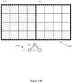
- FIG. 13Aillustrates a region 1300 that includes a plurality of tiles (e.g., sub-polygons, illustrated as small squares), where each tile is associated with a location identifier, such as a geohash code.
- the region 1300can represent one or more polygons that are illustrated using dotted tiles.
- a dotted tile 1304indicates a tile that belongs to one or more polygons in the region 1300 ; an empty tile 1306 indicates a tile that is outside of one or more polygons in the region 1300 .
- the following exemplary descriptionsdeem the region 1300 to include a single polygon 1302 , but the descriptions are also applicable to cases in which the region 1300 includes multiple polygons.
- the IG module 112can instantiate an index tree 1308 with a single root node corresponding to the entire region 1300 .
- FIG. 13Billustrates the region 1300 and the index tree 1308 having a single root node 1310 corresponding to the entire region 1300 .
- the IG module 112can subdivide the region 1300 into two sub-regions 1312 , 1314 , and add nodes 1316 , 1318 corresponding to the sub-regions 1312 , 1314 .
- the IG module 112can associate the nodes 1316 , 1318 with polygon identifiers of polygons that intersect with the sub-regions 1312 , 1314 , respectively.
- the IG module 112can determine whether a polygon covers an entire area represented by a sub-region 1312 or 1314 . If so, the IG module 112 can mark the polygon identifier of that polygon as a leaf identifier for that sub-region (or a node corresponding to that sub-region), which indicates that all sub-trees rooted at that sub-region include that leaf polygon identifier. In the example shown in FIG. 13B , every tile in the sub-region 1312 includes the same polygon identifier corresponding to the polygon 1302 . Therefore, the polygon 1302 covers an entire area represented by the sub-region 1312 . Thus, the polygon identifier corresponding to the polygon 1302 in the node 1316 is a leaf identifier at the node 1316 .
- the IG module 112can stop building the index tree 1308 for the sub-region corresponding to that node (e.g., stop sub-dividing the sub-region corresponding to that node).
- the IG module 112can stop sub-dividing the sub-region 1312 corresponding to the node 1316 .
- not every tile in the sub-region 1314includes the same polygon identifier corresponding to the polygon 1302 .
- the IG module 112is configured to further sub-divide the sub-region 1314 .
- FIG. 13Cillustrates a division of the sub-region 1314 into sub-regions 1320 , 1322 , 1324 , and 1326 . Because only the sub-regions 1324 , 1326 include a tile of the polygon 1302 , the IG module 112 is configured to generate only two additional nodes 1328 , 1330 in the index tree 1308 associated with the sub-regions 1324 , 1326 , respectively, and discard sub-regions 1320 , 1322 from further processing.
- the IG module 12can stop sub-dividing the sub-region 1324 corresponding to the node 1328 . Every tile in the sub-region 1324 includes the polygon identifier of the polygon 1302 . Therefore, the polygon identifier of the polygon 1302 in the node 1328 is a leaf identifier. Furthermore, since the region 1300 includes only a single polygon 1302 , all polygon identifiers associated with the node 1328 is a leaf identifier. Therefore, the IG module 112 can stop sub-dividing the sub-region 1324 corresponding to the node 1328 .
- the IG module 112is configured to further sub-divide the sub-region 1326 . Not every tile in the sub-region 1326 includes the polygon identifier of the polygon 1302 . For example, some of the tiles in the sub-region 1326 does not intersect with the polygon 1302 . Therefore, at least one of the polygon identifiers in the node 1330 is not a leaf polygon identifier. Therefore, the IG module 112 is configured to further sub-divide the sub-region 1326 .
- FIG. 13Dillustrates a division of the sub-region 1326 into sub-regions 1332 , 1334 , 1336 , and 1338 .
- the IG module 112is configured to add two additional nodes 1340 , 1342 to the index tree 1308 , corresponding to sub-regions 1336 , 1338 , respectively.
- the IG module 112can be configured to traverse the index tree 1308 from the leaf nodes (e.g., nodes 1340 , 1342 ) to the root node (e.g., node 1310 ) to reduce the number of polygon identifiers associated with the index tree 1308 .
- the IG module 112is configured to determine whether all children nodes of a particular node (also referred to as a parent node) share the same polygon identifier.
- the IG module 112is configured to remove that polygon identifier from all children nodes, associate the parent node with that polygon identifier, and declare that polygon identifier as the leaf identifier at the parent node. This reduction process can reduce the number of polygon identifiers at the highest precision nodes (e.g., nodes furthest away from the root node).
- the IG module 112can reduce a number of bits used to represent a polygon identifier in the index tree. To this end, the IG module 112 is configured to present a polygon identifier in a child node as an offset into a set of polygon identifiers in the parent node.
- the IG module 112can be configured to represent the polygon identifiers in the child node as an index into the three polygon identifiers in the parent node. Under this scheme, the IG module 112 can represent the two polygon identifiers in the child node as [1, 3]. This representation can reduce the number of bits used to represent polygon identifiers in the index tree.
- the IG module 112can encode the index tree (e.g., the polygon identifiers in each node of the index tree, the set of leaf polygon identifiers) into an index system, as illustrated in FIG. 8B in accordance with some embodiments.
- the index treee.g., the polygon identifiers in each node of the index tree, the set of leaf polygon identifiers
- the IG module 112can encode all the payload data associated with the region so that the data associated with the region (or a polygon within the region) can be retrieved quickly.
- the IG module 112is configured to encode each level's data into a separate substream, including a sub-index or an independent portion of the index.
- the IG module 112can write out this substream data (for each level in the index tree) at the head of the total payload data representing the entire region represented by the index tree.
- the IG module 112can write out all polygon identifiers represented within the given region.
- the IG module 112can encode the hierarchical region/sub-region index tree, using a technique such a geohash encoding. These operations can complete the index generation process and the payload database generation process for a region.
- the IG module 112can repeat steps 1202 - 1206 for each region of interest, and generate an index system for each region. Once the index system for each region is constructed, in step 1208 , the IG module 112 is configured to merge the index systems into a single master index system so that the single master index system can represent all regions of interest.
- the single master index systemcan have a tree structure, and the tree structure can be based on geohash codes. Each leaf node of the single master index system can correspond to a region-level index system generated in steps 1202 - 1206 .
- the index generation process of FIG. 12is beneficial because region-level index systems can be generated in parallel using a distributed computing system. Since regions can be independent of one another, the IG module 112 can assign a single computer to generate an index system for one region without worrying about an index system for another region. This allows for a parallel computation of region-level index systems, thereby providing a computationally scalable mechanism for generating indices for many regions of interest. Furthermore, the index generation process of FIG. 12 allows the IG module 112 to quickly update the index system by building and encoding the index tree of only the region that needs to be updated.
- the QR module 114can use the master index system generated by the IG module 112 , as illustrated in FIG. 12 , to respond to a location query from a client.
- the QR module 114can use the master index system to determine one or more polygons intersecting a location identified in the location query and provide any payload data associated with the one or more polygons to the client.
- FIG. 14illustrates a process 1400 for responding to a location query in accordance with some embodiments.
- the QR module 114receives the location query and extracts a location identifier, such as a [latitude, longitude] pair or a geohash code, from the location query.
- the location associated with the location identifieris referred to as a target location.
- the QR module 114can identify the region that includes the target location, and retrieve, from the master index system, the region-level index system corresponding to that region.
- the QR module 114can allocate memory space to hold the set of polygon identifiers represented by the region, as encoded in the index tree corresponding to the region.
- the memory spacecan be used to hold identifier(s) of polygon(s) that intersect with the target location.
- the QR module 114can walk down the region-level index system to find sub-regions of the region that also intersect with the target location. As the QR module 114 traverses down the index tree, at each node during the traversal, the QR module 114 can collect leaf polygon identifiers associated with the node. Then the QR module 114 can narrow the potential set of potential leaf identifiers that might be found in subsequent iterations. For example, as the QR module 114 walks down the node hierarchy of the index tree, the set of polygon identifiers relevant to a particular node corresponding to a particular sub-region is restricted to the polygon identifiers associated with the parent node of the particular node.
- the QR module 114can terminate the traversal of the region-level index system.
- the resulting set of leaf polygon identifiersrepresents the set of polygons intersecting the location identifier.
- the QR module 114can retrieve payload data associated with the polygons using their identifiers. For example, the QR module 114 can request a database table or a hash table to retrieve any data, such as the name or address, associated with a particular polygon identifier. Subsequently, the QR module 114 can provide, to the client that sent the location query, the set of polygon identifiers associated with the target location and any retrieved data associated with the polygons.
- a regioncan be represented by any type of a location identifier associated with a hierarchical location identifier system, including, for instance, a hash-based location identifier and/or a quad tree-based location identifier.
- a concatenation of a location identifier, associated with a region, with one additional bitcan refer to one of a predetermined number of sub-regions contained within the region.
- a concatenation of a location identifier, associated with a region, with one additional bitcan refer to one of 4 sub-regions, 8 sub-regions, or 16 sub-regions contained within the region.
- a concatenation of a location identifier, associated with a region, with one additional sequence of bits or one additional charactercan refer to one of 4 sub-regions, 8 sub-regions, or 16 sub-regions contained within the region.
- a regioncan be represented by any type of a location identifier that can be associated with a particular geographic/physical precision.
- a data structuresuch as a probabilistic data structure including a bloom filter, may be associated with one of a predetermined set of precisions (e.g. 1 m, 3 m, 5 m, and 10 m) and can encode a location identifier associated with the one of the predetermined set of precisions in, for example, as few bits as possible.
- the client 106can include user equipment of a cellular network.
- the user equipmentcommunicates with one or more radio access networks and with wired communication networks.
- the user equipmentcan be a cellular phone having phonetic communication capabilities.
- the user equipmentcan also be a smart phone providing services such as word processing, web browsing, gaming, e-book capabilities, an operating system, and a full keyboard.
- the user equipmentcan also be a tablet computer providing network access and most of the services provided by a smart phone.
- the user equipmentoperates using an operating system such as Symbian OS, iPhone OS, RIM's Blackberry, Windows Mobile, Linux, HP WebOS, and Android.
- the screenmight be a touch screen that is used to input data to the mobile device, in which case the screen can be used instead of the full keyboard.
- the user equipmentcan also keep global positioning coordinates, profile information, or other location information.
- the client 106also includes any platforms capable of computations and communication. Non-limiting examples can include computers, netbooks, laptops, servers, and any equipment with computation capabilities.
- the client 106is configured with one or more processors that process instructions and run software that may be stored in memory.
- the processoralso communicates with the memory and interfaces to communicate with other devices.
- the processorcan be any applicable processor such as a system-on-a-chip that combines a CPU, an application processor, and flash memory.
- the client 106can also provide a variety of user interfaces such as a keyboard, a touch screen, a trackball, a touch pad, and/or a mouse.
- the client 106may also include speakers and a display device in some embodiments.
- the host server 102can reside in a data center and form a node in a cloud computing infrastructure.
- the host server 102can also provide services on demand.
- a module hosting a clientis capable of migrating from one server to another server seamlessly, without causing program faults or system breakdown.
- the host server 102 on the cloudcan be managed using a management system.
- the subject matter described hereincan be implemented in digital electronic circuitry, or in computer software, firmware, or hardware, including the structural means disclosed in this specification and structural equivalents thereof, or in combinations of them.
- the subject matter described hereincan be implemented as one or more computer program products, such as one or more computer programs tangibly embodied in an information carrier (e.g., in a machine-readable storage device), or embodied in a propagated signal, for execution by, or to control the operation of, data processing apparatus (e.g., a programmable processor, a computer, or multiple computers).
- a computer program(also known as a program, software, software application, or code) can be written in any form of programming language, including compiled or interpreted languages, and it can be deployed in any form, including as a stand-alone program or as a module, component, subroutine, or other unit suitable for use in a computing environment.
- a computer programdoes not necessarily correspond to a file.
- a programcan be stored in a portion of a file that holds other programs or data, in a single file dedicated to the program in question, or in multiple coordinated files (e.g., files that store one or more modules, sub-programs, or portions of code).
- a computer programcan be deployed to be executed on one computer or on multiple computers at one site or distributed across multiple sites and interconnected by a communication network.
- processors suitable for the execution of a computer programinclude, by way of example, both general and special purpose microprocessors, and any one or more processor of any kind of digital computer.
- a processorwill receive instructions and data from a read-only memory or a random access memory or both.
- the essential elements of a computerare a processor for executing instructions and one or more memory devices for storing instructions and data.
- a computerwill also include, or be operatively coupled to receive data from or transfer data to, or both, one or more mass storage devices for storing data, e.g., magnetic, magneto-optical disks, or optical disks.
- Information carriers suitable for embodying computer program instructions and datainclude all forms of non-volatile memory, including by way of example semiconductor memory devices, (e.g., EPROM, EEPROM, and flash memory devices); magnetic disks, (e.g., internal hard disks or removable disks); magneto-optical disks; and optical disks (e.g., CD and DVD disks).
- semiconductor memory devicese.g., EPROM, EEPROM, and flash memory devices
- magnetic diskse.g., internal hard disks or removable disks
- magneto-optical diskse.g., CD and DVD disks
- optical diskse.g., CD and DVD disks.
- the processor and the memorycan be supplemented by, or incorporated in, special purpose logic circuitry.
- the subject matter described hereincan be implemented on a computer having a display device, e.g., a CRT (cathode ray tube) or LCD (liquid crystal display) monitor, for displaying information to the user and a keyboard and a pointing device, (e.g., a mouse or a trackball), by which the user can provide input to the computer.
- a display devicee.g., a CRT (cathode ray tube) or LCD (liquid crystal display) monitor
- a keyboard and a pointing devicee.g., a mouse or a trackball
- Other kinds of devicescan be used to provide for interaction with a user as well.
- feedback provided to the usercan be any form of sensory feedback, (e.g., visual feedback, auditory feedback, or tactile feedback), and input from the user can be received in any form, including acoustic, speech, or tactile input.
- modulesrefers to computing software, firmware, hardware, and/or various combinations thereof. At a minimum, however, modules are not to be interpreted as software that is not implemented on hardware, firmware, or recorded on a non-transitory processor readable recordable storage medium. Indeed “module” is to be interpreted to include at least some physical, non-transitory hardware such as a part of a processor or computer. Two different modules can share the same physical hardware (e.g., two different modules can use the same processor and network interface). The modules described herein can be combined, integrated, separated, and/or duplicated to support various applications.
- a function described herein as being performed at a particular modulecan be performed at one or more other modules and/or by one or more other devices instead of or in addition to the function performed at the particular module.
- the modulescan be implemented across multiple devices and/or other components local or remote to one another. Additionally, the modules can be moved from one device and added to another device, and/or can be included in both devices.
- the subject matter described hereincan be implemented in a computing system that includes a back-end component (e.g., a data server), a middleware component (e.g., an application server), or a front-end component (e.g., a client computer having a graphical user interface or a web browser through which a user can interact with an implementation of the subject matter described herein), or any combination of such back-end, middleware, and front-end components.
- the components of the systemcan be interconnected by any form or medium of digital data communication, e.g., a communication network. Examples of communication networks include a local area network (“LAN”) and a wide area network (“WAN”), e.g., the Internet.
- LANlocal area network
- WANwide area network
Landscapes
- Engineering & Computer Science (AREA)
- Theoretical Computer Science (AREA)
- Databases & Information Systems (AREA)
- Physics & Mathematics (AREA)
- General Physics & Mathematics (AREA)
- Business, Economics & Management (AREA)
- Data Mining & Analysis (AREA)
- Signal Processing (AREA)
- Computer Networks & Wireless Communication (AREA)
- General Engineering & Computer Science (AREA)
- Strategic Management (AREA)
- Entrepreneurship & Innovation (AREA)
- Human Resources & Organizations (AREA)
- Software Systems (AREA)
- Marketing (AREA)
- Economics (AREA)
- General Business, Economics & Management (AREA)
- Finance (AREA)
- Development Economics (AREA)
- Accounting & Taxation (AREA)
- Mathematical Physics (AREA)
- Artificial Intelligence (AREA)
- Computing Systems (AREA)
- Tourism & Hospitality (AREA)
- Computational Linguistics (AREA)
- Evolutionary Computation (AREA)
- Game Theory and Decision Science (AREA)
- Health & Medical Sciences (AREA)
- Medical Informatics (AREA)
- Computer Vision & Pattern Recognition (AREA)
- General Health & Medical Sciences (AREA)
- Operations Research (AREA)
- Quality & Reliability (AREA)
- Primary Health Care (AREA)
- Fuzzy Systems (AREA)
- Remote Sensing (AREA)
- Probability & Statistics with Applications (AREA)
- Automation & Control Theory (AREA)
- Information Retrieval, Db Structures And Fs Structures Therefor (AREA)
- Telephonic Communication Services (AREA)
Abstract
Description
- U.S. Provisional Application No. 61/799,986, filed on Mar. 15, 2013, entitled “SYSTEM FOR ANALYZING AND USING LOCATION BASED BEHAVIOR;”
- U.S. Provisional Application No. 61/800,036, filed on Mar. 15, 2013, entitled “GEOGRAPHIC LOCATION DESCRIPTOR AND LINKER;”
- U.S. Provisional Application No. 61/799,131, filed on Mar. 15, 2013, entitled “SYSTEM AND METHOD FOR CROWD SOURCING DOMAIN SPECIFIC INTELLIGENCE;”
- U.S. Provisional Application No. 61/799,846, filed Mar. 15, 2013, entitled “SYSTEM WITH BATCH AND REAL TIME DATA PROCESSING;” and
- U.S. Provisional Application No. 61/799,817, filed on Mar. 15, 2013, entitled “SYSTEM FOR ASSIGNING SCORES TO LOCATION ENTITIES.”
- U.S. patent application Ser. No. 14/214,208, filed on Mar. 14, 2014, now U.S. Pat. No. 9,594,791, entitled “APPARATUS, SYSTEMS, AND METHODS FOR ANALYZING MOVEMENTS OF TARGET ENTITIES;”
- U.S. patent application Ser. No. 14/214,213, filed on Mar. 14, 2014, entitled “APPARATUS, SYSTEMS, AND METHODS FOR CROWDSOURCING DOMAIN SPECIFIC INTELLIGENCE;”
- U.S. patent application Ser. No. 14/214,219, filed on Mar. 14, 2014, now U.S. Pat. No. 9,317,541, entitled “APPARATUS, SYSTEMS, AND METHODS FOR BATCH AND REALTIME DATA PROCESSING;”
- U.S. patent application Ser. No. 14/214,309, filed on Mar. 14, 2014, now U.S. Pat. No. 10,331,631, entitled “APPARATUS, SYSTEMS, AND METHODS FOR ANALYZING CHARACTERISTICS OF ENTITIES OF INTEREST;” and
- U.S. patent application Ser. No. 14/214,231, filed on Mar. 14, 2014, entitled “APPARATUS, SYSTEMS, AND METHODS FOR GROUPING DATA RECORDS.”
Claims (24)
Priority Applications (2)
| Application Number | Priority Date | Filing Date | Title |
|---|---|---|---|
| US16/590,312US10817484B2 (en) | 2013-03-15 | 2019-10-01 | Apparatus, systems, and methods for providing location information |
| US17/080,605US11461289B2 (en) | 2013-03-15 | 2020-10-26 | Apparatus, systems, and methods for providing location information |
Applications Claiming Priority (10)
| Application Number | Priority Date | Filing Date | Title |
|---|---|---|---|
| US201361799131P | 2013-03-15 | 2013-03-15 | |
| US201361799986P | 2013-03-15 | 2013-03-15 | |
| US201361800036P | 2013-03-15 | 2013-03-15 | |
| US201361799846P | 2013-03-15 | 2013-03-15 | |
| US201361799817P | 2013-03-15 | 2013-03-15 | |
| US14/214,296US9753965B2 (en) | 2013-03-15 | 2014-03-14 | Apparatus, systems, and methods for providing location information |
| US15/673,349US10013446B2 (en) | 2013-03-15 | 2017-08-09 | Apparatus, systems, and methods for providing location information |
| US16/006,748US10268708B2 (en) | 2013-03-15 | 2018-06-12 | System and method for providing sub-polygon based location service |
| US16/367,161US10459896B2 (en) | 2013-03-15 | 2019-03-27 | Apparatus, systems, and methods for providing location information |
| US16/590,312US10817484B2 (en) | 2013-03-15 | 2019-10-01 | Apparatus, systems, and methods for providing location information |
Related Parent Applications (1)
| Application Number | Title | Priority Date | Filing Date |
|---|---|---|---|
| US16/367,161ContinuationUS10459896B2 (en) | 2013-03-15 | 2019-03-27 | Apparatus, systems, and methods for providing location information |
Related Child Applications (1)
| Application Number | Title | Priority Date | Filing Date |
|---|---|---|---|
| US17/080,605ContinuationUS11461289B2 (en) | 2013-03-15 | 2020-10-26 | Apparatus, systems, and methods for providing location information |
Publications (2)
| Publication Number | Publication Date |
|---|---|
| US20200034341A1 US20200034341A1 (en) | 2020-01-30 |
| US10817484B2true US10817484B2 (en) | 2020-10-27 |
Family
ID=50625176
Family Applications (23)
| Application Number | Title | Priority Date | Filing Date |
|---|---|---|---|
| US14/214,296Active2034-05-21US9753965B2 (en) | 2013-03-15 | 2014-03-14 | Apparatus, systems, and methods for providing location information |
| US14/214,231Active2036-10-24US10831725B2 (en) | 2013-03-15 | 2014-03-14 | Apparatus, systems, and methods for grouping data records |
| US14/214,213Active2036-02-25US10817482B2 (en) | 2013-03-15 | 2014-03-14 | Apparatus, systems, and methods for crowdsourcing domain specific intelligence |
| US14/214,219Active2034-10-02US9317541B2 (en) | 2013-03-15 | 2014-03-14 | Apparatus, systems, and methods for batch and realtime data processing |
| US14/214,309Active2035-09-06US10331631B2 (en) | 2013-03-15 | 2014-03-14 | Apparatus, systems, and methods for analyzing characteristics of entities of interest |
| US14/214,208ActiveUS9594791B2 (en) | 2013-03-15 | 2014-03-14 | Apparatus, systems, and methods for analyzing movements of target entities |
| US15/132,228Active2034-07-24US10891269B2 (en) | 2013-03-15 | 2016-04-18 | Apparatus, systems, and methods for batch and realtime data processing |
| US15/420,655ActiveUS9977792B2 (en) | 2013-03-15 | 2017-01-31 | Apparatus, systems, and methods for analyzing movements of target entities |
| US15/673,349ActiveUS10013446B2 (en) | 2013-03-15 | 2017-08-09 | Apparatus, systems, and methods for providing location information |
| US15/960,322ActiveUS10255301B2 (en) | 2013-03-15 | 2018-04-23 | Apparatus, systems, and methods for analyzing movements of target entities |
| US16/006,748ActiveUS10268708B2 (en) | 2013-03-15 | 2018-06-12 | System and method for providing sub-polygon based location service |
| US16/352,664ActiveUS10579600B2 (en) | 2013-03-15 | 2019-03-13 | Apparatus, systems, and methods for analyzing movements of target entities |
| US16/367,161ActiveUS10459896B2 (en) | 2013-03-15 | 2019-03-27 | Apparatus, systems, and methods for providing location information |
| US16/409,776Active2035-01-24US11468019B2 (en) | 2013-03-15 | 2019-05-11 | Apparatus, systems, and methods for analyzing characteristics of entities of interest |
| US16/590,312ActiveUS10817484B2 (en) | 2013-03-15 | 2019-10-01 | Apparatus, systems, and methods for providing location information |
| US16/777,869ActiveUS10866937B2 (en) | 2013-03-15 | 2020-01-30 | Apparatus, systems, and methods for analyzing movements of target entities |
| US17/080,605ActiveUS11461289B2 (en) | 2013-03-15 | 2020-10-26 | Apparatus, systems, and methods for providing location information |
| US17/080,596PendingUS20210286776A1 (en) | 2013-03-15 | 2020-10-26 | Apparatus, systems, and methods for crowdsourcing domain specific intelligence |
| US17/093,151ActiveUS12298969B2 (en) | 2013-03-15 | 2020-11-09 | Apparatus, systems, and methods for grouping data records |
| US17/120,600ActiveUS11762818B2 (en) | 2013-03-15 | 2020-12-14 | Apparatus, systems, and methods for analyzing movements of target entities |
| US17/145,888PendingUS20210374109A1 (en) | 2013-03-15 | 2021-01-11 | Apparatus, systems, and methods for batch and realtime data processing |
| US18/045,431PendingUS20230129014A1 (en) | 2013-03-15 | 2022-10-10 | Apparatus, systems, and methods for analyzing characteristics of entities of interest |
| US18/368,894PendingUS20240264985A1 (en) | 2013-03-15 | 2023-09-15 | Apparatus, systems, and methods for analyzing movements of target entities |
Family Applications Before (14)
| Application Number | Title | Priority Date | Filing Date |
|---|---|---|---|
| US14/214,296Active2034-05-21US9753965B2 (en) | 2013-03-15 | 2014-03-14 | Apparatus, systems, and methods for providing location information |
| US14/214,231Active2036-10-24US10831725B2 (en) | 2013-03-15 | 2014-03-14 | Apparatus, systems, and methods for grouping data records |
| US14/214,213Active2036-02-25US10817482B2 (en) | 2013-03-15 | 2014-03-14 | Apparatus, systems, and methods for crowdsourcing domain specific intelligence |
| US14/214,219Active2034-10-02US9317541B2 (en) | 2013-03-15 | 2014-03-14 | Apparatus, systems, and methods for batch and realtime data processing |
| US14/214,309Active2035-09-06US10331631B2 (en) | 2013-03-15 | 2014-03-14 | Apparatus, systems, and methods for analyzing characteristics of entities of interest |
| US14/214,208ActiveUS9594791B2 (en) | 2013-03-15 | 2014-03-14 | Apparatus, systems, and methods for analyzing movements of target entities |
| US15/132,228Active2034-07-24US10891269B2 (en) | 2013-03-15 | 2016-04-18 | Apparatus, systems, and methods for batch and realtime data processing |
| US15/420,655ActiveUS9977792B2 (en) | 2013-03-15 | 2017-01-31 | Apparatus, systems, and methods for analyzing movements of target entities |
| US15/673,349ActiveUS10013446B2 (en) | 2013-03-15 | 2017-08-09 | Apparatus, systems, and methods for providing location information |
| US15/960,322ActiveUS10255301B2 (en) | 2013-03-15 | 2018-04-23 | Apparatus, systems, and methods for analyzing movements of target entities |
| US16/006,748ActiveUS10268708B2 (en) | 2013-03-15 | 2018-06-12 | System and method for providing sub-polygon based location service |
| US16/352,664ActiveUS10579600B2 (en) | 2013-03-15 | 2019-03-13 | Apparatus, systems, and methods for analyzing movements of target entities |
| US16/367,161ActiveUS10459896B2 (en) | 2013-03-15 | 2019-03-27 | Apparatus, systems, and methods for providing location information |
| US16/409,776Active2035-01-24US11468019B2 (en) | 2013-03-15 | 2019-05-11 | Apparatus, systems, and methods for analyzing characteristics of entities of interest |
Family Applications After (8)
| Application Number | Title | Priority Date | Filing Date |
|---|---|---|---|
| US16/777,869ActiveUS10866937B2 (en) | 2013-03-15 | 2020-01-30 | Apparatus, systems, and methods for analyzing movements of target entities |
| US17/080,605ActiveUS11461289B2 (en) | 2013-03-15 | 2020-10-26 | Apparatus, systems, and methods for providing location information |
| US17/080,596PendingUS20210286776A1 (en) | 2013-03-15 | 2020-10-26 | Apparatus, systems, and methods for crowdsourcing domain specific intelligence |
| US17/093,151ActiveUS12298969B2 (en) | 2013-03-15 | 2020-11-09 | Apparatus, systems, and methods for grouping data records |
| US17/120,600ActiveUS11762818B2 (en) | 2013-03-15 | 2020-12-14 | Apparatus, systems, and methods for analyzing movements of target entities |
| US17/145,888PendingUS20210374109A1 (en) | 2013-03-15 | 2021-01-11 | Apparatus, systems, and methods for batch and realtime data processing |
| US18/045,431PendingUS20230129014A1 (en) | 2013-03-15 | 2022-10-10 | Apparatus, systems, and methods for analyzing characteristics of entities of interest |
| US18/368,894PendingUS20240264985A1 (en) | 2013-03-15 | 2023-09-15 | Apparatus, systems, and methods for analyzing movements of target entities |
Country Status (5)
| Country | Link |
|---|---|
| US (23) | US9753965B2 (en) |
| EP (9) | EP2974434A4 (en) |
| CN (11) | CN110222069A (en) |
| HK (1) | HK1224007A1 (en) |
| WO (6) | WO2014145104A2 (en) |
Cited By (4)
| Publication number | Priority date | Publication date | Assignee | Title |
|---|---|---|---|---|
| US11461289B2 (en)* | 2013-03-15 | 2022-10-04 | Foursquare Labs, Inc. | Apparatus, systems, and methods for providing location information |
| US11631295B2 (en) | 2020-08-11 | 2023-04-18 | ScooterBug, Inc. | Wireless network, mobile systems and methods for controlling access to lockers, strollers, wheel chairs and electronic convenience vehicles provided with machine-readable codes scanned by mobile phones and computing devices |
| US11790722B2 (en) | 2020-08-11 | 2023-10-17 | Best Lockers, Llc | Single-sided storage locker systems accessed and controlled using machine-readable codes scanned by mobile phones and computing devices |
| US11995943B2 (en) | 2020-08-11 | 2024-05-28 | ScooterBug, Inc. | Methods of and systems for controlling access to networked devices provided with machine-readable codes scanned by mobile phones and computing devices |
Families Citing this family (189)
| Publication number | Priority date | Publication date | Assignee | Title |
|---|---|---|---|---|
| US10445799B2 (en) | 2004-09-30 | 2019-10-15 | Uber Technologies, Inc. | Supply-chain side assistance |
| US10687166B2 (en) | 2004-09-30 | 2020-06-16 | Uber Technologies, Inc. | Obtaining user assistance |
| US8358976B2 (en) | 2006-03-24 | 2013-01-22 | The Invention Science Fund I, Llc | Wireless device with an aggregate user interface for controlling other devices |
| US10213645B1 (en)* | 2011-10-03 | 2019-02-26 | Swingbyte, Inc. | Motion attributes recognition system and methods |
| US9672126B2 (en)* | 2011-12-15 | 2017-06-06 | Sybase, Inc. | Hybrid data replication |
| US9222777B2 (en) | 2012-09-07 | 2015-12-29 | The United States Post Office | Methods and systems for creating and using a location identification grid |
| US9223806B2 (en)* | 2013-03-28 | 2015-12-29 | International Business Machines Corporation | Restarting a batch process from an execution point |
| US9535927B2 (en)* | 2013-06-24 | 2017-01-03 | Great-Circle Technologies, Inc. | Method and apparatus for situational context for big data |
| IL227480A0 (en)* | 2013-07-15 | 2013-12-31 | Bg Negev Technologies & Applic Ltd | System for characterizing geographical locations based on multi sensors anonymous data sources |
| US9875321B2 (en)* | 2013-07-19 | 2018-01-23 | Salesforce.Com, Inc. | Geo-location custom indexes |
| US10042911B2 (en)* | 2013-07-30 | 2018-08-07 | International Business Machines Corporations | Discovery of related entities in a master data management system |
| KR101609178B1 (en)* | 2013-09-16 | 2016-04-07 | 엔에이치엔엔터테인먼트 주식회사 | Service method and system for providing reward using moving path of users |
| WO2015044630A1 (en) | 2013-09-26 | 2015-04-02 | British Telecommunications Plc | Efficient event filter |
| US9973466B2 (en)* | 2013-12-16 | 2018-05-15 | Inbubbles Inc. | Space time region based communications |
| WO2015094319A1 (en) | 2013-12-20 | 2015-06-25 | Hewlett-Packard Development Company, L.P. | Generating a visualization of a metric at a level of execution |
| WO2015094315A1 (en)* | 2013-12-20 | 2015-06-25 | Hewlett-Packard Development Company, L.P. | Discarding data points in a time series |
| US10909117B2 (en) | 2013-12-20 | 2021-02-02 | Micro Focus Llc | Multiple measurements aggregated at multiple levels of execution of a workload |
| US9710485B2 (en)* | 2014-03-14 | 2017-07-18 | Twitter, Inc. | Density-based dynamic geohash |
| US9426620B2 (en)* | 2014-03-14 | 2016-08-23 | Twitter, Inc. | Dynamic geohash-based geofencing |
| US20150278860A1 (en)* | 2014-03-25 | 2015-10-01 | Google Inc. | Dynamically determining a search radius to select online content |
| EP2924589B1 (en)* | 2014-03-27 | 2017-03-15 | Kapsch TrafficCom AG | Onboard unit and method for updating geodata therein |
| US11586680B2 (en)* | 2014-03-31 | 2023-02-21 | International Business Machines Corporation | Fast and accurate geomapping |
| US11263646B1 (en)* | 2014-03-31 | 2022-03-01 | Groupon, Inc. | Systems, apparatus, and methods of programmatically determining unique contacts |
| US9552559B2 (en) | 2014-05-06 | 2017-01-24 | Elwha Llc | System and methods for verifying that one or more directives that direct transport of a second end user does not conflict with one or more obligations to transport a first end user |
| US9727664B2 (en)* | 2014-05-06 | 2017-08-08 | International Business Machines Corporation | Grouping records in buckets distributed across nodes of a distributed database system to perform comparison of the grouped records |
| WO2015185919A1 (en)* | 2014-06-02 | 2015-12-10 | Geospock Limited | System for providing location-based social networking services to users of mobile devices |
| US10332223B1 (en)* | 2014-06-06 | 2019-06-25 | Mmsr, Llc | Geographic locale mapping system |
| US10586163B1 (en) | 2014-06-06 | 2020-03-10 | Mmsr, Llc | Geographic locale mapping system for outcome prediction |
| US10902468B2 (en)* | 2014-06-23 | 2021-01-26 | Board Of Regents, The University Of Texas System | Real-time, stream data information integration and analytics system |
| KR101881630B1 (en)* | 2014-06-24 | 2018-07-24 | 경희대학교 산학협력단 | Method and system for providing evaluation information and pattern information using data obtained from user terminal |
| US10592539B1 (en) | 2014-07-11 | 2020-03-17 | Twitter, Inc. | Trends in a messaging platform |
| US9817559B2 (en)* | 2014-07-11 | 2017-11-14 | Noom, Inc. | Predictive food logging |
| US10601749B1 (en)* | 2014-07-11 | 2020-03-24 | Twitter, Inc. | Trends in a messaging platform |
| US10318983B2 (en)* | 2014-07-18 | 2019-06-11 | Facebook, Inc. | Expansion of targeting criteria based on advertisement performance |
| US10528981B2 (en) | 2014-07-18 | 2020-01-07 | Facebook, Inc. | Expansion of targeting criteria using an advertisement performance metric to maintain revenue |
| US20160085832A1 (en)* | 2014-09-24 | 2016-03-24 | Richard L Lam | System and method of analyzing data using bitmap techniques |
| US11562040B2 (en)* | 2014-09-25 | 2023-01-24 | United States Postal Service | Methods and systems for creating and using a location identification grid |
| US10387389B2 (en)* | 2014-09-30 | 2019-08-20 | International Business Machines Corporation | Data de-duplication |
| CN105528384B (en)* | 2014-10-27 | 2019-03-15 | 阿里巴巴集团控股有限公司 | The method for pushing and device of information |
| US10477359B2 (en)* | 2014-12-08 | 2019-11-12 | International Business Machines Corporation | Publishing messages based on geographic area |
| US9483546B2 (en)* | 2014-12-15 | 2016-11-01 | Palantir Technologies Inc. | System and method for associating related records to common entities across multiple lists |
| US10380486B2 (en)* | 2015-01-20 | 2019-08-13 | International Business Machines Corporation | Classifying entities by behavior |
| CA2975002C (en)* | 2015-01-27 | 2020-09-29 | Beijing Didi Infinity Technology And Development Co., Ltd. | Methods and systems for providing information for an on-demand service |
| US10140298B2 (en)* | 2015-02-20 | 2018-11-27 | International Business Machines Corporation | Social networking response management system |
| JP5960863B1 (en)* | 2015-03-11 | 2016-08-02 | エヌ・ティ・ティ・コミュニケーションズ株式会社 | SEARCH DEVICE, SEARCH METHOD, PROGRAM, AND RECORDING MEDIUM |
| US9396210B1 (en) | 2015-03-12 | 2016-07-19 | Verve Wireless, Inc. | Systems, methods, and apparatus for reverse geocoding |
| CN106033510B (en)* | 2015-03-13 | 2018-12-21 | 阿里巴巴集团控股有限公司 | A kind of user equipment recognition methods and system |
| EP3274935A1 (en)* | 2015-03-27 | 2018-01-31 | British Telecommunications public limited company | Anomaly detection by multi-level tolerance relations |
| WO2016175880A1 (en)* | 2015-04-29 | 2016-11-03 | Hewlett Packard Enterprise Development Lp | Merging incoming data in a database |
| US9715695B2 (en)* | 2015-06-01 | 2017-07-25 | Conduent Business Services, Llc | Method, system and processor-readable media for estimating airport usage demand |
| AU2016290893A1 (en)* | 2015-07-03 | 2018-02-01 | Intersective Pty Ltd | A system and a method for monitoring progress of a learner through an experiential learning cycle |
| EP3115906A1 (en) | 2015-07-07 | 2017-01-11 | Toedt, Dr. Selk & Coll. GmbH | Finding doublets in a database |
| US20170039258A1 (en)* | 2015-08-05 | 2017-02-09 | Microsoft Technology Licensing, Llc | Efficient Location-Based Entity Record Conflation |
| US10140327B2 (en)* | 2015-08-24 | 2018-11-27 | Palantir Technologies Inc. | Feature clustering of users, user correlation database access, and user interface generation system |
| US10885042B2 (en)* | 2015-08-27 | 2021-01-05 | International Business Machines Corporation | Associating contextual structured data with unstructured documents on map-reduce |
| US10834042B2 (en)* | 2015-08-31 | 2020-11-10 | International Business Machines Corporation | Inference of location where each textual message was posted |
| CN106557531B (en)* | 2015-09-30 | 2020-07-03 | 伊姆西Ip控股有限责任公司 | Method, apparatus and storage medium for converting complex structured objects into flattened data |
| KR102119868B1 (en)* | 2015-10-20 | 2020-06-05 | 전자부품연구원 | System and method for producting promotional media contents |
| US20170116285A1 (en)* | 2015-10-27 | 2017-04-27 | Microsoft Technology Licensing, Llc | Semantic Location Layer For User-Related Activity |
| US20200389495A1 (en)* | 2015-10-28 | 2020-12-10 | Qomplx, Inc. | Secure policy-controlled processing and auditing on regulated data sets |
| US12081594B2 (en) | 2015-10-28 | 2024-09-03 | Qomplx Llc | Highly scalable four-dimensional geospatial data system for simulated worlds |
| US10673887B2 (en)* | 2015-10-28 | 2020-06-02 | Qomplx, Inc. | System and method for cybersecurity analysis and score generation for insurance purposes |
| US20170236226A1 (en)* | 2015-12-03 | 2017-08-17 | Ashutosh Malaviya | Computerized systems, processes, and user interfaces for globalized score for a set of real-estate assets |
| US11201876B2 (en) | 2015-12-24 | 2021-12-14 | British Telecommunications Public Limited Company | Malicious software identification |
| US10891377B2 (en)* | 2015-12-24 | 2021-01-12 | British Telecommunications Public Limited Company | Malicious software identification |
| US10931689B2 (en) | 2015-12-24 | 2021-02-23 | British Telecommunications Public Limited Company | Malicious network traffic identification |
| US10380512B2 (en)* | 2016-03-11 | 2019-08-13 | Sap Se | Framework for hierarchy-based data processing |
| CA3018881C (en)* | 2016-03-14 | 2023-01-03 | Rubikloud Technologies Inc. | Method and system for persisting data |
| US10504032B2 (en) | 2016-03-29 | 2019-12-10 | Research Now Group, LLC | Intelligent signal matching of disparate input signals in complex computing networks |
| EP3424244A4 (en)* | 2016-04-07 | 2019-09-25 | Bluedot Innovations Pty Ltd. | APPLICATION OF DATA STRUCTURES TO GEOREPERAGE APPLICATIONS |
| US10515101B2 (en)* | 2016-04-19 | 2019-12-24 | Strava, Inc. | Determining clusters of similar activities |
| CN107466103B (en)* | 2016-04-29 | 2020-06-02 | 华为技术有限公司 | A terminal positioning method and network device |
| WO2017210582A1 (en)* | 2016-06-03 | 2017-12-07 | Babel Street, Inc. | Geospatial origin and identity based on dialect detection for text based media |
| US10452414B2 (en)* | 2016-06-30 | 2019-10-22 | Microsoft Technology Licensing, Llc | Assistive technology notifications for relevant metadata changes in a document |
| US10726443B2 (en) | 2016-07-11 | 2020-07-28 | Samsung Electronics Co., Ltd. | Deep product placement |
| US10764077B2 (en)* | 2016-07-26 | 2020-09-01 | RAM Laboratories, Inc. | Crowd-sourced event identification that maintains source privacy |
| US10157498B2 (en)* | 2016-08-18 | 2018-12-18 | Robert Bosch Gmbh | System and method for procedurally generated object distribution in regions of a three-dimensional virtual environment |
| CN106326447B (en)* | 2016-08-26 | 2019-06-21 | 北京量科邦信息技术有限公司 | A kind of detection method and system of crowdsourcing web crawlers crawl data |
| US10552074B2 (en) | 2016-09-23 | 2020-02-04 | Samsung Electronics Co., Ltd. | Summarized data storage management system for streaming data |
| US10521477B1 (en)* | 2016-09-28 | 2019-12-31 | Amazon Technologies, Inc. | Optimized location identification |
| US10885072B2 (en)* | 2016-10-25 | 2021-01-05 | International Business Machines Corporation | Spatial computing for location-based services |
| US11429986B2 (en) | 2016-11-04 | 2022-08-30 | Google Llc | Realtime busyness for places |
| US10635693B2 (en)* | 2016-11-11 | 2020-04-28 | International Business Machines Corporation | Efficiently finding potential duplicate values in data |
| US10585864B2 (en) | 2016-11-11 | 2020-03-10 | International Business Machines Corporation | Computing the need for standardization of a set of values |
| CN106454781B (en)* | 2016-11-22 | 2020-02-28 | 北京小米移动软件有限公司 | Communication message source identification method and device |
| US10324993B2 (en)* | 2016-12-05 | 2019-06-18 | Google Llc | Predicting a search engine ranking signal value |
| US11127027B2 (en) | 2016-12-21 | 2021-09-21 | Engagement Labs Inc./Laboratories Engagement Inc. | System and method for measuring social influence of a brand for improving the brand's performance |
| US10575067B2 (en) | 2017-01-04 | 2020-02-25 | Samsung Electronics Co., Ltd. | Context based augmented advertisement |
| US10606814B2 (en)* | 2017-01-18 | 2020-03-31 | Microsoft Technology Licensing, Llc | Computer-aided tracking of physical entities |
| CN106910199B (en)* | 2017-01-23 | 2019-07-09 | 北京理工大学 | Car networking crowdsourcing method towards city space information collection |
| US20180232493A1 (en)* | 2017-02-10 | 2018-08-16 | Maximus, Inc. | Case-level review tool for physicians |
| US10929818B2 (en)* | 2017-02-16 | 2021-02-23 | Seoul National University R&Db Foundation | Wearable sensor-based automatic scheduling device and method |
| US10565197B2 (en) | 2017-03-02 | 2020-02-18 | International Business Machines Corporation | Search performance using smart bitmap operations |
| US11677757B2 (en) | 2017-03-28 | 2023-06-13 | British Telecommunications Public Limited Company | Initialization vector identification for encrypted malware traffic detection |
| US10810235B1 (en)* | 2017-06-09 | 2020-10-20 | Amazon Technologies, Inc. | Efficient region identification using hierarchical geocoded information |
| US11074247B2 (en)* | 2017-06-16 | 2021-07-27 | Microsoft Technology Licensing, Llc | Read and write access to sorted lists |
| CN107332699A (en)* | 2017-06-22 | 2017-11-07 | 湖南机友科技有限公司 | A kind of collocation method and device of wireless group mobile phone |
| US11682045B2 (en) | 2017-06-28 | 2023-06-20 | Samsung Electronics Co., Ltd. | Augmented reality advertisements on objects |
| CN107341220B (en)* | 2017-06-28 | 2020-05-12 | 阿里巴巴集团控股有限公司 | Multi-source data fusion method and device |
| US10762895B2 (en) | 2017-06-30 | 2020-09-01 | International Business Machines Corporation | Linguistic profiling for digital customization and personalization |
| CN107330466B (en)* | 2017-06-30 | 2023-01-24 | 上海连尚网络科技有限公司 | Extremely-fast geographic GeoHash clustering method |
| WO2019008961A1 (en)* | 2017-07-07 | 2019-01-10 | 日本電気株式会社 | Information processing device, information processing method, and program |
| CN109284952B (en)* | 2017-07-21 | 2023-04-18 | 菜鸟智能物流控股有限公司 | Method and device for positioning home region |
| US11755624B2 (en)* | 2017-07-31 | 2023-09-12 | Rakuten Group, Inc. | Processing system, processing device, processing method, program, and information storage medium |
| US11614952B2 (en)* | 2017-09-13 | 2023-03-28 | Imageteq Technologies, Inc. | Systems and methods for providing modular applications with dynamically generated user experience and automatic authentication |
| US11657425B2 (en)* | 2017-09-29 | 2023-05-23 | Oracle International Corporation | Target user estimation for dynamic assets |
| JP6800825B2 (en)* | 2017-10-02 | 2020-12-16 | 株式会社東芝 | Information processing equipment, information processing methods and programs |
| US11039414B2 (en)* | 2017-11-21 | 2021-06-15 | International Business Machines Corporation | Fingerprint data pre-process method for improving localization model |
| CN108062356A (en)* | 2017-11-27 | 2018-05-22 | 口碑(上海)信息技术有限公司 | Batch data processing system and method |
| CA3026837A1 (en)* | 2017-12-07 | 2019-06-07 | Fifth Third Bancorp | Geospatial market analytics |
| CN108052609A (en)* | 2017-12-13 | 2018-05-18 | 武汉烽火普天信息技术有限公司 | A kind of address matching method based on dictionary and machine learning |
| CN108268594B (en)* | 2017-12-14 | 2021-06-22 | 北京奇艺世纪科技有限公司 | Data query method and device |
| AU2019205341A1 (en) | 2018-01-08 | 2020-06-25 | Equifax Inc. | Facilitating entity resolution, keying, and search match without transmitting personally identifiable information in the clear |
| US20190333085A1 (en)* | 2018-04-25 | 2019-10-31 | International Business Machines Corporation | Identifying geographic market share |
| CN108735292B (en)* | 2018-04-28 | 2021-09-17 | 四川大学 | Removable partial denture scheme decision method and system based on artificial intelligence |
| US12068060B2 (en)* | 2018-04-30 | 2024-08-20 | Koninklijke Philips N.V. | Record finding using multi-party computation |
| CA3099516A1 (en)* | 2018-05-08 | 2019-11-14 | 3M Innovative Properties Company | Hybrid batch and live natural language processing |
| JP2019213183A (en)* | 2018-05-30 | 2019-12-12 | パナソニック インテレクチュアル プロパティ コーポレーション オブアメリカPanasonic Intellectual Property Corporation of America | Clustering method, classification method, clustering apparatus, and classification apparatus |
| RU2720073C2 (en) | 2018-07-04 | 2020-04-23 | Общество С Ограниченной Ответственностью "Яндекс" | Method and electronic device for creating index of segments of polygons |
| US10970281B2 (en)* | 2018-09-06 | 2021-04-06 | Sap Se | Searching for data using superset tree data structures |
| EP3621002A1 (en)* | 2018-09-06 | 2020-03-11 | Koninklijke Philips N.V. | Monitoring moveable entities in a predetermined area |
| EP3847508B1 (en)* | 2018-09-06 | 2024-12-11 | PWC Product Sales LLC | Systems and methods for automatic resolutions of wireless signals |
| EP3623980B1 (en) | 2018-09-12 | 2021-04-28 | British Telecommunications public limited company | Ransomware encryption algorithm determination |
| US12008102B2 (en) | 2018-09-12 | 2024-06-11 | British Telecommunications Public Limited Company | Encryption key seed determination |
| EP3623982B1 (en) | 2018-09-12 | 2021-05-19 | British Telecommunications public limited company | Ransomware remediation |
| US11270471B2 (en) | 2018-10-10 | 2022-03-08 | Bentley Systems, Incorporated | Efficient refinement of tiles of a HLOD tree |
| WO2020081347A1 (en) | 2018-10-14 | 2020-04-23 | Bentley Systems, Incorporated | Conversion of infrastructure model geometry to a tile format |
| EP3864626A1 (en)* | 2018-10-14 | 2021-08-18 | Bentley Systems, Incorporated | Dynamic frontend-driven generation of an hlod tree |
| US12072928B2 (en)* | 2018-10-22 | 2024-08-27 | Google Llc | Finding locally prominent semantic features for navigation and geocoding |
| CN109375923B (en)* | 2018-10-26 | 2022-05-03 | 网易(杭州)网络有限公司 | Method and device for processing change data, storage medium, processor and server |
| US11468284B2 (en)* | 2018-10-26 | 2022-10-11 | MillerKnoll, Inc. | Space utilization measurement and modeling using artificial intelligence |
| US11144337B2 (en)* | 2018-11-06 | 2021-10-12 | International Business Machines Corporation | Implementing interface for rapid ground truth binning |
| CN111291129B (en)* | 2018-12-06 | 2024-02-02 | 浙江宇视科技有限公司 | Target person tracking method and device based on multidimensional data research and judgment |
| US11126673B2 (en)* | 2019-01-29 | 2021-09-21 | Salesforce.Com, Inc. | Method and system for automatically enriching collected seeds with information extracted from one or more websites |
| US10866996B2 (en) | 2019-01-29 | 2020-12-15 | Saleforce.com, inc. | Automated method and system for clustering enriched company seeds into a cluster and selecting best values for each attribute within the cluster to generate a company profile |
| US11512963B2 (en)* | 2019-02-11 | 2022-11-29 | Wejo Ltd. | System and method for processing geolocation event data for low-latency |
| US11710034B2 (en)* | 2019-02-27 | 2023-07-25 | Intel Corporation | Misuse index for explainable artificial intelligence in computing environments |
| US10585990B1 (en)* | 2019-03-15 | 2020-03-10 | Praedicat, Inc. | Live updating visualization of causation scores based on scientific article metadata |
| US11461696B2 (en)* | 2019-03-26 | 2022-10-04 | Aetna Inc. | Efficacy measures for unsupervised learning in a cyber security environment |
| CN110110246B (en)* | 2019-05-13 | 2021-09-07 | 北京金和网络股份有限公司 | Shop recommendation method based on geographic information grid density |
| US11018953B2 (en)* | 2019-06-19 | 2021-05-25 | International Business Machines Corporation | Data center cartography bootstrapping from process table data |
| CN110266834B (en)* | 2019-07-29 | 2022-08-26 | 中国工商银行股份有限公司 | Area searching method and device based on internet protocol address |
| US12124484B2 (en) | 2019-08-02 | 2024-10-22 | Visa International Service Association | Real-time geo-intelligent aggregation engine |
| US11222083B2 (en)* | 2019-08-07 | 2022-01-11 | International Business Machines Corporation | Web crawler platform |
| US11574213B1 (en)* | 2019-08-14 | 2023-02-07 | Palantir Technologies Inc. | Systems and methods for inferring relationships between entities |
| CN110502579A (en)* | 2019-08-26 | 2019-11-26 | 第四范式(北京)技术有限公司 | The system and method calculated for batch and real-time characteristic |
| CN112748954B (en)* | 2019-10-31 | 2022-08-23 | 北京东土科技股份有限公司 | Method and device for configuring registers in batches and computer-readable storage medium |
| US11408746B2 (en)* | 2019-12-04 | 2022-08-09 | Toyota Connected North America, Inc. | Systems and methods for generating attributes-based recommendations |
| CN113127767B (en)* | 2019-12-31 | 2023-02-10 | 中国移动通信集团四川有限公司 | Mobile phone number extraction method and device, electronic equipment and storage medium |
| CN113129406B (en)* | 2019-12-31 | 2024-03-22 | 菜鸟智能物流控股有限公司 | Data processing method and device and electronic equipment |
| US11360971B2 (en)* | 2020-01-16 | 2022-06-14 | Capital One Services, Llc | Computer-based systems configured for entity resolution for efficient dataset reduction |
| US11243969B1 (en)* | 2020-02-07 | 2022-02-08 | Hitps Llc | Systems and methods for interaction between multiple computing devices to process data records |
| JP6810978B1 (en)* | 2020-03-16 | 2021-01-13 | 株式会社ピース企画 | Cluster generator, cluster generation method and cluster generation program |
| JP6827138B1 (en)* | 2020-03-31 | 2021-02-10 | 株式会社フューチャースコープ | Flyer ordering brokerage server, leaflet ordering support server and leaflet ordering method |
| CN111538917B (en)* | 2020-04-20 | 2022-08-26 | 清华大学 | Learner migration route construction method and device |
| JP7282264B2 (en)* | 2020-04-23 | 2023-05-26 | 株式会社Nttドコモ | Population sampling device |
| US11297466B1 (en) | 2020-04-24 | 2022-04-05 | Allstate Insurance Company | Systems for predicting and classifying location data based on machine learning |
| US12438916B2 (en) | 2020-05-13 | 2025-10-07 | Qomplx Llc | Intelligent automated planning system for large-scale operations |
| KR102215989B1 (en)* | 2020-08-06 | 2021-02-16 | 쿠팡 주식회사 | Electronic apparatus for providing picking information of item and method thereof |
| JP2022030253A (en)* | 2020-08-06 | 2022-02-18 | トヨタ自動車株式会社 | Information processing apparatus and program |
| US12164584B2 (en) | 2020-09-08 | 2024-12-10 | Google Llc | System and method for identifying places using contextual information |
| CN112100180B (en)* | 2020-09-21 | 2022-03-04 | 北京嘀嘀无限科技发展有限公司 | Method and device for determining position range, storage medium and electronic equipment |
| US20220318644A1 (en)* | 2020-10-14 | 2022-10-06 | Google Llc | Privacy preserving machine learning predictions |
| US20220130003A1 (en) | 2020-10-26 | 2022-04-28 | Near Pte. Ltd. | Method for automatically inferring place properties based on spatial activity data using bayesian models |
| US11416312B1 (en) | 2021-02-12 | 2022-08-16 | Microsoft Technology Licensing, Llc | Near-real-time data processing with partition files |
| JP7171968B1 (en)* | 2021-03-25 | 2022-11-15 | 楽天グループ株式会社 | Estimation system, estimation method, and program |
| JP7087147B1 (en)* | 2021-03-25 | 2022-06-20 | 楽天グループ株式会社 | Estimating system, estimation method, and program |
| US12205068B2 (en)* | 2021-04-15 | 2025-01-21 | Walmart Apollo, Llc | Catchment modeling |
| US11714812B2 (en)* | 2021-05-10 | 2023-08-01 | Capital One Services, Llc | System for augmenting and joining multi-cadence datasets |
| US11523250B1 (en)* | 2021-05-12 | 2022-12-06 | Valassis Digital Corp. | Computer system with features for determining reliable location data using messages with unreliable location data |
| US20230030245A1 (en)* | 2021-07-30 | 2023-02-02 | Here Global B.V. | Systems and methods for generating location-based information |
| US12134399B2 (en)* | 2021-10-22 | 2024-11-05 | Zoox, Inc. | Drivable surface map for autonomous vehicle navigation |
| US12025465B2 (en) | 2021-10-22 | 2024-07-02 | Zoox, Inc. | Drivable surface map for autonomous vehicle navigation |
| WO2023075774A1 (en)* | 2021-10-28 | 2023-05-04 | Google Llc | Machine learning techniques for user group based content distribution |
| US12153587B1 (en)* | 2021-11-05 | 2024-11-26 | Validate Me LLC | Decision making analysis engine |
| US20230168647A1 (en)* | 2021-11-29 | 2023-06-01 | Airsset Technologies Inc. | Cognitive performance determination based on indoor air quality |
| CN114330574A (en)* | 2021-12-31 | 2022-04-12 | 广东泰迪智能科技股份有限公司 | Fuzzy labeling method for pattern recognition |
| US11907971B2 (en) | 2022-02-23 | 2024-02-20 | Joshua Ritzer | Systems, methods, and storage media for a social commerce platform |
| US20230325228A1 (en)* | 2022-04-12 | 2023-10-12 | Vmware, Inc. | Process tree-based process monitoring in endpoints |
| US20230384121A1 (en)* | 2022-05-25 | 2023-11-30 | GM Global Technology Operations LLC | Recommendation system for vehicle passengers |
| US20240028620A1 (en)* | 2022-07-20 | 2024-01-25 | Dell Products L.P. | System and method for entity resolution using a sorting algorithm and a scoring algorithm with a dynamic thresholding |
| WO2024033699A1 (en)* | 2022-08-11 | 2024-02-15 | L&T Technology Services Limited | A method and system of creating balanced dataset |
| US20240126840A1 (en)* | 2022-10-14 | 2024-04-18 | Dista Technology Private Limited | Clustering method and system |
| US12072845B2 (en)* | 2022-12-21 | 2024-08-27 | Microsoft Technology Licensing, Llc | Systems and methods for pair-wise delta compression |
| US20240232613A1 (en)* | 2023-01-08 | 2024-07-11 | Near Intelligence Holdings, Inc. | Method for performing deep similarity modelling on client data to derive behavioral attributes at an entity level |
| US20240311381A1 (en)* | 2023-03-17 | 2024-09-19 | Ab Initio Technology Llc | Using Metadata to Drive Batch and Real-Time Processing in Data Processing Systems |
| US12346350B2 (en) | 2023-04-12 | 2025-07-01 | Ab Initio Technology Llc | Meta-data driven ingestion and data processing |
| US12380135B2 (en) | 2023-06-19 | 2025-08-05 | International Business Machines Corporation | Records processing based on record attribute embeddings |
| US12361031B1 (en)* | 2024-04-23 | 2025-07-15 | Tesser Insights Inc | Machine learning based data structuring system and method for automating a dimensional data modelling process in data repositories |
Citations (154)
| Publication number | Priority date | Publication date | Assignee | Title |
|---|---|---|---|---|
| US584791A (en) | 1897-06-22 | Metallic fence-post | ||
| US5701467A (en) | 1993-07-07 | 1997-12-23 | European Computer-Industry Research Centre Gmbh | Computer data storage management system and methods of indexing a dataspace and searching a computer memory |
| US6212393B1 (en) | 1999-08-02 | 2001-04-03 | Motorola, Inc. | Method and apparatus for communication within a vehicle dispatch system |
| US20010036224A1 (en) | 2000-02-07 | 2001-11-01 | Aaron Demello | System and method for the delivery of targeted data over wireless networks |
| US6317604B1 (en) | 1999-01-08 | 2001-11-13 | Trueposition, Inc. | Centralized database system for a wireless location system |
| WO2002010989A2 (en) | 2000-07-31 | 2002-02-07 | Eliyon Technologies Corporation | Method for maintaining people and organization information |
| US6360261B1 (en) | 1997-02-14 | 2002-03-19 | Webtrends Corporation | System and method for analyzing remote traffic data in distributed computing environment |
| US20020138571A1 (en) | 2000-07-10 | 2002-09-26 | Jean-Marc Trinon | System and method of enterprise systems and business impact management |
| US20020188581A1 (en) | 2000-06-05 | 2002-12-12 | Fortin Stephen E. | High-performance location management platform |
| US20030036848A1 (en) | 2001-08-16 | 2003-02-20 | Sheha Michael A. | Point of interest spatial rating search method and system |
| US6594791B2 (en) | 1999-01-29 | 2003-07-15 | Nokia Corporation | Signalling method in an incremental redundancy communication system whereby data blocks can be combined |
| US20030135486A1 (en) | 2002-01-11 | 2003-07-17 | Edlund Stefan B. | System for estimating the temporal validity of location reports through pattern analysis |
| US20030204484A1 (en) | 2002-04-26 | 2003-10-30 | International Business Machines Corporation | System and method for determining internal parameters of a data clustering program |
| US20040181526A1 (en) | 2003-03-11 | 2004-09-16 | Lockheed Martin Corporation | Robust system for interactively learning a record similarity measurement |
| US20040185863A1 (en) | 2003-01-28 | 2004-09-23 | Tadashi Ogami | Radio-parameter control in mobile radio communications system |
| US20040254920A1 (en) | 2003-06-16 | 2004-12-16 | Brill Eric D. | Systems and methods that employ a distributional analysis on a query log to improve search results |
| US20050073708A1 (en) | 2003-10-01 | 2005-04-07 | Oh Myoung-Jin | Method of reporting print option in printing system |
| US20050096997A1 (en) | 2003-10-31 | 2005-05-05 | Vivek Jain | Targeting shoppers in an online shopping environment |
| US20050134935A1 (en) | 2003-12-19 | 2005-06-23 | Schmidtler Mauritius A.R. | Automatic document separation |
| US20050240580A1 (en) | 2003-09-30 | 2005-10-27 | Zamir Oren E | Personalization of placed content ordering in search results |
| US20060004850A1 (en) | 2004-07-01 | 2006-01-05 | Chowdhury Abdur R | Analyzing a query log for use in managing category-specific electronic content |
| US20060085177A1 (en) | 2004-10-19 | 2006-04-20 | Microsoft Corporation | Modeling location histories |
| US7058639B1 (en) | 2002-04-08 | 2006-06-06 | Oracle International Corporation | Use of dynamic multi-level hash table for managing hierarchically structured information |
| US20060149774A1 (en) | 2004-12-30 | 2006-07-06 | Daniel Egnor | Indexing documents according to geographical relevance |
| US7096214B1 (en) | 1999-12-15 | 2006-08-22 | Google Inc. | System and method for supporting editorial opinion in the ranking of search results |
| US20060195565A1 (en) | 2003-08-01 | 2006-08-31 | Antoine De-Poorter | Method and Apparatus for Routing a Service Request |
| US20060248106A1 (en) | 2005-03-17 | 2006-11-02 | Milne Andrew J | Interpolated timestamps in high-speed data capture and analysis |
| US20060253481A1 (en) | 2001-06-22 | 2006-11-09 | Guido Matthew A | Geographic database organization that facilitates location-based advertising |
| US7137065B1 (en) | 2000-02-24 | 2006-11-14 | International Business Machines Corporation | System and method for classifying electronically posted documents |
| US20060277197A1 (en) | 2005-06-03 | 2006-12-07 | Bailey Michael P | Data format for website traffic statistics |
| US20060287810A1 (en) | 2005-06-16 | 2006-12-21 | Pasha Sadri | Systems and methods for determining a relevance rank for a point of interest |
| US20070005556A1 (en) | 2005-06-30 | 2007-01-04 | Microsoft Corporation | Probabilistic techniques for detecting duplicate tuples |
| US20070030824A1 (en) | 2005-08-08 | 2007-02-08 | Ribaudo Charles S | System and method for providing communication services to mobile device users incorporating proximity determination |
| US20070072582A1 (en)* | 2005-06-30 | 2007-03-29 | Nokia Corporation | Radio frequency scan |
| US20070088603A1 (en) | 2005-10-13 | 2007-04-19 | Jouppi Norman P | Method and system for targeted data delivery using weight-based scoring |
| US20070100796A1 (en) | 2005-10-28 | 2007-05-03 | Disney Enterprises, Inc. | System and method for targeted ad delivery |
| US20070149216A1 (en) | 2005-12-07 | 2007-06-28 | Ekahau Oy | Location determination techniques |
| US20070245118A1 (en) | 2006-04-12 | 2007-10-18 | Microsoft Corporation | Aggregating data from difference sources |
| US20070256006A1 (en) | 2006-04-28 | 2007-11-01 | Microsoft Corporation | Persisting instance-level report customizations |
| US7330850B1 (en) | 2000-10-04 | 2008-02-12 | Reachforce, Inc. | Text mining system for web-based business intelligence applied to web site server logs |
| US20080077314A1 (en) | 2006-09-27 | 2008-03-27 | Aisin Aw Co., Ltd. | Navigation device |
| US20080248815A1 (en) | 2007-04-08 | 2008-10-09 | James David Busch | Systems and Methods to Target Predictive Location Based Content and Track Conversions |
| US20090005968A1 (en) | 2007-04-13 | 2009-01-01 | Vengroff Darren E | Location-based information determination |
| US20090024546A1 (en) | 2007-06-23 | 2009-01-22 | Motivepath, Inc. | System, method and apparatus for predictive modeling of spatially distributed data for location based commercial services |
| US20090089149A1 (en) | 2007-09-28 | 2009-04-02 | Lerner Matthew R | Systems, techniques, and methods for providing location assessments |
| US20090106228A1 (en) | 2007-10-23 | 2009-04-23 | Weinman Jr Joseph B | Method and apparatus for providing a user traffic weighted search |
| US20090119222A1 (en) | 1996-07-22 | 2009-05-07 | O'neil Kevin P | E-Bazaar featuring personal information security |
| US20090125321A1 (en) | 2007-11-14 | 2009-05-14 | Qualcomm Incorporated | Methods and systems for determining a geographic user profile to determine suitability of targeted content messages based on the profile |
| US20090124241A1 (en) | 2007-11-14 | 2009-05-14 | Qualcomm Incorporated | Method and system for user profile match indication in a mobile environment |
| US20090132469A1 (en) | 2007-11-16 | 2009-05-21 | Urban Mapping, Inc. | Geocoding based on neighborhoods and other uniquely defined informal spaces or geographical regions |
| US20090132605A1 (en) | 2007-04-19 | 2009-05-21 | 2C Change A/S | Handling of data in a data sharing system |
| US7539666B2 (en) | 2004-04-06 | 2009-05-26 | International Business Machines Corporation | Method, system and program for managing geographic data stored in a database |
| US7576754B1 (en) | 2005-10-27 | 2009-08-18 | Google Inc. | System and method for identifying bounds of a geographical area |
| US7577680B1 (en) | 2000-11-09 | 2009-08-18 | Integrated Marketing Technology, Inc. | Web-enabled subscription marketing application |
| US20090207021A1 (en) | 2008-02-12 | 2009-08-20 | Compagnie Industrielle Et Financiere D"Ingenierie "Ingenico" | Traceability method for an electronic payment terminal in the event of a theft thereof, and corresponding computer program |
| US20090254838A1 (en) | 2008-04-03 | 2009-10-08 | Icurrent, Inc. | Information display system based on user profile data with assisted and explicit profile modification |
| US20090282019A1 (en) | 2008-05-12 | 2009-11-12 | Threeall, Inc. | Sentiment Extraction from Consumer Reviews for Providing Product Recommendations |
| US20090280829A1 (en) | 2006-05-22 | 2009-11-12 | Polaris Wireless, Inc. | Using A Priori Geographical Location Density Information To Improve Location Accuracy |
| US20090287405A1 (en) | 2008-05-15 | 2009-11-19 | Garmin Ltd. | Traffic data quality |
| US20090299952A1 (en) | 2008-05-27 | 2009-12-03 | Zheng Jerry | Systems and methods for automatic quality assurance of workflow reports |
| US20090302952A1 (en) | 2005-12-29 | 2009-12-10 | The Trustees Of Columbia University In The City Of New York | Systems And Methods For Distributing A Clock Signal |
| US20090319346A1 (en) | 2002-09-13 | 2009-12-24 | Fogel David B | Intelligently interactive profiling system and method |
| US20100004997A1 (en) | 2008-05-27 | 2010-01-07 | Chand Mehta | Methods and apparatus for generating user profile based on periodic location fixes |
| US20100023515A1 (en) | 2008-07-28 | 2010-01-28 | Andreas Marx | Data clustering engine |
| US20100079336A1 (en) | 2008-09-30 | 2010-04-01 | Sense Networks, Inc. | Comparing Spatial-Temporal Trails In Location Analytics |
| US7734661B2 (en) | 2003-08-11 | 2010-06-08 | Descisys Limited | Method and apparatus for accessing multidimensional data |
| US20100185628A1 (en) | 2007-06-15 | 2010-07-22 | Koninklijke Philips Electronics N.V. | Method and apparatus for automatically generating summaries of a multimedia file |
| US20100214117A1 (en) | 2009-02-22 | 2010-08-26 | Verint Systems Ltd. | System and method for predicting future meetings of wireless users |
| US20100323715A1 (en) | 2009-06-18 | 2010-12-23 | Winters Jack H | Device location prediction for mobile service optimization |
| US20110029853A1 (en) | 2009-08-03 | 2011-02-03 | Webtrends, Inc. | Advanced visualizations in analytics reporting |
| CN102004793A (en) | 2010-12-08 | 2011-04-06 | 厦门雅迅网络股份有限公司 | POI (Point Of Interest) position inquiry index file based on grid space and information inquiry method |
| US20110145228A1 (en) | 2009-12-15 | 2011-06-16 | Mapquest, Inc. | Computer-implemented methods and systems for multi-level geographic query |
| US20110208427A1 (en) | 2010-02-25 | 2011-08-25 | Peter S. Brennan | Location Identification Systems and Methods |
| US8015185B2 (en) | 2004-04-23 | 2011-09-06 | Nhn Corporation | Method and system for detecting search terms whose popularity increase rapidly |
| US20110219226A1 (en) | 2008-11-07 | 2011-09-08 | Telefonaktiebolaget Lm Ericsson (Publ) | Method of Triggering Location Based Events in a User Equipment |
| US20110225288A1 (en) | 2010-03-12 | 2011-09-15 | Webtrends Inc. | Method and system for efficient storage and retrieval of analytics data |
| US20110246059A1 (en) | 2010-03-31 | 2011-10-06 | Sony Corporation | Information processing apparatus, behavior prediction display method, and computer program therefor |
| US8046001B2 (en)* | 2006-11-17 | 2011-10-25 | Yoram Shalmon | Method of providing advertising to mobile units |
| US20110313969A1 (en) | 2010-06-17 | 2011-12-22 | Gowda Timma Ramu | Updating historic data and real-time data in reports |
| US20110320319A1 (en) | 2010-06-23 | 2011-12-29 | Justin Streich | Methods, Systems and Machines for Identifying Geospatial Compatibility Between Consumers and Providers of Goods or Services |
| US20120028650A1 (en) | 2010-07-28 | 2012-02-02 | Openwave Systems Inc. | System and method for predicting future locations of mobile communication devices using connection-related data of a mobile access network |
| US20120031032A1 (en) | 2010-08-05 | 2012-02-09 | Iso-Chemie Gmbh | Sealing Tape |
| US20120047102A1 (en) | 2009-03-25 | 2012-02-23 | Waldeck Technology Llc | Predicting or recommending a users future location based on crowd data |
| US20120047184A1 (en) | 2009-04-29 | 2012-02-23 | Waldeck Technology, Llc | Profile construction using location-based aggregate profile information |
| US8126825B2 (en) | 1998-05-01 | 2012-02-28 | Health Discovery Corporation | Method for visualizing feature ranking of a subset of features for classifying data using a learning machine |
| US20120066218A1 (en) | 2008-08-27 | 2012-03-15 | Sap Ag | Solution search for software support |
| US20120084280A1 (en) | 2010-10-05 | 2012-04-05 | Horacio Ricardo Bouzas | Social network resource integration |
| US20120100869A1 (en) | 2010-10-25 | 2012-04-26 | Alohar Mobile Inc. | Location Based User Behavior Analysis and Applications |
| US20120110183A1 (en) | 2010-10-28 | 2012-05-03 | Symbol Technologies, Inc. | Distributed propagation of data in a wireless communication network |
| US8195709B2 (en) | 2003-03-19 | 2012-06-05 | Roland Pulfer | Comparison of models of a complex system |
| US20120185455A1 (en) | 2011-01-14 | 2012-07-19 | Aliaksandr Hedrevich | System and method of providing search query results |
| US20120182144A1 (en) | 2011-01-19 | 2012-07-19 | Qualcomm Incorporated | Methods and apparatus for distributed learning of parameters of a fingerprint prediction map model |
| US20120185439A1 (en) | 2011-01-14 | 2012-07-19 | Qiming Chen | Data staging for results of analytics |
| US20120191696A1 (en) | 2007-10-04 | 2012-07-26 | Frank Renkes | Selection Of Rows and Values From Indexes With Updates |
| US20120221508A1 (en) | 2011-02-28 | 2012-08-30 | International Machines Corporation | Systems and methods for efficient development of a rule-based system using crowd-sourcing |
| US20120221231A1 (en) | 2009-10-14 | 2012-08-30 | Ntt Docomo, Inc. | Positional information analysis device and positional information analysis method |
| US8260769B1 (en) | 2011-05-04 | 2012-09-04 | Google Inc. | Coordinating different search queries using a translated query cursor |
| US20120226622A1 (en) | 2011-03-03 | 2012-09-06 | Cox Communications, Inc. | Location And Profile Based System Service |
| US20120253862A1 (en) | 2011-03-31 | 2012-10-04 | United Parcel Service Of America, Inc. | Systems and methods for providing a fleet management user interface |
| US20120260209A1 (en) | 2011-04-11 | 2012-10-11 | Credibility Corp. | Visualization Tools for Reviewing Credibility and Stateful Hierarchical Access to Credibility |
| US8301639B1 (en) | 2010-01-29 | 2012-10-30 | Google Inc. | Location based query suggestion |
| US20120278767A1 (en) | 2011-04-27 | 2012-11-01 | Stibel Aaron B | Indices for Credibility Trending, Monitoring, and Lead Generation |
| US20120303745A1 (en) | 2011-05-27 | 2012-11-29 | Qualcomm Incorporated | Application transport level location filtering of internet protocol multicast content delivery |
| US8326845B2 (en) | 2007-12-12 | 2012-12-04 | Vast.com, Inc. | Predictive conversion systems and methods |
| US20120317110A1 (en) | 2005-04-21 | 2012-12-13 | Butterfield Daniel S | Interestingness ranking of media objects |
| US20120331014A1 (en) | 2011-06-27 | 2012-12-27 | Michal Skubacz | Method of administering a knowledge repository |
| US20130031032A1 (en) | 2011-07-27 | 2013-01-31 | Microsoft Corporation | Utilization of features extracted from structured documents to improve search relevance |
| CN102955792A (en) | 2011-08-23 | 2013-03-06 | 崔春明 | Method for implementing transaction processing for real-time full-text search engine |
| US20130066866A1 (en) | 2011-09-08 | 2013-03-14 | Oracle International Corporation | Bi-temporal user profiles for information brokering in collaboration systems |
| US20130066912A1 (en) | 2011-09-14 | 2013-03-14 | International Business Machines Corporation | Deriving Dynamic Consumer Defined Product Attributes from Input Queries |
| US20130073581A1 (en) | 2011-09-15 | 2013-03-21 | Thomas E. Sandholm | Geographically partitioned onlne search system |
| US20130090130A1 (en) | 2011-10-11 | 2013-04-11 | Match.Com, L.L.C. | System And Method For Matching Using Location Information |
| US20130103306A1 (en) | 2010-06-15 | 2013-04-25 | Navitime Japan Co., Ltd. | Navigation system, terminal apparatus, navigation server, navigation apparatus, navigation method, and computer program product |
| US20130103697A1 (en) | 2011-10-12 | 2013-04-25 | Mapquest, Inc. | Systems and Methods for Ranking Points of Interest |
| US20130103607A1 (en) | 2011-10-20 | 2013-04-25 | International Business Machines Corporation | Determination of Projected Carrier Assignment |
| US20130103764A1 (en) | 2010-06-24 | 2013-04-25 | Arbitron Mobile Oy | Network server arrangement for processing non-parametric, multi-dimensional, spatial and temporal human behavior or technical observations measured pervasively, and related method for the same |
| US20130157693A1 (en) | 2011-12-20 | 2013-06-20 | Microsoft Corporation | Ad-hoc user and device engagement platform |
| US8489596B1 (en) | 2013-01-04 | 2013-07-16 | PlaceIQ, Inc. | Apparatus and method for profiling users |
| US20130183998A1 (en) | 2012-01-13 | 2013-07-18 | Apple Inc. | Finding wireless network access points |
| US20130227026A1 (en) | 2012-02-29 | 2013-08-29 | Daemonic Labs | Location profiles |
| US20130226857A1 (en) | 2012-02-24 | 2013-08-29 | Placed, Inc. | Inference pipeline system and method |
| US20130238540A1 (en) | 2011-10-18 | 2013-09-12 | Hugh O'Donoghue | Method and apparatus for improving a user experience or device performance using an enriched user profile |
| US8538973B1 (en) | 2010-04-05 | 2013-09-17 | Google Inc. | Directions-based ranking of places returned by local search queries |
| US20130246175A1 (en) | 2011-12-05 | 2013-09-19 | Qualcomm Labs, Inc. | Selectively presenting advertisements to a customer of a service based on a place movement pattern profile |
| US20130250851A1 (en) | 2012-03-26 | 2013-09-26 | Qualcomm Atheros, Inc. | Encoded wireless data delivery in a wlan positioning system |
| US20130262479A1 (en) | 2011-10-08 | 2013-10-03 | Alohar Mobile Inc. | Points of interest (poi) ranking based on mobile user related data |
| US20130267255A1 (en) | 2011-10-21 | 2013-10-10 | Alohar Mobile Inc. | Identify points of interest using wireless access points |
| US20130304758A1 (en) | 2012-05-14 | 2013-11-14 | Apple Inc. | Crowd Sourcing Information to Fulfill User Requests |
| US8589069B1 (en) | 2009-11-12 | 2013-11-19 | Google Inc. | Enhanced identification of interesting points-of-interest |
| US20130346347A1 (en) | 2012-06-22 | 2013-12-26 | Google Inc. | Method to Predict a Communicative Action that is Most Likely to be Executed Given a Context |
| US8670716B2 (en) | 2007-09-19 | 2014-03-11 | Samsung Electronics Co., Ltd. | Apparatus and method for scheduling in a multi-hop relay wireless communication system |
| US20140115009A1 (en) | 2012-10-19 | 2014-04-24 | International Business Machines Corporation | Gathering Index Statistics Using Sampling |
| US20140128105A1 (en) | 2012-11-06 | 2014-05-08 | Intertrust Technologies Corporation | Activity Recognition Systems and Methods |
| US8751427B1 (en) | 2011-01-05 | 2014-06-10 | Google Inc. | Location-centric recommendation service for users |
| WO2014145059A2 (en) | 2013-03-15 | 2014-09-18 | Bell Tyler | Apparatus, systems, and methods for analyzing movements of target entities |
| US20140278838A1 (en) | 2013-03-14 | 2014-09-18 | Uber Technologies, Inc. | Determining an amount for a toll based on location data points provided by a computing device |
| US20140270402A1 (en) | 2011-07-29 | 2014-09-18 | University Of Ulster | Gait recognition methods and systems |
| US8843315B1 (en) | 2011-06-28 | 2014-09-23 | University Of South Florida | System and method for spatial point-of-interest generation and automated trip segmentation using location data |
| US8855681B1 (en) | 2012-04-20 | 2014-10-07 | Amazon Technologies, Inc. | Using multiple applications to provide location information |
| US8909255B1 (en) | 2012-02-21 | 2014-12-09 | Google Inc. | Reverse geocoder |
| US8977284B2 (en)* | 2001-10-04 | 2015-03-10 | Traxcell Technologies, LLC | Machine for providing a dynamic data base of geographic location information for a plurality of wireless devices and process for making same |
| US20150081717A1 (en) | 2011-08-30 | 2015-03-19 | Patrick Thomas Sidney Pidduck | Systems and methods for generating and using aggregated search indices and non-aggregated value storage |
| US9063226B2 (en) | 2009-01-14 | 2015-06-23 | Microsoft Technology Licensing, Llc | Detecting spatial outliers in a location entity dataset |
| US20150319574A1 (en) | 2009-02-09 | 2015-11-05 | Qualcomm Incorporated | Triggered location services |
| US9350532B2 (en)* | 2002-06-20 | 2016-05-24 | Guidance Software, Inc. | System and method for conducting searches at target devices |
| US9544075B2 (en)* | 2012-02-22 | 2017-01-10 | Qualcomm Incorporated | Platform for wireless identity transmitter and system using short range wireless broadcast |
| US9600501B1 (en) | 2012-11-26 | 2017-03-21 | Google Inc. | Transmitting and receiving data between databases with different database processing capabilities |
| US9686646B1 (en) | 2016-09-29 | 2017-06-20 | Cars.Com, Llc | Integrated geospatial activity reporting |
| US9720555B2 (en) | 2011-12-23 | 2017-08-01 | Gary SORDEN | Location-based services |
| US9801095B2 (en)* | 2010-07-26 | 2017-10-24 | At&T Mobility Ii Llc | Automated wireless access point resource allocation and optimization |
| US10324935B1 (en) | 2018-02-09 | 2019-06-18 | Banjo, Inc. | Presenting event intelligence and trends tailored per geographic area granularity |
| US10353934B1 (en) | 2018-04-27 | 2019-07-16 | Banjo, Inc. | Detecting an event from signals in a listening area |
| US10397757B1 (en) | 2018-04-27 | 2019-08-27 | Banjo, Inc. | Deriving signal location from signal content |
| US10484856B1 (en) | 2018-04-27 | 2019-11-19 | Banjo, Inc. | Normalizing insufficient signals based on additional information |
Family Cites Families (95)
| Publication number | Priority date | Publication date | Assignee | Title |
|---|---|---|---|---|
| US594791A (en)* | 1897-11-30 | Lantern | ||
| US1897594A (en) | 1930-10-23 | 1933-02-14 | Nat Malleable & Steel Castings | Lock |
| US6026368A (en)* | 1995-07-17 | 2000-02-15 | 24/7 Media, Inc. | On-line interactive system and method for providing content and advertising information to a targeted set of viewers |
| US6236365B1 (en)* | 1996-09-09 | 2001-05-22 | Tracbeam, Llc | Location of a mobile station using a plurality of commercial wireless infrastructures |
| US6012053A (en)* | 1997-06-23 | 2000-01-04 | Lycos, Inc. | Computer system with user-controlled relevance ranking of search results |
| US6317787B1 (en)* | 1998-08-11 | 2001-11-13 | Webtrends Corporation | System and method for analyzing web-server log files |
| US20030060211A1 (en)* | 1999-01-26 | 2003-03-27 | Vincent Chern | Location-based information retrieval system for wireless communication device |
| US6212392B1 (en)* | 1999-02-26 | 2001-04-03 | Signal Soft Corp. | Method for determining if the location of a wireless communication device is within a specified area |
| US20050015486A1 (en)* | 2000-03-08 | 2005-01-20 | Thebrain Technologies Corp. | System, method and article of manufacture for organization monitoring |
| US6968332B1 (en)* | 2000-05-25 | 2005-11-22 | Microsoft Corporation | Facility for highlighting documents accessed through search or browsing |
| US7398271B1 (en)* | 2001-04-16 | 2008-07-08 | Yahoo! Inc. | Using network traffic logs for search enhancement |
| US6691069B1 (en)* | 2001-10-25 | 2004-02-10 | Honeywell International Inc. | Methods and apparatus for data retrieval, storage and analysis |
| US20040141003A1 (en)* | 2003-01-21 | 2004-07-22 | Dell Products, L.P. | Maintaining a user interest profile reflecting changing interests of a customer |
| US7577732B2 (en) | 2003-03-28 | 2009-08-18 | Fujitsu Limited | Information distribution service providing system |
| CN100485603C (en)* | 2003-04-04 | 2009-05-06 | 雅虎公司 | Systems and methods for generating concept units from search queries |
| AU2003901968A0 (en)* | 2003-04-23 | 2003-05-15 | Wolfgang Flatow | A universal database schema |
| EP1482418A1 (en)* | 2003-05-28 | 2004-12-01 | Sap Ag | A data processing method and system |
| KR100541048B1 (en) | 2003-06-16 | 2006-01-11 | 삼성전자주식회사 | Semiconductor memory device and test method of the device |
| WO2005022417A2 (en) | 2003-08-27 | 2005-03-10 | Ascential Software Corporation | Methods and systems for real time integration services |
| ZA200505028B (en)* | 2004-03-29 | 2007-03-28 | Microsoft Corp | Systems and methods for fine grained access control of data stored in relational databases |
| KR100659266B1 (en) | 2004-04-22 | 2006-12-20 | 삼성전자주식회사 | System, apparatus and method for transmitting and receiving the data coded by the low density parity check code having a variable coding rate |
| US7962465B2 (en)* | 2006-10-19 | 2011-06-14 | Yahoo! Inc. | Contextual syndication platform |
| US7644077B2 (en)* | 2004-10-21 | 2010-01-05 | Microsoft Corporation | Methods, computer readable mediums and systems for linking related data from at least two data sources based upon a scoring algorithm |
| JP2006221329A (en)* | 2005-02-09 | 2006-08-24 | Toshiba Corp | Behavior prediction device, behavior prediction method, and behavior prediction program |
| US8719244B1 (en)* | 2005-03-23 | 2014-05-06 | Google Inc. | Methods and systems for retrieval of information items and associated sentence fragments |
| US7831381B2 (en)* | 2005-08-04 | 2010-11-09 | Microsoft Corporation | Data engine for ranking popularity of landmarks in a geographical area |
| JP2007110785A (en)* | 2005-10-11 | 2007-04-26 | Denso Corp | Alternator for vehicle |
| US7933897B2 (en)* | 2005-10-12 | 2011-04-26 | Google Inc. | Entity display priority in a distributed geographic information system |
| US8095419B1 (en)* | 2005-10-17 | 2012-01-10 | Yahoo! Inc. | Search score for the determination of search quality |
| US7346594B2 (en)* | 2005-10-18 | 2008-03-18 | International Business Machines Corporation | Classification method and system for small collections of high-value entities |
| JP4762693B2 (en)* | 2005-11-22 | 2011-08-31 | 株式会社日立製作所 | File server, file server log management system, and file server log management method |
| US20090005061A1 (en) | 2005-12-30 | 2009-01-01 | Trueposition, Inc. | Location quality of service indicator |
| US9129290B2 (en)* | 2006-02-22 | 2015-09-08 | 24/7 Customer, Inc. | Apparatus and method for predicting customer behavior |
| US8489110B2 (en) | 2006-05-12 | 2013-07-16 | At&T Intellectual Property I, L.P. | Privacy control of location information |
| US11341202B2 (en)* | 2006-10-04 | 2022-05-24 | Craxel, Inc. | Efficient method of location-based content management and delivery |
| JP5029874B2 (en)* | 2006-12-28 | 2012-09-19 | 富士通株式会社 | Information processing apparatus, information processing method, and information processing program |
| US7849104B2 (en) | 2007-03-01 | 2010-12-07 | Microsoft Corporation | Searching heterogeneous interrelated entities |
| US20080255862A1 (en)* | 2007-04-11 | 2008-10-16 | Bailey Gregory A | Predictive asset ranking score of property |
| US8242959B2 (en) | 2007-04-18 | 2012-08-14 | Trueposition, Inc. | Sparsed U-TDOA wireless location networks |
| US8045506B2 (en) | 2007-04-18 | 2011-10-25 | Trueposition, Inc. | Sparsed U-TDOA wireless location networks |
| JP5327497B2 (en)* | 2007-07-11 | 2013-10-30 | 日立オートモティブシステムズ株式会社 | Map data distribution system and map data update method |
| KR20090025607A (en) | 2007-09-06 | 2009-03-11 | 삼성전자주식회사 | Method and device for updating metadata of content |
| US7836046B2 (en)* | 2008-01-21 | 2010-11-16 | Oracle Financial Services Software Limited | Method and system for facilitating verification of an entity based on business requirements |
| US20140040862A1 (en)* | 2008-04-03 | 2014-02-06 | Adobe Systems Incorporated | Copying Reusable Components from a Remote Source |
| US8503643B2 (en)* | 2008-05-07 | 2013-08-06 | Verizon Patent And Licensing Inc. | Location- and presence-based media session routing |
| US9646025B2 (en)* | 2008-05-27 | 2017-05-09 | Qualcomm Incorporated | Method and apparatus for aggregating and presenting data associated with geographic locations |
| US20100010975A1 (en)* | 2008-07-10 | 2010-01-14 | Morris Robert P | Methods And Systems For Resolving A Query Region To A Network Identifier |
| US20100070339A1 (en)* | 2008-09-15 | 2010-03-18 | Google Inc. | Associating an Entity with a Category |
| CN101350154B (en)* | 2008-09-16 | 2013-01-30 | 北京搜狐新媒体信息技术有限公司 | Method and device for sorting electronic map data |
| US8396024B2 (en)* | 2009-01-27 | 2013-03-12 | Motorola Mobility Llc | Cooperative communications using multiple access points to improve data integrity |
| US20100217525A1 (en)* | 2009-02-25 | 2010-08-26 | King Simon P | System and Method for Delivering Sponsored Landmark and Location Labels |
| US20100305842A1 (en)* | 2009-05-27 | 2010-12-02 | Alpine Electronics, Inc. | METHOD AND APPARATUS TO FILTER AND DISPLAY ONLY POIs CLOSEST TO A ROUTE |
| WO2011003232A1 (en)* | 2009-07-07 | 2011-01-13 | Google Inc. | Query parsing for map search |
| US8423791B1 (en)* | 2009-08-07 | 2013-04-16 | Google Inc. | Location data quarantine system |
| US8959070B2 (en) | 2009-09-15 | 2015-02-17 | Factual Inc. | Processes and systems for collaborative manipulation of data |
| US20110087685A1 (en)* | 2009-10-09 | 2011-04-14 | Microsoft Corporation | Location-based service middleware |
| US8583584B2 (en)* | 2009-10-20 | 2013-11-12 | Google Inc. | Method and system for using web analytics data for detecting anomalies |
| US9176986B2 (en)* | 2009-12-02 | 2015-11-03 | Google Inc. | Generating a combination of a visual query and matching canonical document |
| JP2011118777A (en)* | 2009-12-04 | 2011-06-16 | Sony Corp | Learning device, learning method, prediction device, prediction method, and program |
| US8396490B2 (en)* | 2009-12-17 | 2013-03-12 | Pokos Communications Corp | Method and system for transmitting and receiving messages |
| US8543143B2 (en)* | 2009-12-23 | 2013-09-24 | Nokia Corporation | Method and apparatus for grouping points-of-interest according to area names |
| CN108492181A (en)* | 2010-01-31 | 2018-09-04 | 卡尔.G.沃尔夫 | Method and system for identifying quantitative mispricing of game scores |
| US8346795B2 (en)* | 2010-03-10 | 2013-01-01 | Xerox Corporation | System and method for guiding entity-based searching |
| US8086899B2 (en)* | 2010-03-25 | 2011-12-27 | Microsoft Corporation | Diagnosis of problem causes using factorization |
| US8799061B1 (en)* | 2010-04-26 | 2014-08-05 | Google Inc. | Classifying users for ad targeting |
| US8352483B1 (en)* | 2010-05-12 | 2013-01-08 | A9.Com, Inc. | Scalable tree-based search of content descriptors |
| US20110295751A1 (en)* | 2010-05-27 | 2011-12-01 | Smith Micro Software, Inc. | System and method for subsidized internet access through preferred partners |
| US20110307391A1 (en)* | 2010-06-11 | 2011-12-15 | Microsoft Corporation | Auditing crowd-sourced competition submissions |
| US9715553B1 (en)* | 2010-06-18 | 2017-07-25 | Google Inc. | Point of interest retrieval |
| US8307006B2 (en)* | 2010-06-30 | 2012-11-06 | The Nielsen Company (Us), Llc | Methods and apparatus to obtain anonymous audience measurement data from network server data for particular demographic and usage profiles |
| US20120010996A1 (en)* | 2010-07-07 | 2012-01-12 | Microsoft Corporation | Recommendations and targeted advertising based upon directions requests activity and data |
| CN102142003B (en)* | 2010-07-30 | 2013-04-24 | 华为软件技术有限公司 | Method and device for providing point of interest information |
| WO2012036672A1 (en) | 2010-09-14 | 2012-03-22 | Empire Technology Development Llc | Prediction of mobile bandwidth and usage requirements |
| US8794971B2 (en)* | 2010-10-09 | 2014-08-05 | Yellowpages.Com Llc | Method and system for assigning a task to be processed by a crowdsourcing platform |
| US8548177B2 (en)* | 2010-10-26 | 2013-10-01 | University Of Alaska Fairbanks | Methods and systems for source tracking |
| CN102456055B (en)* | 2010-10-28 | 2014-11-12 | 腾讯科技(深圳)有限公司 | Method and device for retrieving interest points |
| US9122693B2 (en)* | 2010-11-30 | 2015-09-01 | Nokia Technologies Oy | Method and apparatus for determining contextually relevant geographical locations |
| WO2012076192A1 (en) | 2010-12-06 | 2012-06-14 | Fraunhofer-Gesellschaft Zur Förderung Der Angewandten Forschung E.V. . | A method for operating a geolocation database and a geolocation database system |
| US8983995B2 (en)* | 2011-04-15 | 2015-03-17 | Microsoft Corporation | Interactive semantic query suggestion for content search |
| US20120317088A1 (en)* | 2011-06-07 | 2012-12-13 | Microsoft Corporation | Associating Search Queries and Entities |
| US9122720B2 (en)* | 2011-06-14 | 2015-09-01 | Microsoft Technology Licensing, Llc | Enriching database query responses using data from external data sources |
| CN102843349B (en)* | 2011-06-24 | 2018-03-27 | 中兴通讯股份有限公司 | Realize the method and system, terminal and server of mobile augmented reality business |
| US8832789B1 (en)* | 2011-11-18 | 2014-09-09 | Google Inc. | Location-based virtual socializing |
| US9378287B2 (en)* | 2011-12-14 | 2016-06-28 | Patrick Frey | Enhanced search system and method based on entity ranking |
| US9041337B2 (en)* | 2012-05-18 | 2015-05-26 | Linestream Technologies | Motion profile generator |
| US9271110B1 (en)* | 2012-07-09 | 2016-02-23 | Sprint Communications Company L.P. | Location awareness session management and cross application session management |
| JP6480334B2 (en)* | 2012-10-16 | 2019-03-06 | ブリガム・ヤング・ユニバーシティBrigham Young University | Extraction of non-periodic components from time-series waveform data sets |
| US10235683B2 (en)* | 2014-07-18 | 2019-03-19 | PlaceIQ, Inc. | Analyzing mobile-device location histories to characterize consumer behavior |
| US9119055B2 (en)* | 2013-02-06 | 2015-08-25 | Facebook, Inc. | Grouping ambient-location updates |
| US9183438B1 (en) | 2013-03-14 | 2015-11-10 | Google Inc. | Systems, methods, and computer-readable media for determining a salient region of a geographic map |
| US9002837B2 (en)* | 2013-03-15 | 2015-04-07 | Ipar, Llc | Systems and methods for providing expert thread search results |
| JP6507644B2 (en) | 2015-01-05 | 2019-05-08 | セイコーエプソン株式会社 | Liquid jet head and method of manufacturing the same |
| US20160366547A1 (en)* | 2015-06-15 | 2016-12-15 | Microsoft Technology Licensing, Llc | Locating devices by correlating time series datasets |
| US10671648B2 (en) | 2016-02-22 | 2020-06-02 | Eagle View Technologies, Inc. | Integrated centralized property database systems and methods |
| CN105787055B (en)* | 2016-02-26 | 2020-04-21 | 合一网络技术(北京)有限公司 | Information recommendation method and device |
- 2014
- 2014-03-14USUS14/214,296patent/US9753965B2/enactiveActive
- 2014-03-14USUS14/214,231patent/US10831725B2/enactiveActive
- 2014-03-14CNCN201910627036.5Apatent/CN110222069A/enactivePending
- 2014-03-14EPEP14720407.7Apatent/EP2974434A4/ennot_activeCeased
- 2014-03-14EPEP14720841.7Apatent/EP2973036A1/ennot_activeCeased
- 2014-03-14EPEP14730242.6Apatent/EP2973041B1/enactiveActive
- 2014-03-14USUS14/214,213patent/US10817482B2/enactiveActive
- 2014-03-14EPEP21194824.5Apatent/EP4002252A1/enactivePending
- 2014-03-14CNCN201910475715.5Apatent/CN110191416B/enactiveActive
- 2014-03-14HKHK16112108.6Apatent/HK1224007A1/enunknown
- 2014-03-14WOPCT/US2014/029784patent/WO2014145104A2/enactiveApplication Filing
- 2014-03-14USUS14/214,219patent/US9317541B2/enactiveActive
- 2014-03-14WOPCT/US2014/029755patent/WO2014145088A1/enactiveApplication Filing
- 2014-03-14CNCN201480014711.2Apatent/CN105556511A/enactivePending
- 2014-03-14EPEP14727983.0Apatent/EP2973245A4/ennot_activeCeased
- 2014-03-14CNCN202010009026.8Apatent/CN111177125B/enactiveActive
- 2014-03-14CNCN202111561953.1Apatent/CN114240372A/enactivePending
- 2014-03-14CNCN201480014842.0Apatent/CN105556512B/enactiveActive
- 2014-03-14USUS14/214,309patent/US10331631B2/enactiveActive
- 2014-03-14CNCN201480014861.3Apatent/CN105518658A/enactivePending
- 2014-03-14EPEP21163555.2Apatent/EP3876107B1/enactiveActive
- 2014-03-14WOPCT/US2014/029787patent/WO2014145106A1/enactiveApplication Filing
- 2014-03-14USUS14/214,208patent/US9594791B2/enactiveActive
- 2014-03-14CNCN201480014828.0Apatent/CN105556545B/enactiveActive
- 2014-03-14CNCN201480014726.9Apatent/CN105532030B/enactiveActive
- 2014-03-14CNCN201480014776.7Apatent/CN105531698B/enactiveActive
- 2014-03-14EPEP14725818.0Apatent/EP2973039B1/enactiveActive
- 2014-03-14WOPCT/US2014/029737patent/WO2014145076A2/enactiveApplication Filing
- 2014-03-14EPEP14725817.2Apatent/EP2976740A4/ennot_activeCeased
- 2014-03-14CNCN202210796442.6Apatent/CN115130021A/enactivePending
- 2014-03-14WOPCT/US2014/029713patent/WO2014145059A2/enactiveApplication Filing
- 2014-03-14EPEP18179405.8Apatent/EP3401870A1/ennot_activeCeased
- 2014-03-14WOPCT/US2014/029724patent/WO2014145069A1/enactiveApplication Filing
- 2016
- 2016-04-18USUS15/132,228patent/US10891269B2/enactiveActive
- 2017
- 2017-01-31USUS15/420,655patent/US9977792B2/enactiveActive
- 2017-08-09USUS15/673,349patent/US10013446B2/enactiveActive
- 2018
- 2018-04-23USUS15/960,322patent/US10255301B2/enactiveActive
- 2018-06-12USUS16/006,748patent/US10268708B2/enactiveActive
- 2019
- 2019-03-13USUS16/352,664patent/US10579600B2/enactiveActive
- 2019-03-27USUS16/367,161patent/US10459896B2/enactiveActive
- 2019-05-11USUS16/409,776patent/US11468019B2/enactiveActive
- 2019-10-01USUS16/590,312patent/US10817484B2/enactiveActive
- 2020
- 2020-01-30USUS16/777,869patent/US10866937B2/enactiveActive
- 2020-10-26USUS17/080,605patent/US11461289B2/enactiveActive
- 2020-10-26USUS17/080,596patent/US20210286776A1/enactivePending
- 2020-11-09USUS17/093,151patent/US12298969B2/enactiveActive
- 2020-12-14USUS17/120,600patent/US11762818B2/enactiveActive
- 2021
- 2021-01-11USUS17/145,888patent/US20210374109A1/enactivePending
- 2022
- 2022-10-10USUS18/045,431patent/US20230129014A1/enactivePending
- 2023
- 2023-09-15USUS18/368,894patent/US20240264985A1/enactivePending
Patent Citations (185)
| Publication number | Priority date | Publication date | Assignee | Title |
|---|---|---|---|---|
| US584791A (en) | 1897-06-22 | Metallic fence-post | ||
| US5701467A (en) | 1993-07-07 | 1997-12-23 | European Computer-Industry Research Centre Gmbh | Computer data storage management system and methods of indexing a dataspace and searching a computer memory |
| US20090119222A1 (en) | 1996-07-22 | 2009-05-07 | O'neil Kevin P | E-Bazaar featuring personal information security |
| US6360261B1 (en) | 1997-02-14 | 2002-03-19 | Webtrends Corporation | System and method for analyzing remote traffic data in distributed computing environment |
| US8126825B2 (en) | 1998-05-01 | 2012-02-28 | Health Discovery Corporation | Method for visualizing feature ranking of a subset of features for classifying data using a learning machine |
| US7271765B2 (en) | 1999-01-08 | 2007-09-18 | Trueposition, Inc. | Applications processor including a database system, for use in a wireless location system |
| US6317604B1 (en) | 1999-01-08 | 2001-11-13 | Trueposition, Inc. | Centralized database system for a wireless location system |
| USRE42285E1 (en) | 1999-01-08 | 2011-04-12 | Trueposition, Inc. | Applications processor including a database system, for use in a wireless location system |
| US6594791B2 (en) | 1999-01-29 | 2003-07-15 | Nokia Corporation | Signalling method in an incremental redundancy communication system whereby data blocks can be combined |
| US6212393B1 (en) | 1999-08-02 | 2001-04-03 | Motorola, Inc. | Method and apparatus for communication within a vehicle dispatch system |
| US7096214B1 (en) | 1999-12-15 | 2006-08-22 | Google Inc. | System and method for supporting editorial opinion in the ranking of search results |
| US20010036224A1 (en) | 2000-02-07 | 2001-11-01 | Aaron Demello | System and method for the delivery of targeted data over wireless networks |
| US7137065B1 (en) | 2000-02-24 | 2006-11-14 | International Business Machines Corporation | System and method for classifying electronically posted documents |
| US20020188581A1 (en) | 2000-06-05 | 2002-12-12 | Fortin Stephen E. | High-performance location management platform |
| US20020138571A1 (en) | 2000-07-10 | 2002-09-26 | Jean-Marc Trinon | System and method of enterprise systems and business impact management |
| WO2002010989A2 (en) | 2000-07-31 | 2002-02-07 | Eliyon Technologies Corporation | Method for maintaining people and organization information |
| US7330850B1 (en) | 2000-10-04 | 2008-02-12 | Reachforce, Inc. | Text mining system for web-based business intelligence applied to web site server logs |
| US7577680B1 (en) | 2000-11-09 | 2009-08-18 | Integrated Marketing Technology, Inc. | Web-enabled subscription marketing application |
| US20060253481A1 (en) | 2001-06-22 | 2006-11-09 | Guido Matthew A | Geographic database organization that facilitates location-based advertising |
| US20030036848A1 (en) | 2001-08-16 | 2003-02-20 | Sheha Michael A. | Point of interest spatial rating search method and system |
| US8977284B2 (en)* | 2001-10-04 | 2015-03-10 | Traxcell Technologies, LLC | Machine for providing a dynamic data base of geographic location information for a plurality of wireless devices and process for making same |
| US20030135486A1 (en) | 2002-01-11 | 2003-07-17 | Edlund Stefan B. | System for estimating the temporal validity of location reports through pattern analysis |
| US7058639B1 (en) | 2002-04-08 | 2006-06-06 | Oracle International Corporation | Use of dynamic multi-level hash table for managing hierarchically structured information |
| US20030204484A1 (en) | 2002-04-26 | 2003-10-30 | International Business Machines Corporation | System and method for determining internal parameters of a data clustering program |
| US9350532B2 (en)* | 2002-06-20 | 2016-05-24 | Guidance Software, Inc. | System and method for conducting searches at target devices |
| US20090319346A1 (en) | 2002-09-13 | 2009-12-24 | Fogel David B | Intelligently interactive profiling system and method |
| US20040185863A1 (en) | 2003-01-28 | 2004-09-23 | Tadashi Ogami | Radio-parameter control in mobile radio communications system |
| US20040181526A1 (en) | 2003-03-11 | 2004-09-16 | Lockheed Martin Corporation | Robust system for interactively learning a record similarity measurement |
| US8195709B2 (en) | 2003-03-19 | 2012-06-05 | Roland Pulfer | Comparison of models of a complex system |
| US20040254920A1 (en) | 2003-06-16 | 2004-12-16 | Brill Eric D. | Systems and methods that employ a distributional analysis on a query log to improve search results |
| US20060195565A1 (en) | 2003-08-01 | 2006-08-31 | Antoine De-Poorter | Method and Apparatus for Routing a Service Request |
| US7734661B2 (en) | 2003-08-11 | 2010-06-08 | Descisys Limited | Method and apparatus for accessing multidimensional data |
| US20050240580A1 (en) | 2003-09-30 | 2005-10-27 | Zamir Oren E | Personalization of placed content ordering in search results |
| US20050073708A1 (en) | 2003-10-01 | 2005-04-07 | Oh Myoung-Jin | Method of reporting print option in printing system |
| US20050096997A1 (en) | 2003-10-31 | 2005-05-05 | Vivek Jain | Targeting shoppers in an online shopping environment |
| US20050134935A1 (en) | 2003-12-19 | 2005-06-23 | Schmidtler Mauritius A.R. | Automatic document separation |
| US7539666B2 (en) | 2004-04-06 | 2009-05-26 | International Business Machines Corporation | Method, system and program for managing geographic data stored in a database |
| US8015185B2 (en) | 2004-04-23 | 2011-09-06 | Nhn Corporation | Method and system for detecting search terms whose popularity increase rapidly |
| US20060004850A1 (en) | 2004-07-01 | 2006-01-05 | Chowdhury Abdur R | Analyzing a query log for use in managing category-specific electronic content |
| US20060085177A1 (en) | 2004-10-19 | 2006-04-20 | Microsoft Corporation | Modeling location histories |
| US20060149774A1 (en) | 2004-12-30 | 2006-07-06 | Daniel Egnor | Indexing documents according to geographical relevance |
| US20060248106A1 (en) | 2005-03-17 | 2006-11-02 | Milne Andrew J | Interpolated timestamps in high-speed data capture and analysis |
| US20120317110A1 (en) | 2005-04-21 | 2012-12-13 | Butterfield Daniel S | Interestingness ranking of media objects |
| US20060277197A1 (en) | 2005-06-03 | 2006-12-07 | Bailey Michael P | Data format for website traffic statistics |
| US20060287810A1 (en) | 2005-06-16 | 2006-12-21 | Pasha Sadri | Systems and methods for determining a relevance rank for a point of interest |
| US20070005556A1 (en) | 2005-06-30 | 2007-01-04 | Microsoft Corporation | Probabilistic techniques for detecting duplicate tuples |
| US20070072582A1 (en)* | 2005-06-30 | 2007-03-29 | Nokia Corporation | Radio frequency scan |
| US20070030824A1 (en) | 2005-08-08 | 2007-02-08 | Ribaudo Charles S | System and method for providing communication services to mobile device users incorporating proximity determination |
| US20070088603A1 (en) | 2005-10-13 | 2007-04-19 | Jouppi Norman P | Method and system for targeted data delivery using weight-based scoring |
| US7576754B1 (en) | 2005-10-27 | 2009-08-18 | Google Inc. | System and method for identifying bounds of a geographical area |
| US20070100796A1 (en) | 2005-10-28 | 2007-05-03 | Disney Enterprises, Inc. | System and method for targeted ad delivery |
| US20070149216A1 (en) | 2005-12-07 | 2007-06-28 | Ekahau Oy | Location determination techniques |
| US20090302952A1 (en) | 2005-12-29 | 2009-12-10 | The Trustees Of Columbia University In The City Of New York | Systems And Methods For Distributing A Clock Signal |
| US20070245118A1 (en) | 2006-04-12 | 2007-10-18 | Microsoft Corporation | Aggregating data from difference sources |
| US20070256006A1 (en) | 2006-04-28 | 2007-11-01 | Microsoft Corporation | Persisting instance-level report customizations |
| US20090280829A1 (en) | 2006-05-22 | 2009-11-12 | Polaris Wireless, Inc. | Using A Priori Geographical Location Density Information To Improve Location Accuracy |
| US20080077314A1 (en) | 2006-09-27 | 2008-03-27 | Aisin Aw Co., Ltd. | Navigation device |
| US8046001B2 (en)* | 2006-11-17 | 2011-10-25 | Yoram Shalmon | Method of providing advertising to mobile units |
| US20080248815A1 (en) | 2007-04-08 | 2008-10-09 | James David Busch | Systems and Methods to Target Predictive Location Based Content and Track Conversions |
| US20130210463A1 (en) | 2007-04-08 | 2013-08-15 | Enhanced Geographic Llc | Confirming a Venue of User Location |
| US20090005968A1 (en) | 2007-04-13 | 2009-01-01 | Vengroff Darren E | Location-based information determination |
| US20090132605A1 (en) | 2007-04-19 | 2009-05-21 | 2C Change A/S | Handling of data in a data sharing system |
| US20100185628A1 (en) | 2007-06-15 | 2010-07-22 | Koninklijke Philips Electronics N.V. | Method and apparatus for automatically generating summaries of a multimedia file |
| US20090024546A1 (en) | 2007-06-23 | 2009-01-22 | Motivepath, Inc. | System, method and apparatus for predictive modeling of spatially distributed data for location based commercial services |
| US8670716B2 (en) | 2007-09-19 | 2014-03-11 | Samsung Electronics Co., Ltd. | Apparatus and method for scheduling in a multi-hop relay wireless communication system |
| US20090089149A1 (en) | 2007-09-28 | 2009-04-02 | Lerner Matthew R | Systems, techniques, and methods for providing location assessments |
| US20120191696A1 (en) | 2007-10-04 | 2012-07-26 | Frank Renkes | Selection Of Rows and Values From Indexes With Updates |
| US20090106228A1 (en) | 2007-10-23 | 2009-04-23 | Weinman Jr Joseph B | Method and apparatus for providing a user traffic weighted search |
| US20090125321A1 (en) | 2007-11-14 | 2009-05-14 | Qualcomm Incorporated | Methods and systems for determining a geographic user profile to determine suitability of targeted content messages based on the profile |
| US20090124241A1 (en) | 2007-11-14 | 2009-05-14 | Qualcomm Incorporated | Method and system for user profile match indication in a mobile environment |
| US20090132469A1 (en) | 2007-11-16 | 2009-05-21 | Urban Mapping, Inc. | Geocoding based on neighborhoods and other uniquely defined informal spaces or geographical regions |
| US8326845B2 (en) | 2007-12-12 | 2012-12-04 | Vast.com, Inc. | Predictive conversion systems and methods |
| US20090207021A1 (en) | 2008-02-12 | 2009-08-20 | Compagnie Industrielle Et Financiere D"Ingenierie "Ingenico" | Traceability method for an electronic payment terminal in the event of a theft thereof, and corresponding computer program |
| US20090254838A1 (en) | 2008-04-03 | 2009-10-08 | Icurrent, Inc. | Information display system based on user profile data with assisted and explicit profile modification |
| US20090282019A1 (en) | 2008-05-12 | 2009-11-12 | Threeall, Inc. | Sentiment Extraction from Consumer Reviews for Providing Product Recommendations |
| US20090287405A1 (en) | 2008-05-15 | 2009-11-19 | Garmin Ltd. | Traffic data quality |
| US20100004997A1 (en) | 2008-05-27 | 2010-01-07 | Chand Mehta | Methods and apparatus for generating user profile based on periodic location fixes |
| US20090299952A1 (en) | 2008-05-27 | 2009-12-03 | Zheng Jerry | Systems and methods for automatic quality assurance of workflow reports |
| US20100023515A1 (en) | 2008-07-28 | 2010-01-28 | Andreas Marx | Data clustering engine |
| US20120066218A1 (en) | 2008-08-27 | 2012-03-15 | Sap Ag | Solution search for software support |
| US20100079336A1 (en) | 2008-09-30 | 2010-04-01 | Sense Networks, Inc. | Comparing Spatial-Temporal Trails In Location Analytics |
| US20110219226A1 (en) | 2008-11-07 | 2011-09-08 | Telefonaktiebolaget Lm Ericsson (Publ) | Method of Triggering Location Based Events in a User Equipment |
| US9063226B2 (en) | 2009-01-14 | 2015-06-23 | Microsoft Technology Licensing, Llc | Detecting spatial outliers in a location entity dataset |
| US20150319574A1 (en) | 2009-02-09 | 2015-11-05 | Qualcomm Incorporated | Triggered location services |
| US20100214117A1 (en) | 2009-02-22 | 2010-08-26 | Verint Systems Ltd. | System and method for predicting future meetings of wireless users |
| US20120047102A1 (en) | 2009-03-25 | 2012-02-23 | Waldeck Technology Llc | Predicting or recommending a users future location based on crowd data |
| US20120047184A1 (en) | 2009-04-29 | 2012-02-23 | Waldeck Technology, Llc | Profile construction using location-based aggregate profile information |
| US20100323715A1 (en) | 2009-06-18 | 2010-12-23 | Winters Jack H | Device location prediction for mobile service optimization |
| US20110029853A1 (en) | 2009-08-03 | 2011-02-03 | Webtrends, Inc. | Advanced visualizations in analytics reporting |
| US20120221231A1 (en) | 2009-10-14 | 2012-08-30 | Ntt Docomo, Inc. | Positional information analysis device and positional information analysis method |
| US8589069B1 (en) | 2009-11-12 | 2013-11-19 | Google Inc. | Enhanced identification of interesting points-of-interest |
| US20110145228A1 (en) | 2009-12-15 | 2011-06-16 | Mapquest, Inc. | Computer-implemented methods and systems for multi-level geographic query |
| US8301639B1 (en) | 2010-01-29 | 2012-10-30 | Google Inc. | Location based query suggestion |
| US20110208427A1 (en) | 2010-02-25 | 2011-08-25 | Peter S. Brennan | Location Identification Systems and Methods |
| US20110225288A1 (en) | 2010-03-12 | 2011-09-15 | Webtrends Inc. | Method and system for efficient storage and retrieval of analytics data |
| US8918284B2 (en) | 2010-03-31 | 2014-12-23 | Sony Corporation | Information processing apparatus, behavior prediction display method, and computer program therefor |
| US20110246059A1 (en) | 2010-03-31 | 2011-10-06 | Sony Corporation | Information processing apparatus, behavior prediction display method, and computer program therefor |
| US8538973B1 (en) | 2010-04-05 | 2013-09-17 | Google Inc. | Directions-based ranking of places returned by local search queries |
| US20130103306A1 (en) | 2010-06-15 | 2013-04-25 | Navitime Japan Co., Ltd. | Navigation system, terminal apparatus, navigation server, navigation apparatus, navigation method, and computer program product |
| US20110313969A1 (en) | 2010-06-17 | 2011-12-22 | Gowda Timma Ramu | Updating historic data and real-time data in reports |
| US20110320319A1 (en) | 2010-06-23 | 2011-12-29 | Justin Streich | Methods, Systems and Machines for Identifying Geospatial Compatibility Between Consumers and Providers of Goods or Services |
| US20130103764A1 (en) | 2010-06-24 | 2013-04-25 | Arbitron Mobile Oy | Network server arrangement for processing non-parametric, multi-dimensional, spatial and temporal human behavior or technical observations measured pervasively, and related method for the same |
| US9801095B2 (en)* | 2010-07-26 | 2017-10-24 | At&T Mobility Ii Llc | Automated wireless access point resource allocation and optimization |
| US20120028650A1 (en) | 2010-07-28 | 2012-02-02 | Openwave Systems Inc. | System and method for predicting future locations of mobile communication devices using connection-related data of a mobile access network |
| US20120031032A1 (en) | 2010-08-05 | 2012-02-09 | Iso-Chemie Gmbh | Sealing Tape |
| US20120084280A1 (en) | 2010-10-05 | 2012-04-05 | Horacio Ricardo Bouzas | Social network resource integration |
| US20120100869A1 (en) | 2010-10-25 | 2012-04-26 | Alohar Mobile Inc. | Location Based User Behavior Analysis and Applications |
| US20120110183A1 (en) | 2010-10-28 | 2012-05-03 | Symbol Technologies, Inc. | Distributed propagation of data in a wireless communication network |
| CN102004793A (en) | 2010-12-08 | 2011-04-06 | 厦门雅迅网络股份有限公司 | POI (Point Of Interest) position inquiry index file based on grid space and information inquiry method |
| US8751427B1 (en) | 2011-01-05 | 2014-06-10 | Google Inc. | Location-centric recommendation service for users |
| US20120185455A1 (en) | 2011-01-14 | 2012-07-19 | Aliaksandr Hedrevich | System and method of providing search query results |
| US20120185439A1 (en) | 2011-01-14 | 2012-07-19 | Qiming Chen | Data staging for results of analytics |
| US20120182144A1 (en) | 2011-01-19 | 2012-07-19 | Qualcomm Incorporated | Methods and apparatus for distributed learning of parameters of a fingerprint prediction map model |
| US20120221508A1 (en) | 2011-02-28 | 2012-08-30 | International Machines Corporation | Systems and methods for efficient development of a rule-based system using crowd-sourcing |
| US20120226622A1 (en) | 2011-03-03 | 2012-09-06 | Cox Communications, Inc. | Location And Profile Based System Service |
| US20120253862A1 (en) | 2011-03-31 | 2012-10-04 | United Parcel Service Of America, Inc. | Systems and methods for providing a fleet management user interface |
| US20120260209A1 (en) | 2011-04-11 | 2012-10-11 | Credibility Corp. | Visualization Tools for Reviewing Credibility and Stateful Hierarchical Access to Credibility |
| US20120278767A1 (en) | 2011-04-27 | 2012-11-01 | Stibel Aaron B | Indices for Credibility Trending, Monitoring, and Lead Generation |
| US8260769B1 (en) | 2011-05-04 | 2012-09-04 | Google Inc. | Coordinating different search queries using a translated query cursor |
| US20120303745A1 (en) | 2011-05-27 | 2012-11-29 | Qualcomm Incorporated | Application transport level location filtering of internet protocol multicast content delivery |
| US20120331014A1 (en) | 2011-06-27 | 2012-12-27 | Michal Skubacz | Method of administering a knowledge repository |
| US8843315B1 (en) | 2011-06-28 | 2014-09-23 | University Of South Florida | System and method for spatial point-of-interest generation and automated trip segmentation using location data |
| US20130031032A1 (en) | 2011-07-27 | 2013-01-31 | Microsoft Corporation | Utilization of features extracted from structured documents to improve search relevance |
| US20140270402A1 (en) | 2011-07-29 | 2014-09-18 | University Of Ulster | Gait recognition methods and systems |
| CN102955792A (en) | 2011-08-23 | 2013-03-06 | 崔春明 | Method for implementing transaction processing for real-time full-text search engine |
| US20150081717A1 (en) | 2011-08-30 | 2015-03-19 | Patrick Thomas Sidney Pidduck | Systems and methods for generating and using aggregated search indices and non-aggregated value storage |
| US20130066866A1 (en) | 2011-09-08 | 2013-03-14 | Oracle International Corporation | Bi-temporal user profiles for information brokering in collaboration systems |
| US20130066912A1 (en) | 2011-09-14 | 2013-03-14 | International Business Machines Corporation | Deriving Dynamic Consumer Defined Product Attributes from Input Queries |
| US20130073581A1 (en) | 2011-09-15 | 2013-03-21 | Thomas E. Sandholm | Geographically partitioned onlne search system |
| US20130262479A1 (en) | 2011-10-08 | 2013-10-03 | Alohar Mobile Inc. | Points of interest (poi) ranking based on mobile user related data |
| US20130090130A1 (en) | 2011-10-11 | 2013-04-11 | Match.Com, L.L.C. | System And Method For Matching Using Location Information |
| US20130103697A1 (en) | 2011-10-12 | 2013-04-25 | Mapquest, Inc. | Systems and Methods for Ranking Points of Interest |
| US20130238540A1 (en) | 2011-10-18 | 2013-09-12 | Hugh O'Donoghue | Method and apparatus for improving a user experience or device performance using an enriched user profile |
| US20130103607A1 (en) | 2011-10-20 | 2013-04-25 | International Business Machines Corporation | Determination of Projected Carrier Assignment |
| US20130267255A1 (en) | 2011-10-21 | 2013-10-10 | Alohar Mobile Inc. | Identify points of interest using wireless access points |
| US20130246175A1 (en) | 2011-12-05 | 2013-09-19 | Qualcomm Labs, Inc. | Selectively presenting advertisements to a customer of a service based on a place movement pattern profile |
| US20130157693A1 (en) | 2011-12-20 | 2013-06-20 | Microsoft Corporation | Ad-hoc user and device engagement platform |
| US9720555B2 (en) | 2011-12-23 | 2017-08-01 | Gary SORDEN | Location-based services |
| US20130183998A1 (en) | 2012-01-13 | 2013-07-18 | Apple Inc. | Finding wireless network access points |
| US8909255B1 (en) | 2012-02-21 | 2014-12-09 | Google Inc. | Reverse geocoder |
| US9544075B2 (en)* | 2012-02-22 | 2017-01-10 | Qualcomm Incorporated | Platform for wireless identity transmitter and system using short range wireless broadcast |
| US20130226857A1 (en) | 2012-02-24 | 2013-08-29 | Placed, Inc. | Inference pipeline system and method |
| US20130227026A1 (en) | 2012-02-29 | 2013-08-29 | Daemonic Labs | Location profiles |
| US20130250851A1 (en) | 2012-03-26 | 2013-09-26 | Qualcomm Atheros, Inc. | Encoded wireless data delivery in a wlan positioning system |
| US8855681B1 (en) | 2012-04-20 | 2014-10-07 | Amazon Technologies, Inc. | Using multiple applications to provide location information |
| US20130304758A1 (en) | 2012-05-14 | 2013-11-14 | Apple Inc. | Crowd Sourcing Information to Fulfill User Requests |
| US20130346347A1 (en) | 2012-06-22 | 2013-12-26 | Google Inc. | Method to Predict a Communicative Action that is Most Likely to be Executed Given a Context |
| US20140115009A1 (en) | 2012-10-19 | 2014-04-24 | International Business Machines Corporation | Gathering Index Statistics Using Sampling |
| US20140128105A1 (en) | 2012-11-06 | 2014-05-08 | Intertrust Technologies Corporation | Activity Recognition Systems and Methods |
| US9736652B2 (en) | 2012-11-06 | 2017-08-15 | Intertrust Technologies Corporation | Activity recognition systems and methods |
| US9600501B1 (en) | 2012-11-26 | 2017-03-21 | Google Inc. | Transmitting and receiving data between databases with different database processing capabilities |
| US8489596B1 (en) | 2013-01-04 | 2013-07-16 | PlaceIQ, Inc. | Apparatus and method for profiling users |
| US20140278838A1 (en) | 2013-03-14 | 2014-09-18 | Uber Technologies, Inc. | Determining an amount for a toll based on location data points provided by a computing device |
| WO2014145076A2 (en) | 2013-03-15 | 2014-09-18 | Jeffrey Su | Apparatus, systems, and methods for crowdsourcing domain specific intelligence |
| US20140279757A1 (en)* | 2013-03-15 | 2014-09-18 | Factual, Inc. | Apparatus, systems, and methods for grouping data records |
| WO2014145106A1 (en) | 2013-03-15 | 2014-09-18 | Shimanovsky Boris | Apparatus, systems, and methods for grouping data records |
| US20140274154A1 (en) | 2013-03-15 | 2014-09-18 | Factual, Inc. | Apparatus, systems, and methods for providing location information |
| US20140279674A1 (en) | 2013-03-15 | 2014-09-18 | Factual, Inc. | Apparatus, systems, and methods for analyzing characteristics of entities of interest |
| WO2014145069A1 (en) | 2013-03-15 | 2014-09-18 | Ahad Rana | Apparatus, systems, and methods for providing location information |
| US9317541B2 (en) | 2013-03-15 | 2016-04-19 | Factual Inc. | Apparatus, systems, and methods for batch and realtime data processing |
| US20140279811A1 (en) | 2013-03-15 | 2014-09-18 | Factual, Inc. | Apparatus, systems, and methods for crowdsourcing domain specific intelligence |
| US20160232192A1 (en) | 2013-03-15 | 2016-08-11 | Factual, Inc. | Apparatus, systems, and methods for batch and realtime data processing |
| US20140274022A1 (en) | 2013-03-15 | 2014-09-18 | Factual, Inc. | Apparatus, systems, and methods for analyzing movements of target entities |
| US9594791B2 (en)* | 2013-03-15 | 2017-03-14 | Factual Inc. | Apparatus, systems, and methods for analyzing movements of target entities |
| WO2014145104A2 (en) | 2013-03-15 | 2014-09-18 | Michels Bill | Apparatus, systems, and methods for analyzing characteristics of entities of interest |
| US10579600B2 (en) | 2013-03-15 | 2020-03-03 | Factual Inc. | Apparatus, systems, and methods for analyzing movements of target entities |
| US20170206223A1 (en) | 2013-03-15 | 2017-07-20 | Factual, Inc. | Apparatus, systems, and methods for analyzing movements of target entities |
| WO2014145088A1 (en) | 2013-03-15 | 2014-09-18 | SHIMANOVSKY, Boris | Apparatus, systems, and methods for batch and realtime data processing |
| US20140289188A1 (en) | 2013-03-15 | 2014-09-25 | Factual, Inc. | Apparatus, systems, and methods for batch and realtime data processing |
| US10459896B2 (en)* | 2013-03-15 | 2019-10-29 | Factual Inc. | Apparatus, systems, and methods for providing location information |
| US9753965B2 (en)* | 2013-03-15 | 2017-09-05 | Factual Inc. | Apparatus, systems, and methods for providing location information |
| WO2014145059A2 (en) | 2013-03-15 | 2014-09-18 | Bell Tyler | Apparatus, systems, and methods for analyzing movements of target entities |
| US20180011888A1 (en) | 2013-03-15 | 2018-01-11 | Factual Inc. | Apparatus, systems, and methods for providing location information |
| US10331631B2 (en)* | 2013-03-15 | 2019-06-25 | Factual Inc. | Apparatus, systems, and methods for analyzing characteristics of entities of interest |
| US9977792B2 (en) | 2013-03-15 | 2018-05-22 | Factual Inc. | Apparatus, systems, and methods for analyzing movements of target entities |
| US10013446B2 (en)* | 2013-03-15 | 2018-07-03 | Factual Inc. | Apparatus, systems, and methods for providing location information |
| US10255301B2 (en) | 2013-03-15 | 2019-04-09 | Factual Inc. | Apparatus, systems, and methods for analyzing movements of target entities |
| US10268708B2 (en)* | 2013-03-15 | 2019-04-23 | Factual Inc. | System and method for providing sub-polygon based location service |
| US9906906B1 (en) | 2016-09-29 | 2018-02-27 | Cars.Com, Llc | Integrated geospatial activity reporting |
| US9743236B1 (en) | 2016-09-29 | 2017-08-22 | Cars.Com, Llc | Integrated geospatial activity reporting |
| US9686646B1 (en) | 2016-09-29 | 2017-06-20 | Cars.Com, Llc | Integrated geospatial activity reporting |
| US10324935B1 (en) | 2018-02-09 | 2019-06-18 | Banjo, Inc. | Presenting event intelligence and trends tailored per geographic area granularity |
| US10353934B1 (en) | 2018-04-27 | 2019-07-16 | Banjo, Inc. | Detecting an event from signals in a listening area |
| US10397757B1 (en) | 2018-04-27 | 2019-08-27 | Banjo, Inc. | Deriving signal location from signal content |
| US10484856B1 (en) | 2018-04-27 | 2019-11-19 | Banjo, Inc. | Normalizing insufficient signals based on additional information |
Non-Patent Citations (63)
| Title |
|---|
| "DAMA Data Management Knowledge System Guidelines", DAMAInternational, p. 226, Beijing: Tsinghua University Publishing House, Jul. 2012) cited in Office action of Application No. CN201480014861.3 with English Translation. |
| Ahmed Metwally, Christos Faloutsos, "V-Smart-Join: A Scalable MapReduce Framework for All-Pair Similarity Joins of Multisets and Vectors," Journal Proceedings of the VLDB Endowment, vol. 5 Issue 8, Apr. 2012, pp. 704-715. |
| Andrei Tamilin et al, Context-aware Mobile Crowdsourcing, PN153073, UBICOMP, 12, pp. 1-4 Sep. 8, 2012. |
| Anonymous, "SpatialPrefixTree (Lucene 4.0.0 api)," https://web.archive.org/web/20130313072002/http://lucene. apache.org/core/4_0_0/spatial/org/apache/lucene/spatial/prefix/tree/SpatialPrefixTree.html Accessed on Jul. 17, 2017, Published on Mar. 13, 2013, 4 pages. |
| Anonymous: "Record linkage—Wikipedia", 1-15 Mar. 13, 2013 (Mar. 13, 2013), XP055500110, URL:https://en.wikipedia.org/w/index.php?title=Record_linkage&oldid=543842434. |
| Breese, John S., David Heckerman, and Carl Kadie. "Empirical analysis of predictive algorithms for collaborative filtering." Proceedings of the Fourteenth conference on Uncertainty in artificial intelligence. Morgan Kaufmann Publishers Inc., 1998, pp. 43-52. |
| Claims and Response to Communication pursuant to Rules 161(2) and 162 EPC for European Application No. 14725818.0, dated Apr. 29, 2016, 9 pages. |
| Claims and Response to Communication pursuant to Rules 161(2) and 162 EPC for European Application No. 14727983.0, dated Jun. 23, 2016, 10 pages. |
| Claims for Response to Communication pursuant to Rules 161(2) and 162 EPC for European Application No. 14720407.7-1854, dated May 10, 2016, 4 pages. |
| Claims for Response to Communication pursuant to Rules 161(2) and 162 EPC for European Application No. 14725817.2, dated Jul. 11, 2016, 4 pages. |
| Communication pursuant to Article 94(3) EPC for European Application No. 14730242.6, dated Nov. 14, 2016, 4 pages. |
| Communication pursuant to Rules 161(2) and 162 EPC for European Application No. 14720407.7-1854, dated Nov. 10, 2015, 2 pages. |
| Communication pursuant to Rules 161(2) and 162 EPC for European Application No. 14720841.7-1951, dated Oct. 30, 2015, 2 pages. |
| Communication pursuant to Rules 161(2) and 162 EPC for European Application No. 14725817.2-1951 dated Jan. 5, 2016, 2 pages. |
| Communication pursuant to Rules 161(2) and 162 EPC for European Application No. 14725818.0-1951, dated Oct. 30, 2015, 2 pages. |
| Communication pursuant to Rules 161(2) and 162 EPC for European Application No. 14727983.0-1951, dated Dec. 22, 2015, 2 pages. |
| Communication pursuant to Rules 161(2) and 162 EPC for European Application No. 14730242.6-1951, dated Oct. 30, 2015, 2 pages. |
| EP Examination Report EP14725817.2 dated Jul. 17, 2018. |
| European Search Report for European Application No. 14720841.7, dated Oct. 6, 2016, 7 pages. |
| European Search Report for European Application No. 14727983.0-1955, dated Dec. 8, 2016, 9 pages. |
| Franklin, Michael J., et al. "CrowdDB: answering queries with crowdsourcing." Proceedings of the 2011 ACM SIGMOD. |
| Geohash, Wikipedia, the :flee encyclopedia,Jun. 16, 2014, 6 pages, http://en.wikipedia org/w/index.php?title=Geohash&oldid=52302473. |
| International Preliminary Report and Written Opinion for International Application No. PCT/US14/029755 dated Aug. 27, 2014, 10 pages. |
| International Preliminary Report on Patentability for International Application No. PCT/US14/029713 dated Sep. 15, 2015, 6 pages. |
| International Preliminary Report on Patentability for International Application No. PCT/US14/029737 dated Sep. 15, 2015, 7 pages. |
| International Preliminary Report on Patentability for International Application No. PCT/US14/029755 dated Sep. 15, 2015, 5 pages. |
| International Preliminary Report on Patentability for International Application No. PCT/US14/029784 dated Sep. 15, 2015, 6 pages. |
| International Preliminary Report on Patentability for International Application No. PCT/US14/029787 dated Sep. 15, 2015, 4 pages. |
| International Search Report and Written Opinion issued by ISA Application No. PCT/US14/029787 dated Aug. 13, 2014, 9 pages. |
| Italiano, et al., "Synchronization Options for Data Warehouse Designs," Computer, IEEE Computer Society, Mar. 2006, pp. 53-57. |
| Juan Ramos, "Using TF-IDF to Determine Word Relevance in Document Queries", The First Instructional Conference on Machine Learning (ICML-2003), proceedings of, Dec. 3, 2003, pp. 1-4. |
| Kevin W. Boyack, David Newman, Russell J. Duhon, Richard Klavans, Michael Patek, Joseph R. Biberstine, Bob Schijvenaars, Andre Skupin, Nianli Ma, Katy Borner, "Clustering More than Two Million Biomedical Publications: Comparing the Accuracies of Nine Text-Based Similarity Approaches", PLos One, vol. 6, issue 3, e18029, Mar. 2011, pp. 1-11. |
| Lars Kolb et al., "Learning-based entity resolution with MapReduce," Proceeding CloudDB '11 Proceedings of the third international workshop on Cloud data management, Oct. 24, 2011, pp. 1-6. |
| Marti A. Hearst and Jan 0. Pedersen, "Reexamining the Cluster Hypothesis: Scatter/Gather on Retrieval Results", SIGIR '96 Proceedings of the 19th annual international ACM SIGIR conference on Research and development in information retrieval, Aug. 18, 1996, pp. 76-84. |
| Michael J Cafarella: "Extracting and Querying a Comprehensive Web Database", Jan. 1, 2009, pp. 1-7 XP055500317, URL:https://database.cs.wisc.edu/cidr/cidr. |
| Office Action,Chinese Patent Application No. 201480014828.0, with EnglishTranslation, dated Jan. 2, 2019. |
| OOSTEROM VAN P, VIJLBRIEF T: "The Spatial Location Code", PROCEEDINGS OF THE INTERNATIONAL SYMPOSIUM ON SPATIAL DATAHANDLING., XX, XX, 12 August 1996 (1996-08-12) - 16 August 1996 (1996-08-16), XX, pages 3B.1 - 3B.17, XP002293525 |
| Oosterom, V. P. et al., "The Spatial Location Code," Proceedings of the International Symposium on Spatial Datahandling, XP-002293525, Aug. 12, 1996, 12 pages. |
| Qiaozhu Mei et al., "Automatic Labeling of Multinomial Topic Models," KDD '07 Proceedings of the 13th ACM SIGKDD International conference on Knowledge discovery and data mining, Aug. 12, 2007, pp. 490-499. |
| R. Baragalia, G. De Francisci Morales, C. Lucchese, "Document Similarity Self-Join with Map-Reduce," Data Mining (ICDM) 2010 IEEE 10th International Conference on Dec. 13, 2010, pp. 731-736. |
| Response to Communication pursuant to Article 94(3) EPC for European Application No. 14730242.6, dated Mar. 15, 2017, 12 pages. |
| Response to Communication pursuant to Rules 161(2) and 162 EPC for European Application No. 14720407.7-1854, dated May 10, 2016, 3 pages. |
| Response to Communication pursuant to Rules 161(2) and 162 EPC for European Application No. 14720841.7, dated Apr. 29, 2016, 9 pages. |
| Response to Communication pursuant to Rules 161(2) and 162 EPC for European Application No. 14725817.2, dated Jul. 11, 2016, 2 pages. |
| SAMET H.: "Hierarchical Spatial data structures", DESIGN AND IMPLEMENTATION OF LARGE SPATIAL DATABASES. FIRST SYMPOSIUM SSD '89., SPRINGER,, DE, 17 July 1989 (1989-07-17) - 18-07-1989, DE, pages 193 - 212, XP002566914, ISBN: 978-3-540-52208-9 |
| Samet, H. "Hierarchical Spatial Date Structures," Computer Science Department, Center for Automation Research and Institute for Advanced Computer Studies, University of Maryland, XP-002566914, Jul. 17, 1989, pp. 193-212. |
| Search Report and Written Opinion for International Application No. PCT/US14/029713 dated Nov. 5, 2014, 7 pages. |
| Search Report and Written Opinion for International Application No. PCT/US14/029737 dated Dec. 9, 2014, 8 pages. |
| Search Report and Written Opinion for International Application No. PCT/US14/029755 dated Sep. 18, 2014, 8 pages. |
| Search Report and Written Opinion for International Application No. PCT/US14/029784 dated Dec. 17, 2014, 7 pages. |
| Search Report and Written Opinion for International Application No. PCT/US14/029787 dated Sep. 18, 2014, 7 pages. |
| Sebastian Hellmann et al.: "DBpedia Live Extraction", Nov. 1, 2009 (Nov. 11, 2009), on the Move to Meaningful Internet Systems: Otm 2009, Springer Berlin Heidelberg, Berlin, Heidelberg, pp. 1209-1223. |
| Smiley, D. "Lucene 4 Spatial," 2012 Basis Technology, Open Source Conference, Oct. 2, 2012, 16 pages. |
| Specification for Response to Communication pursuant to Rules 161(2) and 162 EPC for European Application No. 14720841.7, dated Apr. 29, 2016, 2 pages. |
| Stanislaw Osi'nski and Dawid Weiss, "A Concept-driven Algorithm for Clustering Search Results", IEEE Intelligent Systems, vol. 20, Issue 3, Jun. 13, 2005, pp. 48-54. |
| Supplementary European Search Report/Opinion EP14725817, Dec. 1, 2016, 6 pages. |
| Supplementary European Search Report/Opinion EP18179405, dated Aug. 27, 2018, 9 pages. |
| Tian, M. et al., "Efficient algorithms for fast integration on large data sets from multiple sources," BMC Medical Informatics and Decision Making, vol. 12, No. 1, 6 pages (Jun. 28, 2012). |
| VARMA H. P., BOUDREAU H., PRIME W.: "A DATA STRUCTURE FOR SPATIO-TEMPORAL DATABASES.", INTERNATIONALE HYDROGRAPHIC REVIEW., INTERNATIONAL HYDROGRAPHIC BUREAU, MONACO., MC, vol. 67., no. 01., 1 January 1990 (1990-01-01), MC, pages 71 - 92., XP000565997, ISSN: 0020-6946 |
| Varma, H.P. et al., "A Data Structure for Spatio-Temporal Databases," International Hydrographic Review, Monaco, vol. 67, Issue 1, XP000565997, Jan. 1990, pp. 71-92. |
| Wang, Cong, et al. "Achieving usable and privacy-assured similarity search over outsourced cloud data." INFOCOM, 2012, Proceedings IEEE. IEEE, 2012. |
| Wilson Wong, et al. "Ontology Learning from Text: A Look Back and Into the Future"; ACM Comouting Surveys (CSUR); vol. 44; Issue 4; Article No. 20; Aug. 2012; pp. 20.1-20.36. |
| Xuan Liu et al., "CDAS: A Crowdsourcing Data Analytics System" , Proceedings of the VLDB Endowment, vol. 5. No. 10, pp. 1040-1051. |
Cited By (12)
| Publication number | Priority date | Publication date | Assignee | Title |
|---|---|---|---|---|
| US11461289B2 (en)* | 2013-03-15 | 2022-10-04 | Foursquare Labs, Inc. | Apparatus, systems, and methods for providing location information |
| US11468019B2 (en) | 2013-03-15 | 2022-10-11 | Foursquare Labs, Inc. | Apparatus, systems, and methods for analyzing characteristics of entities of interest |
| US11762818B2 (en) | 2013-03-15 | 2023-09-19 | Foursquare Labs, Inc. | Apparatus, systems, and methods for analyzing movements of target entities |
| US12298969B2 (en) | 2013-03-15 | 2025-05-13 | Foursquare Labs, Inc. | Apparatus, systems, and methods for grouping data records |
| US11631295B2 (en) | 2020-08-11 | 2023-04-18 | ScooterBug, Inc. | Wireless network, mobile systems and methods for controlling access to lockers, strollers, wheel chairs and electronic convenience vehicles provided with machine-readable codes scanned by mobile phones and computing devices |
| US11790722B2 (en) | 2020-08-11 | 2023-10-17 | Best Lockers, Llc | Single-sided storage locker systems accessed and controlled using machine-readable codes scanned by mobile phones and computing devices |
| US11854335B2 (en) | 2020-08-11 | 2023-12-26 | ScooterBug, Inc. | Wireless access control network for enabling contact-less access control of devices available for rental, access control and use in an environment by scanning multi-level machine-readable and displayed codes displayed in the environment using web-enabled mobile phones |
| US11854336B2 (en) | 2020-08-11 | 2023-12-26 | ScooterBug, Inc. | Wireless access control network for enabling contact-less access control or wireless-networked electric convenience vehicles (ECVs) available for rental access and use in an environment, by scanning multi-level machine-readable codes displayed in the environment using web-enabled mobile phones |
| US11875629B2 (en) | 2020-08-11 | 2024-01-16 | ScooterBug, Inc. | Wireless-networked stroller access control system |
| US11881074B2 (en) | 2020-08-11 | 2024-01-23 | ScooterBug, Inc. | Method of and system for providing wireless access control of wireless-networked mobility vehicles to guest users within an environment |
| US11995943B2 (en) | 2020-08-11 | 2024-05-28 | ScooterBug, Inc. | Methods of and systems for controlling access to networked devices provided with machine-readable codes scanned by mobile phones and computing devices |
| US12211336B2 (en) | 2020-08-11 | 2025-01-28 | Best Lockers, Llc | Method of and system for automatically finding a storage locker rented by a guest within a facility using a mobile phone to scan machine-readable codes on storage lockers within the facility |
Also Published As
Similar Documents
| Publication | Publication Date | Title |
|---|---|---|
| US11461289B2 (en) | Apparatus, systems, and methods for providing location information | |
| US11210268B2 (en) | Scalable space-time density data fusion | |
| US8897803B2 (en) | Finding wireless network access points | |
| US8688680B2 (en) | System and method for preferred services in nomadic environments | |
| US8949196B2 (en) | Systems and methods for matching similar geographic objects | |
| JP2023530795A (en) | Geolocation zone encoding method, method for establishing encoding model, and apparatus | |
| US10133751B2 (en) | Facilitating location-aware analysis | |
| US9910878B2 (en) | Methods for processing within-distance queries | |
| CN113792035A (en) | Track neighbor query method and device, electronic equipment and readable storage medium | |
| US11796339B2 (en) | Smart geocoding of road intersections | |
| US12038895B1 (en) | Systems and methods for geospatial correlation | |
| HK40080885A (en) | Apparatus, systems, and methods for providing location information | |
| US10510095B2 (en) | Searching based on a local density of entities | |
| HK1224728A1 (en) | Apparatus, systems, and methods for providing location information | |
| Van Le et al. | Distributed Spatiotemporal Indexes for Querying and Mining in Key-Value Stores | |
| Fraś et al. | Nearest Neighborhood Determination Methods with Regard to Mobile Location-Based Application |
Legal Events
| Date | Code | Title | Description |
|---|---|---|---|
| FEPP | Fee payment procedure | Free format text:ENTITY STATUS SET TO UNDISCOUNTED (ORIGINAL EVENT CODE: BIG.); ENTITY STATUS OF PATENT OWNER: SMALL ENTITY | |
| FEPP | Fee payment procedure | Free format text:ENTITY STATUS SET TO SMALL (ORIGINAL EVENT CODE: SMAL); ENTITY STATUS OF PATENT OWNER: SMALL ENTITY | |
| AS | Assignment | Owner name:FACTUAL INC., CALIFORNIA Free format text:ASSIGNMENT OF ASSIGNORS INTEREST;ASSIGNORS:RANA, AHAD;SHIMANOVSKY, BORIS;SIGNING DATES FROM 20160219 TO 20160220;REEL/FRAME:051387/0854 | |
| STPP | Information on status: patent application and granting procedure in general | Free format text:RESPONSE TO NON-FINAL OFFICE ACTION ENTERED AND FORWARDED TO EXAMINER | |
| STPP | Information on status: patent application and granting procedure in general | Free format text:NOTICE OF ALLOWANCE MAILED -- APPLICATION RECEIVED IN OFFICE OF PUBLICATIONS | |
| AS | Assignment | Owner name:OBSIDIAN AGENCY SERVICES, INC., CALIFORNIA Free format text:SECURITY INTEREST;ASSIGNOR:FACTUAL INC.;REEL/FRAME:052575/0270 Effective date:20200414 | |
| STPP | Information on status: patent application and granting procedure in general | Free format text:NOTICE OF ALLOWANCE MAILED -- APPLICATION RECEIVED IN OFFICE OF PUBLICATIONS | |
| STPP | Information on status: patent application and granting procedure in general | Free format text:NOTICE OF ALLOWANCE MAILED -- APPLICATION RECEIVED IN OFFICE OF PUBLICATIONS | |
| STCF | Information on status: patent grant | Free format text:PATENTED CASE | |
| AS | Assignment | Owner name:FOURSQUARE LABS, INC., NEW YORK Free format text:ASSIGNMENT OF ASSIGNORS INTEREST;ASSIGNOR:FACTUAL, INC.;REEL/FRAME:059977/0688 Effective date:20220504 | |
| AS | Assignment | Owner name:WELLS FARGO BANK, NATIONAL ASSOCIATION, AS AGENT, MASSACHUSETTS Free format text:SECURITY INTEREST;ASSIGNOR:FOURSQUARE LABS, INC.;REEL/FRAME:060649/0366 Effective date:20220713 | |
| AS | Assignment | Owner name:FOURSQUARE LABS, INC., NEW YORK Free format text:RELEASE OF SECURITY INTEREST AT REEL/FRAME 52575/0270;ASSIGNOR:OBSIDIAN AGENCY SERVICES, INC.;REEL/FRAME:060669/0462 Effective date:20220714 | |
| MAFP | Maintenance fee payment | Free format text:PAYMENT OF MAINTENANCE FEE, 4TH YR, SMALL ENTITY (ORIGINAL EVENT CODE: M2551); ENTITY STATUS OF PATENT OWNER: SMALL ENTITY Year of fee payment:4 |