US10750312B2 - System and method for monitoring devices relative to a user defined geographic area - Google Patents
System and method for monitoring devices relative to a user defined geographic areaDownload PDFInfo
- Publication number
- US10750312B2 US10750312B2US15/696,950US201715696950AUS10750312B2US 10750312 B2US10750312 B2US 10750312B2US 201715696950 AUS201715696950 AUS 201715696950AUS 10750312 B2US10750312 B2US 10750312B2
- Authority
- US
- United States
- Prior art keywords
- geofence
- devices
- user defined
- relative
- location
- Prior art date
- Legal status (The legal status is an assumption and is not a legal conclusion. Google has not performed a legal analysis and makes no representation as to the accuracy of the status listed.)
- Active
Links
Images


Classifications
- H—ELECTRICITY
- H04—ELECTRIC COMMUNICATION TECHNIQUE
- H04W—WIRELESS COMMUNICATION NETWORKS
- H04W4/00—Services specially adapted for wireless communication networks; Facilities therefor
- H04W4/02—Services making use of location information
- H04W4/021—Services related to particular areas, e.g. point of interest [POI] services, venue services or geofences
- H—ELECTRICITY
- H04—ELECTRIC COMMUNICATION TECHNIQUE
- H04L—TRANSMISSION OF DIGITAL INFORMATION, e.g. TELEGRAPHIC COMMUNICATION
- H04L67/00—Network arrangements or protocols for supporting network services or applications
- H04L67/01—Protocols
- H04L67/02—Protocols based on web technology, e.g. hypertext transfer protocol [HTTP]
- H—ELECTRICITY
- H04—ELECTRIC COMMUNICATION TECHNIQUE
- H04W—WIRELESS COMMUNICATION NETWORKS
- H04W4/00—Services specially adapted for wireless communication networks; Facilities therefor
- H04W4/70—Services for machine-to-machine communication [M2M] or machine type communication [MTC]
Definitions
- the present inventionrelates generally to providing a system and method for monitoring devices relative to a user defined geographic area using an enablement platform for building web sites and web applications using data storage, management and publication capabilities of hosted web services.
- An application for monitoring M2M devicesmay want to know if a device location is within or outside a geographical boundary and/or access other data regarding that device. For example, an application may want to know if a delivery truck has left its depot or has arrived at its designated next stop at certain time or speed of that truck at a particular time.
- the present inventionrelates generally to providing a system and method for monitoring devices relative to a user defined geographic area using an enablement platform for building web sites and web applications using data storage, management and publication capabilities of hosted web services.
- the system and method for monitoring devices relative to a user defined geographic area (geofence)are built on existing AerCloud concepts by allowing user to define location attributes and by using the user defined location attributes to configure and evaluate geofence parameters and issue alerts if the devices are performing outside the geofence parameters.
- FIG. 1is a diagram illustrating various steps involved in creating a new instance for development of web sites and web applications and creation of applications using an enablement platform according to an embodiment of the present invention.
- FIG. 2is a diagram illustrating “Live Map”, a widget provided by Application Express allowing users to create applications for tracking of devices and their activity relative to a geographic area using commercially available mapping products according to an embodiment of the present invention.
- FIG. 3is a diagram illustrating “Live Map”, a widget provided by Application Express allowing users to configure alerts according to an embodiment of the present invention.
- FIG. 4is a diagram illustrating “Live Map”, a widget provided by Application Express allowing users to configure alerts by adding “geofence” according to an embodiment of the present invention.
- FIG. 5is a diagram illustrating “Device Entry” a widget provided by Application Express and its interaction with “Device Details” widget illustrating types of location data returned by the Live Map and “Chart” application widgets according to an embodiment of the present invention.
- FIG. 6is a flow diagram illustrating different steps involved in creating a user defined “geofence” according to an embodiment of the present invention.
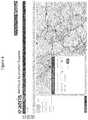
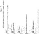
- FIG. 7illustrates an example of data structure that is sent to AerCloud according to an embodiment of the present invention.
- FIG. 8illustrates an example of Geofence workflow according to an embodiment of the present invention.
- FIG. 9illustrates an example of Geofence configuration according to an embodiment of the present invention.
- FIG. 10illustrates an example of criteria for evaluating a Geofence according to an embodiment of the present invention.
- FIG. 11illustrates an example of user defined location attributes according to an embodiment of the present invention.
- FIG. 12illustrates a data processing system 1200 suitable for storing the computer program product and/or executing program code relating to the choices of the users in accordance with an embodiment of the present invention.
- the present inventionrelates generally to providing a system and method monitoring devices relative to a user defined geographic area using an enablement platform for building web sites and web applications using data storage, management and publication capabilities of hosted web services.
- Machine to machine (M2M) network communicationsinvolves technologies to communicate with other devices often of similar abilities, different from traditional cellular communication networks for instance.
- a device having limited logicsuch as a sensor, meter, etc.
- limited resourcessuch as computing power
- the deviceis connected through a communications network to a remote computer or server having an application layer of specific software.
- the data received from the deviceis converted to relevant information associated with the measured event data through the application and may often thereafter undergo analysis or further similar assessment.
- a devicewhen activated, may trigger and communicate the events it is intended for so that those communicated events will then be acted upon by other machines, applications, and/or users on the network.
- M2M environmentsoften involve systems of networks, wired and wireless, that are to be connected to the internet and include personal appliances and similar devices.
- M2M networkstypically devices may stationary or mobile and be connected via wired or wireless access protocols, often through WiFi network protocols or a 3GPP Mobile network protocol. These devices may also have seasonal and/or elastic connectivity needs (e.g., agricultural business needs, store and forward capability).
- GPRSgeneral packet radio services
- M2M communication infrastructureremains most suited to the communication needs and patterns of devices having similar abilities, characteristically, for communicating with other systems and devices on the same network.
- An application for monitoring M2M devicesmay want to know if a device location is within or outside a geographical boundary and/or access other data regarding that device. For example, an application may want to know if a delivery truck has left its depot or has arrived at its designated next stop at certain time or speed of that truck at a particular time. This can be difficult due to limited logic as well as limited resources available to an M2M device.
- the present inventionprovides a system and method for monitoring devices relative to an user defined geographic area using an enablement platform which enables setting up new instances by collecting the required information from the user and feeding it to the necessary pages of the Hosted Data Service (HDS) in the background and developing production-ready M2M applications, using data storage, management and publication capabilities of hosted web services by providing easy-to-use software tools or widgets provided on an “out of the box” basis and an Application Programming Interface (API) that interacts with the instance at the HDS.
- HDSHosted Data Service
- APIApplication Programming Interface
- AerCloud Application Express (AAE) Launcher and AAEwhere AAE Launcher is used with a data management and publication service.
- Aercloud Application Express (AAE)is an application which is used to create new applications for use of data from M2M devices. This is an application running at a website that uses a simple interface (the Aercloud Application Express User Interface, or AAE UI) to help users who already have an instance at a HDS that can receive device data to develop production-ready M2M applications using easy-to-use software tools (widgets) provided on an “out of the box” basis and an Application Programming Interface (API) that interacts with the instance at the HDS.
- AAEApplication Express
- AAE LauncherOnce the user has used AAE Launcher to create a new instance for an application using Aeris AerCloud data management and publication service, the user is able to quickly develop production-ready M2M applications using AerCloud API and widgets provided on an “out of the box” basis at the AAE UI using AAE.
- Geofenceprovides a system and method for creating user defined geographic area using an enablement platform for building web sites and web applications using data storage and management capabilities of web services. Geofence is built on existing AerCloud concepts by allowing user to define location attributes and by using the user defined location attributes to configure and evaluate geofence as described below.
- System Configuration pageinvites users to begin creation of applications via Aercloud Application Express, first by entering their user credentials for their AerCloud account and, if applicable, a key for incorporating maps provided by commercially available mapping products into applications that use a map.
- “The Live Map” application widgetallows users to create applications that allow tracking of devices and their activity relative to a geographic area using commercially available mapping products.
- mapping productsfor defining the boundaries of the geofence using the drawing tool and provides superior flexibility for setting alerts based on device behavior (such as which devices inside the geofence are behaving outside permitted parameters).
- Creation and use of this applicationincludes creating a new alert, seeing all the existing alerts, seeing the detail of the alert in a draggable overlay widget.
- the useris permitted to: enter criteria for a new alert, update the selected alert, delete the selected alert and/or enter name of the alert.
- FIG. 1is a diagram illustrating various steps involved in creation of application using an enablement platform according to an embodiment of the present invention.
- a usersigns in Aercloud Application Express (AAE) using a valid user name and password.
- System Configuration pagethen invites the user via step 102 to begin creation of applications.
- the Live Map applicationallows users to create applications via step 104 that allow tracking of devices and their activity relative to a geographic area using commercially available mapping products.
- the usercan then create “geofences” via step 106 , which are alerts that send notifications when devices have, for example, entered a user-defined geographic area, left that area, or engaged in (or failed to engage in) certain behavior while located within that area.
- FIG. 2is a diagram illustrating “Live Map”, a widget provided by Application Express allowing users to create applications for tracking of devices and their activity relative to a geographic area using commercially available mapping products according to an embodiment of the present invention.
- FIG. 3is a diagram illustrating “Live Map”, a widget provided by Application Express allowing users to configure alerts according to an embodiment of the present invention.
- FIG. 4is a diagram illustrating “Live Map”, a widget provided by Application Express allowing users to configure alerts by adding “geofence” according to an embodiment of the present invention.
- FIG. 5is a diagram illustrating “Device Entry” a widget provided by Application Express and its interaction with “Device Details” widget illustrating types of location data returned by the Live Map and “Chart” application widgets according to an embodiment of the present invention.
- FIG. 6is a flow diagram illustrating different steps 602 - 612 involved in creating a user defined “geofence” according to an embodiment of the present invention, as described above.
- the useris permitted to select a shape for geo-fence, by clicking the Add button in the select a geo-fence shape view to enable geo-fence drawing mode using the simplified tool.
- Other operations for issuing an alert based on user defined geographic area “geofence” included in the widgetare, for example,: 1. See an instruction of what to do while in the geo-fence mode in a green popup. i.e. “Click and drag the mouse on the map to draw a circle.” 2. Remove the geo-fence you have iust drawn 3.
- geo-fence drawing functionalityis enabled via step 604 .
- datais added to the structure via step 606 .
- the datais sent to AerCloud when the user clicks an Apply button on the widget via step 608 .
- the usercan draw as many geofences as they want and send them to AerCloud via step 610 .
- the geo-fence datais sent to Aercloud via step 612 with following properties also defined in the widget: 1.
- FIG. 7illustrates an example of data structure that is sent to AerCloud according to an embodiment of the present invention.
- FIG. 8illustrates an example of Geofence workflow according to an embodiment of the present invention.
- Geofenceis built on existing AerCloud concepts by allowing user to define location attributes and by using the user defined location attributes to configure and evaluate geofence parameters as described below.
- the applicationworks by posting a data model with user-defined location attributes, which is saved in a database with a model id. It then posts a data container associated to the data model, which is saved in a database with a container id. A subscription is posted to the container with a geofence, which is saved in a database with a subscription id and its corresponding container id and device location data is posted to the container id.
- the web service componentfirst reads the geofence associated with the subscription and the user-defined location attributes from the data model associated with the container. Then the web service extracts location from the device data using user-defined location attribute names. According to one embodiment, the location information is then used to evaluate the geofence rule.
- FIG. 9illustrates an example of Geofence configuration according to an embodiment of the present invention.
- a geofencecan contain multiple geographical areas but each area must be a valid GeoJSON object with some required properties such as “areaId” which is used for notifying INSIDE event type and “radius” which is required if the object type is Point. Its value is the radius of a circle in meters.
- FIG. 10illustrates an example of criteria for evaluating a Geofence according to an embodiment of the present invention.
- Event type“inside”
- the “trigger criteria”can be set as “The geofence rule is “true” if a device location is within any area defined in the fence, otherwise “false”.”
- device datais sent to an application only if the geofence rule is evaluated to true. The data is decorated with the “area id” that triggered the fence.
- the “trigger criteria”can be set as “The geofence rule is “true” if a device location is outside all area defined in the fence, otherwise “false”.”
- device datais sent to the application only if the geofence rule is evaluated to true.
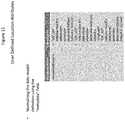
- FIG. 11illustrates an example of user defined location attributes according to an embodiment of the present invention.
- user defined location attributesincludes normalizing the data model definition using the “metadata” field.
- the descriptioncan be “LOC_LAT”, “LOC_LON” and/or “LOC_ALT”.
- LOC_LATindicates that this data model parameter designates latitude.
- Defaultis “latitude”.
- LOC_LONindicates that this data model parameter designates longitude.
- Defaultis “longitude”
- LOC_ALTindicates that this data model parameter designates altitude. Default is “altitude”.
- FIG. 12illustrates a data processing system 1200 , including an M2M device, suitable for storing the computer program product and/or executing program code in accordance with an embodiment of the present invention.
- the data processing system 1200includes a processor 1202 coupled to memory elements 1204 a - b through a system bus 1206 .
- the data processing system 1200may include more than one processor and each processor may be coupled directly or indirectly to one or more memory elements through a system bus.
- Memory elements 1204 a - bcan include local memory employed during actual execution of the program code, bulk storage, and cache memories that provide temporary storage of at least some program code in order to reduce the number of times the code must be retrieved from bulk storage during execution.
- I/O devices 1208 a - bincluding, but not limited to, keyboards, displays, pointing devices, etc.
- I/O devices 1208 a - bmay be coupled to the data processing system 1200 directly or indirectly through intervening I/O controllers (not shown).
- a network adapter 1210is coupled to the data processing system 1202 to enable data processing system 1202 to become coupled to other data processing systems or remote printers or storage devices through communication link 1212 .
- Communication link 1212can be a private or public network. Modems, cable modems, and Ethernet cards are just a few of the currently available types of network adapters.
- Embodiments described hereincan take the form of an entirely hardware implementation, an entirely software implementation, or an implementation containing both hardware and software elements.
- Embodimentsmay be implemented in software, which includes, but is not limited to, application software, firmware, resident software, microcode, etc.
- the steps described hereinmay be implemented using any suitable controller or processor, and software application, which may be stored on any suitable storage location or computer-readable medium.
- the software applicationprovides instructions that enable the processor to cause the receiver to perform the functions described herein.
- embodimentsmay take the form of a computer program product accessible from a computer-usable or computer-readable medium providing program code for use by or in connection with a computer or any instruction execution system.
- a computer-usable or computer-readable mediumcan be any apparatus that can contain, store, communicate, propagate, or transport the program for use by or in connection with the instruction execution system, apparatus, or device.
- the mediummay be an electronic, magnetic, optical, electromagnetic, infrared, semiconductor system (or apparatus or device), or a propagation medium.
- Examples of a computer-readable mediuminclude a semiconductor or solid state memory, magnetic tape, a removable computer diskette, a random access memory (RAM), a read-only memory (ROM), a rigid magnetic disk, and an optical disk.
- Current examples of optical disksinclude digital versatile disk (DVD), compact disk-read-only memory (CD-ROM), and compact disk-read/write (CD-R/W).
- product, device, appliance, terminal, remote device, wireless asset, etc.are intended to be inclusive, interchangeable, and/or synonymous with one another and other similar communication-based equipment for purposes of the present invention though one will recognize that functionally each may have unique characteristics, functions and/or operations which may be specific to its individual capabilities and/or deployment.
- M2M communicationis understood to include methods of utilizing various connected computing devices, servers, clusters of servers, wired and/or wirelessly, which provide a networked infrastructure to deliver computing, processing and storage capacity as services where a user typically accesses applications through a connected means such as but not limited to a web browser, terminal, mobile application or similar while the primary software and data are stored on servers or locations apart from the devices.
- the term communications networkincludes communications across a network (such as that of a M2M but not limited thereto) using one or more communication architectures, methods, and networks, including but not limited to: Code Division Multiple Access (CDMA), Global System for Mobile Communications (GSM) (“GSM” is a trademark of the GSM Association), Universal Mobile Telecommunications System (UMTS), Long Term Evolution (LTE), fourth generation cellular systems (4G) LTE, wireless local area network (WLAN), and one or more wired networks.
- CDMACode Division Multiple Access
- GSMGlobal System for Mobile Communications
- UMTSUniversal Mobile Telecommunications System
- LTELong Term Evolution
- 4G LTEfourth generation cellular systems
- WLANwireless local area network
Landscapes
- Engineering & Computer Science (AREA)
- Computer Networks & Wireless Communication (AREA)
- Signal Processing (AREA)
- Telephonic Communication Services (AREA)
- Stored Programmes (AREA)
- Information Transfer Between Computers (AREA)
- Management, Administration, Business Operations System, And Electronic Commerce (AREA)
Abstract
Description
| { | ||||
| “id” : “myDeviceDataModel_1”, | ||||
| “sclDataSchema” : { | ||||
| “id” : “mySchema_1”, | ||||
| “encoding” : “JSON”, | ||||
| “parameters” : [ { | ||||
| “name” : “deviceLatitude”, | ||||
| “type” : “STRING”, | ||||
| “isIndexed” : false, | ||||
| “metainfo” : { | ||||
| “uom” : “degree”, | ||||
| “normalizedProperty” : “LOC_LAT” | ||||
| } | ||||
| }, { | ||||
| “name” : “deviceLongitude”, | ||||
| “type” : “STRING”, | ||||
| “isIndexed” : false, | ||||
| “metainfo” : { | ||||
| “uom” : “degree”, | ||||
| “normalizedProperty” : “LOC_LON” | ||||
| } | ||||
| }, { | ||||
| “name” : “deviceAltitude”, | ||||
| “type” : “STRING”, | ||||
| “isIndexed” : false, | ||||
| “metainfo” : { | ||||
| “uom” : “degree”, | ||||
| “normalizedProperty” : “LOC_ALT” | ||||
| } | ||||
| } ] | ||||
| } | ||||
| } | ||||
Claims (21)
Priority Applications (3)
| Application Number | Priority Date | Filing Date | Title |
|---|---|---|---|
| US15/696,950US10750312B2 (en) | 2015-08-14 | 2017-09-06 | System and method for monitoring devices relative to a user defined geographic area |
| US15/970,725US10231084B2 (en) | 2015-08-14 | 2018-05-03 | System and method for monitoring devices relative to a learned geographic area |
| US16/944,565US11818623B2 (en) | 2015-08-14 | 2020-07-31 | System and method for monitoring devices relative to a user defined geographic area |
Applications Claiming Priority (3)
| Application Number | Priority Date | Filing Date | Title |
|---|---|---|---|
| US201562205639P | 2015-08-14 | 2015-08-14 | |
| US15/234,463US9774994B2 (en) | 2015-08-14 | 2016-08-11 | System and method for monitoring devices relative to a user defined geographic area |
| US15/696,950US10750312B2 (en) | 2015-08-14 | 2017-09-06 | System and method for monitoring devices relative to a user defined geographic area |
Related Parent Applications (1)
| Application Number | Title | Priority Date | Filing Date |
|---|---|---|---|
| US15/234,463ContinuationUS9774994B2 (en) | 2015-08-14 | 2016-08-11 | System and method for monitoring devices relative to a user defined geographic area |
Related Child Applications (2)
| Application Number | Title | Priority Date | Filing Date |
|---|---|---|---|
| US15/970,061Continuation-In-PartUS10648823B2 (en) | 2015-08-14 | 2018-05-03 | Learning common routes and automatic geofencing in fleet management |
| US16/944,565ContinuationUS11818623B2 (en) | 2015-08-14 | 2020-07-31 | System and method for monitoring devices relative to a user defined geographic area |
Publications (2)
| Publication Number | Publication Date |
|---|---|
| US20170366933A1 US20170366933A1 (en) | 2017-12-21 |
| US10750312B2true US10750312B2 (en) | 2020-08-18 |
Family
ID=57994506
Family Applications (3)
| Application Number | Title | Priority Date | Filing Date |
|---|---|---|---|
| US15/234,463ActiveUS9774994B2 (en) | 2015-08-14 | 2016-08-11 | System and method for monitoring devices relative to a user defined geographic area |
| US15/696,950ActiveUS10750312B2 (en) | 2015-08-14 | 2017-09-06 | System and method for monitoring devices relative to a user defined geographic area |
| US16/944,565Active2037-12-22US11818623B2 (en) | 2015-08-14 | 2020-07-31 | System and method for monitoring devices relative to a user defined geographic area |
Family Applications Before (1)
| Application Number | Title | Priority Date | Filing Date |
|---|---|---|---|
| US15/234,463ActiveUS9774994B2 (en) | 2015-08-14 | 2016-08-11 | System and method for monitoring devices relative to a user defined geographic area |
Family Applications After (1)
| Application Number | Title | Priority Date | Filing Date |
|---|---|---|---|
| US16/944,565Active2037-12-22US11818623B2 (en) | 2015-08-14 | 2020-07-31 | System and method for monitoring devices relative to a user defined geographic area |
Country Status (3)
| Country | Link |
|---|---|
| US (3) | US9774994B2 (en) |
| JP (2) | JP2018523233A (en) |
| WO (1) | WO2017031009A1 (en) |
Families Citing this family (13)
| Publication number | Priority date | Publication date | Assignee | Title |
|---|---|---|---|---|
| US10437575B2 (en) | 2015-08-14 | 2019-10-08 | Aeris Communications, Inc. | Aercloud application express and aercloud application express launcher |
| US10231084B2 (en)* | 2015-08-14 | 2019-03-12 | Aeris Communications, Inc. | System and method for monitoring devices relative to a learned geographic area |
| US9774994B2 (en)* | 2015-08-14 | 2017-09-26 | Aeris Communications, Inc. | System and method for monitoring devices relative to a user defined geographic area |
| US10648823B2 (en)* | 2017-06-22 | 2020-05-12 | Aeris Communications, Inc. | Learning common routes and automatic geofencing in fleet management |
| US10405137B2 (en)* | 2017-03-13 | 2019-09-03 | Kevin R. Imes | Mobile application and system for associating actions with independent geographic locations |
| US10735904B2 (en) | 2017-06-22 | 2020-08-04 | Aeris Communications, Inc. | System and method for monitoring location and activity of devices |
| US11132636B2 (en) | 2017-06-22 | 2021-09-28 | Aeris Communications, Inc. | System and method for monitoring and sharing location and activity of devices |
| US12349023B2 (en) | 2017-06-22 | 2025-07-01 | Aeris Communications, Inc. | Learning locations of interest using IoT devices |
| US11627195B2 (en) | 2017-06-22 | 2023-04-11 | Aeris Communications, Inc. | Issuing alerts for IoT devices |
| US11246004B2 (en) | 2019-04-16 | 2022-02-08 | Milwaukee Electric Tool Corporation | Power tool geofence tracking and dashboard |
| US12160753B2 (en) | 2021-12-17 | 2024-12-03 | T-Mobile Usa, Inc. | Telecommunications network coverage optimization system |
| US11856412B2 (en) | 2021-12-17 | 2023-12-26 | T-Mobile Usa, Inc. | Telecommunications network planning system |
| CN115829182B (en)* | 2023-02-13 | 2023-04-14 | 北京徐工汉云技术有限公司 | Engineering machinery dispatching method and device based on variable geo-fences |
Citations (186)
| Publication number | Priority date | Publication date | Assignee | Title |
|---|---|---|---|---|
| US6239707B1 (en) | 2000-02-22 | 2001-05-29 | Won-Hee Park | Driver condition monitoring apparatus |
| US6496775B2 (en) | 2000-12-20 | 2002-12-17 | Tracer Net Corporation | Method and apparatus for providing automatic status information of a delivery operation |
| US6651001B2 (en) | 2002-03-18 | 2003-11-18 | Micrologics, Inc. | Method of and system and apparatus for integrating maintenance vehicle and service personnel tracking information with the remote monitoring of the location, status, utilization and condition of widely geographically dispersed fleets of vehicular construction equipment and the like to be maintained, and providing and displaying together both construction and maintenance vehicle information |
| US6687356B1 (en)* | 1999-06-18 | 2004-02-03 | Telefonaktiebolaget Lm Ericsson | System and method for providing device-aware services in an integrated telecommunications network |
| US20040111195A1 (en)* | 2002-06-11 | 2004-06-10 | Vries Jeroen Joost De | Systems and methods for marine satellite monitoring |
| US20040193617A1 (en) | 2003-03-28 | 2004-09-30 | Adler Robert M. | Geographically specific advisory alert broadcasting system |
| US20050090978A1 (en)* | 2001-12-21 | 2005-04-28 | Rds-X Fejlesztesi Es Tanacsado Kft. | Control and communication system and method |
| US20050096009A1 (en)* | 2003-09-26 | 2005-05-05 | Jonathan Ackley | Cell phone parental control |
| US20050156715A1 (en)* | 2004-01-16 | 2005-07-21 | Jie Zou | Method and system for interfacing with mobile telemetry devices |
| US6931309B2 (en) | 2003-05-06 | 2005-08-16 | Innosurance, Inc. | Motor vehicle operating data collection and analysis |
| US20060248121A1 (en) | 2005-04-15 | 2006-11-02 | Michael Cacenco | System and method for supporting packaging, publishing and republishing of wireless component applications |
| US7213048B1 (en)* | 2000-04-05 | 2007-05-01 | Microsoft Corporation | Context aware computing devices and methods |
| US20070143013A1 (en) | 2005-12-16 | 2007-06-21 | Breen Thomas B | System and method for updating geo-fencing information on mobile devices |
| US7246009B2 (en) | 2004-02-02 | 2007-07-17 | Glacier Northwest, Inc. | Resource management system, for example, tracking and management system for trucks |
| US20070173991A1 (en)* | 2006-01-23 | 2007-07-26 | Stephen Tenzer | System and method for identifying undesired vehicle events |
| US20080033791A1 (en) | 2006-07-18 | 2008-02-07 | Chacha Search, Inc | Method and system tracking work done by human workers |
| US20080125965A1 (en) | 2006-11-27 | 2008-05-29 | Carani Sherry L | Tracking System and Method with Automatic Map Selector and Geo Fence Defining Features |
| US20080319602A1 (en)* | 2007-06-25 | 2008-12-25 | Mcclellan Scott | System and Method for Monitoring and Improving Driver Behavior |
| US20090009321A1 (en)* | 2007-07-02 | 2009-01-08 | Mcclellan Scott | System and Method for Defining Areas of Interest and Modifying Asset Monitoring in Relation Thereto |
| US20090019357A1 (en) | 2007-04-27 | 2009-01-15 | Bea Systems, Inc. | Web based application constructor using page components accessible by url |
| US20090079555A1 (en) | 2007-05-17 | 2009-03-26 | Giadha Aguirre De Carcer | Systems and methods for remotely configuring vehicle alerts and/or controls |
| US20090248883A1 (en)* | 2008-03-25 | 2009-10-01 | Lalitha Suryanarayana | Apparatus and methods for managing widgets in a wireless communication environment |
| US20090275348A1 (en)* | 2008-05-02 | 2009-11-05 | Weinreich Andrew P | Location-Based Services Platform |
| US20090309789A1 (en)* | 2008-06-11 | 2009-12-17 | Transcore Link Logistics Corporation | Method for geofencing |
| US20090326991A1 (en)* | 2008-06-27 | 2009-12-31 | E-Lantis Corporation | Gps and wireless integrated fleet management system and method |
| US20100075648A1 (en)* | 2008-09-24 | 2010-03-25 | Palm, Inc. | System and method to localize applications on a mobile computing device |
| US20100094500A1 (en)* | 2008-10-14 | 2010-04-15 | Jin Seung-Hee | Telematics terminal and method for controlling vehicle using the same |
| US20100106603A1 (en)* | 2008-10-20 | 2010-04-29 | Carnegie Mellon University | System, method and device for predicting navigational decision-making behavior |
| US20100203901A1 (en)* | 2009-02-11 | 2010-08-12 | Dinoff Robert K | Location-Based Services Using Geofences Generated from Learned Patterns of Movement |
| US20100214068A1 (en)* | 2009-02-23 | 2010-08-26 | Wellcore Corporation | Location Detection |
| US7801538B2 (en) | 2004-02-13 | 2010-09-21 | Envisionit Llc | Message broadcasting geo-fencing system and method |
| US20100280734A1 (en)* | 2006-06-20 | 2010-11-04 | Zonar Systems, Inc. | Method and apparatus to encode fuel use data with gps data and to analyze such data |
| US20100289644A1 (en) | 2009-05-18 | 2010-11-18 | Alarm.Com | Moving asset location tracking |
| US20100306735A1 (en) | 2009-05-27 | 2010-12-02 | Microsoft Corporation | Package design and generation |
| US7848765B2 (en) | 2005-05-27 | 2010-12-07 | Where, Inc. | Location-based services |
| US20110112768A1 (en)* | 2009-11-09 | 2011-05-12 | Qualcomm Incorporated | Scalable GeoFences |
| US20110126168A1 (en) | 2009-11-25 | 2011-05-26 | Crowdsource Technologies Ltd. | Cloud plarform for managing software as a service (saas) resources |
| US20110178811A1 (en) | 2010-01-19 | 2011-07-21 | Telenav, Inc. | Navigation system with geofence validation and method of operation thereof |
| US8000726B2 (en) | 2006-06-01 | 2011-08-16 | Loopt, Inc. | Network manager system for location-aware mobile communication devices |
| US20110202591A1 (en) | 2007-03-14 | 2011-08-18 | Victor Reis | System, method, and apparatus for improved transportation management |
| US8018329B2 (en) | 2008-12-12 | 2011-09-13 | Gordon * Howard Associates, Inc. | Automated geo-fence boundary configuration and activation |
| US20110238457A1 (en) | 2009-11-24 | 2011-09-29 | Telogis, Inc. | Vehicle route selection based on energy usage |
| US20120058764A1 (en)* | 2010-09-08 | 2012-03-08 | Samsung Electronics Co. Ltd. | Apparatus and method for supporting location update registration process in machine to machine communication system |
| US8135505B2 (en)* | 2007-04-27 | 2012-03-13 | Groupon, Inc. | Determining locations of interest based on user visits |
| US20120260228A1 (en) | 2011-04-07 | 2012-10-11 | Infosys Technologies Ltd. | Composite applications using service component architecture model and open virtualization format |
| US20120330722A1 (en) | 2011-06-27 | 2012-12-27 | Cadio, Inc. | Adjusting a process for visit detection based on location data |
| US8346230B2 (en) | 2007-03-06 | 2013-01-01 | Capitol Broadcasting Company, Inc. | System and method for delivering geographically restricted content, such as over-air broadcast programming, to a recipient over a network, namely the internet |
| US20130031029A1 (en)* | 2011-07-26 | 2013-01-31 | United Parcel Service Of America, Inc. | Geofence-based tax estimates |
| US20130055253A1 (en) | 2011-08-30 | 2013-02-28 | Microsoft Corporation | Cloud-based build service |
| US20130066688A1 (en) | 2011-09-08 | 2013-03-14 | Frias Transportation Infrastructure Llc | Regulating driver vehicle input choices in for-hire vehicles |
| US20130090106A1 (en)* | 2011-10-07 | 2013-04-11 | Neuaer, Llc | Automating actions within a phone network based upon scanned wireless signals |
| US20130093603A1 (en) | 2011-10-18 | 2013-04-18 | Visteon Global Technologies, Inc. | Vehicle system and method for assessing and communicating a condition of a driver |
| US20130103307A1 (en)* | 2011-10-19 | 2013-04-25 | Research In Motion Limited | Method, system and apparatus for determining geofence data based on estimated time of arrival |
| US8473148B2 (en) | 2009-08-11 | 2013-06-25 | Certusview Technologies, Llc | Fleet management systems and methods for complex event processing of vehicle-related information via local and remote complex event processing engines |
| US20130190967A1 (en)* | 2011-01-24 | 2013-07-25 | Lexisnexis Risk Solutions Inc. | Systems and methods for telematics montoring and communications |
| US8510200B2 (en) | 2011-12-02 | 2013-08-13 | Spireon, Inc. | Geospatial data based assessment of driver behavior |
| US20130212130A1 (en)* | 2012-02-15 | 2013-08-15 | Flybits, Inc. | Zone Oriented Applications, Systems and Methods |
| US20130245880A1 (en)* | 2012-03-14 | 2013-09-19 | Zonar Systems, Inc. | Event based gps tracking |
| US20130254755A1 (en) | 2012-03-22 | 2013-09-26 | Shenol YOUSOUF | Dynamically updating on-demand runtime platforms executing business applications |
| US20130267253A1 (en) | 2012-01-12 | 2013-10-10 | Environmental Systems Research Institute, Inc. | Trigger zones and dwell time analytics |
| US8566014B1 (en) | 2012-05-17 | 2013-10-22 | Amazon Technologies, Inc. | Discovery of public points of interest |
| US20130289873A1 (en) | 2012-04-27 | 2013-10-31 | Fleetmatics Irl Limited | System and method for tracking driver hours and timekeeping |
| US20130289819A1 (en)* | 2011-01-24 | 2013-10-31 | Lexisnexis Risk Solutions Inc. | Systems and methods for telematics montoring and communications |
| US20130297803A1 (en) | 2012-05-07 | 2013-11-07 | Infosys Limited | Method for providing development and deployment services using a cloud-based platform and devices thereof |
| US20130304347A1 (en)* | 2011-03-31 | 2013-11-14 | United Parcel Service Of America, Inc. | Calculating speed and travel times with travel delays |
| US8589330B2 (en) | 2009-03-25 | 2013-11-19 | Waldeck Technology, Llc | Predicting or recommending a users future location based on crowd data |
| US8595696B2 (en) | 2008-09-30 | 2013-11-26 | International Business Machines Corporation | Development of networked applications |
| US8593277B2 (en) | 2011-03-17 | 2013-11-26 | Kaarya, LLC. | System and method for proximity detection |
| US20130340305A1 (en)* | 2012-06-13 | 2013-12-26 | nMode Solutions, Inc. | Tracking and monitoring of animals with combined wireless technology and geofencing |
| US20130346336A1 (en) | 2012-03-22 | 2013-12-26 | Fedex Corporate Services, Inc. | Systems and methods for trip management |
| US8630768B2 (en) | 2006-05-22 | 2014-01-14 | Inthinc Technology Solutions, Inc. | System and method for monitoring vehicle parameters and driver behavior |
| US20140026113A1 (en) | 2012-07-19 | 2014-01-23 | Arshad Farooqi | Mobile Application Creation System |
| US20140031073A1 (en) | 2009-06-12 | 2014-01-30 | Qualcomm Incorporated | Systems, methods, and machine-readable media providing location-enabled group management |
| US20140057648A1 (en) | 2012-08-22 | 2014-02-27 | Ebay Inc. | Passive dynamic geofencing for mobile devices |
| US20140059695A1 (en) | 2012-08-24 | 2014-02-27 | Environmental Systems Research Institute (ESRI) | Systems and methods for managing location data and providing a privacy framework |
| US8667456B1 (en) | 2011-04-20 | 2014-03-04 | Google Inc. | Cloud-based indexing for integrated development environments |
| US20140062695A1 (en)* | 2012-09-03 | 2014-03-06 | Eric C. Rosen | Method and apparatus for improving tracker battery life while outside a base safe-zone |
| US20140095214A1 (en) | 2012-10-03 | 2014-04-03 | Robert E. Mathe | Systems and methods for providing a driving performance platform |
| US8725569B2 (en)* | 2010-10-25 | 2014-05-13 | Alohar Mobile Inc. | Location based user behavior analysis and applications |
| US20140155094A1 (en) | 2012-12-04 | 2014-06-05 | Ebay Inc. | Dynamic geofence based on members within |
| US8756010B2 (en) | 2009-10-12 | 2014-06-17 | Qualcomm Incorporated | Method and apparatus for identification of points of interest within a predefined area |
| US8755824B1 (en) | 2013-06-28 | 2014-06-17 | Google Inc. | Clustering geofence-based alerts for mobile devices |
| US20140172294A1 (en)* | 2012-12-14 | 2014-06-19 | Magnasoft Consulting India Pvt. Ltd | Method and system for predicting expected time of arrival of objects |
| WO2014106299A1 (en) | 2013-01-07 | 2014-07-10 | Gentile Marcello | Method and system to build and deploy vehicle telematics solutions |
| US20140215043A1 (en) | 2013-01-29 | 2014-07-31 | Kt Corporation | Resource change management in machine to machine network |
| US20140226470A1 (en) | 2013-02-13 | 2014-08-14 | Aeris Communications, Inc. | Method for delivering machine to machine (m2m) application control data over control plane in lte/eps utilizing standard bearer management procedures |
| US20140274115A1 (en)* | 2013-03-15 | 2014-09-18 | Grid-Roots, LLC | Tracking device and remote monitoring system |
| US20140274136A1 (en)* | 2012-06-15 | 2014-09-18 | Qualcomm Incorporated | Client access to mobile location services |
| US20140282380A1 (en) | 2013-03-15 | 2014-09-18 | International Business Machines Corporation | Method and apparatus for enabling agile development of services in cloud computing and traditional environments |
| US8869038B2 (en) | 2010-10-06 | 2014-10-21 | Vistracks, Inc. | Platform and method for analyzing real-time position and movement data |
| US20140325048A1 (en) | 2013-03-15 | 2014-10-30 | Mentor Graphics Corporation | Cloud services platform |
| US20140325394A1 (en) | 2011-05-03 | 2014-10-30 | Kristan Lisa Hamill | Interactive tracking virtual world system |
| US20140351411A1 (en) | 2013-05-21 | 2014-11-27 | Yopima LLC. | Systems and methods for time-based geofencing |
| US20140359552A1 (en) | 2011-09-19 | 2014-12-04 | Tata Consultancy Services Limited | Computer Platform for Development and Deployment of Sensor Data Based Applications and Services |
| US8909256B2 (en) | 2012-08-11 | 2014-12-09 | Federico Fraccaroli | Method and apparatus for mediating among a plurality of profiles associated with users positioned in a shared location |
| US8913983B2 (en) | 2005-05-27 | 2014-12-16 | Telecommunication Systems, Inc. | Voice over internet protocol (VoIP) E911 metro street address guide (MSAG) validation |
| US20140370911A1 (en)* | 2013-06-14 | 2014-12-18 | Microsoft Corporation | Coalescing geo-fence events |
| US20140380264A1 (en) | 2011-09-19 | 2014-12-25 | Tata Consultancy Services, Limited | Computer Platform for Development and Deployment of Sensor-Driven Vehicle Telemetry Applications and Services |
| US8949022B1 (en) | 2014-01-16 | 2015-02-03 | WI-MM Corporation | Cloud based activity monitor for human powered vehicle |
| US8971930B2 (en)* | 2012-12-11 | 2015-03-03 | Blackberry Limited | Geofencing system and method |
| US20150095355A1 (en) | 2012-11-15 | 2015-04-02 | Banjo, Inc. | Systems and methods for dynamic event content curation |
| US9014888B2 (en) | 2011-07-21 | 2015-04-21 | Saturna Green Systems Inc. | Vehicle communication, analysis and operation system |
| US20150135163A1 (en) | 2013-11-12 | 2015-05-14 | Samsung Electronics Co., Ltd. | Server providing cloud service, terminal for developer and method for supporting application development using the same |
| US9043222B1 (en)* | 2006-11-30 | 2015-05-26 | NexRf Corporation | User interface for geofence associated content |
| US20150149980A1 (en) | 2013-09-11 | 2015-05-28 | Tongling Yucheng Software Technology Co., Ltd. | Service model-oriented software operation platform and operation method thereof |
| US20150163630A1 (en)* | 2013-12-06 | 2015-06-11 | Mapquest, Inc. | Systems and methods for geo-location based message streams |
| US20150163626A1 (en)* | 2012-06-11 | 2015-06-11 | Georeach Limited | Monitoring system, server, mobile device and method |
| US20150173037A1 (en) | 2012-06-28 | 2015-06-18 | Koninklijke Philips N.V. | Method of estimating the position of a device and an apparatus implementing the same |
| US20150180746A1 (en)* | 2013-12-19 | 2015-06-25 | Websafety, Inc. | Devices and methods for improving web safety and deterrence of cyberbullying |
| US20150181016A1 (en) | 2013-12-20 | 2015-06-25 | Ebay Inc. | System and method to utilize geo-fences to limit calls to a server system from a user's mobile device |
| US9076165B2 (en) | 2007-04-08 | 2015-07-07 | Enhanced Geographic Llc | Systems and methods to determine the name of a physical business location visited by a user of a wireless device and verify the authenticity of reviews of the physical business location |
| US9076009B2 (en) | 2010-08-13 | 2015-07-07 | Nokia Technologies Oy | Method and apparatus for secure shared personal map layer |
| US9104738B2 (en) | 2008-06-19 | 2015-08-11 | Tropare, Inc. | Leveraging collaborative cloud services to build and share apps |
| CN104835029A (en) | 2015-05-26 | 2015-08-12 | 丹阳飓风物流股份有限公司 | Comprehensive management system for logistics vehicles |
| US9119038B2 (en) | 2013-05-21 | 2015-08-25 | Yopima Llc | Systems and methods for comparative geofencing |
| US20150245189A1 (en) | 2012-10-19 | 2015-08-27 | Srikanth Nalluri | Personal safety and emergency services |
| US9122693B2 (en) | 2010-11-30 | 2015-09-01 | Nokia Technologies Oy | Method and apparatus for determining contextually relevant geographical locations |
| US9140567B2 (en) | 2011-03-03 | 2015-09-22 | Telogis, Inc. | Vehicle route calculation |
| US9141266B2 (en) | 2011-10-04 | 2015-09-22 | Telogis, Inc. | Customizable vehicle fleet reporting system |
| WO2015143416A1 (en) | 2014-03-21 | 2015-09-24 | Ptc Inc. | Systems and methods for developing and using real-time data applications |
| US20150271033A1 (en) | 2014-03-20 | 2015-09-24 | Verizon Patent And Licensing Inc. | Scalable framework for monitoring machine-to-machine (m2m) devices |
| US9146721B1 (en) | 2014-05-30 | 2015-09-29 | Vmware, Inc. | Installation of a software agent via an existing template agent |
| US20150278759A1 (en) | 2014-03-26 | 2015-10-01 | Go Taxi Truck, LLC | System and Method for Vehicle Delivery Tracking Service |
| US20150304175A1 (en) | 2012-12-03 | 2015-10-22 | Hewlett-Packard Development Company, L.P. | Binding of application and infrastructure blueprints |
| US20150350843A1 (en) | 2014-05-30 | 2015-12-03 | Apple Inc. | Location application program interface |
| US9210534B1 (en) | 2015-02-19 | 2015-12-08 | Citrix Systems, Inc. | Location assistance in a machine to machine instant messaging system |
| US9225519B1 (en)* | 2015-03-02 | 2015-12-29 | Federico Fraccaroli | Method, system, and apparatus for enabling secure functionalities |
| US20160003627A1 (en)* | 2014-07-02 | 2016-01-07 | Lytx, Inc. | Automatic geofence determination |
| US9250887B2 (en) | 2010-04-26 | 2016-02-02 | Pivotal Software, Inc. | Cloud platform architecture |
| US20160041833A1 (en) | 2014-05-21 | 2016-02-11 | Societal Innovations Ipco Limited | System and method for fully configurable real time processing |
| US20160042303A1 (en)* | 2014-08-05 | 2016-02-11 | Qtech Partners LLC | Dispatch system and method of dispatching vehicles |
| US20160050536A1 (en) | 2014-08-15 | 2016-02-18 | Motorola Mobility Llc | Identifying personalized meaningful locations |
| WO2016025495A1 (en) | 2014-08-12 | 2016-02-18 | Kerr Michael A | System and method for map based exploration |
| US20160057209A1 (en) | 2014-08-20 | 2016-02-25 | At&T Intellectual Property I, L.P. | Service Centric Virtual Network Function Architecture for Development and Deployment of Open Systems Interconnection Communication Model Layer 4 Through Layer 7 Services in a Cloud Computing System |
| US9275114B2 (en) | 2013-01-04 | 2016-03-01 | PlaceIQ, Inc. | Apparatus and method for profiling users |
| US9277362B2 (en) | 2010-09-03 | 2016-03-01 | Blackberry Limited | Method and apparatus for generating and using location information |
| US20160066141A1 (en)* | 2014-08-29 | 2016-03-03 | Chintan Jain | Efficient geo-fence data transfer and notifications using a time to reach value |
| US20160071333A1 (en)* | 2014-09-05 | 2016-03-10 | Vinli | Vehicle Information System |
| US20160073229A1 (en) | 2014-09-09 | 2016-03-10 | Here Global B.V. | Method and apparatus for providing point-of-interest detection via feature analysis and mobile device position information |
| US20160083697A1 (en) | 2013-02-27 | 2016-03-24 | Cj Cheiljedang Corporation | Novel bacteriophage and antibacterial composition comprising the same |
| US20160086397A1 (en)* | 2014-09-22 | 2016-03-24 | Brian K. Phillips | Method and system for automatically identifying a driver by creating a unique driver profile for a vehicle from driving habits |
| US20160103657A1 (en) | 2012-12-13 | 2016-04-14 | Microsoft Technology Licensing, Llc | Metadata driven real-time analytics framework |
| US20160116596A1 (en)* | 2014-10-27 | 2016-04-28 | Numerex Corp. | Offender monitor with managed rate of location reading |
| US20160124742A1 (en) | 2014-10-30 | 2016-05-05 | Equinix, Inc. | Microservice-based application development framework |
| US9349128B1 (en)* | 2006-11-30 | 2016-05-24 | Nevrf Corporation | Targeted content delivery |
| US20160150021A1 (en) | 2014-11-21 | 2016-05-26 | Kiban Labs, Inc. | Internet of things clock hub device and method |
| US20160173404A1 (en) | 2014-12-15 | 2016-06-16 | Thales | Method to jointly select cloud computing and network services and associated device |
| US20160203651A1 (en)* | 2013-08-20 | 2016-07-14 | Intelligent Imaging Systems, Inc. | Vehicle traffic and vehicle related transaction control system |
| US9424751B2 (en) | 2014-10-24 | 2016-08-23 | Telogis, Inc. | Systems and methods for performing driver and vehicle analysis and alerting |
| US20160247330A1 (en)* | 2015-02-20 | 2016-08-25 | Ford Global Technologies, Llc | Method and Apparatus for Dynamic Position Reporting Rate Determination |
| US20160286355A1 (en)* | 2013-11-11 | 2016-09-29 | Vestigo Technologies Ltd | System and methods which use low wireless data bandwidth consumption for tracking wandering devices |
| US20160284184A1 (en) | 2013-12-04 | 2016-09-29 | Robert Warren BEAN | Protection system for individual mobile objects |
| US9507346B1 (en) | 2015-11-04 | 2016-11-29 | Zoox, Inc. | Teleoperation system and method for trajectory modification of autonomous vehicles |
| US20160357522A1 (en) | 2015-06-08 | 2016-12-08 | Cisco Technology, Inc. | Physical space map overlay and interaction for an internet of things integrated developer environment |
| US20160371553A1 (en) | 2015-06-22 | 2016-12-22 | Digital Ally, Inc. | Tracking and analysis of drivers within a fleet of vehicles |
| US20170006135A1 (en) | 2015-01-23 | 2017-01-05 | C3, Inc. | Systems, methods, and devices for an enterprise internet-of-things application development platform |
| US20170006430A1 (en) | 2015-07-02 | 2017-01-05 | Qualcomm Incorporated | Providing, organizing, and managing location history records of a mobile device |
| US20170006419A1 (en)* | 2015-07-01 | 2017-01-05 | Numerex Corp. | Method and System for Locating a Wireless Tracking Device |
| US20170048669A1 (en)* | 2015-08-14 | 2017-02-16 | Aeris Communications, Inc. | System and method for monitoring devices relative to a user defined geographic area |
| US9661470B1 (en) | 2015-10-05 | 2017-05-23 | Google Inc. | Methods and systems for locating an actor within an environment |
| US20170171204A1 (en) | 2015-12-14 | 2017-06-15 | Afero, Inc. | System and method for performing asset and crowd tracking in an iot system |
| US9712972B2 (en) | 2015-03-24 | 2017-07-18 | Faxi Limited | Method, system and device for determining close proximity of two or more persons |
| US9712486B2 (en) | 2006-09-25 | 2017-07-18 | Weaved, Inc. | Techniques for the deployment and management of network connected devices |
| US20170203633A1 (en) | 2016-01-20 | 2017-07-20 | Wal-Mart Stores, Inc. | Apparatus and method for refrigeration unit control |
| US9741191B1 (en) | 2016-03-31 | 2017-08-22 | Kyocera Document Solutions Inc. | System and method for recording waypoint images along a route |
| US20170244841A1 (en)* | 2016-02-22 | 2017-08-24 | Wisam Costandi | Methods, systems, and apparatus for controlling a mobile |
| US20170270792A1 (en) | 2016-03-20 | 2017-09-21 | Maxwell Joseph Breton | Emergency Vehicle Locator |
| US9792567B2 (en) | 2016-03-11 | 2017-10-17 | Route4Me, Inc. | Methods and systems for managing large asset fleets through a virtual reality interface |
| US9805521B1 (en) | 2013-12-03 | 2017-10-31 | United Parcel Service Of America, Inc. | Systems and methods for assessing turns made by a vehicle |
| US9817948B2 (en) | 2015-05-15 | 2017-11-14 | Josh Swank | System and method for monitoring activities through portable devices |
| US9826345B2 (en) | 2012-06-18 | 2017-11-21 | Here Global B.V. | Method and apparatus for detecting points of interest or events based on geotagged data and geolocation seeds |
| US9838843B1 (en) | 2016-10-13 | 2017-12-05 | Adobe Systems Incorporated | Generating data-driven geo-fences |
| US20170349058A1 (en) | 2016-06-07 | 2017-12-07 | Briggs & Stratton Corporation | Fleet management system for outdoor power equipment |
| US20170359237A1 (en) | 2016-06-13 | 2017-12-14 | Verizon Patent And Licensing Inc. | Internet-of-things partner integration |
| US20180005522A1 (en) | 2016-07-04 | 2018-01-04 | Intel Corporation | IoT/CLOUD ENABLED FASTER AMBULANCES |
| US9871865B2 (en) | 2013-07-11 | 2018-01-16 | Neura, Inc. | Physical environment profiling through internet of things integration platform |
| US9878663B1 (en) | 2016-12-07 | 2018-01-30 | International Business Machines Corporation | Cognitive dialog system for driving safety |
| US20180049001A1 (en) | 2016-08-10 | 2018-02-15 | Yandex Europe Ag | Method of and server for processing wireless device sensor data to generate an entity vector associated with a physical location |
| US20180199239A1 (en) | 2014-03-13 | 2018-07-12 | Vodafone Ip Licensing Limited | Management of resource allocation in a mobile telecommunication network |
| US10037668B1 (en) | 2017-05-09 | 2018-07-31 | Microsoft Technology Licensing, Llc | Emergency alerting system and method |
| US20180255428A1 (en)* | 2015-08-14 | 2018-09-06 | Aeris Communications, Inc. | System and method for monitoring devices relative to a learned geographic area |
| US10097960B2 (en) | 2017-02-21 | 2018-10-09 | At&T Intellectual Property I, L.P. | Velocity-weighted analysis of user equipment location data |
| US20180302476A1 (en) | 2017-04-15 | 2018-10-18 | Microsoft Technology Licensing, Llc | Iot device jobs |
| US20180365785A1 (en) | 2017-06-14 | 2018-12-20 | International Business Machines Corporation | Cognitive emergency task coordination |
| US20180372503A1 (en)* | 2017-06-22 | 2018-12-27 | Aeris Communications, Inc. | Learning common routes and automatic geofencing in fleet management |
| US20190285426A1 (en) | 2016-12-02 | 2019-09-19 | Verizon Connect Ireland Limited | System and method for deriving operation information of a fleet and analyzing the same |
Family Cites Families (19)
| Publication number | Priority date | Publication date | Assignee | Title |
|---|---|---|---|---|
| JP5166682B2 (en)* | 2005-08-12 | 2013-03-21 | ソニーモバイルコミュニケーションズ株式会社 | Terminal control method, terminal device, and program |
| JP4664826B2 (en) | 2006-01-26 | 2011-04-06 | 財団法人日本自動車研究所 | Vehicle behavior analysis system |
| CN102203810A (en) | 2008-09-09 | 2011-09-28 | 美国联合包裹服务公司 | Systems and methods of utilizing telematics data to improve fleet management operations |
| US8138940B2 (en) | 2009-05-01 | 2012-03-20 | Cathy Horton | Municipal operations monitoring and alert system |
| US20110208797A1 (en)* | 2010-02-22 | 2011-08-25 | Full Armor Corporation | Geolocation-Based Management of Virtual Applications |
| IN2011CH01189A (en)* | 2011-04-07 | 2012-10-19 | ||
| US9002348B2 (en)* | 2012-11-20 | 2015-04-07 | Aeris Communications, Inc. | Utilizing devices nearby |
| US9456302B2 (en) | 2013-06-03 | 2016-09-27 | Temeda Llc | Geospatial asset tracking systems, methods and apparatus for acquiring, manipulating and presenting telematic metadata |
| GB2515522A (en)* | 2013-06-26 | 2014-12-31 | Ibm | Mobile network based geofencing |
| US9626811B2 (en) | 2014-06-19 | 2017-04-18 | Atieva, Inc. | Vehicle fault early warning system |
| US20160104096A1 (en) | 2014-10-10 | 2016-04-14 | Staffly, Inc. | Matching short-term staffing assignments based on previous employee and employer ratings and a real-time live interview |
| KR102314673B1 (en) | 2015-04-07 | 2021-10-20 | 삼성전자주식회사 | Electronic device and method of providing information in the electronic device |
| US9432944B1 (en) | 2015-06-13 | 2016-08-30 | KeepTrax, Inc. | Determining whether a mobile device user is substantially stationary within a geo-fence |
| US9824508B2 (en) | 2015-09-15 | 2017-11-21 | Cubic Corporation | Transit vehicle sensor system |
| US11829927B2 (en) | 2016-05-04 | 2023-11-28 | United Parcel Service Of America, Inc. | Remote initiation of interaction by a computing entity |
| US10070261B2 (en) | 2016-10-04 | 2018-09-04 | Apple Inc. | Harvesting labels for significant locations and updating a location fingerprint database using harvested labels |
| US10136280B2 (en) | 2016-08-29 | 2018-11-20 | International Business Machines Corporation | Parallel user interaction with physical and modeled system |
| US10015353B1 (en) | 2016-12-29 | 2018-07-03 | Konica Minolta Laboratory U.S.A., Inc. | Method and system of using IPv6 packet extensions to allow or prevent execution of a job based on physical location |
| US10735904B2 (en) | 2017-06-22 | 2020-08-04 | Aeris Communications, Inc. | System and method for monitoring location and activity of devices |
- 2016
- 2016-08-11USUS15/234,463patent/US9774994B2/enactiveActive
- 2016-08-12WOPCT/US2016/046924patent/WO2017031009A1/ennot_activeCeased
- 2016-08-12JPJP2018502350Apatent/JP2018523233A/enactivePending
- 2017
- 2017-09-06USUS15/696,950patent/US10750312B2/enactiveActive
- 2020
- 2020-07-31USUS16/944,565patent/US11818623B2/enactiveActive
- 2021
- 2021-07-16JPJP2021117902Apatent/JP2021182414A/enactivePending
Patent Citations (196)
| Publication number | Priority date | Publication date | Assignee | Title |
|---|---|---|---|---|
| US6687356B1 (en)* | 1999-06-18 | 2004-02-03 | Telefonaktiebolaget Lm Ericsson | System and method for providing device-aware services in an integrated telecommunications network |
| US6239707B1 (en) | 2000-02-22 | 2001-05-29 | Won-Hee Park | Driver condition monitoring apparatus |
| US7213048B1 (en)* | 2000-04-05 | 2007-05-01 | Microsoft Corporation | Context aware computing devices and methods |
| US6496775B2 (en) | 2000-12-20 | 2002-12-17 | Tracer Net Corporation | Method and apparatus for providing automatic status information of a delivery operation |
| US20050090978A1 (en)* | 2001-12-21 | 2005-04-28 | Rds-X Fejlesztesi Es Tanacsado Kft. | Control and communication system and method |
| US6651001B2 (en) | 2002-03-18 | 2003-11-18 | Micrologics, Inc. | Method of and system and apparatus for integrating maintenance vehicle and service personnel tracking information with the remote monitoring of the location, status, utilization and condition of widely geographically dispersed fleets of vehicular construction equipment and the like to be maintained, and providing and displaying together both construction and maintenance vehicle information |
| US20040111195A1 (en)* | 2002-06-11 | 2004-06-10 | Vries Jeroen Joost De | Systems and methods for marine satellite monitoring |
| US20040193617A1 (en) | 2003-03-28 | 2004-09-30 | Adler Robert M. | Geographically specific advisory alert broadcasting system |
| US6931309B2 (en) | 2003-05-06 | 2005-08-16 | Innosurance, Inc. | Motor vehicle operating data collection and analysis |
| US20050096009A1 (en)* | 2003-09-26 | 2005-05-05 | Jonathan Ackley | Cell phone parental control |
| US20050156715A1 (en)* | 2004-01-16 | 2005-07-21 | Jie Zou | Method and system for interfacing with mobile telemetry devices |
| US7246009B2 (en) | 2004-02-02 | 2007-07-17 | Glacier Northwest, Inc. | Resource management system, for example, tracking and management system for trucks |
| US7801538B2 (en) | 2004-02-13 | 2010-09-21 | Envisionit Llc | Message broadcasting geo-fencing system and method |
| US20060248121A1 (en) | 2005-04-15 | 2006-11-02 | Michael Cacenco | System and method for supporting packaging, publishing and republishing of wireless component applications |
| US8913983B2 (en) | 2005-05-27 | 2014-12-16 | Telecommunication Systems, Inc. | Voice over internet protocol (VoIP) E911 metro street address guide (MSAG) validation |
| US7848765B2 (en) | 2005-05-27 | 2010-12-07 | Where, Inc. | Location-based services |
| US20070143013A1 (en) | 2005-12-16 | 2007-06-21 | Breen Thomas B | System and method for updating geo-fencing information on mobile devices |
| US20070173991A1 (en)* | 2006-01-23 | 2007-07-26 | Stephen Tenzer | System and method for identifying undesired vehicle events |
| US8630768B2 (en) | 2006-05-22 | 2014-01-14 | Inthinc Technology Solutions, Inc. | System and method for monitoring vehicle parameters and driver behavior |
| US8000726B2 (en) | 2006-06-01 | 2011-08-16 | Loopt, Inc. | Network manager system for location-aware mobile communication devices |
| US20100280734A1 (en)* | 2006-06-20 | 2010-11-04 | Zonar Systems, Inc. | Method and apparatus to encode fuel use data with gps data and to analyze such data |
| US20080033791A1 (en) | 2006-07-18 | 2008-02-07 | Chacha Search, Inc | Method and system tracking work done by human workers |
| US9712486B2 (en) | 2006-09-25 | 2017-07-18 | Weaved, Inc. | Techniques for the deployment and management of network connected devices |
| US20080125965A1 (en) | 2006-11-27 | 2008-05-29 | Carani Sherry L | Tracking System and Method with Automatic Map Selector and Geo Fence Defining Features |
| US9043222B1 (en)* | 2006-11-30 | 2015-05-26 | NexRf Corporation | User interface for geofence associated content |
| US9349128B1 (en)* | 2006-11-30 | 2016-05-24 | Nevrf Corporation | Targeted content delivery |
| US8346230B2 (en) | 2007-03-06 | 2013-01-01 | Capitol Broadcasting Company, Inc. | System and method for delivering geographically restricted content, such as over-air broadcast programming, to a recipient over a network, namely the internet |
| US20110202591A1 (en) | 2007-03-14 | 2011-08-18 | Victor Reis | System, method, and apparatus for improved transportation management |
| US9076165B2 (en) | 2007-04-08 | 2015-07-07 | Enhanced Geographic Llc | Systems and methods to determine the name of a physical business location visited by a user of a wireless device and verify the authenticity of reviews of the physical business location |
| US20090019357A1 (en) | 2007-04-27 | 2009-01-15 | Bea Systems, Inc. | Web based application constructor using page components accessible by url |
| US8135505B2 (en)* | 2007-04-27 | 2012-03-13 | Groupon, Inc. | Determining locations of interest based on user visits |
| US20150106206A1 (en) | 2007-04-27 | 2015-04-16 | Groupon, Inc. | Determining locations of interest based on user visits |
| US20090079555A1 (en) | 2007-05-17 | 2009-03-26 | Giadha Aguirre De Carcer | Systems and methods for remotely configuring vehicle alerts and/or controls |
| US20080319602A1 (en)* | 2007-06-25 | 2008-12-25 | Mcclellan Scott | System and Method for Monitoring and Improving Driver Behavior |
| US20090009321A1 (en)* | 2007-07-02 | 2009-01-08 | Mcclellan Scott | System and Method for Defining Areas of Interest and Modifying Asset Monitoring in Relation Thereto |
| US20090248883A1 (en)* | 2008-03-25 | 2009-10-01 | Lalitha Suryanarayana | Apparatus and methods for managing widgets in a wireless communication environment |
| US20090275348A1 (en)* | 2008-05-02 | 2009-11-05 | Weinreich Andrew P | Location-Based Services Platform |
| US20090309789A1 (en)* | 2008-06-11 | 2009-12-17 | Transcore Link Logistics Corporation | Method for geofencing |
| US9104738B2 (en) | 2008-06-19 | 2015-08-11 | Tropare, Inc. | Leveraging collaborative cloud services to build and share apps |
| US20090326991A1 (en)* | 2008-06-27 | 2009-12-31 | E-Lantis Corporation | Gps and wireless integrated fleet management system and method |
| US20100075648A1 (en)* | 2008-09-24 | 2010-03-25 | Palm, Inc. | System and method to localize applications on a mobile computing device |
| US8595696B2 (en) | 2008-09-30 | 2013-11-26 | International Business Machines Corporation | Development of networked applications |
| US20100094500A1 (en)* | 2008-10-14 | 2010-04-15 | Jin Seung-Hee | Telematics terminal and method for controlling vehicle using the same |
| US20100106603A1 (en)* | 2008-10-20 | 2010-04-29 | Carnegie Mellon University | System, method and device for predicting navigational decision-making behavior |
| US8018329B2 (en) | 2008-12-12 | 2011-09-13 | Gordon * Howard Associates, Inc. | Automated geo-fence boundary configuration and activation |
| US20100203901A1 (en)* | 2009-02-11 | 2010-08-12 | Dinoff Robert K | Location-Based Services Using Geofences Generated from Learned Patterns of Movement |
| US20100214068A1 (en)* | 2009-02-23 | 2010-08-26 | Wellcore Corporation | Location Detection |
| US8589330B2 (en) | 2009-03-25 | 2013-11-19 | Waldeck Technology, Llc | Predicting or recommending a users future location based on crowd data |
| US20100289644A1 (en) | 2009-05-18 | 2010-11-18 | Alarm.Com | Moving asset location tracking |
| US20100306735A1 (en) | 2009-05-27 | 2010-12-02 | Microsoft Corporation | Package design and generation |
| US20140031073A1 (en) | 2009-06-12 | 2014-01-30 | Qualcomm Incorporated | Systems, methods, and machine-readable media providing location-enabled group management |
| US8473148B2 (en) | 2009-08-11 | 2013-06-25 | Certusview Technologies, Llc | Fleet management systems and methods for complex event processing of vehicle-related information via local and remote complex event processing engines |
| US8756010B2 (en) | 2009-10-12 | 2014-06-17 | Qualcomm Incorporated | Method and apparatus for identification of points of interest within a predefined area |
| US20110112768A1 (en)* | 2009-11-09 | 2011-05-12 | Qualcomm Incorporated | Scalable GeoFences |
| US20110238457A1 (en) | 2009-11-24 | 2011-09-29 | Telogis, Inc. | Vehicle route selection based on energy usage |
| US20110126168A1 (en) | 2009-11-25 | 2011-05-26 | Crowdsource Technologies Ltd. | Cloud plarform for managing software as a service (saas) resources |
| US20110178811A1 (en) | 2010-01-19 | 2011-07-21 | Telenav, Inc. | Navigation system with geofence validation and method of operation thereof |
| US9250887B2 (en) | 2010-04-26 | 2016-02-02 | Pivotal Software, Inc. | Cloud platform architecture |
| US9076009B2 (en) | 2010-08-13 | 2015-07-07 | Nokia Technologies Oy | Method and apparatus for secure shared personal map layer |
| US9277362B2 (en) | 2010-09-03 | 2016-03-01 | Blackberry Limited | Method and apparatus for generating and using location information |
| US20120058764A1 (en)* | 2010-09-08 | 2012-03-08 | Samsung Electronics Co. Ltd. | Apparatus and method for supporting location update registration process in machine to machine communication system |
| US8869038B2 (en) | 2010-10-06 | 2014-10-21 | Vistracks, Inc. | Platform and method for analyzing real-time position and movement data |
| US8725569B2 (en)* | 2010-10-25 | 2014-05-13 | Alohar Mobile Inc. | Location based user behavior analysis and applications |
| US9122693B2 (en) | 2010-11-30 | 2015-09-01 | Nokia Technologies Oy | Method and apparatus for determining contextually relevant geographical locations |
| US20130289819A1 (en)* | 2011-01-24 | 2013-10-31 | Lexisnexis Risk Solutions Inc. | Systems and methods for telematics montoring and communications |
| US20130190967A1 (en)* | 2011-01-24 | 2013-07-25 | Lexisnexis Risk Solutions Inc. | Systems and methods for telematics montoring and communications |
| US9140567B2 (en) | 2011-03-03 | 2015-09-22 | Telogis, Inc. | Vehicle route calculation |
| US8593277B2 (en) | 2011-03-17 | 2013-11-26 | Kaarya, LLC. | System and method for proximity detection |
| US20130304347A1 (en)* | 2011-03-31 | 2013-11-14 | United Parcel Service Of America, Inc. | Calculating speed and travel times with travel delays |
| US20120260228A1 (en) | 2011-04-07 | 2012-10-11 | Infosys Technologies Ltd. | Composite applications using service component architecture model and open virtualization format |
| US8667456B1 (en) | 2011-04-20 | 2014-03-04 | Google Inc. | Cloud-based indexing for integrated development environments |
| US20140325394A1 (en) | 2011-05-03 | 2014-10-30 | Kristan Lisa Hamill | Interactive tracking virtual world system |
| US9576295B2 (en) | 2011-06-27 | 2017-02-21 | Service Management Group, Inc. | Adjusting a process for visit detection based on location data |
| US20120330722A1 (en) | 2011-06-27 | 2012-12-27 | Cadio, Inc. | Adjusting a process for visit detection based on location data |
| US9014888B2 (en) | 2011-07-21 | 2015-04-21 | Saturna Green Systems Inc. | Vehicle communication, analysis and operation system |
| US20130031029A1 (en)* | 2011-07-26 | 2013-01-31 | United Parcel Service Of America, Inc. | Geofence-based tax estimates |
| US20130055253A1 (en) | 2011-08-30 | 2013-02-28 | Microsoft Corporation | Cloud-based build service |
| US20130066688A1 (en) | 2011-09-08 | 2013-03-14 | Frias Transportation Infrastructure Llc | Regulating driver vehicle input choices in for-hire vehicles |
| US20140380264A1 (en) | 2011-09-19 | 2014-12-25 | Tata Consultancy Services, Limited | Computer Platform for Development and Deployment of Sensor-Driven Vehicle Telemetry Applications and Services |
| US20140359552A1 (en) | 2011-09-19 | 2014-12-04 | Tata Consultancy Services Limited | Computer Platform for Development and Deployment of Sensor Data Based Applications and Services |
| US9141266B2 (en) | 2011-10-04 | 2015-09-22 | Telogis, Inc. | Customizable vehicle fleet reporting system |
| US20130090106A1 (en)* | 2011-10-07 | 2013-04-11 | Neuaer, Llc | Automating actions within a phone network based upon scanned wireless signals |
| US20130093603A1 (en) | 2011-10-18 | 2013-04-18 | Visteon Global Technologies, Inc. | Vehicle system and method for assessing and communicating a condition of a driver |
| US20130103307A1 (en)* | 2011-10-19 | 2013-04-25 | Research In Motion Limited | Method, system and apparatus for determining geofence data based on estimated time of arrival |
| US8510200B2 (en) | 2011-12-02 | 2013-08-13 | Spireon, Inc. | Geospatial data based assessment of driver behavior |
| US20130267253A1 (en) | 2012-01-12 | 2013-10-10 | Environmental Systems Research Institute, Inc. | Trigger zones and dwell time analytics |
| US20130212130A1 (en)* | 2012-02-15 | 2013-08-15 | Flybits, Inc. | Zone Oriented Applications, Systems and Methods |
| US20130245880A1 (en)* | 2012-03-14 | 2013-09-19 | Zonar Systems, Inc. | Event based gps tracking |
| US20130254755A1 (en) | 2012-03-22 | 2013-09-26 | Shenol YOUSOUF | Dynamically updating on-demand runtime platforms executing business applications |
| US20130346336A1 (en) | 2012-03-22 | 2013-12-26 | Fedex Corporate Services, Inc. | Systems and methods for trip management |
| US20130289873A1 (en) | 2012-04-27 | 2013-10-31 | Fleetmatics Irl Limited | System and method for tracking driver hours and timekeeping |
| US20130297803A1 (en) | 2012-05-07 | 2013-11-07 | Infosys Limited | Method for providing development and deployment services using a cloud-based platform and devices thereof |
| US8566014B1 (en) | 2012-05-17 | 2013-10-22 | Amazon Technologies, Inc. | Discovery of public points of interest |
| US20150163626A1 (en)* | 2012-06-11 | 2015-06-11 | Georeach Limited | Monitoring system, server, mobile device and method |
| US20130340305A1 (en)* | 2012-06-13 | 2013-12-26 | nMode Solutions, Inc. | Tracking and monitoring of animals with combined wireless technology and geofencing |
| US20140274136A1 (en)* | 2012-06-15 | 2014-09-18 | Qualcomm Incorporated | Client access to mobile location services |
| US9826345B2 (en) | 2012-06-18 | 2017-11-21 | Here Global B.V. | Method and apparatus for detecting points of interest or events based on geotagged data and geolocation seeds |
| US20150173037A1 (en) | 2012-06-28 | 2015-06-18 | Koninklijke Philips N.V. | Method of estimating the position of a device and an apparatus implementing the same |
| US20150012908A1 (en)* | 2012-07-19 | 2015-01-08 | Arshad Farooqi | Mobile Application Creation System |
| US20140026113A1 (en) | 2012-07-19 | 2014-01-23 | Arshad Farooqi | Mobile Application Creation System |
| US8909256B2 (en) | 2012-08-11 | 2014-12-09 | Federico Fraccaroli | Method and apparatus for mediating among a plurality of profiles associated with users positioned in a shared location |
| US20140057648A1 (en) | 2012-08-22 | 2014-02-27 | Ebay Inc. | Passive dynamic geofencing for mobile devices |
| US20140059695A1 (en) | 2012-08-24 | 2014-02-27 | Environmental Systems Research Institute (ESRI) | Systems and methods for managing location data and providing a privacy framework |
| US20140062695A1 (en)* | 2012-09-03 | 2014-03-06 | Eric C. Rosen | Method and apparatus for improving tracker battery life while outside a base safe-zone |
| US20140095214A1 (en) | 2012-10-03 | 2014-04-03 | Robert E. Mathe | Systems and methods for providing a driving performance platform |
| US20150245189A1 (en) | 2012-10-19 | 2015-08-27 | Srikanth Nalluri | Personal safety and emergency services |
| US20150095355A1 (en) | 2012-11-15 | 2015-04-02 | Banjo, Inc. | Systems and methods for dynamic event content curation |
| US20150304175A1 (en) | 2012-12-03 | 2015-10-22 | Hewlett-Packard Development Company, L.P. | Binding of application and infrastructure blueprints |
| US20140155094A1 (en) | 2012-12-04 | 2014-06-05 | Ebay Inc. | Dynamic geofence based on members within |
| US8971930B2 (en)* | 2012-12-11 | 2015-03-03 | Blackberry Limited | Geofencing system and method |
| US20160103657A1 (en) | 2012-12-13 | 2016-04-14 | Microsoft Technology Licensing, Llc | Metadata driven real-time analytics framework |
| US20140172294A1 (en)* | 2012-12-14 | 2014-06-19 | Magnasoft Consulting India Pvt. Ltd | Method and system for predicting expected time of arrival of objects |
| US9275114B2 (en) | 2013-01-04 | 2016-03-01 | PlaceIQ, Inc. | Apparatus and method for profiling users |
| WO2014106299A1 (en) | 2013-01-07 | 2014-07-10 | Gentile Marcello | Method and system to build and deploy vehicle telematics solutions |
| US20140215043A1 (en) | 2013-01-29 | 2014-07-31 | Kt Corporation | Resource change management in machine to machine network |
| US20140226470A1 (en) | 2013-02-13 | 2014-08-14 | Aeris Communications, Inc. | Method for delivering machine to machine (m2m) application control data over control plane in lte/eps utilizing standard bearer management procedures |
| US20160083697A1 (en) | 2013-02-27 | 2016-03-24 | Cj Cheiljedang Corporation | Novel bacteriophage and antibacterial composition comprising the same |
| US20140282380A1 (en) | 2013-03-15 | 2014-09-18 | International Business Machines Corporation | Method and apparatus for enabling agile development of services in cloud computing and traditional environments |
| US20140274115A1 (en)* | 2013-03-15 | 2014-09-18 | Grid-Roots, LLC | Tracking device and remote monitoring system |
| US20140325048A1 (en) | 2013-03-15 | 2014-10-30 | Mentor Graphics Corporation | Cloud services platform |
| US9119038B2 (en) | 2013-05-21 | 2015-08-25 | Yopima Llc | Systems and methods for comparative geofencing |
| US20140351411A1 (en) | 2013-05-21 | 2014-11-27 | Yopima LLC. | Systems and methods for time-based geofencing |
| US20140370911A1 (en)* | 2013-06-14 | 2014-12-18 | Microsoft Corporation | Coalescing geo-fence events |
| US20150264527A1 (en) | 2013-06-28 | 2015-09-17 | Google Inc. | Clustering geofence-based alerts for mobile devices |
| US8755824B1 (en) | 2013-06-28 | 2014-06-17 | Google Inc. | Clustering geofence-based alerts for mobile devices |
| US9871865B2 (en) | 2013-07-11 | 2018-01-16 | Neura, Inc. | Physical environment profiling through internet of things integration platform |
| US20160203651A1 (en)* | 2013-08-20 | 2016-07-14 | Intelligent Imaging Systems, Inc. | Vehicle traffic and vehicle related transaction control system |
| US20150149980A1 (en) | 2013-09-11 | 2015-05-28 | Tongling Yucheng Software Technology Co., Ltd. | Service model-oriented software operation platform and operation method thereof |
| US20160286355A1 (en)* | 2013-11-11 | 2016-09-29 | Vestigo Technologies Ltd | System and methods which use low wireless data bandwidth consumption for tracking wandering devices |
| US20150135163A1 (en) | 2013-11-12 | 2015-05-14 | Samsung Electronics Co., Ltd. | Server providing cloud service, terminal for developer and method for supporting application development using the same |
| US9805521B1 (en) | 2013-12-03 | 2017-10-31 | United Parcel Service Of America, Inc. | Systems and methods for assessing turns made by a vehicle |
| US20160284184A1 (en) | 2013-12-04 | 2016-09-29 | Robert Warren BEAN | Protection system for individual mobile objects |
| US20150163630A1 (en)* | 2013-12-06 | 2015-06-11 | Mapquest, Inc. | Systems and methods for geo-location based message streams |
| US20150180746A1 (en)* | 2013-12-19 | 2015-06-25 | Websafety, Inc. | Devices and methods for improving web safety and deterrence of cyberbullying |
| US20150181016A1 (en) | 2013-12-20 | 2015-06-25 | Ebay Inc. | System and method to utilize geo-fences to limit calls to a server system from a user's mobile device |
| US8949022B1 (en) | 2014-01-16 | 2015-02-03 | WI-MM Corporation | Cloud based activity monitor for human powered vehicle |
| US20180199239A1 (en) | 2014-03-13 | 2018-07-12 | Vodafone Ip Licensing Limited | Management of resource allocation in a mobile telecommunication network |
| US20150271033A1 (en) | 2014-03-20 | 2015-09-24 | Verizon Patent And Licensing Inc. | Scalable framework for monitoring machine-to-machine (m2m) devices |
| WO2015143416A1 (en) | 2014-03-21 | 2015-09-24 | Ptc Inc. | Systems and methods for developing and using real-time data applications |
| US20150278759A1 (en) | 2014-03-26 | 2015-10-01 | Go Taxi Truck, LLC | System and Method for Vehicle Delivery Tracking Service |
| US20160041833A1 (en) | 2014-05-21 | 2016-02-11 | Societal Innovations Ipco Limited | System and method for fully configurable real time processing |
| US9615202B2 (en) | 2014-05-30 | 2017-04-04 | Apple Inc. | Determining a significant user location for providing location-based services |
| US9146721B1 (en) | 2014-05-30 | 2015-09-29 | Vmware, Inc. | Installation of a software agent via an existing template agent |
| US20150350843A1 (en) | 2014-05-30 | 2015-12-03 | Apple Inc. | Location application program interface |
| US20160003627A1 (en)* | 2014-07-02 | 2016-01-07 | Lytx, Inc. | Automatic geofence determination |
| US20160042303A1 (en)* | 2014-08-05 | 2016-02-11 | Qtech Partners LLC | Dispatch system and method of dispatching vehicles |
| US20190266518A1 (en)* | 2014-08-05 | 2019-08-29 | Mario A. Medina | Dispatch system and method of dispatching vehicles |
| WO2016025495A1 (en) | 2014-08-12 | 2016-02-18 | Kerr Michael A | System and method for map based exploration |
| US20160050536A1 (en) | 2014-08-15 | 2016-02-18 | Motorola Mobility Llc | Identifying personalized meaningful locations |
| US20160057209A1 (en) | 2014-08-20 | 2016-02-25 | At&T Intellectual Property I, L.P. | Service Centric Virtual Network Function Architecture for Development and Deployment of Open Systems Interconnection Communication Model Layer 4 Through Layer 7 Services in a Cloud Computing System |
| US20160066141A1 (en)* | 2014-08-29 | 2016-03-03 | Chintan Jain | Efficient geo-fence data transfer and notifications using a time to reach value |
| US20160071333A1 (en)* | 2014-09-05 | 2016-03-10 | Vinli | Vehicle Information System |
| US20160073229A1 (en) | 2014-09-09 | 2016-03-10 | Here Global B.V. | Method and apparatus for providing point-of-interest detection via feature analysis and mobile device position information |
| US9988058B2 (en)* | 2014-09-22 | 2018-06-05 | Brian K. Phillips | Method and system for automatically identifying a driver by creating a unique driver profile for a vehicle from driving habits |
| US20160086397A1 (en)* | 2014-09-22 | 2016-03-24 | Brian K. Phillips | Method and system for automatically identifying a driver by creating a unique driver profile for a vehicle from driving habits |
| US9424751B2 (en) | 2014-10-24 | 2016-08-23 | Telogis, Inc. | Systems and methods for performing driver and vehicle analysis and alerting |
| US20160116596A1 (en)* | 2014-10-27 | 2016-04-28 | Numerex Corp. | Offender monitor with managed rate of location reading |
| US20160124742A1 (en) | 2014-10-30 | 2016-05-05 | Equinix, Inc. | Microservice-based application development framework |
| US20160150021A1 (en) | 2014-11-21 | 2016-05-26 | Kiban Labs, Inc. | Internet of things clock hub device and method |
| US20160173404A1 (en) | 2014-12-15 | 2016-06-16 | Thales | Method to jointly select cloud computing and network services and associated device |
| US20170006135A1 (en) | 2015-01-23 | 2017-01-05 | C3, Inc. | Systems, methods, and devices for an enterprise internet-of-things application development platform |
| US9210534B1 (en) | 2015-02-19 | 2015-12-08 | Citrix Systems, Inc. | Location assistance in a machine to machine instant messaging system |
| US20160247330A1 (en)* | 2015-02-20 | 2016-08-25 | Ford Global Technologies, Llc | Method and Apparatus for Dynamic Position Reporting Rate Determination |
| US9225519B1 (en)* | 2015-03-02 | 2015-12-29 | Federico Fraccaroli | Method, system, and apparatus for enabling secure functionalities |
| US9712972B2 (en) | 2015-03-24 | 2017-07-18 | Faxi Limited | Method, system and device for determining close proximity of two or more persons |
| US9817948B2 (en) | 2015-05-15 | 2017-11-14 | Josh Swank | System and method for monitoring activities through portable devices |
| CN104835029A (en) | 2015-05-26 | 2015-08-12 | 丹阳飓风物流股份有限公司 | Comprehensive management system for logistics vehicles |
| US20160357522A1 (en) | 2015-06-08 | 2016-12-08 | Cisco Technology, Inc. | Physical space map overlay and interaction for an internet of things integrated developer environment |
| US20160371553A1 (en) | 2015-06-22 | 2016-12-22 | Digital Ally, Inc. | Tracking and analysis of drivers within a fleet of vehicles |
| US20170006419A1 (en)* | 2015-07-01 | 2017-01-05 | Numerex Corp. | Method and System for Locating a Wireless Tracking Device |
| US20170006430A1 (en) | 2015-07-02 | 2017-01-05 | Qualcomm Incorporated | Providing, organizing, and managing location history records of a mobile device |
| US20170366933A1 (en)* | 2015-08-14 | 2017-12-21 | Aeris Communications, Inc. | System and method for monitoring devices relative to a user defined geographic area |
| US9774994B2 (en)* | 2015-08-14 | 2017-09-26 | Aeris Communications, Inc. | System and method for monitoring devices relative to a user defined geographic area |
| US20180255428A1 (en)* | 2015-08-14 | 2018-09-06 | Aeris Communications, Inc. | System and method for monitoring devices relative to a learned geographic area |
| US20170048669A1 (en)* | 2015-08-14 | 2017-02-16 | Aeris Communications, Inc. | System and method for monitoring devices relative to a user defined geographic area |
| US10231084B2 (en)* | 2015-08-14 | 2019-03-12 | Aeris Communications, Inc. | System and method for monitoring devices relative to a learned geographic area |
| US9661470B1 (en) | 2015-10-05 | 2017-05-23 | Google Inc. | Methods and systems for locating an actor within an environment |
| US9507346B1 (en) | 2015-11-04 | 2016-11-29 | Zoox, Inc. | Teleoperation system and method for trajectory modification of autonomous vehicles |
| US20170171204A1 (en) | 2015-12-14 | 2017-06-15 | Afero, Inc. | System and method for performing asset and crowd tracking in an iot system |
| US20170203633A1 (en) | 2016-01-20 | 2017-07-20 | Wal-Mart Stores, Inc. | Apparatus and method for refrigeration unit control |
| US20170244841A1 (en)* | 2016-02-22 | 2017-08-24 | Wisam Costandi | Methods, systems, and apparatus for controlling a mobile |
| US9792567B2 (en) | 2016-03-11 | 2017-10-17 | Route4Me, Inc. | Methods and systems for managing large asset fleets through a virtual reality interface |
| US20170270792A1 (en) | 2016-03-20 | 2017-09-21 | Maxwell Joseph Breton | Emergency Vehicle Locator |
| US9741191B1 (en) | 2016-03-31 | 2017-08-22 | Kyocera Document Solutions Inc. | System and method for recording waypoint images along a route |
| US20170349058A1 (en) | 2016-06-07 | 2017-12-07 | Briggs & Stratton Corporation | Fleet management system for outdoor power equipment |
| US20170359237A1 (en) | 2016-06-13 | 2017-12-14 | Verizon Patent And Licensing Inc. | Internet-of-things partner integration |
| US20180005522A1 (en) | 2016-07-04 | 2018-01-04 | Intel Corporation | IoT/CLOUD ENABLED FASTER AMBULANCES |
| US20180049001A1 (en) | 2016-08-10 | 2018-02-15 | Yandex Europe Ag | Method of and server for processing wireless device sensor data to generate an entity vector associated with a physical location |
| US9838843B1 (en) | 2016-10-13 | 2017-12-05 | Adobe Systems Incorporated | Generating data-driven geo-fences |
| US20190285426A1 (en) | 2016-12-02 | 2019-09-19 | Verizon Connect Ireland Limited | System and method for deriving operation information of a fleet and analyzing the same |
| US9878663B1 (en) | 2016-12-07 | 2018-01-30 | International Business Machines Corporation | Cognitive dialog system for driving safety |
| US10097960B2 (en) | 2017-02-21 | 2018-10-09 | At&T Intellectual Property I, L.P. | Velocity-weighted analysis of user equipment location data |
| US20180302476A1 (en) | 2017-04-15 | 2018-10-18 | Microsoft Technology Licensing, Llc | Iot device jobs |
| US10037668B1 (en) | 2017-05-09 | 2018-07-31 | Microsoft Technology Licensing, Llc | Emergency alerting system and method |
| US20180365785A1 (en) | 2017-06-14 | 2018-12-20 | International Business Machines Corporation | Cognitive emergency task coordination |
| US20180372503A1 (en)* | 2017-06-22 | 2018-12-27 | Aeris Communications, Inc. | Learning common routes and automatic geofencing in fleet management |
Non-Patent Citations (22)
| Title |
|---|
| Adelabu, Design and Construction of a Vehicle Tracking and Accident Alert System Using GPS and GSM Module, Nov. 30, 2017., Retrieved from the Internet: http://repository.fuoye.edu.ng/bitstream/123456789/1441/1/DESIGN%20AND%20CONSTRUCTION%20%20OF%20A%20VEHICLE%20TRACKING%20AND%20ACCIDENT%20ALERT%20SYSTEM%20%20USING%20%20GPS%20%20AND%20GSM%20MODULE.pdf. (C) Nov. 2017. |
| Almomani et al., "Ubiquitous GPS vehicle tracking and management system", In Applied Electrical Engineering and Computing Technologies (AEECT), Dec. 31, 2011, IEEE Jordan Conference on, pp. 1-6. |
| AT&T, Fleet management and tracking, Feb. 26, 2018., Retrieved from the Internet: https://www.business.att.com/solutions/Service/internet-of-things/vehicle-solutions/iot-connected-fleet/. (C)2018. Earliest publication date via Wayback archive:http://web.archive.org/web/20180226093503/https://www.business.att.com/solutions/Service/internet-of-things/vehicle-solutions/iot-connected-fleet/. |
| B Loganayagi et al., "Creating Virtual Platform for Cloud Computing," 2010 [retrieved on May 9, 2019], 2010 IEEE International Conference on Computational Intelligence and Computing Research, pp. 1-4, downloaded from: https://ieeexplore.ieee.org 2010. |
| Boukhechba et al.,Hybrid battery-friendly mobile solution for extracting users' visited places, Dec. 31, 2016. |
| Brouwers et al., Dwelling in the canyons: Dwelling detection in Urban Environments Using GPS, Wi-Fi, and Geolocation, Dec. 14, 2011. |
| Dennis Mbuvi, "Airtel Provide Connectivity to 2nk Sacco's Frotcom Fleet Management System", Airtel, Africa News Service, Feb. 2013. |
| Frey, IoT ushers in a new era for supply chain fulfillment, Oct. 25, 2017, Retrieved from the Internet: https://internetofthingsagenda.techtarget.com/blog/IoT-Agenda/IoT-ushers-in-a-new-era-for-supply-chain-fulfillment. |
| Gantait et al., Use vehicle sensor data to execute smart transactions in Blockchain, IBM, Jun. 5, 2017., Retrieved from Internet: https://www.ibm.com/developerworks/cloud/library/cl-blockchain-for-cognitive-iot-apps2/. |
| GeoFencing & Alerts, myGeoTracking, Abaqus Inc., Jul. 11, 2016, 1 page, Retrieved from: http://www.mygeotracking.com/solutions/pdf/geo_fencing_alerts.pdf. |
| Gerla et al., "Internet of vehicles: From intelligent grid to autonomous cars and vehicular clouds", In Internet of Things (WF-IoT), 2014 IEEE World Forum on, pp. 241-246., Dec. 31, 2014. |
| International Search Report and Written Opinion from International Application No. PCT/US16/46923 dated Oct. 27, 2016. |
| International Search Report and Written Opinion from International Application No. PCT/US16/46924 dated Oct. 28, 2016. |
| International Search Report and Written Opinion from International Application No. PCTUS1838825 dated Sep. 18, 2018. |
| Jin et al., "An information framework for creating a smart city through internet of things", IEEE Internet of Things Journal, 1(2), pp. 112-121, Dec. 31, 2014. |
| Merlino et al., Mobile crowdsensing as a service: A platform for applications on top of sensing Clouds, http://www.sciencedirect.com/science/article/pii/S0167739X15002976, Mar. 2016. |
| Perera et al., Energy Efficient Location and Activity-aware On-Demand Mobile Distributed Sensing Platform for Sensing as a Service in IoT Clouds, http://arxiv.org/abs/1601.00428, Apr. 1, 2016. |
| Radha Guha et al, "Impact of Web 2.0 and Cloud Computing Platform on Software Engineering," 2011 [retrieved on Mar. 9, 2019], International Symposium on Electronic System Design, pp. 213-218, downloaded from:https//ieeexplore.ieee.org 2011. |
| Rusu et al., "Localization in large-scale underground environments with RFID", 24th Canadian Conference on Electrical and Computer Engineering (CCECE), May 31, 2011. |
| Wei-Tek Tsai et al., "Service-Oriented Cloud Computing Architecture," 2010 [retrieved on May 9, 2019], Seventh International Conference on Information Technology: New Generations, pp. 684-689, downloaded from: https://ieeexplore.ieee.org/. 2010. |
| Wikipedia, "Virtual Machine," 2013, pp. 1-11, downloaded from the Wayback Machine Internet Archive at <url>:https://web.archive.org/web/20130402165412/https://en.wikipedia.org/wiki/Wireless_sensor_network. |
| Wikipedia, "Virtual Machine," 2014, pp. 1-9, downloaded from the Wayback Machine Internet Archive at ,<url>:https://web.archive.org/web/20140402003043/https://en.wikipedia.org/wiki/Virtual_machine. |
Also Published As
| Publication number | Publication date |
|---|---|
| JP2021182414A (en) | 2021-11-25 |
| US20170366933A1 (en) | 2017-12-21 |
| US20170048669A1 (en) | 2017-02-16 |
| US11818623B2 (en) | 2023-11-14 |
| US20200367013A1 (en) | 2020-11-19 |
| US9774994B2 (en) | 2017-09-26 |
| JP2018523233A (en) | 2018-08-16 |
| WO2017031009A1 (en) | 2017-02-23 |
Similar Documents
| Publication | Publication Date | Title |
|---|---|---|
| US11818623B2 (en) | System and method for monitoring devices relative to a user defined geographic area | |
| US10231084B2 (en) | System and method for monitoring devices relative to a learned geographic area | |
| US11553301B2 (en) | Systems and methods for deploying dynamic geofences based on content consumption levels in a geographic location | |
| US11333510B2 (en) | Learning locations of interest using IoT devices | |
| US9119038B2 (en) | Systems and methods for comparative geofencing | |
| US10425854B2 (en) | Method and system for network services related to geographic location | |
| US9813852B2 (en) | System and method for positioning terminal | |
| US11334920B2 (en) | System and method for dynamically retrieving and monitoring geofence activity | |
| US10437575B2 (en) | Aercloud application express and aercloud application express launcher | |
| US20140351411A1 (en) | Systems and methods for time-based geofencing | |
| KR20150091381A (en) | Dynamic geofence based on members within | |
| US20220094753A1 (en) | Systems and methods for providing location services | |
| CN104243286A (en) | Method for achieving public wifi authentication through WeChat | |
| US20160358189A1 (en) | Data acquisition and analytics reporting | |
| KR20180058785A (en) | Improved RESTful behavior | |
| US12349023B2 (en) | Learning locations of interest using IoT devices | |
| US20170034083A1 (en) | Geolocation- and time-based alerts that identify client devices in geographic areas |
Legal Events
| Date | Code | Title | Description |
|---|---|---|---|
| FEPP | Fee payment procedure | Free format text:ENTITY STATUS SET TO UNDISCOUNTED (ORIGINAL EVENT CODE: BIG.); ENTITY STATUS OF PATENT OWNER: SMALL ENTITY | |
| FEPP | Fee payment procedure | Free format text:ENTITY STATUS SET TO SMALL (ORIGINAL EVENT CODE: SMAL); ENTITY STATUS OF PATENT OWNER: SMALL ENTITY | |
| STPP | Information on status: patent application and granting procedure in general | Free format text:FINAL REJECTION MAILED | |
| STPP | Information on status: patent application and granting procedure in general | Free format text:ADVISORY ACTION MAILED | |
| STPP | Information on status: patent application and granting procedure in general | Free format text:NON FINAL ACTION MAILED | |
| STPP | Information on status: patent application and granting procedure in general | Free format text:FINAL REJECTION MAILED | |
| STPP | Information on status: patent application and granting procedure in general | Free format text:RESPONSE AFTER FINAL ACTION FORWARDED TO EXAMINER | |
| STPP | Information on status: patent application and granting procedure in general | Free format text:NOTICE OF ALLOWANCE MAILED -- APPLICATION RECEIVED IN OFFICE OF PUBLICATIONS | |
| STPP | Information on status: patent application and granting procedure in general | Free format text:PUBLICATIONS -- ISSUE FEE PAYMENT VERIFIED | |
| STCF | Information on status: patent grant | Free format text:PATENTED CASE | |
| MAFP | Maintenance fee payment | Free format text:PAYMENT OF MAINTENANCE FEE, 4TH YR, SMALL ENTITY (ORIGINAL EVENT CODE: M2551); ENTITY STATUS OF PATENT OWNER: SMALL ENTITY Year of fee payment:4 |