US10691662B1 - Geo-temporal indexing and searching - Google Patents
Geo-temporal indexing and searchingDownload PDFInfo
- Publication number
- US10691662B1 US10691662B1US15/358,002US201615358002AUS10691662B1US 10691662 B1US10691662 B1US 10691662B1US 201615358002 AUS201615358002 AUS 201615358002AUS 10691662 B1US10691662 B1US 10691662B1
- Authority
- US
- United States
- Prior art keywords
- data
- temporal
- time
- component
- geo
- Prior art date
- Legal status (The legal status is an assumption and is not a legal conclusion. Google has not performed a legal analysis and makes no representation as to the accuracy of the status listed.)
- Active, expires
Links
Images


Classifications
- G—PHYSICS
- G06—COMPUTING OR CALCULATING; COUNTING
- G06F—ELECTRIC DIGITAL DATA PROCESSING
- G06F16/00—Information retrieval; Database structures therefor; File system structures therefor
- G06F16/20—Information retrieval; Database structures therefor; File system structures therefor of structured data, e.g. relational data
- G06F16/22—Indexing; Data structures therefor; Storage structures
- G06F16/2228—Indexing structures
- G06F16/2255—Hash tables
- G—PHYSICS
- G06—COMPUTING OR CALCULATING; COUNTING
- G06F—ELECTRIC DIGITAL DATA PROCESSING
- G06F16/00—Information retrieval; Database structures therefor; File system structures therefor
- G06F16/20—Information retrieval; Database structures therefor; File system structures therefor of structured data, e.g. relational data
- G06F16/24—Querying
- G06F16/245—Query processing
- G06F16/2458—Special types of queries, e.g. statistical queries, fuzzy queries or distributed queries
- G06F16/2477—Temporal data queries
- G—PHYSICS
- G06—COMPUTING OR CALCULATING; COUNTING
- G06F—ELECTRIC DIGITAL DATA PROCESSING
- G06F16/00—Information retrieval; Database structures therefor; File system structures therefor
- G06F16/20—Information retrieval; Database structures therefor; File system structures therefor of structured data, e.g. relational data
- G06F16/29—Geographical information databases
Definitions
- the present disclosuregenerally relates to computer-based analysis of geospatial data that includes a temporal component.
- Data analysts and other computer usersoften interact with and request data from computer-based databases containing large collections of data objects.
- the data object collectionsmay be generated and collected by various corporations, businesses, governmental agencies, and other organizations and often represent huge amounts of data.
- the datamay include DNS traffic logs, transaction logs of banks, call data records, or any other potentially high-volume data.
- Geospatial datagenerally represents any data that includes a geographical component and that associates the data with particular geographic locations or areas.
- a crime enforcement agencymay track data that corresponds to crime reports received within a particular city.
- One item of information stored in association with each crime reportmay include a geographical component indicating a location of the incident specified by the crime report.
- An example data object representing each crime reportmay include values representing a longitude and latitude corresponding to the geographical location of the incident.
- a data analyst with access to such datamay then specify geospatial search requests such as, for example, a search request for crime reports associated with incidents within a specified geographical radius or within a four block perimeter.
- a temporal componentgenerally refers to one or more data values that indicate a particular point in time, such as a date and/or time of day, or a range of time.
- a crime enforcement agencymay store in association with each crime report a time value indicating an approximate time the incident in the crime report occurred.
- data analystsmay specify requests for data objects associated with a particular time range of interest, for example, all crime reports associated with an incident that occurred within the past three months.
- Databaseshave provided mechanisms for efficiently indexing and searching geospatial data for a number of years. These mechanisms include geospatial indices that transform the geospatial data into values that are well-suited for database indexing while preserving a notion of geographical locality in the indexed data.
- indexing and searching for geo-temporal datapresents a number of challenges that are not resolved by today's geospatial indexing techniques. For example, because the notion of geographical locality does not accurately translate to the added dimensionality of time, the use of geospatial indexing mechanisms on geo-temporal data often results in highly inefficient processing of geo-temporal queries. Further, user requests for geo-temporal data are often focused on highly varied granularities of time for reasons practical to desired lines of inquiries on the data, but that complicate efforts to efficiently index the data.
- the present disclosureattempts to address these problems and others, facilitating low latency searches of large and dynamic data sets that include geo-temporal data.
- FIG. 1illustrates an example computer system comprising a set of interconnected functional modules for indexing and searching geo-temporal data.
- FIG. 2is an example graphical user interface for a computer display for specifying a geo-temporal query.
- FIG. 3illustrates a flowchart illustrating a process of indexing geo-temporal data
- FIG. 4illustrates a flowchart illustrating processing a geo-temporal query.
- FIG. 5illustrates a computer system upon which an embodiment may be implemented.
- Geo-temporal datagenerally refers to data that includes both a geospatial component and a temporal component.
- the geospatial componentmay comprise one or more stored data values indicating a geographic location and the temporal component may comprise one or more values indicating a point in time or range of time.
- a geo-temporal indexing structureis generated and managed in computer memory; for example, indexes may be stored on disk and cached in memory on demand.
- the geo-temporal indexing structureis based in part on user input specifying one or more time sets or granularities that are likely to correspond to time ranges specified in user requests for the stored and indexed geo-temporal data.
- the geo-temporal datamay be obtained from potentially multiple disparate data sources and examples of geo-temporal data include, but are not limited to, network traffic logs, bank transaction records, phone call records, crime data, or any other data that includes both a geospatial and temporal component.
- the geo-temporal datais received and indexed in a data repository based on a geospatial component of the data.
- the indexing of the geo-temporal data based on the geospatial componentmay be based on Z-order curves, Hilbert curves, or any other geospatial indexing technique.
- the datain addition to geospatially indexing the geo-temporal data, the data is further indexed in the data repository based on a temporal component of the data and based on received user input specifying one or more time granularities that a user may, for example, anticipate to be time granularities that are likely to correspond to user requests against the indexed data. Examples of various time granularities that may be used in embodiments, or together in one embodiment, include years, months, days, and any other useful measure of time.
- a “temporal index bucket” groupcomprising one or more temporal index buckets is created in the data repository for each of the user-specified time granularities.
- each temporal index bucket of a temporal index bucket groupcorresponds to a particular range of time equal to the corresponding time granularity for that bucket group.
- Each particular temporal index bucketincludes one or more references to geospatially indexed data objects that are associated with a temporal value that falls within the particular range of time associated with the particular temporal index bucket.
- a temporal index bucket groupis created for the specified time granularity of months.
- the temporal index bucket groupincludes one or more temporal index buckets that each correspond to a particular month time range and each particular index bucket indexes a portion of the geo-temporal data that is associated with a temporal component that falls within the particular month time range for that particular bucket. If a user additionally specifies a time granularity of days for the same data, a separate temporal index bucket group is created for day time ranges and indexes the geo-temporal data into temporal index buckets of individual day time ranges.
- requests for geo-temporal data indexed in a data repositoryare processed using one or more of the generated index bucket groups.
- a geo-temporal requestmay be a query specifying one or more geospatial search parameters and one or more temporal search parameters.
- a geo-temporal request for geo-temporal data indexed according to the methods described hereinis transformed into one or more second requests against one or more temporal index buckets based on the temporal component specified in the request. For example, assume particular geo-temporal data includes data with temporal components associated with time values falling within each of the years 2000-2010 and is indexed according to a time granularity of years.
- the temporal index bucket groupmay then include a temporal index bucket for each of the years 2000, 2001, 2002, and so forth. If a geo-temporal query is received specifying a particular geospatial and a temporal range spanning the years 2008 and 2009, the geo-temporal query may be transformed into separate queries against the 2008 and 2009 temporal index buckets.
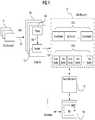
- FIG. 1illustrates an example computer system for indexing and searching geo-temporal data.
- an organization or entitymay manage one or more data sources 101 that generate data, perhaps continuously or on an ongoing or periodic basis. Any sizeable organization will typically manage multiple data sources 101 that generate a large amount of data.
- Example data sources 101include databases, log files, transaction logs, call data records, access logs, netflows, authentication logs, authorization logs, e-mail message spools, and any other container for data.
- Data generated by data sources 101includes, but is not limited to, any data that reflects an activity of an individual person or organization.
- the activitymay be an online activity, such as, for example, accessing a website, sending or receiving an e-mail, or making an online payment with a credit card or an offline activity such as, for example, using a key card to gain access to a building.
- Data generated by data sources 101also includes, but is not limited to, geo-temporal data.
- Geo-temporal datais data that may reflect activities such as those identified above and other activities that include both a geospatial component and a temporal component. For example, geo-temporal data may reflect cell phone call records that are each associated with data values reflecting a particular geographic location of the cell phone and a particular time that the call was made or received.
- data generated by data sources 101adheres to some sort of data structure or data format.
- data stored in a databasemay adhere to a relational database structure or related schema.
- data in a log filemay be formatted in eXtensible Markup Language (XML), Keyhole Markup Language (KML), or in plain-text (e.g., ASCII) with whitespace characters (e.g., tab, space, and newline characters) providing structure, or generally any other machine-parseable character based format.
- XMLeXtensible Markup Language
- KMLKeyhole Markup Language
- ASCIIplain-text
- whitespace characterse.g., tab, space, and newline characters
- Data sources 101 of an organizationmay generate and collect large amounts of data that includes geo-temporal data. Organizations would appreciate a way to efficiently analyze these collections of data including geo-temporal data to quickly identify information of interest or information pertinent to a line of inquiry.
- Information included in geo-temporal datamay be requested in geo-temporal queries that specify one or more geospatial search parameters corresponding to geographical areas of interest and one or more temporal search parameters corresponding to points in time or time ranges of interest.
- the geo-temporal information reflecting activities of interestmay be as varied along the geospatial and temporal dimensions as, for example, a request for all activities within a single city block within the past five years to all activities within an entire city within the past five hours.
- One approach for processing a geo-temporal queryis to first perform a geographically-focused search for all data objects reflecting activities in the specified geographical area and subsequently filtering the returned geographical results based on the specified temporal range.
- processing queries in this manneroften may result in filtering of the majority of the geographically-focused search results because the vast majority of the results may fall outside of the temporal range specified in a query. For example, if a large volume of crime report data is recorded for a particular geographic area over a period of many years and a user subsequently submits a query for crime reports in the particular geographic area for the past day, the majority of data returned by a geographically-focused search will be filtered out in order to refine the results to the specified temporal range.
- a data processing systemcomprises a data repository 111 , one or more adaptors 103 , and a search mechanism 113 with an interface 114 .
- the data repository 111 , the adaptors(s) 103 , the search mechanism 113 , and the interface 114may be interconnected to one another using any suitable data communication mechanism such as, for example, one or more data networks.
- the one or more data networksmay include one or more local area networks (LANs), one or more wide area networks (WANs), or internetworks such as the public Internet.
- the components of the systemmay be distributed across one or more computer systems such as the computer system 500 of FIG. 5 , which is further described herein. When distributed across multiple computer systems, components may additionally be distributed geographically, for example, across one or more data centers.
- the data repository 111may operate on one or more computing nodes of a cluster of computing nodes.
- the computing nodesmay be interconnected via a communication bus such as one or more local area data networks, one or more wide area data networks, the Internet, or other suitable data network or communication mechanism.
- data stored in data repository 111may be stored as key-value pairs.
- the stored key-value pairsmay be distributed across the computing nodes of the cluster.
- the data repository 111is implemented using the Apache Cassandra distributed database management system.
- Apache Cassandrais an open source software project maintained by the Apache Software Foundation and currently available online at the Internet domain cassandra.apache.org.
- the data repository 111is implemented using the Apache HBase distributed database management system.
- Apache HBaseis open source software maintained by the Apache Software Foundation and currently available online at the Internet domain hbase.apache.org.
- other distributed key-value data store systemsmay be used for the data repository 111 and the present embodiments are not limited to only the Apache Cassandra or the Apache HBase system.
- the adaptor(s) 103are configured to consume input data 102 and store the data in the data repository 111 .
- at least one adaptor 103is configured to ingest geo-temporal data from a data source 101 .
- the term “input data”refers to data that is presented as input to the system. That is, data that is obtained by an adaptor 103 from a data source 101 for processing and possible input into the data repository 111 .
- the term “geo-temporal data”refers to any input data that includes one or more values representing a geospatial component and one or more values representing a temporal component.
- values representing a geospatial componentmay include one or more numerical values specifying a longitude and latitude or any other representation of a geographical location.
- a temporal componentincludes one or more values specifying one or more points in time and may be specified, for example, by a character string or numerical value representing a midnight Coordinated Universal Time (UTC) value or any other representation of time values.
- UTCCoordinated Universal Time
- An adaptor 103may obtain input data 102 through any number of means including receiving input data 102 from a data source 101 or retrieving input data 102 from a data source 101 . If receiving, the adaptor 103 may, for example, receive the input data 102 in one or more network messages or event notifications. In this case, the adaptor 103 may have a network listener to which the data source 101 can connect and provide the network message or event notification. If retrieving, the adaptor 103 may, for example, periodically access or connect to a data source 101 to obtain input data 102 as a network client of the data source 101 . Other techniques for obtaining input data 102 may be used according to the requirements of the implementation at hand in various embodiments and no particular technique is required.
- a parser 104produces a stream of data blocks and a stream of index keys and values and an importer 109 produces a stream of key-value pairs 110 from the stream of data blocks and index keys and values produced by parser 104 .
- the stream of input data 102 processed by an adaptor 103may be obtained continuously or essentially continuously by the adaptor 103 as data sources 101 generate new data.
- an adaptor 103 for a web access log filemay obtain input data 102 as a web server process is writing to the log file.
- the data repository 111is also continuously or essentially continuously updated with new data blocks and new key-value pairs 110 . Old or stale data can be purged from the data repository 111 to effectively provide a rolling window of an organization's data.
- an adaptor 103may be configured to obtain a fixed amount of data to create a snapshot of the organization's data in the repository 111 .
- a combination of continuous or essentially continuous data streams and a fixed amount of datamay be used as well.
- some adaptors 103may be configured to obtain input data 102 from data sources 101 continuously or essentially continuously while other adaptors 103 may be configured to obtain a set amount of input data 102 from other data sources 101 .
- the data processing pipeline of an adaptor 103includes a parser 104 and an importer 109 . It will be understood that these and other associated building blocks and components of an adaptor 103 , may be configured as stand-alone logic elements, or may be combined together in one or more assemblies, as needed or appropriate for the particular implementation at hand.
- a logic elementmay be implemented in software, hardware, or combination of hardware and software.
- input data 102 that includes a geospatial componentmay be specified as geospatially searchable.
- a usermay configure parser 104 and/or importer 109 to identify particular data items of input data 102 as geospatially searchable data.
- data items of input data 102may be specified as geospatially searchable by default and without user input.
- geospatially searchable datamay be searched using queries that specify one or more geographical search parameters such as, for example, latitude and longitude values that define a geographical area.
- input data 102 that includes a geospatial component and that is specified to be geospatially searchableis geospatially indexed in the data repository 111 , as further described below.
- input data 102 that is specified as geospatially searchableis geospatially indexed in the data repository 111 by a parser 104 and an importer 109 of an adaptor 103 .
- One responsibility of a parser 104is to divide the stream of input data 102 into discrete data blocks.
- the data blocksare stored in the data repository 111 and indexed by key-value pairs stored in the data repository by the importer 109 .
- Each data blockmay be optionally compressed by the parser 104 using any suitable lossless data compression algorithm, or the parser 104 may send the data blocks to the data repository 111 uncompressed where they are compressed by the data repository 111 .
- any number of methodsmay be used to divide the input data 102 stream into data blocks including division of the input data 102 by logical data entity boundaries or into uniformly sized data blocks.
- one responsibility of the importer 109is to store the index keys and values in the data repository 111 in a manner that indexes the data blocks generated by the parser 104 .
- input data 102 that is geospatially indexedmay be stored in one or more data blocks, as described above, and indexed based on an index key that is derived from the geospatial component of the data.
- the index key for geospatially indexed datamay be a Z-order curve value that is generated based on the geospatial data component of the data.
- a Z-order curve valueis a one-dimensional representation of a multidimensional data representation.
- the one-dimensional representationmay be a single numeric value and the multidimensional data representation may be numeric values representing a longitude and latitude corresponding to a geographic location.
- a Z-order curve valuemay be generated, for example, by interleaving the binary values of each of the values of the two-dimensional representation.
- a generated Z-order curve valueis used to index a data block containing the data item associated with the geospatial value represented by the generated Z-order curve value.
- the geospatial indexing technique described aboveis provided only as an example and the present embodiments are not limited to the Z-order curve geospatial indexing technique.
- input data 102may include geo-temporal data that is specified as geo-temporally searchable.
- FIG. 3is a flow diagram of a process for indexing geo-temporal data in accordance with one or more embodiments described herein.
- geo-temporal input datais received that is associated with a geospatial component and a temporal component (block 300 ).
- the geo-temporal input datais indexed in a geospatial index based on the geospatial component (block 302 ).
- the geo-temporal datamay be indexed in data repository 111 according to a geospatial indexing technique such as the techniques described above.
- temporal index configuration datais received specifying one or more time granularities (e.g., years, months, days, hours, etc.) (block 304 ).
- the temporal index configuration datamay be specified by a user involved in the importation of input data 102 by using, for example, interface 114 .
- the particular time granularitiesmay be specified as part of a data import configuration file or other user input mechanisms.
- the particular time granularitiesmay be specified before, during, or after the input data 102 is imported into data repository 111 .
- geo-temporal data that has previously been geospatially indexedmay be re-indexed based on a temporal component, or geo-temporal data of input data 102 may be contemporaneously geospatially and temporally indexed at the time of data importation.
- an index bucket groupis generated for each time granularity specified in the temporal index configuration data (block 306 ).
- the generation of a temporal index bucket groupincludes storing a copy of the geospatial index data in one or more temporal index buckets.
- Each particular temporal index bucket in a temporal index bucket grouprepresents a particular range of time spanning an amount of time equal to the time granularity of the temporal index bucket group.
- each temporal index bucket groupstores a copy of the geospatial index data, with each index entry of the geospatial index stored in a particular temporal index bucket.
- the particular temporal index bucket storing each geospatial index entryis the temporal index bucket that is associated with a time range that includes the value specified by the temporal component of the data object referenced by the geospatial index entry. For example, if a temporal index bucket group is generated for a time granularity of years, and a particular data object of input data 102 includes a temporal component specifying a time value that falls within the year 2010, the geospatial index entry for that data object may be stored in a temporal index bucket representing the year 2010 in the year granularity temporal index bucket group.
- each temporal index bucketis stored in data repository 111 and represented by a row key in the distributed key-value data repository.
- the user-specified time granularitiescorrespond to time granularities that are expected by the user or others to be specified in geo-temporal queries against the data as stored in data repository 111 .
- an analyst involved in the importation of geo-temporal datamay be aware that users often desire to search for data objects associated with particular geographic regions and that are associated with temporal components within particular year time spans and/or particular hour time spans.
- an analyst involved in the importation of datamay specify temporal index configuration data indicating two time granularities for the geo-temporal input data: a year time granularity and an hour time granularity.
- temporal index bucket group 112 Bmay correspond to the index bucket group for the hour granularity.
- generated temporal index buckets of temporal index bucket group 112 Amay represent particular year timespans (e.g., 1978, 2002, 2009, 2012) and generated temporal index buckets of temporal index bucket group 112 B may represent particular day timespans (e.g., Mar. 15, 1978; Jan. 10, 2009).
- an indexed reference to the input datais stored in a particular temporal index bucket of each generated temporal index bucket group (block 308 ).
- a temporal index bucket in a particular temporal index bucket groupdoes not yet exist for the temporal value specified by the input data, a new temporal index bucket is generated for the temporal index bucket group.
- a new temporal index bucketis generated.
- the following sectionsdescribe an example graphical user interface display for specifying a geo-temporal query.
- the graphical user interface display described hereinrepresents only a selected example of a visualization for the geo-temporal query operations that are described herein.
- the disclosurebroadly encompasses any method of creating and processing geo-temporal queries that are described herein.
- the geo-temporal search functionalityis provided by a combination of a search mechanism 113 and the data repository 111 .
- the search functionalityis provided entirely be the data repository 111 or a combination of the data repository 111 , a search mechanism 113 , and one or more other system component(s) are also possible.
- the example graphical user interfacemerely represents one way to receive input from a user to specify a geo-temporal query; in other embodiments, programmatic methods may be used to obtain the same query specification information and other forms of data output may be used such as logging, reporting, storing in database tables, storing in spreadsheets, etc.
- a search mechanism 113receives as input a set of geo-temporal search parameters and provides as output a set of search results.
- FIG. 2illustrates an example graphical user interface 200 that enables a user to specify a set of search parameters for a geo-temporal query.
- Graphical user interface 200includes interface components that enable a user to specify both a geospatial bounding area and a time value or range of time values as geospatial and temporal search parameters, respectively.
- Interface component 204illustrates a representation of a geographical map that may be used to specify one or more desired geospatial bounding areas.
- bounding area 206represents an example bounding area that a user may specify on the map using an input mechanism such as, for example, a mouse pointer to draw the bounding area on the map.
- a specified bounding areasuch as bounding area 206 defines a geographical area of interest to the user that will be specified as a geospatial search parameter in a resulting geo-temporal query.
- a bounding areamay be defined using a number of shapes including, but not limited to, a radial or polygonal bounding area.
- a usermay additionally specify a temporal range of interest using graphical user interface 200 .
- a specified temporal range for a geo-temporal querymay include one or more of a start date and/or time value and an end date and/or time value.
- Graphical interface component 202illustrates an example interface component enabling a user to specify a temporal range as a search parameter.
- An interface componentsuch as interface component 202 may include, among other input elements, one or more input elements for entering date and time values. For example, a user may enter one or more dates using text boxes, a calendar, or any other interface component for entering dates and/or time values.
- interface component 202may include one or more additional input parameters enabling the specification of one or more other search parameters, for example, a search string, a sort order, etc.
- a geo-temporal querymay be generated based on the input received at graphical user interface 200 .
- search mechanismmay transform the user input received at graphical user interface 200 into a textual representation of a geo-temporal query that includes search parameters corresponding to the user input received at graphical user interface 200 .
- the geo-temporal querymay be processed by search mechanism 113 .
- FIG. 4illustrates a flow diagram of a process for carrying out a geo-temporal query in accordance with one or more of embodiments described herein.
- a search queryis received (block 400 ) that includes both a geospatial component and a temporal component.
- one or more second queriesare generated (block 402 ), with each of the second queries corresponding to a particular temporal index bucket of a temporal index bucket group.
- the temporal index bucketsare selected to correspond to the temporal component of the query.
- a geo-temporal queryis received that specifies a temporal range of Jan. 1, 2011 to Jan. 2, 2012
- the systemmay transform the geo-temporal query into a second query against the bucket corresponding to the data year 2011 and two additional second queries corresponding to the days of Jan. 1, 2012 and Jan. 2, 2012.
- processing each of the second queriesincludes processing the geospatial component of the geo-temporal query on the data stored in each of the buckets. For example, if the data in data repository 111 is geospatially indexed using Z-order curve values, the geospatial component of the query may be transformed into one or more Z-order values and the values may be used to return corresponding results from each of the temporal index buckets. In an embodiment, the zero or more results returned from each of the one or more temporal index buckets are aggregated to form an initial result set.
- processing a geo-temporal querymay include one more steps of post-filtering.
- the result set returned by the one or more second queriesmay include one or more data items that are not within the exact temporal range specified by the geo-temporal query.
- the search mechanism 113may filter (block 406 ) the one or more results that are not within the specified temporal range. For example, assume that a geo-temporal index is created using a specified time granularity of an hour, resulting in a temporal index bucket group with one or more temporal index buckets of hour time ranges (e.g., 1:00 pm-2:00 pm, 2:00 pm-3:00 pm, 3:00 pm-4:00 pm, etc.).
- An example geo-temporal querymay then include a temporal search parameter specifying a time range on a particular day between 2:15 pm and 3:15 pm.
- the search mechanism 113may transform the query into two queries that query the temporal index buckets that index data objects associated with a temporal value between the time ranges of 2:00 pm-3:00 pm and 3:00 pm-4:00 pm, respectively.
- search mechanism 113may post-filter the data object results in order to filter any data objects that are associated with a temporal value outside of the range specified in the query, i.e., those data objects in the temporal ranges of 2:00 pm-2:14 pm and 3:16 pm-4:00 pm.
- the techniques described hereinare implemented by one or more special-purpose computing devices.
- the special-purpose computing devicesmay be hard-wired to perform the techniques, or may include digital electronic devices such as one or more application-specific integrated circuits (ASICs) or field programmable gate arrays (FPGAs) that are persistently programmed to perform the techniques, or may include one or more general purpose hardware processors programmed to perform the techniques pursuant to program instructions in firmware, memory, other storage, or a combination.
- ASICsapplication-specific integrated circuits
- FPGAsfield programmable gate arrays
- Such special-purpose computing devicesmay also combine custom hard-wired logic, ASICs, or FPGAs with custom programming to accomplish the techniques.
- the special-purpose computing devicesmay be desktop computer systems, portable computer systems, handheld devices, networking devices or any other device that incorporates hard-wired and/or program logic to implement the techniques.
- FIG. 5is a block diagram that illustrates a computer system 500 upon which an embodiment may be implemented.
- Computer system 500includes a bus 502 or other communication mechanism for communicating information, and a hardware processor 504 coupled with bus 502 for processing information.
- Hardware processor 504may be, for example, a general purpose microprocessor.
- Computer system 500also includes a main memory 506 , such as a random access memory (RAM) or other dynamic storage device, coupled to bus 502 for storing information and instructions to be executed by processor 504 .
- Main memory 506also may be used for storing temporary variables or other intermediate information during execution of instructions to be executed by processor 504 .
- Such instructionswhen stored in non-transitory storage media accessible to processor 504 , render computer system 500 into a special-purpose machine that is customized to perform the operations specified in the instructions.
- Computer system 500further includes a read only memory (ROM) 508 or other static storage device coupled to bus 502 for storing static information and instructions for processor 504 .
- ROMread only memory
- a storage device 510such as a magnetic disk, optical disk, or solid-state drive is provided and coupled to bus 502 for storing information and instructions.
- Computer system 500may be coupled via bus 502 to a display 512 , such as a cathode ray tube (CRT), for displaying information to a computer user.
- a display 512such as a cathode ray tube (CRT)
- An input device 514is coupled to bus 502 for communicating information and command selections to processor 504 .
- cursor control 516is Another type of user input device
- cursor control 516such as a mouse, a trackball, or cursor direction keys for communicating direction information and command selections to processor 504 and for controlling cursor movement on display 512 .
- This input devicetypically has two degrees of freedom in two axes, a first axis (e.g., x) and a second axis (e.g., y), that allows the device to specify positions in a plane.
- Computer system 500may implement the techniques described herein using customized hard-wired logic, one or more ASICs or FPGAs, firmware and/or program logic which in combination with the computer system causes or programs computer system 500 to be a special-purpose machine. According to one embodiment, the techniques herein are performed by computer system 500 in response to processor 504 executing one or more sequences of one or more instructions contained in main memory 506 . Such instructions may be read into main memory 506 from another storage medium, such as storage device 510 . Execution of the sequences of instructions contained in main memory 506 causes processor 504 to perform the process steps described herein. In alternative embodiments, hard-wired circuitry may be used in place of or in combination with software instructions.
- Non-volatile mediaincludes, for example, optical disks, magnetic disks, or solid-state drives, such as storage device 510 .
- Volatile mediaincludes dynamic memory, such as main memory 506 .
- storage mediainclude, for example, a floppy disk, a flexible disk, hard disk, solid-state drive, magnetic tape, or any other magnetic data storage medium, a CD-ROM, any other optical data storage medium, any physical medium with patterns of holes, a RAM, a PROM, and EPROM, a FLASH-EPROM, NVRAM, any other memory chip or cartridge.
- Storage mediais distinct from but may be used in conjunction with transmission media.
- Transmission mediaparticipates in transferring information between storage media.
- transmission mediaincludes coaxial cables, copper wire and fiber optics, including the wires that comprise bus 502 .
- transmission mediacan also take the form of acoustic or light waves, such as those generated during radio-wave and infra-red data communications.
- Various forms of mediamay be involved in carrying one or more sequences of one or more instructions to processor 504 for execution.
- the instructionsmay initially be carried on a magnetic disk or solid-state drive of a remote computer.
- the remote computercan load the instructions into its dynamic memory and send the instructions over a telephone line using a modem.
- a modem local to computer system 500can receive the data on the telephone line and use an infra-red transmitter to convert the data to an infra-red signal.
- An infra-red detectorcan receive the data carried in the infra-red signal and appropriate circuitry can place the data on bus 502 .
- Bus 502carries the data to main memory 506 , from which processor 504 retrieves and executes the instructions.
- the instructions received by main memory 506may optionally be stored on storage device 510 either before or after execution by processor 504 .
- Computer system 500also includes a communication interface 518 coupled to bus 502 .
- Communication interface 518provides a two-way data communication coupling to a network link 520 that is connected to a local network 522 .
- communication interface 518may be an integrated services digital network (ISDN) card, cable modem, satellite modem, or a modem to provide a data communication connection to a corresponding type of telephone line.
- ISDNintegrated services digital network
- communication interface 518may be a local area network (LAN) card to provide a data communication connection to a compatible LAN.
- LANlocal area network
- Wireless linksmay also be implemented.
- communication interface 518sends and receives electrical, electromagnetic or optical signals that carry digital data streams representing various types of information.
- Network link 520typically provides data communication through one or more networks to other data devices.
- network link 520may provide a connection through local network 522 to a host computer 524 or to data equipment operated by an Internet Service Provider (ISP) 526 .
- ISP 526in turn provides data communication services through the world wide packet data communication network now commonly referred to as the “Internet” 528 .
- Internet 528uses electrical, electromagnetic or optical signals that carry digital data streams.
- the signals through the various networks and the signals on network link 520 and through communication interface 518which carry the digital data to and from computer system 500 , are example forms of transmission media.
- Computer system 500can send messages and receive data, including program code, through the network(s), network link 520 and communication interface 518 .
- a server 530might transmit a requested code for an application program through Internet 528 , ISP 526 , local network 522 and communication interface 518 .
- the received codemay be executed by processor 504 as it is received, and/or stored in storage device 510 , or other non-volatile storage for later execution.
Landscapes
- Engineering & Computer Science (AREA)
- Theoretical Computer Science (AREA)
- Physics & Mathematics (AREA)
- Databases & Information Systems (AREA)
- General Physics & Mathematics (AREA)
- General Engineering & Computer Science (AREA)
- Data Mining & Analysis (AREA)
- Software Systems (AREA)
- Fuzzy Systems (AREA)
- Mathematical Physics (AREA)
- Probability & Statistics with Applications (AREA)
- Computational Linguistics (AREA)
- Remote Sensing (AREA)
- Information Retrieval, Db Structures And Fs Structures Therefor (AREA)
Abstract
Description
This application claims the benefit under 35 U.S.C. § 120 as a continuation of application Ser. No. 13/728,879, filed Dec. 27, 2012, the entire contents of which is hereby incorporated herein by reference for all purposes as if fully set forth herein. The applicant(s) hereby rescind any disclaimer of claim scope in the parent application(s) or the prosecution history thereof and advise the USPTO that the claims in this application may be broader than any claim in the parent applications.
The present disclosure generally relates to computer-based analysis of geospatial data that includes a temporal component.
Data analysts and other computer users often interact with and request data from computer-based databases containing large collections of data objects. The data object collections may be generated and collected by various corporations, businesses, governmental agencies, and other organizations and often represent huge amounts of data. For example, the data may include DNS traffic logs, transaction logs of banks, call data records, or any other potentially high-volume data.
One particular type of data that such organizations may often collect and analyze is geospatial data. Geospatial data generally represents any data that includes a geographical component and that associates the data with particular geographic locations or areas. For example, a crime enforcement agency may track data that corresponds to crime reports received within a particular city. One item of information stored in association with each crime report may include a geographical component indicating a location of the incident specified by the crime report. An example data object representing each crime report may include values representing a longitude and latitude corresponding to the geographical location of the incident. A data analyst with access to such data may then specify geospatial search requests such as, for example, a search request for crime reports associated with incidents within a specified geographical radius or within a four block perimeter.
Organizations also frequently collect data that includes a temporal component. A temporal component generally refers to one or more data values that indicate a particular point in time, such as a date and/or time of day, or a range of time. For example, in reference to the example crime report information, a crime enforcement agency may store in association with each crime report a time value indicating an approximate time the incident in the crime report occurred. In the example, by storing the temporal information, data analysts may specify requests for data objects associated with a particular time range of interest, for example, all crime reports associated with an incident that occurred within the past three months.
Databases have provided mechanisms for efficiently indexing and searching geospatial data for a number of years. These mechanisms include geospatial indices that transform the geospatial data into values that are well-suited for database indexing while preserving a notion of geographical locality in the indexed data. However, indexing and searching for geo-temporal data presents a number of challenges that are not resolved by today's geospatial indexing techniques. For example, because the notion of geographical locality does not accurately translate to the added dimensionality of time, the use of geospatial indexing mechanisms on geo-temporal data often results in highly inefficient processing of geo-temporal queries. Further, user requests for geo-temporal data are often focused on highly varied granularities of time for reasons practical to desired lines of inquiries on the data, but that complicate efforts to efficiently index the data.
The present disclosure attempts to address these problems and others, facilitating low latency searches of large and dynamic data sets that include geo-temporal data.
The approaches described in this section are approaches that could be pursued, but not necessarily approaches that have been previously conceived or pursued. Therefore, unless otherwise indicated, it should not be assumed that any of the approaches described in this section qualify as prior art merely by virtue of their inclusion in this section.
In the drawings:
In the following description, for the purposes of explanation, numerous specific details are set forth in order to provide a thorough understanding of the present invention. It will be apparent, however, that the present invention may be practiced without these specific details. In other instances, well-known structures and devices are shown in block diagram form in order to avoid unnecessarily obscuring the present invention. Embodiments are described herein according to the following outline:
- 1.0 General Overview
- 2.0 Structural and Functional Overview
- 2.1 Data Sources
- 2.2 Data Repository
- 2.3 Geo-temporal Data Importation
- 2.3.1 Indexing Geospatial Data
- 2.3.2 Indexing Geo-temporal Data
- 3.0 Example Geo-temporal Search Operation
- 4.0 Implementation Mechanisms—Hardware Overview
1.0 General Overview
The present disclosure is directed to computer systems and methods for indexing and searching geo-temporal data stored in a data repository. Geo-temporal data generally refers to data that includes both a geospatial component and a temporal component. The geospatial component may comprise one or more stored data values indicating a geographic location and the temporal component may comprise one or more values indicating a point in time or range of time. In general terms, in order to more efficiently process requests for geo-temporal data stored in a key-value data repository, a geo-temporal indexing structure is generated and managed in computer memory; for example, indexes may be stored on disk and cached in memory on demand. In an embodiment, the geo-temporal indexing structure is based in part on user input specifying one or more time sets or granularities that are likely to correspond to time ranges specified in user requests for the stored and indexed geo-temporal data.
The geo-temporal data may be obtained from potentially multiple disparate data sources and examples of geo-temporal data include, but are not limited to, network traffic logs, bank transaction records, phone call records, crime data, or any other data that includes both a geospatial and temporal component. In an embodiment, the geo-temporal data is received and indexed in a data repository based on a geospatial component of the data. In an embodiment, the indexing of the geo-temporal data based on the geospatial component may be based on Z-order curves, Hilbert curves, or any other geospatial indexing technique.
In an embodiment, in addition to geospatially indexing the geo-temporal data, the data is further indexed in the data repository based on a temporal component of the data and based on received user input specifying one or more time granularities that a user may, for example, anticipate to be time granularities that are likely to correspond to user requests against the indexed data. Examples of various time granularities that may be used in embodiments, or together in one embodiment, include years, months, days, and any other useful measure of time. In an embodiment, a “temporal index bucket” group comprising one or more temporal index buckets is created in the data repository for each of the user-specified time granularities. In an embodiment, each temporal index bucket of a temporal index bucket group corresponds to a particular range of time equal to the corresponding time granularity for that bucket group. Each particular temporal index bucket includes one or more references to geospatially indexed data objects that are associated with a temporal value that falls within the particular range of time associated with the particular temporal index bucket.
For example, if a user involved in the importation of geo-temporal data is aware that user requests are likely to be received for geo-temporal data within particular month ranges, the user may specify a time granularity of months for the indexing of the imported geo-temporal data. In the example, in response to receiving the user input, a temporal index bucket group is created for the specified time granularity of months. The temporal index bucket group includes one or more temporal index buckets that each correspond to a particular month time range and each particular index bucket indexes a portion of the geo-temporal data that is associated with a temporal component that falls within the particular month time range for that particular bucket. If a user additionally specifies a time granularity of days for the same data, a separate temporal index bucket group is created for day time ranges and indexes the geo-temporal data into temporal index buckets of individual day time ranges.
In an embodiment, requests for geo-temporal data indexed in a data repository are processed using one or more of the generated index bucket groups. For example, a geo-temporal request may be a query specifying one or more geospatial search parameters and one or more temporal search parameters. In an embodiment, a geo-temporal request for geo-temporal data indexed according to the methods described herein is transformed into one or more second requests against one or more temporal index buckets based on the temporal component specified in the request. For example, assume particular geo-temporal data includes data with temporal components associated with time values falling within each of the years 2000-2010 and is indexed according to a time granularity of years. The temporal index bucket group may then include a temporal index bucket for each of the years 2000, 2001, 2002, and so forth. If a geo-temporal query is received specifying a particular geospatial and a temporal range spanning the years 2008 and 2009, the geo-temporal query may be transformed into separate queries against the 2008 and 2009 temporal index buckets.
2.0 Structural and Functional Overview
2.1 Data Sources
Data generated bydata sources 101 includes, but is not limited to, any data that reflects an activity of an individual person or organization. The activity may be an online activity, such as, for example, accessing a website, sending or receiving an e-mail, or making an online payment with a credit card or an offline activity such as, for example, using a key card to gain access to a building. Data generated bydata sources 101 also includes, but is not limited to, geo-temporal data. Geo-temporal data is data that may reflect activities such as those identified above and other activities that include both a geospatial component and a temporal component. For example, geo-temporal data may reflect cell phone call records that are each associated with data values reflecting a particular geographic location of the cell phone and a particular time that the call was made or received.
Typically, but not always, data generated bydata sources 101 adheres to some sort of data structure or data format. For example, data stored in a database may adhere to a relational database structure or related schema. As another example, data in a log file, including geo-temporal data, may be formatted in eXtensible Markup Language (XML), Keyhole Markup Language (KML), or in plain-text (e.g., ASCII) with whitespace characters (e.g., tab, space, and newline characters) providing structure, or generally any other machine-parseable character based format.
One approach for processing a geo-temporal query is to first perform a geographically-focused search for all data objects reflecting activities in the specified geographical area and subsequently filtering the returned geographical results based on the specified temporal range. However, processing queries in this manner often may result in filtering of the majority of the geographically-focused search results because the vast majority of the results may fall outside of the temporal range specified in a query. For example, if a large volume of crime report data is recorded for a particular geographic area over a period of many years and a user subsequently submits a query for crime reports in the particular geographic area for the past day, the majority of data returned by a geographically-focused search will be filtered out in order to refine the results to the specified temporal range.
Referring again toFIG. 1 , in an embodiment a data processing system comprises adata repository 111, one or more adaptors103, and asearch mechanism 113 with aninterface 114. Thedata repository 111, the adaptors(s)103, thesearch mechanism 113, and theinterface 114 may be interconnected to one another using any suitable data communication mechanism such as, for example, one or more data networks. The one or more data networks may include one or more local area networks (LANs), one or more wide area networks (WANs), or internetworks such as the public Internet. The components of the system may be distributed across one or more computer systems such as thecomputer system 500 ofFIG. 5 , which is further described herein. When distributed across multiple computer systems, components may additionally be distributed geographically, for example, across one or more data centers.
2.2 Data Repository
Thedata repository 111 may operate on one or more computing nodes of a cluster of computing nodes. The computing nodes may be interconnected via a communication bus such as one or more local area data networks, one or more wide area data networks, the Internet, or other suitable data network or communication mechanism. In an embodiment, data stored indata repository 111 may be stored as key-value pairs. In an embodiment, in order to handle large data sets, the stored key-value pairs may be distributed across the computing nodes of the cluster.
In some embodiments, thedata repository 111 is implemented using the Apache Cassandra distributed database management system. Apache Cassandra is an open source software project maintained by the Apache Software Foundation and currently available online at the Internet domain cassandra.apache.org. In other embodiments, thedata repository 111 is implemented using the Apache HBase distributed database management system. Apache HBase is open source software maintained by the Apache Software Foundation and currently available online at the Internet domain hbase.apache.org. However, other distributed key-value data store systems may be used for thedata repository 111 and the present embodiments are not limited to only the Apache Cassandra or the Apache HBase system.
2.3 Geo-Temporal Data Importation
The adaptor(s)103 are configured to consumeinput data 102 and store the data in thedata repository 111. There may be an adaptor103 for each type ofdata source 101. For example, there may be an adaptor for ingestinginput data 102 produced by a databasesystem data source 101 and another adaptor103 for a web accesslog data source 101. In an embodiment, at least one adaptor103 is configured to ingest geo-temporal data from adata source 101.
In this context, the term “input data” refers to data that is presented as input to the system. That is, data that is obtained by an adaptor103 from adata source 101 for processing and possible input into thedata repository 111. The term “geo-temporal data” refers to any input data that includes one or more values representing a geospatial component and one or more values representing a temporal component. For example, values representing a geospatial component may include one or more numerical values specifying a longitude and latitude or any other representation of a geographical location. A temporal component includes one or more values specifying one or more points in time and may be specified, for example, by a character string or numerical value representing a midnight Coordinated Universal Time (UTC) value or any other representation of time values.
An adaptor103 may obtaininput data 102 through any number of means including receivinginput data 102 from adata source 101 or retrievinginput data 102 from adata source 101. If receiving, the adaptor103 may, for example, receive theinput data 102 in one or more network messages or event notifications. In this case, the adaptor103 may have a network listener to which thedata source 101 can connect and provide the network message or event notification. If retrieving, the adaptor103 may, for example, periodically access or connect to adata source 101 to obtaininput data 102 as a network client of thedata source 101. Other techniques for obtaininginput data 102 may be used according to the requirements of the implementation at hand in various embodiments and no particular technique is required.
In some embodiments, aparser 104 produces a stream of data blocks and a stream of index keys and values and animporter 109 produces a stream of key-value pairs110 from the stream of data blocks and index keys and values produced byparser 104.
The stream ofinput data 102 processed by an adaptor103 may be obtained continuously or essentially continuously by the adaptor103 asdata sources 101 generate new data. For example, an adaptor103 for a web access log file may obtaininput data 102 as a web server process is writing to the log file. In this case, where the stream ofinput data 102 is continuous or essentially continuous, thedata repository 111 is also continuously or essentially continuously updated with new data blocks and new key-value pairs110. Old or stale data can be purged from thedata repository 111 to effectively provide a rolling window of an organization's data. Alternatively, an adaptor103 may be configured to obtain a fixed amount of data to create a snapshot of the organization's data in therepository 111. A combination of continuous or essentially continuous data streams and a fixed amount of data may be used as well. For example, some adaptors103 may be configured to obtaininput data 102 fromdata sources 101 continuously or essentially continuously while other adaptors103 may be configured to obtain a set amount ofinput data 102 fromother data sources 101.
As mentioned, in one embodiment, the data processing pipeline of an adaptor103 includes aparser 104 and animporter 109. It will be understood that these and other associated building blocks and components of an adaptor103, may be configured as stand-alone logic elements, or may be combined together in one or more assemblies, as needed or appropriate for the particular implementation at hand. A logic element may be implemented in software, hardware, or combination of hardware and software.
2.3.1 Indexing Geospatial Data
In an embodiment,input data 102 that includes a geospatial component may be specified as geospatially searchable. For example, a user may configureparser 104 and/orimporter 109 to identify particular data items ofinput data 102 as geospatially searchable data. In other embodiments, data items ofinput data 102 may be specified as geospatially searchable by default and without user input. In general, geospatially searchable data may be searched using queries that specify one or more geographical search parameters such as, for example, latitude and longitude values that define a geographical area. In an embodiment,input data 102 that includes a geospatial component and that is specified to be geospatially searchable is geospatially indexed in thedata repository 111, as further described below.
In an embodiment,input data 102 that is specified as geospatially searchable is geospatially indexed in thedata repository 111 by aparser 104 and animporter 109 of an adaptor103. One responsibility of aparser 104 is to divide the stream ofinput data 102 into discrete data blocks. The data blocks are stored in thedata repository 111 and indexed by key-value pairs stored in the data repository by theimporter 109. Each data block may be optionally compressed by theparser 104 using any suitable lossless data compression algorithm, or theparser 104 may send the data blocks to thedata repository 111 uncompressed where they are compressed by thedata repository 111. Any number of methods may be used to divide theinput data 102 stream into data blocks including division of theinput data 102 by logical data entity boundaries or into uniformly sized data blocks. In an embodiment, one responsibility of theimporter 109 is to store the index keys and values in thedata repository 111 in a manner that indexes the data blocks generated by theparser 104.
In an embodiment,input data 102 that is geospatially indexed may be stored in one or more data blocks, as described above, and indexed based on an index key that is derived from the geospatial component of the data. For example, in an embodiment, the index key for geospatially indexed data may be a Z-order curve value that is generated based on the geospatial data component of the data. In general, a Z-order curve value is a one-dimensional representation of a multidimensional data representation. The one-dimensional representation may be a single numeric value and the multidimensional data representation may be numeric values representing a longitude and latitude corresponding to a geographic location. A Z-order curve value may be generated, for example, by interleaving the binary values of each of the values of the two-dimensional representation. In an embodiment, a generated Z-order curve value is used to index a data block containing the data item associated with the geospatial value represented by the generated Z-order curve value. The geospatial indexing technique described above is provided only as an example and the present embodiments are not limited to the Z-order curve geospatial indexing technique.
2.3.2 Indexing Geo-Temporal Data
Similar to the specification ofparticular input data 102 as geospatially searchable, in an embodiment,input data 102 may include geo-temporal data that is specified as geo-temporally searchable.FIG. 3 is a flow diagram of a process for indexing geo-temporal data in accordance with one or more embodiments described herein. Initially, geo-temporal input data is received that is associated with a geospatial component and a temporal component (block300). The geo-temporal input data is indexed in a geospatial index based on the geospatial component (block302). For example, the geo-temporal data may be indexed indata repository 111 according to a geospatial indexing technique such as the techniques described above.
In an embodiment, temporal index configuration data is received specifying one or more time granularities (e.g., years, months, days, hours, etc.) (block304). In an embodiment, the temporal index configuration data may be specified by a user involved in the importation ofinput data 102 by using, for example,interface 114. In other embodiments, the particular time granularities may be specified as part of a data import configuration file or other user input mechanisms. In an embodiment, the particular time granularities may be specified before, during, or after theinput data 102 is imported intodata repository 111. For example, geo-temporal data that has previously been geospatially indexed may be re-indexed based on a temporal component, or geo-temporal data ofinput data 102 may be contemporaneously geospatially and temporally indexed at the time of data importation.
In an embodiment, based on the received temporal index configuration data, an index bucket group is generated for each time granularity specified in the temporal index configuration data (block306). In an embodiment, the generation of a temporal index bucket group includes storing a copy of the geospatial index data in one or more temporal index buckets. Each particular temporal index bucket in a temporal index bucket group represents a particular range of time spanning an amount of time equal to the time granularity of the temporal index bucket group. In an embodiment, each temporal index bucket group stores a copy of the geospatial index data, with each index entry of the geospatial index stored in a particular temporal index bucket. The particular temporal index bucket storing each geospatial index entry is the temporal index bucket that is associated with a time range that includes the value specified by the temporal component of the data object referenced by the geospatial index entry. For example, if a temporal index bucket group is generated for a time granularity of years, and a particular data object ofinput data 102 includes a temporal component specifying a time value that falls within the year 2010, the geospatial index entry for that data object may be stored in a temporal index bucket representing the year 2010 in the year granularity temporal index bucket group. In an embodiment, each temporal index bucket is stored indata repository 111 and represented by a row key in the distributed key-value data repository.
In general, the user-specified time granularities correspond to time granularities that are expected by the user or others to be specified in geo-temporal queries against the data as stored indata repository 111. For example, an analyst involved in the importation of geo-temporal data may be aware that users often desire to search for data objects associated with particular geographic regions and that are associated with temporal components within particular year time spans and/or particular hour time spans. In the example, an analyst involved in the importation of data may specify temporal index configuration data indicating two time granularities for the geo-temporal input data: a year time granularity and an hour time granularity. For example, temporalindex bucket group 112A inFIG. 1 may correspond to the index bucket group for the year time granularity and temporalindex bucket group 112B may correspond to the index bucket group for the hour granularity. In the example, generated temporal index buckets of temporalindex bucket group 112A may represent particular year timespans (e.g., 1978, 2002, 2009, 2012) and generated temporal index buckets of temporalindex bucket group 112B may represent particular day timespans (e.g., Mar. 15, 1978; Jan. 10, 2009).
In an embodiment, based on the temporal component of the input data, an indexed reference to the input data is stored in a particular temporal index bucket of each generated temporal index bucket group (block308). In an embodiment, if a temporal index bucket in a particular temporal index bucket group does not yet exist for the temporal value specified by the input data, a new temporal index bucket is generated for the temporal index bucket group. In reference to the example temporalindex bucket groups 112A and11B, if input data is received specifying a temporal component value corresponding to the date Jan. 10, 2009 and no temporal bucket exists in day granularity temporalindex bucket group 112B corresponding to January 10, a new temporal index bucket is generated.
3.0 Example Search Operation
For the purposes of clearly illustrating how the functions described herein operate upon geo-temporal queries, the following sections describe an example graphical user interface display for specifying a geo-temporal query. However, the graphical user interface display described herein represents only a selected example of a visualization for the geo-temporal query operations that are described herein. Thus, the disclosure broadly encompasses any method of creating and processing geo-temporal queries that are described herein. In the following description, it will be assumed for the sake of illustration that the geo-temporal search functionality is provided by a combination of asearch mechanism 113 and thedata repository 111. However, this is just one possible implementation. Other implementations where the search functionality is provided entirely be thedata repository 111 or a combination of thedata repository 111, asearch mechanism 113, and one or more other system component(s) are also possible.
Further, no particular graphical user interface is required and the disclosure is intended to encompass the geo-temporal query processing approaches that are described independent of any graphical user interface, and it is not intended to be limited to any particular graphical user interface or other form of display. For example, the example graphical user interface merely represents one way to receive input from a user to specify a geo-temporal query; in other embodiments, programmatic methods may be used to obtain the same query specification information and other forms of data output may be used such as logging, reporting, storing in database tables, storing in spreadsheets, etc.
In general, asearch mechanism 113 receives as input a set of geo-temporal search parameters and provides as output a set of search results.FIG. 2 illustrates an examplegraphical user interface 200 that enables a user to specify a set of search parameters for a geo-temporal query.Graphical user interface 200 includes interface components that enable a user to specify both a geospatial bounding area and a time value or range of time values as geospatial and temporal search parameters, respectively.
In an embodiment, a user may additionally specify a temporal range of interest usinggraphical user interface 200. In an embodiment, a specified temporal range for a geo-temporal query may include one or more of a start date and/or time value and an end date and/or time value.Graphical interface component 202 illustrates an example interface component enabling a user to specify a temporal range as a search parameter. An interface component such asinterface component 202 may include, among other input elements, one or more input elements for entering date and time values. For example, a user may enter one or more dates using text boxes, a calendar, or any other interface component for entering dates and/or time values. In addition to specifying a temporal range,interface component 202 may include one or more additional input parameters enabling the specification of one or more other search parameters, for example, a search string, a sort order, etc.
In an embodiment, a geo-temporal query may be generated based on the input received atgraphical user interface 200. For example, search mechanism may transform the user input received atgraphical user interface 200 into a textual representation of a geo-temporal query that includes search parameters corresponding to the user input received atgraphical user interface 200. After the geo-temporal query is generated, the geo-temporal query may be processed bysearch mechanism 113.
In response to each of the second queries, zero or more results are returned from each of the particular temporal index buckets (block404). The results returned from each of the temporal index buckets are those results that satisfy the geospatial component of the query. Thus, in an embodiment, processing each of the second queries includes processing the geospatial component of the geo-temporal query on the data stored in each of the buckets. For example, if the data indata repository 111 is geospatially indexed using Z-order curve values, the geospatial component of the query may be transformed into one or more Z-order values and the values may be used to return corresponding results from each of the temporal index buckets. In an embodiment, the zero or more results returned from each of the one or more temporal index buckets are aggregated to form an initial result set.
In an embodiment, processing a geo-temporal query may include one more steps of post-filtering. As a result of the particular partitioning of the temporal index buckets, the result set returned by the one or more second queries may include one or more data items that are not within the exact temporal range specified by the geo-temporal query. In an embodiment, thesearch mechanism 113 may filter (block406) the one or more results that are not within the specified temporal range. For example, assume that a geo-temporal index is created using a specified time granularity of an hour, resulting in a temporal index bucket group with one or more temporal index buckets of hour time ranges (e.g., 1:00 pm-2:00 pm, 2:00 pm-3:00 pm, 3:00 pm-4:00 pm, etc.). An example geo-temporal query may then include a temporal search parameter specifying a time range on a particular day between 2:15 pm and 3:15 pm. In response to receiving the example geo-temporal query, thesearch mechanism 113 may transform the query into two queries that query the temporal index buckets that index data objects associated with a temporal value between the time ranges of 2:00 pm-3:00 pm and 3:00 pm-4:00 pm, respectively. After retrieving any data objects from either or both of the two index buckets that satisfy any geospatial component of the query,search mechanism 113 may post-filter the data object results in order to filter any data objects that are associated with a temporal value outside of the range specified in the query, i.e., those data objects in the temporal ranges of 2:00 pm-2:14 pm and 3:16 pm-4:00 pm.
4.0 Implementation Mechanisms—Hardware Overview
According to one embodiment, the techniques described herein are implemented by one or more special-purpose computing devices. The special-purpose computing devices may be hard-wired to perform the techniques, or may include digital electronic devices such as one or more application-specific integrated circuits (ASICs) or field programmable gate arrays (FPGAs) that are persistently programmed to perform the techniques, or may include one or more general purpose hardware processors programmed to perform the techniques pursuant to program instructions in firmware, memory, other storage, or a combination. Such special-purpose computing devices may also combine custom hard-wired logic, ASICs, or FPGAs with custom programming to accomplish the techniques. The special-purpose computing devices may be desktop computer systems, portable computer systems, handheld devices, networking devices or any other device that incorporates hard-wired and/or program logic to implement the techniques.
For example,FIG. 5 is a block diagram that illustrates acomputer system 500 upon which an embodiment may be implemented.Computer system 500 includes abus 502 or other communication mechanism for communicating information, and ahardware processor 504 coupled withbus 502 for processing information.Hardware processor 504 may be, for example, a general purpose microprocessor.
The term “storage media” as used herein refers to any non-transitory media that store data and/or instructions that cause a machine to operate in a specific fashion. Such storage media may comprise non-volatile media and/or volatile media. Non-volatile media includes, for example, optical disks, magnetic disks, or solid-state drives, such asstorage device 510. Volatile media includes dynamic memory, such asmain memory 506. Common forms of storage media include, for example, a floppy disk, a flexible disk, hard disk, solid-state drive, magnetic tape, or any other magnetic data storage medium, a CD-ROM, any other optical data storage medium, any physical medium with patterns of holes, a RAM, a PROM, and EPROM, a FLASH-EPROM, NVRAM, any other memory chip or cartridge.
Storage media is distinct from but may be used in conjunction with transmission media. Transmission media participates in transferring information between storage media. For example, transmission media includes coaxial cables, copper wire and fiber optics, including the wires that comprisebus 502. Transmission media can also take the form of acoustic or light waves, such as those generated during radio-wave and infra-red data communications.
Various forms of media may be involved in carrying one or more sequences of one or more instructions toprocessor 504 for execution. For example, the instructions may initially be carried on a magnetic disk or solid-state drive of a remote computer. The remote computer can load the instructions into its dynamic memory and send the instructions over a telephone line using a modem. A modem local tocomputer system 500 can receive the data on the telephone line and use an infra-red transmitter to convert the data to an infra-red signal. An infra-red detector can receive the data carried in the infra-red signal and appropriate circuitry can place the data onbus 502.Bus 502 carries the data tomain memory 506, from whichprocessor 504 retrieves and executes the instructions. The instructions received bymain memory 506 may optionally be stored onstorage device 510 either before or after execution byprocessor 504.
Network link520 typically provides data communication through one or more networks to other data devices. For example,network link 520 may provide a connection throughlocal network 522 to ahost computer 524 or to data equipment operated by an Internet Service Provider (ISP)526.ISP 526 in turn provides data communication services through the world wide packet data communication network now commonly referred to as the “Internet”528.Local network 522 andInternet 528 both use electrical, electromagnetic or optical signals that carry digital data streams. The signals through the various networks and the signals onnetwork link 520 and throughcommunication interface 518, which carry the digital data to and fromcomputer system 500, are example forms of transmission media.
The received code may be executed byprocessor 504 as it is received, and/or stored instorage device 510, or other non-volatile storage for later execution.
In the foregoing specification, embodiments have been described with reference to numerous specific details that may vary from implementation to implementation. The specification and drawings are, accordingly, to be regarded in an illustrative rather than a restrictive sense. The sole and exclusive indicator of the scope of the embodiments, and what is intended by the applicants to be the scope of the embodiments, is the literal and equivalent scope of the set of claims that issue from this application, in the specific form in which such claims issue, including any subsequent correction.
Claims (16)
1. A computer-implemented method for indexing data items that are associated with a geospatial component and a time component, the computer-implemented method comprising:
receiving a data item that is associated with at least a geospatial component and a time component;
storing a reference to the data item in a geospatial index based on the geospatial component;
receiving time index configuration data indicating a first time granularity, a second time granularity, and a third time granularity;
generating a first plurality of database index buckets for the first time granularity, a second plurality of database index buckets for the second time granularity, and a third plurality of database index buckets for the third time granularity;
storing, based on the time component, a second reference to the data item in a database index bucket of the first plurality, the second plurality, and the third plurality;
receiving a search request comprising at least a second time component;
generating at least two search queries using the second time component retrieving one or more data items using the at least two search queries;
wherein the method is performed by one or more computing devices.
2. The method ofclaim 1 , wherein the second time component comprises a time range.
3. The method ofclaim 2 , further comprising filtering one or more of the one or more data items retrieved by the two search queries that are not in the time range specified by the search request.
4. The method ofclaim 1 , wherein the geospatial component comprises a Z-order geographic value.
5. The method ofclaim 1 , wherein the time component comprises a value representing a date and time.
6. The method ofclaim 1 , wherein the first time granularity, the second time granularity, and the third time granularity are specified by a user or based on requirements of a user-specified query.
7. The method ofclaim 1 , wherein the first time granularity, the second time granularity, and the third time granularity are one of seconds, minutes, hours, days, months, years, decades, centuries.
8. The method ofclaim 1 , wherein each of the first plurality of database index buckets is identified by a hash value.
9. A non-transitory computer-readable medium storing one or more sequences of instructions, which when executed by one or more processors, cause the one or more processors to carry out the steps of:
receiving a data item that is associated with at least a geospatial component and a time component;
storing a reference to the data item in a geospatial index based on the geospatial component;
receiving time index configuration data indicating a first time granularity, a second time granularity, and a third time granularity;
generating a first plurality of database index buckets for the first time granularity, a second plurality of database index buckets for the second time granularity, and a third plurality of database index buckets for the third time granularity;
storing, based on the time component, a second reference to the data item in a database index bucket of the first plurality, the second plurality, and the third plurality;
receiving a search request comprising at least a second time component;
generating at least two search queries using the second time component;
retrieving one or more data items using the at least two search queries.
10. The non-transitory computer readable medium ofclaim 9 , wherein said second time component comprises a time range.
11. The non-transitory computer readable medium ofclaim 10 , further comprising filtering one or more of the one or more data items retrieved by the two search queries that are not in the time range specified by the search request.
12. The non-transitory computer readable medium ofclaim 9 , wherein the geospatial component comprises a Z-order geographic value.
13. The non-transitory computer readable medium ofclaim 9 , wherein said time component comprises a value representing a date and time.
14. The non-transitory computer readable medium ofclaim 9 , wherein the first time granularity, the second time granularity, and the third time granularity are specified by a user or based on requirements of a user-specified query.
15. The non-transitory computer readable medium ofclaim 9 , wherein the first time granularity, the second time granularity, and the third time granularity are one of seconds, minutes, hours, years, decades, centuries.
16. The non-transitory computer readable medium ofclaim 9 , wherein each of the first plurality of database index buckets is identified by a hash value.
Priority Applications (1)
| Application Number | Priority Date | Filing Date | Title |
|---|---|---|---|
| US15/358,002US10691662B1 (en) | 2012-12-27 | 2016-11-21 | Geo-temporal indexing and searching |
Applications Claiming Priority (2)
| Application Number | Priority Date | Filing Date | Title |
|---|---|---|---|
| US13/728,879US9501507B1 (en) | 2012-12-27 | 2012-12-27 | Geo-temporal indexing and searching |
| US15/358,002US10691662B1 (en) | 2012-12-27 | 2016-11-21 | Geo-temporal indexing and searching |
Related Parent Applications (1)
| Application Number | Title | Priority Date | Filing Date |
|---|---|---|---|
| US13/728,879ContinuationUS9501507B1 (en) | 2012-12-27 | 2012-12-27 | Geo-temporal indexing and searching |
Publications (1)
| Publication Number | Publication Date |
|---|---|
| US10691662B1true US10691662B1 (en) | 2020-06-23 |
Family
ID=57287706
Family Applications (2)
| Application Number | Title | Priority Date | Filing Date |
|---|---|---|---|
| US13/728,879Active2034-08-06US9501507B1 (en) | 2012-12-27 | 2012-12-27 | Geo-temporal indexing and searching |
| US15/358,002Active2034-12-24US10691662B1 (en) | 2012-12-27 | 2016-11-21 | Geo-temporal indexing and searching |
Family Applications Before (1)
| Application Number | Title | Priority Date | Filing Date |
|---|---|---|---|
| US13/728,879Active2034-08-06US9501507B1 (en) | 2012-12-27 | 2012-12-27 | Geo-temporal indexing and searching |
Country Status (1)
| Country | Link |
|---|---|
| US (2) | US9501507B1 (en) |
Cited By (4)
| Publication number | Priority date | Publication date | Assignee | Title |
|---|---|---|---|---|
| US11366810B2 (en)* | 2020-04-27 | 2022-06-21 | Salesforce.Com, Inc. | Index contention under high concurrency in a database system |
| US20220221297A1 (en)* | 2020-06-02 | 2022-07-14 | FLIR Belgium BVBA | Waypoint timeline user interface systems and methods |
| US20220222234A1 (en)* | 2019-11-14 | 2022-07-14 | Acronis International Gmbh | Systems and methods for multiplexing data of an underlying index |
| US11775545B1 (en) | 2020-09-23 | 2023-10-03 | Amazon Technologies, Inc. | Cloud-based database for spatial data lifecycle management |
Families Citing this family (17)
| Publication number | Priority date | Publication date | Assignee | Title |
|---|---|---|---|---|
| US11726979B2 (en) | 2016-09-13 | 2023-08-15 | Oracle International Corporation | Determining a chronological order of transactions executed in relation to an object stored in a storage system |
| US10733159B2 (en) | 2016-09-14 | 2020-08-04 | Oracle International Corporation | Maintaining immutable data and mutable metadata in a storage system |
| US10860534B2 (en) | 2016-10-27 | 2020-12-08 | Oracle International Corporation | Executing a conditional command on an object stored in a storage system |
| US10956051B2 (en) | 2016-10-31 | 2021-03-23 | Oracle International Corporation | Data-packed storage containers for streamlined access and migration |
| US10191936B2 (en) | 2016-10-31 | 2019-01-29 | Oracle International Corporation | Two-tier storage protocol for committing changes in a storage system |
| US10275177B2 (en) | 2016-10-31 | 2019-04-30 | Oracle International Corporation | Data layout schemas for seamless data migration |
| US10169081B2 (en) | 2016-10-31 | 2019-01-01 | Oracle International Corporation | Use of concurrent time bucket generations for scalable scheduling of operations in a computer system |
| US10180863B2 (en) | 2016-10-31 | 2019-01-15 | Oracle International Corporation | Determining system information based on object mutation events |
| US10506380B2 (en) | 2016-12-22 | 2019-12-10 | Nokia Solutions And Networks Oy | User motion profiling based on user equipment cell location |
| CN108460094A (en)* | 2018-01-30 | 2018-08-28 | 上海天旦网络科技发展有限公司 | The method and system of storage statistical data |
| CN111352956B (en)* | 2020-02-24 | 2023-07-14 | 交通运输部水运科学研究所 | A shipping big data collection and storage system |
| US11762932B2 (en)* | 2020-06-30 | 2023-09-19 | Amazon Technologies, Inc. | Spatial search using key-value store |
| US20230359751A1 (en)* | 2022-05-09 | 2023-11-09 | International Business Machines Corporation | Safety-measure centric temporal containers for real-time creation during a digital meeting |
| US12292881B1 (en) | 2022-09-30 | 2025-05-06 | Amazon Technologies, Inc. | Distributed transaction execution across shards of scalable database tables |
| US12147317B1 (en) | 2022-09-30 | 2024-11-19 | Amazon Technologies, Inc. | Backup and restore of client-managed and system-managed database tables |
| US12105692B1 (en) | 2022-09-30 | 2024-10-01 | Amazon Technologies, Inc. | Shard management for scaling database tables |
| US11947555B1 (en)* | 2022-09-30 | 2024-04-02 | Amazon Technologies, Inc. | Intelligent query routing across shards of scalable database tables |
Citations (338)
| Publication number | Priority date | Publication date | Assignee | Title |
|---|---|---|---|---|
| US4899161A (en) | 1988-07-21 | 1990-02-06 | International Business Machines Corporation | High accuracy coordinate conversion method for air traffic control applications |
| US4958305A (en) | 1987-11-04 | 1990-09-18 | General Electric Company | Polygon edge clipping |
| US5329108A (en) | 1991-11-22 | 1994-07-12 | Cherloc | Map with indexes for a geographical information system and system for applying same |
| WO1995032424A1 (en) | 1994-05-23 | 1995-11-30 | Coulter Corporation | Detection of reticulocytes |
| US5754182A (en) | 1994-11-09 | 1998-05-19 | Matsushita Electric Industrial Co., Ltd. | Shape model generation device for generating shape models with a reduced number of polygons while maintaining quality of the two-dimensional image of the generated shape models |
| US5781195A (en) | 1996-04-16 | 1998-07-14 | Microsoft Corporation | Method and system for rendering two-dimensional views of a three-dimensional surface |
| US5781704A (en) | 1996-10-11 | 1998-07-14 | Environmental Criminology Research, Inc. | Expert system method of performing crime site analysis |
| WO2000009529A2 (en) | 1998-08-14 | 2000-02-24 | I2 Technologies, Inc. | System and method for visually representing a supply chain |
| US6091956A (en) | 1997-06-12 | 2000-07-18 | Hollenberg; Dennis D. | Situation information system |
| US6157747A (en) | 1997-08-01 | 2000-12-05 | Microsoft Corporation | 3-dimensional image rotation method and apparatus for producing image mosaics |
| US6169552B1 (en) | 1996-04-16 | 2001-01-02 | Xanavi Informatics Corporation | Map display device, navigation device and map display method |
| US6173067B1 (en) | 1998-04-07 | 2001-01-09 | Hughes Electronics Corporation | System and method for rapid determination of visibility-based terrain properties over broad regions |
| US6178432B1 (en) | 1996-09-30 | 2001-01-23 | Informative Graphics Corp. | Method and apparatus for creating interactive web page objects |
| US6247019B1 (en) | 1998-03-17 | 2001-06-12 | Prc Public Sector, Inc. | Object-based geographic information system (GIS) |
| WO2001098925A2 (en) | 2000-06-20 | 2001-12-27 | Globexplorer, Inc. | Method, system and computer program product for delivering spatially referenced information in a global computer network |
| US20020003539A1 (en) | 1999-12-27 | 2002-01-10 | Yoshihisa Abe | Method and apparatus for reducing three-dimensional shape data |
| US20020033848A1 (en) | 2000-04-21 | 2002-03-21 | Sciammarella Eduardo Agusto | System for managing data objects |
| US6389289B1 (en) | 1998-05-07 | 2002-05-14 | Hughes Electronics Corporation | Earth tiling system for providing regional based service in a mobile satellite communication network |
| US20020065708A1 (en) | 2000-09-22 | 2002-05-30 | Hikmet Senay | Method and system for interactive visual analyses of organizational interactions |
| US6414683B1 (en) | 1996-11-01 | 2002-07-02 | International Business Machines Corporation | Surface simplification preserving a solid volume |
| US20020095360A1 (en) | 2001-01-16 | 2002-07-18 | Joao Raymond Anthony | Apparatus and method for providing transaction history information, account history information, and/or charge-back information |
| US20020095658A1 (en) | 1997-05-27 | 2002-07-18 | Microsoft Corporation | Computer programming language statement building and information tool |
| US20020103705A1 (en) | 2000-12-06 | 2002-08-01 | Forecourt Communication Group | Method and apparatus for using prior purchases to select activities to present to a customer |
| US6430305B1 (en) | 1996-12-20 | 2002-08-06 | Synaptics, Incorporated | Identity verification methods |
| US20020116120A1 (en) | 2001-02-16 | 2002-08-22 | Patrick Ruiz | Bundled map guide |
| US20020130867A1 (en) | 2001-03-14 | 2002-09-19 | Kai-Shu Yang | Method of constructing progressive mesh |
| US20020130906A1 (en) | 2001-03-16 | 2002-09-19 | Ken Miyaki | Point-of interest icon and point-of- interest mark display method |
| US20020147805A1 (en) | 1996-10-15 | 2002-10-10 | Eran Leshem | Software system and methods for generating and graphically representing web site usage data |
| US6483509B1 (en) | 1999-04-09 | 2002-11-19 | International Business Machines Corp. | Curve contour smoothing |
| US20030009493A1 (en) | 2001-05-23 | 2003-01-09 | Eastman Kodak Company | Using digital objects organized according to a histogram timeline |
| US6529900B1 (en) | 1999-01-14 | 2003-03-04 | International Business Machines Corporation | Method and apparatus for data visualization |
| US20030052896A1 (en) | 2000-03-29 | 2003-03-20 | Higgins Darin Wayne | System and method for synchronizing map images |
| US20030103049A1 (en) | 2001-11-30 | 2003-06-05 | Caterpillar Inc. | Cuts removal system for triangulated CAD models |
| US20030126102A1 (en) | 1999-09-21 | 2003-07-03 | Choicemaker Technologies, Inc. | Probabilistic record linkage model derived from training data |
| US20030144868A1 (en) | 2001-10-11 | 2003-07-31 | Macintyre James W. | System, method, and computer program product for processing and visualization of information |
| US20030163352A1 (en) | 2002-01-17 | 2003-08-28 | Jo Surpin | Method and system for gainsharing of physician services |
| US6631496B1 (en) | 1999-03-22 | 2003-10-07 | Nec Corporation | System for personalizing, organizing and managing web information |
| US20030200192A1 (en) | 2002-04-18 | 2003-10-23 | Bell Brian L. | Method of organizing information into topical, temporal, and location associations for organizing, selecting, and distributing information |
| US20030225755A1 (en) | 2002-05-28 | 2003-12-04 | Hitachi, Ltd. | Document search method and system, and document search result display system |
| US6662103B1 (en) | 1999-03-22 | 2003-12-09 | Arc Second Inc. | Method and system for creating a user-selectable arbitrary coordinate frame |
| US20040030492A1 (en) | 2002-08-07 | 2004-02-12 | Hrl Laboratories, Llc | Method and apparatus for geographic shape preservation for identification |
| US20040034570A1 (en) | 2002-03-20 | 2004-02-19 | Mark Davis | Targeted incentives based upon predicted behavior |
| US20040039498A1 (en) | 2002-08-23 | 2004-02-26 | Mark Ollis | System and method for the creation of a terrain density model |
| US20040098236A1 (en) | 2002-07-19 | 2004-05-20 | Evans & Sutherland Computer Corporation | System and method for modeling a spheroid world database |
| US6757445B1 (en) | 2000-10-04 | 2004-06-29 | Pixxures, Inc. | Method and apparatus for producing digital orthophotos using sparse stereo configurations and external models |
| WO2004057268A2 (en) | 2002-12-19 | 2004-07-08 | Rafael-Armament Development Authority Ltd. | A method and system for processing and analyzing digital terrain data |
| US20040143602A1 (en) | 2002-10-18 | 2004-07-22 | Antonio Ruiz | Apparatus, system and method for automated and adaptive digital image/video surveillance for events and configurations using a rich multimedia relational database |
| US20040153418A1 (en) | 2003-02-05 | 2004-08-05 | Hanweck Gerald Alfred | System and method for providing access to data from proprietary tools |
| US20040236688A1 (en) | 2000-10-30 | 2004-11-25 | Bozeman William O. | Universal positive pay database method, system, and computer useable medium |
| US6828920B2 (en) | 2001-06-04 | 2004-12-07 | Lockheed Martin Orincon Corporation | System and method for classifying vehicles |
| US20050010472A1 (en) | 2003-07-08 | 2005-01-13 | Quatse Jesse T. | High-precision customer-based targeting by individual usage statistics |
| WO2005013200A1 (en) | 2003-08-01 | 2005-02-10 | Perry Peterson | Close-packed, uniformly adjacent, multiresolutional, overlapping spatial data ordering |
| US20050034062A1 (en) | 2003-06-18 | 2005-02-10 | Bufkin Michael P. | Methods and systems for encoding geographic coordinates and features in a portable document format file |
| US20050080769A1 (en) | 2003-10-14 | 2005-04-14 | Microsoft Corporation | System and process for presenting search results in a histogram/cluster format |
| US20050086207A1 (en) | 2003-10-16 | 2005-04-21 | Carsten Heuer | Control for selecting data query and visual configuration |
| US20050143602A1 (en) | 2001-12-06 | 2005-06-30 | Mitsubishi Chemical Corporation | Oxidation reactor, process for producing (meth) acrylic acids, and method for analyzing easily-polymerizable compounds |
| US20050162523A1 (en) | 2004-01-22 | 2005-07-28 | Darrell Trevor J. | Photo-based mobile deixis system and related techniques |
| US20050182502A1 (en) | 2004-02-12 | 2005-08-18 | International Business Machines Corporation | System and method for detecting generalized space-time clusters |
| US20050182793A1 (en) | 2004-02-18 | 2005-08-18 | Keenan Viktor M. | Map structure and method for producing |
| US20050223044A1 (en) | 2004-04-06 | 2005-10-06 | International Business Machines Corporation | Method, system and program for managing geographic data stored in a database |
| US20050267652A1 (en) | 2004-05-28 | 2005-12-01 | Lockheed Martin Corporation | Intervisibility determination |
| US6978419B1 (en) | 2000-11-15 | 2005-12-20 | Justsystem Corporation | Method and apparatus for efficient identification of duplicate and near-duplicate documents and text spans using high-discriminability text fragments |
| US6983203B1 (en) | 2000-07-28 | 2006-01-03 | Alpine Electronics, Inc. | POI icon display method and navigation system |
| US6985950B1 (en) | 2001-03-06 | 2006-01-10 | Microsoft Corporation | System for creating a space-efficient document categorizer for training and testing of automatic categorization engines |
| US20060026120A1 (en) | 2004-03-24 | 2006-02-02 | Update Publications Lp | Method and system for collecting, processing, and distributing residential property data |
| US7036085B2 (en) | 1999-07-22 | 2006-04-25 | Barbara L. Barros | Graphic-information flow method and system for visually analyzing patterns and relationships |
| US20060090141A1 (en) | 2001-05-23 | 2006-04-27 | Eastman Kodak Company | Method and system for browsing large digital multimedia object collections |
| US20060143079A1 (en) | 2004-12-29 | 2006-06-29 | Jayanta Basak | Cross-channel customer matching |
| US20060143075A1 (en) | 2003-09-22 | 2006-06-29 | Ryan Carr | Assumed demographics, predicted behaviour, and targeted incentives |
| US20060139375A1 (en) | 2004-03-23 | 2006-06-29 | Rasmussen Jens E | Secondary map in digital mapping system |
| US20060149596A1 (en) | 2002-01-17 | 2006-07-06 | Jo Surpin | Method and system for evaluating a physician's economic performance and gainsharing of physician services |
| US20060146050A1 (en) | 2005-01-05 | 2006-07-06 | Hideaki Yamauchi | Vertex reduction graphic drawing method and device |
| US20060200384A1 (en) | 2005-03-03 | 2006-09-07 | Arutunian Ethan B | Enhanced map imagery, such as for location-based advertising and location-based reporting |
| US20060241974A1 (en) | 2005-04-26 | 2006-10-26 | Chao David Y | System and method for peer-profiling individual performance |
| US20060251307A1 (en) | 2005-04-13 | 2006-11-09 | Charles Florin | Method and apparatus for generating a 2D image having pixels corresponding to voxels of a 3D image |
| US20060259527A1 (en) | 2005-05-13 | 2006-11-16 | Devarakonda Murthy V | Changed files list with time buckets for efficient storage management |
| US20060271277A1 (en) | 2005-05-27 | 2006-11-30 | Jianing Hu | Interactive map-based travel guide |
| US20060279630A1 (en) | 2004-07-28 | 2006-12-14 | Manoj Aggarwal | Method and apparatus for total situational awareness and monitoring |
| US7158878B2 (en) | 2004-03-23 | 2007-01-02 | Google Inc. | Digital mapping system |
| US20070000999A1 (en) | 2005-06-06 | 2007-01-04 | First Data Corporation | System and method for authorizing electronic payment transactions |
| US20070011150A1 (en) | 2005-06-28 | 2007-01-11 | Metacarta, Inc. | User Interface For Geographic Search |
| US20070011304A1 (en) | 2005-06-06 | 2007-01-11 | Error Brett M | Asp for web analytics including a real-time segmentation workbench |
| US20070016363A1 (en) | 2005-07-15 | 2007-01-18 | Oracle International Corporation | Interactive map-based user interface for transportation planning |
| US7168039B2 (en) | 1998-06-02 | 2007-01-23 | International Business Machines Corporation | Method and system for reducing the horizontal space required for displaying a column containing text data |
| US20070024620A1 (en) | 2005-08-01 | 2007-02-01 | Muller-Fischer Matthias H | Method of generating surface defined by boundary of three-dimensional point cloud |
| US20070057966A1 (en) | 2005-09-09 | 2007-03-15 | Canon Kabushiki Kaisha | Information processing apparatus, information processing method, program, and storage medium |
| US20070078832A1 (en) | 2005-09-30 | 2007-04-05 | Yahoo! Inc. | Method and system for using smart tags and a recommendation engine using smart tags |
| US20070115373A1 (en) | 2005-11-22 | 2007-05-24 | Eastman Kodak Company | Location based image classification with map segmentation |
| US20070188516A1 (en) | 2006-02-10 | 2007-08-16 | Ioup Elias Z K | Method for Efficiently Transforming a raster image from one map projection to another map projection |
| US20070208498A1 (en) | 2006-03-03 | 2007-09-06 | Inrix, Inc. | Displaying road traffic condition information and user controls |
| US20070208497A1 (en) | 2006-03-03 | 2007-09-06 | Inrix, Inc. | Detecting anomalous road traffic conditions |
| US20070258642A1 (en) | 2006-04-20 | 2007-11-08 | Microsoft Corporation | Geo-coding images |
| US20070284433A1 (en) | 2006-06-08 | 2007-12-13 | American Express Travel Related Services Company, Inc. | Method, system, and computer program product for customer-level data verification |
| US20070294643A1 (en) | 2004-03-30 | 2007-12-20 | Kyle Henry M | System for managing the navigational usability of an interactive map |
| US20080010605A1 (en) | 2006-06-12 | 2008-01-10 | Metacarta, Inc. | Systems and methods for generating and correcting location references extracted from text |
| US20080040684A1 (en) | 2006-08-14 | 2008-02-14 | Richard Crump | Intelligent Pop-Up Window Method and Apparatus |
| US20080040678A1 (en) | 2006-08-14 | 2008-02-14 | Richard Crump | Interactive Area Guide Method, System and Apparatus |
| US20080077642A1 (en) | 2006-07-14 | 2008-03-27 | Carbone John N | Geographical Information Display System and Method |
| US20080082578A1 (en) | 2006-09-29 | 2008-04-03 | Andrew Hogue | Displaying search results on a one or two dimensional graph |
| US20080098085A1 (en) | 2006-10-20 | 2008-04-24 | Sap Ag | Service enabled tagged user interfaces |
| US20080104019A1 (en) | 2006-10-26 | 2008-05-01 | Microsoft Corporation | Associating Geographic-Related Information with Objects |
| US7375732B2 (en) | 2004-03-17 | 2008-05-20 | Microsoft Corporation | Methods and apparatus for navigating an image |
| WO2008064207A2 (en) | 2006-11-20 | 2008-05-29 | Palantir Technologies, Inc. | Creating data in a data store using a dynamic ontology |
| US20080132251A1 (en) | 2006-06-01 | 2008-06-05 | Altman Samuel H | Geo-Tagged Journal System for Location-Aware Mobile Communication Devices |
| US20080133579A1 (en) | 2006-11-17 | 2008-06-05 | Nhn Corporation | Map service system and method |
| US20080163073A1 (en) | 2006-11-13 | 2008-07-03 | Tele Atlas North America, Inc. | System and method for providing multiple participants with a central access portal to geographic point of interest data |
| US20080192053A1 (en) | 2007-02-08 | 2008-08-14 | Microsoft Corporation | Transforming Offline Maps into Interactive Online Maps |
| US20080208820A1 (en)* | 2007-02-28 | 2008-08-28 | Psydex Corporation | Systems and methods for performing semantic analysis of information over time and space |
| US20080222295A1 (en) | 2006-11-02 | 2008-09-11 | Addnclick, Inc. | Using internet content as a means to establish live social networks by linking internet users to each other who are simultaneously engaged in the same and/or similar content |
| US20080223834A1 (en) | 2007-03-16 | 2008-09-18 | Eggfusion, Inc. | Method and apparatus for laser marking objects |
| US20080229056A1 (en) | 2007-03-12 | 2008-09-18 | Broadcom Corporation | Method and apparatus for dual-hashing tables |
| US20080255973A1 (en) | 2007-04-10 | 2008-10-16 | Robert El Wade | Sales transaction analysis tool and associated method of use |
| US20080263468A1 (en) | 2007-04-17 | 2008-10-23 | Guava Technologies, Inc. | Graphical User Interface for Analysis and Comparison of Location-Specific Multiparameter Data Sets |
| US20080267107A1 (en) | 2007-04-27 | 2008-10-30 | Outland Research, Llc | Attraction wait-time inquiry apparatus, system and method |
| US20080270468A1 (en) | 2007-04-25 | 2008-10-30 | Magellan Navigation, Inc. | Adjusting spatial operations based on map density |
| US20080278311A1 (en) | 2006-08-10 | 2008-11-13 | Loma Linda University Medical Center | Advanced Emergency Geographical Information System |
| US7457706B2 (en) | 2000-08-16 | 2008-11-25 | Harris Corporation | 3-dimensional interactive image modeling system |
| US20080294678A1 (en) | 2007-02-13 | 2008-11-27 | Sean Gorman | Method and system for integrating a social network and data repository to enable map creation |
| US20080301643A1 (en) | 2007-05-28 | 2008-12-04 | Google Inc. | Map Gadgets |
| US20080313132A1 (en) | 2007-06-15 | 2008-12-18 | Fang Hao | High accuracy bloom filter using partitioned hashing |
| US20090002492A1 (en) | 2006-06-16 | 2009-01-01 | Senem Velipasalar | Method and system for spatio-temporal event detection using composite definitions for camera systems |
| US20090026170A1 (en) | 2007-03-12 | 2009-01-29 | Tokyo Electron Limited | Plasma processing apparatus and method of plasma distribution correction |
| US20090027418A1 (en) | 2007-07-24 | 2009-01-29 | Maru Nimit H | Map-based interfaces for storing and locating information about geographical areas |
| US7502786B2 (en) | 2006-01-12 | 2009-03-10 | International Business Machines Corporation | Visual method and apparatus for enhancing search result navigation |
| US20090088964A1 (en) | 2007-09-28 | 2009-04-02 | Dave Schaaf | Map scrolling method and apparatus for navigation system for selectively displaying icons |
| US7519470B2 (en) | 2006-03-15 | 2009-04-14 | Microsoft Corporation | Location-based caching for mobile devices |
| US20090100018A1 (en) | 2007-10-12 | 2009-04-16 | Jonathan Roberts | System and method for capturing, integrating, discovering, and using geo-temporal data |
| US20090106178A1 (en) | 2007-10-23 | 2009-04-23 | Sas Institute Inc. | Computer-Implemented Systems And Methods For Updating Predictive Models |
| US20090112745A1 (en) | 2007-10-30 | 2009-04-30 | Intuit Inc. | Technique for reducing phishing |
| US7529195B2 (en) | 2004-07-30 | 2009-05-05 | Fortiusone, Inc. | System and method of mapping and analyzing vulnerabilities in networks |
| US20090115786A1 (en) | 2006-04-24 | 2009-05-07 | Takamasa Shimasaki | Drawing device, and drawing method |
| US20090125459A1 (en) | 2007-11-09 | 2009-05-14 | Norton Richard Elliott | Method and system for rule-based content filtering |
| WO2009061501A1 (en) | 2007-11-09 | 2009-05-14 | Telecommunication Systems, Inc. | Points-of-interest panning on a displayed map with a persistent search on a wireless phone |
| US20090132953A1 (en) | 2007-11-16 | 2009-05-21 | Iac Search & Media, Inc. | User interface and method in local search system with vertical search results and an interactive map |
| US20090132921A1 (en) | 2007-11-16 | 2009-05-21 | Samsung Electronics Co., Ltd. | User interface for displaying and playing multimedia contents, apparatus comprising the same, and control method thereof |
| US20090144262A1 (en) | 2007-12-04 | 2009-06-04 | Microsoft Corporation | Search query transformation using direct manipulation |
| US20090158185A1 (en) | 2007-12-17 | 2009-06-18 | Socialexplorer, Inc. | Adaptive map layer visibility control |
| US20090171939A1 (en) | 2007-12-28 | 2009-07-02 | Yahoo! Inc. | User-generated activity maps |
| US20090172511A1 (en) | 2007-12-26 | 2009-07-02 | Alexander Decherd | Analysis of time-based geospatial mashups using AD HOC visual queries |
| US7558677B2 (en) | 2005-08-23 | 2009-07-07 | R.A. Smith National, Inc. | High accuracy survey-grade GIS system |
| US20090179892A1 (en) | 2006-08-30 | 2009-07-16 | Sony Computer Entertainment Inc. | Image viewer, image displaying method and information storage medium |
| US20090187548A1 (en) | 2008-01-22 | 2009-07-23 | Sungkyungkwan University Foundation For Corporate Collaboration | System and method for automatically classifying search results |
| US20090187464A1 (en) | 2008-01-22 | 2009-07-23 | International Business Machines Corporation | Method and apparatus for end-to-end retail store site optimization |
| US20090187447A1 (en) | 2008-01-08 | 2009-07-23 | Honesty Young Cheng | Checking the correctness of gis data |
| US20090187546A1 (en) | 2008-01-21 | 2009-07-23 | International Business Machines Corporation | Method, System and Computer Program Product for Duplicate Detection |
| US7574428B2 (en) | 2005-10-11 | 2009-08-11 | Telmap Ltd | Geometry-based search engine for navigation systems |
| US7579965B2 (en) | 2006-03-03 | 2009-08-25 | Andrew Bucholz | Vehicle data collection and processing system |
| US20090222400A1 (en) | 2005-12-16 | 2009-09-03 | Nextbio | Categorization and filtering of scientific data |
| US20090249244A1 (en) | 2000-10-10 | 2009-10-01 | Addnclick, Inc. | Dynamic information management system and method for content delivery and sharing in content-, metadata- & viewer-based, live social networking among users concurrently engaged in the same and/or similar content |
| WO2009123975A1 (en) | 2008-03-31 | 2009-10-08 | The Boeing Company | System and method for forming optimized perimeter surveillance |
| US20090271343A1 (en) | 2008-04-25 | 2009-10-29 | Anthony Vaiciulis | Automated entity identification for efficient profiling in an event probability prediction system |
| US7617314B1 (en) | 2005-05-20 | 2009-11-10 | Network General Technology | HyperLock technique for high-speed network data monitoring |
| US7617232B2 (en) | 2004-09-02 | 2009-11-10 | Microsoft Corporation | Centralized terminology and glossary development |
| US7620628B2 (en) | 2004-12-06 | 2009-11-17 | Yahoo! Inc. | Search processing with automatic categorization of queries |
| US20090292626A1 (en) | 2008-04-22 | 2009-11-26 | Oxford J Craig | System and method for interactive map, database, and social networking engine |
| US20090300528A1 (en) | 2006-09-29 | 2009-12-03 | Stambaugh Thomas M | Browser event tracking for distributed web-based processing, spatial organization and display of information |
| US20090307049A1 (en) | 2008-06-05 | 2009-12-10 | Fair Isaac Corporation | Soft Co-Clustering of Data |
| US20090313463A1 (en) | 2005-11-01 | 2009-12-17 | Commonwealth Scientific And Industrial Research Organisation | Data matching using data clusters |
| US20090319418A1 (en) | 2005-03-31 | 2009-12-24 | Trading Technologies International, Inc. | System and Method for Dynamically Regulating Order Entry in an Electronic Trading Environment |
| US7663621B1 (en) | 2006-11-03 | 2010-02-16 | Nvidia Corporation | Cylindrical wrapping using shader hardware |
| US20100042922A1 (en) | 2005-05-12 | 2010-02-18 | Apple Inc. | Customizable, dynamic and on-demand database-informer for relational databases |
| US20100057716A1 (en) | 2008-08-28 | 2010-03-04 | Stefik Mark J | System And Method For Providing A Topic-Directed Search |
| US20100063961A1 (en) | 2008-09-05 | 2010-03-11 | Fotonauts, Inc. | Reverse Tagging of Images in System for Managing and Sharing Digital Images |
| US20100070523A1 (en) | 2008-07-11 | 2010-03-18 | Lior Delgo | Apparatus and software system for and method of performing a visual-relevance-rank subsequent search |
| US20100070842A1 (en) | 2008-09-15 | 2010-03-18 | Andrew Aymeloglu | One-click sharing for screenshots and related documents |
| US20100076968A1 (en) | 2008-05-27 | 2010-03-25 | Boyns Mark R | Method and apparatus for aggregating and presenting data associated with geographic locations |
| US20100098318A1 (en) | 2008-10-20 | 2010-04-22 | Jpmorgan Chase Bank, N.A. | Method and System for Duplicate Check Detection |
| US20100161735A1 (en) | 2008-12-23 | 2010-06-24 | Sanjeev Sharma | Email addressee verification |
| US20100162176A1 (en) | 2008-12-23 | 2010-06-24 | Dunton Randy R | Reduced complexity user interface |
| US20100185692A1 (en) | 2009-01-20 | 2010-07-22 | Bin Zhang | System and method for determining intervals of a space filling curve in a query box |
| US20100191563A1 (en) | 2009-01-23 | 2010-07-29 | Doctors' Administrative Solutions, Llc | Physician Practice Optimization Tracking |
| US20100199225A1 (en) | 2009-01-30 | 2010-08-05 | Navico Holdings As | Method, apparatus and computer program product for synchronizing cursor events |
| US20100198684A1 (en) | 2005-02-01 | 2010-08-05 | Redfin Corporation | Interactive map-based search and advertising |
| US7805457B1 (en) | 2008-02-14 | 2010-09-28 | Securus Technologies, Inc. | System and method for identifying members of a gang or security threat group |
| US7809703B2 (en) | 2006-12-22 | 2010-10-05 | International Business Machines Corporation | Usage of development context in search operations |
| US20100262688A1 (en) | 2009-01-21 | 2010-10-14 | Daniar Hussain | Systems, methods, and devices for detecting security vulnerabilities in ip networks |
| US20100277611A1 (en) | 2009-05-01 | 2010-11-04 | Adam Holt | Automatic content tagging, such as tagging digital images via a wireless cellular network using metadata and facial recognition |
| US20100293174A1 (en) | 2009-05-12 | 2010-11-18 | Microsoft Corporation | Query classification |
| US20100321399A1 (en) | 2009-06-18 | 2010-12-23 | Patrik Ellren | Maps from Sparse Geospatial Data Tiles |
| US20110022312A1 (en) | 2009-07-23 | 2011-01-27 | Fmr Llc | Generating and Tracking Activity Patterns for Mobile Devices |
| US20110032388A1 (en) | 2004-03-19 | 2011-02-10 | Manico Joseph A | Digital video system for assembling video sequences |
| US20110061013A1 (en) | 2009-09-08 | 2011-03-10 | Target Brands, Inc. | Operations dashboard |
| US7917376B2 (en) | 2003-12-29 | 2011-03-29 | Montefiore Medical Center | System and method for monitoring patient care |
| US20110078173A1 (en) | 2009-09-30 | 2011-03-31 | Avaya Inc. | Social Network User Interface |
| US7920963B2 (en) | 2007-02-22 | 2011-04-05 | Iac Search & Media, Inc. | Map interface with a movable marker |
| US20110093327A1 (en) | 2009-10-15 | 2011-04-21 | Visa U.S.A. Inc. | Systems and Methods to Match Identifiers |
| US20110090254A1 (en) | 2009-10-20 | 2011-04-21 | John Antonio Carrino | Techniques for drawing geodetic polygons |
| US20110099133A1 (en) | 2009-10-28 | 2011-04-28 | Industrial Technology Research Institute | Systems and methods for capturing and managing collective social intelligence information |
| US7941321B2 (en) | 2002-04-12 | 2011-05-10 | International Business Machines Corporation | Facilitating management of service elements usable in providing information technology service offerings |
| CN102054015A (en) | 2009-10-28 | 2011-05-11 | 财团法人工业技术研究院 | System and method for organizing community intelligence information using an organic object data model |
| US20110109435A1 (en)* | 2009-11-12 | 2011-05-12 | Nokia Corporation | Method and apparatus for the retrieval of similar places |
| US7945852B1 (en) | 2006-05-19 | 2011-05-17 | Washington State University Research Foundation | Strategies for annotating digital maps |
| WO2011058507A1 (en) | 2009-11-11 | 2011-05-19 | Dror Nadam | Apparatus, system and method for self orientation |
| US20110117878A1 (en) | 2009-11-13 | 2011-05-19 | David Barash | Community-Based Response System |
| US7962281B2 (en) | 2004-03-23 | 2011-06-14 | Google Inc. | Generating and serving tiles in a digital mapping system |
| US20110153384A1 (en) | 2009-12-17 | 2011-06-23 | Matthew Donald Horne | Visual comps builder |
| US20110153368A1 (en) | 2009-12-17 | 2011-06-23 | XtremeGIS, Inc. | User Interactive Reinsurance Risk Analysis Application |
| US7970240B1 (en) | 2001-12-17 | 2011-06-28 | Google Inc. | Method and apparatus for archiving and visualizing digital images |
| US20110161096A1 (en) | 2009-12-28 | 2011-06-30 | General Electric Company | Methods and systems for mapping healthcare services analytics for volume and trends |
| US20110173093A1 (en) | 2007-11-14 | 2011-07-14 | Psota James Ryan | Evaluating public records of supply transactions for financial investment decisions |
| US20110170799A1 (en) | 2010-01-12 | 2011-07-14 | John Antonio Carrino | Techniques for density mapping |
| US20110208724A1 (en) | 2005-10-12 | 2011-08-25 | Google Inc. | Entity Display Priority In A Distributed Geographic Information System |
| US20110218934A1 (en) | 2010-03-03 | 2011-09-08 | Jeremy Elser | System and methods for comparing real properties for purchase and for generating heat maps to aid in identifying price anomalies of such real properties |
| US20110225198A1 (en) | 2005-11-21 | 2011-09-15 | Edwards Rocky L | System and Methods for Linking Multiple Events Involving Firearms and Gang Related Activities |
| US20110238690A1 (en) | 2010-03-26 | 2011-09-29 | Nokia Corporation | Method and Apparatus for Multi-Item Searching |
| US8036632B1 (en) | 2007-02-02 | 2011-10-11 | Resource Consortium Limited | Access of information using a situational network |
| US8036971B2 (en) | 2007-03-30 | 2011-10-11 | Palantir Technologies, Inc. | Generating dynamic date sets that represent market conditions |
| US8046283B2 (en) | 2003-01-31 | 2011-10-25 | Trading Technologies International, Inc. | System and method for money management in electronic trading environment |
| US20110270604A1 (en) | 2010-04-28 | 2011-11-03 | Nec Laboratories America, Inc. | Systems and methods for semi-supervised relationship extraction |
| US20110270705A1 (en) | 2010-04-29 | 2011-11-03 | Cheryl Parker | System and Method for Geographic Based Data Visualization and Extraction |
| US8054756B2 (en) | 2006-09-18 | 2011-11-08 | Yahoo! Inc. | Path discovery and analytics for network data |
| US8065080B2 (en) | 2006-10-31 | 2011-11-22 | At&T Intellectual Property I, Lp | Location stamping and logging of electronic events and habitat generation |
| US20110289397A1 (en) | 2010-05-19 | 2011-11-24 | Mauricio Eastmond | Displaying Table Data in a Limited Display Area |
| US20110314007A1 (en) | 2010-06-16 | 2011-12-22 | Guy Dassa | Methods, systems, and media for content ranking using real-time data |
| US20120011238A1 (en) | 2005-07-22 | 2012-01-12 | Yogesh Chunilal Rathod | System and method for managing dynamically created groups |
| US20120022945A1 (en) | 2010-07-22 | 2012-01-26 | Visa International Service Association | Systems and Methods to Identify Payment Accounts Having Business Spending Activities |
| US20120054284A1 (en) | 2010-08-25 | 2012-03-01 | International Business Machines Corporation | Communication management method and system |
| US20120059853A1 (en) | 2010-01-18 | 2012-03-08 | Salesforce.Com, Inc. | System and method of learning-based matching |
| US20120066166A1 (en) | 2010-09-10 | 2012-03-15 | International Business Machines Corporation | Predictive Analytics for Semi-Structured Case Oriented Processes |
| US20120066296A1 (en) | 2007-05-28 | 2012-03-15 | Google Inc. | Inter-Domain Communication |
| US8145703B2 (en) | 2007-11-16 | 2012-03-27 | Iac Search & Media, Inc. | User interface and method in a local search system with related search results |
| US20120079363A1 (en) | 2005-09-09 | 2012-03-29 | Microsoft Corporation | Filtering User Interface for a Data Summary Table |
| US20120084118A1 (en) | 2010-09-30 | 2012-04-05 | International Business Machines Corporation | Sales predication for a new store based on on-site market survey data and high resolution geographical information |
| US20120106801A1 (en) | 2010-11-03 | 2012-05-03 | Jackson Scott A | Vehicle tracking and locating system |
| US20120131512A1 (en) | 2010-11-22 | 2012-05-24 | International Business Machines Corporation | Displaying posts in real time along axes on a computer screen |
| US20120144335A1 (en) | 2010-12-02 | 2012-06-07 | Microsoft Corporation | Data visualizations including interactive time line representations |
| US20120148158A1 (en)* | 2010-12-08 | 2012-06-14 | Microsoft Corporation | Place-based image organization |
| US20120158527A1 (en) | 2010-12-21 | 2012-06-21 | Class6Ix, Llc | Systems, Methods and/or Computer Readable Storage Media Facilitating Aggregation and/or Personalized Sequencing of News Video Content |
| US20120159362A1 (en) | 2010-12-15 | 2012-06-21 | International Business Machines Corporation | User Interface Construction |
| US20120159363A1 (en) | 2010-12-16 | 2012-06-21 | Microsoft Corporation | Z-order bands |
| US8214361B1 (en) | 2008-09-30 | 2012-07-03 | Google Inc. | Organizing search results in a topic hierarchy |
| CN102546446A (en) | 2010-12-13 | 2012-07-04 | 太仓市浏河镇亿网行网络技术服务部 | Email device |
| US20120173381A1 (en) | 2011-01-03 | 2012-07-05 | Stanley Benjamin Smith | Process and system for pricing and processing weighted data in a federated or subscription based data source |
| US20120173985A1 (en) | 2010-12-29 | 2012-07-05 | Tyler Peppel | Multi-dimensional visualization of temporal information |
| US8229947B2 (en) | 2007-03-30 | 2012-07-24 | Canon Kabushiki Kaisha | Image processing apparatus and method for controlling image processing apparatus |
| US8229902B2 (en) | 2006-11-01 | 2012-07-24 | Ab Initio Technology Llc | Managing storage of individually accessible data units |
| US20120206469A1 (en) | 2011-02-15 | 2012-08-16 | Tudor Hulubei | Efficient pre-computing of simplified vector data for rendering at multiple zoom levels |
| US20120208636A1 (en) | 2010-10-19 | 2012-08-16 | Oliver Feige | Methods, Server System and Browser Clients for Providing a Game Map of a Browser-Based Online Multi-Player Game |
| US20120221580A1 (en) | 2005-09-27 | 2012-08-30 | Patentratings, Llc | Method and system for probabilistically quantifying and visualizing relevance between two or more citationally or contextually related data objects |
| US20120221553A1 (en) | 2011-02-24 | 2012-08-30 | Lexisnexis, A Division Of Reed Elsevier Inc. | Methods for electronic document searching and graphically representing electronic document searches |
| US8290838B1 (en) | 2006-12-29 | 2012-10-16 | Amazon Technologies, Inc. | Indicating irregularities in online financial transactions |
| US8301464B1 (en) | 2008-07-18 | 2012-10-30 | Cave Consulting Group, Inc. | Method and system for producing statistical analysis of medical care information |
| US8302855B2 (en) | 2005-03-09 | 2012-11-06 | Diebold, Incorporated | Banking system controlled responsive to data bearing records |
| US8325178B1 (en) | 2007-12-05 | 2012-12-04 | The United States Of America, As Represented By The Secretary Of The Navy | Lines-of-sight and viewsheds determination system |
| US20120323888A1 (en) | 2011-06-17 | 2012-12-20 | Osann Jr Robert | Automatic Webpage Characterization and Search Results Annotation |
| US20130006725A1 (en) | 2011-06-30 | 2013-01-03 | Accenture Global Services Limited | Tolling integration technology |
| US20130021445A1 (en) | 2010-04-12 | 2013-01-24 | Alexandre Cossette-Pacheco | Camera Projection Meshes |
| US20130060786A1 (en) | 2011-09-02 | 2013-03-07 | Xerox Corporation | Text-based searching of image data |
| US20130057551A1 (en) | 2007-10-01 | 2013-03-07 | David S. Ebert | Visual Analytics Law Enforcement Tools |
| US8397171B2 (en) | 2006-03-31 | 2013-03-12 | Reaearch In Motion Limited | User interface methods and apparatus for controlling the visual display of maps having selectable map elements in mobile communication devices |
| US8400448B1 (en) | 2007-12-05 | 2013-03-19 | The United States Of America, As Represented By The Secretary Of The Navy | Real-time lines-of-sight and viewsheds determination system |
| US20130073550A1 (en)* | 2011-09-15 | 2013-03-21 | Fujitsu Limited | Information management method and information management apparatus |
| US20130073377A1 (en) | 2011-09-15 | 2013-03-21 | Stephan HEATH | Mobile device system and method providing 3d geo-target location-based mobile commerce searching/purchases, discounts/coupons products, goods, and services, and social networking |
| US8407180B1 (en) | 2010-11-29 | 2013-03-26 | Teradata Us, Inc. | Eliminating inner joins based on a temporal relationship constraint |
| US20130076732A1 (en) | 2011-09-28 | 2013-03-28 | Clearwater International, Llc | Simplifying a polygon |
| US8412234B1 (en) | 2011-12-07 | 2013-04-02 | Sprint Communications Company L.P. | Clustering location and time for location prediction |
| US8412707B1 (en) | 2008-06-13 | 2013-04-02 | Ustringer LLC | Method and apparatus for distributing content |
| US8422825B1 (en) | 2008-11-05 | 2013-04-16 | Hover Inc. | Method and system for geometry extraction, 3D visualization and analysis using arbitrary oblique imagery |
| US20130096988A1 (en) | 2011-10-05 | 2013-04-18 | Mastercard International, Inc. | Nomination engine |
| US20130101159A1 (en) | 2011-10-21 | 2013-04-25 | Qualcomm Incorporated | Image and video based pedestrian traffic estimation |
| US20130132398A1 (en) | 2011-11-22 | 2013-05-23 | Martin Pfeifle | Location Based Full Text Search |
| US8463036B1 (en) | 2010-09-30 | 2013-06-11 | A9.Com, Inc. | Shape-based search of a collection of content |
| US20130150004A1 (en) | 2006-08-11 | 2013-06-13 | Michael Rosen | Method and apparatus for reducing mobile phone usage while driving |
| US20130151453A1 (en) | 2011-12-07 | 2013-06-13 | Inkiru, Inc. | Real-time predictive intelligence platform |
| CN103167093A (en) | 2011-12-08 | 2013-06-19 | 青岛海信移动通信技术股份有限公司 | Filling method of mobile phone email address |
| US8473454B2 (en) | 2009-03-10 | 2013-06-25 | Xerox Corporation | System and method of on-demand document processing |
| US20130166480A1 (en) | 2011-12-21 | 2013-06-27 | Telenav, Inc. | Navigation system with point of interest classification mechanism and method of operation thereof |
| US8484115B2 (en) | 2007-10-03 | 2013-07-09 | Palantir Technologies, Inc. | Object-oriented time series generator |
| US20130179420A1 (en) | 2012-01-09 | 2013-07-11 | Brightedge Technologies, Inc. | Search engine optimization for category specific search results |
| US20130176321A1 (en) | 2012-01-06 | 2013-07-11 | Google Inc. | System and method for displaying information local to a selected area |
| US8489641B1 (en) | 2010-07-08 | 2013-07-16 | Google Inc. | Displaying layers of search results on a map |
| US8489331B2 (en) | 2010-04-29 | 2013-07-16 | Microsoft Corporation | Destination maps user interface |
| US20130185307A1 (en) | 2012-01-18 | 2013-07-18 | Technion Research & Development Foundation Ltd. | Methods and systems of supervised learning of semantic relatedness |
| US8498984B1 (en) | 2011-11-21 | 2013-07-30 | Google Inc. | Categorization of search results |
| US8515207B2 (en) | 2007-05-25 | 2013-08-20 | Google Inc. | Annotations in panoramic images, and applications thereof |
| US20130238616A1 (en) | 2007-09-06 | 2013-09-12 | Linkedln Corporation | Detecting associates |
| US20130246170A1 (en) | 2010-03-16 | 2013-09-19 | UberMedia, Inc. | Systems and methods for interacting with messages, authors, and followers |
| US20130246537A1 (en) | 2009-12-10 | 2013-09-19 | Satish Kumar Gaddala | System and method for monitoring social engineering in a computer network environment |
| US20130254900A1 (en) | 2010-08-13 | 2013-09-26 | Nokia Corporation | Method and apparatus for secure shared personal map layer |
| US20130263019A1 (en) | 2012-03-30 | 2013-10-03 | Maria G. Castellanos | Analyzing social media |
| US20130268520A1 (en) | 2012-04-04 | 2013-10-10 | Microsoft Corporation | Incremental Visualization for Structured Data in an Enterprise-level Data Store |
| US20130282723A1 (en) | 2009-02-02 | 2013-10-24 | Waldeck Technology, Llc | Maintaining A Historical Record Of Anonymized User Profile Data By Location For Users In A Mobile Environment |
| US20130279757A1 (en) | 2012-04-19 | 2013-10-24 | Intelligence Based Integrated Security Systems, In | Large venue security method |
| US20130282696A1 (en) | 2012-04-23 | 2013-10-24 | Sap Ag | Interactive data exploration and visualization tool |
| US20130290825A1 (en) | 2012-04-26 | 2013-10-31 | Henrik Arndt | Switch control in report generation |
| US20130297619A1 (en) | 2012-05-07 | 2013-11-07 | The Nasdaq Omx Group, Inc. | Social media profiling |
| US8589273B2 (en) | 2002-12-23 | 2013-11-19 | Ge Corporate Financial Services, Inc. | Methods and systems for managing risk management information |
| US20130339891A1 (en) | 2012-06-05 | 2013-12-19 | Apple Inc. | Interactive Map |
| US20140012796A1 (en) | 2010-11-24 | 2014-01-09 | Logrhythm, Inc. | Advanced intelligence engine |
| US20140040371A1 (en) | 2009-12-01 | 2014-02-06 | Topsy Labs, Inc. | Systems and methods for identifying geographic locations of social media content collected over social networks |
| US20140068487A1 (en) | 2012-09-05 | 2014-03-06 | Roche Diagnostics Operations, Inc. | Computer Implemented Methods For Visualizing Correlations Between Blood Glucose Data And Events And Apparatuses Thereof |
| US8688573B1 (en) | 2012-10-16 | 2014-04-01 | Intuit Inc. | Method and system for identifying a merchant payee associated with a cash transaction |
| US20140095509A1 (en) | 2012-10-02 | 2014-04-03 | Banjo, Inc. | Method of tagging content lacking geotags with a location |
| US20140108380A1 (en) | 2012-10-12 | 2014-04-17 | International Business Machines Corporation | Iterative Refinement of Cohorts Using Visual Exploration and Data Analytics |
| US20140108985A1 (en) | 2012-10-08 | 2014-04-17 | Fisher-Rosemount Systems, Inc. | Configurable User Displays in a Process Control System |
| US20140123279A1 (en) | 2012-10-29 | 2014-05-01 | Michael G. Bishop | Dynamic quarantining for malware detection |
| US20140136285A1 (en) | 2012-11-15 | 2014-05-15 | Homer Tlc, Inc. | System and method for classifying relevant competitors |
| US20140143009A1 (en) | 2012-11-16 | 2014-05-22 | International Business Machines Corporation | Risk reward estimation for company-country pairs |
| US8742934B1 (en) | 2012-04-29 | 2014-06-03 | Intel-Based Solutions, LLC | System and method for facilitating the execution of law enforcement duties and enhancing anti-terrorism and counter-terrorism capabilities |
| US20140157172A1 (en) | 2012-11-30 | 2014-06-05 | Drillmap | Geographic layout of petroleum drilling data and methods for processing data |
| US20140164502A1 (en) | 2012-12-07 | 2014-06-12 | Alex Khodorenko | System and method for social message classification based on influence |
| US20140176606A1 (en) | 2012-12-20 | 2014-06-26 | Analytical Graphics Inc. | Recording and visualizing images using augmented image data |
| US20140189536A1 (en) | 2013-01-02 | 2014-07-03 | Microsoft Corporation | Social media impact assessment |
| US20140195515A1 (en) | 2013-01-10 | 2014-07-10 | I3 Analytics | Methods and systems for querying and displaying data using interactive three-dimensional representations |
| US8799799B1 (en) | 2013-05-07 | 2014-08-05 | Palantir Technologies Inc. | Interactive geospatial map |
| US20140218400A1 (en) | 2013-02-05 | 2014-08-07 | PropertyRadar, Inc. | Method for Providing Real Estate Data on an Interactive Map |
| US20140222793A1 (en) | 2013-02-07 | 2014-08-07 | Parlance Corporation | System and Method for Automatically Importing, Refreshing, Maintaining, and Merging Contact Sets |
| US8812960B1 (en) | 2013-10-07 | 2014-08-19 | Palantir Technologies Inc. | Cohort-based presentation of user interaction data |
| US8830322B2 (en) | 2012-08-06 | 2014-09-09 | Cloudparc, Inc. | Controlling use of a single multi-vehicle parking space and a restricted location within the single multi-vehicle parking space using multiple cameras |
| DE102014204830A1 (en) | 2013-03-15 | 2014-09-18 | Palantir Technologies, Inc. | Computer-implemented systems and methods for comparing and associating objects |
| DE102014204834A1 (en) | 2013-03-15 | 2014-09-18 | Palantir Technologies, Inc. | Computer-implemented systems and methods for comparing and associating objects |
| DE102014204827A1 (en) | 2013-03-14 | 2014-09-18 | Palantir Technologies, Inc. | Explode similar entities from a transactional database |
| US8868535B1 (en)* | 2000-02-24 | 2014-10-21 | Richard Paiz | Search engine optimizer |
| US20140358829A1 (en) | 2013-06-01 | 2014-12-04 | Adam M. Hurwitz | System and method for sharing record linkage information |
| US20140366132A1 (en) | 2011-07-15 | 2014-12-11 | Norse Corporation | Systems and Methods for Dynamic Protection from Electronic Attacks |
| US20140361899A1 (en) | 2012-01-06 | 2014-12-11 | 3M Innovative Properties Company | Released offender geospatial location information trend analysis |
| US8924388B2 (en) | 2013-03-15 | 2014-12-30 | Palantir Technologies Inc. | Computer-implemented systems and methods for comparing and associating objects |
| GB2516155A (en) | 2013-05-07 | 2015-01-14 | Palantir Technologies Inc | Interactive geospatial map |
| US8938686B1 (en) | 2013-10-03 | 2015-01-20 | Palantir Technologies Inc. | Systems and methods for analyzing performance of an entity |
| US20150029176A1 (en) | 2013-07-23 | 2015-01-29 | Palantir Technologies, Inc. | Multiple viewshed analysis |
| US8949164B1 (en) | 2011-09-08 | 2015-02-03 | George O. Mohler | Event forecasting system |
| US8953887B2 (en)* | 2004-07-09 | 2015-02-10 | Terrago Technologies, Inc. | Processing time-based geospatial data |
| US8983494B1 (en) | 2013-02-08 | 2015-03-17 | Urban Airship, Inc. | Processing location information |
| US9009177B2 (en) | 2009-09-25 | 2015-04-14 | Microsoft Corporation | Recommending points of interests in a region |
| US20150106170A1 (en) | 2013-10-11 | 2015-04-16 | Adam BONICA | Interface and methods for tracking and analyzing political ideology and interests |
| US9021384B1 (en) | 2013-11-04 | 2015-04-28 | Palantir Technologies Inc. | Interactive vehicle information map |
| EP2869211A2 (en) | 2013-11-04 | 2015-05-06 | Palantir Technologies, Inc. | Optimized display of multi-column table |
| EP2889814A1 (en) | 2013-12-26 | 2015-07-01 | Palantir Technologies, Inc. | System and method for detecting confidential information emails |
| US20150186821A1 (en) | 2014-01-02 | 2015-07-02 | Palantir Technologies Inc. | Computer-implemented methods and systems for analyzing healthcare data |
| US20150187100A1 (en) | 2013-03-07 | 2015-07-02 | Alex Berry | Presenting multiple map results with on-map labels |
| EP2892197A1 (en) | 2014-01-03 | 2015-07-08 | Palantir Technologies, Inc. | IP reputation |
| US9104695B1 (en) | 2009-07-27 | 2015-08-11 | Palantir Technologies, Inc. | Geotagging structured data |
| US9104293B1 (en) | 2012-12-19 | 2015-08-11 | Amazon Technologies, Inc. | User interface points of interest approaches for mapping applications |
| US9111380B2 (en) | 2012-06-05 | 2015-08-18 | Apple Inc. | Rendering maps |
| US9129219B1 (en) | 2014-06-30 | 2015-09-08 | Palantir Technologies, Inc. | Crime risk forecasting |
| US9146125B2 (en) | 2012-06-05 | 2015-09-29 | Apple Inc. | Navigation application with adaptive display of graphical directional indicators |
| US20150312323A1 (en) | 2014-04-25 | 2015-10-29 | Google Inc. | System and method for providing individualized portable asset applications |
| US9280618B1 (en) | 2013-07-26 | 2016-03-08 | Applied Predictive Technologies, Inc. | Systems and methods for control strategy criteria selection |
- 2012
- 2012-12-27USUS13/728,879patent/US9501507B1/enactiveActive
- 2016
- 2016-11-21USUS15/358,002patent/US10691662B1/enactiveActive
Patent Citations (384)
| Publication number | Priority date | Publication date | Assignee | Title |
|---|---|---|---|---|
| US4958305A (en) | 1987-11-04 | 1990-09-18 | General Electric Company | Polygon edge clipping |
| US4899161A (en) | 1988-07-21 | 1990-02-06 | International Business Machines Corporation | High accuracy coordinate conversion method for air traffic control applications |
| US5329108A (en) | 1991-11-22 | 1994-07-12 | Cherloc | Map with indexes for a geographical information system and system for applying same |
| WO1995032424A1 (en) | 1994-05-23 | 1995-11-30 | Coulter Corporation | Detection of reticulocytes |
| EP0763201A1 (en) | 1994-05-23 | 1997-03-19 | Coulter Corporation | Detection of reticulocytes |
| US5754182A (en) | 1994-11-09 | 1998-05-19 | Matsushita Electric Industrial Co., Ltd. | Shape model generation device for generating shape models with a reduced number of polygons while maintaining quality of the two-dimensional image of the generated shape models |
| US5781195A (en) | 1996-04-16 | 1998-07-14 | Microsoft Corporation | Method and system for rendering two-dimensional views of a three-dimensional surface |
| US6169552B1 (en) | 1996-04-16 | 2001-01-02 | Xanavi Informatics Corporation | Map display device, navigation device and map display method |
| US6178432B1 (en) | 1996-09-30 | 2001-01-23 | Informative Graphics Corp. | Method and apparatus for creating interactive web page objects |
| US5781704A (en) | 1996-10-11 | 1998-07-14 | Environmental Criminology Research, Inc. | Expert system method of performing crime site analysis |
| US5781704C1 (en) | 1996-10-11 | 2002-07-16 | Environmental Criminology Res | Expert system method of performing crime site analysis |
| US20020147805A1 (en) | 1996-10-15 | 2002-10-10 | Eran Leshem | Software system and methods for generating and graphically representing web site usage data |
| US6414683B1 (en) | 1996-11-01 | 2002-07-02 | International Business Machines Corporation | Surface simplification preserving a solid volume |
| US6430305B1 (en) | 1996-12-20 | 2002-08-06 | Synaptics, Incorporated | Identity verification methods |
| US20020095658A1 (en) | 1997-05-27 | 2002-07-18 | Microsoft Corporation | Computer programming language statement building and information tool |
| US6091956A (en) | 1997-06-12 | 2000-07-18 | Hollenberg; Dennis D. | Situation information system |
| US6157747A (en) | 1997-08-01 | 2000-12-05 | Microsoft Corporation | 3-dimensional image rotation method and apparatus for producing image mosaics |
| US6247019B1 (en) | 1998-03-17 | 2001-06-12 | Prc Public Sector, Inc. | Object-based geographic information system (GIS) |
| US6173067B1 (en) | 1998-04-07 | 2001-01-09 | Hughes Electronics Corporation | System and method for rapid determination of visibility-based terrain properties over broad regions |
| US6389289B1 (en) | 1998-05-07 | 2002-05-14 | Hughes Electronics Corporation | Earth tiling system for providing regional based service in a mobile satellite communication network |
| US7168039B2 (en) | 1998-06-02 | 2007-01-23 | International Business Machines Corporation | Method and system for reducing the horizontal space required for displaying a column containing text data |
| WO2000009529A2 (en) | 1998-08-14 | 2000-02-24 | I2 Technologies, Inc. | System and method for visually representing a supply chain |
| US6529900B1 (en) | 1999-01-14 | 2003-03-04 | International Business Machines Corporation | Method and apparatus for data visualization |
| US6662103B1 (en) | 1999-03-22 | 2003-12-09 | Arc Second Inc. | Method and system for creating a user-selectable arbitrary coordinate frame |
| US6631496B1 (en) | 1999-03-22 | 2003-10-07 | Nec Corporation | System for personalizing, organizing and managing web information |
| US6483509B1 (en) | 1999-04-09 | 2002-11-19 | International Business Machines Corp. | Curve contour smoothing |
| US7036085B2 (en) | 1999-07-22 | 2006-04-25 | Barbara L. Barros | Graphic-information flow method and system for visually analyzing patterns and relationships |
| US20030126102A1 (en) | 1999-09-21 | 2003-07-03 | Choicemaker Technologies, Inc. | Probabilistic record linkage model derived from training data |
| US20020003539A1 (en) | 1999-12-27 | 2002-01-10 | Yoshihisa Abe | Method and apparatus for reducing three-dimensional shape data |
| US8868535B1 (en)* | 2000-02-24 | 2014-10-21 | Richard Paiz | Search engine optimizer |
| US20030052896A1 (en) | 2000-03-29 | 2003-03-20 | Higgins Darin Wayne | System and method for synchronizing map images |
| US20020033848A1 (en) | 2000-04-21 | 2002-03-21 | Sciammarella Eduardo Agusto | System for managing data objects |
| WO2001098925A2 (en) | 2000-06-20 | 2001-12-27 | Globexplorer, Inc. | Method, system and computer program product for delivering spatially referenced information in a global computer network |
| US6983203B1 (en) | 2000-07-28 | 2006-01-03 | Alpine Electronics, Inc. | POI icon display method and navigation system |
| US7457706B2 (en) | 2000-08-16 | 2008-11-25 | Harris Corporation | 3-dimensional interactive image modeling system |
| US20020065708A1 (en) | 2000-09-22 | 2002-05-30 | Hikmet Senay | Method and system for interactive visual analyses of organizational interactions |
| US20050031197A1 (en) | 2000-10-04 | 2005-02-10 | Knopp David E. | Method and apparatus for producing digital orthophotos using sparse stereo configurations and external models |
| US6757445B1 (en) | 2000-10-04 | 2004-06-29 | Pixxures, Inc. | Method and apparatus for producing digital orthophotos using sparse stereo configurations and external models |
| US20090249244A1 (en) | 2000-10-10 | 2009-10-01 | Addnclick, Inc. | Dynamic information management system and method for content delivery and sharing in content-, metadata- & viewer-based, live social networking among users concurrently engaged in the same and/or similar content |
| US20040236688A1 (en) | 2000-10-30 | 2004-11-25 | Bozeman William O. | Universal positive pay database method, system, and computer useable medium |
| US6978419B1 (en) | 2000-11-15 | 2005-12-20 | Justsystem Corporation | Method and apparatus for efficient identification of duplicate and near-duplicate documents and text spans using high-discriminability text fragments |
| US20020103705A1 (en) | 2000-12-06 | 2002-08-01 | Forecourt Communication Group | Method and apparatus for using prior purchases to select activities to present to a customer |
| US20020095360A1 (en) | 2001-01-16 | 2002-07-18 | Joao Raymond Anthony | Apparatus and method for providing transaction history information, account history information, and/or charge-back information |
| US20020116120A1 (en) | 2001-02-16 | 2002-08-22 | Patrick Ruiz | Bundled map guide |
| US6985950B1 (en) | 2001-03-06 | 2006-01-10 | Microsoft Corporation | System for creating a space-efficient document categorizer for training and testing of automatic categorization engines |
| US20020130867A1 (en) | 2001-03-14 | 2002-09-19 | Kai-Shu Yang | Method of constructing progressive mesh |
| US20020130906A1 (en) | 2001-03-16 | 2002-09-19 | Ken Miyaki | Point-of interest icon and point-of- interest mark display method |
| US20030009493A1 (en) | 2001-05-23 | 2003-01-09 | Eastman Kodak Company | Using digital objects organized according to a histogram timeline |
| US20060090141A1 (en) | 2001-05-23 | 2006-04-27 | Eastman Kodak Company | Method and system for browsing large digital multimedia object collections |
| US6828920B2 (en) | 2001-06-04 | 2004-12-07 | Lockheed Martin Orincon Corporation | System and method for classifying vehicles |
| US20030144868A1 (en) | 2001-10-11 | 2003-07-31 | Macintyre James W. | System, method, and computer program product for processing and visualization of information |
| US20080288306A1 (en) | 2001-10-11 | 2008-11-20 | Visual Sciences Technologies, Llc | System, method and computer program product for processing and visualization of information |
| US20030103049A1 (en) | 2001-11-30 | 2003-06-05 | Caterpillar Inc. | Cuts removal system for triangulated CAD models |
| US20050143602A1 (en) | 2001-12-06 | 2005-06-30 | Mitsubishi Chemical Corporation | Oxidation reactor, process for producing (meth) acrylic acids, and method for analyzing easily-polymerizable compounds |
| US7970240B1 (en) | 2001-12-17 | 2011-06-28 | Google Inc. | Method and apparatus for archiving and visualizing digital images |
| US20030163352A1 (en) | 2002-01-17 | 2003-08-28 | Jo Surpin | Method and system for gainsharing of physician services |
| US20060149596A1 (en) | 2002-01-17 | 2006-07-06 | Jo Surpin | Method and system for evaluating a physician's economic performance and gainsharing of physician services |
| US20080195417A1 (en) | 2002-01-17 | 2008-08-14 | Jo Surpin | Method and system for evaluating a physician's economic performance and gainsharing of physician services |
| US20040034570A1 (en) | 2002-03-20 | 2004-02-19 | Mark Davis | Targeted incentives based upon predicted behavior |
| US7941321B2 (en) | 2002-04-12 | 2011-05-10 | International Business Machines Corporation | Facilitating management of service elements usable in providing information technology service offerings |
| US20030200192A1 (en) | 2002-04-18 | 2003-10-23 | Bell Brian L. | Method of organizing information into topical, temporal, and location associations for organizing, selecting, and distributing information |
| US20030225755A1 (en) | 2002-05-28 | 2003-12-04 | Hitachi, Ltd. | Document search method and system, and document search result display system |
| US7872647B2 (en) | 2002-07-19 | 2011-01-18 | Rockwell Collins Simulation And Training Solutions Llc | System and method for modeling a spheroid world database |
| US20040098236A1 (en) | 2002-07-19 | 2004-05-20 | Evans & Sutherland Computer Corporation | System and method for modeling a spheroid world database |
| US20040030492A1 (en) | 2002-08-07 | 2004-02-12 | Hrl Laboratories, Llc | Method and apparatus for geographic shape preservation for identification |
| US20040039498A1 (en) | 2002-08-23 | 2004-02-26 | Mark Ollis | System and method for the creation of a terrain density model |
| US20040143602A1 (en) | 2002-10-18 | 2004-07-22 | Antonio Ruiz | Apparatus, system and method for automated and adaptive digital image/video surveillance for events and configurations using a rich multimedia relational database |
| WO2004057268A2 (en) | 2002-12-19 | 2004-07-08 | Rafael-Armament Development Authority Ltd. | A method and system for processing and analyzing digital terrain data |
| US8589273B2 (en) | 2002-12-23 | 2013-11-19 | Ge Corporate Financial Services, Inc. | Methods and systems for managing risk management information |
| US8046283B2 (en) | 2003-01-31 | 2011-10-25 | Trading Technologies International, Inc. | System and method for money management in electronic trading environment |
| US20040153418A1 (en) | 2003-02-05 | 2004-08-05 | Hanweck Gerald Alfred | System and method for providing access to data from proprietary tools |
| US20050034062A1 (en) | 2003-06-18 | 2005-02-10 | Bufkin Michael P. | Methods and systems for encoding geographic coordinates and features in a portable document format file |
| US20050010472A1 (en) | 2003-07-08 | 2005-01-13 | Quatse Jesse T. | High-precision customer-based targeting by individual usage statistics |
| WO2005013200A1 (en) | 2003-08-01 | 2005-02-10 | Perry Peterson | Close-packed, uniformly adjacent, multiresolutional, overlapping spatial data ordering |
| US20060143075A1 (en) | 2003-09-22 | 2006-06-29 | Ryan Carr | Assumed demographics, predicted behaviour, and targeted incentives |
| US8214764B2 (en) | 2003-10-14 | 2012-07-03 | Microsoft Corporation | System and process for presenting search results in a histogram/cluster format |
| US20050080769A1 (en) | 2003-10-14 | 2005-04-14 | Microsoft Corporation | System and process for presenting search results in a histogram/cluster format |
| US20050086207A1 (en) | 2003-10-16 | 2005-04-21 | Carsten Heuer | Control for selecting data query and visual configuration |
| US7917376B2 (en) | 2003-12-29 | 2011-03-29 | Montefiore Medical Center | System and method for monitoring patient care |
| US20050162523A1 (en) | 2004-01-22 | 2005-07-28 | Darrell Trevor J. | Photo-based mobile deixis system and related techniques |
| US20050182502A1 (en) | 2004-02-12 | 2005-08-18 | International Business Machines Corporation | System and method for detecting generalized space-time clusters |
| US20050182793A1 (en) | 2004-02-18 | 2005-08-18 | Keenan Viktor M. | Map structure and method for producing |
| US7375732B2 (en) | 2004-03-17 | 2008-05-20 | Microsoft Corporation | Methods and apparatus for navigating an image |
| US20110032388A1 (en) | 2004-03-19 | 2011-02-10 | Manico Joseph A | Digital video system for assembling video sequences |
| US7158878B2 (en) | 2004-03-23 | 2007-01-02 | Google Inc. | Digital mapping system |
| US20060139375A1 (en) | 2004-03-23 | 2006-06-29 | Rasmussen Jens E | Secondary map in digital mapping system |
| US7962281B2 (en) | 2004-03-23 | 2011-06-14 | Google Inc. | Generating and serving tiles in a digital mapping system |
| US7894984B2 (en) | 2004-03-23 | 2011-02-22 | Google Inc. | Digital mapping system |
| US7379811B2 (en) | 2004-03-23 | 2008-05-27 | Google Inc. | Digital mapping system |
| US20110137766A1 (en) | 2004-03-23 | 2011-06-09 | Google Inc. | Digital Mapping System |
| US20060026120A1 (en) | 2004-03-24 | 2006-02-02 | Update Publications Lp | Method and system for collecting, processing, and distributing residential property data |
| US20070294643A1 (en) | 2004-03-30 | 2007-12-20 | Kyle Henry M | System for managing the navigational usability of an interactive map |
| US7539666B2 (en) | 2004-04-06 | 2009-05-26 | International Business Machines Corporation | Method, system and program for managing geographic data stored in a database |
| US20050223044A1 (en) | 2004-04-06 | 2005-10-06 | International Business Machines Corporation | Method, system and program for managing geographic data stored in a database |
| US20050267652A1 (en) | 2004-05-28 | 2005-12-01 | Lockheed Martin Corporation | Intervisibility determination |
| US8953887B2 (en)* | 2004-07-09 | 2015-02-10 | Terrago Technologies, Inc. | Processing time-based geospatial data |
| US20060279630A1 (en) | 2004-07-28 | 2006-12-14 | Manoj Aggarwal | Method and apparatus for total situational awareness and monitoring |
| US7529195B2 (en) | 2004-07-30 | 2009-05-05 | Fortiusone, Inc. | System and method of mapping and analyzing vulnerabilities in networks |
| US7617232B2 (en) | 2004-09-02 | 2009-11-10 | Microsoft Corporation | Centralized terminology and glossary development |
| US7620628B2 (en) | 2004-12-06 | 2009-11-17 | Yahoo! Inc. | Search processing with automatic categorization of queries |
| US20060143079A1 (en) | 2004-12-29 | 2006-06-29 | Jayanta Basak | Cross-channel customer matching |
| US20060146050A1 (en) | 2005-01-05 | 2006-07-06 | Hideaki Yamauchi | Vertex reduction graphic drawing method and device |
| US20100198684A1 (en) | 2005-02-01 | 2010-08-05 | Redfin Corporation | Interactive map-based search and advertising |
| US20060200384A1 (en) | 2005-03-03 | 2006-09-07 | Arutunian Ethan B | Enhanced map imagery, such as for location-based advertising and location-based reporting |
| US8302855B2 (en) | 2005-03-09 | 2012-11-06 | Diebold, Incorporated | Banking system controlled responsive to data bearing records |
| US20090319418A1 (en) | 2005-03-31 | 2009-12-24 | Trading Technologies International, Inc. | System and Method for Dynamically Regulating Order Entry in an Electronic Trading Environment |
| US20060251307A1 (en) | 2005-04-13 | 2006-11-09 | Charles Florin | Method and apparatus for generating a 2D image having pixels corresponding to voxels of a 3D image |
| US20060241974A1 (en) | 2005-04-26 | 2006-10-26 | Chao David Y | System and method for peer-profiling individual performance |
| US20100042922A1 (en) | 2005-05-12 | 2010-02-18 | Apple Inc. | Customizable, dynamic and on-demand database-informer for relational databases |
| US20060259527A1 (en) | 2005-05-13 | 2006-11-16 | Devarakonda Murthy V | Changed files list with time buckets for efficient storage management |
| US7617314B1 (en) | 2005-05-20 | 2009-11-10 | Network General Technology | HyperLock technique for high-speed network data monitoring |
| US20060271277A1 (en) | 2005-05-27 | 2006-11-30 | Jianing Hu | Interactive map-based travel guide |
| US20070011304A1 (en) | 2005-06-06 | 2007-01-11 | Error Brett M | Asp for web analytics including a real-time segmentation workbench |
| US20070000999A1 (en) | 2005-06-06 | 2007-01-04 | First Data Corporation | System and method for authorizing electronic payment transactions |
| US8200676B2 (en) | 2005-06-28 | 2012-06-12 | Nokia Corporation | User interface for geographic search |
| US20070011150A1 (en) | 2005-06-28 | 2007-01-11 | Metacarta, Inc. | User Interface For Geographic Search |
| US20070016363A1 (en) | 2005-07-15 | 2007-01-18 | Oracle International Corporation | Interactive map-based user interface for transportation planning |
| US20120011238A1 (en) | 2005-07-22 | 2012-01-12 | Yogesh Chunilal Rathod | System and method for managing dynamically created groups |
| US20070024620A1 (en) | 2005-08-01 | 2007-02-01 | Muller-Fischer Matthias H | Method of generating surface defined by boundary of three-dimensional point cloud |
| US7558677B2 (en) | 2005-08-23 | 2009-07-07 | R.A. Smith National, Inc. | High accuracy survey-grade GIS system |
| US20070057966A1 (en) | 2005-09-09 | 2007-03-15 | Canon Kabushiki Kaisha | Information processing apparatus, information processing method, program, and storage medium |
| US20120079363A1 (en) | 2005-09-09 | 2012-03-29 | Microsoft Corporation | Filtering User Interface for a Data Summary Table |
| US20120221580A1 (en) | 2005-09-27 | 2012-08-30 | Patentratings, Llc | Method and system for probabilistically quantifying and visualizing relevance between two or more citationally or contextually related data objects |
| US20070078832A1 (en) | 2005-09-30 | 2007-04-05 | Yahoo! Inc. | Method and system for using smart tags and a recommendation engine using smart tags |
| US7574428B2 (en) | 2005-10-11 | 2009-08-11 | Telmap Ltd | Geometry-based search engine for navigation systems |
| US8290942B2 (en) | 2005-10-12 | 2012-10-16 | Google Inc. | Entity display priority in a distributed geographic information system |
| US20110208724A1 (en) | 2005-10-12 | 2011-08-25 | Google Inc. | Entity Display Priority In A Distributed Geographic Information System |
| US20090313463A1 (en) | 2005-11-01 | 2009-12-17 | Commonwealth Scientific And Industrial Research Organisation | Data matching using data clusters |
| US20110225198A1 (en) | 2005-11-21 | 2011-09-15 | Edwards Rocky L | System and Methods for Linking Multiple Events Involving Firearms and Gang Related Activities |
| US20070115373A1 (en) | 2005-11-22 | 2007-05-24 | Eastman Kodak Company | Location based image classification with map segmentation |
| US20090222400A1 (en) | 2005-12-16 | 2009-09-03 | Nextbio | Categorization and filtering of scientific data |
| US7502786B2 (en) | 2006-01-12 | 2009-03-10 | International Business Machines Corporation | Visual method and apparatus for enhancing search result navigation |
| US20070188516A1 (en) | 2006-02-10 | 2007-08-16 | Ioup Elias Z K | Method for Efficiently Transforming a raster image from one map projection to another map projection |
| US7791616B2 (en) | 2006-02-10 | 2010-09-07 | The United States Of America As Represented By The Secretary Of The Navy | Method for efficiently transforming a raster image from one map projection to another map projection |
| US20070208498A1 (en) | 2006-03-03 | 2007-09-06 | Inrix, Inc. | Displaying road traffic condition information and user controls |
| US20070208497A1 (en) | 2006-03-03 | 2007-09-06 | Inrix, Inc. | Detecting anomalous road traffic conditions |
| US7899611B2 (en) | 2006-03-03 | 2011-03-01 | Inrix, Inc. | Detecting anomalous road traffic conditions |
| US7579965B2 (en) | 2006-03-03 | 2009-08-25 | Andrew Bucholz | Vehicle data collection and processing system |
| US7519470B2 (en) | 2006-03-15 | 2009-04-14 | Microsoft Corporation | Location-based caching for mobile devices |
| US8397171B2 (en) | 2006-03-31 | 2013-03-12 | Reaearch In Motion Limited | User interface methods and apparatus for controlling the visual display of maps having selectable map elements in mobile communication devices |
| US20070258642A1 (en) | 2006-04-20 | 2007-11-08 | Microsoft Corporation | Geo-coding images |
| US20090115786A1 (en) | 2006-04-24 | 2009-05-07 | Takamasa Shimasaki | Drawing device, and drawing method |
| US7945852B1 (en) | 2006-05-19 | 2011-05-17 | Washington State University Research Foundation | Strategies for annotating digital maps |
| US20080132251A1 (en) | 2006-06-01 | 2008-06-05 | Altman Samuel H | Geo-Tagged Journal System for Location-Aware Mobile Communication Devices |
| US20070284433A1 (en) | 2006-06-08 | 2007-12-13 | American Express Travel Related Services Company, Inc. | Method, system, and computer program product for customer-level data verification |
| US20080010605A1 (en) | 2006-06-12 | 2008-01-10 | Metacarta, Inc. | Systems and methods for generating and correcting location references extracted from text |
| US20090002492A1 (en) | 2006-06-16 | 2009-01-01 | Senem Velipasalar | Method and system for spatio-temporal event detection using composite definitions for camera systems |
| US8134457B2 (en) | 2006-06-16 | 2012-03-13 | International Business Machines Corporation | Method and system for spatio-temporal event detection using composite definitions for camera systems |
| US20080077642A1 (en) | 2006-07-14 | 2008-03-27 | Carbone John N | Geographical Information Display System and Method |
| US8290943B2 (en) | 2006-07-14 | 2012-10-16 | Raytheon Company | Geographical information display system and method |
| US20080278311A1 (en) | 2006-08-10 | 2008-11-13 | Loma Linda University Medical Center | Advanced Emergency Geographical Information System |
| US20130150004A1 (en) | 2006-08-11 | 2013-06-13 | Michael Rosen | Method and apparatus for reducing mobile phone usage while driving |
| US20080040678A1 (en) | 2006-08-14 | 2008-02-14 | Richard Crump | Interactive Area Guide Method, System and Apparatus |
| US20080040684A1 (en) | 2006-08-14 | 2008-02-14 | Richard Crump | Intelligent Pop-Up Window Method and Apparatus |
| US20090179892A1 (en) | 2006-08-30 | 2009-07-16 | Sony Computer Entertainment Inc. | Image viewer, image displaying method and information storage medium |
| US8054756B2 (en) | 2006-09-18 | 2011-11-08 | Yahoo! Inc. | Path discovery and analytics for network data |
| US20080082578A1 (en) | 2006-09-29 | 2008-04-03 | Andrew Hogue | Displaying search results on a one or two dimensional graph |
| US20090300528A1 (en) | 2006-09-29 | 2009-12-03 | Stambaugh Thomas M | Browser event tracking for distributed web-based processing, spatial organization and display of information |
| US20080098085A1 (en) | 2006-10-20 | 2008-04-24 | Sap Ag | Service enabled tagged user interfaces |
| US20080104019A1 (en) | 2006-10-26 | 2008-05-01 | Microsoft Corporation | Associating Geographic-Related Information with Objects |
| US8065080B2 (en) | 2006-10-31 | 2011-11-22 | At&T Intellectual Property I, Lp | Location stamping and logging of electronic events and habitat generation |
| US8229902B2 (en) | 2006-11-01 | 2012-07-24 | Ab Initio Technology Llc | Managing storage of individually accessible data units |
| US20080222295A1 (en) | 2006-11-02 | 2008-09-11 | Addnclick, Inc. | Using internet content as a means to establish live social networks by linking internet users to each other who are simultaneously engaged in the same and/or similar content |
| US7663621B1 (en) | 2006-11-03 | 2010-02-16 | Nvidia Corporation | Cylindrical wrapping using shader hardware |
| US20080163073A1 (en) | 2006-11-13 | 2008-07-03 | Tele Atlas North America, Inc. | System and method for providing multiple participants with a central access portal to geographic point of interest data |
| US20080133579A1 (en) | 2006-11-17 | 2008-06-05 | Nhn Corporation | Map service system and method |
| WO2008064207A2 (en) | 2006-11-20 | 2008-05-29 | Palantir Technologies, Inc. | Creating data in a data store using a dynamic ontology |
| US7809703B2 (en) | 2006-12-22 | 2010-10-05 | International Business Machines Corporation | Usage of development context in search operations |
| US8290838B1 (en) | 2006-12-29 | 2012-10-16 | Amazon Technologies, Inc. | Indicating irregularities in online financial transactions |
| US8036632B1 (en) | 2007-02-02 | 2011-10-11 | Resource Consortium Limited | Access of information using a situational network |
| US8368695B2 (en) | 2007-02-08 | 2013-02-05 | Microsoft Corporation | Transforming offline maps into interactive online maps |
| US20080192053A1 (en) | 2007-02-08 | 2008-08-14 | Microsoft Corporation | Transforming Offline Maps into Interactive Online Maps |
| US20080294678A1 (en) | 2007-02-13 | 2008-11-27 | Sean Gorman | Method and system for integrating a social network and data repository to enable map creation |
| US7920963B2 (en) | 2007-02-22 | 2011-04-05 | Iac Search & Media, Inc. | Map interface with a movable marker |
| US20080208820A1 (en)* | 2007-02-28 | 2008-08-28 | Psydex Corporation | Systems and methods for performing semantic analysis of information over time and space |
| US20090026170A1 (en) | 2007-03-12 | 2009-01-29 | Tokyo Electron Limited | Plasma processing apparatus and method of plasma distribution correction |
| US20080229056A1 (en) | 2007-03-12 | 2008-09-18 | Broadcom Corporation | Method and apparatus for dual-hashing tables |
| US20080223834A1 (en) | 2007-03-16 | 2008-09-18 | Eggfusion, Inc. | Method and apparatus for laser marking objects |
| US8036971B2 (en) | 2007-03-30 | 2011-10-11 | Palantir Technologies, Inc. | Generating dynamic date sets that represent market conditions |
| US8229947B2 (en) | 2007-03-30 | 2012-07-24 | Canon Kabushiki Kaisha | Image processing apparatus and method for controlling image processing apparatus |
| US20080255973A1 (en) | 2007-04-10 | 2008-10-16 | Robert El Wade | Sales transaction analysis tool and associated method of use |
| US20080263468A1 (en) | 2007-04-17 | 2008-10-23 | Guava Technologies, Inc. | Graphical User Interface for Analysis and Comparison of Location-Specific Multiparameter Data Sets |
| US20080270468A1 (en) | 2007-04-25 | 2008-10-30 | Magellan Navigation, Inc. | Adjusting spatial operations based on map density |
| US20080267107A1 (en) | 2007-04-27 | 2008-10-30 | Outland Research, Llc | Attraction wait-time inquiry apparatus, system and method |
| US8515207B2 (en) | 2007-05-25 | 2013-08-20 | Google Inc. | Annotations in panoramic images, and applications thereof |
| US20120066296A1 (en) | 2007-05-28 | 2012-03-15 | Google Inc. | Inter-Domain Communication |
| US20080301643A1 (en) | 2007-05-28 | 2008-12-04 | Google Inc. | Map Gadgets |
| US20080313132A1 (en) | 2007-06-15 | 2008-12-18 | Fang Hao | High accuracy bloom filter using partitioned hashing |
| US20090027418A1 (en) | 2007-07-24 | 2009-01-29 | Maru Nimit H | Map-based interfaces for storing and locating information about geographical areas |
| US20130238616A1 (en) | 2007-09-06 | 2013-09-12 | Linkedln Corporation | Detecting associates |
| US20090088964A1 (en) | 2007-09-28 | 2009-04-02 | Dave Schaaf | Map scrolling method and apparatus for navigation system for selectively displaying icons |
| US20130057551A1 (en) | 2007-10-01 | 2013-03-07 | David S. Ebert | Visual Analytics Law Enforcement Tools |
| US8484115B2 (en) | 2007-10-03 | 2013-07-09 | Palantir Technologies, Inc. | Object-oriented time series generator |
| US20090100018A1 (en) | 2007-10-12 | 2009-04-16 | Jonathan Roberts | System and method for capturing, integrating, discovering, and using geo-temporal data |
| US20090106178A1 (en) | 2007-10-23 | 2009-04-23 | Sas Institute Inc. | Computer-Implemented Systems And Methods For Updating Predictive Models |
| US20090112745A1 (en) | 2007-10-30 | 2009-04-30 | Intuit Inc. | Technique for reducing phishing |
| US20090125459A1 (en) | 2007-11-09 | 2009-05-14 | Norton Richard Elliott | Method and system for rule-based content filtering |
| WO2009061501A1 (en) | 2007-11-09 | 2009-05-14 | Telecommunication Systems, Inc. | Points-of-interest panning on a displayed map with a persistent search on a wireless phone |
| US20110173093A1 (en) | 2007-11-14 | 2011-07-14 | Psota James Ryan | Evaluating public records of supply transactions for financial investment decisions |
| US20090132953A1 (en) | 2007-11-16 | 2009-05-21 | Iac Search & Media, Inc. | User interface and method in local search system with vertical search results and an interactive map |
| US8145703B2 (en) | 2007-11-16 | 2012-03-27 | Iac Search & Media, Inc. | User interface and method in a local search system with related search results |
| US20090132921A1 (en) | 2007-11-16 | 2009-05-21 | Samsung Electronics Co., Ltd. | User interface for displaying and playing multimedia contents, apparatus comprising the same, and control method thereof |
| US20090144262A1 (en) | 2007-12-04 | 2009-06-04 | Microsoft Corporation | Search query transformation using direct manipulation |
| US8400448B1 (en) | 2007-12-05 | 2013-03-19 | The United States Of America, As Represented By The Secretary Of The Navy | Real-time lines-of-sight and viewsheds determination system |
| US8325178B1 (en) | 2007-12-05 | 2012-12-04 | The United States Of America, As Represented By The Secretary Of The Navy | Lines-of-sight and viewsheds determination system |
| US20090158185A1 (en) | 2007-12-17 | 2009-06-18 | Socialexplorer, Inc. | Adaptive map layer visibility control |
| US8230333B2 (en) | 2007-12-26 | 2012-07-24 | Vistracks, Inc. | Analysis of time-based geospatial mashups using AD HOC visual queries |
| US20090172511A1 (en) | 2007-12-26 | 2009-07-02 | Alexander Decherd | Analysis of time-based geospatial mashups using AD HOC visual queries |
| US20090171939A1 (en) | 2007-12-28 | 2009-07-02 | Yahoo! Inc. | User-generated activity maps |
| US20090187447A1 (en) | 2008-01-08 | 2009-07-23 | Honesty Young Cheng | Checking the correctness of gis data |
| US20090187546A1 (en) | 2008-01-21 | 2009-07-23 | International Business Machines Corporation | Method, System and Computer Program Product for Duplicate Detection |
| US20090187548A1 (en) | 2008-01-22 | 2009-07-23 | Sungkyungkwan University Foundation For Corporate Collaboration | System and method for automatically classifying search results |
| US20090187464A1 (en) | 2008-01-22 | 2009-07-23 | International Business Machines Corporation | Method and apparatus for end-to-end retail store site optimization |
| US7805457B1 (en) | 2008-02-14 | 2010-09-28 | Securus Technologies, Inc. | System and method for identifying members of a gang or security threat group |
| WO2009123975A1 (en) | 2008-03-31 | 2009-10-08 | The Boeing Company | System and method for forming optimized perimeter surveillance |
| US20100106420A1 (en) | 2008-03-31 | 2010-04-29 | The Boeing Company | System and method for forming optimized perimeter surveillance |
| US20090292626A1 (en) | 2008-04-22 | 2009-11-26 | Oxford J Craig | System and method for interactive map, database, and social networking engine |
| US20090271343A1 (en) | 2008-04-25 | 2009-10-29 | Anthony Vaiciulis | Automated entity identification for efficient profiling in an event probability prediction system |
| US20100076968A1 (en) | 2008-05-27 | 2010-03-25 | Boyns Mark R | Method and apparatus for aggregating and presenting data associated with geographic locations |
| US20090307049A1 (en) | 2008-06-05 | 2009-12-10 | Fair Isaac Corporation | Soft Co-Clustering of Data |
| US8452790B1 (en) | 2008-06-13 | 2013-05-28 | Ustringer LLC | Method and apparatus for distributing content |
| US8412707B1 (en) | 2008-06-13 | 2013-04-02 | Ustringer LLC | Method and apparatus for distributing content |
| US20100070523A1 (en) | 2008-07-11 | 2010-03-18 | Lior Delgo | Apparatus and software system for and method of performing a visual-relevance-rank subsequent search |
| US8301464B1 (en) | 2008-07-18 | 2012-10-30 | Cave Consulting Group, Inc. | Method and system for producing statistical analysis of medical care information |
| US20100057716A1 (en) | 2008-08-28 | 2010-03-04 | Stefik Mark J | System And Method For Providing A Topic-Directed Search |
| US8010545B2 (en) | 2008-08-28 | 2011-08-30 | Palo Alto Research Center Incorporated | System and method for providing a topic-directed search |
| US20100063961A1 (en) | 2008-09-05 | 2010-03-11 | Fotonauts, Inc. | Reverse Tagging of Images in System for Managing and Sharing Digital Images |
| US20100070842A1 (en) | 2008-09-15 | 2010-03-18 | Andrew Aymeloglu | One-click sharing for screenshots and related documents |
| US8214361B1 (en) | 2008-09-30 | 2012-07-03 | Google Inc. | Organizing search results in a topic hierarchy |
| US20100098318A1 (en) | 2008-10-20 | 2010-04-22 | Jpmorgan Chase Bank, N.A. | Method and System for Duplicate Check Detection |
| US8422825B1 (en) | 2008-11-05 | 2013-04-16 | Hover Inc. | Method and system for geometry extraction, 3D visualization and analysis using arbitrary oblique imagery |
| US20100162176A1 (en) | 2008-12-23 | 2010-06-24 | Dunton Randy R | Reduced complexity user interface |
| US20100161735A1 (en) | 2008-12-23 | 2010-06-24 | Sanjeev Sharma | Email addressee verification |
| US20100185692A1 (en) | 2009-01-20 | 2010-07-22 | Bin Zhang | System and method for determining intervals of a space filling curve in a query box |
| US20100262688A1 (en) | 2009-01-21 | 2010-10-14 | Daniar Hussain | Systems, methods, and devices for detecting security vulnerabilities in ip networks |
| US20100191563A1 (en) | 2009-01-23 | 2010-07-29 | Doctors' Administrative Solutions, Llc | Physician Practice Optimization Tracking |
| US20100199225A1 (en) | 2009-01-30 | 2010-08-05 | Navico Holdings As | Method, apparatus and computer program product for synchronizing cursor events |
| US20130282723A1 (en) | 2009-02-02 | 2013-10-24 | Waldeck Technology, Llc | Maintaining A Historical Record Of Anonymized User Profile Data By Location For Users In A Mobile Environment |
| US8473454B2 (en) | 2009-03-10 | 2013-06-25 | Xerox Corporation | System and method of on-demand document processing |
| US20100277611A1 (en) | 2009-05-01 | 2010-11-04 | Adam Holt | Automatic content tagging, such as tagging digital images via a wireless cellular network using metadata and facial recognition |
| US20100293174A1 (en) | 2009-05-12 | 2010-11-18 | Microsoft Corporation | Query classification |
| US20100321399A1 (en) | 2009-06-18 | 2010-12-23 | Patrik Ellren | Maps from Sparse Geospatial Data Tiles |
| US20110022312A1 (en) | 2009-07-23 | 2011-01-27 | Fmr Llc | Generating and Tracking Activity Patterns for Mobile Devices |
| US20150338233A1 (en) | 2009-07-27 | 2015-11-26 | Palantir Technologies, Inc. | Geotagging Structured Data |
| US9104695B1 (en) | 2009-07-27 | 2015-08-11 | Palantir Technologies, Inc. | Geotagging structured data |
| US20110061013A1 (en) | 2009-09-08 | 2011-03-10 | Target Brands, Inc. | Operations dashboard |
| US9009177B2 (en) | 2009-09-25 | 2015-04-14 | Microsoft Corporation | Recommending points of interests in a region |
| US20110078173A1 (en) | 2009-09-30 | 2011-03-31 | Avaya Inc. | Social Network User Interface |
| US20110093327A1 (en) | 2009-10-15 | 2011-04-21 | Visa U.S.A. Inc. | Systems and Methods to Match Identifiers |
| US20110090254A1 (en) | 2009-10-20 | 2011-04-21 | John Antonio Carrino | Techniques for drawing geodetic polygons |
| US8085268B2 (en) | 2009-10-20 | 2011-12-27 | Palantir Technologies, Inc. | Techniques for drawing geodetic polygons |
| US20110099133A1 (en) | 2009-10-28 | 2011-04-28 | Industrial Technology Research Institute | Systems and methods for capturing and managing collective social intelligence information |
| CN102054015A (en) | 2009-10-28 | 2011-05-11 | 财团法人工业技术研究院 | System and method for organizing community intelligence information using an organic object data model |
| WO2011058507A1 (en) | 2009-11-11 | 2011-05-19 | Dror Nadam | Apparatus, system and method for self orientation |
| US20110109435A1 (en)* | 2009-11-12 | 2011-05-12 | Nokia Corporation | Method and apparatus for the retrieval of similar places |
| US20110117878A1 (en) | 2009-11-13 | 2011-05-19 | David Barash | Community-Based Response System |
| US20140040371A1 (en) | 2009-12-01 | 2014-02-06 | Topsy Labs, Inc. | Systems and methods for identifying geographic locations of social media content collected over social networks |
| US20130246537A1 (en) | 2009-12-10 | 2013-09-19 | Satish Kumar Gaddala | System and method for monitoring social engineering in a computer network environment |
| US20110153368A1 (en) | 2009-12-17 | 2011-06-23 | XtremeGIS, Inc. | User Interactive Reinsurance Risk Analysis Application |
| US20110153384A1 (en) | 2009-12-17 | 2011-06-23 | Matthew Donald Horne | Visual comps builder |
| US20110161096A1 (en) | 2009-12-28 | 2011-06-30 | General Electric Company | Methods and systems for mapping healthcare services analytics for volume and trends |
| US20110170799A1 (en) | 2010-01-12 | 2011-07-14 | John Antonio Carrino | Techniques for density mapping |
| US8564596B2 (en) | 2010-01-12 | 2013-10-22 | Palantir Technologies, Inc. | Techniques for density mapping |
| US20120059853A1 (en) | 2010-01-18 | 2012-03-08 | Salesforce.Com, Inc. | System and method of learning-based matching |
| US20110218934A1 (en) | 2010-03-03 | 2011-09-08 | Jeremy Elser | System and methods for comparing real properties for purchase and for generating heat maps to aid in identifying price anomalies of such real properties |
| US20130246170A1 (en) | 2010-03-16 | 2013-09-19 | UberMedia, Inc. | Systems and methods for interacting with messages, authors, and followers |
| US20110238690A1 (en) | 2010-03-26 | 2011-09-29 | Nokia Corporation | Method and Apparatus for Multi-Item Searching |
| US20130021445A1 (en) | 2010-04-12 | 2013-01-24 | Alexandre Cossette-Pacheco | Camera Projection Meshes |
| US20110270604A1 (en) | 2010-04-28 | 2011-11-03 | Nec Laboratories America, Inc. | Systems and methods for semi-supervised relationship extraction |
| US8489331B2 (en) | 2010-04-29 | 2013-07-16 | Microsoft Corporation | Destination maps user interface |
| US20110270705A1 (en) | 2010-04-29 | 2011-11-03 | Cheryl Parker | System and Method for Geographic Based Data Visualization and Extraction |
| US20110289397A1 (en) | 2010-05-19 | 2011-11-24 | Mauricio Eastmond | Displaying Table Data in a Limited Display Area |
| US20110314007A1 (en) | 2010-06-16 | 2011-12-22 | Guy Dassa | Methods, systems, and media for content ranking using real-time data |
| US8489641B1 (en) | 2010-07-08 | 2013-07-16 | Google Inc. | Displaying layers of search results on a map |
| US20120022945A1 (en) | 2010-07-22 | 2012-01-26 | Visa International Service Association | Systems and Methods to Identify Payment Accounts Having Business Spending Activities |
| US20130254900A1 (en) | 2010-08-13 | 2013-09-26 | Nokia Corporation | Method and apparatus for secure shared personal map layer |
| US20120054284A1 (en) | 2010-08-25 | 2012-03-01 | International Business Machines Corporation | Communication management method and system |
| US20120066166A1 (en) | 2010-09-10 | 2012-03-15 | International Business Machines Corporation | Predictive Analytics for Semi-Structured Case Oriented Processes |
| US20120084118A1 (en) | 2010-09-30 | 2012-04-05 | International Business Machines Corporation | Sales predication for a new store based on on-site market survey data and high resolution geographical information |
| US8463036B1 (en) | 2010-09-30 | 2013-06-11 | A9.Com, Inc. | Shape-based search of a collection of content |
| US20120208636A1 (en) | 2010-10-19 | 2012-08-16 | Oliver Feige | Methods, Server System and Browser Clients for Providing a Game Map of a Browser-Based Online Multi-Player Game |
| US8781169B2 (en) | 2010-11-03 | 2014-07-15 | Endeavoring, Llc | Vehicle tracking and locating system |
| US20120106801A1 (en) | 2010-11-03 | 2012-05-03 | Jackson Scott A | Vehicle tracking and locating system |
| US20120131512A1 (en) | 2010-11-22 | 2012-05-24 | International Business Machines Corporation | Displaying posts in real time along axes on a computer screen |
| US20140012796A1 (en) | 2010-11-24 | 2014-01-09 | Logrhythm, Inc. | Advanced intelligence engine |
| US8407180B1 (en) | 2010-11-29 | 2013-03-26 | Teradata Us, Inc. | Eliminating inner joins based on a temporal relationship constraint |
| US20120144335A1 (en) | 2010-12-02 | 2012-06-07 | Microsoft Corporation | Data visualizations including interactive time line representations |
| US20120148158A1 (en)* | 2010-12-08 | 2012-06-14 | Microsoft Corporation | Place-based image organization |
| CN102546446A (en) | 2010-12-13 | 2012-07-04 | 太仓市浏河镇亿网行网络技术服务部 | Email device |
| US20120159362A1 (en) | 2010-12-15 | 2012-06-21 | International Business Machines Corporation | User Interface Construction |
| US20120159363A1 (en) | 2010-12-16 | 2012-06-21 | Microsoft Corporation | Z-order bands |
| US20120158527A1 (en) | 2010-12-21 | 2012-06-21 | Class6Ix, Llc | Systems, Methods and/or Computer Readable Storage Media Facilitating Aggregation and/or Personalized Sequencing of News Video Content |
| US20120173985A1 (en) | 2010-12-29 | 2012-07-05 | Tyler Peppel | Multi-dimensional visualization of temporal information |
| US20120173381A1 (en) | 2011-01-03 | 2012-07-05 | Stanley Benjamin Smith | Process and system for pricing and processing weighted data in a federated or subscription based data source |
| US20120206469A1 (en) | 2011-02-15 | 2012-08-16 | Tudor Hulubei | Efficient pre-computing of simplified vector data for rendering at multiple zoom levels |
| US20120221553A1 (en) | 2011-02-24 | 2012-08-30 | Lexisnexis, A Division Of Reed Elsevier Inc. | Methods for electronic document searching and graphically representing electronic document searches |
| US20120323888A1 (en) | 2011-06-17 | 2012-12-20 | Osann Jr Robert | Automatic Webpage Characterization and Search Results Annotation |
| US20130006725A1 (en) | 2011-06-30 | 2013-01-03 | Accenture Global Services Limited | Tolling integration technology |
| US20140366132A1 (en) | 2011-07-15 | 2014-12-11 | Norse Corporation | Systems and Methods for Dynamic Protection from Electronic Attacks |
| US20130060786A1 (en) | 2011-09-02 | 2013-03-07 | Xerox Corporation | Text-based searching of image data |
| US8949164B1 (en) | 2011-09-08 | 2015-02-03 | George O. Mohler | Event forecasting system |
| US20130073377A1 (en) | 2011-09-15 | 2013-03-21 | Stephan HEATH | Mobile device system and method providing 3d geo-target location-based mobile commerce searching/purchases, discounts/coupons products, goods, and services, and social networking |
| US20130073550A1 (en)* | 2011-09-15 | 2013-03-21 | Fujitsu Limited | Information management method and information management apparatus |
| AU2012216622A1 (en) | 2011-09-28 | 2013-04-11 | Palantir Technologies, Inc. | Simplifying a polygon |
| US8508533B2 (en) | 2011-09-28 | 2013-08-13 | Palantir Technologies, Inc. | Simplifying a polygon |
| EP2575107A2 (en) | 2011-09-28 | 2013-04-03 | Palantir Technologies, Inc. | Simplifying a polygon |
| US20130100134A1 (en) | 2011-09-28 | 2013-04-25 | Palantir Technologies, Inc. | Simplifying a polygon |
| US20130076732A1 (en) | 2011-09-28 | 2013-03-28 | Clearwater International, Llc | Simplifying a polygon |
| US8514229B2 (en) | 2011-09-28 | 2013-08-20 | Palantir Technologies, Inc. | Simplifying a polygon |
| US20130096988A1 (en) | 2011-10-05 | 2013-04-18 | Mastercard International, Inc. | Nomination engine |
| US20130101159A1 (en) | 2011-10-21 | 2013-04-25 | Qualcomm Incorporated | Image and video based pedestrian traffic estimation |
| US8498984B1 (en) | 2011-11-21 | 2013-07-30 | Google Inc. | Categorization of search results |
| US20130132398A1 (en) | 2011-11-22 | 2013-05-23 | Martin Pfeifle | Location Based Full Text Search |
| US20130151453A1 (en) | 2011-12-07 | 2013-06-13 | Inkiru, Inc. | Real-time predictive intelligence platform |
| US8412234B1 (en) | 2011-12-07 | 2013-04-02 | Sprint Communications Company L.P. | Clustering location and time for location prediction |
| CN103167093A (en) | 2011-12-08 | 2013-06-19 | 青岛海信移动通信技术股份有限公司 | Filling method of mobile phone email address |
| US20130166480A1 (en) | 2011-12-21 | 2013-06-27 | Telenav, Inc. | Navigation system with point of interest classification mechanism and method of operation thereof |
| US20130176321A1 (en) | 2012-01-06 | 2013-07-11 | Google Inc. | System and method for displaying information local to a selected area |
| US20140361899A1 (en) | 2012-01-06 | 2014-12-11 | 3M Innovative Properties Company | Released offender geospatial location information trend analysis |
| US20130179420A1 (en) | 2012-01-09 | 2013-07-11 | Brightedge Technologies, Inc. | Search engine optimization for category specific search results |
| US20130185307A1 (en) | 2012-01-18 | 2013-07-18 | Technion Research & Development Foundation Ltd. | Methods and systems of supervised learning of semantic relatedness |
| US20130263019A1 (en) | 2012-03-30 | 2013-10-03 | Maria G. Castellanos | Analyzing social media |
| US20130268520A1 (en) | 2012-04-04 | 2013-10-10 | Microsoft Corporation | Incremental Visualization for Structured Data in an Enterprise-level Data Store |
| US20130279757A1 (en) | 2012-04-19 | 2013-10-24 | Intelligence Based Integrated Security Systems, In | Large venue security method |
| US20130282696A1 (en) | 2012-04-23 | 2013-10-24 | Sap Ag | Interactive data exploration and visualization tool |
| US20130290825A1 (en) | 2012-04-26 | 2013-10-31 | Henrik Arndt | Switch control in report generation |
| US8742934B1 (en) | 2012-04-29 | 2014-06-03 | Intel-Based Solutions, LLC | System and method for facilitating the execution of law enforcement duties and enhancing anti-terrorism and counter-terrorism capabilities |
| US20130297619A1 (en) | 2012-05-07 | 2013-11-07 | The Nasdaq Omx Group, Inc. | Social media profiling |
| US9111380B2 (en) | 2012-06-05 | 2015-08-18 | Apple Inc. | Rendering maps |
| US9146125B2 (en) | 2012-06-05 | 2015-09-29 | Apple Inc. | Navigation application with adaptive display of graphical directional indicators |
| US20130339891A1 (en) | 2012-06-05 | 2013-12-19 | Apple Inc. | Interactive Map |
| US8830322B2 (en) | 2012-08-06 | 2014-09-09 | Cloudparc, Inc. | Controlling use of a single multi-vehicle parking space and a restricted location within the single multi-vehicle parking space using multiple cameras |
| US20140068487A1 (en) | 2012-09-05 | 2014-03-06 | Roche Diagnostics Operations, Inc. | Computer Implemented Methods For Visualizing Correlations Between Blood Glucose Data And Events And Apparatuses Thereof |
| US20140095509A1 (en) | 2012-10-02 | 2014-04-03 | Banjo, Inc. | Method of tagging content lacking geotags with a location |
| US20140108985A1 (en) | 2012-10-08 | 2014-04-17 | Fisher-Rosemount Systems, Inc. | Configurable User Displays in a Process Control System |
| US20140108380A1 (en) | 2012-10-12 | 2014-04-17 | International Business Machines Corporation | Iterative Refinement of Cohorts Using Visual Exploration and Data Analytics |
| US8688573B1 (en) | 2012-10-16 | 2014-04-01 | Intuit Inc. | Method and system for identifying a merchant payee associated with a cash transaction |
| US20140123279A1 (en) | 2012-10-29 | 2014-05-01 | Michael G. Bishop | Dynamic quarantining for malware detection |
| US20140136285A1 (en) | 2012-11-15 | 2014-05-15 | Homer Tlc, Inc. | System and method for classifying relevant competitors |
| US20140143009A1 (en) | 2012-11-16 | 2014-05-22 | International Business Machines Corporation | Risk reward estimation for company-country pairs |
| US20140157172A1 (en) | 2012-11-30 | 2014-06-05 | Drillmap | Geographic layout of petroleum drilling data and methods for processing data |
| US20140164502A1 (en) | 2012-12-07 | 2014-06-12 | Alex Khodorenko | System and method for social message classification based on influence |
| US9104293B1 (en) | 2012-12-19 | 2015-08-11 | Amazon Technologies, Inc. | User interface points of interest approaches for mapping applications |
| US20140176606A1 (en) | 2012-12-20 | 2014-06-26 | Analytical Graphics Inc. | Recording and visualizing images using augmented image data |
| US20140189536A1 (en) | 2013-01-02 | 2014-07-03 | Microsoft Corporation | Social media impact assessment |
| US20140195515A1 (en) | 2013-01-10 | 2014-07-10 | I3 Analytics | Methods and systems for querying and displaying data using interactive three-dimensional representations |
| US20140218400A1 (en) | 2013-02-05 | 2014-08-07 | PropertyRadar, Inc. | Method for Providing Real Estate Data on an Interactive Map |
| US20140222793A1 (en) | 2013-02-07 | 2014-08-07 | Parlance Corporation | System and Method for Automatically Importing, Refreshing, Maintaining, and Merging Contact Sets |
| US8983494B1 (en) | 2013-02-08 | 2015-03-17 | Urban Airship, Inc. | Processing location information |
| US20150187100A1 (en) | 2013-03-07 | 2015-07-02 | Alex Berry | Presenting multiple map results with on-map labels |
| DE102014204827A1 (en) | 2013-03-14 | 2014-09-18 | Palantir Technologies, Inc. | Explode similar entities from a transactional database |
| DE102014204830A1 (en) | 2013-03-15 | 2014-09-18 | Palantir Technologies, Inc. | Computer-implemented systems and methods for comparing and associating objects |
| DE102014204834A1 (en) | 2013-03-15 | 2014-09-18 | Palantir Technologies, Inc. | Computer-implemented systems and methods for comparing and associating objects |
| US20150106379A1 (en) | 2013-03-15 | 2015-04-16 | Palantir Technologies Inc. | Computer-implemented systems and methods for comparing and associating objects |
| US8924389B2 (en) | 2013-03-15 | 2014-12-30 | Palantir Technologies Inc. | Computer-implemented systems and methods for comparing and associating objects |
| US8924388B2 (en) | 2013-03-15 | 2014-12-30 | Palantir Technologies Inc. | Computer-implemented systems and methods for comparing and associating objects |
| NL2012778A (en) | 2013-05-07 | 2014-11-10 | Palantir Technologies | Interactive geospatial map. |
| US20140333651A1 (en) | 2013-05-07 | 2014-11-13 | Palantir Technologies Inc. | Interactive data object map |
| US20140337772A1 (en) | 2013-05-07 | 2014-11-13 | Palantir Technologies Inc. | Interactive data object map |
| US8799799B1 (en) | 2013-05-07 | 2014-08-05 | Palantir Technologies Inc. | Interactive geospatial map |
| GB2516155A (en) | 2013-05-07 | 2015-01-14 | Palantir Technologies Inc | Interactive geospatial map |
| NZ624557A (en) | 2013-05-07 | 2014-08-29 | Palantir Technologies Inc | Interactive geospatial map |
| US20140358829A1 (en) | 2013-06-01 | 2014-12-04 | Adam M. Hurwitz | System and method for sharing record linkage information |
| DE102013222023A1 (en) | 2013-07-23 | 2015-01-29 | Palantir Technologies, Inc. | Multiple viewing area analysis |
| US20150029176A1 (en) | 2013-07-23 | 2015-01-29 | Palantir Technologies, Inc. | Multiple viewshed analysis |
| US9280618B1 (en) | 2013-07-26 | 2016-03-08 | Applied Predictive Technologies, Inc. | Systems and methods for control strategy criteria selection |
| EP2858014A2 (en) | 2013-10-03 | 2015-04-08 | Palantir Technologies, Inc. | User interfaces relating to performance |
| US8938686B1 (en) | 2013-10-03 | 2015-01-20 | Palantir Technologies Inc. | Systems and methods for analyzing performance of an entity |
| US20150100907A1 (en) | 2013-10-03 | 2015-04-09 | Palantir Technologies Inc. | Systems and methods for analyzing performance of an entity |
| US8812960B1 (en) | 2013-10-07 | 2014-08-19 | Palantir Technologies Inc. | Cohort-based presentation of user interaction data |
| EP2858018A1 (en) | 2013-10-07 | 2015-04-08 | Palantir Technologies, Inc. | Interactive user interface |
| US20150100897A1 (en) | 2013-10-07 | 2015-04-09 | Palantir Technologies Inc. | Cohort-based presentation of user interaction data |
| US20150106170A1 (en) | 2013-10-11 | 2015-04-16 | Adam BONICA | Interface and methods for tracking and analyzing political ideology and interests |
| US9021384B1 (en) | 2013-11-04 | 2015-04-28 | Palantir Technologies Inc. | Interactive vehicle information map |
| EP2869211A2 (en) | 2013-11-04 | 2015-05-06 | Palantir Technologies, Inc. | Optimized display of multi-column table |
| EP2889814A1 (en) | 2013-12-26 | 2015-07-01 | Palantir Technologies, Inc. | System and method for detecting confidential information emails |
| US20150188872A1 (en) | 2013-12-26 | 2015-07-02 | Palantir Technologies, Inc. | System and method for detecting confidential information emails |
| US20150187036A1 (en) | 2014-01-02 | 2015-07-02 | Palantir Technologies Inc. | Computer-implemented methods and systems for analyzing healthcare data |
| US20150186821A1 (en) | 2014-01-02 | 2015-07-02 | Palantir Technologies Inc. | Computer-implemented methods and systems for analyzing healthcare data |
| EP2892197A1 (en) | 2014-01-03 | 2015-07-08 | Palantir Technologies, Inc. | IP reputation |
| US20150312323A1 (en) | 2014-04-25 | 2015-10-29 | Google Inc. | System and method for providing individualized portable asset applications |
| US9129219B1 (en) | 2014-06-30 | 2015-09-08 | Palantir Technologies, Inc. | Crime risk forecasting |
| US20150379413A1 (en) | 2014-06-30 | 2015-12-31 | Palantir Technologies, Inc. | Crime risk forecasting |
| EP2963595A1 (en) | 2014-06-30 | 2016-01-06 | Palantir Technologies, Inc. | Crime risk forecasting |
Non-Patent Citations (162)
| Title |
|---|
| "A First Look: Predicting Market Demand for Food Retail using a Huff Analysis," TRF Policy Solutions, Jul. 2012, pp. 30. |
| "Andy Turner's GISRUK 2012 Notes" <https://docs.google.com/document/d/1cTmxg7mVx5gd89IqbICYvCEnHA4QAivH4I4WpyPsqE4/edit?pli=1> printed Sep. 16, 2013 in 15 pages. |
| "HunchLab: Heat Map and Kernel Density Calculation for Crime Analysis," Azavea Journal, printed from www.azavea.com/blogs/newsletter/v4i4/kernel-density-capabilities-added-to-hunchlab/ on Sep. 9, 2014, 2 pages. |
| "Refresh CSS Ellipsis When Resizing Container-Stack Overflow," Jul. 31, 2013, retrieved from internet http://stackoverflow.com/questions/17964681/refresh-css-ellipsis-when-resizing-container, retrieved on May 18, 2015. |
| "Refresh CSS Ellipsis When Resizing Container—Stack Overflow," Jul. 31, 2013, retrieved from internet http://stackoverflow.com/questions/17964681/refresh-css-ellipsis-when-resizing-container, retrieved on May 18, 2015. |
| AMNET, "5 Great Tools for Visualizing Your Twitter Followers," posted Aug. 4, 2010, http://www.amnetblog.com/component/content/article/115-5-grate-tools-for-visualizing-your-twitter-followers.html. |
| APPACTS, "Smart Thinking for Super Apps," <http://www.appacts.com> Printed Jul. 18, 2013 in 4 pages. |
| APSALAR, "Data Powered Mobile Advertising," "Free Mobile App Analytics" and various analytics related screen shots <http://apsalar.com> Printed Jul. 18, 2013 in 8 pages. |
| Barnes et al., "Viewshed Analysis", GIS-ARC/INFO 2001, <www.evsc.virginia.edu/˜jhp7e/evsc466/student_pres/Rounds.pdf>. |
| Capptain-Pilot Your Apps, <http://www.capptain.com> Printed Jul. 18, 2013 in 6 pages. |
| Capptain—Pilot Your Apps, <http://www.capptain.com> Printed Jul. 18, 2013 in 6 pages. |
| Carver et al., "Real-Time Visibility Analysis and Rapid Viewshed Calculation Using a Voxel-Based Modelling Approach," GISRUK 2012 Conference, Apr. 11-13, Lancaster UK, Apr. 13, 2012, pp. 6. |
| Celik, Tantek, "CSS Basic User Interface Module Level 3 (CSS3 UI)," Section 8 Resizing and Overflow, Jan. 17, 2012, retrieved from internet http://www.w3.org/TR/2012/WD-c553-ui-20120117/#resizing-amp-overflow retrieved on May 18, 2015. |
| Celik, Tantek, "CSS Basic User Interface Module Level 3 (CSS3 UI)," Section 8 Resizing and Overflow, Jan. 17, 2012, retrieved from internet http://www.w3.org/TR/2012/WD-css3-ui-20120117/#resizing-amp-overflow retrieved on May 18, 2015. |
| Chen et al., "Bringing Order to the Web: Automatically Categorizing Search Results," CHI 2000, Proceedings of the SIGCHI conference on Human Factors in Computing Systems, Apr. 1-6, 2000, The Hague, The Netherlands, pp. 145-152. |
| Cohn, et al., "Semi-supervised clustering with user feedback," Constrained Clustering: Advances in Algorithms, Theory, and Applications 4.1 (2003): 17-32. |
| Countly Mobile Analytics, <http://count.ly/> Printed Jul. 18, 2013 in 9 pages. |
| Definition "Identify", downloaded Jan. 22, 2015, 1 page. |
| Definition "Overlay", downloaded Jan. 22, 2015, 1 page. |
| DISTIMO-App Analytics, <http://www.distimo.com/app-analytics> Printed Jul. 18, 2013 in 5 pages. |
| DISTIMO—App Analytics, <http://www.distimo.com/app-analytics> Printed Jul. 18, 2013 in 5 pages. |
| Dramowicz, Ela, "Retail Trade Area Analysis Using the Huff Model," Directions Magazine, Jul. 2, 2005 in 10 pages, http://www.directionsmag.com/articles/retail-trade-area-analysis-using-the-huff-model/123411. |
| Flurry Analytics, <http://www.flurry.com/> Printed Jul. 18, 2013 in 14 pages. |
| Ghosh, P., "A Solution of Polygon Containment, Spatial Planning, and Other Related Problems Using Minkowski Operations," Computer Vision, Graphics, and Image Processing, 1990, vol. 49, pp. 1-35. |
| GIS-NET 3 Public _ Department of Regional Planning. Planning & Zoning Information for UNINCORPORATED LA County. Retrieved Oct. 2, 2013 from http://gis.planning.lacounty.gov/GIS-NET3_Public/Viewer.html. |
| Google Analytics Official Website-Web Analytics & Reporting, <http://www.google.com/analytics.index.html> Printed Jul. 18, 2013 in 22 pages. |
| Google Analytics Official Website—Web Analytics & Reporting, <http://www.google.com/analytics.index.html> Printed Jul. 18, 2013 in 22 pages. |
| Gorr et al., "Crime Hot Spot Forecasting: Modeling and Comparative Evaluation", Grant 98-IJ-CX-K005, May 6, 2002, 37 pages. |
| Griffith, Daniel A., "A Generalized Huff Model," Geographical Analysis, Apr. 1982, vol. 14, No. 2, pp. 135-144. |
| Gu et al., "Record Linkage: Current Practice and Future Directions," Jan. 15, 2004, pp. 32. |
| Hansen et al., "Analyzing Social Media Networks with NodeXL: Insights from a Connected World", Chapter 4, pp. 53-67 and Chapter 10, pp. 143-164, published Sep. 2010. |
| Haralick et al., "Image Analysis Using Mathematical Morphology," Pattern Analysis and Machine Intelligence, IEEE Transactions, Jul. 1987, vol. PAMI-9, No. 4, pp. 532-550. |
| Hibbert et al., "Prediction of Shopping Behavior Using a Huff Model Within a GIS Framework," Healthy Eating in Context, Mar. 18, 2011, pp. 16. |
| Hua et al., "A Multi-attribute Data Structure with Parallel Bloom Filters for Network Services", HiPC 2006, LNCS 4297, pp. 277-288, 2006. |
| Huang et al., "Systematic and Integrative Analysis of Large Gene Lists Using DAVID Bioinformatics Resources," Nature Protocols, 4.1, 2008, 44-57. |
| Huff et al., "Calibrating the Huff Model Using ArcGIS Business Analyst," ESRI, Sep. 2008, pp. 33. |
| Huff, David L., "Parameter Estimation in the Huff Model," ESRI, ArcUser, Oct.-Dec. 2003, pp. 34-36. |
| Ipbucker, C., "Inverse Transformation for Several Pseudo-cylindrical Map Projections Using Jacobian Matrix," ICCSA 2009, Part 1 LNCS 5592, pp. 553-564. |
| Keylines.com, "An Introduction to KeyLines and Network Visualization," Mar. 2014, <http://keylines.com/wp-content/uploads/2014/03/KeyLines-White-Paper.pdf> downloaded May 12, 2014 in 8 pages. |
| Keylines.com, "KeyLines Datasheet," Mar. 2014, <http://keylines.com/wp-content/uploads/2014/03/KeyLines-datasheet.pdf> downloaded May 12, 2014 in 2 pages. |
| Keylines.com, "Visualizing Threats: Improved Cyber Security Through Network Visualization," Apr. 2014, <http://keylines.com/wp-content/uploads/2014/04/Visualizing-Threats1.pdf> downloaded May 12, 2014 in 10. |
| Kontagent Mobile Analytics, <http://www.kontagent.com/> Printed Jul. 18, 2013 in 9 pages. |
| Levine, N., "Crime Mapping and the Crimestat Program," Geographical Analysis, 2006, vol. 38, pp. 41-56. |
| Liu, Tianshun, "Combining GIS and the Huff Model to Analyze Suitable Locations for a New Asian Supermarket in the Minneapolis and St. Paul, Minnesota USA," Papers in Resource Analysis, 2012, vol. 14, pp. 8. |
| Localytics-Mobile App Marketing & Analytics, <http://www.localytics.com/> Printed Jul. 18, 2013 in 12 pages. |
| Localytics—Mobile App Marketing & Analytics, <http://www.localytics.com/> Printed Jul. 18, 2013 in 12 pages. |
| Mandagere, Nagapramod, "Buffer Operations in GIS," <http://www-users.cs.umn.edu/˜npramod/enc_pdf.pdf> retrieved Jan. 28, 2010, pp. 7. |
| Manno et al., "Introducing Collaboration in Single-user Applications through the Centralized Control Architecture," 2010, pp. 10. |
| Map Builder, "Rapid Mashup Development Tool for Google and Yahoo Maps!" <http://web.archive.org/web/20090626224734/http://www.mapbuilder.net/> printed Jul. 20, 2012 in 2 pages. |
| Map of San Jose, CA. Retrieved Oct. 2, 2013 from http://maps.bing.com. |
| Map of San Jose, CA. Retrieved Oct. 2, 2013 from http://maps.google.com. |
| Map of San Jose, CA. Retrieved Oct. 2, 2013 from http://maps.yahoo.com. |
| Mixpanel-Mobile Analytics, <https://mixpanel.com/> Printed Jul. 18, 2013 in 13 pages. |
| Mixpanel—Mobile Analytics, <https://mixpanel.com/> Printed Jul. 18, 2013 in 13 pages. |
| Murray, C., Oracle Spatial Developer's Guide-6 Coordinate Systems (Spatial Reference Systems), <http://docs.oracle.com/cd/B28359_01/appdev.111/b28400.pdf>, Jun. 2009. |
| Murray, C., Oracle Spatial Developer's Guide—6 Coordinate Systems (Spatial Reference Systems), <http://docs.oracle.com/cd/B28359_01/appdev.111/b28400.pdf>, Jun. 2009. |
| Notice of Acceptance for Australian Patent Application No. 2012216622 dated Jan. 6, 2015. |
| Official Communication for Australian Patent Application No. 2014202442 dated Mar. 19, 2015. |
| Official Communication for Australian Patent Application No. 2014213553 dated May 7, 2015. |
| Official Communication for European Patent Application No. 14187739.9 dated Jul. 6, 2015. |
| Official Communication for European Patent Application No. 14187996.5 dated Feb. 12, 2015. |
| Official Communication for European Patent Application No. 14191540.5 dated May 27, 2015. |
| Official Communication for European Patent Application No. 14200298.9 dated May 13, 2015. |
| Official Communication for Great Britain Patent Application No. 1404486.1 dated Aug. 27, 2014. |
| Official Communication for Great Britain Patent Application No. 1404486.1 dated May 21, 2015. |
| Official Communication for Great Britain Patent Application No. 1404489.5 dated Aug. 27, 2014. |
| Official Communication for Great Britain Patent Application No. 1404489.5 dated May 21, 2015. |
| Official Communication for Great Britain Patent Application No. 1404489.5 dated Oct. 6, 2014. |
| Official Communication for Great Britain Patent Application No. 1404499.4 dated Aug. 20, 2014. |
| Official Communication for Great Britain Patent Application No. 1404499.4 dated Jun. 11, 2015. |
| Official Communication for Great Britain Patent Application No. 1404499.4 dated Sep. 29, 2014. |
| Official Communication for Great Britain Patent Application No. 1408025.3 dated Nov. 6, 2014. |
| Official Communication for Netherlands Patent Application No. 2011632 dated Feb. 8, 2016. |
| Official Communication for Netherlands Patent Application No. 2012778 dated Sep. 22, 2015. |
| Official Communication for New Zealand Patent Application No. 622473 dated Jun. 19, 2014. |
| Official Communication for New Zealand Patent Application No. 622473 dated Mar. 27, 2014. |
| Official Communication for New Zealand Patent Application No. 622513 dated Apr. 3, 2014. |
| Official Communication for New Zealand Patent Application No. 628161 dated Aug. 25, 2014. |
| Official Communication for New Zealand Patent Application No. 628585 dated Aug. 26, 2014. |
| Official Communication in New Zealand Application No. 628840 dated Aug. 28, 2014. |
| Open Street Map, "Amm's Diary:Unconnected ways and other data quality issues," http://www.openstreetmap.org/user/amm/diary printed Jul. 23, 2012 in 3 pages. |
| Open Web Analytics (OWA), <http://www.openwebanalytics.com/> Printed Jul. 19, 2013 in 5 pages. |
| Piwik-Free Web Analytics Software. <http://piwik.org/> Printed Jul. 19, 2013 in18 pages. |
| Piwik—Free Web Analytics Software. <http://piwik.org/> Printed Jul. 19, 2013 in18 pages. |
| POI Editor, "How to: Create Your Own Points of Interest," <http://www.poieditor.com/articles/how_to_create_your_own_points_of_interest/> printed Jul. 22, 2012 in 4 pages. |
| Pozzi et al., "Vegetation and Population Density in Urban and Suburban Areas in the U.S.A." Third International Symposium of Remote Sensing of Urban Areas Istanbul, Turkey, Jun. 2002, pp. 8. |
| Qiu, Fang, "3d Analysis and Surface Modeling", <http://web.archive.org/web/20091202221925/http://www.utsa.edu/Irsg/Teaching/EES6513/08-3D.pdf> printed Sep. 16, 2013 in 26 pages. |
| Reddy et al., "Under the hood of GeoVRML 1.0," SRI International, Proceedings of the fifth symposium on Vurtual Reality Modeling Language (Web3D-VRML), New York, NY, Feb. 2000, pp. 23-28. <http://pdf.aminer.org/000/648/038/under_the_hood_of_geovrml.pdf>. |
| Reibel et al., "Areal Interpolation of Population Counts Using Pre-classi_ed Land Cover Data," Population Research and Policy Review, 2007, vol. 26, pp. 619-633. |
| Reibel, M., "Geographic Information Systems and Spatial Data Processing in Demography: a Review," Population Research and Policy Review, 2007, vol. 26, pp. 601-618. |
| Rizzardi et al., "Interfacing U.S. Census Map Files with Statistical Graphics Software: Application and Use in Epidemiology," Statistics in Medicine, Oct. 1993, vol. 12, No. 19-20, pp. 1953-1964. |
| Sigrist, et al., "PROSITE, a Protein Domain Database for Functional Characterization and Annotation," Nucleic Acids Research, 2010, vol. 38, pp. D161-D166. |
| Snyder, "Map Projections-A Working Manual," U.S. Geological Survey Professional paper 1395, United States Government Printing Office, Washington: 1987, pp. 11-21 and 60-70. |
| Snyder, "Map Projections—A Working Manual," U.S. Geological Survey Professional paper 1395, United States Government Printing Office, Washington: 1987, pp. 11-21 and 60-70. |
| SONRIS, "Using the Area of Interest Tools," <http://web.archive.org/web/20061001053327/http://sonris-www.dnr.state.la.us/gis/instruct_files/tutslide12> printed Jan. 3, 2013 in 1 page. |
| StatCounter-Free Invisible Web Tracker, Hit Counter and Web Stats, <http://statcounter.com/> Printed Jul. 19, 2013 in 17 pages. |
| StatCounter—Free Invisible Web Tracker, Hit Counter and Web Stats, <http://statcounter.com/> Printed Jul. 19, 2013 in 17 pages. |
| Tangelder et al., "Freeform Shape Matching Using Minkowski Operations," The Netherlands, Jun. 1996, pp. 12. |
| TestFlight-Beta Testing on the Fly, <http://testflightapp.com/> Printed Jul. 18, 2013 in 3 pages. |
| TestFlight—Beta Testing on the Fly, <http://testflightapp.com/> Printed Jul. 18, 2013 in 3 pages. |
| Thompson, Mick, "Getting Started with GEO,"Getting Started with GEO, Jul. 26, 2011. |
| trak.io, <http://trak.io/> printed Jul. 18, 2013 in 3 pages. |
| U.S. Appl. No. 12/840,673, dated Jul. 21, 2010, Office Action, dated Sep. 17, 2014. |
| U.S. Appl. No. 12/840,673, filed Jul. 21, 2010, Final Office Action, dated Jan. 2, 2015. |
| U.S. Appl. No. 12/840,673, filed Jul. 21, 2010, Notice of Allowance, dated Apr. 6, 2015. |
| U.S. Appl. No. 13/728,879, filed Dec. 27, 2012, Final Office Action, dated Aug. 12, 2015. |
| U.S. Appl. No. 13/728,879, filed Dec. 27, 2012, First Office Action Interview, dated Jan. 27, 2015. |
| U.S. Appl. No. 13/728,879, filed Dec. 27, 2012, Interview Summary, dated Mar. 17, 2015. |
| U.S. Appl. No. 13/728,879, filed Dec. 27, 2012, Notice of Allowance, dated Jun. 21, 2016. |
| U.S. Appl. No. 13/728,879, filed Dec. 27, 2012, Office Action, dated Nov. 20, 2015. |
| U.S. Appl. No. 13/827,491, filed Mar. 14, 2013, Final Office Action, dated Jun. 22, 2015. |
| U.S. Appl. No. 13/827,491, filed Mar. 14, 2013, Office Action, dated Dec. 1, 2014. |
| U.S. Appl. No. 13/948,859, filed Jul. 23, 2013, Notice of Allowance, dated Dec. 10, 2014. |
| U.S. Appl. No. 14/225,006, filed Mar. 25, 2014, First Office Action Interview, dated Feb. 27, 2015. |
| U.S. Appl. No. 14/225,006, filed Mar. 25, 2014, First Office Action Interview, dated Sep. 10, 2014. |
| U.S. Appl. No. 14/225,084, filed Mar. 25, 2014, First Office Action Interview, dated Feb. 20, 2015. |
| U.S. Appl. No. 14/225,084, filed Mar. 25, 2014, First Office Action Interview, dated Sep. 2, 2014. |
| U.S. Appl. No. 14/225,084, filed Mar. 25, 2014, Notice of Allowance, dated May 4, 2015. |
| U.S. Appl. No. 14/225,160, filed Mar. 25, 2014, Advisory Action, dated May 20, 2015. |
| U.S. Appl. No. 14/225,160, filed Mar. 25, 2014, Final Office Action, dated Feb. 11, 2015. |
| U.S. Appl. No. 14/225,160, filed Mar. 25, 2014, First Office Action Interview, dated Jul. 29, 2014. |
| U.S. Appl. No. 14/225,160, filed Mar. 25, 2014, First Office Action Interview, dated Oct. 22, 2014. |
| U.S. Appl. No. 14/255,084, filed Mar. 25, 2014, Notice of Allowance, dated May 4, 2015. |
| U.S. Appl. No. 14/289,596, filed May 28, 2014, Advisory Action, dated Apr. 30, 2015. |
| U.S. Appl. No. 14/289,596, filed May 28, 2014, Final Office Action, dated Jan. 26, 2015. |
| U.S. Appl. No. 14/289,596, filed May 28, 2014, First Office Action Interview, dated Jul. 18, 2014. |
| U.S. Appl. No. 14/289,596, filed May 28, 2014, Office Action, dated May 9, 2016. |
| U.S. Appl. No. 14/289,599, filed May 28, 2014, Advisory Action, dated Sep. 4, 2015. |
| U.S. Appl. No. 14/289,599, filed May 28, 2014, Final Office Action, dated May 29, 2015. |
| U.S. Appl. No. 14/289,599, filed May 28, 2014, First Office Action Interview, dated Jul. 22, 2014. |
| U.S. Appl. No. 14/294,098, filed Jun. 2, 2014, Final Office Action, dated Nov. 6, 2014. |
| U.S. Appl. No. 14/294,098, filed Jun. 2, 2014, First Office Action Interview, dated Aug. 15, 2014. |
| U.S. Appl. No. 14/294,098, filed Jun. 2, 2014, Notice of Allowance, dated Dec. 29, 2014. |
| U.S. Appl. No. 14/319,161, filed Jun. 30, 2014, Final Office Action, dated Jan. 23, 2015. |
| U.S. Appl. No. 14/319,161, filed Jun. 30, 2014, Notice of Allowance, dated May 4, 2015. |
| U.S. Appl. No. 14/451,221, filed Aug. 4, 2014, Office Action, dated Oct. 21, 2014. |
| U.S. Appl. No. 14/463,615, filed Aug. 19, 2014, Final Office Action, dated May 21, 2015. |
| U.S. Appl. No. 14/463,615, filed Aug. 19, 2014, First Office Action Interview, dated Jan. 28, 2015. |
| U.S. Appl. No. 14/463,615, filed Aug. 19, 2014, First Office Action Interview, dated Nov. 13, 2014. |
| U.S. Appl. No. 14/479,863, filed Sep. 8, 2014, First Office Action Interview, dated Dec. 26, 2014. |
| U.S. Appl. No. 14/479,863, filed Sep. 8, 2014, Notice of Allowance, dated Mar. 31, 2015. |
| U.S. Appl. No. 14/483,527, filed Sep. 11, 2014, Final Office Action, dated Jun. 22, 2015. |
| U.S. Appl. No. 14/483,527, filed Sep. 11, 2014, First Office Action Interview, dated Jan. 28, 2015. |
| U.S. Appl. No. 14/490,612, filed Sep. 18, 2014, Final Office Action, dated Aug. 18, 2015. |
| U.S. Appl. No. 14/552,336, filed Nov. 24, 2014, First Office Action Interview, dated Jul. 20, 2015. |
| U.S. Appl. No. 14/571,098, filed Dec. 15, 2014, First Office Action Interview, dated Aug. 5, 2015. |
| U.S. Appl. No. 14/571,098, filed Dec. 15, 2014, First Office Action Interview, dated Mar. 11, 2015. |
| U.S. Appl. No. 14/730,123, filed Jun. 3, 2015, First Office Action Interview, dated Sep. 21, 2015. |
| U.S. Appl. No. 14/730,123, filed Jun. 3, 2015, Notice of Allowance, dated Apr. 12, 2016. |
| U.S. Appl. No. 14/929,584, filed Nov. 2, 2015, Final Office Action, dated May 25, 2016. |
| U.S. Appl. No. 14/929,584, filed Nov. 2, 2015, Office Action, dated Feb. 4, 2016. |
| U.S. Appl. No. 14/934,004, filed Nov. 5, 2015, First Office Action Interview, dated Feb. 16, 2016. |
| UserMetrix, <http://usermetrix.com/android-analytics> printed Jul. 18, 2013 in 3 pages. |
| Valentini et al., "Ensembles of Learning Machines", M. Marinaro and R. Tagliaferri (Eds.): WIRN VIETRI 2002, LNCS 2486, pp. 3-20. |
| VB Forums, "Buffer a Polygon," Internet Citation, <http://www.vbforums.com/showthread.php?198436-Buffer-a-Polygon>, Specifically Thread #1, #5 & #11 retrieved on May 2, 2013, pp. 8. |
| Vivid Solutions, "JTS Topology Suite: Technical Specifications," <http://www.vividsolutions.com/jts/bin/JTS%20Technical%20Specs.pdf> Version 1.4, 2003, pp. 36. |
| Vose et al., "Help File for ModelRisk Version 5," 2007, Vose Software, pp. 349-353. [Uploaded in 2 Parts]. |
| Wang et al., "Research on a Clustering Data De-Duplication Mechanism Based on Bloom Filter," IEEE 2010, 5 pages. |
| Wikipedia, "Douglas_Peucker-Algorithms," <http://de.wikipedia.org/w/index.php?title=Douglas-Peucker-Algorithmus&oldid=91846042> printed Jul. 2011, pp. 2. |
| Wikipedia, "Ramer_Douglas_Peucker Algorithm," <http://en.wikipedia.org/wiki/Ramer%E2%80%93Douglas%E2%80%93Peucker_algorithm> printed Jul. 2011, pp. 3. |
| Wongsuphasawat et al., "Visual Analytics for Transportation Incident Data Sets," Transportation Research Record 2138, 2009, pp. 135-145. |
| Woodbridge, Stephen, "[geos-devel] Polygon simplification," <http://lists.osgeo.org/pipermail/geos-devel/2011-May/005210.html> dated May 8, 2011, pp. 3. |
Cited By (6)
| Publication number | Priority date | Publication date | Assignee | Title |
|---|---|---|---|---|
| US20220222234A1 (en)* | 2019-11-14 | 2022-07-14 | Acronis International Gmbh | Systems and methods for multiplexing data of an underlying index |
| US11734246B2 (en)* | 2019-11-14 | 2023-08-22 | Acronis International Gmbh | Systems and methods for multiplexing data of an underlying index |
| US11366810B2 (en)* | 2020-04-27 | 2022-06-21 | Salesforce.Com, Inc. | Index contention under high concurrency in a database system |
| US20220221297A1 (en)* | 2020-06-02 | 2022-07-14 | FLIR Belgium BVBA | Waypoint timeline user interface systems and methods |
| US12372368B2 (en)* | 2020-06-02 | 2025-07-29 | Raymarine Uk Limited | Waypoint timeline user interface systems and methods |
| US11775545B1 (en) | 2020-09-23 | 2023-10-03 | Amazon Technologies, Inc. | Cloud-based database for spatial data lifecycle management |
Also Published As
| Publication number | Publication date |
|---|---|
| US9501507B1 (en) | 2016-11-22 |
Similar Documents
| Publication | Publication Date | Title |
|---|---|---|
| US10691662B1 (en) | Geo-temporal indexing and searching | |
| US11392550B2 (en) | System and method for investigating large amounts of data | |
| EP3549036B1 (en) | Generating, accessing, and displaying lineage metadata | |
| EP2672397B1 (en) | Generating reports based on materialized view | |
| US8086592B2 (en) | Apparatus and method for associating unstructured text with structured data | |
| CN112527886A (en) | Data warehouse system based on urban brain | |
| CN112989156A (en) | Big data based policy and enterprise matching method and system | |
| US20110153683A1 (en) | Method and system for generating visual representations of data | |
| US11416514B2 (en) | Interactive dynamic geo-spatial application with enriched map tiles | |
| CN112148807A (en) | A method of constructing data warehouse in electromagnetic environment field | |
| US11841846B1 (en) | Generating object morphisms during object search | |
| Catlett et al. | Plenario: An Open Data Discovery and Exploration Platform for Urban Science. | |
| Dobos et al. | A multi-terabyte relational database for geo-tagged social network data | |
| US20140143248A1 (en) | Integration to central analytics systems | |
| Liu et al. | A preliminary approach of constructing a knowledge graph-based enterprise informationized audit platform | |
| Zhang et al. | Construction and Application of Place Name and Address Management System Based on Elasticsearch | |
| CN115033574A (en) | Information generation method, information generation device, electronic device, and storage medium | |
| Wang et al. | Research on the Construction and Application of Burma-Vietnam's Political Event Data Set | |
| Upadhyay et al. | Big Data Analytics | |
| Liu et al. | A case study of MapReduce-based expressway traffic data analysis and service system | |
| Isha et al. | Design and implementation of public data warehouse | |
| Péquegnat et al. | Distributed archive and single access system for accelerometric event data: a NERIES initiative | |
| CN117493709A (en) | Data center frame construction system for POI |
Legal Events
| Date | Code | Title | Description |
|---|---|---|---|
| STCF | Information on status: patent grant | Free format text:PATENTED CASE | |
| MAFP | Maintenance fee payment | Free format text:PAYMENT OF MAINTENANCE FEE, 4TH YEAR, LARGE ENTITY (ORIGINAL EVENT CODE: M1551); ENTITY STATUS OF PATENT OWNER: LARGE ENTITY Year of fee payment:4 |