US10304329B2 - Method and system for determining traffic-related characteristics - Google Patents
Method and system for determining traffic-related characteristicsDownload PDFInfo
- Publication number
- US10304329B2 US10304329B2US16/022,184US201816022184AUS10304329B2US 10304329 B2US10304329 B2US 10304329B2US 201816022184 AUS201816022184 AUS 201816022184AUS 10304329 B2US10304329 B2US 10304329B2
- Authority
- US
- United States
- Prior art keywords
- traffic
- vehicle
- determining
- location
- data
- Prior art date
- Legal status (The legal status is an assumption and is not a legal conclusion. Google has not performed a legal analysis and makes no representation as to the accuracy of the status listed.)
- Active
Links
Images


Classifications
- G—PHYSICS
- G08—SIGNALLING
- G08G—TRAFFIC CONTROL SYSTEMS
- G08G1/00—Traffic control systems for road vehicles
- G08G1/01—Detecting movement of traffic to be counted or controlled
- G08G1/0104—Measuring and analyzing of parameters relative to traffic conditions
- G08G1/0125—Traffic data processing
- G08G1/0133—Traffic data processing for classifying traffic situation
- G06K9/00825—
- G—PHYSICS
- G06—COMPUTING OR CALCULATING; COUNTING
- G06V—IMAGE OR VIDEO RECOGNITION OR UNDERSTANDING
- G06V20/00—Scenes; Scene-specific elements
- G06V20/50—Context or environment of the image
- G06V20/56—Context or environment of the image exterior to a vehicle by using sensors mounted on the vehicle
- G06V20/58—Recognition of moving objects or obstacles, e.g. vehicles or pedestrians; Recognition of traffic objects, e.g. traffic signs, traffic lights or roads
- G06V20/584—Recognition of moving objects or obstacles, e.g. vehicles or pedestrians; Recognition of traffic objects, e.g. traffic signs, traffic lights or roads of vehicle lights or traffic lights
- G—PHYSICS
- G08—SIGNALLING
- G08G—TRAFFIC CONTROL SYSTEMS
- G08G1/00—Traffic control systems for road vehicles
- G08G1/01—Detecting movement of traffic to be counted or controlled
- G08G1/0104—Measuring and analyzing of parameters relative to traffic conditions
- G08G1/0108—Measuring and analyzing of parameters relative to traffic conditions based on the source of data
- G08G1/0112—Measuring and analyzing of parameters relative to traffic conditions based on the source of data from the vehicle, e.g. floating car data [FCD]
- G—PHYSICS
- G08—SIGNALLING
- G08G—TRAFFIC CONTROL SYSTEMS
- G08G1/00—Traffic control systems for road vehicles
- G08G1/01—Detecting movement of traffic to be counted or controlled
- G08G1/0104—Measuring and analyzing of parameters relative to traffic conditions
- G08G1/0108—Measuring and analyzing of parameters relative to traffic conditions based on the source of data
- G08G1/012—Measuring and analyzing of parameters relative to traffic conditions based on the source of data from other sources than vehicle or roadside beacons, e.g. mobile networks
- G—PHYSICS
- G08—SIGNALLING
- G08G—TRAFFIC CONTROL SYSTEMS
- G08G1/00—Traffic control systems for road vehicles
- G08G1/01—Detecting movement of traffic to be counted or controlled
- G08G1/0104—Measuring and analyzing of parameters relative to traffic conditions
- G08G1/0125—Traffic data processing
- G08G1/0129—Traffic data processing for creating historical data or processing based on historical data
- G—PHYSICS
- G08—SIGNALLING
- G08G—TRAFFIC CONTROL SYSTEMS
- G08G1/00—Traffic control systems for road vehicles
- G08G1/09—Arrangements for giving variable traffic instructions
- G08G1/0962—Arrangements for giving variable traffic instructions having an indicator mounted inside the vehicle, e.g. giving voice messages
- G08G1/0967—Systems involving transmission of highway information, e.g. weather, speed limits
- G08G1/096708—Systems involving transmission of highway information, e.g. weather, speed limits where the received information might be used to generate an automatic action on the vehicle control
- G08G1/096716—Systems involving transmission of highway information, e.g. weather, speed limits where the received information might be used to generate an automatic action on the vehicle control where the received information does not generate an automatic action on the vehicle control
- G—PHYSICS
- G08—SIGNALLING
- G08G—TRAFFIC CONTROL SYSTEMS
- G08G1/00—Traffic control systems for road vehicles
- G08G1/09—Arrangements for giving variable traffic instructions
- G08G1/0962—Arrangements for giving variable traffic instructions having an indicator mounted inside the vehicle, e.g. giving voice messages
- G08G1/0967—Systems involving transmission of highway information, e.g. weather, speed limits
- G08G1/096733—Systems involving transmission of highway information, e.g. weather, speed limits where a selection of the information might take place
- G08G1/096741—Systems involving transmission of highway information, e.g. weather, speed limits where a selection of the information might take place where the source of the transmitted information selects which information to transmit to each vehicle
- G—PHYSICS
- G08—SIGNALLING
- G08G—TRAFFIC CONTROL SYSTEMS
- G08G1/00—Traffic control systems for road vehicles
- G08G1/09—Arrangements for giving variable traffic instructions
- G08G1/0962—Arrangements for giving variable traffic instructions having an indicator mounted inside the vehicle, e.g. giving voice messages
- G08G1/0967—Systems involving transmission of highway information, e.g. weather, speed limits
- G08G1/096766—Systems involving transmission of highway information, e.g. weather, speed limits where the system is characterised by the origin of the information transmission
- G08G1/096775—Systems involving transmission of highway information, e.g. weather, speed limits where the system is characterised by the origin of the information transmission where the origin of the information is a central station
- H—ELECTRICITY
- H04—ELECTRIC COMMUNICATION TECHNIQUE
- H04W—WIRELESS COMMUNICATION NETWORKS
- H04W4/00—Services specially adapted for wireless communication networks; Facilities therefor
- H04W4/02—Services making use of location information
- H04W4/025—Services making use of location information using location based information parameters
- H04W4/027—Services making use of location information using location based information parameters using movement velocity, acceleration information
Definitions
- This inventionrelates generally to the vehicle monitoring field, and more specifically to a new and useful method and system for determining traffic-related characteristics associated with one or more vehicles.
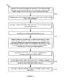
- FIG. 1is a flowchart representation of an embodiment of a method
- FIG. 2is a graphical representation of a variation of an embodiment of the method
- FIG. 3is a graphical representation of a variation of an embodiment of the method
- FIG. 4depicts a flowchart representation of an example implementation of an embodiment of the method.
- FIG. 5depicts a flowchart representation of an example implementation of an embodiment of the method.
- embodiments of a method 100 for traffic characterization associated with a vehiclecan include: collecting a movement dataset sampled at least at one of a location sensor and a motion sensor associated with the vehicle, during a driving session associated with movement of the vehicle (e.g., a time period during which the vehicle moves) S 110 ; extracting a set of features from the movement dataset associated with movement of the vehicle during the driving session S 130 ; and determining one or more traffic-related characteristics associated with the vehicle based on the set of features S 140 .
- the method 100can include: collecting a supplementary dataset configured to supplement the movement dataset S 120 ; initiating a traffic-related action based on the one or more traffic-related characteristics S 150 ; and/or any other suitable processes.
- Embodiments of the method 100 and/or system 200function to characterize one or more vehicles' interactions with one or more aspects related to traffic (e.g., the vehicle's compliance with traffic laws; identification of traffic indicators associated with the vehicle's route; etc.) to aid users (e.g., drivers; users residing in and/or on the vehicle; users associated with the driving session; users independent of the driving session; etc.) and/or other entities (e.g., third parties such as insurance entities; etc.) in relation to evaluating, improving, and/or otherwise processing traffic-related characteristics.
- traffice.g., the vehicle's compliance with traffic laws; identification of traffic indicators associated with the vehicle's route; etc.
- userse.g., drivers; users residing in and/or on the vehicle; users associated with the driving session; users independent of the driving session; etc.
- other entitiese.g., third parties such as insurance entities; etc.
- the method 100 and/or system 200can determine traffic-related characteristics for a vehicle based on movement features of the vehicle and other vehicles (e.g., through comparing a vehicle's movement features relative to movement features of geographically proximal vehicles on the same vehicular path during the current time period or a historic time period, such as to determine speed limit compliance, etc.), in relation to traffic regulations surrounding posted speed limitations and/or other speed limitations established by other traffic or environmental conditions. Additionally or alternatively, the method 100 and/or system 200 can function to leverage the traffic-related characteristics in determining and/or promoting traffic-related actions. For example, the method 100 and/or system 200 can enable real-time traffic characterization based on at least one of movement data and supplemental data to automatically generate traffic-related educational guidance (e.g., optimized route information).
- traffic-related educational guidancee.g., optimized route information
- the method 100is preferably implemented on one or more mobile devices removably coupled to one or more vehicles (e.g., residing in the vehicle; mounted to the vehicle and/or component coupled to the vehicle; physically coupled to the vehicle; communicatively coupled to the vehicle; etc.). Additionally or alternatively, the method 100 can be implemented by any number of suitable devices (e.g., including the vehicle itself; remote computing systems; etc.).
- One or more instances and/or portions of the method 100 and/or processes described hereincan be performed asynchronously (e.g., sequentially), concurrently (e.g., in parallel; concurrently on different threads for parallel computing to improve system processing ability for determining and/or otherwise processing traffic-related characteristics; etc.), in temporal relation to a trigger event, and/or in any other suitable order at any suitable time and frequency by and/or using one or more instances of the system 200 (e.g., a system 200 including processing systems such as remote computing systems; sensors; vehicles; mobile devices; etc.), elements, and/or entities described herein.
- the method 100 and/or system 200can be configured in any suitable manner.
- the method 100 and/or system 200can confer several benefits over conventional methodologies used for determining traffic related characteristics.
- the method 100 and/or system 200can perform one or more of the following:
- the technologycan leverage non-generic location data (e.g., location datasets, GPS data, etc.) and/or motion data (e.g., motion datasets, accelerometer data, gyroscope data, etc.) to conveniently and unobtrusively determine a traffic-related characteristic.
- location data and/or motion datacan be passively collected at a user's mobile computing device (e.g., a smartphone), such that the technology can perform traffic characteristic determination without requiring a user to purchase additional hardware (e.g., a specialized onboard device for monitoring traffic-related characteristics, a purpose-built such device, etc.).
- the technologycan determine traffic-related characteristics with high accuracy.
- the technologycan accurately infer traffic laws (e.g., traffic regulations, traffic rules, de facto traffic rules based on aggregated traffic data, etc.) based on movement data collected from the field, thereby minimizing the use of third party datasets that compile traffic regulations for various geographic locations, which can be outdated, inaccurate, or otherwise unsuitable.
- the technologycan provide accurate traffic-related characteristic determination while allowing a user to have flexibility in placement of their mobile computing device in relation to the vehicle (e.g., motor vehicles, bicycles, watercraft, aircraft, spacecraft, railed vehicles, etc.). Traffic-related characteristics can be determined when the mobile computing device collecting movement data is in a user's pocket, in a user's hand, mounted within the car, in a cup holder, and/or in other suitable locations within the vehicle.
- the technologycan automatically initiate traffic-related actions in response to determination of traffic-related characteristics.
- Traffic-related actionscan include any one or more of controlling the user device, sending a notification to the user or a related entity, generating user-specific content, and/or other suitable user-related actions.
- the type of initiated traffic-related actioncan be tailored to the particular traffic-related characteristic based on movement data (e.g., motion data, location data, etc.) and/or supplemental data.
- the technologycan include a software development kit for third-parties to integrate the traffic-related characteristic determination features, thereby enabling third-parties to leverage traffic-related characteristics and related data for purposes of driving education, ride sharing, valet services, navigation, roadside assistance, insurance processing, emergency services, and/or other suitable services.
- the technologycan determine traffic-related characteristics in real-time (e.g., instantaneously, substantially real-time, near real-time, etc.).
- Prompt determination of traffic-related characteristicse.g., compliance with traffic laws or regulations, deviation from ambient traffic characteristics, etc.
- appropriate messagese.g., driver specific messages, passenger specific messages, moving violation specific messages, compliance specific messages, noncompliance specific messages, etc.
- the technologycan improve the technical fields of at least vehicle telematics, computational modeling of traffic-related characteristics, and traffic-related characteristic determination with mobile computing device data.
- the technologycan continuously collect and utilize non-generic sensor data (e.g., location sensor data, motion sensor data, GPS data, audio/visual data, ambient light data, etc.) to provide real-time determination of traffic-related characteristics.
- non-generic sensor datae.g., location sensor data, motion sensor data, GPS data, audio/visual data, ambient light data, etc.
- the technologycan take advantage of the non-generic sensor data and/or supplemental data (e.g., vehicle sensor data, weather data, traffic data, environmental data, biosignal sensor data, etc.) to better improve the understanding of correlations between such data and traffic-related characteristic, leading to an increased understanding of variables affecting user behavior while driving and/or riding in a vehicle and/or traffic behavior at the scale of a population of users driving vehicles.
- supplemental datae.g., vehicle sensor data, weather data, traffic data, environmental data, biosignal sensor data, etc.
- the technologycan provide technical solutions necessarily rooted in computer technology (e.g., utilizing computational models to determine user characteristics from non-generic location and/or motion datasets collected at mobile computing devices, etc.) to overcome issues specifically arising with computer technology (e.g., issues surrounding how to leverage movement data collected by a mobile computing device to determine traffic-related characteristics, and/or to automatically initiate traffic-related actions for responding to traffic-related characterization, etc.).
- computer technologye.g., utilizing computational models to determine user characteristics from non-generic location and/or motion datasets collected at mobile computing devices, etc.
- issues specifically arising with computer technologye.g., issues surrounding how to leverage movement data collected by a mobile computing device to determine traffic-related characteristics, and/or to automatically initiate traffic-related actions for responding to traffic-related characterization, etc.
- the technologycan leverage specialized computing devices (e.g., computing devices with GPS location capabilities, computing devices with motion sensor functionality, etc.) to collect specialized datasets for characterizing traffic behaviors executed by the vehicle (e.g., under the influence of the driver's control, when controlled by an autonomous control system, etc.).
- specialized computing devicese.g., computing devices with GPS location capabilities, computing devices with motion sensor functionality, etc.
- the technologycan enable prompt collision detection (e.g., substantially as described in U.S. application Ser. No. 15/727,972, filed 9 Oct. 2017, which is incorporated herein in its entirety by this reference), and correlation of the collision with whether the user was in compliance with traffic regulations at the time of the collision (e.g., to determine a fault status of the user, to determine a not-fault status of the user, etc.).
- prompt collision detectione.g., substantially as described in U.S. application Ser. No. 15/727,972, filed 9 Oct. 2017, which is incorporated herein in its entirety by this reference
- correlation of the collision with whether the user was in compliance with traffic regulations at the time of the collisione.g., to determine a fault status of the user, to determine a not-fault status of the user, etc.
- the technologycan, however, provide any other suitable benefit(s) in the context of using non-generalized computer systems for determining one or more traffic-related characteristics and initiating traffic-related actions.
- Block S 110recites: collecting a movement dataset sampled at least at one of a location sensor and a motion sensor associated with the vehicle, during a time period of movement of the vehicle.
- Block S 110functions to collect movement-related data for use in evaluating one or more traffic-related characteristics associated with vehicles (e.g., motor vehicles, bicycles, watercraft, aircraft, spacecraft, railed vehicles, etc.), users (e.g., a vehicle driver, vehicle passenger, pedestrian, etc.) and/or other suitable entities.
- vehiclese.g., motor vehicles, bicycles, watercraft, aircraft, spacecraft, railed vehicles, etc.
- userse.g., a vehicle driver, vehicle passenger, pedestrian, etc.
- Movement datasetspreferably describe at least one of position, velocity, and/or acceleration (PVA) of one or more vehicles, user devices (e.g., user smartphones), users, and/or any other suitable entities, but can additionally or alternatively describe any suitable movement-related characteristic.
- movement dataset collected at a first entitye.g., sampled at a sensor of a user device
- movement of the first entitye.g., movement dataset describing PVA of the vehicle in which the user device resides
- one or more other entitiese.g., movement dataset sampled at a sensor of a first user device residing in a first vehicle, where the movement dataset describes PVA of a second vehicle geographically proximal the first vehicle, etc.
- Movement datasetsare preferably sampled at one or more movement sensors indicative of one or more of motion and/or location, which can include one or more of: motion sensors (e.g., multi-axis and/or single-axis accelerometers, gyroscopes, etc.), location sensors (e.g., GPS data collection components, magnetometer, compass, altimeter, etc.), sensors associated with vehicle diagnostic systems (e.g., OBD-I, OBD-1.5, OBD-II, CAN, etc.), optical sensors, audio sensors, electromagnetic (EM)-related sensors (e.g., radar, lidar, sonar, ultrasound, infrared radiation, magnetic positioning, etc.), environmental sensors (e.g., temperature sensors, etc.), biometric sensors, and/or any other suitable sensors.
- motion sensorse.g., multi-axis and/or single-axis accelerometers, gyroscopes, etc.
- location sensorse.g., GPS data collection components, magnetometer, compass, al
- Movement datasetspreferably include both location datasets (e.g., data describing the location of the sensor collecting the movement dataset) and motion datasets (e.g., data describing the motion of the sensor collecting the movement datasets).
- a movement datasetcan, in some variations, include only a location dataset or only a motion dataset.
- the methodcan include collecting a movement dataset that includes only a motion dataset at a first time point, and collecting a movement dataset that includes only a location dataset at a second time point, wherein the first time point can precede the second time point, the second time point can precede the first time point, and/or the first and second time points can be contemporaneous (e.g., simultaneous, substantially simultaneous, proximal in time, etc.).
- Block S 110preferably includes collecting movement datasets associated with different traffic-related situations including vehicle interaction (e.g., historic, current, and/or predicted interaction) with one or more: traffic laws (e.g., PVA data for a vehicle in the context of applicable traffic laws, traffic regulations, traffic rules, etc.), traffic indicators (e.g., PVA data in relation to compliance with traffic indicators, etc.) and/or other suitable traffic parameters.
- vehicle interactione.g., historic, current, and/or predicted interaction
- traffic lawse.g., PVA data for a vehicle in the context of applicable traffic laws, traffic regulations, traffic rules, etc.
- traffic indicatorse.g., PVA data in relation to compliance with traffic indicators, etc.
- Traffic lawscan include any one or more of: driving rules, vehicle code such as Department of Motor Vehicles (e.g., DMV, bureau of motor vehicles/BMV, motor vehicle department/MVD, etc.) code, moving violations (e.g., speed limits, reckless driving, driving under the influence, illegal turns, illegal lane changes, incompliance or noncompliance with traffic indicators, etc.), non-moving violations (e.g., parking violations, license violations, paperwork violations, equipment violations, etc.), and/or any other suitable laws or regulations associated with vehicles.
- vehicle codesuch as Department of Motor Vehicles (e.g., DMV, bureau of motor vehicles/BMV, motor vehicle department/MVD, etc.) code
- moving violationse.g., speed limits, reckless driving, driving under the influence, illegal turns, illegal lane changes, incompliance or noncompliance with traffic indicators, etc.
- non-moving violationse.g., parking violations, license violations, paperwork violations, equipment violations, etc.
- Traffic indicatorscan include any one or more of: traffic signs (e.g., stop signs, warning signs, regulatory signs, guide signs, yield signs, construction signs, recreational signs, service signs, marker signs, etc.), traffic lights (e.g., street lights, signal lights, vehicle lights, supplemental device lights, building lights, etc.), traffic markings (e.g., road surface markings such as yellow and/or white lines; bike lane markings; yield lines; lane markings; turnout markings; passing lanes; carpool lanes; turn indicators; etc.), and/or any other suitable indicators of traffic-related aspects.
- traffic signse.g., stop signs, warning signs, regulatory signs, guide signs, yield signs, construction signs, recreational signs, service signs, marker signs, etc.
- traffic lightse.g., street lights, signal lights, vehicle lights, supplemental device lights, building lights, etc.
- traffic markingse.g., road surface markings such as yellow and/or white lines; bike lane markings; yield lines; lane markings; turnout marking
- the method 100can include collecting a movement dataset; identifying a location corresponding to the movement dataset; mapping (e.g., at a traffic-related characteristic database, at a remote database, etc.) the location to a set of traffic parameters applicable to the location (e.g., to a traffic regulation applicable to the location; and storing the movement dataset in association with the set of traffic parameters.
- mapping the location to the set of traffic parameterscan tagging, labeling, and/or otherwise associating the movement dataset to the location.
- the method 100can include determining an indicator type associated with a visual traffic indicator, based on movement features (e.g.
- the type of a visual traffic indicator(e.g., a stop sign, a traffic light, etc.) can be inferred based on motion characteristics (e.g., wherein a vehicle stopping for a predetermined time period corresponds to a stop sign at a four way intersection, wherein a vehicle exhibits a pattern of accelerometer signals corresponding to approaching a red light that changes to a green light, etc.) without the use of optical data.
- processing movement datasets in relation to traffic-related situationscan be performed in any suitable manner.
- Block S 110preferably includes collecting one or more location datasets, which can include any one or more of: GPS data (e.g., position coordinates, associated time stamps, etc.), geolocation data (e.g., indicating county, city, country, and/or other suitable geographic region corresponding to a specific set of traffic parameters, etc.), geofence data (e.g., whether the location dataset corresponds to a location inside a geofence, outside a geofence, etc.), microlocation (e.g., determined using in-vehicle microlocation beacons, etc.), indoor positioning system data, local positioning system data, multilateration data, GSM localization data, self-reported positioning, control plane locating data, compass data, magnetometer data, route data (e.g., origin, destination, location along a route, etc.), and/or any other suitable location-related data.
- GPS datae.g., position coordinates, associated time stamps, etc.
- geolocation datae.g., indicating county, city,
- Block S 110can include determining change in relative distance between a plurality of user devices (e.g., residing in different vehicles, arranged in vehicles proximal to a primary vehicle, located in vehicles within a predetermined distance of one another such as 150 ft, 1-500 ft, etc.) to determine PVA parameters corresponding to vehicles associated with the plurality of user devices.
- a plurality of user devicese.g., residing in different vehicles, arranged in vehicles proximal to a primary vehicle, located in vehicles within a predetermined distance of one another such as 150 ft, 1-500 ft, etc.
- collecting one or more location datasetscan be performed in any suitable manner.
- Block S 110preferably includes collecting one or more motion datasets, which can include one or more of: accelerometer data (e.g., single-axis data, multi-axis data), gyroscope data (e.g., single-axis data, multi-axis data), velocity data (e.g., speed, instantaneous velocity, average velocity, change in velocity, velocity variability over time, maximum velocity, minimum velocity, etc.), acceleration data (e.g., instantaneous acceleration, gravitational acceleration, average acceleration, change in acceleration, acceleration variability over time, maximum acceleration, minimum acceleration, etc.), displacement data, orientation data, rotation data, turning data, and/or any other suitable motion-related data.
- accelerometer datae.g., single-axis data, multi-axis data
- gyroscope datae.g., single-axis data, multi-axis data
- velocity datae.g., speed, instantaneous velocity, average velocity, change in velocity, velocity variability over time, maximum velocity, minimum velocity, etc.
- Block S 110can include collecting motion datasets sampled at one or more inertial sensors (e.g., accelerometers, etc.) of the user device, where the motion datasets can be indicative of acceleration movement features, braking movement features, and/or other suitable movement features for the vehicle.
- Block S 110can include collecting a plurality of motion datasets corresponding to a set of user devices associated with a set of geographically proximal vehicles; and storing the plurality of motion datasets in association with each other (e.g., for subsequent processing to generate comparisons between relative motion in determining one or more traffic-related characteristics), but associating motion datasets (and/or other datasets) can be based on any suitable criteria.
- Block S 110can include identifying a set of user devices corresponding to a set of secondary vehicles driving proximal the vehicle location during a driving session, and retrieving a set of movement datasets collected by the set of user devices contemporaneously with the driving session.
- collecting motion datasetscan be performed in any other suitable manner.
- Block S 110movement datasets can be collected by a plurality of mobile devices.
- Block S 110can include cooperative data capture based on mobile device data (e.g., data collected using a plurality of mobile computing devices).
- Block S 110can include any element substantially as described in U.S. application Ser. No. 15/921,152, filed 14 Mar. 2018, titled “Method for Mobile Device-Based Cooperative Data Capture”, which is incorporated herein in its entirety by this reference.
- movement datasetsare preferably sampled by components arranged at a user device (e.g., mobile device, smartphone, laptop, tablet, smart watch, smart glasses, virtual reality devices, augmented reality devices, aerial devices such as drones, medical devices, etc.), but can additionally or alternatively be sampled by components associated with (e.g., arranged at, positioned within, mounted to, physically connected to, etc.) any suitable device and/or vehicle (e.g., movement datasets sampled at vehicle sensors).
- a user devicee.g., mobile device, smartphone, laptop, tablet, smart watch, smart glasses, virtual reality devices, augmented reality devices, aerial devices such as drones, medical devices, etc.
- components associated withe.g., arranged at, positioned within, mounted to, physically connected to, etc.
- any suitable device and/or vehiclee.g., movement datasets sampled at vehicle sensors.
- Block S 110can include collecting movement data from a population of mobile devices associated with a user characteristic (e.g., a shared driving behavior, etc.) and/or vehicle characteristic (e.g., a shared driving session route, etc.), where the population-level data can be used to generate traffic characteristic models, determine reference traffic-related characteristic (e.g., expected speed limit for a driving session route at the current time, etc.), and/or otherwise determine and/or leverage traffic-related characteristics.
- Block S 110can include collecting movement data for a first vehicle from devices in geographically proximal vehicles (e.g., a second vehicle), from devices associated with pedestrians, and/or from other supplementary devices.
- Multiple sources of movement datacan be used to reduce noise (e.g., through averaging data), improve data accuracy, fill gaps of movement data during a time period, increase confidence levels associated with determining traffic-related characteristics and/or initiating traffic-related actions, and/or perform any suitable operation in relation to the method 100 .
- collecting movement data S 110can be performed in any suitable manner.
- the method 100can additionally or alternatively include Block S 120 , which recites: collecting supplementary dataset configured to supplement the movement dataset.
- Block S 120functions to collect data that can be used in combination with, to filter, to control for errors in, and/or otherwise supplement movement data collected in Block S 110 , and/or other suitable data associated with the method 100 .
- supplementary datacan include any one or more of: traffic data (e.g., type of vehicular path such as a freeway road or local road upon which the vehicle is driving; accident data; traffic level; type of traffic congestion; etc.), vehicle data (e.g., indicative of vehicle information describing one or more characteristics of one or more vehicles; etc.), user data (e.g., behavioral datasets such as datasets describing driving behavior; social media datasets; demographic datasets; device event datasets; etc.), optical data (e.g., imagery; video; internal vehicle-facing optical data of users and/or other objects; external vehicle-facing optical data of route, landmarks, geographical markers; mobile computing device camera data; etc.), audio data (e.g., associated with vehicle operation and/or indicative of movement features, such as audio corresponding to vehicle turn signal operation, audio corresponding to acceleration and/or braking; audio associated with user conversations; traffic-related audio; audio associated with interactions between users and vehicles, between vehicles and proximal vehicles; environmental audio; etc.), bio
- traffic datae.
- Block S 120can include collecting environmental data.
- Environmental datacan include any one or more of: weather conditions (e.g., weather forecast, temperature, humidity, precipitation, wind, etc.), road conditions (e.g., road closure, road opening, number of road lanes, road deterioration, etc.), pressure conditions (e.g., ambient pressure, etc.), air quality (e.g., pollution levels, etc.), and/or other suitable environmental data.
- weather conditionse.g., weather forecast, temperature, humidity, precipitation, wind, etc.
- road conditionse.g., road closure, road opening, number of road lanes, road deterioration, etc.
- pressure conditionse.g., ambient pressure, etc.
- air qualitye.g., pollution levels, etc.
- a weather forecast describing thunderstorms proximal the driver's locationcan indicate a higher likelihood of a weather dependent traffic characteristic (e.g., a slower average ambient speed corresponding to geographically proximal vehicles).
- weather datacan be used to augment a traffic law used to determine a traffic compliance parameter (e.g., wherein a posted speed limit is reduced by 5 mph during rain, wherein a driver is required to turn on the vehicle lights in the event of rain, etc.).
- road conditions indicating a single-lane freewayanalyzed along with a motion dataset describing a vehicular speed in excess of the freeway speed limit, can indicate a greater chance of occurrence of a vehicular accident event and correspondingly higher risk parameter (e.g., determined in accordance with one or more variations of Block S 140 ).
- collecting environmental datacan be otherwise suitably performed.
- Block S 120can include collecting traffic data.
- Traffic datacan include any one or more of: accident data (e.g., number of accidents within a predetermined radius of the user, accident frequency, accident rate, types of accidents, frequency of accidents, etc.), traffic level, traffic laws (e.g., speed limit, intersection laws, turning laws), traffic lights, type of vehicular path (e.g., freeway, intersection, etc.), and/or other suitable traffic data.
- accident datae.g., number of accidents within a predetermined radius of the user, accident frequency, accident rate, types of accidents, frequency of accidents, etc.
- traffic levele.g., traffic level, traffic laws (e.g., speed limit, intersection laws, turning laws), traffic lights, type of vehicular path (e.g., freeway, intersection, etc.), and/or other suitable traffic data.
- traffic lawse.g., speed limit, intersection laws, turning laws
- traffic lightse.g., type of vehicular path (e.g., freeway, intersection, etc.
- collecting traffic datacan include querying a traffic information database (e.g., traffic accident tracker) with GPS coordinate inputs; and receiving a traffic report for a location proximal the vehicle location.
- a traffic information databasee.g., traffic accident tracker
- higher amounts of traffic proximal the vehicle locationcan indicate a higher likelihood of a multi-vehicle collision.
- a vehicle driver violating traffic lawse.g., turning left at an intersection prohibiting left turns
- can indicate a higher likelihood of a particular vehicle accident typee.g., a T-bone collision.
- collecting traffic datacan be otherwise suitably performed.
- the method 100can include: collecting traffic data (e.g., online sources) describing traffic parameters for a location (e.g., county, city, state, etc.); parsing the traffic data (e.g., through applying natural language processing algorithms, which can be applied to any suitable portion of the method 100 . etc.); and associating the parsed traffic data with the location (e.g., geofences corresponding to the location, etc.).
- traffic datae.g., online sources
- parsing the traffic datae.g., through applying natural language processing algorithms, which can be applied to any suitable portion of the method 100 . etc.
- associating the parsed traffic data with the locatione.g., geofences corresponding to the location, etc.
- the method 100can include: collecting optical data for visual traffic indicators (e.g., satellite imagery capturing traffic signs, traffic lights, traffic markings, etc.); classifying the visual traffic indicators based on the optical data (e.g., through leveraging computer vision algorithms, which can be applied to any suitable portion of the method 100 ; etc.); and updating a traffic map (e.g., stored at a traffic-related characteristic database and usable for any suitable portion of the method 100 ) with the classified visual traffic indicators.
- visual traffic indicatorse.g., satellite imagery capturing traffic signs, traffic lights, traffic markings, etc.
- classifying the visual traffic indicators based on the optical datae.g., through leveraging computer vision algorithms, which can be applied to any suitable portion of the method 100 ; etc.
- updating a traffic mape.g., stored at a traffic-related characteristic database and usable for any suitable portion of the method 100 ) with the classified visual traffic indicators.
- the method 100can include: collecting an image dataset at an image sensor of the mobile computing device, wherein the image sensor of the mobile computing device is arranged within the vehicle to image a spatial region forward of the vehicle; extracting a visual traffic indicator from the image dataset; validating a traffic law (e.g., determined based on one or more variations of Block S 140 ) based on the visual traffic indicator at the mobile computing device; determining the traffic compliance parameter in response to validating the traffic law; and updating a traffic map stored at the remote computing system based on validating the traffic law.
- processing of supplementary datasetscan be performed in any suitable manner.
- Block S 120can include collecting contextual data.
- Contextual datacan include any one or more of: temporal data (e.g., time of day, date, etc.), driver data, mobile electronic device usage (e.g., driver texting, usage of smartphone while driving, etc.), vehicle model data (e.g., model, age, accident history, mileage, repair history, etc.), light sensor data (e.g., associated with a user's mobile electronic device, etc.), and/or any other suitable contextual data.
- temporal datae.g., time of day, date, etc.
- driver datae.g., mobile electronic device usage
- vehicle model datae.g., model, age, accident history, mileage, repair history, etc.
- light sensor datae.g., associated with a user's mobile electronic device, etc.
- collecting contextual datacan include collecting driver behavior data (e.g., actively collected driver data, derived from movement data, etc.), which can be used to adjust and/or select one or more traffic characterization models and/or traffic-related characteristic models tailored to a given driver.
- Driver behavior datae.g., actively collected driver data, derived from movement data, etc.
- Block S 120can include any elements described in U.S. application Ser. No. 14/206,721 filed 12 Mar. 2014 and entitled “System and Method for Determining a Driver in a Telematic Application,” which is incorporated herein in its entirety by this reference.
- Block S 120can include collecting temporal data indicating the time (e.g., of day, of the year, etc.) when a driving session is occurring.
- timee.g., of day, of the year, etc.
- certain traffic characteristics and/or traffic lawscan be correlated with certain times of day and/or days of the year (e.g., no left turns at a given intersection between the hours of 8-10 AM and 3-6 PM, a lower speed limit in a school zone at times when children are present, etc.).
- mobile computing device usage by the driver during the driving sessione.g., texting while driving
- collecting temporal datacan be otherwise suitably performed.
- vehicle datacan include any one or more of: proximity sensor data (e.g., radar, electromagnetic sensor data, ultrasonic sensor data, light detection and ranging, light amplification for detection and ranging, line laser scanner, laser detection and ranging, airborne laser swath mapping, laser altimetry, sonar, data indicating PVA of proximal vehicles, etc.), vehicle camera data (e.g., in-car cameras, exterior cameras, back-up cameras, dashboard cameras, front-view cameras, side-view cameras, image recognition data, infrared camera, 3D stereo camera, monocular camera, etc.), engine data, odometer, altimeter, location sensor data, motion sensor data, environmental data, light sensor data, vehicle diagnostic system data, data from application programming interfaces of traffic-related applications, and/or any other suitable vehicle data.
- proximity sensor datae.g., radar, electromagnetic sensor data, ultrasonic sensor data, light detection and ranging, light amplification for detection and ranging, line laser scanner, laser detection and ranging, airborne laser s
- collecting vehicle operation datacan include receiving vehicle operation data (e.g., collected by a vehicle diagnostic system; sampled at a proximity sensor; etc.) at a user device (e.g., with an application executing on the user device) communicably connected to the vehicle (e.g., wirelessly paired with the vehicle; connected to the vehicle through a wired connection between a user device and an OBD port of the vehicle; authorized to receive data from the vehicle; authenticated by the vehicle; etc.); and/or receiving the vehicle operation data at a remote server (e.g., from the user device, for subsequent movement feature extraction and analysis; etc.).
- vehicle operation datae.g., collected by a vehicle diagnostic system; sampled at a proximity sensor; etc.
- a user devicee.g., with an application executing on the user device
- the vehiclee.g., wirelessly paired with the vehicle; connected to the vehicle through a wired connection between a user device and an OBD port of the vehicle; authorized to receive data from the vehicle; authentic
- collecting vehicle operation datacan include directly receiving the vehicle operation data from the vehicle (e.g., through a vehicle Internet connection; through vehicle registration associated with a remote server, such as through an application executing on a user device; etc.). Additionally or alternatively, any characteristics described in relation to movement datasets (e.g., in Block S 110 ) can additionally or alternatively apply to supplementary datasets (e.g., collecting supplementary datasets at any time and/or frequency from one or more mobile devices associated with vehicles; etc.). However, collecting supplementary datasets S 120 can be performed in any suitable manner.
- Block S 130recites: extracting a set of features associated with movement of the vehicle during the time period.
- the set of featurescan be defined as a vehicle motion characteristic (e.g., characteristic of vehicle motion) such as the path through space of the vehicle, the trajectory of the vehicle, PVA data associated with the vehicle, and any other suitable characteristics of vehicle motion.
- Block S 130functions to process data (e.g., collected in Blocks S 110 and/or S 120 ; output in Blocks S 140 and/or S 150 , etc.) into a form suited for determining traffic-related characteristics and/or traffic-related actions.
- Processing datacan include any one or more of: extracting features, performing pattern recognition on data, fusing data from multiple sources, combining values (e.g., averaging values, normalizing values, etc.), standardizing, validating, converting (e.g., digital-to-analog conversion, analog-to-digital conversion), wave modulating, filtering (e.g., Kalman filtering), noise reduction, smoothing, model fitting, transforming, windowing, clipping, mapping, applying mathematical operations (e.g., derivatives, moving averages, etc.), multiplexing, demultiplexing, extrapolating, interpolating, and/or any other suitable processing operations.
- valuese.g., averaging values, normalizing values, etc.
- standardizingvalidating
- convertinge.g., digital-to-analog conversion, analog-to-digital conversion
- wave modulatinge.g., filtering (e.g., Kalman filtering), noise reduction, smoothing, model fitting, transforming, windowing, clip
- processing datacan include applying one or more computer-implemented rules (e.g., feature engineering rules for extracting features from one or more datasets) in processing data for conferring improvements (e.g., in accuracy of determining values of traffic-related characteristics; in storing and/or retrieving data such as traffic characteristic models, associated inputs, and/or associated outputs; in inventive distributions of functionality across networks including user devices, vehicles, remote computing systems, and/or other components; in leveraging non-generalized systems including location sensors, inertial sensors, proximity sensors, and/or other suitable systems; etc.) in one or more aspects of the system.
- rulese.g., feature engineering rules for extracting features from one or more datasets
- conferring improvementse.g., in accuracy of determining values of traffic-related characteristics; in storing and/or retrieving data such as traffic characteristic models, associated inputs, and/or associated outputs; in inventive distributions of functionality across networks including user devices, vehicles, remote computing systems, and/or other components; in leveraging non-generalized systems including location sensors
- Featurescan include any one or more of: cross-user features (e.g., features combining PVA data derived from a plurality of user devices associated with a single vehicle or with a plurality of vehicles; etc.), cross-vehicle features (e.g., features analyzing PVA data from a set of proximal vehicles within a predetermined distance threshold from a vehicle associated with a current driving session; etc.), textual features (e.g., word frequency, sentiment, punctuation associated with textually-described traffic laws and/or regulations; textual features associated with words, numbers, and/or symbols on a traffic indicator such as a sign displaying one or more words; etc.), graphical features (e.g., color, size, shape, and/or other graphical features associated with traffic indicators, such as color of traffic signs, traffic lights, or traffic markings on a road; etc.), audio features (e.g., Mel Frequency Cepstral Coefficients extracted from audio captured by
- movement featurespreferably characterize PVA of the vehicle, user device, and/or other suitable entity.
- movement featurescan include any one or more of: raw movement data (e.g., raw location data, raw motion data, etc.), processed movement data, movement profiles (e.g., driving profile, braking profile, position profile, speed profile, acceleration profile, turning profile, etc.), identified driving actions (e.g., parking, acceleration, braking, short following, lane-departure, freewheeling, U-turn, left turn, right turn, over-revving, stationary vehicle, moving vehicle, etc.), user physical activity features (e.g., user cardiovascular parameters; walking pace; walking routes to and/or from vehicles; breathing parameters; physical activity characteristics before, during, and/or after driving sessions; etc.), and/or any other suitable features.
- raw movement datae.g., raw location data, raw motion data, etc.
- movement profilese.g., driving profile, braking profile, position profile, speed profile, acceleration profile, turning profile, etc.
- identified driving actions
- Block S 130can include applying a feature selection rule (e.g., feature selection algorithms such as exhaustive, best first, simulated annealing, greedy forward, greedy backward, and/or other suitable feature selection algorithms) to filter, rank, and/or otherwise select features for use in generating one or more traffic characterization models (e.g., in Block S 130 ).
- Feature selection rulescan select features based on optimizing for processing speed (e.g., model training and/or execution speed; data retrieval speed; etc.), accuracy (e.g., for determining traffic-related characteristics), traffic-related actions (e.g., determining traffic-related actions tailored to a user, vehicle, traffic-related situation, etc.) and/or any other suitable criteria operable to improve the system 200 .
- computer-implemented rulescan be applied in performing various portions of the method 100 (e.g., model generation and/or selection rules for characterizing users; user preference rules for promoting traffic-related actions; etc.) and/or in conferring any suitable improvements to the system 200 .
- determining features and/or otherwise processing datasetscan be performed in any suitable manner.
- Block S 140includes determining one or more traffic-related characteristics associated with the vehicle based on the set of features (and/or any other suitable datasets, such as data collected in Blocks S 110 and/or S 120 , historical movement datasets associated with user devices that have been arranged in vehicles traversing a proximal location as that of the primary vehicle at which the mobile computing device is located, and/or outputs associated with Block S 140 and/or Block S 150 , etc.).
- Block S 140functions to evaluate, characterize, determine, store, update, and/or otherwise determine one or more traffic-related characteristics associated with one or more vehicles and/or users.
- Traffic-related characteristicspreferably characterize one or more interactions (e.g., physical interactions, relative movement features, communicative interactions, etc.) between a vehicle and one or more of: supplementary vehicles (e.g., geographically proximal vehicles; etc.), traffic parameters (e.g., traffic laws, traffic indicators, etc.), users, user devices, pedestrians, and/or any other aspect associated with traffic.
- supplementary vehiclese.g., geographically proximal vehicles; etc.
- traffic parameterse.g., traffic laws, traffic indicators, etc.
- usersuser devices, pedestrians, and/or any other aspect associated with traffic.
- Traffic-related characteristicscan include any one or more of: traffic compliance parameters (e.g., describing compliance with and/or deviation from traffic laws, traffic indicators, and/or other suitable traffic parameters; based on comparison of movement features and/or other suitable data for a driving session to traffic parameters associated with the driving session, such as traffic laws for locations of the driving session; etc.), traffic law parameters (e.g., predicted traffic laws, such as estimated speed limit based on PVA for a geographically proximal set of vehicles; operative traffic laws, such as derived from comparisons of predicted traffic laws to actual traffic laws; etc.), traffic indicator parameters (e.g., identified traffic indicators such as U-turn legality based on historical movement features for vehicles at an intersection; operative traffic indicators, such as derived from predicted traffic indictors to actual traffic indicators; etc.), route parameters (e.g., traffic-based routes from origin to destination; estimated time to destination; vehicular accident events on route; etc.), risk parameters (e.g., risk of incompliance with traffic parameters; risk relative to other users
- Block S 140can include determining traffic-related characteristic tailored to one or more conditions (e.g., temporal conditions, location conditions, vehicle conditions).
- Block S 140can include estimating an operative speed limit (and/or other suitable traffic-related characteristic) for a location (e.g., a particular road on a route; etc.), time (e.g., at a particular time of day, etc.), vehicle type (e.g., fleet vehicles, cargo trucks, motorcycles, taxis, buses, tow vehicles, etc.), and/or any other suitable criteria.
- the method 100can include determining a second traffic maneuver executed by the vehicle during the driving session at the vehicle location, and determining the traffic compliance parameter based on a comparison between the first traffic maneuver and the second traffic maneuver (e.g., comparing accelerometer signals corresponding to a U-turn executed by the vehicle to the U-turn defined by the traffic law as prohibited).
- traffic-related characteristicscan be otherwise suitably determined in any suitable manner.
- Block S 140includes determining a risk parameter (e.g., based on the traffic related characteristics; wherein the traffic-related characteristic is the risk parameter; etc.).
- the risk parameteris preferably determined according to a risk model associated with the user; Block S 140 can include generating the risk model and/or utilizing the risk model to determine the risk parameter.
- Block S 140can include any element described in U.S. application Ser. No. 16/000,675, filed 5 Jun. 2018, and titled “Method and System for Risk Modeling in Autonomous Vehicles”, which is incorporated herein by this reference in its entirety.
- Block S 140can additionally or alternatively include determining a risk parameter in any other suitable manner.
- determining traffic-related characteristicsis preferably based on one or more movement features (e.g., derived from datasets sampled at a user smartphone), but can additionally or alternatively be based on any suitable datasets.
- determining traffic-related characteristicscan be based on PVA data (e.g., movement features extracted from location data and/or motion data).
- Block S 140can include determining a traffic compliance parameter based on comparing a current vehicle speed to an average vehicle speed derived from speeds for geographically proximal vehicles (e.g., driving on the highway), where incompliance with a traffic law can be predicted in response to the current vehicle speed exceeding the average vehicle speed beyond a threshold amount.
- Block S 140can include determining a traffic compliance parameter based on comparing a current vehicle speed to an actual speed limit (e.g., derived from parsing optical data of a speed limit sign for the road on which the vehicle is traveling, inferred from historical average speeds of vehicles along the same roadway on which the vehicle is traveling, retrieved from a roadway database, etc.).
- Block S 140can include determining a risk parameter (e.g., of a traffic violation, where the risk can be presented to the user as a traffic-related notification for guidance; etc.) based on comparing a current vehicle speed on a road to an operative speed limit derived from a set of historical PVA data for vehicles traveling on the road.
- Block S 140can include determining traffic compliance parameters based on location data.
- the method 100can include: identifying a set of user devices associated with a location of the driving session (e.g., user devices currently being used in driving sessions at the same location or proximal location; user devices associated with historical driving sessions at the same location or proximal location; user devices associated with driving sessions from a shared origin and/or to a shared destination; etc.); retrieving movement datasets for the user devices for driving sessions associated with the location, and determining a traffic-related characteristic (e.g., traffic law parameter, traffic regulation, etc.) based on the movement datasets.
- a traffic-related characteristice.g., traffic law parameter, traffic regulation, etc.
- the method 100can include: receiving, at a user device associated with a driving session, signal data (e.g., a broadcasted signal; a wirelessly transmitted signal; a WiFi-based signal; a Bluetooth-based signal; a personal area network signal; a local area network signal; a wide area network signal) transmitted from one or more supplemental devices (e.g., a supplemental user device residing in a supplemental vehicle), supplemental vehicles (e.g., a supplemental vehicle proximal to the vehicle of the driving session; etc.), and determining one or more traffic-related characteristics based on the signal data (e.g., deriving a traffic compliance parameter based on relative speed between the driving session vehicle and the supplemental vehicle from which the signal data originates, where the relative speed can be derived from the signal data, such as signal strength and/or angle of arrival describing location over time of the supplemental vehicle in relation to the driving session vehicle; etc.).
- signal datae.g., a broadcasted signal; a wirelessly transmitted
- Block S 140can include determining traffic-related characteristics based on motion data.
- Block S 140can include determining a traffic lane parameter (e.g., legal lane changes; number of lanes; width of lanes; traffic directionality on the lane; etc.) for a road based on inertial sensor data (e.g., sampled at user smartphones associated with driving sessions on the road) describing vehicular movement in relation to lanes of the road (e.g., lane changes by the vehicles, etc.).
- a traffic lane parametere.g., legal lane changes; number of lanes; width of lanes; traffic directionality on the lane; etc.
- inertial sensor datae.g., sampled at user smartphones associated with driving sessions on the road
- vehicular movement in relation to lanes of the roade.g., lane changes by the vehicles, etc.
- Block S 140can include determining a traffic law parameter (e.g., legality of a vehicle turn, such as left turns, U-turns, etc.) for a location based on a set of motion datasets describing frequency and/or type of turns exhibited at the location (e.g., in historical driving sessions at an intersection, etc.).
- a traffic law parametere.g., legality of a vehicle turn, such as left turns, U-turns, etc.
- Block S 140can include determining a traffic indicator parameter (e.g., average duration of different modes of a traffic light, such as average duration of a green, yellow, or red light mode of a traffic light, etc.) based on a set of motion datasets describing vehicular stoppage duration (e.g., for stationary vehicles at a red light), vehicular drive-through duration (e.g., for vehicles driving through a green light), and/or other suitable parameters associated with traffic indicators.
- determining traffic-related characteristics based on PVA data and/or other movement featurescan be performed in any suitable manner.
- Block S 140can include determining traffic-related characteristics based on traffic data.
- Block S 140can include: determining a location of a vehicle associated with a driving session; in response to receiving the location at a remote server, mapping the location to a set of traffic laws (e.g., derived from traffic data collected from a third party source) corresponding to the location; and determining a traffic compliance parameter based on comparing the traffic laws against a movement dataset associated with the feature.
- Block S 140can include determining a risk parameter based on accident data for a type of vehicular path (e.g., highway, which can be correlated with increased risk of vehicular accident event; local road; etc.) included in a driving session route.
- a type of vehicular pathe.g., highway, which can be correlated with increased risk of vehicular accident event; local road; etc.
- Block S 140can be based on any one or more of: vehicle data (e.g., collecting at least one of radar, sonar, and/or lidar data from a vehicle, where the data is indicative of relative speeds of proximal vehicles; and determining one or more traffic-related characteristics based on the relative speeds; etc.), optical data (e.g., identifying traffic indicator parameters and/or traffic law parameters based on imagery and/or video capturing the traffic indicators, such as a speed limit sign; determining traffic-related characteristics based on PVA data derived from optical data; etc.), audio data (e.g., identifying a vehicle turn at an intersection based on audio data indicating turn signal audio; and comparing the vehicle turn to traffic laws associated with turn legality at the intersection; etc.), user data (e.g., deriving user perspectives regarding traffic laws and/or traffic indicators based on social media data; and determining traffic-related characteristics based on the user perspectives; etc.), biometric data (e.g., determining cardiovascular parameters during time periods associated with vehicle data
- Block S 140preferably includes determining traffic-related characteristics with one or more traffic characteristic models (e.g., using movement features and/or other suitable datasets for inputs; outputting traffic-related characteristics and/or associated confidence levels; etc.) including any one or more of: probabilistic properties, heuristic properties, deterministic properties, and/or any other suitable properties.
- traffic characteristic modelse.g., using movement features and/or other suitable datasets for inputs; outputting traffic-related characteristics and/or associated confidence levels; etc.
- probabilistic propertiese.g., heuristic properties, deterministic properties, and/or any other suitable properties.
- Block S 140 and/or other portions of the method 100can employ machine learning approaches including any one or more of: supervised learning, unsupervised learning, semi-supervised learning, reinforcement learning, regression, an instance-based method, a regularization method, a decision tree learning method, a Bayesian method, a kernel method, a clustering method, an associated rule learning algorithm, a neural network model, a deep learning algorithm, a dimensionality reduction method, an ensemble method (e.g., determining a first speed for a proximal vehicle based on processing signal data associated with the proximal vehicle using a first traffic characteristic model during a time period; determining a second speed for the proximal vehicle based on processing optical data captured of the proximal vehicle using a second traffic characteristic model during the time period; and determining a final speed for the proximal vehicle during the time period based on combining the first and second speeds such as through averaging, weight
- the method 100can include collecting a set of movement datasets for one or more users during historic driving sessions, the set of movement datasets associated with known traffic-related characteristics (e.g., route; time from origin to destination; compliance with traffic laws and/or traffic indicators; date; etc.); generating (e.g., training; updating; etc.) a traffic characteristic model based on the set of movement datasets and the known traffic-related characteristics; and determining a traffic-related characteristic for a current driving session based on a movement dataset for the driving session (e.g., determining estimated route time based on the historical driving sessions for the route; determining a traffic compliance parameter associated with speed limit based on comparing a speed for the current driving session to historic speeds for the historic driving sessions along a shared route; etc.).
- known traffic-related characteristicse.g., route; time from origin to destination; compliance with traffic laws and/or traffic indicators; date; etc.
- generatinge.g., training; updating; etc.
- a traffic characteristic modelbased on the set
- Block S 140includes 4 comparing the vehicle speed to the speed limit, and determining a risk parameter based on comparing the vehicle speed to the speed limit (e.g., as described above).
- applying traffic characteristic models to determine traffic-related characteristicscan be performed in any suitable manner.
- Block S 140can include determining a traffic-related characteristic (e.g., associated with vehicle movement) based on a set of movement datasets collected by a set of user devices contemporaneously with the driving session (e.g., corresponding to geographically proximal vehicles), and determining a traffic compliance parameter based on a comparison between the traffic-related characteristic and the vehicle motion characteristic (e.g., a comparison between an ambient speed and the vehicle speed).
- the traffic compliance parametercan be determined based on a comparison between the vehicle motion characteristic and a traffic law.
- the traffic compliance parametercan be determined based on a combination of a comparison between the traffic-related characteristic and the vehicle motion characteristic and a comparison between the traffic law and the vehicle motion characteristic (e.g., to consider the behavior of ambient traffic in evaluating user compliance with the traffic law, as in cases where “going with the flow” of the traffic can be acceptable even if the ambient speed is greater than the speed limit, etc.).
- different traffic characterization modelse.g., generated with different algorithms, with different sets of features, with different input and/or output types, etc.
- can be usede.g., determined; selected, stored, retrieved, executed, updated, etc.
- any one or more of the types of data associated with the method 100which can confer improvements to the system 200 by improving traffic characterization accuracy (e.g., by tailoring analysis to a particular driving session, vehicle, user, and/or other entity, etc.), retrieval speed for the appropriate model from a database (e.g., by associating tailored traffic characteristic models with particular user accounts and/or other identifiers), training and/or execution of models (e.g., using feature-engineering computer implemented rules, etc.), and/or other suitable aspects of the system 200 .
- determining traffic-related characteristicscan be performed using threshold conditions (e.g., monitoring traffic compliance parameters in response to PVA data exceeding a PVA threshold; determining risk parameters in response to detecting a geographically proximal law enforcement entity; etc.), reference profiles (e.g., comparison of a current driving behavior profile to reference driving behavior profiles associated with traffic law compliance or incompliance, comparison to reference traffic-related characteristics, users, user accounts, vehicles, etc.), weights, and/or any other suitable data.
- threshold conditionse.g., monitoring traffic compliance parameters in response to PVA data exceeding a PVA threshold; determining risk parameters in response to detecting a geographically proximal law enforcement entity; etc.
- reference profilese.g., comparison of a current driving behavior profile to reference driving behavior profiles associated with traffic law compliance or incompliance, comparison to reference traffic-related characteristics, users, user accounts, vehicles, etc.
- weightse.g., weights, and/or any other suitable data.
- determining traffic-related characteristics S 140can be
- the method 100can additionally or alternatively include Block S 150 , which recites: initiating one or more traffic-related actions based on the one or more traffic-related characteristics.
- Block S 150functions to determine, promote, provide, and/or otherwise initiate a traffic-related action for responding to determination of one or more traffic-related characteristics.
- Traffic-related actionscan include any one or more of: traffic-related notifications, insurance processing, and/or dataset processing (e.g., storing traffic-related characteristics such as traffic law parameters in association with one or more vehicular path identifiers identifying vehicular paths; storing traffic-related characteristics such as traffic compliance parameters in association with one or more user accounts identifying one or more users; etc.), where such processing can confer improvements in data storage and/or retrieval, such as for generating risk profiles for users for subsequent processing (e.g., presentation to the user and/or associated entities; transmission to insurance entities; etc.).
- traffic-related actionscan include any suitable type of traffic-related action.
- initiating traffic-related notificationscan include generating, transmitting, presenting, and/or otherwise promoting traffic-related notifications including any one or more of: educational notifications (e.g., including driving sessions summaries including traffic-related characteristics; including advice for improving traffic-related characteristics such as reducing risk parameter values and/or increasing traffic compliance values, as shown in FIGS. 2-3 ; etc.), services notifications (e.g., for facilitating services such as insurance services; emergency services; routing services, where routes can be determined for optimizing traffic-related characteristics, such as time from origin to destination; roadside assistance services; vehicle repair services; technical services for autonomous vehicles; etc.), and/or any other suitable notifications. For example, as shown in FIG.
- educational notificationse.g., including driving sessions summaries including traffic-related characteristics; including advice for improving traffic-related characteristics such as reducing risk parameter values and/or increasing traffic compliance values, as shown in FIGS. 2-3 ; etc.
- services notificationse.g., for facilitating services such as insurance services; emergency services; routing services, where routes can be determined for
- the method 100can include presenting a traffic-related notification including a traffic indicator (e.g., retrieved from a traffic-related characteristic database including associations between locations and traffic indicators) corresponding to location of a current driving session.
- a traffic indicatore.g., retrieved from a traffic-related characteristic database including associations between locations and traffic indicators
- Block S 150can include promoting a roadside assistance service notification in response to detecting a vehicle stoppage event (e.g., a vehicle pulling over to the side of the road; etc.) in the context of proximal vehicles traveling at greater relative speeds (e.g., vehicles passing by the vehicle pulling over; etc.).
- Block S 150can include personalizing a traffic-related notification (and/or other traffic-related action) to a driving behavior of a user.
- the method 100can include determining a driving behavior indicating a high frequency of driving through intersections when a traffic light is transitioning to a stop indicator (e.g., while a traffic light is displaying a yellow light subsequently to displaying a green light, in advance of displaying a red light); and promoting a traffic-related notification warning indicating an upcoming traffic light and/or a corresponding status in relation to the stop indicator (e.g., warning the user to reduce driving speed to allow for smoother braking upon transition of a traffic signal from green to red, warning the user that the user has increased his or her risk of running a red light by a determined amount by his or her behavior, etc.).
- initiating traffic-related notificationscan be performed any suitable manner.
- facilitating insurance processingcan include any one or more of: processing insurance claims (e.g., pre-filling insurance claims, transmitting insurance claims, etc.), insurance education, transmitting traffic-related characteristics (e.g., risk parameters; traffic compliance parameters; etc.) and/or associated information (e.g., datasets collected in Block S 110 -S 120 ) to an insurance company and/or related entities or insurance entities (e.g., insurance underwriters, primary insurers, secondary insurers, an insurance agent, a claims adjuster, etc.), and/or any other suitable action.
- processing insurance claimse.g., pre-filling insurance claims, transmitting insurance claims, etc.
- traffic-related characteristicse.g., risk parameters; traffic compliance parameters; etc.
- associated informatione.g., datasets collected in Block S 110 -S 120
- an insurance company and/or related entities or insurance entitiese.g., insurance underwriters, primary insurers, secondary insurers, an insurance agent, a claims adjuster, etc.
- Block S 150can include automatically filling (e.g., in response to a vehicular accident event; in response to a manual request by the user; etc.) and transmitting a first notice of loss (FNOL) with information derived from traffic-related characteristics describing the vehicular accident event (e.g., speeds of geographically proximal vehicles; speed of a vehicle involved in the vehicular accident event; historical speeds of vehicles on the route; traffic law parameters and/or traffic indicator parameters associated with the location of the vehicular accident event; etc.), and/or derived from any suitable datasets associated with the method 100 .
- traffic-related characteristics describing the vehicular accident evente.g., speeds of geographically proximal vehicles; speed of a vehicle involved in the vehicular accident event; historical speeds of vehicles on the route; traffic law parameters and/or traffic indicator parameters associated with the location of the vehicular accident event; etc.
- traffic-related characteristics describing the vehicular accident evente.g., speeds of geographically proximal vehicles; speed of a vehicle involved in the vehicul
- initiating a traffic-related actioncan include controlling one or more user devices (e.g., including supplemental sensors from which supplemental datasets are collected) to promote the traffic-related action (e.g., through generating control instructions for the user devices, such as at a remote computing system, and transmitting the control instructions to the user devices; through activating an application executable on the user device; etc.).
- controlling one or more user devicese.g., including supplemental sensors from which supplemental datasets are collected
- to promote the traffic-related actione.g., through generating control instructions for the user devices, such as at a remote computing system, and transmitting the control instructions to the user devices; through activating an application executable on the user device; etc.
- Block S 150can include controlling one or more devices (e.g., user devices, vehicles, etc.) to sample datasets, present traffic-related notifications, modify vehicle operation and/or parameters of a driving session (e.g., PVA parameters, route parameters, environmental parameters such as temperature and/or lighting; etc.), and/or perform any suitable process (e.g., for optimizing traffic-related characteristics, etc.). Additionally or alternatively, controlling user devices can be performed in any suitable manner.
- devicese.g., user devices, vehicles, etc.
- modify vehicle operation and/or parameters of a driving sessione.g., PVA parameters, route parameters, environmental parameters such as temperature and/or lighting; etc.
- any suitable processe.g., for optimizing traffic-related characteristics, etc.
- Block S 150can include performing navigation based on the traffic-related characteristic.
- Block S 150can include any element substantially as described in U.S. application Ser. No. 15/243,513, filed 29 Aug. 2016, and titled “Method for Accelerometer-Assisted Navigation”, which is incorporated herein in its entirety by this reference.
- Block S 150can include generating a notification indicative of noncompliance and a corrective driver action, and providing the notification to the user at the mobile computing device.
- the notificationcan a textual notification (e.g., a message rendered at a display of the mobile device), an audio notification (e.g., a synthesized spoken message, an audio signature indicative of a particular traffic infraction, etc.), a visual notification (e.g., a flashing light, an image rendered on a display, etc.), and any other suitable notification type.
- Block S 150includes storing the traffic compliance parameter in association with a user account of the user at a remote computing system (e.g., in a database of user profiles and/or accounts). In another example, Block S 150 includes transmitting the traffic compliance parameter to an insurance entity associated with the user.
- initiating traffic-related actionscan additionally or alternatively be performed in any other suitable manner.
- the method 100includes: collecting a first location dataset at a location sensor of the mobile computing device during a driving session defining a first time period of movement of the vehicle, wherein the mobile computing device is associated with a user; collecting a first motion dataset at a motion sensor of the mobile computing device during the driving session; extracting a vehicle motion characteristic from at least one of the location dataset and the motion dataset; extracting a vehicle location from the location dataset; inferring a traffic law associated with the vehicle location based on a set of historical movement datasets collected at a set of mobile computing devices associated with historical driving sessions intersecting the vehicle location, wherein the historical driving sessions occur before the first time period; wherein inferring the traffic law is performed at a remote computing system in communication with the mobile computing device; receiving the inferred traffic law at the mobile computing device contemporaneously with the driving session; at the mobile computing device, determining a traffic compliance parameter associated with the vehicle motion characteristic based on a comparison between the vehicle motion characteristic and the traffic law; and
- the method 100includes collecting a first location dataset at a location sensor of the mobile computing device during a driving session defining a first time period of movement of the vehicle, wherein the mobile computing device is associated with a user; collecting a first motion dataset at a motion sensor of the mobile computing device during the driving session; extracting a vehicle motion characteristic from at least one of the location dataset and the motion dataset; extracting a vehicle location from the location dataset; identifying a set of user devices corresponding to a set of geographically proximal vehicles driving proximal the vehicle location during the driving session; determining a traffic-related characteristic associated with the movement based on a set of movement datasets collected by the set of user devices contemporaneously with the driving session; determining a traffic compliance parameter associated with the vehicle motion characteristic based on a comparison between the traffic-related characteristic and the vehicle motion characteristic; and in response to determining the traffic compliance parameter, initiating a traffic-related action.
- the method 100 and/or system 200 of the embodimentscan be embodied and/or implemented at least in part as a machine configured to receive a computer-readable medium storing computer-readable instructions.
- the instructionscan be executed by computer-executable components integrated with the application, applet, host, server, network, website, communication service, communication interface, hardware/firmware/software elements of a patient computer or mobile device, or any suitable combination thereof.
- Other systems and methods of the embodimentscan be embodied and/or implemented at least in part as a machine configured to receive a computer-readable medium storing computer-readable instructions.
- the instructionscan be executed by computer-executable components integrated with apparatuses and networks of the type described above.
- the computer-readable mediumcan be stored on any suitable computer readable media such as RAMs, ROMs, flash memory, EEPROMs, optical devices (CD or DVD), hard drives, floppy drives, or any suitable device.
- the computer-executable componentcan be a processor, though any suitable dedicated hardware device can (alternatively or additionally) execute the instructions.
- each block in the flowchart or block diagramscan represent a module, segment, step, or portion of code, which includes one or more executable instructions for implementing the specified logical function(s).
- the functions noted in the blockcan occur out of the order noted in the FIGURES.
Landscapes
- Physics & Mathematics (AREA)
- General Physics & Mathematics (AREA)
- Chemical & Material Sciences (AREA)
- Analytical Chemistry (AREA)
- Life Sciences & Earth Sciences (AREA)
- Atmospheric Sciences (AREA)
- Engineering & Computer Science (AREA)
- Multimedia (AREA)
- Theoretical Computer Science (AREA)
- Computer Networks & Wireless Communication (AREA)
- Signal Processing (AREA)
- Traffic Control Systems (AREA)
Abstract
Description
Claims (20)
Priority Applications (4)
| Application Number | Priority Date | Filing Date | Title |
|---|---|---|---|
| US16/022,184US10304329B2 (en) | 2017-06-28 | 2018-06-28 | Method and system for determining traffic-related characteristics |
| US16/387,319US11062594B2 (en) | 2017-06-28 | 2019-04-17 | Method and system for determining traffic-related characteristics |
| US17/345,411US11735037B2 (en) | 2017-06-28 | 2021-06-11 | Method and system for determining traffic-related characteristics |
| US18/218,425US20230351888A1 (en) | 2017-06-28 | 2023-07-05 | Method and system for determining traffic-related characteristics |
Applications Claiming Priority (2)
| Application Number | Priority Date | Filing Date | Title |
|---|---|---|---|
| US201762526113P | 2017-06-28 | 2017-06-28 | |
| US16/022,184US10304329B2 (en) | 2017-06-28 | 2018-06-28 | Method and system for determining traffic-related characteristics |
Related Child Applications (1)
| Application Number | Title | Priority Date | Filing Date |
|---|---|---|---|
| US16/387,319ContinuationUS11062594B2 (en) | 2017-06-28 | 2019-04-17 | Method and system for determining traffic-related characteristics |
Publications (2)
| Publication Number | Publication Date |
|---|---|
| US20190005812A1 US20190005812A1 (en) | 2019-01-03 |
| US10304329B2true US10304329B2 (en) | 2019-05-28 |
Family
ID=64734432
Family Applications (4)
| Application Number | Title | Priority Date | Filing Date |
|---|---|---|---|
| US16/022,184ActiveUS10304329B2 (en) | 2017-06-28 | 2018-06-28 | Method and system for determining traffic-related characteristics |
| US16/387,319Active2038-10-27US11062594B2 (en) | 2017-06-28 | 2019-04-17 | Method and system for determining traffic-related characteristics |
| US17/345,411Active2038-10-20US11735037B2 (en) | 2017-06-28 | 2021-06-11 | Method and system for determining traffic-related characteristics |
| US18/218,425AbandonedUS20230351888A1 (en) | 2017-06-28 | 2023-07-05 | Method and system for determining traffic-related characteristics |
Family Applications After (3)
| Application Number | Title | Priority Date | Filing Date |
|---|---|---|---|
| US16/387,319Active2038-10-27US11062594B2 (en) | 2017-06-28 | 2019-04-17 | Method and system for determining traffic-related characteristics |
| US17/345,411Active2038-10-20US11735037B2 (en) | 2017-06-28 | 2021-06-11 | Method and system for determining traffic-related characteristics |
| US18/218,425AbandonedUS20230351888A1 (en) | 2017-06-28 | 2023-07-05 | Method and system for determining traffic-related characteristics |
Country Status (1)
| Country | Link |
|---|---|
| US (4) | US10304329B2 (en) |
Cited By (10)
| Publication number | Priority date | Publication date | Assignee | Title |
|---|---|---|---|---|
| US11062594B2 (en)* | 2017-06-28 | 2021-07-13 | Zendrive, Inc. | Method and system for determining traffic-related characteristics |
| US11079235B2 (en) | 2015-08-20 | 2021-08-03 | Zendrive, Inc. | Method for accelerometer-assisted navigation |
| US11375338B2 (en) | 2015-08-20 | 2022-06-28 | Zendrive, Inc. | Method for smartphone-based accident detection |
| US11659368B2 (en) | 2016-09-12 | 2023-05-23 | Zendrive, Inc. | Method for mobile device-based cooperative data capture |
| US11734963B2 (en) | 2013-03-12 | 2023-08-22 | Zendrive, Inc. | System and method for determining a driver in a telematic application |
| US11775010B2 (en) | 2019-12-02 | 2023-10-03 | Zendrive, Inc. | System and method for assessing device usage |
| US11871313B2 (en) | 2017-11-27 | 2024-01-09 | Zendrive, Inc. | System and method for vehicle sensing and analysis |
| US11878720B2 (en) | 2016-12-09 | 2024-01-23 | Zendrive, Inc. | Method and system for risk modeling in autonomous vehicles |
| US12056633B2 (en) | 2021-12-03 | 2024-08-06 | Zendrive, Inc. | System and method for trip classification |
| US12400272B2 (en) | 2019-12-02 | 2025-08-26 | Credit Karma, Llc | System and method for assessing device usage |
Families Citing this family (55)
| Publication number | Priority date | Publication date | Assignee | Title |
|---|---|---|---|---|
| WO2017123665A1 (en) | 2016-01-11 | 2017-07-20 | Netradyne Inc. | Driver behavior monitoring |
| US10460600B2 (en) | 2016-01-11 | 2019-10-29 | NetraDyne, Inc. | Driver behavior monitoring |
| US10779179B2 (en) | 2016-03-08 | 2020-09-15 | Aurora Insight Inc. | System and method for large-scale radio frequency signal collection and processing |
| US9857188B1 (en) | 2016-06-29 | 2018-01-02 | Uber Technologies, Inc. | Providing alternative routing options to a rider of a transportation management system |
| EP3491358A4 (en) | 2016-07-31 | 2019-07-31 | Netradyne, Inc. | DETERMINE THE CAUSALITY OF TRAFFIC-RELATED EVENTS AND ENCOURAGE GOOD BEHAVIOR AT THE WHEEL |
| US10636298B2 (en)* | 2017-08-11 | 2020-04-28 | Cubic Corporation | Adaptive traffic control using object tracking and identity details |
| WO2019068042A1 (en)* | 2017-09-29 | 2019-04-04 | Netradyne Inc. | Multiple exposure event determination |
| WO2019075341A1 (en) | 2017-10-12 | 2019-04-18 | Netradyne Inc. | Detection of driving actions that mitigate risk |
| US10368196B2 (en)* | 2017-11-28 | 2019-07-30 | International Business Machines Corporation | Suppressing notifications based on directed location activity |
| US11417128B2 (en)* | 2017-12-22 | 2022-08-16 | Motorola Solutions, Inc. | Method, device, and system for adaptive training of machine learning models via detected in-field contextual incident timeline entry and associated located and retrieved digital audio and/or video imaging |
| US10773732B1 (en)* | 2018-06-27 | 2020-09-15 | Direct Current Capital LLC | Systems and methods for interfacing with an occupant |
| US10838986B2 (en)* | 2018-07-12 | 2020-11-17 | Here Global B.V. | Method and system for classifying vehicle based road sign observations |
| GB2577082B (en)* | 2018-09-12 | 2021-01-06 | Ford Global Tech Llc | Determining road safety |
| US12026610B2 (en)* | 2018-09-25 | 2024-07-02 | International Business Machines Corporation | Reinforcement learning by sharing individual data within dynamic groups |
| US20220188874A1 (en)* | 2018-12-14 | 2022-06-16 | Productive Application Solutions, Inc. | Method for Monitoring Billboard Media Distribution |
| US20200202706A1 (en)* | 2018-12-20 | 2020-06-25 | Qualcomm Incorporated | Message Broadcasting for Vehicles |
| EP3899582B1 (en)* | 2018-12-21 | 2025-02-19 | Telefonaktiebolaget LM Ericsson (publ) | Method for improving radar measurements in a handheld device |
| JP7145398B2 (en)* | 2019-03-12 | 2022-10-03 | トヨタ自動車株式会社 | ADVERTISING DISPLAY DEVICE, VEHICLE AND ADVERTISING DISPLAY METHOD |
| EP3712870B1 (en)* | 2019-03-21 | 2022-11-02 | Zenuity AB | Method and arrangement for validating speed limit information for a road vehicle |
| EP3949163B1 (en)* | 2019-04-04 | 2025-08-27 | Telefonaktiebolaget LM Ericsson (publ) | Technique for classifying a ue as an aerial ue |
| US11262763B2 (en) | 2019-05-01 | 2022-03-01 | Smartdrive Systems, Inc. | Systems and methods for using risk profiles for creating and deploying new vehicle event definitions to a fleet of vehicles |
| US11300977B2 (en)* | 2019-05-01 | 2022-04-12 | Smartdrive Systems, Inc. | Systems and methods for creating and using risk profiles for fleet management of a fleet of vehicles |
| US11609579B2 (en) | 2019-05-01 | 2023-03-21 | Smartdrive Systems, Inc. | Systems and methods for using risk profiles based on previously detected vehicle events to quantify performance of vehicle operators |
| KR20210005393A (en)* | 2019-07-04 | 2021-01-14 | 현대자동차주식회사 | Apparatus for controlling u-turn of autonomous vehicle and method thereof |
| US11741704B2 (en)* | 2019-08-30 | 2023-08-29 | Qualcomm Incorporated | Techniques for augmented reality assistance |
| US12373892B1 (en)* | 2020-03-04 | 2025-07-29 | State Farm Mutual Automobile Insurance Company | Systems and methods for generating on-demand products responsive to real-time geolocation and telematics |
| KR102842931B1 (en)* | 2020-03-23 | 2025-08-08 | 현대자동차주식회사 | Method and apparatus for generating u-turn path of autonomous vehicle based on deep learning |
| US12187289B1 (en) | 2020-04-07 | 2025-01-07 | State Farm Mutual Automobile Insurance Company | Systems and methods for generating refined risk models responsive to vehicle-based telematics data |
| CN113516844A (en)* | 2020-04-10 | 2021-10-19 | 深圳富泰宏精密工业有限公司 | Driving assistance method and vehicle |
| US20210347360A1 (en)* | 2020-05-11 | 2021-11-11 | Micron Technology, Inc. | Automated driving actions for determined driving conditions |
| DE102020112899A1 (en)* | 2020-05-13 | 2021-11-18 | Audi Aktiengesellschaft | Method and system for fully automatic guidance of a motor vehicle and motor vehicle |
| DE102020211586A1 (en) | 2020-09-16 | 2022-03-17 | Robert Bosch Gesellschaft mit beschränkter Haftung | Method for detecting and classifying objects in road traffic |
| CN114255606B (en)* | 2020-09-21 | 2023-09-22 | 华为技术有限公司 | Assisted driving reminder, map assisted driving reminder method, device and map |
| US12314909B1 (en) | 2020-11-13 | 2025-05-27 | Quanata, Llc | Systems and methods for classifying a vehicular trip as for personal use or for work based upon similarity in device interaction features |
| US20220172606A1 (en)* | 2020-12-01 | 2022-06-02 | Ridecell, Inc. | Systems and Methods for Extracting Data From Autonomous Vehicles |
| CN112735457B (en)* | 2020-12-11 | 2022-05-17 | 中国汽车技术研究中心有限公司 | Voice denoising method and system |
| CN112700138A (en)* | 2020-12-31 | 2021-04-23 | 京东数字科技控股股份有限公司 | Method, device and system for road traffic risk management |
| US11322017B1 (en)* | 2021-01-28 | 2022-05-03 | Hayden Ai Technologies, Inc. | Systems and methods for managing traffic rules using multiple mapping layers with traffic management semantics |
| US12106660B2 (en)* | 2021-06-30 | 2024-10-01 | State Farm Mutual Automobile Insurance Company | High speed determination of intersection traversal without road data |
| US20230041498A1 (en)* | 2021-08-04 | 2023-02-09 | Ford Global Technologies, Llc | Driver Assistance Systems And Methods For Deployment In A Drive-Through Lane |
| US12399016B2 (en) | 2021-09-13 | 2025-08-26 | Omnitracs, Llc | Systems and methods for determining and using fleet-specific driver performance |
| US12125320B2 (en) | 2021-09-13 | 2024-10-22 | Omnitracs, Llc | Systems and methods for determining and using deviations from driver-specific performance expectations |
| JP7548176B2 (en)* | 2021-09-24 | 2024-09-10 | トヨタ自動車株式会社 | Vehicle fleet control system and method |
| JP7442948B2 (en)* | 2021-10-18 | 2024-03-05 | 矢崎総業株式会社 | External display device |
| US20230135603A1 (en)* | 2021-11-03 | 2023-05-04 | Toyota Motor Engineering & Manufacturing North America, Inc. | Methods and systems for providing roadside drone service |
| US12337845B1 (en)* | 2021-12-23 | 2025-06-24 | United Services Automobile Association (Usaa) | Method and system for automatically detecting a vehicle accident |
| US12282963B1 (en) | 2022-02-08 | 2025-04-22 | United Services Automobile Association (Usaa) | Automatedly generating and issuing accident data gathering recommendations following a vehicle accident |
| US12205456B1 (en) | 2022-03-01 | 2025-01-21 | United Services Automobile Association (Usaa) | Automatic vehicle accident notifications within a distributed network of recipients |
| US12253826B1 (en) | 2022-03-02 | 2025-03-18 | United States Automobile Association (USAA) | Configuring hologram interactions with vehicle passengers |
| JP2023151292A (en)* | 2022-03-31 | 2023-10-16 | 本田技研工業株式会社 | Traffic safety support system and learning method thereof |
| US12375879B2 (en)* | 2022-06-01 | 2025-07-29 | Qualcomm Incorporated | Systems and methods for navigation model enhancement |
| JP2024025874A (en)* | 2022-08-15 | 2024-02-28 | トヨタ自動車株式会社 | Vehicle display device |
| US20240075939A1 (en)* | 2022-09-02 | 2024-03-07 | Caret Holdings, Inc. | Inferring Operator Characteristics from Device Motion Data |
| US20250003759A1 (en)* | 2023-06-29 | 2025-01-02 | Mapbox, Inc. | Adjusting Route Travel Time Estimates in an Electronic Map System |
| EP4539010A1 (en)* | 2023-10-04 | 2025-04-16 | GEOTAB Inc. | Systems and methods for predicting collision probabilities associated with roadway intersections |
Citations (74)
| Publication number | Priority date | Publication date | Assignee | Title |
|---|---|---|---|---|
| DE3439000A1 (en) | 1984-10-25 | 1986-04-30 | Teldix Gmbh, 6900 Heidelberg | Integrated-navigation device |
| EP0534892A1 (en) | 1991-09-27 | 1993-03-31 | Nessim Igal Levy | Position-locating method |
| US6049778A (en) | 1997-10-31 | 2000-04-11 | Walker Asset Management Limited Partnership | Method and apparatus for administering a reward program |
| WO2004085220A1 (en) | 2003-03-26 | 2004-10-07 | Continental Teves Ag & Co. Ohg | Electronic control system for a vehicle and method for determining at least one driver-independent intervention in a vehicle system |
| US20050080555A1 (en) | 2000-12-22 | 2005-04-14 | Microsoft Corporation | Context-aware systems and methods, location-aware systems and methods, context-aware vehicles and methods of operating the same, and location-aware vehicles and methods of operating the same |
| US20050093868A1 (en) | 2003-10-30 | 2005-05-05 | Microsoft Corporation | Distributed sensing techniques for mobile devices |
| US20050197773A1 (en) | 2004-03-05 | 2005-09-08 | Bell Geospace Inc. | Method and system for evaluating geophysical survey data |
| US20070208494A1 (en) | 2006-03-03 | 2007-09-06 | Inrix, Inc. | Assessing road traffic flow conditions using data obtained from mobile data sources |
| US20080033776A1 (en) | 2006-05-24 | 2008-02-07 | Archetype Media, Inc. | System and method of storing data related to social publishers and associating the data with electronic brand data |
| US20080103907A1 (en) | 2006-10-25 | 2008-05-01 | Pudding Ltd. | Apparatus and computer code for providing social-network dependent information retrieval services |
| DE102008008555A1 (en) | 2007-02-21 | 2008-08-28 | Continental Teves Ag & Co. Ohg | Method for minimizing hazardous situations with vehicles, involves detecting vehicle environment and evaluating possible hazardous situations by system |
| US20080243439A1 (en) | 2007-03-28 | 2008-10-02 | Runkle Paul R | Sensor exploration and management through adaptive sensing framework |
| US20080312832A1 (en) | 2007-06-12 | 2008-12-18 | Greene Daniel H | Dual assessment for early collision warning |
| US20100056175A1 (en) | 2006-05-26 | 2010-03-04 | Panasonic Corporation | Mobility management in communication networks |
| US20100100398A1 (en) | 2008-10-16 | 2010-04-22 | Hartford Fire Insurance Company | Social network interface |
| US20100106406A1 (en) | 2007-04-30 | 2010-04-29 | Peiker Acustic Gmbh & Co. | Navigation system and control unit for navigation system |
| US7801675B2 (en) | 2007-07-13 | 2010-09-21 | Dash Navigation, Inc. | System and method of identifying portions of roads |
| US20100273508A1 (en) | 2007-12-20 | 2010-10-28 | Telecom Italia S.P.A. | Method and System for Forecasting Travel Times on Roads |
| US20110124311A1 (en) | 2007-12-06 | 2011-05-26 | Continental Teves Ag & Co. Ohg | Method and system for transmitting an emergency call |
| US20110246156A1 (en) | 2008-12-23 | 2011-10-06 | Continental Safety Engineering International Gmbh | Method for Determining the Probability of a Collision of a Vehicle With a Living Being |
| US20120066053A1 (en) | 2010-09-15 | 2012-03-15 | Yahoo! Inc. | Determining whether to provide an advertisement to a user of a social network |
| US20120089328A1 (en)* | 2010-10-09 | 2012-04-12 | Telenav, Inc. | Navigation system with distance limitation mechanism and method of operation thereof |
| US20120149400A1 (en) | 2010-12-08 | 2012-06-14 | Deutsche Telekom Ag | Energy-efficient positioning system for smartphone using cell-id sequence matching |
| US8264375B2 (en) | 2009-01-29 | 2012-09-11 | Navteq B.V. | Method and system for developing traffic messages |
| US20120245963A1 (en) | 2011-03-23 | 2012-09-27 | Peak David F | System and method for distributing insurance social media related information |
| US20130052614A1 (en) | 2011-08-31 | 2013-02-28 | Pulsar Informatics, Inc. | Driver Performance Metric |
| US20130096731A1 (en) | 2011-10-12 | 2013-04-18 | Drivecam, Inc. | Drive event capturing based on geolocation |
| US20130130639A1 (en) | 2011-11-18 | 2013-05-23 | General Motors Llc | Providing emergency communication services using a vehicle telematics unit and a mobile device |
| US8504035B2 (en) | 2010-11-09 | 2013-08-06 | Ntt Docomo, Inc. | System and method for population tracking, counting, and movement estimation using mobile operational data and/or geographic information in mobile network |
| KR20130106106A (en) | 2012-03-19 | 2013-09-27 | 현대모비스 주식회사 | Appratus and method for judgment 3 dimension |
| US20130302758A1 (en) | 2010-12-15 | 2013-11-14 | Andrew William Wright | Method and system for logging vehicle behavior |
| US20130317860A1 (en) | 2012-05-24 | 2013-11-28 | Hartford Fire Insurance Company | System and method for rendering dynamic insurance quote interface |
| US20130325517A1 (en) | 2011-11-16 | 2013-12-05 | Gregory Berg | Insurance Systems and Method Using Online Social Networks |
| US20130332357A1 (en) | 2012-06-06 | 2013-12-12 | Google Inc. | Setting peer-to-peer authorization levels with social network content |
| US20140038640A1 (en) | 2011-04-19 | 2014-02-06 | Kees Wesselius | System and method for associating devices moving along the same travel path |
| US20140046896A1 (en) | 2012-08-13 | 2014-02-13 | Kevin Grant Potter | Automated Extraction and Reporting on Applicant Private Social Network Information |
| US20140081670A1 (en) | 2012-09-14 | 2014-03-20 | Hartford Fire Insurance Company | System and method for automated validation and augmentation of quotation data |
| GB2492369B (en) | 2011-06-29 | 2014-04-02 | Itis Holdings Plc | Method and system for collecting traffic data |
| US20140188638A1 (en) | 2008-01-16 | 2014-07-03 | Martin Kelly Jones | Systems and Methods for Determining Mobile Thing (MT) Identification and/or MT Motion Activity Using Sensor Data of Wireless Communication Device (WCD) |
| US20140197967A1 (en) | 2013-01-11 | 2014-07-17 | Navteq B.V. | Real-time vehicle spacing control |
| US20140232592A1 (en) | 2010-03-26 | 2014-08-21 | Coherent Navigation, Inc. | Vehicle navigation using non-gps leo signals and on-board sensors |
| US20140244156A1 (en) | 2013-02-28 | 2014-08-28 | Navteq B.V. | Method and apparatus for minimizing power consumption in a navigation system |
| US20140244150A1 (en) | 2013-02-28 | 2014-08-28 | Ford Global Technologies, Llc | Driver coaching system |
| US20140288765A1 (en) | 2013-03-19 | 2014-09-25 | Ford Global Technologies, Llc | Method of building and using local map of vehicle drive path |
| US20140288828A1 (en) | 2013-03-22 | 2014-09-25 | Qualcomm Incorporated | Estimating an initial position and navigation state using vehicle odometry |
| US8996234B1 (en) | 2011-10-11 | 2015-03-31 | Lytx, Inc. | Driver performance determination based on geolocation |
| US20150229666A1 (en) | 2013-03-15 | 2015-08-13 | Zerofox, Inc. | Social network profile data removal |
| US20150246654A1 (en) | 2012-01-13 | 2015-09-03 | Pulse Function F6 Ltd | Telematics system with 3d intertial sensors |
| US20150327034A1 (en) | 2010-09-21 | 2015-11-12 | Cellepathy Ltd. | Device control based on number of vehicle occupants |
| US20150334545A1 (en) | 2006-05-16 | 2015-11-19 | Nicholas M. Maier | Method and system for an emergency location information service (e-lis) from automated vehicles |
| US20160033366A1 (en) | 2014-07-29 | 2016-02-04 | Honeywell International Inc. | Motion detection devices and systems |
| US20160059855A1 (en) | 2014-09-01 | 2016-03-03 | Honda Research Institute Europe Gmbh | Method and system for post-collision manoeuvre planning and vehicle equipped with such system |
| US20160068156A1 (en) | 2014-09-10 | 2016-03-10 | Volkswagen Ag | Modifying autonomous vehicle driving by recognizing vehicle characteristics |
| US20160086285A1 (en) | 2007-05-10 | 2016-03-24 | Allstate Insurance Company | Road Segment Safety Rating |
| US9368027B2 (en) | 2013-11-01 | 2016-06-14 | Here Global B.V. | Traffic data simulator |
| US20160171521A1 (en)* | 2007-05-10 | 2016-06-16 | Allstate Insurance Company | Road segment safety rating system |
| US20160174049A1 (en) | 2013-07-26 | 2016-06-16 | Anagog Ltd. | Associating external devices to vehicles and usage of said association |
| US20160232785A1 (en)* | 2015-02-09 | 2016-08-11 | Kevin Sunlin Wang | Systems and methods for traffic violation avoidance |
| US20160269852A1 (en) | 2013-12-06 | 2016-09-15 | Apple Inc. | Mobile device sensor data subscribing and sharing |
| US20160272140A1 (en) | 2015-03-16 | 2016-09-22 | Hyundai Motor Company | Device and method for providing vehicle accident information |
| US9467515B1 (en)* | 2011-04-22 | 2016-10-11 | Angel A. Penilla | Methods and systems for sending contextual content to connected vehicles and configurable interaction modes for vehicle interfaces |
| US9495601B2 (en) | 2013-12-09 | 2016-11-15 | Mirsani, LLC | Detecting and reporting improper activity involving a vehicle |
| US20160381505A1 (en) | 2015-06-25 | 2016-12-29 | Motorola Mobility Llc | Mobile communication device system and method for determining mode settings of vehicle passengers |
| US20160379310A1 (en)* | 2015-01-28 | 2016-12-29 | Allstate Insurance Company | Interactive Dashboard Display |
| US20160379485A1 (en) | 2015-06-25 | 2016-12-29 | Here Global B.V. | Method and apparatus for providing safety levels estimate for a travel link based on signage information |
| US9536428B1 (en)* | 2014-05-19 | 2017-01-03 | Allstate Insurance Company | Electronic display systems connected to vehicles and vehicle-based systems |
| US20170053461A1 (en) | 2015-08-20 | 2017-02-23 | Zendrive, Inc. | Method for smartphone-based accident detection |
| US20170097243A1 (en)* | 2012-03-14 | 2017-04-06 | Autoconnect Holdings Llc | Driver facts behavior information storage system |
| US20170126810A1 (en) | 2015-11-04 | 2017-05-04 | Zoox, Inc. | Software application and logic to modify configuration of an autonomous vehicle |
| US20170234689A1 (en) | 2016-02-15 | 2017-08-17 | Allstate Insurance Company | Real Time Risk Assessment and Operational Changes with Semi-Autonomous Vehicles |
| US9773281B1 (en)* | 2014-09-16 | 2017-09-26 | Allstate Insurance Company | Accident detection and recovery |
| US9854396B2 (en) | 2015-11-23 | 2017-12-26 | Sap Portals Israel Ltd. | Monitoring movement transitions via cellular network data |
| US20170371608A1 (en)* | 2014-05-19 | 2017-12-28 | Allstate Insurance Company | Electronic Display Systems Connected to Vehicles and Vehicle-Based Systems |
| US20180174446A1 (en)* | 2015-02-09 | 2018-06-21 | Kevin Sunlin Wang | System and method for traffic violation avoidance |
Family Cites Families (128)
| Publication number | Priority date | Publication date | Assignee | Title |
|---|---|---|---|---|
| US5673039A (en) | 1992-04-13 | 1997-09-30 | Pietzsch Ag | Method of monitoring vehicular traffic and of providing information to drivers and system for carring out the method |
| US5646857A (en) | 1995-03-31 | 1997-07-08 | Trimble Navigation Limited | Use of an altitude sensor to augment availability of GPS location fixes |
| JP3931432B2 (en) | 1998-06-19 | 2007-06-13 | 株式会社デンソー | Car navigation system |
| US20040046335A1 (en) | 2000-03-27 | 2004-03-11 | Knox Lawrence D. | Surface vehicle vertical trajectory planning |
| JP4229358B2 (en) | 2001-01-22 | 2009-02-25 | 株式会社小松製作所 | Driving control device for unmanned vehicles |
| US6826477B2 (en) | 2001-04-23 | 2004-11-30 | Ecole Polytechnique Federale De Lausanne (Epfl) | Pedestrian navigation method and apparatus operative in a dead reckoning mode |
| JP4497748B2 (en) | 2001-04-27 | 2010-07-07 | パイオニア株式会社 | Navigation device, server device for navigation system, destination estimation processing program, and recording medium recording destination estimation processing program |
| US8326257B2 (en) | 2002-10-28 | 2012-12-04 | Qualcomm Incorporated | Utilizing speed and position information to select an operational mode in a wireless communication system |
| JP3969373B2 (en) | 2003-09-26 | 2007-09-05 | アイシン・エィ・ダブリュ株式会社 | Navigation device |
| CZ2004770A3 (en)* | 2004-06-29 | 2006-02-15 | Pavelka@Miloslav | Method of detecting operator fatigue caused by muscle activity and apparatus for making the same |
| US20060153198A1 (en) | 2005-01-10 | 2006-07-13 | Siemens Communications, Inc. | Systems and methods for uninterrupted communication sessions |
| US20070005228A1 (en) | 2005-06-30 | 2007-01-04 | Sehat Sutardja | GPS-based traffic monitoring system |
| JP2007212265A (en) | 2006-02-09 | 2007-08-23 | Nissan Motor Co Ltd | Route presentation device |
| US20070208501A1 (en) | 2006-03-03 | 2007-09-06 | Inrix, Inc. | Assessing road traffic speed using data obtained from mobile data sources |
| CA2660493A1 (en) | 2006-08-17 | 2008-02-21 | Experian Information Solutions, Inc. | System and method for providing a score for a used vehicle |
| US9932033B2 (en) | 2007-05-10 | 2018-04-03 | Allstate Insurance Company | Route risk mitigation |
| US8577703B2 (en) | 2007-07-17 | 2013-11-05 | Inthinc Technology Solutions, Inc. | System and method for categorizing driving behavior using driver mentoring and/or monitoring equipment to determine an underwriting risk |
| JP2009133702A (en) | 2007-11-30 | 2009-06-18 | Clarion Co Ltd | Positioning device |
| US8315786B2 (en) | 2008-06-27 | 2012-11-20 | Microsoft Corporation | Local decision policies about the sharing of sensed data that enhance privacy and lower communication costs for services that aggregate data from personal devices |
| US10210479B2 (en) | 2008-07-29 | 2019-02-19 | Hartford Fire Insurance Company | Computerized sysem and method for data acquistion and application of disparate data to two stage bayesian networks to generate centrally maintained portable driving score data |
| WO2010042545A2 (en) | 2008-10-09 | 2010-04-15 | University Of Utah Research Foundation | System and method for preventing cell phone use while driving |
| US8352188B2 (en) | 2009-02-02 | 2013-01-08 | Surface Systems & Instruments, Inc. | Apparatus for generating high resolution surface topology map using surface profiling and surveying instrumentation |
| US8054168B2 (en) | 2009-02-27 | 2011-11-08 | General Motors Llc | System and method for estimating an emergency level of a vehicular accident |
| EP2428028A4 (en) | 2009-05-08 | 2014-07-02 | Obdedge Llc | Systems, methods, and devices for policy-based control and monitoring of use of mobile devices by vehicle operators |
| US20100299021A1 (en) | 2009-05-21 | 2010-11-25 | Reza Jalili | System and Method for Recording Data Associated with Vehicle Activity and Operation |
| US9086292B2 (en) | 2009-06-26 | 2015-07-21 | Microsoft Technology Licensing, Llc | Routing, alerting, and transportation guidance based on preferences and learned or inferred risks and desirabilities |
| US9688286B2 (en) | 2009-09-29 | 2017-06-27 | Omnitracs, Llc | System and method for integrating smartphone technology into a safety management platform to improve driver safety |
| US8442447B2 (en) | 2009-11-19 | 2013-05-14 | Research In Motion Limited | Method, device and system for detecting the mobility of a mobile device |
| US9222798B2 (en) | 2009-12-22 | 2015-12-29 | Modena Enterprises, Llc | Systems and methods for identifying an activity of a user based on a chronological order of detected movements of a computing device |
| JP4998543B2 (en) | 2009-12-22 | 2012-08-15 | カシオ計算機株式会社 | Positioning device, positioning method and program |
| US9558520B2 (en) | 2009-12-31 | 2017-01-31 | Hartford Fire Insurance Company | System and method for geocoded insurance processing using mobile devices |
| US20120065871A1 (en) | 2010-06-23 | 2012-03-15 | Massachusetts Institute Of Technology | System and method for providing road condition and congestion monitoring |
| US8395542B2 (en) | 2010-08-27 | 2013-03-12 | Trimble Navigation Limited | Systems and methods for computing vertical position |
| US9800716B2 (en) | 2010-09-21 | 2017-10-24 | Cellepathy Inc. | Restricting mobile device usage |
| US9390625B2 (en) | 2010-09-29 | 2016-07-12 | Cyber Physical Systems, Inc. | System and method for automatic traffic accident determination and notification |
| JP5263260B2 (en) | 2010-10-27 | 2013-08-14 | 株式会社デンソー | Positioning device for moving body and car navigation device |
| WO2012056655A1 (en) | 2010-10-28 | 2012-05-03 | パナソニック株式会社 | Traffic accident detection device and method of detecting traffic accident |
| US20120129545A1 (en) | 2010-11-19 | 2012-05-24 | IIlume Software, Inc. | Systems and methods for selectively invoking positioning systems for mobile device control applications using multiple sensing modalities |
| US8612139B2 (en) | 2010-11-30 | 2013-12-17 | GM Global Technology Operations LLC | Systems and methods for planning vehicle routes based on safety factors |
| US8447804B2 (en) | 2010-12-21 | 2013-05-21 | GM Global Technology Operations LLC | Information gathering system using multi-radio telematics devices |
| CA2823152C (en) | 2010-12-26 | 2019-08-06 | The Travelers Indemnity Company | Systems and methods for utilization of risk zones |
| US8928495B2 (en) | 2011-01-24 | 2015-01-06 | Lexisnexis Risk Solutions Inc. | Systems and methods for telematics monitoring and communications |
| US20120197587A1 (en) | 2011-02-01 | 2012-08-02 | Yiu Wah Luk | Vehicle ride evaluation |
| IT1403839B1 (en) | 2011-02-09 | 2013-11-08 | Infomobility It S P A | SAFETY DEVICE FOR VEHICLE. |
| US9221428B2 (en) | 2011-03-02 | 2015-12-29 | Automatic Labs Inc. | Driver identification system and methods |
| US9424606B2 (en) | 2011-04-28 | 2016-08-23 | Allstate Insurance Company | Enhanced claims settlement |
| US8543135B2 (en) | 2011-05-12 | 2013-09-24 | Amit Goyal | Contextually aware mobile device |
| US20110307188A1 (en) | 2011-06-29 | 2011-12-15 | State Farm Insurance | Systems and methods for providing driver feedback using a handheld mobile device |
| EP2557503B1 (en) | 2011-07-28 | 2020-04-01 | Tata Consultancy Services Ltd. | Application performance measurement and reporting |
| WO2013023061A1 (en) | 2011-08-09 | 2013-02-14 | Ims Solutions, Inc. | Vehicle monitoring system with automatic driver identification |
| US20130069802A1 (en) | 2011-09-20 | 2013-03-21 | Amotech Ltd. | Car accident automatic emergency service alerting system |
| US8989914B1 (en) | 2011-12-19 | 2015-03-24 | Lytx, Inc. | Driver identification based on driving maneuver signature |
| JP2013195143A (en) | 2012-03-16 | 2013-09-30 | Nikon Corp | Position detecting device, electronic apparatus, position detecting system, and program |
| JP5867223B2 (en) | 2012-03-26 | 2016-02-24 | 富士通株式会社 | Positioning system, server, portable terminal, positioning method and program |
| KR101966622B1 (en) | 2012-04-05 | 2019-04-09 | 삼성전자주식회사 | Method of Fabricating and Correcting Nano-Imprint Lithography Templates |
| US8731530B1 (en) | 2012-04-26 | 2014-05-20 | Intelligent Technologies International, Inc. | In-vehicle driver cell phone detector |
| US9483884B2 (en) | 2012-05-09 | 2016-11-01 | Innova Electronics, Inc. | Smart phone app-based remote vehicle diagnostic system and method |
| US8634822B2 (en) | 2012-06-24 | 2014-01-21 | Tango Networks, Inc. | Automatic identification of a vehicle driver based on driving behavior |
| US20140074402A1 (en) | 2012-09-12 | 2014-03-13 | Lexisnexis Risk Solutions Fl Inc. | Systems and methods for determining risks associated with driving routes |
| US9414221B1 (en) | 2012-12-21 | 2016-08-09 | Apio Systems, Inc. | System and method for determining compromised driving |
| US9008641B2 (en) | 2012-12-27 | 2015-04-14 | Intel Corporation | Detecting a user-to-wireless device association in a vehicle |
| US20140358394A1 (en) | 2013-02-15 | 2014-12-04 | Lxtch, Llc | Jolt and Jar Recorder System and Methods of Use Thereof |
| US10191918B1 (en) | 2013-02-15 | 2019-01-29 | United Parcel Service Of America, Inc. | Concepts for enhanced location information |
| US10154382B2 (en) | 2013-03-12 | 2018-12-11 | Zendrive, Inc. | System and method for determining a driver in a telematic application |
| US8738523B1 (en) | 2013-03-15 | 2014-05-27 | State Farm Mutual Automobile Insurance Company | Systems and methods to identify and profile a vehicle operator |
| US9224293B2 (en) | 2013-03-16 | 2015-12-29 | Donald Warren Taylor | Apparatus and system for monitoring and managing traffic flow |
| US9131347B2 (en) | 2013-04-26 | 2015-09-08 | Qualcomm Incorporated | Utilizing a pressure profile to determine a location context identifier |
| US20150025917A1 (en) | 2013-07-15 | 2015-01-22 | Advanced Insurance Products & Services, Inc. | System and method for determining an underwriting risk, risk score, or price of insurance using cognitive information |
| WO2015008290A2 (en) | 2013-07-18 | 2015-01-22 | Secure4Drive Communication Ltd. | Method and device for assisting in safe driving of a vehicle |
| US20150084757A1 (en) | 2013-09-23 | 2015-03-26 | Agero, Inc. | Methods and systems for determining auto accidents using mobile phones and initiating emergency response |
| US9064412B2 (en) | 2013-10-09 | 2015-06-23 | Bayerische Motoren Werke Aktiengesellschaft | Method for providing information to first responders of vehicle accidents |
| US9360323B2 (en) | 2014-02-17 | 2016-06-07 | Tourmaline Labs, Inc. | Systems and methods for estimating movements of a vehicle using a mobile device |
| US20160189303A1 (en) | 2014-03-21 | 2016-06-30 | Gil Emanuel Fuchs | Risk Based Automotive Insurance Rating System |
| US9715711B1 (en) | 2014-05-20 | 2017-07-25 | State Farm Mutual Automobile Insurance Company | Autonomous vehicle insurance pricing and offering based upon accident risk |
| US20220005291A1 (en) | 2014-05-20 | 2022-01-06 | State Farm Mutual Automobile Insurance Company | Autonomous vehicle operation feature monitoring and evaluation of effectiveness |
| CN106416314B (en) | 2014-06-24 | 2020-01-10 | 英特尔公司 | Device, system and method for geo-fencing |
| US9913099B2 (en) | 2014-08-06 | 2018-03-06 | Mobile Video Computing Solutions, LLC | Crash event detection, response and reporting apparatus and method |
| US9628975B1 (en) | 2014-08-06 | 2017-04-18 | Mobile Video Computing Solutions Llc | Crash event detection, response and reporting apparatus and method |
| US10623899B2 (en) | 2014-08-06 | 2020-04-14 | Mobile Video Computing Solutions Llc | Crash event detection, response and reporting apparatus and method |
| US20160042767A1 (en) | 2014-08-08 | 2016-02-11 | Utility Associates, Inc. | Integrating data from multiple devices |
| US20160048399A1 (en) | 2014-08-15 | 2016-02-18 | At&T Intellectual Property I, L.P. | Orchestrated sensor set |
| US9763055B2 (en) | 2014-08-26 | 2017-09-12 | Regents Of The University Of Minnesota | Travel and activity capturing |
| US11170446B1 (en) | 2014-10-28 | 2021-11-09 | State Farm Mutual Automobile Insurance Company | Systems and methods for communicating with an electric vehicle |
| US20160129913A1 (en) | 2014-11-06 | 2016-05-12 | Lars Boesen | System and Method for the Automatic Persona Identification of a Person Post Motion |
| US10043397B2 (en) | 2015-02-01 | 2018-08-07 | Clear Ag, Inc. | Mission prioritization and work order arrangement for unmanned aerial vehicles and remotely-piloted vehicles |
| US10267661B2 (en) | 2015-03-23 | 2019-04-23 | Incoming Pty Ltd | Energy efficient mobile context collection |
| US9767625B1 (en) | 2015-04-13 | 2017-09-19 | Allstate Insurance Company | Automatic crash detection |
| US9967701B1 (en) | 2015-04-20 | 2018-05-08 | Verizon Patent And Licensing Inc. | Pressure sensor assisted position determination |
| US10067157B2 (en) | 2015-05-07 | 2018-09-04 | Truemotion, Inc. | Methods and systems for sensor-based vehicle acceleration determination |
| US9892363B2 (en) | 2015-05-07 | 2018-02-13 | Truemotion, Inc. | Methods and systems for sensor-based driving data collection |
| US9449495B1 (en) | 2015-05-15 | 2016-09-20 | State Farm Mutual Automobile Insurance Company | Crash detection and severity classification system implementing emergency assistance |
| EP3095659A1 (en) | 2015-05-19 | 2016-11-23 | Volvo Car Corporation | Method and system for providing a driver behaviour adapted evasive manoeuvre |
| CN106294474B (en) | 2015-06-03 | 2019-07-16 | 阿里巴巴集团控股有限公司 | Show processing method, the apparatus and system of data |
| US10055981B2 (en) | 2015-06-11 | 2018-08-21 | Here Global B.V. | Traffic speed modeling |
| US9842437B2 (en) | 2015-06-29 | 2017-12-12 | Allstate Insurance Company | Automatically identifying drivers |
| US9457754B1 (en) | 2015-07-13 | 2016-10-04 | State Farm Mutual Automobile Insurance Company | Method and system for identifying vehicle collisions using sensor data |
| US9888392B1 (en) | 2015-07-24 | 2018-02-06 | Allstate Insurance Company | Detecting handling of a device in a vehicle |
| CN107848488A (en) | 2015-08-03 | 2018-03-27 | 深圳市好航科技有限公司 | Multi-purpose vehicle intelligent monitoring system and method |
| US9805601B1 (en) | 2015-08-28 | 2017-10-31 | State Farm Mutual Automobile Insurance Company | Vehicular traffic alerts for avoidance of abnormal traffic conditions |
| US10139237B2 (en) | 2015-09-01 | 2018-11-27 | Chris Outwater | Method for remotely identifying one of a passenger and an assigned vehicle to the other |
| US9587952B1 (en) | 2015-09-09 | 2017-03-07 | Allstate Insurance Company | Altering autonomous or semi-autonomous vehicle operation based on route traversal values |
| MX2018004579A (en) | 2015-10-13 | 2018-09-03 | Athena Vision Llc | Accurately determining real time parameters describing vehicle motion based on multiple data sources. |
| US10304260B2 (en) | 2015-10-26 | 2019-05-28 | Verizon Patent And Licensing, Inc. | Automated vehicle identification and inspection data processing system |
| US10176524B1 (en) | 2015-10-26 | 2019-01-08 | Allstate Insurance Company | Vehicle-to-vehicle incident information collection |
| US20170124660A1 (en) | 2015-11-02 | 2017-05-04 | Verizon Patent And Licensing Inc. | Telematics Based Systems and Methods for Determining and Representing Driving Behavior |
| US10054446B2 (en) | 2015-11-17 | 2018-08-21 | Truemotion, Inc. | Methods and systems for combining sensor data to measure vehicle movement |
| US9928667B2 (en) | 2015-12-21 | 2018-03-27 | International Business Machines Corporation | Determining vehicle occupancy using sensors |
| US10295363B1 (en) | 2016-01-22 | 2019-05-21 | State Farm Mutual Automobile Insurance Company | Autonomous operation suitability assessment and mapping |
| US10324463B1 (en) | 2016-01-22 | 2019-06-18 | State Farm Mutual Automobile Insurance Company | Autonomous vehicle operation adjustment based upon route |
| US10349219B2 (en) | 2016-01-26 | 2019-07-09 | Truemotion, Inc. | Methods and systems for combining sensor data to determine vehicle movement information |
| US11220258B2 (en) | 2016-01-26 | 2022-01-11 | Cambridge Mobile Telematics Inc. | Systems and methods for sensor-based vehicle crash prediction, detection, and reconstruction |
| US9632507B1 (en) | 2016-01-29 | 2017-04-25 | Meritor Wabco Vehicle Control Systems | System and method for adjusting vehicle platoon distances based on predicted external perturbations |
| US10269075B2 (en) | 2016-02-02 | 2019-04-23 | Allstate Insurance Company | Subjective route risk mapping and mitigation |
| US20170241791A1 (en) | 2016-02-24 | 2017-08-24 | Allstate Insurance Company | Risk Maps |
| US9788156B1 (en) | 2016-03-30 | 2017-10-10 | International Business Machines Corporation | Geofence determination |
| US10081357B2 (en) | 2016-06-23 | 2018-09-25 | Honda Motor Co., Ltd. | Vehicular communications network and methods of use and manufacture thereof |
| US10127812B2 (en) | 2016-08-29 | 2018-11-13 | Allstate Insurance Company | Electrical data processing system for monitoring or affecting movement of a vehicle using a traffic device |
| US9928432B1 (en) | 2016-09-14 | 2018-03-27 | Nauto Global Limited | Systems and methods for near-crash determination |
| US10733460B2 (en) | 2016-09-14 | 2020-08-04 | Nauto, Inc. | Systems and methods for safe route determination |
| EP3520094A2 (en) | 2016-09-29 | 2019-08-07 | Cubic Corporation | Systems and methods for using autonomous vehicles in traffic |
| US10937060B2 (en) | 2017-04-24 | 2021-03-02 | International Business Machines Corporation | Intelligent location based notification |
| US9900747B1 (en) | 2017-05-16 | 2018-02-20 | Cambridge Mobile Telematics, Inc. | Using telematics data to identify a type of a trip |
| US20170279947A1 (en) | 2017-06-13 | 2017-09-28 | Mediatek Inc. | Hybrid Telematics Enhancements With In-Vehicle Mobile Devices And Smart Sensors |
| EP3638542B1 (en)* | 2017-06-16 | 2022-01-26 | Nauto, Inc. | System and method for contextualized vehicle operation determination |
| US11627195B2 (en) | 2017-06-22 | 2023-04-11 | Aeris Communications, Inc. | Issuing alerts for IoT devices |
| US10304329B2 (en)* | 2017-06-28 | 2019-05-28 | Zendrive, Inc. | Method and system for determining traffic-related characteristics |
| US20190035266A1 (en) | 2017-07-26 | 2019-01-31 | GM Global Technology Operations LLC | Systems and methods for road user classification, position, and kinematic parameter measuring and reporting via a digital telecommunication network |
| KR102374919B1 (en)* | 2017-10-16 | 2022-03-16 | 주식회사 만도모빌리티솔루션즈 | Device And Method of Automatic Driving Support |
- 2018
- 2018-06-28USUS16/022,184patent/US10304329B2/enactiveActive
- 2019
- 2019-04-17USUS16/387,319patent/US11062594B2/enactiveActive
- 2021
- 2021-06-11USUS17/345,411patent/US11735037B2/enactiveActive
- 2023
- 2023-07-05USUS18/218,425patent/US20230351888A1/ennot_activeAbandoned
Patent Citations (76)
| Publication number | Priority date | Publication date | Assignee | Title |
|---|---|---|---|---|
| DE3439000A1 (en) | 1984-10-25 | 1986-04-30 | Teldix Gmbh, 6900 Heidelberg | Integrated-navigation device |
| EP0534892A1 (en) | 1991-09-27 | 1993-03-31 | Nessim Igal Levy | Position-locating method |
| US6049778A (en) | 1997-10-31 | 2000-04-11 | Walker Asset Management Limited Partnership | Method and apparatus for administering a reward program |
| US20050080555A1 (en) | 2000-12-22 | 2005-04-14 | Microsoft Corporation | Context-aware systems and methods, location-aware systems and methods, context-aware vehicles and methods of operating the same, and location-aware vehicles and methods of operating the same |
| WO2004085220A1 (en) | 2003-03-26 | 2004-10-07 | Continental Teves Ag & Co. Ohg | Electronic control system for a vehicle and method for determining at least one driver-independent intervention in a vehicle system |
| US20050093868A1 (en) | 2003-10-30 | 2005-05-05 | Microsoft Corporation | Distributed sensing techniques for mobile devices |
| US20050197773A1 (en) | 2004-03-05 | 2005-09-08 | Bell Geospace Inc. | Method and system for evaluating geophysical survey data |
| US20070208494A1 (en) | 2006-03-03 | 2007-09-06 | Inrix, Inc. | Assessing road traffic flow conditions using data obtained from mobile data sources |
| US20150334545A1 (en) | 2006-05-16 | 2015-11-19 | Nicholas M. Maier | Method and system for an emergency location information service (e-lis) from automated vehicles |
| US20080033776A1 (en) | 2006-05-24 | 2008-02-07 | Archetype Media, Inc. | System and method of storing data related to social publishers and associating the data with electronic brand data |
| US20100056175A1 (en) | 2006-05-26 | 2010-03-04 | Panasonic Corporation | Mobility management in communication networks |
| US20080103907A1 (en) | 2006-10-25 | 2008-05-01 | Pudding Ltd. | Apparatus and computer code for providing social-network dependent information retrieval services |
| DE102008008555A1 (en) | 2007-02-21 | 2008-08-28 | Continental Teves Ag & Co. Ohg | Method for minimizing hazardous situations with vehicles, involves detecting vehicle environment and evaluating possible hazardous situations by system |
| US20080243439A1 (en) | 2007-03-28 | 2008-10-02 | Runkle Paul R | Sensor exploration and management through adaptive sensing framework |
| US20100106406A1 (en) | 2007-04-30 | 2010-04-29 | Peiker Acustic Gmbh & Co. | Navigation system and control unit for navigation system |
| US20160171521A1 (en)* | 2007-05-10 | 2016-06-16 | Allstate Insurance Company | Road segment safety rating system |
| US20160086285A1 (en) | 2007-05-10 | 2016-03-24 | Allstate Insurance Company | Road Segment Safety Rating |
| US20080312832A1 (en) | 2007-06-12 | 2008-12-18 | Greene Daniel H | Dual assessment for early collision warning |
| US7801675B2 (en) | 2007-07-13 | 2010-09-21 | Dash Navigation, Inc. | System and method of identifying portions of roads |
| US20110124311A1 (en) | 2007-12-06 | 2011-05-26 | Continental Teves Ag & Co. Ohg | Method and system for transmitting an emergency call |
| US20100273508A1 (en) | 2007-12-20 | 2010-10-28 | Telecom Italia S.P.A. | Method and System for Forecasting Travel Times on Roads |
| US20140188638A1 (en) | 2008-01-16 | 2014-07-03 | Martin Kelly Jones | Systems and Methods for Determining Mobile Thing (MT) Identification and/or MT Motion Activity Using Sensor Data of Wireless Communication Device (WCD) |
| US20100100398A1 (en) | 2008-10-16 | 2010-04-22 | Hartford Fire Insurance Company | Social network interface |
| US20110246156A1 (en) | 2008-12-23 | 2011-10-06 | Continental Safety Engineering International Gmbh | Method for Determining the Probability of a Collision of a Vehicle With a Living Being |
| US8264375B2 (en) | 2009-01-29 | 2012-09-11 | Navteq B.V. | Method and system for developing traffic messages |
| US20140232592A1 (en) | 2010-03-26 | 2014-08-21 | Coherent Navigation, Inc. | Vehicle navigation using non-gps leo signals and on-board sensors |
| US20120066053A1 (en) | 2010-09-15 | 2012-03-15 | Yahoo! Inc. | Determining whether to provide an advertisement to a user of a social network |
| US20150327034A1 (en) | 2010-09-21 | 2015-11-12 | Cellepathy Ltd. | Device control based on number of vehicle occupants |
| US8489330B2 (en)* | 2010-10-09 | 2013-07-16 | Fleetcor Technologies Operating Company, Llc | Navigation system with distance limitation mechanism and method of operation thereof |
| US20120089328A1 (en)* | 2010-10-09 | 2012-04-12 | Telenav, Inc. | Navigation system with distance limitation mechanism and method of operation thereof |
| US8504035B2 (en) | 2010-11-09 | 2013-08-06 | Ntt Docomo, Inc. | System and method for population tracking, counting, and movement estimation using mobile operational data and/or geographic information in mobile network |
| US20120149400A1 (en) | 2010-12-08 | 2012-06-14 | Deutsche Telekom Ag | Energy-efficient positioning system for smartphone using cell-id sequence matching |
| US20160189442A1 (en) | 2010-12-15 | 2016-06-30 | Gillian Switalski | Method and System for Logging Vehicle Behavior |
| US20130302758A1 (en) | 2010-12-15 | 2013-11-14 | Andrew William Wright | Method and system for logging vehicle behavior |
| US20120245963A1 (en) | 2011-03-23 | 2012-09-27 | Peak David F | System and method for distributing insurance social media related information |
| US20140038640A1 (en) | 2011-04-19 | 2014-02-06 | Kees Wesselius | System and method for associating devices moving along the same travel path |
| US9467515B1 (en)* | 2011-04-22 | 2016-10-11 | Angel A. Penilla | Methods and systems for sending contextual content to connected vehicles and configurable interaction modes for vehicle interfaces |
| GB2492369B (en) | 2011-06-29 | 2014-04-02 | Itis Holdings Plc | Method and system for collecting traffic data |
| US20130052614A1 (en) | 2011-08-31 | 2013-02-28 | Pulsar Informatics, Inc. | Driver Performance Metric |
| US8996234B1 (en) | 2011-10-11 | 2015-03-31 | Lytx, Inc. | Driver performance determination based on geolocation |
| US20130096731A1 (en) | 2011-10-12 | 2013-04-18 | Drivecam, Inc. | Drive event capturing based on geolocation |
| US20130325517A1 (en) | 2011-11-16 | 2013-12-05 | Gregory Berg | Insurance Systems and Method Using Online Social Networks |
| US20130130639A1 (en) | 2011-11-18 | 2013-05-23 | General Motors Llc | Providing emergency communication services using a vehicle telematics unit and a mobile device |
| US20150246654A1 (en) | 2012-01-13 | 2015-09-03 | Pulse Function F6 Ltd | Telematics system with 3d intertial sensors |
| US20170097243A1 (en)* | 2012-03-14 | 2017-04-06 | Autoconnect Holdings Llc | Driver facts behavior information storage system |
| KR20130106106A (en) | 2012-03-19 | 2013-09-27 | 현대모비스 주식회사 | Appratus and method for judgment 3 dimension |
| US20130317860A1 (en) | 2012-05-24 | 2013-11-28 | Hartford Fire Insurance Company | System and method for rendering dynamic insurance quote interface |
| US20130332357A1 (en) | 2012-06-06 | 2013-12-12 | Google Inc. | Setting peer-to-peer authorization levels with social network content |
| US20140046896A1 (en) | 2012-08-13 | 2014-02-13 | Kevin Grant Potter | Automated Extraction and Reporting on Applicant Private Social Network Information |
| US20140081670A1 (en) | 2012-09-14 | 2014-03-20 | Hartford Fire Insurance Company | System and method for automated validation and augmentation of quotation data |
| US20140197967A1 (en) | 2013-01-11 | 2014-07-17 | Navteq B.V. | Real-time vehicle spacing control |
| US20140244150A1 (en) | 2013-02-28 | 2014-08-28 | Ford Global Technologies, Llc | Driver coaching system |
| US20140244156A1 (en) | 2013-02-28 | 2014-08-28 | Navteq B.V. | Method and apparatus for minimizing power consumption in a navigation system |
| US20150229666A1 (en) | 2013-03-15 | 2015-08-13 | Zerofox, Inc. | Social network profile data removal |
| US20140288765A1 (en) | 2013-03-19 | 2014-09-25 | Ford Global Technologies, Llc | Method of building and using local map of vehicle drive path |
| US20140288828A1 (en) | 2013-03-22 | 2014-09-25 | Qualcomm Incorporated | Estimating an initial position and navigation state using vehicle odometry |
| US20160174049A1 (en) | 2013-07-26 | 2016-06-16 | Anagog Ltd. | Associating external devices to vehicles and usage of said association |
| US9368027B2 (en) | 2013-11-01 | 2016-06-14 | Here Global B.V. | Traffic data simulator |
| US20160269852A1 (en) | 2013-12-06 | 2016-09-15 | Apple Inc. | Mobile device sensor data subscribing and sharing |
| US9495601B2 (en) | 2013-12-09 | 2016-11-15 | Mirsani, LLC | Detecting and reporting improper activity involving a vehicle |
| US9536428B1 (en)* | 2014-05-19 | 2017-01-03 | Allstate Insurance Company | Electronic display systems connected to vehicles and vehicle-based systems |
| US20170371608A1 (en)* | 2014-05-19 | 2017-12-28 | Allstate Insurance Company | Electronic Display Systems Connected to Vehicles and Vehicle-Based Systems |
| US20160033366A1 (en) | 2014-07-29 | 2016-02-04 | Honeywell International Inc. | Motion detection devices and systems |
| US20160059855A1 (en) | 2014-09-01 | 2016-03-03 | Honda Research Institute Europe Gmbh | Method and system for post-collision manoeuvre planning and vehicle equipped with such system |
| US20160068156A1 (en) | 2014-09-10 | 2016-03-10 | Volkswagen Ag | Modifying autonomous vehicle driving by recognizing vehicle characteristics |
| US9773281B1 (en)* | 2014-09-16 | 2017-09-26 | Allstate Insurance Company | Accident detection and recovery |
| US20160379310A1 (en)* | 2015-01-28 | 2016-12-29 | Allstate Insurance Company | Interactive Dashboard Display |
| US20160232785A1 (en)* | 2015-02-09 | 2016-08-11 | Kevin Sunlin Wang | Systems and methods for traffic violation avoidance |
| US20180174446A1 (en)* | 2015-02-09 | 2018-06-21 | Kevin Sunlin Wang | System and method for traffic violation avoidance |
| US20160272140A1 (en) | 2015-03-16 | 2016-09-22 | Hyundai Motor Company | Device and method for providing vehicle accident information |
| US20160381505A1 (en) | 2015-06-25 | 2016-12-29 | Motorola Mobility Llc | Mobile communication device system and method for determining mode settings of vehicle passengers |
| US20160379485A1 (en) | 2015-06-25 | 2016-12-29 | Here Global B.V. | Method and apparatus for providing safety levels estimate for a travel link based on signage information |
| US20170053461A1 (en) | 2015-08-20 | 2017-02-23 | Zendrive, Inc. | Method for smartphone-based accident detection |
| US20170126810A1 (en) | 2015-11-04 | 2017-05-04 | Zoox, Inc. | Software application and logic to modify configuration of an autonomous vehicle |
| US9854396B2 (en) | 2015-11-23 | 2017-12-26 | Sap Portals Israel Ltd. | Monitoring movement transitions via cellular network data |
| US20170234689A1 (en) | 2016-02-15 | 2017-08-17 | Allstate Insurance Company | Real Time Risk Assessment and Operational Changes with Semi-Autonomous Vehicles |
Non-Patent Citations (8)
| Title |
|---|
| "Das Tathagata; et al."PRISM: Platform for Remote Sensing using Smartphones," In. Proc. Mobisys '10, Jun. 15-18, 2010, San Francisco, USA, pp. 63-76.", Jan. 2, 2018 00:00:00.0. |
| European Patent Office Search Report for Application No. 16837957.6, dated Sep. 7, 2018. |
| Giuseppe, Guido et al., "Using Smartphones as a Tool to Capture Road Traffic Attributes", University of Calabria, Department of Civil Engineering, via P.Bucci, 87036-Rende (CS) Italy, Applied Mechanics and Materials, vol. 432 (2013, Trans Tech Publications, Switzerland, pp. 513-519. |
| Giuseppe, Guido et al., "Using Smartphones as a Tool to Capture Road Traffic Attributes", University of Calabria, Department of Civil Engineering, via P.Bucci, 87036—Rende (CS) Italy, Applied Mechanics and Materials, vol. 432 (2013, Trans Tech Publications, Switzerland, pp. 513-519. |
| International Search Report and Written Opinion for PCT Application No. PCT/US2017/051218 dated Nov. 17, 2018. |
| Kalra, Nidhi, "Analyzing Driving and Road Events via Smartphone", International Journal of Computer Applications (0975-8887), vol. 98-No. 12, Jul. 2014, pp. 5-9. |
| Kalra, Nidhi, "Analyzing Driving and Road Events via Smartphone", International Journal of Computer Applications (0975-8887), vol. 98—No. 12, Jul. 2014, pp. 5-9. |
| Mohan, Prashanth et al., "Nericell: Rich Monitoring of Road and Traffic Conditions using Mobile Smartphones", Microsoft Research India, SenSys '08, Nov. 5-7, 2008, Raleigh North Carolina, USA, 14 pages. |
Cited By (14)
| Publication number | Priority date | Publication date | Assignee | Title |
|---|---|---|---|---|
| US11734963B2 (en) | 2013-03-12 | 2023-08-22 | Zendrive, Inc. | System and method for determining a driver in a telematic application |
| US12230073B2 (en) | 2013-03-12 | 2025-02-18 | Credit Karma, Llc | System and method for determining a driver in a telematic application |
| US11079235B2 (en) | 2015-08-20 | 2021-08-03 | Zendrive, Inc. | Method for accelerometer-assisted navigation |
| US11375338B2 (en) | 2015-08-20 | 2022-06-28 | Zendrive, Inc. | Method for smartphone-based accident detection |
| US11927447B2 (en) | 2015-08-20 | 2024-03-12 | Zendrive, Inc. | Method for accelerometer-assisted navigation |
| US11659368B2 (en) | 2016-09-12 | 2023-05-23 | Zendrive, Inc. | Method for mobile device-based cooperative data capture |
| US12192865B2 (en) | 2016-09-12 | 2025-01-07 | Credit Karma, Llc | Method for mobile device-based cooperative data capture |
| US11878720B2 (en) | 2016-12-09 | 2024-01-23 | Zendrive, Inc. | Method and system for risk modeling in autonomous vehicles |
| US11735037B2 (en) | 2017-06-28 | 2023-08-22 | Zendrive, Inc. | Method and system for determining traffic-related characteristics |
| US11062594B2 (en)* | 2017-06-28 | 2021-07-13 | Zendrive, Inc. | Method and system for determining traffic-related characteristics |
| US11871313B2 (en) | 2017-11-27 | 2024-01-09 | Zendrive, Inc. | System and method for vehicle sensing and analysis |
| US11775010B2 (en) | 2019-12-02 | 2023-10-03 | Zendrive, Inc. | System and method for assessing device usage |
| US12400272B2 (en) | 2019-12-02 | 2025-08-26 | Credit Karma, Llc | System and method for assessing device usage |
| US12056633B2 (en) | 2021-12-03 | 2024-08-06 | Zendrive, Inc. | System and method for trip classification |
Also Published As
| Publication number | Publication date |
|---|---|
| US20230351888A1 (en) | 2023-11-02 |
| US11735037B2 (en) | 2023-08-22 |
| US11062594B2 (en) | 2021-07-13 |
| US20210304593A1 (en) | 2021-09-30 |
| US20190244516A1 (en) | 2019-08-08 |
| US20190005812A1 (en) | 2019-01-03 |
Similar Documents
| Publication | Publication Date | Title |
|---|---|---|
| US11735037B2 (en) | Method and system for determining traffic-related characteristics | |
| US20220292956A1 (en) | Method and system for vehicular-related communications | |
| US20220286811A1 (en) | Method for smartphone-based accident detection | |
| US11727495B1 (en) | Collision risk-based engagement and disengagement of autonomous control of a vehicle | |
| US20210407225A1 (en) | Method and system for vehicle-related driver characteristic determination | |
| US10247565B2 (en) | Traffic risk avoidance for a route selection system | |
| US11783421B2 (en) | Traveling-based insurance ratings | |
| US10803525B1 (en) | Determining a property of an insurance policy based on the autonomous features of a vehicle | |
| JP2023504269A (en) | Route risk determination method and system | |
| US10796369B1 (en) | Determining a property of an insurance policy based on the level of autonomy of a vehicle | |
| US10336252B2 (en) | Long term driving danger prediction system | |
| US11930089B2 (en) | Highway detection system for generating customized notifications | |
| US10783586B1 (en) | Determining a property of an insurance policy based on the density of vehicles |
Legal Events
| Date | Code | Title | Description |
|---|---|---|---|
| FEPP | Fee payment procedure | Free format text:ENTITY STATUS SET TO UNDISCOUNTED (ORIGINAL EVENT CODE: BIG.); ENTITY STATUS OF PATENT OWNER: SMALL ENTITY | |
| FEPP | Fee payment procedure | Free format text:ENTITY STATUS SET TO SMALL (ORIGINAL EVENT CODE: SMAL); ENTITY STATUS OF PATENT OWNER: SMALL ENTITY | |
| AS | Assignment | Owner name:ZENDRIVE, INC., CALIFORNIA Free format text:ASSIGNMENT OF ASSIGNORS INTEREST;ASSIGNORS:MATUS, JONATHAN;RISBOOD, PANKAJ;SIGNING DATES FROM 20180810 TO 20180817;REEL/FRAME:046687/0566 | |
| STPP | Information on status: patent application and granting procedure in general | Free format text:NOTICE OF ALLOWANCE MAILED -- APPLICATION RECEIVED IN OFFICE OF PUBLICATIONS | |
| STPP | Information on status: patent application and granting procedure in general | Free format text:PUBLICATIONS -- ISSUE FEE PAYMENT VERIFIED | |
| STCF | Information on status: patent grant | Free format text:PATENTED CASE | |
| AS | Assignment | Owner name:TRINITY CAPITAL INC., ARIZONA Free format text:INTELLECTUAL PROPERTY SECURITY AGREEMENT;ASSIGNOR:ZENDRIVE, INC.;REEL/FRAME:056896/0460 Effective date:20210716 | |
| MAFP | Maintenance fee payment | Free format text:PAYMENT OF MAINTENANCE FEE, 4TH YR, SMALL ENTITY (ORIGINAL EVENT CODE: M2551); ENTITY STATUS OF PATENT OWNER: SMALL ENTITY Year of fee payment:4 | |
| AS | Assignment | Owner name:ZENDRIVE, INC., CALIFORNIA Free format text:TERMINATION AND RELEASE OF IP SECURITY AGREEMENT;ASSIGNOR:TRINITY CAPITAL INC.;REEL/FRAME:068383/0870 Effective date:20240711 | |
| AS | Assignment | Owner name:CREDIT KARMA, LLC, CALIFORNIA Free format text:ASSIGNMENT OF ASSIGNORS INTEREST;ASSIGNOR:ZENDRIVE, INC.;REEL/FRAME:068584/0017 Effective date:20240711 |