US10301018B2 - Fixed drone visualization in security systems - Google Patents
Fixed drone visualization in security systemsDownload PDFInfo
- Publication number
- US10301018B2 US10301018B2US14/516,671US201414516671AUS10301018B2US 10301018 B2US10301018 B2US 10301018B2US 201414516671 AUS201414516671 AUS 201414516671AUS 10301018 B2US10301018 B2US 10301018B2
- Authority
- US
- United States
- Prior art keywords
- drone
- waypoint
- unmanned aerial
- aerial vehicle
- data
- Prior art date
- Legal status (The legal status is an assumption and is not a legal conclusion. Google has not performed a legal analysis and makes no representation as to the accuracy of the status listed.)
- Active
Links
Images
Classifications
- B—PERFORMING OPERATIONS; TRANSPORTING
- B64—AIRCRAFT; AVIATION; COSMONAUTICS
- B64C—AEROPLANES; HELICOPTERS
- B64C39/00—Aircraft not otherwise provided for
- B64C39/02—Aircraft not otherwise provided for characterised by special use
- B64C39/024—Aircraft not otherwise provided for characterised by special use of the remote controlled vehicle type, i.e. RPV
- G—PHYSICS
- G05—CONTROLLING; REGULATING
- G05D—SYSTEMS FOR CONTROLLING OR REGULATING NON-ELECTRIC VARIABLES
- G05D1/00—Control of position, course, altitude or attitude of land, water, air or space vehicles, e.g. using automatic pilots
- G05D1/0094—Control of position, course, altitude or attitude of land, water, air or space vehicles, e.g. using automatic pilots involving pointing a payload, e.g. camera, weapon, sensor, towards a fixed or moving target
- G—PHYSICS
- G05—CONTROLLING; REGULATING
- G05D—SYSTEMS FOR CONTROLLING OR REGULATING NON-ELECTRIC VARIABLES
- G05D1/00—Control of position, course, altitude or attitude of land, water, air or space vehicles, e.g. using automatic pilots
- G05D1/60—Intended control result
- G05D1/656—Interaction with payloads or external entities
- G05D1/686—Maintaining a relative position with respect to moving targets, e.g. following animals or humans
- G—PHYSICS
- G05—CONTROLLING; REGULATING
- G05D—SYSTEMS FOR CONTROLLING OR REGULATING NON-ELECTRIC VARIABLES
- G05D1/00—Control of position, course, altitude or attitude of land, water, air or space vehicles, e.g. using automatic pilots
- G05D1/60—Intended control result
- G05D1/656—Interaction with payloads or external entities
- G05D1/689—Pointing payloads towards fixed or moving targets
- G—PHYSICS
- G06—COMPUTING OR CALCULATING; COUNTING
- G06Q—INFORMATION AND COMMUNICATION TECHNOLOGY [ICT] SPECIALLY ADAPTED FOR ADMINISTRATIVE, COMMERCIAL, FINANCIAL, MANAGERIAL OR SUPERVISORY PURPOSES; SYSTEMS OR METHODS SPECIALLY ADAPTED FOR ADMINISTRATIVE, COMMERCIAL, FINANCIAL, MANAGERIAL OR SUPERVISORY PURPOSES, NOT OTHERWISE PROVIDED FOR
- G06Q50/00—Information and communication technology [ICT] specially adapted for implementation of business processes of specific business sectors, e.g. utilities or tourism
- G06Q50/10—Services
- G06Q50/26—Government or public services
- G—PHYSICS
- G08—SIGNALLING
- G08B—SIGNALLING OR CALLING SYSTEMS; ORDER TELEGRAPHS; ALARM SYSTEMS
- G08B25/00—Alarm systems in which the location of the alarm condition is signalled to a central station, e.g. fire or police telegraphic systems
- G08B25/001—Alarm cancelling procedures or alarm forwarding decisions, e.g. based on absence of alarm confirmation
- G—PHYSICS
- G08—SIGNALLING
- G08B—SIGNALLING OR CALLING SYSTEMS; ORDER TELEGRAPHS; ALARM SYSTEMS
- G08B25/00—Alarm systems in which the location of the alarm condition is signalled to a central station, e.g. fire or police telegraphic systems
- G08B25/01—Alarm systems in which the location of the alarm condition is signalled to a central station, e.g. fire or police telegraphic systems characterised by the transmission medium
- G08B25/08—Alarm systems in which the location of the alarm condition is signalled to a central station, e.g. fire or police telegraphic systems characterised by the transmission medium using communication transmission lines
- G—PHYSICS
- G08—SIGNALLING
- G08B—SIGNALLING OR CALLING SYSTEMS; ORDER TELEGRAPHS; ALARM SYSTEMS
- G08B29/00—Checking or monitoring of signalling or alarm systems; Prevention or correction of operating errors, e.g. preventing unauthorised operation
- G08B29/18—Prevention or correction of operating errors
- G08B29/185—Signal analysis techniques for reducing or preventing false alarms or for enhancing the reliability of the system
- B64C2201/127—
- B64C2201/141—
- B—PERFORMING OPERATIONS; TRANSPORTING
- B64—AIRCRAFT; AVIATION; COSMONAUTICS
- B64U—UNMANNED AERIAL VEHICLES [UAV]; EQUIPMENT THEREFOR
- B64U2101/00—UAVs specially adapted for particular uses or applications
- B64U2101/30—UAVs specially adapted for particular uses or applications for imaging, photography or videography
- B64U2101/31—UAVs specially adapted for particular uses or applications for imaging, photography or videography for surveillance
- B—PERFORMING OPERATIONS; TRANSPORTING
- B64—AIRCRAFT; AVIATION; COSMONAUTICS
- B64U—UNMANNED AERIAL VEHICLES [UAV]; EQUIPMENT THEREFOR
- B64U2201/00—UAVs characterised by their flight controls
- B64U2201/10—UAVs characterised by their flight controls autonomous, i.e. by navigating independently from ground or air stations, e.g. by using inertial navigation systems [INS]
- G—PHYSICS
- G06—COMPUTING OR CALCULATING; COUNTING
- G06T—IMAGE DATA PROCESSING OR GENERATION, IN GENERAL
- G06T2207/00—Indexing scheme for image analysis or image enhancement
- G06T2207/30—Subject of image; Context of image processing
- G06T2207/30232—Surveillance
- G—PHYSICS
- G08—SIGNALLING
- G08B—SIGNALLING OR CALLING SYSTEMS; ORDER TELEGRAPHS; ALARM SYSTEMS
- G08B13/00—Burglar, theft or intruder alarms
- G08B13/18—Actuation by interference with heat, light, or radiation of shorter wavelength; Actuation by intruding sources of heat, light, or radiation of shorter wavelength
- G08B13/189—Actuation by interference with heat, light, or radiation of shorter wavelength; Actuation by intruding sources of heat, light, or radiation of shorter wavelength using passive radiation detection systems
- G08B13/194—Actuation by interference with heat, light, or radiation of shorter wavelength; Actuation by intruding sources of heat, light, or radiation of shorter wavelength using passive radiation detection systems using image scanning and comparing systems
- G08B13/196—Actuation by interference with heat, light, or radiation of shorter wavelength; Actuation by intruding sources of heat, light, or radiation of shorter wavelength using passive radiation detection systems using image scanning and comparing systems using television cameras
- G08B13/19695—Arrangements wherein non-video detectors start video recording or forwarding but do not generate an alarm themselves
Definitions
- This descriptionrelates to operation of security systems in particular surveillance systems.
- surveillance systemswere those that were manned by humans that regularly traversed a facility checking in at guard stations and making observations.
- Surveillance systemsprogressed to include closed circuit television monitoring, and more recently integrated systems have been developed to include video cameras installed at strategic locations in a facility. These video cameras are in communication with a centralized remote monitoring facility and operators at the facility visually sweep the facility from the monitoring center. These tours are scripted and timed at a user request. Upon discovery of suspicious activity, the operator can engage in a custom designed response plan.
- a methodincludes sending by a computer to a drone a message to cause the drone to fly to a specific location within a facility, determining when the drone has reached the specific location, causing the drone to enter a hover mode, where the drone remains in a substantially fixed location hovering over the specific location within the facility, receiving sensor data from a sensor carried by the drone, apply processing to the sensor data to detect an unacceptable level of detected feature differences in features contained in the sensor data at the location in the facility; and outputting an indication of unacceptable level of detected feature differences.
- the methodautonomously launches the drone from a drone station on demand by reception of the message to the drone.
- the methodcauses the drone to check by to the drone station within the facility when an indication is received to terminate the hover mode.
- the indicationis received from a server or central monitoring station causing the drone to terminate the hover mode.
- the indication receivedis a signal that indicates the drone needs refueling.
- the sensor datais captured by the drone and compare with sensor data previously captured to determine whether there exists the unacceptable level of detected feature differences.
- an unmanned aerial vehicleincludes a computer carried by the unmanned aerial vehicle to control flight of the unmanned aerial vehicle, at least one sensor carried by the unmanned aerial vehicle, with the computer configured to cause the unmanned vehicle to fly to a specific location within a facility, determine when the unmanned aerial vehicle has reached the specific location, cause the unmanned aerial vehicle to enter a hover mode, where the unmanned aerial vehicle remains in a substantially fixed location hovering over the specific location within the facility, receive sensor data from the sensor carried by the unmanned aerial vehicle, apply processing to the sensor data to detect an unacceptable level of detected feature differences in features contained in the sensor data at the location in the facility, and output an indication of unacceptable level of detected feature differences to a remote server system.
- aspects of the inventioninclude computer program products tangible stored on a physical, hardware storage device or devices or systems.
- drones and analysis information provided by the droneswould likely significantly reduce the rate of false alarms while providing more robust surveillance monitoring at lower costs than many current techniques. Reducing false alarms would likely minimize costs borne by alarm monitoring companies, building owners, and security professionals, and better utilize police department resources to handle real intrusion situations.
- FIG. 1is a schematic diagram of an example surveillance system at a facility.
- FIG. 1Ais a schematic of a typical structure.
- FIG. 2is a block diagram of a surveillance system.
- FIG. 3is a flow diagram showing an example process for determining surveillance mapping.
- FIG. 4is a flow diagram of an analysis process.
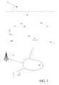
- the facility 14is, e.g., a commercial, industrial, facility, with interior areas, 14 a (buildings) and exterior areas 14 b that are subject to surveillance.
- the buildings 14 acan be of any configuration, wide open spaces such as a warehouse, to compartmentalized facilities such as labs/offices.
- the surveillance system 12includes one or more UAV or drone stations 16 (for example, HATP's, discussed below).
- a UAV (unmanned aerial vehicle) commonly known as a droneis a remotely piloted airborne vehicle, i.e., an aircraft that does not have a human pilot aboard. However, a human controls the flight of the drone remotely or in some applications the flight of the drone is controlled autonomously by onboard computers.
- the drone stations 16provide bases for one or more of the plural drones 18 .
- the systemalso includes a server 20 that is in communication with the drones 18 and a gateway 22 to send data to and receive data from a remote, central monitoring station 24 (also referred to as central monitoring center) via one or more data or communication networks 26 (only one shown), such as the Internet; the phone system or cellular communication system 25 being examples of others.
- the server 20receives signals from the plural drones. These signals include video signals from onboard cameras as well as location information.
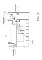
- FIG. 1Aan exemplary floor plan for an exemplary one of the buildings 14 a is shown in some detail, including hallways, and offices with various doorways, all shown schematically but not with reference numbers. Also shown are fixed location markers 30 that can be any one of a number of technologies, e.g., waypoints discussed below, the server 20 , gateway 22 and drone station 16 that is likewise a waypoint discussed below.
- fixed location markers 30can be any one of a number of technologies, e.g., waypoints discussed below, the server 20 , gateway 22 and drone station 16 that is likewise a waypoint discussed below.
- the dronescan carry several types of sensor/detectors.
- One type of sensoris a video camera that sends video data to the server 20 .
- Examples of other types of sensors 28 binclude microphones to send audio data.
- the sensors 28communicate wirelessly to the server 20 or communicate through an on-board computer on the drone.
- sensors 28 acapture audio and video and send signals to the server 20 .
- the server 20determines whether to trigger and/or send alarm messages to the monitoring station 18 .
- An operator at the remote control stationcontrols actions of the drone.
- the data or communication network 24may include any combination of wired and wireless links capable of carrying packet and/or switched traffic, and may span multiple carriers, and a wide geography.
- the data network 24may simply be the public Internet.
- the data network 24may include one or more wireless links, and may include a wireless data network, e.g., with tower 25 such as a 2G, 3G, 4G or LTE cellular data network.
- Further network componentssuch as access points, routers, switches, DSL modems, and the like possibly interconnecting the server 20 with the data network 24 are not illustrated.
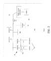
- the drone 18includes processor 32 and memory 34 , and storage 33 and a wireless network interface card (NIC) 36 all coupled via a bus 42 .
- the drone 18also includes one or more sensors and one or more interfaces 38 to receive sensor data from the sensors 28 . Illustrated for explanatory purpose are camera and microphone sensors 28 and interfaces 38 for those sensors. The sensors 28 are coupled to the interfaces either via hard wiring or wirelessly.
- the drone 18also includes flight control electronics and one or more electric motors to control one or more propellers.
- the droneincludes a body that can be either that of a plane or a helicopter.
- the drone flight control electronicsare response to control signals received by the processor via the wireless interface card that allow a remotely positioned operator to control flight of the drone and control the camera and microphone on the drone.
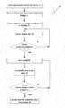
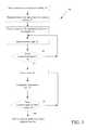
- an alarm conditionis asserted 51 within the facility.
- the droneis autonomously programmed 52 by the server with a route that starts from the drone's initial location, typically a home station to a location where the alarm condition was asserted.
- the dronein an autonomous manner flies to that location in the building carrying sensors to gather sensor data that can be in various forms such as live video that is sent back to the server and onto the security monitoring center where the video is stored and viewed.
- the droneis launched, and as the drone flies the programmed pattern it collects such sensor data. However, the drone is programmed to fly to a particular location within a facility.
- the drone or the serverdetermines 58 when the drone is at the specified location. Prior to arriving, (determination is “no”) the drone continues to send and the server receives sensor data over the flight path. Once the drone arrives at that specific location in the facility, the drone hovers 60 at that location in the facility by entering a hover mode.
- the dronecan be controlled autonomously such that the camera is pointing to a location of interest or at that point the drone can be controlled by an operator.
- the dronecontinually captures 62 sensor data, e.g., video. This data is stored and sent back to the operator for display on a display device.
- the dronereceives 64 a signal to return to base.
- the signalcan originate either from the operator (monitoring station) or the server 20 , an authorized client device (not shown) or the drone 18 itself, as the drone would be monitoring its fuel supply or level of remaining battery charge. In the latter situations of the signal originating from the server 20 or authorized client device or the drone 18 itself, one of those devices would send a signal back to the operator (monitoring station) to indicate that the drone 18 is returning to base 66 to allow another drone to be launched.
- Guidance within or outside of a buildingcan be accomplished by several techniques.
- guidancecan be accomplished by global position system (GPS) tracking.
- Alternative techniquesinclude an operator at the monitoring facility manually flying the drone to a specific location or having the drone hover at the location.
- GPSglobal position system
- Alternative techniquesinclude an operator at the monitoring facility manually flying the drone to a specific location or having the drone hover at the location.
- guidancecan be accomplished by feature recognition to follow a preprogrammed map of the interior of the building.
- Another type of navigationis a map based type navigation that includes a database that stores images of landmarks, descriptions of items and navigation instructions.
- a third type of navigationis by r.f. (radio frequency) beacons being deployed within the facility, sending out r.f signals that a guidance system on board the drone captures and uses to apply a triangulation algorithm to figure out current location.
- r.f.radio frequency
- the dronehas crash avoidance systems that are used during flight to detect and record any physical objects that disrupt the ability of the drone to follow a route plan.
- Many dronesnow come supplied with crash avoidance systems that determine proximity to nearby objects and are used with drone navigation to navigate around the object and return to a preprogrammed path or route.
- programmable waypointsplaced, e.g., at location points, objects, locations, etc. along a path determined by the plan that a drone will fly to in sequential order while using crash avoidance capability to move along safely and intact between waypoints.
- the number of programmable routesis limited by the amount of onboard memory allocated for routes. If RPs are stored on a server and delivered to the drone during flight, the number of waypoints is limited by the amount of server memory and processing power allocated for waypoints.
- the waypointsare small devices that are programmable and include an RF transmitter devices, e.g., RFID or low power RF transmitters that continually broadcast its identity and/or placement and which are placed at locations where the asset being protected is located and at all permitted points of entry to the protected area.
- an RF transmitter devicese.g., RFID or low power RF transmitters that continually broadcast its identity and/or placement and which are placed at locations where the asset being protected is located and at all permitted points of entry to the protected area.
- waypointis an Asset to Protect (ATP) waypoint.
- ATPAsset to Protect
- HATPHome Asset to Protect
- This waypointitself is a high value item, and susceptible to attack or theft. It is the home for the drone where the drone docs, recharges, and exchanges data with the server(s) the drone is associated with. The drone continually calculates how much power the drone has for flying, how far away the drone is from a HATP, and thus can calculate when to return to an HATP for recharging.
- PPPPerimeter Point to Protect
- This waypointis an item or area of high value and susceptible to attack or theft.
- the Route Planis a flight path that is developed and programmed into the drone, by the server executing a flight service.
- the Route Planis established by the use of the aforementioned waypoints.
- the Route Plancan be predefined for each HATP waypoint to each location of interest, i.e., ATP waypoint.
- These RPcan be preloaded into the drone, memory permitting, or a single RP can be uploaded into the drone on demand, based on a detected alarm condition by the server.
- the dronerecognizes the existence of the waypoints and uses the waypoints to navigate to and between waypoints.
- crash avoidancewhile traveling to a waypoint, the flight plan is established and recorded.
- the droneuses crash avoidance to determine and report any deviations from the already determine plan.
- the dronecaptures images of the deviation and reports them as troubles during the premises disarmed period or alarm during the premises armed period.
- a Triggered Alarm Responseis provided by the drone and server that contain the flight service programmed with the awareness of the desired (normal non-alarm/trouble) condition of the environment is interfaced to other security systems and/or services, i.e. Intrusion Detection System, Access Control, and Video Surveillance.
- the interfacecan be done through a predefined Application Programming Interface (API) using Web Services, XML, or proprietary formats.
- APIApplication Programming Interface
- the droneuses the RP and crash avoidance to fly to the waypoint closest to the reported point of protection that triggered the alarm or trouble to capture and transmit to the Home Asset to Protect (HATP) point(s) video images, sound, and temperature.
- HATPHome Asset to Protect
- the dronenavigates by the above mentioned waypoints processing captured signals from the various waypoints to recognize its current position (e.g. stairs, exits, doors, corridors, etc.) within a facility.
- the dronehas stored the flight plan that takes into consideration the relevant building or environment. Having this information, the drone correlates captures signals to features in the flight plan. By correlating the captured signals to the features in the flight plan, the drone can determine its current waypoint, is provided information on that waypoint, and can navigate to a subsequent waypoint based on the flight plan.
- the dronemay incorporate the functionality of a compass to assist in navigation.
- the processingrather than be performed by the drone, is performed by the server and the server receives the signals, processes the signals against the flight plan and the server sends navigation instructions to the drone to control flight of the drone.
- a flight planis essentially a navigation map structure that is produced and includes paths between a starting waypoint and an ending waypoint.
- the navigation mapis stored as a structure such as a graph data structure that includes a set of nodes and a set of edges that establish relationships (connections) between the nodes.
- Each location or landmarkcorresponds to a waypoint and is represented as a node or vertex of the graph, and each description or distance between two waypoints is represented as an edge or link between the nodes.
- informationthat is in the form of flight instructions that control how the drone navigates from one node to the next node, e.g., by including data on engine speed and direction.
- the edgescorrespond to relationships between the waypoints.
- Each edgehas information about connectedness to other waypoints and information about proximity of waypoints. Since each node generally has one or more edges that connect to one or more nodes, a description of the relationship between nodes, such as navigation instructions for the flight electronics are obtained by accessing the data structure that stores the information defining the relationships among the waypoints.
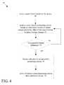
- the server 20 system and/or the central monitoring stationreceives 70 signals from various sensors e.g., a camera, a microphone, etc. on the drones.
- the server 20applies 72 analytics to the sensor data, e.g., the video, by comparing for instance, current images captured by the drone at a particular location to stored images previously taken at the same location to detect features in the current images that are different than expected based on the stored images.
- the analyticsoutputs an indication.
- the serverperforms the processing
- the server 20notifies the monitoring station or where the monitor station 20 is performing the processing, monitoring station alerts the operator. Additional actions 78 can be taken by the server 20 and/or central monitor station 24 , as a result of outputting the indication.
- the processing upon detection of an unacceptable lever of feature differencescan signal launching of additional drones or for an intervention or modification of the hover position of the drone.
- a modified flight patterncan be accomplished by the server 20 producing a new flight pattern taking into consideration results of analytics processing, and reprogramming the drone with the new flight pattern.
- the server 20can cause flight control of the drone to be transferred to an operator.
- the analytics processingproduces messages that are sent to a display (not shown) within view of the operator to assist the operator in guiding the drone and thus apply a new flight pattern.
- the new flight patterncan be varied including causing the drone to hover about that location providing continuous video surveillance back to the monitoring station or to follow a path determined by the analytics processing.
- the alarm condition discussed abovecan be detected by other sensors within a facility, such as a window being opened or a glass break detector or contact switch being asserted which are captured by an intrusion detection system (not shown).
- a drone at a Home Asset to Protect (HATP) waypointis autonomously launched from the Home Asset to Protect (HATP) waypoint, by the server 20 that is also part of broader intrusion detection system (not shown) to fly to that location providing constant surveillance of the location until the incident is evaluated and handled.
- the drone, the server or the central monitor stationcan perform, part or all of the processing in FIGS. 3 and 4 .
- the systemincludes a charging station HATP waypoint where drones land to recharge batteries (not shown) as needed.
- the dronesare small, inexpensive devices that are programmed to fly a predetermined pattern or to specific locations of interest within a building providing live video back to a security monitoring center.
- Drones employed hereinare selected according to the type and nature of the surveillance. For example, when the drones are employed to hover, a helicopter type drone might be preferable to an airplane type drone. In addition, when deployed outdoors of the facility, the drones in general can be relatively large in comparison to those employed inside a building within the facility. Moreover, a drone employed within a building that has wide open spaces can be in general larger than one employed in a building that has many rooms and corridors. Thus, a typical wing span for a drone outside can be 1 to 5 feet, whereas inside it would likely be less than 1 foot.
- sensorscan be carried by the drone, thus sensors include microphones to sense sound, and cameras to capture images and/or video.
- sensorscan include sensors to capture motion, vibration, pressure, heat, and so forth, in an appropriate combination to detect a true condition in a facility.
- the memory 34stores program instructions and data used by the processor.
- the memory 34may be a suitable combination of random access memory and read-only memory, and may host suitable program instructions (e.g. firmware or operating software), and configuration and operating data and may be organized as a file system or otherwise.
- suitable program instructionse.g. firmware or operating software
- configuration and operating datamay be organized as a file system or otherwise.
- the program instructions stored in the memorymay further store software components allowing network communications and establishment of connections to the data network.
- Program instructions stored in the memory along with configuration datamay control overall operation of drone.
- An example monitoring station 18can be a single physical monitoring station or center in FIG. 1 . However, it could alternatively be formed of multiple monitoring centers/stations, each at a different physical location, and each in communication with the data network 24 .
- the central monitoring station 18includes one or more monitoring server(s) 82 each processing messages from the drones and/or user devices (not shown).
- the monitoring server 82may include a processor, a network interface and a memory (all not illustrated).
- the monitoring server 82may physically take the form of a rack mounted card and may be in communication with one or more operator terminals (not shown).
- An example monitoring server 82is a SURGARDTM SG-System III Virtual, or similar system.
- each monitoring server 82acts as a controller for each monitoring server 82 , and is in communication with, and controls overall operation, of each server 82 .
- the processormay include, or be in communication with the memory that stores processor executable instructions controlling the overall operation of the monitoring server 82 .
- Suitable softwareenable each monitoring server 82 to receive alarms and cause appropriate actions to occur.
- Softwaremay include a suitable Internet protocol (IP) stack and applications/clients.
- IPInternet protocol
- Each monitoring server 82 of central monitoring station 18may be associated with an IP address and port(s) by which it communicates with the control panels 16 and/or the user devices to handle alarm events, etc.
- the monitoring server addressmay be static, and thus always identify a particular one of monitoring server 32 to the intrusion detection panels. Alternatively, dynamic addresses could be used, and associated with static domain names, resolved through a domain name service.
- the network interfacemay be a conventional network interface that interfaces with the network 24 ( FIG. 1 ) to receive incoming signals, and may for example take the form of an Ethernet network interface card (NIC).
- NICEthernet network interface card
- Serverscan be any of a variety of computing devices capable of receiving information, such as a server, a distributed computing system 10 , a rack-mounted server and so forth. Server may be a single server or a group of servers that are at a same location or at different locations. Servers can receive information from client device user device via interfaces. Interfaces can be any type of interface capable of receiving information over a network, such as an Ethernet interface, a wireless networking interface, a fiber-optic networking interface, a modem, and so forth. Server also includes a processor and memory and a bus system including, for example, an information bus and a motherboard, can be used to establish and to control information communication between the components of server.
- Processormay include one or more microprocessors.
- processormay include any appropriate processor and/or logic that is capable of receiving and storing information, and of communicating over a network (not shown).
- Memorycan include a hard drive and a random access memory storage device, such as a dynamic random access memory computer readable hardware storage devices and media and other types of non-transitory storage devices.
- Embodimentscan be implemented in digital electronic circuitry, or in computer hardware, firmware, software, or in combinations thereof.
- Computer programscan be implemented in a high-level procedural or object oriented programming language, or in assembly or machine language if desired; and in any case, the language can be a compiled or interpreted language.
- Suitable processorsinclude, by way of example, both general and special purpose microprocessors.
- a processorwill receive instructions and information from a read-only memory and/or a random access memory.
- a computerwill include one or more mass storage devices for storing information files; such devices include magnetic disks, such as internal hard disks and removable disks; magneto-optical disks; and optical disks.
- Hardware storage devices suitable for tangibly embodying computer program instructions and informationinclude all forms of non-volatile memory, including by way of example semiconductor memory devices, such as EPROM, EEPROM, and flash memory devices; magnetic disks such as internal hard disks and removable disks; magneto-optical disks; and CD_ROM disks. Any of the foregoing can be supplemented by, or incorporated in, ASICs (application-specific integrated circuits).
- semiconductor memory devicessuch as EPROM, EEPROM, and flash memory devices
- magnetic diskssuch as internal hard disks and removable disks
- magneto-optical disksmagneto-optical disks
- CD_ROM diskscompact discs
- crash avoidance systemse.g., navigation is recognition-based guidance accomplished by applying feature recognition to follow a preprogrammed map of the interior of the building.
- the mapwould be as a series of features extracted from images.
- the dronecapture images during flight, applies feature recognition to the images and extracts those recognized features and compares recognized features to features in the map to adjust flight paths, as needed within the building.
- Other embodimentsare within the scope of the following claims.
Landscapes
- Engineering & Computer Science (AREA)
- Business, Economics & Management (AREA)
- Physics & Mathematics (AREA)
- General Physics & Mathematics (AREA)
- Aviation & Aerospace Engineering (AREA)
- Tourism & Hospitality (AREA)
- Emergency Management (AREA)
- Radar, Positioning & Navigation (AREA)
- Remote Sensing (AREA)
- Automation & Control Theory (AREA)
- Human Resources & Organizations (AREA)
- Marketing (AREA)
- Development Economics (AREA)
- Health & Medical Sciences (AREA)
- Economics (AREA)
- General Health & Medical Sciences (AREA)
- Computer Security & Cryptography (AREA)
- Educational Administration (AREA)
- Primary Health Care (AREA)
- Strategic Management (AREA)
- General Business, Economics & Management (AREA)
- Theoretical Computer Science (AREA)
- Alarm Systems (AREA)
- Traffic Control Systems (AREA)
Abstract
Description
Claims (16)
Priority Applications (7)
| Application Number | Priority Date | Filing Date | Title |
|---|---|---|---|
| US14/516,671US10301018B2 (en) | 2014-10-17 | 2014-10-17 | Fixed drone visualization in security systems |
| EP15720569.1AEP3207435B1 (en) | 2014-10-17 | 2015-10-16 | Fixed drone visualization in security systems |
| PCT/EP2015/074010WO2016059214A1 (en) | 2014-10-17 | 2015-10-16 | Fixed drone visualization in security systems |
| US16/274,066US11414188B2 (en) | 2014-10-17 | 2019-02-12 | Fixed drone visualization in security systems |
| US17/880,948US11753162B2 (en) | 2014-10-17 | 2022-08-04 | Fixed drone visualization in security systems |
| US18/228,140US12071238B2 (en) | 2014-10-17 | 2023-07-31 | Fixed drone visualization in security systems |
| US18/794,628US20240393806A1 (en) | 2014-10-17 | 2024-08-05 | Fixed drone visualization in security systems |
Applications Claiming Priority (1)
| Application Number | Priority Date | Filing Date | Title |
|---|---|---|---|
| US14/516,671US10301018B2 (en) | 2014-10-17 | 2014-10-17 | Fixed drone visualization in security systems |
Related Child Applications (1)
| Application Number | Title | Priority Date | Filing Date |
|---|---|---|---|
| US16/274,066ContinuationUS11414188B2 (en) | 2014-10-17 | 2019-02-12 | Fixed drone visualization in security systems |
Publications (2)
| Publication Number | Publication Date |
|---|---|
| US20160107749A1 US20160107749A1 (en) | 2016-04-21 |
| US10301018B2true US10301018B2 (en) | 2019-05-28 |
Family
ID=54347504
Family Applications (5)
| Application Number | Title | Priority Date | Filing Date |
|---|---|---|---|
| US14/516,671ActiveUS10301018B2 (en) | 2014-10-17 | 2014-10-17 | Fixed drone visualization in security systems |
| US16/274,066Active2036-04-25US11414188B2 (en) | 2014-10-17 | 2019-02-12 | Fixed drone visualization in security systems |
| US17/880,948ActiveUS11753162B2 (en) | 2014-10-17 | 2022-08-04 | Fixed drone visualization in security systems |
| US18/228,140ActiveUS12071238B2 (en) | 2014-10-17 | 2023-07-31 | Fixed drone visualization in security systems |
| US18/794,628PendingUS20240393806A1 (en) | 2014-10-17 | 2024-08-05 | Fixed drone visualization in security systems |
Family Applications After (4)
| Application Number | Title | Priority Date | Filing Date |
|---|---|---|---|
| US16/274,066Active2036-04-25US11414188B2 (en) | 2014-10-17 | 2019-02-12 | Fixed drone visualization in security systems |
| US17/880,948ActiveUS11753162B2 (en) | 2014-10-17 | 2022-08-04 | Fixed drone visualization in security systems |
| US18/228,140ActiveUS12071238B2 (en) | 2014-10-17 | 2023-07-31 | Fixed drone visualization in security systems |
| US18/794,628PendingUS20240393806A1 (en) | 2014-10-17 | 2024-08-05 | Fixed drone visualization in security systems |
Country Status (3)
| Country | Link |
|---|---|
| US (5) | US10301018B2 (en) |
| EP (1) | EP3207435B1 (en) |
| WO (1) | WO2016059214A1 (en) |
Cited By (7)
| Publication number | Priority date | Publication date | Assignee | Title |
|---|---|---|---|---|
| US20180086456A1 (en)* | 2016-09-28 | 2018-03-29 | Federal Express Corporation | Aerial drone-based systems and methods for adaptively providing an aerial relocatable communication hub within a delivery vehicle |
| US11199859B2 (en)* | 2016-06-01 | 2021-12-14 | Cape Mcuas, Inc. | Apparatus and method for network based operation of an unmanned aerial vehicle |
| US11410420B1 (en)* | 2020-07-28 | 2022-08-09 | Wells Fargo Bank, N.A. | Enhancing branch opening and closing procedures using autonomous drone security and monitoring |
| US11414188B2 (en)* | 2014-10-17 | 2022-08-16 | Johnson Controls Tyco IP Holdings LLP | Fixed drone visualization in security systems |
| US11586208B2 (en)* | 2014-10-24 | 2023-02-21 | Clearpath Robotics Inc. | Systems and methods for executing a task with an unmanned vehicle |
| US11702204B1 (en)* | 2016-02-23 | 2023-07-18 | State Farm Mutual Automobile Insurance Company | Systems and methods for operating drones in response to an incident |
| US12046041B2 (en) | 2021-05-25 | 2024-07-23 | Motorola Solutions, Inc. | Flight guidance and control interfaces for unmanned air vehicles |
Families Citing this family (136)
| Publication number | Priority date | Publication date | Assignee | Title |
|---|---|---|---|---|
| US6658091B1 (en) | 2002-02-01 | 2003-12-02 | @Security Broadband Corp. | LIfestyle multimedia security system |
| US11811845B2 (en) | 2004-03-16 | 2023-11-07 | Icontrol Networks, Inc. | Communication protocols over internet protocol (IP) networks |
| US10522026B2 (en) | 2008-08-11 | 2019-12-31 | Icontrol Networks, Inc. | Automation system user interface with three-dimensional display |
| US10313303B2 (en) | 2007-06-12 | 2019-06-04 | Icontrol Networks, Inc. | Forming a security network including integrated security system components and network devices |
| US7711796B2 (en) | 2006-06-12 | 2010-05-04 | Icontrol Networks, Inc. | Gateway registry methods and systems |
| US11159484B2 (en) | 2004-03-16 | 2021-10-26 | Icontrol Networks, Inc. | Forming a security network including integrated security system components and network devices |
| GB2428821B (en) | 2004-03-16 | 2008-06-04 | Icontrol Networks Inc | Premises management system |
| US11489812B2 (en) | 2004-03-16 | 2022-11-01 | Icontrol Networks, Inc. | Forming a security network including integrated security system components and network devices |
| US8963713B2 (en) | 2005-03-16 | 2015-02-24 | Icontrol Networks, Inc. | Integrated security network with security alarm signaling system |
| US12063220B2 (en) | 2004-03-16 | 2024-08-13 | Icontrol Networks, Inc. | Communication protocols in integrated systems |
| US9141276B2 (en) | 2005-03-16 | 2015-09-22 | Icontrol Networks, Inc. | Integrated interface for mobile device |
| US10156959B2 (en) | 2005-03-16 | 2018-12-18 | Icontrol Networks, Inc. | Cross-client sensor user interface in an integrated security network |
| US11677577B2 (en) | 2004-03-16 | 2023-06-13 | Icontrol Networks, Inc. | Premises system management using status signal |
| US10237237B2 (en) | 2007-06-12 | 2019-03-19 | Icontrol Networks, Inc. | Communication protocols in integrated systems |
| US9531593B2 (en) | 2007-06-12 | 2016-12-27 | Icontrol Networks, Inc. | Takeover processes in security network integrated with premise security system |
| US11190578B2 (en) | 2008-08-11 | 2021-11-30 | Icontrol Networks, Inc. | Integrated cloud system with lightweight gateway for premises automation |
| US11244545B2 (en) | 2004-03-16 | 2022-02-08 | Icontrol Networks, Inc. | Cross-client sensor user interface in an integrated security network |
| US9609003B1 (en) | 2007-06-12 | 2017-03-28 | Icontrol Networks, Inc. | Generating risk profile using data of home monitoring and security system |
| US10444964B2 (en) | 2007-06-12 | 2019-10-15 | Icontrol Networks, Inc. | Control system user interface |
| US20170118037A1 (en) | 2008-08-11 | 2017-04-27 | Icontrol Networks, Inc. | Integrated cloud system for premises automation |
| US8635350B2 (en) | 2006-06-12 | 2014-01-21 | Icontrol Networks, Inc. | IP device discovery systems and methods |
| US10142392B2 (en) | 2007-01-24 | 2018-11-27 | Icontrol Networks, Inc. | Methods and systems for improved system performance |
| US10339791B2 (en) | 2007-06-12 | 2019-07-02 | Icontrol Networks, Inc. | Security network integrated with premise security system |
| US11277465B2 (en) | 2004-03-16 | 2022-03-15 | Icontrol Networks, Inc. | Generating risk profile using data of home monitoring and security system |
| US10348575B2 (en) | 2013-06-27 | 2019-07-09 | Icontrol Networks, Inc. | Control system user interface |
| US9729342B2 (en) | 2010-12-20 | 2017-08-08 | Icontrol Networks, Inc. | Defining and implementing sensor triggered response rules |
| US11916870B2 (en) | 2004-03-16 | 2024-02-27 | Icontrol Networks, Inc. | Gateway registry methods and systems |
| US11368429B2 (en) | 2004-03-16 | 2022-06-21 | Icontrol Networks, Inc. | Premises management configuration and control |
| US11343380B2 (en) | 2004-03-16 | 2022-05-24 | Icontrol Networks, Inc. | Premises system automation |
| US8988221B2 (en) | 2005-03-16 | 2015-03-24 | Icontrol Networks, Inc. | Integrated security system with parallel processing architecture |
| US20090077623A1 (en) | 2005-03-16 | 2009-03-19 | Marc Baum | Security Network Integrating Security System and Network Devices |
| US10721087B2 (en) | 2005-03-16 | 2020-07-21 | Icontrol Networks, Inc. | Method for networked touchscreen with integrated interfaces |
| US11582065B2 (en) | 2007-06-12 | 2023-02-14 | Icontrol Networks, Inc. | Systems and methods for device communication |
| US10200504B2 (en) | 2007-06-12 | 2019-02-05 | Icontrol Networks, Inc. | Communication protocols over internet protocol (IP) networks |
| US11316958B2 (en) | 2008-08-11 | 2022-04-26 | Icontrol Networks, Inc. | Virtual device systems and methods |
| US11201755B2 (en) | 2004-03-16 | 2021-12-14 | Icontrol Networks, Inc. | Premises system management using status signal |
| US11113950B2 (en) | 2005-03-16 | 2021-09-07 | Icontrol Networks, Inc. | Gateway integrated with premises security system |
| US20120324566A1 (en) | 2005-03-16 | 2012-12-20 | Marc Baum | Takeover Processes In Security Network Integrated With Premise Security System |
| US9306809B2 (en) | 2007-06-12 | 2016-04-05 | Icontrol Networks, Inc. | Security system with networked touchscreen |
| US10999254B2 (en) | 2005-03-16 | 2021-05-04 | Icontrol Networks, Inc. | System for data routing in networks |
| US20110128378A1 (en) | 2005-03-16 | 2011-06-02 | Reza Raji | Modular Electronic Display Platform |
| US11615697B2 (en) | 2005-03-16 | 2023-03-28 | Icontrol Networks, Inc. | Premise management systems and methods |
| US11496568B2 (en) | 2005-03-16 | 2022-11-08 | Icontrol Networks, Inc. | Security system with networked touchscreen |
| US20170180198A1 (en) | 2008-08-11 | 2017-06-22 | Marc Baum | Forming a security network including integrated security system components |
| US11700142B2 (en) | 2005-03-16 | 2023-07-11 | Icontrol Networks, Inc. | Security network integrating security system and network devices |
| US10079839B1 (en) | 2007-06-12 | 2018-09-18 | Icontrol Networks, Inc. | Activation of gateway device |
| US12063221B2 (en) | 2006-06-12 | 2024-08-13 | Icontrol Networks, Inc. | Activation of gateway device |
| US11706279B2 (en) | 2007-01-24 | 2023-07-18 | Icontrol Networks, Inc. | Methods and systems for data communication |
| US7633385B2 (en) | 2007-02-28 | 2009-12-15 | Ucontrol, Inc. | Method and system for communicating with and controlling an alarm system from a remote server |
| US8451986B2 (en) | 2007-04-23 | 2013-05-28 | Icontrol Networks, Inc. | Method and system for automatically providing alternate network access for telecommunications |
| US11316753B2 (en) | 2007-06-12 | 2022-04-26 | Icontrol Networks, Inc. | Communication protocols in integrated systems |
| US10423309B2 (en) | 2007-06-12 | 2019-09-24 | Icontrol Networks, Inc. | Device integration framework |
| US11601810B2 (en) | 2007-06-12 | 2023-03-07 | Icontrol Networks, Inc. | Communication protocols in integrated systems |
| US10666523B2 (en) | 2007-06-12 | 2020-05-26 | Icontrol Networks, Inc. | Communication protocols in integrated systems |
| US11212192B2 (en) | 2007-06-12 | 2021-12-28 | Icontrol Networks, Inc. | Communication protocols in integrated systems |
| US11423756B2 (en) | 2007-06-12 | 2022-08-23 | Icontrol Networks, Inc. | Communication protocols in integrated systems |
| US12003387B2 (en) | 2012-06-27 | 2024-06-04 | Comcast Cable Communications, Llc | Control system user interface |
| US12184443B2 (en) | 2007-06-12 | 2024-12-31 | Icontrol Networks, Inc. | Controlling data routing among networks |
| US11218878B2 (en) | 2007-06-12 | 2022-01-04 | Icontrol Networks, Inc. | Communication protocols in integrated systems |
| US11646907B2 (en) | 2007-06-12 | 2023-05-09 | Icontrol Networks, Inc. | Communication protocols in integrated systems |
| US10498830B2 (en) | 2007-06-12 | 2019-12-03 | Icontrol Networks, Inc. | Wi-Fi-to-serial encapsulation in systems |
| US11089122B2 (en) | 2007-06-12 | 2021-08-10 | Icontrol Networks, Inc. | Controlling data routing among networks |
| US10523689B2 (en) | 2007-06-12 | 2019-12-31 | Icontrol Networks, Inc. | Communication protocols over internet protocol (IP) networks |
| US10389736B2 (en) | 2007-06-12 | 2019-08-20 | Icontrol Networks, Inc. | Communication protocols in integrated systems |
| US11237714B2 (en) | 2007-06-12 | 2022-02-01 | Control Networks, Inc. | Control system user interface |
| US10616075B2 (en) | 2007-06-12 | 2020-04-07 | Icontrol Networks, Inc. | Communication protocols in integrated systems |
| US12283172B2 (en) | 2007-06-12 | 2025-04-22 | Icontrol Networks, Inc. | Communication protocols in integrated systems |
| US10223903B2 (en) | 2010-09-28 | 2019-03-05 | Icontrol Networks, Inc. | Integrated security system with parallel processing architecture |
| US11831462B2 (en) | 2007-08-24 | 2023-11-28 | Icontrol Networks, Inc. | Controlling data routing in premises management systems |
| US11916928B2 (en) | 2008-01-24 | 2024-02-27 | Icontrol Networks, Inc. | Communication protocols over internet protocol (IP) networks |
| US20170185278A1 (en) | 2008-08-11 | 2017-06-29 | Icontrol Networks, Inc. | Automation system user interface |
| US11729255B2 (en) | 2008-08-11 | 2023-08-15 | Icontrol Networks, Inc. | Integrated cloud system with lightweight gateway for premises automation |
| US11258625B2 (en)* | 2008-08-11 | 2022-02-22 | Icontrol Networks, Inc. | Mobile premises automation platform |
| US11792036B2 (en)* | 2008-08-11 | 2023-10-17 | Icontrol Networks, Inc. | Mobile premises automation platform |
| US11758026B2 (en) | 2008-08-11 | 2023-09-12 | Icontrol Networks, Inc. | Virtual device systems and methods |
| US8638211B2 (en) | 2009-04-30 | 2014-01-28 | Icontrol Networks, Inc. | Configurable controller and interface for home SMA, phone and multimedia |
| WO2011143273A1 (en) | 2010-05-10 | 2011-11-17 | Icontrol Networks, Inc | Control system user interface |
| US8836467B1 (en) | 2010-09-28 | 2014-09-16 | Icontrol Networks, Inc. | Method, system and apparatus for automated reporting of account and sensor zone information to a central station |
| US11750414B2 (en) | 2010-12-16 | 2023-09-05 | Icontrol Networks, Inc. | Bidirectional security sensor communication for a premises security system |
| US9147337B2 (en) | 2010-12-17 | 2015-09-29 | Icontrol Networks, Inc. | Method and system for logging security event data |
| US11146637B2 (en) | 2014-03-03 | 2021-10-12 | Icontrol Networks, Inc. | Media content management |
| US11405463B2 (en) | 2014-03-03 | 2022-08-02 | Icontrol Networks, Inc. | Media content management |
| CN105793792B (en)* | 2014-12-25 | 2018-09-25 | 深圳市大疆创新科技有限公司 | The flight householder method and system of unmanned plane, unmanned plane and mobile terminal |
| US9494936B2 (en) | 2015-03-12 | 2016-11-15 | Alarm.Com Incorporated | Robotic assistance in security monitoring |
| US9819911B2 (en)* | 2015-07-13 | 2017-11-14 | Honeywell International Inc. | Home, office security, surveillance system using micro mobile drones and IP cameras |
| US10283000B2 (en)* | 2015-10-23 | 2019-05-07 | Vigilair Limited | Unmanned aerial vehicle deployment system |
| US10228695B2 (en)* | 2016-01-20 | 2019-03-12 | Alarm.Com Incorporated | Drone control device |
| US9773419B1 (en)* | 2016-03-24 | 2017-09-26 | International Business Machines Corporation | Pre-positioning aerial drones |
| DE102016005403B4 (en)* | 2016-04-30 | 2018-04-26 | Diehl Metering Gmbh | Method for communication between at least one counter device and a flight device |
| US10188580B2 (en)* | 2016-05-09 | 2019-01-29 | Toyota Motor Engineering & Manufacturing North America, Inc. | Systems and methods for providing environment information using an unmanned vehicle |
| DE102016109242A1 (en)* | 2016-05-19 | 2017-11-23 | Keil Group GmbH | monitoring system |
| ITUA20164468A1 (en)* | 2016-06-17 | 2017-12-17 | Dal Pozzo Tommaso | SYSTEM AND METHOD FOR TRACING ONE OR MORE PEOPLE FOLLOWING AN ALARM EVENT. |
| CN105978999B (en)* | 2016-06-27 | 2019-04-26 | 北京小米移动软件有限公司 | Alarm method and device |
| CN106114880A (en)* | 2016-06-29 | 2016-11-16 | 杨珊珊 | The system for prompting of a kind of unmanned vehicle air crash and method thereof |
| US11129067B2 (en) | 2016-07-06 | 2021-09-21 | Lg Electronics Inc. | Method and apparatus for supporting handover of drone in wireless communication system |
| KR102630227B1 (en)* | 2016-07-21 | 2024-01-29 | 한화비전 주식회사 | Surveillance Data Providing System and Method Thereof |
| CN106227232A (en)* | 2016-07-26 | 2016-12-14 | 斑马信息科技有限公司 | The control method of unmanned plane, device and equipment |
| WO2018083798A1 (en)* | 2016-11-07 | 2018-05-11 | 株式会社ラムロック | Monitoring system and mobile robot device |
| DE102016223437A1 (en)* | 2016-11-25 | 2018-05-30 | Sms Group Gmbh | Unmanned vehicles for process monitoring in industrial plants |
| KR101765235B1 (en)* | 2016-11-28 | 2017-08-04 | 한국건설기술연구원 | FACILITY MAINTENANCE SYSTEM USING INTERNET OF THINGS (IoT) BASED SENSOR AND UNMANNED AIR VEHICLE (UAV), AND METHOD FOR THE SAME |
| US10756919B1 (en) | 2016-11-28 | 2020-08-25 | Alarm.Com Incorporated | Connected automation controls using robotic devices |
| CA3046868A1 (en)* | 2016-12-12 | 2018-06-21 | Stephen Scott Trundle | Drone pre-surveillance |
| US10356590B2 (en)* | 2016-12-16 | 2019-07-16 | Fetch Robotics, Inc. | System and method for responding to emergencies using robotic assistance |
| US20180186473A1 (en)* | 2017-01-03 | 2018-07-05 | International Business Machines Corporation | Drone hotel and system, method and computer program product for a drone hotel |
| CA3050098A1 (en) | 2017-01-17 | 2018-07-26 | Alarm.Com Incorporated | Dynamic drone navigation |
| FR3067473B1 (en)* | 2017-06-09 | 2019-06-28 | Drone Protect System | VIDEO SURVEILLANCE METHOD USING AT LEAST ONE AUTONOMOUS DRONE AND DEVICE FOR IMPLEMENTING THE SAME |
| US10852751B2 (en) | 2017-07-07 | 2020-12-01 | Sensormatic Electronics, LLC | Building bots interfacing with security systems |
| WO2019028389A1 (en) | 2017-08-04 | 2019-02-07 | Walmart Apollo, Llc | Systems, devices, and methods for generating a dynamic three dimensional communication map |
| US10726712B2 (en)* | 2017-08-23 | 2020-07-28 | Sensormatic Electronics, LLC | Building bots interfacing with intrusion detection systems |
| AU2018324086B2 (en) | 2017-08-30 | 2022-02-03 | Alarm.Com Incorporated | System and method for monitoring a property using drone beacons |
| US10330480B1 (en)* | 2017-09-07 | 2019-06-25 | Amazon Technologies, Inc. | Deployable sensors |
| US10322802B1 (en) | 2017-09-07 | 2019-06-18 | Amazon Technologies, Inc. | Deployable sensors |
| US11016487B1 (en)* | 2017-09-29 | 2021-05-25 | Alarm.Com Incorporated | Optimizing a navigation path of a robotic device |
| CN107807666A (en)* | 2017-11-29 | 2018-03-16 | 天津聚飞创新科技有限公司 | aircraft, flight control method and device |
| US11138890B2 (en)* | 2017-11-29 | 2021-10-05 | International Business Machines Corporation | Secure access for drone package delivery |
| US10685229B2 (en)* | 2017-12-21 | 2020-06-16 | Wing Aviation Llc | Image based localization for unmanned aerial vehicles, and associated systems and methods |
| US10922431B2 (en) | 2017-12-27 | 2021-02-16 | Honeywell International Inc. | Systems and methods for dynamically masking video and images captured by a drone device camera |
| US11781890B2 (en)* | 2017-12-29 | 2023-10-10 | Intel Corporation | Method, a circuit and a system for environmental sensing |
| CN108445504A (en)* | 2018-03-20 | 2018-08-24 | 迪比(重庆)智能科技研究院有限公司 | A kind of multi-rotor unmanned aerial vehicle indoor navigation method |
| US11140814B2 (en)* | 2018-05-21 | 2021-10-12 | Kubota Corporation | Work vehicle having display unit |
| US11393346B1 (en)* | 2018-06-11 | 2022-07-19 | Amazon Technologies, Inc. | Location beacon using pre-existing infrastructure |
| US11281200B2 (en)* | 2018-10-01 | 2022-03-22 | Fisher-Rosemount Systems, Inc. | Drone-enabled operator rounds |
| US20210323669A1 (en)* | 2018-11-22 | 2021-10-21 | Lorenz Technology Aps | Method for inducing an autonomous behavior into an unmanned vehicle, and a communication unit for use in such a method |
| US11049404B2 (en)* | 2019-02-06 | 2021-06-29 | Motorola Mobility Llc | Methods and systems for unmanned aircraft monitoring in response to Internet-of-things initiated investigation requests |
| US11745870B1 (en)* | 2019-03-15 | 2023-09-05 | Alarm.Com Incorporated | Surveillance with security camera drone |
| FR3100075B1 (en) | 2019-08-23 | 2021-11-05 | Atos Integration | PERSON DETECTION DEVICE BY DRONE |
| CN110599727B (en)* | 2019-09-16 | 2021-04-16 | 星泽天下(北京)科技有限公司 | Emergency command management system for forest fire |
| US12169414B2 (en) | 2019-10-24 | 2024-12-17 | Alarm.Com Incorporated | Drone navigation and landing |
| CN110910294A (en)* | 2019-11-11 | 2020-03-24 | 广西财经学院 | A shared UAV management platform and service method for scenic spots |
| CN111508176A (en)* | 2020-03-17 | 2020-08-07 | 猫头鹰安防科技有限公司 | Forest fire control fire extinguishing system based on unmanned aerial vehicle |
| US11581010B2 (en)* | 2020-06-05 | 2023-02-14 | Alarm.Com Incorporated | Drone assisted setup for building specific sound localization model |
| CN111752278B (en)* | 2020-06-30 | 2021-11-30 | 珠海云洲智能科技股份有限公司 | Fixed point control method and device of navigation equipment and electronic equipment |
| EP4186046A4 (en)* | 2020-07-21 | 2023-12-27 | Alarm.com Incorporated | PROPERTY MONITORING AND MANAGEMENT USING A DRONE |
| KR102499995B1 (en) | 2020-07-22 | 2023-02-15 | 한국전자통신연구원 | Reconnaissance unmanned aerial vehicle and surveillance area flight method for unmanned aerial vehicle detection |
| CN112017386A (en)* | 2020-08-14 | 2020-12-01 | 中国科学院上海微系统与信息技术研究所 | A forest and grassland fire monitoring system |
| US20240168479A1 (en)* | 2022-11-21 | 2024-05-23 | Ford Global Technologies, Llc | Vehicular worksite monitoring and assistance |
Citations (19)
| Publication number | Priority date | Publication date | Assignee | Title |
|---|---|---|---|---|
| US5083106A (en)* | 1991-02-11 | 1992-01-21 | Detection Systems, Inc. | Intruder detection system with programmable countdown timer for self-supervision |
| US6192314B1 (en)* | 1998-03-25 | 2001-02-20 | Navigation Technologies Corp. | Method and system for route calculation in a navigation application |
| US6317690B1 (en)* | 1999-06-28 | 2001-11-13 | Min-Chung Gia | Path planning, terrain avoidance and situation awareness system for general aviation |
| US20050131607A1 (en)* | 1995-06-07 | 2005-06-16 | Automotive Technologies International Inc. | Method and arrangement for obtaining information about vehicle occupants |
| US20060058928A1 (en) | 2004-09-14 | 2006-03-16 | Beard Randal W | Programmable autopilot system for autonomous flight of unmanned aerial vehicles |
| US20080144884A1 (en)* | 2006-07-20 | 2008-06-19 | Babak Habibi | System and method of aerial surveillance |
| US20090303042A1 (en)* | 2008-06-04 | 2009-12-10 | National Chiao Tung University | Intruder detection system and method |
| US20100100269A1 (en) | 2008-10-20 | 2010-04-22 | Honeywell International Inc. | Systems and Methods for Unmanned Aerial Vehicle Navigation |
| US20110046817A1 (en)* | 2009-08-18 | 2011-02-24 | Honeywell International Inc. | Incremental Position-Based Guidance For A UAV |
| US20110144828A1 (en)* | 2009-12-11 | 2011-06-16 | The Boeing Company | Unmanned Multi-Purpose Ground Vehicle with Different Levels of Control |
| US20120235864A1 (en)* | 2011-03-16 | 2012-09-20 | Itt Manufacturing Enterprises, Inc. | System and Method for Three-Dimensional Geolocation of Emitters Based on Energy Measurements |
| US20120261144A1 (en) | 2011-04-14 | 2012-10-18 | The Boeing Company | Fire Management System |
| US20120286951A1 (en)* | 2011-05-13 | 2012-11-15 | Hess Brian K | Consumer alarm with quiet button |
| US20140067167A1 (en) | 2012-07-17 | 2014-03-06 | Elwha LLC, a limited liability company of the State of Delaware | Unmanned device interaction methods and systems |
| US20150205298A1 (en)* | 2014-01-17 | 2015-07-23 | Knightscope, Inc. | Autonomous data machines and systems |
| US9162753B1 (en)* | 2012-12-31 | 2015-10-20 | Southern Electrical Equipment Company, Inc. | Unmanned aerial vehicle for monitoring infrastructure assets |
| US20160042637A1 (en)* | 2014-08-11 | 2016-02-11 | Clandestine Development, Llc | Drone Safety Alert Monitoring System and Method |
| US9422139B1 (en)* | 2014-05-19 | 2016-08-23 | Google Inc. | Method of actively controlling winch swing via modulated uptake and release |
| US20170300049A1 (en)* | 2016-04-15 | 2017-10-19 | Podway Ltd | System for and method of maximizing utilization of a closed transport system in an on-demand network |
Family Cites Families (5)
| Publication number | Priority date | Publication date | Assignee | Title |
|---|---|---|---|---|
| WO2009070712A2 (en)* | 2007-11-27 | 2009-06-04 | Jadi, Inc. | Method and system for locating and navigating a target |
| US9158304B2 (en)* | 2013-11-10 | 2015-10-13 | Google Inc. | Methods and systems for alerting and aiding an emergency situation |
| US9494937B2 (en)* | 2014-06-20 | 2016-11-15 | Verizon Telematics Inc. | Method and system for drone deliveries to vehicles in route |
| US10301018B2 (en)* | 2014-10-17 | 2019-05-28 | Tyco Fire & Security Gmbh | Fixed drone visualization in security systems |
| US10089887B2 (en)* | 2015-03-06 | 2018-10-02 | Timothy Just | Drone encroachment avoidance monitor |
- 2014
- 2014-10-17USUS14/516,671patent/US10301018B2/enactiveActive
- 2015
- 2015-10-16WOPCT/EP2015/074010patent/WO2016059214A1/enactiveApplication Filing
- 2015-10-16EPEP15720569.1Apatent/EP3207435B1/enactiveActive
- 2019
- 2019-02-12USUS16/274,066patent/US11414188B2/enactiveActive
- 2022
- 2022-08-04USUS17/880,948patent/US11753162B2/enactiveActive
- 2023
- 2023-07-31USUS18/228,140patent/US12071238B2/enactiveActive
- 2024
- 2024-08-05USUS18/794,628patent/US20240393806A1/enactivePending
Patent Citations (19)
| Publication number | Priority date | Publication date | Assignee | Title |
|---|---|---|---|---|
| US5083106A (en)* | 1991-02-11 | 1992-01-21 | Detection Systems, Inc. | Intruder detection system with programmable countdown timer for self-supervision |
| US20050131607A1 (en)* | 1995-06-07 | 2005-06-16 | Automotive Technologies International Inc. | Method and arrangement for obtaining information about vehicle occupants |
| US6192314B1 (en)* | 1998-03-25 | 2001-02-20 | Navigation Technologies Corp. | Method and system for route calculation in a navigation application |
| US6317690B1 (en)* | 1999-06-28 | 2001-11-13 | Min-Chung Gia | Path planning, terrain avoidance and situation awareness system for general aviation |
| US20060058928A1 (en) | 2004-09-14 | 2006-03-16 | Beard Randal W | Programmable autopilot system for autonomous flight of unmanned aerial vehicles |
| US20080144884A1 (en)* | 2006-07-20 | 2008-06-19 | Babak Habibi | System and method of aerial surveillance |
| US20090303042A1 (en)* | 2008-06-04 | 2009-12-10 | National Chiao Tung University | Intruder detection system and method |
| US20100100269A1 (en) | 2008-10-20 | 2010-04-22 | Honeywell International Inc. | Systems and Methods for Unmanned Aerial Vehicle Navigation |
| US20110046817A1 (en)* | 2009-08-18 | 2011-02-24 | Honeywell International Inc. | Incremental Position-Based Guidance For A UAV |
| US20110144828A1 (en)* | 2009-12-11 | 2011-06-16 | The Boeing Company | Unmanned Multi-Purpose Ground Vehicle with Different Levels of Control |
| US20120235864A1 (en)* | 2011-03-16 | 2012-09-20 | Itt Manufacturing Enterprises, Inc. | System and Method for Three-Dimensional Geolocation of Emitters Based on Energy Measurements |
| US20120261144A1 (en) | 2011-04-14 | 2012-10-18 | The Boeing Company | Fire Management System |
| US20120286951A1 (en)* | 2011-05-13 | 2012-11-15 | Hess Brian K | Consumer alarm with quiet button |
| US20140067167A1 (en) | 2012-07-17 | 2014-03-06 | Elwha LLC, a limited liability company of the State of Delaware | Unmanned device interaction methods and systems |
| US9162753B1 (en)* | 2012-12-31 | 2015-10-20 | Southern Electrical Equipment Company, Inc. | Unmanned aerial vehicle for monitoring infrastructure assets |
| US20150205298A1 (en)* | 2014-01-17 | 2015-07-23 | Knightscope, Inc. | Autonomous data machines and systems |
| US9422139B1 (en)* | 2014-05-19 | 2016-08-23 | Google Inc. | Method of actively controlling winch swing via modulated uptake and release |
| US20160042637A1 (en)* | 2014-08-11 | 2016-02-11 | Clandestine Development, Llc | Drone Safety Alert Monitoring System and Method |
| US20170300049A1 (en)* | 2016-04-15 | 2017-10-19 | Podway Ltd | System for and method of maximizing utilization of a closed transport system in an on-demand network |
Non-Patent Citations (1)
| Title |
|---|
| International Search Report and Written Opinion, PCT/EP2015/074010. |
Cited By (23)
| Publication number | Priority date | Publication date | Assignee | Title |
|---|---|---|---|---|
| US11414188B2 (en)* | 2014-10-17 | 2022-08-16 | Johnson Controls Tyco IP Holdings LLP | Fixed drone visualization in security systems |
| US12071238B2 (en) | 2014-10-17 | 2024-08-27 | Tyco Fire & Security Gmbh | Fixed drone visualization in security systems |
| US11753162B2 (en) | 2014-10-17 | 2023-09-12 | Johnson Controls Tyco IP Holdings LLP | Fixed drone visualization in security systems |
| US12072709B2 (en) | 2014-10-24 | 2024-08-27 | Rockwell Automation Technologies, Inc. | Systems and methods for executing a task with an unmanned vehicle |
| US11586208B2 (en)* | 2014-10-24 | 2023-02-21 | Clearpath Robotics Inc. | Systems and methods for executing a task with an unmanned vehicle |
| US12386364B2 (en) | 2016-02-23 | 2025-08-12 | State Farm Mutual Automobile Insurance Company | Systems and methods for operating drones in response to an incident |
| US12346130B2 (en) | 2016-02-23 | 2025-07-01 | State Farm Mutual Automobile Insurance Company | Systems and methods for operating drones in response to an incident |
| US11702204B1 (en)* | 2016-02-23 | 2023-07-18 | State Farm Mutual Automobile Insurance Company | Systems and methods for operating drones in response to an incident |
| US11199859B2 (en)* | 2016-06-01 | 2021-12-14 | Cape Mcuas, Inc. | Apparatus and method for network based operation of an unmanned aerial vehicle |
| US11042831B2 (en) | 2016-09-28 | 2021-06-22 | Federal Express Corporation | Paired drone-based systems and methods for conducting a modified inspection of a delivery vehicle |
| US11861549B2 (en) | 2016-09-28 | 2024-01-02 | Federal Express Corporation | Aerial drone-based systems and methods for adaptively providing an aerial relocatable communication hub within a delivery vehicle |
| US11107030B2 (en) | 2016-09-28 | 2021-08-31 | Federal Express Corporation | Enhanced systems, apparatus, and methods for positioning of an airborne relocatable communication hub supporting a plurality of wireless devices |
| US12406221B2 (en) | 2016-09-28 | 2025-09-02 | Federal Express Corporation | Enhanced systems, apparatus, and methods for positioning of an airborne relocatable communication hub supporting a plurality of wireless devices |
| US11068836B2 (en) | 2016-09-28 | 2021-07-20 | Federal Express Corporation | Systems and methods for monitoring the internal storage contents of a shipment storage using one or more internal monitor drones |
| US20180086456A1 (en)* | 2016-09-28 | 2018-03-29 | Federal Express Corporation | Aerial drone-based systems and methods for adaptively providing an aerial relocatable communication hub within a delivery vehicle |
| US11775919B2 (en) | 2016-09-28 | 2023-10-03 | Federal Express Corporation | Aerial drone-based systems and methods for adaptively providing an aerial relocatable communication hub within a delivery vehicle |
| US10657485B2 (en) | 2016-09-28 | 2020-05-19 | Federal Express Corporation | Paired drone-based systems and methods for conducting a modified inspection of a delivery vehicle |
| US10664791B2 (en) | 2016-09-28 | 2020-05-26 | Federal Express Corporation | Systems and methods for monitoring the internal storage contents of a shipment storage using one or more internal monitor drones |
| US10878365B2 (en)* | 2016-09-28 | 2020-12-29 | Federal Express Corporation | Aerial drone-based systems and methods for adaptively providing an aerial relocatable communication hub within a delivery vehicle |
| US10679172B2 (en) | 2016-09-28 | 2020-06-09 | Federal Express Corporation | Paired drone-based systems and methods for conducting a verified inspection of delivery vehicle |
| US11410420B1 (en)* | 2020-07-28 | 2022-08-09 | Wells Fargo Bank, N.A. | Enhancing branch opening and closing procedures using autonomous drone security and monitoring |
| US11663821B1 (en) | 2020-07-28 | 2023-05-30 | Wells Fargo Bank, N.A. | Enhancing branch opening and closing procedures using autonomous drone security and monitoring |
| US12046041B2 (en) | 2021-05-25 | 2024-07-23 | Motorola Solutions, Inc. | Flight guidance and control interfaces for unmanned air vehicles |
Also Published As
| Publication number | Publication date |
|---|---|
| US20240393806A1 (en) | 2024-11-28 |
| US12071238B2 (en) | 2024-08-27 |
| US20220380049A1 (en) | 2022-12-01 |
| US20230406497A1 (en) | 2023-12-21 |
| US20190176985A1 (en) | 2019-06-13 |
| US11414188B2 (en) | 2022-08-16 |
| US20160107749A1 (en) | 2016-04-21 |
| US11753162B2 (en) | 2023-09-12 |
| EP3207435A1 (en) | 2017-08-23 |
| WO2016059214A1 (en) | 2016-04-21 |
| EP3207435B1 (en) | 2019-05-01 |
Similar Documents
| Publication | Publication Date | Title |
|---|---|---|
| US12071238B2 (en) | Fixed drone visualization in security systems | |
| US11157021B2 (en) | Drone tours in security systems | |
| US10726712B2 (en) | Building bots interfacing with intrusion detection systems | |
| US10852751B2 (en) | Building bots interfacing with security systems | |
| US20220177130A1 (en) | Systems and methods for tracking, evaluating and determining a response to emergency situations using unmanned airborne vehicles | |
| US20210263537A1 (en) | Uav systems, including autonomous uav operational containment systems, and associated systems, devices, and methods | |
| Berrahal et al. | Border surveillance monitoring using quadcopter UAV-aided wireless sensor networks | |
| JP2023538589A (en) | Unmanned aircraft with resistance to hijacking, jamming, and spoofing attacks | |
| US20210264799A1 (en) | Uavs, including multi-processor uavs with secured parameters, and associated systems, devices, and methods | |
| US20170234966A1 (en) | Device for uav detection and identification | |
| AU2019203621A1 (en) | Unmanned aerial vehicle for situational awareness to first responders and alarm investigation | |
| Ramaraj et al. | Aerial surveillance of public areas with autonomous track and follow using image processing | |
| WO2018063713A1 (en) | Device for uav detection and identification | |
| KR102286417B1 (en) | A security service providing method by using drones and an apparatus for providing the security service | |
| CN106162070A (en) | Safety monitoring system and method thereof | |
| KR20220029809A (en) | An apparatus for providing security service using drones that determine reconnaissance flight patterns according to emergency situation information | |
| KR102612615B1 (en) | Unmanned Aerial Vehicle-based Inspection/Patrol System and Method | |
| US20240119146A1 (en) | Sensor fusion in security systems | |
| Tchouchenkov et al. | Detection and protection against unwanted small UAVs | |
| WO2024081702A1 (en) | Sensor fusion in security systems | |
| CN119383206A (en) | Multi-unmanned platform patrol system and implementation method thereof | |
| KR20220087038A (en) | A drone controlled through communication network and control method of the drone | |
| KR20220029806A (en) | A method of providing security services using a drone that reflects the user's drone control command | |
| KR20220029805A (en) | A method for operation of a security service providing device using a drone | |
| KR20220027584A (en) | A method for providing security services using drones that determine reconnaissance flight patterns based on surveillance events |
Legal Events
| Date | Code | Title | Description |
|---|---|---|---|
| AS | Assignment | Owner name:TYCO FIRE & SECURITY GMBH, SWITZERLAND Free format text:ASSIGNMENT OF ASSIGNORS INTEREST;ASSIGNOR:MUCCI, ANTHONY;REEL/FRAME:034661/0789 Effective date:20150105 | |
| STPP | Information on status: patent application and granting procedure in general | Free format text:NOTICE OF ALLOWANCE MAILED -- APPLICATION RECEIVED IN OFFICE OF PUBLICATIONS | |
| STPP | Information on status: patent application and granting procedure in general | Free format text:PUBLICATIONS -- ISSUE FEE PAYMENT RECEIVED | |
| STPP | Information on status: patent application and granting procedure in general | Free format text:PUBLICATIONS -- ISSUE FEE PAYMENT VERIFIED | |
| STCF | Information on status: patent grant | Free format text:PATENTED CASE | |
| AS | Assignment | Owner name:JOHNSON CONTROLS TYCO IP HOLDINGS LLP, WISCONSIN Free format text:NUNC PRO TUNC ASSIGNMENT;ASSIGNOR:JOHNSON CONTROLS, INC.;REEL/FRAME:058889/0556 Effective date:20210806 Owner name:JOHNSON CONTROLS US HOLDINGS LLC, WISCONSIN Free format text:NUNC PRO TUNC ASSIGNMENT;ASSIGNOR:JOHNSON CONTROLS SECURITY SOLUTIONS LLC;REEL/FRAME:058887/0969 Effective date:20210806 Owner name:JOHNSON CONTROLS, INC., WISCONSIN Free format text:NUNC PRO TUNC ASSIGNMENT;ASSIGNOR:JOHNSON CONTROLS US HOLDINGS LLC;REEL/FRAME:058889/0353 Effective date:20210806 | |
| MAFP | Maintenance fee payment | Free format text:PAYMENT OF MAINTENANCE FEE, 4TH YEAR, LARGE ENTITY (ORIGINAL EVENT CODE: M1551); ENTITY STATUS OF PATENT OWNER: LARGE ENTITY Year of fee payment:4 | |
| AS | Assignment | Owner name:TYCO FIRE & SECURITY GMBH, SWITZERLAND Free format text:ASSIGNMENT OF ASSIGNORS INTEREST;ASSIGNOR:JOHNSON CONTROLS TYCO IP HOLDINGS LLP;REEL/FRAME:068494/0384 Effective date:20240201 |