US10282684B2 - Performing selective operations based on mobile device locations - Google Patents
Performing selective operations based on mobile device locationsDownload PDFInfo
- Publication number
- US10282684B2 US10282684B2US14/683,828US201514683828AUS10282684B2US 10282684 B2US10282684 B2US 10282684B2US 201514683828 AUS201514683828 AUS 201514683828AUS 10282684 B2US10282684 B2US 10282684B2
- Authority
- US
- United States
- Prior art keywords
- driver
- drivers
- mobile computing
- computer system
- rules
- Prior art date
- Legal status (The legal status is an assumption and is not a legal conclusion. Google has not performed a legal analysis and makes no representation as to the accuracy of the status listed.)
- Active
Links
Images


Classifications
- G—PHYSICS
- G06—COMPUTING OR CALCULATING; COUNTING
- G06Q—INFORMATION AND COMMUNICATION TECHNOLOGY [ICT] SPECIALLY ADAPTED FOR ADMINISTRATIVE, COMMERCIAL, FINANCIAL, MANAGERIAL OR SUPERVISORY PURPOSES; SYSTEMS OR METHODS SPECIALLY ADAPTED FOR ADMINISTRATIVE, COMMERCIAL, FINANCIAL, MANAGERIAL OR SUPERVISORY PURPOSES, NOT OTHERWISE PROVIDED FOR
- G06Q10/00—Administration; Management
- G06Q10/06—Resources, workflows, human or project management; Enterprise or organisation planning; Enterprise or organisation modelling
- G06Q10/063—Operations research, analysis or management
- G06Q10/0631—Resource planning, allocation, distributing or scheduling for enterprises or organisations
- G06Q10/06311—Scheduling, planning or task assignment for a person or group
- G06Q10/063114—Status monitoring or status determination for a person or group
- G06Q50/30—
- G—PHYSICS
- G06—COMPUTING OR CALCULATING; COUNTING
- G06Q—INFORMATION AND COMMUNICATION TECHNOLOGY [ICT] SPECIALLY ADAPTED FOR ADMINISTRATIVE, COMMERCIAL, FINANCIAL, MANAGERIAL OR SUPERVISORY PURPOSES; SYSTEMS OR METHODS SPECIALLY ADAPTED FOR ADMINISTRATIVE, COMMERCIAL, FINANCIAL, MANAGERIAL OR SUPERVISORY PURPOSES, NOT OTHERWISE PROVIDED FOR
- G06Q50/00—Information and communication technology [ICT] specially adapted for implementation of business processes of specific business sectors, e.g. utilities or tourism
- G06Q50/40—Business processes related to the transportation industry
- H—ELECTRICITY
- H04—ELECTRIC COMMUNICATION TECHNIQUE
- H04B—TRANSMISSION
- H04B1/00—Details of transmission systems, not covered by a single one of groups H04B3/00 - H04B13/00; Details of transmission systems not characterised by the medium used for transmission
- H04B1/38—Transceivers, i.e. devices in which transmitter and receiver form a structural unit and in which at least one part is used for functions of transmitting and receiving
- H04B1/3822—Transceivers, i.e. devices in which transmitter and receiver form a structural unit and in which at least one part is used for functions of transmitting and receiving specially adapted for use in vehicles
- H—ELECTRICITY
- H04—ELECTRIC COMMUNICATION TECHNIQUE
- H04W—WIRELESS COMMUNICATION NETWORKS
- H04W4/00—Services specially adapted for wireless communication networks; Facilities therefor
- H04W4/02—Services making use of location information
- H04W4/021—Services related to particular areas, e.g. point of interest [POI] services, venue services or geofences
- Y—GENERAL TAGGING OF NEW TECHNOLOGICAL DEVELOPMENTS; GENERAL TAGGING OF CROSS-SECTIONAL TECHNOLOGIES SPANNING OVER SEVERAL SECTIONS OF THE IPC; TECHNICAL SUBJECTS COVERED BY FORMER USPC CROSS-REFERENCE ART COLLECTIONS [XRACs] AND DIGESTS
- Y04—INFORMATION OR COMMUNICATION TECHNOLOGIES HAVING AN IMPACT ON OTHER TECHNOLOGY AREAS
- Y04S—SYSTEMS INTEGRATING TECHNOLOGIES RELATED TO POWER NETWORK OPERATION, COMMUNICATION OR INFORMATION TECHNOLOGIES FOR IMPROVING THE ELECTRICAL POWER GENERATION, TRANSMISSION, DISTRIBUTION, MANAGEMENT OR USAGE, i.e. SMART GRIDS
- Y04S10/00—Systems supporting electrical power generation, transmission or distribution
- Y04S10/50—Systems or methods supporting the power network operation or management, involving a certain degree of interaction with the load-side end user applications
- Y04S10/54—
Definitions
- a network servicecan provide a platform to enable users to request an on-demand service through use of computing devices.
- Service providerscan also operate computing devices to communicate with the network service, and at times, to receive invitations to perform the on-demand services for requesting users.
- the network servicecan perform various operations to determine which service providers to assign to which requesting users based on location information received from the computing devices operated by both services providers and requesting users, respectively.
- FIG. 1illustrates an example system to perform location-based operations in connection with a transport service.
- FIG. 2illustrates an example method for performing location-based operations in connection with a transport service.
- FIGS. 3A and 3Billustrate other example methods for performing location-based operations in connection with a transport service.
- FIG. 4is a block diagram that illustrates a mobile computing device upon which embodiments described herein may be implemented.
- FIG. 5is a block diagram that illustrates a computer system upon which examples described herein may be implemented.
- a systemcan perform selective operations for a set of service providers based on the locations of the mobile computing devices operated by those service providers.
- the systemcan detect or track the locations of mobile computing devices operated by service providers to determine whether a location-based event has occurred with respect to any of the mobile computing devices. If a location-based event is detected in connection with a mobile computing device, the system can perform an operation(s) for the respective service provider that would otherwise not have been performed.
- the system described hereincan be associated with, be in communication with, be a part of, or include a service arrangement system.
- a service arrangement systemcan arrange on-demand services to be provided by service providers for respective users through use of mobile computing devices.
- the systemcan periodically receive location data (and/or other data) from individual mobile computing devices operated by service providers. Based on the received location data, the system can determine when a first mobile computing device has entered a geographic region associated with a geofence.
- a geofencecan correspond to a geographic region and can be defined by a perimeter or at least three location data points.
- a location data pointcan correspond to an address, a landmark, or a geo-coordinate of a coordinate system, such as a latitude and a longitude.
- the systemcan classify the respective service provider operating the first mobile computing device as being subject to a set of criteria different from the default criteria that the respective service provider would have otherwise been subject to when the first mobile computing device is not within the geographic region.
- the systemcan perform operations for the service provider that are different from default operations associated with the default criteria. Still further, the system can continue to periodically receive location data from the mobile computing devices, and based on the received location data, the system can determine when the first mobile computing device has exited the geographic region. In response, the system can remove the classification of the service provider as being subject to the set of criteria. Once the classification is removed, the system can perform default operations, if necessary, for the service provider.
- the systemcan process or manage the service provider differently from other service providers that are not subject to the alternate set of criteria. For example, once the service provider enters a geographic region, the service provider can be grouped with other service providers in the geographic region. The system can perform an alternate selection process for those service providers in the group as compared to a default selection process. In another example, the system can transmit, to a remote computing system, data associated with the service provider that would otherwise not have been transmitted if the service provider was subject to the default criteria.
- the systemcan determine when a first mobile computing device has entered a geographic region based on received location data, and in response, determine a first set of information associated with a respective driver operating the first mobile computing device.
- a drivercan correspond to a service provider that is to provide transport or delivery services.
- the first set of informationcan include one or more of a vehicle identifier (ID) or a driver ID corresponding to the respective driver, and can also include at least one of (i) a current date, (ii) a time when the system determined that the first mobile computing device entered the geographic region, (iii) a location data point of the first mobile computing device when the first mobile computing device entered the geographic region, or (iv) an identifier corresponding to an entity associated with the system.
- IDvehicle identifier
- driver IDa driver ID corresponding to the respective driver
- the first set of informationcan include just an ID, or any combination of the listed information. Such information can be useful, for example, to satisfy safety or regulatory requirements, or financial or accounting requirements.
- the systemcan then transmit the first set of information to a remote computing system over one or more networks.
- the remote computing systemcan be operated or controlled by a third-party entity that is different from the entity that operates or controls the system.
- the systemcan subsequently determine, based on the received location data, when the first computing device has exited the geographic region.
- the systemcan determine a second set of information associated with the respective driver.
- the second set of informationcan include the vehicle ID or driver ID, and can also include at least one of (i) the current date, (ii) a time when the system determined that the first mobile computing device exited the geographic region, (iii) a location data point of the first mobile computing device when the first mobile computing device exited the geographic region, or (iv) the identifier corresponding to the entity.
- the systemcan transmit the second set of information to the remote computing system.
- the systemcan perform a selective operation(s) for the respective driver.
- the systemcan record information for each occurrence in a database.
- the systemcan use a counter to keep track of the number of times individual drivers enter the geographic region in a given duration of time (e.g., a day, a week, a month, etc.).
- the systemcan keep track of the number of times individual drivers exit the geographic region and/or the number of times individual drivers perform location-based actions in the geographic region (e.g., picks up riders or drops off riders).
- the systemcan store a set of information each time a location-based event occurs with respect to the geographic region in a given duration and transmit the sets of information to the remote computing system in bulk after the given duration.
- a client device, a driver device, a computing device, and/or a mobile computing devicerefer to devices corresponding to desktop computers, cellular devices or smartphones, personal digital assistants (PDAs), laptop computers, tablet devices, etc., that can provide network connectivity and processing resources for communicating with a system(s) over one or more networks, such as a service arrangement system.
- a driver devicecan also correspond to custom hardware of a vehicle, such as an in-vehicle computing device, that has network connectivity and location-determination capabilities.
- examples described hereinrelate to a variety of location-based (and/or on-demand) services, such as a transport service, a food truck service, a delivery service, an entertainment service, etc. to be arranged between users and service providers.
- a service arrangement systemcan be implemented by any entity that provides goods or services for purchase through the use of computing devices and network(s).
- the service arrangement systemcan correspond to a transport arrangement system that arranges transport services to be provided for riders by drivers of vehicles.
- One or more examples described hereinprovide that methods, techniques, and actions performed by a computing device are performed programmatically, or as a computer-implemented method.
- Programmaticallymeans through the use of code or computer-executable instructions. These instructions can be stored in one or more memory resources of the computing device.
- a programmatically performed stepmay or may not be automatic.
- a programmatic module, engine, or componentcan include a program, a sub-routine, a portion of a program, or a software component or a hardware component capable of performing one or more stated tasks or functions.
- a module or componentcan exist on a hardware component independently of other modules or components. Alternatively, a module or component can be a shared element or process of other modules, programs or machines.
- computing devicesincluding processing and memory resources.
- one or more examples described hereinmay be implemented, in whole or in part, on computing devices such as servers, desktop computers, cellular or smartphones, personal digital assistants (e.g., PDAs), laptop computers, printers, digital picture frames, network equipment (e.g., routers) and tablet devices.
- PDAspersonal digital assistants
- Memory, processing, and network resourcesmay all be used in connection with the establishment, use, or performance of any example described herein (including with the performance of any method or with the implementation of any system).
- one or more examples described hereinmay be implemented through the use of instructions that are executable by one or more processors. These instructions may be carried on a computer-readable medium.
- Machines shown or described with figures belowprovide examples of processing resources and computer-readable mediums on which instructions for implementing examples described herein can be carried and/or executed.
- the numerous machines shown with examples described hereininclude processor(s) and various forms of memory for holding data and instructions.
- Examples of computer-readable mediumsinclude permanent memory storage devices, such as hard drives on personal computers or servers.
- Other examples of computer storage mediumsinclude portable storage units, such as CD or DVD units, flash memory (such as carried on smartphones, multifunctional devices or tablets), and magnetic memory.
- Computers, terminals, network enabled devicesare all examples of machines and devices that utilize processors, memory, and instructions stored on computer-readable mediums. Additionally, examples may be implemented in the form of computer-programs, or a computer usable carrier medium capable of carrying such a program.
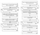
- FIG. 1illustrates an example system to perform location-based operations in connection with a transport service.
- a system 100can be in communication with or be a part of a service arrangement system, such as a transport arrangement system.
- the system 100can include a number of components including a driver track 110 , a plurality of databases 120 , a trip manage 130 , a data select 140 , a driver device interface 150 , and a system interface 160 .
- the system 100can include other components, such as a rider device interface to communicate with rider devices, but those components are not illustrated in FIG. 1 for purpose of simplicity.
- the components of the system 100can combine to perform selective operations for select drivers based on location data provided by driver devices 170 .
- Logiccan be implemented with various applications (e.g., software) and/or with hardware of the computing device that implements the system 100 .
- the system 100can be implemented by, and operated on, a computing system(s) through execution of instructions stored in one or more memory resources of the computing system(s).
- the system 100can be implemented on network side resources, such as on one or more servers or data centers, or implemented through other computer systems in alternative architectures (e.g., peer-to-peer networks, etc.).
- different components of the system 100can be implemented on different computing systems that are in communication with each other.
- the system 100can include a driver device interface 150 to exchange data with a plurality of driver devices 170 .
- the system 100can include a system interface 160 to exchange data with one or more remote systems 180 .
- the driver device interface 150 and the system interface 160can use one or more network resources of the computing system to exchange communications over one or more wireless networks (e.g., a cellular transceiver, a WLAN transceiver, etc.).
- Each of the driver devices 170can store and run a respective driver application 171 (a client-side application that can also be referred to herein as a designated service application) that can interface with the driver device interface 150 .
- the driver application 171can include or use an application programming interface (API), such as an externally facing API, to communicate data with the system 100 .
- APIapplication programming interface
- the externally facing APIcan provide access to the system 100 via secure access channels over the network through any number of methods, such as web-based forms, programmatic access via restful APIs, Simple Object Access Protocol (SOAP), remote procedure call (RPC), scripting access, etc.
- rider devicescan also each run a client application (also referred to herein as a rider application) that can interface with a rider device interface to communicate with the system 100 .
- a rider operating a rider devicecan view information about a transport service and make a request for a transport service using the client application.
- an individual drivere.g., a service provider
- the drivercan launch a respective driver application 171 on the driver's respective driver device 170 and/or sign in using credentials associated with the driver's account.
- the driver application 171can operate in any one of a plurality of states, including, for example: (i) a signed-in state or off-duty state, e.g., after the driver logs in with his or her credentials, the driver has not yet indicated via user input on the driver application 171 that he or she is available to provide a transport service, or has indicated that he or she is no longer available to provide a transport service, (ii) an on-duty state, e.g., after the driver has indicated via user input on the driver application 171 that he or she is available to provide a transport service, (iii) an on-route state, e.g., the driver is to provide a transport service for a rider and is traveling to a specified pickup location of the rider, (iv) an on-trip state, e.g., the driver has picked up the rider and is providing the transport service (transporting the rider to a specified destination), or (v) a suspended state, e.g., the driver has hidden
- the driver application 171can provide driver status information 173 to the system 100 once the driver application 171 is launched and/or based on the state that the driver application 171 is operating in.
- the driver application 171can periodically transmit the driver status information 173 any time the driver application 171 is running on the driver device (and/or is not in a suspended state), while in another example, the driver application 171 can periodically transmit the driver status information 173 only when the driver is operating in a particular state(s), e.g., when the driver application 171 is operating in the on-duty state, the on-route state, and/or the on-trip state.
- the driver application 171can transmit the driver status information 173 when the driver application 171 changes states and/or in response to user input provided by the driver on the driver application 171 .
- the driver status information 173can include one or more of (i) a driver identifier (ID) associated with the driver, (ii) a device ID associated with the driver device 170 , (iii) an application ID associated with the driver application 171 , (iv) a state information corresponding to the state the driver application 171 is operating in, or (v) a location data point corresponding to the current location of the driver device 170 (e.g., a latitude and longitude coordinate), and/or an associated timestamp, a bearing, and/or an error value of that location data point.
- the location data point (and its associated timestamp, bearing, and/or error value)can be generated by a global positioning system (GPS) receiver of the driver device 170 .
- GPSglobal positioning system
- the driver devicecan use one or more of other location determination mechanisms, such as Wi-Fi or cell tower triangulation or trilateration, to determine the location data point.
- the driver track 110can receive the driver status information 173 from a plurality of driver devices 170 and can continuously update a driver database 121 with the information from the driver status information 173 .
- the system 100can include multiple driver databases 121 , for purpose of simplicity, the driver database 121 is described as a single database in FIG. 1 . Similarly, each of the other databases 120 can represent one or more respective databases in the example of FIG. 1 .
- the driver database 121can store information about the driver accounts with the system 100 as well as the location and state information for each driver. For example, for each driver application 171 running on a respective driver device 170 , the driver track 110 can store the most up-to-date or most recent location and state information of each respective driver in the driver database 121 , and/or store previous locations and previous state information of each respective driver determined during a previous duration of time (e.g., the last day, the last week, or the last month).
- a previous duration of timee.g., the last day, the last week, or the last month.
- the driver track 110can determine, based on respective location and/or state information, whether a driver is currently located at a particular position or geographic region (and/or is in a particular state) that causes that driver to be subject to a set of alternate operational criteria (as opposed to default criteria).
- the driver track 110can access a geofence database 123 , which stores information about a plurality of geofences.
- Each geofence entry stored in the geofence database 123can include a geofence ID and a set of location information to define the geofence, and/or can be associated with one or more rules (or include one or more rule IDs).
- a geofencecan correspond to a geographic region or area and can be defined by a perimeter.
- a perimeter of a geofencecan be defined in a variety of ways, e.g., using three or more location data points or can be defined using a radius value from a center location data point of the geofence (e.g., a circumference of a circular shaped geofence).
- the geofence entriesmay be configurable by a user, such as by an administrative user of the system 100 or by a third-party user of a third-party remote system 180 .
- the driver track 110can repeatedly perform a location check to determine whether any of the drivers have entered or exited a specified geographic region(s) or whether an event occurred while any of the drivers are in a specific geographic region(s). For example, for each driver operating a driver device 170 , the driver track 110 can receive a location data point corresponding to the current location of that driver device 170 and check whether the location data point is positioned within any of the geofences from the geofence database 123 .
- the driver track 110can track the driver's movement, update the driver database 121 , and periodically check whether the driver has entered or exited a geographic region associated with a geofence. In this manner, the driver track 110 can perform the location check for an individual driver each time the driver track 110 receives the location data point from the driver application 171 operated by that driver.
- the driver track 110can determine one or more rules associated with that geofence, and/or perform an operation(s) associated with the one or more rules.
- rules that are associated with geofencescan be stored in a rules or parameters database 124 .
- One or more rulescan specify what operation(s) or process(es) the system 100 is to perform for a particular driver or set of drivers.
- the driver track 110can determine a set of rules or criteria associated with that geofence, and classify the driver as being subject to the set of rules or criteria.
- the driver track 110classifies 113 the driver as being subject to a set of criteria by flagging or marking an account associated with the driver or by adding the driver ID (and/or other associated identifier, such as a device ID) to a list or a group.
- a location-based eventcan depend on a particular state of the driver application 171 .
- the driver track 110can use both the location information and state information of a driver to determine whether a location-based event has occurred.
- a drivercan be classified 113 as being subject to a set of rules or criteria when the driver has entered a geographic region associated with that geofence and when the driver application 171 is also operating in a particular state(s) (e.g., is in an on-duty state or an on-trip state).
- the driver track 110may determine that no location-based event occurred even if the driver enters and exits a geographic region associated with that geofence.
- a set of criteria associated with a geofencecan instruct the system 100 to manage a set of drivers (that are positioned within a geographic region of the geofence or have entered or exited the geographic region) differently than if the set of drivers was subject to default criteria (e.g., by classifying those drivers as being subject to the specified set of criteria and/or by performing one or more operations for those drivers).
- the system 100can operate default or normal operations in connection with transport services.
- default operationscan correspond to or include a default transport arrangement process for requesting riders and select drivers.
- the system 100can include a transport service (or trip) manage 130 that can receive a request 131 for a transport service that was generated and transmitted by a rider device operated by a requesting rider.
- the request 131can include information associated with the rider, and can include a specified pickup location 132 , a destination location, and/or a vehicle type.
- the trip manage 130can create a trip entry associated with the request 131 and store the trip entry (along with other trip entries) in the trip database 122 .
- the trip manage 130can also include a driver select 135 that performs a driver selection process in order to select a driver to provide the transport service for the rider.
- the driver select 135can identify a set of available drivers (e.g., those that are capable of providing the transport service for the rider and/or are driving a vehicle of the specified vehicle type) based on the current location information of the drivers in the driver database 121 , and select a driver from the set of available drivers.
- the driver select 135can identify the set of available drivers by determining which drivers are within a predetermined radius of the pickup location 132 and can select the driver from the set based on certain criteria, e.g., by determining which driver is closest to the pickup location 132 and/or has the shortest estimated travel time away from the pickup location 132 .
- the trip manage 130can transmit an invitation 151 to the selected driver's driver device 170 .
- the invitation 151can include user information 152 (e.g., the user's name, rating, photo, etc.), the pickup location information 153 corresponding to the pickup location 132 , and/or the destination location information, if any has been provided by the rider.
- the trip manage 130can receive indication of the acceptance, update the associated trip entry in the trip database 122 , and can provide trip information 133 to the requesting rider device (e.g., the driver information, the estimated time of arrival, the location of the driver, etc.).
- the trip manage 130can then track the performance of the transport service by monitoring the location of the driver and determining when the transport service is complete, and update the trip entry accordingly.
- the trip manage 130can also perform alternate operations (as compared to operations performed in connection with the default transport arrangement process) for one or more drivers that are classified as being subject to a set of criteria different from the default criteria.
- a particular geofencecan be associated with a set of rules/criteria that instructs the driver select 135 to manage those drivers that are located in the geographic region associated with that geofence differently than those that are not in the geographic region.
- the set of rules/criteriacan cause the driver track 110 to flag or include the driver IDs of those drivers that are located in the geographic region in a list or group (such as a group stored in a groups database 126 ).
- An example of a groupcan correspond to a queue that the driver select 135 can use to perform a driver selection process.
- the driver select 135can determine the appropriate queue associated with that geofence and can select the driver that has been in the queue the longest (e.g., a first in, first out queue), as opposed to selecting the driver that is closest to or has the shortest estimated travel time to the pickup location. In this manner, the driver select 135 can perform alternate operations (or operate in a different mode than a default mode) for a set of drivers in accordance with the set of rules/criteria associated with the geofence, as compared to the default operations in connection with transport services.
- a geofencecan be associated with a set of rules/criteria that specifies which group or class of drivers, located in the geographic region of that geofence, can be selected to provide transport services for riders having pickup locations in that geographic region. If a driver that is not in the specified group or class of drivers enters the geographic region, for example, the driver track 110 can add a driver ID of that driver in a group (e.g., a do not select group). In such case, when the trip manage 130 receives a request 131 for transport, including a pickup location 132 in the given geographic region, the driver select 135 can perform a driver selection while excluding those drivers that are in the do not select group.
- Such an examplecan be useful for abiding by rules or regulations provided by different jurisdictions that cover different geographic regions (e.g., certain driver types can only operate in certain jurisdictions, or must have a certain state driver's licenses, etc.).
- the associated rules/criteriacan instruct the driver track 110 to cause a notification or an alert to be transmitted, e.g., to a computing device operated by an administrative user of the system 100 .
- the notification or alertcan include driver information and/or location information of the driver.
- Such examplescan be useful for providing safety features or fraud prevention features to the administrators of the system 100 by notifying the administrators when a driver(s) enters an unsafe region or a region having a history of fraudulent behavior by either riders or drivers in the region.
- the system 100can perform additional alternative operations in conjunction with the default operations for or in connection with a set of drivers that are subject to an alternate set of criteria (as opposed to default criteria).
- a geofencecan be associated with a set of criteria that causes the system 100 to transmit information to one or more remote systems 180 .
- the geofencecan define a geographic region that corresponds to or includes an airport and its surrounding areas. For example, an entity that operates the system 100 may have entered into an agreement with an airport entity that manages or operates the airport, such that the system 100 provides driver information to a remote system 180 operated by the airport entity.
- the driver informationcan inform the airport entity when drivers enter or exit the geographic region for purpose of providing transport services in connection with the airport (e.g., pick up or drop off riders at the airport) over a duration of time.
- Such driver informationcan be used by the airport entity for determining ingress and egress points, for accounting purposes, for safety purposes (e.g., be aware of who is in the geographic region of the airport), and/or for determining statistics associated with the airport.
- the driver track 110can determine when location-based events occur with respect to the geographic region of the geofence, such as when drivers enter or exit the geographic region or when drivers perform some action within the geographic region. According to this example, when the driver track 110 determines that a driver has entered the geographic region associated with the geofence (e.g., crossed a boundary or perimeter of the geofence), based on the location data provided by the driver device 170 , the driver track 110 can determine a set of rules associated with that geofence. The set of rules can specify what driver information is to be determined or retrieved from the driver database 121 and where to transmit the driver information.
- the set of rulescan specify an entity or third party ID associated with the geofence
- the driver track 110can determine, from the third party database 125 , information associated with the third party ID, including the name of the third party, the associated geofence ID, and/or the address, port, or socket of the third party remote system 180 that the driver information is to be transmitted to, as well as what driver information is to be transmitted to the remote system 180 of the third party entity.
- the driver track 110can transmit a trigger 111 that instructs the data select 140 to determine, from the driver database 121 , the appropriate driver information and transmit the driver information to the appropriate remote system 180 in accordance with the information associated with the third party ID.
- the data select 140can access the driver database 121 to determine a set of driver information in accordance with the rules/criteria associated with the geofence.
- the data select 140can determine a first set of information associated with the driver that entered the geographic region, including one or more of a vehicle ID (e.g., vehicle identification number, vehicle type information, a photograph of the vehicle, and/or vehicle license plate number, etc.), a driver ID corresponding to the respective driver (e.g., a name, a photograph of the driver, a unique ID or username of the driver, a unique ID for the driver's device, and/or driver's license information, etc.), the current date, the time when the system 100 determined that the driver's driver device 170 entered the geographic region, a location data point of the driver device 170 when the driver device 170 entered the geographic region, or the associated third party entity information.
- the data select 140can then transmit, via the system interface 160 , the first set of information 141 to the remote system 180 using the address, port
- the driver track 110can determine whether other location-based events have occurred with respect to the driver in/at the geographic region, such as whether the driver has received an invitation for transport service while in the geographic region and/or accepted the invitation, completed a transport service in the geographic region, and/or has exited the geographic region. For example, if the driver track 110 detects that the driver has exited the geographic region, the driver track 110 can again transmit a trigger 111 to cause the data select 140 to determine and transmit a second set of driver information in accordance with the rules/criteria associated with the geofence.
- the second set of driver informationcan be similar to the first set, and can include, for example, one or more of the vehicle ID, the driver ID, the current date, the time when the system 100 determined that the driver's driver device 170 exited the geographic region, a location data point of the driver device 170 when the driver device 170 exited the geographic region, or the associated third party entity information.
- the driver track 110can also transmit a trigger 111 to cause the data select 140 to determine and transmit another set of driver information associated with this location-based event to the remote system 180 .
- This set of driver informationcan include one or more of the vehicle ID, the driver ID, the current date, the time when the system 100 determined that the driver's driver device 170 received or accepted the invitation, a location data point of the driver device 170 when the driver device 170 received or accepted the invitation, or the associated third party entity information.
- the driver track 110can transmit a trigger 111 to cause the data select 140 to determine and transmit another set of driver information associated with this location-based event to the remote system, such as one or more of the vehicle ID, the driver ID, the current date, the time when the system 100 determined that the driver's driver device 170 indicated completion of the transport service, a location data point of the driver device 170 when the driver device 170 completed the transport service, or the associated third party entity information.
- a trigger 111to cause the data select 140 to determine and transmit another set of driver information associated with this location-based event to the remote system, such as one or more of the vehicle ID, the driver ID, the current date, the time when the system 100 determined that the driver's driver device 170 indicated completion of the transport service, a location data point of the driver device 170 when the driver device 170 completed the transport service, or the associated third party entity information.
- sets of driver informationcan be transmitted to the third party remote system 180 at various instances of time, triggered by location-based events associated with the geofence (e.g., when the driver enters or exits the geographic region, or performs an action in the geographic region).
- the system 100can keep track of each instance in a given duration of time (e.g., increment a counter) and/or can store a set of information associated with that event, such as the set of driver information described, in a memory resource (e.g., a local memory resource or one that is accessible by the system 100 over one or more networks).
- a memory resourcee.g., a local memory resource or one that is accessible by the system 100 over one or more networks.
- the system 100can use the stored information for a variety of purposes, such as for accounting, for internal auditing, for safety/regulatory purposes (e.g., to have a detailed record of where drivers are operating), or for traffic or location studies (e.g., determine traffic behavior in a region).
- purposessuch as for accounting, for internal auditing, for safety/regulatory purposes (e.g., to have a detailed record of where drivers are operating), or for traffic or location studies (e.g., determine traffic behavior in a region).
- the system 100can keep track of how many times, in a given duration (e.g., in a week or a month), drivers on its platform have picked up or dropped off a rider in a geographic region, e.g., such as at a region that includes an airport, and store such information in a database of the plurality of database 120 .
- a geofencecan be associated with the airport and can cover a geographic region that includes the airport and its surrounding areas.
- An accounting component 190 of the system 100can access the database in order to generate a record(s) 191 for use with any of the variety of purposes.
- the accounting component 190can access the database to generate and provide a record(s) 191 to an entity associated with that geographic region/geofence (e.g., an airport entity).
- the record 191can indicate the number of times drivers have entered and/or exited the airport for purpose of providing transport services, and/or picked up or dropped off riders at the airport in a given duration (e.g., a month) for purpose of paying a total fee for the amount of transport services taking place at the airport.
- the record 191can also include detailed sets of information associated with each of the occurrences.
- the accounting component 190can generate the record 191 based on a predetermined schedule, periodically (e.g., at the end of every week or month), or in response to administrative user input. For example, for a given duration, the accounting component 190 can use the information associated with the geofence (e.g., the number of times drivers have entered and/or exited the airport for purpose of providing transport services, and/or picked up or dropped off riders at the airport) to calculate the amount of fees owed to the airport entity.
- the record(s) 191can be provided to the entity via the system interface 160 or via another portal or other communication mechanism, such as via an e-mail communication or a webpage content, using the respective entity information (e.g., from the third party database 125 ).
- the system 100in response to detecting a location-based event with respect to a geofence, can transmit a data item to the remote system 180 to indicate the occurrence of an event.
- the remote system 180can increment a counter(s) to keep track of the total number of location-based event occurrences that have occurred (e.g., in a duration of time).
- the data itemcan be indicative of the respective location-based event.
- a third party entity that operates the remote system 180may want to perform an accounting and charge a fee (either charge the drivers or the entity that implements the system 100 ) in relation to transport services at the airport.
- a third party entity that operates the remote system 180may want to perform an accounting and charge a fee (either charge the drivers or the entity that implements the system 100 ) in relation to transport services at the airport.
- the remote system 180can keep a record and determine a fee based on the number of instances that drivers entered and/or exited the airport for purpose of providing transport services, and/or picked up or dropped off riders at the airport.
- the remote system 180can determine a fee for each respective instance.
- the remote system 180can charge the total fee at scheduled times or periodically (e.g., every week or every month, etc.) and can reset the counter(s), for example, each time thereafter.
- the remote system 180can include a similar accounting component, such as the accounting component 190 of the system 100 .
- the remote system 180can determine the amount of fees that is to be owed, generate a record of location-based event occurrences that occurred in a given duration of time, and transmit the record to the entity operating the system 100 .
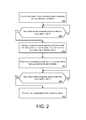
- FIG. 2illustrates an example method for performing location-based operations in connection with a transport service.
- a method such as described by an example of FIG. 2can be implemented using, for example, components described with an example of FIG. 1 . Accordingly, references made to elements of FIG. 1 are for purposes of illustrating a suitable element or component for performing a step or sub-step being described.
- the system 100can receive information from individual driver devices operated by drivers ( 210 ). Each driver can operate a driver application 171 on the respective driver device 170 that periodically transmit status information to the system 100 .
- the status information 173can include driver information, state information of the driver/driver application, and/or location information corresponding to the current location of the respective driver device 170 .
- the system 100can continuously store and update the driver database 121 with the information received from the driver devices 170 .
- the system 100can also determine, based on the location information received from the driver devices, whether any of the driver devices has entered a geographic region associated with a geofence ( 220 ). According to some examples, the driver track 110 can perform a location check of each location data point received from a driver device to determine whether that location data point is positioned within any geographic regions specified by geofences in the geofence database 123 . If no drivers have entered any specified geographic regions, the driver track 110 can continue to receive status information 173 and perform location checks.
- the driver track 110can classify the first driver as being subject to a first set of criteria associated with the geofence (as compared to default criteria that the first driver would have been subject to if the first driver was outside the geographic region or in another region) ( 230 ).
- the first set of criteriacan specify how the system 100 is to handle the first driver (as well as other drivers that are also classified as being subject to the first set of criteria) and/or what operations or processes to perform for the first driver that are different from default operations.
- the driver track 110can classify the first driver as being subject to a first set of criteria by flagging or marking the first driver's driver account or by adding the driver ID of the first driver to a list or a group (or a queue).
- the system 100can also perform one or more operations in connection with the first driver based on the first driver being classified as being subject to the first set of criteria ( 240 ). In some variations, the system 100 may not perform any operations for the first driver if no operations are necessary. For example, the first driver may have entered the geographic region, but then provided input on the driver application 171 to go off-duty or close/turn off the driver application 171 , or may have exited the geographic region before the first driver was subject to any driver selection process by the system 100 .
- the system 100can perform one or more operations based on the first driver being subject to the first set of criteria, such as transmitting sets of data to a remote system in response to detecting that the first driver entered the geographic region and/or in response to classifying the first driver as being subject to the first set of criteria.
- the system 100can also detect, based on the location information received from the driver devices, whether the first driver has exited the geographic region ( 250 ). For example, as the driver travels or changes position and the driver device 170 provides status information 173 , the driver track 110 can continue to check whether the driver has exited the geographic region. If the driver has not exited the geographic region, the system 100 can continue to perform one or more operations, as necessary, specified by the first set of criteria. On the other hand, if the driver track 110 determines that the first driver has exited the geographic region, the driver track 110 can remove the existing classification of the first driver to enable the first driver to no longer be subject to the first set of criteria (and instead, be subject to the default criteria) ( 260 ). According to some examples, the system 100 can also, concurrently, perform one or more operations with removing the existing classification (e.g., transmit a set of data, remove the driver ID from the list or group, trigger an alert to be transmitted by the system 100 , etc.).
- the existing classificatione.g
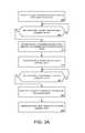
- FIGS. 3A and 3Billustrate other example methods for performing location-based operations in connection with a transport service.
- FIGS. 3A and 3Bcan illustrate a particular use case example of the method described in FIG. 2 .
- Methods such as described by examples of FIGS. 3A and 3Bcan be implemented using, for example, components described with an example of FIG. 1 . Accordingly, references made to elements of FIG. 1 are for purposes of illustrating a suitable element or component for performing a step or sub-step being described.
- the system 100can receive status information, including location information, from individual driver devices operated by drivers, such as described in step 210 of FIG. 2 ( 310 ). Based on the location information, the system 100 can determine whether any driver devices have entered a geographic region specified by a geofence ( 320 ). If not, the system 100 can continue to receive status information from driver devices and continuously perform a location check for individual driver devices.
- the system 100can determine a first set of information associated with the first driver ( 330 ).
- the driver track 110can identify one or more rules/criteria associated with the geofence, which can instruct the system 100 to perform a specified set of operations in connection with the first driver (e.g., transmit data to a third party system).
- the driver track 110can identify from a third party database 125 , for example, information of a third party entity that is associated with the one or more rules/criteria and/or the geofence.
- the information of the third party entitycan specify what set of driver information is to be retrieved from the driver database 121 and where to transmit the set of driver information.
- the driver track 110can cause the data select 140 to retrieve the appropriate set of driver information associated with the first driver from the driver database 121 .
- the first set of driver informationcan include at least one or more of a vehicle ID, a driver ID corresponding to the first driver, the current date, the time when the system 100 determined that the first driver's driver device entered the geographic region, a location data point of the driver device when the driver device entered the geographic region, or the associated third party entity information.
- the data select 140can then transmit the first set of driver information to the remote system 180 operated by the third party entity ( 340 ), e.g., using the associated third party entity information.
- the driver track 110can continue to monitor the driver device and determine, based on the location information received from the driver device, whether the first driver device has exited the geographic region ( 350 ). If not, the driver track 110 continues to monitor the driver device and perform location checks.
- the driver track 110can cause the data select 140 to determine a second set of driver information associated with the first driver (e.g., by retrieving the driver information from the driver database 121 ) ( 360 ).
- the second set of driver informationcan include at least one or more of the vehicle ID, the driver ID, the current date, the time when the system 100 determined that the first driver's driver device exited the geographic region, a location data point of the driver device when the driver device exited the geographic region, or the associated third party entity information.
- the data select 140can transmit the second set of information to the remote system 180 . In this manner, in some examples, when location-based events occur with respect to a particular geographic region, the system 100 can perform operations apart from or in addition to the default operations performed by the system in connection with transport services.
- FIG. 3Billustrates an additional instance of the system 100 detecting a location-based event in connection with the geographic region.
- the first drivercan enter the geographic region, such as a geographic region associated with an airport and its surrounding areas, in order to (i) pass through while traveling, in general, (ii) potentially receive an invitation to perform a transport service for a requesting rider, and/or (iii) drop off a rider that the driver is currently driving, for example, at the airport.
- the driver track 110can also determine when an event has occurred in the geographic region ( 342 ). If no event has occurred in the geographic region, the system continues to monitor the first driver's device to determine whether the first driver has exited the geographic region, such as described in FIG.
- the driver track 110can cause the data select to determine a second set of information associated with the first driver and transmit the second set of information to the remote system ( 344 ).
- Such an eventcan correspond to any one of the driver application receiving an invitation, the driver accepting the invitation, the driver indicating that a requesting rider has been picked up (e.g., and the driver is now in the on-trip state), the driver indicating that a transport service is being completed and has dropped off the rider.
- the driver track 110can detect whether an event has occurred from status information received from the first driver's device (e.g., indicating that the first driver has accepted an invitation, has started the transport service, or has completed a transport service) and/or from information provided from the trip manage 130 , which transmits the invitation to the driver device and/or receives an acceptance from the driver device.
- the data select 140can determine a set of information associated with the detected event.
- the set of informationcan include one or more of a vehicle ID, a driver ID corresponding to the first driver, the current date, the time when the system 100 determined that the event occurred in the geographic region, a location data point of the driver device when the event occurred in the geographic region, or the associated third party entity information.
- the system 100can continue to detect whether one or more other events have occurred in the geographic region, and can determine and transmit a set of driver information each time the event is detected, until the system 100 determines that the first driver has exited the geographic region (and performs the remaining steps of FIG. 3B ).
- FIG. 4is a block diagram that illustrates a mobile computing device upon which embodiments described herein may be implemented.
- a computing device 400may correspond to a mobile computing device, such as a cellular device that is capable of telephony, messaging, and data services.
- the computing device 400can correspond to a rider device or a driver device. Examples of such devices include smartphones, handsets or tablet devices for cellular carriers.
- the computing device 400includes a processor 410 , memory resources 420 , a display device 430 (e.g., such as a touch-sensitive display device), one or more communication sub-systems 440 (including wireless communication sub-systems), input mechanisms 450 (e.g., an input mechanism can include or be part of the touch-sensitive display device), and one or more sensors 460 , including a location detection mechanism (e.g., GPS receiver).
- a location detection mechanisme.g., GPS receiver
- at least one of the communication sub-systems 440sends and receives cellular data over data channels and voice channels.
- the communications sub-systems 440can include a cellular transceiver and one or more short-range wireless transceivers.
- the processor 410can provide a variety of content to be displayed on the display 430 by executing instructions stored in the memory resources 420 .
- the memory resources 420can store instructions corresponding to the driver application 425 , for example, and other data, such as data associated with the driver application 425 (e.g., trip entry data, driver information, driver credentials, etc.).
- the processor 410is configured with software and/or other logic to perform one or more processes, steps, and other functions described with implementations, such as described by FIGS. 1 through 3B , and elsewhere in the application.
- the processor 410can execute instructions and data corresponding to the driver application 425 in order to periodically receive or retrieve location data 465 corresponding to the current location of the computing device 400 and providing status information of the driver/driver application 425 to the service arrangement system (e.g., the system 100 of FIG. 1 ).
- the processor 410can also execute the driver application instructions 425 to cause various user interfaces 415 to be displayed on the display 430 .
- the user interfaces 415can correspond to user interfaces that are displayed in connection with the transport service, including an invitation user interface when an invitation is received form the system 100 , and other user interfaces corresponding to respective driver application states.
- the user interfaces 415can also include selectable features to enable the driver to provide input via the input mechanisms 450 to indicate changes in the driver application state.
- the computing device 400can periodically determine a location data point 465 of the current location of the computing device 400 from the GPS receiver. In another example, the computing device 400 can determine the current location by using one or more transceivers or a GPS receiver of the communications sub-systems 440 . While FIG. 4 is illustrated for a mobile computing device, one or more examples may be implemented on other types of devices, including full-functional computers, such as laptops and desktops (e.g., PC).
- FIG. 5is a block diagram that illustrates a computer system upon which examples described herein may be implemented.
- the service arrangement systeme.g., the system 100
- the service arrangement systemmay also be implemented using a combination of multiple computer systems as described by FIG. 5 .
- the computer system 500includes processing resources, such as one or more processors 510 , a main memory 520 , a read-only memory (ROM) 530 , a storage device 540 , and a communication interface 550 .
- the computer system 500includes at least one processor 510 for processing information and the main memory 520 , such as a random access memory (RAM) or other dynamic storage device, for storing information and instructions to be executed by the processor 510 .
- the main memory 520also may be used for storing temporary variables or other intermediate information during execution of instructions to be executed by the processor 510 .
- the computer system 500may also include the ROM 530 or other static storage device for storing static information and instructions for the processor 510 .
- the storage device 540such as a magnetic disk or optical disk, is provided for storing information and instructions.
- the storage device 540can correspond to a computer-readable medium that stores driver track instructions 542 and trip manage instructions 544 for performing operations discussed with respect to FIGS. 1 through 3B .
- the computer system 500can receive location data from a plurality of driver devices, determine which drivers have triggered a location-based event with respect to a geographic region specified by a geofence, and perform alternate operations (as opposed to default operations) for or in connection with those drivers.
- the storage device 540can store other instructions, such as instructions to implement the data select component of FIG. 1 , and other data, such as data stored in the plurality of databases 120 of FIG. 1 .
- the communication interface 550can enable the computer system 500 to communicate with one or more networks 580 (e.g., cellular network) through use of the network link (wirelessly or using a wire). Using the network link, the computer system 500 can communicate with a plurality of devices, such as the mobile computing devices of the riders and drivers. According to some examples, the computer system 500 can receive driver status information 552 from the driver devices, such as described by some examples of FIGS. 1 through 3B . When certain location-based events occur with respect to a geographic region, the computer system 500 can transmit a set of driver information 554 to a third party operated remote system, such as described by examples of FIGS. 1 through 3B .
- networks 580e.g., cellular network
- the computer system 500can communicate with a plurality of devices, such as the mobile computing devices of the riders and drivers.
- the computer system 500can receive driver status information 552 from the driver devices, such as described by some examples of FIGS. 1 through 3B .
- the computer system 500can transmit a set
- the computer system 500can also include a display device 560 , such as a cathode ray tube (CRT), an LCD monitor, or a television set, for example, for displaying graphics and information to a user.
- a display device 560such as a cathode ray tube (CRT), an LCD monitor, or a television set, for example, for displaying graphics and information to a user.
- An input mechanism 570such as a keyboard that includes alphanumeric keys and other keys, can be coupled to the computer system 500 for communicating information and command selections to the processor 510 .
- Other non-limiting, illustrative examples of the input mechanisms 570include a mouse, a trackball, touch-sensitive screen, or cursor direction keys for communicating direction information and command selections to the processor 510 and for controlling cursor movement on the display 560 .
- Examples described hereinare related to the use of the computer system 500 for implementing the techniques described herein. According to one example, those techniques are performed by the computer system 500 in response to the processor 510 executing one or more sequences of one or more instructions contained in the main memory 520 . Such instructions may be read into the main memory 520 from another machine-readable medium, such as the storage device 540 . Execution of the sequences of instructions contained in the main memory 520 causes the processor 510 to perform the process steps described herein. In alternative implementations, hard-wired circuitry may be used in place of or in combination with software instructions to implement examples described herein. Thus, the examples described are not limited to any specific combination of hardware circuitry and software.
Landscapes
- Business, Economics & Management (AREA)
- Human Resources & Organizations (AREA)
- Engineering & Computer Science (AREA)
- Strategic Management (AREA)
- Economics (AREA)
- Entrepreneurship & Innovation (AREA)
- Tourism & Hospitality (AREA)
- Theoretical Computer Science (AREA)
- General Physics & Mathematics (AREA)
- Marketing (AREA)
- General Business, Economics & Management (AREA)
- Physics & Mathematics (AREA)
- Signal Processing (AREA)
- Computer Networks & Wireless Communication (AREA)
- Operations Research (AREA)
- Quality & Reliability (AREA)
- Educational Administration (AREA)
- Development Economics (AREA)
- Game Theory and Decision Science (AREA)
- Health & Medical Sciences (AREA)
- General Health & Medical Sciences (AREA)
- Primary Health Care (AREA)
- Traffic Control Systems (AREA)
- Telephonic Communication Services (AREA)
Abstract
Description
Claims (15)
Priority Applications (7)
| Application Number | Priority Date | Filing Date | Title |
|---|---|---|---|
| US14/683,828US10282684B2 (en) | 2015-02-26 | 2015-04-10 | Performing selective operations based on mobile device locations |
| PCT/US2016/019895WO2016138450A1 (en) | 2015-02-26 | 2016-02-26 | Performing selective operations based on mobile device locations |
| US16/291,733US11151489B2 (en) | 2015-02-26 | 2019-03-04 | Computing system implementing multiple driver selection processes based on device locations |
| US17/480,923US11687851B2 (en) | 2015-02-26 | 2021-09-21 | Computing system implementing a driver selection process based on device location |
| US18/195,256US12051018B2 (en) | 2015-02-26 | 2023-05-09 | Computing system implementing a driver selection process based on device location |
| US18/753,200US20240346409A1 (en) | 2015-02-26 | 2024-06-25 | Computing system implementing a driver selection process based on device location |
| US19/015,035US20250225454A1 (en) | 2015-02-26 | 2025-01-09 | Computing system implementing a driver selection process based on device location |
Applications Claiming Priority (2)
| Application Number | Priority Date | Filing Date | Title |
|---|---|---|---|
| US201562121212P | 2015-02-26 | 2015-02-26 | |
| US14/683,828US10282684B2 (en) | 2015-02-26 | 2015-04-10 | Performing selective operations based on mobile device locations |
Related Child Applications (1)
| Application Number | Title | Priority Date | Filing Date |
|---|---|---|---|
| US16/291,733ContinuationUS11151489B2 (en) | 2015-02-26 | 2019-03-04 | Computing system implementing multiple driver selection processes based on device locations |
Publications (2)
| Publication Number | Publication Date |
|---|---|
| US20160253617A1 US20160253617A1 (en) | 2016-09-01 |
| US10282684B2true US10282684B2 (en) | 2019-05-07 |
Family
ID=56789896
Family Applications (6)
| Application Number | Title | Priority Date | Filing Date |
|---|---|---|---|
| US14/683,828ActiveUS10282684B2 (en) | 2015-02-26 | 2015-04-10 | Performing selective operations based on mobile device locations |
| US16/291,733Active2036-02-08US11151489B2 (en) | 2015-02-26 | 2019-03-04 | Computing system implementing multiple driver selection processes based on device locations |
| US17/480,923ActiveUS11687851B2 (en) | 2015-02-26 | 2021-09-21 | Computing system implementing a driver selection process based on device location |
| US18/195,256ActiveUS12051018B2 (en) | 2015-02-26 | 2023-05-09 | Computing system implementing a driver selection process based on device location |
| US18/753,200PendingUS20240346409A1 (en) | 2015-02-26 | 2024-06-25 | Computing system implementing a driver selection process based on device location |
| US19/015,035PendingUS20250225454A1 (en) | 2015-02-26 | 2025-01-09 | Computing system implementing a driver selection process based on device location |
Family Applications After (5)
| Application Number | Title | Priority Date | Filing Date |
|---|---|---|---|
| US16/291,733Active2036-02-08US11151489B2 (en) | 2015-02-26 | 2019-03-04 | Computing system implementing multiple driver selection processes based on device locations |
| US17/480,923ActiveUS11687851B2 (en) | 2015-02-26 | 2021-09-21 | Computing system implementing a driver selection process based on device location |
| US18/195,256ActiveUS12051018B2 (en) | 2015-02-26 | 2023-05-09 | Computing system implementing a driver selection process based on device location |
| US18/753,200PendingUS20240346409A1 (en) | 2015-02-26 | 2024-06-25 | Computing system implementing a driver selection process based on device location |
| US19/015,035PendingUS20250225454A1 (en) | 2015-02-26 | 2025-01-09 | Computing system implementing a driver selection process based on device location |
Country Status (2)
| Country | Link |
|---|---|
| US (6) | US10282684B2 (en) |
| WO (1) | WO2016138450A1 (en) |
Cited By (6)
| Publication number | Priority date | Publication date | Assignee | Title |
|---|---|---|---|---|
| US20200394623A1 (en)* | 2019-06-14 | 2020-12-17 | Toyota Motor North America, Inc. | Automated service management for a transport |
| US11151489B2 (en)* | 2015-02-26 | 2021-10-19 | Uber Technologies, Inc. | Computing system implementing multiple driver selection processes based on device locations |
| US11244254B2 (en)* | 2014-12-31 | 2022-02-08 | The City And County Of San Francisco | Application-based commercial ground transportation clearinghouse system |
| US11379761B2 (en) | 2014-03-13 | 2022-07-05 | Uber Technologies, Inc. | Configurable push notifications for a transport service |
| US11503133B2 (en) | 2014-03-31 | 2022-11-15 | Uber Technologies, Inc. | Adjusting attributes for an on-demand service system based on real-time information |
| US11671791B2 (en) | 2015-07-10 | 2023-06-06 | Uber Technologies, Inc. | Selecting a messaging protocol for transmitting data in connection with a location-based service |
Families Citing this family (18)
| Publication number | Priority date | Publication date | Assignee | Title |
|---|---|---|---|---|
| US9960986B2 (en) | 2014-03-19 | 2018-05-01 | Uber Technologies, Inc. | Providing notifications to devices based on real-time conditions related to an on-demand service |
| US20160189067A1 (en)* | 2014-12-31 | 2016-06-30 | The City And County Of San Francisco | Application-based commercial ground transportation management system |
| US10013697B1 (en) | 2015-09-02 | 2018-07-03 | State Farm Mutual Automobile Insurance Company | Systems and methods for managing and processing vehicle operator accounts based on vehicle operation data |
| US10339536B2 (en)* | 2015-11-17 | 2019-07-02 | Schneider Enterprise Resources, LLC | Geolocation compliance for a mobile workforce |
| US9867021B1 (en) | 2015-12-02 | 2018-01-09 | Hopgrade, Inc. | Specially programmed computing devices being continuously configured to allow unfamiliar individuals to have instantaneous real-time meetings to create a new marketplace for goods and/or services |
| US11301800B1 (en) | 2016-03-14 | 2022-04-12 | Amazon Technologies, Inc. | Package tracking utilizing modifiable delivery tags |
| US10997545B1 (en) | 2016-03-14 | 2021-05-04 | Amazon Technologies, Inc. | Package tracking utilizing active delivery tags |
| US10242574B2 (en) | 2016-03-21 | 2019-03-26 | Uber Technologies, Inc. | Network computer system to address service providers to contacts |
| US12347342B2 (en) | 2017-06-15 | 2025-07-01 | Faac Incorporated | Driving simulation scoring system |
| CA3066757A1 (en)* | 2017-06-15 | 2018-12-20 | Faac Incorporated | A driving simulation system configured to train a driver |
| US20190311629A1 (en)* | 2018-04-06 | 2019-10-10 | Lyft, Inc. | Generating and managing virtual queues at congested venues |
| US11514543B2 (en)* | 2018-06-05 | 2022-11-29 | Beijing Didi Infinity Technology And Development Co., Ltd. | System and method for ride order dispatching |
| US11246005B2 (en)* | 2019-12-20 | 2022-02-08 | Beijing Didi Infinity Technology And Development Co., Ltd. | Safety geofence zone deployment |
| GB2592441A (en)* | 2020-02-28 | 2021-09-01 | Shufa Ltd | Centralised driver tracking system |
| US11374808B2 (en) | 2020-05-29 | 2022-06-28 | Corning Research & Development Corporation | Automated logging of patching operations via mixed reality based labeling |
| US11295135B2 (en)* | 2020-05-29 | 2022-04-05 | Corning Research & Development Corporation | Asset tracking of communication equipment via mixed reality based labeling |
| EP4464047A1 (en)* | 2022-01-10 | 2024-11-20 | Axon Enterprise, Inc. | Using multiple geofences to initiate recording devices |
| CN114440904B (en)* | 2022-01-28 | 2024-03-15 | 中国第一汽车股份有限公司 | Geofence data updating method, device, medium and equipment |
Citations (62)
| Publication number | Priority date | Publication date | Assignee | Title |
|---|---|---|---|---|
| US5945919A (en)* | 1996-05-30 | 1999-08-31 | Trimble Navigation Limited | Dispatcher free vehicle allocation system |
| US6356838B1 (en) | 2000-07-25 | 2002-03-12 | Sunil Paul | System and method for determining an efficient transportation route |
| US6453298B2 (en) | 1998-07-10 | 2002-09-17 | Honda Giken Kogyo Kabushiki Kaisha | Method of operating a vehicle redistribution system based upon predicted ride demands |
| US20020143587A1 (en) | 2001-04-02 | 2002-10-03 | Microsoft Corporation | Optimized system and method for finding best fares |
| WO2003040972A1 (en) | 2001-11-07 | 2003-05-15 | Sitra Ltd | Ride-share request matching system and method |
| US6756913B1 (en) | 1999-11-01 | 2004-06-29 | Mourad Ben Ayed | System for automatically dispatching taxis to client locations |
| US20060235739A1 (en) | 2005-04-18 | 2006-10-19 | United Parcel Service Of America, Inc. | Systems and methods for dynamically updating a dispatch plan |
| US20070093247A1 (en) | 2005-10-11 | 2007-04-26 | Raziq Yaqub | Monitoring of Vehicle Conditions Utilizing Cellular Broadcasts |
| US20070143013A1 (en)* | 2005-12-16 | 2007-06-21 | Breen Thomas B | System and method for updating geo-fencing information on mobile devices |
| US7248184B2 (en) | 2003-08-05 | 2007-07-24 | Harman Becker Automotive Systems Gmbh | System for processing digital map data |
| US20080114629A1 (en) | 2006-11-09 | 2008-05-15 | Yahoo! Inc. | System for matching users and transportation providers |
| US20080125964A1 (en) | 2006-11-27 | 2008-05-29 | Carani Sherry L | Tracking System and Method with Automatic Map Selector And Geo Fence Defining Features |
| US20080195428A1 (en) | 2007-02-12 | 2008-08-14 | O'sullivan Sean | Shared transport system and service network |
| US20090006182A1 (en) | 2007-06-29 | 2009-01-01 | Mark Andrew Gammon | Forecasting Volume for a Promotion |
| US20090216600A1 (en)* | 2008-02-27 | 2009-08-27 | Montiss Llc | Systems and methods for arranging a transport transaction |
| US20100017126A1 (en) | 2008-07-16 | 2010-01-21 | Qualcomm Incorporated | Method for dynamic creation of a geofence in a wireless system |
| US7657256B2 (en) | 2001-07-11 | 2010-02-02 | International Business Machines Corporation | Notifying a user of a portable wireless device |
| US7817990B2 (en) | 2008-02-08 | 2010-10-19 | Skidata Ag | Method of ordering location-specific services |
| US20100265052A1 (en)* | 2006-10-24 | 2010-10-21 | Webtech Wireless Inc. | Unified Vehicle Parameters |
| US20100280852A1 (en) | 2007-05-11 | 2010-11-04 | Palo Alto Research Center Incorporated | System And Method For Financial Transactions In A Rideshare Environment |
| US7917153B2 (en) | 2004-03-31 | 2011-03-29 | France Telecom | Method and apparatus for creating, directing, storing and automatically delivering a message to an intended recipient upon arrival of a specified mobile object at a designated location |
| US20110112768A1 (en) | 2009-11-09 | 2011-05-12 | Qualcomm Incorporated | Scalable GeoFences |
| KR20110061568A (en) | 2008-08-15 | 2011-06-09 | 에이티엑스 그룹 인코포레이티드 | Criteria-based audio messaging in vehicles |
| US20110238300A1 (en)* | 2010-03-23 | 2011-09-29 | United Parcel Service Of America, Inc. | Geofence-based triggers for automated data collection |
| US8065342B1 (en) | 2008-02-22 | 2011-11-22 | BorgSolutions, Inc. | Method and system for monitoring a mobile equipment fleet |
| US20110307282A1 (en) | 2009-12-04 | 2011-12-15 | Garrett Camp | System and method for operating a service to arrange transport between a customer and a transport party |
| US20120041675A1 (en) | 2010-08-10 | 2012-02-16 | Steven Juliver | Method and System for Coordinating Transportation Service |
| US20120046110A1 (en) | 2010-08-13 | 2012-02-23 | Lee Amaitis | Multi-process communication regarding gaming information |
| US20120089326A1 (en)* | 2010-10-08 | 2012-04-12 | Thomas Bouve | Selected driver notification of transitory roadtrip events |
| US20120200411A1 (en) | 2011-02-03 | 2012-08-09 | Best Gregory C | Providing information about mobile communication devices with respect to an area of interest |
| US20120232943A1 (en) | 2011-03-09 | 2012-09-13 | Makor Issues And Rights Ltd. | Automatic optimal taxicab mobile location based dispatching system |
| US20120253892A1 (en)* | 2011-03-31 | 2012-10-04 | United Parcel Service Of America, Inc. | Systems and methods for assessing delivery performance based on operational data |
| US20120306659A1 (en)* | 2011-05-30 | 2012-12-06 | Microsoft Corporation | Reverse reminders |
| US8339251B2 (en) | 2007-07-23 | 2012-12-25 | R+L Carriers, Inc. | Information transmission and processing systems and methods for freight carriers |
| US20130162425A1 (en) | 2011-12-22 | 2013-06-27 | Qualcomm Incorporated | System and method for generating real-time alert notifications in an asset tracking system |
| US8504406B2 (en) | 2003-03-31 | 2013-08-06 | Restaurant Services, Inc. | Method of product ordering and inventory repositioning for a promotion |
| US20130290200A1 (en) | 2012-04-29 | 2013-10-31 | Monaeo, Llc. | Systems and methods of compliance tracking |
| WO2013166216A1 (en) | 2012-05-01 | 2013-11-07 | Joseph Michael | Systems and methods for monitoring, managing, and facilitating location - and/or other criteria-dpendent targeted communications and /or transactions |
| US20130310053A1 (en) | 2012-05-15 | 2013-11-21 | QUALCOMM Atheros, Incorporated | Creating geofence assistance information |
| US20130332527A1 (en) | 2010-07-02 | 2013-12-12 | Nokia Corporation | Method and apparatus for organizing a group event |
| US8624727B2 (en) | 2008-01-28 | 2014-01-07 | Saigh And Son, Llc | Personal safety mobile notification system |
| EP2682868A2 (en) | 2012-07-02 | 2014-01-08 | Ricoh Company, Ltd. | Remote notification and action system |
| US20140066090A1 (en) | 2012-09-06 | 2014-03-06 | Square, Inc. | Generating geofences |
| US20140087711A1 (en)* | 2012-09-27 | 2014-03-27 | Aegis Mobility, Inc. | Mobile device context incorporating near field communications |
| US20140108201A1 (en) | 2011-07-26 | 2014-04-17 | Stephen Patrick Frechette | Method and System for the Location-Based Discovery and Validated Payment of a Service Provider |
| US20140156410A1 (en) | 2012-11-30 | 2014-06-05 | Ebay Inc. | Systems and methods to provide transport aware geofences |
| US20140172727A1 (en) | 2005-12-23 | 2014-06-19 | Raj V. Abhyanker | Short-term automobile rentals in a geo-spatial environment |
| US8768294B2 (en) | 2010-06-25 | 2014-07-01 | EmergenSee, LLC | Notification and tracking system for mobile devices |
| US20140279707A1 (en)* | 2013-03-15 | 2014-09-18 | CAA South Central Ontario | System and method for vehicle data analysis |
| US8855916B2 (en) | 2011-11-30 | 2014-10-07 | At&T Mobility Ii, Llc | Comparison of multi-dimensional datasets |
| US20140365250A1 (en) | 2013-06-05 | 2014-12-11 | Fujitsu Limited | Transportation service reservation method and apparatus |
| US20150032484A1 (en) | 2013-07-23 | 2015-01-29 | Yakov Z. Mermelstein | Method for making reservations |
| US20150031388A1 (en) | 2013-07-25 | 2015-01-29 | Square, Inc. | Generating geofences |
| US20150148060A1 (en) | 2013-11-28 | 2015-05-28 | Microsoft Corporation | Geofence compositions |
| EP2879410A1 (en) | 2013-11-26 | 2015-06-03 | GT Gettaxi Limited | System and method for ordering a transportation vehicle using a near-field communication device |
| US20150161564A1 (en) | 2013-12-11 | 2015-06-11 | Uber Technologies, Inc. | System and method for optimizing selection of drivers for transport requests |
| US20160014561A1 (en) | 2014-07-10 | 2016-01-14 | ZappApp, LLC. | Geolocation messaging services |
| US9372090B2 (en) | 2014-04-03 | 2016-06-21 | Palo Alto Research Center Incorporated | Computer-implemented system and method for dynamically coordinating travel |
| US20160191637A1 (en) | 2014-12-30 | 2016-06-30 | Facebook, Inc. | Executing requests for services using shared location data |
| US20160217669A1 (en) | 2015-01-23 | 2016-07-28 | Wearsafe Labs Llc | Systems and methods for emergency event reporting and emergency notification |
| US9424515B2 (en) | 2011-12-05 | 2016-08-23 | FasterFare, LLC | Predicting taxi utilization information |
| US9631933B1 (en) | 2014-05-23 | 2017-04-25 | Google Inc. | Specifying unavailable locations for autonomous vehicles |
Family Cites Families (30)
| Publication number | Priority date | Publication date | Assignee | Title |
|---|---|---|---|---|
| GB0126809D0 (en)* | 2001-11-07 | 2002-01-02 | Isaac Stephen J | A car-sharing system |
| US20060059023A1 (en) | 2002-08-02 | 2006-03-16 | Alex Mashinsky | Method system and apparatus for providing transportation services |
| US7899862B2 (en) | 2002-11-18 | 2011-03-01 | Aol Inc. | Dynamic identification of other users to an online user |
| WO2005013063A2 (en)* | 2003-07-25 | 2005-02-10 | Landsonar, Inc. | System and method for determining recommended departure time |
| US9002342B2 (en) | 2005-12-02 | 2015-04-07 | Nokia Corporation | System, apparatus, and method for dynamically customizing and configuring applications |
| US7738891B2 (en) | 2005-12-02 | 2010-06-15 | Nokia Corporation | System, apparatus, and method for dynamically configuring application access point settings |
| US8719391B2 (en) | 2006-03-07 | 2014-05-06 | Nokia Corporation | Method and system for controlling contextual information push services |
| GB0616257D0 (en) | 2006-08-16 | 2006-09-27 | Ibm | Storage management system for preserving consistency of remote copy data |
| US20080122691A1 (en) | 2006-11-27 | 2008-05-29 | Carani Sherry L | Tracking system and method with multiple time zone selector, dynamic screens and multiple screen presentations |
| EP3367176B1 (en) | 2007-09-04 | 2022-07-13 | Kabushiki Kaisha Toshiba | Cartridge body, toner cartridge and image forming apparatus having toner cartridge |
| US8126903B2 (en) | 2009-12-21 | 2012-02-28 | Sap Ag | Computer implemented method for allocating drivers and passengers sharing a trip |
| US20110231493A1 (en) | 2010-03-16 | 2011-09-22 | Microsoft Corporation | Location-based notification |
| US8332517B2 (en) | 2010-03-31 | 2012-12-11 | Incnetworks, Inc. | Method, computer program, and algorithm for computing network service value pricing based on communication service experiences delivered to consumers and merchants over a smart multi-services (SMS) communication network |
| US8554608B1 (en) | 2010-04-17 | 2013-10-08 | James O'Connor | Driver controlled automated taxi service and devices |
| US20120215594A1 (en)* | 2011-02-18 | 2012-08-23 | Amtech Systems, LLC | System and method for gps lane and toll determination and asset position matching |
| FI20115464A0 (en)* | 2011-05-13 | 2011-05-13 | Raeisaenen Sami | Arrangement and method of joint transport |
| WO2013072729A1 (en) | 2011-11-14 | 2013-05-23 | Way Better Ltd | System and method for ride sharing |
| US8538374B1 (en) | 2011-12-07 | 2013-09-17 | Barry E. Haimo | Emergency communications mobile application |
| WO2013115758A1 (en) | 2012-02-01 | 2013-08-08 | Mapas Inteligentes, Llc | Geocoding points of interest and service route delivery and audit field performance and sales method and apparatus |
| US9208397B2 (en) | 2012-08-27 | 2015-12-08 | Paypal, Inc. | Codeless QR code |
| US20140073300A1 (en) | 2012-09-10 | 2014-03-13 | Genband Us Llc | Managing Telecommunication Services using Proximity-based Technologies |
| US20140258894A1 (en) | 2013-03-05 | 2014-09-11 | Research In Motion Limited | Visual Timeline Of An Application History |
| US20140279658A1 (en) | 2013-03-12 | 2014-09-18 | United Parcel Service Of America, Inc. | Systems and methods of suggesting attended delivery/pickup locations |
| US10198700B2 (en) | 2014-03-13 | 2019-02-05 | Uber Technologies, Inc. | Configurable push notifications for a transport service |
| US9960986B2 (en) | 2014-03-19 | 2018-05-01 | Uber Technologies, Inc. | Providing notifications to devices based on real-time conditions related to an on-demand service |
| AU2015296265A1 (en)* | 2014-07-30 | 2017-02-16 | Uber Technologies, Inc. | Arranging a transport service for multiple users |
| US10282684B2 (en) | 2015-02-26 | 2019-05-07 | Uber Technologies, Inc. | Performing selective operations based on mobile device locations |
| US10212536B2 (en) | 2015-07-10 | 2019-02-19 | Uber Technologies, Inc. | Selecting a messaging protocol for transmitting data in connection with a location-based service |
| TWI696300B (en) | 2016-03-15 | 2020-06-11 | 晶元光電股份有限公司 | A light-emitting device and the manufacturing method thereof |
| US20170351977A1 (en) | 2016-06-07 | 2017-12-07 | Uber Technologies, Inc. | Facilitating user action based on transmissions of data to mobile devices |
- 2015
- 2015-04-10USUS14/683,828patent/US10282684B2/enactiveActive
- 2016
- 2016-02-26WOPCT/US2016/019895patent/WO2016138450A1/enactiveApplication Filing
- 2019
- 2019-03-04USUS16/291,733patent/US11151489B2/enactiveActive
- 2021
- 2021-09-21USUS17/480,923patent/US11687851B2/enactiveActive
- 2023
- 2023-05-09USUS18/195,256patent/US12051018B2/enactiveActive
- 2024
- 2024-06-25USUS18/753,200patent/US20240346409A1/enactivePending
- 2025
- 2025-01-09USUS19/015,035patent/US20250225454A1/enactivePending
Patent Citations (66)
| Publication number | Priority date | Publication date | Assignee | Title |
|---|---|---|---|---|
| US5945919A (en)* | 1996-05-30 | 1999-08-31 | Trimble Navigation Limited | Dispatcher free vehicle allocation system |
| US6453298B2 (en) | 1998-07-10 | 2002-09-17 | Honda Giken Kogyo Kabushiki Kaisha | Method of operating a vehicle redistribution system based upon predicted ride demands |
| US6756913B1 (en) | 1999-11-01 | 2004-06-29 | Mourad Ben Ayed | System for automatically dispatching taxis to client locations |
| US6356838B1 (en) | 2000-07-25 | 2002-03-12 | Sunil Paul | System and method for determining an efficient transportation route |
| US20020143587A1 (en) | 2001-04-02 | 2002-10-03 | Microsoft Corporation | Optimized system and method for finding best fares |
| US7657256B2 (en) | 2001-07-11 | 2010-02-02 | International Business Machines Corporation | Notifying a user of a portable wireless device |
| WO2003040972A1 (en) | 2001-11-07 | 2003-05-15 | Sitra Ltd | Ride-share request matching system and method |
| US8504406B2 (en) | 2003-03-31 | 2013-08-06 | Restaurant Services, Inc. | Method of product ordering and inventory repositioning for a promotion |
| US7248184B2 (en) | 2003-08-05 | 2007-07-24 | Harman Becker Automotive Systems Gmbh | System for processing digital map data |
| US7917153B2 (en) | 2004-03-31 | 2011-03-29 | France Telecom | Method and apparatus for creating, directing, storing and automatically delivering a message to an intended recipient upon arrival of a specified mobile object at a designated location |
| US20060235739A1 (en) | 2005-04-18 | 2006-10-19 | United Parcel Service Of America, Inc. | Systems and methods for dynamically updating a dispatch plan |
| US20070093247A1 (en) | 2005-10-11 | 2007-04-26 | Raziq Yaqub | Monitoring of Vehicle Conditions Utilizing Cellular Broadcasts |
| US7493211B2 (en)* | 2005-12-16 | 2009-02-17 | General Electric Company | System and method for updating geo-fencing information on mobile devices |
| US20070143013A1 (en)* | 2005-12-16 | 2007-06-21 | Breen Thomas B | System and method for updating geo-fencing information on mobile devices |
| US20140172727A1 (en) | 2005-12-23 | 2014-06-19 | Raj V. Abhyanker | Short-term automobile rentals in a geo-spatial environment |
| US8587420B2 (en)* | 2006-10-24 | 2013-11-19 | Webtech Wireless Inc. | Unified vehicle parameters |
| US20100265052A1 (en)* | 2006-10-24 | 2010-10-21 | Webtech Wireless Inc. | Unified Vehicle Parameters |
| US20080114629A1 (en) | 2006-11-09 | 2008-05-15 | Yahoo! Inc. | System for matching users and transportation providers |
| US20080125964A1 (en) | 2006-11-27 | 2008-05-29 | Carani Sherry L | Tracking System and Method with Automatic Map Selector And Geo Fence Defining Features |
| US20080195428A1 (en) | 2007-02-12 | 2008-08-14 | O'sullivan Sean | Shared transport system and service network |
| US20100280852A1 (en) | 2007-05-11 | 2010-11-04 | Palo Alto Research Center Incorporated | System And Method For Financial Transactions In A Rideshare Environment |
| US20090006182A1 (en) | 2007-06-29 | 2009-01-01 | Mark Andrew Gammon | Forecasting Volume for a Promotion |
| US8339251B2 (en) | 2007-07-23 | 2012-12-25 | R+L Carriers, Inc. | Information transmission and processing systems and methods for freight carriers |
| US8624727B2 (en) | 2008-01-28 | 2014-01-07 | Saigh And Son, Llc | Personal safety mobile notification system |
| US7817990B2 (en) | 2008-02-08 | 2010-10-19 | Skidata Ag | Method of ordering location-specific services |
| US8065342B1 (en) | 2008-02-22 | 2011-11-22 | BorgSolutions, Inc. | Method and system for monitoring a mobile equipment fleet |
| US20090216600A1 (en)* | 2008-02-27 | 2009-08-27 | Montiss Llc | Systems and methods for arranging a transport transaction |
| US20100017126A1 (en) | 2008-07-16 | 2010-01-21 | Qualcomm Incorporated | Method for dynamic creation of a geofence in a wireless system |
| KR20110061568A (en) | 2008-08-15 | 2011-06-09 | 에이티엑스 그룹 인코포레이티드 | Criteria-based audio messaging in vehicles |
| US20110112768A1 (en) | 2009-11-09 | 2011-05-12 | Qualcomm Incorporated | Scalable GeoFences |
| US20110307282A1 (en) | 2009-12-04 | 2011-12-15 | Garrett Camp | System and method for operating a service to arrange transport between a customer and a transport party |
| US20130132140A1 (en) | 2009-12-04 | 2013-05-23 | Uber Technologies, Inc. | Determining a location related to on-demand services through use of portable computing devices |
| US20110238300A1 (en)* | 2010-03-23 | 2011-09-29 | United Parcel Service Of America, Inc. | Geofence-based triggers for automated data collection |
| US8768294B2 (en) | 2010-06-25 | 2014-07-01 | EmergenSee, LLC | Notification and tracking system for mobile devices |
| US20130332527A1 (en) | 2010-07-02 | 2013-12-12 | Nokia Corporation | Method and apparatus for organizing a group event |
| US20120041675A1 (en) | 2010-08-10 | 2012-02-16 | Steven Juliver | Method and System for Coordinating Transportation Service |
| US20120046110A1 (en) | 2010-08-13 | 2012-02-23 | Lee Amaitis | Multi-process communication regarding gaming information |
| US20120089326A1 (en)* | 2010-10-08 | 2012-04-12 | Thomas Bouve | Selected driver notification of transitory roadtrip events |
| US20120200411A1 (en) | 2011-02-03 | 2012-08-09 | Best Gregory C | Providing information about mobile communication devices with respect to an area of interest |
| US20120232943A1 (en) | 2011-03-09 | 2012-09-13 | Makor Issues And Rights Ltd. | Automatic optimal taxicab mobile location based dispatching system |
| US20120253892A1 (en)* | 2011-03-31 | 2012-10-04 | United Parcel Service Of America, Inc. | Systems and methods for assessing delivery performance based on operational data |
| US20120306659A1 (en)* | 2011-05-30 | 2012-12-06 | Microsoft Corporation | Reverse reminders |
| US20140108201A1 (en) | 2011-07-26 | 2014-04-17 | Stephen Patrick Frechette | Method and System for the Location-Based Discovery and Validated Payment of a Service Provider |
| US8855916B2 (en) | 2011-11-30 | 2014-10-07 | At&T Mobility Ii, Llc | Comparison of multi-dimensional datasets |
| US9424515B2 (en) | 2011-12-05 | 2016-08-23 | FasterFare, LLC | Predicting taxi utilization information |
| US9147335B2 (en) | 2011-12-22 | 2015-09-29 | Omnitracs, Llc | System and method for generating real-time alert notifications in an asset tracking system |
| US20130162425A1 (en) | 2011-12-22 | 2013-06-27 | Qualcomm Incorporated | System and method for generating real-time alert notifications in an asset tracking system |
| US20130290200A1 (en) | 2012-04-29 | 2013-10-31 | Monaeo, Llc. | Systems and methods of compliance tracking |
| WO2013166216A1 (en) | 2012-05-01 | 2013-11-07 | Joseph Michael | Systems and methods for monitoring, managing, and facilitating location - and/or other criteria-dpendent targeted communications and /or transactions |
| US20130310053A1 (en) | 2012-05-15 | 2013-11-21 | QUALCOMM Atheros, Incorporated | Creating geofence assistance information |
| EP2682868A2 (en) | 2012-07-02 | 2014-01-08 | Ricoh Company, Ltd. | Remote notification and action system |
| US20140066090A1 (en) | 2012-09-06 | 2014-03-06 | Square, Inc. | Generating geofences |
| US20140087711A1 (en)* | 2012-09-27 | 2014-03-27 | Aegis Mobility, Inc. | Mobile device context incorporating near field communications |
| US20140156410A1 (en) | 2012-11-30 | 2014-06-05 | Ebay Inc. | Systems and methods to provide transport aware geofences |
| US20140279707A1 (en)* | 2013-03-15 | 2014-09-18 | CAA South Central Ontario | System and method for vehicle data analysis |
| US20140365250A1 (en) | 2013-06-05 | 2014-12-11 | Fujitsu Limited | Transportation service reservation method and apparatus |
| US20150032484A1 (en) | 2013-07-23 | 2015-01-29 | Yakov Z. Mermelstein | Method for making reservations |
| US20150031388A1 (en) | 2013-07-25 | 2015-01-29 | Square, Inc. | Generating geofences |
| EP2879410A1 (en) | 2013-11-26 | 2015-06-03 | GT Gettaxi Limited | System and method for ordering a transportation vehicle using a near-field communication device |
| US20150148060A1 (en) | 2013-11-28 | 2015-05-28 | Microsoft Corporation | Geofence compositions |
| US20150161564A1 (en) | 2013-12-11 | 2015-06-11 | Uber Technologies, Inc. | System and method for optimizing selection of drivers for transport requests |
| US9372090B2 (en) | 2014-04-03 | 2016-06-21 | Palo Alto Research Center Incorporated | Computer-implemented system and method for dynamically coordinating travel |
| US9631933B1 (en) | 2014-05-23 | 2017-04-25 | Google Inc. | Specifying unavailable locations for autonomous vehicles |
| US20160014561A1 (en) | 2014-07-10 | 2016-01-14 | ZappApp, LLC. | Geolocation messaging services |
| US20160191637A1 (en) | 2014-12-30 | 2016-06-30 | Facebook, Inc. | Executing requests for services using shared location data |
| US20160217669A1 (en) | 2015-01-23 | 2016-07-28 | Wearsafe Labs Llc | Systems and methods for emergency event reporting and emergency notification |
Non-Patent Citations (4)
| Title |
|---|
| EESR in EP 15765578 dated Oct. 25, 2017. |
| EESR in EP 16824968.8 dated Jan. 30, 2019. |
| International Search Report and Written Opinion in PCT/US2016/019895 dated Jun. 29, 2016. |
| IPRP in PCT/US2016/019895 dated Sep. 8, 2017. |
Cited By (10)
| Publication number | Priority date | Publication date | Assignee | Title |
|---|---|---|---|---|
| US11379761B2 (en) | 2014-03-13 | 2022-07-05 | Uber Technologies, Inc. | Configurable push notifications for a transport service |
| US11922340B2 (en) | 2014-03-13 | 2024-03-05 | Uber Technologies, Inc. | Configurable push notifications for a transport service |
| US11503133B2 (en) | 2014-03-31 | 2022-11-15 | Uber Technologies, Inc. | Adjusting attributes for an on-demand service system based on real-time information |
| US12010192B2 (en) | 2014-03-31 | 2024-06-11 | Uber Technologies, Inc. | Adjusting attributes for an on-demand service system based on real-time information |
| US11244254B2 (en)* | 2014-12-31 | 2022-02-08 | The City And County Of San Francisco | Application-based commercial ground transportation clearinghouse system |
| US11151489B2 (en)* | 2015-02-26 | 2021-10-19 | Uber Technologies, Inc. | Computing system implementing multiple driver selection processes based on device locations |
| US11687851B2 (en) | 2015-02-26 | 2023-06-27 | Uber Technologies, Inc. | Computing system implementing a driver selection process based on device location |
| US12051018B2 (en) | 2015-02-26 | 2024-07-30 | Uber Technologies, Inc. | Computing system implementing a driver selection process based on device location |
| US11671791B2 (en) | 2015-07-10 | 2023-06-06 | Uber Technologies, Inc. | Selecting a messaging protocol for transmitting data in connection with a location-based service |
| US20200394623A1 (en)* | 2019-06-14 | 2020-12-17 | Toyota Motor North America, Inc. | Automated service management for a transport |
Also Published As
| Publication number | Publication date |
|---|---|
| WO2016138450A1 (en) | 2016-09-01 |
| US20250225454A1 (en) | 2025-07-10 |
| US20230274206A1 (en) | 2023-08-31 |
| US12051018B2 (en) | 2024-07-30 |
| US11687851B2 (en) | 2023-06-27 |
| US20240346409A1 (en) | 2024-10-17 |
| US20160253617A1 (en) | 2016-09-01 |
| US11151489B2 (en) | 2021-10-19 |
| US20220004973A1 (en) | 2022-01-06 |
| US20190197460A1 (en) | 2019-06-27 |
Similar Documents
| Publication | Publication Date | Title |
|---|---|---|
| US12051018B2 (en) | Computing system implementing a driver selection process based on device location | |
| US11605246B2 (en) | Programmatically determining location information in connection with a transport service | |
| US11671791B2 (en) | Selecting a messaging protocol for transmitting data in connection with a location-based service | |
| US20220044186A1 (en) | Arranging a transport service for multiple users | |
| US10528901B2 (en) | Managing service provider accounts based on completion of tasks | |
| US20240161218A1 (en) | Programmatically providing information in connection with location-based services to service providers | |
| AU2015231331B2 (en) | Providing notifications to devices based on real-time conditions related to an on-demand service | |
| CA2965397A1 (en) | Arranging on-demand services based on one or more predefined rules | |
| US11416792B2 (en) | Network system capable of grouping multiple service requests | |
| AU2014362392A1 (en) | Intelligent queuing for user selection in providing on-demand services | |
| WO2015002765A1 (en) | System and method for splitting a fee for an on-demand service | |
| US20210182759A1 (en) | Network computer system for matching service providers to transport requests using provider-selected criterion |
Legal Events
| Date | Code | Title | Description |
|---|---|---|---|
| AS | Assignment | Owner name:UBER TECHNOLOGIES, INC., CALIFORNIA Free format text:ASSIGNMENT OF ASSIGNORS INTEREST;ASSIGNORS:TRUONG, MICHAEL;PROCTOR, IAIN;REEL/FRAME:035383/0963 Effective date:20150409 | |
| AS | Assignment | Owner name:CORTLAND CAPITAL MARKET SERVICES LLC, AS ADMINISTRATIVE AGENT, ILLINOIS Free format text:SECURITY INTEREST;ASSIGNOR:UBER TECHNOLOGIES, INC.;REEL/FRAME:045853/0418 Effective date:20180404 Owner name:CORTLAND CAPITAL MARKET SERVICES LLC, AS ADMINISTR Free format text:SECURITY INTEREST;ASSIGNOR:UBER TECHNOLOGIES, INC.;REEL/FRAME:045853/0418 Effective date:20180404 | |
| AS | Assignment | Owner name:CORTLAND CAPITAL MARKET SERVICES LLC, AS ADMINISTR Free format text:CORRECTIVE ASSIGNMENT TO CORRECT THE PROPERTY NUMBER PREVIOUSLY RECORDED AT REEL: 45853 FRAME: 418. ASSIGNOR(S) HEREBY CONFIRMS THE ASSIGNMENT;ASSIGNOR:UBER TECHNOLOGIES, INC.;REEL/FRAME:049259/0064 Effective date:20180404 Owner name:CORTLAND CAPITAL MARKET SERVICES LLC, AS ADMINISTRATIVE AGENT, ILLINOIS Free format text:CORRECTIVE ASSIGNMENT TO CORRECT THE PROPERTY NUMBER PREVIOUSLY RECORDED AT REEL: 45853 FRAME: 418. ASSIGNOR(S) HEREBY CONFIRMS THE ASSIGNMENT;ASSIGNOR:UBER TECHNOLOGIES, INC.;REEL/FRAME:049259/0064 Effective date:20180404 | |
| STPP | Information on status: patent application and granting procedure in general | Free format text:PUBLICATIONS -- ISSUE FEE PAYMENT VERIFIED | |
| STCF | Information on status: patent grant | Free format text:PATENTED CASE | |
| AS | Assignment | Owner name:MORGAN STANLEY SENIOR FUNDING, INC., AS ADMINISTRA Free format text:SECURITY INTEREST;ASSIGNOR:UBER TECHNOLOGIES, INC.;REEL/FRAME:050767/0109 Effective date:20191017 Owner name:MORGAN STANLEY SENIOR FUNDING, INC., AS ADMINISTRA Free format text:SECURITY INTEREST;ASSIGNOR:UBER TECHNOLOGIES, INC.;REEL/FRAME:050767/0076 Effective date:20191017 Owner name:MORGAN STANLEY SENIOR FUNDING, INC., AS ADMINISTRATIVE AGENT, MARYLAND Free format text:SECURITY INTEREST;ASSIGNOR:UBER TECHNOLOGIES, INC.;REEL/FRAME:050767/0076 Effective date:20191017 Owner name:MORGAN STANLEY SENIOR FUNDING, INC., AS ADMINISTRATIVE AGENT, MARYLAND Free format text:SECURITY INTEREST;ASSIGNOR:UBER TECHNOLOGIES, INC.;REEL/FRAME:050767/0109 Effective date:20191017 | |
| AS | Assignment | Owner name:UBER TECHNOLOGIES, INC., CALIFORNIA Free format text:RELEASE BY SECURED PARTY;ASSIGNOR:CORTLAND CAPITAL MARKET SERVICES LLC, AS ADMINISTRATIVE AGENT;REEL/FRAME:055547/0404 Effective date:20210225 | |
| MAFP | Maintenance fee payment | Free format text:PAYMENT OF MAINTENANCE FEE, 4TH YEAR, LARGE ENTITY (ORIGINAL EVENT CODE: M1551); ENTITY STATUS OF PATENT OWNER: LARGE ENTITY Year of fee payment:4 | |
| AS | Assignment | Owner name:UBER TECHNOLOGIES, INC., CALIFORNIA Free format text:TERMINATION AND RELEASE OF PATENT SECURITY AGREEMENT (TERM LOAN) AT REEL 050767, FRAME 0076;ASSIGNOR:MORGAN STANLEY SENIOR FUNDING, INC. AS ADMINISTRATIVE AGENT;REEL/FRAME:069133/0167 Effective date:20240909 | |
| AS | Assignment | Owner name:UBER TECHNOLOGIES, INC., CALIFORNIA Free format text:RELEASE BY SECURED PARTY;ASSIGNOR:MORGAN STANLEY SENIOR FUNDING, INC., AS ADMINISTRATIVE AGENT;REEL/FRAME:069110/0508 Effective date:20240926 |