US10274333B2 - Navigation using routine driving information and destination areas - Google Patents
Navigation using routine driving information and destination areasDownload PDFInfo
- Publication number
- US10274333B2 US10274333B2US15/590,167US201715590167AUS10274333B2US 10274333 B2US10274333 B2US 10274333B2US 201715590167 AUS201715590167 AUS 201715590167AUS 10274333 B2US10274333 B2US 10274333B2
- Authority
- US
- United States
- Prior art keywords
- route
- user
- location
- poi
- data
- Prior art date
- Legal status (The legal status is an assumption and is not a legal conclusion. Google has not performed a legal analysis and makes no representation as to the accuracy of the status listed.)
- Active
Links
Images


Classifications
- G—PHYSICS
- G01—MEASURING; TESTING
- G01C—MEASURING DISTANCES, LEVELS OR BEARINGS; SURVEYING; NAVIGATION; GYROSCOPIC INSTRUMENTS; PHOTOGRAMMETRY OR VIDEOGRAMMETRY
- G01C21/00—Navigation; Navigational instruments not provided for in groups G01C1/00 - G01C19/00
- G01C21/26—Navigation; Navigational instruments not provided for in groups G01C1/00 - G01C19/00 specially adapted for navigation in a road network
- G01C21/34—Route searching; Route guidance
- G01C21/36—Input/output arrangements for on-board computers
- G01C21/3679—Retrieval, searching and output of POI information, e.g. hotels, restaurants, shops, filling stations, parking facilities
- G—PHYSICS
- G01—MEASURING; TESTING
- G01C—MEASURING DISTANCES, LEVELS OR BEARINGS; SURVEYING; NAVIGATION; GYROSCOPIC INSTRUMENTS; PHOTOGRAMMETRY OR VIDEOGRAMMETRY
- G01C21/00—Navigation; Navigational instruments not provided for in groups G01C1/00 - G01C19/00
- G01C21/26—Navigation; Navigational instruments not provided for in groups G01C1/00 - G01C19/00 specially adapted for navigation in a road network
- G01C21/34—Route searching; Route guidance
- G01C21/3453—Special cost functions, i.e. other than distance or default speed limit of road segments
- G01C21/3492—Special cost functions, i.e. other than distance or default speed limit of road segments employing speed data or traffic data, e.g. real-time or historical
- G—PHYSICS
- G01—MEASURING; TESTING
- G01C—MEASURING DISTANCES, LEVELS OR BEARINGS; SURVEYING; NAVIGATION; GYROSCOPIC INSTRUMENTS; PHOTOGRAMMETRY OR VIDEOGRAMMETRY
- G01C21/00—Navigation; Navigational instruments not provided for in groups G01C1/00 - G01C19/00
- G—PHYSICS
- G01—MEASURING; TESTING
- G01C—MEASURING DISTANCES, LEVELS OR BEARINGS; SURVEYING; NAVIGATION; GYROSCOPIC INSTRUMENTS; PHOTOGRAMMETRY OR VIDEOGRAMMETRY
- G01C21/00—Navigation; Navigational instruments not provided for in groups G01C1/00 - G01C19/00
- G01C21/26—Navigation; Navigational instruments not provided for in groups G01C1/00 - G01C19/00 specially adapted for navigation in a road network
- G01C21/34—Route searching; Route guidance
- G01C21/3453—Special cost functions, i.e. other than distance or default speed limit of road segments
- G01C21/3484—Personalized, e.g. from learned user behaviour or user-defined profiles
- G—PHYSICS
- G01—MEASURING; TESTING
- G01C—MEASURING DISTANCES, LEVELS OR BEARINGS; SURVEYING; NAVIGATION; GYROSCOPIC INSTRUMENTS; PHOTOGRAMMETRY OR VIDEOGRAMMETRY
- G01C21/00—Navigation; Navigational instruments not provided for in groups G01C1/00 - G01C19/00
- G01C21/26—Navigation; Navigational instruments not provided for in groups G01C1/00 - G01C19/00 specially adapted for navigation in a road network
- G01C21/34—Route searching; Route guidance
- G01C21/36—Input/output arrangements for on-board computers
- G01C21/3605—Destination input or retrieval
- G01C21/3611—Destination input or retrieval using character input or menus, e.g. menus of POIs
- G—PHYSICS
- G01—MEASURING; TESTING
- G01C—MEASURING DISTANCES, LEVELS OR BEARINGS; SURVEYING; NAVIGATION; GYROSCOPIC INSTRUMENTS; PHOTOGRAMMETRY OR VIDEOGRAMMETRY
- G01C21/00—Navigation; Navigational instruments not provided for in groups G01C1/00 - G01C19/00
- G01C21/26—Navigation; Navigational instruments not provided for in groups G01C1/00 - G01C19/00 specially adapted for navigation in a road network
- G01C21/34—Route searching; Route guidance
- G01C21/36—Input/output arrangements for on-board computers
- G01C21/3605—Destination input or retrieval
- G01C21/3617—Destination input or retrieval using user history, behaviour, conditions or preferences, e.g. predicted or inferred from previous use or current movement
- G—PHYSICS
- G08—SIGNALLING
- G08G—TRAFFIC CONTROL SYSTEMS
- G08G1/00—Traffic control systems for road vehicles
- G08G1/09—Arrangements for giving variable traffic instructions
- G08G1/0962—Arrangements for giving variable traffic instructions having an indicator mounted inside the vehicle, e.g. giving voice messages
- G08G1/0968—Systems involving transmission of navigation instructions to the vehicle
- G08G1/096805—Systems involving transmission of navigation instructions to the vehicle where the transmitted instructions are used to compute a route
- G—PHYSICS
- G01—MEASURING; TESTING
- G01C—MEASURING DISTANCES, LEVELS OR BEARINGS; SURVEYING; NAVIGATION; GYROSCOPIC INSTRUMENTS; PHOTOGRAMMETRY OR VIDEOGRAMMETRY
- G01C21/00—Navigation; Navigational instruments not provided for in groups G01C1/00 - G01C19/00
- G01C21/26—Navigation; Navigational instruments not provided for in groups G01C1/00 - G01C19/00 specially adapted for navigation in a road network
- G01C21/28—Navigation; Navigational instruments not provided for in groups G01C1/00 - G01C19/00 specially adapted for navigation in a road network with correlation of data from several navigational instruments
- G01C21/30—Map- or contour-matching
- G01C21/32—Structuring or formatting of map data
- G—PHYSICS
- G01—MEASURING; TESTING
- G01C—MEASURING DISTANCES, LEVELS OR BEARINGS; SURVEYING; NAVIGATION; GYROSCOPIC INSTRUMENTS; PHOTOGRAMMETRY OR VIDEOGRAMMETRY
- G01C21/00—Navigation; Navigational instruments not provided for in groups G01C1/00 - G01C19/00
- G01C21/26—Navigation; Navigational instruments not provided for in groups G01C1/00 - G01C19/00 specially adapted for navigation in a road network
- G01C21/34—Route searching; Route guidance
Definitions
- the inventionrelates generally to navigation and more particularly to devices providing interactive navigation services based on historical driving information and methods for using such devices.
- a hybrid satellite and terrestrial communication systemsuch as a Mobile Satellite Services (MSS) system with an Ancillary Terrestrial Component (ATC), for example, can provide a more efficient spectrum utilization and a more effective coverage in rural and urban areas than can be provided by stand-alone mobile satellite systems. For that reason, existing MSS/ATC systems have been typically used to provide voice communication services that cover a wide geographic coverage. Using existing MSS/ATC systems to make available other types of services, however, poses many implementation challenges. For instance, to support mobile interactive services, an MSS/ATC system design may need to effectively handle multicast transmissions across both satellite networks and ancillary terrestrial networks along with interactive communications with individual users. A properly designed MSS/ATC system can support one or more mobile interactive services, including mobile or in-vehicle navigation services, for example.
- MSSMobile Satellite Services
- ATCAncillary Terrestrial Component
- travel directions to a destination point or locationcan be obtained by a search process that uses information stored in the vehicle and/or information received from a navigation service provider through a cellular network, for example.
- a usercan specify travel or routing preferences in the navigation service search criteria.
- a usercan specify, for example, a preference for the fastest travel time, for the shortest travel distance, and/or for routes that include highways over routes that include country or rural roads.
- the navigation service search criteriacan be limited by the navigation system and/or by the network that supports the system.
- An apparatusincludes a controller to process one or more criterion for selecting a point-of-interest (POI).
- the criterioncan be based on historical trip data.
- Data related to a POIincluding a community-of-interest (COI) rating, for example, can be accessed through a satellite and terrestrial mobile communication network.
- COIcommunity-of-interest
- Multiple POIscan be graphically represented for user selection based on the criterion and/or on other data.
- data related to the selected POIincluding navigation data
- the controllercan access navigation data to a specified destination.
- the navigation datacan be based on historical trip data such as route segments and destination areas.
- the navigation datacan be accessed from a mobile or in-vehicle system or through the satellite and terrestrial mobile communication network from a navigation service provider and can be displayed to assist a user in reaching the specified destination.
- FIG. 1is a schematic representation of a satellite and terrestrial mobile communication network, according to an embodiment of the invention.
- FIGS. 2-3are block diagrams of a mobile interactive services system for satellite and terrestrial communication, according to embodiments of the invention.
- FIGS. 4A-4Bare front views of controllers and passenger devices for use with a hybrid satellite and terrestrial communication network, according to embodiments of the invention.
- FIG. 5is a schematic representation of a navigation map including routine trip data, according to an embodiment of the invention.
- FIG. 6Ais a schematic representation of a navigation map including defined areas, according to an embodiment of the invention.
- FIG. 6Bis a schematic representation of a navigation map including dynamic areas, according to an embodiment of the invention.
- FIG. 7is a schematic representation illustrating the selection of navigation data based on historical trip data, according to an embodiment of the invention.
- FIG. 8is a schematic representation of a navigation map including points-of-interest, according to an embodiment of the invention.
- FIG. 9Ais a front view of a controller that can graphically display data related to one or more points-of-interest, according to an embodiment of the invention.
- FIG. 9Bis a front view of a controller that can graphically display navigation data and other data related to a point-of-interest, according to an embodiment of the invention.
- FIG. 9Cis a front view of a controller that can graphically display navigation data and website data related to a point-of-interest, according to another embodiment of the invention.
- FIG. 9Dis a front view of a controller that can graphically displaying feedback data provided to a community-of-interest related to a point-of-interest, according to an embodiment of the invention.
- FIGS. 10-11are flow charts illustrating a method according to an embodiment of the invention.
- the devices and methods described hereinare generally related to mobile or in-vehicle interactive navigation services.
- the devices and methodsare suitable for use in a hybrid satellite and terrestrial (satellite/terrestrial) communication system, such as a Mobile Satellite Services (MSS) system with an Ancillary Terrestrial Component (ATC).
- MSSMobile Satellite Services
- ATCAncillary Terrestrial Component
- An MSS MSS/ATC systemcan use one or more satellites to support a wide geographic coverage of mobile satellite interactive services. For example, a portion of the 2 GHz spectrum allocated for MSS satellite communications can be used to provide effective service coverage to rural and remote areas.
- the land-based ATC networkcan facilitate service penetration in urban and suburban areas through effective satellite and terrestrial frequency reuse.
- the mobile interactive satellite services described hereincan be used to provide navigation, guidance, and/or additional information such that a user can travel from a current location to a specified or preferred destination.
- the destinationcan be a specified address, the name of a place or location, and/or a destination category, for example.
- the destinationcan be a point-of-interest (POI), such as a restaurant, store, or entertainment venue, for example, which can be selected from multiple POIs within a specified destination category.
- POIpoint-of-interest
- the selection of a POIcan be based, at least partially, on historical information collected during previously conducted trips, on other navigation information related to the POIs, and/or on a community-of-interest (COI) rating for the POIs, for example.
- Information related to the multiple POIscan be graphically or visually represented to facilitate the destination selection process.
- navigation, guidance, and/or other information related to a specified or selected destinationcan be displayed to assist the user in reaching the destination.
- a route segmentis intended to mean a single segment or a combination of segments.
- a destination areais intended to mean, for example, a single destination area or more than one destination areas.
- FIG. 1depicts a schematic representation of a satellite and terrestrial mobile communication network, according to an embodiment of the invention.
- a hybrid satellite/terrestrial communication network 100can be configured to provide mobile interactive satellite services, such as interactive navigation services, for example.
- the hybrid satellite/terrestrial communication network 100can include a first satellite 110 , terrestrial antennas 150 , 152 , and/or 154 , a first ground station 120 , and a network 130 .
- the hybrid satellite/terrestrial communication network 100can have a second satellite 111 and/or a second ground station 121 to support other mobile interactive satellite services, such as mobile video services that provide satellite television multicasting, for example.
- the first satellite 110can be configured to communicate with the first ground station 120 through one or more signals in a connection or communication path 170 that includes, for example, uplink signals and downlink signals.
- the uplink signalscan be used to communicate information or data from the first ground station 120 to the first satellite 110 .
- the uplink-communicated informationcan include a multicast portion or component (e.g., video, music, traffic reports, radio) and/or an interactive component (e.g., navigation data, travel assistance data).
- the downlink signalscan be used to communicate data, such as interactive data (e.g., requests for navigation services, requests for travel assistance services), from the first satellite 110 to the first ground station 120 .
- the first ground station 120can be configured to process at least a portion of the data or information related to an interactive service that can be supported by the hybrid satellite/terrestrial communication network 100 .
- the first ground station 120can be configured to process multicast, interactive, and/or control data for communication with the first satellite 110 .
- the first ground station 120can generate ground-based beam-forming (GBBF) information that is communicated to the first satellite 110 via the communication path 170 .
- GBBFground-based beam-forming
- the GBBF informationcan be used to configure a transmission antenna, such as an antenna array, for example, which can be used by the first satellite 110 to generate an appropriate number of beam spots and beam spot locations, and/or appropriate beam spot shapes to effectively communicate with a mobile interactive services system, such as one that can be used in the vehicle 140 , and/or with terrestrial antennas 150 and 152 .
- the GBBF informationcan be dynamically modified to adjust communication operations, including spectrum bandwidth and/or geographic coverage, for example, between the first satellite 110 and users of mobile interactive satellite services.
- GBBF informationcan be processed in a manner such that priority in spectrum bandwidth and/or geographic coverage can be given to affected areas.
- the first satellite 110can be configured to communicate with a mobile interactive services system through one or more signals in a connection or communication path 172 .
- the first satellite 110can communicate with a mobile interactive services system in the vehicle 140 .
- the communication path 172can include a downlink signals through which the first satellite 110 can wirelessly transmit multicast and/or interactive data to the mobile interactive services system and an uplink signals to wirelessly transmit interactive data from the mobile interactive services system in the vehicle 140 to the first satellite 110 .
- a usercan request data, such as travel assistance data, data related to a specific destination, and/or data related to a destination or assistance category of interest, for example, through one or more mobile interactive satellite services supported though the uplink signals in the communication path 172 .
- a mobile interactive services systemcan communicate with a service provider (e.g., navigation service provider, travel assistance service provider, a travel assistance service center) through the downlink and uplink signals in the communication path 172 .
- a service providere.g., navigation service provider, travel assistance service provider
- the first satellite 110can be configured to communicate with terrestrial antennas 150 and 152 using one or more signals through communication paths 174 and 176 , respectively.
- communication paths 174 and 176can each include a downlink path from the first satellite 110 to the terrestrial antennas 150 and 152 , respectively.
- Each of the downlink pathscan support multicast and/or interactive data communication to the terrestrial antenna.
- the terrestrial antenna 150can be configured to further communicate multicast and/or interactive data received from the first satellite 110 to a mobile interactive services system in the vehicle 140 through a downlink path in a communication path 178 . In the example shown in FIG.
- terrestrial antenna 150may not be configured to receive interactive data from the mobile interactive services system in the vehicle 140 (e.g., communication path 178 may not support uplink signals to terrestrial antenna 150 ).
- terrestrial antenna 152can be configured to further communicate multicast and/or interactive data received from the first satellite 110 to a mobile interactive services system in the vehicle 140 through a downlink path in a communication path 182 .
- communication path 182can have an uplink path that can support transmission of signals that include interactive data from the mobile interactive services system in the vehicle 140 to the terrestrial antenna 152 .
- the ground station 120can be configured to communicate with terrestrial antennas 150 , 152 , and 154 through a network 130 .
- land-based communication of multicast and/or interactive datacan occur through terrestrial antennas 150 , 152 , and 154 .
- terrestrial antennas 150 , 152 , and 154can be configured to communicate multicast and/or interactive data via at least one of communication paths 178 , 182 , and 180 , respectively, with a mobile interactive services system in the vehicle 140 .
- Terrestrial antennas 152 and 154can be configured for bi-directional communication and can receive interactive data from the mobile interactive services system in the vehicle 140 through uplink paths in communication paths 182 and 180 , respectively.
- Terrestrial antennas 152 and 154can be configured to communicate interactive data received from the mobile interactive services system in the vehicle 140 to the ground station 120 through the network 130 for processing.
- the network 130can include at least a portion of, for example, a public switched telephone network (PSTN), a packet-switched network, a satellite network, and/or a wireless network.
- PSTNpublic switched telephone network
- the packet-switched networkcan be a multi-protocol label switching (MPLS) network that can carry different kinds of traffic such as Internet protocol (IP) packets, asynchronous transfer mode (ATM) frames, synchronous optical network (SONET) frames, and/or Ethernet frames, for example.
- IPInternet protocol
- ATMasynchronous transfer mode
- SONETsynchronous optical network
- Ethernet framesfor example.
- the ground station 120can be configured to communicate with the network 130 through a network connection or communication path 162 .
- Terrestrial antennas 150 , 152 , and 154can communicate with the network 130 through a network connection or communication path 160 .
- Communication paths 160 and 162can include, in some instances, a broadband and/or long-haul optical fiber connection.
- hybrid satellite/terrestrial communication network 100can include a number of ground stations, terrestrial antennas, and/or satellites that can be different from those of the different embodiments described in FIG. 1 .
- other embodiments of the hybrid satellite/terrestrial communication network 100can support multiple devices that, like the mobile interactive services system in the vehicle 140 , can be configured to communicate with the first satellite 110 and with the terrestrial antennas 150 , 152 , and/or 154 .
- handheld devices, laptops, and/or in-vehicle systemscan be configured to receive and/or transmit data related to mobile interactive satellite services through an embodiment of the hybrid satellite/terrestrial communication network 100 .
- FIGS. 2-3are block diagrams of a mobile interactive services system for satellite and terrestrial communication, according to embodiments of the invention.
- FIG. 2depicts a schematic representation of a mobile interactive services system 200 that can be configured to provide mobile interactive satellite services.
- the mobile interactive services system 200can be an in-vehicle system (i.e., can operate within and/or coupled to the vehicle, for example).
- the mobile interactive services system 200can include a controller module 210 , a modem module 220 , and/or a media server module 230 .
- the mobile interactive services system 200can include one or more passenger device modules 240 0 , . . . , 240 N .
- the controller module 210 , the modem module 220 , the media server module 230 , and the passenger device modules 240 0 , . . . , 240 Ncan be software-based (e.g., set of instructions executable at a processor, software code) and/or hardware-based (e.g., circuit system, processor, application-specific integrated circuit (ASIC), field programmable gate array (FPGA)).
- the mobile interactive services system 200can be configured to communicate with a vehicle communication network, such as, for example, a controller area network (CAN), an on-board diagnostics II (OBD-II), a media-oriented system transport (MOST), or other like vehicle communication networks.
- a vehicle communication networksuch as, for example, a controller area network (CAN), an on-board diagnostics II (OBD-II), a media-oriented system transport (MOST), or other like vehicle communication networks.
- CANcontroller area network
- OBD-IIon-board diagnostics II
- MOSTmedia-oriented system transport
- the controller module 210can be configured to process and/or display data such as data received from other modules or components of the mobile interactive services system 200 , data that is provided as input from a user, and/or data received from a vehicle communication network or bus. For instance, the controller module 210 can receive, process, and/or display multicast and/or interactive data that is received via the modem module 220 . In some instances, the controller module 210 can receive, process, and/or display data (e.g., video, audio, navigation, and/or travel assistance data) stored in the media server module 230 .
- the data processing provided by the controller module 210can include processing that supports mobile interactive satellite services such as mobile interactive navigation services, for example.
- the controller module 210can be configured to store data before, during, and/or after processing.
- the controller module 210can be configured to collect and/or process historical trip data from one or more previous trips. In other embodiments, the controller module 210 can process historical trip data for transmission to a service provider or service center that may further process the historical trip data to generate, for example, navigation and/or travel assistance data. The navigation data generated from the processed historical trip data can be subsequently received by the mobile interactive services system 200 .
- Historical trip datacan include, for example, departure time and/or location, arrival time and/or location, road or route segments traveled, travel time, travel distance, time of departure, and/or date (day, week, month, and/or year) of travel. In some embodiments, historical trip data can include navigation data or guidance data that may have been received from a navigation service provider for consideration by a user during a previously occurring trip.
- An example of historical trip data processingcan include determining which trips are routine or regularly occurring trips.
- routinely occurring tripscan be determined by generating statistical information which may be compared to specified thresholds to determine when a certain trip (e.g., weekday morning commute to work) occurs routinely.
- a road or route segment traveled during a routine tripcan be referred to as a routine route segment and a destination location or destination area arrived to during a routine trip can be referred to as a routine destination location or a routine destination area, respectively, for example.
- a user of the mobile interactive services system 200may indicate to the system that a trip is a routine trip.
- the controller module 210can be configured to communicate data to other components of the mobile interactive services system 200 .
- the controller module 210can communicate user input data, such as interactive data, to the modem module 220 .
- the controller module 210can be configured to control at least a portion of the operation of other components of the mobile interactive services system 200 .
- the controller module 210can control, for example, the providing of video, audio, and/or other data to the passenger device modules 240 0 , . . . , 240 N .
- the modem module 220can be configured to communicate with a network such as the hybrid satellite/terrestrial communication network 100 described in FIG. 1 .
- the modem module 220can support multiple wireless and/or satellite communication or networking protocols, including multiple cellular communication protocols, for example.
- the modem module 220can support one or more satellite communication protocols, such as digital video broadcasting satellite services to handhelds (DVB-SH) or DVB second generation (DVB-S2).
- the modem module 220can communicate with cellular networks such as global system for mobile communications (GSM) or code-division multiple access (CDMA) networks, for example.
- GSMglobal system for mobile communications
- CDMAcode-division multiple access
- the modem module 220can be configured to support wireless side-loading operations, such as content loading from a local area network (LAN), through multiple wireless interfaces, including WiMax IEEE 802.16 interface and/or WiFi IEEE 802.11 interface, for example.
- LANlocal area network
- WiMax IEEE 802.16 interfaceand/or WiFi IEEE 8
- the media server module 230can be configured to store multimedia data (e.g., video, audio, navigation, and/or travel assistance data).
- the multimedia datacan be stored in, for example, integrated circuit (IC) memory, compact discs (CDs), digital video discs (DVDs), and other like machine-readable storage medium.
- the media server module 230can receive multimedia data for storage from the modem module 220 .
- the media server module 230can operate as a digital video recorder (DVR), for example.
- DVRdigital video recorder
- multimedia datae.g., current satellite video channel programming
- stored multimedia datae.g., previously stored satellite video channel programming
- the media server module 230can communicate stored multimedia data to the controller module 210 , which may process and/or display the multimedia data.
- the controller module 210can display video data, audio data, instructional information, travel assistance information, navigation maps, guidance information, travel directions, information related to specified destinations and/or destinations within destination categories, personal and/or community ratings of places, and/or other information that may be stored in the media server module 230 .
- the controller module 210may communicate at least a portion of the multimedia data received from the media server module 230 to one or more of the passenger device modules 240 0 , . . . , 240 N for display.
- the passenger device modules 240 0 , . . . , 240 Ncan be configured to process and/or display data received from the controller module 210 .
- the passenger device modules 240 0 , . . . , 240 Ncan be configured to play movies, music, radio programming, video games, and/or other applications.
- the controller module 210can be used to select which application is provided in each of the passenger device modules.
- the passenger device modules 240 0 , . . . , 240 Ncan be configured such that each can provide the same application (e.g., multiple users can play a single video game) or different applications (e.g., different movies in each module).
- Other embodiments of the mobile interactive services system 200can include architectural organizations, such as data and/or control bus architectures, for example, different from those of the different embodiments described in FIG. 2 .
- more than one of the modules described in FIG. 2can be combined into a single module.
- One or more of the functionalities or operations provided by different modules described in FIG. 2can be shared between different modules and/or can be combined such that a single module provides the functionality or operation.
- Other embodiments of the mobile interactive services system 200can include one or more modules that can support additional mobile interactive satellite services.
- FIG. 3depicts a schematic representation of a mobile interactive services system 300 that can be configured to provide mobile interactive satellite services such as mobile interactive navigation services and/or mobile interactive travel assistance services, for example.
- the mobile interactive services system 300can include one or more radio frequency (RF) front-end modules 302 0 , . . . , 302 M , one or more baseband processing modules 304 0 , . . . , 304 M , a memory module 306 , a multimedia processing module 308 , a processing module 312 , an interface module 314 , a media server module 310 , a display module 318 , an audio module 320 , and/or an input/output (I/O) module 322 .
- RFradio frequency
- the mobile interactive services system 300can include one or more passenger device modules 316 0 , . . . , 316 N .
- the media server module 310 and the passenger device modules 316 0 , . . . , 316 N in FIG. 3can have, respectively, substantially similar functionality as that of the media server module 230 and of the passenger device modules 240 0 , . . . , 240 N described in FIG. 2 .
- the RF front-end modules 302 0 , . . . , 302 Mcan be coupled to one or more antennas, such as the antennas 301 0 , . . . , 301 M , for example, for transmission and/or reception of RF signals.
- the mobile interactive services system 300can communicate with a hybrid satellite/terrestrial communication network through the RF front-end modules 302 0 , . . . , 302 M via the antennas 301 0 , . . . , 301 M .
- Each of the antennas 301 0 , . . . , 301 Mcan be a single antenna or multiple antennas, such as antenna arrays, for example.
- the mobile interactive services system 300can support multiple-input multiple-output (MIMO) operations, and other like operations that use antenna diversity or smart antenna technology.
- MIMOmultiple-input multiple-output
- the modules or components of the mobile interactive services system 300can be software-based (e.g., set of instructions executable at a processor, software code) and/or hardware-based (e.g., circuit system, processor, application-specific integrated circuit (ASIC), field programmable gate array (FPGA)).
- the RF front-end modules 302 0 , . . . , 302 Mcan be configured to process RF signals.
- an RF front-end modulecan operate as a transmitter (i.e., processes signals for wireless transmission) and/or as a receiver (i.e., processes wirelessly-received signals).
- An RF front-end modulecan be configured to perform multiple signal processing operations, including, but not limited to, amplification, filtering, analog-to-digital conversion (ADC), de-modulation, modulation, digital-to-analog conversion (DAC), and/or mixing, for example.
- ADCanalog-to-digital conversion
- DACdigital-to-analog conversion
- an RF front-end modulecan convert received RF signals to an appropriate baseband frequency for further processing and/or convert baseband frequency signals to appropriate RF signals for wireless transmission.
- An RF front-end modulecan process signals according to one or more terrestrial (e.g., land-based) and/or satellite RF communication protocols.
- the baseband processing modules 304 0 , . . . , 304 Mcan be configured to perform digital signal processing operations on data received from an RF front-end module, from the processing module 312 , and/or from the memory module 306 , for example.
- a baseband processing modulecan communicate processed data to an RF front-end module for wireless transmission or to another module of the mobile interactive services system 300 for further processing.
- video content from a video interactive servicecan be received and processed by a baseband processing module and can be communicated to the multimedia processing module 308 for further processing.
- navigation or navigation-related datacan be received and processed by a baseband processing module and can be communicated to the processing module 312 for further processing and/or to the memory module 306 for storage.
- a baseband processing modulecan process data according to one or more terrestrial and/or satellite RF communication protocols.
- a baseband processing modulecan provide feedback information to an RF front-end module based on information that results from processing data.
- the memory module 306can include a machine-readable storage medium, such as an IC memory, for example, that can be configured to store data used by the mobile interactive services system 300 .
- the stored datacan include data related to one or more mobile interactive satellite services such as navigation services and/or travel assistance services.
- the memory module 306can store navigation and/or navigation-related data that can include, without limitation, historical trip data, current trip data, navigation data provided by a service provider that is related to a previously conducted trip, navigation data related to a selected point-of-interest (POI), and/or data related to multiple POIs for a specified destination category.
- POIpoint-of-interest
- the memory module 306can be configured to store other types of data including, without limitation, data related to terrestrial and/or satellite communication protocols, data related to terrestrial and/or satellite communication activity, video data, audio data, and/or application data.
- the memory module 306can store data received from and/or to be communicated to a hybrid satellite/terrestrial communication network through the RF front-end modules 302 0 , . . . , 302 M .
- the multimedia processing module 308can be configured to digitally process multimedia data (e.g., video, audio, and/or content data). For example, video data can be decoded and/or encoded at the multimedia processing module 308 according to the appropriate video coding standard.
- the multimedia processing module 308can be configured to support more than one video, audio, and/or content data coding standard, such as the H.264 standard and the MPEG-4 standard for video coding, for example.
- the processing module 312can provide at least a portion of the multimedia data processing operations supported by the mobile interactive services system 300 .
- the multimedia processing module 308can be optimized for video data processing operations and the processing module 312 can be used to provide audio and/or content data processing operations.
- the processing module 312can be configured to provide operations for mobile interactive satellite services, including mobile interactive navigation services and/or mobile interactive travel assistance services. For example, along with providing control operations for the mobile interactive services system 300 , the processing module 312 can provide mobile interactive navigation services operations that include, but are not limited to, operations related to the processing, storing, displaying, organizing, selecting, and/or inputting of user data. In this regard, the processing module 312 can receive data from a hybrid satellite/terrestrial communication network through the RF front-end modules 302 0 , . . . , 302 M and the baseband processing modules 304 0 , . . . , 304 M .
- the processing module 312can receive data from the memory module 306 , the multimedia processing module 308 , the display module 318 , media server module 310 , the audio module 320 , the I/O module 322 , and/or the passenger device modules 316 0 , . . . , 316 N .
- the interface module 314can be configured to communicate data between multiple modules and the processing module 312 .
- the interface module 314can support multiple interface busses, protocols, and/or standards, such as the inter-integrated circuit (I.sup.2C) bus, the integrated inter-chip sound (I.sup.2S) bus, the serial-peripheral interface (SPI) bus, and/or the universal serial bus (USB), for example.
- the interface module 314can use different bus protocols to communicate, for example, audio, video, content, and/or graphical data between the processing module 312 and one or more modules.
- a controller modulesuch as the controller 210 in FIG.
- the display module 318can communicate with the interface module 314 through one interface protocol and the audio module 320 through a different interface protocol.
- the I/O module 322can communicate user selection data, such as touch-screen data input or button data input, for example, using yet a different interface protocol.
- Other embodiments of the mobile interactive services system 300can include architectural organizations, such as data and/or control bus architectures, for example, different from those of the different embodiments described in FIG. 3 . In other embodiments, more than one of the modules described in FIG. 3 can be combined into a single module. One or more of the functionalities or operations provided by different modules described in FIG. 3 can be shared between different modules and/or can be combined such that a single module provides the functionality or operation. Other embodiments of the mobile interactive services system 300 can include one or more modules that can support additional mobile interactive satellite services.
- FIGS. 4A-4Bare front views of controllers and passenger devices for use with a hybrid satellite and terrestrial communication network, according to embodiments of the invention.
- FIG. 4Ashows a front view of a module 400 , which can be a controller module or a passenger device module as described in FIGS. 2 and 3 , for example.
- the module 400can include a display screen 404 that can be configured to graphically represent or display data, including data related to mobile interactive satellite services such as navigation services and/or travel assistance services, for example.
- the display screen 404can be a touch-screen display, for example, which can be used to enter data, such as alphanumeric data and/or selection data.
- the data entered through a touch-screen displaycan be subsequently processed by a mobile interactive services system to provide appropriate operations for mobile interactive satellite services.
- certain operations and/or selectionscan be activated by touching an icon or other graphical or visual representation displayed on the screen.
- certain operations and/or selectionscan be activated by gesturing and/or writing on the touch-screen display.
- FIG. 4Bdepicts a front view of a module 402 that can include the display screen 404 .
- the module 402can include one or more controls 406 (e.g., buttons) that can be used to enter data, such as alphanumeric data and/or selection data.
- controls 406e.g., buttons
- the controls 406can be used as soft buttons that provide a different set of selection options.
- one or more of the controls 406can be used as hard buttons that provide a fixed set of selection options, such as setting the module to an ON or OFF state.
- the controllers or passenger devices described in FIGS. 4A-4Bcan detect selections made by a user through the user interface provided by the display screen 404 and/or the controls 406 .
- the modules 400 and 402can include audio and/or visual components (not shown) that can be used to input and/or output data.
- a speaker(not shown) can be included to provide a user with audio navigation instructions or with audio travel assistance instructions.
- a microphone(not shown) can be used to provide a mobile interactive services system with spoken selections or spoken input data, such as speaking a POI destination category or speaking a destination address.
- a camera(not shown) can be included to detect user motions, gestures, and/or signals that can correspond to a data entry operation.
- controllers in a mobile interactive services systemcan be used to provide a user interface for mobile interactive satellite services that can be supported through a network such as the hybrid satellite/terrestrial communication network 100 .
- Navigation servicesfor example, can use the interactive aspect of the hybrid satellite/terrestrial communication network 100 to offer users a wide geographic coverage and a more flexible, effective, and/or feature-rich navigation and guidance experience.
- FIG. 5is a schematic representation of a navigation map, including routine trip data, according to an embodiment of the invention.
- a navigation map 500can be a graphical representation of a geographic area or region that includes information regarding multiple locations (e.g., towns, cities, places, landmarks, addresses) and/or road information (e.g., road identification, road lanes, exit identification, road intersections and junctions, speed limits).
- the geographic region in the navigation map 500can correspond to a region for which mobile interactive satellite services can be provided.
- the navigation map 500can include information that can be used by a mobile interactive navigation service to determine and/or provide navigation instructions and/or other navigation-related data.
- the navigation map 500can include multiple locations S, A, B, C, D, E, and F, multiple road or route segments, and/or multiple road or route nodes.
- a route segmentcan refer to a road or to a portion of a road between two route nodes, for example.
- a solid-line route segmentcan be associated with a large road, such as a highway, for example, and a dotted-line route segment can be associated with a local road, such as a back road or a rural road, for example.
- a solid-line route segmentcan generally correspond to a route segment in which a driver can travel at a faster speed than when traveling through a dotted-line route segment.
- a route nodecan refer to an intersection or junction between two or more route segments, for example. In some instances (not shown), a route node can also refer to a location or landmark in a route segment that need not be associated with a road intersection or junction.
- route segments S 0 , S 1 , S 2 , S 3 , and S 4 and nodes N 0 , N 1 , N 2 , and N 3maybe traversed.
- route segments S 0 , S 1 , S 2 , and S 8 and nodes N 0 , N 1 , and N 2may be traversed.
- Traveling between location S and location Cmay involve traversing route segments S 0 , S 10 , S 11 , S 12 , and S 13 and nodes N 0 , N 5 , N 6 , and N 7 .
- traveling between location A and location Fmay involve traversing route segments S 4 , S 5 , S 6 , S 13 , S 12 , and S 16 and nodes N 3 , N 4 , location C, N 7 , and N 6 .
- a first route for a trip starting at location S and having as destination location Bcan include traversing route segments S 0 , S 1 , S 2 , and S 8 and nodes N 0 , N 1 , and N 2 .
- a second route for a trip starting at location S and having as destination location Bcan include traversing route segments S 0 , S 10 , S 11 , S 12 , and S 9 and nodes N 0 , N 5 , N 6 , and N 7 , for example.
- the first and second routescan differ in multiple aspects, including total travel distance, travel time, average travel speed, route segments and/or nodes traversed, travel areas or neighborhoods, ease or comfort in traveling (e.g., highway traffic or local road traffic), and/or costs (e.g., tolls), for example.
- Differences in routes for a particular tripcan result in a user of a mobile interactive services system (e.g., a driver or vehicle passenger) having a preference for one route over another route.
- the usermay routinely or regularly prefer to travel using a particular route for trips between specified locations.
- An example of a regularly occurring tripcan be going from the user's home to their place of work at the beginning of a work day.
- Another example of a regularly occurring tripcan be the return trip home at the end of the work day.
- the user or drivercan have a preference for one of multiple possible routes that may be available when traveling to and from work, for example.
- a regularly occurring tripcan be referred to as a routine trip and the route segments traversed during the routine trip can be referred to as routine route segments, for example.
- a mobile interactive navigation systemcan be used to collect historical trip data which can be processed to determine whether a trip occurs with a sufficient degree of regularity to be a routine trip.
- Historical trip information that can be processed to determine whether a trip is a routine tripcan include, but need not be limited to, starting and destination locations, departure time, arrival time, and/or day of travel (e.g., Monday, weekday, weekend).
- the mobile interactive navigation systemcan process the historical trip data while in other instances the historical trip data can be communicated to a provider of navigation and/or travel assistance services for processing. In the example shown in FIG.
- a routine trip 502can include traveling from a location S to a destination at location C.
- the routine trip 502can include a route that traverses route segments S 0 , S 10 , S 11 , S 12 , and S 12 and nodes N 0 , N 5 , N 6 , and N 7 .
- an “R”can be used to label routine route segments associated with the routine trip 502 .
- a usermay prefer to use routine route segments when making a trip that is different from the routine trip 502 .
- a usercan select between, for example, a first route that includes traversing route segments S 0 , S 1 , S 2 , and S 8 and route nodes N 0 , N 1 , and N 2 , and a second route that includes traversing route segments S 0 , S 10 , S 11 , S 12 , and S 9 and route nodes N 0 , N 5 , N 6 , and N 7 .
- the user or drivermay prefer the second route over the first route because it includes routine route segments S 0 , S 10 , S 11 , and S 12 with which the user may be more comfortable and/or familiar, for example.
- Routine route segmentscan be temporally defined, that is, can be associated with a specific time of day and with specific days.
- a route segmentcan be a routine route segment for a first trip but may not be a routine route segment for a second trip because of the time and/or day in which the second trip is occurring.
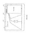
- FIG. 6Ais a schematic representation of a navigation map including defined areas, according to an embodiment of the invention.
- FIG. 6Adepicts a navigation map 600 that includes the location information and road information described in FIG. 5 . Also shown are multiple areas A 1 , A 2 , A 3 , and A 4 .
- the areas A 1 , A 2 , A 3 , and A 4can each have a specified or defined geographic area, however, they need not have similar areas, shapes, contours, and/or outlines. In other embodiments, the areas can have different areas, shapes, contours, and/or outlines from those described in FIG. 6A . Moreover, other embodiments can include a different number of areas than the number used in the example in FIG. 6A .
- Each of the locations S, A, B, C, D, E, and Fcan be located within one of the areas A 1 , A 2 , A 3 , and A 4 , for example.
- locations S, D, and Ecan be located within area A 1 .
- locations C and Fcan be located within area A 3 .
- the locationmay be included within more than one of the areas A 1 , A 2 , A 3 , and A 4 .
- a starting areacan refer to an area or region in which the starting point of a trip is located, for example.
- a destination areacan refer to an area or region in which the destination of a trip is located, for example.
- a user of a mobile interactive services systemcan start at location A in area A 1 and can arrive at location S in area A 2 .
- area A 1is the starting area
- area A 2is the destination area.
- a user or drivermay travel from one area to another area or may travel within one of the areas (i.e., the starting and destination areas can be the same).
- a user of a mobile interactive services systemmay routinely or regularly prefer to travel to a specific destination area. For example, the user's place of work, preferred supermarket, and preferred shopping mall may all be located in area A 3 .
- a regularly occurring destination areacan be referred to as a routine destination area, for example.
- a mobile interactive navigation systemcan be used to collect historical trip data which can be processed to determine whether a particular destination area occurs with a sufficient degree of regularity to be a routine destination area.
- Destination areascan be temporally defined, that is, can be associated with a specific time of day and with specific days.
- a destination areacan be a routine destination area for a first trip but may not be a routine destination area for a second trip because of the time and/or day in which the second trip is occurring.
- FIG. 6Bis a schematic representation of a navigation map including dynamic destination areas, according to an embodiment of the invention.
- FIG. 6Bdepicts a navigation map 650 that includes the location information and road information described in FIGS. 5 and 6A .
- multiple areas B 1 , B 2 , and B 3which can each be dynamically specified or defined based on, for example, historical trip data. For instance, the area, contour, shape, and/or size of each of the areas B 1 , B 2 , and B 3 can be adjusted or modified based on statistical information that can result from the processing of historical trip data.
- Areas B 1 , B 2 , and B 3can, in some instances, overlap such that a location in the navigation map 650 can be included in more than one of areas B 1 , B 2 , and B 3 . Moreover, as areas B 1 , B 2 , and B 3 can dynamically change, whether a location is included within a specified area can vary over time.
- the home of a user of a mobile interactive services systemcan be in location S and the user may take short trips, such as for local grocery shopping, for example, to locations D and E.
- the geographic scope of area B 1may be at least partially determined from historical trip data collected from trips between the user's home and local shopping in locations D and E. Changes in the user's local shopping habits can result in changes to area B 1 .
- the user's place of workcan be in location C.
- the usermay generally stop at locations B and F (e.g., gas station, coffee shop) when traveling to and/or from work.
- the geographic scope of area B 3may be determined at least partially from historical trip data collected from trips to and/or from work. Changes in the user's travel habits to work (e.g., dropping off and/or picking up a child at daycare near location A) can result in changes to area B 1 .
- a user of a mobile interactive services systemmay routinely or regularly prefer to travel to a specific destination area.
- area B 3can be a routine destination area when the user travels to area B 3 as a destination area with a sufficient degree of regularity.
- the usercan have a preference for route segments located within a routine destination area when making a trip.
- the usercan select between, for example, a first route that includes route segments S 0 , S 1 , S 2 , and S 8 and route nodes N 0 , N 1 , and N 2 , and a second route that includes route segments S 0 , S 10 , S 11 , S 12 , and S 9 and route nodes N 0 , N 5 , N 6 , and N 7 .
- the usercan have a preference for the second route because it includes more route segments (e.g., S 11 , S 12 , and S 9 ) associated with routine destination area B 3 than the first route (e.g., S 8 ).
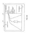
- FIG. 7is a schematic representation illustrating the selection of navigation data based on historical trip data, according to an embodiment of the invention. Shown in FIG. 7 is a travel diagram 700 that includes information related to multiple travel or navigation routes, one of which can be selected for a trip between locations S and B as described in FIG. 6B .
- a mobile interactive services systemsuch as the mobile interactive services systems 200 and 300 in FIGS. 2 and 3 , respectively, can be used to collect, process, operate, display, and/or select data such as the navigation data illustrated in FIG. 7 .
- the travel diagram 700can have data that is based on collected and/or processed historical trip data, including route segment information (e.g. routine route segments) and/or travel area information (e.g., routine destination area).
- route segment informatione.g. routine route segments
- travel area informatione.g., routine destination area
- at least a portion the navigation data shown in FIG. 7can be received from a service provider (e.g., a navigation service provider) through a hybrid satellite
- the example illustrated by the travel diagram 700includes a first route 702 , a second route 704 , and a third route 706 .
- Other examplescan illustrate travel routes for a trip between locations S and B that are different from those shown in FIG. 7 .
- the first route 702can correspond to, for example, a route resulting in the least amount of travel time. Because most of the route segments in the first route 702 are larger roads (solid lines), travel time for the first route 702 may be the fastest.
- the first route 702can include route segments S 0 , S 1 , S 2 , S 3 , S 5 , and S 7 , of which only route segment S 0 is a routine route segment (R).
- the destination, location Bcan be associated with areas B 2 and B 3 because it is located in an overlap region between areas B 2 and B 3 .
- location Bis approached using route segment S 7 in area B 2 , thus location B is associated with area B 2 and not with area B 3 .
- the second route 704can correspond to, for example, a travel route resulting in the shortest travel distance.
- the second route 704can include route segments S 0 , S 1 , S 2 , and S 8 , of which only route segment S 0 is a routine route segment (R).
- route segment S 0is a routine route segment (R).
- location Bis approached using route segment S 8 in area B 2 , thus location B is associated with area B 2 and not with area B 3 .
- the third route 706can correspond to, for example, a travel route that can include multiple routine route segments (R).
- the third route 706can include route segments S 0 , S 10 , S 11 , S 12 , and S 9 , of which only route segment S 9 is not a routine route segment (R).
- location Bis approached using route segment S 9 in area B 3 , thus location B is associated with area B 3 , which is a routine destination area, and not with area B 2 .
- a user of a mobile interactive services systemcan have a preference for, for example, the fastest travel route, the shortest travel route distance, the travel route with the most routine route segments, the travel route to a routine destination area, and/or a combination of the above. Based on these preferences, the user may select the navigation data of one of the travel routes in the travel diagram 700 . For example, the user can prefer the third route 706 because it includes a large number of routine route segments and because location B is associated with a routine destination area.
- Routine route segments and routine destination areasmay give the user a level of comfort, ease, and/or familiarity from previous experiences (e.g., previous trips) that can overcome, in some instances, the benefits of faster travel time and shorter travel distance provided by the first route 702 and the second route 704 , respectively.
- a user's preferencescan be included in the navigation data that is provided by a navigation service through a mobile interactive services system.
- the mobile interactive services systemcan process the user's preferences to generate at least a portion of the navigation data illustrated by the travel diagram 700 .
- a navigation service providercan process the user's preferences and communicate navigation data that is based on these preferences to the mobile interactive services system through a hybrid satellite/terrestrial communication network.
- the processing of a user's preferencescan include providing a weight, ranking, and/or priority to multiple aspects of a trip such as, but need not limited to, travel time, travel distance, starting and/or destination location, destination area information, route segment information, traffic conditions, time of day, and/or day of travel.
- the weighted aspects of the tripcan be combined to determine at least one criterion that can be used to select one of the multiple travel routes that are possible for a particular trip.
- the combinationcan be a linear combination while in another example the combination can be non-linear.
- the criterion or criteriacan be used to graphically represent a relative preference between multiple travel routes such that the user can select one of the travel routes.
- the criterion or criteriacan be used by a navigation service operated through a mobile interactive services system to determine a preferred travel route.
- the navigation data of the preferred travel routecan be made available (e.g., graphically represented or displayed on a display screen) to the user through a mobile interactive services system.
- routine route segments and/or routine destination areasmay be given significant weight when determining the criterion or criteria from which to select a travel route.
- the user's travel preferencescan be used to adjust or modify navigation instructions or data provided by a navigation service provider.
- the mobile interactive services systemcan replace a portion of a travel route provided by a navigation service provider with one or more routine route segments.
- FIG. 8is a schematic representation of a navigation map including points-of-interest, according to an embodiment of the invention.
- FIG. 8depicts a navigation map 800 that includes the location information, road information, and area information described in FIG. 6B .
- multiple points-of-interestPOI
- POI 0is located in area B 1 near location D
- POI 1is located in area B 1 near location E
- POI 2is located in area B 3 near location F
- POI 3is located in area B 3 near location C
- POI 4is located in areas B 2 and B 3 near location B
- POI 5is located in area B 2 near location A.
- Each POImay correspond to, for example, a destination location from one or more destination categories selected by a user through a mobile interactive services system.
- a drivercan search for navigation or guidance data to a destination category such as entertainment places (e.g., restaurants, cinemas, theaters).
- the drivercan be provided by a navigation service and through the mobile interactive services system with one or more POIs that may meet the search criteria.
- the navigation or travel route preferences of the user mobile interactive services systemcan be used to determine at least one criterion for traveling to each POI that provides a relative preference between multiple POIs.
- the usermay prefer traveling to a POI that is near a location which may result in the shortest travel time from a current location, traveling to a POI near a location which may result in using multiple routine route segments (R), traveling to a POI near a location in a routine destination area, and/or a combination of the above.
- a POIthat is near a location which may result in the shortest travel time from a current location
- Rroutine route segments
- the POI datacan include ratings, reviews, and/or rankings that can be provided by a community with similar inters tests to those of the user (e.g., a community-of-interest (COI)).
- COIcommunity-of-interest
- the travel criterion or criteriacan, in these instances, include information related to the COI rating. For example, when two or more POIs meet relatively similar travel preferences, the POI with the highest rating by a COI can be preferred over the others.
- At least a portion of the data related to the POIscan be graphically represented in the mobile interactive services system to assist the user in the selection process.
- data related to the POIscan be graphically represented to indicate a relative preference between multiple POIs based on, for example, one or more travel criterion.
- the travel criterion or criteria resultscan be used by a navigation service operated through a mobile interactive services system to determine a preferred POIs for the destination category.
- the navigation data of the preferred POIcan be made available (e.g., graphically represented or displayed on a display screen) to the user through a mobile interactive services system.
- the mobile interactive services systemcan also make available data related to the remaining POIs upon user request.
- the mobile interactive services systemcan provide data related to the POI, including navigation data.
- FIG. 9Ais a front view of a controller that can graphically display data related to one or more points-of-interest, according to an embodiment of the invention.
- a mobile interactive services systemcan include a controller 900 having a display screen 910 .
- the controller 900can include at least a portion of the functionality provided by the controller module 210 described in FIG. 2 .
- the display screen 910can have a first portion 930 and a second portion 940 . In other embodiments, the display screen 910 can include more or fewer portions than those described in FIG. 9A .
- the first portion 930 of the display screen 910can be used to visually or graphically represent information related to, for example, a navigation map 920 .
- the navigation map 920can include location information (e.g., towns, cities, addresses, names of places, landmarks) and road information as described in the examples in FIGS. 5, 6A, 6B, and 8 .
- the navigation map 920can include data related to the POIs as described in FIG. 8 .
- the second portion 940 of the display screen 910can be used to graphically or visually represent, for example, the relative organization of the POIs that results from considering the user's travel route preferences from a starting location S. In this example, the POIs can be listed from top to bottom in order of preference.
- different graphical representations of POI preferencescan be used that may be different from those described in FIG. 9A .
- a usercan select any one POI and need not select the POI with the highest relative preference.
- the display screen 910can be a touch screen, for example, such that a user can select one of the POIs through the display screen 910 .
- the controller 900can include buttons that can be used to select a POI from those graphically represented on the display screen 910 .
- FIG. 9Bis a front view of a controller that can graphically display navigation data and other data related to a point-of-interest, according to an embodiment of the invention.
- the userhas selected or accepted POI 2 from the multiple POIs that resulted from the destination category search.
- the display screen 910can be used to provide navigation or guidance data and/or additional data related to the POI 2 .
- the display screen 910can have a first portion 950 , a second portion 960 , and a third portion 970 .
- the display screen 910can include more or fewer portions than those described in FIG. 9B .
- the first portion 950 of the display screen 910can include graphically or visually represented guidance or navigation data to assist the user in traveling from a current location S to the location of the selected POI (i.e., POI 2 in this example).
- the second portion 960 of the display screen 910can include graphically or visually represented data related to the POI 2 , such as, for example, an address, a telephone number, an email, a hyperlink to a website, an estimated time of arrival at POI 2 , and/or a community-of-interest (COI) rating and/or review of the POI when available.
- the third portion 970 of the display screen 910can include, for example, multimedia information (e.g., advertisement, offers, commercial logos, audio content) related to the POI 2 .
- FIG. 9Cis a front view of a controller that can graphically display navigation data and website data related to a selected point-of-interest, according to another embodiment of the invention.
- the display screen 910can be used to provide navigation or guidance data and/or additional data related to the selected POI (i.e., POI 2 in this example).
- the display screen 910can have a first portion 950 and a second portion 980 .
- the display screen 910can include more or fewer portions than those described in FIG. 9C . As shown in FIGS.
- the first portion 950 of the display screen 910can include graphically or visually represented guidance or navigation data to assist the user in traveling from a current location S to the location of POI 2 .
- the second portion 980 of the display screen 910 in FIG. 9Ccan include, for example, a website related to the POI 2 .
- the website of POI 2 shown in FIG. 9Cmay have been displayed from the user selecting a hyperlink, such as the hyperlink described in FIG. 9B , for example.
- FIG. 9Dis a front view of a controller that can graphically display feedback data provided to a community-of-interest related to a selected point-of-interest, according to an embodiment of the invention.
- the display screen 910can be used to provide navigation or guidance data, to provide additional data related to selected POI (i.e., POI 2 in this example), and/or to submit data related to the selected POI.
- the display screen 910can have a first portion 950 and a second portion 990 .
- the display screen 910can include more or fewer portions than those described in FIG. 9D . As shown in FIGS.
- the first portion 950 of the display screen 910can include graphically or visually represented guidance or navigation information to assist the user in traveling from current a location S to the location of POI 2 .
- the userhas arrived at POI 2 .
- the second portion 990 of the display screen 910can include, for example, graphically or visually represented data to assist the user in submitting information related to POI 2 , such as a personal ratings and/or reviews, for example.
- the usercan belong to one or more communities that share common interests (e.g., parents with young children groups, retired people groups, traveling bands groups). These communities can share with its members the ratings and/or reviews of particular POIs.
- the second portion 990can be used to select a community-of-interest (COI) and to provide the selected COI with a personal rating and/or review of services and/or facilities associated with POI 2 (e.g., quality of service, promptness, cost, cleanliness).
- COIcommunity-of-interest
- POI 2e.g., quality of service, promptness, cost, cleanliness
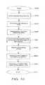
- FIG. 10is a flow chart illustrating a method for selecting a POI based on historical trip data, according to an embodiment of the invention.
- a mobile interactive services systemthat supports navigation services can access historical trip data, such as trip data related to departure time, arrival time, time and/or date of travel, travel distances, starting and/or destination locations, route segments, destination areas, and/or navigation or guidance data provided for previously occurring trips, for example.
- the historical trip datacan be accessed from memory in the mobile interactive services system and/or through a hybrid satellite/terrestrial mobile communication network, for example.
- the historical trip datacan include processed historical trip data such as routine route segment data and/or routine destination area data.
- data related to one or more POIscan be accessed by the mobile interactive services system.
- the POI datacan result from a search of a selected destination category through a navigation service.
- the POI datacan include information related to multiple POIs such as location of a POI, name, contact information (e.g., telephone number, fax number, email, text messaging, hyperlinks), and/or ratings or reviews provided by one or more communities or groups (e.g., COI ratings).
- the POI datacan be accessed from memory in the mobile interactive services system and/or through a hybrid satellite/terrestrial mobile communication network, for example. In this regard, the POI data can be received from a navigation service provider.
- At 1006at least one criterion can be used for selecting a POI.
- the criterion or criteriacan be based on historical trip data, user preferences, and/or other data related to the POIs, such as ratings or reviews, for example.
- at least one criterioncan be determined by providing a weight or weighting factor to one or more aspects of the historical trip data, the user preferences, and/or other data related to the POIs.
- routine route segments, routine destination areas, and/or ratings or reviewscan be weighted more heavily to reflect the user's travel preferences.
- the mobile interactive services systemcan graphically represent data related to the POIs based on, at least partially, at least one criterion determined for POI selection.
- a display screencan be used to graphically represent the location of the POIs.
- the display screencan also be used to graphically represent POI information, such as name, for example, in a manner that illustrate relative POI preferences based on the criterion or criteria.
- a usercan select or accept a POI based on the criterion and/or other POI data.
- a usercan activate a portion of the mobile interactive services system, such as a touch-screen or a button, to indicate which of the POIs is being selected.
- the mobile interactive services systemcan determine a preferred POI based on the criterion or criteria and can provide the user with the option of accepting the preferred POI.
- the userneed not accept the preferred POI and the mobile interactive services system can present subsequent options of POIs (e.g., according to relative criterion preference) until the user accepts one.
- the mobile interactive services systemcan graphically represent data related to the selected or accepted POI.
- the mobile interactive services systemcan provide the user with navigation or guidance information, data related to the selected POI (e.g., address and contact information, hyperlinks, websites, and/or multimedia content).
- the methodcan proceed to end 1016 .
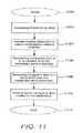
- FIG. 11is a flow chart illustrating a method for obtaining navigation data to a destination point based on historical trip data, according to an embodiment of the invention.
- a mobile interactive services systemcan access historical trip data from memory in the mobile interactive services system, for example.
- the historical trip datacan include processed historical trip data such as routine route segment data and/or routine destination area data.
- the historical trip datacan be communicated to a navigation service provider through a hybrid satellite/terrestrial mobile communication network, for example.
- the navigation service providercan process the historical trip data, including determining statistical information to identify routine or regularly occurring trips, for example.
- a usercan request navigation data for a specified location or destination from the navigation service provider via the hybrid satellite/terrestrial mobile communication network.
- the navigation service providercan generate navigation data for the user-specified location based, at least partially, on the historical trip data received.
- the mobile interactive services systemcan receive the navigation data generated by the navigation service provider through the hybrid satellite/terrestrial mobile communication network.
- the mobile interactive services systemcan graphically represent the navigation data, including travel directions or guidance and/or additional data related to the specified destination.
- the navigation service providercan update the navigation data to, for example, reflect changes in the user's location and/or to indicate changes in remaining travel time and/or distance to travel to arrive at the destination location.
- the methodcan proceed to end 1114 .
- a processor in a mobile interactive navigation servicecan be operated to process at least one criterion for multiple of POIs based on historical trip data.
- the historical trip datacan include route segment data and destination area data.
- An input devicecan also be coupled to the processor and can be operated to detect a selection of one of the graphically represented POIs.
- a modemcan be coupled to the processor and can be operated to receive data related to the POIs from a hybrid satellite/terrestrial mobile communication network.
- the criterion or criteriacan be based on a portion of the route segment data related to travel to the one of the POIs from a current location, the portion of the destination area data related to a location of the POIs, and/or a rating provided by a COI.
- the processorcan be operated to process a preferred POI based on the at least one criterion.
- a displaycan be coupled to the processor that can be configured to graphically represent the multiple POIs based on the criterion or criteria.
- the graphically represented datacan include, for example, data related to a preferred POI, data related to the POIs in an order that is based on the criterion, and data related to the selected POI.
- a processor in a mobile interactive navigation servicecan be operated process navigation data to a destination for graphical representation in a display.
- the navigation datacan be based on historical trip data and the historical trip data can include route segment data and destination area data.
- the processorcan access the navigation data from memory and/or through a hybrid satellite/terrestrial mobile communication network.
- the memorycan be operated to store navigation data, historical trip data, and/or data related to a previously conducted trip.
- the processorcan process data related to a previously conducted trip to generate historical trip data.
- the processorcan process the historical trip data for communication to a navigation service provider through the hybrid satellite/terrestrial mobile communication network and via a modem coupled to the processor.
- the modemcan also receive navigation data from the service provider through the hybrid satellite/terrestrial mobile communication network.
- the navigation data received from the service providercan be based on a portion of the route segment data related to travel to the destination from a current location and/or a portion of the destination area data related to a location of the destination.
- the navigation data received from the service providercan be updated based on historical trip data, traffic data, and/or user deviations from previously provided navigation data.
- a processor in a mobile interactive services systemcan be programmed to process at least one criterion for each of multiple POIs based on historical trip data.
- the historical trip datacan include route segment data and/or destination area data.
- the processorcan be programmed to process the criterion or criteria for the POIs to provide a graphical representation of the POIs.
- the processorcan be programmed to process a selection of one of the graphically represented POIs.
- the mobile interactive services device described hereincan include various combinations and/or sub-combinations of the components and/or features of the different embodiments described.
- the mobile interactive navigation services and the mobile interactive services deviceas well as the methods of using the mobile interactive navigation services and the mobile interactive services device can be used with other wireless network systems.
- Embodiments of a mobile interactive navigation servicecan also be provided without the mobile interactive services device described herein.
- a mobile interactive navigation servicecan be configured to be used with other suitable controllers, vehicle consoles, handheld devices, and/or laptop computers, not specifically described herein. Data from a mobile interactive navigation service can be accessed, processed, displayed, and/or selected in a different manner than as illustrated and described herein.
- a mobile interactive navigation servicecan also be provided with other interactive features and/or services such as, for example, travel assistance services.
- Some embodimentsinclude a processor and a related processor-readable medium having instructions or computer code thereon for performing various processor-implemented operations.
- processorscan be implemented as hardware modules such as embedded microprocessors, microprocessors as part of a computer system, Application-Specific Integrated Circuits (“ASICs”), and Programmable Logic Devices (“PLDs”).
- ASICsApplication-Specific Integrated Circuits
- PLDsProgrammable Logic Devices
- Such processorscan also be implemented as one or more software modules in programming languages as Java, C++, C, assembly, a hardware description language, or any other suitable programming language.
- a processorincludes media and computer code (also can be referred to as code) specially designed and constructed for the specific purpose or purposes.
- processor-readable mediainclude, but are not limited to: magnetic storage media such as hard disks, floppy disks, and magnetic tape; optical storage media such as Compact Disc/Digital Video Discs (“CD/DVDs”), Compact Disc-Read Only Memories (“CD-ROMs”), and holographic devices; magneto-optical storage media such as optical disks, and read-only memory (“ROM”) and random-access memory (“RAM”) devices.
- Examples of computer codeinclude, but are not limited to, micro-code or micro-instructions, machine instructions, such as produced by a compiler, and files containing higher-level instructions that are executed by a computer using an interpreter.
- an embodiment of the inventionmay be implemented using Java, C++, or other object-oriented programming language and development tools.
- Additional examples of computer codeinclude, but are not limited to, control signals, encrypted code, and compressed code.
Landscapes
- Engineering & Computer Science (AREA)
- Radar, Positioning & Navigation (AREA)
- Remote Sensing (AREA)
- Automation & Control Theory (AREA)
- Physics & Mathematics (AREA)
- General Physics & Mathematics (AREA)
- Health & Medical Sciences (AREA)
- General Health & Medical Sciences (AREA)
- Social Psychology (AREA)
- Human Computer Interaction (AREA)
- Navigation (AREA)
Abstract
Description
Claims (22)
Priority Applications (1)
| Application Number | Priority Date | Filing Date | Title |
|---|---|---|---|
| US15/590,167US10274333B2 (en) | 2008-03-04 | 2017-05-09 | Navigation using routine driving information and destination areas |
Applications Claiming Priority (4)
| Application Number | Priority Date | Filing Date | Title |
|---|---|---|---|
| US12/042,207US8626230B2 (en) | 2008-03-04 | 2008-03-04 | Method and system for using routine driving information in mobile interactive satellite services |
| US14/095,807US9109916B2 (en) | 2008-03-04 | 2013-12-03 | Method and system for using routine driving information |
| US14/827,158US9664526B2 (en) | 2008-03-04 | 2015-08-14 | Method and system for using routine driving information |
| US15/590,167US10274333B2 (en) | 2008-03-04 | 2017-05-09 | Navigation using routine driving information and destination areas |
Related Parent Applications (1)
| Application Number | Title | Priority Date | Filing Date |
|---|---|---|---|
| US14/827,158ContinuationUS9664526B2 (en) | 2008-03-04 | 2015-08-14 | Method and system for using routine driving information |
Publications (2)
| Publication Number | Publication Date |
|---|---|
| US20170241793A1 US20170241793A1 (en) | 2017-08-24 |
| US10274333B2true US10274333B2 (en) | 2019-04-30 |
Family
ID=41054505
Family Applications (6)
| Application Number | Title | Priority Date | Filing Date |
|---|---|---|---|
| US12/042,207Active2031-04-26US8626230B2 (en) | 2008-03-04 | 2008-03-04 | Method and system for using routine driving information in mobile interactive satellite services |
| US13/619,848ActiveUS8942620B2 (en) | 2008-03-04 | 2012-09-14 | Method and system for using routine driving information in mobile interactive satellite services |
| US13/798,922ActiveUS8750790B2 (en) | 2008-03-04 | 2013-03-13 | Method and system for using routine driving information in mobile interactive services |
| US14/095,807ActiveUS9109916B2 (en) | 2008-03-04 | 2013-12-03 | Method and system for using routine driving information |
| US14/827,158ActiveUS9664526B2 (en) | 2008-03-04 | 2015-08-14 | Method and system for using routine driving information |
| US15/590,167ActiveUS10274333B2 (en) | 2008-03-04 | 2017-05-09 | Navigation using routine driving information and destination areas |
Family Applications Before (5)
| Application Number | Title | Priority Date | Filing Date |
|---|---|---|---|
| US12/042,207Active2031-04-26US8626230B2 (en) | 2008-03-04 | 2008-03-04 | Method and system for using routine driving information in mobile interactive satellite services |
| US13/619,848ActiveUS8942620B2 (en) | 2008-03-04 | 2012-09-14 | Method and system for using routine driving information in mobile interactive satellite services |
| US13/798,922ActiveUS8750790B2 (en) | 2008-03-04 | 2013-03-13 | Method and system for using routine driving information in mobile interactive services |
| US14/095,807ActiveUS9109916B2 (en) | 2008-03-04 | 2013-12-03 | Method and system for using routine driving information |
| US14/827,158ActiveUS9664526B2 (en) | 2008-03-04 | 2015-08-14 | Method and system for using routine driving information |
Country Status (2)
| Country | Link |
|---|---|
| US (6) | US8626230B2 (en) |
| WO (1) | WO2009148653A1 (en) |
Cited By (1)
| Publication number | Priority date | Publication date | Assignee | Title |
|---|---|---|---|---|
| US11237014B2 (en)* | 2019-03-29 | 2022-02-01 | Honda Motor Co., Ltd. | System and method for point of interest user interaction |
Families Citing this family (47)
| Publication number | Priority date | Publication date | Assignee | Title |
|---|---|---|---|---|
| ATE362251T1 (en)* | 2000-09-11 | 2007-06-15 | Transnexus Inc | BILLING SERVER FOR INTERNET AND MULTIMEDIA COMMUNICATIONS |
| US9222797B2 (en)* | 2007-04-17 | 2015-12-29 | Esther Abramovich Ettinger | Device, system and method of contact-based routing and guidance |
| US9276664B2 (en) | 2007-04-30 | 2016-03-01 | Dish Network Corporation | Mobile interactive satellite services |
| US8457682B2 (en)* | 2008-03-04 | 2013-06-04 | Dbsd Satellite Services G.P. | Method and system for integrated satellite assistance services |
| US8626230B2 (en)* | 2008-03-04 | 2014-01-07 | Dish Network Corporation | Method and system for using routine driving information in mobile interactive satellite services |
| US9129332B1 (en) | 2008-03-05 | 2015-09-08 | United Services Automobile Association (Usaa) | Systems and methods for price searching and intelligent shopping lists on a mobile device |
| JP5549125B2 (en)* | 2008-09-29 | 2014-07-16 | 株式会社日立製作所 | Advertisement information providing server and mobile terminal |
| US20120023446A1 (en)* | 2009-01-30 | 2012-01-26 | Minde Tor Bjoern | Presentation of a digital map |
| US10001384B2 (en)* | 2009-11-12 | 2018-06-19 | Here Global B.V. | Method and apparatus for the retrieval of similar places |
| US20110130956A1 (en)* | 2009-11-30 | 2011-06-02 | Nokia Corporation | Method and apparatus for presenting contextually appropriate navigation instructions |
| US8396663B2 (en)* | 2009-12-15 | 2013-03-12 | Navteq B.V. | Speed profile dictionary |
| JP5454183B2 (en)* | 2010-02-04 | 2014-03-26 | 株式会社デンソー | Process planning apparatus, method thereof, and program thereof |
| US9122701B2 (en)* | 2010-05-13 | 2015-09-01 | Rovi Guides, Inc. | Systems and methods for providing media content listings according to points of interest |
| EP2646781B1 (en)* | 2010-11-30 | 2018-12-26 | TomTom Navigation B.V. | Navigation methods and systems |
| US9390137B2 (en) | 2011-06-29 | 2016-07-12 | Nokia Technologies Oy | Method and apparatus for providing an ordering metric for a multi-dimensional contextual query |
| US20130054141A1 (en)* | 2011-08-29 | 2013-02-28 | Princeton Satellite Systems | Weighted Path Selection for Mapping Route Selection |
| US8977488B2 (en)* | 2012-06-27 | 2015-03-10 | Toyota Motor Engineering & Manufacturing North America, Inc. | Systems, methods and vehicles for providing route guidance |
| JP6020150B2 (en)* | 2012-12-27 | 2016-11-02 | 日産自動車株式会社 | Vehicle information providing device |
| JP6248294B2 (en)* | 2013-06-20 | 2017-12-20 | 三菱自動車工業株式会社 | Information provision system |
| US9702716B2 (en)* | 2013-08-28 | 2017-07-11 | Verizon Telematics Inc. | Traffic score determination |
| US8930124B1 (en)* | 2013-08-30 | 2015-01-06 | International Business Machines Corporation | Dynamic speed limit generation |
| US9891064B2 (en)* | 2014-01-31 | 2018-02-13 | Aruba Networks, Inc. | Selection of a route based on prior user behavior or commercial interests |
| US9008858B1 (en)* | 2014-03-31 | 2015-04-14 | Toyota Motor Engineering & Manufacturing North America, Inc. | System and method for providing adaptive vehicle settings based on a known route |
| CN105528359B (en)* | 2014-09-29 | 2019-05-07 | 国际商业机器公司 | For storing the method and system of travel track |
| US9696173B2 (en)* | 2014-12-10 | 2017-07-04 | Red Hat, Inc. | Providing an instruction notification for navigation |
| US9857194B2 (en)* | 2014-12-11 | 2018-01-02 | Red Hat, Inc. | Time related points of interest for navigation system |
| DE102015208806A1 (en)* | 2015-05-12 | 2016-11-17 | Bayerische Motoren Werke Aktiengesellschaft | Optimized route recommendation by navigation system |
| GB2543269A (en)* | 2015-10-12 | 2017-04-19 | Information Edge Ltd | A navigation system |
| US11099023B1 (en) | 2016-01-05 | 2021-08-24 | Open Invention Network Llc | Intermediate navigation destinations |
| DE102016215830A1 (en) | 2016-08-23 | 2018-03-01 | Bayerische Motoren Werke Aktiengesellschaft | Method for optimizing route guidance by a navigation system |
| CN107036610A (en)* | 2016-11-18 | 2017-08-11 | 四川研宝科技有限公司 | It is a kind of based on method from predetermined paths to user's propelling data, terminal and server |
| US10563990B1 (en)* | 2017-05-09 | 2020-02-18 | Palantir Technologies Inc. | Event-based route planning |
| US11003183B2 (en)* | 2017-09-13 | 2021-05-11 | Baidu Usa Llc | Driving scene based path planning for autonomous driving vehicles |
| EP3580625B1 (en)* | 2017-09-18 | 2024-02-14 | Baidu.com Times Technology (Beijing) Co., Ltd. | Driving scenario based lane guidelines for path planning of autonomous driving vehicles |
| JP7035531B2 (en)* | 2017-12-28 | 2022-03-15 | トヨタ自動車株式会社 | Vehicle operation management system |
| RU2711127C2 (en) | 2018-07-03 | 2020-01-15 | Общество С Ограниченной Ответственностью "Яндекс" | Method of obtaining a user command by an electronic device processor using a touch screen of an electronic device |
| CN110749330B (en)* | 2018-07-23 | 2021-08-13 | 阿里巴巴(中国)有限公司 | Navigation path planning method and device |
| US11080267B2 (en)* | 2018-08-31 | 2021-08-03 | Waymo Llc | Validating road intersections |
| US20200217687A1 (en)* | 2019-01-09 | 2020-07-09 | Sf Motors, Inc. | Consolidated vehicle navigation and information system |
| CN111462512A (en)* | 2019-01-22 | 2020-07-28 | 上海博泰悦臻网络技术服务有限公司 | Vehicle and driving route selection method and device applied to vehicle |
| US11230379B2 (en)* | 2019-03-28 | 2022-01-25 | Betria Interactive, LLC | Organizing places of interest in-flight |
| DE102019112922A1 (en) | 2019-05-16 | 2020-11-19 | Dr. Ing. H.C. F. Porsche Aktiengesellschaft | Method and device for navigation |
| FR3108400B1 (en)* | 2020-03-17 | 2022-04-08 | Renault Sas | method of planning a route for a motor vehicle |
| CN111735473B (en)* | 2020-07-06 | 2022-04-19 | 无锡广盈集团有限公司 | Beidou navigation system capable of uploading navigation information |
| US12105834B2 (en) | 2020-07-24 | 2024-10-01 | International Business Machines Corporation | User privacy for autonomous vehicles |
| CN114204982B (en)* | 2021-12-28 | 2023-12-12 | 航天恒星科技有限公司 | High-low orbit general-purpose wide-frequency satellite communication system and method |
| US20230306317A1 (en)* | 2022-03-28 | 2023-09-28 | International Business Machines Corporation | Computer Technology For Setting And Presenting An Itinerary For A Traveler |
Citations (103)
| Publication number | Priority date | Publication date | Assignee | Title |
|---|---|---|---|---|
| US4992947A (en) | 1987-12-28 | 1991-02-12 | Aisin Aw Co., Ltd. | Vehicular navigation apparatus with help function |
| US5394561A (en) | 1990-03-06 | 1995-02-28 | Motorola, Inc. | Networked satellite and terrestrial cellular radiotelephone systems |
| US5758261A (en) | 1995-06-06 | 1998-05-26 | Globalstar L.P. | Low earth orbit communication satellite gateway-to-gateway relay system |
| US5919246A (en) | 1994-10-07 | 1999-07-06 | Mannesmann Aktiengesellschaft | Target input for navigation system |
| US6212473B1 (en) | 1999-09-20 | 2001-04-03 | Ford Global Technologies, Inc. | Vehicle navigation system having inferred user preferences |
| US6269304B1 (en) | 1999-03-01 | 2001-07-31 | Aisin Aw Co., Ltd | Navigation system and method and storage medium in which navigation programs are stored |
| US6360167B1 (en) | 1999-01-29 | 2002-03-19 | Magellan Dis, Inc. | Vehicle navigation system with location-based multi-media annotation |
| US20020065078A1 (en) | 2000-11-24 | 2002-05-30 | Alcatel | Satellite-based multimedia telecommunication method and system |
| US6405129B1 (en) | 2000-11-29 | 2002-06-11 | Alpine Electronics, Inc. | Method of displaying POI icons for navigation apparatus |
| US6484094B1 (en) | 2002-02-19 | 2002-11-19 | Alpine Electronics, Inc. | Display method and apparatus for navigation system |
| US6487496B2 (en) | 2000-03-29 | 2002-11-26 | Honda Giken Kogyo Kabushiki Kaisha | Mobile navigation apparatus with route deviation indication |
| US6505118B2 (en) | 2001-01-26 | 2003-01-07 | Ford Motor Company | Navigation system for land vehicles that learns and incorporates preferred navigation routes |
| US6522865B1 (en) | 1999-08-10 | 2003-02-18 | David D. Otten | Hybrid satellite communications system |
| US20030154128A1 (en) | 2002-02-11 | 2003-08-14 | Liga Kevin M. | Communicating and displaying an advertisement using a personal video recorder |
| US20040022326A1 (en) | 2002-07-30 | 2004-02-05 | John Morrish | Digital audio receiver |
| US6711474B1 (en) | 2000-01-24 | 2004-03-23 | G. Victor Treyz | Automobile personal computer systems |
| US6714760B2 (en) | 2001-05-10 | 2004-03-30 | Qualcomm Incorporated | Multi-mode satellite and terrestrial communication device |
| US6714860B1 (en) | 1999-11-30 | 2004-03-30 | Robert Bosch Gmbh | Navigation device with means for displaying advertisements |
| US6741834B1 (en) | 2000-06-06 | 2004-05-25 | Hughes Electronics Corporation | Device and method to improve integrated presentation of existing radio services and advanced multimedia services |
| US20040110467A1 (en) | 1999-01-07 | 2004-06-10 | Hughes Electronics Corporation | Method and apparatus for providing wideband services using medium and low earth orbit satellites |
| US6771742B2 (en) | 2001-11-05 | 2004-08-03 | Intrado Inc. | Geographic routing of emergency service call center emergency calls |
| US20040203919A1 (en)* | 2003-03-12 | 2004-10-14 | General Motors Corporation | Location-based services for a telematics service subscriber |
| US6816778B2 (en) | 2001-12-29 | 2004-11-09 | Alpine Electronics, Inc | Event finder with navigation system and display method thereof |
| US20040242152A1 (en) | 2003-05-30 | 2004-12-02 | The Boeing Company | Wireless communication system with split spot beam payload |
| US6865149B1 (en) | 2000-03-03 | 2005-03-08 | Luminous Networks, Inc. | Dynamically allocated ring protection and restoration technique |
| US20050055724A1 (en) | 2003-09-10 | 2005-03-10 | Wi Networks Inc. | Head end installation for broadcasting with return channel |
| US20050136832A1 (en) | 2003-07-30 | 2005-06-23 | Spreizer Steven H. | Distributed satellite-based communications network and method of providing interactive communications services using the same |
| US6941222B2 (en) | 2001-04-27 | 2005-09-06 | Pioneer Corporation | Navigation system, server system for a navigation system, and computer-readable information recorded medium in which destination prediction program is recorded |
| US6944139B1 (en) | 1998-03-27 | 2005-09-13 | Worldspace Management Corporation | Digital broadcast system using satellite direct broadcast and terrestrial repeater |
| US6950625B2 (en) | 2001-02-12 | 2005-09-27 | Ico Services Limited | Communications apparatus and method |
| US20050239404A1 (en) | 2004-04-07 | 2005-10-27 | Karabinis Peter D | Satellite/hands-free interlock systems and/or companion devices for radioterminals and related methods |
| US6961658B2 (en) | 2000-11-01 | 2005-11-01 | Navteq North America, Llc | Method, system and article of manufacture for identifying regularly traveled routes |
| US6992991B2 (en) | 1995-12-08 | 2006-01-31 | Atc Technologies, Llc | Mobile communications terminal for satellite communications system |
| US20060023656A1 (en) | 2004-07-29 | 2006-02-02 | Anglin Richard L Jr | Interactive digital data broadcasting system |
| US6999720B2 (en) | 2001-09-14 | 2006-02-14 | Atc Technologies, Llc | Spatial guardbands for terrestrial reuse of satellite frequencies |
| US7013205B1 (en)* | 2004-11-22 | 2006-03-14 | International Business Machines Corporation | System and method for minimizing energy consumption in hybrid vehicles |
| EP1635482A2 (en) | 2004-09-08 | 2006-03-15 | Alcatel | Rural broadband hybrid satellite/terrestrial network architecture |
| US7017175B2 (en) | 2001-02-02 | 2006-03-21 | Opentv, Inc. | Digital television application protocol for interactive television |
| US7031702B2 (en) | 2001-09-14 | 2006-04-18 | Atc Technologies, Llc | Additional systems and methods for monitoring terrestrially reused satellite frequencies to reduce potential interference |
| US7071842B1 (en) | 2002-06-27 | 2006-07-04 | Earthcomber, Llc | System and method for locating and notifying a user of a person, place or thing having attributes matching the user's stated preferences |
| US20060160219A1 (en) | 2002-07-12 | 2006-07-20 | Takara Bio Inc. | Method of transferring mutation into target nucleic acid |
| US7082365B2 (en) | 2001-08-16 | 2006-07-25 | Networks In Motion, Inc. | Point of interest spatial rating search method and system |
| US20060190981A1 (en) | 2004-10-07 | 2006-08-24 | Visiware | Carousel technology for interactive television |
| US20060217885A1 (en) | 2005-03-24 | 2006-09-28 | Mark Crady | User location driven identification of service vehicles |
| US20060229810A1 (en) | 2005-04-11 | 2006-10-12 | John Cross | GPS device and method for displaying weather data |
| US20060253246A1 (en) | 2005-04-18 | 2006-11-09 | Cera Christopher D | Data-driven combined traffic/weather views |
| US7136661B2 (en) | 2003-07-08 | 2006-11-14 | Lucent Technologies Inc. | Weather alert notification to mobile station upon weather alert occurrence during a time period |
| WO2007004737A1 (en) | 2005-07-05 | 2007-01-11 | Kabushiki Kaisha Aichi Corporation | Vehicle for work at high place |
| US7164661B2 (en) | 2000-04-14 | 2007-01-16 | Hughes Networks Systems, Llc | System and method for providing a two-way satellite system |
| US7174127B2 (en) | 1999-08-10 | 2007-02-06 | Atc Technologies, Llc | Data communications systems and methods using different wireless links for inbound and outbound data |
| US7176813B2 (en) | 2004-09-10 | 2007-02-13 | Xanavi Informatics Corporation | System and method for processing and displaying traffic information in an automotive navigation system |
| US20070058083A1 (en) | 2005-09-12 | 2007-03-15 | Samsung Electronics Co., Ltd. | Broadcasting signal receiver and control method thereof |
| US7194270B2 (en) | 1999-10-15 | 2007-03-20 | Northrop Grumman Corporation | Dynamic beam width selection for non-uniform density multiple access cells |
| US20070086460A1 (en) | 2005-10-13 | 2007-04-19 | Samsung Electronics Co., Ltd. | Method and apparatus for supporting multicast/broadcast in wireless communication system |
| US20070087756A1 (en) | 2005-10-04 | 2007-04-19 | Hoffberg Steven M | Multifactorial optimization system and method |
| US7224935B2 (en) | 2000-11-29 | 2007-05-29 | Visteon Global Technologies, Inc. | Telematics application for implementation in conjunction with a satellite broadcast delivery system |
| US20070124789A1 (en)* | 2005-10-26 | 2007-05-31 | Sachson Thomas I | Wireless interactive communication system |
| US7233860B2 (en) | 2003-07-16 | 2007-06-19 | Magellan Navigation, Inc. | Intelligent modular navigation information capability |
| US20070150174A1 (en)* | 2005-12-08 | 2007-06-28 | Seymour Shafer B | Predictive navigation |
| US7239963B2 (en) | 2002-08-26 | 2007-07-03 | Alpine Electronics, Inc. | Method and apparatus for displaying navigation information |
| US7242948B2 (en) | 2001-03-23 | 2007-07-10 | Lucent Technologies Inc. | Providing location based directory numbers for personalized services |
| US20070182592A1 (en) | 2006-02-07 | 2007-08-09 | Koninklijke Kpn N.V. | Vehicle communication device |
| US7269503B2 (en) | 2003-09-23 | 2007-09-11 | Navteq North America, Llc | Method and system for developing traffic messages |
| US7271742B2 (en) | 2002-03-01 | 2007-09-18 | Networks In Motion, Inc. | Method and apparatus for sending, retrieving and planning location relevant information |
| US7274906B1 (en) | 2003-09-16 | 2007-09-25 | At & T Bls Intellectual Property, Inc. | Digital radio feedback systems |
| US7274905B1 (en) | 2003-09-16 | 2007-09-25 | At & T Bls Intellectual Property, Inc. | Digital radio feedback apparatuses, systems, and methods |
| US7286931B2 (en) | 2002-02-26 | 2007-10-23 | Alpine Electronics, Inc. | Vehicle navigation device and method of displaying POI information using same |
| US7289039B2 (en) | 2004-09-10 | 2007-10-30 | Xanavi Informatics Corporation | Apparatus and method for processing and displaying traffic information in an automotive navigation system |
| US20070288162A1 (en)* | 2004-05-19 | 2007-12-13 | Honda Motor Company Ltd. | System and Method for Off Route Processing |
| US20080033639A1 (en) | 2006-06-23 | 2008-02-07 | Aisin Aw Co., Ltd. | Map information delivery system, method, and program |
| US20080071466A1 (en)* | 2006-08-18 | 2008-03-20 | Inrix, Inc. | Representative road traffic flow information based on historical data |
| US20080094250A1 (en)* | 2006-10-19 | 2008-04-24 | David Myr | Multi-objective optimization for real time traffic light control and navigation systems for urban saturated networks |
| US20080125958A1 (en)* | 2006-11-27 | 2008-05-29 | Gregory Jensen Boss | Method and system for calculating least-cost routes based on historical fuel efficiency, street mapping and location based services |
| US20080134260A1 (en) | 2006-12-04 | 2008-06-05 | Qualcomm Incorporated | Systems, methods and apparatus for providing sequences of media segments and corresponding interactive data on a channel in a media distribution system |
| US7412313B2 (en)* | 2004-01-07 | 2008-08-12 | Temic Automotive Of North America, Inc. | Maintenance assistance for a vehicle |
| US20080200114A1 (en) | 2005-06-14 | 2008-08-21 | Fraunhofer-Gesellschaft Zur Forderung Der Angewandten Forschung E.V. | Terrestrial Transmitting Station for Transmitting a Terrestrial Broadcast Signal, Satellite-Aided Broadcast System and Receiver for a Satellite-Aided Broadcast System |
| US20080228562A1 (en)* | 1995-10-27 | 2008-09-18 | Total Technology Inc. | Fully Automated Vehicle Dispatching, Monitoring and Billing |
| US20080248815A1 (en)* | 2007-04-08 | 2008-10-09 | James David Busch | Systems and Methods to Target Predictive Location Based Content and Track Conversions |
| US20080268838A1 (en)* | 2007-04-30 | 2008-10-30 | Ico Satellite Services G.P. | Mobile interactive satellite services |
| US20080288406A1 (en)* | 2007-05-16 | 2008-11-20 | The Marketing Store Worldwide Llc | System and method for telematic marketing |
| US20080319642A1 (en)* | 2007-06-21 | 2008-12-25 | Debie Tod Andrew | Route Calculation |
| US20090007185A1 (en) | 2004-07-01 | 2009-01-01 | British Sky Broadcasting Limited | Wireless Network System and Devices |
| US20090028318A1 (en)* | 2007-07-25 | 2009-01-29 | Kulvir Singh Bhogal | Location-based call routing |
| US7490004B2 (en) | 2003-12-19 | 2009-02-10 | Alpine Electronics, Inc. | Vehicle navigation apparatus and method of searching for and displaying neighborhood facilities |
| US20090118996A1 (en)* | 2003-07-25 | 2009-05-07 | Christopher Kantarjiev | System and method for determining a prediction of average speed for a segment of roadway |
| US7577576B2 (en) | 2003-10-31 | 2009-08-18 | Walter Baechtiger | Network branch placement tool |
| US20090228196A1 (en)* | 2008-03-04 | 2009-09-10 | Stefan Bernard Raab | Method and system for using routine driving information in mobile interactive satellite services |
| US7599770B2 (en)* | 2005-12-14 | 2009-10-06 | Cynthia Hardy | Apparatus and method for tracking vehicle travel and expenditures |
| US7609700B1 (en) | 2005-03-11 | 2009-10-27 | At&T Mobility Ii Llc | QoS channels for multimedia services on a general purpose operating system platform using data cards |
| US7610151B2 (en) | 2006-06-27 | 2009-10-27 | Microsoft Corporation | Collaborative route planning for generating personalized and context-sensitive routing recommendations |
| US7623859B2 (en) | 2001-09-14 | 2009-11-24 | Atc Technologies, Llc | Additional aggregate radiated power control for multi-band/multi-mode satellite radiotelephone communications systems and methods |
| US7765055B2 (en) | 2005-04-18 | 2010-07-27 | Traffic.Com, Inc. | Data-driven traffic views with the view based on a user-selected object of interest |
| US7778591B1 (en) | 2006-04-07 | 2010-08-17 | Dell Products L.P. | Radio with backchannel feedback |
| US7813874B2 (en) | 2006-03-22 | 2010-10-12 | Alpine Electronics, Inc. | On-vehicle navigation system, route guide method, and computer-readable recording medium |
| US7826789B2 (en) | 2007-01-08 | 2010-11-02 | Sony Ericsson Mobile Communications Ab | System and method for interactive broadcasting |
| US8060389B2 (en) | 2000-06-07 | 2011-11-15 | Apple Inc. | System and method for anonymous location based services |
| US8099086B2 (en) | 2006-06-21 | 2012-01-17 | Ektimisi Semiotics Holdings, Llc | System and method for providing a descriptor for a location to a recipient |
| US20120065872A1 (en) | 2004-02-05 | 2012-03-15 | Nortrup Edward H | Real-time traffic condition measurement using network transmission data |
| US20120150425A1 (en) | 2006-03-03 | 2012-06-14 | Inrix, Inc. | Determining road traffic conditions using multiple data samples |
| US20120205437A1 (en) | 2005-09-28 | 2012-08-16 | Hand Held Products, Inc. | Data collection device and network having radio signal responsive operation |
| US20120271541A1 (en) | 2011-04-20 | 2012-10-25 | Telefonaktiebolaget L M Ericsson (Publ) | Route recommendation system |
| US8457682B2 (en)* | 2008-03-04 | 2013-06-04 | Dbsd Satellite Services G.P. | Method and system for integrated satellite assistance services |
| US20130166208A1 (en) | 2007-06-28 | 2013-06-27 | Apple Inc. | Disfavored Route Progressions or Locations |
Family Cites Families (14)
| Publication number | Priority date | Publication date | Assignee | Title |
|---|---|---|---|---|
| US6377981B1 (en) | 1997-11-20 | 2002-04-23 | Cyberstar, L.P. | Modular digital data communication cyberstation and cyberserver |
| US6847496B1 (en)* | 2001-07-12 | 2005-01-25 | Terabeam Corporation | Transmission of free-space optical communication signals through windows |
| US7930716B2 (en) | 2002-12-31 | 2011-04-19 | Actv Inc. | Techniques for reinsertion of local market advertising in digital video from a bypass source |
| US7174153B2 (en)* | 2003-12-23 | 2007-02-06 | Gregory A Ehlers | System and method for providing information to an operator of an emergency response vehicle |
| US7639646B2 (en) | 2004-03-17 | 2009-12-29 | Qualcomm Incorporated | Satellite diversity system, apparatus and method |
| AT501483B8 (en)* | 2004-05-26 | 2007-02-15 | Gfm Beteiligungs & Man Gmbh | DEVICE FOR FORGING A WORKPIECE |
| KR20060079734A (en) | 2005-01-03 | 2006-07-06 | 삼성전기주식회사 | Single Tuning Satellite DMV Receiver |
| US7619507B2 (en)* | 2006-05-17 | 2009-11-17 | Ford Motor Company | System and method for receiving information in a vehicle |
| KR101482120B1 (en)* | 2008-08-01 | 2015-01-21 | 엘지전자 주식회사 | Mobile terminal capable of schedule management and control method thereof |
| US8412709B1 (en)* | 2008-10-23 | 2013-04-02 | Google Inc. | Distributed information collection using pre-generated identifier |
| US8305444B2 (en)* | 2008-11-14 | 2012-11-06 | Toyota Motor Engineering & Manufacturing North America, Inc. | Integrated visual display system |
| US8068016B2 (en)* | 2009-02-04 | 2011-11-29 | Mitsubishi Electric Research Laboratories, Inc. | Method and system for disseminating witness information in multi-hop broadcast network |
| US20130151088A1 (en)* | 2011-11-16 | 2013-06-13 | Flextronics Ap, Llc | Method and system for vehicle data collection regarding traffic |
| WO2013074899A1 (en)* | 2011-11-16 | 2013-05-23 | Flextronics Ap, Llc | Configurable dash display |
- 2008
- 2008-03-04USUS12/042,207patent/US8626230B2/enactiveActive
- 2009
- 2009-03-03WOPCT/US2009/035845patent/WO2009148653A1/enactiveApplication Filing
- 2012
- 2012-09-14USUS13/619,848patent/US8942620B2/enactiveActive
- 2013
- 2013-03-13USUS13/798,922patent/US8750790B2/enactiveActive
- 2013-12-03USUS14/095,807patent/US9109916B2/enactiveActive
- 2015
- 2015-08-14USUS14/827,158patent/US9664526B2/enactiveActive
- 2017
- 2017-05-09USUS15/590,167patent/US10274333B2/enactiveActive
Patent Citations (114)
| Publication number | Priority date | Publication date | Assignee | Title |
|---|---|---|---|---|
| US4992947A (en) | 1987-12-28 | 1991-02-12 | Aisin Aw Co., Ltd. | Vehicular navigation apparatus with help function |
| US5394561A (en) | 1990-03-06 | 1995-02-28 | Motorola, Inc. | Networked satellite and terrestrial cellular radiotelephone systems |
| US5919246A (en) | 1994-10-07 | 1999-07-06 | Mannesmann Aktiengesellschaft | Target input for navigation system |
| US5758261A (en) | 1995-06-06 | 1998-05-26 | Globalstar L.P. | Low earth orbit communication satellite gateway-to-gateway relay system |
| US20080228562A1 (en)* | 1995-10-27 | 2008-09-18 | Total Technology Inc. | Fully Automated Vehicle Dispatching, Monitoring and Billing |
| US6992991B2 (en) | 1995-12-08 | 2006-01-31 | Atc Technologies, Llc | Mobile communications terminal for satellite communications system |
| US6944139B1 (en) | 1998-03-27 | 2005-09-13 | Worldspace Management Corporation | Digital broadcast system using satellite direct broadcast and terrestrial repeater |
| US20040110467A1 (en) | 1999-01-07 | 2004-06-10 | Hughes Electronics Corporation | Method and apparatus for providing wideband services using medium and low earth orbit satellites |
| US6360167B1 (en) | 1999-01-29 | 2002-03-19 | Magellan Dis, Inc. | Vehicle navigation system with location-based multi-media annotation |
| US6269304B1 (en) | 1999-03-01 | 2001-07-31 | Aisin Aw Co., Ltd | Navigation system and method and storage medium in which navigation programs are stored |
| US6522865B1 (en) | 1999-08-10 | 2003-02-18 | David D. Otten | Hybrid satellite communications system |
| US7174127B2 (en) | 1999-08-10 | 2007-02-06 | Atc Technologies, Llc | Data communications systems and methods using different wireless links for inbound and outbound data |
| US6212473B1 (en) | 1999-09-20 | 2001-04-03 | Ford Global Technologies, Inc. | Vehicle navigation system having inferred user preferences |
| US7194270B2 (en) | 1999-10-15 | 2007-03-20 | Northrop Grumman Corporation | Dynamic beam width selection for non-uniform density multiple access cells |
| US6714860B1 (en) | 1999-11-30 | 2004-03-30 | Robert Bosch Gmbh | Navigation device with means for displaying advertisements |
| US6711474B1 (en) | 2000-01-24 | 2004-03-23 | G. Victor Treyz | Automobile personal computer systems |
| US6865149B1 (en) | 2000-03-03 | 2005-03-08 | Luminous Networks, Inc. | Dynamically allocated ring protection and restoration technique |
| US6487496B2 (en) | 2000-03-29 | 2002-11-26 | Honda Giken Kogyo Kabushiki Kaisha | Mobile navigation apparatus with route deviation indication |
| US7164661B2 (en) | 2000-04-14 | 2007-01-16 | Hughes Networks Systems, Llc | System and method for providing a two-way satellite system |
| US6741834B1 (en) | 2000-06-06 | 2004-05-25 | Hughes Electronics Corporation | Device and method to improve integrated presentation of existing radio services and advanced multimedia services |
| US8060389B2 (en) | 2000-06-07 | 2011-11-15 | Apple Inc. | System and method for anonymous location based services |
| US6961658B2 (en) | 2000-11-01 | 2005-11-01 | Navteq North America, Llc | Method, system and article of manufacture for identifying regularly traveled routes |
| US20020065078A1 (en) | 2000-11-24 | 2002-05-30 | Alcatel | Satellite-based multimedia telecommunication method and system |
| US6405129B1 (en) | 2000-11-29 | 2002-06-11 | Alpine Electronics, Inc. | Method of displaying POI icons for navigation apparatus |
| US7224935B2 (en) | 2000-11-29 | 2007-05-29 | Visteon Global Technologies, Inc. | Telematics application for implementation in conjunction with a satellite broadcast delivery system |
| US6505118B2 (en) | 2001-01-26 | 2003-01-07 | Ford Motor Company | Navigation system for land vehicles that learns and incorporates preferred navigation routes |
| US7017175B2 (en) | 2001-02-02 | 2006-03-21 | Opentv, Inc. | Digital television application protocol for interactive television |
| US6950625B2 (en) | 2001-02-12 | 2005-09-27 | Ico Services Limited | Communications apparatus and method |
| US7242948B2 (en) | 2001-03-23 | 2007-07-10 | Lucent Technologies Inc. | Providing location based directory numbers for personalized services |
| US6941222B2 (en) | 2001-04-27 | 2005-09-06 | Pioneer Corporation | Navigation system, server system for a navigation system, and computer-readable information recorded medium in which destination prediction program is recorded |
| US6714760B2 (en) | 2001-05-10 | 2004-03-30 | Qualcomm Incorporated | Multi-mode satellite and terrestrial communication device |
| US7321826B2 (en) | 2001-08-16 | 2008-01-22 | Networks In Motion, Inc. | Point on interest spatial rating search |
| US20060229807A1 (en)* | 2001-08-16 | 2006-10-12 | Networks In Motion, Inc. | Point of interest spatial rating search |
| US7082365B2 (en) | 2001-08-16 | 2006-07-25 | Networks In Motion, Inc. | Point of interest spatial rating search method and system |
| US7623859B2 (en) | 2001-09-14 | 2009-11-24 | Atc Technologies, Llc | Additional aggregate radiated power control for multi-band/multi-mode satellite radiotelephone communications systems and methods |
| US6999720B2 (en) | 2001-09-14 | 2006-02-14 | Atc Technologies, Llc | Spatial guardbands for terrestrial reuse of satellite frequencies |
| US7031702B2 (en) | 2001-09-14 | 2006-04-18 | Atc Technologies, Llc | Additional systems and methods for monitoring terrestrially reused satellite frequencies to reduce potential interference |
| US6771742B2 (en) | 2001-11-05 | 2004-08-03 | Intrado Inc. | Geographic routing of emergency service call center emergency calls |
| US6816778B2 (en) | 2001-12-29 | 2004-11-09 | Alpine Electronics, Inc | Event finder with navigation system and display method thereof |
| US20030154128A1 (en) | 2002-02-11 | 2003-08-14 | Liga Kevin M. | Communicating and displaying an advertisement using a personal video recorder |
| US6484094B1 (en) | 2002-02-19 | 2002-11-19 | Alpine Electronics, Inc. | Display method and apparatus for navigation system |
| US7286931B2 (en) | 2002-02-26 | 2007-10-23 | Alpine Electronics, Inc. | Vehicle navigation device and method of displaying POI information using same |
| US7271742B2 (en) | 2002-03-01 | 2007-09-18 | Networks In Motion, Inc. | Method and apparatus for sending, retrieving and planning location relevant information |
| US7071842B1 (en) | 2002-06-27 | 2006-07-04 | Earthcomber, Llc | System and method for locating and notifying a user of a person, place or thing having attributes matching the user's stated preferences |
| US20060160219A1 (en) | 2002-07-12 | 2006-07-20 | Takara Bio Inc. | Method of transferring mutation into target nucleic acid |
| US20040022326A1 (en) | 2002-07-30 | 2004-02-05 | John Morrish | Digital audio receiver |
| US7239963B2 (en) | 2002-08-26 | 2007-07-03 | Alpine Electronics, Inc. | Method and apparatus for displaying navigation information |
| US20040203919A1 (en)* | 2003-03-12 | 2004-10-14 | General Motors Corporation | Location-based services for a telematics service subscriber |
| US20040242152A1 (en) | 2003-05-30 | 2004-12-02 | The Boeing Company | Wireless communication system with split spot beam payload |
| US7136661B2 (en) | 2003-07-08 | 2006-11-14 | Lucent Technologies Inc. | Weather alert notification to mobile station upon weather alert occurrence during a time period |
| US7233860B2 (en) | 2003-07-16 | 2007-06-19 | Magellan Navigation, Inc. | Intelligent modular navigation information capability |
| US20090118996A1 (en)* | 2003-07-25 | 2009-05-07 | Christopher Kantarjiev | System and method for determining a prediction of average speed for a segment of roadway |
| US20050136832A1 (en) | 2003-07-30 | 2005-06-23 | Spreizer Steven H. | Distributed satellite-based communications network and method of providing interactive communications services using the same |
| US20050055724A1 (en) | 2003-09-10 | 2005-03-10 | Wi Networks Inc. | Head end installation for broadcasting with return channel |
| US7274905B1 (en) | 2003-09-16 | 2007-09-25 | At & T Bls Intellectual Property, Inc. | Digital radio feedback apparatuses, systems, and methods |
| US7274906B1 (en) | 2003-09-16 | 2007-09-25 | At & T Bls Intellectual Property, Inc. | Digital radio feedback systems |
| US7269503B2 (en) | 2003-09-23 | 2007-09-11 | Navteq North America, Llc | Method and system for developing traffic messages |
| US7577576B2 (en) | 2003-10-31 | 2009-08-18 | Walter Baechtiger | Network branch placement tool |
| US7490004B2 (en) | 2003-12-19 | 2009-02-10 | Alpine Electronics, Inc. | Vehicle navigation apparatus and method of searching for and displaying neighborhood facilities |
| US7412313B2 (en)* | 2004-01-07 | 2008-08-12 | Temic Automotive Of North America, Inc. | Maintenance assistance for a vehicle |
| US7469184B2 (en)* | 2004-01-07 | 2008-12-23 | Temic Automotive Of North America, Inc. | Maintenance assistance for a vehicle |
| US20120065872A1 (en) | 2004-02-05 | 2012-03-15 | Nortrup Edward H | Real-time traffic condition measurement using network transmission data |
| US20050239404A1 (en) | 2004-04-07 | 2005-10-27 | Karabinis Peter D | Satellite/hands-free interlock systems and/or companion devices for radioterminals and related methods |
| US20070288162A1 (en)* | 2004-05-19 | 2007-12-13 | Honda Motor Company Ltd. | System and Method for Off Route Processing |
| US20090007185A1 (en) | 2004-07-01 | 2009-01-01 | British Sky Broadcasting Limited | Wireless Network System and Devices |
| US20060023656A1 (en) | 2004-07-29 | 2006-02-02 | Anglin Richard L Jr | Interactive digital data broadcasting system |
| EP1635482A2 (en) | 2004-09-08 | 2006-03-15 | Alcatel | Rural broadband hybrid satellite/terrestrial network architecture |
| US7289039B2 (en) | 2004-09-10 | 2007-10-30 | Xanavi Informatics Corporation | Apparatus and method for processing and displaying traffic information in an automotive navigation system |
| US7176813B2 (en) | 2004-09-10 | 2007-02-13 | Xanavi Informatics Corporation | System and method for processing and displaying traffic information in an automotive navigation system |
| US20060190981A1 (en) | 2004-10-07 | 2006-08-24 | Visiware | Carousel technology for interactive television |
| US7013205B1 (en)* | 2004-11-22 | 2006-03-14 | International Business Machines Corporation | System and method for minimizing energy consumption in hybrid vehicles |
| US7609700B1 (en) | 2005-03-11 | 2009-10-27 | At&T Mobility Ii Llc | QoS channels for multimedia services on a general purpose operating system platform using data cards |
| US20060217885A1 (en) | 2005-03-24 | 2006-09-28 | Mark Crady | User location driven identification of service vehicles |
| US20060229810A1 (en) | 2005-04-11 | 2006-10-12 | John Cross | GPS device and method for displaying weather data |
| US7765055B2 (en) | 2005-04-18 | 2010-07-27 | Traffic.Com, Inc. | Data-driven traffic views with the view based on a user-selected object of interest |
| US20060253246A1 (en) | 2005-04-18 | 2006-11-09 | Cera Christopher D | Data-driven combined traffic/weather views |
| US20080200114A1 (en) | 2005-06-14 | 2008-08-21 | Fraunhofer-Gesellschaft Zur Forderung Der Angewandten Forschung E.V. | Terrestrial Transmitting Station for Transmitting a Terrestrial Broadcast Signal, Satellite-Aided Broadcast System and Receiver for a Satellite-Aided Broadcast System |
| WO2007004737A1 (en) | 2005-07-05 | 2007-01-11 | Kabushiki Kaisha Aichi Corporation | Vehicle for work at high place |
| US20070058083A1 (en) | 2005-09-12 | 2007-03-15 | Samsung Electronics Co., Ltd. | Broadcasting signal receiver and control method thereof |
| US20120205437A1 (en) | 2005-09-28 | 2012-08-16 | Hand Held Products, Inc. | Data collection device and network having radio signal responsive operation |
| US20070087756A1 (en) | 2005-10-04 | 2007-04-19 | Hoffberg Steven M | Multifactorial optimization system and method |
| US20070086460A1 (en) | 2005-10-13 | 2007-04-19 | Samsung Electronics Co., Ltd. | Method and apparatus for supporting multicast/broadcast in wireless communication system |
| US20070124789A1 (en)* | 2005-10-26 | 2007-05-31 | Sachson Thomas I | Wireless interactive communication system |
| US20070150174A1 (en)* | 2005-12-08 | 2007-06-28 | Seymour Shafer B | Predictive navigation |
| US7599770B2 (en)* | 2005-12-14 | 2009-10-06 | Cynthia Hardy | Apparatus and method for tracking vehicle travel and expenditures |
| US20070182592A1 (en) | 2006-02-07 | 2007-08-09 | Koninklijke Kpn N.V. | Vehicle communication device |
| US20120150425A1 (en) | 2006-03-03 | 2012-06-14 | Inrix, Inc. | Determining road traffic conditions using multiple data samples |
| US7813874B2 (en) | 2006-03-22 | 2010-10-12 | Alpine Electronics, Inc. | On-vehicle navigation system, route guide method, and computer-readable recording medium |
| US7778591B1 (en) | 2006-04-07 | 2010-08-17 | Dell Products L.P. | Radio with backchannel feedback |
| US8099086B2 (en) | 2006-06-21 | 2012-01-17 | Ektimisi Semiotics Holdings, Llc | System and method for providing a descriptor for a location to a recipient |
| US20080033639A1 (en) | 2006-06-23 | 2008-02-07 | Aisin Aw Co., Ltd. | Map information delivery system, method, and program |
| US7610151B2 (en) | 2006-06-27 | 2009-10-27 | Microsoft Corporation | Collaborative route planning for generating personalized and context-sensitive routing recommendations |
| US7908076B2 (en)* | 2006-08-18 | 2011-03-15 | Inrix, Inc. | Representative road traffic flow information based on historical data |
| US20080071466A1 (en)* | 2006-08-18 | 2008-03-20 | Inrix, Inc. | Representative road traffic flow information based on historical data |
| US20110202266A1 (en)* | 2006-08-18 | 2011-08-18 | Inrix, Inc. | Representative road traffic flow information based on historical data |
| US20080094250A1 (en)* | 2006-10-19 | 2008-04-24 | David Myr | Multi-objective optimization for real time traffic light control and navigation systems for urban saturated networks |
| US20080125958A1 (en)* | 2006-11-27 | 2008-05-29 | Gregory Jensen Boss | Method and system for calculating least-cost routes based on historical fuel efficiency, street mapping and location based services |
| US7778769B2 (en) | 2006-11-27 | 2010-08-17 | International Business Machines Corporation | Method and system for calculating least-cost routes based on historical fuel efficiency, street mapping and location based services |
| US20080134260A1 (en) | 2006-12-04 | 2008-06-05 | Qualcomm Incorporated | Systems, methods and apparatus for providing sequences of media segments and corresponding interactive data on a channel in a media distribution system |
| US7826789B2 (en) | 2007-01-08 | 2010-11-02 | Sony Ericsson Mobile Communications Ab | System and method for interactive broadcasting |
| US20080248815A1 (en)* | 2007-04-08 | 2008-10-09 | James David Busch | Systems and Methods to Target Predictive Location Based Content and Track Conversions |
| US9939286B2 (en)* | 2007-04-30 | 2018-04-10 | Dish Network L.L.C. | Method and system for integrated assistance services |
| US20160182169A1 (en)* | 2007-04-30 | 2016-06-23 | Dish Network Corporation | Mobile interactive satellite services |
| US20080268838A1 (en)* | 2007-04-30 | 2008-10-30 | Ico Satellite Services G.P. | Mobile interactive satellite services |
| US20160182168A1 (en)* | 2007-04-30 | 2016-06-23 | Dish Network Corporation | Mobile interactive satellite services |
| US9276664B2 (en)* | 2007-04-30 | 2016-03-01 | Dish Network Corporation | Mobile interactive satellite services |
| US20080288406A1 (en)* | 2007-05-16 | 2008-11-20 | The Marketing Store Worldwide Llc | System and method for telematic marketing |
| US20080319642A1 (en)* | 2007-06-21 | 2008-12-25 | Debie Tod Andrew | Route Calculation |
| US20130166208A1 (en) | 2007-06-28 | 2013-06-27 | Apple Inc. | Disfavored Route Progressions or Locations |
| US20090028318A1 (en)* | 2007-07-25 | 2009-01-29 | Kulvir Singh Bhogal | Location-based call routing |
| US8457682B2 (en)* | 2008-03-04 | 2013-06-04 | Dbsd Satellite Services G.P. | Method and system for integrated satellite assistance services |
| US20090228196A1 (en)* | 2008-03-04 | 2009-09-10 | Stefan Bernard Raab | Method and system for using routine driving information in mobile interactive satellite services |
| US9664526B2 (en)* | 2008-03-04 | 2017-05-30 | Dish Network Corporation | Method and system for using routine driving information |
| US20120271541A1 (en) | 2011-04-20 | 2012-10-25 | Telefonaktiebolaget L M Ericsson (Publ) | Route recommendation system |
Non-Patent Citations (67)
| Title |
|---|
| COTS Satellite—Terrestrial Broadcast System for Deployed Communications, NATO Consultation, Command and Control Agency (NC3A), Communications and Information Systems Division, The Hague, The Netherlands, Author: R. Segura, 2002, 6 pages. |
| EP17155746.5, Communication Pursuant to Rules 70(2) and 70a(2), dated Aug. 7, 2017, 2 pages. |
| EP17155746.5, Examination Report, dated Jan. 25, 2019. |
| EP17155746.5, Extended European Search Report and Preliminary Report on Patentability, dated Jul. 3, 2017, 10 pages. |
| EP17155746.5, Notice of Publication, dated Jul. 5, 2017, 2 pages. |
| EP17155746.5, Publication, dated Aug. 2, 2017, 26 pages. |
| EP17155746.5, Response to Rule 70(2) Communication, dated Feb. 1, 2018, 20 pages. |
| EP17155748, Extended European Search Report, dated Jun. 28, 2017, 3 pages. |
| EP17155748, Preliminary Report on Patentability, dated Jun. 28, 2017, 8 pages. |
| EP171557481.1, Communication pursuant to Rule 70(2) and 70a(2) EPC, dated Jul. 31, 2017, 2 pages. |
| EP171557481.1, Exam Rpt, dated Jan. 25, 2019. |
| EP171557481.1, Notice of Intent to Publish, dated Jun. 28, 2017, 2 pages. |
| EP171557481.1, Response to Rule 70(2) Communication, dated Jan. 24, 2018, 23 pages. |
| EP17155749.9, Extended European Search Report and Preliminary Opinion on Patentability, dated Jun. 29, 2017, 12 pages. |
| EP17155749.9, Notice of Intent to Publish, dated Jul. 5, 2017, 2 pages. |
| EP1755749.9, Communication Pursuant to Rules 70(2) and 70a(2), dated Aug. 7, 2017, 2 pages. |
| EP1755749.9, Exam Report, dated Jan. 28, 2019. |
| EP1755749.9, Publication, dated Aug. 2, 2017, 26 pages. |
| EP1755749.9, Response to Rule 70(2) Communication, dated Feb. 1, 2018, 22 pages. |
| U.S. Appl. No. 14/321,559, Amendment & Response, dated May 29, 2017, 13 pages. |
| U.S. Appl. No. 14/321,559, filed Jul. 1, 2014. |
| U.S. Appl. No. 14/321,559, Issue Notice, dated Mar. 22, 2018, 1 page. |
| U.S. Appl. No. 14/321,559, Notice of Allowance, dated Aug. 25, 2017, 5 pages. |
| U.S. Appl. No. 14/321,559, Notice of Allowance, dated Dec. 4, 2017, 5 pages. |
| U.S. Appl. No. 14/321,559, Notice of Allowance, dated Jul. 6, 2017, 5 pages. |
| U.S. Appl. No. 14/321,559, Prosecution Reopened, dated Sep. 29, 2017, 2 pages. |
| U.S. Appl. No. 14/321,559, RCE, dated Aug. 29, 2017 , 3 pages. |
| U.S. Appl. No. 14/321,559, RCE, dated Aug. 7, 2017, 3 pages. |
| U.S. Appl. No. 14/827,158, Issue Notification, dated May 10, 2017, 1 page. |
| U.S. Appl. No. 15/046,091, Appeal Brief, dated Jan. 8, 2018, 49 pages. |
| U.S. Appl. No. 15/046,091, Appellant's Reply Brief, dated Jun. 2, 2018, 9 pages. |
| U.S. Appl. No. 15/046,091, Examiner's Answer, dated Apr. 5, 2018, 25 pages. |
| U.S. Appl. No. 15/046,091, filed Feb. 17, 2016. |
| U.S. Appl. No. 15/046,091, Final Office Action, dated Jun. 16, 2017, 18 pages. |
| U.S. Appl. No. 15/046,091, Notice of Appeal, Pre-appeal Conference Request and Brief, dated Oct. 16, 2017, 9 pages. |
| U.S. Appl. No. 15/046,091, Pre-Appeal Conference Decision, dated Nov. 17, 2017, 2 pages. |
| U.S. Appl. No. 15/046,091, Response to Final Action, dated Aug. 16, 2017, 20 pages. |
| U.S. Appl. No. 15/055,856, Advisory Action and AFCP 2.0 Decision, dated Sep. 15, 2017, 5 pages. |
| U.S. Appl. No. 15/055,856, Amendment & Response, dated Mar. 14, 2018, 12 pages. |
| U.S. Appl. No. 15/055,856, filed Feb. 29, 2016. |
| U.S. Appl. No. 15/055,856, Final Office Action, dated Jun. 28, 2017, 22 pages. |
| U.S. Appl. No. 15/055,856, Final Office Action, dated Jun. 28, 2018, 19 pages. |
| U.S. Appl. No. 15/055,856, Non-Final Office Action, dated Dec. 15, 2017, 21 pages. |
| U.S. Appl. No. 15/055,856, Notice of Allowability, dated Feb. 21, 2019. |
| U.S. Appl. No. 15/055,856, Notice of Allowability, dated Jan. 10, 2019. |
| U.S. Appl. No. 15/055,856, Notice of Allowance, dated Nov. 26, 2018, 10 pages. |
| U.S. Appl. No. 15/055,856, RCE and Amendment, dated Sep. 26, 2018, 13 pages. |
| U.S. Appl. No. 15/055,856, RCE filed, dated Sep. 21, 2017, 3 pages. |
| U.S. Appl. No. 15/055,856, Response to Final Action, dated Aug. 28, 2017, 20 pages. |
| U.S. Appl. No. 15/055,874, Advisory Action and AFCP 2.0 Decision, dated Oct. 5, 2017, 5 pages. |
| U.S. Appl. No. 15/055,874, Advisory Action Response filed with RCE, dated Oct. 12, 2017, 20 pages. |
| U.S. Appl. No. 15/055,874, Amendment & Response, dated Sep. 14, 2017, 17 pages. |
| U.S. Appl. No. 15/055,874, Appeal Brief, dated Feb. 14, 2019. |
| U.S. Appl. No. 15/055,874, Corrected Non-Final Office Action, dated Mar. 7, 2018, 32 pages. |
| U.S. Appl. No. 15/055,874, filed Feb. 29, 2016. |
| U.S. Appl. No. 15/055,874, Final Office Action, dated Sep. 20, 2018, 31 pages. |
| U.S. Appl. No. 15/055,874, Final Rejection, dated Jul. 14, 2017, 28 pages. |
| U.S. Appl. No. 15/055,874, Non-Final Office Action, dated Feb. 9, 2018, 28 pages. |
| U.S. Appl. No. 15/055,874, Notice of Appeal dated Dec. 19, 2018, 2 pages. |
| U.S. Appl. No. 15/055,874, Response to Office Action, dated Jun. 2, 2018, 14 pages. |
| U.S. Appl. No. 15/923,343, Amendment & Response, dated Sep. 9, 2018, 15 pages. |
| U.S. Appl. No. 15/923,343, eTerminal Disclaimer, dated Sep. 9, 2018, 3 pages. |
| U.S. Appl. No. 15/923,343, filed Mar. 16, 2018. |
| U.S. Appl. No. 15/923,343, Final Office Action, dated Dec. 31, 2018, 14 pages. |
| U.S. Appl. No. 15/923,343, Non-final Office Action, dated Jun. 14, 2018, 19 pages. |
| U.S. Appl. No. 15/923,343, RCE, Amendment and Response, dated Mar. 11, 2019. |
| U.S. Appl. No. 16/290,780, filed Mar. 2, 2019. |
Cited By (1)
| Publication number | Priority date | Publication date | Assignee | Title |
|---|---|---|---|---|
| US11237014B2 (en)* | 2019-03-29 | 2022-02-01 | Honda Motor Co., Ltd. | System and method for point of interest user interaction |
Also Published As
| Publication number | Publication date |
|---|---|
| US8626230B2 (en) | 2014-01-07 |
| US20140095072A1 (en) | 2014-04-03 |
| US20170241793A1 (en) | 2017-08-24 |
| US8942620B2 (en) | 2015-01-27 |
| US9109916B2 (en) | 2015-08-18 |
| US20090228196A1 (en) | 2009-09-10 |
| US20130013193A1 (en) | 2013-01-10 |
| US20160054136A1 (en) | 2016-02-25 |
| WO2009148653A1 (en) | 2009-12-10 |
| US20130197805A1 (en) | 2013-08-01 |
| US9664526B2 (en) | 2017-05-30 |
| US8750790B2 (en) | 2014-06-10 |
Similar Documents
| Publication | Publication Date | Title |
|---|---|---|
| US10274333B2 (en) | Navigation using routine driving information and destination areas | |
| US8457682B2 (en) | Method and system for integrated satellite assistance services | |
| US9103677B2 (en) | Generating optimal itineraries based on network connectivity | |
| US20070010942A1 (en) | Determining a route to a destination based on partially completed route | |
| CN102037328A (en) | Navigation apparatus, server apparatus and method of providing point of interest data | |
| TW201017109A (en) | Navigation apparatus, server apparatus and method of providing point of interest information | |
| TW200949281A (en) | Portable navigation device, portable electronic communications apparatus, and method of generating radio data system information therefor | |
| JP5419553B2 (en) | Information providing apparatus, information providing method, and computer program | |
| CN102753940A (en) | Navigation apparatus, audible instruction generation system and method of generating audible instructions | |
| TW200948099A (en) | Navigation device and method | |
| JP4689104B2 (en) | Parking lot information retrieval method, parking lot information retrieval system and program | |
| JP2012514216A (en) | Navigation device and method for displaying data | |
| JP2006031398A (en) | Navigation server, cellular telephone set, navigation device and navigation method | |
| JP2003304457A (en) | Program guide creation apparatus, program guide creation method, and program guide creation program | |
| KR20110013434A (en) | Portable telecommunications devices, communication systems, how to eliminate error data, and how to reduce re-tuning delays | |
| KR101358596B1 (en) | Method of searching a route intelligently using mesh communication, method of searching a circumference, and terminal | |
| JP2007078587A (en) | System, method, and program for route retrieval and computer-readable record medium | |
| WO2007015386A1 (en) | Information providing device, information providing method, information providing program, and computer readable recording medium | |
| JP2006226892A (en) | Navigation system | |
| JP2007071640A (en) | Route search apparatus, route search method, route search program, and computer-readable storage medium | |
| JP2001165689A (en) | Car navigation device | |
| JP2002148057A (en) | Car navigation system | |
| TW201028653A (en) | Apparatus for enriching a representation of a parking location and method of enriching a representation of a parking location |
Legal Events
| Date | Code | Title | Description |
|---|---|---|---|
| AS | Assignment | Owner name:DISH NETWORK CORPORATION, COLORADO Free format text:SECURITY INTEREST;ASSIGNOR:DBSD SATELLITE SERVICES G.P.;REEL/FRAME:047460/0175 Effective date:20110317 Owner name:ICO SATELLITE SERVICES, G.P., VIRGINIA Free format text:ASSIGNMENT OF ASSIGNORS INTEREST;ASSIGNOR:RAAB, STEFAN BERNARD;REEL/FRAME:047459/0942 Effective date:20080303 Owner name:DBSD SATELLITE SERVICES G.P., VIRGINIA Free format text:CHANGE OF NAME;ASSIGNOR:ICO SATELLITE SERVICES G.P.;REEL/FRAME:047496/0745 Effective date:20090513 | |
| STPP | Information on status: patent application and granting procedure in general | Free format text:AWAITING TC RESP, ISSUE FEE PAYMENT VERIFIED | |
| STCF | Information on status: patent grant | Free format text:PATENTED CASE | |
| AS | Assignment | Owner name:DBSD SATELLITE SERVICES G.P., COLORADO Free format text:RELEASE BY SECURED PARTY;ASSIGNOR:DISH NETWORK CORPORATION;REEL/FRAME:055027/0519 Effective date:20210122 Owner name:DBSD CORPORATION, COLORADO Free format text:NUNC PRO TUNC ASSIGNMENT;ASSIGNOR:DBSD SERVICES LTD;REEL/FRAME:055028/0080 Effective date:20210122 Owner name:DBSD SERVICES LTD, COLORADO Free format text:NUNC PRO TUNC ASSIGNMENT;ASSIGNOR:DBSD SATELLITE SERVICES G.P.;REEL/FRAME:055027/0846 Effective date:20210122 Owner name:DBSD CORPORATION, COLORADO Free format text:ASSIGNMENT OF ASSIGNORS INTEREST;ASSIGNOR:DISH NETWORK CORPORATIN;REEL/FRAME:055028/0895 Effective date:20210122 | |
| MAFP | Maintenance fee payment | Free format text:PAYMENT OF MAINTENANCE FEE, 4TH YEAR, LARGE ENTITY (ORIGINAL EVENT CODE: M1551); ENTITY STATUS OF PATENT OWNER: LARGE ENTITY Year of fee payment:4 |