US10242456B2 - Digitally encoded marker-based augmented reality (AR) - Google Patents
Digitally encoded marker-based augmented reality (AR)Download PDFInfo
- Publication number
- US10242456B2 US10242456B2US13/487,513US201213487513AUS10242456B2US 10242456 B2US10242456 B2US 10242456B2US 201213487513 AUS201213487513 AUS 201213487513AUS 10242456 B2US10242456 B2US 10242456B2
- Authority
- US
- United States
- Prior art keywords
- dem
- data
- image
- marker
- augmented reality
- Prior art date
- Legal status (The legal status is an assumption and is not a legal conclusion. Google has not performed a legal analysis and makes no representation as to the accuracy of the status listed.)
- Active, expires
Links
Images


Classifications
- G—PHYSICS
- G06—COMPUTING OR CALCULATING; COUNTING
- G06T—IMAGE DATA PROCESSING OR GENERATION, IN GENERAL
- G06T7/00—Image analysis
- G06T7/70—Determining position or orientation of objects or cameras
- G06T7/73—Determining position or orientation of objects or cameras using feature-based methods
- G—PHYSICS
- G06—COMPUTING OR CALCULATING; COUNTING
- G06T—IMAGE DATA PROCESSING OR GENERATION, IN GENERAL
- G06T17/00—Three dimensional [3D] modelling, e.g. data description of 3D objects
- G06T17/05—Geographic models
- G—PHYSICS
- G06—COMPUTING OR CALCULATING; COUNTING
- G06T—IMAGE DATA PROCESSING OR GENERATION, IN GENERAL
- G06T19/00—Manipulating 3D models or images for computer graphics
- G06T19/006—Mixed reality
- G—PHYSICS
- G06—COMPUTING OR CALCULATING; COUNTING
- G06T—IMAGE DATA PROCESSING OR GENERATION, IN GENERAL
- G06T2207/00—Indexing scheme for image analysis or image enhancement
- G06T2207/30—Subject of image; Context of image processing
- G06T2207/30204—Marker
Definitions
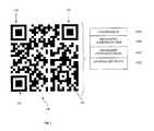
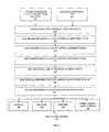
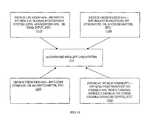
- FIG. 2illustrates a method for encoding the metadata 100 A- 100 D onto a marker such as DEM 100 .
- the methodmay be implemented by a computer with a processor running a program or application adapted to perform the illustrated steps/functions.
- the world coordinate data 100 C and the type of this data 100 Bare input by a user or operator by any of a variety of input mechanisms (e.g., keyboard, mouse, touchscreen, and so on) and stored, at least temporarily, in memory/data storage.
- the optional additional metadata 100 Dmay also be provided at 211 by an operator or user of the computing device performing the method of FIG. 2 .
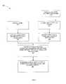
- the user device 400may also contain a DEM generator 445 that is capable of performing the steps shown in FIG. 2 to create a DEM (such as DEM 100 of FIG. 1 ).
- the generated DEMmay be displayed on the display device or screen 408 of the AR user device 400 for capturing as part of an input image by another one of the user devices 400 .
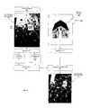
- the scaling factor computed in 665would then be ⁇ 50 m North (or 50 m South) and ⁇ 20 m East (or 20 m West).
- the digital model geometry 620would have to be moved 50 m South and 20 m West to be aligned with the AR system.
Landscapes
- Engineering & Computer Science (AREA)
- Physics & Mathematics (AREA)
- Theoretical Computer Science (AREA)
- Software Systems (AREA)
- General Physics & Mathematics (AREA)
- Geometry (AREA)
- Computer Graphics (AREA)
- Remote Sensing (AREA)
- Computer Vision & Pattern Recognition (AREA)
- Computer Hardware Design (AREA)
- General Engineering & Computer Science (AREA)
- Processing Or Creating Images (AREA)
- User Interface Of Digital Computer (AREA)
Abstract
Description
Claims (9)
Priority Applications (3)
| Application Number | Priority Date | Filing Date | Title |
|---|---|---|---|
| US13/487,513US10242456B2 (en) | 2011-06-23 | 2012-06-04 | Digitally encoded marker-based augmented reality (AR) |
| US16/262,526US10489930B2 (en) | 2011-06-23 | 2019-01-30 | Digitally encoded marker-based augmented reality (AR) |
| US16/686,737US11080885B2 (en) | 2011-06-23 | 2019-11-18 | Digitally encoded marker-based augmented reality (AR) |
Applications Claiming Priority (4)
| Application Number | Priority Date | Filing Date | Title |
|---|---|---|---|
| US201161500559P | 2011-06-23 | 2011-06-23 | |
| US201161534165P | 2011-09-13 | 2011-09-13 | |
| US201261609441P | 2012-03-12 | 2012-03-12 | |
| US13/487,513US10242456B2 (en) | 2011-06-23 | 2012-06-04 | Digitally encoded marker-based augmented reality (AR) |
Related Child Applications (1)
| Application Number | Title | Priority Date | Filing Date |
|---|---|---|---|
| US16/262,526ContinuationUS10489930B2 (en) | 2011-06-23 | 2019-01-30 | Digitally encoded marker-based augmented reality (AR) |
Publications (2)
| Publication Number | Publication Date |
|---|---|
| US20120327117A1 US20120327117A1 (en) | 2012-12-27 |
| US10242456B2true US10242456B2 (en) | 2019-03-26 |
Family
ID=47361427
Family Applications (3)
| Application Number | Title | Priority Date | Filing Date |
|---|---|---|---|
| US13/487,513Active2034-10-04US10242456B2 (en) | 2011-06-23 | 2012-06-04 | Digitally encoded marker-based augmented reality (AR) |
| US16/262,526Expired - Fee RelatedUS10489930B2 (en) | 2011-06-23 | 2019-01-30 | Digitally encoded marker-based augmented reality (AR) |
| US16/686,737Expired - Fee RelatedUS11080885B2 (en) | 2011-06-23 | 2019-11-18 | Digitally encoded marker-based augmented reality (AR) |
Family Applications After (2)
| Application Number | Title | Priority Date | Filing Date |
|---|---|---|---|
| US16/262,526Expired - Fee RelatedUS10489930B2 (en) | 2011-06-23 | 2019-01-30 | Digitally encoded marker-based augmented reality (AR) |
| US16/686,737Expired - Fee RelatedUS11080885B2 (en) | 2011-06-23 | 2019-11-18 | Digitally encoded marker-based augmented reality (AR) |
Country Status (1)
| Country | Link |
|---|---|
| US (3) | US10242456B2 (en) |
Cited By (4)
| Publication number | Priority date | Publication date | Assignee | Title |
|---|---|---|---|---|
| CN107833280A (en)* | 2017-11-09 | 2018-03-23 | 交通运输部天津水运工程科学研究所 | A kind of outdoor moving augmented reality method being combined based on geographic grid with image recognition |
| US11080885B2 (en)* | 2011-06-23 | 2021-08-03 | Limitless Computing, Inc. | Digitally encoded marker-based augmented reality (AR) |
| US20220375182A1 (en)* | 2019-06-20 | 2022-11-24 | Procore Technologies, Inc. | Computer System and Method for Creating an Augmented Environment Using QR Tape |
| US20240153220A1 (en)* | 2020-08-25 | 2024-05-09 | Diesel Holdings, Llc | Augmented reality application and method |
Families Citing this family (75)
| Publication number | Priority date | Publication date | Assignee | Title |
|---|---|---|---|---|
| JP5912059B2 (en)* | 2012-04-06 | 2016-04-27 | ソニー株式会社 | Information processing apparatus, information processing method, and information processing system |
| US10013623B2 (en)* | 2012-06-29 | 2018-07-03 | Blackberry Limited | System and method for determining the position of an object displaying media content |
| US9728008B2 (en)* | 2012-12-10 | 2017-08-08 | Nant Holdings Ip, Llc | Interaction analysis systems and methods |
| CN103049729B (en)* | 2012-12-30 | 2015-12-23 | 成都理想境界科技有限公司 | Based on the augmented reality method of Quick Response Code, system and terminal |
| CN103049728B (en)* | 2012-12-30 | 2016-02-03 | 成都理想境界科技有限公司 | Based on the augmented reality method of Quick Response Code, system and terminal |
| US9336629B2 (en) | 2013-01-30 | 2016-05-10 | F3 & Associates, Inc. | Coordinate geometry augmented reality process |
| CN103971400B (en)* | 2013-02-06 | 2018-02-02 | 阿里巴巴集团控股有限公司 | A kind of method and system of the three-dimension interaction based on identification code |
| US20140225814A1 (en)* | 2013-02-14 | 2014-08-14 | Apx Labs, Llc | Method and system for representing and interacting with geo-located markers |
| US9946963B2 (en) | 2013-03-01 | 2018-04-17 | Layar B.V. | Barcode visualization in augmented reality |
| CN103164518A (en)* | 2013-03-06 | 2013-06-19 | 杭州九树网络科技有限公司 | Mobile terminal (MT) augmented reality application system and method |
| US20140270477A1 (en)* | 2013-03-14 | 2014-09-18 | Jonathan Coon | Systems and methods for displaying a three-dimensional model from a photogrammetric scan |
| JP6255706B2 (en) | 2013-04-22 | 2018-01-10 | 富士通株式会社 | Display control apparatus, display control method, display control program, and information providing system |
| JP6167691B2 (en)* | 2013-06-26 | 2017-07-26 | カシオ計算機株式会社 | AR marker and AR marker display medium |
| KR101440766B1 (en)* | 2013-08-09 | 2014-09-18 | 디에스글로벌 (주) | Method for virtual image delivery service using printed matter |
| KR102133843B1 (en)* | 2013-10-31 | 2020-07-14 | 엘지전자 주식회사 | Apparatus and Method for Head Mounted Display indicating process of 3D printing |
| US20150219767A1 (en)* | 2014-02-03 | 2015-08-06 | Board Of Regents, The University Of Texas System | System and method for using global navigation satellite system (gnss) navigation and visual navigation to recover absolute position and attitude without any prior association of visual features with known coordinates |
| JP6244954B2 (en) | 2014-02-06 | 2017-12-13 | 富士通株式会社 | Terminal apparatus, information processing apparatus, display control method, and display control program |
| JP6217437B2 (en)* | 2014-02-14 | 2017-10-25 | 富士通株式会社 | Terminal apparatus, information processing apparatus, display control method, and display control program |
| US9613448B1 (en) | 2014-03-14 | 2017-04-04 | Google Inc. | Augmented display of information in a device view of a display screen |
| US20150302639A1 (en)* | 2014-03-26 | 2015-10-22 | Augmentecture, Inc. | Method and system for creating enhanced images including augmented reality features to be viewed on mobile devices with corresponding designs |
| US9728010B2 (en)* | 2014-12-30 | 2017-08-08 | Microsoft Technology Licensing, Llc | Virtual representations of real-world objects |
| CN104732477B (en)* | 2015-02-04 | 2018-03-16 | 长春理工大学 | Registration method based on Magnetic position tracker and motion capture system |
| US10289880B2 (en)* | 2015-03-09 | 2019-05-14 | Nizar RASHEED | Augmented reality memorial |
| CN106502554B (en)* | 2015-09-08 | 2021-09-17 | 腾讯科技(深圳)有限公司 | Display control method and device |
| US9964951B1 (en) | 2015-09-25 | 2018-05-08 | Amazon Technologies, Inc. | Fiducial-based navigation of unmanned vehicles |
| US11351472B2 (en) | 2016-01-19 | 2022-06-07 | Disney Enterprises, Inc. | Systems and methods for using a gyroscope to change the resistance of moving a virtual weapon |
| US10026229B1 (en)* | 2016-02-09 | 2018-07-17 | A9.Com, Inc. | Auxiliary device as augmented reality platform |
| US11663783B2 (en) | 2016-02-10 | 2023-05-30 | Disney Enterprises, Inc. | Systems and methods for using augmented reality with the internet of things |
| US10587834B2 (en) | 2016-03-07 | 2020-03-10 | Disney Enterprises, Inc. | Systems and methods for tracking objects for augmented reality |
| CN105933637A (en)* | 2016-04-26 | 2016-09-07 | 上海与德通讯技术有限公司 | Video communication method and system |
| JP2018005091A (en)* | 2016-07-06 | 2018-01-11 | 富士通株式会社 | Display control program, display control method and display controller |
| US10802787B2 (en)* | 2016-09-30 | 2020-10-13 | Sony Interactive Entertainment Inc. | Integrating audience participation content into virtual reality content |
| CN106297734B (en)* | 2016-10-20 | 2020-04-28 | 广州三星通信技术研究有限公司 | Screen brightness adjusting method and device for electronic terminal |
| CN106873768B (en)* | 2016-12-30 | 2020-05-05 | 中兴通讯股份有限公司 | Augmented reality method, device and system |
| WO2018221198A1 (en)* | 2017-05-31 | 2018-12-06 | 株式会社フジキン | System, method and computer program for managing semiconductor manufacturing apparatus |
| KR20180131856A (en)* | 2017-06-01 | 2018-12-11 | 에스케이플래닛 주식회사 | Method for providing of information about delivering products and apparatus terefor |
| US9928632B1 (en) | 2017-06-14 | 2018-03-27 | Capital One Services, Llc | Systems and methods for generating and reading intrinsic matrixed bar codes |
| JP2019128758A (en)* | 2018-01-24 | 2019-08-01 | セイコーエプソン株式会社 | Head-mounted display, and method for controlling head-mounted display |
| US10481680B2 (en) | 2018-02-02 | 2019-11-19 | Disney Enterprises, Inc. | Systems and methods to provide a shared augmented reality experience |
| US10546431B2 (en)* | 2018-03-29 | 2020-01-28 | Disney Enterprises, Inc. | Systems and methods to augment an appearance of physical object for an augmented reality experience |
| US11354815B2 (en) | 2018-05-23 | 2022-06-07 | Samsung Electronics Co., Ltd. | Marker-based augmented reality system and method |
| US10818093B2 (en) | 2018-05-25 | 2020-10-27 | Tiff's Treats Holdings, Inc. | Apparatus, method, and system for presentation of multimedia content including augmented reality content |
| US10984600B2 (en) | 2018-05-25 | 2021-04-20 | Tiff's Treats Holdings, Inc. | Apparatus, method, and system for presentation of multimedia content including augmented reality content |
| WO2020068086A1 (en)* | 2018-09-27 | 2020-04-02 | Hewlett-Packard Development Company, L.P. | Generating images for objects |
| US10974132B2 (en) | 2018-10-02 | 2021-04-13 | Disney Enterprises, Inc. | Systems and methods to provide a shared interactive experience across multiple presentation devices based on detection of one or more extraterrestrial bodies |
| KR20200064577A (en)* | 2018-11-29 | 2020-06-08 | 전자부품연구원 | Mobile Hologram Display Terminal for Augmented Reality |
| US12131590B2 (en)* | 2018-12-05 | 2024-10-29 | Xerox Corporation | Environment blended packaging |
| US10983672B2 (en)* | 2019-02-12 | 2021-04-20 | Caterpilar Inc. | Augmented reality model alignment |
| US11014008B2 (en) | 2019-03-27 | 2021-05-25 | Disney Enterprises, Inc. | Systems and methods for game profile development based on virtual and/or real activities |
| US10916061B2 (en) | 2019-04-24 | 2021-02-09 | Disney Enterprises, Inc. | Systems and methods to synchronize real-world motion of physical objects with presentation of virtual content |
| US11034092B2 (en) | 2019-06-17 | 2021-06-15 | International Business Machines Corporation | 3D-printed object with dynamic augmented-reality textures |
| WO2021013380A1 (en) | 2019-07-22 | 2021-01-28 | Sew-Eurodrive Gmbh & Co. Kg | Method for operating a system and system for carrying out the method |
| US11275453B1 (en) | 2019-09-30 | 2022-03-15 | Snap Inc. | Smart ring for manipulating virtual objects displayed by a wearable device |
| US11145117B2 (en)* | 2019-12-02 | 2021-10-12 | At&T Intellectual Property I, L.P. | System and method for preserving a configurable augmented reality experience |
| CN114730212B (en)* | 2019-12-05 | 2024-11-26 | Oppo广东移动通信有限公司 | Method and system for associating device coordinate systems in a multi-person AR system |
| US10777017B1 (en)* | 2020-01-24 | 2020-09-15 | Vertebrae Inc. | Augmented reality presentation using a uniform resource identifier |
| US11277597B1 (en) | 2020-03-31 | 2022-03-15 | Snap Inc. | Marker-based guided AR experience |
| US11610088B1 (en) | 2020-04-07 | 2023-03-21 | Apple Inc. | Time varying visual marker verification and decoding |
| US11798429B1 (en) | 2020-05-04 | 2023-10-24 | Snap Inc. | Virtual tutorials for musical instruments with finger tracking in augmented reality |
| US11232638B1 (en) | 2020-05-20 | 2022-01-25 | Bradley French | System and method for creating links to superimposable digital media content messages viewable on an electronic device |
| US11520399B2 (en) | 2020-05-26 | 2022-12-06 | Snap Inc. | Interactive augmented reality experiences using positional tracking |
| US12093763B2 (en) | 2020-06-19 | 2024-09-17 | Apple Inc. | Visual marker |
| US11925863B2 (en) | 2020-09-18 | 2024-03-12 | Snap Inc. | Tracking hand gestures for interactive game control in augmented reality |
| US11546505B2 (en) | 2020-09-28 | 2023-01-03 | Snap Inc. | Touchless photo capture in response to detected hand gestures |
| KR20230124732A (en) | 2020-12-29 | 2023-08-25 | 스냅 인코포레이티드 | Fine hand gestures to control virtual and graphical elements |
| US11740313B2 (en) | 2020-12-30 | 2023-08-29 | Snap Inc. | Augmented reality precision tracking and display |
| KR20230124077A (en) | 2020-12-30 | 2023-08-24 | 스냅 인코포레이티드 | Augmented reality precision tracking and display |
| US11531402B1 (en) | 2021-02-25 | 2022-12-20 | Snap Inc. | Bimanual gestures for controlling virtual and graphical elements |
| EP4320502A1 (en) | 2021-04-08 | 2024-02-14 | Snap, Inc. | Bimanual interactions between mapped hand regions for controlling virtual and graphical elements |
| US11861070B2 (en) | 2021-04-19 | 2024-01-02 | Snap Inc. | Hand gestures for animating and controlling virtual and graphical elements |
| CN113240798B (en)* | 2021-05-19 | 2022-04-22 | 郑州轻工业大学 | Intelligent detection and configuration method of material completeness based on digital twin and AR |
| CN113610986B (en)* | 2021-07-06 | 2024-04-23 | 同济大学 | A digital-physical coupling method and system based on biological invariant characteristics |
| CN116737028A (en)* | 2022-03-02 | 2023-09-12 | 北京字跳网络技术有限公司 | Short video playing method and device and electronic equipment |
| US12149539B2 (en) | 2022-04-28 | 2024-11-19 | Charter Communications Operating, Llc | Managing functionality of a computing device to interact with field equipment |
| US11928777B1 (en)* | 2023-05-03 | 2024-03-12 | Katmai Tech Inc. | Using optical labels in a virtual environment |
Citations (59)
| Publication number | Priority date | Publication date | Assignee | Title |
|---|---|---|---|---|
| US4096992A (en) | 1976-09-06 | 1978-06-27 | Nippondenso Co., Ltd. | System for recognizing bar code information |
| US5428212A (en) | 1992-12-21 | 1995-06-27 | Asahi Kogaku Kogyo Kabushiki Kaisha | Encoded symbol reader |
| US5554841A (en) | 1994-03-01 | 1996-09-10 | Lynn Ltd. | Article marker and decoding method |
| US20010038718A1 (en)* | 1997-05-09 | 2001-11-08 | Rakesh Kumar | Method and apparatus for performing geo-spatial registration of imagery |
| US6330356B1 (en) | 1999-09-29 | 2001-12-11 | Rockwell Science Center Llc | Dynamic visual registration of a 3-D object with a graphical model |
| US20020052709A1 (en)* | 2000-09-19 | 2002-05-02 | Olympus Optical Co., Ltd. | Three-dimensional position/orientation sensing apparatus, information presenting system, and model error detecting system |
| US20030076980A1 (en) | 2001-10-04 | 2003-04-24 | Siemens Corporate Research, Inc.. | Coded visual markers for tracking and camera calibration in mobile computing systems |
| US20030080978A1 (en)* | 2001-10-04 | 2003-05-01 | Nassir Navab | Augmented reality system |
| US20040046779A1 (en)* | 2002-05-24 | 2004-03-11 | Olympus Optical Co., Ltd. | Information presentation system of visual field agreement type, and portable information terminal and server for use in the system |
| US6937255B2 (en)* | 2003-03-20 | 2005-08-30 | Tama-Tlo, Ltd. | Imaging apparatus and method of the same |
| US20060038833A1 (en) | 2004-08-19 | 2006-02-23 | Mallinson Dominic S | Portable augmented reality device and method |
| US7127082B2 (en) | 2002-09-27 | 2006-10-24 | Hrl Laboratories, Llc | Active fiducials for augmented reality |
| US20070038944A1 (en) | 2005-05-03 | 2007-02-15 | Seac02 S.R.I. | Augmented reality system with real marker object identification |
| US20070098234A1 (en)* | 2005-10-31 | 2007-05-03 | Mark Fiala | Marker and method for detecting said marker |
| US20070143082A1 (en)* | 2005-12-15 | 2007-06-21 | Degnan Donald A | Method and System for Virtual Decoration |
| US7295220B2 (en)* | 2004-05-28 | 2007-11-13 | National University Of Singapore | Interactive system and method |
| US20070273644A1 (en)* | 2004-11-19 | 2007-11-29 | Ignacio Mondine Natucci | Personal device with image-acquisition functions for the application of augmented reality resources and method |
| US7343278B2 (en) | 2002-10-22 | 2008-03-11 | Artoolworks, Inc. | Tracking a surface in a 3-dimensional scene using natural visual features of the surface |
| US20080147325A1 (en) | 2006-12-18 | 2008-06-19 | Maassel Paul W | Method and system for providing augmented reality |
| US7398930B2 (en) | 1994-03-04 | 2008-07-15 | Hand Held Products, Inc. | Bar code reading device having image data in plurality of different formats |
| US20080266323A1 (en) | 2007-04-25 | 2008-10-30 | Board Of Trustees Of Michigan State University | Augmented reality user interaction system |
| US7529387B2 (en)* | 2004-05-14 | 2009-05-05 | Canon Kabushiki Kaisha | Placement information estimating method and information processing device |
| US20090289955A1 (en)* | 2008-05-22 | 2009-11-26 | Yahoo! Inc. | Reality overlay device |
| US20100033484A1 (en)* | 2006-12-05 | 2010-02-11 | Nac-Woo Kim | Personal-oriented multimedia studio platform apparatus and method for authorization 3d content |
| US7671875B2 (en)* | 2004-09-28 | 2010-03-02 | Canon Kabushiki Kaisha | Information processing method and apparatus |
| US20100057586A1 (en)* | 2008-09-04 | 2010-03-04 | China Software Venture | Offer Reporting Apparatus and Method |
| US20100092079A1 (en)* | 2008-10-14 | 2010-04-15 | Joshua Victor Aller | Target and method of detecting, identifying, and determining 3-d pose of the target |
| US20100091096A1 (en)* | 2008-10-10 | 2010-04-15 | Canon Kabushiki Kaisha | Image processing apparatus and image processing method |
| US7719563B2 (en)* | 2003-12-11 | 2010-05-18 | Angus Richards | VTV system |
| US20100230328A1 (en) | 2009-03-16 | 2010-09-16 | United States Postal Service | Intelligent barcode systems |
| US20100289817A1 (en)* | 2007-09-25 | 2010-11-18 | Metaio Gmbh | Method and device for illustrating a virtual object in a real environment |
| US7840340B2 (en) | 2007-04-13 | 2010-11-23 | United Parcel Service Of America, Inc. | Systems, methods, and computer program products for generating reference geocodes for point addresses |
| US7850067B1 (en) | 2007-11-27 | 2010-12-14 | Sprint Communications Company L.P. | Color bar codes |
| US7886978B2 (en) | 2007-09-20 | 2011-02-15 | Microsoft Corporation | Techniques for decoding images of barcodes |
| US20110052083A1 (en)* | 2009-09-02 | 2011-03-03 | Junichi Rekimoto | Information providing method and apparatus, information display method and mobile terminal, program, and information providing system |
| US20110134108A1 (en)* | 2009-12-07 | 2011-06-09 | International Business Machines Corporation | Interactive three-dimensional augmented realities from item markers for on-demand item visualization |
| US20110141254A1 (en)* | 2009-11-17 | 2011-06-16 | Roebke Mark J | Systems and methods for augmented reality |
| US20110148924A1 (en)* | 2009-12-22 | 2011-06-23 | John Tapley | Augmented reality system method and appartus for displaying an item image in acontextual environment |
| US20110164163A1 (en)* | 2010-01-05 | 2011-07-07 | Apple Inc. | Synchronized, interactive augmented reality displays for multifunction devices |
| US8019148B2 (en) | 2007-03-29 | 2011-09-13 | Canon Kabushiki Kaisha | Image processing apparatus and image processing method |
| US20110305368A1 (en)* | 2010-06-11 | 2011-12-15 | Nintendo Co., Ltd. | Storage medium having image recognition program stored therein, image recognition apparatus, image recognition system, and image recognition method |
| US20110310087A1 (en)* | 2010-06-16 | 2011-12-22 | Qualcomm Incorporated | User interface transition between camera view and map view |
| US20120069051A1 (en)* | 2008-09-11 | 2012-03-22 | Netanel Hagbi | Method and System for Compositing an Augmented Reality Scene |
| US20120086727A1 (en)* | 2010-10-08 | 2012-04-12 | Nokia Corporation | Method and apparatus for generating augmented reality content |
| US20120113141A1 (en)* | 2010-11-09 | 2012-05-10 | Cbs Interactive Inc. | Techniques to visualize products using augmented reality |
| US20120147039A1 (en)* | 2010-12-13 | 2012-06-14 | Pantech Co., Ltd. | Terminal and method for providing augmented reality |
| US8226011B2 (en)* | 2005-04-06 | 2012-07-24 | Eidgenoessische Technische Hochshcule Zuerich | Method of executing an application in a mobile device |
| US20120218300A1 (en)* | 2011-02-25 | 2012-08-30 | Nintendo Co., Ltd. | Image processing system, method and apparatus, and computer-readable medium recording image processing program |
| US8384770B2 (en)* | 2010-06-02 | 2013-02-26 | Nintendo Co., Ltd. | Image display system, image display apparatus, and image display method |
| US20130141461A1 (en)* | 2011-12-06 | 2013-06-06 | Tom Salter | Augmented reality camera registration |
| US8542906B1 (en)* | 2008-05-21 | 2013-09-24 | Sprint Communications Company L.P. | Augmented reality image offset and overlay |
| US20140022281A1 (en)* | 2012-07-18 | 2014-01-23 | The Boeing Company | Projecting airplane location specific maintenance history using optical reference points |
| US8823697B2 (en)* | 2008-02-12 | 2014-09-02 | Gwangju Institute Of Science And Technology | Tabletop, mobile augmented reality system for personalization and cooperation, and interaction method using augmented reality |
| US8854356B2 (en)* | 2010-09-28 | 2014-10-07 | Nintendo Co., Ltd. | Storage medium having stored therein image processing program, image processing apparatus, image processing system, and image processing method |
| US8922588B2 (en)* | 2011-08-31 | 2014-12-30 | Nintendo Co., Ltd. | Information processing program, information processing system, information processing apparatus, and information processing method, utilizing augmented reality technique |
| US9013505B1 (en)* | 2007-11-27 | 2015-04-21 | Sprint Communications Company L.P. | Mobile system representing virtual objects on live camera image |
| US9058764B1 (en)* | 2007-11-30 | 2015-06-16 | Sprint Communications Company L.P. | Markers to implement augmented reality |
| US9278281B2 (en)* | 2010-09-27 | 2016-03-08 | Nintendo Co., Ltd. | Computer-readable storage medium, information processing apparatus, information processing system, and information processing method |
| US9383262B2 (en)* | 2009-10-23 | 2016-07-05 | Testo Ag | Imaging inspection device |
Family Cites Families (7)
| Publication number | Priority date | Publication date | Assignee | Title |
|---|---|---|---|---|
| JP4253567B2 (en)* | 2003-03-28 | 2009-04-15 | オリンパス株式会社 | Data authoring processor |
| JP5084167B2 (en)* | 2006-03-31 | 2012-11-28 | キヤノン株式会社 | Position and orientation measurement method and apparatus |
| US7542821B2 (en)* | 2007-07-26 | 2009-06-02 | 3M Innovative Properties Company | Multi-unit process spatial synchronization of image inspection systems |
| JP5423406B2 (en)* | 2010-01-08 | 2014-02-19 | ソニー株式会社 | Information processing apparatus, information processing system, and information processing method |
| JP5704962B2 (en)* | 2011-02-25 | 2015-04-22 | 任天堂株式会社 | Information processing system, information processing method, information processing apparatus, and information processing program |
| US8817046B2 (en)* | 2011-04-21 | 2014-08-26 | Microsoft Corporation | Color channels and optical markers |
| US10242456B2 (en)* | 2011-06-23 | 2019-03-26 | Limitless Computing, Inc. | Digitally encoded marker-based augmented reality (AR) |
- 2012
- 2012-06-04USUS13/487,513patent/US10242456B2/enactiveActive
- 2019
- 2019-01-30USUS16/262,526patent/US10489930B2/ennot_activeExpired - Fee Related
- 2019-11-18USUS16/686,737patent/US11080885B2/ennot_activeExpired - Fee Related
Patent Citations (65)
| Publication number | Priority date | Publication date | Assignee | Title |
|---|---|---|---|---|
| US4096992A (en) | 1976-09-06 | 1978-06-27 | Nippondenso Co., Ltd. | System for recognizing bar code information |
| US5428212A (en) | 1992-12-21 | 1995-06-27 | Asahi Kogaku Kogyo Kabushiki Kaisha | Encoded symbol reader |
| US5554841A (en) | 1994-03-01 | 1996-09-10 | Lynn Ltd. | Article marker and decoding method |
| US7398930B2 (en) | 1994-03-04 | 2008-07-15 | Hand Held Products, Inc. | Bar code reading device having image data in plurality of different formats |
| US20010038718A1 (en)* | 1997-05-09 | 2001-11-08 | Rakesh Kumar | Method and apparatus for performing geo-spatial registration of imagery |
| US6330356B1 (en) | 1999-09-29 | 2001-12-11 | Rockwell Science Center Llc | Dynamic visual registration of a 3-D object with a graphical model |
| US20020052709A1 (en)* | 2000-09-19 | 2002-05-02 | Olympus Optical Co., Ltd. | Three-dimensional position/orientation sensing apparatus, information presenting system, and model error detecting system |
| US7274380B2 (en)* | 2001-10-04 | 2007-09-25 | Siemens Corporate Research, Inc. | Augmented reality system |
| US7809194B2 (en) | 2001-10-04 | 2010-10-05 | Siemens Corporation | Coded visual markers for tracking and camera calibration in mobile computing systems |
| US20030076980A1 (en) | 2001-10-04 | 2003-04-24 | Siemens Corporate Research, Inc.. | Coded visual markers for tracking and camera calibration in mobile computing systems |
| US20030080978A1 (en)* | 2001-10-04 | 2003-05-01 | Nassir Navab | Augmented reality system |
| US20040046779A1 (en)* | 2002-05-24 | 2004-03-11 | Olympus Optical Co., Ltd. | Information presentation system of visual field agreement type, and portable information terminal and server for use in the system |
| US7127082B2 (en) | 2002-09-27 | 2006-10-24 | Hrl Laboratories, Llc | Active fiducials for augmented reality |
| US7343278B2 (en) | 2002-10-22 | 2008-03-11 | Artoolworks, Inc. | Tracking a surface in a 3-dimensional scene using natural visual features of the surface |
| US6937255B2 (en)* | 2003-03-20 | 2005-08-30 | Tama-Tlo, Ltd. | Imaging apparatus and method of the same |
| US7719563B2 (en)* | 2003-12-11 | 2010-05-18 | Angus Richards | VTV system |
| US7529387B2 (en)* | 2004-05-14 | 2009-05-05 | Canon Kabushiki Kaisha | Placement information estimating method and information processing device |
| US7295220B2 (en)* | 2004-05-28 | 2007-11-13 | National University Of Singapore | Interactive system and method |
| US20060038833A1 (en) | 2004-08-19 | 2006-02-23 | Mallinson Dominic S | Portable augmented reality device and method |
| US7671875B2 (en)* | 2004-09-28 | 2010-03-02 | Canon Kabushiki Kaisha | Information processing method and apparatus |
| US20070273644A1 (en)* | 2004-11-19 | 2007-11-29 | Ignacio Mondine Natucci | Personal device with image-acquisition functions for the application of augmented reality resources and method |
| US8226011B2 (en)* | 2005-04-06 | 2012-07-24 | Eidgenoessische Technische Hochshcule Zuerich | Method of executing an application in a mobile device |
| US20070038944A1 (en) | 2005-05-03 | 2007-02-15 | Seac02 S.R.I. | Augmented reality system with real marker object identification |
| US7769236B2 (en) | 2005-10-31 | 2010-08-03 | National Research Council Of Canada | Marker and method for detecting said marker |
| US20070098234A1 (en)* | 2005-10-31 | 2007-05-03 | Mark Fiala | Marker and method for detecting said marker |
| US20070143082A1 (en)* | 2005-12-15 | 2007-06-21 | Degnan Donald A | Method and System for Virtual Decoration |
| US20100033484A1 (en)* | 2006-12-05 | 2010-02-11 | Nac-Woo Kim | Personal-oriented multimedia studio platform apparatus and method for authorization 3d content |
| US20100171758A1 (en)* | 2006-12-18 | 2010-07-08 | Reallaer LLC | Method and system for generating augmented reality signals |
| US20080147325A1 (en) | 2006-12-18 | 2008-06-19 | Maassel Paul W | Method and system for providing augmented reality |
| US8019148B2 (en) | 2007-03-29 | 2011-09-13 | Canon Kabushiki Kaisha | Image processing apparatus and image processing method |
| US7840340B2 (en) | 2007-04-13 | 2010-11-23 | United Parcel Service Of America, Inc. | Systems, methods, and computer program products for generating reference geocodes for point addresses |
| US20080266323A1 (en) | 2007-04-25 | 2008-10-30 | Board Of Trustees Of Michigan State University | Augmented reality user interaction system |
| US7886978B2 (en) | 2007-09-20 | 2011-02-15 | Microsoft Corporation | Techniques for decoding images of barcodes |
| US20100289817A1 (en)* | 2007-09-25 | 2010-11-18 | Metaio Gmbh | Method and device for illustrating a virtual object in a real environment |
| US9013505B1 (en)* | 2007-11-27 | 2015-04-21 | Sprint Communications Company L.P. | Mobile system representing virtual objects on live camera image |
| US7850067B1 (en) | 2007-11-27 | 2010-12-14 | Sprint Communications Company L.P. | Color bar codes |
| US9058764B1 (en)* | 2007-11-30 | 2015-06-16 | Sprint Communications Company L.P. | Markers to implement augmented reality |
| US8823697B2 (en)* | 2008-02-12 | 2014-09-02 | Gwangju Institute Of Science And Technology | Tabletop, mobile augmented reality system for personalization and cooperation, and interaction method using augmented reality |
| US8542906B1 (en)* | 2008-05-21 | 2013-09-24 | Sprint Communications Company L.P. | Augmented reality image offset and overlay |
| US20090289955A1 (en)* | 2008-05-22 | 2009-11-26 | Yahoo! Inc. | Reality overlay device |
| US20100057586A1 (en)* | 2008-09-04 | 2010-03-04 | China Software Venture | Offer Reporting Apparatus and Method |
| US20120069051A1 (en)* | 2008-09-11 | 2012-03-22 | Netanel Hagbi | Method and System for Compositing an Augmented Reality Scene |
| US20100091096A1 (en)* | 2008-10-10 | 2010-04-15 | Canon Kabushiki Kaisha | Image processing apparatus and image processing method |
| US20100092079A1 (en)* | 2008-10-14 | 2010-04-15 | Joshua Victor Aller | Target and method of detecting, identifying, and determining 3-d pose of the target |
| US20100230328A1 (en) | 2009-03-16 | 2010-09-16 | United States Postal Service | Intelligent barcode systems |
| US20110052083A1 (en)* | 2009-09-02 | 2011-03-03 | Junichi Rekimoto | Information providing method and apparatus, information display method and mobile terminal, program, and information providing system |
| US9383262B2 (en)* | 2009-10-23 | 2016-07-05 | Testo Ag | Imaging inspection device |
| US20110141254A1 (en)* | 2009-11-17 | 2011-06-16 | Roebke Mark J | Systems and methods for augmented reality |
| US20110134108A1 (en)* | 2009-12-07 | 2011-06-09 | International Business Machines Corporation | Interactive three-dimensional augmented realities from item markers for on-demand item visualization |
| US20110148924A1 (en)* | 2009-12-22 | 2011-06-23 | John Tapley | Augmented reality system method and appartus for displaying an item image in acontextual environment |
| US20110164163A1 (en)* | 2010-01-05 | 2011-07-07 | Apple Inc. | Synchronized, interactive augmented reality displays for multifunction devices |
| US8384770B2 (en)* | 2010-06-02 | 2013-02-26 | Nintendo Co., Ltd. | Image display system, image display apparatus, and image display method |
| US20110305368A1 (en)* | 2010-06-11 | 2011-12-15 | Nintendo Co., Ltd. | Storage medium having image recognition program stored therein, image recognition apparatus, image recognition system, and image recognition method |
| US8731332B2 (en)* | 2010-06-11 | 2014-05-20 | Nintendo Co., Ltd. | Storage medium having image recognition program stored therein, image recognition apparatus, image recognition system, and image recognition method |
| US20110310087A1 (en)* | 2010-06-16 | 2011-12-22 | Qualcomm Incorporated | User interface transition between camera view and map view |
| US9278281B2 (en)* | 2010-09-27 | 2016-03-08 | Nintendo Co., Ltd. | Computer-readable storage medium, information processing apparatus, information processing system, and information processing method |
| US8854356B2 (en)* | 2010-09-28 | 2014-10-07 | Nintendo Co., Ltd. | Storage medium having stored therein image processing program, image processing apparatus, image processing system, and image processing method |
| US20120086727A1 (en)* | 2010-10-08 | 2012-04-12 | Nokia Corporation | Method and apparatus for generating augmented reality content |
| US20120113141A1 (en)* | 2010-11-09 | 2012-05-10 | Cbs Interactive Inc. | Techniques to visualize products using augmented reality |
| US20120147039A1 (en)* | 2010-12-13 | 2012-06-14 | Pantech Co., Ltd. | Terminal and method for providing augmented reality |
| US20120218300A1 (en)* | 2011-02-25 | 2012-08-30 | Nintendo Co., Ltd. | Image processing system, method and apparatus, and computer-readable medium recording image processing program |
| US8922588B2 (en)* | 2011-08-31 | 2014-12-30 | Nintendo Co., Ltd. | Information processing program, information processing system, information processing apparatus, and information processing method, utilizing augmented reality technique |
| US20130141461A1 (en)* | 2011-12-06 | 2013-06-06 | Tom Salter | Augmented reality camera registration |
| US20140022281A1 (en)* | 2012-07-18 | 2014-01-23 | The Boeing Company | Projecting airplane location specific maintenance history using optical reference points |
| US9448758B2 (en)* | 2012-07-18 | 2016-09-20 | The Boeing Company | Projecting airplane location specific maintenance history using optical reference points |
Cited By (7)
| Publication number | Priority date | Publication date | Assignee | Title |
|---|---|---|---|---|
| US11080885B2 (en)* | 2011-06-23 | 2021-08-03 | Limitless Computing, Inc. | Digitally encoded marker-based augmented reality (AR) |
| CN107833280A (en)* | 2017-11-09 | 2018-03-23 | 交通运输部天津水运工程科学研究所 | A kind of outdoor moving augmented reality method being combined based on geographic grid with image recognition |
| CN107833280B (en)* | 2017-11-09 | 2021-05-11 | 交通运输部天津水运工程科学研究所 | An Outdoor Mobile Augmented Reality Method Based on Geographic Grid and Image Recognition |
| US20220375182A1 (en)* | 2019-06-20 | 2022-11-24 | Procore Technologies, Inc. | Computer System and Method for Creating an Augmented Environment Using QR Tape |
| US11822988B2 (en)* | 2019-06-20 | 2023-11-21 | Procore Technologies, Inc. | Computer system and method for creating an augmented environment using QR tape |
| US12217109B2 (en) | 2019-06-20 | 2025-02-04 | Procore Technologies, Inc. | Creating an augmented environment using QR tape |
| US20240153220A1 (en)* | 2020-08-25 | 2024-05-09 | Diesel Holdings, Llc | Augmented reality application and method |
Also Published As
| Publication number | Publication date |
|---|---|
| US11080885B2 (en) | 2021-08-03 |
| US10489930B2 (en) | 2019-11-26 |
| US20200082563A1 (en) | 2020-03-12 |
| US20120327117A1 (en) | 2012-12-27 |
| US20190172221A1 (en) | 2019-06-06 |
Similar Documents
| Publication | Publication Date | Title |
|---|---|---|
| US11080885B2 (en) | Digitally encoded marker-based augmented reality (AR) | |
| US11393173B2 (en) | Mobile augmented reality system | |
| JP4958497B2 (en) | Position / orientation measuring apparatus, position / orientation measuring method, mixed reality presentation system, computer program, and storage medium | |
| US10225506B2 (en) | Information processing apparatus and information processing method | |
| US9031283B2 (en) | Sensor-aided wide-area localization on mobile devices | |
| US8872851B2 (en) | Augmenting image data based on related 3D point cloud data | |
| CN110794955B (en) | Positioning tracking method, device, terminal equipment and computer readable storage medium | |
| JP6625734B2 (en) | Method and apparatus for superimposing a virtual image on a photograph of a real scene, and a portable device | |
| KR20130092836A (en) | Apparatus and method of guiding designated seat based on augmented reality technique | |
| KR101863647B1 (en) | Hypothetical line mapping and verification for 3D maps | |
| Luley et al. | Mobile augmented reality for tourists–MARFT | |
| KR20120091749A (en) | Visualization system for augment reality and method thereof | |
| US10907977B1 (en) | Human-aided geo-rectification of geospatial metadata in video using a graphical interface | |
| JP2010158056A (en) | Link information display device, display method thereof, and link information processing system | |
| US9245192B2 (en) | Ad collateral detection | |
| KR101640020B1 (en) | Augmentated image providing system and method thereof | |
| Ayadi et al. | The skyline as a marker for augmented reality in urban context | |
| JP4497880B2 (en) | Index identification method and apparatus | |
| WO2023147376A1 (en) | Geo-spatial context for full-motion video | |
| CN113450439A (en) | Virtual-real fusion method, device and system |
Legal Events
| Date | Code | Title | Description |
|---|---|---|---|
| AS | Assignment | Owner name:LIMITLESS COMPUTING, INC., COLORADO Free format text:ASSIGNMENT OF ASSIGNORS INTEREST;ASSIGNOR:MODERN GRIDS, INC.;REEL/FRAME:028311/0122 Effective date:20120425 | |
| STCF | Information on status: patent grant | Free format text:PATENTED CASE | |
| AS | Assignment | Owner name:MODERN GRIDS, INC., COLORADO Free format text:ASSIGNMENT OF ASSIGNORS INTEREST;ASSIGNORS:FRANKLIN, JEFFREY B.;WELLER, ERRIN T.;REEL/FRAME:058006/0202 Effective date:20110801 | |
| AS | Assignment | Owner name:IP3 2021, SERIES 600 OF ALLIED SECURITY TRUST I, NEW JERSEY Free format text:ASSIGNMENT OF ASSIGNORS INTEREST;ASSIGNOR:LIMITLESS COMPUTING, INC.;REEL/FRAME:058119/0870 Effective date:20211108 | |
| FEPP | Fee payment procedure | Free format text:ENTITY STATUS SET TO UNDISCOUNTED (ORIGINAL EVENT CODE: BIG.); ENTITY STATUS OF PATENT OWNER: LARGE ENTITY | |
| FEPP | Fee payment procedure | Free format text:MAINTENANCE FEE REMINDER MAILED (ORIGINAL EVENT CODE: REM.); ENTITY STATUS OF PATENT OWNER: LARGE ENTITY | |
| FEPP | Fee payment procedure | Free format text:SURCHARGE FOR LATE PAYMENT, LARGE ENTITY (ORIGINAL EVENT CODE: M1554); ENTITY STATUS OF PATENT OWNER: LARGE ENTITY | |
| MAFP | Maintenance fee payment | Free format text:PAYMENT OF MAINTENANCE FEE, 4TH YEAR, LARGE ENTITY (ORIGINAL EVENT CODE: M1551); ENTITY STATUS OF PATENT OWNER: LARGE ENTITY Year of fee payment:4 | |
| AS | Assignment | Owner name:GEOSYMM VENTURES LLC, TEXAS Free format text:ASSIGNMENT OF ASSIGNORS INTEREST;ASSIGNOR:IP3 2021, SERIES 600 0F ALLIED SECURITY TRUST;REEL/FRAME:063984/0711 Effective date:20230602 |