US10109094B2 - Interface to index and display geospatial data - Google Patents
Interface to index and display geospatial dataDownload PDFInfo
- Publication number
- US10109094B2 US10109094B2US15/258,715US201615258715AUS10109094B2US 10109094 B2US10109094 B2US 10109094B2US 201615258715 AUS201615258715 AUS 201615258715AUS 10109094 B2US10109094 B2US 10109094B2
- Authority
- US
- United States
- Prior art keywords
- data
- geospatial
- display
- base layer
- point
- Prior art date
- Legal status (The legal status is an assumption and is not a legal conclusion. Google has not performed a legal analysis and makes no representation as to the accuracy of the status listed.)
- Active, expires
Links
Images


Classifications
- G—PHYSICS
- G06—COMPUTING OR CALCULATING; COUNTING
- G06F—ELECTRIC DIGITAL DATA PROCESSING
- G06F16/00—Information retrieval; Database structures therefor; File system structures therefor
- G06F16/20—Information retrieval; Database structures therefor; File system structures therefor of structured data, e.g. relational data
- G06F16/29—Geographical information databases
- G—PHYSICS
- G06—COMPUTING OR CALCULATING; COUNTING
- G06T—IMAGE DATA PROCESSING OR GENERATION, IN GENERAL
- G06T11/00—2D [Two Dimensional] image generation
- G06T11/60—Editing figures and text; Combining figures or text
- G06F17/30241—
- G—PHYSICS
- G06—COMPUTING OR CALCULATING; COUNTING
- G06T—IMAGE DATA PROCESSING OR GENERATION, IN GENERAL
- G06T11/00—2D [Two Dimensional] image generation
- G06T11/20—Drawing from basic elements, e.g. lines or circles
- G06T11/206—Drawing of charts or graphs
- G—PHYSICS
- G06—COMPUTING OR CALCULATING; COUNTING
- G06F—ELECTRIC DIGITAL DATA PROCESSING
- G06F3/00—Input arrangements for transferring data to be processed into a form capable of being handled by the computer; Output arrangements for transferring data from processing unit to output unit, e.g. interface arrangements
- G06F3/01—Input arrangements or combined input and output arrangements for interaction between user and computer
- G06F3/048—Interaction techniques based on graphical user interfaces [GUI]
- G06F3/0484—Interaction techniques based on graphical user interfaces [GUI] for the control of specific functions or operations, e.g. selecting or manipulating an object, an image or a displayed text element, setting a parameter value or selecting a range
- G06F3/04847—Interaction techniques to control parameter settings, e.g. interaction with sliders or dials
- G—PHYSICS
- G06—COMPUTING OR CALCULATING; COUNTING
- G06T—IMAGE DATA PROCESSING OR GENERATION, IN GENERAL
- G06T2200/00—Indexing scheme for image data processing or generation, in general
- G06T2200/24—Indexing scheme for image data processing or generation, in general involving graphical user interfaces [GUIs]
Definitions
- the subject matter disclosed hereingenerally relates to interfaces configured to index and display geospatial data.
- example embodimentsrelate to a system to receive, and display geospatial vector data.
- a geographic information systemis a system designed to capture, store, manipulate, analyze, manage, and present geospatial data.
- First responders and other professionals and non-professionals in search and rescue groupsoften use geographic information systems to identify areas which may be affected by natural disasters, or other similar events.
- FIG. 1is a network diagram illustrating a network environment suitable for causing display of a geospatial interface configured to receive and index geospatial data, according to some example embodiments.
- FIG. 2is a block diagram illustrating components of a geospatial interface system suitable to receive and index geospatial data, according to some example embodiments.
- FIG. 3is a flowchart illustrating operations of the geospatial interface system in performing a method for updating a display of geospatial data within a geospatial interface, according to some example embodiments.
- FIG. 4is a flowchart illustrating operations of the geospatial interface system in performing a method for updating a display of geospatial data within a geospatial interface, according to some example embodiments.
- FIG. 5is a flowchart illustrating operations of the geospatial interface system in performing a method for updating a display of geospatial data within a geospatial interface, according to some example embodiments.
- FIG. 6is a flowchart illustrating operations of the geospatial interface system in performing a method for updating a display of geospatial data within a geospatial interface, according to some example embodiments.
- FIG. 7is an interaction diagram illustrating various example interactions between the geospatial interface system, a source device, and a client device, according to some example embodiments.
- FIG. 8is a diagram illustrating a geospatial interface configured to present geospatial data, according to some example embodiments.
- FIG. 9is a diagram illustrating a geospatial interface configured to present geospatial data, according to some example embodiments.
- FIG. 10is a diagram illustrating a geospatial interface configured to present geospatial data, according to some example embodiments.
- FIG. 11is a diagram illustrating a geospatial interface configured to present geospatial data, according to some example embodiments.
- FIG. 12is a block diagram illustrating components of a machine, according to some example embodiments, able to read instructions from a machine-readable medium and perform any one or more of the methodologies discussed herein.
- Example embodiments described hereinpertain to a geospatial interface system configured to cause display of geospatial data within a graphical user interface at a client device, receive data points from multiple data sources, unify the data points, and present the unified data points as interactive graphical elements within the graphical user interface, in a presentation layer separate from the geospatial data.
- the geospatial interface systemmay be or include a group of one or more server machines configured to provide one or more geospatial data display, indexing, and management services.
- a client devicemay accordingly display a graphical user interface generated by the geospatial interface system.
- the geospatial interface systemis configured (e.g., by one or more suitable modules that include one or more processors) to cause display of geospatial data (e.g., map images, a base layer with a coordinate plane) within a graphical user interface at a client device, receive data points from data sources, and overlay graphical representations of the data points at locations on the base layer of the geospatial data based on metadata of the data points and a coordinate reference system of the map itself.
- the data pointsmay include metadata comprising vector and temporal data, as well as identification data.
- the data pointmay additionally include styling data that dictates stylistic and visual elements of the geospatial data useable to generate a raster image (rather than actually storing a raster image).
- Vector datacomes in the form of points and lines that are geometrically and mathematically associated.
- the data points thereformay be stored and displayed based on a set of coordinates.
- a two-dimensional pointis stored as (x, y)
- a line segmentis stored as a series of point pairs, where each pair represents a straight line segment, for example, (x1, y1) and (x2, y2) indicating a line from (x1, y1) to (x2, y2).
- the vector datais assembled by the geospatial interface system based on the temporal data (e.g., a time series).
- Vector dataproduces smaller file size than, for example, a raster image, because a raster image needs space for all pixels while only point coordinates are stored in vector representation.
- the temporal datamay indicate a time stamp, frequency, or interval in which the data is received.
- the metadata of the data pointsmay also include identification and text data, such as a description associated with the data point.
- a data pointmay include text indicating a label for the data point (e.g., EVACUATION ZONE), or a family identifier, to describe a source of the data point (e.g., AMBULANCE-1).
- the text datamay include a description or summarization to be transmitted to the geospatial interface system.
- the geospatial interface systemUpon receiving the data points from the data source (or sources), the geospatial interface system links the data points to other associated data points displayed within the graphical user interface. For example, data points may be associated based on having a common source, a common family identifier, or based on a user input to link two or more data points. Having linked the associated data points, the geospatial interface system updates the display.
- the geospatial interface systemmay be further configured to facilitate searching sets of data points displayed within the graphical user interface. For example, consider an example embodiment where the geospatial data displayed within the graphical user interface comprises a map image and a base layer with a coordinate system, and the data points are overlaid at locations on the base layer based on associated vector data. To search for and identify relevant data points, a user may provide an input directly into the graphical user interface, specifying a boundary, or a point or line with a radius, to specify a search region. In response, the geospatial interface system causes display of a set of data points located within the specified region.
- the usermay specify search criteria, such as temporal constraints (e.g., within the last hour, day, week, month, or the last ten data points from this source) or search terms, in order to identify only those data points received within the specified span of time, frequency, or chronology.
- search criteriasuch as temporal constraints (e.g., within the last hour, day, week, month, or the last ten data points from this source) or search terms, in order to identify only those data points received within the specified span of time, frequency, or chronology.
- the geospatial interface systemmay then identify data points having temporal data within the specified time frame, or text data matching the search terms to display within the graphical user interface.
- the geospatial interface systemmay present an interface to enable a user to assign a family identifier, as well as a data retrieval interval to one or more data sources.
- data received from a data sourcemay then be automatically linked with other data points of the same family (e.g., based on the family identifier).
- the geospatial interface systemmay ping the data source at intervals defined by the user input to retrieve data points.
- a usere.g., a first responder
- the geospatial interface systemgenerates and causes display of a graphical user interface at the client device
- the graphical user interfaceincludes a presentation of a map image (e.g., a region affected by a natural disaster) over a base layer with a coordinate system, with a set of graphical representations of data points received from data sources (e.g., search and rescue teams, firetrucks, ambulances) overlaid on the map image at various locations based on associated metadata.
- the data pointsmay be represented as color coded points, such that each family identifier includes a corresponding color (e.g., blue indicates a particular ambulance or set of ambulances, red indicates a firetruck or set of firetrucks).
- the geospatial interface systemcauses display of a dialogue box containing display criteria.
- the display criteriamay include temporal constraints for the associated family identifier.
- the usermay wish to display the last ten data points received from a particular family indictor (or individual data source), or alternatively, may choose to define a range of time (e.g., from 12:00 PM to 3:00 PM).
- the geospatial interface systemupdates the graphical user interface to display only the set of data points which fit within the temporal constraint, based on associated metadata (e.g., the temporal data).
- the geospatial interface systemmay also update the map image displayed to correspond to the defined temporal constraint, by including only those images which were taken during the span of time.
- the usermay define a boundary on the map image, by drawing a polygon on the map image, or placing a point or line segment, and defining a radius from the point or line segment.
- the geospatial interface systemdisplays all data points which exist within the enclosed region or boundary, based on their metadata. For example, the user may want information describing how many first responder had been to a particular area, and when the first responders were there. By defining a boundary enclosing the region, the user can then access the relevant data.
- the geospatial interface systemmay receive and index data points pertaining to a location from a data source (e.g., GPS module), wherein the data points include vector and temporal data.
- a data sourcee.g., GPS module
- the geospatial interface systemretrieves and buckets and presents each data point by time (e.g., based on the temporal data) in order to convey temporal elements of the data.
- the usermay define a region by placing a boundary, or placing a point on the map image, and assigning text data to the point or boundary (e.g., “Evacuate to this area”).
- the geospatial interface systemmay then transmit a notification to personnel, and cause display of the point or boundary with the text data at client devices of personnel who are also accessing the geospatial interface system.
- the usermay define specific personnel associated with data sources (e.g., an ambulance) to notify.
- FIG. 1is a network diagram illustrating a network environment 100 suitable for operating a geospatial interface system 142 , according to some example embodiments.
- a networked system 102provides server-side functionality, via a network 104 (e.g., an Intranet, the Internet or a Wide Area Network (WAN)), to one or more clients.
- FIG. 1illustrates, for example, a web client 112 (e.g. a web browser), client application(s) 114 , and a programmatic client 116 executing on respective client device 110 .
- a web client 112e.g. a web browser
- client application(s) 114e.g. a web browser
- programmatic client 116e.g. a programmatic client 116 executing on respective client device 110 .
- An Application Program Interface (API) server 120 and a web server 122are coupled to, and provide programmatic and web interfaces respectively to, one or more application server 140 .
- the application server(s) 140host the geospatial interface system 142 .
- the application servers 140are, in turn, shown to be coupled to one or more database servers 124 that facilitate access to one or more databases 126 .
- the geospatial interface system 142is a server application with a web front-end that causes display of geospatial data, including for example map images and a base layer with a coordinate system, within a graphical user interface at a client device 110 .
- the geospatial interface system 142receives and indexes data points received from data sources, and displays graphical representations of the data points within the graphical user interface.
- the geospatial information system 142may be configured to receive data points, determine a location on a base layer to overlay a graphical representation of the data point, and cause display of the graphical representation at the client device 110 . While the geospatial interface system 142 is shown in FIG. 1 to form part of the networked system 102 , it will be appreciated that, in alternative embodiments, the geospatial interface system 142 may form part of a system that is separate and distinct from the networked system 102 .
- FIG. 1also illustrates a client application 132 , executing on a source device 130 , as having programmatic access to the networked system 102 via the programmatic interface provided by the API server 120 .
- the source device 130may, for example, be a source of geospatial data useable by the geospatial interface system 142 .
- FIG. 2is a block diagram illustrating components of a geospatial interface system 142 suitable to generate and cause display of geospatial data within a graphical user interface, receive data points from multiple data sources, index and unify the data points by linking them with associated data points within the geospatial interface system 142 , and cause display of graphical representations of the data points within the graphical user interface, according to some example embodiments.
- each componente.g., a module or engine
- FIG. 2represents a set of executable software instructions and the corresponding hardware (e.g., memory and processor) for executing the instructions.
- the geospatial interface system 142is shown as including a data retrieval module 202 , an interface 204 , and an indexing module 206 , each of which is configured and communicatively coupled to communicate with the other modules (e.g., via a bus, shared memory, or a switch).
- Data pointsare obtained via the data retrieval module 202 , from one or more data sources (e.g., the source device 130 or the client device 110 ).
- the data retrieval module 202may receive a request to retrieve geospatial data from the source device 130 , or from the client device 110 .
- a user at the client device 110may define a data retrieval interval in the geospatial interface system 142 in which to receive data from the source device 130 .
- the data retrieval intervalmay include a frequency, and an identifier of the source device 130 .
- the data retrieval module 202retrieves data points from the source device 130 .
- the data retrieval module 220may request data points from the source source device 130 based on individual data retrieval requests received from the user at the client device 110 .
- the data retrieval module 202provides the data points to the indexing module 206 .
- the indexing module 206is configured to identify and index the data point, based on metadata associated with the data point. For example, the indexing module 206 may assign all data points received from a particular data source (e.g., source device 130 ) to a particular family identifier.
- a particular data sourcee.g., source device 130
- the data retrieval module 202After indexing the data points, the data retrieval module 202 provides the indexed data points to the interface module 204 .
- the interface module 204is configured to overlay a graphical representation of the data point at a location on the geospatial data within the graphical user interface.
- the interface module 204may extract vector data, temporal data, and text data from the data point in order to generate and place the graphical representation.
- any one or more of the modules describedmay be implemented using hardware alone (e.g., one or more of the processors 212 of a machine) or a combination of hardware and software.
- any module described of the geospatial interface system 142may physically include an arrangement of one or more of the processors 212 (e.g., a subset of or among the one or more processors 212 of the machine) configured to perform the operations described herein for that module.
- any module of the geospatial interface system 142may include software, hardware, or both, that configures an arrangement of one or more processors 212 (e.g., among the one or more processors 212 of the machine) to perform the operations described herein for that module.
- modules of the geospatial interface system 142may include and configure different arrangements of such processors 212 or a single arrangement of such processors 212 at different points in time.
- any two or more modules of the geospatial interface system 142may be combined into a single module, and the functions described herein for a single module may be subdivided among multiple modules.
- modules described herein as being implemented within a single machine, database, or devicemay be distributed across multiple machines, databases, or devices.
- FIG. 3is a flowchart illustrating operations of the geospatial interface system 142 in performing a method 300 of indexing and causing display of a data point, according to some example embodiments.
- the method 300may be embodied in computer-readable instructions for execution by one or more processors such that the steps of the method 300 may be performed in part or in whole by the components of the geospatial interface system 142 ; accordingly, the method 300 is described below by way of example with reference thereto. However, it shall be appreciated that the method 300 may be deployed on various other hardware configurations and is not intended to be limited to the geospatial interface system 142 .
- the interface module 204causes display of geospatial data within a graphical user interface at a client device.
- the geospatial datamay include, for example, a set of map images, a base layer with an associated coordinate plane, and a graphical representation of a first data point received from a data source (e.g., source device 130 ).
- the graphical representation of the data pointmay be color coded based on an associated family identifier.
- the data retrieval module 202receives a second data point from a data source (e.g., source device 130 ).
- the second data pointmay include associated metadata, including, for example, vector data defining coordinates of the data point with respect to the base layer, temporal data, and text data including, for example, an identifier of the data source, as well as notes and other text.
- the index module 206extracts the metadata of the second data point to determine a location to overlay a graphical representation of the second data point on the base layer, and to identify an appropriate family identifier to assign to the second data point (e.g., based on the identifier of the data source).
- the index module 206links the first data point with the second data point based on the family identifier, and at operation 320 , the interface module 204 updates the display of the geospatial data to include a graphical representation of the second data point overlaid on the base layer.
- one or more operations 325 , 330 , and 335may be performed as part (e.g., a precursor task, a subroutine, or portion) of method 300 , according to some example embodiments.
- the method 300 as shown in FIG. 4illustrates a method for defining a boundary to retrieve a set of data points.
- Operation 325may be performed by the interface module 204 .
- the interface module 204may receive a user input defining a boundary within the base layer of the geospatial data. For example, a user may draw a radius or polygon over the base layer in order to define a boundary.
- the interface module 204identifies a set of data points located within the defined boundary.
- the usermay simply select a point, or draw a line segment, and define a distance from the point or line segment in which to set a boundary.
- the usermay provide additional search criteria, such as a family identifier.
- the interface module 204identifies and presents a set of data points based on the boundary and search criteria.
- the interface module 204causes display of the set of interface elements at locations overlaid on top of the base layer at the client device.
- the interface module 204also causes display of a dialogue box including additional details about the identified set of data points.
- the dialogue boxmay include an indication of a total number of data points which have been received from the defined region, from other data sources or family identifiers, as well as a total amount of time spent in the defined region.
- one or more operations 345 , 350 , 355 , and 360may be performed as a part (e.g., a precursor task, a subroutine, or portion) of the method 300 , according to some example embodiments.
- the method 300 illustrated in FIG. 5depicts operations to define a temporal constraint, and displaying a set of data points based on the temporal constraint.
- Operation 345may be performed by the interface module 204 .
- the interface module 204receives a selection of a first data point overlaid on the base layer of the geospatial data at the client device 110 .
- a user at client device 110may select the first data point via a cursor element, or by a tactile input to the graphical user interface.
- the interface module 204causes display of an interface control element configured to receive a temporal constraint (e.g., a dialogue box) within the graphical user interface.
- a temporal constrainte.g., a dialogue box
- the interface control elementmay have a set of one or more search fields in addition to the temporal constraint to provide search criteria, such as text data, family identifiers, and so on.
- the temporal constraintmay be displayed as a drop down menu, or a text field, wherein a user may define the temporal constraints.
- Temporal constraintsmay include a period of time (e.g., a range), a specific date or time (e.g., a point in time), a chronology (e.g., the last ten data points received), as well as an interval (e.g., data points received within a minute before or after a time).
- the interface module 204receives a limit of the temporal constraint via the interface control element.
- the interface module 204updates the display of the geospatial data to include a set of data points based on the temporal constraints and the family identifier of the first data point selected.
- the interface module 204may provide the temporal constraints to the indexing module 206 which then searches the temporal data of the data points associated with the family identifier.
- the interface module 204updates the display to include only those data points identified.
- the geospatial interface system 142also enables a user at client device 110 to generate a curated display, and present the curated display to a subservient device or set of devices, including for example, the source device 130 , as well as a main display linked to the client device 110 (e.g., a separate presentation screen).
- a subservient device or set of devicesincluding for example, the source device 130 , as well as a main display linked to the client device 110 (e.g., a separate presentation screen).
- one or more operations 365 , 370 , 375 , and 380may be performed as a part (e.g., a precursor task, a subroutine, or portion) of the method 300 , according to some example embodiments.
- the method 300 illustrated in FIG. 6depicts the operations to generate and present a curated view.
- Operation 365may be performed by the interface module 204 .
- the interface module 204receives a selection of a first data point from client device 110 .
- the selectionmay include a set of data points, or a selection of a boundary region.
- the interface module 204causes display of an interface control element configured to receive a curated display.
- the interface control elementmay include one or more interface elements to receive curation data, such as a drop down menu, text box, image upload field, as well as a priority indicator.
- the interface control module 204receives curation data via the interface control element.
- the curation datamay include, for example, text and image data.
- a usermay upload one or more images to display at the subservient devices, as well as text associated with each image, or with the set of images.
- the interface control moduleupdates the display of the geospatial data to include the curated view.
- the interface module 204may display the curated view at a set of subservient devices (e.g., client device 130 ), or at a separate presentation screen.
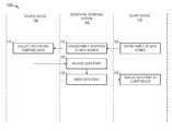
- FIG. 7is an interaction diagram depicting example exchanges between the geospatial interface system 142 , source device 130 , and client device 110 , consistent with some example embodiments.
- the client device 705receives an input into a graphical user interface generated by the geospatial interface system 142 , to define a family of data point.
- the definition of the family of data pointsmay include one or more data sources (e.g., source device 130 ), and a family identifier.
- the family definitionmay also include a frequency, or data retrieval interval to assign to the data sources.
- the data retrieval intervalspecifies a rate at which data points are retrieved from the data source.
- the geospatial interface system 142receives the definition of the family, and assigns the family identifier to the one or more data sources identified. By doing so, data points received from the one or more data sources are indexed by the geospatial interface system 142 based on the family identifier.
- the data sourcee.g., source device 130
- the geospatial interface system 142receives a data point from the source device 130 , based on the defined interval.
- the data pointcomprises the temporal data and the vector data, such that the vector data defines coordinates of the data point, and the temporal data defines a time series associated with the data point.
- the data pointmay also include image and text data.
- the index module 206indexes and unifies the data by linking it with other associated data points.
- Data pointsmay be associated based on sharing a common family identifier, or in some example embodiments may be linked based on user input.
- a usermay specify temporal or vector data attributes to link data points based on. For example, a user may specify that all data points received in a window of time are linked.
- a user accessing the GIS 142 on a client device 110is presented with the GIS interface 700 , including the imagery search field 710 .
- the usermay provide the imagery search field 710 with search criteria (e.g., a file name, file source) in order to retrieve one or more images and data to be uploaded into the GIS 142 , and to generate an present a tile cache based on the uploaded image (e.g., geospatial data 702 ).
- search criteriae.g., a file name, file source
- FIG. 8depicts an exemplary graphical user interface 800 generated by the geospatial interface system 142 , configured to display geospatial data including a map image 802 , a base layer, and one or more data points 804 received from various data sources.
- data pointsare received from various data sources (e.g., source device 130 ) at the geospatial interface system 142 , indexed based on metadata associated with the data points (e.g., vector data, temporal data), and displayed within the graphical user interface 800 at a client device 110 .
- the displaymay include a graph element 806 configured to display a time series of the data points.
- FIG. 9depicts an exemplary graphical user interface 900 generated by the geospatial interface system 142 , configured to display geospatial data including a map image 902 , a base layer, and one or more data points 904 received from various data sources.
- a user of client device 110may select a data point (e.g., via a cursor element 906 ), and in response, the geospatial interface system 142 causes display of an interface control element 908 configured to receive temporal constraints (e.g., temporal constraints 910 ).
- temporal constraintse.g., temporal constraints 910
- the usermay provide temporal constraints via the interface control element, and in response, the geospatial interface system 142 may update the display of the graphical user interface 900 to include the set of data points 904 based on the temporal constraints specified (e.g., based on the temporal data of the data points).
- the geospatial interface system 142may update the display to include only a set of data points which includes temporal data within the defined range.
- the usermay specify a chronology (e.g., the last ten data points), and in response the geospatial interface system 142 updates to display only the last ten data points received.
- FIG. 10depicts an exemplary graphical user interface 1000 generated by the geospatial interface system 142 , configured to display geospatial data including a map image 1002 , a base layer, and one or more data points (e.g., data point 1004 ) received from various data sources.
- the geospatial interface system 142displays data point labels (e.g., data point label 1010 ) for each data point.
- the geospatial interface system 142may display associated data points (e.g., linked data points, data points with common family identifier) by connecting the associated data points with line segments (e.g., line segment 1006 ).
- the line segmentsmay include an indicator 1008 of a direction of movement.
- FIG. 11depicts an exemplary graphical user interface 1100 generated by the geospatial interface system 142 , configured to display geospatial data including a map image 1102 , a base layer, and one or more data points (e.g., data point 1104 ) received from various data sources.
- the geospatial interface system 142presents a notification (e.g., notification 1106 , notification 1108 ) at the client device 110 in response to receiving a data point from a data source.
- the geospatial interface system 142may receive a notification request from the client device 110 , wherein the notification request includes an indication of an event, and a notification distribution.
- the geospatial interface system 142causes display of notifications 1106 at the client device 110 , as well as a set of additional client devices defined by the notification distribution. For example, the user may configure the notification to be distributed to a specific set of devices.
- FIG. 12is a block diagram illustrating components of a machine 1200 , according to some example embodiments, able to read instructions 1224 from a machine-readable medium 1222 (e.g., a non-transitory machine-readable medium, a machine-readable storage medium, a computer-readable storage medium, or any suitable combination thereof) and perform any one or more of the methodologies discussed herein, in whole or in part.
- a machine-readable medium 1222e.g., a non-transitory machine-readable medium, a machine-readable storage medium, a computer-readable storage medium, or any suitable combination thereof
- FIG. 1222e.g., a non-transitory machine-readable medium, a machine-readable storage medium, a computer-readable storage medium, or any suitable combination thereof
- the machine 1200in the example form of a computer system (e.g., a computer) within which the instructions 1224 (e.g., software, a program, an application, an applet, an app, or other executable code) for causing the machine 1200 to perform any one or more of the methodologies discussed herein may be executed, in whole or in part.
- the instructions 1224e.g., software, a program, an application, an applet, an app, or other executable code
- the machine 1200operates as a standalone device or may be communicatively coupled (e.g., networked) to other machines.
- the machine 1200may operate in the capacity of a server machine or a client machine in a server-client network environment, or as a peer machine in a distributed (e.g., peer-to-peer) network environment.
- the machine 1200may be a server computer, a client computer, a PC, a tablet computer, a laptop computer, a netbook, a cellular telephone, a smartphone, a set-top box (STB), a personal digital assistant (PDA), a web appliance, a network router, a network switch, a network bridge, or any machine capable of executing the instructions 1224 , sequentially or otherwise, that specify actions to be taken by that machine.
- STBset-top box
- PDApersonal digital assistant
- STBset-top box
- web appliancea network router, a network switch, a network bridge, or any machine capable of executing the instructions 1224 , sequentially or otherwise, that specify actions to be taken by that machine.
- the machine 1200includes a processor 1202 (e.g., a central processing unit (CPU), a graphics processing unit (GPU), a digital signal processor (DSP), an application specific integrated circuit (ASIC), a radio-frequency integrated circuit (RFIC), or any suitable combination thereof), a main memory 1204 , and a static memory 1206 , which are configured to communicate with each other via a bus 1208 .
- the processor 1202may contain solid-state digital microcircuits (e.g., electronic, optical, or both) that are configurable, temporarily or permanently, by some or all of the instructions 1224 such that the processor 1202 is configurable to perform any one or more of the methodologies described herein, in whole or in part.
- a set of one or more microcircuits of the processor 1202may be configurable to execute one or more modules (e.g., software modules) described herein.
- the processor 1202is a multicore CPU (e.g., a dual-core CPU, a quad-core CPU, or a 128-core CPU) within which each of multiple cores is a separate processor that is able to perform any one or more of the methodologies discussed herein, in whole or in part.
- beneficial effects described hereinmay be provided by the machine 1200 with at least the processor 1202 , these same effects may be provided by a different kind of machine that contains no processors (e.g., a purely mechanical system, a purely hydraulic system, or a hybrid mechanical-hydraulic system), if such a processor-less machine is configured to perform one or more of the methodologies described herein.
- a processor-less machinee.g., a purely mechanical system, a purely hydraulic system, or a hybrid mechanical-hydraulic system
- the machine 1200may further include a graphics display 1210 (e.g., a plasma display panel (PDP), a light emitting diode (LED) display, a liquid crystal display (LCD), a projector, a cathode ray tube (CRT), or any other display capable of displaying graphics or video).
- the machine 1200may also include an input/output device 1212 (e.g., a keyboard or keypad, a mouse, or a trackpad), a storage unit 1216 , an audio generation device 1218 (e.g., a sound card, an amplifier, a speaker, a headphone jack, or any suitable combination thereof), and a network interface device 1220 .
- a graphics display 1210e.g., a plasma display panel (PDP), a light emitting diode (LED) display, a liquid crystal display (LCD), a projector, a cathode ray tube (CRT), or any other display capable of displaying graphics or video.
- the storage unit 1216includes the machine-readable medium 1222 (e.g., a tangible and non-transitory machine-readable storage medium) on which are stored the instructions 1224 embodying any one or more of the methodologies or functions described herein.
- the instructions 1224may also reside, completely or at least partially, within the main memory 1204 , within the processor 1202 (e.g., within the processor's cache memory), within the static memory 1206 , or all three, before or during execution thereof by the machine 1200 . Accordingly, the main memory 1204 and the processor 1202 may be considered machine-readable media (e.g., tangible and non-transitory machine-readable media).
- the instructions 1224may be transmitted or received over a network 1226 via the network interface device 1220 .
- the network interface device 1220may communicate the instructions 1224 using any one or more transfer protocols (e.g., hypertext transfer protocol (HTTP)).
- HTTPhypertext transfer protocol
- the term “memory”refers to a machine-readable medium able to store data temporarily or permanently and may be taken to include, but not be limited to, random-access memory (RAM), read-only memory (ROM), buffer memory, flash memory, and cache memory. While the machine-readable medium 1222 is shown in an example embodiment to be a single medium, the term “machine-readable medium” should be taken to include a single medium or multiple media (e.g., a centralized or distributed database, or associated caches and servers) able to store the instructions 1224 .
- machine-readable mediumshall also be taken to include any medium, or combination of multiple media, that is capable of storing the instructions 1224 for execution by the machine 1200 , such that the instructions 1224 , when executed by one or more processors of the machine 1200 (e.g., processor 1202 ), cause the machine 1200 to perform any one or more of the methodologies described herein, in whole or in part.
- a “machine-readable medium”refers to a single storage apparatus or device, as well as cloud-based storage systems or storage networks that include multiple storage apparatus or devices.
- machine-readable mediumshall accordingly be taken to include, but not be limited to, one or more tangible and non-transitory data repositories (e.g., data volumes) in the example form of a solid-state memory chip, an optical disc, a magnetic disc, or any suitable combination thereof.
- the instructions 1224 for execution by the machine 1200may be communicated by a carrier medium.
- Examples of such a carrier mediuminclude a storage medium (e.g., a non-transitory machine-readable storage medium, such as a solid-state memory, being physically moved from one place to another place) and a transient medium (e.g., a propagating signal that communicates the instructions 1224 ).
- a storage mediume.g., a non-transitory machine-readable storage medium, such as a solid-state memory, being physically moved from one place to another place
- a transient mediume.g., a propagating signal that communicates the instructions 1224 .
- Modulesmay constitute software modules (e.g., code stored or otherwise embodied on a machine-readable medium or in a transmission medium), hardware modules, or any suitable combination thereof.
- a “hardware module”is a tangible (e.g., non-transitory) unit capable of performing certain operations and may be configured or arranged in a certain physical manner.
- one or more computer systemse.g., a standalone computer system, a client computer system, or a server computer system
- one or more hardware modules of a computer systeme.g., a processor or a group of processors
- softwaree.g., an application or application portion
- a hardware modulemay be implemented mechanically, electronically, or any suitable combination thereof.
- a hardware modulemay include dedicated circuitry or logic that is permanently configured to perform certain operations.
- a hardware modulemay be a special-purpose processor, such as a field programmable gate array (FPGA) or an ASIC.
- a hardware modulemay also include programmable logic or circuitry that is temporarily configured by software to perform certain operations.
- a hardware modulemay include software encompassed within a CPU or other programmable processor. It will be appreciated that the decision to implement a hardware module mechanically, in dedicated and permanently configured circuitry, or in temporarily configured circuitry (e.g., configured by software) may be driven by cost and time considerations.
- hardware moduleshould be understood to encompass a tangible entity, and such a tangible entity may be physically constructed, permanently configured (e.g., hardwired), or temporarily configured (e.g., programmed) to operate in a certain manner or to perform certain operations described herein.
- “hardware-implemented module”refers to a hardware module. Considering embodiments in which hardware modules are temporarily configured (e.g., programmed), each of the hardware modules need not be configured or instantiated at any one instance in time. For example, where a hardware module comprises a CPU configured by software to become a special-purpose processor, the CPU may be configured as respectively different special-purpose processors (e.g., each included in a different hardware module) at different times.
- Softwaree.g., a software module
- Hardware modulescan provide information to, and receive information from, other hardware modules. Accordingly, the described hardware modules may be regarded as being communicatively coupled. Where multiple hardware modules exist contemporaneously, communications may be achieved through signal transmission (e.g., over appropriate circuits and buses) between or among two or more of the hardware modules. In embodiments in which multiple hardware modules are configured or instantiated at different times, communications between such hardware modules may be achieved, for example, through the storage and retrieval of information in memory structures to which the multiple hardware modules have access. For example, one hardware module may perform an operation and store the output of that operation in a memory device to which it is communicatively coupled. A further hardware module may then, at a later time, access the memory device to retrieve and process the stored output. Hardware modules may also initiate communications with input or output devices, and can operate on a resource (e.g., a collection of information).
- a resourcee.g., a collection of information
- processorsmay be temporarily configured (e.g., by software) or permanently configured to perform the relevant operations. Whether temporarily or permanently configured, such processors may constitute processor-implemented modules that operate to perform one or more operations or functions described herein. Accordingly, the operations described herein may be at least partially processor-implemented, since a processor is an example of hardware. For example, at least some operations of any method may be performed by one or more processor-implemented modules.
- processor-implemented modulerefers to a hardware module in which the hardware includes one or more processors.
- the one or more processorsmay also operate to support performance of the relevant operations in a “cloud computing” environment or as a “software as a service” (SaaS).
- SaaSsoftware as a service
- at least some of the operationsmay be performed by a group of computers (as examples of machines including processors), with these operations being accessible via a network (e.g., the Internet) and via one or more appropriate interfaces (e.g., an application program interface (API)).
- APIapplication program interface
- the performance of certain operationsmay be distributed among the one or more processors, whether residing only within a single machine or deployed across a number of machines.
- the one or more processors or hardware modulese.g., processor-implemented modules
- may be located in a single geographic locatione.g., within a home environment, an office environment, or a server farm.
- the one or more processors or hardware modulesmay be distributed across a number of geographic locations.
Landscapes
- Engineering & Computer Science (AREA)
- Theoretical Computer Science (AREA)
- Physics & Mathematics (AREA)
- General Physics & Mathematics (AREA)
- Databases & Information Systems (AREA)
- Remote Sensing (AREA)
- Data Mining & Analysis (AREA)
- General Engineering & Computer Science (AREA)
- User Interface Of Digital Computer (AREA)
Abstract
Description
Claims (20)
Priority Applications (4)
| Application Number | Priority Date | Filing Date | Title |
|---|---|---|---|
| US15/258,715US10109094B2 (en) | 2015-12-21 | 2016-09-07 | Interface to index and display geospatial data |
| EP16206016.4AEP3185147A1 (en) | 2015-12-21 | 2016-12-21 | Interface to index and display geospatial data |
| US16/106,505US10733778B2 (en) | 2015-12-21 | 2018-08-21 | Interface to index and display geospatial data |
| US16/906,255US11238632B2 (en) | 2015-12-21 | 2020-06-19 | Interface to index and display geospatial data |
Applications Claiming Priority (2)
| Application Number | Priority Date | Filing Date | Title |
|---|---|---|---|
| US201562270510P | 2015-12-21 | 2015-12-21 | |
| US15/258,715US10109094B2 (en) | 2015-12-21 | 2016-09-07 | Interface to index and display geospatial data |
Related Child Applications (1)
| Application Number | Title | Priority Date | Filing Date |
|---|---|---|---|
| US16/106,505ContinuationUS10733778B2 (en) | 2015-12-21 | 2018-08-21 | Interface to index and display geospatial data |
Publications (2)
| Publication Number | Publication Date |
|---|---|
| US20170178376A1 US20170178376A1 (en) | 2017-06-22 |
| US10109094B2true US10109094B2 (en) | 2018-10-23 |
Family
ID=57680093
Family Applications (3)
| Application Number | Title | Priority Date | Filing Date |
|---|---|---|---|
| US15/258,715Active2036-10-05US10109094B2 (en) | 2015-12-21 | 2016-09-07 | Interface to index and display geospatial data |
| US16/106,505ActiveUS10733778B2 (en) | 2015-12-21 | 2018-08-21 | Interface to index and display geospatial data |
| US16/906,255ActiveUS11238632B2 (en) | 2015-12-21 | 2020-06-19 | Interface to index and display geospatial data |
Family Applications After (2)
| Application Number | Title | Priority Date | Filing Date |
|---|---|---|---|
| US16/106,505ActiveUS10733778B2 (en) | 2015-12-21 | 2018-08-21 | Interface to index and display geospatial data |
| US16/906,255ActiveUS11238632B2 (en) | 2015-12-21 | 2020-06-19 | Interface to index and display geospatial data |
Country Status (2)
| Country | Link |
|---|---|
| US (3) | US10109094B2 (en) |
| EP (1) | EP3185147A1 (en) |
Cited By (3)
| Publication number | Priority date | Publication date | Assignee | Title |
|---|---|---|---|---|
| US11132377B2 (en) | 2015-06-03 | 2021-09-28 | Palantir Technologies Inc. | Server implemented geographic information system with graphical interface |
| US11238632B2 (en)* | 2015-12-21 | 2022-02-01 | Palantir Technologies Inc. | Interface to index and display geospatial data |
| US20230121659A1 (en)* | 2018-07-13 | 2023-04-20 | DreamHammer Corporation | Geospatial asset management |
Families Citing this family (3)
| Publication number | Priority date | Publication date | Assignee | Title |
|---|---|---|---|---|
| US10783173B2 (en)* | 2016-04-08 | 2020-09-22 | Global Grid Systems Inc. | Methods and systems for selecting and analyzing geospatial data on a discrete global grid system |
| JP7574537B2 (en)* | 2020-02-27 | 2024-10-29 | 富士フイルムビジネスイノベーション株式会社 | Information processing device and computer program |
| US11775545B1 (en) | 2020-09-23 | 2023-10-03 | Amazon Technologies, Inc. | Cloud-based database for spatial data lifecycle management |
Citations (221)
| Publication number | Priority date | Publication date | Assignee | Title |
|---|---|---|---|---|
| US4899161A (en) | 1988-07-21 | 1990-02-06 | International Business Machines Corporation | High accuracy coordinate conversion method for air traffic control applications |
| US4958305A (en) | 1987-11-04 | 1990-09-18 | General Electric Company | Polygon edge clipping |
| US5329108A (en) | 1991-11-22 | 1994-07-12 | Cherloc | Map with indexes for a geographical information system and system for applying same |
| WO1995032424A1 (en) | 1994-05-23 | 1995-11-30 | Coulter Corporation | Detection of reticulocytes |
| US5754182A (en) | 1994-11-09 | 1998-05-19 | Matsushita Electric Industrial Co., Ltd. | Shape model generation device for generating shape models with a reduced number of polygons while maintaining quality of the two-dimensional image of the generated shape models |
| US5781195A (en) | 1996-04-16 | 1998-07-14 | Microsoft Corporation | Method and system for rendering two-dimensional views of a three-dimensional surface |
| US5781704A (en) | 1996-10-11 | 1998-07-14 | Environmental Criminology Research, Inc. | Expert system method of performing crime site analysis |
| WO2000009529A2 (en) | 1998-08-14 | 2000-02-24 | I2 Technologies, Inc. | System and method for visually representing a supply chain |
| US6091956A (en) | 1997-06-12 | 2000-07-18 | Hollenberg; Dennis D. | Situation information system |
| US6100897A (en) | 1995-12-22 | 2000-08-08 | Art +Com Medientechnologie Und Gestaltung Gmbh | Method and device for pictorial representation of space-related data |
| US6157747A (en) | 1997-08-01 | 2000-12-05 | Microsoft Corporation | 3-dimensional image rotation method and apparatus for producing image mosaics |
| US6169552B1 (en) | 1996-04-16 | 2001-01-02 | Xanavi Informatics Corporation | Map display device, navigation device and map display method |
| US6173067B1 (en) | 1998-04-07 | 2001-01-09 | Hughes Electronics Corporation | System and method for rapid determination of visibility-based terrain properties over broad regions |
| US6178432B1 (en) | 1996-09-30 | 2001-01-23 | Informative Graphics Corp. | Method and apparatus for creating interactive web page objects |
| US6247019B1 (en) | 1998-03-17 | 2001-06-12 | Prc Public Sector, Inc. | Object-based geographic information system (GIS) |
| WO2001098925A2 (en) | 2000-06-20 | 2001-12-27 | Globexplorer, Inc. | Method, system and computer program product for delivering spatially referenced information in a global computer network |
| US20020003539A1 (en) | 1999-12-27 | 2002-01-10 | Yoshihisa Abe | Method and apparatus for reducing three-dimensional shape data |
| US20020033848A1 (en) | 2000-04-21 | 2002-03-21 | Sciammarella Eduardo Agusto | System for managing data objects |
| US6389289B1 (en) | 1998-05-07 | 2002-05-14 | Hughes Electronics Corporation | Earth tiling system for providing regional based service in a mobile satellite communication network |
| US6414683B1 (en) | 1996-11-01 | 2002-07-02 | International Business Machines Corporation | Surface simplification preserving a solid volume |
| US20020116120A1 (en) | 2001-02-16 | 2002-08-22 | Patrick Ruiz | Bundled map guide |
| US20020130867A1 (en) | 2001-03-14 | 2002-09-19 | Kai-Shu Yang | Method of constructing progressive mesh |
| US20020130906A1 (en) | 2001-03-16 | 2002-09-19 | Ken Miyaki | Point-of interest icon and point-of- interest mark display method |
| US6483509B1 (en) | 1999-04-09 | 2002-11-19 | International Business Machines Corp. | Curve contour smoothing |
| US6529900B1 (en) | 1999-01-14 | 2003-03-04 | International Business Machines Corporation | Method and apparatus for data visualization |
| US20030052896A1 (en) | 2000-03-29 | 2003-03-20 | Higgins Darin Wayne | System and method for synchronizing map images |
| US20030103049A1 (en) | 2001-11-30 | 2003-06-05 | Caterpillar Inc. | Cuts removal system for triangulated CAD models |
| US20030144868A1 (en) | 2001-10-11 | 2003-07-31 | Macintyre James W. | System, method, and computer program product for processing and visualization of information |
| US20030163352A1 (en) | 2002-01-17 | 2003-08-28 | Jo Surpin | Method and system for gainsharing of physician services |
| US6631496B1 (en) | 1999-03-22 | 2003-10-07 | Nec Corporation | System for personalizing, organizing and managing web information |
| US20030225755A1 (en) | 2002-05-28 | 2003-12-04 | Hitachi, Ltd. | Document search method and system, and document search result display system |
| US6662103B1 (en) | 1999-03-22 | 2003-12-09 | Arc Second Inc. | Method and system for creating a user-selectable arbitrary coordinate frame |
| US20040030492A1 (en) | 2002-08-07 | 2004-02-12 | Hrl Laboratories, Llc | Method and apparatus for geographic shape preservation for identification |
| US20040039498A1 (en) | 2002-08-23 | 2004-02-26 | Mark Ollis | System and method for the creation of a terrain density model |
| US20040098236A1 (en) | 2002-07-19 | 2004-05-20 | Evans & Sutherland Computer Corporation | System and method for modeling a spheroid world database |
| US6757445B1 (en) | 2000-10-04 | 2004-06-29 | Pixxures, Inc. | Method and apparatus for producing digital orthophotos using sparse stereo configurations and external models |
| WO2004057268A2 (en) | 2002-12-19 | 2004-07-08 | Rafael-Armament Development Authority Ltd. | A method and system for processing and analyzing digital terrain data |
| US20040143602A1 (en) | 2002-10-18 | 2004-07-22 | Antonio Ruiz | Apparatus, system and method for automated and adaptive digital image/video surveillance for events and configurations using a rich multimedia relational database |
| US6828920B2 (en) | 2001-06-04 | 2004-12-07 | Lockheed Martin Orincon Corporation | System and method for classifying vehicles |
| WO2005013200A1 (en) | 2003-08-01 | 2005-02-10 | Perry Peterson | Close-packed, uniformly adjacent, multiresolutional, overlapping spatial data ordering |
| US20050034062A1 (en) | 2003-06-18 | 2005-02-10 | Bufkin Michael P. | Methods and systems for encoding geographic coordinates and features in a portable document format file |
| US20050080769A1 (en) | 2003-10-14 | 2005-04-14 | Microsoft Corporation | System and process for presenting search results in a histogram/cluster format |
| US20050134607A1 (en)* | 2003-12-17 | 2005-06-23 | Quid Novi, S.A., Inc. | Method and apparatus for representing data using layered objects |
| US20050162523A1 (en) | 2004-01-22 | 2005-07-28 | Darrell Trevor J. | Photo-based mobile deixis system and related techniques |
| US20050182502A1 (en) | 2004-02-12 | 2005-08-18 | International Business Machines Corporation | System and method for detecting generalized space-time clusters |
| US20050182793A1 (en) | 2004-02-18 | 2005-08-18 | Keenan Viktor M. | Map structure and method for producing |
| US20050223044A1 (en) | 2004-04-06 | 2005-10-06 | International Business Machines Corporation | Method, system and program for managing geographic data stored in a database |
| US20050267652A1 (en) | 2004-05-28 | 2005-12-01 | Lockheed Martin Corporation | Intervisibility determination |
| US6983203B1 (en) | 2000-07-28 | 2006-01-03 | Alpine Electronics, Inc. | POI icon display method and navigation system |
| US6985950B1 (en) | 2001-03-06 | 2006-01-10 | Microsoft Corporation | System for creating a space-efficient document categorizer for training and testing of automatic categorization engines |
| US20060026170A1 (en) | 2003-05-20 | 2006-02-02 | Jeremy Kreitler | Mapping method and system |
| US7036085B2 (en) | 1999-07-22 | 2006-04-25 | Barbara L. Barros | Graphic-information flow method and system for visually analyzing patterns and relationships |
| US20060139375A1 (en) | 2004-03-23 | 2006-06-29 | Rasmussen Jens E | Secondary map in digital mapping system |
| US20060149596A1 (en) | 2002-01-17 | 2006-07-06 | Jo Surpin | Method and system for evaluating a physician's economic performance and gainsharing of physician services |
| US20060146050A1 (en) | 2005-01-05 | 2006-07-06 | Hideaki Yamauchi | Vertex reduction graphic drawing method and device |
| US20060200384A1 (en) | 2005-03-03 | 2006-09-07 | Arutunian Ethan B | Enhanced map imagery, such as for location-based advertising and location-based reporting |
| US20060197837A1 (en) | 2005-02-09 | 2006-09-07 | The Regents Of The University Of California. | Real-time geo-registration of imagery using cots graphics processors |
| US20060241974A1 (en) | 2005-04-26 | 2006-10-26 | Chao David Y | System and method for peer-profiling individual performance |
| US20060251307A1 (en) | 2005-04-13 | 2006-11-09 | Charles Florin | Method and apparatus for generating a 2D image having pixels corresponding to voxels of a 3D image |
| US20060259527A1 (en) | 2005-05-13 | 2006-11-16 | Devarakonda Murthy V | Changed files list with time buckets for efficient storage management |
| US20060271277A1 (en) | 2005-05-27 | 2006-11-30 | Jianing Hu | Interactive map-based travel guide |
| US20060279630A1 (en) | 2004-07-28 | 2006-12-14 | Manoj Aggarwal | Method and apparatus for total situational awareness and monitoring |
| US7158878B2 (en) | 2004-03-23 | 2007-01-02 | Google Inc. | Digital mapping system |
| US20070011150A1 (en) | 2005-06-28 | 2007-01-11 | Metacarta, Inc. | User Interface For Geographic Search |
| US20070016363A1 (en) | 2005-07-15 | 2007-01-18 | Oracle International Corporation | Interactive map-based user interface for transportation planning |
| US20070024620A1 (en) | 2005-08-01 | 2007-02-01 | Muller-Fischer Matthias H | Method of generating surface defined by boundary of three-dimensional point cloud |
| US20070057966A1 (en) | 2005-09-09 | 2007-03-15 | Canon Kabushiki Kaisha | Information processing apparatus, information processing method, program, and storage medium |
| US20070078832A1 (en) | 2005-09-30 | 2007-04-05 | Yahoo! Inc. | Method and system for using smart tags and a recommendation engine using smart tags |
| US20070115373A1 (en) | 2005-11-22 | 2007-05-24 | Eastman Kodak Company | Location based image classification with map segmentation |
| US20070188516A1 (en) | 2006-02-10 | 2007-08-16 | Ioup Elias Z K | Method for Efficiently Transforming a raster image from one map projection to another map projection |
| US20070208497A1 (en) | 2006-03-03 | 2007-09-06 | Inrix, Inc. | Detecting anomalous road traffic conditions |
| US20070208498A1 (en) | 2006-03-03 | 2007-09-06 | Inrix, Inc. | Displaying road traffic condition information and user controls |
| US20070258642A1 (en) | 2006-04-20 | 2007-11-08 | Microsoft Corporation | Geo-coding images |
| US20070294643A1 (en) | 2004-03-30 | 2007-12-20 | Kyle Henry M | System for managing the navigational usability of an interactive map |
| US20080010605A1 (en) | 2006-06-12 | 2008-01-10 | Metacarta, Inc. | Systems and methods for generating and correcting location references extracted from text |
| US20080021726A1 (en) | 2004-02-19 | 2008-01-24 | Celeritasworks, Llc | Community Awareness Management Systems and Methods |
| US20080040684A1 (en) | 2006-08-14 | 2008-02-14 | Richard Crump | Intelligent Pop-Up Window Method and Apparatus |
| US20080077642A1 (en) | 2006-07-14 | 2008-03-27 | Carbone John N | Geographical Information Display System and Method |
| US20080082578A1 (en) | 2006-09-29 | 2008-04-03 | Andrew Hogue | Displaying search results on a one or two dimensional graph |
| US20080098085A1 (en) | 2006-10-20 | 2008-04-24 | Sap Ag | Service enabled tagged user interfaces |
| US20080104019A1 (en) | 2006-10-26 | 2008-05-01 | Microsoft Corporation | Associating Geographic-Related Information with Objects |
| US7375732B2 (en) | 2004-03-17 | 2008-05-20 | Microsoft Corporation | Methods and apparatus for navigating an image |
| WO2008064207A2 (en) | 2006-11-20 | 2008-05-29 | Palantir Technologies, Inc. | Creating data in a data store using a dynamic ontology |
| US20080133579A1 (en) | 2006-11-17 | 2008-06-05 | Nhn Corporation | Map service system and method |
| US20080163073A1 (en) | 2006-11-13 | 2008-07-03 | Tele Atlas North America, Inc. | System and method for providing multiple participants with a central access portal to geographic point of interest data |
| US20080192053A1 (en) | 2007-02-08 | 2008-08-14 | Microsoft Corporation | Transforming Offline Maps into Interactive Online Maps |
| US20080229056A1 (en) | 2007-03-12 | 2008-09-18 | Broadcom Corporation | Method and apparatus for dual-hashing tables |
| US20080223834A1 (en) | 2007-03-16 | 2008-09-18 | Eggfusion, Inc. | Method and apparatus for laser marking objects |
| US20080263468A1 (en) | 2007-04-17 | 2008-10-23 | Guava Technologies, Inc. | Graphical User Interface for Analysis and Comparison of Location-Specific Multiparameter Data Sets |
| US20080270468A1 (en) | 2007-04-25 | 2008-10-30 | Magellan Navigation, Inc. | Adjusting spatial operations based on map density |
| US20080267107A1 (en) | 2007-04-27 | 2008-10-30 | Outland Research, Llc | Attraction wait-time inquiry apparatus, system and method |
| US20080278311A1 (en) | 2006-08-10 | 2008-11-13 | Loma Linda University Medical Center | Advanced Emergency Geographical Information System |
| US7457706B2 (en) | 2000-08-16 | 2008-11-25 | Harris Corporation | 3-dimensional interactive image modeling system |
| US20080294678A1 (en) | 2007-02-13 | 2008-11-27 | Sean Gorman | Method and system for integrating a social network and data repository to enable map creation |
| US20080301643A1 (en) | 2007-05-28 | 2008-12-04 | Google Inc. | Map Gadgets |
| US20090002492A1 (en) | 2006-06-16 | 2009-01-01 | Senem Velipasalar | Method and system for spatio-temporal event detection using composite definitions for camera systems |
| US20090027418A1 (en) | 2007-07-24 | 2009-01-29 | Maru Nimit H | Map-based interfaces for storing and locating information about geographical areas |
| US7502786B2 (en) | 2006-01-12 | 2009-03-10 | International Business Machines Corporation | Visual method and apparatus for enhancing search result navigation |
| US20090088964A1 (en) | 2007-09-28 | 2009-04-02 | Dave Schaaf | Map scrolling method and apparatus for navigation system for selectively displaying icons |
| US7519470B2 (en) | 2006-03-15 | 2009-04-14 | Microsoft Corporation | Location-based caching for mobile devices |
| US20090100018A1 (en) | 2007-10-12 | 2009-04-16 | Jonathan Roberts | System and method for capturing, integrating, discovering, and using geo-temporal data |
| US7529195B2 (en) | 2004-07-30 | 2009-05-05 | Fortiusone, Inc. | System and method of mapping and analyzing vulnerabilities in networks |
| US20090115786A1 (en) | 2006-04-24 | 2009-05-07 | Takamasa Shimasaki | Drawing device, and drawing method |
| WO2009061501A1 (en) | 2007-11-09 | 2009-05-14 | Telecommunication Systems, Inc. | Points-of-interest panning on a displayed map with a persistent search on a wireless phone |
| US20090132953A1 (en) | 2007-11-16 | 2009-05-21 | Iac Search & Media, Inc. | User interface and method in local search system with vertical search results and an interactive map |
| US20090132921A1 (en) | 2007-11-16 | 2009-05-21 | Samsung Electronics Co., Ltd. | User interface for displaying and playing multimedia contents, apparatus comprising the same, and control method thereof |
| US20090144262A1 (en) | 2007-12-04 | 2009-06-04 | Microsoft Corporation | Search query transformation using direct manipulation |
| US20090158185A1 (en) | 2007-12-17 | 2009-06-18 | Socialexplorer, Inc. | Adaptive map layer visibility control |
| US20090172511A1 (en) | 2007-12-26 | 2009-07-02 | Alexander Decherd | Analysis of time-based geospatial mashups using AD HOC visual queries |
| US20090171939A1 (en) | 2007-12-28 | 2009-07-02 | Yahoo! Inc. | User-generated activity maps |
| US7558677B2 (en) | 2005-08-23 | 2009-07-07 | R.A. Smith National, Inc. | High accuracy survey-grade GIS system |
| US20090179892A1 (en) | 2006-08-30 | 2009-07-16 | Sony Computer Entertainment Inc. | Image viewer, image displaying method and information storage medium |
| US20090187464A1 (en) | 2008-01-22 | 2009-07-23 | International Business Machines Corporation | Method and apparatus for end-to-end retail store site optimization |
| US20090187447A1 (en) | 2008-01-08 | 2009-07-23 | Honesty Young Cheng | Checking the correctness of gis data |
| US7574428B2 (en) | 2005-10-11 | 2009-08-11 | Telmap Ltd | Geometry-based search engine for navigation systems |
| US7579965B2 (en) | 2006-03-03 | 2009-08-25 | Andrew Bucholz | Vehicle data collection and processing system |
| US20090222400A1 (en) | 2005-12-16 | 2009-09-03 | Nextbio | Categorization and filtering of scientific data |
| WO2009123975A1 (en) | 2008-03-31 | 2009-10-08 | The Boeing Company | System and method for forming optimized perimeter surveillance |
| US7617314B1 (en) | 2005-05-20 | 2009-11-10 | Network General Technology | HyperLock technique for high-speed network data monitoring |
| US7620628B2 (en) | 2004-12-06 | 2009-11-17 | Yahoo! Inc. | Search processing with automatic categorization of queries |
| US20090292626A1 (en) | 2008-04-22 | 2009-11-26 | Oxford J Craig | System and method for interactive map, database, and social networking engine |
| US7663621B1 (en) | 2006-11-03 | 2010-02-16 | Nvidia Corporation | Cylindrical wrapping using shader hardware |
| US20100057716A1 (en) | 2008-08-28 | 2010-03-04 | Stefik Mark J | System And Method For Providing A Topic-Directed Search |
| US20100063961A1 (en) | 2008-09-05 | 2010-03-11 | Fotonauts, Inc. | Reverse Tagging of Images in System for Managing and Sharing Digital Images |
| US20100070523A1 (en) | 2008-07-11 | 2010-03-18 | Lior Delgo | Apparatus and software system for and method of performing a visual-relevance-rank subsequent search |
| US20100076968A1 (en) | 2008-05-27 | 2010-03-25 | Boyns Mark R | Method and apparatus for aggregating and presenting data associated with geographic locations |
| US20100162176A1 (en) | 2008-12-23 | 2010-06-24 | Dunton Randy R | Reduced complexity user interface |
| US20100198684A1 (en) | 2005-02-01 | 2010-08-05 | Redfin Corporation | Interactive map-based search and advertising |
| US20100199225A1 (en) | 2009-01-30 | 2010-08-05 | Navico Holdings As | Method, apparatus and computer program product for synchronizing cursor events |
| US7805457B1 (en) | 2008-02-14 | 2010-09-28 | Securus Technologies, Inc. | System and method for identifying members of a gang or security threat group |
| US7809703B2 (en) | 2006-12-22 | 2010-10-05 | International Business Machines Corporation | Usage of development context in search operations |
| US20100277611A1 (en) | 2009-05-01 | 2010-11-04 | Adam Holt | Automatic content tagging, such as tagging digital images via a wireless cellular network using metadata and facial recognition |
| US20100293174A1 (en) | 2009-05-12 | 2010-11-18 | Microsoft Corporation | Query classification |
| US20100321399A1 (en) | 2009-06-18 | 2010-12-23 | Patrik Ellren | Maps from Sparse Geospatial Data Tiles |
| US20110022312A1 (en) | 2009-07-23 | 2011-01-27 | Fmr Llc | Generating and Tracking Activity Patterns for Mobile Devices |
| US7920963B2 (en) | 2007-02-22 | 2011-04-05 | Iac Search & Media, Inc. | Map interface with a movable marker |
| US20110090254A1 (en) | 2009-10-20 | 2011-04-21 | John Antonio Carrino | Techniques for drawing geodetic polygons |
| US7945852B1 (en) | 2006-05-19 | 2011-05-17 | Washington State University Research Foundation | Strategies for annotating digital maps |
| WO2011058507A1 (en) | 2009-11-11 | 2011-05-19 | Dror Nadam | Apparatus, system and method for self orientation |
| US20110117878A1 (en) | 2009-11-13 | 2011-05-19 | David Barash | Community-Based Response System |
| US7962281B2 (en) | 2004-03-23 | 2011-06-14 | Google Inc. | Generating and serving tiles in a digital mapping system |
| US20110153368A1 (en) | 2009-12-17 | 2011-06-23 | XtremeGIS, Inc. | User Interactive Reinsurance Risk Analysis Application |
| US7970240B1 (en) | 2001-12-17 | 2011-06-28 | Google Inc. | Method and apparatus for archiving and visualizing digital images |
| US20110161096A1 (en) | 2009-12-28 | 2011-06-30 | General Electric Company | Methods and systems for mapping healthcare services analytics for volume and trends |
| US20110170799A1 (en) | 2010-01-12 | 2011-07-14 | John Antonio Carrino | Techniques for density mapping |
| US20110208724A1 (en) | 2005-10-12 | 2011-08-25 | Google Inc. | Entity Display Priority In A Distributed Geographic Information System |
| US20110218934A1 (en) | 2010-03-03 | 2011-09-08 | Jeremy Elser | System and methods for comparing real properties for purchase and for generating heat maps to aid in identifying price anomalies of such real properties |
| US20110225198A1 (en) | 2005-11-21 | 2011-09-15 | Edwards Rocky L | System and Methods for Linking Multiple Events Involving Firearms and Gang Related Activities |
| US20110238690A1 (en) | 2010-03-26 | 2011-09-29 | Nokia Corporation | Method and Apparatus for Multi-Item Searching |
| US8036632B1 (en) | 2007-02-02 | 2011-10-11 | Resource Consortium Limited | Access of information using a situational network |
| US20110260860A1 (en)* | 2010-04-26 | 2011-10-27 | Raghav Gupta | Geosocial network system and method for aggregating group members |
| US20110270705A1 (en) | 2010-04-29 | 2011-11-03 | Cheryl Parker | System and Method for Geographic Based Data Visualization and Extraction |
| US8065080B2 (en) | 2006-10-31 | 2011-11-22 | At&T Intellectual Property I, Lp | Location stamping and logging of electronic events and habitat generation |
| US20120066296A1 (en) | 2007-05-28 | 2012-03-15 | Google Inc. | Inter-Domain Communication |
| US8145703B2 (en) | 2007-11-16 | 2012-03-27 | Iac Search & Media, Inc. | User interface and method in a local search system with related search results |
| US20120084118A1 (en) | 2010-09-30 | 2012-04-05 | International Business Machines Corporation | Sales predication for a new store based on on-site market survey data and high resolution geographical information |
| US20120106801A1 (en) | 2010-11-03 | 2012-05-03 | Jackson Scott A | Vehicle tracking and locating system |
| US20120144335A1 (en) | 2010-12-02 | 2012-06-07 | Microsoft Corporation | Data visualizations including interactive time line representations |
| US20120158527A1 (en) | 2010-12-21 | 2012-06-21 | Class6Ix, Llc | Systems, Methods and/or Computer Readable Storage Media Facilitating Aggregation and/or Personalized Sequencing of News Video Content |
| US20120159363A1 (en) | 2010-12-16 | 2012-06-21 | Microsoft Corporation | Z-order bands |
| US8214361B1 (en) | 2008-09-30 | 2012-07-03 | Google Inc. | Organizing search results in a topic hierarchy |
| US20120173985A1 (en) | 2010-12-29 | 2012-07-05 | Tyler Peppel | Multi-dimensional visualization of temporal information |
| US8229947B2 (en) | 2007-03-30 | 2012-07-24 | Canon Kabushiki Kaisha | Image processing apparatus and method for controlling image processing apparatus |
| US20120208636A1 (en) | 2010-10-19 | 2012-08-16 | Oliver Feige | Methods, Server System and Browser Clients for Providing a Game Map of a Browser-Based Online Multi-Player Game |
| US20120206469A1 (en) | 2011-02-15 | 2012-08-16 | Tudor Hulubei | Efficient pre-computing of simplified vector data for rendering at multiple zoom levels |
| US20120221580A1 (en) | 2005-09-27 | 2012-08-30 | Patentratings, Llc | Method and system for probabilistically quantifying and visualizing relevance between two or more citationally or contextually related data objects |
| US8301464B1 (en) | 2008-07-18 | 2012-10-30 | Cave Consulting Group, Inc. | Method and system for producing statistical analysis of medical care information |
| US8325178B1 (en) | 2007-12-05 | 2012-12-04 | The United States Of America, As Represented By The Secretary Of The Navy | Lines-of-sight and viewsheds determination system |
| US20120323888A1 (en) | 2011-06-17 | 2012-12-20 | Osann Jr Robert | Automatic Webpage Characterization and Search Results Annotation |
| US20130006725A1 (en) | 2011-06-30 | 2013-01-03 | Accenture Global Services Limited | Tolling integration technology |
| US20130021445A1 (en) | 2010-04-12 | 2013-01-24 | Alexandre Cossette-Pacheco | Camera Projection Meshes |
| US20130057551A1 (en) | 2007-10-01 | 2013-03-07 | David S. Ebert | Visual Analytics Law Enforcement Tools |
| US20130060786A1 (en) | 2011-09-02 | 2013-03-07 | Xerox Corporation | Text-based searching of image data |
| US8397171B2 (en) | 2006-03-31 | 2013-03-12 | Reaearch In Motion Limited | User interface methods and apparatus for controlling the visual display of maps having selectable map elements in mobile communication devices |
| US8400448B1 (en) | 2007-12-05 | 2013-03-19 | The United States Of America, As Represented By The Secretary Of The Navy | Real-time lines-of-sight and viewsheds determination system |
| US20130073377A1 (en) | 2011-09-15 | 2013-03-21 | Stephan HEATH | Mobile device system and method providing 3d geo-target location-based mobile commerce searching/purchases, discounts/coupons products, goods, and services, and social networking |
| US8407180B1 (en) | 2010-11-29 | 2013-03-26 | Teradata Us, Inc. | Eliminating inner joins based on a temporal relationship constraint |
| US20130076732A1 (en) | 2011-09-28 | 2013-03-28 | Clearwater International, Llc | Simplifying a polygon |
| US8412707B1 (en) | 2008-06-13 | 2013-04-02 | Ustringer LLC | Method and apparatus for distributing content |
| US8412234B1 (en) | 2011-12-07 | 2013-04-02 | Sprint Communications Company L.P. | Clustering location and time for location prediction |
| US8422825B1 (en) | 2008-11-05 | 2013-04-16 | Hover Inc. | Method and system for geometry extraction, 3D visualization and analysis using arbitrary oblique imagery |
| US20130101159A1 (en) | 2011-10-21 | 2013-04-25 | Qualcomm Incorporated | Image and video based pedestrian traffic estimation |
| US8463036B1 (en) | 2010-09-30 | 2013-06-11 | A9.Com, Inc. | Shape-based search of a collection of content |
| US20130150004A1 (en) | 2006-08-11 | 2013-06-13 | Michael Rosen | Method and apparatus for reducing mobile phone usage while driving |
| US20130176321A1 (en) | 2012-01-06 | 2013-07-11 | Google Inc. | System and method for displaying information local to a selected area |
| US20130179420A1 (en) | 2012-01-09 | 2013-07-11 | Brightedge Technologies, Inc. | Search engine optimization for category specific search results |
| US8489331B2 (en) | 2010-04-29 | 2013-07-16 | Microsoft Corporation | Destination maps user interface |
| US8489641B1 (en) | 2010-07-08 | 2013-07-16 | Google Inc. | Displaying layers of search results on a map |
| US8498984B1 (en) | 2011-11-21 | 2013-07-30 | Google Inc. | Categorization of search results |
| US8515207B2 (en) | 2007-05-25 | 2013-08-20 | Google Inc. | Annotations in panoramic images, and applications thereof |
| US20130254900A1 (en) | 2010-08-13 | 2013-09-26 | Nokia Corporation | Method and apparatus for secure shared personal map layer |
| US20130268520A1 (en) | 2012-04-04 | 2013-10-10 | Microsoft Corporation | Incremental Visualization for Structured Data in an Enterprise-level Data Store |
| US20130282723A1 (en) | 2009-02-02 | 2013-10-24 | Waldeck Technology, Llc | Maintaining A Historical Record Of Anonymized User Profile Data By Location For Users In A Mobile Environment |
| US20130279757A1 (en) | 2012-04-19 | 2013-10-24 | Intelligence Based Integrated Security Systems, In | Large venue security method |
| US20130339891A1 (en) | 2012-06-05 | 2013-12-19 | Apple Inc. | Interactive Map |
| US8742934B1 (en) | 2012-04-29 | 2014-06-03 | Intel-Based Solutions, LLC | System and method for facilitating the execution of law enforcement duties and enhancing anti-terrorism and counter-terrorism capabilities |
| US20140176606A1 (en) | 2012-12-20 | 2014-06-26 | Analytical Graphics Inc. | Recording and visualizing images using augmented image data |
| US8799799B1 (en) | 2013-05-07 | 2014-08-05 | Palantir Technologies Inc. | Interactive geospatial map |
| US20140218400A1 (en) | 2013-02-05 | 2014-08-07 | PropertyRadar, Inc. | Method for Providing Real Estate Data on an Interactive Map |
| US8830322B2 (en) | 2012-08-06 | 2014-09-09 | Cloudparc, Inc. | Controlling use of a single multi-vehicle parking space and a restricted location within the single multi-vehicle parking space using multiple cameras |
| US20140361899A1 (en) | 2012-01-06 | 2014-12-11 | 3M Innovative Properties Company | Released offender geospatial location information trend analysis |
| GB2516155A (en) | 2013-05-07 | 2015-01-14 | Palantir Technologies Inc | Interactive geospatial map |
| US8938686B1 (en) | 2013-10-03 | 2015-01-20 | Palantir Technologies Inc. | Systems and methods for analyzing performance of an entity |
| US20150029176A1 (en) | 2013-07-23 | 2015-01-29 | Palantir Technologies, Inc. | Multiple viewshed analysis |
| US8949164B1 (en) | 2011-09-08 | 2015-02-03 | George O. Mohler | Event forecasting system |
| US8984099B1 (en) | 2013-01-11 | 2015-03-17 | Google Inc. | Systems and methods for identifying increased user interest and promoting content in a geographic information system |
| US9009177B2 (en) | 2009-09-25 | 2015-04-14 | Microsoft Corporation | Recommending points of interests in a region |
| US20150106170A1 (en) | 2013-10-11 | 2015-04-16 | Adam BONICA | Interface and methods for tracking and analyzing political ideology and interests |
| US9021384B1 (en) | 2013-11-04 | 2015-04-28 | Palantir Technologies Inc. | Interactive vehicle information map |
| US20150187036A1 (en) | 2014-01-02 | 2015-07-02 | Palantir Technologies Inc. | Computer-implemented methods and systems for analyzing healthcare data |
| US20150187100A1 (en) | 2013-03-07 | 2015-07-02 | Alex Berry | Presenting multiple map results with on-map labels |
| US9104293B1 (en) | 2012-12-19 | 2015-08-11 | Amazon Technologies, Inc. | User interface points of interest approaches for mapping applications |
| US9104695B1 (en) | 2009-07-27 | 2015-08-11 | Palantir Technologies, Inc. | Geotagging structured data |
| US9111380B2 (en) | 2012-06-05 | 2015-08-18 | Apple Inc. | Rendering maps |
| US9129219B1 (en) | 2014-06-30 | 2015-09-08 | Palantir Technologies, Inc. | Crime risk forecasting |
| US9146125B2 (en) | 2012-06-05 | 2015-09-29 | Apple Inc. | Navigation application with adaptive display of graphical directional indicators |
| US20150312323A1 (en) | 2014-04-25 | 2015-10-29 | Google Inc. | System and method for providing individualized portable asset applications |
| US20150347457A1 (en) | 2014-05-28 | 2015-12-03 | Oracle International Corporation | Automatic update for map cache |
| US20150370828A1 (en) | 2014-06-21 | 2015-12-24 | Google Inc. | Tile-Based Distribution of Searchable Geospatial Data to Client Devices |
| US9460175B1 (en) | 2015-06-03 | 2016-10-04 | Palantir Technologies Inc. | Server implemented geographic information system with graphical interface |
| EP3185147A1 (en) | 2015-12-21 | 2017-06-28 | Palantir Technologies, Inc. | Interface to index and display geospatial data |
Family Cites Families (5)
| Publication number | Priority date | Publication date | Assignee | Title |
|---|---|---|---|---|
| US8271497B2 (en)* | 2009-12-03 | 2012-09-18 | Sony Computer Entertainment Inc. | Information processing apparatus and information processing method outputting information on movement of person |
| US8924872B1 (en)* | 2013-10-18 | 2014-12-30 | Palantir Technologies Inc. | Overview user interface of emergency call data of a law enforcement agency |
| US9572002B2 (en)* | 2013-10-22 | 2017-02-14 | Patrocinium Systems LLC | Interactive emergency information and identification systems and methods |
| US9600146B2 (en)* | 2015-08-17 | 2017-03-21 | Palantir Technologies Inc. | Interactive geospatial map |
| US10775963B2 (en)* | 2015-11-24 | 2020-09-15 | The Boeing Company | Simulation environment |
- 2016
- 2016-09-07USUS15/258,715patent/US10109094B2/enactiveActive
- 2016-12-21EPEP16206016.4Apatent/EP3185147A1/ennot_activeCeased
- 2018
- 2018-08-21USUS16/106,505patent/US10733778B2/enactiveActive
- 2020
- 2020-06-19USUS16/906,255patent/US11238632B2/enactiveActive
Patent Citations (262)
| Publication number | Priority date | Publication date | Assignee | Title |
|---|---|---|---|---|
| US4958305A (en) | 1987-11-04 | 1990-09-18 | General Electric Company | Polygon edge clipping |
| US4899161A (en) | 1988-07-21 | 1990-02-06 | International Business Machines Corporation | High accuracy coordinate conversion method for air traffic control applications |
| US5329108A (en) | 1991-11-22 | 1994-07-12 | Cherloc | Map with indexes for a geographical information system and system for applying same |
| WO1995032424A1 (en) | 1994-05-23 | 1995-11-30 | Coulter Corporation | Detection of reticulocytes |
| EP0763201A1 (en) | 1994-05-23 | 1997-03-19 | Coulter Corporation | Detection of reticulocytes |
| US5754182A (en) | 1994-11-09 | 1998-05-19 | Matsushita Electric Industrial Co., Ltd. | Shape model generation device for generating shape models with a reduced number of polygons while maintaining quality of the two-dimensional image of the generated shape models |
| US6100897A (en) | 1995-12-22 | 2000-08-08 | Art +Com Medientechnologie Und Gestaltung Gmbh | Method and device for pictorial representation of space-related data |
| US6169552B1 (en) | 1996-04-16 | 2001-01-02 | Xanavi Informatics Corporation | Map display device, navigation device and map display method |
| US5781195A (en) | 1996-04-16 | 1998-07-14 | Microsoft Corporation | Method and system for rendering two-dimensional views of a three-dimensional surface |
| US6178432B1 (en) | 1996-09-30 | 2001-01-23 | Informative Graphics Corp. | Method and apparatus for creating interactive web page objects |
| US5781704A (en) | 1996-10-11 | 1998-07-14 | Environmental Criminology Research, Inc. | Expert system method of performing crime site analysis |
| US5781704C1 (en) | 1996-10-11 | 2002-07-16 | Environmental Criminology Res | Expert system method of performing crime site analysis |
| US6414683B1 (en) | 1996-11-01 | 2002-07-02 | International Business Machines Corporation | Surface simplification preserving a solid volume |
| US6091956A (en) | 1997-06-12 | 2000-07-18 | Hollenberg; Dennis D. | Situation information system |
| US6157747A (en) | 1997-08-01 | 2000-12-05 | Microsoft Corporation | 3-dimensional image rotation method and apparatus for producing image mosaics |
| US6247019B1 (en) | 1998-03-17 | 2001-06-12 | Prc Public Sector, Inc. | Object-based geographic information system (GIS) |
| US6173067B1 (en) | 1998-04-07 | 2001-01-09 | Hughes Electronics Corporation | System and method for rapid determination of visibility-based terrain properties over broad regions |
| US6389289B1 (en) | 1998-05-07 | 2002-05-14 | Hughes Electronics Corporation | Earth tiling system for providing regional based service in a mobile satellite communication network |
| WO2000009529A2 (en) | 1998-08-14 | 2000-02-24 | I2 Technologies, Inc. | System and method for visually representing a supply chain |
| US6529900B1 (en) | 1999-01-14 | 2003-03-04 | International Business Machines Corporation | Method and apparatus for data visualization |
| US6662103B1 (en) | 1999-03-22 | 2003-12-09 | Arc Second Inc. | Method and system for creating a user-selectable arbitrary coordinate frame |
| US6631496B1 (en) | 1999-03-22 | 2003-10-07 | Nec Corporation | System for personalizing, organizing and managing web information |
| US6483509B1 (en) | 1999-04-09 | 2002-11-19 | International Business Machines Corp. | Curve contour smoothing |
| US7036085B2 (en) | 1999-07-22 | 2006-04-25 | Barbara L. Barros | Graphic-information flow method and system for visually analyzing patterns and relationships |
| US20020003539A1 (en) | 1999-12-27 | 2002-01-10 | Yoshihisa Abe | Method and apparatus for reducing three-dimensional shape data |
| US20030052896A1 (en) | 2000-03-29 | 2003-03-20 | Higgins Darin Wayne | System and method for synchronizing map images |
| US20020033848A1 (en) | 2000-04-21 | 2002-03-21 | Sciammarella Eduardo Agusto | System for managing data objects |
| WO2001098925A2 (en) | 2000-06-20 | 2001-12-27 | Globexplorer, Inc. | Method, system and computer program product for delivering spatially referenced information in a global computer network |
| US6983203B1 (en) | 2000-07-28 | 2006-01-03 | Alpine Electronics, Inc. | POI icon display method and navigation system |
| US7457706B2 (en) | 2000-08-16 | 2008-11-25 | Harris Corporation | 3-dimensional interactive image modeling system |
| US6757445B1 (en) | 2000-10-04 | 2004-06-29 | Pixxures, Inc. | Method and apparatus for producing digital orthophotos using sparse stereo configurations and external models |
| US20050031197A1 (en) | 2000-10-04 | 2005-02-10 | Knopp David E. | Method and apparatus for producing digital orthophotos using sparse stereo configurations and external models |
| US20020116120A1 (en) | 2001-02-16 | 2002-08-22 | Patrick Ruiz | Bundled map guide |
| US6985950B1 (en) | 2001-03-06 | 2006-01-10 | Microsoft Corporation | System for creating a space-efficient document categorizer for training and testing of automatic categorization engines |
| US20020130867A1 (en) | 2001-03-14 | 2002-09-19 | Kai-Shu Yang | Method of constructing progressive mesh |
| US20020130906A1 (en) | 2001-03-16 | 2002-09-19 | Ken Miyaki | Point-of interest icon and point-of- interest mark display method |
| US6828920B2 (en) | 2001-06-04 | 2004-12-07 | Lockheed Martin Orincon Corporation | System and method for classifying vehicles |
| US20030144868A1 (en) | 2001-10-11 | 2003-07-31 | Macintyre James W. | System, method, and computer program product for processing and visualization of information |
| US20080288306A1 (en) | 2001-10-11 | 2008-11-20 | Visual Sciences Technologies, Llc | System, method and computer program product for processing and visualization of information |
| US20030103049A1 (en) | 2001-11-30 | 2003-06-05 | Caterpillar Inc. | Cuts removal system for triangulated CAD models |
| US7970240B1 (en) | 2001-12-17 | 2011-06-28 | Google Inc. | Method and apparatus for archiving and visualizing digital images |
| US20060149596A1 (en) | 2002-01-17 | 2006-07-06 | Jo Surpin | Method and system for evaluating a physician's economic performance and gainsharing of physician services |
| US20080195417A1 (en) | 2002-01-17 | 2008-08-14 | Jo Surpin | Method and system for evaluating a physician's economic performance and gainsharing of physician services |
| US20030163352A1 (en) | 2002-01-17 | 2003-08-28 | Jo Surpin | Method and system for gainsharing of physician services |
| US20030225755A1 (en) | 2002-05-28 | 2003-12-04 | Hitachi, Ltd. | Document search method and system, and document search result display system |
| US7872647B2 (en) | 2002-07-19 | 2011-01-18 | Rockwell Collins Simulation And Training Solutions Llc | System and method for modeling a spheroid world database |
| US20040098236A1 (en) | 2002-07-19 | 2004-05-20 | Evans & Sutherland Computer Corporation | System and method for modeling a spheroid world database |
| US20040030492A1 (en) | 2002-08-07 | 2004-02-12 | Hrl Laboratories, Llc | Method and apparatus for geographic shape preservation for identification |
| US20040039498A1 (en) | 2002-08-23 | 2004-02-26 | Mark Ollis | System and method for the creation of a terrain density model |
| US20040143602A1 (en) | 2002-10-18 | 2004-07-22 | Antonio Ruiz | Apparatus, system and method for automated and adaptive digital image/video surveillance for events and configurations using a rich multimedia relational database |
| WO2004057268A2 (en) | 2002-12-19 | 2004-07-08 | Rafael-Armament Development Authority Ltd. | A method and system for processing and analyzing digital terrain data |
| US20060026170A1 (en) | 2003-05-20 | 2006-02-02 | Jeremy Kreitler | Mapping method and system |
| US20050034062A1 (en) | 2003-06-18 | 2005-02-10 | Bufkin Michael P. | Methods and systems for encoding geographic coordinates and features in a portable document format file |
| WO2005013200A1 (en) | 2003-08-01 | 2005-02-10 | Perry Peterson | Close-packed, uniformly adjacent, multiresolutional, overlapping spatial data ordering |
| US20050080769A1 (en) | 2003-10-14 | 2005-04-14 | Microsoft Corporation | System and process for presenting search results in a histogram/cluster format |
| US8214764B2 (en) | 2003-10-14 | 2012-07-03 | Microsoft Corporation | System and process for presenting search results in a histogram/cluster format |
| US20050134607A1 (en)* | 2003-12-17 | 2005-06-23 | Quid Novi, S.A., Inc. | Method and apparatus for representing data using layered objects |
| US20050162523A1 (en) | 2004-01-22 | 2005-07-28 | Darrell Trevor J. | Photo-based mobile deixis system and related techniques |
| US20050182502A1 (en) | 2004-02-12 | 2005-08-18 | International Business Machines Corporation | System and method for detecting generalized space-time clusters |
| US20050182793A1 (en) | 2004-02-18 | 2005-08-18 | Keenan Viktor M. | Map structure and method for producing |
| US20080021726A1 (en) | 2004-02-19 | 2008-01-24 | Celeritasworks, Llc | Community Awareness Management Systems and Methods |
| US7375732B2 (en) | 2004-03-17 | 2008-05-20 | Microsoft Corporation | Methods and apparatus for navigating an image |
| US20110137766A1 (en) | 2004-03-23 | 2011-06-09 | Google Inc. | Digital Mapping System |
| US7379811B2 (en) | 2004-03-23 | 2008-05-27 | Google Inc. | Digital mapping system |
| US7894984B2 (en) | 2004-03-23 | 2011-02-22 | Google Inc. | Digital mapping system |
| US7158878B2 (en) | 2004-03-23 | 2007-01-02 | Google Inc. | Digital mapping system |
| US20060139375A1 (en) | 2004-03-23 | 2006-06-29 | Rasmussen Jens E | Secondary map in digital mapping system |
| US7962281B2 (en) | 2004-03-23 | 2011-06-14 | Google Inc. | Generating and serving tiles in a digital mapping system |
| US20070294643A1 (en) | 2004-03-30 | 2007-12-20 | Kyle Henry M | System for managing the navigational usability of an interactive map |
| US7539666B2 (en) | 2004-04-06 | 2009-05-26 | International Business Machines Corporation | Method, system and program for managing geographic data stored in a database |
| US20050223044A1 (en) | 2004-04-06 | 2005-10-06 | International Business Machines Corporation | Method, system and program for managing geographic data stored in a database |
| US20050267652A1 (en) | 2004-05-28 | 2005-12-01 | Lockheed Martin Corporation | Intervisibility determination |
| US20060279630A1 (en) | 2004-07-28 | 2006-12-14 | Manoj Aggarwal | Method and apparatus for total situational awareness and monitoring |
| US7529195B2 (en) | 2004-07-30 | 2009-05-05 | Fortiusone, Inc. | System and method of mapping and analyzing vulnerabilities in networks |
| US7620628B2 (en) | 2004-12-06 | 2009-11-17 | Yahoo! Inc. | Search processing with automatic categorization of queries |
| US20060146050A1 (en) | 2005-01-05 | 2006-07-06 | Hideaki Yamauchi | Vertex reduction graphic drawing method and device |
| US20100198684A1 (en) | 2005-02-01 | 2010-08-05 | Redfin Corporation | Interactive map-based search and advertising |
| US20060197837A1 (en) | 2005-02-09 | 2006-09-07 | The Regents Of The University Of California. | Real-time geo-registration of imagery using cots graphics processors |
| US20060200384A1 (en) | 2005-03-03 | 2006-09-07 | Arutunian Ethan B | Enhanced map imagery, such as for location-based advertising and location-based reporting |
| US20060251307A1 (en) | 2005-04-13 | 2006-11-09 | Charles Florin | Method and apparatus for generating a 2D image having pixels corresponding to voxels of a 3D image |
| US20060241974A1 (en) | 2005-04-26 | 2006-10-26 | Chao David Y | System and method for peer-profiling individual performance |
| US20060259527A1 (en) | 2005-05-13 | 2006-11-16 | Devarakonda Murthy V | Changed files list with time buckets for efficient storage management |
| US7617314B1 (en) | 2005-05-20 | 2009-11-10 | Network General Technology | HyperLock technique for high-speed network data monitoring |
| US20060271277A1 (en) | 2005-05-27 | 2006-11-30 | Jianing Hu | Interactive map-based travel guide |
| US8200676B2 (en) | 2005-06-28 | 2012-06-12 | Nokia Corporation | User interface for geographic search |
| US20070011150A1 (en) | 2005-06-28 | 2007-01-11 | Metacarta, Inc. | User Interface For Geographic Search |
| US20070016363A1 (en) | 2005-07-15 | 2007-01-18 | Oracle International Corporation | Interactive map-based user interface for transportation planning |
| US20070024620A1 (en) | 2005-08-01 | 2007-02-01 | Muller-Fischer Matthias H | Method of generating surface defined by boundary of three-dimensional point cloud |
| US7558677B2 (en) | 2005-08-23 | 2009-07-07 | R.A. Smith National, Inc. | High accuracy survey-grade GIS system |
| US20070057966A1 (en) | 2005-09-09 | 2007-03-15 | Canon Kabushiki Kaisha | Information processing apparatus, information processing method, program, and storage medium |
| US20120221580A1 (en) | 2005-09-27 | 2012-08-30 | Patentratings, Llc | Method and system for probabilistically quantifying and visualizing relevance between two or more citationally or contextually related data objects |
| US20070078832A1 (en) | 2005-09-30 | 2007-04-05 | Yahoo! Inc. | Method and system for using smart tags and a recommendation engine using smart tags |
| US7574428B2 (en) | 2005-10-11 | 2009-08-11 | Telmap Ltd | Geometry-based search engine for navigation systems |
| US8290942B2 (en) | 2005-10-12 | 2012-10-16 | Google Inc. | Entity display priority in a distributed geographic information system |
| US20110208724A1 (en) | 2005-10-12 | 2011-08-25 | Google Inc. | Entity Display Priority In A Distributed Geographic Information System |
| US20110225198A1 (en) | 2005-11-21 | 2011-09-15 | Edwards Rocky L | System and Methods for Linking Multiple Events Involving Firearms and Gang Related Activities |
| US20070115373A1 (en) | 2005-11-22 | 2007-05-24 | Eastman Kodak Company | Location based image classification with map segmentation |
| US20090222400A1 (en) | 2005-12-16 | 2009-09-03 | Nextbio | Categorization and filtering of scientific data |
| US7502786B2 (en) | 2006-01-12 | 2009-03-10 | International Business Machines Corporation | Visual method and apparatus for enhancing search result navigation |
| US7791616B2 (en) | 2006-02-10 | 2010-09-07 | The United States Of America As Represented By The Secretary Of The Navy | Method for efficiently transforming a raster image from one map projection to another map projection |
| US20070188516A1 (en) | 2006-02-10 | 2007-08-16 | Ioup Elias Z K | Method for Efficiently Transforming a raster image from one map projection to another map projection |
| US20070208498A1 (en) | 2006-03-03 | 2007-09-06 | Inrix, Inc. | Displaying road traffic condition information and user controls |
| US20070208497A1 (en) | 2006-03-03 | 2007-09-06 | Inrix, Inc. | Detecting anomalous road traffic conditions |
| US7899611B2 (en) | 2006-03-03 | 2011-03-01 | Inrix, Inc. | Detecting anomalous road traffic conditions |
| US7579965B2 (en) | 2006-03-03 | 2009-08-25 | Andrew Bucholz | Vehicle data collection and processing system |
| US7519470B2 (en) | 2006-03-15 | 2009-04-14 | Microsoft Corporation | Location-based caching for mobile devices |
| US8397171B2 (en) | 2006-03-31 | 2013-03-12 | Reaearch In Motion Limited | User interface methods and apparatus for controlling the visual display of maps having selectable map elements in mobile communication devices |
| US20070258642A1 (en) | 2006-04-20 | 2007-11-08 | Microsoft Corporation | Geo-coding images |
| US20090115786A1 (en) | 2006-04-24 | 2009-05-07 | Takamasa Shimasaki | Drawing device, and drawing method |
| US7945852B1 (en) | 2006-05-19 | 2011-05-17 | Washington State University Research Foundation | Strategies for annotating digital maps |
| US20080010605A1 (en) | 2006-06-12 | 2008-01-10 | Metacarta, Inc. | Systems and methods for generating and correcting location references extracted from text |
| US20090002492A1 (en) | 2006-06-16 | 2009-01-01 | Senem Velipasalar | Method and system for spatio-temporal event detection using composite definitions for camera systems |
| US8134457B2 (en) | 2006-06-16 | 2012-03-13 | International Business Machines Corporation | Method and system for spatio-temporal event detection using composite definitions for camera systems |
| US20080077642A1 (en) | 2006-07-14 | 2008-03-27 | Carbone John N | Geographical Information Display System and Method |
| US8290943B2 (en) | 2006-07-14 | 2012-10-16 | Raytheon Company | Geographical information display system and method |
| US20080278311A1 (en) | 2006-08-10 | 2008-11-13 | Loma Linda University Medical Center | Advanced Emergency Geographical Information System |
| US20130150004A1 (en) | 2006-08-11 | 2013-06-13 | Michael Rosen | Method and apparatus for reducing mobile phone usage while driving |
| US20080040684A1 (en) | 2006-08-14 | 2008-02-14 | Richard Crump | Intelligent Pop-Up Window Method and Apparatus |
| US20090179892A1 (en) | 2006-08-30 | 2009-07-16 | Sony Computer Entertainment Inc. | Image viewer, image displaying method and information storage medium |
| US20080082578A1 (en) | 2006-09-29 | 2008-04-03 | Andrew Hogue | Displaying search results on a one or two dimensional graph |
| US20080098085A1 (en) | 2006-10-20 | 2008-04-24 | Sap Ag | Service enabled tagged user interfaces |
| US20080104019A1 (en) | 2006-10-26 | 2008-05-01 | Microsoft Corporation | Associating Geographic-Related Information with Objects |
| US8065080B2 (en) | 2006-10-31 | 2011-11-22 | At&T Intellectual Property I, Lp | Location stamping and logging of electronic events and habitat generation |
| US7663621B1 (en) | 2006-11-03 | 2010-02-16 | Nvidia Corporation | Cylindrical wrapping using shader hardware |
| US20080163073A1 (en) | 2006-11-13 | 2008-07-03 | Tele Atlas North America, Inc. | System and method for providing multiple participants with a central access portal to geographic point of interest data |
| US20080133579A1 (en) | 2006-11-17 | 2008-06-05 | Nhn Corporation | Map service system and method |
| WO2008064207A2 (en) | 2006-11-20 | 2008-05-29 | Palantir Technologies, Inc. | Creating data in a data store using a dynamic ontology |
| US7809703B2 (en) | 2006-12-22 | 2010-10-05 | International Business Machines Corporation | Usage of development context in search operations |
| US8036632B1 (en) | 2007-02-02 | 2011-10-11 | Resource Consortium Limited | Access of information using a situational network |
| US8368695B2 (en) | 2007-02-08 | 2013-02-05 | Microsoft Corporation | Transforming offline maps into interactive online maps |
| US20080192053A1 (en) | 2007-02-08 | 2008-08-14 | Microsoft Corporation | Transforming Offline Maps into Interactive Online Maps |
| US20080294678A1 (en) | 2007-02-13 | 2008-11-27 | Sean Gorman | Method and system for integrating a social network and data repository to enable map creation |
| US7920963B2 (en) | 2007-02-22 | 2011-04-05 | Iac Search & Media, Inc. | Map interface with a movable marker |
| US20080229056A1 (en) | 2007-03-12 | 2008-09-18 | Broadcom Corporation | Method and apparatus for dual-hashing tables |
| US20080223834A1 (en) | 2007-03-16 | 2008-09-18 | Eggfusion, Inc. | Method and apparatus for laser marking objects |
| US8229947B2 (en) | 2007-03-30 | 2012-07-24 | Canon Kabushiki Kaisha | Image processing apparatus and method for controlling image processing apparatus |
| US20080263468A1 (en) | 2007-04-17 | 2008-10-23 | Guava Technologies, Inc. | Graphical User Interface for Analysis and Comparison of Location-Specific Multiparameter Data Sets |
| US20080270468A1 (en) | 2007-04-25 | 2008-10-30 | Magellan Navigation, Inc. | Adjusting spatial operations based on map density |
| US20080267107A1 (en) | 2007-04-27 | 2008-10-30 | Outland Research, Llc | Attraction wait-time inquiry apparatus, system and method |
| US8515207B2 (en) | 2007-05-25 | 2013-08-20 | Google Inc. | Annotations in panoramic images, and applications thereof |
| US20120066296A1 (en) | 2007-05-28 | 2012-03-15 | Google Inc. | Inter-Domain Communication |
| US20080301643A1 (en) | 2007-05-28 | 2008-12-04 | Google Inc. | Map Gadgets |
| US20090027418A1 (en) | 2007-07-24 | 2009-01-29 | Maru Nimit H | Map-based interfaces for storing and locating information about geographical areas |
| US20090088964A1 (en) | 2007-09-28 | 2009-04-02 | Dave Schaaf | Map scrolling method and apparatus for navigation system for selectively displaying icons |
| US20130057551A1 (en) | 2007-10-01 | 2013-03-07 | David S. Ebert | Visual Analytics Law Enforcement Tools |
| US20090100018A1 (en) | 2007-10-12 | 2009-04-16 | Jonathan Roberts | System and method for capturing, integrating, discovering, and using geo-temporal data |
| WO2009061501A1 (en) | 2007-11-09 | 2009-05-14 | Telecommunication Systems, Inc. | Points-of-interest panning on a displayed map with a persistent search on a wireless phone |
| US8145703B2 (en) | 2007-11-16 | 2012-03-27 | Iac Search & Media, Inc. | User interface and method in a local search system with related search results |
| US20090132921A1 (en) | 2007-11-16 | 2009-05-21 | Samsung Electronics Co., Ltd. | User interface for displaying and playing multimedia contents, apparatus comprising the same, and control method thereof |
| US20090132953A1 (en) | 2007-11-16 | 2009-05-21 | Iac Search & Media, Inc. | User interface and method in local search system with vertical search results and an interactive map |
| US20090144262A1 (en) | 2007-12-04 | 2009-06-04 | Microsoft Corporation | Search query transformation using direct manipulation |
| US8400448B1 (en) | 2007-12-05 | 2013-03-19 | The United States Of America, As Represented By The Secretary Of The Navy | Real-time lines-of-sight and viewsheds determination system |
| US8325178B1 (en) | 2007-12-05 | 2012-12-04 | The United States Of America, As Represented By The Secretary Of The Navy | Lines-of-sight and viewsheds determination system |
| US20090158185A1 (en) | 2007-12-17 | 2009-06-18 | Socialexplorer, Inc. | Adaptive map layer visibility control |
| US20090172511A1 (en) | 2007-12-26 | 2009-07-02 | Alexander Decherd | Analysis of time-based geospatial mashups using AD HOC visual queries |
| US8230333B2 (en) | 2007-12-26 | 2012-07-24 | Vistracks, Inc. | Analysis of time-based geospatial mashups using AD HOC visual queries |
| US20090171939A1 (en) | 2007-12-28 | 2009-07-02 | Yahoo! Inc. | User-generated activity maps |
| US20090187447A1 (en) | 2008-01-08 | 2009-07-23 | Honesty Young Cheng | Checking the correctness of gis data |
| US20090187464A1 (en) | 2008-01-22 | 2009-07-23 | International Business Machines Corporation | Method and apparatus for end-to-end retail store site optimization |
| US7805457B1 (en) | 2008-02-14 | 2010-09-28 | Securus Technologies, Inc. | System and method for identifying members of a gang or security threat group |
| WO2009123975A1 (en) | 2008-03-31 | 2009-10-08 | The Boeing Company | System and method for forming optimized perimeter surveillance |
| US20100106420A1 (en) | 2008-03-31 | 2010-04-29 | The Boeing Company | System and method for forming optimized perimeter surveillance |
| US20090292626A1 (en) | 2008-04-22 | 2009-11-26 | Oxford J Craig | System and method for interactive map, database, and social networking engine |
| US20100076968A1 (en) | 2008-05-27 | 2010-03-25 | Boyns Mark R | Method and apparatus for aggregating and presenting data associated with geographic locations |
| US8412707B1 (en) | 2008-06-13 | 2013-04-02 | Ustringer LLC | Method and apparatus for distributing content |
| US8452790B1 (en) | 2008-06-13 | 2013-05-28 | Ustringer LLC | Method and apparatus for distributing content |
| US20100070523A1 (en) | 2008-07-11 | 2010-03-18 | Lior Delgo | Apparatus and software system for and method of performing a visual-relevance-rank subsequent search |
| US8301464B1 (en) | 2008-07-18 | 2012-10-30 | Cave Consulting Group, Inc. | Method and system for producing statistical analysis of medical care information |
| US20100057716A1 (en) | 2008-08-28 | 2010-03-04 | Stefik Mark J | System And Method For Providing A Topic-Directed Search |
| US8010545B2 (en) | 2008-08-28 | 2011-08-30 | Palo Alto Research Center Incorporated | System and method for providing a topic-directed search |
| US20100063961A1 (en) | 2008-09-05 | 2010-03-11 | Fotonauts, Inc. | Reverse Tagging of Images in System for Managing and Sharing Digital Images |
| US8214361B1 (en) | 2008-09-30 | 2012-07-03 | Google Inc. | Organizing search results in a topic hierarchy |
| US8422825B1 (en) | 2008-11-05 | 2013-04-16 | Hover Inc. | Method and system for geometry extraction, 3D visualization and analysis using arbitrary oblique imagery |
| US20100162176A1 (en) | 2008-12-23 | 2010-06-24 | Dunton Randy R | Reduced complexity user interface |
| US20100199225A1 (en) | 2009-01-30 | 2010-08-05 | Navico Holdings As | Method, apparatus and computer program product for synchronizing cursor events |
| US20130282723A1 (en) | 2009-02-02 | 2013-10-24 | Waldeck Technology, Llc | Maintaining A Historical Record Of Anonymized User Profile Data By Location For Users In A Mobile Environment |
| US20100277611A1 (en) | 2009-05-01 | 2010-11-04 | Adam Holt | Automatic content tagging, such as tagging digital images via a wireless cellular network using metadata and facial recognition |
| US20100293174A1 (en) | 2009-05-12 | 2010-11-18 | Microsoft Corporation | Query classification |
| US20100321399A1 (en) | 2009-06-18 | 2010-12-23 | Patrik Ellren | Maps from Sparse Geospatial Data Tiles |
| US20110022312A1 (en) | 2009-07-23 | 2011-01-27 | Fmr Llc | Generating and Tracking Activity Patterns for Mobile Devices |
| US9104695B1 (en) | 2009-07-27 | 2015-08-11 | Palantir Technologies, Inc. | Geotagging structured data |
| US20150338233A1 (en) | 2009-07-27 | 2015-11-26 | Palantir Technologies, Inc. | Geotagging Structured Data |
| US9009177B2 (en) | 2009-09-25 | 2015-04-14 | Microsoft Corporation | Recommending points of interests in a region |
| US8085268B2 (en) | 2009-10-20 | 2011-12-27 | Palantir Technologies, Inc. | Techniques for drawing geodetic polygons |
| US20110090254A1 (en) | 2009-10-20 | 2011-04-21 | John Antonio Carrino | Techniques for drawing geodetic polygons |
| WO2011058507A1 (en) | 2009-11-11 | 2011-05-19 | Dror Nadam | Apparatus, system and method for self orientation |
| US20110117878A1 (en) | 2009-11-13 | 2011-05-19 | David Barash | Community-Based Response System |
| US20110153368A1 (en) | 2009-12-17 | 2011-06-23 | XtremeGIS, Inc. | User Interactive Reinsurance Risk Analysis Application |
| US20110161096A1 (en) | 2009-12-28 | 2011-06-30 | General Electric Company | Methods and systems for mapping healthcare services analytics for volume and trends |
| US8564596B2 (en) | 2010-01-12 | 2013-10-22 | Palantir Technologies, Inc. | Techniques for density mapping |
| US20110170799A1 (en) | 2010-01-12 | 2011-07-14 | John Antonio Carrino | Techniques for density mapping |
| US20110218934A1 (en) | 2010-03-03 | 2011-09-08 | Jeremy Elser | System and methods for comparing real properties for purchase and for generating heat maps to aid in identifying price anomalies of such real properties |
| US20110238690A1 (en) | 2010-03-26 | 2011-09-29 | Nokia Corporation | Method and Apparatus for Multi-Item Searching |
| US20130021445A1 (en) | 2010-04-12 | 2013-01-24 | Alexandre Cossette-Pacheco | Camera Projection Meshes |
| US20110260860A1 (en)* | 2010-04-26 | 2011-10-27 | Raghav Gupta | Geosocial network system and method for aggregating group members |
| US8489331B2 (en) | 2010-04-29 | 2013-07-16 | Microsoft Corporation | Destination maps user interface |
| US20110270705A1 (en) | 2010-04-29 | 2011-11-03 | Cheryl Parker | System and Method for Geographic Based Data Visualization and Extraction |
| US8489641B1 (en) | 2010-07-08 | 2013-07-16 | Google Inc. | Displaying layers of search results on a map |
| US20130254900A1 (en) | 2010-08-13 | 2013-09-26 | Nokia Corporation | Method and apparatus for secure shared personal map layer |
| US8463036B1 (en) | 2010-09-30 | 2013-06-11 | A9.Com, Inc. | Shape-based search of a collection of content |
| US20120084118A1 (en) | 2010-09-30 | 2012-04-05 | International Business Machines Corporation | Sales predication for a new store based on on-site market survey data and high resolution geographical information |
| US20120208636A1 (en) | 2010-10-19 | 2012-08-16 | Oliver Feige | Methods, Server System and Browser Clients for Providing a Game Map of a Browser-Based Online Multi-Player Game |
| US8781169B2 (en) | 2010-11-03 | 2014-07-15 | Endeavoring, Llc | Vehicle tracking and locating system |
| US20120106801A1 (en) | 2010-11-03 | 2012-05-03 | Jackson Scott A | Vehicle tracking and locating system |
| US8407180B1 (en) | 2010-11-29 | 2013-03-26 | Teradata Us, Inc. | Eliminating inner joins based on a temporal relationship constraint |
| US20120144335A1 (en) | 2010-12-02 | 2012-06-07 | Microsoft Corporation | Data visualizations including interactive time line representations |
| US20120159363A1 (en) | 2010-12-16 | 2012-06-21 | Microsoft Corporation | Z-order bands |
| US20120158527A1 (en) | 2010-12-21 | 2012-06-21 | Class6Ix, Llc | Systems, Methods and/or Computer Readable Storage Media Facilitating Aggregation and/or Personalized Sequencing of News Video Content |
| US20120173985A1 (en) | 2010-12-29 | 2012-07-05 | Tyler Peppel | Multi-dimensional visualization of temporal information |
| US20120206469A1 (en) | 2011-02-15 | 2012-08-16 | Tudor Hulubei | Efficient pre-computing of simplified vector data for rendering at multiple zoom levels |
| US20120323888A1 (en) | 2011-06-17 | 2012-12-20 | Osann Jr Robert | Automatic Webpage Characterization and Search Results Annotation |
| US20130006725A1 (en) | 2011-06-30 | 2013-01-03 | Accenture Global Services Limited | Tolling integration technology |
| US20130060786A1 (en) | 2011-09-02 | 2013-03-07 | Xerox Corporation | Text-based searching of image data |
| US8949164B1 (en) | 2011-09-08 | 2015-02-03 | George O. Mohler | Event forecasting system |
| US20130073377A1 (en) | 2011-09-15 | 2013-03-21 | Stephan HEATH | Mobile device system and method providing 3d geo-target location-based mobile commerce searching/purchases, discounts/coupons products, goods, and services, and social networking |
| US8514229B2 (en) | 2011-09-28 | 2013-08-20 | Palantir Technologies, Inc. | Simplifying a polygon |
| US20130076732A1 (en) | 2011-09-28 | 2013-03-28 | Clearwater International, Llc | Simplifying a polygon |
| EP2575107A2 (en) | 2011-09-28 | 2013-04-03 | Palantir Technologies, Inc. | Simplifying a polygon |
| US20130100134A1 (en) | 2011-09-28 | 2013-04-25 | Palantir Technologies, Inc. | Simplifying a polygon |
| AU2012216622B2 (en) | 2011-09-28 | 2015-01-22 | Palantir Technologies, Inc. | Simplifying a polygon |
| US8508533B2 (en) | 2011-09-28 | 2013-08-13 | Palantir Technologies, Inc. | Simplifying a polygon |
| US20130101159A1 (en) | 2011-10-21 | 2013-04-25 | Qualcomm Incorporated | Image and video based pedestrian traffic estimation |
| US8498984B1 (en) | 2011-11-21 | 2013-07-30 | Google Inc. | Categorization of search results |
| US8412234B1 (en) | 2011-12-07 | 2013-04-02 | Sprint Communications Company L.P. | Clustering location and time for location prediction |
| US20140361899A1 (en) | 2012-01-06 | 2014-12-11 | 3M Innovative Properties Company | Released offender geospatial location information trend analysis |
| US20130176321A1 (en) | 2012-01-06 | 2013-07-11 | Google Inc. | System and method for displaying information local to a selected area |
| US20130179420A1 (en) | 2012-01-09 | 2013-07-11 | Brightedge Technologies, Inc. | Search engine optimization for category specific search results |
| US20130268520A1 (en) | 2012-04-04 | 2013-10-10 | Microsoft Corporation | Incremental Visualization for Structured Data in an Enterprise-level Data Store |
| US20130279757A1 (en) | 2012-04-19 | 2013-10-24 | Intelligence Based Integrated Security Systems, In | Large venue security method |
| US8742934B1 (en) | 2012-04-29 | 2014-06-03 | Intel-Based Solutions, LLC | System and method for facilitating the execution of law enforcement duties and enhancing anti-terrorism and counter-terrorism capabilities |
| US9146125B2 (en) | 2012-06-05 | 2015-09-29 | Apple Inc. | Navigation application with adaptive display of graphical directional indicators |
| US9111380B2 (en) | 2012-06-05 | 2015-08-18 | Apple Inc. | Rendering maps |
| US20130339891A1 (en) | 2012-06-05 | 2013-12-19 | Apple Inc. | Interactive Map |
| US8830322B2 (en) | 2012-08-06 | 2014-09-09 | Cloudparc, Inc. | Controlling use of a single multi-vehicle parking space and a restricted location within the single multi-vehicle parking space using multiple cameras |
| US9104293B1 (en) | 2012-12-19 | 2015-08-11 | Amazon Technologies, Inc. | User interface points of interest approaches for mapping applications |
| US20140176606A1 (en) | 2012-12-20 | 2014-06-26 | Analytical Graphics Inc. | Recording and visualizing images using augmented image data |
| US8984099B1 (en) | 2013-01-11 | 2015-03-17 | Google Inc. | Systems and methods for identifying increased user interest and promoting content in a geographic information system |
| US20140218400A1 (en) | 2013-02-05 | 2014-08-07 | PropertyRadar, Inc. | Method for Providing Real Estate Data on an Interactive Map |
| US20150187100A1 (en) | 2013-03-07 | 2015-07-02 | Alex Berry | Presenting multiple map results with on-map labels |
| NL2012778A (en) | 2013-05-07 | 2014-11-10 | Palantir Technologies | Interactive geospatial map. |
| US8799799B1 (en) | 2013-05-07 | 2014-08-05 | Palantir Technologies Inc. | Interactive geospatial map |
| NZ624557A (en) | 2013-05-07 | 2014-08-29 | Palantir Technologies Inc | Interactive geospatial map |
| US20140333651A1 (en) | 2013-05-07 | 2014-11-13 | Palantir Technologies Inc. | Interactive data object map |
| US20140337772A1 (en) | 2013-05-07 | 2014-11-13 | Palantir Technologies Inc. | Interactive data object map |
| GB2516155A (en) | 2013-05-07 | 2015-01-14 | Palantir Technologies Inc | Interactive geospatial map |
| US20150029176A1 (en) | 2013-07-23 | 2015-01-29 | Palantir Technologies, Inc. | Multiple viewshed analysis |
| DE102013222023A1 (en) | 2013-07-23 | 2015-01-29 | Palantir Technologies, Inc. | Multiple viewing area analysis |
| EP2858014A2 (en) | 2013-10-03 | 2015-04-08 | Palantir Technologies, Inc. | User interfaces relating to performance |
| US8938686B1 (en) | 2013-10-03 | 2015-01-20 | Palantir Technologies Inc. | Systems and methods for analyzing performance of an entity |
| US20150100907A1 (en) | 2013-10-03 | 2015-04-09 | Palantir Technologies Inc. | Systems and methods for analyzing performance of an entity |
| US20150106170A1 (en) | 2013-10-11 | 2015-04-16 | Adam BONICA | Interface and methods for tracking and analyzing political ideology and interests |
| US9021384B1 (en) | 2013-11-04 | 2015-04-28 | Palantir Technologies Inc. | Interactive vehicle information map |
| US20150186821A1 (en) | 2014-01-02 | 2015-07-02 | Palantir Technologies Inc. | Computer-implemented methods and systems for analyzing healthcare data |
| US20150187036A1 (en) | 2014-01-02 | 2015-07-02 | Palantir Technologies Inc. | Computer-implemented methods and systems for analyzing healthcare data |
| US20150312323A1 (en) | 2014-04-25 | 2015-10-29 | Google Inc. | System and method for providing individualized portable asset applications |
| US20150347457A1 (en) | 2014-05-28 | 2015-12-03 | Oracle International Corporation | Automatic update for map cache |
| US20150370828A1 (en) | 2014-06-21 | 2015-12-24 | Google Inc. | Tile-Based Distribution of Searchable Geospatial Data to Client Devices |
| US9129219B1 (en) | 2014-06-30 | 2015-09-08 | Palantir Technologies, Inc. | Crime risk forecasting |
| US20150379413A1 (en) | 2014-06-30 | 2015-12-31 | Palantir Technologies, Inc. | Crime risk forecasting |
| EP2963595A1 (en) | 2014-06-30 | 2016-01-06 | Palantir Technologies, Inc. | Crime risk forecasting |
| US9460175B1 (en) | 2015-06-03 | 2016-10-04 | Palantir Technologies Inc. | Server implemented geographic information system with graphical interface |
| EP3185147A1 (en) | 2015-12-21 | 2017-06-28 | Palantir Technologies, Inc. | Interface to index and display geospatial data |
Non-Patent Citations (91)
| Title |
|---|
| "A First Look: Predicting Market Demand for Food Retails using a Huff Analysis", TRF Policy Solutions, CDFI Fund, Capacity Building Initiative, (Jul. 2012), 1-30. |
| "Amm's diary", Open Street Map, [Online]. Retrieved from the Internet: <URL: http://www.openstreetmap.org/user/amm/diary>, (Accessed: Jul. 23, 2012), 3 pgs. |
| "Australian Application Serial No. 2012216622, Office Action dated Jan. 6, 2015", 2 pgs. |
| "Australian Application Serial No. 2014202442, Office Action dated Mar. 19, 2015", 5 pgs. |
| "Australian Application Serial No. 2014213553, Office Action dated May 7, 2015", 2 pgs. |
| "Buffer a Polygon", VBForums, [Online]. Retrieved from the Internet: <URL: http://www.vbforums.com/showthread.php?198436-Buffer-a-Polygon>, (Accessed: Oct. 10, 2016), 13 pgs. |
| "Douglas-Peucker-Algorithmus", Wikipedia (W/ Machine Translation), [Online]. [Archived Jul. 29, 2011]. Retrieved from the Internet: <URL: http://de.wikipedia.org/w/index.php?title=Douglas-Peucker-Algorithmus&oldid=91846042″>, (Last Modified: Jul. 29, 2011), 4 pgs. |
| "European Application Serial No. 14187739.9, Extended European Search Report dated Jul. 6, 2015", 9 pgs. |
| "European Application Serial No. 16172401.8, Extended European Search Report dated Oct. 7, 2016", 9 pgs. |
| "European Application Serial No. 16206016.4, Extended European Search Report dated May 17, 2017", 11 pgs. |
| "GIS-NET 3 Public Department of Regional Planning", http://gis.planning.lacounty.gov/GIS-NET3_Public/Viewer.htmll, (Oct. 2, 2013), 1-2. |
| "Great Britain Application Serial No. 1408025.3, Office Action dated Nov. 6, 2014", 3 pgs. |
| "How to georectify an image in ArcMap 10", [Online] Retrieved from the internet: http://web.archive.org/web/20140223140 531/http://gi s.une.edu/data/geog370/Georef erencingLabGEOG370_Spri ng2013.pdf, (Feb. 23, 2014), 1-8. |
| "Hunchlab: Heat Map and Kernel Density Calculation for Crime Analysis", Azavea Journal, [Online]. Retrieved from the Internet: <www.azavea.com/blogs/newsletter/v4i4/kernel-density-capabilities-added-to-hunchlab>, (Sep. 9, 2014), 2 pgs. |
| "Identify-Defintion", Downloaded Jan. 22, 2015, (Jan. 22, 2015), 1 pg. |
| "Map Builder: Rapid Mashup Development Tool for Google and Yahoo Maps!" http://web.archive.org/web/20090626224734/http://www.mapbuilder.net/, (Jul. 20, 2012), 2 pgs. |
| "Map of San Jose, CA", Retrieved Oct. 2, 2013 from http://maps.google.com, (Oct. 2, 2013), 1 pg. |
| "Map of San Jose, CA", Yahoo, [Online] retrieved from the internet: <http://maps.yahoo.com>, (Oct. 2, 2013), 1 pg. |
| "Map of San Jose, CA.", Retrieved Oct. 2, 2013 from http://maps.bing.com, (Oct. 2, 2013), 1 PG. |
| "Netherlands Application Serial No. 2011632, Netherlands Search Report dated Feb. 8, 2016", W/ English Translation, 9 pgs. |
| "Netherlands Application Serial No. 2012778, Netherlands Search Report dated Sep. 22, 2015", W/ English Translation, 10 pgs. |
| "New Zealand Application Serial No. 628585, Office Action dated Aug. 26, 2014", 2 pgs. |
| "New Zealand Application Serial No. 628840, Office Action dated Aug. 28, 2014", 2 pgs. |
| "Overlay-Definition", Downloaded Jan. 22, 2015, (Jan. 22, 2015), 1. |
| "Ramer-Douglas-Peucker algorithm", Wikipedia, [Online]. [Archived May 31, 2013]. Retrieved from the Internet: <URL: http://en wikipedia.orglw/index. php ?title= Ramer-DouglasPeucker_algorithm&oldid=557739119>, (Last Modified: May 31, 2013), 3 pgs. |
| "U.S. Appl. No. 12/840,673, Final Office Action dated Jan. 2, 2015", 21 pgs. |
| "U.S. Appl. No. 12/840,673, Non Final Office Action dated Sep. 17, 2014", 21 pgs. |
| "U.S. Appl. No. 12/840,673, Notice of Allowance dated Apr. 6, 2015", 11 pgs. |
| "U.S. Appl. No. 13/728,879, Final Office Action dated Aug. 12, 2015", 9 pgs. |
| "U.S. Appl. No. 13/728,879, First Action Interview Office Action Summary dated Mar. 17, 2015", 5 pgs. |
| "U.S. Appl. No. 13/728,879, First Action Interview Pre-Interview Communication dated Jan. 27, 2015", 4 pgs. |
| "U.S. Appl. No. 13/728,879, Non Final Office Action dated Nov. 20, 2015", 9 pgs. |
| "U.S. Appl. No. 13/917,571, Issue Notification dated Aug. 5, 2014", 1 pg. |
| "U.S. Appl. No. 13/948,859, Notice of Allowance dated Dec. 10, 2014", 8 pgs. |
| "U.S. Appl. No. 14/289,596, Advisory Action dated Apr. 30, 2015", 3 pgs. |
| "U.S. Appl. No. 14/289,596, Final Office Action dated Jan. 26, 2015", 38 pgs. |
| "U.S. Appl. No. 14/289,596, First Action Interview Pre-Interview Communication dated Jul. 18, 2014", 4 pgs. |
| "U.S. Appl. No. 14/289,599, Advisory Action dated Sep. 4, 2015", 24 pgs. |
| "U.S. Appl. No. 14/289,599, Final Office Action dated May 29, 2015", 8 pgs. |
| "U.S. Appl. No. 14/289,599, First Action Interview Pre-Interview Communication dated Jul. 22, 2014", 5 pgs. |
| "U.S. Appl. No. 14/294,098, Final Office Action dated Nov. 6, 2014", 22 pgs. |
| "U.S. Appl. No. 14/294,098, First Action Interview Pre-Interview Communication dated Aug. 15, 2014", 17 pgs. |
| "U.S. Appl. No. 14/294,098, Notice of Allowance dated Dec. 29, 2014", 9 pgs. |
| "U.S. Appl. No. 14/319,161, Final Office Action dated Jan. 23, 2015", 21 pgs. |
| "U.S. Appl. No. 14/319,161, Notice of Allowance dated May 4, 2015", 6 pgs. |
| "U.S. Appl. No. 14/490,612, Final Office Action dated Aug. 18, 2015", 71 pgs. |
| "U.S. Appl. No. 14/730,123, First Action Interview Pre-Interview Communication dated Sep. 21, 2015", 18 pgs. |
| "U.S. Appl. No. 14/730,123, Notice of Allowance dated Apr. 12, 2016", 10 pgs. |
| "U.S. Appl. No. 14/730,123, Pre-Interview First Office Action dated Dec. 7, 2015", 5 pgs. |
| "U.S. Appl. No. 14/730,123, Response filed Feb. 8, 2016 to First Action Interview Office Action dated Dec. 7, 2015", 18 pgs. |
| "U.S. Appl. No. 14/730,123, Response filed Nov. 20, 2016 to Pre-Interview First Office Action dated Sep. 21, 2015", 1 pg. |
| "U.S. Appl. No. 14/929,584, Non Final Office Action dated Feb. 4, 2016", 15 pgs. |
| "U.S. Appl. No. 14/934,004, First Action Interview Pre-Interview Communication dated Feb. 16, 2016", 5 pgs. |
| "U.S. Appl. No. 15/209,477, Non Final Office Action dated Jun. 6, 2017", 16 pgs. |
| "Using the Area of Interest Tools", Sonris, [Online]. Retrieved from the Internet: <URL: http://web.archive.org/web/20061001053327/http://sonris-www.dnr.state.la.us/gis/instruct_files/tutslide12.htm>, (Oct. 1, 2006), 1 pg. |
| "Identify—Defintion", Downloaded Jan. 22, 2015, (Jan. 22, 2015), 1 pg. |
| "Overlay—Definition", Downloaded Jan. 22, 2015, (Jan. 22, 2015), 1. |
| Aquino, J., et al., "JTS Topology Suite", Vivid Solutions, Technical Specifications Version 1.4, (Oct. 17, 2003), 1-36. |
| Barnes, Diane, et al., "Viewshed Analysis", GIS-ARC/INFO, (2001), 1-10. |
| Barnes, Diane, et al., "Viewshed Analysis", GIS—ARC/INFO, (2001), 1-10. |
| Barto, "How To: Create Your Own Points of Interest", How to, [Online]. Retrieved from the Internet: <URL: http://www. poieditor .com/ articles/how to_create your_ own_points_of interest/>, (Jul. 2, 2008), 4 pgs. |
| Carver, Steve, et al., "Real-time visibility analysis and rapid viewshed calculation using a voxelbased modelling approach", (Apr. 13, 2012), 6 pgs. |
| Chen, et al., "Bringing Order to the Web: Automatically Categorizing Search Results", Proceedings of the SIGCHI conference on Human Factors in Computing Systems, The Hague, The Netherlands, (2000), 145-152. |
| Dramowicz, Ela, "Retail Trade Area Analysis Using the Huff Model", Directions Magazine,, [Online] retrieved from the internet: <http://www.directionsmag.com/articles/retail-trade-area-analysis-using-the-huff-model/123411>, (Jul. 2, 2005), 10 pgs. |
| Ghosh, Pijush K, "A Solution of Polygon Containment, Spatial Planning, and Other Related Problems Using Minkowski Operations", National Centre for Software Technology, Bombay India, (Feb. 15, 1989), 35 pgs. |
| Gorr, et al., "Crime Hot Spot Forecasting: Modeling and Comparative Evaluation", Grant 98-IJ-CX-K005, (May 6, 2002), 37 pgs. |
| Griffith, Daniel A, et al., "A Generalized Huff Model", Geographical Analysis, vol. 14, No. 2, (Apr. 1982), 135-144. |
| Haralick, Robert M, et al., "Image Analysis Using Mathematical Morphology", IEE Transactions on pattern analysis and machine intelligence, vol. PAMI-9, (Jul. 4, 1987), 19 pgs. |
| Hibbert, et al., "Prediction of Shopping Behavior Using a Huff Model Within a GIS Framework", (Mar. 18, 2011), 16 pgs. |
| Huang, DA Wei, et al., "Systematic and Integrative Analysis of Large Gene Lists Using DAVID Bioinformatics Resources", Nature Protocols, 4.1, (Dec. 2008), 44-57. |
| Huff, David L, "Parameter Estimation in the Huff Model", ESRI, ArcUser, (2003), 34-36. |
| Huff, et al., "Calibrating the Huff Model Using ArcGIS Business Analyst", ESRI, (Sep. 2008), 33 pgs. |
| Ipbucker, C, et al., "Inverse Transformation for Several Pseudo-cylindrical Map Projections Using Jacobian Matrix", ICCSA 2009, Part 1 LNCS 5592, (2009), 2 pgs. |
| Levine, Ned, "Crime Mapping and the Crimestat Program", Geographical Analysis, vol. 38, (2006), 41-56. |
| Liu, T., "Combining GIS and the Huff Model to Analyze Suitable Locations for a New Asian Supermarket in the Minneapolis and St. Paul, Minnesota USA", Papers in Resource Analysis, 2012, vol. 14, (2012), 8 pgs. |
| Mandagere, Nagapramod, "Buffer Operations in GIS", [Online]. Retrieved from the Internet: <URL: http://www-users.cs.umn.edu/˜npramod/enc_pdf.pdf>, (Printed: Jan. 20, 2010), 7 pgs. |
| Murray, C, "Oracle Spatial Developer's Guide-6 Coordinate Systems (Spatial Reference Systems)", [Online]. Retrieved from the Internet<URL:http://docs.oracle.com/cd/B28359_01/appdev.111/b28400.pdf>, (Jun. 2009), 870 pgs. |
| Pozzi, F., et at, "Vegetation and Population Density in Urban and Suburban Areas in the USA", Presented at the Third International Symposium of Remote Sensing of Urban Areas; Istanbul, Turkey, Jun. 2002, (Jun. 2002), 8 pgs. |
| Reddy, Martin, et al., "Under the Hood of GeoVRML 1.0", Proceeding VRML '00 Proceedings of the fifth symposium on Virtual reality modeling language (Web3D-VRML), (2000), 7. |
| Reibel, M., et al., "Areal Interpolation of Population Counts Using Pre-classified Land Cover Data", Popul Res Policy Rev. 26, (Sep. 19, 2007), 619-633. |
| Reibel, M., et al., "Geographic Information Systems and Spatial Data Processing in Demography: a Review", Popul Res Policy Rev (2007) 26, (Sep. 6, 2007), 601-618. |
| Rizzardi, M., et al., "Interfacing U.S. Census Map Files With Statistical Graphics Software: Application and Use in Epidemiology", Statistics in Medicine, vol. 12, (1993), 1953-1964. |
| Snyder, John P, "Map Projections-A Working Manual", U.S. Geological Survey Professional Paper, 1395, (1987), 29 pgs. |
| Snyder, John P, "Map Projections—A Working Manual", U.S. Geological Survey Professional Paper, 1395, (1987), 29 pgs. |
| Tangelder, J W.H, et al., "Freeform Shape Machining Using Minkowski Operations", (Jun. 1996), 12 pgs. |
| Thompson, Mick, "Getting Started with GEO", (Jul. 26, 2011), 3 pgs. |
| Turner, Andy, "Andy Turner's GISRUK 2012 Notes", Google Drive-https://docs.google.com/document/d/1cTmxg7mVx5gd89lqbICYvDEnHA4QAivH417WpyPsqE4edit?pli=1, (Sep. 16, 2013), 1-15. |
| Turner, Andy, "Andy Turner's GISRUK 2012 Notes", Google Drive—https://docs.google.com/document/d/1cTmxg7mVx5gd89lqbICYvDEnHA4QAivH417WpyPsqE4edit?pli=1, (Sep. 16, 2013), 1-15. |
| Valentini, Giorgio, et al., "Ensembles of Learning Machines", Lecture Notes in Computer Science: Neural Nets, Springer Berlin Heidelberg, (Sep. 26, 2002), 3-20. |
| Wongsuphasawat, Krist, et al., "Visual Analytics for Transportation Incident Data Sets", Transportation Research Record: Journal of the Transportation Research Board, No. 2138, (2009), 135-145. |
| Woodbridge, Stephen, "Polygon Simplification", [Online]. Retrieved from the Internet<URL:http://lists.osgeo.org/pipermail/geos-devel/2011-May/005210.html>, (May 8, 2011), 2 pgs. |
Cited By (6)
| Publication number | Priority date | Publication date | Assignee | Title |
|---|---|---|---|---|
| US11132377B2 (en) | 2015-06-03 | 2021-09-28 | Palantir Technologies Inc. | Server implemented geographic information system with graphical interface |
| US11748372B2 (en) | 2015-06-03 | 2023-09-05 | Palantir Technologies Inc. | Server implemented geographic information system with graphical interface |
| US12222953B2 (en) | 2015-06-03 | 2025-02-11 | Palantir Technologies Inc. | Server implemented geographic information system with graphical interface |
| US11238632B2 (en)* | 2015-12-21 | 2022-02-01 | Palantir Technologies Inc. | Interface to index and display geospatial data |
| US20230121659A1 (en)* | 2018-07-13 | 2023-04-20 | DreamHammer Corporation | Geospatial asset management |
| US12340066B2 (en)* | 2018-07-13 | 2025-06-24 | DreamHammer Corporation | Geospatial asset management |
Also Published As
| Publication number | Publication date |
|---|---|
| US20180357807A1 (en) | 2018-12-13 |
| EP3185147A1 (en) | 2017-06-28 |
| US10733778B2 (en) | 2020-08-04 |
| US20170178376A1 (en) | 2017-06-22 |
| US11238632B2 (en) | 2022-02-01 |
| US20200327710A1 (en) | 2020-10-15 |
Similar Documents
| Publication | Publication Date | Title |
|---|---|---|
| US11238632B2 (en) | Interface to index and display geospatial data | |
| US12222953B2 (en) | Server implemented geographic information system with graphical interface | |
| US20240414209A1 (en) | Highly scalable four-dimensional geospatial data system for simulated worlds | |
| US11362923B2 (en) | Techniques for infrastructure analysis of internet-based activity | |
| US10528589B2 (en) | Cross visualization interaction between data visualizations | |
| CN107431721B (en) | Method, system, and medium for partitioning application distribution for different electronic devices | |
| US11580294B2 (en) | Techniques for web framework detection | |
| EP3557437A1 (en) | Systems and methods for search template generation | |
| US20160098414A1 (en) | Systems and methods to present activity across multiple devices | |
| WO2021096940A1 (en) | Computerized system and method for electronically generating a dynamically visualized hierarchical representation of electronic information | |
| US20200167133A1 (en) | Web service mashup orchestrator | |
| US11652893B2 (en) | Enhanced processing of user profiles using data structures specialized for graphical processing units (GPUs) | |
| CA2929829C (en) | Displaying activity across multiple devices | |
| US12307326B2 (en) | Interactive region based on optically readable code | |
| US12079223B1 (en) | Systems and methods for visualizing analytics tags associated with page elements of a web page | |
| US12081594B2 (en) | Highly scalable four-dimensional geospatial data system for simulated worlds | |
| US20160232644A1 (en) | Difference image compression |
Legal Events
| Date | Code | Title | Description |
|---|---|---|---|
| AS | Assignment | Owner name:PALANTIR TECHNOLOGIES INC., CALIFORNIA Free format text:ASSIGNMENT OF ASSIGNORS INTEREST;ASSIGNOR:HONG, PETER;REEL/FRAME:044023/0254 Effective date:20170825 | |
| STCF | Information on status: patent grant | Free format text:PATENTED CASE | |
| AS | Assignment | Owner name:ROYAL BANK OF CANADA, AS ADMINISTRATIVE AGENT, CANADA Free format text:SECURITY INTEREST;ASSIGNOR:PALANTIR TECHNOLOGIES INC.;REEL/FRAME:051709/0471 Effective date:20200127 Owner name:MORGAN STANLEY SENIOR FUNDING, INC., AS ADMINISTRATIVE AGENT, NEW YORK Free format text:SECURITY INTEREST;ASSIGNOR:PALANTIR TECHNOLOGIES INC.;REEL/FRAME:051713/0149 Effective date:20200127 | |
| AS | Assignment | Owner name:PALANTIR TECHNOLOGIES INC., CALIFORNIA Free format text:RELEASE BY SECURED PARTY;ASSIGNOR:ROYAL BANK OF CANADA;REEL/FRAME:052856/0382 Effective date:20200604 Owner name:MORGAN STANLEY SENIOR FUNDING, INC., NEW YORK Free format text:SECURITY INTEREST;ASSIGNOR:PALANTIR TECHNOLOGIES INC.;REEL/FRAME:052856/0817 Effective date:20200604 | |
| AS | Assignment | Owner name:PALANTIR TECHNOLOGIES INC., CALIFORNIA Free format text:CORRECTIVE ASSIGNMENT TO CORRECT THE ERRONEOUSLY LISTED PATENT BY REMOVING APPLICATION NO. 16/832267 FROM THE RELEASE OF SECURITY INTEREST PREVIOUSLY RECORDED ON REEL 052856 FRAME 0382. ASSIGNOR(S) HEREBY CONFIRMS THE RELEASE OF SECURITY INTEREST;ASSIGNOR:ROYAL BANK OF CANADA;REEL/FRAME:057335/0753 Effective date:20200604 | |
| MAFP | Maintenance fee payment | Free format text:PAYMENT OF MAINTENANCE FEE, 4TH YEAR, LARGE ENTITY (ORIGINAL EVENT CODE: M1551); ENTITY STATUS OF PATENT OWNER: LARGE ENTITY Year of fee payment:4 | |
| AS | Assignment | Owner name:WELLS FARGO BANK, N.A., NORTH CAROLINA Free format text:ASSIGNMENT OF INTELLECTUAL PROPERTY SECURITY AGREEMENTS;ASSIGNOR:MORGAN STANLEY SENIOR FUNDING, INC.;REEL/FRAME:060572/0640 Effective date:20220701 Owner name:WELLS FARGO BANK, N.A., NORTH CAROLINA Free format text:SECURITY INTEREST;ASSIGNOR:PALANTIR TECHNOLOGIES INC.;REEL/FRAME:060572/0506 Effective date:20220701 |