TW202217242A - Method and device for determining a navigation profile for a vehicle in a geographical area - Google Patents
Method and device for determining a navigation profile for a vehicle in a geographical areaDownload PDFInfo
- Publication number
- TW202217242A TW202217242ATW110134894ATW110134894ATW202217242ATW 202217242 ATW202217242 ATW 202217242ATW 110134894 ATW110134894 ATW 110134894ATW 110134894 ATW110134894 ATW 110134894ATW 202217242 ATW202217242 ATW 202217242A
- Authority
- TW
- Taiwan
- Prior art keywords
- road segment
- speed
- route
- road
- training
- Prior art date
Links
Images


Classifications
- G—PHYSICS
- G01—MEASURING; TESTING
- G01C—MEASURING DISTANCES, LEVELS OR BEARINGS; SURVEYING; NAVIGATION; GYROSCOPIC INSTRUMENTS; PHOTOGRAMMETRY OR VIDEOGRAMMETRY
- G01C21/00—Navigation; Navigational instruments not provided for in groups G01C1/00 - G01C19/00
- G01C21/26—Navigation; Navigational instruments not provided for in groups G01C1/00 - G01C19/00 specially adapted for navigation in a road network
- G01C21/34—Route searching; Route guidance
- G01C21/3446—Details of route searching algorithms, e.g. Dijkstra, A*, arc-flags or using precalculated routes
- G—PHYSICS
- G01—MEASURING; TESTING
- G01C—MEASURING DISTANCES, LEVELS OR BEARINGS; SURVEYING; NAVIGATION; GYROSCOPIC INSTRUMENTS; PHOTOGRAMMETRY OR VIDEOGRAMMETRY
- G01C21/00—Navigation; Navigational instruments not provided for in groups G01C1/00 - G01C19/00
- G01C21/26—Navigation; Navigational instruments not provided for in groups G01C1/00 - G01C19/00 specially adapted for navigation in a road network
- G01C21/34—Route searching; Route guidance
- B—PERFORMING OPERATIONS; TRANSPORTING
- B60—VEHICLES IN GENERAL
- B60W—CONJOINT CONTROL OF VEHICLE SUB-UNITS OF DIFFERENT TYPE OR DIFFERENT FUNCTION; CONTROL SYSTEMS SPECIALLY ADAPTED FOR HYBRID VEHICLES; ROAD VEHICLE DRIVE CONTROL SYSTEMS FOR PURPOSES NOT RELATED TO THE CONTROL OF A PARTICULAR SUB-UNIT
- B60W60/00—Drive control systems specially adapted for autonomous road vehicles
- B60W60/001—Planning or execution of driving tasks
- B60W60/0025—Planning or execution of driving tasks specially adapted for specific operations
- B60W60/00253—Taxi operations
- G—PHYSICS
- G01—MEASURING; TESTING
- G01C—MEASURING DISTANCES, LEVELS OR BEARINGS; SURVEYING; NAVIGATION; GYROSCOPIC INSTRUMENTS; PHOTOGRAMMETRY OR VIDEOGRAMMETRY
- G01C21/00—Navigation; Navigational instruments not provided for in groups G01C1/00 - G01C19/00
- G01C21/26—Navigation; Navigational instruments not provided for in groups G01C1/00 - G01C19/00 specially adapted for navigation in a road network
- G01C21/34—Route searching; Route guidance
- G01C21/3407—Route searching; Route guidance specially adapted for specific applications
- G01C21/3438—Rendezvous; Ride sharing
- G—PHYSICS
- G01—MEASURING; TESTING
- G01C—MEASURING DISTANCES, LEVELS OR BEARINGS; SURVEYING; NAVIGATION; GYROSCOPIC INSTRUMENTS; PHOTOGRAMMETRY OR VIDEOGRAMMETRY
- G01C21/00—Navigation; Navigational instruments not provided for in groups G01C1/00 - G01C19/00
- G01C21/26—Navigation; Navigational instruments not provided for in groups G01C1/00 - G01C19/00 specially adapted for navigation in a road network
- G01C21/34—Route searching; Route guidance
- G01C21/3453—Special cost functions, i.e. other than distance or default speed limit of road segments
- G01C21/3492—Special cost functions, i.e. other than distance or default speed limit of road segments employing speed data or traffic data, e.g. real-time or historical
- G—PHYSICS
- G01—MEASURING; TESTING
- G01C—MEASURING DISTANCES, LEVELS OR BEARINGS; SURVEYING; NAVIGATION; GYROSCOPIC INSTRUMENTS; PHOTOGRAMMETRY OR VIDEOGRAMMETRY
- G01C21/00—Navigation; Navigational instruments not provided for in groups G01C1/00 - G01C19/00
- G01C21/38—Electronic maps specially adapted for navigation; Updating thereof
- G01C21/3804—Creation or updating of map data
- G01C21/3833—Creation or updating of map data characterised by the source of data
- G01C21/3841—Data obtained from two or more sources, e.g. probe vehicles
- G—PHYSICS
- G06—COMPUTING OR CALCULATING; COUNTING
- G06N—COMPUTING ARRANGEMENTS BASED ON SPECIFIC COMPUTATIONAL MODELS
- G06N5/00—Computing arrangements using knowledge-based models
- G06N5/01—Dynamic search techniques; Heuristics; Dynamic trees; Branch-and-bound
- G—PHYSICS
- G06—COMPUTING OR CALCULATING; COUNTING
- G06Q—INFORMATION AND COMMUNICATION TECHNOLOGY [ICT] SPECIALLY ADAPTED FOR ADMINISTRATIVE, COMMERCIAL, FINANCIAL, MANAGERIAL OR SUPERVISORY PURPOSES; SYSTEMS OR METHODS SPECIALLY ADAPTED FOR ADMINISTRATIVE, COMMERCIAL, FINANCIAL, MANAGERIAL OR SUPERVISORY PURPOSES, NOT OTHERWISE PROVIDED FOR
- G06Q10/00—Administration; Management
- G06Q10/04—Forecasting or optimisation specially adapted for administrative or management purposes, e.g. linear programming or "cutting stock problem"
- G06Q10/047—Optimisation of routes or paths, e.g. travelling salesman problem
- B—PERFORMING OPERATIONS; TRANSPORTING
- B60—VEHICLES IN GENERAL
- B60W—CONJOINT CONTROL OF VEHICLE SUB-UNITS OF DIFFERENT TYPE OR DIFFERENT FUNCTION; CONTROL SYSTEMS SPECIALLY ADAPTED FOR HYBRID VEHICLES; ROAD VEHICLE DRIVE CONTROL SYSTEMS FOR PURPOSES NOT RELATED TO THE CONTROL OF A PARTICULAR SUB-UNIT
- B60W2556/00—Input parameters relating to data
- B60W2556/40—High definition maps
- B—PERFORMING OPERATIONS; TRANSPORTING
- B60—VEHICLES IN GENERAL
- B60W—CONJOINT CONTROL OF VEHICLE SUB-UNITS OF DIFFERENT TYPE OR DIFFERENT FUNCTION; CONTROL SYSTEMS SPECIALLY ADAPTED FOR HYBRID VEHICLES; ROAD VEHICLE DRIVE CONTROL SYSTEMS FOR PURPOSES NOT RELATED TO THE CONTROL OF A PARTICULAR SUB-UNIT
- B60W2556/00—Input parameters relating to data
- B60W2556/45—External transmission of data to or from the vehicle
- B60W2556/50—External transmission of data to or from the vehicle of positioning data, e.g. GPS [Global Positioning System] data
Landscapes
- Engineering & Computer Science (AREA)
- Radar, Positioning & Navigation (AREA)
- Remote Sensing (AREA)
- Automation & Control Theory (AREA)
- Physics & Mathematics (AREA)
- General Physics & Mathematics (AREA)
- Business, Economics & Management (AREA)
- Human Resources & Organizations (AREA)
- Theoretical Computer Science (AREA)
- Strategic Management (AREA)
- Economics (AREA)
- Transportation (AREA)
- Mechanical Engineering (AREA)
- Human Computer Interaction (AREA)
- Marketing (AREA)
- Computational Linguistics (AREA)
- Game Theory and Decision Science (AREA)
- Operations Research (AREA)
- Quality & Reliability (AREA)
- Tourism & Hospitality (AREA)
- General Business, Economics & Management (AREA)
- Development Economics (AREA)
- Artificial Intelligence (AREA)
- Entrepreneurship & Innovation (AREA)
- Data Mining & Analysis (AREA)
- Evolutionary Computation (AREA)
- Computing Systems (AREA)
- General Engineering & Computer Science (AREA)
- Mathematical Physics (AREA)
- Software Systems (AREA)
- Navigation (AREA)
- Traffic Control Systems (AREA)
Abstract
Description
Translated fromChinese發明領域Field of Invention
本發明的各個方面涉及用於供地理區域中的車輛判定導航輪廓的方法及裝置。Various aspects of the present invention relate to methods and apparatus for determining a navigation profile for a vehicle in a geographic area.
發明背景Background of the Invention
使顧客能夠使用他們的智慧型手機來叫車之一電子叫車服務的品質在很大程度上取決於導航輪廓判定的準確程度,即該電子叫車服務的車輛採取或將採取的該等路線,因為這些導航輪廓的判定係有效操作像是把車輛分配給旅程及車輛導航所必需要之各種參數的基礎。然而,道路網路可能很複雜,並且針對一旅程可能有許多參數對是否要走或應該走一路線有影響,例如,在該道路上是否預期會有大交通量、是否有速限、是否是私人道路、是否需要支付通行費等等。因此,可允許準確預測所採用或應該採用路線之用於判定導航輪廓的方法係所欲的。The quality of an e-hailing service that enables customers to use their smartphones to hail a ride depends largely on the accuracy of the determination of the navigation contours, i.e. the routes taken or will be taken by vehicles of the e-hailing service , since the determination of these navigation profiles is the basis for effectively operating as a vehicle for the assignment of the vehicle to the journey and various parameters necessary for vehicle navigation. However, road networks can be complex, and there can be many parameters for a journey that affect whether a route is or should be taken, for example, whether there is a lot of traffic expected on the road, whether there is a speed limit, whether Private roads, whether to pay tolls, etc. Therefore, a method for determining a navigation profile that allows accurate prediction of the route taken or should be taken is desirable.
發明概要Summary of Invention
各種實施例涉及一種供一地理區域中車輛判定一導航輪廓的方法,其包括有獲得該地理區域的一道路網路,該道路網路包括有連接該地理區域中位置的道路段,藉由指派一初始速度給該道路網路的每一個道路段來初始化一導航地圖,使用包括有用於複數個旅程之每一個的一訓練路線對該導航地圖進行訓練,方式係藉由判定一道路段係在該訓練路線中但不在該決定路線中的一旅程數量是否高於一第一臨界值,並且如果一道路段係在該訓練路線中但不在該決定路線中的該旅程數量係高於該第一臨界值,則指派一較高的速度給該道路段;判定一道路段係在該決定路線中但不在該訓練路線中的一旅程數量是否高於一第二臨界值,並且如果一道路段係在該決定路線中但不在該訓練路線中的該旅程數量係高於該第二臨界值,則指派一較低的速度給該道路段;以及使用該經訓練的導航地圖判定包括有供該地理區域中一車輛用之一路線的一導航輪廓。Various embodiments relate to a method for a vehicle in a geographic area to determine a navigation profile, comprising obtaining a road network for the geographic area, the road network including road segments connecting locations in the geographic area, by assigning an initial velocity for each road segment of the road network to initialize a navigation map, which is trained using a training route including a training route for each of the plurality of journeys, by determining that a road segment is in the Whether the number of journeys in the training route but not in the decision route is higher than a first threshold, and if the number of journeys of a road segment in the training route but not in the decision route is higher than the first threshold , assign a higher speed to the road segment; determine whether the number of journeys in which a road segment is in the determined route but not in the training route is higher than a second threshold, and if a road segment is in the determined route the number of journeys in but not in the training route is above the second threshold, assigning a lower speed to the road segment; and using the trained navigation map to determine the presence of a vehicle for the geographic area A navigation profile with a route.
根據一個實施例,該第一臨界值及該第二臨界值取決於該道路段係在該決定路線、該訓練路線或兩者中的該旅程數量。According to one embodiment, the first threshold and the second threshold depend on the number of journeys of the road segment in the decision route, the training route, or both.
根據一個實施例,該方法包括判定一道路段係在該訓練路線中但不在該決定路線中的該旅程數量是否高於該第一臨界值及一第三臨界值,並且如果一道路段係在該訓練路線中但不在該決定路線中的該旅程數量係高於該第一臨界值及該第三臨界值,則指派一較高的速度給該道路段,以及判定一道路段係在該決定路線中但不在該訓練路線中的一旅程數量是否高於一第二臨界值及一第四臨界值,並且如果一道路段係在該決定路線中但不在該訓練路線中的該旅程數量係高於該第二臨界值及該第四臨界值,則指派一較低的速度給該道路段,其中該第一臨界值及該第二臨界值係絕對臨界值,並且其中該第三臨界值及該第四臨界值係相對臨界值,其取決於該道路段係在該決定路線、該訓練路線或兩者中的該旅程數量。According to one embodiment, the method includes determining whether the number of journeys in which a road segment is in the training route but not in the determined route is higher than the first threshold and a third threshold, and if a road segment is in the training the number of journeys in the route but not in the determined route is higher than the first threshold and the third threshold, assign a higher speed to the road segment, and determine that a road segment is in the determined route but Whether the number of trips not in the training route is higher than a second threshold and a fourth threshold, and if a road segment is in the decision route but not in the training route the number of trips is higher than the second threshold and the fourth threshold, assign a lower speed to the road segment, wherein the first threshold and the second threshold are absolute thresholds, and wherein the third threshold and the fourth threshold The value is a relative threshold that depends on the number of journeys the road segment is in the decision route, the training route, or both.
根據一個實施例,初始化該導航地圖包括把該道路網路的每一個道路段分配給一道路段速度群組,並且迭代地訓練該導航地圖,包括針對每一個道路段速度群組,確定在使用該導航地圖與使用該等訓練路線所決定之該等路線之間的一平均偏差,並調整該道路段速度群組的該速度以降低該平均偏差;以及對於該道路段速度群組的每一個道路段,判定一道路段係在該訓練路線中但不在該決定路線中的一旅程數量是否高於一第一臨界值,並且如果該道路段係在該訓練路線中但不在該決定路線中的該旅程數量係高於該第一臨界值,則把該道路段分配給比該道路段速度群組之該速度要高之一速度的一道路段速度群組,以及判定一道路段係在該決定路線中但不在該訓練路線中的一旅程數量是否高於一第二臨界值,並且如果該道路段係在該決定路線中但不在該訓練路線中的該旅程數量係高於一第二臨界值,則把該道路段分配給比該道路段速度群組之該速度要低之一速度的一道路段速度群組。According to one embodiment, initializing the navigation map includes assigning each road segment of the road network to a road segment speed group, and iteratively training the navigation map includes, for each road segment speed group, determining whether to use the an average deviation between the navigation map and the routes determined using the training routes, and adjusting the speed of the road segment speed group to reduce the average deviation; and for each road of the road segment speed group segment, determine whether the number of journeys in which a road segment is in the training route but not in the decision route is higher than a first threshold, and if the road segment is in the training route but not in the decision route for the journey the number is higher than the first threshold, assign the road segment to a road segment speed group that is one speed higher than the speed of the road segment speed group, and determine that a road segment is in the determined route but Whether the number of journeys not in the training route is higher than a second threshold, and if the road segment is in the decision route but not in the training route the number of journeys is higher than a second threshold, set The road segment is assigned to a road segment speed group that is a speed lower than the speed of the road segment speed group.
根據一個實施例,該方法更包括,如果該道路段係在該訓練路線中但不在該決定路線中的該旅程數量不高於該第一臨界值而且該道路段係在該決定路線中但不在該訓練路線中的一旅程數量也不高於該第二臨界值,則把該道路段分配給與該道路段來自之該道路段速度群組具有相同速度的一道路段速度群組。According to one embodiment, the method further comprises, if the number of journeys in which the road segment is in the training route but not in the determined route is not higher than the first threshold and the road segment is in the determined route but not in the determined route If the number of journeys in the training route is also not higher than the second threshold, the road segment is assigned to a road segment speed group having the same speed as the road segment speed group from which the road segment came.
根據一個實施例,調整該道路段速度群組的該速度包括在一調整範圍內調整該速度。According to one embodiment, adjusting the speed of the road segment speed group includes adjusting the speed within an adjustment range.
根據一個實施例,如果該道路段速度群組係用於一較高速度的一道路段速度群組,則調整該道路段速度群組的該速度包括增加該道路段速度群組的該速度。According to one embodiment, if the road segment speed group is for a road segment speed group of a higher speed, adjusting the speed of the road segment speed group includes increasing the speed of the road segment speed group.
根據一個實施例,如果該道路段速度群組係用於一較低速度的一道路段速度群組,則調整該道路段速度群組的該速度包括降低該道路段速度群組的該速度。According to one embodiment, if the road segment speed group is for a road segment speed group of a lower speed, adjusting the speed of the road segment speed group includes reducing the speed of the road segment speed group.
根據一個實施例,該方法包括為每一個道路段速度群組產生具有一節點的一調整樹,其中迭代地訓練該導航地圖包括以一深度優先搜尋順序來遍歷該調整樹的該等節點,並且當一節點正被遍歷時,針對該節點的該道路段速度群組,對該道路段速度群組的該速度執行該調整,以及,針對該節點之該道路段速度群組中的每一個道路段,執行:判定一道路段係在該訓練路線中但不在該決定路線中的一旅程數量是否高於一第一臨界值,並且如果該道路段係在該訓練路線中但不在該決定路線中的該旅程數量係高於該第一臨界值,則把該道路段分配給比該道路段速度群組之該速度要高之一速度的一道路段速度群組;以及判定一道路段係在該決定路線中但不在該訓練路線中的一旅程數量是否高於一第二臨界值,並且如果該道路段係在該決定路線中但不在該訓練路線中的該旅程數量係高於一第二臨界值,則把該道路段分配給比該道路段速度群組之該速度要低之一速度的一道路段速度群組。According to one embodiment, the method includes generating an adjustment tree having a node for each road segment speed group, wherein iteratively training the navigation map includes traversing the nodes of the adjustment tree in a depth-first search order, and When a node is being traversed, performing the adjustment for the speed of the road segment speed group for the node, and for each road in the road segment speed group for the node segment, execute: determine whether the number of journeys in which a road segment is in the training route but not in the decision route is higher than a first threshold, and if the road segment is in the training route but not in the decision route the number of journeys is higher than the first threshold, assigning the road segment to a road segment speed group having a speed higher than the speed of the road segment speed group; and determining that a road segment is on the determined route whether the number of journeys in but not in the training route is higher than a second threshold, and if the number of journeys in the determined route but not in the training route is higher than a second threshold, The road segment is then assigned to a road segment speed group that is a speed lower than the speed of the road segment speed group.
根據一個實施例,該方法包括,當一節點正被遍歷時,除了該調整樹的葉節點之外,為一較高速度的一道路段速度群組產生一子節點並為一較低速度的一道路段速度群組產生一子節點。According to one embodiment, the method includes, when a node is being traversed, in addition to the leaf nodes of the adjustment tree, generating a child node for a road segment speed group of a higher speed and a path of a lower speed The segment speed group produces a child node.
根據一個實施例,該方法更包括評估該經訓練導航地圖的該平順度,並且如果在該訓練中或超過該訓練迭代的一預定次數該平順度已經惡化超過一預定最大量,則重新訓該練導航地圖。According to one embodiment, the method further includes evaluating the smoothness of the trained navigation map, and retraining the smoothness if the smoothness has deteriorated by more than a predetermined maximum during the training or over a predetermined number of training iterations Practice navigation maps.
根據一個實施例,獲取該地理區域的該道路網路包括獲取有關於該地理區域中道路位置的資訊並把該等道路再分為該等道路段。According to one embodiment, obtaining the road network for the geographic area includes obtaining information about the locations of roads in the geographic area and subdividing the roads into the road segments.
根據一個實施例,由該等道路段所連接之該地理區域中的該等位置係該等道路的交叉點,並且把該等道路再分為道路段包括在該等交叉點處再分該等道路。According to one embodiment, the locations in the geographic area connected by the road segments are intersections of the roads, and subdividing the roads into road segments includes subdividing the roads at the intersections the way.
根據一個實施例,該方法更包括藉由該判定的導航輪廓來導航一或多輛車輛。According to one embodiment, the method further includes navigating one or more vehicles using the determined navigation profile.
根據一個實施例,該方法更包括把該判定的導航輪廓傳送到一車輛並控制該車輛以遵循在該導航輪廓中所包括的該路線。According to one embodiment, the method further includes transmitting the determined navigation profile to a vehicle and controlling the vehicle to follow the route included in the navigation profile.
根據一個實施例,提供了一種伺服器電腦,其包括有一無線電介面、一記憶體介面及被組配來執行該等上述實施例任一之方法的一處理單元。According to one embodiment, a server computer is provided that includes a radio interface, a memory interface, and a processing unit configured to perform the method of any of the above-described embodiments.
根據一個實施例,提供了一種包括有程式指令的一電腦程式元件,當該等程式指令由一或多個處理器執行時,致使該等一或多個處理器執行該等上述實施例任一之方法。According to one embodiment, there is provided a computer program element comprising program instructions that, when executed by one or more processors, cause the one or more processors to execute any of the above-described embodiments method.
根據一個實施例,提供了一種包括有程式指令的一電腦可讀取媒體,當該等程式指令由一或多個處理器執行時,致使該等一或多個處理器執行該等上述實施例任一之方法。According to one embodiment, a computer-readable medium is provided that includes program instructions that, when executed by one or more processors, cause the one or more processors to perform the above-described embodiments any method.
較佳實施例之詳細說明 以下的詳細描述參考了該等附圖,該等附圖通過說明的方式圖示出可在其中實踐本發明的具體細節及實施例。這些實施例以足夠詳細的方式被描述以使本領域的習知技藝者能夠實踐本發明。在不脫離本發明範圍的情況下,其他實施例可被利用並且可以進行結構及邏輯上的改變。該等各種實施例不一定係相互排斥的,因為一些實施例可以與一或多個其他的實施例相結合以形成新的實施例。DETAILED DESCRIPTION OF THE PREFERRED EMBODIMENT The following detailed description refers to the accompanying drawings, which illustrate, by way of illustration, specific details and embodiments in which the invention may be practiced. These embodiments are described in sufficient detail to enable those skilled in the art to practice the invention. Other embodiments may be utilized and structural and logical changes may be made without departing from the scope of the present invention. These various embodiments are not necessarily mutually exclusive, as some embodiments can be combined with one or more other embodiments to form new embodiments.
在該等裝置或方法其中一個的上下文中所描述的實施例對於其他的裝置或方法會類似地有效。類似地,在一裝置的上下文中所描述的實施例對於一車輛或一方法類似地有效,反之亦然。Embodiments described in the context of one of these apparatuses or methods may be similarly valid for the other apparatuses or methods. Similarly, embodiments described in the context of an apparatus are similarly valid for a vehicle or a method, and vice versa.
在一實施例的上下文中所描述的特徵可相應地適用在其他實施例中相同或相似的特徵。在一實施例的上下文中所描述的特徵可相應地適用於其他的實施例,即使在這些其他實施例中並沒有被明確地描述。此外,針對在一實施例上下文中之一特徵所描述之添加及/或組合及/或替代可相應地適用於在其他實施例中相同或相似的特徵。Features described in the context of one embodiment may correspondingly apply to the same or similar features in other embodiments. Features described in the context of one embodiment are correspondingly applicable to other embodiments, even if not explicitly described in these other embodiments. Furthermore, additions and/or combinations and/or substitutions described for one feature in the context of one embodiment may correspondingly apply to the same or similar features in other embodiments.
在不同實施例的該上下文中,關於一特徵或元件所使用之該等冠詞「一」、「一個」及「該」包括對該等特徵或元件之一或多個的參考。In this context of various embodiments, the articles "a," "an," and "the" used in reference to a feature or element include references to one or more of the feature or element.
如在本文中所使用的,用語「及/或」包括該等相關聯所列項目之一或多個的任意及所有的組合。As used herein, the term "and/or" includes any and all combinations of one or more of the associated listed items.
在下文中,實施例將被詳細地說明。Hereinafter, embodiments will be described in detail.
通常被使用在一智慧型手機上的一電子叫車應用程式允許其使用者透過他或她的智慧型手機叫來一計程車(或一私人司機)以進行一旅程。An e-hailing application, commonly used on a smartphone, allows its user to hail a taxi (or a personal driver) through his or her smartphone for a journey.
圖1展示出包括有一智慧型手機100及一伺服器(電腦)106的一種通訊佈置。FIG. 1 shows a communication arrangement including a
該智慧型手機100具有一螢幕,其顯示一電子叫車應用程式的該圖形使用者介面(GUI),該智慧型手機的使用者先前已安裝該電子叫車應用程式在他的智慧型手機上並已打開(即開始)以進行電子叫車(計程車或私人司機)。The
該GUI 101包括該使用者附近的一地圖102(該應用程式可基於一位置服務,例如基於GPS的位置服務來決定該地圖)。此外,該GUI 101包括一出發點框103(其可被設置為從位置服務所獲得該使用者當前的位置)及一目的地框104,使用者可觸碰其以輸入一目的地(例如開啟目的地的一可能列表)。也可能有一功能表(圖中未顯示),其允許該使用者可選擇不同的選項,例如如何支付(現金、信用卡、該電子叫車服務的信用餘額)。當該使用者選擇了一目的地並做出任何必要的選項選擇時,他或她可以觸碰一「尋找汽車」按鈕105以開始搜尋一合適的汽車。The GUI 101 includes a map 102 in the vicinity of the user (the application may determine the map based on a location service, such as GPS-based location service). In addition, the GUI 101 includes a starting point box 103 (which can be set to obtain the user's current location from location services) and a
為此,該電子叫車應用程式經由一無線電連接與該電子叫車服務的該伺服器106進行通訊。該伺服器106 包括一資料庫107,其具有有關於已註冊車輛108 (即,形成該運輸服務之該供應的車輛)當前位置的資訊、有關於何時它們被預期有空的資訊、有關於交通堵塞的資訊等等。由此看來,該伺服器106的一處理器110選擇最適合的車輛(如果有的話,即如果該請求可被滿足)並提供何時該司機可到達那裡接該使用者的時刻、該乘坐的價格以及需要花多久時間可到達該目的地的一估計。該伺服器把此傳回該智慧型手機100並且該智慧型手機100把該資訊顯示在該GUI 101上。然後該使用者可藉由觸碰相應的按鈕來接受(即預訂)。如果該使用者接受,該伺服器106通知該被選擇的車輛108(或,等同地,它的司機),即該伺服器106已分配用於實現該運輸請求的該車輛。To this end, the e-hailing application communicates with the
應被注意的是,雖然該伺服器106被描述為一單一伺服器,它的功能,例如用於為整個城市提供電子叫車服務,將通常在實際應用中由多個伺服器電腦的一種佈置來被提供(例如實現一雲端服務)。因此,在下文中描述由該伺服器106所提供的該功能可被理解為係由多台伺服器或多台伺服器電腦的一種佈置來被提供的。It should be noted that although the
為了判定所有與路線相關的資訊,例如最為合適的司機以及該司機何時將可以到達那裡接載該使用者的該時間估計、該旅程價格以及到達該目的地所需要花的時間,該處理器110存取儲存有地圖資料的一資料庫107,該地圖資料包括有例如一或多張導航地圖112,該等導航地圖出指示道路位於何處、允許的前進方向、速限、等等。In order to determine all route-related information, such as the most suitable driver and the estimated time of when the driver will be available to pick up the user, the price of the journey, and the time it will take to reach the destination, the
在該實例中,該資料庫107係由該伺服器電腦106的一本地記憶體109來實現。然而,它也可至少部分地在該伺服器電腦106的外部來實現,例如在一雲端中,並且它可藉由存取一外部資料庫111來被填充,例如,諸如OSM(開放街道地圖)類的一開放路線地圖資訊資料庫。In this example, the
該等服務車輛108的該導航品質對於叫車服務具有重要的意義。一準確的導航路線對於許多基於位置的服務至關重要,諸如計算準確的 ETA/ETT(預計的到達/旅程時間)、定價、預訂單派送及多點旅程整合。同時,它可以顯著改善司機及顧客的體驗,因為更好的路線可以節省時間、避免額外成本、避開交通、避開限制並提供客製化的路線。此外,一車隊的高效導航可以避免交通擁堵、事故風險、降低油耗、等等。This navigation quality of the
該伺服器106可以藉由估計該司機將採取的該路線來判定上述的資訊(例如ETA及ETT)。該伺服器106使用儲存在資料庫107中的一導航地圖112來計算該路線。The
一導航地圖112可被轉換成由點及加權線所組成的一大路線圖。基於在該圖中的該等所有權重,該伺服器106可以使用多種最短路徑判定技術來決定一旅程的路線(在一起始位置與一目的地之間),諸如戴克斯特拉(Dijkstra)及收縮層次結構來搜尋及計算從起點到終點的路線。A
然而,一司機可能並不一定沿著最短或最快的路徑來行駛。有許多影響因素(例如交通、收費、限制、熟悉度、天氣、交通號誌、轉彎、等等)可能會影響一司機的選擇。通常,可以把導航的該等影響因素映射到權重中以調整一道路的該速度或針對該道路(即該路線圖的該邊緣)添加時間/成本的懲罰。然而,通常很難以了解每位司機的偏好並考慮所有實際的當地地圖條件。因此,根據一個實施例,該伺服器106從歷史資料中學習並調整一導航地圖112的該等道路速度。換句話說,該伺服器106使用歷史資料作為該導航地圖112的訓練資料。這允許該伺服器106可更準確地估計由司機所要採取的路線。該歷史資料包括司機所採取的路線並被儲存在該資料庫107中。一司機針對一旅程所採取的該路線可從該司機的車輛108被傳送到該伺服器106(例如,以一車輛軌跡或司機軌跡的形式,例如一GPS(全球定位系統)軌跡)並且該伺服器106可把指出該路線的資訊儲存到該資料庫107中以建立該歷史資料。However, a driver may not necessarily travel along the shortest or fastest route. There are many influencing factors (eg, traffic, tolls, restrictions, familiarity, weather, traffic signs, turns, etc.) that may influence a driver's choice. In general, the influencing factors of navigation can be mapped into weights to adjust the speed of a road or add time/cost penalties for the road (ie the edge of the roadmap). However, it is often difficult to understand each driver's preferences and take into account all actual local map conditions. Thus, according to one embodiment, the
一種用於路線最佳化的方法,即用於改善所採取路線的估計(或預測或判定),或換句話說,以在導航地圖112可更適合該等實際地理環境的意義上來改善該導航地圖112,係學習從在道路類別等級上的資料來學習該道路類型速度,例如考慮高速公路、幹線等等大約20種道路類別(即使在一導航地圖中可能有數百萬條道路)。該導航地圖112可包括為每一個道路類別指定一速度的一速度設定檔,這意味著該伺服器106認為相同類別的所有道路具有相同的速度。該伺服器106可例如藉由一網格搜尋演算法來調整該等道路類別速度以改善路線判定。A method for route optimization, i.e., to improve the estimation (or prediction or determination) of the route taken, or in other words, to improve the navigation in the sense that the
儘管在道路類別等級的該路線最佳化可以改善所採取路線的該預測(並且類似地,如果在該伺服器106使用一判定路線來導航一車輛106可改善該車輛的導航),但是它不夠精細並且該改善係有限的。實際上,並非所有具相同道路類別的道路的速度都相同。例如,在市區及郊區中高速公路速度通常不同。由於交通量的原因,市區高速公路的速度在大多數情況下都比郊區高速公路的速度要慢。While the route optimization at the road class level can improve the prediction of the route taken (and similarly, if the
此外,該上述道路類別等級的路線安排最佳化方法無法解決道路屬於一私人區域道路或一收費道路的問題。一般來說,司機不會或不被允許經過私人區域。然而,這很難藉由簡單地改變在一個道路類別中的該速度來解決,因為在私人區域中的道路可能有不同的道路類別。此外,由於一收費道路的該額外費用,如果有替代的免費路線,司機可能不會選擇收費道路。同樣地,收費道路可以有不同的道路類別,因此使用該上述路線安排最佳化方法也難以解決。 有鑑於該等上述的問題,根據各種實施例,本發明提供了一種具更細粒度之路線安排最佳化方法,其工作在一速度類別等級上,用以解決該等上述的問題。速度類別等級係指一個道路類別速度可被分開為數個速度類別。根據各種實施例,道路被分開成道路段並且該等道路段的該等速度被調整。這允許以不同的速度處理不同的道路。相比之下,上述該道路類別等級最佳化方法無法把該道路速度分開為不同的道路段速度,因為該網格搜尋僅調整該道路速度,其意味著該道路之該等所有的道路段速度將同時被調整。該等道路段係包括有一道路的該等基本要素。例如,它們由一地圖編輯器產生來表示一道路。它們通常很短。例如,對於從一個交叉點到下一個交叉點的一些短距離,可能只有一個道路段,但是如果存在有其他的地圖標記,例如在該地圖中(例如在一OSM地圖中)所觀察到的,則在交叉點之間通常可能有兩個或更多個道路段。因此,因為節點不僅指交叉點,道路段不但可以從交叉點到交叉點還可以承載其他的道路屬性(諸如交通號誌、一障礙物、等等)。一個道路段可被視為拓撲地連接在該圖上的兩個節點。對於節點的定義,可以使用與OSM地圖相同的概念。In addition, the above-mentioned road class-level routing optimization method cannot solve the problem that the road belongs to a private area road or a toll road. Generally, drivers will not or are not allowed to pass through private areas. However, this is difficult to solve by simply changing the speed in one road class, since roads in private areas may have different road classes. Furthermore, due to this additional cost of a toll road, drivers may not choose a toll road if an alternative toll-free route is available. Likewise, toll roads can have different road classes, so using the above routing optimization method is also difficult to solve. In view of the above-mentioned problems, according to various embodiments, the present invention provides a more fine-grained routing optimization method, which operates at a speed class level, to solve the above-mentioned problems. Speed class rating means that a road class speed can be divided into several speed classes. According to various embodiments, the road is divided into road segments and the speeds of the road segments are adjusted. This allows different roads to be handled at different speeds. In contrast, the road class level optimization method described above cannot separate the road speed into different road segment speeds because the grid search only adjusts the road speed, which means that all road segments of the road The speed will be adjusted at the same time. The road segments include the basic elements of a road. For example, they are generated by a map editor to represent a road. They are usually very short. For example, for some short distance from one junction to the next, there may be only one road segment, but if there are other map markers, such as observed in this map (such as in an OSM map), Then there may usually be two or more road segments between the intersections. Therefore, since nodes do not only refer to junctions, road segments can carry other road attributes (such as traffic signs, an obstacle, etc.) not only from junction to junction. A road segment can be viewed as two nodes connected topologically on the graph. For the definition of nodes, the same concept as for OSM maps can be used.
根據一個實施例,為了把一道路速度拆分成不同的道路段速度,該伺服器106使用一調整樹以使用一深度優先搜尋順序來探索一個道路類別的不同速度類別。該調整樹的每一個樹節點都有若干條速度相同且道路類別相同的道路段。該伺服器106按照下面將詳細描述的一統計及分類策略分別為該節點產生具有較高、相等及較低速度的三個子節點。該伺服器106獨立地把所有的該等道路段分配給該等子節點。最後,該伺服器106為道路段產生不同的速度類別。這種速度類別等級方法可以解決上面所提及之針對該道路類別等級方法的該等問題(主要是因為網格搜尋不能很好地縮放到道路段,但是一調整樹則可以,因為它引入速度類別)。這允許改善(例如,根據下文所描述的offCourseRatio度量來)估計司機將採取路線(例如用於判定ETA及ETT)或導航(例如自主)車輛或兩者的路線預測。此外,該速度類別等級方法為每一個道路類別產生分類資訊,因為它為每一個道路類別產生數個速度類別。這為了解每一個道路類別的該行為提供了洞察力(例如,對於相同的道路類別,在市中心地區的那些道路往往可能具有較低的速度)。此外,該速度類別等級的方法可以輕鬆地被應用並被擴展到不同的城市。According to one embodiment, in order to split a road speed into different road segment speeds, the
如下文會被更詳細描述的,該伺服器電腦106更可使用一正則化項來監控該等調整結果以避免過度擬合。As will be described in more detail below, the
如以上所解釋的,可以看出根據各種實施例由該伺服器106所運用的該路線最佳化方法聚焦於該速度類別等級。給定可能包括數百萬條預訂軌跡(即已預訂旅程之已記錄的路線,以下也被稱為「預訂」)的訓練資料、包括有一道路網路之該導航地圖112的一初始版本、以及根據一個實施例指定每一個道路類別之一速度的一速度輪廓,該伺服器106獲取每一個道路類別的該速度,以深度優先搜尋順序來調整每一個道路段的該速度並產生一調整樹。它把該等結果儲存在一客製化的速度組配檔案113中,該檔案包括有有關於該等經調整的道路段以及與該等道路段相關聯之該經最佳化速度的資訊。該伺服器106可以使用該速度組配檔案113來進行路線安排(路線預測及導航),會比使用該導航地圖的該初始版本(其不包括該速度組配檔案)進行路線安排更為準確。應被注意的是,該速度組配檔案113被視為該導航地圖112的一部分(但仍然可以是與該導航地圖112相關聯的一單獨檔案)。除了來自該速度組配檔案113的該資訊之外,該導航地圖112指定了一道路網路,該道路網路包含有其速度係由該速度組配檔案113來定義之該等道路段。As explained above, it can be seen that the route optimization method employed by the
根據各種實施例,該路線安排最佳化方法包括稱為offCourseRatio的一度量。該offCourseRatio測量一決定的(即一路線計畫)偏離一司機軌跡(即由一司機所採取的路線)的程度。該offCourseRatio的該值範圍係從0(完全地相同)到1(完全地偏離)。在該等速度類別的訓練期間可以定期檢查該offCourseRatio。例如,對於涉及有用多次調整迭代之訓練的大量訓練資料,可以在每一次調整迭代中檢查offCourseRatio的該平均值。According to various embodiments, the routing optimization method includes a metric called offCourseRatio. The offCourseRatio measures the degree to which a decision (ie, a route plan) deviates from a driver's trajectory (ie, the route taken by a driver). The value of the offCourseRatio ranges from 0 (exactly the same) to 1 (exactly deviating). The offCourseRatio can be checked periodically during training for the speed classes. For example, for large amounts of training data involving training with multiple tuning iterations, this average of offCourseRatio can be checked at each tuning iteration.
如以上所述,該路線安排最佳化的輸入係訓練資料及一原始導航地圖(可能帶有原始道路速度類別)。訓練資料係司機在由該導航地圖所覆蓋的該地理區域內所採取的歷史路線(例如司機軌跡資料)。該導航地圖例如係用於一城市的一導航地圖,其允許基於一旅程的該起點及該終點來決定一旅程的一路線計畫。As mentioned above, the inputs to the routing optimization are training data and a raw navigation map (possibly with raw road speed classes). Training data is historical routes taken by drivers in the geographic area covered by the navigation map (eg, driver trajectory data). The navigation map is, for example, a navigation map for a city, which allows a route plan for a journey to be determined based on the start point and the end point of a journey.
該伺服器106一開始計算該原始offCourseRatio(即針對該原始導航地圖)。然後它產生一虛擬樹根及幾個子節點,這些子節點包含一組由該原始速度依遞減順序被分隔開的地圖道路段。每一個道路段都與該司機軌跡所覆蓋該道路段的該等預訂相關。The
其次,如以上所述,它會從速度最大的該第一子節點開始搜尋。該搜尋功能將使用一種策略對該等節點的道路段執行統計,並把所有該等節點的道路段分為三個子集,並把它們標記為三個子節點,例如也依速度遞減順序排列。這三個子集包括一「較高」、一「相等」以及一「較低」的子集,這意味著移動到下一個樹層之一道路段的該速度取決於其速度是否係較高、相等、還是較低來被分配給下一層子集。Second, as mentioned above, it searches from the first child node with the highest velocity. The search function will use a strategy to perform statistics on the road segments of such nodes and divide the road segments of all such nodes into three subsets and label them as three child nodes, eg also in decreasing order of speed. These three subsets include a "higher", an "equal" and a "lower" subset, which means that the speed of a road segment moving to the next tree level depends on whether its speed is higher, equal or lower to be assigned to the next level subset.
該伺服器106然後根據深度優先搜尋處理下一個節點。如果該節點的速度屬性為較高/較低,則把該等節點道路段的該速度增加/減少一調整量(在一調整範圍內)並更新該速度組配檔案113。接下來,該伺服器106使用該更新後的速度組配檔案113來重建該導航地圖112,針對該訓練資料(即在該訓練資料中所包括的旅程)產生路線計畫並計算該所得的offCourseRatio。如果該所得的offCourseRatio低於在調整該速度之前的值,則該伺服器106更新它並把該經改變的(即經調整的)速度寫入該速度組配檔案113並儲存它。在該調整範圍內搜尋該調整量後,其包括對每一次調整量計算所得的offCourseRatio並與該上次調整量的offCourseRatio進行比較(從該未調整的速度開始),該伺服器106得到一部分最佳化的道路段速度。它重複執行統計及分類以速度遞減順序產生三個子節點並繼續地進入下一個樹層。The
根據深度優先搜尋,當該向下搜尋達到一樹深度臨界值或沒有要被調整之道路段等等的一結束條件時,該伺服器106停止前進到一更深層,而是繼續與當前節點(即最後處理的節點)的兄弟節點進行處理。如果其所有的兄弟節點都已處理完畢,則該搜尋節點返回其父節點的兄弟節點,依此類推。According to a depth-first search, when the downward search reaches a tree depth threshold or an end condition with no road segment to be adjusted, etc., the
因此,該伺服器106產生一棵大樹,其節點已按深度優先順序來處理。當此遍歷程式(包括調整在該等節點處的該等速度)完成時,該速度組配檔案113保存該等道路段速度的該最終結果。在這個處理(其可被看作是該導航地圖的訓練,特別是該等道路段速度的訓練)之後,為了防止過擬合,如以下所述,該伺服器106可藉由一正則化項相對於該原始地圖來評估該產生導航地圖的該平順度。如果該平順度不好,則該伺服器106可以調整輸入參數(如該調整範圍)並重新訓該練導航地圖112直到它變得更好為止。Thus, the
作為該導航地圖訓練的結果, •覆蓋的道路段被重新指派到一多速度類別等級,而不是具有一道路類型速度。可用的訓練資料越多,使用該經訓練之導航地圖的該路線預測就越準確。 •該總體平均offCourseRatio保證比在訓練前更好。實驗表明,在大多數城市中,使用來自一電子叫車服務司機軌跡的訓練資料進行調整後,它獲得了15%以上的改善,而不會過度擬合。因此,可以改善像是ETT(預計的旅程時間)及ETA(預計的到達時間)/EDT(預計的旅程距離)用於一電子叫車服務的關鍵 OKR(目標及關鍵結果)。 •大多數私人區域道路及收費道路可能都被反映在該經訓練的導航地圖中。通常,私人道路段的該速度會降低並且同時在該等私人道路附近道路段的該速度會增加,因為大多數的司機不會行經該私人區域並會繞行過它(例如平行於它)。如果大多數的司機不會因收費公路可高速行駛而選擇它,那麼收費公路道路段的速度通常會降低以避免其被安排在路線中。As a result of this navigation map training, • Covered road segments are reassigned to a multi-speed class class instead of having a road-type speed. The more training data available, the more accurate the route prediction using the trained navigation map. • The overall average offCourseRatio is guaranteed to be better than before training. Experiments show that it achieves more than 15% improvement without overfitting in most cities when adjusted using training data from the trajectories of drivers of an e-hailing service. Therefore, key OKRs (objectives and key results) such as ETT (Estimated Travel Time) and ETA (Estimated Time of Arrival)/EDT (Estimated Travel Distance) for an e-hailing service can be improved. • Most private area roads and toll roads are likely to be reflected in this trained navigation map. Typically, the speed of private road segments will decrease and at the same time the speed of road segments near those private roads will increase because most drivers will not travel through the private area and will bypass it (eg, parallel to it). If a toll road is not chosen by most drivers because it can be driven at high speeds, the speed of the toll road segment is usually reduced to avoid it being placed in the route.
該導航地圖訓練係可適應的使得可在不同條件下使用不同參數被套用,例如: •地圖類型:城市地圖、特定車輛路線地圖(例如四輪地圖、兩輪地圖)、國家,甚至客製化的地圖。 •訓練資料的時間範圍:全週時間或只有尖峰/非尖峰時段。 •調整選項:諸如精確度、樹深度、統計決策條件等等。 •過濾道路、初始道路順序:某些道路類型可能不考慮(例如被過濾掉)或者可以使用不同的初始順序來代替速度遞減順序。The navigation map training system is adaptable so that it can be applied under different conditions using different parameters, such as: • Map types: city maps, vehicle-specific route maps (eg four-wheel maps, two-wheel maps), countries, and even customized maps. • Time range of training data: full week time or only peak/non-peak hours. • Tuning options: such as precision, tree depth, statistical decision conditions, and more. • Filtered roads, initial road order: Some road types may not be considered (eg filtered out) or a different initial order may be used in place of the decreasing speed order.
此外,該導航地圖訓練可以很容易地被放大(例如,到一更多數量的道路類型)並且該調整程序可被直觀地解讀。Furthermore, the navigation map training can be easily scaled up (eg, to a greater number of road types) and the adjustment procedure can be intuitively interpreted.
在下面,該道路段速度調整程序(即導航地圖訓練)的一個實例將被詳細地解釋。In the following, an example of the road segment speed adjustment procedure (ie, navigation map training) will be explained in detail.
為此,首先,在這導航地圖訓練中輸入及輸出資料的該表現方式被描述。 1. 道路網路(被包括在導航地圖112中) 一道路網路係一加權圖


該「OffCourseRatio」是測量一決定的路線計畫(即,一決定的路線)偏離該司機的軌跡


一決定的路線與司機的軌跡共享的邊越多,則該等兩條路徑就越相似。兩條路徑的該重疊被要求係連續的,因為路線計畫中的該邊序列係按一時間順序來被連接的。The more edges a determined route shares with the driver's trajectory, the more similar the two paths are. The overlap of the two paths is required to be continuous because the sequence of edges in the route plan are connected in a chronological order.
如可被看出的是,該offCourseRatio介於0與1之間。值為0表示該等兩條路線完全相同,而值為1則表示它們完全不同。可以使用當前版本的導航地圖為在該訓練資料集D中的每一個預訂決定一offCourseRatio值(從該未經訓練的版本開始並以一越來越充分訓練的導航地圖繼續進行)。每一個預訂都是獨立的,並且該導航地圖被訓練以最佳化在該訓練資料上該offCourseRatio的該平均值。As can be seen, the offCourseRatio is between 0 and 1. A value of 0 means the two routes are identical, while a value of 1 means they are completely different. An offCourseRatio value can be determined for each subscription in the training datasetD using the current version of the navigation map (starting from the untrained version and continuing with an increasingly well-trained navigation map). Each booking is independent and the navigation map is trained to optimize the average of the offCourseRatio over the training data.
這意味著由該訓練所解決的最佳化問題係


如以上所述,該伺服器106執行統計(即決定統計資訊)並在一樹資料結構中套用深度優先搜尋並把該道路類別速度分類為若干個新的速度類別。As described above, the
在該樹資料結構中,每一個節點(除了葉節點之外)都有三個子節點,每一個速度類別「較高速度類別」、「相等速度類別」及「較低速度類別」各有一個。表1顯示了用於把每一個道路段分類為這些速度類別中之一個的一分類策略。
應被注意的是,該伺服器106執行該導航地圖訓練的前提係假設已選擇該訓練資料之該等路線的該等司機總是已選擇他們認為最快路線。It should be noted that the
如在表1中所示,對於在一預訂的上下文中所出現的每一個道路段,存在有三種情況。As shown in Table 1, for each road segment that occurs in the context of a subscription, there are three cases.
YY:如果該道路段在一預訂的路線計畫(由該路線引擎決定)中也在該預訂之該司機的軌跡(來自該訓練資料)中,則用於該道路段的該速度係正確的(相對於該預訂)。YY: The speed for the road segment is correct if the road segment is also in the driver's trajectory (from the training data) for the subscription in a predetermined routing plan (determined by the routing engine) (relative to the booking).
YN:如果該道路段係在一預訂之一司機的軌跡中,但不在該預訂之一決定的路線計畫中,說明了當前速度較慢使得該路線引擎未把該道路段包括在該路線中。因此,這表明應該要提高該速度。YN: If the road segment is in the track of the driver of one of the reservations, but not in the route plan determined by one of the reservations, the current speed is so slow that the route engine did not include the road segment in the route . So this suggests that the speed should be increased.
NY:如果該道路段在一預訂之一決定的路線計畫中,但不在該預訂之該司機的軌跡中,則表示當前速度很快,使得該路線引擎有納入該道路段但司機實際上並未選擇該道路段。因此,這表明應該降低該道路段的該速度以防止該路線引擎路納入該道路段。NY: If the road segment is in the route plan determined by one of the reservations, but not in the driver's trajectory for the reservation, the current speed is so high that the route engine has included the road segment but the driver is not actually The road segment is not selected. Therefore, this indicates that the speed of the road segment should be reduced to prevent the route engine road from being incorporated into the road segment.
通常,一道路段會出現在多次預訂中(即多次預訂中的決定的路線或司機軌跡或兩者)。因此,該伺服器106對表1的YY、YN、NY三種情況進行統計,例如對預訂的數量進行計數#YY、#YN及#NY分別來對應YY、YN及NY,並比較該比例來判定要增加道路段的速度、保持相等還是降低速度。例如,把一道路段分類為一速度類別的該決策標準可以如下。 1.

應被注意的是,用於該等相對數量臨界值為0.7的不等式也可被看作為是絕對數量#YN及#NY的不等式,其臨界值取決於#YY+#YN+#NY,方式係把兩邊都乘以#YY+#YN+#NY(導出用於該等絕對數量的臨界值為0.7 * #YY+#YN+#NY)。It should be noted that the inequalities for these relative quantities with a critical value of 0.7 can also be regarded as inequalities for absolute quantities #YN and #NY, whose critical value depends on #YY+#YN+#NY by taking both sides together. Both are multiplied by #YY+#YN+#NY (the threshold for deriving these absolute quantities is 0.7 * #YY+#YN+#NY).
在下面的演算法2中描述了該分類的一種示例性實現方式。
在演算法2中,操作Add(road segment)把該道路段添加到一相應的子節點。In Algorithm 2, the operation Add(road segment) adds the road segment to a corresponding child node.
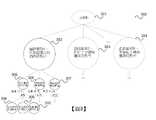
圖2圖示出對該調整樹的一個節點200所執行的該道路段速度調整。在處理開始時,該節點包括(即相關聯到)具有相同(初始)速度的一組道路段204。Figure 2 illustrates the road segment speed adjustment performed at a
為該節點200定義了三個子節點201、202、203:一較高速度類別節點201、一相等速度類別節點202以及一較低速度類別節點203。該節點200及該等子節點201、202、203中的每一個有一識別(ID)。Three
在205中,調整該節點(即該組道路段204)的該速度。At 205, the speed of the node (ie the set of road segments 204) is adjusted.
對於該調整,該伺服器106啟動具有速度調整範圍[x,y]的一迴圈(例如,[x,y]為[-2,t]/[0,0]/[-t,2]用於調整方向「高」/「相等」/「低」;2或-2只是為了保護;調整方向「相等」及「原始」表示不進行調整)。在該迴圈的迭代中,從該等節點初始速度開始,所有道路段204的速度在該調整方向(「高」或「低」)上相對於原始速度遍歷該速度調整範圍。在該迴圈的每次迭代中,該伺服器106更新該速度組配檔案、啟動該路線引擎以基於該預訂的起點及終點獲得一決定的路線計畫、在 208中計算該offCourseRatio(使用來自該預訂之該訓練資料的該司機軌跡207)以及在209中與前一個offCourseRatio(即沒有當前迭代之該調整下該速度的offCourseRatio) 進行比較。如果該offCourseRatio有所改善,則當前迭代之該經調整的速度將被保持為該節點的速度(可能在該迴圈之後續迭代中被進一步地更改)。結果,在所有迭代之後,它將獲得該節點的道路段204之一經最佳化的速度210。For this adjustment, the
在211中,在得到該經最佳化的速度210之後,該伺服器106進行統計並把該等道路段204按照上述參照表1及演算法2所描述的該分類策略分類為該等三個子節點201、202、203的該等三個速度類別。該伺服器106給予該等三個子節點該經最佳化的速度210作為初始速度,並把該調整方向「高」給予該較高速度類別節點201、「相等」給予該相等速度類別節點202以及「低」給予該較低速度類別節點。In 211, after obtaining the optimized
在下面的演算法3中,描述一節點之該速度調整的一種示例性實現方式。
圖3圖示了在整個調整樹300上執行的該道路段速度調整。FIG. 3 illustrates this road segment speed adjustment performed over the
在該實例中,該調整樹300在一第一層中具有一虛擬根301(不與任何道路段相關聯)及節點302、303、304的一第二層以及更多層,其中,如以上所述,從該第二層開始每一個節點對於每一個速度類別(高、相等及低)都有三個子節點。在圖3中,示出了該第三層的子節點305、306、307,它們是該第二層該最左邊節點302的該等子節點。此外,示出了該第四層的子節點308、309、310,它們是該第三層最左邊節點304的該等子節點。In this example, the
該伺服器106從根到葉對該等節點302-310執行速度調整(以一深度優先搜尋順序,例如前序遍歷)。The
根據一個實施例,在每一層上,該等節點被排序使得它們的速度從左到右遞減。According to one embodiment, on each layer, the nodes are ordered such that their velocity decreases from left to right.
該第二層的該等節點302、303、304與該等道路類別相關聯,即該第二層的每一個節點302、303、304被賦予一特定道路類別之道路的所有道路段。因此,該伺服器106不對該第二層節點302、303、304執行速度調整,因為它們的速度係在該等道路類別之該速度輪廓中的該道路類別速度。假設高速公路的速度最高並對路線安排的影響最大。The
每個樹節點的初始速度及初始offCourseRatio係由其父節點經最佳化的速度及與該經最佳化速度相對應的該offCourseRatio來給出。因此,一旦遍歷了該整個樹300,該結果就是所有道路段的一最終 offCourseRatio及道路段速度類別,針對該輸入訓練資料進行了最佳化。The initial speed and initial offCourseRatio of each tree node are given by the optimized speed of its parent node and the offCourseRatio corresponding to the optimized speed. Thus, once the
對於相等速類別節點306、309,該伺服器執行統計及分類但不調整速度,因為其由該父節點的該調整來給出。For equal
例如,在該調整樹中該深度優先搜尋有三個結束條件,即一節點係一葉節點,當: 1. 該節點之所有道路段均未被指派到較高/較低的速度類別。所以沒必要調整。 2. 已達到一調整樹深度臨界值(例如係一輸入參數)。 3. 該節點調整方向為「相等」,其父節點也是一「相等」速度類別節點,其意味著不需要對該等道路段進行統計及分類,因為該父節點不改變其速度,因此不會影響之後的節點。For example, in the adjustment tree, the depth-first search has three end conditions, that is, a node is a leaf node, when: 1. All road segments of this node are not assigned to higher/lower speed classes. So no need to adjust. 2. An adjustment tree depth threshold (eg, an input parameter) has been reached. 3. The adjustment direction of the node is "equal", and its parent node is also an "equal" speed category node, which means that there is no need to count and classify these road segments, because the parent node does not change its speed, so it will not. Affects subsequent nodes.
當遍歷該整個樹300時,每個一葉節點代表一個速度類別。該伺服器106產生一速度組配檔案113,其包括每個經調整的道路段資訊及速度。使用這個速度組配檔,該伺服器106可以(藉由其路線引擎)更準確地預測路線。該offCourseRatio針對該訓練資料被最佳化。When traversing the
在下面的演算法4中描述了該速度類別等級路線安排最佳化的一示例性實現方式。它使用了演算法2的StatisticsAndClassification及演算法3的OneNodeTuning。
藉由上述程序,該道路段速度經過調整後被拆分為若干道路段速度類別。使用這些速度類別的導航存在有一過度擬合的風險,這意味著一決定的路線可能並不平順,從而導致司機可能不得不要做多次的轉彎。因此,為了避免過度擬合,根據一個實施例,使用一正則化項來衡量該平順度:
如以上公式所示,兩條道路段


如果在速度調整之後該平順因子變得更差(在某些節點的執行後或在執行該完整路線最佳化之後),則該伺服器106可以調整該等控制參數並重新調整直到它變好為止。因此,它可以在最佳化該道路網路導航的同時避免過擬合。If the smoothing factor becomes worse after speed adjustment (after execution of certain nodes or after execution of the full route optimization), the
總之,根據各種實施例,提供了一種如在圖4中所示的方法。In summary, according to various embodiments, a method as shown in FIG. 4 is provided.
圖4展示出一流程圖400,其圖示出一種用於供在一地理區域中一車輛判定導航輪廓的方法。FIG. 4 shows a
在401中,獲取該地理區域的一道路網路,該道路網路包括有連接在該地理區域中位置的道路段。In 401, a road network for the geographic area is obtained, the road network including road segments connected to locations in the geographic area.
在402中,藉由為該道路網路的每一個道路段指派一初始速度來初始化一導航地圖(其中,初始速度例如係由該道路段所屬一道路之一道路類別的該速度來給出)。In 402, a navigation map is initialized by assigning an initial speed to each road segment of the road network (where the initial speed is eg given by the speed of a road class of a road to which the road segment belongs) .
在403中,使用包括有用於複數個旅程中每一個之一訓練路線的訓練資料來訓練該導航地圖,藉由 判定一道路段係在該訓練路線中但不在該決定路線中的一旅程數量是否高於一第一臨界值,並且如果一道路段係在該訓練路線中但不在該決定路線中的該旅程數量係高於該第一臨界值,指派一較高的速度給該道路段,以及 判定一道路段係在該決定路線中但不在該訓練路線中的一旅程數量是否高於一第二臨界值,並且如果一道路段係在該決定路線中但不在該訓練路線中的該旅程數量係高於該第二臨界值,指派一較低的速度給該道路段。At 403, the navigation map is trained using the training data including the training route for each of the plurality of journeys, by Determining whether the number of journeys in which a road segment is in the training route but not in the decision route is higher than a first threshold, and if the number of journeys in which a road segment is in the training route but not in the decision route is high at the first threshold, assigning a higher speed to the road segment, and Determining whether the number of journeys in which a road segment is in the determined route but not in the training route is higher than a second threshold, and if the number of journeys in which a road segment is in the determined route but not in the training route is high At the second threshold, a lower speed is assigned to the road segment.
在404中,一導航輪廓被判定,其包括有使用該經訓練的導航地圖供在該地理區域中一車輛用的一路線。At 404, a navigation profile is determined that includes a route for a vehicle in the geographic area using the trained navigation map.
換言之,根據各種實施例,降低司機很少走之道路段的該速度同時增加司機經常走之道路段的該速度。因此,道路段速度被使用作為指出一道路段對於一旅程之合適程度(或受歡迎程度)的一參數。訓練這些道路段速度後,可以在該地理區域內進行有效導航。訓練該導航地圖可以被看成是從演示中學習,即從演示中訓練一機器學習模型,其中在這個實例中該等演示係由司機所走的路線,而該機器學習模型被訓練成它自己可以提出用於旅程的路線。它可藉由考慮道路段速度的一最短路徑演算法(即考慮邊權重計算在頂點之間最短路徑的一演算法)從該經訓練的導航地圖決定一旅程的路線。因此,經過訓練的該機器學習模型可被看成包括該導航地圖及該路線引擎,並且它被訓練成可以得出與該訓練資料中之該等路線相似的路線(並可一般化到沒看過的旅程)。In other words, according to various embodiments, the speed of the road segment that is seldom traveled by the driver is decreased while the speed of the road segment that the driver frequently travels is increased. Therefore, road segment speed is used as a parameter indicating the suitability (or popularity) of a road segment for a journey. After training these road segment speeds, efficient navigation within that geographic area is possible. Training the navigation map can be viewed as learning from demonstrations, i.e. training a machine learning model from demonstrations, where in this instance the demonstrations are routes taken by drivers, and the machine learning model is trained as itself Routes for the journey can be proposed. It can determine the route of a journey from the trained navigation map by a shortest path algorithm that takes into account road segment speeds (ie, an algorithm that calculates the shortest path between vertices taking into account edge weights). Thus, the trained machine learning model can be seen as including the navigation map and the route engine, and it is trained to derive routes similar to the routes in the training data (and can be generalized to journey of).
因此,圖4的該方法可以是一種用於控制一車輛(或控制一車輛之該導航)之方法的一部分,其中該經訓練的導航資料被提供給一車輛並且使用該經訓的導航地圖資料來控制該車輛(或其導航系統)。Thus, the method of FIG. 4 may be part of a method for controlling a vehicle (or controlling the navigation of a vehicle) wherein the trained navigation data is provided to a vehicle and the trained navigation map data is used to Control the vehicle (or its navigation system).
例如,一旅程所要採取的路線可由該伺服器106來決定並被傳送給該相應的車輛108,即被指派給該旅程的該車輛,使得該司機可以遵循該路線。在一自動車的情況下,可以根據該決定的路線來控制該車輛。該伺服器106使用儲存在資料庫107中的一導航地圖來計算該路線。For example, the route to be taken for a journey may be determined by the
術語導航輪廓可以指提供給一車輛用以導航該車輛的一路線或指該車輛將採取路線的該預測。The term navigation profile may refer to a route provided to a vehicle for navigating the vehicle or to the prediction of the route the vehicle will take.
像該導航地圖、該道路網路及該訓練資料等各種資料都是電子資料並且該方法可以是電腦實現的。Various materials like the navigation map, the road network, and the training materials are electronic materials and the method may be computer-implemented.
圖4的該方法例如係由如在圖5中所示的一伺服器電腦來執行的。The method of FIG. 4 is performed, for example, by a server computer as shown in FIG. 5 .
圖5根據一實施例展示出一伺服器電腦500。FIG. 5 shows a
該伺服器電腦500包括一通訊介面501(例如被組配來接收司機的軌跡或一道路網路的該規格,或把導航地圖資料或導航輪廓傳送給另一個伺服器(例如一導航伺服器)或在一車輛中的一導航裝置)。該伺服器電腦500更包括一處理單元502及一記憶體503。該記憶體503可由該處理單元502使用來儲存,例如,待處理之司機的軌跡及一道路網路。該伺服器電腦被組配來執行圖4的方法。The
在本文中所描述的該等方法可被執行以及在本文中所描述之該等各種處理或運算單元及裝置可由一或多個電路來實現。在一實施例中,一「電路」可被理解為任何種類的邏輯實現實體,其可以是硬體、軟體、韌體、或它們的任意組合。因此,在一實施例中,一「電路」可以是一固線式邏輯電路或一可規劃的邏輯電路,諸如一可規劃處理器,例如一微處理器。一「電路」還可以是被實現成或由一處理器來執行的軟體,例如任何種類的電腦程式,例如使用一虛擬機器碼的一電腦程式。根據一替代的實施例,在本文中所描述之該等各個功能之任何其他類型的實現方式也可被理解為一種「電路」。The methods described herein may be performed and the various processing or arithmetic units and devices described herein may be implemented by one or more circuits. In one embodiment, a "circuit" can be understood as any kind of logic implementing entity, which can be hardware, software, firmware, or any combination thereof. Thus, in one embodiment, a "circuit" may be a hardwired logic circuit or a programmable logic circuit, such as a programmable processor, such as a microprocessor. A "circuit" can also be software implemented as or executed by a processor, such as any kind of computer program, such as a computer program using a virtual machine code. According to an alternative embodiment, any other type of implementation of the various functions described herein may also be understood as a "circuit".
雖然已經參考了特定的實施例具體地展示及描述了本發明,但本領域的習知技藝者應當理解的是,在不脫離如由所附請求項所限定之本發明精神及範圍的情況下,可以在其中進行形式及細節上的各種改變。因此,本發明的範圍係由所附請求項來指出並因此旨在包括落入該等請求項等價物之含義及範圍內所有的變化。While the present invention has been particularly shown and described with reference to specific embodiments, it will be understood by those skilled in the art that the present invention is not deviated from the spirit and scope of the present invention as defined by the appended claims. , various changes in form and detail may be made therein. Accordingly, the scope of the present invention is indicated by the appended claims and is therefore intended to include all changes that come within the meaning and range of equivalents of such claims.
100:智慧型手機 101:GUI 103:出發點框 104:目的地框 106:伺服器 107:資料庫 108:車輛 109:記憶體 110:處理器 111:外部資料庫 200:節點 201、202、203:子節點 204:道路段 205:調整 206:ReRoute 207:司機軌跡 209:比較 210:最佳的速度 211:統計及分類 300:調整樹 301:虛擬根 302、303、304:節點 305、306、307、308、309、310:子節點 400:方法 401〜404:方塊 500:伺服器電腦 501:通訊介面 502:處理單元 503:記憶體100: Smartphone 101: GUI 103: Starting point box 104: Destination Box 106: Server 107:Database 108: Vehicles 109: Memory 110: Processor 111: External Repository 200:
參考較佳實施例之詳細說明時若結合非限制性實例及該等附圖進行考慮,將能更佳地理解本發明,其中: -圖1展示出供包括有一智慧型手機及一伺服器之一電子叫車服務用的一通訊佈置。 -圖2圖示出針對一個道路段群組的一道路段速度調整。 -圖3圖示出針對一道路段的一道路段速度調整。 -圖4係一流程圖,其根據一個實施例圖示出一種方法。 -圖5根據一實施例展示出一伺服器電腦。The present invention will be better understood when considered in conjunction with the non-limiting examples and the accompanying drawings in conjunction with the detailed description of the preferred embodiment, wherein: - Figure 1 shows a communication arrangement for an electronic ride-hailing service comprising a smartphone and a server. - Figure 2 illustrates a road segment speed adjustment for a road segment group. - Figure 3 illustrates a road segment speed adjustment for a road segment. - Figure 4 is a flow chart illustrating a method according to an embodiment. - Figure 5 shows a server computer according to an embodiment.
300:調整樹300: Adjustment Tree
301:虛擬根301: virtual root
302、303、304:節點302, 303, 304: Node
305、306、307、308、309、310:子節點305, 306, 307, 308, 309, 310: child nodes
Claims (18)
Translated fromChineseApplications Claiming Priority (2)
| Application Number | Priority Date | Filing Date | Title |
|---|---|---|---|
| SG10202009324U | 2020-09-22 | ||
| SG10202009324U | 2020-09-22 |
Publications (1)
| Publication Number | Publication Date |
|---|---|
| TW202217242Atrue TW202217242A (en) | 2022-05-01 |
Family
ID=80847040
Family Applications (1)
| Application Number | Title | Priority Date | Filing Date |
|---|---|---|---|
| TW110134894ATW202217242A (en) | 2020-09-22 | 2021-09-17 | Method and device for determining a navigation profile for a vehicle in a geographical area |
Country Status (4)
| Country | Link |
|---|---|
| US (1) | US12013248B2 (en) |
| CN (1) | CN116194935B (en) |
| TW (1) | TW202217242A (en) |
| WO (1) | WO2022066098A1 (en) |
Families Citing this family (3)
| Publication number | Priority date | Publication date | Assignee | Title |
|---|---|---|---|---|
| EP4024366A1 (en)* | 2020-12-30 | 2022-07-06 | Argo AI GmbH | Method for controlling a driving behavior of an autonomously driving vehicle, processing device for performing the method, data storage medium and vehicle |
| US11988515B2 (en)* | 2021-09-28 | 2024-05-21 | Uber Technologies, Inc. | Penalizing difficult immediate maneuvers in routing cost functions |
| DE102022118329A1 (en)* | 2022-07-21 | 2024-02-01 | Dr. Ing. H.C. F. Porsche Aktiengesellschaft | Computer-implemented method for determining a navigation route |
Family Cites Families (15)
| Publication number | Priority date | Publication date | Assignee | Title |
|---|---|---|---|---|
| DE10128517A1 (en) | 2001-06-13 | 2003-01-02 | Vodafone Ag | Method for generating navigation data for route guidance and navigation system |
| DE102005004332A1 (en) | 2005-01-31 | 2006-08-03 | Robert Bosch Gmbh | Road network navigation system route determination procedure allows use of time dependent speed values for different road classes |
| US7912628B2 (en) | 2006-03-03 | 2011-03-22 | Inrix, Inc. | Determining road traffic conditions using data from multiple data sources |
| US8126641B2 (en) | 2006-06-30 | 2012-02-28 | Microsoft Corporation | Route planning with contingencies |
| US7706964B2 (en) | 2006-06-30 | 2010-04-27 | Microsoft Corporation | Inferring road speeds for context-sensitive routing |
| EP2203714B1 (en) | 2007-10-26 | 2017-05-10 | TomTom Traffic B.V. | A method of creating map data |
| WO2016028184A1 (en)* | 2014-08-19 | 2016-02-25 | Motorola Solutions, Inc. | Method of and system for determining route speed of a mobile navigation unit movable along a route segment of a route having a plurality of intersections |
| CN112051855B (en)* | 2016-01-05 | 2025-04-08 | 御眼视觉技术有限公司 | Navigation system for host vehicle, autonomous vehicle, and method of navigating autonomous vehicle |
| US9952056B2 (en) | 2016-03-11 | 2018-04-24 | Route4Me, Inc. | Methods and systems for detecting and verifying route deviations |
| US10024675B2 (en)* | 2016-05-10 | 2018-07-17 | Microsoft Technology Licensing, Llc | Enhanced user efficiency in route planning using route preferences |
| US10838423B2 (en)* | 2018-08-07 | 2020-11-17 | GM Global Technology Operations LLC | Intelligent vehicle navigation systems, methods, and control logic for deriving road segment speed limits |
| CN109801491B (en)* | 2019-01-18 | 2022-09-13 | 深圳壹账通智能科技有限公司 | Intelligent navigation method, device and equipment based on risk assessment and storage medium |
| CN110686686B (en)* | 2019-06-04 | 2020-10-02 | 滴图(北京)科技有限公司 | System and method for map matching |
| CN110108292B (en)* | 2019-06-12 | 2020-03-27 | 山东师范大学 | Vehicle navigation path planning method, system, device and medium |
| EP4121329A4 (en)* | 2020-03-18 | 2024-04-17 | Electra Vehicles, Inc. | SYSTEMS AND METHODS FOR MANAGING SPEED PROFILES |
- 2021
- 2021-09-15CNCN202180051909.8Apatent/CN116194935B/enactiveActive
- 2021-09-15USUS18/026,248patent/US12013248B2/enactiveActive
- 2021-09-15WOPCT/SG2021/050560patent/WO2022066098A1/ennot_activeCeased
- 2021-09-17TWTW110134894Apatent/TW202217242A/enunknown
Also Published As
| Publication number | Publication date |
|---|---|
| US12013248B2 (en) | 2024-06-18 |
| CN116194935B (en) | 2024-02-20 |
| CN116194935A (en) | 2023-05-30 |
| US20230324187A1 (en) | 2023-10-12 |
| WO2022066098A1 (en) | 2022-03-31 |
Similar Documents
| Publication | Publication Date | Title |
|---|---|---|
| US12259250B2 (en) | Multimodal vehicle routing system and method with vehicle parking | |
| US9599488B2 (en) | Method and apparatus for providing navigational guidance using the states of traffic signal | |
| Yuan et al. | T-drive: driving directions based on taxi trajectories | |
| RU2406158C2 (en) | Methods of predicting destinations from partial trajectories employing open- and closed-world modeling methods | |
| TW202217242A (en) | Method and device for determining a navigation profile for a vehicle in a geographical area | |
| US7848880B2 (en) | Traffic information adaptive to a user's travel | |
| US8370053B2 (en) | Method and system for a traffic management system based on multiple classes | |
| KR102628004B1 (en) | Generate navigation routes and identify carpooling options, taking into account calculated trade-offs between parameters | |
| CN111133277A (en) | Method, apparatus and computer program product for generating routes using time and space | |
| US20090125229A1 (en) | Corridor mapping with alternative routes | |
| US11079245B1 (en) | Techniques for route planning optimization | |
| CN107270925B (en) | User vehicle navigation system, device and method | |
| CN113706857B (en) | Method, device and equipment for determining road trafficability and storage medium | |
| Liu et al. | Themis: A participatory navigation system for balanced traffic routing | |
| CN104697543B (en) | A kind of path searching method therefor for merging individual character preference heterogeneity | |
| CN114839984A (en) | A shuttle route planning method, device, equipment and storage medium | |
| Rodrigues et al. | Hybrid context-aware multimodal routing | |
| US11170030B2 (en) | Selecting properties using location constraints based on travel time contours | |
| KR101350224B1 (en) | Vehicle route searching method and apparatus thereof | |
| EP4152292B1 (en) | Snap to road, popular routes, popular stops, predicting roadway speed, and contiguous region identification | |
| US12442643B2 (en) | Snap to road, popular routes, popular stops, predicting roadway speed, and contiguous region identification | |
| CN118840855A (en) | Arrival time estimation method and related device | |
| Yoon | Route Design with Optimal Learning | |
| Vedernikov | Optimal route planning for hitchhiking. | |
| CN119756391A (en) | Traffic time prediction method, model training method and device |