RU2755491C1 - Method for detecting icing zones in the take-off and landing sectors of aircraft in a meteorological radar complex - Google Patents
Method for detecting icing zones in the take-off and landing sectors of aircraft in a meteorological radar complexDownload PDFInfo
- Publication number
- RU2755491C1 RU2755491C1RU2021104303ARU2021104303ARU2755491C1RU 2755491 C1RU2755491 C1RU 2755491C1RU 2021104303 ARU2021104303 ARU 2021104303ARU 2021104303 ARU2021104303 ARU 2021104303ARU 2755491 C1RU2755491 C1RU 2755491C1
- Authority
- RU
- Russia
- Prior art keywords
- aircraft
- landing
- take
- meteorological
- icing
- Prior art date
Links
- 238000000034methodMethods0.000titleclaimsabstractdescription14
- 238000002310reflectometryMethods0.000claimsabstractdescription15
- 238000009434installationMethods0.000claimsdescription5
- 239000011148porous materialSubstances0.000claimsdescription3
- 238000001514detection methodMethods0.000claims1
- 238000003672processing methodMethods0.000abstract1
- 239000000126substanceSubstances0.000abstract1
- 101100018859Arabidopsis thaliana IMK3 geneProteins0.000description6
- 208000014651Meester-Loeys syndromeDiseases0.000description6
- XLYOFNOQVPJJNP-UHFFFAOYSA-NwaterSubstancesOXLYOFNOQVPJJNP-UHFFFAOYSA-N0.000description4
- 238000010586diagramMethods0.000description2
- 238000005259measurementMethods0.000description2
- 239000011120plywoodSubstances0.000description2
- 230000015572biosynthetic processEffects0.000description1
- 230000004807localizationEffects0.000description1
- 238000004519manufacturing processMethods0.000description1
- 238000001556precipitationMethods0.000description1
- 230000002035prolonged effectEffects0.000description1
Images
Classifications
- B—PERFORMING OPERATIONS; TRANSPORTING
- B64—AIRCRAFT; AVIATION; COSMONAUTICS
- B64D—EQUIPMENT FOR FITTING IN OR TO AIRCRAFT; FLIGHT SUITS; PARACHUTES; ARRANGEMENT OR MOUNTING OF POWER PLANTS OR PROPULSION TRANSMISSIONS IN AIRCRAFT
- B64D15/00—De-icing or preventing icing on exterior surfaces of aircraft
- B64D15/20—Means for detecting icing or initiating de-icing
- G—PHYSICS
- G01—MEASURING; TESTING
- G01S—RADIO DIRECTION-FINDING; RADIO NAVIGATION; DETERMINING DISTANCE OR VELOCITY BY USE OF RADIO WAVES; LOCATING OR PRESENCE-DETECTING BY USE OF THE REFLECTION OR RERADIATION OF RADIO WAVES; ANALOGOUS ARRANGEMENTS USING OTHER WAVES
- G01S13/00—Systems using the reflection or reradiation of radio waves, e.g. radar systems; Analogous systems using reflection or reradiation of waves whose nature or wavelength is irrelevant or unspecified
- G01S13/88—Radar or analogous systems specially adapted for specific applications
- G01S13/95—Radar or analogous systems specially adapted for specific applications for meteorological use
- G01S13/951—Radar or analogous systems specially adapted for specific applications for meteorological use ground based
- G—PHYSICS
- G01—MEASURING; TESTING
- G01W—METEOROLOGY
- G01W1/00—Meteorology
- G01W1/10—Devices for predicting weather conditions
- Y—GENERAL TAGGING OF NEW TECHNOLOGICAL DEVELOPMENTS; GENERAL TAGGING OF CROSS-SECTIONAL TECHNOLOGIES SPANNING OVER SEVERAL SECTIONS OF THE IPC; TECHNICAL SUBJECTS COVERED BY FORMER USPC CROSS-REFERENCE ART COLLECTIONS [XRACs] AND DIGESTS
- Y02—TECHNOLOGIES OR APPLICATIONS FOR MITIGATION OR ADAPTATION AGAINST CLIMATE CHANGE
- Y02A—TECHNOLOGIES FOR ADAPTATION TO CLIMATE CHANGE
- Y02A90/00—Technologies having an indirect contribution to adaptation to climate change
- Y02A90/10—Information and communication technologies [ICT] supporting adaptation to climate change, e.g. for weather forecasting or climate simulation
Landscapes
- Engineering & Computer Science (AREA)
- Remote Sensing (AREA)
- Radar, Positioning & Navigation (AREA)
- Physics & Mathematics (AREA)
- General Physics & Mathematics (AREA)
- Computer Networks & Wireless Communication (AREA)
- Electromagnetism (AREA)
- Environmental & Geological Engineering (AREA)
- Life Sciences & Earth Sciences (AREA)
- Atmospheric Sciences (AREA)
- Biodiversity & Conservation Biology (AREA)
- Ecology (AREA)
- Environmental Sciences (AREA)
- Aviation & Aerospace Engineering (AREA)
- Radar Systems Or Details Thereof (AREA)
Abstract
Description
Translated fromRussianИзобретение относится к способам обработки сигналов в метеорологических радиолокационных комплексах (МРЛК) и может быть использовано для обнаружения зон вероятного обледенения в секторах взлета и посадки летательных аппаратов (ЛА).The invention relates to methods for signal processing in meteorological radar systems (MRLK) and can be used to detect areas of probable icing in the sectors of takeoff and landing of aircraft.
Известен способ определения появления гололедно-изморезевых отложений с помощью ледоскопа, состоящего из круглого фанерного диска диаметром 30 см, который можно поднимать и опускать на вертикальной оси, вкопанной в землю, кольца диаметром 20 см, проволки диаметром 0,2-0,3 мм, заключающийся в том, что фанерный диск устанавливается на одном уровне с поверхностью снега для сбора изморози и инея, закрепляют кольцо на стержне на удалении 20 см от верхнего конца стержня для сбора изморози, натягивают проволку между кольцом и верхним концом стержня для наблюдения изморозевых отложений, снимают и взвешивают каждый датчик [1].There is a known method for determining the appearance of ice and sea deposits using an ice scope consisting of a round plywood disk with a diameter of 30 cm, which can be raised and lowered on a vertical axis dug into the ground, rings with a diameter of 20 cm, wires with a diameter of 0.2-0.3 mm, consisting in the fact that the plywood disk is installed flush with the surface of the snow to collect frost and frost, fix the ring on the rod at a distance of 20 cm from the upper end of the rod for collecting frost, pull the wire between the ring and the upper end of the rod to observe the frost deposits, remove and weigh each sensor [1].
Недостатком данного способа является локализация измерений в одной точке, где устанавливается ледоскоп, и отсутствие возможности их пролонгации в пространстве, в том числе в секторах взлета и посадки ЛА.The disadvantage of this method is the localization of measurements at one point, where the ice scope is installed, and the lack of the possibility of their prolongation in space, including in the takeoff and landing sectors of the aircraft.
Известен способ обнаружения в доплеровском метеорологическом радиолокаторе (ДМРЛ-С) зон вероятного обледенения, заключающийся в последовательном азимутальном круговом сканировании атмосферы на нескольких углах места антенны в диапазоне 0-90 градусов, записи данных в каждом наблюдении в выходном «объемном файле», где в сферической системе координат последовательно, для каждого элемента конического сечения сохраняются координаты - дальность, азимут и угол места, а также измеренные характеристики радиоэха, в результате обработки «объемных файлов» строится трехмерная модель облачной атмосферы в полусфере радиолокационного обзора, с помощью которой в соответствии выражением [2]There is a known method of detecting zones of probable icing in a Doppler meteorological radar (DMRL-S), which consists in sequential azimuthal circular scanning of the atmosphere at several antenna elevation angles in the range of 0-90 degrees, recording data in each observation in the output "volume file", where in a spherical the coordinate system sequentially, for each element of the conical section, the coordinates are stored - the range, azimuth and elevation, as well as the measured characteristics of the radio echo; as a result of processing the "volumetric files", a three-dimensional model of the cloudy atmosphere in the hemisphere of the radar survey is built, with the help of which, in accordance with the expression [2 ]

гдеwhere

П - метеопотенциал ДМРЛ-С;P is the DMRL-S meteorological potential;
θ - ширина луча диаграммы направленности антенны в азимутальной и угломестной плоскостях,θ is the beamwidth of the antenna pattern in the azimuth and elevation planes,
формируются отражаемости атмосферы, представляющие собой набор карт метеорологических характеристик облачности и осадков, по которым оценивается вертикально-интегрированная водность VIL в соответствии с выражением [3]the reflectivity of the atmosphere is formed, which is a set of maps of meteorological characteristics of cloudiness and precipitation, according to which the vertically-integrated water content VIL is estimated in accordance with the expression [3]

гдеwhere
Zi - радиолокационная отражаемость в столбе в i-ом дискрете по высоте;Zi - radar reflectivity in the column in the i-th discrete in height;
Δh - шаг по высоте от i-го до i+1 дискрета высоты,Δh - step in height from i-th to i + 1 discrete height,
устанавливают пороговое значение величины VIL=0,03 кг/м, при превышении текущего значения VIL его порогового значения принимают решение о наличии обледенения по данным водности метеообразования в высотном слое между изотермами 0° и -15°С, при этом температурный профиль - высоты изотерм определяются путем двухкратного в сутки аэрологического зондирования по данным соседних метеостанций [3].set the threshold value of VIL = 0.03 kg / m, when the current value of VIL exceeds its threshold value, a decision is made on the presence of icing according to the water content of meteorological formation in the height layer between the isotherms of 0 ° and -15 ° C, while the temperature profile is the height of the isotherms are determined by twice a day aerological sounding according to the data of neighboring meteorological stations [3].
Недостатком данного способа является низкая эффективность обнаружения зон вероятного обледенения в секторах взлета и посадки ЛА.The disadvantage of this method is the low efficiency of detecting areas of probable icing in the sectors of takeoff and landing of aircraft.
Это обусловлено тем, что, во-первых, ДМРЛ-С, как правило, устанавливаются без привязки к аэродромам, следовательно формируют метеопродукты во всей полусфере без детализации в секторах взлета и посадки ЛА, во-вторых, для определения температурного профиля в районе аэродрома используются недостаточно точные данные аэрологического зондирования атмосферы, которые обновляются только дважды в сутки, при этом аэрологическая станция может находиться на удалении десятков-сотен километров от ДМРЛ-С и аэродрома, в-третьих, вертикально-интегрированная водность (выражение (2)) не описывает водность в каждой точке глиссады или траектории набора или снижения высоты.This is due to the fact that, firstly, DMRL-S, as a rule, are installed without reference to aerodromes, therefore, they form meteorological products in the entire hemisphere without detailing in the aircraft take-off and landing sectors, and secondly, to determine the temperature profile in the aerodrome area, they are used insufficiently accurate data of aerological sounding of the atmosphere, which are updated only twice a day, while the aerological station may be located at a distance of tens to hundreds of kilometers from the DMRL-S and the airfield, thirdly, the vertically integrated water content (expression (2)) does not describe the water content at each point of the glide path or climb or descent trajectory.
Цель изобретения - повысить эффективность обнаружения зон вероятного обледенения в секторах взлета и посадки летательных аппаратов.The purpose of the invention is to improve the efficiency of detecting areas of probable icing in the sectors of take-off and landing of aircraft.
Для достижения цели с помощью метеорологической радиолокационной станции (МРЛС) ближней аэродромной зоны (БАЗ), входящей в состав метеорологического радиолокационного комплекса (МРЛК) и устанавливаемой непосредственно на аэродроме, в секторе взлета и посадки ЛА осуществляется сканирование атмосферы в азимутальной и угломестной плоскостях, оценивается мощность отраженного сигнала, для каждого импульсного объема вычисляется отражаемость Z атмосферы в соответствии с выражением (1).To achieve the goal, using the meteorological radar station (MRS) of the near aerodrome zone (BAZ), which is part of the meteorological radar complex (MRLK) and installed directly at the aerodrome, the atmosphere is scanned in the azimuth and elevation planes in the aircraft take-off and landing sector, the power is estimated the reflected signal, for each pulse volume, the reflectivity Z of the atmosphere is calculated in accordance with expression (1).
Далее устанавливают порог отражаемости Zпор, соответствующий метеопродукту - слабый дождь, при превышении которого величиной отражаемости Z в координатах дальность - азимут фиксируются минимальная и максимальная дальности с высокой отражаемостью с соответствующими высотами H1 и Н2. С помощью теплового профилемера, входящего в состав МРЛК и установленного в точке установки МРЛС БАЗ, измеряется значение высоты нулевой изотермы НT=0. В [4] показано, что температурный профиль, измеренный в точке установки МРЛС БАЗ при отсутствии прохождения атмосферных фронтов (так как фронтальные зоны характеризуются значительными изменениями температуры воздуха до десятков градусов), может быть пролонгирован на дальность до 10 км, что вполне достаточно для этапов взлета и посадки летательных аппаратов. При одновременном выполнении условийNext, the threshold of reflectivity Zpores is set , corresponding to the meteorological product - light rain, when exceeded by the value of reflectivity Z in the coordinates range - azimuth, the minimum and maximum ranges with high reflectivity are fixed with the corresponding heights H1 and H2 . With the help of a thermal profiler, which is a part of the MRLK and installed at the point of installation of the MRLS BAZ, the value of the height of the zero isotherm HT = 0 is measured. It is shown in [4] that the temperature profile measured at the point of installation of the BAZ MRLS in the absence of the passage of atmospheric fronts (since the frontal zones are characterized by significant changes in air temperature up to tens of degrees) can be prolonged to a distance of up to 10 km, which is quite enough for stages takeoff and landing of aircraft. When conditions are met simultaneously

гдеwhere
Нтек - текущее значение высоты полета ЛА в секторе взлета и посадки, принимают решение о том, что на данных высотах с соответствующими дальностями существует зона вероятного обледенения, в противном случае -при невыполнении хотя бы одного из условий (3), принимают решение о том, что на данных высотах с соответствующими дальностями отсутствует зона вероятного обледенения.Нtech - the current value of the aircraft flight altitude in the take-off and landing sector, make a decision that there is a zone of probable icing at these altitudes with the corresponding ranges, otherwise, if at least one of the conditions (3) is not met, a decision is made that that at these heights with the corresponding ranges there is no zone of probable icing.
Новыми признаками, обладающими существенными отличиями, являются следующие.New features with significant differences are the following.
1. Установка МРЛС БАЗ и теплового профилемера, входящих в состав МРЛК, непосредственно на аэродроме.1. Installation of MRLS BAZ and a thermal profiler, which are part of the MRLK, directly at the airfield.
2. Фиксация минимальной и максимальной дальности с высокой отражаемостью с соответствующими высотами H1 и Н2.2. Fixing the minimum and maximum range with high reflectivity with the corresponding heights H1 and H2 .
3. Измерение значения высоты нулевой изотермы НT=0 с помощью профилемера, установленного в точке установки МРЛС БАЗ.3. Measurement of the value of the height of the zero isotherm НT = 0 using a profiler installed at the point of installation of the BAZ MRLS.
4. На основе анализа выполнений условий (3) принятие решения о существовании или отсутствии зоны вероятного обледенения.4. Based on the analysis of the fulfillment of conditions (3) making a decision on the existence or absence of a zone of probable icing.
Данные признаки обладают существенными отличиями, так как в известных способах не обнаружены.These features have significant differences, since they were not found in the known methods.
Применение всех новых признаков позволит с высокой эффективностью обнаружить зоны вероятного обледенения в секторах взлета и посадки летательных аппаратов.The use of all new features will make it possible with high efficiency to detect areas of probable icing in the take-off and landing sectors of aircraft.
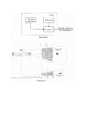
На рисунке 1 приведена блок-схема МРЛК, в состав которого входят МРЛС БАЗ, тепловой профилемер и вычислитель, реализующий предлагаемый способ, на рисунке 2 - эпюры, поясняющие предлагаемый способ на примере захода летательного аппарата на посадку.Figure 1 shows a block diagram of an MRLK, which includes a BAZ MRLS, a thermal profiler and a computer that implements the proposed method, in Figure 2 - diagrams explaining the proposed method using the example of an aircraft landing approach.
Способ обнаружения в метеорологическом радиолокационном комплексе зон обледенения в секторах взлета и посадки летательных аппаратов осуществляется следующим образом (рисунок 1).The method of detecting icing zones in the take-off and landing sectors of aircraft in the meteorological radar complex is carried out as follows (Figure 1).
МРЛК в составе МРЛС ближней аэродромной зоны, теплового профилемера и вычислителя, устанавливается непосредственно на аэродроме. В секторе взлета и посадки (рисунок 2) осуществляется сканирование атмосферы в азимутальной и угломестной плоскостях. В МРЛС (рисунок 1) оценивается мощность отраженного сигнала и для каждого импульсного объема в вычислителе вычисляется отражаемость Z атмосферы в соответствии с выражением (1).MRLK as part of the MRS of the near airfield zone, a thermal profiler and a computer, is installed directly at the airfield. In the take-off and landing sector (Figure 2), the atmosphere is scanned in the azimuth and elevation planes. In the MRLS (Figure 1), the power of the reflected signal is estimated and for each pulse volume in the calculator, the reflectivity Z of the atmosphere is calculated in accordance with expression (1).
Зона с высокой отражаемостью локализуется в вычислителе в координатах дальность - азимут порогом Zпор=20 дlBZ (слабый дождь), при превышении которого в вычислителе фиксируются (рисунок 2) минимальная D1 и максимальная D2 дальности с высокой отражаемостью с соответствующими высотами H1 и Н2.The zone with high reflectivity is localized in the calculator in the coordinates range - azimuth with a threshold Zpore = 20 dlBZ (light rain), when exceeding which the calculator records (Figure 2) the minimum D1 and maximum D2 ranges with high reflectivity with the corresponding heights H1 and H2 .
С помощью теплового профилемера измеряется значение высоты нулевой изотермы НT=0. В вычислителе (рисунок 1) осуществляется анализ выполнения условий (3). При одновременном выполнении условий (3) принимают решение о том, что на данных высотах с соответствующими дальностями существует зона вероятного обледенения, в противном случае - при невыполнении хотя бы одного из условий (3), принимают решение о том, что на данных высотах с соответствующими дальностями отсутствует зона вероятного обледенения.Using a thermal profiler, the value of the height of the zero isotherm HT = 0 is measured. The calculator (Figure 1) analyzes the fulfillment of conditions (3). If conditions (3) are met simultaneously, a decision is made that there is a zone of probable icing at these heights with the corresponding ranges, there is no zone of probable icing.
Таким образом, применение предлагаемого способа позволит повысить эффективность обнаружения зон вероятного обледенения в секторах взлета и посадки летательных аппаратов.Thus, the use of the proposed method will improve the efficiency of detecting areas of probable icing in the sectors of take-off and landing of aircraft.
ИСТОЧНИКИ ИНФОРМАЦИИSOURCES OF INFORMATION
1. Руководство по метеорологическим приборам и методам наблюдений ВМО №8, 2008 г. Обновлено в 2010, 2014 (аналог).1. Guide to Meteorological Instruments and Methods of Observation WMO No. 8, 2008. Updated in 2010, 2014 (analogue).
2. Методические указания по производству метеорологических радиолокационных наблюдений на ДМРЛ-С на сети. СПб.: РосГидроМет, 2013, 164 с.2. Guidelines for the production of meteorological radar observations on the DMRL-S on the network. Saint Petersburg: RosHydroMet, 2013, 164 p.
3. Временные методические указания по использованию информации доплеровского метеорологического радиолокатора ДМРЛ-С в синоптической практике. Вторая редакция. М.: РосГидроМет, 2017. 121 с. (прототип).3. Temporary guidelines for the use of information from the Doppler meteorological radar DMRL-S in synoptic practice. Second edition. M .: RosHydroMet, 2017.112 p. (prototype).
4. Болелов, Э.А., Васильев, О.В., Галаева, К.И. Пространственная изменчивость профиля температуры воздуха в районе аэродрома. Научный вестник ГосНИИ ГА, №29 (340), М.: 2019, с. 146-154.4. Bolelov, E.A., Vasiliev, O.V., Galaeva, K.I. Spatial variability of the air temperature profile in the aerodrome area. Scientific Bulletin of GosNII GA, No. 29 (340), Moscow: 2019, p. 146-154.
Claims (5)
Translated fromRussian


Priority Applications (1)
| Application Number | Priority Date | Filing Date | Title |
|---|---|---|---|
| RU2021104303ARU2755491C1 (en) | 2021-02-19 | 2021-02-19 | Method for detecting icing zones in the take-off and landing sectors of aircraft in a meteorological radar complex |
Applications Claiming Priority (1)
| Application Number | Priority Date | Filing Date | Title |
|---|---|---|---|
| RU2021104303ARU2755491C1 (en) | 2021-02-19 | 2021-02-19 | Method for detecting icing zones in the take-off and landing sectors of aircraft in a meteorological radar complex |
Publications (1)
| Publication Number | Publication Date |
|---|---|
| RU2755491C1true RU2755491C1 (en) | 2021-09-16 |
Family
ID=77745531
Family Applications (1)
| Application Number | Title | Priority Date | Filing Date |
|---|---|---|---|
| RU2021104303ARU2755491C1 (en) | 2021-02-19 | 2021-02-19 | Method for detecting icing zones in the take-off and landing sectors of aircraft in a meteorological radar complex |
Country Status (1)
| Country | Link |
|---|---|
| RU (1) | RU2755491C1 (en) |
Citations (11)
| Publication number | Priority date | Publication date | Assignee | Title |
|---|---|---|---|---|
| GB2271190B (en)* | 1992-10-05 | 1995-11-15 | Tristan John Gadsby | Aviation icing advisor |
| RU2099746C1 (en)* | 1993-11-22 | 1997-12-20 | Атабиев Махти Джафарович | Method of prediction of danger of ice formation on aircraft in overcooled clouds |
| US6125327A (en)* | 1997-01-15 | 2000-09-26 | Harris Corporation | System for identifying and generating geographic map display of aircraft icing conditions |
| RU2228883C2 (en)* | 2002-01-11 | 2004-05-20 | Главная геофизическая обсерватория им. А.И. Воейкова | Method of reduction of danger of icing of flying vehicles |
| EP1545972B1 (en)* | 2002-08-26 | 2010-02-10 | Dalsgaard Nielsen APS | A method of determining the risk of ice deposition due to precipitation and apparatus for exercising the method |
| RU2580375C1 (en)* | 2014-12-30 | 2016-04-10 | Федеральное государственное бюджетное учреждение науки Институт мониторинга климатических и экологических систем Сибирского отделения Российской академии наук (ИМКЭС СО РАН) | Remote method of determining spatial zones of probable icing of aircraft in real time |
| GB2544876A (en)* | 2015-10-30 | 2017-05-31 | Ge Aviation Systems Llc | Enhancing engine performance to improve fuel consumption based on atmospheric ice particles |
| US9846230B1 (en)* | 2013-03-15 | 2017-12-19 | Rockwell Collins, Inc. | System and method for ice detection |
| RU2664972C1 (en)* | 2017-09-25 | 2018-08-24 | Акционерное общество "Институт прикладной астрономии" (АО "ИПА") | Method of remote determination of conditions for aircraft icing based on radiometry of real time |
| RU2672040C2 (en)* | 2017-01-27 | 2018-11-08 | Михаил Юрьевич Пашкевич | Method of providing aircraft with meteorological information |
| US10214294B1 (en)* | 2015-08-21 | 2019-02-26 | Blue Storm Associates, Inc. | Method and system for predicting potential icing conditions |
- 2021
- 2021-02-19RURU2021104303Apatent/RU2755491C1/enactive
Patent Citations (11)
| Publication number | Priority date | Publication date | Assignee | Title |
|---|---|---|---|---|
| GB2271190B (en)* | 1992-10-05 | 1995-11-15 | Tristan John Gadsby | Aviation icing advisor |
| RU2099746C1 (en)* | 1993-11-22 | 1997-12-20 | Атабиев Махти Джафарович | Method of prediction of danger of ice formation on aircraft in overcooled clouds |
| US6125327A (en)* | 1997-01-15 | 2000-09-26 | Harris Corporation | System for identifying and generating geographic map display of aircraft icing conditions |
| RU2228883C2 (en)* | 2002-01-11 | 2004-05-20 | Главная геофизическая обсерватория им. А.И. Воейкова | Method of reduction of danger of icing of flying vehicles |
| EP1545972B1 (en)* | 2002-08-26 | 2010-02-10 | Dalsgaard Nielsen APS | A method of determining the risk of ice deposition due to precipitation and apparatus for exercising the method |
| US9846230B1 (en)* | 2013-03-15 | 2017-12-19 | Rockwell Collins, Inc. | System and method for ice detection |
| RU2580375C1 (en)* | 2014-12-30 | 2016-04-10 | Федеральное государственное бюджетное учреждение науки Институт мониторинга климатических и экологических систем Сибирского отделения Российской академии наук (ИМКЭС СО РАН) | Remote method of determining spatial zones of probable icing of aircraft in real time |
| US10214294B1 (en)* | 2015-08-21 | 2019-02-26 | Blue Storm Associates, Inc. | Method and system for predicting potential icing conditions |
| GB2544876A (en)* | 2015-10-30 | 2017-05-31 | Ge Aviation Systems Llc | Enhancing engine performance to improve fuel consumption based on atmospheric ice particles |
| RU2672040C2 (en)* | 2017-01-27 | 2018-11-08 | Михаил Юрьевич Пашкевич | Method of providing aircraft with meteorological information |
| RU2664972C1 (en)* | 2017-09-25 | 2018-08-24 | Акционерное общество "Институт прикладной астрономии" (АО "ИПА") | Method of remote determination of conditions for aircraft icing based on radiometry of real time |
Non-Patent Citations (1)
| Title |
|---|
| ПЕРВУШИН Р.В. Обеспечение безопасности полётов летательных аппаратов в условиях вероятного обледенения // Машиностроение и безопасность жизнедеятельности. N 2(16), 2013 г., сс. 9-12.* |
Similar Documents
| Publication | Publication Date | Title |
|---|---|---|
| Wakimoto et al. | The Garden City, Kansas, storm during VORTEX 95. Part I: Overview of the storm’s life cycle and mesocyclogenesis | |
| Chan et al. | Application of short-range lidar in wind shear alerting | |
| Martin et al. | Discrimination of bird and insect radar echoes in clear air using high-resolution radars | |
| Weiss et al. | Evolving complex electrical structures of the STEPS 25 June 2000 multicell storm | |
| D'Adderio et al. | GPM-CO observations of Medicane Ianos: Comparative analysis of precipitation structure between development and mature phase | |
| Chan et al. | Depiction of complex airflow near Hong Kong International Airport using a Doppler LIDAR with a two-dimensional wind retrieval technique | |
| French et al. | Wave-induced boundary layer separation in the lee of the Medicine Bow Mountains. Part I: Observations | |
| Reitebuch et al. | Determination of airflow across the Alpine ridge by a combination of airborne Doppler lidar, routine radiosounding and numerical simulation | |
| Chan | Generation of an eddy dissipation rate map at the Hong Kong International Airport based on Doppler lidar data | |
| RU2755491C1 (en) | Method for detecting icing zones in the take-off and landing sectors of aircraft in a meteorological radar complex | |
| Drechsel et al. | Three-dimensional wind retrieval: Application of MUSCAT to dual-Doppler lidar | |
| Singh et al. | Estimation of snow accumulation on Samudra Tapu glacier, Western Himalaya using airborne ground penetrating radar | |
| Shusse et al. | Relationship between precipitation core behavior in cumulonimbus clouds and surface rainfall intensity on 18 August 2011 in the Kanto Region, Japan | |
| Griffin et al. | Polarimetric radar observations of simultaneous tornadoes on 10 May 2010 near Norman, Oklahoma | |
| Kim et al. | Retrieval and accuracy evaluation of horizontal winds from Doppler lidars during ICE-POP 2018 | |
| Dabas et al. | Use of a sodar to improve the forecast of fogs and low clouds on airports | |
| Dinevich et al. | Algorithmic system for identifying bird radio-echo and plotting radar ornithological charts | |
| Chadwick et al. | Radar remote sensing of the clear atmosphere—Review and applications | |
| Barbaresco et al. | Wake vortex profiling by Doppler X-band radar: Orly trials at initial take-off & ILS interception critical areas | |
| Fan et al. | Wind shear signal simulation of the airborne weather radar | |
| Villa et al. | Enhanced Weather Detection and Tracking Algorithms in Primary Surveillance Radar | |
| Bushnell | Dropsonde measurements of vertical winds in the Colorado thunderstorm of 22 July 1972 | |
| Weber et al. | Wind shear detection with airport surveillance radars | |
| Steinheuer et al. | Exploiting the full potential of Doppler lidars: High‐resolution wind‐gust profiling in significant weather | |
| Dinevich et al. | Radar monitoring of seasonal bird migration over central Israel |