RU2108627C1 - Position indicating system - Google Patents
Position indicating systemDownload PDFInfo
- Publication number
- RU2108627C1 RU2108627C1RU93058671ARU93058671ARU2108627C1RU 2108627 C1RU2108627 C1RU 2108627C1RU 93058671 ARU93058671 ARU 93058671ARU 93058671 ARU93058671 ARU 93058671ARU 2108627 C1RU2108627 C1RU 2108627C1
- Authority
- RU
- Russia
- Prior art keywords
- time
- station
- signals
- stations
- specified
- Prior art date
Links
- 230000006870functionEffects0.000claimsabstractdescription4
- 230000005540biological transmissionEffects0.000claimsdescription35
- 230000006854communicationEffects0.000claimsdescription16
- 238000004891communicationMethods0.000claimsdescription15
- 230000001360synchronised effectEffects0.000claimsdescription3
- 230000005855radiationEffects0.000claimsdescription2
- 230000029777axis specificationEffects0.000claims1
- 238000001514detection methodMethods0.000claims1
- 230000008054signal transmissionEffects0.000claims1
- 239000000126substanceSubstances0.000abstract1
- 230000033001locomotionEffects0.000description13
- 238000010586diagramMethods0.000description7
- 238000000926separation methodMethods0.000description7
- 230000008901benefitEffects0.000description6
- 238000012544monitoring processMethods0.000description6
- 230000008859changeEffects0.000description5
- RZVHIXYEVGDQDX-UHFFFAOYSA-N9,10-anthraquinoneChemical compoundC1=CC=C2C(=O)C3=CC=CC=C3C(=O)C2=C1RZVHIXYEVGDQDX-UHFFFAOYSA-N0.000description3
- 230000004807localizationEffects0.000description3
- 238000000034methodMethods0.000description3
- 230000001934delayEffects0.000description2
- 230000003252repetitive effectEffects0.000description2
- 230000011664signalingEffects0.000description2
- 230000007704transitionEffects0.000description2
- 241001465754MetazoaSpecies0.000description1
- 230000001154acute effectEffects0.000description1
- 238000004590computer programMethods0.000description1
- 239000004020conductorSubstances0.000description1
- 239000013078crystalSubstances0.000description1
- 230000009429distressEffects0.000description1
- 238000005516engineering processMethods0.000description1
- 230000010006flightEffects0.000description1
- 230000009545invasionEffects0.000description1
- 230000007774longtermEffects0.000description1
- 238000013507mappingMethods0.000description1
- 230000008520organizationEffects0.000description1
- 238000012545processingMethods0.000description1
- 238000011160researchMethods0.000description1
- 230000004044responseEffects0.000description1
- 238000012552reviewMethods0.000description1
- 238000012502risk assessmentMethods0.000description1
- 230000002269spontaneous effectEffects0.000description1
- 230000029305taxisEffects0.000description1
- 238000012546transferMethods0.000description1
- 230000000007visual effectEffects0.000description1
Images


Classifications
- G—PHYSICS
- G08—SIGNALLING
- G08G—TRAFFIC CONTROL SYSTEMS
- G08G5/00—Traffic control systems for aircraft
- G08G5/50—Navigation or guidance aids
- G08G5/56—Navigation or guidance aids for two or more aircraft
- G—PHYSICS
- G01—MEASURING; TESTING
- G01S—RADIO DIRECTION-FINDING; RADIO NAVIGATION; DETERMINING DISTANCE OR VELOCITY BY USE OF RADIO WAVES; LOCATING OR PRESENCE-DETECTING BY USE OF THE REFLECTION OR RERADIATION OF RADIO WAVES; ANALOGOUS ARRANGEMENTS USING OTHER WAVES
- G01S19/00—Satellite radio beacon positioning systems; Determining position, velocity or attitude using signals transmitted by such systems
- G01S19/01—Satellite radio beacon positioning systems transmitting time-stamped messages, e.g. GPS [Global Positioning System], GLONASS [Global Orbiting Navigation Satellite System] or GALILEO
- G01S19/13—Receivers
- G01S19/14—Receivers specially adapted for specific applications
- G01S19/15—Aircraft landing systems
- G—PHYSICS
- G01—MEASURING; TESTING
- G01S—RADIO DIRECTION-FINDING; RADIO NAVIGATION; DETERMINING DISTANCE OR VELOCITY BY USE OF RADIO WAVES; LOCATING OR PRESENCE-DETECTING BY USE OF THE REFLECTION OR RERADIATION OF RADIO WAVES; ANALOGOUS ARRANGEMENTS USING OTHER WAVES
- G01S5/00—Position-fixing by co-ordinating two or more direction or position line determinations; Position-fixing by co-ordinating two or more distance determinations
- G01S5/0009—Transmission of position information to remote stations
- G01S5/0072—Transmission between mobile stations, e.g. anti-collision systems
- G—PHYSICS
- G08—SIGNALLING
- G08G—TRAFFIC CONTROL SYSTEMS
- G08G5/00—Traffic control systems for aircraft
- G08G5/20—Arrangements for acquiring, generating, sharing or displaying traffic information
- G08G5/25—Transmission of traffic-related information between aircraft
- G—PHYSICS
- G08—SIGNALLING
- G08G—TRAFFIC CONTROL SYSTEMS
- G08G5/00—Traffic control systems for aircraft
- G08G5/20—Arrangements for acquiring, generating, sharing or displaying traffic information
- G08G5/26—Transmission of traffic-related information between aircraft and ground stations
Landscapes
- Engineering & Computer Science (AREA)
- Physics & Mathematics (AREA)
- General Physics & Mathematics (AREA)
- Aviation & Aerospace Engineering (AREA)
- Radar, Positioning & Navigation (AREA)
- Remote Sensing (AREA)
- Computer Networks & Wireless Communication (AREA)
- Position Fixing By Use Of Radio Waves (AREA)
- Radar Systems Or Details Thereof (AREA)
- Traffic Control Systems (AREA)
- Train Traffic Observation, Control, And Security (AREA)
- Luminescent Compositions (AREA)
- Indole Compounds (AREA)
- Electric Propulsion And Braking For Vehicles (AREA)
Abstract
Description
Translated fromRussianИзобретение относится к системе для индикации положений движущихся объектов, которая позволяет совокупности движущихся объектов или станций осуществлять слежение друг за другом и центральной станции или ряду центральных станций осуществлять слежение за положениями индивидуального и/или всех членов этой совокупности. The invention relates to a system for indicating the positions of moving objects, which allows a set of moving objects or stations to track each other and to a central station or a number of central stations to track the positions of an individual and / or all members of this set.
Системы для определения положения хорошо известны уже в течение долгого времени, например, система DECCA, система LORAN, система VLF OMEGA, NDB, VOR и DME. Для использования на центральных станциях известны различные типы радарных систем, такие как радар первичной информации (PSR) и радар вторичной, обзорной информации (SSR). Система радара SSR содержит наземное устройство опроса и импульсные повторители SSR в движущихся объектах. Positioning systems have been well known for a long time, for example, the DECCA system, the LORAN system, the VLF OMEGA system, NDB, VOR and DME. Various types of radar systems are known for use at central stations, such as the primary information radar (PSR) and the secondary surveillance information radar (SSR). The SSR radar system includes a ground polling device and pulse SSR repeaters in moving objects.
В последнее время была создана Американская система (Система глобального позиционирования) и соответствующая Российская система, называемая GLONASS, обе эти системы базируются на сигналах времени, посылаемых со спутников, имеющих известные элементы орбиты. Когда по крайней мере четыре таких спутника находятся выше горизонта, возможно получение локально однозначного положения с очень высокой точностью. Устройство для получения информации о таком положении хорошо известны и коммерчески доступны, что делает излишним приводить здесь их подробное описание, которое было бы больше, чем необходимо для описания настоящего изобретения. Recently, the American system (Global Positioning System) was created and the corresponding Russian system, called GLONASS, both of these systems are based on time signals sent from satellites having known elements of the orbit. When at least four such satellites are above the horizon, it is possible to obtain a locally unique position with very high accuracy. A device for obtaining information about this situation is well known and commercially available, which makes it unnecessary to provide here a detailed description, which would be more than necessary to describe the present invention.
Тот факт, что точное положение может быть получено с помощью оборудования, имеющего умеренную цену, привел к предложению его использования в навигации и для наблюдения за авиацией, перенаселенность которой самолетами стала печально известной в последние годы. Согласно заявке Великобритании GB-A-2 155 720, было предложено включить в ответ авиационного импульсного повторителя на запрос от станции управления не только его обычную информацию идентификации, но также и положение, определяемое станцией GPS движущегося объекта, несущего этот импульсный повторитель. The fact that an accurate position can be obtained with moderate-priced equipment has led to a proposal for its use in navigation and for monitoring aviation, the overpopulation of which by aircraft has become infamous in recent years. According to the application of Great Britain GB-A-2 155 720, it was proposed to include in the response of the aircraft pulse repeater to a request from the control station not only its usual identification information, but also the position determined by the GPS station of the moving object carrying this pulse repeater.
В патенте США N 4,835,537, включенном здесь в качестве ссылки, предлагается создать систему предотвращения столкновений, в которой самолеты, взлетно-посадочные полосы, фиксированные препятствия и наземные средства передвижения в аэропортах сигнализируют о своих положениях всем участкам движения. Тем самым сигнализация осуществляется в отдельном радиоканале для всех участников движения, с каждым участником движения, определяющим момент, когда этот канал не занят, и начинающим передавать свое сообщение по истечении произвольного времени ожидания. Эта передаваемая мощность удерживается на низком уровне, чтобы она не превышала радиуса уровня контролируемого воздушного пространства. U.S. Pat. No. 4,835,537, incorporated herein by reference, proposes the creation of a collision avoidance system in which aircraft, runways, fixed obstacles and ground vehicles at airports signal their positions to all traffic areas. Thus, the alarm is carried out in a separate radio channel for all participants in the movement, with each participant in the movement determining the moment when this channel is not busy, and starting to transmit its message after an arbitrary waiting time. This transmitted power is kept low so that it does not exceed the radius of the level of controlled airspace.
В настоящее время ответственность за контроль и мониторинг воздушного движения над землей разделяется между рядом Областных Центров Управления (АСС), и Центров Полетной Информации (FIC), каждый из которых ответственен за соответствующие регионы (Регионы Полетной Информации - FIR), в которых осуществляется мониторинг земли и управление воздушным движением, осуществляемым в определенных или во всех частях воздушного пространства, и/или обеспечивается определенное обслуживание самолета, который выполнил план полета. Каждый раз, когда самолет покидает один из этих регионов FIR, центр управления следующим регионам FIR извещается о принятой траектории полета, чтобы этот самолет мог быть обнаружен или идентифицирован. Перед вхождением в этот следующий регион FIR экипажу этого самолета отдается приказ об установлении радиоконтакта с центром управления региона FIR, в который этот самолет собирается войти. Currently, responsibility for the control and monitoring of air traffic above the ground is divided between a number of Regional Management Centers (ACC) and Flight Information Centers (FIC), each of which is responsible for the respective regions (Flight Information Regions - FIR) in which land monitoring is carried out and air traffic control, carried out in certain or in all parts of the airspace, and / or certain services are provided for the aircraft that has fulfilled the flight plan. Each time an aircraft leaves one of these FIR regions, the control center for the next FIR regions is notified of the accepted flight path so that this aircraft can be detected or identified. Before entering this next FIR region, the crew of this aircraft is ordered to establish radio contact with the control center of the FIR region, into which this aircraft is about to enter.
Воздушное движение должно осуществляться по ограниченному ряду воздушных коридоров, часто называемых "авиалиниями" ("airways"), или заданным маршрутом. Эти авиалинии устанавливаются вдоль базирующихся на земле радионавигационных маяков или путем комбинации расположений таких радионавигационных маяков и "фиксированных точек", определяемых расстоянием и направлением к/от наземных маяков. Навигация самолета осуществляется с помощью приемников на борту, которые могут обнаруживать сигналы от наземных радионавигационных маяков, и имеют устройство отображения, которое указывает местоположение самолета относительно наземного маяка. Над поверхностью земли и в близких окрестностях от аэропорта центры управления также осуществляют мониторинг и контроль передвижений самолета с помощью радара. Минимальное боковое разделение между самолетами, летящими на одной высоте в этих контролируемых с помощью радара областях, может варьироваться обычно между 5-10 морскими милями. При окончательном приближении к аэропорту это минимальное радарное разделение между самолетами обычно составляет три морских мили. В областях, не имеющих радарного покрытия, это минимальное разделение для воздушного движения на той же высоте и дорожке обычно составляет десять минут, что в зависимости от скорости самолета составляет расстояние от 80 до 90 морских миль. Air traffic should be carried out on a limited number of air corridors, often referred to as "airways", or on a given route. These airlines are established along ground-based radio navigation beacons or by a combination of the locations of such radio navigation beacons and "fixed points", determined by the distance and direction to / from the ground beacons. The aircraft is navigated using receivers on board, which can detect signals from ground-based radio navigation beacons, and have a display device that indicates the location of the aircraft relative to the ground-based beacon. Above the surface of the earth and in the vicinity of the airport, control centers also monitor and control aircraft movements using radar. The minimum lateral separation between airplanes flying at the same height in these radar-controlled areas can usually vary between 5-10 nautical miles. When finally approaching the airport, this minimum radar separation between aircraft is usually three nautical miles. In areas without radar coverage, this minimum separation for air traffic at the same altitude and track is usually ten minutes, which, depending on the speed of the aircraft, ranges from 80 to 90 nautical miles.
Воздушное движение над океанами осуществляется по заданным маршрутам. Учитывая тот факт, что невозможно определить положение самолета с помощью наземных радиомаяков или радара при работе над океаном, это разделение между самолетами должно быть существенно увеличено. Обычно минимальное боковое разделение между самолетами, летящими на одной высоте и на одной дорожке, в случае Севера Атлантики, составляет 60 морских миль. Air traffic over the oceans is carried out on given routes. Given the fact that it is impossible to determine the position of the aircraft using ground-based radio beacons or radar when working on the ocean, this separation between the aircraft should be significantly increased. Typically, the minimum lateral separation between aircraft flying at the same altitude and on the same track, in the case of the North Atlantic, is 60 nautical miles.
В настоящее время число авиалиний и маршрутов ограничено, и самолет должен быть привязан к так называемым "слотам" ("интервалам"), которые распределены между авиационными компаниями или между индивидуальными самолетами, и очень часто заблаговременно. Задержись самолет по любым причинам на несколько минут на земле и пропусти свой "слот", это может вызвать дополнительные задержки на несколько часов, прежде чем этот самолет сможет получить новый свободный "слот". Currently, the number of airlines and routes is limited, and the aircraft must be tied to the so-called "slots" ("intervals"), which are distributed between aviation companies or between individual aircraft, and very often in advance. Hold the plane for any reason for several minutes on the ground and miss your "slot", this may cause additional delays for several hours before this plane can get a new free "slot".
Специальное управление полетом или устройства управления полетом установлены во многих областях мира. Необходимость в этих устройствах управления полетом и в процедурах распределения "слотов" вызывается недостатком вместимости в системах авиалиний на протяжении полетных маршрутов, и загруженностью аэропортов. Special flight control or flight control devices are installed in many areas of the world. The need for these flight control devices and procedures for the allocation of "slots" is caused by the lack of capacity in airline systems along flight routes, and the congestion of airports.
В аэропортах эта вместимость ограничивается рядом факторов. В основном, число взлетно-посадочных полос, рулежных дорожек и пропускных пунктов аэропортов, метеорологические условия, аппаратура навигации и приземления, процедуры управления воздушным движением и т.п., все это является важными элементами, которые по отдельности или все вместе влияют на эту вместимость. В ситуациях плохой видимости эти проблемы вместимости увеличиваются, главным образом благодаря неспособности современной технологии обеспечить управление воздушным движением с предоставлением возможности отображать и контролировать движения самолета и наземных транспортных средств. Времена занятости взлетно-посадочных полос также возрастают, когда самолет вынужден передвигаться на пониженных скоростях из-за трудности навигации на земле и плохой видимости. Это также снижает вместимость аэропорта. At airports, this capacity is limited by a number of factors. Basically, the number of runways, taxiways and airport checkpoints, meteorological conditions, navigation and landing equipment, air traffic control procedures, etc., are all important elements that individually or collectively affect this capacity . In situations of poor visibility, these capacity problems increase, mainly due to the inability of modern technology to provide air traffic control with the ability to display and control the movements of aircraft and ground vehicles. Occupation times for runways also increase when an aircraft is forced to travel at reduced speeds due to land navigation difficulties and poor visibility. It also reduces the capacity of the airport.
Число инцидентов и несчастных случаев, вызванных потенциальными или реальными столкновениями самолетов с самолетами на земле и самолетов с наземными транспортными средствами за последние десятилетия возросло. Число таких серьезных инцидентов, произошедших в США, составляет величину порядка 5-7 на 100000 взлетов и посадок. Ряд фатальных инцидентов происходит уже на протяжении многих лет. The number of incidents and accidents caused by potential or actual collisions of airplanes with airplanes on the ground and airplanes with land vehicles has increased over the past decades. The number of such serious incidents that occurred in the United States is about 5-7 per 100,000 take-offs and landings. A number of fatal incidents have been happening for many years.
Система, которая обеспечила бы возможность управлению воздушным движением отображать и контролировать операции самолета на земле, также как и движения по земле наземных транспортных средств, в которой каждый член этой системы передавал бы информацию о своем положении и идентификации и представлял бы ее управлению воздушным движением для отображения ее, например, на дисплее, а также обеспечивал бы эту же информацию для пилотов, и которая могла бы использоваться для управления движением самолета, имела бы существенную важность с точки зрения повышения вместимости аэропортов и надежности. A system that would allow air traffic control to display and control aircraft operations on the ground, as well as ground movements of land vehicles, in which each member of this system would transmit information about its position and identification and present it to air traffic control for display it, for example, on the display, and would also provide the same information for pilots, and which could be used to control the movement of the aircraft, would be of significant importance from the point of view Nia increase capacity airports and reliability.
Ожидается, что эти проблемы вместимости и надежности станут еще острее, так как, согласно прогнозам, воздушное движение будет продолжать увеличиваться с относительно высокой скорость. Удвоение существующего числа воздушных пассажиров (приблизительно 1,2 биллиона) и почти пропорциональный прирост числа операций самолетов, как ожидается, произойдет через ближайшие 10-12 лет. It is expected that these capacity and reliability problems will become even more acute since, according to forecasts, air traffic will continue to increase at a relatively high speed. Doubling the existing number of air passengers (approximately 1.2 billion) and an almost proportional increase in the number of aircraft operations is expected to occur in the next 10-12 years.
Согласно заявлению представителя Немецкого Института аэрокосмических исследований, "если бы мы могли получить одно дополнительное приземление в час во Франкфурте, в течение года это составило бы 10 миллионов немецких марок на экономии в задержках". ("Нью сайентист" 16 ноября 1991 г., стр. 23). According to a representative from the German Institute for Aerospace Research, "if we could get one extra touchdown per hour in Frankfurt, this would amount to 10 million German marks during the year to save on delays." (New Scientist November 16, 1991, p. 23).
Было создано несколько международных рабочих групп для рассмотрения существующей ситуации и для выработки рекомендаций о действиях, которые следует предпринять, чтобы повысить вместимость систем управления воздушным движением, а также надежность на земле. Несколько рабочих групп проводят свою работу под эгидой "Международной организации гражданской авиации" - ICAO. В нескольких странах, особенно в США, прикладываются существенные усилия для решения проблем безопасности, связанных с наземными операциями в аэропортах. Several international working groups have been set up to review the current situation and to make recommendations on actions that should be taken to increase the capacity of air traffic control systems, as well as reliability on the ground. Several working groups conduct their work under the auspices of the "International Civil Aviation Organization" - ICAO. Significant efforts are being made in several countries, especially in the United States, to address the security problems associated with ground operations at airports.
Таким образом, официально признается, что существует недостаток вместимости и что будет получена существенная экономия средств, если системы, которые могут обеспечить повышенную способность контроля и отображения воздушного движения, смогут повысить как безопасность, так и вместимость. Thus, it is officially recognized that there is a lack of capacity and that significant cost savings will be achieved if systems that can provide enhanced air traffic control and display capabilities can increase both safety and capacity.
Главная цель изобретения - получить системы для контроля за совокупность подвижных объектов в том, что касается их мест расположений, с каждым членом совокупности, посылающим информацию о его положении в общий радиоканал, и которая допускает существование даже очень больших совокупностей объектов, предупреждая столкновения объектов и допуская центральное управление. Предполагаемыми совокупностями объектов могут быть самолеты, наземные транспортные средства и морские суда. Для того, чтобы такая система работала оптимально, необходимо исключать столкновения не только чисто физического характера, но также и столкновения коммуникационной природы, оба значения действительных столкновений предполагают, что более чем один участник передает одновременно так, что они мешают друг другу, и что невозможность передавать вызвана переполнением общего коммуникационного канала. The main objective of the invention is to obtain systems for monitoring the totality of moving objects in terms of their locations, with each member of the population sending information about its position to a common radio channel, and which allows the existence of even very large collections of objects, preventing collisions of objects and allowing central management. Estimated collections of objects may include airplanes, land vehicles and ships. In order for such a system to work optimally, it is necessary to exclude collisions not only of a purely physical nature, but also collisions of a communication nature, both values of actual collisions suggest that more than one participant transmits at a time so that they interfere with each other, and that the inability to transmit caused by the overflow of a common communication channel.
Специально частью этой цели изобретения для авиации является получение системы, которая могла бы быть использована самолетом где угодно, без исключения. Естественно, что риск столкновения будет больше там, где движение более плотное, но случайные скопления самолетов могут образоваться практически в любом месте земного шара. A special part of this objective of the invention for aviation is to provide a system that could be used by an airplane anywhere, without exception. Naturally, the risk of a collision will be greater where the traffic is denser, but random clusters of aircraft can form almost anywhere in the world.
Другой целью изобретения является создание лучшей возможности распределения самолетов для повышения вместимости воздушного пространства за счет исключения необходимости в структуре радиомаяков через распределенную локализацию, с каждым самолетом, имеющим свое собственное средство, позволяющее ему следовать по любому заданному коридору или маршруту, которое не должно быть материализовано с помощью общего наземного оборудования. В особенности там, где системы радиомаяков еще не были установлены, возможна большая экономия средств в этом отношении. Далее, когда могут быть определены маршруты, которые не зависят от систем радиомаяков, число маршрутов может быть повышено практически по желанию, и имеется возможность избежать существенного переполнения, по крайней мере, в окрестностях аэропортов. Узких мест при взлетах и посадках также можно избежать в значительной степени, если будут улучшены системы управления воздушным движением таким образом, чтобы боковые и/или вертикальные разделения между самолетами были уменьшены, а вместимость воздушного пространства повышена без возрастания риска столкновения. Another objective of the invention is to create a better ability to distribute aircraft to increase airspace capacity by eliminating the need for a structure of beacons through distributed localization, with each aircraft having its own means, allowing it to follow any given corridor or route that should not be materialized with using common ground equipment. Especially where radio beacon systems have not yet been installed, large savings are possible in this regard. Further, when routes that are independent of beacon systems can be determined, the number of routes can be increased almost at will, and it is possible to avoid significant overcrowding, at least in the vicinity of airports. Bottlenecks during takeoffs and landings can also be avoided to a large extent if air traffic control systems are improved so that side and / or vertical separation between aircraft is reduced and airspace capacity is increased without increasing the risk of collision.
При долговременных полетах над морем или в ненаселенных областях в настоящее время не существует систем, которые бы обеспечивали точное поверхностное управление авиацией, так как самолет не может быть обнаружен, например, радаром. Поэтому другая цель этого изобретения - обеспечить возможность для самолета, находящегося в таком положении, сообщать о своем положении центральной станции, предпочтительно с помощью спутниковой коммуникации, а частота этого сообщения затем может быть определена в самолете в зависимости от интенсивности локального воздушного движения, подлежащей определению системой. For long-term flights over the sea or in uninhabited areas, there are currently no systems that provide precise surface control of aviation, since the aircraft cannot be detected, for example, by radar. Therefore, another object of this invention is to provide an opportunity for an aircraft in such a position to report its position to a central station, preferably by satellite communication, and the frequency of this message can then be determined in the aircraft depending on the intensity of local air traffic to be determined by the system .
Указанные и другие цели и преимущества достигаются в соответствии с изобретением с помощью системы индикации положения, включающей совокупность одновременно активных, движущихся станций, каждая из которых улавливает свое географическое положение, принимая сигналы от геометрических распределенных передатчиков, имеющих известные положения, и в которой каждая участвующая станция имеет передатчики для отправки в радиоканал, общий для этой системы, сигналов, индицирующих собственные идентичности и географические положения, и средство памяти для запоминания сигналов от других участвующих движущихся станций, и в которой в соответствии с этим изобретением каждая станция имеет средство обработки, такое как компьютер, содержащее ось вращения, которая прецизионно (точно) контролируется сигналами времени, принятыми от указанных, геометрически распределенных передатчиков, с указанной осью времени, определяющей блоки времени, стандартизованные вдобавок к этому, и перечисленные в заданном повторяющемся кадре, с указанным средством памяти, регистрирующим свободные блоки времени, в течение которых не было принято никаких передач, средство для выбора одного из указанных блоков времени для собственной повторяющейся передачи в нем информации идентичности и положения, с указанным передатчиком, работающим на частоте, имеющей дальность, существенно ограниченную линией зрения, и предпочтительно средство для выбора одного из указанных блоков времени для собственной повторяющейся передачи в нем информации идентичности и положения, с указанным передатчиком, работающим на частоте, имеющей дальность, существенно ограниченную линией зрения, и предпочтительно средство для произвольного переключения одного из используемых указанных блоков времени, и другой блок, зарегистрированный как свободный. В соответствии с предпочтительным примером осуществления каждая станция также определяет плотность воздушного движения в окружающей ее внешней среде и определяет в функции от нее, как много блоков времени должно использоваться в последующих кадрах. These and other goals and advantages are achieved in accordance with the invention using a position indicating system comprising a set of simultaneously active, moving stations, each of which captures its geographical position, receiving signals from geometrical distributed transmitters having known positions, and in which each participating station has transmitters for sending to a radio channel common to this system, signals indicating their own identities and geographical locations, and means memory for storing signals from other participating moving stations, and in which, in accordance with this invention, each station has processing means, such as a computer containing a rotation axis, which is precisely (precisely) controlled by time signals received from said geometrically distributed transmitters, a specified time axis defining time blocks standardized in addition to this and listed in a given repeating frame, with a specified memory means registering free time blocks nor, during which any transmissions were received, means for selecting one of the indicated time blocks for repetitive transmission of identity and position information therein, with said transmitter operating at a frequency having a range substantially limited by the line of sight, and preferably means for the choice of one of these time blocks for its own repetitive transmission of identity and position information in it, with the specified transmitter operating at a frequency having a range, significantly limits line of sight, and preferably means for randomly switching one of the used indicated time blocks, and another block registered as free. In accordance with a preferred embodiment, each station also determines the density of air traffic in its external environment and determines, as a function of it, how many time blocks should be used in subsequent frames.
Предпочтительно иметь в каждой станции монитор или что-то подобное, чтобы показывать местоположения других станций, наложенные, например, на карту. Другой предпочтительной особенностью является определение действительного риска столкновения из-за географического соседства, предупреждая об этом экипаж с помощью сигнала опасности. Поскольку имеется установленная сесть наземных центров управления (Областных центров управления - АСС, или центров полетной информации - FIC) для управления и мониторинга всех движений в воздухе, обо всех движениях в воздухе следует сообщать на землю с тем, чтобы в принципе только управление воздушным движением могло назначать изменение маршрута, включая изменение высоты, в ненаселенных регионах сигнализация к наземным центрам управления должна осуществляться с помощью спутниковых коммуникаций. It is preferable to have a monitor or the like in each station to show locations of other stations superimposed, for example, on a map. Another preferred feature is the determination of the actual risk of a collision due to geographical proximity, warning the crew about this with a hazard signal. Since there is an established set of ground control centers (Regional control centers - ACC, or flight information centers - FIC) for controlling and monitoring all movements in the air, all movements in the air should be reported to the ground so that, in principle, only air traffic control can assign a change of route, including a change in altitude, in uninhabited regions, signaling to ground control centers should be carried out using satellite communications.
Конкретным качеством безопасности и избыточности является возможность использования передачи от других движущихся наземных объектов и/или станций в целях вторичной локализации. Если объект утрачивает средство спутниковой локализации, возможно, чтобы этот объект сохранил свою ось времени, работающей с помощью синхронизации от передач других движущихся объектов и/или наземных станций, а так как эти самолеты излучают сигналы положения в точном соответствии с хорошей синхронизацией службы единого времени ИТС, эти движущиеся объекты могут служить как вторичная система геометрических распределенных передатчиков, заменяющих спутники. A specific quality of safety and redundancy is the ability to use transmission from other moving ground objects and / or stations for secondary localization. If an object loses satellite localization means, it is possible that this object retains its time axis, which works by synchronizing from the transmissions of other moving objects and / or ground stations, and since these aircraft emit position signals in exact accordance with good synchronization of the ITS single time service , these moving objects can serve as a secondary system of geometrical distributed transmitters replacing satellites.
В соответствии с предпочтительным примером выполнения системы согласно изобретению предполагается, что наземная станция, например, в аэропорту, способна отдать приказ ближайшему самолету, чтобы он спонтанно остановил передачу и переключился на передачу в заказанном режиме, с блоками времени в максимальном кадре, определенными этой станцией. Наземная станция должна отдать этот приказ только один раз, что означает большую экономию времени занятости канала по сравнению с современным полигоном. По сравнению с используемым в настоящее время радарным обзором определенное преимущество здесь заключается в том, что самолет, подлетающий к аэропорту, не будет затенять каждого другого, даже если они движутся в одном направлении. Этот приказ от наземной станции может быть модифицирован на ведение более частых передач, когда самолет подлетает ближе к аэропорту, т.е. на посылку нескольких передач в течение каждого максимального кадра. According to a preferred embodiment of the system according to the invention, it is assumed that a ground station, for example, at an airport, is able to order the nearest aircraft to spontaneously stop transmission and switch to transmission in the ordered mode, with time blocks in the maximum frame defined by this station. The ground station should give this order only once, which means a big saving in channel busy time compared to a modern landfill. Compared to the radar survey currently in use, a definite advantage here is that the plane approaching the airport will not obscure each other, even if they are moving in the same direction. This order from the ground station can be modified to conduct more frequent transmissions when the plane flies closer to the airport, i.e. to send multiple transmissions during each maximum frame.
В соответствии с другим предпочтительным примером вторжения эта же система может быть использована для отслеживания наземного движения, например, в аэропорту. Каждое транспортное средство, допущенное на летное поле, должно тогда нести законченную систему, которая сигнализирует рассматриваемому наземному устройству управления, а также может быть принято другими транспортирующими средствами или самолетами. По крайней мере, эта наземная станция управления будет иметь дисплей с картой, на которой представлены движения всех транспортных средств и самолетов, такой же дисплей по желанию может быть установлен и на этих транспортных средствах. Эта же карта может быть показана на аналогично оборудованных самолетах. Ввиду того факта, что в больших аэропортах могут иметься сотни движущихся транспортных средств и самолетов, эта система внесла бы значительный вклад в улучшение надежности. According to another preferred example of an invasion, the same system can be used to track ground movement, for example, at an airport. Each vehicle admitted to the airfield must then carry a complete system that signals the considered ground control device, and may also be received by other transport means or aircraft. At the very least, this ground control station will have a display with a map that shows the movements of all vehicles and aircraft; the same display can optionally be installed on these vehicles. The same map can be shown on similarly equipped aircraft. Due to the fact that there may be hundreds of moving vehicles and aircraft at large airports, this system would make a significant contribution to improving reliability.
При работе в системе GPS эти локальные оси времени могут быть выполнены исключительно точными, так как каждый из спутников излучает сигналы в системе единого времени ИТС. Чтобы рассчитывать положение в пространстве, должно приниматься не менее четырех передач от супников, так как неизвестны три пространственных координаты и время. Поскольку скорость света известна, соответствующие расстояния до этих спутников и истинное время ИТС определяется из этих сигналов времени. (Если известна высота, теоретически необходимо только три спутника). Затем можно посчитать, что необходимая точность по времени ИТС должна составлять приблизительно 100 НС. Очевидные военные соображения дают величину дрожания времени произвольного характера, которая прибавляется к сигналам времени спутника (названную избирательной пригодностью - S/A), делая необходимым для очень точного определения положения иметь доступ к наземной станции (называемой Опорной станцией), находящейся в пределах покрытия, для компенсации этого дрожания времени. Однако этой точности времени вполне достаточно для целей этого изобретения, так как каждая станция имеет доступ к оси времени, имеющей такую же точность. When working in the GPS system, these local time axes can be made extremely accurate, since each of the satellites emits signals in the ITS common time system. In order to calculate the position in space, at least four transmissions from the tureens must be received, since three spatial coordinates and time are unknown. Since the speed of light is known, the corresponding distances to these satellites and the true time of the ITS are determined from these time signals. (If the altitude is known, only three satellites are theoretically necessary). Then it can be calculated that the required accuracy in time of ITS should be approximately 100 NS. Obvious military considerations give an amount of arbitrary time jitter, which is added to satellite time signals (called S / A selectivity), making it necessary for very accurate positioning to have access to a ground station (called a Reference station) within the coverage, for compensate for this jitter time. However, this time accuracy is sufficient for the purposes of this invention, since each station has access to a time axis having the same accuracy.
Вместо использования такой высоко прецизионной нормали времени возможно также построить систему, в которой одна из движущихся станций была бы разработана как мастер времени, выдающей серии (lots). Учитывая хороший стандарт времени, доступный от спутников GPS, предпочтительно использовать это время. Однако если приемник спутника GPS на одной станции откажет, таймеры других движущихся станций могут быть использованы как резервное средство. Если откажут сами спутники, можно прибегнуть к сигналам, посылаемым в этот канал передачи существующими фиксированными станциями в аэропортах, и эти движущиеся станции будут способны передавать их положения известным способам, предоставляя систему позиционирования, которая является подчиненной, но все-таки используемой в случае аварийной ситуации. Поэтому в соответствии с изобретением каждая движущаяся станция использует для передачи блоки времени, определенные общей осью времени. Каждая станция пытается выбрать блоки времени, которые не заняты другой станцией. Одновременно каждая станция прослушивает заданную радиочастоту и определяет относительные положения, по крайней мере, ближайших соседей относительно своего собственного положения. Эта собственная станция определяет, исходя из этих данных, насколько часто она должна передавать. Самолет над пустынным морем, возможно, посылает информацию о своем положении один раз в минуту, тогда как другой самолет при очень напряженном движении должен будет передавать сигналы своего положения через очень короткие интервалы времени. Instead of using such a high precision time normal, it is also possible to build a system in which one of the moving stations would be designed as a master of time, issuing lots. Given the good standard of time available from GPS satellites, it is preferable to use this time. However, if the GPS satellite receiver at one station fails, the timers of the other moving stations can be used as backup. If the satellites themselves fail, you can resort to the signals sent to this transmission channel by the existing fixed stations at airports, and these moving stations will be able to transmit their positions to known methods, providing a positioning system that is subordinate, but still used in case of emergency . Therefore, in accordance with the invention, each moving station uses for transmission blocks of time defined by a common time axis. Each station tries to select time blocks that are not occupied by another station. At the same time, each station listens for a given radio frequency and determines the relative positions of at least the nearest neighbors relative to its own position. This own station determines, based on these data, how often it should transmit. A plane over a deserted sea may send information about its position once a minute, while another plane with very heavy traffic will have to transmit signals of its position at very short intervals.
В соответствии с предпочтительным примером волнения риск столкновения передач может быть очень сильно понижен тем, что автономно передающая станция может инициировать в регулярной передаче, что она собирается переключить блок времени и к какому из свободных блоков времени это переключение должно быть сделано. Эта информация посылается в последнем сообщении старого блока и, возможно, в одном или более из предшествующих отправлений в этом блоке. Другие участники будут знать это и не станут присваивать этот блок времени. Вновь вступающие станции будут прослушивать один или более максимальных кадров перед началом передачи и не станут пытаться передавать в течение блока времени, который уж был присвоен до этого. Таким образом, этот тип столкновения едва ли возможен, за исключением случая, когда две вновь вступающие станции обе пытаются занять свободный блок времени. Вероятность такого события еще больше уменьшается тем фактом, что вступление системы обычно происходит в аэропорту и передача начинается по приказу от центрального управления. In accordance with a preferred example of a disturbance, the risk of a collision of transmissions can be greatly reduced by the fact that an autonomous transmitting station can initiate in a regular transmission that it is going to switch the time block and to which of the free time blocks this switching should be done. This information is sent in the last message of the old block and, possibly, in one or more of the previous departures in this block. Other participants will know this and will not assign this block of time. Newly entering stations will listen to one or more maximum frames before the start of transmission and will not try to transmit during the time block that was assigned before. Thus, this type of collision is hardly possible, except when two newly entering stations both try to take a free block of time. The likelihood of such an event is further reduced by the fact that the entry of the system usually takes place at the airport and the transfer begins by order of the central office.
Это изобретение не ограничивается использованием движения в воздухе или на море и может также использоваться на земле для слежения за поездами, грузовиками, такси и даже за животными, обеспеченными необходимым оборудованием. В определенных случаях и в соответствии с конкретным воплощением центральная станция может отдать участнику приказ на отправку большего количества информации, чем информация о его собственном положении. Каждая станция хранит в своей памяти положения других движущихся станций, сигналы от которых она приняла. Возможно, что центральная станция затем потребует передать ей содержимое этой памяти, обеспечивая этим возможность локализовать станции, передачи от которых не смогли быть приняты этой центральной станцией. This invention is not limited to the use of air or sea traffic and can also be used on the ground to track trains, trucks, taxis and even animals equipped with the necessary equipment. In certain cases and in accordance with a particular embodiment, the central station may order the participant to send more information than information about his own position. Each station stores in its memory the positions of other moving stations, the signals from which it received. It is possible that the central station will then require the contents of this memory to be transmitted to it, thereby providing the ability to localize stations from which transmission could not be received by this central station.
Исходя из этой фундаментальной идеи, что все движущиеся станции в системе имеют точную ось времени, назначение блоков времени может быть выполнено многими способами, их длина может выбираться многими способами, так же, как скорость сигнализации и используемая ширина полосы. Based on this fundamental idea that all moving stations in the system have an exact time axis, the time blocks can be assigned in many ways, their length can be selected in many ways, just like the signaling speed and used bandwidth.
В представленном случае и исходя из обстоятельств, эта обмениваемая информация в каждой передаче может состоять из 150-200 бит. При скорости передачи 9600 бод (baud) такое сообщение занимает максимум 20 мс. Время переключения с приема на передачу составляет 1-3 мс, а так как станция должна прослушивать все блоки времени, когда она сама не ведет передачу, необходимо сначала организовать такое "мертвое" время и создающее возможность для передающей станции прослушать окончательное сообщение в следующем блоке времени. Подходящая длительность для такого блока времени могла бы быть равной 26,66 мс, с тем чтобы каждая минута содержала 2250 блоков времени. По практическим причинам удобно будет принять определенный период, например, одну минуту, в качестве максимального кадра. In the presented case, and based on the circumstances, this exchanged information in each transmission may consist of 150-200 bits. At a baud rate of 9600, this message takes a maximum of 20 ms. The switching time from reception to transmission is 1-3 ms, and since the station must listen to all the time blocks when it itself does not transmit, you must first arrange such a "dead" time and create the opportunity for the transmitting station to listen to the final message in the next time block . A suitable duration for such a time block could be 26.66 ms so that each minute contains 2250 time blocks. For practical reasons, it will be convenient to take a certain period, for example, one minute, as the maximum frame.
Каждая станция прослушивает трафик на назначенной частоте и регистрирует в своей памяти, какие блоки времени свободны, а также положение и т.п. для таких станций, сигналы которых она принимает. Эта информация автоматически обрабатывается с целью определить, как близко эти соседи находятся и как должна выполняться собственная передача. Те станции, которые не имеют близких соседей, не должны передавать часто, т. е. они должны передавать только дважды или несколько раз в минуту. Each station listens for traffic at a designated frequency and registers in its memory which time blocks are free, as well as position, etc. for those stations whose signals it receives. This information is automatically processed to determine how close these neighbors are and how their own transmission should be performed. Those stations that do not have close neighbors should not transmit frequently, that is, they should transmit only twice or several times per minute.
Эта информация также может обрабатываться для представления на мониторе, в подходящем масштабе, затем могут быть показаны окружающие станции с вектором, длина которого указывает скорость, и с цифрами, обозначающими высоту. В отличие от обыкновенного радара это изображение или карта соотносится с фиксированной системой координат (вычерченной). Это значительно упрощает визуальный анализ риска столкновения. В некоторых случаях, когда этот объект должен выполнять приказ по обслуживанию транспортных средств в аэропорту для предотвращения столкновений, возможно оставлять монитор на каждом транспортном средстве, так как будет достаточно, если центральное управление сможет наблюдать систему на мониторе. This information can also be processed to be displayed on a monitor at a suitable scale, then surrounding stations can be shown with a vector whose length indicates the speed and with numbers indicating the height. Unlike an ordinary radar, this image or map correlates with a fixed coordinate system (drawn). This greatly simplifies visual collision risk analysis. In some cases, when this object must comply with the order for servicing vehicles at the airport to prevent collisions, it is possible to leave a monitor on each vehicle, as it will be enough if the central control can observe the system on the monitor.
Как указывалось, предусматривается, чтобы станция могла быть активной в автономном режиме или в приказном режиме наземной станции. В автономном режиме передачи эта индивидуальная станция выбирает блок времени, который оказался незанятым при предыдущем прослушивании. С целью предотвращения ситуации, когда более чем одна станция присваивает один и тот же блок и блокирует его, что ни одна из станций не в состоянии осознать, не обладая способностью одновременной передачи и приема, они систематически изменяют выбранный блок времени, с частыми интервалами, используя генератор случайных чисел (псевдо-случайный алгоритм). Например, эта станция может совершать переход через произвольно определяемое число занятых блоков времени к свободному блоку времени. Если, как объяснялось ранее, об этом переходе было предварительно заявлено и новый блок времени тем самым предварительно очищен, взаимные помехи практически могут быть исключены. As indicated, it is envisaged that the station could be active in standalone mode or in an ordered mode of a ground station. In stand-alone transmission mode, this individual station selects a block of time that turned out to be unoccupied during the previous listening. In order to prevent the situation when more than one station assigns the same block and blocks it, that none of the stations is able to realize, without the ability to transmit and receive simultaneously, they systematically change the selected time block, at frequent intervals, using random number generator (pseudo-random algorithm). For example, this station can make a transition through an arbitrarily determined number of occupied time blocks to a free time block. If, as explained earlier, this transition has been previously announced and a new time unit has been previously cleared, mutual interference can practically be eliminated.
Этот приказной режим обычно устанавливается по приказу от фиксированной станции, например, от воздушного управления аэродромом (приказной режим наземной станции). Эта фиксированная станция имеет ту же ось времени и может вызывать движущиеся станции в свободном блоке времени, назначая им серии индивидуального блока времени и заставляя их останавливать автономную передачу, и затем передавать только в указанных сериях блоки времени. Эта станция управляемая воздушным движением затем может получать информацию положения в произвольные интервалы времени. Удобно ограничивать эти доступные блоки времени для приказного режима, скажем до 75% времени полного максимального кадра, но даже при таком ограничении и вышеуказанном примере будет доступно 1685 блоков времени в минуту. Даже если будет необходимо отслеживать до 50 самолетов, они смогут передавать с интервалами около двух секунд. Это следует сравнивать со стандартной системой вращающегося радара, антенны которого вращаются со скоростью, меньшей чем 6-8 с за оборот. Этот пример очень схематичен, так как самолет обычно передает на разных скоростях м наибольшая скорость необходима только, когда самолет находится очень близко к аэродрому. This command mode is usually set by order from a fixed station, for example, from air control of an aerodrome (command mode of a ground station). This fixed station has the same time axis and can call moving stations in a free time block, assigning them a series of an individual time block and forcing them to stop autonomous transmission, and then transmit time blocks only in the indicated series. This air traffic control station can then receive position information at arbitrary time intervals. It is convenient to limit these available blocks of time for the command mode, say up to 75% of the total maximum frame time, but even with this restriction and the above example, 1685 blocks of time per minute will be available. Even if it will be necessary to track up to 50 aircraft, they will be able to transmit at intervals of about two seconds. This should be compared with a standard rotating radar system whose antennas rotate at a speed of less than 6-8 s per revolution. This example is very sketchy, since the plane usually transmits at different speeds. The highest speed is only needed when the plane is very close to the airfield.
Управление воздушным движением может также отображать это движение на дисплее в соответствующем масштабе и обеспечивать обзор гораздо более высокого качества, чем то, что было возможно до сих пор, особенно в тех областях, в которых радарные системы не могут быть или не были организованы. Для стран, которые еще не приобщились к важной наземной инфраструктуре управления воздушным движением для управления самолетами, настоящее изобретение может обеспечить высококачественную, экономически эффективную альтернативу инфраструктуре вложений, которая в настоящее время может выходить за пределы их возможностей. В регионах, которые в настоящее время не охвачены радиолокационным покрытием, движущиеся станции могут сообщать через спутниковые коммуникации информацию идентичности, положения, высоты и т.п., информируя ответственные наземные центры управления обо всех положения, а наземная станция затем может отдать приказ самолету об изменении его направления или высоты для избежания столкновений. Для обеспечения прибытия самолета в точно заданное время, не допуская при этом очередей, переполнения или описывания окружностей перед посадкой в аэропорту, управление воздушным движением может предложить самолету совершать крейсерское движение с заданной скоростью. Air traffic control can also display this movement on a display at an appropriate scale and provide a much better view than what has been possible so far, especially in areas where radar systems cannot or have not been organized. For countries that have not yet joined the important ground-based air traffic control infrastructure for aircraft control, the present invention can provide a high-quality, cost-effective alternative to an investment infrastructure that may currently go beyond their capabilities. In regions that are currently not covered by radar coverage, moving stations can report identity, position, altitude, etc. via satellite communications, informing responsible ground control centers of all positions, and the ground station can then order the aircraft to change its direction or height to avoid collisions. To ensure that the aircraft arrives at a precisely specified time, while avoiding bursts, overflows, or circumscribing before landing at the airport, air traffic control can offer the aircraft to cruise at a given speed.
Изобретение создает возможность для получения нескольких преимуществ для воздушного движения. Первое преимущество заключается в том, что возможно распределять авиационные коридоры-авиалинии, определенные по радиомаякам, которые ранее проводили к скоплениям, а иногда - к удлинению полетного пути между аэропортами. Второе преимущество - это улучшенная возможность отслеживать движения самолетов и наземных транспортных средств. Во многих случаях вместимость взлетно-посадочной полосы может быть повышена. В мертвый штиль воздушные возмущения, создаваемые самолетом на взлетно-посадочной полосе, могут сохраняться в течение нескольких минут, но обычно очень быстро уносятся ветром, так что при слабом боковом ветре эта вместимость может быть повышена, если разделение между последовательно садящимся и взлетающим самолетом может быть уменьшено без увеличения риска столкновения. При плохой видимости самолет может двигаться по земле с большей скоростью, минимизируя этим время занятости взлетно-посадочной полосы и улучшая вместимость. The invention provides an opportunity for several advantages for air traffic. The first advantage is that it is possible to distribute air corridors-airlines identified by beacons that previously led to clusters, and sometimes to lengthen the flight path between airports. The second advantage is the improved ability to track aircraft and ground vehicles. In many cases, the runway capacity can be increased. In the dead calm, the air disturbances created by the aircraft on the runway can persist for several minutes, but are usually carried away very quickly by the wind, so that with a low crosswind this capacity can be increased if the separation between the sequentially landing and take-off aircraft can be reduced without increasing collision risk. With poor visibility, the aircraft can move on the ground at a higher speed, thereby minimizing the time taken by the runway and improving capacity.
При движении на море проблема состоит в том, что многие морские пути и гавани сильно перегружены, представляя опасность, особенно при плохой погоде, и столкновения могут приводить к серьезным последствиям не только для самих судов. Даже здесь изобретение может оказаться очень ценным. Если участники морского и воздушного движения будут оборудованы устройствами в соответствии с изобретением, каждый со своей собственной, отведенной ему частотой, возможно дополнительное преимущество. При возникновении бедствия на море бедствующему судну может быть разрешено вклиниться в частоту воздушного движения, чтобы послать сообщение MAYDAY, которое, вероятно, будет принято станцией на самолете благодаря его большой высоте. Эта авиационная станция сможет затем вклиниться в морскую частоту и связаться с другими судами, которые недостижимы для сигналов положения от бедствующего судна. When navigating at sea, the problem is that many sea lanes and harbors are heavily overloaded, representing a danger, especially in bad weather, and collisions can lead to serious consequences not only for the ships themselves. Even here, an invention can be very valuable. If the participants in sea and air traffic are equipped with devices in accordance with the invention, each with its own frequency assigned to it, an additional advantage is possible. In the event of a maritime distress, a distressed vessel may be allowed to wedge itself into the air traffic frequency to send a MAYDAY message, which is likely to be received by the station on the plane due to its high altitude. This aircraft station can then wedge into the sea frequency and communicate with other vessels that are unattainable for position signals from a distressed vessel.
На фиг. 1 дана блок-схема станции в соответствии с изобретением; на фиг. 2 - коммуникационный процессор для станции; на фиг. 3 - 7 - соответственно блок-схема примерной компьютерной программы. In FIG. 1 is a block diagram of a station in accordance with the invention; in FIG. 2 - communication processor for the station; in FIG. 3 to 7 are respectively a block diagram of an exemplary computer program.
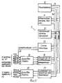
Пример. Движущаяся станция, показанная на фиг. 1, содержит устройство 1, которое отслеживает воздушное движение, компьютер 2 представления данных, и монитор 3, на котором пилот может визуально наблюдать за воздушным движением. Устройство 1 содержит приемник 4 информации от спутника для системы GPS, который принимает сигналы от множества спутников, содержащие сигналы времени и орбитальные элементы. В принципе это изобретение не ограничено использованием спутников системы GPS. Также Российская система GLONASS или комбинация систем GPS или GLONASS может быть использована для определения положения движущегося объекта. Такое устройство GPS коммерчески доступны, например Magnavox MX 4200 от "Магновокс корп." США. Кроме этого, следует сказать, что такое устройство может доставлять географическое положение по широте и долготе с высокой точностью, по высоте с несколько меньшей точностью и время ИТС с очень высокой точностью. Далее, доступна информация по скорости и курсу. Эта информация доступна для процесса коммуникаций 5, который в свою очередь соединен с передатчиком-приемником 6. Этот приемник 4 информации от спутника работает на частоте 1,4 ГГц, тогда как передатчик-приемник работает на частоте 141 МГц. Этот примерный процессор коммуникаций более подробно показан на фиг. 2. Следующая информация посылается при каждом событии передачи:
1. Флаг начала и код, индицирующий спонтанный режим передачи или приказной режим передачи (8 бит).Example. The moving station shown in FIG. 1, comprises a device 1 that monitors air movement, a data presentation computer 2, and a monitor 3, on which a pilot can visually observe air movement. The device 1 comprises a satellite information receiver 4 for a GPS system, which receives signals from a plurality of satellites containing time signals and orbital elements. In principle, this invention is not limited to the use of GPS satellites. Also, the Russian GLONASS system or a combination of GPS or GLONASS systems can be used to determine the position of a moving object. Such a GPS device is commercially available, for example Magnavox MX 4200 from Magnovox Corp. USA. In addition, it should be said that such a device can deliver a geographical position in latitude and longitude with high accuracy, in height with slightly less accuracy and ITS time with very high accuracy. Further, information on speed and course is available. This information is available for the
1. The start flag and code indicating the spontaneous transmission mode or the ordered transmission mode (8 bits).
2. Код идентификации станции (18 бит, 8 знаков, каждый по 6 бит). 2. Station identification code (18 bits, 8 characters, 6 bits each).
3. Положение по широте и долготе (24 бита широта за 1/1000 мин; 25 битов долгота за 1/1000 мин). 3. Latitude and longitude position (24 bits longitude for 1/1000 min; 25 bits longitude for 1/1000 min).
4. Скорость, 11 бит, Kt шага. 4. Speed, 11 bit, Kt step.
5. Направление полета, 12 бит, десятые доли градуса. 5. Flight direction, 12 bits, tenths of a degree.
6. Высота, 12 бит, шаги по 16 футов. 6. Height, 12 bits, steps of 16 feet.
7. Время, 6 бит, когда эти передаваемые значения активны (0-6- с). 7. Time, 6 bits, when these transmitted values are active (0-6-s).
8. Биты состояния, объявляющие начало сообщения об изменении блоков, и т.п. 8. Status bits announcing the start of a message about a change in blocks, etc.
9. Контрольная сумма. 9. The checksum.
10. Флаг конца. 10. The flag of the end.
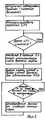
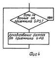
Как видно из фиг. 2, процессор 5 коммуникаций содержит микропроцессор 10, оперативную память RAM 11, постоянную память программ PROM 12 и схему таймера 13, которые все взаимодействуют через ширину адреса 15 и шину данных 14. Для связи с другими устройствами имеется схема последовательной связи 16, а для передачи и приема синхронных коммуникаций - сопроцессор 17. В качестве микропроцессора можно использовать кристалл HD64180 ("Хитачи"), а в качестве сопроцессора - siemens S АБ 82525 (версия VA3). Схема таймера 13, которая отслеживает мультиплексирование времени, запитывается от устройства GPS 4 (фиг. 1) сигналами, синхронизированными временем ИТС через проводник 18 (фиг. 2), принимая один сигнал времени в секунду и последующую информацию времени от системы GPS. Драйверы 19 и 20 добавлены для обеспечения соответствующей синхронизации сигналов. Оперативная память RAM 11 запоминает каталог всех принятых сигналов от других станций, так что идентичности и положения запоминаются и обновляются. В течение времени максимального кадра все принимаемые участники будут прослушиваться, и чтобы не засорять память информацией от неактивных участников, информация неактивных участников будет удаляться из памяти, если эти участники не прослушиваются в течение заданного времени. Далее запоминается информация о том, какие блоки времени свободны. Процессор коммуникаций также определяет повторяющуюся скорость излучения в зависимости от плотности воздушного движения или по приказу от центральной наземной станции. Микропроцессор 10 работает с программным обеспечением, содержащим систему, работающую в режиме реального времени, возбуждающую ряд различных программ с разными приоритетами:
Программа 1 считывает и декодирует данные от главного компьютера, которым может быть компьютер 1 на фиг. 1 или в случае фиксированной станции управления - ее собственный главный компьютер. Блок-схема такой программы представлена на фиг. 3.As can be seen from FIG. 2, the
Program 1 reads and decodes data from the host computer, which may be computer 1 in FIG. 1 or in the case of a fixed control station, its own host computer. A block diagram of such a program is shown in FIG. 3.
Программа 2 считывает и декодирует данные, приходящие от приемника 4 GPS в соответствии с блок-схемой на фиг. 4. Program 2 reads and decodes data coming from the GPS receiver 4 in accordance with the block diagram of FIG. 4.
Программа 3 генерирует сообщения и управляет передачей и другими функциями контроля для приемопередатчика 6 (фиг. 1) в соответствии с блок-схемой, показанной на фиг. 5. Program 3 generates messages and controls transmission and other monitoring functions for transceiver 6 (FIG. 1) in accordance with the block diagram shown in FIG. 5.
Программа 4 обеспечивает прием и декодирование принятых сообщений от приемопередатчика и обновляет каталог других пользователей, включая сюда картографирование блоков времени или других слотов времени в качестве занятых в соответствии с блок-схемой на фиг. 6. Program 4 provides reception and decoding of received messages from the transceiver and updates the catalog of other users, including mapping of time blocks or other time slots as busy in accordance with the block diagram in FIG. 6.
Программа 5 обновляет каталог пользователей, удаляя из него участников, которые либо перестали прослушиваться, либо потому, что они уже приземлились и отключились, либо находятся вне пределов досягаемости. Затем рассчитывается скорость собственных сообщений, например, вычислением того, как много соседей находятся в пределах заданного расстояния. Определяется наименьшая скорость передачи, ниже которой скорость не должна падать. Затем определяется нагрузка на ридиоканал. Блок-схема программы 5 показана на фиг. 7.
Компьютер 2 представления данных извлекает свои данные из каталога в памяти процессора коммуникаций и манипулирует этой информацией, частично для удовлетворения потребностей монитора, и частично для сигнализации пилоту о действиях, которые могут быть необходимы. Так как во время длинных маршрутов уровень и частота стимулов низкие и поэтому трудно полностью сосредоточить внимание, было бы очень ценно иметь возможность создавать точные сигналы для привлечения внимания в соответствии с определенными критериями (рядом находится другая станция на пути к своей собственной станции и т.п.). Для правильного функционирования особенно важно, чтобы все станции располагали осью времени, имеющей хорошую надежность. В приведенном примере это осуществляется схемой таймера 13, которая, принимая раз в секунду импульс времени от устройства GPS, может привязывать частоту синхронизации процессора с очень высокой точностью, то есть так, чтобы можно было поддерживать назначенные или присвоенные блоки времени. Presentation computer 2 retrieves its data from a directory in the memory of the communication processor and manipulates this information, partly to satisfy the needs of the monitor, and partly to signal the pilot about actions that may be necessary. Since during long routes the level and frequency of incentives is low and it is therefore difficult to focus completely, it would be very valuable to be able to create accurate signals to attract attention in accordance with certain criteria (there is another station nearby on the way to its own station, etc. .). For proper operation, it is especially important that all stations have a time axis that has good reliability. In the above example, this is done by the
Возможно также, если по некоторой причине приемник GPS отказал, получать помощь от сигналов времени, принятых соседними станциями, включая наземные станции. Эти сигналы, принятые по радио, могут быть использованы в качестве другого множества геометрически распределенных передатчиков, имеющих известные положения. Точность этого положения, конечно, будет пониженной. Поэтому предпочтительно включать в это сообщение информацию о том, что информация положения менее точная. В случае отказа спутников GPS по некоторой причине (маловероятное событие) система может все-таки сохранять ограниченную работоспособность в течение времени, пока множество наземных станций будет обеспечивать общее время, например, с точными сигналами синхронизации, которые могут калиброваться от выбранного спутника из существующих спутников с геостационарной орбитой. Чтобы эта система была работоспособной как всемирная система, необходимо, чтобы существовал общий протокол для частот, которые должны использоваться, а также расстановка всех блоков времени и кадров. Поэтому настоящий пример следует рассматриваться как неограничивающий пример приложения этого изобретения, как это будет без труда понятно специалистам и в этой отрасли техники. It is also possible, if for some reason the GPS receiver has refused, to receive assistance from the time signals received by neighboring stations, including ground stations. These signals received by radio can be used as another set of geometrically distributed transmitters having known positions. The accuracy of this provision will, of course, be reduced. Therefore, it is preferable to include in this message information that the position information is less accurate. In case of failure of GPS satellites for some reason (an unlikely event), the system can still maintain limited performance over time, while many ground stations will provide a total time, for example, with accurate synchronization signals that can be calibrated from a selected satellite from existing satellites with geostationary orbit. For this system to work as a global system, it is necessary that there is a common protocol for the frequencies to be used, as well as the arrangement of all time blocks and frames. Therefore, this example should be considered as a non-limiting example of the application of this invention, as will be readily apparent to those skilled in the art.
Claims (13)
Translated fromRussianApplications Claiming Priority (7)
| Application Number | Priority Date | Filing Date | Title |
|---|---|---|---|
| SE9102034-7 | 1991-07-01 | ||
| SE9102034ASE9102034D0 (en) | 1991-07-01 | 1991-07-01 | Position System |
| SE9102362ASE468452B (en) | 1991-07-01 | 1991-08-15 | Position-indicating system and position station for a position-indicating system |
| SE9102362-2 | 1991-08-15 | ||
| SE9103542-8 | 1991-11-28 | ||
| SE9103542ASE9103542D0 (en) | 1991-11-28 | 1991-11-28 | Position System |
| PCT/SE1992/000485WO1993001576A1 (en) | 1991-07-01 | 1992-06-29 | A position indicating system |
Publications (2)
| Publication Number | Publication Date |
|---|---|
| RU93058671A RU93058671A (en) | 1998-02-20 |
| RU2108627C1true RU2108627C1 (en) | 1998-04-10 |
Family
ID=27355635
Family Applications (1)
| Application Number | Title | Priority Date | Filing Date |
|---|---|---|---|
| RU93058671ARU2108627C1 (en) | 1991-07-01 | 1992-06-29 | Position indicating system |
Country Status (16)
| Country | Link |
|---|---|
| US (1) | US5506587A (en) |
| EP (1) | EP0592560B1 (en) |
| JP (1) | JP3262332B2 (en) |
| KR (1) | KR100238959B1 (en) |
| AT (1) | ATE157474T1 (en) |
| AU (1) | AU661706B2 (en) |
| BR (1) | BR9206225A (en) |
| CA (1) | CA2111980C (en) |
| DE (1) | DE69221871T2 (en) |
| DK (1) | DK0592560T3 (en) |
| ES (1) | ES2109366T3 (en) |
| FI (1) | FI109492B (en) |
| GR (1) | GR3025456T3 (en) |
| NO (1) | NO309670B1 (en) |
| RU (1) | RU2108627C1 (en) |
| WO (1) | WO1993001576A1 (en) |
Cited By (8)
| Publication number | Priority date | Publication date | Assignee | Title |
|---|---|---|---|---|
| RU2152078C1 (en)* | 1999-08-26 | 2000-06-27 | Открытое акционерное общество Раменское приборостроительное конструкторское бюро | System for information support of interaction in aircraft group |
| RU2240265C1 (en)* | 2003-03-13 | 2004-11-20 | Федеральное государственное унитарное предприятие "Научно-производственное объединение им. С.А. Лавочкина" | Method for determining precise time of appearance of celestial phenomenon |
| RU2241627C2 (en)* | 2002-07-19 | 2004-12-10 | Государственное унитарное предприятие Российский научно-исследовательский и проектно-конструкторский институт информатизации, автоматизации и связи МПС | Device to determine length of train |
| RU2251652C2 (en)* | 2003-08-27 | 2005-05-10 | Закрытое акционерное общество "Дженерал Телеком" | Mode of determination of a bullet's hitting point at a target |
| RU2333538C2 (en)* | 2006-07-12 | 2008-09-10 | ООО "Фирма "НИТА" | Method of indication of observed object position |
| RU2363009C1 (en)* | 2007-11-14 | 2009-07-27 | Вячеслав Адамович Заренков | System to determine spatial position of objects |
| RU2380722C2 (en)* | 2005-07-18 | 2010-01-27 | Эрбюс Франс | Method and device for detection of ground location of moving object, in particular aircraft in airplane |
| RU2586076C1 (en)* | 2014-12-29 | 2016-06-10 | Федеральное государственное бюджетное учреждение "4 Центральный научно-исследовательский институт Министерства обороны Российской Федерации" | Method of detecting tampering of accuracy characteristics of space navigation systems |
Families Citing this family (126)
| Publication number | Priority date | Publication date | Assignee | Title |
|---|---|---|---|---|
| US5748147A (en)* | 1992-03-04 | 1998-05-05 | Motorola Inc | Position locating rescue transceiver |
| US5327144A (en)* | 1993-05-07 | 1994-07-05 | Associated Rt, Inc. | Cellular telephone location system |
| FR2706660B1 (en)* | 1993-06-17 | 1995-09-01 | Dassault Electronique | Permanent anti-collision aid for aircraft. |
| FR2706659B1 (en)* | 1993-06-17 | 1995-09-01 | Dassault Electronique | Anti-collision electronic device for ships. |
| CH687941A5 (en)* | 1993-06-22 | 1997-03-27 | Koechler Erika | Vehicle driver information system |
| ATE225519T1 (en)* | 1994-03-11 | 2002-10-15 | Toshiba Kk | MONITORING SYSTEM FOR CONTROLLABLE TARGETS |
| JP3751021B2 (en)* | 1994-04-19 | 2006-03-01 | ノースロップ グラマン コーポレーション | Aircraft location and identification system |
| US5781150A (en)* | 1995-01-25 | 1998-07-14 | American Technology Corporation | GPS relative position detection system |
| US5952959A (en)* | 1995-01-25 | 1999-09-14 | American Technology Corporation | GPS relative position detection system |
| US5689269A (en)* | 1995-01-25 | 1997-11-18 | American Technology Corporation | GPS relative position detection system |
| US7629899B2 (en) | 1997-10-22 | 2009-12-08 | Intelligent Technologies International, Inc. | Vehicular communication arrangement and method |
| US7426437B2 (en) | 1997-10-22 | 2008-09-16 | Intelligent Technologies International, Inc. | Accident avoidance systems and methods |
| JPH0942981A (en)* | 1995-08-02 | 1997-02-14 | Sony Corp | Position detection device |
| US5748136A (en)* | 1995-09-22 | 1998-05-05 | Rockwell International Corporation | Electronic landmark enhancement to GPS based navigation systems |
| FR2743892B1 (en)* | 1996-01-19 | 1998-02-13 | Sextant Avionique | AIRCRAFT HANDLING ASSISTANCE SYSTEM USING A HEADSET VIEWER |
| DE19602053A1 (en)* | 1996-01-20 | 1997-07-24 | Ruediger Klaschka | Device for monitoring the distance between two objects |
| FR2748842B1 (en)* | 1996-05-14 | 1998-08-14 | Sextant Avionique | NOISE ANALYSIS SYSTEM FOR PASSING ON AIR VEHICLES |
| US5907293A (en)* | 1996-05-30 | 1999-05-25 | Sun Microsystems, Inc. | System for displaying the characteristics, position, velocity and acceleration of nearby vehicles on a moving-map |
| FR2752120B1 (en)* | 1996-08-01 | 1999-01-29 | Sagem | SINGLE CHANNEL COMMUNICATION SYSTEM AND TRANSMITTER FOR SUCH A SYSTEM |
| CA2265875C (en) | 1996-09-09 | 2007-01-16 | Dennis Jay Dupray | Location of a mobile station |
| US6236365B1 (en) | 1996-09-09 | 2001-05-22 | Tracbeam, Llc | Location of a mobile station using a plurality of commercial wireless infrastructures |
| US9134398B2 (en) | 1996-09-09 | 2015-09-15 | Tracbeam Llc | Wireless location using network centric location estimators |
| SE511553C2 (en)* | 1996-09-18 | 1999-10-18 | Saab Dynamics Ab | Device for real-time simulation of an object's position in a three-dimensional coordinate system |
| US6069570A (en)* | 1996-09-20 | 2000-05-30 | Atx Technologies, Inc. | Asset location system |
| US7801736B1 (en)* | 2000-10-13 | 2010-09-21 | Wms Gaming, Inc. | System, method, and article of manufacture for locating and communicating with a patron at a hospitality facility |
| US5890079A (en) | 1996-12-17 | 1999-03-30 | Levine; Seymour | Remote aircraft flight recorder and advisory system |
| US5936574A (en)* | 1997-01-20 | 1999-08-10 | Klaschka; Ruediger | Device for monitoring the distance between two objects |
| US5940035A (en)* | 1997-03-27 | 1999-08-17 | Innovative Solutions & Support Inc. | Method for calibrating aircraft altitude sensors |
| US7085775B2 (en)* | 1997-04-09 | 2006-08-01 | Sidewinder Holdings Ltd. | Database method and system for conducting integrated dispatching |
| US8255144B2 (en) | 1997-10-22 | 2012-08-28 | Intelligent Technologies International, Inc. | Intra-vehicle information conveyance system and method |
| US8965677B2 (en) | 1998-10-22 | 2015-02-24 | Intelligent Technologies International, Inc. | Intra-vehicle information conveyance system and method |
| US20090043506A1 (en)* | 1997-10-22 | 2009-02-12 | Intelligent Technologies International, Inc. | Method and System for Controlling Timing of Vehicle Transmissions |
| DE19749526C2 (en)* | 1997-11-08 | 2001-10-25 | Hermann Rohling | Process for the automatic organization of a radio data transmission network |
| US6054950A (en)* | 1998-01-26 | 2000-04-25 | Multispectral Solutions, Inc. | Ultra wideband precision geolocation system |
| US5987421A (en)* | 1998-02-05 | 1999-11-16 | Morfun Systems, Inc. | Computerized system and method for locating individual members of discrete groups and for electronically registering and holding the ' groups position in waiting lines |
| US6127946A (en) | 1998-03-13 | 2000-10-03 | B.V.R. Technologies Ltd. | Method of selecting an optimal communication channel |
| US20060241763A1 (en)* | 1998-08-03 | 2006-10-26 | Synthes (Usa) | Multipiece bone implant |
| JP2000207679A (en)* | 1999-01-19 | 2000-07-28 | Equos Research Co Ltd | Information communication equipment for traveling object |
| US6185504B1 (en) | 1999-01-28 | 2001-02-06 | International Business Machines Corporation | Vehicle scheduling and collision avoidance system using time multiplexed global positioning system |
| US6236936B1 (en) | 1999-01-28 | 2001-05-22 | International Business Machines Corporation | Maintaining a desired separation or distribution in a moving cluster of machines using a time multiplexed global positioning system |
| US6275771B1 (en) | 1999-01-28 | 2001-08-14 | International Business Machines Corporation | Time multiplexed global positioning system cell location beacon system |
| US6529823B1 (en) | 1999-01-28 | 2003-03-04 | International Business Machines Corporation | Maintaining desired distribution of machines using time multiplexed global positioning system |
| CA2266208C (en)* | 1999-03-19 | 2008-07-08 | Wenking Corp. | Remote road traffic data exchange and intelligent vehicle highway system |
| FR2791849B1 (en)* | 1999-03-31 | 2001-06-29 | Cit Alcatel | NODE AND ON-BOARD STATION FOR ESTABLISHING A COMMUNICATION TO A PASSENGER OF A VEHICLE AT ANY TIME |
| US6169958B1 (en)* | 1999-04-09 | 2001-01-02 | Vsis, Inc. | Ionospheric correction for single frequency GPS receivers using three satellites |
| US6384776B1 (en)* | 1999-04-30 | 2002-05-07 | B. Todd Martin | EM signal detection and position broadcasting system and method |
| US7330150B1 (en) | 1999-05-07 | 2008-02-12 | Garmin Corporation | Combined global positioning system receiver and radio |
| US6373430B1 (en) | 1999-05-07 | 2002-04-16 | Gamin Corporation | Combined global positioning system receiver and radio |
| US7196659B1 (en) | 1999-05-07 | 2007-03-27 | Garmin Corporation | Combined global positioning system receiver and radio |
| US6348877B1 (en) | 1999-06-17 | 2002-02-19 | International Business Machines Corporation | Method and system for alerting a pilot to the location of other aircraft |
| JP2001094916A (en) | 1999-09-17 | 2001-04-06 | Sony Corp | Information processing method and apparatus, and program storage medium |
| FR2802691B1 (en)* | 1999-12-21 | 2002-03-22 | Thomson Csf | MARITIME SURVEILLANCE PROCESS |
| US7949362B2 (en)* | 2000-05-18 | 2011-05-24 | Sirf Technology, Inc. | Satellite positioning aided communication system selection |
| US6427120B1 (en)* | 2000-08-14 | 2002-07-30 | Sirf Technology, Inc. | Information transfer in a multi-mode global positioning system used with wireless networks |
| US7970412B2 (en) | 2000-05-18 | 2011-06-28 | Sirf Technology, Inc. | Aided location communication system |
| US7970411B2 (en)* | 2000-05-18 | 2011-06-28 | Sirf Technology, Inc. | Aided location communication system |
| US8078189B2 (en) | 2000-08-14 | 2011-12-13 | Sirf Technology, Inc. | System and method for providing location based services over a network |
| US6462708B1 (en)* | 2001-04-05 | 2002-10-08 | Sirf Technology, Inc. | GPS-based positioning system for mobile GPS terminals |
| US7929928B2 (en)* | 2000-05-18 | 2011-04-19 | Sirf Technology Inc. | Frequency phase correction system |
| US6389291B1 (en)* | 2000-08-14 | 2002-05-14 | Sirf Technology | Multi-mode global positioning system for use with wireless networks |
| US9875492B2 (en) | 2001-05-22 | 2018-01-23 | Dennis J. Dupray | Real estate transaction system |
| US10684350B2 (en) | 2000-06-02 | 2020-06-16 | Tracbeam Llc | Services and applications for a communications network |
| US10641861B2 (en) | 2000-06-02 | 2020-05-05 | Dennis J. Dupray | Services and applications for a communications network |
| US7236883B2 (en)* | 2000-08-14 | 2007-06-26 | Sirf Technology, Inc. | Aiding in a satellite positioning system |
| US6931233B1 (en) | 2000-08-31 | 2005-08-16 | Sirf Technology, Inc. | GPS RF front end IC with programmable frequency synthesizer for use in wireless phones |
| AU2001225779A1 (en)* | 2000-12-07 | 2002-06-18 | Ching-Fang Lin | Vehicle positioning and data integrating method and system thereof |
| WO2002063436A2 (en)* | 2001-02-07 | 2002-08-15 | Universal City Studios, Inc. | Reservation system and methods for theme parks |
| US8145367B2 (en) | 2001-03-06 | 2012-03-27 | Honeywell International Inc. | Closed airport surface alerting system |
| US7587278B2 (en)* | 2002-05-15 | 2009-09-08 | Honeywell International Inc. | Ground operations and advanced runway awareness and advisory system |
| SE518926C2 (en)* | 2001-05-10 | 2002-12-10 | Saab Ab | Vehicle display device and ways to display detected threats, remaining fuel quantity and time offset |
| US7668554B2 (en)* | 2001-05-21 | 2010-02-23 | Sirf Technology, Inc. | Network system for aided GPS broadcast positioning |
| GB2379570A (en)* | 2001-09-05 | 2003-03-12 | Robert Leighton Harding | Maritime ship safety system |
| US20030102956A1 (en)* | 2001-10-19 | 2003-06-05 | Mcmanus Jeff | Queuing system and methods |
| US7142900B1 (en)* | 2001-11-01 | 2006-11-28 | Garmin Ltd. | Combined global positioning system receiver and radio |
| DE10204202B4 (en)* | 2002-02-01 | 2012-11-22 | FLARM Technology GmbH | Gliders, motor gliders or kites with a device for data transmission and method and system for data transmission between gliders, motor gliders or kites |
| US7363145B2 (en)* | 2002-05-15 | 2008-04-22 | Honeywell International Inc. | Ground operations and imminent landing runway selection |
| US20040111195A1 (en)* | 2002-06-11 | 2004-06-10 | Vries Jeroen Joost De | Systems and methods for marine satellite monitoring |
| SE0201974D0 (en) | 2002-06-26 | 2002-06-26 | Saab Ab | Autonomous Communication System |
| US6816782B1 (en) | 2002-10-10 | 2004-11-09 | Garmin Ltd. | Apparatus, systems and methods for navigation data transfer between portable devices |
| EP1416648A1 (en)* | 2002-10-28 | 2004-05-06 | Siemens Aktiengesellschaft | Method for decentralized synchronization in a self-organizing radio communication system |
| US6768450B1 (en) | 2002-11-07 | 2004-07-27 | Garmin Ltd. | System and method for wirelessly linking a GPS device and a portable electronic device |
| WO2004052030A1 (en)* | 2002-11-27 | 2004-06-17 | U-Nav Microelectronics Corporation | System and method for networking a plurality of nodes |
| US6718236B1 (en) | 2003-04-29 | 2004-04-06 | The Mitre Corporation | Method for conducting a moving vehicle along a trajectory of a coordinated maneuver based on state information broadcast by other vehicles participating in the coordinated maneuver |
| JP4315832B2 (en)* | 2004-02-17 | 2009-08-19 | 三菱電機株式会社 | Thermal infrared sensor element and thermal infrared sensor array |
| US20060021231A1 (en)* | 2004-07-28 | 2006-02-02 | Carey Nancy D | Adaptive scissors |
| EP1630765A1 (en) | 2004-08-31 | 2006-03-01 | Saab Ab | STDMA collision avoidance system |
| US8107609B2 (en) | 2004-12-06 | 2012-01-31 | Callwave, Inc. | Methods and systems for telephony call-back processing |
| US7908080B2 (en) | 2004-12-31 | 2011-03-15 | Google Inc. | Transportation routing |
| US7479925B2 (en)* | 2005-03-23 | 2009-01-20 | Honeywell International Inc. | Airport runway collision avoidance system and method |
| US8855107B1 (en) | 2005-07-01 | 2014-10-07 | Callwave Communications, Llc | Methods and systems for call routing via a telephone number |
| WO2008048244A2 (en)* | 2005-09-28 | 2008-04-24 | Raytheon Company | Methods and apparatus for radar time sensor |
| GB2437589B (en) | 2006-02-14 | 2009-12-16 | Furuno Electric Co | Navigational aid and carrier sense technique |
| FR2897958B1 (en)* | 2006-02-28 | 2008-04-04 | Airbus France Sas | DEVICE FOR DETERMINING MAXIMUM SIDE SPACE OF A FOLLOWING MOBILE WITH RESPECT TO A MOBILE FOLLOWED. |
| US7925320B2 (en) | 2006-03-06 | 2011-04-12 | Garmin Switzerland Gmbh | Electronic device mount |
| US8548447B1 (en) | 2006-10-06 | 2013-10-01 | Callwave Communications, Llc | Methods and systems for blocking unwanted telecommunications |
| US7876865B2 (en) | 2007-06-08 | 2011-01-25 | COM DEV International Ltd | System and method for decoding automatic identification system signals |
| FR2918470B1 (en)* | 2007-07-06 | 2009-09-18 | Thales Sa | METHOD FOR IMPROVING THE INTEGRITY AND SAFETY OF AN AVIONIC SYSTEM |
| US7447588B1 (en)* | 2007-07-16 | 2008-11-04 | Wenshine Technology Ltd. | Method and system for partitioning a continental roadway network for an intelligent vehicle highway system |
| JP5294909B2 (en)* | 2008-05-12 | 2013-09-18 | 株式会社ジャパンディスプレイウェスト | Liquid crystal display panel and manufacturing method thereof |
| US8155666B2 (en) | 2008-06-16 | 2012-04-10 | Skyhook Wireless, Inc. | Methods and systems for determining location using a cellular and WLAN positioning system by selecting the best cellular positioning system solution |
| US8780788B2 (en)* | 2009-09-25 | 2014-07-15 | Com Dev International Ltd. | Systems and methods for decoding automatic identification system signals |
| US9331774B2 (en)* | 2010-06-09 | 2016-05-03 | Exactearth Ltd. | Systems and methods for segmenting a satellite field of view for detecting radio frequency signals |
| US9606219B2 (en) | 2010-08-02 | 2017-03-28 | Progeny Systems Corporation | Systems and methods for locating a target in a GPS-denied environment |
| DE102010034792A1 (en)* | 2010-08-18 | 2012-02-23 | Astrium Gmbh | Device and method for three-dimensional positioning |
| US9538493B2 (en) | 2010-08-23 | 2017-01-03 | Finetrak, Llc | Locating a mobile station and applications therefor |
| JP5577213B2 (en)* | 2010-10-20 | 2014-08-20 | 古野電気株式会社 | Automatic vessel identification device, automatic vessel identification method, and automatic vessel identification program |
| US8890746B2 (en) | 2010-11-03 | 2014-11-18 | Skyhook Wireless, Inc. | Method of and system for increasing the reliability and accuracy of location estimation in a hybrid positioning system |
| US8692705B2 (en)* | 2011-09-21 | 2014-04-08 | Rockwell Collins, Inc. | Apparatus and method for generating low latency position information from position signals transmitted in a narrow bandwidth channel of a radio frequency |
| US9015567B2 (en) | 2012-04-12 | 2015-04-21 | Com Dev International Ltd. | Methods and systems for consistency checking and anomaly detection in automatic identification system signal data |
| WO2013163218A1 (en)* | 2012-04-24 | 2013-10-31 | Rubin Kim | V2v safety system with a hybrid physical layer |
| US9253753B2 (en) | 2012-04-24 | 2016-02-02 | Zetta Research And Development Llc-Forc Series | Vehicle-to-vehicle safety transceiver using time slots |
| US20130278441A1 (en)* | 2012-04-24 | 2013-10-24 | Zetta Research and Development, LLC - ForC Series | Vehicle proxying |
| US9300423B2 (en)* | 2012-04-24 | 2016-03-29 | Zetta Research and Development LLC—ForC Series | Device for synchronizing a time base for V2V communictation |
| US9129532B2 (en) | 2012-04-24 | 2015-09-08 | Zetta Research and Development LLC, ForC series | Hybrid protocol transceiver for V2V communication |
| DE102012214912B4 (en)* | 2012-08-22 | 2015-04-23 | Deutsches Zentrum für Luft- und Raumfahrt e.V. | Method for direct wireless data exchange in ad hoc mode |
| EP2778802B1 (en)* | 2013-03-11 | 2019-07-31 | Kapsch TrafficCom AB | A method for communication within a co-operative system |
| RU2556890C2 (en)* | 2013-10-17 | 2015-07-20 | Открытое акционерное общество "Концерн радиостроения "Вега" | Error signal generation at control over object placing to preset point |
| US9441976B2 (en)* | 2014-07-02 | 2016-09-13 | Qualcomm Incorporated | Methods and systems for collaborative navigation and operation with a mobile device and a wearable device |
| EP3196595B1 (en)* | 2014-09-16 | 2019-12-18 | Furuno Electric Co., Ltd. | Own-ship surrounding information display device and own-ship surrounding information display method |
| RU2587471C1 (en)* | 2015-05-13 | 2016-06-20 | Федеральное государственное автономное образовательное учреждение высшего образования "Сибирский федеральный университет" | Method of measuring distance between onboard and ground transceiving stations |
| WO2017174115A1 (en)* | 2016-04-05 | 2017-10-12 | Saronikos Trading And Services, Unipessoal Lda | Apparatus and method for reducing collision risks |
| US10795029B2 (en) | 2017-02-14 | 2020-10-06 | United States Of America As Represented By The Secretary Of The Navy | Systems and methods for transmitting ship positions and tracks over multiple communications channels |
| WO2019028906A1 (en)* | 2017-08-11 | 2019-02-14 | Lenovo (Beijing) Limited | Transmitting aerial vehicle position information |
| WO2019034307A1 (en) | 2017-08-14 | 2019-02-21 | Sas Inferency | Door to door multimodal track and trace device |
| IT201800005384A1 (en)* | 2018-05-15 | 2019-11-15 | Collision avoidance system and method | |
| US12137064B2 (en) | 2022-08-19 | 2024-11-05 | United States Of America As Represented By The Secretary Of The Navy | Communication terminal for addressed messaging within an automated identification system arrangement using aid to navigation transponder |
Family Cites Families (8)
| Publication number | Priority date | Publication date | Assignee | Title |
|---|---|---|---|---|
| US3566404A (en)* | 1968-12-16 | 1971-02-23 | Trw Inc | Vehicle collision avoidance system |
| US4380050A (en)* | 1980-06-30 | 1983-04-12 | Tanner Jesse H | Aircraft location and collision avoidance system |
| GB2155720B (en)* | 1984-03-08 | 1987-10-21 | Standard Telephones Cables Ltd | Vehicle location system |
| FR2601168B1 (en)* | 1986-07-04 | 1988-09-16 | Lmt Radio Professionelle | ANTI-COLLISION SYSTEM FOR MARITIME NAVIGATION. |
| US4835537A (en)* | 1986-07-16 | 1989-05-30 | Manion James H | Telemetry burst collision avoidance system |
| US5153836A (en)* | 1990-08-22 | 1992-10-06 | Edward J. Fraughton | Universal dynamic navigation, surveillance, emergency location, and collision avoidance system and method |
| IL95990A (en)* | 1990-10-15 | 1994-07-31 | B V R Technologies Ltd | Anti-collision warning system |
| US5367524A (en)* | 1991-08-05 | 1994-11-22 | Motorola, Inc. | Method for sequential data transmission |
- 1992
- 1992-06-29RURU93058671Apatent/RU2108627C1/enactive
- 1992-06-29ESES92914913Tpatent/ES2109366T3/ennot_activeExpired - Lifetime
- 1992-06-29AUAU22913/92Apatent/AU661706B2/ennot_activeExpired
- 1992-06-29DKDK92914913.6Tpatent/DK0592560T3/enactive
- 1992-06-29DEDE69221871Tpatent/DE69221871T2/ennot_activeExpired - Lifetime
- 1992-06-29KRKR1019930704118Apatent/KR100238959B1/ennot_activeExpired - Lifetime
- 1992-06-29ATAT92914913Tpatent/ATE157474T1/enactive
- 1992-06-29CACA002111980Apatent/CA2111980C/ennot_activeExpired - Lifetime
- 1992-06-29BRBR9206225Apatent/BR9206225A/ennot_activeIP Right Cessation
- 1992-06-29USUS08/170,167patent/US5506587A/ennot_activeExpired - Lifetime
- 1992-06-29EPEP92914913Apatent/EP0592560B1/ennot_activeExpired - Lifetime
- 1992-06-29WOPCT/SE1992/000485patent/WO1993001576A1/enactiveIP Right Grant
- 1992-06-29JPJP50217993Apatent/JP3262332B2/ennot_activeExpired - Lifetime
- 1993
- 1993-12-28NONO934868Apatent/NO309670B1/ennot_activeIP Right Cessation
- 1993-12-31FIFI935969Apatent/FI109492B/ennot_activeIP Right Cessation
- 1997
- 1997-11-25GRGR970403102Tpatent/GR3025456T3/enunknown
Non-Patent Citations (1)
| Title |
|---|
| Шебшаевич В.С. и др. Дифференциальный режим сетевой спутниковой радионавигационной системы. Зарубежная радиоэлектроника, N 1, 1989 - М., Радио и связь, с.5 - 32. Мищенко И.Н., Раманов Л.М. Новые разработки спутниковых радионавигационных систем. Зарубежная радиоэлектроника, N 1, 1989, - М.: Родио и связь, с.68 - 81.* |
Cited By (8)
| Publication number | Priority date | Publication date | Assignee | Title |
|---|---|---|---|---|
| RU2152078C1 (en)* | 1999-08-26 | 2000-06-27 | Открытое акционерное общество Раменское приборостроительное конструкторское бюро | System for information support of interaction in aircraft group |
| RU2241627C2 (en)* | 2002-07-19 | 2004-12-10 | Государственное унитарное предприятие Российский научно-исследовательский и проектно-конструкторский институт информатизации, автоматизации и связи МПС | Device to determine length of train |
| RU2240265C1 (en)* | 2003-03-13 | 2004-11-20 | Федеральное государственное унитарное предприятие "Научно-производственное объединение им. С.А. Лавочкина" | Method for determining precise time of appearance of celestial phenomenon |
| RU2251652C2 (en)* | 2003-08-27 | 2005-05-10 | Закрытое акционерное общество "Дженерал Телеком" | Mode of determination of a bullet's hitting point at a target |
| RU2380722C2 (en)* | 2005-07-18 | 2010-01-27 | Эрбюс Франс | Method and device for detection of ground location of moving object, in particular aircraft in airplane |
| RU2333538C2 (en)* | 2006-07-12 | 2008-09-10 | ООО "Фирма "НИТА" | Method of indication of observed object position |
| RU2363009C1 (en)* | 2007-11-14 | 2009-07-27 | Вячеслав Адамович Заренков | System to determine spatial position of objects |
| RU2586076C1 (en)* | 2014-12-29 | 2016-06-10 | Федеральное государственное бюджетное учреждение "4 Центральный научно-исследовательский институт Министерства обороны Российской Федерации" | Method of detecting tampering of accuracy characteristics of space navigation systems |
Also Published As
| Publication number | Publication date |
|---|---|
| NO934868L (en) | 1993-12-28 |
| CA2111980C (en) | 2002-08-20 |
| CA2111980A1 (en) | 1993-01-21 |
| BR9206225A (en) | 1994-12-13 |
| AU2291392A (en) | 1993-02-11 |
| FI935969A0 (en) | 1993-12-31 |
| ES2109366T3 (en) | 1998-01-16 |
| EP0592560B1 (en) | 1997-08-27 |
| FI109492B (en) | 2002-08-15 |
| US5506587A (en) | 1996-04-09 |
| KR100238959B1 (en) | 2000-01-15 |
| GR3025456T3 (en) | 1998-02-27 |
| ATE157474T1 (en) | 1997-09-15 |
| DE69221871D1 (en) | 1997-10-02 |
| EP0592560A1 (en) | 1994-04-20 |
| NO309670B1 (en) | 2001-03-05 |
| AU661706B2 (en) | 1995-08-03 |
| FI935969L (en) | 1993-12-31 |
| JPH07501879A (en) | 1995-02-23 |
| JP3262332B2 (en) | 2002-03-04 |
| DE69221871T2 (en) | 1998-04-02 |
| NO934868D0 (en) | 1993-12-28 |
| DK0592560T3 (en) | 1998-04-06 |
| WO1993001576A1 (en) | 1993-01-21 |
Similar Documents
| Publication | Publication Date | Title |
|---|---|---|
| RU2108627C1 (en) | Position indicating system | |
| US3750166A (en) | Pilot data system | |
| EP0760955B1 (en) | Aircraft location and identification system | |
| JP7086183B2 (en) | Methods and systems for tracking, processing and integrating airport ground vehicle location data into the Automatic Dependent Surveillance (ADS-B) network infrastructure. | |
| JP3494286B2 (en) | Method, system, and computer program product for displaying machine position | |
| US3925750A (en) | Air traffic control system | |
| US10650688B1 (en) | Air traffic situational awareness using HF communication | |
| JP2005140795A (en) | Proximity / formation positioning collision avoidance system | |
| WO2008065658A1 (en) | Aircraft anti-collision system and method | |
| DK178749B1 (en) | Low earth orbit satellite for air traffic control | |
| Gillani et al. | A proposed communication, navigation & surveillance system architecture to support urban air traffic management | |
| KR20090069412A (en) | Cockpit display system for providing automatic navigation information | |
| Bussolari et al. | Mode S data link applications for general aviation | |
| Sudarshan | Role of Avionics in Air Safety | |
| Vickers | Navigation of V/STOL Aircraft in High‐Density Urban Areas | |
| Weiss | A concept for air traffic control | |
| Chorley | Electronics and communications in air traffic control | |
| Nilsson | GPS/GLONASS user systems in Sweden | |
| Pélegrin | Data Transmission between Planes and Control Centers | |
| Morgan | Thoughts on an improved ATC system | |
| Senapati et al. | ADS-B Technology With GPS Aided Geo Augmented Navigation | |
| SE468452B (en) | Position-indicating system and position station for a position-indicating system | |
| Pilley | Using GPS and ADS in the Central Atlantic Metroplex for Seamless Air and Ground Terminal Area Control and Management | |
| Hardaker | Future Civil Aviation Needs: Recommendations of RTCA Special Committee 155 | |
| Bussolari | for GeneralAviation |