KR20200098696A - Control device and method for identification of parking area - Google Patents
Control device and method for identification of parking areaDownload PDFInfo
- Publication number
- KR20200098696A KR20200098696AKR1020207021741AKR20207021741AKR20200098696AKR 20200098696 AKR20200098696 AKR 20200098696AKR 1020207021741 AKR1020207021741 AKR 1020207021741AKR 20207021741 AKR20207021741 AKR 20207021741AKR 20200098696 AKR20200098696 AKR 20200098696A
- Authority
- KR
- South Korea
- Prior art keywords
- vehicles
- control device
- vehicle
- parking area
- identifying
- Prior art date
- Legal status (The legal status is an assumption and is not a legal conclusion. Google has not performed a legal analysis and makes no representation as to the accuracy of the status listed.)
- Granted
Links
- 238000000034methodMethods0.000titleclaimsabstractdescription86
- 230000002123temporal effectEffects0.000claimsdescription4
- 238000004590computer programMethods0.000abstractdescription10
- 238000005516engineering processMethods0.000abstractdescription8
- 238000004891communicationMethods0.000description28
- 238000001914filtrationMethods0.000description8
- 230000006870functionEffects0.000description8
- 238000012545processingMethods0.000description8
- 230000001413cellular effectEffects0.000description3
- 239000000446fuelSubstances0.000description3
- 238000010801machine learningMethods0.000description3
- 238000000926separation methodMethods0.000description3
- 239000008186active pharmaceutical agentSubstances0.000description2
- 230000001419dependent effectEffects0.000description2
- 238000010586diagramMethods0.000description2
- 238000012423maintenanceMethods0.000description2
- 238000007726management methodMethods0.000description2
- 230000003287optical effectEffects0.000description2
- 230000000284resting effectEffects0.000description2
- 208000019901Anxiety diseaseDiseases0.000description1
- 230000005856abnormalityEffects0.000description1
- 230000036506anxietyEffects0.000description1
- 230000006399behaviorEffects0.000description1
- 230000009286beneficial effectEffects0.000description1
- 238000007418data miningMethods0.000description1
- 238000011161developmentMethods0.000description1
- 238000003745diagnosisMethods0.000description1
- 230000000694effectsEffects0.000description1
- 230000007257malfunctionEffects0.000description1
- 238000012544monitoring processMethods0.000description1
- 238000013439planningMethods0.000description1
- 239000000047productSubstances0.000description1
- 239000007787solidSubstances0.000description1
- 238000006467substitution reactionMethods0.000description1
- 239000013589supplementSubstances0.000description1
- 238000012706support-vector machineMethods0.000description1
- 238000012384transportation and deliveryMethods0.000description1
- XLYOFNOQVPJJNP-UHFFFAOYSA-NwaterSubstancesOXLYOFNOQVPJJNP-UHFFFAOYSA-N0.000description1
Images


Classifications
- G—PHYSICS
- G08—SIGNALLING
- G08G—TRAFFIC CONTROL SYSTEMS
- G08G1/00—Traffic control systems for road vehicles
- G08G1/14—Traffic control systems for road vehicles indicating individual free spaces in parking areas
- G08G1/141—Traffic control systems for road vehicles indicating individual free spaces in parking areas with means giving the indication of available parking spaces
- G—PHYSICS
- G08—SIGNALLING
- G08G—TRAFFIC CONTROL SYSTEMS
- G08G1/00—Traffic control systems for road vehicles
- G08G1/14—Traffic control systems for road vehicles indicating individual free spaces in parking areas
- G08G1/145—Traffic control systems for road vehicles indicating individual free spaces in parking areas where the indication depends on the parking areas
- G08G1/147—Traffic control systems for road vehicles indicating individual free spaces in parking areas where the indication depends on the parking areas where the parking area is within an open public zone, e.g. city centre
- G—PHYSICS
- G01—MEASURING; TESTING
- G01C—MEASURING DISTANCES, LEVELS OR BEARINGS; SURVEYING; NAVIGATION; GYROSCOPIC INSTRUMENTS; PHOTOGRAMMETRY OR VIDEOGRAMMETRY
- G01C21/00—Navigation; Navigational instruments not provided for in groups G01C1/00 - G01C19/00
- G01C21/26—Navigation; Navigational instruments not provided for in groups G01C1/00 - G01C19/00 specially adapted for navigation in a road network
- G01C21/34—Route searching; Route guidance
- G01C21/36—Input/output arrangements for on-board computers
- G01C21/3679—Retrieval, searching and output of POI information, e.g. hotels, restaurants, shops, filling stations, parking facilities
- G01C21/3685—Retrieval, searching and output of POI information, e.g. hotels, restaurants, shops, filling stations, parking facilities the POI's being parking facilities
- G—PHYSICS
- G01—MEASURING; TESTING
- G01C—MEASURING DISTANCES, LEVELS OR BEARINGS; SURVEYING; NAVIGATION; GYROSCOPIC INSTRUMENTS; PHOTOGRAMMETRY OR VIDEOGRAMMETRY
- G01C21/00—Navigation; Navigational instruments not provided for in groups G01C1/00 - G01C19/00
- G01C21/38—Electronic maps specially adapted for navigation; Updating thereof
- G01C21/3804—Creation or updating of map data
- G—PHYSICS
- G08—SIGNALLING
- G08G—TRAFFIC CONTROL SYSTEMS
- G08G1/00—Traffic control systems for road vehicles
- G08G1/01—Detecting movement of traffic to be counted or controlled
- G08G1/0104—Measuring and analyzing of parameters relative to traffic conditions
- G08G1/0108—Measuring and analyzing of parameters relative to traffic conditions based on the source of data
- G08G1/0112—Measuring and analyzing of parameters relative to traffic conditions based on the source of data from the vehicle, e.g. floating car data [FCD]
- G—PHYSICS
- G08—SIGNALLING
- G08G—TRAFFIC CONTROL SYSTEMS
- G08G1/00—Traffic control systems for road vehicles
- G08G1/01—Detecting movement of traffic to be counted or controlled
- G08G1/0104—Measuring and analyzing of parameters relative to traffic conditions
- G08G1/0125—Traffic data processing
- G08G1/0129—Traffic data processing for creating historical data or processing based on historical data
- G—PHYSICS
- G08—SIGNALLING
- G08G—TRAFFIC CONTROL SYSTEMS
- G08G1/00—Traffic control systems for road vehicles
- G08G1/01—Detecting movement of traffic to be counted or controlled
- G08G1/0104—Measuring and analyzing of parameters relative to traffic conditions
- G08G1/0137—Measuring and analyzing of parameters relative to traffic conditions for specific applications
- G08G1/0141—Measuring and analyzing of parameters relative to traffic conditions for specific applications for traffic information dissemination
- G—PHYSICS
- G08—SIGNALLING
- G08G—TRAFFIC CONTROL SYSTEMS
- G08G1/00—Traffic control systems for road vehicles
- G08G1/065—Traffic control systems for road vehicles by counting the vehicles in a section of the road or in a parking area, i.e. comparing incoming count with outgoing count
- G—PHYSICS
- G08—SIGNALLING
- G08G—TRAFFIC CONTROL SYSTEMS
- G08G1/00—Traffic control systems for road vehicles
- G08G1/14—Traffic control systems for road vehicles indicating individual free spaces in parking areas
- G08G1/141—Traffic control systems for road vehicles indicating individual free spaces in parking areas with means giving the indication of available parking spaces
- G08G1/143—Traffic control systems for road vehicles indicating individual free spaces in parking areas with means giving the indication of available parking spaces inside the vehicles
- G—PHYSICS
- G08—SIGNALLING
- G08G—TRAFFIC CONTROL SYSTEMS
- G08G1/00—Traffic control systems for road vehicles
- G08G1/14—Traffic control systems for road vehicles indicating individual free spaces in parking areas
- G08G1/141—Traffic control systems for road vehicles indicating individual free spaces in parking areas with means giving the indication of available parking spaces
- G08G1/144—Traffic control systems for road vehicles indicating individual free spaces in parking areas with means giving the indication of available parking spaces on portable or mobile units, e.g. personal digital assistant [PDA]
- G—PHYSICS
- G08—SIGNALLING
- G08G—TRAFFIC CONTROL SYSTEMS
- G08G1/00—Traffic control systems for road vehicles
- G08G1/14—Traffic control systems for road vehicles indicating individual free spaces in parking areas
- G08G1/145—Traffic control systems for road vehicles indicating individual free spaces in parking areas where the indication depends on the parking areas
- G08G1/148—Management of a network of parking areas
- G—PHYSICS
- G08—SIGNALLING
- G08G—TRAFFIC CONTROL SYSTEMS
- G08G1/00—Traffic control systems for road vehicles
- G08G1/20—Monitoring the location of vehicles belonging to a group, e.g. fleet of vehicles, countable or determined number of vehicles
- G08G1/205—Indicating the location of the monitored vehicles as destination, e.g. accidents, stolen, rental
- G—PHYSICS
- G01—MEASURING; TESTING
- G01C—MEASURING DISTANCES, LEVELS OR BEARINGS; SURVEYING; NAVIGATION; GYROSCOPIC INSTRUMENTS; PHOTOGRAMMETRY OR VIDEOGRAMMETRY
- G01C21/00—Navigation; Navigational instruments not provided for in groups G01C1/00 - G01C19/00
- G01C21/26—Navigation; Navigational instruments not provided for in groups G01C1/00 - G01C19/00 specially adapted for navigation in a road network
- G01C21/34—Route searching; Route guidance
- G01C21/36—Input/output arrangements for on-board computers
Landscapes
- Physics & Mathematics (AREA)
- General Physics & Mathematics (AREA)
- Engineering & Computer Science (AREA)
- Radar, Positioning & Navigation (AREA)
- Remote Sensing (AREA)
- Chemical & Material Sciences (AREA)
- Analytical Chemistry (AREA)
- Automation & Control Theory (AREA)
- Traffic Control Systems (AREA)
Abstract
Translated fromKoreanDescription
Translated fromKorean본 개시는 차량과 관련된 기술에 관한 것으로, 특히 차량의 주차 구역을 식별하는 방법에 관한 것이다. 본 개시는 또한 제안된 방법을 수행하기 위한 제어 장치 및 컴퓨터 프로그램에 관한 것이다.TECHNICAL FIELD The present disclosure relates to vehicle-related technology, and more particularly, to a method of identifying a parking area of a vehicle. The present disclosure also relates to a control device and a computer program for performing the proposed method.
트럭과 같은 대형 차량 운전자는 종종 운전 시간 제약에 따라 도로를 따라 휴식을 취할 수 있는 주차 공간을 찾는 데에 어려움을 겪는다. 또한, 주차 공간에 도착하기 전에, 운전자가 트럭이 주차하기에 충분할 정도로 주차 공간이 큰지를 알기 어려울 수 있다. 또한, 차량에 밤새 머무르는 운전자가 적절한 주차 공간을 찾지 못하면, 운전자는 손상(예: 트럭 덮개의 절단) 또는 화물 및 연료 도난 문제에 직면할 수 있다. 이로 인해 운전자들 사이에 스트레스와 불안감이 발생할 수 있다.Drivers of large vehicles such as trucks often have difficulty finding parking spaces to rest along the road, subject to driving time constraints. Also, before reaching the parking space, it can be difficult for the driver to know if the parking space is large enough for the truck to park. In addition, if drivers staying overnight in the vehicle cannot find a suitable parking space, the driver may face problems with damage (eg cut off the truck cover) or theft of cargo and fuel. This can cause stress and anxiety among drivers.
예컨대 스웨덴 교통국("Trafikverket")과 같은 데이터 소스를 구비하는, 안전한 트럭 주차장이 있는 데이터베이스가 소수 국가에 존재한다. 이 데이터베이스는 알려진 주차 구역에 대한 정보를 기반으로 한다. 그러나, 많은 운전자는 주로 적절한 주차 공간을 찾을 때 주로 소문에 의존하는데, 이는 일반적으로 상당히 신뢰할 수 없다.Databases with secure truck parking spaces exist in a few countries, with data sources such as the Swedish Transportation Authority ("Trafikverket"). This database is based on information on known parking areas. However, many drivers rely primarily on rumors when looking for a suitable parking space, which is generally quite unreliable.
휴식 장소를 찾는 또 다른 솔루션이 JP2014021840호에 제시되어 있다. 이 문헌은 넓은 장소에서 개별 차량의 승무원이 수행한 실제 휴식에서 얻은 휴식 장소와 관련된 정보를 수집하여, 그 정보를 데이터베이스에 저장하고, 개별 차량이 그 정보를 공유할 것을 제안하고 있다. 그러나 이 솔루션은 차량이 차량 범주 및 차량의 현재 위치를 포함하여 "휴식 이벤트" 정보를 적극적으로 공유할 것을 필요로 한다.Another solution for finding a place to rest is presented in JP2014021840. This document proposes to collect information related to a resting place obtained from an actual rest performed by a crew of an individual vehicle in a large place, store the information in a database, and share the information with each vehicle. However, this solution requires vehicles to actively share "rest event" information, including vehicle category and vehicle's current location.
본 개시의 목적은 종래 기술의 단점 중 적어도 일부를 완화시키는 것이다. 따라서 본 발명의 목적은, 운전자가 적당한 주차 공간(예를 들어 밤새 머무를 수 있는 장소)을 쉽게 찾고, 주차 공간에 대한 정보를 공유할 수 있도록 하는 것이다. 또한, 본 발명의 목적은, 전 세계적으로 구현될 수 있고 위치 외에 추가 정보를 고려할 수 있는 주차 구역을 결정하는 방법을 제공하는 것이다.It is an object of the present disclosure to alleviate at least some of the drawbacks of the prior art. Accordingly, an object of the present invention is to enable a driver to easily find a suitable parking space (eg, a place where he can stay overnight) and to share information about the parking space. It is also an object of the present invention to provide a method for determining a parking area that can be implemented globally and can take into account additional information in addition to the location.
이들 목적 및 다른 목적은 독립 항에 따른 방법 및 장치, 그리고 종속 항에 따른 실시형태에 의해 적어도 부분적으로 달성된다.These and other objects are at least partially achieved by a method and apparatus according to the independent claims and an embodiment according to the dependent claims.
제1 측면에 따르면, 본 개시는 주차 구역을 식별하기 위한 방법에 관한 것이다. 본 방법은, 복수의 차량의 정지장소들을 결정하는 단계로, 여기서 하나의 정지장소는 복수의 차량 중 하나가 사전에 결정된 기간보다 더 오랫동안 머무른 곳의 지리적 위치인, 정지장소 결정 단계를 포함한다. 본 방법은, 결정된 정지장소의 지리적 위치의 공간 상의 근접도에 기초하여 결정된 정지장소를 클러스터로 클러스터링 하는 단계 및 하나 이상의 사전에 결정된 기준을 충족시키는 하나 이상의 클러스터를 식별함으로써 주차 구역을 결정하는 단계를 추가로 포함한다.According to a first aspect, the present disclosure relates to a method for identifying a parking area. The method includes determining stopping points of a plurality of vehicles, wherein one stopping point is a geographic location of a place where one of the plurality of vehicles stayed for longer than a predetermined period of time, comprising a step of determining a stopping point. The method includes clustering the determined stopping places into clusters based on the spatial proximity of the determined stopping places geographic locations, and determining a parking zone by identifying one or more clusters that meet one or more predetermined criteria. Includes additionally.
오늘날 사용되는 데이터베이스와 달리, 제안된 방법을 통해 운전자는 비공식적인 주차 및 휴식 장소도 탐색할 수 있다. 또한, 제안된 방법은 연결된 차량으로부터 오는 실시간 데이터에 기초하여 주차 구역을 결정할 수 있다. 따라서, 일부 실시형태들에서, 방법에 의해 제공된 정보는 항상 최신 정보일 것이고, 이는 데이터베이스에서 주차 구역을 찾을 때에는 그렇지 않을 수 있다.Unlike the databases used today, the proposed method allows drivers to explore informal parking and rest areas as well. In addition, the proposed method can determine the parking area based on real-time data from the connected vehicle. Thus, in some embodiments, the information provided by the method will always be up-to-date, which may not be the case when looking for a parking area in the database.
이 방법은 또한 차량에 연결된 차량 또는 전화와 같은 다른 위치 소스가 있어야하기 때문에 구현하기 쉽다. 이를 통해 운전자는 운전 및 휴식 시간을 보다 쉽게 준수할 수 있다. 식별된 주차 구역은 노선을 계획할 때 미리 그리고 도로에서 의사 결정 지원으로 사용될 수 있다.This method is also easy to implement because the vehicle must have another location source such as a connected vehicle or phone. This makes it easier for drivers to comply with driving and break times. The identified parking areas can be used in advance when planning routes and as decision support on the road.
일부 실시형태에 따르면, 방법은 복수의 차량의 위치 데이터를 획득하는 단계를 포함하고, 정지장소 결정 단계는 위치 데이터에 기초하여 정지장소를 결정하는 단계를 포함한다. 종래 기술과 달리, 이 방법은 차량이 정지를 보고하는 것에 의존하지 않는다(예를 들어, "정지 시작"-"정지 종료" 이벤트). 대신에, 방법은 위치 소스에 관계없이 임의의 위치 데이터에 기초하여 정지를 계산할 수 있다. 예를 들어, 차량 자체가 아닌 휴대폰(차량 내)으로부터 데이터가 수집될 수 있으며, 이는 이 방법이 차량 제조사와 무관하게 한다.According to some embodiments, the method includes acquiring location data of a plurality of vehicles, and the step of determining the stopping place includes determining the stopping place based on the location data. Unlike the prior art, this method does not rely on the vehicle reporting a stop (eg “stop start”-“stop stop” event). Instead, the method can calculate a stop based on any location data regardless of the location source. For example, data may be collected from the mobile phone (in the vehicle) rather than the vehicle itself, which makes this method independent of the vehicle manufacturer.
일부 실시형태들에 따르면, 위치 데이터는 복수의 차량들 각각에 대한 하나의 타임 스탬프 위치 스트림을 포함하고, 결정하는 단계는 공차 레벨 미만의 공간 분리를 갖는 타임 스탬프 위치의 시퀀스를 식별하는 단계를 포함한다. 이에 의해, 정지장소가 강력한 방식으로 계산될 수 있다.According to some embodiments, the location data comprises one time stamp location stream for each of the plurality of vehicles, and the determining step comprises identifying a sequence of time stamp locations having a spatial separation below the tolerance level. do. Thereby, the stopping point can be calculated in a powerful way.
일부 실시형태들에 따르면, 각 정지장소는 또한 차량이 정류장에 머무르거나 멈출 때를 정의하는 시간과 관련되고, 클러스터링은 또한 시간의 시간 근접도에 기초한다. 따라서, 위치뿐만 아니라 연결된 차량으로부터 추가 정보가 추출될 수 있다. 시간을 사용함으로써 보다 관련성이 높은 정보가 제공된다.According to some embodiments, each stop is also associated with a time defining when the vehicle stays at or stops at a stop, and clustering is also based on the temporal proximity of time. Accordingly, additional information can be extracted from not only the location but also the connected vehicle. The use of time provides more relevant information.
일부 실시형태에 따르면, 결정하는 단계는 미리 결정된 수 이상의 정지장소를 결정하는 단계를 포함한다. 클러스터링에 사용된 정지장소 수가 사전 결정된 수 또는 레벨을 초과하면 정보의 신뢰성이 높아진다.According to some embodiments, the step of determining includes determining at least a predetermined number of stops. When the number of stopping points used for clustering exceeds a predetermined number or level, the reliability of information increases.
일부 실시형태들에 따르면, 이 방법은 위치 데이터 및/또는 사용자 입력에 기초하여, 결정된 주차 공간 중 하나가 가득 찼는지 여부와 같이 결정된 정지장소와 관련된 가용 정보를 결정하는 단계를 추가로 포함한다. 따라서 클러스터링의 데이터를 예를 들어 운전자로부터 오는 입력을 조합함으로써, 정보의 관련성이 훨씬 높아질 수 있다.According to some embodiments, the method further includes determining, based on the location data and/or the user input, available information related to the determined stop, such as whether one of the determined parking spaces is full. Therefore, by combining the data of clustering, for example, input from the driver, the relevance of the information can be much higher.
일부 실시형태에 따르면, 방법은 결정된 주차 구역을 식별하는 정보를 사용자 인터페이스를 통해 사용자에게 제공하는 단계를 더 포함한다. 주차 장소에 대한 정보를 운전자에게 제공함으로써, 운전자는 스트레스를 덜 받고 품질을 더욱 향상시킬 수 있는 추가 데이터(즉, WC 근처, 깨끗한 주차 장소, 안전 등)에 기꺼이 기여할 수 있다.According to some embodiments, the method further comprises providing information identifying the determined parking area to the user through the user interface. By providing the driver with information about the parking spot, the driver is less stressed and willing to contribute additional data (i.e. near WC, clean parking spots, safety, etc.) that can further improve quality.
일부 실시형태에 따르면, 이 방법은 클러스터의 정지장소 수가 임계 값을 초과하는 것을 포함하는 미리 정해진 기준을 추가로 포함한다. 따라서, 상당히 많은 수의 차량이 사용한 주차 구역만이 고려될 수 있습니다. 따라서 무관한 주차 구역이 걸러져서 사용자에게 표시되지 않을 수 있다.According to some embodiments, the method further comprises a predetermined criterion comprising the number of stops in the cluster exceeding a threshold value. Therefore, only parking areas used by a significant number of vehicles can be considered. Therefore, irrelevant parking areas may be filtered out and not displayed to the user.
일부 실시형태에 따르면, 이 방법은 클러스터에 머물렀던 차량이 미리 정해진 수의 차량 소유자보다 더 많다는 것을 포함하는 미리 결정된 기준을 포함한다. 이 기준은 예를 들어 개인 차고 등이 보고된다.According to some embodiments, the method includes a predetermined criterion comprising more vehicles that have stayed in the cluster than a predetermined number of vehicle owners. This criterion is reported, for example private garage.
일부 실시형태에 따르면, 이 방법은 클러스터에 머물렀던 다른 개별 차량의 수가 임계 값 이상이라는 것을 포함하는 미리 정해진 기준을 포함한다. 하나 또는 몇 대의 개별 차량에서만 사용되는 주차 구역은 아마도 적합한 주차 구역이 아니고, 다른 사람의 "개인 주택"일 가능성이 높으므로, 적합한 주차 구역으로 간주되어서는 안 된다.According to some embodiments, the method includes a predetermined criterion including that the number of other individual vehicles that have stayed in the cluster is above a threshold value. A parking area that is only used by one or a few individual vehicles should not be considered a suitable parking area, as it is probably not a suitable parking area and is likely to be someone else's "private home".
일부 실시형태에 따르면, 이 방법은 복수의 차량 중 하나가 정지장소 중 하나에 머물렀던 시점의 빈도수가 미리 결정된 빈도수 간격 내에 있다는 것을 포함하는 미리 결정된 기준을 포함한다. 이에 의해, 주차 구역의 판정 품질이 높아질 것이다. 즉, 그들이 좋은 주차 공간일 가능성이 더 높아질 것이다.According to some embodiments, the method includes a predetermined criterion including that the frequency at which one of the plurality of vehicles has stayed at one of the stops is within a predetermined frequency interval. Thereby, the judgment quality of the parking area will be improved. In other words, they will be more likely to be good parking spaces.
일부 실시형태들에 따르면, 이 방법은 사용자 입력에 의해 정의된 다른 기준들을 포함하는 미리 결정된 기준들을 추가로 포함한다. 이에 의해, 소위 근거 정보에 관한 정보를 추가함으로써 제안된 방법을 개선할 수 있다.According to some embodiments, the method further comprises predetermined criteria including other criteria defined by user input. Thereby, the proposed method can be improved by adding information about so-called basis information.
제2 양태에 따르면, 본 개시는 주차 구역을 식별하도록 구성된 제어 장치에 관한 것이다. 제어 장치는 복수의 차량의 정지장소를 결정하도록 구성되며, 하나의 정지장소는 복수의 차량 중 하나의 차량이 미리 결정된 시간 기간보다 오래 머무른 지리적 위치이다. 제어 장치는 정지장소의 지리적 위치의 지리적 공간적 근접성에 기초하여 결정된 정지장소를 클러스터로 클러스터링하고, 하나 이상의 미리 결정된 기준을 충족시키는 하나 이상의 클러스터를 식별함으로써 주차 구역을 결정하도록 구성된다.According to a second aspect, the present disclosure relates to a control device configured to identify a parking area. The control device is configured to determine a stopping place of the plurality of vehicles, and one stopping place is a geographic location in which one vehicle among the plurality of vehicles stays longer than a predetermined time period. The control device is configured to cluster the determined stop points into clusters based on the geographical and spatial proximity of the geographic location of the stop places, and to determine the parking area by identifying one or more clusters that meet one or more predetermined criteria.
일부 실시형태에 따르면, 제어 장치는 복수의 차량의 위치 데이터를 획득하고, 그 위치 데이터에 기초하여 정지장소를 결정하도록 구성된다.According to some embodiments, the control device is configured to obtain position data of a plurality of vehicles, and to determine a stop position based on the position data.
일부 실시형태에 따르면, 위치 데이터는 복수의 차량 각각에 대한 타임 스탬프된 위치의 하나의 스트림을 포함하고, 제어 장치는 공차 미만의 공간적 간격을 갖는 타임 스탬프된 위치의 시퀀스를 식별함으로써 정지장소를 결정하도록 구성된다.According to some embodiments, the location data includes one stream of time-stamped locations for each of the plurality of vehicles, and the control device determines a stop location by identifying a sequence of time-stamped locations with a spatial spacing less than tolerance. Is configured to
일부 실시형태들에 따르면, 각 정지장소는 또한 차량이 정지장소에 머무른 시간을 정의하는 시간과 관련되고, 클러스터링은 또한 정지 시점에서의 시간 근접도에 기초한다.According to some embodiments, each stop is also associated with a time defining the time the vehicle has stayed at the stop, and the clustering is also based on the proximity of time at the stop.
일부 실시형태에 따르면, 제어 장치는 미리 결정된 수 이상의 정지장소를 결정하도록 구성된다.According to some embodiments, the control device is configured to determine more than a predetermined number of stops.
일부 실시형태에 따르면, 제어 장치는 결정된 주차 구역을 식별하는 정보를 사용자 인터페이스를 통해 사용자에게 제공하도록 구성된다.According to some embodiments, the control device is configured to provide information identifying the determined parking area to the user through the user interface.
일부 실시형태에 따르면, 제어 장치는 위치 데이터 및/또는 사용자 입력에 기초하여, 결정된 주차 구역 중 하나가 가득 찬지 여부를 예측하도록 구성된다.According to some embodiments, the control device is configured to predict whether one of the determined parking areas is full based on location data and/or user input.
제3 양태에 따르면, 본 개시는 프로그램이 컴퓨터에 의해 실행될 때, 컴퓨터로 하여금 상기 및 아래에 설명된 방법의 실시형태들 중 어느 하나에 따른 방법을 수행하게 하는 명령들을 포함하는 컴퓨터 프로그램에 관한 것이다.According to a third aspect, the present disclosure relates to a computer program comprising instructions for causing a computer to perform a method according to any one of the embodiments of the method described above and below, when the program is executed by a computer. .
제4 측면에 따르면, 본 개시는 컴퓨터에 의해 실행될 때, 컴퓨터로 하여금 위에서 및 아래에 설명된 방법의 실시형태들 중 어느 하나를 수행하게 하는 명령들을 포함하는 컴퓨터 판독 가능 매체에 관한 것이다.According to a fourth aspect, the present disclosure relates to a computer-readable medium containing instructions that, when executed by a computer, cause a computer to perform any of the embodiments of the method described above and below.
도 1은 복수의 차량 중 하나의 차량의 정면도이다.
도 2는 도 1의 차량을 보다 상세하게 도시하는 도면이다.
도 3은 제안된 방법이 구현될 수 있는 시스템을 도시한다.
도 4a는 복수의 차량의 타임 스탬프 위치를 도시한다.
도 4b는 도 4a의 위치 데이터로부터 결정된 정지장소 및 클러스터를 도시한다.
도 4c는 도 4b의 클러스터를 필터링함으로써 주차 구역이 결정되는 것을 도시한다.
도 5는 예시적 실시형태에 따른 방법의 일 실시형태를 나타내는 흐름도이다.
도 6은 정지장소를 결정하는 일례를 도시한 것이다.
도 7은 예시적 실시형태에 따른 제어 장치를 도시한다.
도 8a 및 도 8b는 사용자 인터페이스의 예시적인 구현을 도시한다.1 is a front view of one vehicle among a plurality of vehicles.
FIG. 2 is a diagram showing the vehicle of FIG. 1 in more detail.
3 shows a system in which the proposed method can be implemented.
4A shows time stamp positions of a plurality of vehicles.
Fig. 4B shows a stop position and a cluster determined from the position data of Fig. 4A.
Fig. 4c shows that the parking area is determined by filtering the cluster of Fig. 4b.
5 is a flow diagram illustrating one embodiment of a method according to an exemplary embodiment.
6 shows an example of determining a stop location.
7 shows a control device according to an exemplary embodiment.
8A and 8B show an exemplary implementation of a user interface.
본 개시는 연결된 차량의 위치 데이터를 기초로 하여 예를 들어 차량 운전자의 적당한 휴식 장소인 차량을 위한 주차 구역을 식별하기 위한 알고리즘을 제안한다. 또한, 본 개시는 이 식별을 통해 사용자 가치를 생성하는 방법을 설명하는 완전한 서비스 기능을 제안한다. 종래 기술의 솔루션과 달리, 제안된 솔루션의 일부 실시형태는 현장 차량과의 연결을 포함한다. 또한 예를 들어 등급 기능으로 사용자 입력을 가능하게 한다. 다시 말해서, 본 명세서에서는 몇몇 연결된 차량이 두 번 이상 멈춘 구역에 대한 정보를 수집함으로써 "주차 구역"을 식별하는 것이 제안된다.The present disclosure proposes an algorithm for identifying a parking zone for a vehicle, for example a suitable resting place for the vehicle driver, based on the location data of the connected vehicle. In addition, the present disclosure proposes a complete service function describing how to create user value through this identification. Unlike prior art solutions, some embodiments of the proposed solution involve a connection with a field vehicle. It also enables user input, for example with a rating function. In other words, it is proposed herein to identify a "parking zone" by collecting information on an area where several connected vehicles have stopped more than once.
보다 구체적으로, 복수의 차량의 개별 정지장소를 클러스터로 그룹화 또는 클러스터링 함으로써 잠재적인 주차 구역이 결정되는 것이 제안된다. 클러스터의 서브세트 또는 일부는 (일부 필터링 휴리스틱(heuristic)을 사용하여) 주차 구역으로 식별되고, API(Application Programming Interface)를 통해 노출된다. API 뿐만 아니라, 완벽한 서비스 기능 예컨대 사용자 인터페이스가 추가될 수 있다. 완벽한 서비스 기능은, 기본적인 간단한 주차 구역 추천에서부터 주차 구역 가용 상태 및 주차 구역 등급 기능에 이르기까지일 수 있다.More specifically, it is proposed that a potential parking area is determined by grouping or clustering individual stops of a plurality of vehicles into a cluster. A subset or part of the cluster is identified as a parking area (using some filtering heuristic) and exposed through an Application Programming Interface (API). In addition to APIs, complete service functions such as user interfaces can be added. Complete service functions can range from basic simple parking zone recommendations to parking zone availability and parking zone rating functions.
제안된 방법은 복수의 차량(100)(또는 한 세트의 차량)에 의해 제공된 데이터를 사용하여 주차 구역을 식별하는 단계를 포함한다. 도 1은 복수의 차량(100) 중 하나의 예시적인 차량(1)의 정면을 도시한다. 복수의 차량(100)은 예를 들어 구성 가능한 기간 동안 특정 차량 생산자에 의해 생산된 모든 차량 또는 이의 서브 세트; 동일한 소유자가 소유하고 있는 모든 차량 또는 그 서브 세트; 특정 지역의 모든 차량 또는 그 서브세트 등일 수 있다.The proposed method includes the step of identifying a parking area using data provided by a plurality of vehicles 100 (or a set of vehicles). 1 shows a front view of an
차량(1)은 예를 들어 트럭, 자동차, 오토바이, 트레일러, 버스, 자전거, 기차, 트램, 항공기, 선박, 케이블 운송, 공중 전차, 무인 항공기, 우주선 또는 기타 예를 들어 바퀴, 레일, 공기, 물 또는 이와 유사한 매체 위에서 주행하는 유사한 유인 또는 무인 운반 수단 같은 넓은 의미의 운송 수단을 포함할 수 있다.
차량(1)은 도로 위, 레일 위, 지형에서, 수중, 공기 중, 우주 등에서 주행하도록 구성될 수 있다. 차량(1)은 다양한 실시형태에서 운전자 제어 또는 무인(즉, 자동 제어) 제어될 수 있다. 그러나, 명확성을 향상시키기 위해, 이하에서 차량(1)은 운전자를 갖는 것으로 기술된다.The
차량(1)은 제3 자가 제공하는 차량군 관리 서비스 또는 유사한 서비스에 연결될 수 있다. 이러한 서비스는 예를 들어 차량(1) 추적 및 주행 거리와 연료 소비 같은 차량 파라미터의 진단, 유지보수 등을 포함할 수 있다.The
"차량군 관리 서비스(fleet management service)"라는 표현은 본 개시에서 그 자체가 본 발명의 일부가 아닌 서비스의 일종으로 간주되며, 예를 들어 적은 연료의 사용 및/또는 CO2 배출을 줄이기 위해 운전자를 학습시키고, 차량(1)의 이상 또는 오작동 및/또는 과속 같은 운전자의 부적절한 행동을 감시하고, 유지보수 및 서비스 조치 등에 관한 권장 사항을 제공하기 위한 교육적 서비스를 포함할 수 있다.The expression "fleet management service" is regarded in this disclosure as a kind of service that itself is not a part of the present invention, for example, to use less fuel and/or to reduce CO2 emissions. It may include educational services for learning, monitoring the driver's inappropriate behavior, such as abnormalities or malfunctions of the
도 2는 제안된 기술과 관련된 차량(1) 부분을 더 상세하게 도시한다. 보다 구체적으로, 차량(1)은 하나 이상의 제어 유닛(11), 위치결정 장치(12), 내비게이션 유닛(13) 및 무선 통신 인터페이스(14)를 포함한다.2 shows in more detail the part of the
위치결정 장치(12)는 예를 들어 Navigation Signal Timing and Ranging(Navistar) Global Positioning System(GPS), Differential GPS(DGPS), Galileo, GLONASS 등과 같은 위성 내비게이션 시스템에 기초하여 차량(1)의 지리적 위치를 결정하도록 구성된다.The
따라서, 시간, 차량 속도, 방향 등뿐만 아니라 위치결정 장치(12)(및 그에 따른 차량(1))의 지리적 위치가 다양한 실시형태에 따라 연속적으로, 또는 소정의 미리 결정되거나 구성 가능한 시간 간격으로 결정될 수 있다Thus, the time, vehicle speed, direction, etc., as well as the geographic location of the positioning device 12 (and thus the vehicle 1) may be determined continuously or at predetermined predetermined or configurable time intervals according to various embodiments. Can
무선 통신 인터페이스(14)는 예를 들어 외부 제어 장치(200)(도 3)인 서버 또는 백엔드와의 무선 통신을 가능하게 하도록 구성된다.The
통신은 예를 들어 3GPP LTE, LTE-Advanced, E-UTRAN, UMTS, GSM, GSM/EDGE, WCDMA, TDMA(Time Division Multiple Access) 네트워크, FDMA(Frequency Division Multiple Access) 네트워크, OFDMA(Orthogonal FDMA) 네트워크, Single-Carrier FDMA(SC-FDMA) 네트워크, WiMAX(Worldwide Interoperability for Microwave Access) 또는 UMB(Ultra Mobile Broadband), HSPA(High Speed Packet Access) (E-UTRA)(Evolved Universal Terrestrial Radio Access), UTRA(Universal Terrestrial Radio Access), GERAN(GSM EDGE Radio Access Network), 3GPP2 CDMA 기술, 예컨대 CDMA2000 1 x RTT 및 HRPD(High Rate Packet Data) 등을 포함하는 무선 인터페이스 또는 적어도 셀룰러 무선 접근 기술에 의해 영향을 받을 수 있는 기술에 의해 수행될 수 있다. 전술한 것은 무선 통신 네트워크를 통한 일부 옵션을 언급할 뿐이다.Communication is, for example, 3GPP LTE, LTE-Advanced, E-UTRAN, UMTS, GSM, GSM/EDGE, WCDMA, TDMA (Time Division Multiple Access) network, FDMA (Frequency Division Multiple Access) network, OFDMA (Orthogonal FDMA) network. , Single-Carrier FDMA (SC-FDMA) network, WiMAX (Worldwide Interoperability for Microwave Access) or UMB (Ultra Mobile Broadband), HSPA (High Speed Packet Access) (E-UTRA) (Evolved Universal Terrestrial Radio Access), UTRA ( Universal Terrestrial Radio Access), GERAN (GSM EDGE Radio Access Network), 3GPP2 CDMA technology, such as CDMA2000 1 x RTT, and a radio interface including HRPD (High Rate Packet Data), or at least cellular radio access technology. It can be done by any technique. What has been described above only refers to some options over a wireless communication network.
무선 통신은 또는 대안적으로 예컨대 WAVE(Wireless Access in Vehicular Environment)라고 불리는 차량 네트워크를 위한 IEEE 802.11의 작동을 위한 특별 모드와 같이 무선 차량 통신을 위한 임의의 IEEE에 따라 수행될 수 있다. IEEE 802.11은 802.11 Wireless LAN medium access layer(MAC) 및 physical layer(PHY) 사양의 확장이다.The wireless communication may or alternatively be performed according to any IEEE for wireless vehicle communication, such as a special mode for operation of IEEE 802.11 for a vehicle network, for example called Wireless Access in Vehicular Environment (WAVE). IEEE 802.11 is an extension of the 802.11 Wireless LAN medium access layer (MAC) and physical layer (PHY) specifications.
제어 유닛(11)은 차량(1) 내의 하나 이상의 전기 시스템(또는 서브시스템)을 제어하는 내장된 장치이다. 제어 유닛(11)은 하드웨어 및 소프트웨어를 포함한다. 하드웨어는 기본적으로 PCB(Printed Circuit Board) 상의 다양한 전자 부품을 포함한다. 이러한 전자 부품 중 가장 중요한 것은 일반적으로 예컨대 EPROM 또는 플래시 메모리 칩과 함께 예컨대 마이크로프로세서인 처리 장치이다. 소프트웨어(펌웨어라고도 함)는 일반적으로 마이크로컨트롤러에서 실행되는 하위 레벨 소프트웨어 코드이다.The
전형적으로, 차량(1)은 CAN(Controller Area Network)을 통해 통신하는 다수의 제어 유닛을 포함한다. CAN 네트워크는 차량(1)의 다양한 제어 유닛들 간의 통신을 처리하는데 사용된다. 종종, 중앙 제어 유닛을 통해 연결된 복수의 CAN 네트워크가 차량(1)에 배치된다. 일부 현대 자동차는 최대 80개의 제어 유닛을 갖는다. 그러나, 간략화를 위해 단지 하나의 제어 유닛(11) 만이 도 2에 도시되어 있다. 그렇지만, 제안된 기술은 차량(1) 내 임의의 제어 유닛(11)에서 구현될 수 있음을 이해해야 한다.Typically, the
차량(1)의 제어 유닛(11), 위치결정 장치(12) 및 무선 통신 인터페이스(13)는 예를 들어 유선 또는 무선 통신 버스를 통해 대화식으로 통신할 수 있다. 통신 버스는 전술한 CAN 버스, MOST(Media Oriented Systems Transport) 버스 또는 이와 유사한 것을 포함할 수 있다. 그러나, 이와는 다르게 통신은 전술한 무선 통신 기술 중 임의의 것을 포함하거나 적어도 영감을 받는 무선 연결을 통해 이루어질 수 있다.The
제어 유닛(11)은 또한 위치결정 장치(12)의 기능을 제어하도록 구성된다. 보다 구체적으로, 제어 유닛은 차량(1)의 타임 스탬프 위치(10)를 포함하는 위치결정 데이터를 생성하고, 위치결정 데이터를 차량(1) 외부에 있는 장치 예컨대 제어 장치(200)(도 3)에 송신하도록 무선 통신을 제어하게 위치결정 장치(12)를 제어하도록 구성된다.The
도 3은 제안된 기술이 구현될 수 있는 시스템의 개념적 이미지이다. 시스템은 복수의 차량(100), 제어 장치(200) 및 사용자 인터페이스(300)를 포함하는 장치를 포함한다. 복수의 차량(100)은 제어 장치(200)에 연결되어 있다. 연결은 예를 들어 셀룰러 무선 액세스 기술을 사용하여 인터넷을 통해 이루어진다. 복수의 차량(100)은 제어 장치(200)에 데이터를 전송한다. 예를 들어, 차량(100)은 도 2와 관련하여 설명된 바와 같이 위치 데이터를 연속적으로 생성하고 위치 제어 데이터를 제어 장치(200)에 전송한다. 제어 장치(200)는 복수의 차량(100)으로부터 데이터(예컨대 위치 데이터)를 수신하고, 그 데이터를 기초하여 도 5의 흐름도와 관련하여 설명되는 방법을 사용하여 주차 구역을 식별한다. 그 후 주차 구역은 사용자 인터페이스(300)를 통해 사용자에게 제시될 수 있다. 제어 장치(200)는 또한 데이터베이스(400)를 포함하거나 데이터베이스(400)에 연결될 수 있으며, 데이터베이스(400)는 차량 관련 데이터 및/또는 지리적 지도 데이터를 포함할 수 있다.3 is a conceptual image of a system in which the proposed technology can be implemented. The system includes a device including a plurality of
이제 먼저 지형의 지리적 지도를 나타내는 도 4a 내지 도 4d를 참조하여, 제어 장치에 의해 수행되는 주차 구역을 식별하기 위한 제안된 방법의 원리를 간략하게 설명한다.First, referring to Figs. 4A to 4D showing a geographic map of the terrain, the principle of the proposed method for identifying a parking area performed by the control device will be briefly described.
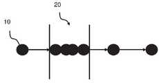
도 4a는 상이한 시점에 기록된 복수의 차량(100)의 타임 스탬프 순간 위치(10)를 도시한다. 타임 스탬프 위치(10)는 예를 들어 복수의 차량(100)의 위치결정 장치(12)에 의해 기록된다. 이와는 다르게, 타임 스탬프 위치(10)는 GPS 장치 또는 휴대폰과 같은 차량의 다른 장치에 의해 기록된다. 각 개별 차량의 위치는 일반적으로 주기적으로 예를 들어 매 초에 기록된다. 따라서, 타임 스탬프 위치(10)는 복수의 차량(100)이 시간에 따라 어떻게 움직이는지를 도시한다.4A shows the time stamp
도 4b는 도 4a의 위치 데이터로부터 결정된 정지장소(stop)를 도시한다. 정지장소(20)는 복수의 차량(100)의 임의의 차량이 정지된, 즉 미리 정해진 시간 동안 머물고 있는 위치(10)(도 4a)의 정지장소이다. 다시 말해서, 개별 차량의 오로지 순간적인 위치인 도 4a의 위치와 달리, 도 4b의 정지장소는 복수의 차량 중 하나가 상당한 시간 동안 머무른 위치를 나타낸다. 따라서, 하나의 정지장소는 일반적으로 시간, 지리적 위치(예를 들어 좌표) 및 차량 신원에 의해 정의된다. 정지장소는 도 6과 관련하여 더 설명되는 바와 같이 상이한 방식으로 결정될 수 있다. 일반적으로, 차량이 일정 시간 동안 정지하고 있는 정지장소만이 관련된다. 차량이 정지장소에서 보낸 시간도 기록될 수 있다.FIG. 4B shows a stop determined from the position data of FIG. 4A. The
도 4b는 또한 정지장소(20)의 클러스터(30)(점선 타원으로 표시됨)의 일부 예를 도시한다. 클러스터(30)는 여기서 정지장소(20)의 지리적 위치에 기초하여 정지장소(20)를 클러스터링 또는 그룹화함으로써 형성된다. 여기서 정지장소(20)는 공간적(또는 지리적) 근접도에 기초하여 그룹화 된다. 다시 말해서, 하나의 클러스터(30)는 서로 가까이 위치하고 있는 차량 정류장소(20)를 나타내게 된다. 따라서, 하나의 클러스터(30)는 복수의 정지장소(20)를 포함할 수 있다. 정지장소(20)의 클러스터링을 수행할 때, 복수의 클러스터가 형성된다. 일부 클러스터(30)는 각각 하나의 단일 정지장소(20)만을 포함할 수 있다. 다른 클러스터는 각각이 서로 근접한 여러 정지장소(20)를 포함할 수 있다. 클러스터링을 수행할 때, 일부 또는 모든 정지장소(20)가 클러스터에 포함될 수 있다. 단순화를 위해, 도 4b에는 단지 몇 개의 클러스터만이 표시되어 있지만, 클러스터링이 더 많은 클러스터를 생성할 수 있다.FIG. 4B also shows some examples of clusters 30 (indicated by dashed ellipses) of
도 4c는 클러스터(30)로부터 결정된 주차 구역(40)을 도시한다. 주차 구역(40)은 특정의 미리 정의된 기준을 충족시키는 클러스터(30)이다. 주차 구역(40)은 특정 기준을 충족시키는 클러스터(30)에서 차량의 중심 또는 평균 위치로서 결정될 수 있다. 기준은 예를 들어 도 5와 관련하여 아래에 추가로 설명되는 바와 같이 클러스터 내의 차량 수 또는 다른 파라미터를 포함할 수 있다.4C shows the
도 5는 하나의 예시적인 실시형태에 따른 주차 구역 식별 방법의 일 실시형태를 나타내는 흐름도이다. 이 방법은 예를 들어 복수의 차량(100)과 무선으로 통신하게 배치되어 있는, 차량 제작자가 소유하는 서버(또는 백엔드)와 같은 제어 장치(200)(도 7)에 의해 수행되는 것이 일반적이다. 보다 구체적으로, 이 방법은 일반적으로 제어 장치의 프로세서(210)(도 7)에 의해 수행된다. 방법은 복수의 차량(100)으로부터 충분한 데이터가 검색되면 연속적으로 수행될 수 있다. 다시 말해서, 새로운 데이터가 이용가능해지면 바로 이 방법이 다시 수행될 수 있어서, 새로운 정지장소가 발견될 수 있고 오래된 정지장소는 연속적으로 평가되며, 새로운 정지장소가 발견될 것이다. 따라서, 이 방법은 복수의 차량(100)으로부터의 위치가 평가되기 때문에 주차 구역이 결정되고 사라지는 "살아있는(living)" 모델을 생성한다. 예를 들어 특정 기간 동안 대응 클러스터에 새로운 정지장소가 추가되면, 결정된 주차 구역이 제거될 수 있다.Fig. 5 is a flow chart showing an embodiment of a method for identifying a parking area according to an exemplary embodiment. This method is typically performed by a control device 200 (FIG. 7 ), such as a server (or backend) owned by a vehicle manufacturer, arranged to communicate wirelessly with a plurality of
이 방법은 프로그램이 컴퓨터(또는 보다 구체적으로는 컴퓨터의 프로세서)에 의해 실행될 때 컴퓨터로 하여금 방법을 수행하게 하는 명령을 포함하는 컴퓨터 프로그램으로서 구현될 수 있다. 일부 실시형태들에 따르면, 컴퓨터 프로그램은 컴퓨터에 의해 실행될 때 컴퓨터로 하여금 방법을 수행하게 하는 명령들을 포함하는 컴퓨터 판독 가능 매체(예를 들어, 메모리 또는 콤팩트디스크)에 저장된다.This method may be implemented as a computer program comprising instructions that cause the computer to perform the method when the program is executed by a computer (or more specifically a processor of the computer). According to some embodiments, the computer program is stored on a computer-readable medium (eg, memory or compact disk) containing instructions that, when executed by a computer, cause a computer to perform a method.
이 방법은 복수의 차량의 정지장소(20)를 결정하는 단계 S2를 포함한다. 하나의 정지장소는 예를 들어 복수의 차량(100) 중 적어도 하나의 차량이 미리 결정된 기간보다 오래 머무른 곳의 지리적 위치로 정의된다. 정지장소는 일반적으로 지리적 위치, 정지장소에서 차량이 멈춰 있는 시간 및 정지장소에 정지되어 있는 차량의 아이덴티티에 의해 정의된다. 정지장소는 또한 정지 기간 또는 다른 차량 데이터로서 추가 파라미터에 의해 정의되거나 추가 파라미터와 관련될 수 있다. 정지장소(20)의 목적을 식별하기 위한 추가 기술이 개발될 수 있다. 예를 들어 차량(1)이 물품 배달을 위해 정지하는 것이라면, 그러한 정지는 주차 공간을 식별하는 데에 사용되지 않을 수 있다.The method includes a step S2 of determining the stopping
정지장치는 복수의 차량(100)으로부터 수신된 데이터에 기초하여 결정된다. 복수의 차량의 각 개별 차량에 의해 제공되는 데이터는 예를 들어. 위치 데이터, 즉 예컨대 GPS로부터 받은 타임 스탬프 위치 같은 차량의 위치를 나타내는 데이터이다. 이와는 다르게, 데이터는 차량의 정지장소를 명시적으로 나타내거나 정의하는 데이터일 수 있다.The stopping device is determined based on data received from the plurality of
다시 말해서, 일부 실시형태들에서, 방법은 복수의 차량(100)의 위치 데이터를 획득하는 단계 S1 및 그 위치 데이터에 기초하여 정지장소(20)를 결정하는 단계 S2를 추가로 포함한다. 위치 데이터를 획득하는 단계는 예를 들어 복수의 차량(100)의 내비게이션 유닛으로부터 또는 GPS 및 휴대폰과 같은 차량의 다른 위치 결정 장치로부터 위치 데이터를 수신하는 단계를 포함한다. 위치 데이터는 예를 들어 일련의 차량의 타임 스탬프 위치를 포함한다.In other words, in some embodiments, the method further includes a step S1 of acquiring position data of the plurality of
일련의 위치로부터 정지장소를 식별하는 방법에는 여러 가지가 있다(예컨대 중심 기반, 속도 기반, 지속 시간 기반, 밀도 기반). 예를 들어 https://rd.springer.com/article/10.1007/s4054-015-0079-x에서 검색된, Journal of Modern Transportation, 2015년 9월, Volume 23, Issue 3, pp 202-213의 "Identification of activity stop locations in GPS trajectories by density-based clustering method combined with support vector machines"를 참고하기 바란다.There are several ways to identify a stop from a set of positions (e.g. center-based, velocity-based, duration-based, density-based). For example, "Identification of the Journal of Modern Transportation, September 2015, Volume 23,
도 6은 정지장소(20)를 결정하는 단계 S2를 위해 사용될 수 있는 정지장소(20) 결정을 위한 하나의 예시적 알고리즘을 도시한다. 이 알고리즘은 시간의 지리 공간 밀도(geospatial density)에 기초하며, 이는 속도가 낮다는 복잡한 방법이다. 이는 기본적으로, 각 위치와 그 후속 위치 사이의 거리가 하나의 임계 값보다 작고 시퀀스의 첫 번째 위치와 시퀀스의 마지막 위치 사이의 시간이 다른 임계 값보다 큰, 차량의 연속 위치 중 하나의 시퀀스가 정지장소로 간주된다는 것을 의미한다. 다시 말해, 하나의 예시적인 실시형태에서, 위치 데이터는 복수의 차량(100) 각각에 대한 하나의 타임 스탬프 위치(10) 스트림을 포함하고, 결정 단계 S2는 지리 공간 분리가 허용 레벨보다 작은 타임 스탬프 위치(10)의 시퀀스를 식별하는 단계를 포함한다. 허용 레벨은 예를 들어 GPS의 정확도에 대응한다. 그 이유는 GPS가 완벽하지 않기 때문에 차량이 완전히 정지하더라도 GPS에 의해 결정된 위치가 정확히 동일하지 않기 때문이다. 따라서 이 알고리즘의 목적은 예를 들어 GPS의 예상 오차 한계 내에서만 다른 GPS 위치의 시퀀스를 식별하기 위한 것이다.6 shows one exemplary algorithm for determining the stopping
위치 데이터에 기초하여 정지장소를 산출하는 것과 관련된 하나의 장점은 그 방법이 보다 일반적이라는 것이다. 원칙적으로, 차량의 위치를추적하는 차량에 휴대폰을 설치하는 것으로 충분하다. 다른 장점은 정지장소 결정을 위한 알고리즘을 제어하고, 정지장소의 적절한 필터링을 제공하는 임계 값을 선택할 수 있다는 것이다. 예를 들어, 차량이 아주 짧은 시간 동안 머무른 정지장소를 무시하고 싶을 수 있다.One advantage associated with calculating the stopping point based on location data is that the method is more general. In principle, it is sufficient to install a mobile phone in a vehicle that tracks the vehicle's location. Another advantage is that you can control the algorithm for determining the stop point and select a threshold that provides appropriate filtering of the stop point. For example, you may want to ignore stops where the vehicle stays for a very short time.
대안적인 실시형태에서, 정지장소는 차량(또는 차량의 다른 장치, 예를 들어 휴대 전화)에서 결정되어, 제어 장치(200)에 보고될 수 있다. 예를 들어, 일부 차량은 정지장소를 검출하고 정보를 전송하기 위한 내장 로직을 구비할 수 있다. 따라서, 일부 실시형태에 따르면, 결정 단계는 복수의 차량(100)으로부터 정지장소를 정의하는 데이터를 수신하는 단계를 포함한다. 예를 들어, 데이터는 정지장소(20)의 정지 시작 시간, 종료 시간 및/또는 체류 시간을 정의할 수 있다.In an alternative embodiment, the stopping point may be determined in the vehicle (or other device in the vehicle, for example a mobile phone) and reported to the
신뢰할 수 있는 정보를 얻으려면 데이터 양 또는 보다 구체적으로 정지장소의 수가 중요할 수 있다. 따라서, 일부 실시형태들에서, 결정 단계 S2는 미리 결정된 수의 정지장소(20)보다 많은 수를 결정하는 것을 포함한다. 미리 결정된 수는 예를 들어. 경험적으로 결정된다. 그러나 적어도 10분마다(종종 더 자주) 위치 데이터를 보고하는 300000개를 상회하는 차량이 연결된 차량을 보유하는 일반적인 차량 제조업체는 일 년에 160억 개의 위치를생성한다(-300000 대의 차량*365일*24시간*연 6회/시간). 이는, 최소한 몇 년 동안 데이터가 지속적으로 수집되는 경우 일반적으로 신뢰할 수 있는 정보를 제공하기에 충분하다.The amount of data or more specifically the number of stops can be important to obtain reliable information. Thus, in some embodiments, determining step S2 includes determining a number greater than a predetermined number of stop points 20. The predetermined number is for example. It is determined empirically. However, a typical vehicle manufacturer with connected vehicles with more than 300,000 vehicles reporting location data at least every 10 minutes (often more often) creates 16 billion locations per year (-300,000 vehicles*365 days*). 24 hours*6 times a year/hour). This is generally sufficient to provide reliable information if data is being continuously collected for at least several years.
이 방법은 결정된 정지장소(20)의 공간적 근접도에 기초하여 결정된 정지장소(20)를 클러스터(30)로 클러스터링하는 단계 S3을 추가로 포함한다. 클러스터링은 정지장소(20)가, 동일한 그룹(클러스터라 칭함) 내의 객체가 다른 그룹(클러스터)에 있는 것보다 서로에게 더 유사한(어떤 의미에서, 여기에서는 지리적 위치)으로 그룹화 됨을 의미한다. 클러스터링 단계 S3은 예를 들어 밀도-기반 클러스터링 알고리즘, 연결성-기반 클러스터링 알고리즘 및/또는 센트로이드-기반 클러스터링 알고리즘을 사용하여 구현될 수 있다.The method further includes a step S3 of clustering the determined stopping
또한 지리적 공간에서의 근접도(closeness)와 관련하여, 이것을 정지장소의 "셀프-조인(self-join)"으로 설명할 수 있다. "셀프-조인"이라는 용어는 데이터베이스 이론에서 비롯되었으며 세트 조인 방법을 설명한다. 수학적으로는 세트의 곱집합을 계산하는 것을 의미한다. 즉, 한 요소가 한 세트에서 나오고 다른 요소가 다른 세트에서 오는 모든 조합이 계산되고, 그러면 "조인-조건"은 유지될 조합을 나타낸다. 일반적인 "조인-조건"은 한 요소의 필드가 다른 요소의 한 필드와 동일하다는 것이다. 예를 들어 소유자의 아이덴티티(소유자 ID)를 나타내는 하나의 데이터 필드를 갖는 복수의 차량과, 아이덴티티(ID)를 갖는 복수의 차량 소유자가 있다면, 조인 조건으로 "소유자 id = id"를 사용함으로써 차량들이 그들의 소유자와 조인될 수 있다. 이 경우, 정지 위치를 "조인-조건"으로 사용하는 정지장소들 사이에 연결이 이루어지고, 여기서 "조인-조건"은 정지장소들 사이의 거리가 임계 값 미만이어야 한다는 것이다.Also with regard to the closeness in geographic space, this can be described as a "self-join" of a stop. The term "self-join" comes from database theory and describes a set join method. Mathematically, it means computing the product set of a set. That is, all combinations of one element coming from one set and the other coming from another set are counted, and then the "join-condition" represents the combination to be maintained. The general "join-condition" is that a field in one element is the same as a field in another element. For example, if there are multiple vehicles having one data field representing the owner's identity (owner ID), and multiple vehicle owners having an identity (ID), the vehicles can be selected by using "owner id = id" as a join condition. Can be joined with their owners. In this case, a connection is made between stop points using the stop position as a "join-condition", where the "join-condition" means that the distance between the stops must be less than a threshold value.
클러스터링은 차량이 정지장소에 정지할 때와 같은 다른 파라미터를 추가로 고려할 수 있다. 따라서, 일부 실시형태에서, 각각의 정지장소(20)는 또한 차량이 정지장소(20)에 머무르거나 멈출 때를 정의하는 시간과 관련되고, 클러스터링 단계 S3은 또한 정지장소(20)의 시간의 시간 근접도에 기초한다. 시간은 예를 들어 차량이 정지장소에서 정차(즉, 도착)한 시점 또는 차량이 정지장소에서 정지하고 있는 기간이다. 기간의 근접도는 예를 들어 기간의 종점 및/또는 중간을 비교함으로써 결정될 수 있다. 다시 말해서, 클러스터는 시간과 지리적 거리 모두가 가까운 정지장소들을 포함할 것이다. 예를 들어 시간이 상당히 가까운 정류장(이 경우 60-90일)만 수락하는 것이 유익할 것이다. 이 방법은 제시간에 필터링하지 않고 작동할 가능성이 있지만, 시간 측면에서 가장자리를 필터링하면 결과가 향상될 수 있다.Clustering can additionally take into account other parameters, such as when the vehicle stops at a stopping point. Thus, in some embodiments, each
정지장소의 클러스터는 기본적으로 서로 근방에 위치하는 정지장소의 그룹이다. 클러스터에 대응하는 구역은 주차하기에 좋은 영역으로 간주될 수 있다. 그러나, 클러스터링은 일반적으로 적합한 주차 지역은 아니지만 하나 이상의 차량이 자주 정지하는 일부 구역을 드러낼 수도 있다. 이러한 구역의 예로는 차량 정비소, 운전자 집 또는 개인 차고이다. 따라서 주차 구역에 대한 좋은 정보를 제공하려면 일반적으로 약간의 필터링이 필요하다. 다시 말해서, 이 방법은 하나 이상의 미리 결정된 기준을 충족시키는 클러스터를 식별함으로써 주차 구역(40)을 결정하는 단계 S4를 추가로 포함한다. 클러스터가 적당한 주차 영역인지를 결정하는 데에 간단한 휴리스틱 모델이 사용될 수 있다. 장기적으로 기계 학습을 사용하여 적당한 주차 공간을 선택하기 위한 모델을 학습할 수도 있다.A cluster of stop places is basically a group of stop places located near each other. The area corresponding to the cluster can be regarded as a good parking area. However, clustering is generally not a suitable parking area, but may reveal some areas where one or more vehicles frequently stop. Examples of such areas are auto repair shops, driver's homes, or private garages. So it usually needs some filtering to provide good information about parking areas. In other words, the method further includes a step S4 of determining the
필터링은 예를 들어 단 하나의 특정 차량만 정지했거나 한 명의 소유자의 차량이 정지한 몇몇 정지장소 또는 클러스터만 포함하는 클러스터를 걸러낼 수 있다. 즉, 일부 실시형태들에 따르면, 사전에 결정된 기준은 클러스터에 머물렀던 차량(1)이 사전에 결정된 수의 차량 소유자보다 많은 것에 속한다는 것을 포함한다. 일부 실시형태에 따르면, 사전에 결정된 기준은 클러스터(30)에 머물렀던 상이한 개별 차량의 수가 임계 값, 예를 들어 30-80 범위보다 많다는 것을 포함한다.Filtering can filter out clusters containing only a few stops or clusters where only one specific vehicle has stopped, for example, or one owner's vehicle has stopped. That is, according to some embodiments, the predetermined criterion includes that the
또 다른 옵션은 정지 구역이 주차와 관련된 것으로 간주되지 않을 수 있는, 매우 적은 클러스터를 걸러내는 것이다. 따라서, 일부 실시형태에 따르면, 사전에 결정된 기준은 클러스터의 정지장소(20)의 수가 임계 값, 예를 들어 30-80개보다 많아야 하는 것을 포함한다.Another option is to filter out very few clusters, where the stop zone may not be considered parking related. Thus, according to some embodiments, the predetermined criterion includes that the number of
예를 들어 개인 주차 구역을 피하려면, 예를 들어 지난 한 달 동안 예컨대 50대의 고유 차량이 클러스터에 머물렀을 것을 필요로 할 수 있다. 이러한 규칙은 또한 매우 적은 차량이 정차했던 주차 구역을 배제한다.To avoid private parking areas, for example, it may be necessary that for example 50 unique vehicles have stayed in the cluster over the past month, for example. These rules also exclude parking areas where very few vehicles have stopped.
필터링은 정지들 사이의 시간이 매우 긴 클러스터를 제거할 수도 있다. 따라서, 일부 실시형태에 따르면, 사전에 결정된 기준은, 복수의 차량(100) 중 하나가 클러스터(30)에 머물렀던 시점의 빈도수가 사전에 결정된 간격(interval), 예를 들어 40-60일 이내인 것을 포함한다.Filtering may remove clusters with very long times between stops. Accordingly, according to some embodiments, the predetermined criterion is that the frequency at which one of the plurality of
일부 실시형태에 따르면, 사전에 결정된 기준은 사용자 입력에 의해 정의된 다른 기준을 포함한다. 예를 들어, 다른 운전자가 관련이 없는 것으로 표시한 주차 구역 예컨대 적당하지 않거나 안전하지 않거나 또는 불편한 주차 구역을 표시한 주차 구역을 걸러낼 수 있다. 이러한 유형의 사용자 입력에 대해서는 후술한다.According to some embodiments, the pre-determined criteria include other criteria defined by user input. For example, it is possible to filter out parking areas that other drivers have marked as irrelevant, such as those that have marked unsuitable, unsafe or inconvenient parking areas. This type of user input will be described later.
사전에 정해진 기준의 일 예시로서, 클러스터로부터 주차 구역을 식별하는데 사용될 수 있는 하나의 안전한 가정은 예를 들어 주차 구역은 Y개의 다른 차량 소유자의 X대 이상의 차량이 Z 분/시간 이상 머물렀던 영역(즉 클러스터)이라고 가정하는 것이다. 개발이 진행됨에 따라 예컨대 기계 학습 및/또는 사용자 입력을 사용하여 추가 휴리스틱이 개발될 수 있다.As an example of a pre-determined criterion, one safe assumption that can be used to identify a parking area from a cluster is, for example, a parking area is an area where X or more vehicles of Y different vehicle owners stayed for more than Z minutes/hour (i.e. Cluster). As development progresses, additional heuristics may be developed, for example using machine learning and/or user input.
클러스터(30)는 또한 클러스터를 설명하는 다른 데이터, 예를 들어 클러스터는 도착 시간의 히스토그램(예: 20% 아침, 30% 아침, 10% 오후, 35% 저녁, 5% 밤) 또는 연결된 차량이 하루 중 몇 시에 있는 지에 대한 히스토그램이 포함될 수 있다. 예를 들어, 차량이 저녁에 도착하여 아침에 서 있으면, 이는 저녁, 밤, 아침에 "버킷(bucket)"에 기여한다. 클러스터와 관련될 수 있는 다른 가능한 파라미터는 "지난달에 주차 구역에 머물렀던 차량 수", "지난달에 주차 구역에 머물렀던 차량 수" 또는 "주차 구역에 주차한 평균 시간"이다. 이러한 모든 데이터는 클러스터가(적당한) 주차 구역인지를 결정하기 위해 사전에 정해진 기준에 의해 사용될 수 있다.
결정된 주차 구역(40)이 가득 찬지 아닌지를 아는 것도 관련될 수 있다. 위치 데이터(예를 들어, 복수의 차량으로부터의 GPS 데이터)는 모든 복수의 차량(100)이 현재 있는 위치 및 그들이 있었던 위치(및 그들이 어느 방향으로 운전하고 있는지)를 나타내기 때문에, 이 데이터는 또한 현재 어떤 차량이 주차 구역에 주차되어 있는 지를 결정하고, 어떤 차량이 주차 구역으로 향하고 있는지 또는 어떤 차량이 곧 떠나려고 하는지를 추정하는 데에 사용될 수 있다. 또는, 복수의 차량(100)에서의 카메라와 같은 다른 장치로부터의 입력 또는 사용자 입력이 이용 가능성을 예측하는 데에 사용될 수 있다.It may also be relevant to know whether the
즉, 일부 실시형태에 따르면, 이 방법은, 위치 데이터 또는 사용자 입력에 기초하여, 결정된 주차 구역(40)과 연관된 가용 정보를 결정하는 단계 S5를 추가로 포함한다. 다르게 설명하면, 일부 실시형태에서, 이 방법은, 위치 데이터 또는 사용자 입력에 기초하여, 결정된 주차 구역(40) 중 하나가 가득 찼는지 여부를 예측하는 단계를 추가로 포함한다.That is, according to some embodiments, the method further comprises a step S5 of determining, based on location data or user input, available information associated with the
결정된 주차 구역(40)은 API(Application Programming Interface)를 통해 노출되거나 제공되는 것이 일반적이다. 달리 말하면, 일부 실시형태들에서, 이 방법은 API를 통해 결정된 주차 구역을 식별하는 정보를 제공하는 단계를 추가로 포함한다. API는 (서비스 제공업체, 예를 들어 차량 제조업체만 액세스할 수 있는) 내부 API이거나 또는 누구나 액세스할 수 있는 공용 API일 수 있다. API 외에도 완벽한 서비스 기능 예를 들어 사용자 인터페이스가 추가될 수 있다.The
따라서, 일부 실시형태들에서, 이 방법은 사용자 인터페이스(300)를 통해 결정된 주차 구역을 식별하는 정보를 사용자에게 제공하는 단계 S6을 추가로 포함한다. 사용자 인터페이스(300)는 상이한 방식으로 생성될 수 있고, 상이한 수단 예컨대 디스플레이를 이용하여 제시될 수 있다. 사용자 인터페이스(300)는 예를 들어 웹 인터페이스, 모바일 장치 또는 기타 소프트웨어 응용 프로그램일 수 있다. 사용자 인터페이스(300)는 휴대폰, 태블릿 또는 컴퓨터와 같은 상이한 유형의 장치의 디스플레이 상에 제공될 수 있다. 하나의 가능성은 그래픽 사용자 인터페이스에서 지도에 주차 구역과 주차 구역의 크기를 표시하여, 운전자가 그들이 쉴 적당한 장소를 쉽게 체크할 수 있도록 하는 것이다. 이와는 다르게, 오디오, 서면 또는 다른 임의의 수단을 사용하여 정보가 제공될 수 있다.Thus, in some embodiments, the method further includes a step S6 of providing the user with information identifying the determined parking area via the
결정된 가용 정보, 보안 정보 또는 다른 운전자에 의해 제공된 정보와 같은 다른 정보가 또한 제공될 수 있다.Other information may also be provided, such as determined available information, security information or information provided by other drivers.
모든 데이터 마이닝 또는 기계 학습에서 공통적으로 해결해야 할 과제는 알려진 사례 소위 지상 실측 정보에 대해 모델이 어떻게 보여야 하는지에 대한 지식을 갖는 것이다. 한 가지 제안은 운전자 자신이 지도에 지점을 표시할 수 있으며 모든 사람이 볼 수 있기 전에 검토될 수 있다는 것이다. 운전자는 밤새 머무를 수 있는 영역을 표시하고 등급을 매기고 그 것에 관한 짧은 의견을 쓰도록 요청받을 수도 있다. 즉, 일부 실시형태에서, 방법은 사용자 인터페이스(300)를 통해 주차 구역과 관련된 정보를 포함하는 사용자 입력을 수신하는 단계를 포함한다.A common challenge in all data mining or machine learning is to have knowledge of how the model should look for known examples, so-called ground truth information. One suggestion is that the driver himself can mark a point on the map and it can be reviewed before everyone can see it. The driver may be asked to mark, rate and write a short comment on the areas where they can stay overnight. That is, in some embodiments, the method includes receiving a user input including information related to the parking area via the
다른 예에서, 특정 장소에서 많은 사건/범죄가 발생했는지를 사용자에게 표시하는 것이 가능할 수 있다. 이러한 정보는 운전자 등급에 대한 보완 자료로 경찰 보고서에서 가져올 수 있다.In another example, it may be possible to indicate to the user that many events/crimes have occurred in a particular location. This information can be taken from the police report as a supplement to the driver class.
도 7은 예시적인 실시형태에 따른 제어 장치(200)를 도시한다. 제어 장치(1)는 백엔드(backend)라고도 하는 오프-보드 시스템이며, 이는 차량 제조업체의 서버 또는 클라우드 서버와 같은 외부 서버에서 구현되는 일반적이다.7 shows a
전형적인 구현에서, 제어 장치(200)는 프로세서(210), 통신 인터페이스(220) 및 메모리(230)를 포함한다. 제어 장치(200)는 사용자 인터페이스(300)가 생성될 수 있는 적어도 하나의 디스플레이에 연결되거나 적어도 하나의 디스플레이를 더 포함할 수 있다.In a typical implementation, the
프로세서(210)는 처리 회로, 즉 중앙 처리 장치(CPU), 처리 장치, 처리 회로, 프로세서, 주문형 집적 회로(ASIC), 마이크로프로세서 또는 명령을 해석하고 실행할 수 있는 다른 처리 로직 중 하나 이상을 포함할 수 있다. 본 명세서에서 이용된 표현 "프로세서"는 예를 들어 상기 열거된 것들 중 임의의 것 또는 모두와 같은 복수의 처리 회로를 포함하는 처리 회로를 나타낼 수 있다.
통신 인터페이스(220)는 제어 장치(200)와 외부 장치 사이의 통신을 가능하게 하도록 구성된다. 예를 들어, 통신 인터페이스(220)는 복수의 차량(100)과 제어 장치(200) 사이의 통신을 가능하게 하도록 구성된다. 통신 인터페이스(220)는 표준 유선 또는 무선 통신 인터페이스일 수 있다. 예를 들어, 통신 인터페이스는 이더넷 연결 또는 WiFi 연결을 설정하도록 구성된다. 통신 인터페이스(220)는 또한 사용자 인터페이스(300)가 생성되는 디스플레이 또는 주차 구역을 결정할 때 사용되는 정보를 포함하는 외부 데이터베이스와 같은 다른 장치와의 통신을 가능하게 하도록 구성될 수 있다.The
제어 장치(200), 또는 보다 구체적으로 제어 장치의 프로세서(210)는 상기 및 하기 기술된 방법의 모든 양태를 수행하도록 구성된다. 이것은 일반적으로 제어 회로의 하나 이상의 프로세서(210)에서 메모리(230)에 저장된 컴퓨터 프로그램 코드를 실행함으로써 수행된다.The
상기 언급된 컴퓨터 프로그램 제품은 예를 들어 제어 장치(200)의 프로세서(210)에 로딩될 때 일부 실시형태에 따라 단계 S1-S6(도 5) 중 적어도 일부를 수행하기 위한 컴퓨터 프로그램 코드를 운반하는 데이터 캐리어의 형태로 제공될 수 있다. 데이터 캐리어는 예를 들어 하드 디스크, CD ROM 디스크, 메모리 스틱, 광학 저장 장치, 자기 저장 장치 또는 비일시적 방식으로 기계 판독 가능 데이터를 보유할 수 있는 디스크 또는 테이프 같은 다른 임의의 적당한 매체일 수 있다.The computer program product mentioned above carries computer program code for performing at least some of the steps S1-S6 (Fig. 5) according to some embodiments, for example when loaded on the
보다 구체적으로, 제어 장치(200)는 복수의 차량(100)의 위치 데이터를 획득하도록 구성된다. 이는 전형적으로 셀룰러 네트워크를 사용하여 설정된 인터넷 연결을 통해 복수의 차량(100)으로부터 데이터를 수신하는 단계를 포함한다.More specifically, the
제어 장치(200)는 또한 정지장소(20)를 결정하도록 구성되며, 여기서 하나의 정지장소는, 도 5와 관련하여 이미 설명된 바와 같이, 복수의 차량(100) 중 하나의 차량이 사전에 결정된 기간보다 오래 머무른 지리적 위치이다.The
제어 장치(200)는 정지장소(20)의 지리 공간적 근접도에 기초하여 결정된 정지장소(20)를 클러스터(30)로 클러스터링하고, 이미 도 5와 관련하여 설명된 바와 같이, 하나 이상의 미리 결정된 기준을 충족시키는 클러스터(30)를 식별함으로써 주차 구역(40)을 결정하도록 구성된다.The
일부 실시형태에서, 제어 장치(200)는 복수의 차량(100)의 위치 데이터를 획득하고, 위치 데이터에 기초하여 정지장소(20)를 결정하도록 구성된다. 위치 데이터는 예를 들어 통신 인터페이스(220)를 통해 복수의 차량(100)으로부터 획득된다.In some embodiments, the
일부 실시형태들에서, 위치 데이터는 복수의 차량(100)의 각각에 대한 일련의 타임 스탬핑 위치(10)를 포함하고, 제어 장치(200)는 공차 레벨 미만의 공간적 분리를 갖는 타임 스탬프 위치(10)의 시퀀스를 식별함으로써 정지장소(20)를 결정하도록 구성된다.In some embodiments, the location data comprises a series of time stamped
일부 실시형태에서, 각각의 정지장소(20)는 또한 차량이 정지장소(20)에 머물렀을 때를 정의하는 시간과 관련되고, 클러스터링 단계 S3은 또한 시간들의 시간 근접도에 기초한다.In some embodiments, each
일부 실시형태에서, 제어 장치(200)는 사전에 결정된 수보다 많은 수의 정지장소(20)를 결정하도록 구성된다.In some embodiments, the
일부 실시형태에서, 제어 장치(200)는 위치 데이터 및/또는 사용자 입력에 기초하여 결정된 주차 구역(40)과 관련된 가용 정보를 결정하도록 구성된다.In some embodiments, the
일부 실시형태에서, 제어 장치(200)는 API를 통해 결정된 주차 영역을 노출 시키도록 구성된다. API는 통신 인터페이스(220)를 통해 액세스 가능한 외부 API일 수 있다.In some embodiments, the
일부 실시형태에서, 제어 장치(200)는 결정된 주차 구역을 식별하는 정보를 사용자 인터페이스(300)를 통해 사용자에게 제공하도록 구성된다. 사용자 인터페이스(300)는 제어 장치(200)에 포함된 디스플레이에 제공될 수 있다. 또는, 사용자 인터페이스는 디스플레이 예를 들어 통신 인터페이스(220)를 통해 제어 장치(200)에 연결된 휴대폰 또는 컴퓨터의 디스플레이에 제공될 수 있다.In some embodiments, the
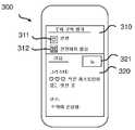
도 8a는 결정된 주차 구역을 식별하는 정보를 사용자에게 제공하기 위한(휴대폰(80) 상에 렌더링된) 사용자 인터페이스(300)의 예시적인 구현을 도시한다. 도 8a에 도시된 바와 같이, 주차 구역은 내비게이션 응용 프로그램에서 예를 들어 선택 가능한 아이콘(301)으로서 지도 위에 표시될 수 있다.8A shows an exemplary implementation of a user interface 300 (rendered on the mobile phone 80) for providing a user with information identifying a determined parking area. As shown in Fig. 8A, the parking zone may be displayed on a map in a navigation application, for example as a
도 8b는 결정된 주차 구역과 관련된 사용자 입력을 수신하기 위한 사용자 인터페이스(300)의 예시적인 구현을 도시한다. 이 사용자 인터페이스는 예를 들어 사용자가 도 8a에 도시된 선택 가능한 아이콘(301) 중 하나를 클릭할 때 생성된다. 사용자 인터페이스는 예를 들어 복수의 선택 가능한 아이콘 "안전"(311) 또는 "안전하지 않은"(312) 중 하나를 선택함으로써 주차 구역의 등급을 매기거나 평가하는 하나의 섹션(310)을 포함한다. 사용자 인터페이스는 또한 사용자가 주차 구역에 대한 의견을 읽거나 제공할 수 있는 하나의 섹션(320)을 포함할 수 있다. 새로운 의견은 예를 들어 아이콘 "New" 321을 선택하여 등록될 수 있다.8B shows an exemplary implementation of a
첨부 도면에 도시된 바와 같이 실시형태들의 설명에서 사용된 용어는 설명된 방법, 제어 장치 또는 컴퓨터 프로그램을 제한하려는 것이 아니다. 첨부된 청구 범위에 의해 정의된 본 발명의 실시형태를 벗어나지 않고 다양한 변경, 대체 및/또는 변경이 이루어질 수 있다.As shown in the accompanying drawings, the terms used in the description of the embodiments are not intended to limit the described method, control device or computer program. Various changes, substitutions and/or changes may be made without departing from the embodiments of the invention as defined by the appended claims.
본 명세서에 사용된 용어 "및/또는"은 관련되어 열거된 항목 중 하나 이상의 임의의 및 모든 조합을 포함한다. 본 명세서에 사용된 용어 "또는"은 수학적 OR, 즉 포괄적 논리합으로서 해석되고; 달리 명시하지 않는 한 수학적 배타적 OR(XOR)이 아니다. 또한, 단수 형태 "a", "an" 및 "the"는 "적어도 하나"로 해석되어야 하며, 달리 명시적으로 언급되지 않는 한 동일한 종류의 복수의 엔티티를 포함할 수도 있다. "포함한다(include)", "포함하다(comprise)", "포함하는" 및/또는 "포함하는"이라는 용어는 언급된 특징, 동작, 정수, 단계, 연산, 요소 및/또는 구성 요소의 존재를 특정하지만, 하나 이상의 다른 특징, 동작, 정수, 단계, 연산, 요소, 구성 요소 및/또는 그 그룹의 존재 또는 추가를 배제하지 않아야 한다. 예를 들어 하나의 프로세서 같은 단수 유닛이 청구 범위에 기재된 여러 항목의 기능들을 수행할 수 있다. 특정 조치들이 서로 다른 종속 항들에서 인용된다는 사실이, 이러한 조치들의 조합이 유리하게 사용될 수 없다는 것을 나타내지 않는다. 컴퓨터 프로그램은 광 저장 매체 또는 다른 하드웨어와 함께 또는 다른 하드웨어의 일부로서 공급되는 고체 매체와 같은 적절한 매체에 저장/분포될 수 있지만, 인터넷 또는 다른 유선 또는 무선 통신 시스템을 통하는 것과 같이 다른 형태로 분배될 수도 있다.The term “and/or” as used herein includes any and all combinations of one or more of the items listed in relation to it. As used herein, the term “or” is interpreted as a mathematical OR, ie inclusive OR; It is not a mathematically exclusive OR (XOR) unless otherwise specified. In addition, the singular forms “a”, “an” and “the” should be interpreted as “at least one”, and may include a plurality of entities of the same type unless explicitly stated otherwise. The terms “include”, “comprise”, “comprise” and/or “comprise” refer to the presence of the recited features, actions, integers, steps, operations, elements and/or components. But does not exclude the presence or addition of one or more other features, actions, integers, steps, operations, elements, components and/or groups thereof. A singular unit, such as, for example, one processor may perform the functions of several items described in the claims. The fact that certain measures are cited in different dependent claims does not indicate that a combination of these measures cannot be used to advantage. The computer program may be stored/distributed on a suitable medium such as an optical storage medium or a solid medium supplied with or as part of other hardware, but may be distributed in other forms such as through the Internet or other wired or wireless communication system. May be.
Claims (15)
Translated fromKorean- 복수의 차량의 정지장소(20)들을 결정하는 단계 S2로, 여기서 하나의 정지장소는 복수의 차량(100) 중 하나가 사전에 결정된 기간보다 더 오랫동안 머무른 곳의 지리적 위치인, 정지장소 결정 단계 S2,
- 결정된 정지장소(20)의 지리적 위치의 공간 상의 근접도에 기초하여 결정된 정지장소(20)를 클러스터(30)로 클러스터링 하는 단계 S3, 및
- 하나 이상의 사전에 결정된 기준을 충족시키는 하나 이상의 클러스터를 식별함으로써 주차 구역(40)을 결정하는 단계 S4를 포함하는 것을 특징으로 하는 주차 구역 식별 방법.As a method of identifying the parking area 40,
-A step S2 of determining the stopping places 20 of the plurality of vehicles, where one stopping place is a geographic location of a place where one of the plurality of vehicles 100 stayed longer than a predetermined period, a stopping place determining step S2,
-Step S3 of clustering the determined stopping place 20 into a cluster 30 based on the spatial proximity of the determined stopping place 20, and
-A method of identifying a parking zone, comprising the step S4 of determining the parking zone 40 by identifying one or more clusters meeting one or more predetermined criteria.
- 복수의 차량(100)의 위치 데이터를 획득하는 단계 S1을 추가로 포함하고, 정지장소 결정 단계 S2는 위치 데이터에 기초하여 정지장소(20)를 결정하는 단계를 포함하는 것을 특징으로 하는 주차 구역 식별 방법.The method of claim 1,
-A parking zone, characterized in that it further comprises a step S1 of acquiring position data of the plurality of vehicles 100, and the stopping place determining step S2 comprises determining the stopping place 20 based on the position data. Identification method.
위치 데이터는 복수의 차량(100) 각각에 대한 일련의 타임 스탬프 위치(10)를 포함하고, 정지장소 결정 단계 S2는 공간 상에서 공차 레벨 미만으로 분리되어 있는 타임 스탬프 위치(10)의 시퀀스를 식별하는 단계를 포함하는 것을 특징으로 하는 주차 구역 식별 방법.The method of claim 2,
The position data includes a series of time stamp positions 10 for each of the plurality of vehicles 100, and the stop position determination step S2 identifies a sequence of time stamp positions 10 separated by less than the tolerance level in space. Parking zone identification method comprising the step.
각 정지장소(20)는, 차량이 정지장소(20)에 정지해 있을 때를 정의하는 시간과 관련되어 있고, 클러스터링 하는 단계 S3은 또한 시간의 시간 근접도에 기초하는 것을 특징으로 하는 주차 구역 식별 방법.The method according to any one of the preceding claims,
Each stop point 20 is associated with a time defining when the vehicle is stopped at the stop point 20, and the clustering step S3 is also based on the temporal proximity of time. Way.
정지장소 결정 단계 S2는 사전에 결정된 수를 상회하는 정지장소(20)를 결정하는 단계를 포함하는 것을 특징으로 하는 주차 구역 식별 방법.The method according to any one of the preceding claims,
The stopping place determination step S2 comprises the step of determining the stopping place 20 that exceeds a predetermined number.
- 위치 데이터 및/또는 사용자 입력에 기초하여, 결정된 주차 구역(40)에 관련된 가용 정보를 결정하는 단계 S5를 추가로 포함하는 것을 특징으로 하는 주차 구역 식별 방법.The method according to any one of the preceding claims,
-A method of identifying a parking area, characterized in that it further comprises a step S5 of determining available information related to the determined parking area 40 based on the location data and/or user input.
- 결정된 주차 구역을 식별하는 정보를 사용자 인터페이스(300)를 통해 사용자에게 제공하는 단계 S6을 추가로 포함하는 것을 특징으로 하는 주차 구역 식별 방법.The method according to any one of the preceding claims,
-A method for identifying a parking area, further comprising a step S6 of providing information identifying the determined parking area to a user through the user interface 300.
사전에 결정된 기준은 다음 중 적어도 하나를 포함하는 것을 특징으로 하는 주차 구역 식별 방법.
- 클러스터의 정지장소(20)의 수가 임계 값보다 높음,
- 클러스터에 머무른 차량(1)이 사전에 결정된 차량 소유자의 수보다 많음,
- 클러스터(30)에 머무른 상이한 개별 차량 수가 임계 값보다 높음,
- 복수의 차량(100) 중 하나가 클러스터(30)에 머무른 시점의 빈도수가 사전에 결정된 빈도수 간격 내에 속함,
- 사용자 입력에 의해 정의된 다른 기준.The method according to any one of the preceding claims,
A method for identifying a parking area, characterized in that the predetermined criterion includes at least one of the following.
-The number of stopping points (20) in the cluster is higher than the threshold value,
-More vehicles (1) staying in the cluster than the number of vehicle owners determined in advance,
-The number of different individual vehicles staying in the cluster 30 is higher than the threshold value,
-The frequency at which one of the plurality of vehicles 100 stays in the cluster 30 falls within a predetermined frequency interval,
-Other criteria defined by user input.
- 복수의 차량의 정지장소(20)들을 결정하되, 여기서 하나의 정지장소는 복수의 차량(100) 중 하나가 사전에 결정된 기간보다 더 오랫동안 머무른 곳의 지리적 위치인, 정지장소를 결정하고,
- 결정된 정지장소(20)의 지리적 위치의 공간 상의 근접도에 기초하여 결정된 정지장소(20)를 클러스터(30)로 클러스터링 하고, 및
- 하나 이상의 사전에 결정된 기준을 충족시키는 하나 이상의 클러스터를 식별함으로써 주차 구역(40)을 결정하도록 구성되는 것을 특징으로 하는 제어 장치.A control device 200 configured to identify a parking zone, the control device comprising:
-Determine the stopping points 20 of the plurality of vehicles, wherein one stopping place determines the stopping place, which is the geographical location where one of the plurality of vehicles 100 stayed longer than a predetermined period,
-Clustering the determined stopping place 20 based on the spatial proximity of the determined stopping place 20 into a cluster 30, and
-A control device, characterized in that it is arranged to determine the parking area (40) by identifying one or more clusters meeting one or more predetermined criteria.
제어 장치(100)는,
- 복수의 차량(10)의 위치 데이터를 획득하고, 그 위치 데이터에 기초하여 정지장소(20)를 결정하도록 구성되는 것을 특징으로 하는 제어 장치.The method of claim 9,
The control device 100,
-A control device, characterized in that it is configured to obtain position data of a plurality of vehicles (10) and to determine a stop position (20) based on the position data.
위치 데이터는 복수의 차량(100) 각각에 대한 일련의 타임 스탬프 위치(10)를 포함하고, 제어 장치(100)는 공간 상에서 공차 레벨 미만으로 분리되어 있는 타임 스탬프 위치(10)의 시퀀스를 식별함으로써 정지장소(20)를 결정하게 구성되는 것을 특징으로 하는 제어 장치.The method of claim 10,
The location data includes a series of time stamp locations 10 for each of a plurality of vehicles 100, and the control device 100 identifies a sequence of time stamp locations 10 separated by less than a tolerance level in space. Control device, characterized in that configured to determine the stop (20).
각 정지장소(20)는, 차량이 정지장소(20)에 정지해 있을 때를 정의하는 시간과 관련되어 있고, 클러스터링 하는 단계 S3은 또한 시간의 시간 근접도에 기초하는 것을 특징으로 하는 제어 장치.The method according to any one of claims 9 to 11,
Each stop point 20 is associated with a time defining when the vehicle is stopped at the stop point 20, and the clustering step S3 is also based on the temporal proximity of time.
제어 장치는 사전에 결정된 수를 상회하는 정지장소(20)를 결정하도록 구성되는 것을 특징으로 하는 제어 장치.The method according to any one of claims 9 to 12,
Control device, characterized in that the control device is configured to determine a stopping point (20) that exceeds a predetermined number.
제어 장치(100)는 위치 데이터 및/또는 사용자 입력에 기초하여, 결정된 주차 구역(40)에 관련된 가용 정보를 결정하도록 구성되는 것을 특징으로 하는 제어 장치.The method according to any one of claims 9 to 13,
The control device (100) is configured to determine, based on the location data and/or user input, available information related to the determined parking area (40).
제어 장치(100)는 결정된 주차 구역을 식별하는 정보를 사용자 인터페이스(300)를 통해 사용자에게 제공하도록 구성되는 것을 특징으로 하는 제어 장치.The method according to any one of claims 9 to 14,
The control device 100 is a control device, characterized in that configured to provide the user with information identifying the determined parking area through the user interface (300).
Applications Claiming Priority (3)
| Application Number | Priority Date | Filing Date | Title |
|---|---|---|---|
| SE1850238ASE541634C2 (en) | 2018-03-06 | 2018-03-06 | Method and control arrangement for identification of parking areas |
| SE1850238-5 | 2018-03-06 | ||
| PCT/SE2019/050183WO2019172823A1 (en) | 2018-03-06 | 2019-03-04 | Method and control arrangement for identification of parking areas |
Publications (2)
| Publication Number | Publication Date |
|---|---|
| KR20200098696Atrue KR20200098696A (en) | 2020-08-20 |
| KR102415293B1 KR102415293B1 (en) | 2022-06-30 |
Family
ID=67846283
Family Applications (1)
| Application Number | Title | Priority Date | Filing Date |
|---|---|---|---|
| KR1020207021741AActiveKR102415293B1 (en) | 2018-03-06 | 2019-03-04 | Control device and method for parking area identification |
Country Status (7)
| Country | Link |
|---|---|
| US (1) | US11410554B2 (en) |
| EP (1) | EP3762912A4 (en) |
| KR (1) | KR102415293B1 (en) |
| CN (1) | CN111788617B (en) |
| BR (1) | BR112020014842A2 (en) |
| SE (1) | SE541634C2 (en) |
| WO (1) | WO2019172823A1 (en) |
Cited By (1)
| Publication number | Priority date | Publication date | Assignee | Title |
|---|---|---|---|---|
| EP4002321A1 (en)* | 2020-11-23 | 2022-05-25 | GEOTAB Inc. | Intelligent zoning |
Families Citing this family (20)
| Publication number | Priority date | Publication date | Assignee | Title |
|---|---|---|---|---|
| EP3772729B1 (en)* | 2019-08-08 | 2022-08-31 | Ningbo Geely Automobile Research & Development Co. Ltd. | A method for preconditioning vehicles |
| US12094339B2 (en)* | 2020-02-24 | 2024-09-17 | Schneider Enterprise Resources, LLC | Systems and methods for parking suggestions |
| US12111161B2 (en) | 2020-02-24 | 2024-10-08 | Schneider Enterprise Resources, LLC | Systems and methods for generating trip plan |
| US12222212B2 (en) | 2020-02-24 | 2025-02-11 | Schneider Enterprise Resources, LLC | Systems and methods for predicting estimated time of arrival |
| US12085400B2 (en)* | 2020-05-27 | 2024-09-10 | Rm Acquisition, Llc | Routing system that incorporates hours of service into time estimates |
| JP7415822B2 (en)* | 2020-06-29 | 2024-01-17 | トヨタ自動車株式会社 | Information processing devices, information processing systems, programs, and vehicles |
| JP7363707B2 (en)* | 2020-08-03 | 2023-10-18 | トヨタ自動車株式会社 | Information processing device, information processing system, information processing program, and information processing method |
| US20220335829A1 (en)* | 2021-04-16 | 2022-10-20 | Wejo Limited | System and method for vehicle event data processing for identifying and updating parking areas |
| CN113361914B (en)* | 2021-06-04 | 2021-12-28 | 南京大学 | A method and system for early warning of hazardous waste transportation risk management and control |
| CN114141014B (en)* | 2021-11-30 | 2023-04-18 | 中寰卫星导航通信有限公司 | Method, device and equipment for determining parking lot and storage medium |
| US12399017B2 (en) | 2021-12-01 | 2025-08-26 | Schneider Enterprise Resources, LLC | Systems and methods for predictive feedback analysis based on estimated time of arrival |
| US12354477B2 (en)* | 2021-12-07 | 2025-07-08 | Toyota Motor Engineering & Manufacturing North America, Inc. | Systems and methods for activation of intelligent parking availability functions |
| US11881109B2 (en)* | 2021-12-27 | 2024-01-23 | Here Global B.V. | Method, apparatus, and system for providing in-parking navigation |
| CN115050210B (en)* | 2022-06-07 | 2023-10-20 | 杭州市城市大脑停车系统运营股份有限公司 | Parking lot intelligent induction method, system and device based on time sequence prediction |
| CN115083161B (en)* | 2022-06-15 | 2023-08-04 | 平安国际融资租赁有限公司 | Vehicle stay point evaluation method and device, electronic equipment and readable storage medium |
| JP7700752B2 (en)* | 2022-07-27 | 2025-07-01 | トヨタ自動車株式会社 | DATA GENERATION SYSTEM, DATA GENERATION METHOD, AND PROGRAM |
| US12307897B2 (en)* | 2022-12-20 | 2025-05-20 | Here Global B.V. | System to predict vehicle parking bunching |
| US20240210512A1 (en)* | 2022-12-27 | 2024-06-27 | Honda Motor Co., Ltd. | Management apparatus and management method |
| CN116071954A (en)* | 2022-12-29 | 2023-05-05 | 北京中交兴路信息科技有限公司 | Method, device, equipment and storage medium for identifying vehicle parking area |
| CN119541189A (en)* | 2024-09-20 | 2025-02-28 | 东南大学 | A data-driven method for identifying parking purpose of urban green freight new energy vehicles |
Citations (2)
| Publication number | Priority date | Publication date | Assignee | Title |
|---|---|---|---|---|
| JP2014021840A (en)* | 2012-07-20 | 2014-02-03 | Yazaki Energy System Corp | Information management method for operation information collection system, on-vehicle device for operation information collection system and management device for operation information collection system |
| US20160225255A1 (en)* | 2015-01-30 | 2016-08-04 | Nissan North America, Inc. | Spatial clustering of vehicle probe data |
Family Cites Families (21)
| Publication number | Priority date | Publication date | Assignee | Title |
|---|---|---|---|---|
| JP2009289174A (en) | 2008-05-30 | 2009-12-10 | Aisin Aw Co Ltd | Parking lot information determination system and program |
| EP2387697B1 (en)* | 2009-01-14 | 2018-06-06 | TomTom Traffic B.V. | Server apparatus and method of collecting parking location information |
| TWI408340B (en) | 2009-07-27 | 2013-09-11 | Htc Corp | Mehtod for displaying navigation route, navigation apparatus and computer program product |
| US9355063B2 (en)* | 2010-08-12 | 2016-05-31 | Tomtom Germany Gmbh & Co. Kg | Parking lot detection using probe data |
| US8606499B2 (en) | 2011-12-16 | 2013-12-10 | Navteq B.V. | Method and apparatus for determining parking area location information |
| JP5886671B2 (en) | 2012-03-30 | 2016-03-16 | 株式会社ゼンリン | Parking lot fullness judging device, judging method and program therefor |
| US8781735B2 (en) | 2012-06-25 | 2014-07-15 | Google Inc. | Adaptive clustering of locations |
| CN103594000B (en) | 2013-11-22 | 2016-03-02 | 天津大学 | Based on the parking stall search platform of mobile network service |
| US20150177002A1 (en) | 2013-12-24 | 2015-06-25 | Mobydom Ltd. | Method and system for generating a parking areas map based on signals from personal communication devices indicative of parking events |
| CN103903438B (en) | 2014-03-14 | 2015-10-28 | 深圳先进技术研究院 | The place recognition methods of passenger stock illegal parking and system |
| US20160025503A1 (en) | 2014-07-24 | 2016-01-28 | Ford Global Technologies, Llc | Vehicle parking management |
| US9508260B2 (en)* | 2014-10-31 | 2016-11-29 | Toyota Motor Engineering & Manufacturing North America, Inc. | Method to improve parking space identification in autonomous driving |
| US9904932B2 (en) | 2014-12-29 | 2018-02-27 | Google Llc | Analyzing semantic places and related data from a plurality of location data reports |
| US9568335B2 (en)* | 2015-01-30 | 2017-02-14 | Nissan North America, Inc. | Associating parking areas with destinations based on automatically identified associations between vehicle operating information and non-vehicle operating information |
| DE102015207804B4 (en) | 2015-04-28 | 2017-03-16 | Robert Bosch Gmbh | Method for detecting parking areas and / or open spaces |
| US10096248B2 (en)* | 2015-06-11 | 2018-10-09 | Nissan North America, Inc. | Parking lot mapping system |
| US10242574B2 (en)* | 2016-03-21 | 2019-03-26 | Uber Technologies, Inc. | Network computer system to address service providers to contacts |
| DE102017206343A1 (en)* | 2017-04-12 | 2018-10-18 | Robert Bosch Gmbh | Method for determining data of a traffic scenario |
| EP3662431A4 (en)* | 2017-08-01 | 2021-04-14 | Balu Subramanya | Advanced parking management system |
| US10648831B2 (en)* | 2017-08-31 | 2020-05-12 | Here Global B.V. | Method, apparatus, and computer program product for providing an indication of favorability of parking locations |
| US11526798B2 (en)* | 2017-11-14 | 2022-12-13 | International Business Machines Corporation | Parking availability predictor |
- 2018
- 2018-03-06SESE1850238Apatent/SE541634C2/enunknown
- 2019
- 2019-03-04USUS16/976,517patent/US11410554B2/enactiveActive
- 2019-03-04KRKR1020207021741Apatent/KR102415293B1/enactiveActive
- 2019-03-04BRBR112020014842-3Apatent/BR112020014842A2/enunknown
- 2019-03-04CNCN201980015953.6Apatent/CN111788617B/enactiveActive
- 2019-03-04WOPCT/SE2019/050183patent/WO2019172823A1/ennot_activeCeased
- 2019-03-04EPEP19764999.9Apatent/EP3762912A4/ennot_activeWithdrawn
Patent Citations (2)
| Publication number | Priority date | Publication date | Assignee | Title |
|---|---|---|---|---|
| JP2014021840A (en)* | 2012-07-20 | 2014-02-03 | Yazaki Energy System Corp | Information management method for operation information collection system, on-vehicle device for operation information collection system and management device for operation information collection system |
| US20160225255A1 (en)* | 2015-01-30 | 2016-08-04 | Nissan North America, Inc. | Spatial clustering of vehicle probe data |
Cited By (3)
| Publication number | Priority date | Publication date | Assignee | Title |
|---|---|---|---|---|
| EP4002321A1 (en)* | 2020-11-23 | 2022-05-25 | GEOTAB Inc. | Intelligent zoning |
| US11934644B2 (en) | 2020-11-23 | 2024-03-19 | Geotab Inc. | Intelligent zoning |
| US12379832B2 (en) | 2020-11-23 | 2025-08-05 | Geotab Inc. | Intelligent zoning |
Also Published As
| Publication number | Publication date |
|---|---|
| US11410554B2 (en) | 2022-08-09 |
| CN111788617A (en) | 2020-10-16 |
| US20200410861A1 (en) | 2020-12-31 |
| KR102415293B1 (en) | 2022-06-30 |
| SE541634C2 (en) | 2019-11-19 |
| EP3762912A4 (en) | 2021-12-01 |
| CN111788617B (en) | 2022-10-14 |
| SE1850238A1 (en) | 2019-09-07 |
| BR112020014842A2 (en) | 2020-12-08 |
| EP3762912A1 (en) | 2021-01-13 |
| WO2019172823A1 (en) | 2019-09-12 |
Similar Documents
| Publication | Publication Date | Title |
|---|---|---|
| KR102415293B1 (en) | Control device and method for parking area identification | |
| US20240379008A1 (en) | Tracking and analysis of drivers within a fleet of vehicles | |
| EP3165034B1 (en) | Automatic geofence determination | |
| US11511666B2 (en) | Systems and methods for utilizing machine learning to identify vehicle surroundings, route conditions, and points of interest | |
| US10304260B2 (en) | Automated vehicle identification and inspection data processing system | |
| US10309788B2 (en) | Determining street segment headings | |
| US9519658B2 (en) | Determining the accuracy of map data | |
| US9812015B1 (en) | Systems and methods for determining parking information for a vehicle using vehicle data and external parking data | |
| CN105785969B (en) | Identify the selectivity exchange of the origin of Vehicular impact and the data about shock | |
| CN111179589B (en) | Method, device, device and storage medium for vehicle OD prediction | |
| US9869557B2 (en) | Determining the accuracy of map data and providing reports for same | |
| US10168424B1 (en) | Management of mobile objects | |
| US11328597B2 (en) | Defining and delivering parking zones to vehicles | |
| WO2019076444A1 (en) | Method and system for evaluating contextual risk profiles in a vehicle | |
| SE1650379A1 (en) | Detection of a vehicle usage mode | |
| Babiyola et al. | Development of an Internet of Things-based Integrated System for Fleet Management in RealTime | |
| CN117007062A (en) | Processing method and device of travel track data and traffic navigation method | |
| Verma et al. | A smartphone-based passenger assistant for public bus commute in developing countries | |
| CN110502601B (en) | Method and device for searching warehouse | |
| US20230177952A1 (en) | A system and method for generating utilization data of a vehicle | |
| Chen et al. | A high-efficiency mobile positioning system by using commercial vehicle operation data based on cloud computing techniques |
Legal Events
| Date | Code | Title | Description |
|---|---|---|---|
| PA0105 | International application | Patent event date:20200724 Patent event code:PA01051R01D Comment text:International Patent Application | |
| PA0201 | Request for examination | ||
| PG1501 | Laying open of application | ||
| E902 | Notification of reason for refusal | ||
| PE0902 | Notice of grounds for rejection | Comment text:Notification of reason for refusal Patent event date:20211027 Patent event code:PE09021S01D | |
| E701 | Decision to grant or registration of patent right | ||
| PE0701 | Decision of registration | Patent event code:PE07011S01D Comment text:Decision to Grant Registration Patent event date:20220328 | |
| GRNT | Written decision to grant | ||
| PR0701 | Registration of establishment | Comment text:Registration of Establishment Patent event date:20220627 Patent event code:PR07011E01D | |
| PR1002 | Payment of registration fee | Payment date:20220628 End annual number:3 Start annual number:1 | |
| PG1601 | Publication of registration |