KR20200095061A - Weather risk information system supporting collection, analysis, and disaster forecasting of snow risk information data - Google Patents
Weather risk information system supporting collection, analysis, and disaster forecasting of snow risk information dataDownload PDFInfo
- Publication number
- KR20200095061A KR20200095061AKR1020190012667AKR20190012667AKR20200095061AKR 20200095061 AKR20200095061 AKR 20200095061AKR 1020190012667 AKR1020190012667 AKR 1020190012667AKR 20190012667 AKR20190012667 AKR 20190012667AKR 20200095061 AKR20200095061 AKR 20200095061A
- Authority
- KR
- South Korea
- Prior art keywords
- data
- snow
- risk
- snowfall
- weather
- Prior art date
- Legal status (The legal status is an assumption and is not a legal conclusion. Google has not performed a legal analysis and makes no representation as to the accuracy of the status listed.)
- Granted
Links
Images

Classifications
- G—PHYSICS
- G06—COMPUTING OR CALCULATING; COUNTING
- G06Q—INFORMATION AND COMMUNICATION TECHNOLOGY [ICT] SPECIALLY ADAPTED FOR ADMINISTRATIVE, COMMERCIAL, FINANCIAL, MANAGERIAL OR SUPERVISORY PURPOSES; SYSTEMS OR METHODS SPECIALLY ADAPTED FOR ADMINISTRATIVE, COMMERCIAL, FINANCIAL, MANAGERIAL OR SUPERVISORY PURPOSES, NOT OTHERWISE PROVIDED FOR
- G06Q50/00—Information and communication technology [ICT] specially adapted for implementation of business processes of specific business sectors, e.g. utilities or tourism
- G06Q50/10—Services
- G06Q50/26—Government or public services
- G—PHYSICS
- G06—COMPUTING OR CALCULATING; COUNTING
- G06F—ELECTRIC DIGITAL DATA PROCESSING
- G06F15/00—Digital computers in general; Data processing equipment in general
- G06F15/16—Combinations of two or more digital computers each having at least an arithmetic unit, a program unit and a register, e.g. for a simultaneous processing of several programs
- G—PHYSICS
- G06—COMPUTING OR CALCULATING; COUNTING
- G06F—ELECTRIC DIGITAL DATA PROCESSING
- G06F16/00—Information retrieval; Database structures therefor; File system structures therefor
- G06F16/10—File systems; File servers
- G06F16/14—Details of searching files based on file metadata
- G06F16/156—Query results presentation
- G—PHYSICS
- G06—COMPUTING OR CALCULATING; COUNTING
- G06Q—INFORMATION AND COMMUNICATION TECHNOLOGY [ICT] SPECIALLY ADAPTED FOR ADMINISTRATIVE, COMMERCIAL, FINANCIAL, MANAGERIAL OR SUPERVISORY PURPOSES; SYSTEMS OR METHODS SPECIALLY ADAPTED FOR ADMINISTRATIVE, COMMERCIAL, FINANCIAL, MANAGERIAL OR SUPERVISORY PURPOSES, NOT OTHERWISE PROVIDED FOR
- G06Q50/00—Information and communication technology [ICT] specially adapted for implementation of business processes of specific business sectors, e.g. utilities or tourism
- G06Q50/10—Services
Landscapes
- Engineering & Computer Science (AREA)
- Business, Economics & Management (AREA)
- Theoretical Computer Science (AREA)
- General Physics & Mathematics (AREA)
- Tourism & Hospitality (AREA)
- Physics & Mathematics (AREA)
- Health & Medical Sciences (AREA)
- Primary Health Care (AREA)
- Computer Hardware Design (AREA)
- General Business, Economics & Management (AREA)
- Strategic Management (AREA)
- Economics (AREA)
- General Health & Medical Sciences (AREA)
- Human Resources & Organizations (AREA)
- Marketing (AREA)
- General Engineering & Computer Science (AREA)
- Library & Information Science (AREA)
- Data Mining & Analysis (AREA)
- Development Economics (AREA)
- Educational Administration (AREA)
- Databases & Information Systems (AREA)
- Software Systems (AREA)
- Management, Administration, Business Operations System, And Electronic Commerce (AREA)
Abstract
Translated fromKoreanDescription
Translated fromKorean본 발명은 기상위험정보 시스템에 관한 것으로, 구체적으로 적설위험 정보 데이터의 수집, 분석, 재난예보를 지원하는 기상위험정보 시스템에 관한 것이다.The present invention relates to a meteorological risk information system, and more particularly, to a meteorological risk information system that supports collection, analysis, and disaster forecasting of snow risk information data.
[국가지원 연구개발에 대한 설명][Explanation on national support R&D]
본 연구는 중소기업기술정보진흥원의 주관 하에 중소벤처기업부의 중소기업기술혁신개발(적설위험 정보 데이터 수집, 분석, 재난예보를 지원하는 기상위험정보 플랫폼, 과제 고유번호: 1425125276, 과제 세부번호: S2634316)의 지원에 의하여 이루어진 것이다.This study was conducted under the supervision of the Small and Medium Business Technology Information Promotion Agency (SMEs) of the SME technology innovation development (meteorological risk information platform that supports collecting, analyzing, and predicting snowfall risk information, project specific number: 1425125276, project detail number: S2634316). It was achieved through support.
이상 기후로 인하여 최근 국지성 폭설이 빈번하게 발생하고 있어, 폭설로 인한 피해 발생이 크게 증가하고 있는 상황이다. 국지성 폭설은 피해지역을 예측할 수 없는 양상을 보임에 따라 눈이 잘 내리지 않는 지역에서도 많은 눈이 내려 피해를 가중시키고 있다. 즉, 비닐하우스 단지, 공장 지대, 축사, 체육관 건축물 등 예상하지 못하는 많은 눈에 의해 많은 재산 피해뿐만 아니라, 인명 피해까지 발생하고 있는 상황이다.Due to the abnormal climate, local heavy snow has been frequently occurring in recent years, and the incidence of damage due to heavy snow has increased significantly. As the local heavy snow shows an unpredictable pattern in the affected area, a lot of snow falls even in areas where it does not snow well, increasing the damage. In other words, not only a lot of property damage but also human life is caused by a lot of unexpected snow, such as a green house complex, a factory site, a livestock house, and a gym building.
현재의 적설에 대한 기상위험정보 시스템은 수치모델에 기반한 기상현상 중심의 정보를 제공하는 것으로, 예상되는 적설량과 기후 정보를 단순 전달(예를 들어, 5~20 cm의 눈이 예상되고, 15 m/s 이상의 강풍이 예상됩니다.)하는 것에 불과하다. 이러한, 기상현상 중심의 정보를 제공하는 기상위험정보 시스템은 적설의 위험성 및 심각성을 사용자들에게 효율적이며 직접적으로 전달하지 못하여, 적절한 적설에 대한 대비 또는 대피가 수행되지 못하게 한다.The current weather risk information system for snowfall provides information centered on meteorological phenomena based on a numerical model, and simply delivers expected snowfall and climate information (e.g., 5-20 cm of snow is expected, 15 m A strong wind of more than /s is expected.) The meteorological risk information system providing information centered on meteorological phenomena does not efficiently and directly communicate the danger and severity of snowfall to users, and thus prevents proper preparation or evacuation for snowfall.
또한, 상술한 적설의 피해는 적설의 중량에 의해 발생되는 피해이나, 현재의 적설에 대한 기상위험정보 시스템은 한국 특허 출원 10-2015-0187189에 개시된 바와 같이, 적설된 높이에 기반하여 수행되었다. 즉, 피해 예방 및 대피에 실질적으로 고려되어야 하는 적설의 중량이 적설에 대한 기상위험정보 시스템에는 반영되지 못하고 있는 상황이다.In addition, the above-described damage from snowfall is damage caused by the weight of snowfall, but the current weather risk information system for snowfall was performed based on the snowfall height, as disclosed in Korean Patent Application 10-2015-0187189. In other words, the weight of snowfall, which should be substantially considered for damage prevention and evacuation, is not reflected in the weather risk information system for snowfall.
그리고, 시설물의 구조 및 특징, 시설물이 위치한 지리적 환경에 따라 동일한 적설량이 동일하더라도 시설물에 끼치는 영향은 상이할 수 있다. 적설 재난에 효율적으로 대처, 대비하기 위해서는 보다 많은 기초 데이터를 고려하여 사회, 경제적인 영향을 함께 제공하는 기상위험정보 시스템이 요구되고 있다.In addition, even if the same amount of snowfall is the same according to the structure and characteristics of the facility and the geographical environment in which the facility is located, the effect on the facility may be different. In order to effectively cope with and prepare for a snow disaster, a meteorological risk information system that provides social and economic impacts in consideration of more basic data is required.
본 발명은 상술한 문제점을 해결하기 위해 안출된 것으로, 적설 중량에 기초로, 시설물의 구조 및 특징, 지리적 환경을 고려한 적설 재난 예보를 생성하는 기상위험정보 시스템을 제공한다.The present invention has been devised to solve the above-described problem, and provides a weather hazard information system that generates a snow disaster forecast in consideration of a structure and characteristic of a facility, and a geographical environment based on snow weight.
본 발명의 일 실시예에 따른 기상위험정보 시스템은 적설위험 정보 데이터의 수집, 분석, 재난예보를 지원하는 기상위험정보 시스템으로, 상기 기상위험정보 시스템은 데이터를 저장하는 복수의 스토리지로 구성된 분산 스토리지 레이어, 데이터를 수집하고 분석하는 데이터 시스템 레이어, 수집된 데이터 및 분석 데이터를 기초로 기상위험정보를 제공하는 서비스를 제공하는 서비스 레이어를 포함하며, 상기 데이터 시스템 레이어는, 기설정된 시간 단위로 적설위험 정보 데이터를 수집하는 데이터 수집부; 상기 수집된 적설위험 정보 데이터의 분산 저장을 제어하는 데이터 저장부; 및 상기 수집된 적설위험 정보 데이터를 기초로 적설 재난 영향 정보를 생성하는 데이터 분석부를 포함하고, 상기 적설위험 정보 데이터는 적어도 적설 중량 데이터, 기상 데이터, 지형 정보 데이터 및 시설물 데이터를 포함한다.The weather risk information system according to an embodiment of the present invention is a weather risk information system that supports collection, analysis, and disaster forecasting of snow risk information data, and the weather risk information system is a distributed storage consisting of a plurality of storages for storing data. It includes a layer, a data system layer that collects and analyzes data, and a service layer that provides a service that provides meteorological risk information based on the collected data and analysis data, and the data system layer includes snow risk in a preset time unit. A data collection unit for collecting information data; A data storage unit controlling distributed storage of the collected snowfall risk information data; And a data analysis unit generating snow disaster impact information based on the collected snow risk information data, wherein the snow risk information data includes at least snow weight data, weather data, terrain information data, and facility data.
일 실시예에서, 상기 적설 재난 영향 정보는 적어도 적설 패턴, 다양한 유형에 따른 적설 위험도, 적설 위험 지도를 포함하고, 상기 데이터 분석부는 상기 적설 패턴을 생성하는 적설 패턴 예측부 및 상기 적설 위험도 및 상기 적설 위험 지도를 생성하는 위험도 산출부를 포함할 수 있다.In one embodiment, the snow disaster impact information includes at least a snowfall pattern, a snowfall risk according to various types, a snowfall risk map, and the data analysis unit generates a snowfall pattern prediction unit and the snowfall risk and the snowfall It may include a risk calculation unit that generates a risk map.
일 실시예에서, 상기 위험도 산출부는 상기 적설 위험도를 기초로 각 지역 또는 각 시설에 대한 위험 단계를 설정하며, 상기 적설 위험 지도는 상기 각 지역 또는 각 시설에 대한 위험 단계가 GIS 기반의 지도에 반영되어 생성될 수 있다.In one embodiment, the risk level calculation unit sets a risk level for each area or each facility based on the snow risk level, and the snow risk map reflects the risk level for each area or facility on a GIS-based map Can be created.
일 실시예에서, 상기 위험도 산출부는 적설 중량 데이터를 기초로 단일 적설 위험율을 계산하고, 상기 단일 적설 위험율에 상기 기상 데이터, 상기 지형 정보 데이터, 상기 시설물 데이터 및 상기 적설 패턴 중 적어도 하나를 더 고려하여 상기 적설 위험도를 산출할 수 있다.In one embodiment, the risk calculation unit calculates a single snowfall risk rate based on snowfall weight data, and further considers at least one of the weather data, the terrain information data, the facility data, and the snowfall pattern to the single snowfall risk rate. The snow cover risk can be calculated.
일 실시예에서, 상기 적설 패턴은 예상 적설량 및 눈의 특성을 포함하고, 상기 적설 패턴 예측부는 적어도 상기 적설 중량 데이터 및 상기 기상 데이터를 기초로 상기 예상 적설량 및 상기 눈의 특성을 결정할 수 있다.In an embodiment, the snowfall pattern includes an expected amount of snowfall and characteristics of snow, and the snowfall pattern prediction unit may determine the expected snowfall amount and characteristics of the snow based on at least the snowfall weight data and the meteorological data.
일 실시예에서, 상기 서비스 레이어에서 제공하는 기상위험정보는 기상 예측 정보, 예측 적설량 및 상기 적설 재난 영향 정보에 기초하여 생성된 적설 재난 예보를 포함할 수 있다.In an embodiment, the weather risk information provided by the service layer may include weather prediction information, a predicted snow amount, and a snow disaster forecast generated based on the snow disaster impact information.
일 실시예에서, 상기 서비스 레이어는 상기 기상위험정보에 대한 쿼리 기능을 제공하여 사용자가 원하는 조건의 기상위험정보를 필터링하여 제공할 수 있다.In an embodiment, the service layer may provide a query function for the weather risk information to filter and provide weather risk information of a user's desired condition.
일 실시예에서, 상기 기상위험정보 시스템은 전문가 크라우드 시스템과 연동되며, 상기 서비스 레이어는 상기 전문가 크라우드 시스템에서 제공되는 전문가 기상위험정보를 상기 적설 재난 예보와 함께 제공할 수 있다.In an embodiment, the meteorological risk information system is interlocked with an expert crowd system, and the service layer may provide expert weather risk information provided by the expert crowd system together with the snowfall disaster forecast.
일 실시예에서, 상기 전문가 크라우드 시스템은 전문가 집단으로부터 특정 지역 및 기업에 대한 기상 예보 또는 기상 관련 컨설팅이 수행되도록 구성되며, 요청된 기상 예보 또는 기상 관련 컨설팅에 적합한 전문가를 보유하고 있는 전문가 데이터베이스에서 선별하여 해당 서비스를 제공하는 큐레이션 서비스를 포함할 수 있다.In one embodiment, the expert crowd system is configured to perform weather forecasting or meteorological consulting for a specific region and company from a group of experts, and selected from an expert database having experts suitable for the requested weather forecast or meteorological consulting. Thus, a curation service that provides the corresponding service may be included.
일 실시예에서, 상기 전문가 기상위험정보는 상기 수집된 적설위험 정보 데이터 및 상기 적설 재난 영향 정보에 대한 전문가 집단의 의견을 기초로 생성될 수 있다.In an embodiment, the expert meteorological risk information may be generated based on an opinion of a group of experts on the collected snow risk information data and the snow disaster impact information.
일 실시예에서, 상기 적설 중량 데이터는 적설 중량을 기준으로 산출한 데이터이며, 전국의 기상청 또는 주요 지자체의 관공서에 기설치된 중량식 적설계로부터 수집되고, 상기 중량식 적설계는 하판, 상기 하판과 대향되어 위치하는 상판, 상기 상판과 상기 하판 사이에 위치하는 무게 감지 센서를 포함하고, 상기 상판에 적설되는 눈의 무게를 측정하는 적설 중량 데이터 로거일 수 있다.In one embodiment, the snowfall weight data is data calculated based on the snowfall weight, and is collected from a heavy design pre-installed at a national meteorological office or a major local government office, and the heavy design is a lower plate, the lower plate and It may be a snowfall weight data logger that includes an upper plate positioned opposite to each other, and a weight detection sensor positioned between the upper plate and the lower plate, and measures the weight of snow accumulated on the upper plate.
일 실시예에서, 상기 기상 데이터는 기상청에서 운영하는 자동 기상 관측 장비(AWS) 또는 별개로 특정 지역에 설치되어 현장의 기상 정보를 수집하는 장치로부터 수집되고, 상기 지형 데이터는 GIS 데이터 및 수치 지형도를 포함하며, 상기 시설물 데이터는 각 관공서로부터 제공되는 공공 데이터 및 개방 데이터로, 시설물의 위치, 기본 구조, 재료, 연식에 대한 정보를 포함할 수 있다.In one embodiment, the meteorological data is collected from an automatic weather observation equipment (AWS) operated by the Meteorological Agency or a device separately installed in a specific area to collect meteorological information of the site, and the topographic data is GIS data and a digital topographic map. The facility data is public data and open data provided by each government office, and may include information on the location, basic structure, material, and year of the facility.
본 발명의 일 실시예에 따른 기상위험정보 시스템은 적설 중량에 기초하며, 시설물의 구조 및 특징, 시설물이 위치한 지리적 환경을 고려한 적설 재난 예보를 생성한다. 즉, 보다 객관적이고 사용자들의 피해와 직접적인 데이터를 기초로 적설에 대한 기상 위험을 예보할 수 있다.The meteorological risk information system according to an embodiment of the present invention is based on the snow weight, and generates a snow disaster forecast in consideration of the structure and characteristics of the facility and the geographical environment in which the facility is located. That is, it is more objective and it is possible to predict the weather risk for snowfall based on the damage and direct data of users.
또한, 본 발명의 일 실시예에 따른 기상위험정보 시스템은 적설 위험 지도와 같은 시각화된 데이터로써 지역 또는 시설에 대한 위험도를 제공하는 바, 적설에 대한 위험성을 보다 효과적으로 사용자들에게 제공할 수 있다.In addition, the meteorological risk information system according to an embodiment of the present invention provides a degree of risk to an area or facility as visualized data such as a snowfall risk map, and thus the risk of snowfall can be more effectively provided to users.
또한, 본 발명의 일 실시예에 따른 기상위험정보 시스템은 위험 단계가 높은 지역 및 시설에 대해 적설 재난 예보를 먼저 제공하여, 재난 상황에서의 대처 및 자원의 사용이 보다 효율적으로 수행되도록 한다.In addition, the meteorological risk information system according to an embodiment of the present invention provides a snow disaster forecast first for areas and facilities with high risk levels, so that coping in a disaster situation and resource use are more efficiently performed.
또한, 본 발명의 일 실시예에 따른 기상위험정보 시스템은 기상위험정보에 대한 쿼리 기능을 제공하여 사용자가 원하는 조건의 기상위험정보를 필터링하여 제공할 수 있다.In addition, the meteorological risk information system according to an embodiment of the present invention may provide a query function for meteorological risk information by filtering and providing weather risk information of a user's desired condition.
나아가, 본 발명의 일 실시예에 따른 기상위험정보 시스템은 전문가 크라우드 시스템에서 제공된 전문가 기상위험정보를 적설 재난 예보와 함께 사용자들에게 제공하여, 보다 신뢰성 있는 정보를 사용자들에게 제공할 수 있다.Further, the meteorological risk information system according to an embodiment of the present invention may provide more reliable information to users by providing expert meteorological risk information provided by the expert crowd system together with a snow disaster forecast to users.
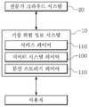
도 1은 본 발명의 일 실시예에 따른, 적설위험 정보 데이터의 수집, 분석, 재난예보를 지원하는 기상위험정보 시스템의 개략적인 시스템 아키텍처를 나타낸다.
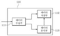
도 2는 데이터 시스템 레이어의 구성을 도시한 블록도이다.
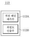
도 3은 데이터 분석부의 구성을 도시한 블록도이다.
도 4a는 GIS 위성 사진의 예시적인 도면이다.
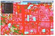
도 4b는 본 발명의 적설 위험도를 GIS 기반에 반영한 적설 위험 지도의 예시적인 도면이다.1 shows a schematic system architecture of a meteorological risk information system supporting collection, analysis, and disaster forecasting of snow risk information data according to an embodiment of the present invention.
2 is a block diagram showing the configuration of a data system layer.
3 is a block diagram showing the configuration of a data analysis unit.
4A is an exemplary diagram of a GIS satellite image.
4B is an exemplary diagram of a snowfall risk map reflecting the snowfall risk of the present invention on a GIS basis.
아래에서는 첨부한 도면을 참조하여 본 발명이 속하는 기술 분야에서 통상의 지식을 가진 자가 용이하게 실시할 수 있도록 본 발명의 실시예를 상세히 설명한다. 그러나 본 발명은 여러 가지 상이한 형태로 구현될 수 있으며 여기에서 설명하는 실시예에 한정되지 않는다. 명세서 전체에서, 어떤 부분이 어떤 구성요소를 "포함"한다고 할 때, 이는 특별히 반대되는 기재가 없는 한 다른 구성요소를 제외하는 것이 아니라 다른 구성요소를 더 포함할 수 있는 것을 의미한다.Hereinafter, exemplary embodiments of the present invention will be described in detail with reference to the accompanying drawings so that those skilled in the art to which the present invention pertains may easily practice. However, the present invention can be implemented in many different forms and is not limited to the embodiments described herein. Throughout the specification, when a part “includes” a certain component, it means that the component may further include other components, not to exclude other components, unless otherwise stated.
다르게 정의되지 않는 한, 기술적이거나 과학적인 용어를 포함해서 여기서 사용되는 모든 용어들은 본 발명이 속하는 기술 분야에서 통상의 지식을 가진 자에 의해 일반적으로 이해되는 것과 동일한 의미를 가지고 있다. 일반적으로 사용되는 사전에 정의되어 있는 것과 같은 용어들은 관련 기술의 문맥 상 가지는 의미와 일치하는 의미를 가지는 것으로 분석되어야 하며, 본 출원에서 명백하게 정의하지 않는 한, 이상적이거나 과도하게 형식적인 의미로 분석되지 않는다.Unless otherwise defined, all terms used herein, including technical or scientific terms, have the same meaning as commonly understood by one of ordinary skill in the art to which the present invention belongs. Terms such as those defined in a commonly used dictionary should be analyzed as having a meaning consistent with the meaning in the context of the related technology, and should not be analyzed as an ideal or excessively formal meaning unless explicitly defined in this application. Does not.
도 1은 본 발명의 일 실시예에 따른, 적설위험 정보 데이터의 수집, 분석, 재난예보를 지원하는 기상위험정보 시스템(10)의 개략적인 시스템 아키텍처를 나타낸다. 본 실시예에 따른 기상위험정보 시스템(10)은 중량식 적설 측정에 기반한 적설위험 정보 데이터를 수집하고, 이를 분석한 적설 재난 예보를 관련 기관 및 기업에 제공할 수 있다.1 shows a schematic system architecture of a meteorological
또한, 본 실시예에 따른 기상위험정보 시스템(10)은 전문가 크라우드 소싱을 통해 구축된 전문가 크라우드 시스템(20)과 연동될 수 있으며, 전문가 크라우드 시스템(20)에서 생성된 전문가 기상위험정보를 적설 재난 예보와 함께 사용자들에게 제공할 수 있다.In addition, the meteorological
도 1을 참조하면, 본 발명의 적설위험 정보 데이터의 수집, 분석, 재난예보를 지원하는 기상위험정보 시스템(10)은 3개의 레이어(Layer), 예컨대, 분산 스토리지 레이어(100), 데이터 시스템 레이어(110) 및 서비스 레이어(120)로 구성된다.Referring to FIG. 1, a weather
최하위 레이어인 분산 스토리지 레이어(100)는 수집 또는 분석된 정보를 분산 스토리지에 분산하여 저장하고, 조회된 정보를 제공하는 기능을 수행한다. 이러한 분산 스토리지 레이어를 구성하는 저장 시스템은 데이터가 저장된 복수의 저장 장치들을 포함할 수 있다. 이때, 저장 장치는 물리적으로 데이터를 저장하는 복수의 스토리지들(예컨대, 로컬 스토리지, 네트워크 스토리지 등)을 포함할 수 있고, 각 저장 장치는 복수의 저장 위치를 포함할 수 있다.The
데이터 시스템 레이어(110)는 데이터를 수집하고, 데이터마이닝 등을 적용하여 데이터를 분석하고 추론하여 분석정보를 생성하며, 분산 스토리지를 관리(주관)하고, 서비스 레이어 내의 서비스 서버 등의 요청을 받아 분석 정보를 취합하여 전달하는 게이트웨이 기능을 수행하는 하나 이상을 모듈(부)로 구성될 수 있다.The
데이터 시스템 레이어(110)를 구성하는 복수의 모듈(부)들 중 일부는 서비스 레이어(120)의 적어도 하나의 구성에 연결될 수 있고, 복수의 모듈(부)들 중 다른 일부는 전술한 스토리지 레이어(100)의 적어도 하나의 구성에 연결될 수 있다.Some of the plurality of modules (units) constituting the
최상위 레이어인 서비스 레이어(120)는 웹, 서버, API 등을 통해 분석정보에 기초한 다양한 서비스를 제공하는 기능을 수행한다. 서비스 레이어(120)는 수집된 데이터 및 분석된 데이터를 기초로 기상위험정보를 제공하는 서비스를 제공할 수 있다. 즉, 서비스 레이어를 구성하는 서비스 시스템은 고객의 요청에 따라 데이터 분석에 기반한 다양한 서비스를 고객에게 제공할 수 있다.The service layer 120, which is the highest layer, performs a function of providing various services based on analysis information through web, server, API, and the like. The service layer 120 may provide a service that provides weather risk information based on collected data and analyzed data. That is, the service system constituting the service layer can provide various services based on data analysis to customers according to the customer's request.
이하, 데이터 시스템 레이어의 구성을 중심으로, 본 발명의 일 실시예에 따른, 기상위험정보 시스템이 적설위험 정보 데이터를 수집, 분석, 재난예보를 수행하는 과정에 보다 상세히 설명하도록 한다.Hereinafter, focusing on the configuration of the data system layer, a process in which the meteorological risk information system according to an embodiment of the present invention collects, analyzes, and predicts snowfall risk information will be described in more detail.
도 2는 데이터 시스템 레이어의 구성을 도시한 블록도이다. 도 3은 데이터 분석부의 구성을 도시한 블록도이다. 도 4a는 GIS 위성 사진의 예시적인 도면이다. 도 4b는 본 발명의 적설 위험도를 GIS 기반에 반영한 적설 위험 지도의 예시적인 도면이다.2 is a block diagram showing the configuration of a data system layer. 3 is a block diagram showing the configuration of a data analysis unit. 4A is an exemplary diagram of a GIS satellite image. 4B is an exemplary diagram of a snowfall risk map reflecting the snowfall risk of the present invention on a GIS basis.
도 2 및 도 3을 참조하면, 본 발명의 일 실시예에 따른 기상위험정보 시스템(10)의 데이터 시스템 레이어(110)는 데이터 수집부(111), 데이터 저장부(112), 데이터 분석부(113)를 포함한다.2 and 3, the
데이터 수집부(111)는 적설 위험 정보 데이터를 수집할 수 있다. 적설 위험 정보 데이터는 적설에 따른 기상위험정보를 산출하기 위한 기초 데이터일 수 있다. 적설 위험 정보 데이터는 적어도 적설 중량 데이터, 기상 데이터, 지형 정보 데이터 및 시설물 데이터를 포함할 수 있다.The
적설 중량 데이터는 적설량을 적설 높이가 아닌 적설 중량을 기준으로 산출한 데이터일 수 있다. 적설 중량 데이터는 전국의 기상청, 또는 주요 지자체의 관공서에 기설치된 중량식 적설계에서 수집될 수 있다. 중량식 적설계는 하판, 상기 하판과 대향되어 위치하는 상판, 하판과 상판 사이에 위치하는 무게 감지 센서를 포함하고, 상판에 적설되는 눈의 무게를 측정하는 적설 중량 데이터 로거일 수 있다. 데이터 수집부(111)는 기설정된 시간 단위로 적설 중량 데이터를 적어도 하나 이상의 중량식 적설계로부터 수집할 수 있다.The snow weight data may be data calculated based on the snow weight, not the snow height. The snow weight data can be collected from the national meteorological agency or the heavy design installed in the government offices of major local governments. The gravimetric design includes a lower plate, an upper plate positioned opposite to the lower plate, and a weight detection sensor positioned between the lower plate and the upper plate, and may be a snow weight data logger that measures the weight of snow accumulated on the upper plate. The
기상 데이터는 기상청에서 운영하는 자동 기상 관측 장비(AWS) 또는 별개로 특정 지역에 설치되어 현장의 기상 정보를 수집하는 장치로부터 수집될 수 있다. 기상 데이터는 특정 지역의 기온(평균기온, 최고기온, 최저기온), 풍향, 풍속(평균풍속, 최대풍속, 최소풍속), 습도(실효습도, 최대습도, 최소습도), 기압 및 강수량 등의 정보를 포함할 수 있다. 또한, 기상 데이터는 기상 예보가 필요한 전체 지역(예를 들어, 대한민국 전지역, 육상 및 해상을 모두 포함)의 전선, 기압 패턴 데이터, 레이더 영상 데이터 등을 포함할 수 있다. 또한, 상기 기상 데이터는 현재의 데이터뿐만 아니라 미래의 기상 예측 정보도 포함할 수 있다. 데이터 수집부(111)는 기설정된 시간 단위로 기상 데이터를 수집할 수 있다.The meteorological data may be collected from an automatic meteorological observation equipment (AWS) operated by the Meteorological Agency or a device separately installed in a specific area to collect weather information of a site. Weather data is information such as temperature (average temperature, maximum temperature, minimum temperature), wind direction, wind speed (average wind speed, maximum wind speed, minimum wind speed), humidity (effective humidity, maximum humidity, minimum humidity), air pressure and precipitation in a specific region. It may include. In addition, the meteorological data may include electric wires, air pressure pattern data, radar image data, and the like of the entire region requiring weather forecasting (eg, all regions of Korea, including both land and sea). In addition, the meteorological data may include not only current data but also future weather prediction information. The
지형 정보 데이터는 관측되는 지역의 지형적인 특성을 파악할 수 있는 데이터에 해당한다. 지형 정보 데이터는 GIS 데이터를 포함할 수 있다. 여기서, GIS 데이터는 일반 지도와 같은 지형정보 및 관련 시설에 대한 정보를 인공위성으로 수집하여 생성한 지리정보시스템에 해당한다. 데이터 수집부(111)는 GIS 데이터를 기설정된 시간 단위로 수집할 수 있다.The topographic information data corresponds to data that can grasp the topographic characteristics of the observed area. The topographic information data may include GIS data. Here, the GIS data corresponds to a geographic information system generated by collecting topographic information such as a general map and information on related facilities through an artificial satellite. The
또한, 지형 정보 데이터는 국내 국토지리정보원에서 발행하는 1/25,000 축척의 수치 지형도를 포함할 수 있으며, 지형도는 단위격자 내 분포하는 경사(예로 산록하단부, 산록상단부, 산복하단부, 산복상단부, 산정하단부 등) 및 향(예로 북, 북동, 동, 남동, 남서, 서, 북서)에 대한 정보를 포함할 수 있다.In addition, the topographic information data can include a 1/25,000-scale digital topographic map issued by the National Geographic Information Institute, and the topographic map is the slope distributed within the unit grid (e.g., the bottom of the hill, the top of the hill, the bottom of the hill, the top of the mountain, the bottom of the mountain. Etc.) and heading (for example, north, northeast, east, southeast, southwest, west, northwest).
시설물 데이터는 각 관공서로부터 제공받는 공공 데이터 및 개방 데이터일 수 있다. 여기서, 시설물은 비닐 하우스, 공장, 축사, 체육관, 문화재 등 적설의 피해를 직접적으로 받는 건축물을 포함할 수 있다. 뿐만 아니라, 시설물은 도로 시설, 철도 시설 및 항공 시설도 포함할 수 있다. 시설물 데이터는 상기 시설물의 위치, 기본 구조, 특징, 재료, 연식(노후화 정도)에 대한 정보를 포함할 수 있다.The facility data may be public data and open data provided by each government office. Here, the facility may include a building that directly suffers damage from snow, such as a plastic house, a factory, a livestock house, a gymnasium, and a cultural property. In addition, the facilities may include road facilities, railroad facilities, and aviation facilities. The facility data may include information on the location, basic structure, characteristics, material, and age (degree of aging) of the facility.
데이터 수집부(111)은 상술한 데이터를 수집하기 위한 송수신부(미도시)를 포함할 수 있다. 송수신부(미도시)은 네트워크를 통한 통신 방법으로 다양한 객체로부터 데이터를 수집할 수 있다. 네트워크를 통한 통신 방법은 유선 통신, 무선 통신, 3G, 4G, 유선 인터넷 또는 무선 인터넷일 수도 있고, 이 외에도 유선 공중망, 무선 이동 통신망 또는 휴대 인터넷 등과 통합된 코어망일 수도 있고, TCP/IP 프로토콜 및 그 상위 계층에 존재하는 여러 서비스, 즉 HTTP(Hyper Text Transfer Protocol), Telnet, FTP(File Transfer Protocol), DNS(Domain Name System), SMTP(Simple Mail Transfer Protocol) 등을 제공하는 개방형 컴퓨터 네트워크일 수도 있으나, 이에 제한되지 않는다.The
상술한 바와 같이, 데이터 수집부(111)는 적설 위험 정보 데이터를 분산된 객체들로부터 수집할 수 있다. 즉, 자동 기상 관측 장비(AWS), 적설 중량 데이터는 물리적으로 분산된 곳에 위치하며, 데이터 수집부(111)은 이들로부터 데이터를 수집할 수 있다. 데이터 수집부(111)은 분산 환경에서 대량의 데이터를 효과적으로 수집하고, 이를 합친 후 다른 곳으로 전송하기 위해 유연한 스트리밍 데이터 플로우(Streaming Data Flow) 아키텍처 기반으로 구성될 수 있다. 데이터 수집부(111)은 예를 들어, 플룸(Flume)으로 구현될 수 있으나, 이에 한정되는 것은 아니다. 데이터 수집부(111)는 현재 수집된 적설 위험 정보 데이터를 데이터 저장부(112) 및 데이터 분석부(113)에 제공할 수 있다.As described above, the
데이터 저장부(112)는 수집된 적설 위험 정보 데이터의 분산 저장을 제어할 수 있다. 적설 위험 정보 데이터는 기존의 데이터베이스 관리도구로 데이터를 수집, 분석할 수 있는 역량을 넘어서는 대량의 정형, 비정형 또는 반정형 데이터의 집합에 해당하는 빅데이터일 수 있다. 여기서, 정형 데이터는 고정된 필드에 저장된 데이터로서, 적설 데이터, 기상 데이터 등 관계형 데이터베이스, 스프레드시트 등에 저장될 수 있는 데이터이다. 또한, 비정형 데이터는 고정된 필드에 저장되어 있지 않은 데이터로서, 예컨대, 텍스트 문서, 이미지, 동영상, 음성 데이터 등이 있다. 또한, 반정형 데이터는 고정된 필드에 저장되어 있지 않지만 메타데이터나 스키마를 포함하는 데이터로서, 예컨대, XML, HTML, 텍스트 등이 있다.The
데이터 저장부(112)는 수집된 적설 위험 정보 데이터를 복수의 스토리지들에 분산 저장하고, 관리할 수 있도록 구성된다. 또한, 데이터 저장부(112)는 후술할 데이터 분석부(113)의 분석 데이터를 분산 저장하고, 관리하도록 구성된다.The
데이터 저장부(112)는 효율적으로 대규모의 비정형/정형 데이터를 분산 처리하기 위해 클러스터 컴퓨터에서 대량의 데이터를 처리할 수 있는 분산 프레임워크인 하둡(Hadoop)으로 구현될 수 있고, 분산파일시스템 HDFS(Hadoop Distributed File System)와 대용량 자료를 빠르게 처리할 수 있는 맵리듀스(MapReduce) 프레임워크를 포함할 수 있다. 다만, 이에 한정되는 것은 아니며, 데이터 유형에 따라 다른 빅데이터 통합 관리 방법이 적용될 수도 있다.The
또한, 데이터 저장부(112)는 수집된 적설 위험 정보 데이터의 종류, 특성, 시간 등 따라 검색 가능하도록 수집된 적설 위험 정보 데이터를 저장할 수 있다. 또한, 데이터 저장부(112)는 분산 저장된 복수의 스토리지들의 동작 상태를 모니터링할 수 있다.In addition, the
데이터 분석부(113)는 수집된 적설 위험 정보 데이터를 기초로 적설 재난 영향 정보를 실시간으로 분석할 수 있다. 즉, 데이터 분석부(113)는 수집된 적설 중량 데이터, 기상 데이터, 지형 정보 데이터 및 시설물 데이터를 기초로 적설 재난 영향 정보를 산출할 수 있다. 적설 재난 영향 정보는 적어도 적설 패턴, 다양한 유형에 따른 적설 위험도, 적설 위험도를 표시한 적설 위험 지도를 포함할 수 있다.The
구체적으로, 데이터 분석부(113)는 적설 패턴 예측부(113A) 및 위험도 산출부(113B)를 포함한다.Specifically, the
적설 패턴 예측부(113A)는 적설 위험 정보 데이터를 기초로 적설 패턴을 실시간 예측할 수 있다. 적설 패턴은 현재 내리고 있는 눈에 대한 향후 예측 자료에 해당한다. 즉, 적설 패턴 예측부(113A)는 현재 시간 이후로 각 지역 및 각 시설에 눈이 어떠한 방식으로 얼마만큼 더 내릴 것인지를 결정할 수 있다. 이러한, 적설 패턴은 적어도 예상 적설량 및 적설되는 눈의 특성을 포함할 수 있다.The snowfall
적설 패턴 예측부(113A)는 수집된 적설 중량 데이터, 기상 데이터를 기초로 적설량을 예측할 수 있다. 예시적으로, 적설 패턴 예측부(113A)는 수집된 기상 데이터(온도, 습도, 풍속 등)를 반영한 기상-적설량 회귀 모델을 포함하고 있으며, 현재의 적설 중량 데이터와 기상 예측 정보를 기초로 적설량을 예측할 수 있다. 또한, 적설 패턴 예측부(113A)는 지형 정보 데이터 또는 시설물 데이터 중 적어도 하나를 더 고려하여 적설량을 예측할 수 있다. 지형에 따라 적설량은 상이할 수 있으며, 시설물의 구조에 따라 적설량은 상이할 수 있다. 예를 들어, 고지대, 산간 지방은 적설량에 대해 가중치를 설정하여 적설량을 예측할 수 있으며, 바람의 영향을 고려하여 적설이 보다 많이 발생되는 지역을 설정하여 해당 지역에 대해 가중치를 설정할 수 있다. 또한, 적설 패턴 예측부(113A)는 현재의 적설 중량 데이터, 기상 데이터와 과거의 적설 중량 데이터, 기상 데이터를 비교하여 예측 적설량을 결정할 수도 있다.The snow
또한, 적설 패턴 예측부(113A)는 적설 위험 정보 데이터를 기초로 지역 또는 시설에 따라 적설되는 눈의 특성(습설 정도)를 결정할 수도 있다. 눈의 특성, 특히 습설 정도에 따라 적설에 따른 피해는 상이할 수 있다. 습설은 습기를 머금은 눈에 해당하며, 기온이 높을 때 내리는 눈으로 수분이 많고 응집력이 강한 특성이 있다. 따라서, 시설물에 대한 피해는 건설보다 습설이 발생한 경우 더 많이 발생한다. 적설 패턴 예측부(113A)는 향후 적설되는 눈의 특성을 결정할 수 있으며, 눈의 특성은 향후 분석에 적용될 수 있다.In addition, the snowfall
위험도 산출부(113B)는 적설 위험 정보 데이터 및 적설 패턴을 기초로 적설 위험도를 산출할 수 있다. 위험도 산출부(113B)는 데이터 분석부(113)는 적설 중량 데이터를 기초로 단일 적설 위험율을 계산한다. 단일 적설 위험율은 적설 중량만을 고려한 적설 재난의 위험율일 수 있다. 데이터 분석부(113)는 단일 적설 위험율에 다른 적설 위험 정보 데이터인 기상 데이터, 지형 정보 데이터, 시설물 데이터 및 적설 패턴 중 적어도 하나 이상을 더 고려하여 다양한 유형별 적설 위험도를 산출할 수 있다.The
예시적으로, 위험도 산출부(113B)는 단일 적설 위험율에 시설물 데이터를 더 고려하여, 건축물 유형에 따른 적설 위험도를 산출할 수 있다. 예시적으로, 비닐 하우스 건축물의 경우, 일반 건축물 대비 위험도가 가중될 수 있다.For example, the
또한, 데이터 분석부(113)는 시설물의 위치에 따른 지형적인 특징을 더 고려하여 지형 특성에 따른 적설 위험도를 산출할 수도 있다. 산지지형, 분지지형, 바다(동해, 서해, 남해)의 영향 등을 고려하여 특정 지형에 대한 위험도를 가중할 수 있다.In addition, the
또한, 위험도 산출부(113B)는 기상 데이터를 더 고려하여 기상 특성에 따른 적설 위험도를 산출할 수도 있다. 기상 데이터를 고려하여 습설이 계속 발생되는 것으로 판단되는 경우, 위험도 산출부(113B)는 위험도를 더 가중할 수 있다.In addition, the
또한, 위험도 산출부(113B)는 적설 위험 정보 데이터 및 예측 적설량을 기초로 도로 시설에 대한 결빙에 따른 위험도, 공항 또는 철도 시설의 이용에 대한 위험도 등을 더 산출할 수도 있다.In addition, the
또한, 위험도 산출부(113B)는 건축물 유형에 따른 붕괴 위험도에 예측 적설량을 더 고려하여 상기 건축물의 붕괴 예상 시점, 시설물의 위험도가 최고가 되는 예상 시점을 추정할 수도 있다.In addition, the
위험도 산출부(113B)는 산출된 적설 위험도를 기초로 각 지역 또는 각 시설에 대한 위험 단계를 설정할 수 있다. 각 시설에 대해 상술한 다양한 유형의 적설 위험도를 고려하여 위험 단계를 설정할 수 있다. 예시적으로, 적설 위험도가 높을수록 위험 단계도 높아질 수 있다.The
또한, 위험도 산출부(113B)는 다양한 유형에 따른 적설 위험도를 GIS 기반의 지도에 반영한 적설 위험 지도를 생성할 수 있다. 적설 위험 지도는 GIS 기반의 지도에 상기 위험 단계가 각 지역 또는 각 시설에 반영되어 생성될 수 있다. 도 4b는 적설 위험 지도의 예시적인 화면에 해당한다. 적설 위험 지도에서 각 지역 또는 각 시설은 현재의 위험 단계에 따라 상이한 색상으로 표시될 수 있다. 예시적으로, 위험 단계가 높은 지역 또는 시설은 붉은 색상으로 표시되어, 해당 시설 또는 지역에 대한 직접적인 위험 정보를 사용자들에게 제공할 수 있다. 적설 위험 지도는 다양한 유형에 따른 적설 위험도를 제공할 수 있다. 예시적으로, 적설 위험 지도는 기상 환경에 따른 적설 위험도, 건축물 유형에 따른 적설 위험도, 시간에 따른 적설 위험도를 각각 제공할 수 있다.In addition, the
데이터 분석부(113)에서 생성된 분석 데이터인 적설 재난 영향 정보, 예를 들어, 적설 패턴, 적설 위험도 및 적설 위험 지도 등은 데이터 저장부(112)를 통해 복수의 스토리지들에 저장될 수 있다.Snowfall disaster impact information, which is the analysis data generated by the
데이터 저장부(112)는 서비스 레이어(120)에서 제공하는 서비스를 구성하는 데이터를 제공할 수 있다. 또한, 서비스 레이어(120)를 이용하는 사용자의 요청에 따른 데이터를 필터링하여 제공할 수도 있다.The
서비스 레이어(120)는 수집된 데이터 및 분석 데이터를 기초로 기상위험정보를 제공할 수 있다. 기상위험정보에는 적설 재난 영향 정보를 기초로 생성된 적설 재난 예보가 포함될 수 있다. 즉, 서비스 레이어(120)는 적설 재난 예보를 사용자들에게 제공할 수 있다.The service layer 120 may provide meteorological risk information based on collected data and analysis data. The weather risk information may include a snow disaster forecast generated based on snow disaster impact information. That is, the service layer 120 may provide a snow disaster forecast to users.
여기서, 상기 사용자들은 적설에 대한 피해를 직접적으로 입게 되는 비닐 하우스, 공장, 축사, 체육관, 문화재 등을 운영 주체 및 적설 경보를 수행하여야 하는 기관, 정부, 지자체, 기업 등일 수 있다.Here, the users may be a plastic house, a factory, a livestock house, a gymnasium, a cultural property, etc., which are directly affected by snowfall, and an organization, a government, a local government, a corporation, etc. that must perform a snowfall warning.
적설 재난 예보는 상술한 바와 같이, 적설 중량에 기초하며, 시설물의 구조 및 특징, 시설물이 위치한 지리적 환경을 고려한 데이터에 해당한다. 즉, 본 실시예에 다른 서비스 레이어(120)는 상기 사용자들에게 적설에 대한 위험성을 객관적인 데이터를 기반으로 직접적으로 제공할 수 있다. 예시적으로, “특정 지역에 위치한 비닐 하우스는 현재 15kg이 적설된 상태로, 현재 형태가 유지되면 3시간 후 붕괴 가능성이 있음”과 같은 형태로 사용자들에게 적설에 의한 현재 상황, 재난 발생 가능성을 제시하여, 적설의 의한 위험을 강조할 수 있다.As described above, the snow disaster forecast is based on the snow weight, and corresponds to data in consideration of the structure and characteristics of the facility and the geographical environment in which the facility is located. That is, the service layer 120 according to the present embodiment may directly provide the users with the risk of snow cover based on objective data. For example, in a form such as, “A plastic house located in a specific area currently has 15 kg of snow, and if the current shape is maintained, there is a possibility of collapse after 3 hours.” By presenting it, you can highlight the dangers of snow.
또한, 서비스 레이어(120)는 적설 위험 지도와 같은 시각화된 데이터로써 지역 또는 시설에 대한 위험도를 제공하는 바, 적설에 대한 위험성을 보다 효과적으로 사용자들에게 제공할 수 있다.In addition, since the service layer 120 provides a degree of risk to an area or facility as visualized data such as a snowfall risk map, the risk of snowfall may be more effectively provided to users.
또한, 적설 재난 예보는 위험 단계가 높은 지역 및 시설에 대해 먼저 제공될 수 있다. 따라서, 재난 발생될 지역 및 시설에 대해서 대피 및 구호 활동이 먼저 수행될 수 있으며, 재난 상황에서의 대처 및 자원의 사용이 보다 효율적으로 수행될 수 있다.In addition, snow disaster forecasts can be provided first for areas and facilities with high risk levels. Accordingly, evacuation and relief activities can be performed first for areas and facilities where a disaster will occur, and coping and use of resources in a disaster situation can be performed more efficiently.
또한, 서비스 레이어(120)는 적설의 위험뿐만 아니라, 수집된 기상 데이터 및 분석 데이터를 기초로 생성된 기상 예측 정보, 예측 적설량을 상기 기상위험정보로써 제공할 수 있다. 또한, 서비스 레이어(120)는 기상위험정보에 대한 쿼리 기능을 제공하여 사용자가 원하는 조건의 기상위험정보를 필터링하여 제공할 수 있다.In addition, the service layer 120 may provide not only the risk of snowfall, but also weather prediction information and predicted snowfall generated based on collected meteorological data and analysis data as the weather risk information. In addition, the service layer 120 may provide a query function for meteorological hazard information, filtering and providing meteorological hazard information of a user's desired condition.
나아가, 본 실시예에 따른 서비스 레이어(120)는 전문가 크라우드 시스템(20)에서 제공된 전문가 기상위험정보를 사용자들에게 상기 적설 재난 예보 및/또는 기상 예측 정보와 함께 제공할 수 있다.Furthermore, the service layer 120 according to the present embodiment may provide expert weather risk information provided by the
여기서, 전문가 크라우드 시스템(20)은 본 발명의 기상위험정보 시스템(10)에 포함되도록 구성될 수 있으나, 이에 한정되는 것은 아니며, 별도의 시스템으로 구성되어 본 발명의 기상위험정보 시스템(10)과 연동될 수 있다.Here, the
전문가 크라우드 시스템(20)은 전문가 집단으로부터 특정 지역 및 기업에 대한 기상 예보 및 기상 관련 컨설팅이 수행되도록 구성될 수 있다. 전문가 크라우드 시스템(20)은 요청된 기상 예보, 기상 관련 컨설팅에 적합한 전문가를 보유하고 있는 전문가 데이터베이스에서 선별하여 해당 서비스를 제공하는 큐레이션 서비스를 포함할 수 있다. 여기서, 전문가 데이터베이스는 기상 전문가, 시설물 전문가, 지형 전문가, 문화재 건축물 전문가 등 다양한 분야의 전문가를 포함할 수 있다. 전문가 크라우드 시스템(20)은 요청된 기상 예보, 기상 관련 컨설팅에 특화된 전문가 집단을 선별하여, 보다 전문화된 기상 예보, 기상 관련 컨설팅을 사용자들에 제공할 수 있다. 예시적으로, 문화재 건축물에 대한 기상 관련 컨설팅이 의뢰되는 경우, 기상 전문가 및 문화재 건축물 전문가가 선택되어 이에 대한 컨설팅 서비스를 제공할 수 있다.The
전문가 크라우드 시스템(20)은 데이터 저장부(112)를 통해, 분산 스토리지 레이어(100)에 저장된 데이터를 공유할 수 있으며 저장된 데이터 및 분석 데이터를 기초로 상기 기상 예보 서비스 및 기상 관련 컨설팅 서비스를 제공할 수 있다.The
또한, 전문가 크라우드 시스템(20)은 다양한 분야의 전문가 집단으로부터 제공받은 기상 예측 및/또는 기상 분석 결과에 대한 의견을 기초로 전문가 기상위험정보를 생성할 수 있다. 구체적으로, 전문가 크라우드 시스템(20)은 본 발명의 기상위험정보 시스템(10)에서 수집된 데이터 및 분석된 데이터(적설 재난 영향 정보)에 대한 전문가 집단의 의견을 수집할 수 있으며, 이를 기초로 전문가 기상위험정보를 생성할 수 있다. 데이터 저장부(112)는 전문가 크라우드 시스템(20)에 수집된 데이터 및 분석된 데이터를 제공하며, 이에 대응하는 전문가 기상위험정보를 수신할 수 있다. 서비스 레이어(120)는 제공받은 전문가 기상위험정보를 상기 적설 재난 예보 및/또는 기상 예측 정보와 함께 사용자들에게 제공할 수 있다. 즉, 특정 시설물에 대한 적설 재난 예보를 전문가의 의견과 함께 제공할 수 있다. 본 발명의 기상위험정보 시스템(10)은 전문가 기상위험정보를 적설 재난 예보와 함께 제공하는 바, 보다 신뢰성 있는 정보를 사용자들에게 제공할 수 있다.In addition, the
이상에서는 실시예들을 참조하여 설명하였지만 본 발명은 이러한 실시예들 또는 도면에 의해 한정되는 것으로 분석되어서는 안 되며, 해당 기술 분야의 숙련된 당업자는 하기의 특허 청구 범위에 기재된 본 발명의 사상 및 영역으로부터 벗어나지 않는 범위 내에서 본 발명을 다양하게 수정 및 변경시킬 수 있음을 이해할 수 있을 것이다.Although the above has been described with reference to the embodiments, the present invention should not be analyzed as being limited by these embodiments or drawings, and those skilled in the art will have the spirit and scope of the present invention described in the following claims. It will be understood that various modifications and changes can be made to the present invention within the range not departing from.
10: 기상위험정보 시스템
11: 전문가 크라우드 시스템
100: 분산 스토리지 레이어
110: 데이터 시스템 레이어
111: 데이터 수집부
112: 데이터 저장부
113: 데이터 분석부
120: 서비스 레이어10: Weather hazard information system
11: Expert crowd system
100: distributed storage layer
110: data system layer
111: data collection unit
112: data storage unit
113: data analysis unit
120: service layer
Claims (12)
Translated fromKorean상기 데이터 시스템 레이어는,
기설정된 시간 단위로 적설위험 정보 데이터를 수집하는 데이터 수집부;
상기 수집된 적설위험 정보 데이터의 분산 저장을 제어하는 데이터 저장부; 및
상기 수집된 적설위험 정보 데이터를 기초로 적설 재난 영향 정보를 생성하는 데이터 분석부를 포함하고,
상기 적설위험 정보 데이터는 적어도 적설 중량 데이터, 기상 데이터, 지형 정보 데이터 및 시설물 데이터를 포함하는 것을 특징으로 하는 기상위험정보 시스템.It is a weather risk information system that supports collection, analysis, and disaster forecasting of snow risk information data.The weather risk information system is a distributed storage layer composed of a plurality of storages to store data, a data system layer that collects and analyzes data, and collects It includes a service layer that provides a service that provides weather risk information based on the collected data and analysis data,
The data system layer,
A data collection unit for collecting snowfall risk information data in a preset time unit;
A data storage unit controlling distributed storage of the collected snowfall risk information data; And
Includes a data analysis unit for generating snow disaster impact information based on the collected snow risk information data,
The snow risk information data includes at least snow weight data, weather data, terrain information data, and facility data.
상기 적설 재난 영향 정보는 적어도 적설 패턴, 다양한 유형에 따른 적설 위험도, 적설 위험 지도를 포함하고,
상기 데이터 분석부는 상기 적설 패턴을 생성하는 적설 패턴 예측부 및 상기 적설 위험도 및 상기 적설 위험 지도를 생성하는 위험도 산출부를 포함하는 것을 특징으로 하는 기상위험정보 시스템.According to claim 1,
The snow disaster impact information includes at least a snow pattern, a snow risk according to various types, a snow risk map,
And the data analysis unit includes a snowfall pattern prediction unit generating the snowfall pattern, and a risk calculation unit generating the snowfall risk and the snowfall risk map.
상기 위험도 산출부는 상기 적설 위험도를 기초로 각 지역 또는 각 시설에 대한 위험 단계를 설정하며,
상기 적설 위험 지도는 상기 각 지역 또는 각 시설에 대한 위험 단계가 GIS 기반의 지도에 반영되어 생성되는 것을 특징으로 하는 기상위험정보 시스템.The method of claim 2,
The risk calculation unit sets a risk level for each region or each facility based on the snow risk,
The snow risk map is a meteorological risk information system, characterized in that the risk level for each region or each facility is reflected in the GIS-based map to be generated.
상기 위험도 산출부는 적설 중량 데이터를 기초로 단일 적설 위험율을 계산하고, 상기 단일 적설 위험율에 상기 기상 데이터, 상기 지형 정보 데이터, 상기 시설물 데이터 및 상기 적설 패턴 중 적어도 하나를 더 고려하여 상기 적설 위험도를 산출하는 것을 특징으로 하는 기상위험정보 시스템.The method of claim 2,
The risk calculation unit calculates a single snowfall risk rate based on snowfall weight data, and calculates the snowfall risk by further considering at least one of the weather data, the terrain information data, the facility data, and the snowfall pattern in the single snowfall risk rate. Weather risk information system, characterized in that.
상기 적설 패턴은 예상 적설량 및 눈의 특성을 포함하고,
상기 적설 패턴 예측부는 적어도 상기 적설 중량 데이터 및 상기 기상 데이터를 기초로 상기 예상 적설량 및 상기 눈의 특성을 결정하는 것을 특징으로 하는 기상위험정보 시스템.The method of claim 2,
The snow pattern includes an expected amount of snow and snow characteristics,
The snowfall pattern prediction unit determines the predicted snowfall and the snow characteristics based on at least the snowfall weight data and the meteorological data.
상기 서비스 레이어에서 제공하는 기상위험정보는 기상 예측 정보, 예측 적설량 및 상기 적설 재난 영향 정보에 기초하여 생성된 적설 재난 예보를 포함하는 것을 특징으로 하는 기상위험정보 시스템.According to claim 1,
The meteorological risk information provided by the service layer includes weather prediction information, a predicted snow amount, and a snow disaster forecast generated based on the snow disaster impact information.
상기 서비스 레이어는 상기 기상위험정보에 대한 쿼리 기능을 제공하여 사용자가 원하는 조건의 기상위험정보를 필터링하여 제공하는 것을 특징으로 하는 기상위험정보 시스템.According to claim 1,
And the service layer provides a query function for the weather risk information to filter and provide weather risk information under conditions desired by the user.
상기 기상위험정보 시스템은 전문가 크라우드 시스템과 연동되며,
상기 서비스 레이어는 상기 전문가 크라우드 시스템에서 제공되는 전문가 기상위험정보를 상기 적설 재난 예보와 함께 제공하는 것을 특징으로 하는 기상위험정보 시스템.The method of claim 7,
The meteorological risk information system is linked with the expert crowd system,
And the service layer provides expert weather risk information provided by the expert crowd system together with the snowfall disaster forecast.
상기 전문가 크라우드 시스템은 전문가 집단으로부터 특정 지역 및 기업에 대한 기상 예보 또는 기상 관련 컨설팅이 수행되도록 구성되며,
상기 전문가 크라우드 시스템은,
전문가 데이터베이스에서 요청된 기상 예보 또는 기상 관련 컨설팅에 대응하는 전문가를 선별하여 서비스를 제공하는 큐레이션 서비스를 포함하는 것을 특징으로 하는 기상위험정보 시스템.The method of claim 8,
The expert crowd system is configured to perform weather forecasting or weather-related consulting for specific regions and companies from expert groups,
The expert crowd system,
A meteorological risk information system comprising a curation service that selects and provides a service by selecting an expert corresponding to a weather forecast or weather-related consulting requested from an expert database.
상기 전문가 기상위험정보는 상기 수집된 적설위험 정보 데이터 및 상기 적설 재난 영향 정보에 대한 전문가 집단의 의견을 기초로 생성되는 것을 특징으로 하는 기상위험정보 시스템.The method of claim 8,
The expert weather risk information is generated based on the collected snow risk information data and an opinion of a group of experts on the snow disaster impact information.
상기 적설 중량 데이터는 적설 중량을 기준으로 산출한 데이터이며, 전국의 기상청 또는 주요 지자체의 관공서에 기설치된 중량식 적설계로부터 수집되고,
상기 중량식 적설계는 하판, 상기 하판과 대향되어 위치하는 상판, 상기 상판과 상기 하판 사이에 위치하는 무게 감지 센서를 포함하고, 상기 상판에 적설되는 눈의 무게를 측정하는 적설 중량 데이터 로거인 것을 특징으로 하는 기상위험정보 시스템.According to claim 1,
The snow weight data is data calculated on the basis of the snow weight, and is collected from heavy design pre-installed at the national meteorological office or major local government offices,
The gravimetric design includes a lower plate, an upper plate positioned opposite to the lower plate, and a weight detection sensor positioned between the upper plate and the lower plate, and is a snow weight data logger that measures the weight of snow placed on the upper plate. Weather risk information system characterized by.
상기 기상 데이터는 기상청에서 운영하는 자동 기상 관측 장비(AWS) 또는 별개로 특정 지역에 설치되어 현장의 기상 정보를 수집하는 장치로부터 수집되고,
상기 지형 데이터는 GIS 데이터 및 수치 지형도를 포함하며,
상기 시설물 데이터는 각 관공서로부터 제공되는 공공 데이터 및 개방 데이터로, 시설물의 위치, 기본 구조, 재료, 연식에 대한 정보를 포함하는 것을 특징으로 하는 기상위험정보 시스템.The method of claim 11,
The meteorological data is collected from an automatic weather observation equipment (AWS) operated by the Meteorological Agency or a device separately installed in a specific area to collect weather information of the site,
The topographic data includes GIS data and a digital topographic map,
The facility data is public data and open data provided by each government office, and includes information on the location, basic structure, material, and year of the facility.
Priority Applications (1)
| Application Number | Priority Date | Filing Date | Title |
|---|---|---|---|
| KR1020190012667AKR102219233B1 (en) | 2019-01-31 | 2019-01-31 | Weather risk information system supporting collection, analysis, and disaster forecasting of snow risk information data |
Applications Claiming Priority (1)
| Application Number | Priority Date | Filing Date | Title |
|---|---|---|---|
| KR1020190012667AKR102219233B1 (en) | 2019-01-31 | 2019-01-31 | Weather risk information system supporting collection, analysis, and disaster forecasting of snow risk information data |
Publications (2)
| Publication Number | Publication Date |
|---|---|
| KR20200095061Atrue KR20200095061A (en) | 2020-08-10 |
| KR102219233B1 KR102219233B1 (en) | 2021-02-24 |
Family
ID=72049222
Family Applications (1)
| Application Number | Title | Priority Date | Filing Date |
|---|---|---|---|
| KR1020190012667AActiveKR102219233B1 (en) | 2019-01-31 | 2019-01-31 | Weather risk information system supporting collection, analysis, and disaster forecasting of snow risk information data |
Country Status (1)
| Country | Link |
|---|---|
| KR (1) | KR102219233B1 (en) |
Cited By (2)
| Publication number | Priority date | Publication date | Assignee | Title |
|---|---|---|---|---|
| KR102370726B1 (en)* | 2020-10-28 | 2022-03-07 | 부산대학교 산학협력단 | Apparatus for calculating of vulnerability indexes for assessing resilience each administrative regions |
| US20230094079A1 (en)* | 2020-02-21 | 2023-03-30 | United Kingdom Research And Innovation | Measuring snowfall |
Citations (7)
| Publication number | Priority date | Publication date | Assignee | Title |
|---|---|---|---|---|
| KR20070060605A (en)* | 2005-12-09 | 2007-06-13 | 주식회사 씨엠 | Disaster Management System and Method |
| KR101587799B1 (en)* | 2014-09-03 | 2016-01-22 | 우천용 | building collapse due to snow alarm system |
| KR20160110035A (en)* | 2015-09-25 | 2016-09-21 | 유찬호 | System for predict accident |
| KR20170046797A (en)* | 2014-09-10 | 2017-05-02 | 애큐웨더 아이엔씨. | Customizable weather analysis system for user-specified weather conditions |
| KR101802165B1 (en)* | 2016-11-17 | 2017-11-28 | 대한민국 | Method and system for estimating empirical snow depth |
| KR101827711B1 (en)* | 2016-11-18 | 2018-02-09 | 전북대학교산학협력단 | A system and method for preventing collapse of vinyl house by snow load |
| KR20180112650A (en)* | 2017-09-18 | 2018-10-12 | 대한민국(행정안전부 국립재난안전연구원장) | Automatic Information System for hazard map of facilities collapse using Modis satellite image and AWS materials |
- 2019
- 2019-01-31KRKR1020190012667Apatent/KR102219233B1/enactiveActive
Patent Citations (7)
| Publication number | Priority date | Publication date | Assignee | Title |
|---|---|---|---|---|
| KR20070060605A (en)* | 2005-12-09 | 2007-06-13 | 주식회사 씨엠 | Disaster Management System and Method |
| KR101587799B1 (en)* | 2014-09-03 | 2016-01-22 | 우천용 | building collapse due to snow alarm system |
| KR20170046797A (en)* | 2014-09-10 | 2017-05-02 | 애큐웨더 아이엔씨. | Customizable weather analysis system for user-specified weather conditions |
| KR20160110035A (en)* | 2015-09-25 | 2016-09-21 | 유찬호 | System for predict accident |
| KR101802165B1 (en)* | 2016-11-17 | 2017-11-28 | 대한민국 | Method and system for estimating empirical snow depth |
| KR101827711B1 (en)* | 2016-11-18 | 2018-02-09 | 전북대학교산학협력단 | A system and method for preventing collapse of vinyl house by snow load |
| KR20180112650A (en)* | 2017-09-18 | 2018-10-12 | 대한민국(행정안전부 국립재난안전연구원장) | Automatic Information System for hazard map of facilities collapse using Modis satellite image and AWS materials |
Cited By (2)
| Publication number | Priority date | Publication date | Assignee | Title |
|---|---|---|---|---|
| US20230094079A1 (en)* | 2020-02-21 | 2023-03-30 | United Kingdom Research And Innovation | Measuring snowfall |
| KR102370726B1 (en)* | 2020-10-28 | 2022-03-07 | 부산대학교 산학협력단 | Apparatus for calculating of vulnerability indexes for assessing resilience each administrative regions |
Also Published As
| Publication number | Publication date |
|---|---|
| KR102219233B1 (en) | 2021-02-24 |
Similar Documents
| Publication | Publication Date | Title |
|---|---|---|
| CN110770610B (en) | Self-learning immediate forecasting system for simulating, recording and predicting convective weather | |
| US8209124B2 (en) | Apparatus and method for providing environmental predictive indicators to emergency response managers | |
| Wanik et al. | Storm outage modeling for an electric distribution network in Northeastern USA | |
| Clow et al. | Evaluation of SNODAS snow depth and snow water equivalent estimates for the Colorado Rocky Mountains, USA | |
| Rolinski et al. | The Santa Ana wildfire threat index: Methodology and operational implementation | |
| Wahiduzzaman et al. | A kernel density estimation approach of North Indian Ocean tropical cyclone formation and the association with convective available potential energy and equivalent potential temperature | |
| Mahmood et al. | Mesonets: Mesoscale weather and climate observations for the United States | |
| Goleiji et al. | Forest fire risk assessment-an integrated approach based on multicriteria evaluation | |
| CN113344735B (en) | Disaster prevention and reduction monitoring and early warning system of power grid equipment | |
| Liu et al. | A comprehensive risk analysis of transportation networks affected by rainfall‐induced multihazards | |
| KR102143039B1 (en) | Remote monitoring and control apparatus for the type of multi-path | |
| Pearse et al. | Migrating Whooping Cranes avoid wind‐energy infrastructure when selecting stopover habitat | |
| KR102219233B1 (en) | Weather risk information system supporting collection, analysis, and disaster forecasting of snow risk information data | |
| KR102688022B1 (en) | How to provide the smart city safety service platform | |
| Horita et al. | AGORA-GeoDash: A geosensor dashboard for real-time flood risk monitoring. | |
| CN113313342B (en) | Method and system for analyzing failure probability of power grid equipment caused by multiple natural disasters | |
| Azad et al. | National flood forecasting and warning system of Malaysia: an overview | |
| Jaedicke et al. | GIS-aided avalanche warning in Norway | |
| CN115456463A (en) | Risk grade classification method and system for mountain torrent disaster dangerous area | |
| KR101735792B1 (en) | Method and apparatus for predicting disaster of chemical substance based on grating structure | |
| Iglesias et al. | Predictive modeling of severe weather impact on individuals and populations using Machine Learning | |
| CN118941076A (en) | Power grid security emergency warning method, device and medium based on multi-source data fusion | |
| Forssén et al. | Resilience of electricity distribution networks against extreme weather conditions | |
| Saia et al. | A technical overview of the North Carolina Econet | |
| Treinish et al. | Predicting impacts of weather-driven urban disasters in the current and future climate |
Legal Events
| Date | Code | Title | Description |
|---|---|---|---|
| PA0109 | Patent application | Patent event code:PA01091R01D Comment text:Patent Application Patent event date:20190131 | |
| PA0201 | Request for examination | ||
| E902 | Notification of reason for refusal | ||
| PE0902 | Notice of grounds for rejection | Comment text:Notification of reason for refusal Patent event date:20200703 Patent event code:PE09021S01D | |
| PG1501 | Laying open of application | ||
| E701 | Decision to grant or registration of patent right | ||
| PE0701 | Decision of registration | Patent event code:PE07011S01D Comment text:Decision to Grant Registration Patent event date:20210126 | |
| GRNT | Written decision to grant | ||
| PR0701 | Registration of establishment | Comment text:Registration of Establishment Patent event date:20210217 Patent event code:PR07011E01D | |
| PR1002 | Payment of registration fee | Payment date:20210218 End annual number:3 Start annual number:1 | |
| PG1601 | Publication of registration | ||
| PR1001 | Payment of annual fee | Payment date:20250218 Start annual number:5 End annual number:5 |