KR20180135373A - Apparatus and method for providing virtualized data service based on gis - Google Patents
Apparatus and method for providing virtualized data service based on gisDownload PDFInfo
- Publication number
- KR20180135373A KR20180135373AKR1020170073419AKR20170073419AKR20180135373AKR 20180135373 AKR20180135373 AKR 20180135373AKR 1020170073419 AKR1020170073419 AKR 1020170073419AKR 20170073419 AKR20170073419 AKR 20170073419AKR 20180135373 AKR20180135373 AKR 20180135373A
- Authority
- KR
- South Korea
- Prior art keywords
- gis
- information
- database
- unit
- data
- Prior art date
- Legal status (The legal status is an assumption and is not a legal conclusion. Google has not performed a legal analysis and makes no representation as to the accuracy of the status listed.)
- Granted
Links
Images


Classifications
- G06F17/30241—
- G—PHYSICS
- G06—COMPUTING OR CALCULATING; COUNTING
- G06F—ELECTRIC DIGITAL DATA PROCESSING
- G06F16/00—Information retrieval; Database structures therefor; File system structures therefor
- G06F16/20—Information retrieval; Database structures therefor; File system structures therefor of structured data, e.g. relational data
- G06F16/29—Geographical information databases
Landscapes
- Engineering & Computer Science (AREA)
- Databases & Information Systems (AREA)
- Theoretical Computer Science (AREA)
- Remote Sensing (AREA)
- Data Mining & Analysis (AREA)
- Physics & Mathematics (AREA)
- General Engineering & Computer Science (AREA)
- General Physics & Mathematics (AREA)
- Management, Administration, Business Operations System, And Electronic Commerce (AREA)
- Information Retrieval, Db Structures And Fs Structures Therefor (AREA)
Abstract
Translated fromKoreanDescription
Translated fromKorean본 발명은 가상화 데이터 서비스 제공 기술에 관한 것으로, 보다 상세하게는, 공공정보를 필요로 하는 GIS(Geographic Information System) 서비스 운영자에게 가상화 데이터베이스와 연계된 GIS 서비스 운용환경을 제공해주어 GIS 서비스 운영자가 번거로운 절차 없이 바로 웹 상에서 지도 서비스를 운영할 수 있도록 하는 GIS 기반의 가상화 데이터 서비스 제공 장치 및 방법에 관한 것이다.The present invention relates to a virtualization data service providing technology, and more particularly, to a GIS service operating environment associated with a virtualization database to a GIS (Geographic Information System) service operator requiring public information, And more particularly, to a GIS-based virtualization data service providing apparatus and method for enabling a map service to be operated on the web without any prior art.
종래의 공공정보에 관한 대용량 공간참조유형 자료 제공 기술은 공공정보를 이용한 공간정보서비스 수요자로부터 자료 요청이 수신되면 해당 공공정보의 제공을 담당하는 시스템 측에서 사용자 요청과 연관된 데이터를 데이터베이스로부터 가져와 파일로 생성하고, 생성된 파일을 CD(Compact Disc), DVD(digital versatile disc)나 FTP(File Transfer Protocol), Open API(Application Programming Interface) 등의 시스템 연계 방식을 통해 해당 공공정보 수요자에게 제공하는 방식으로 공공정보 수요자의 지도 서비스 개발을 지원할 수 있다. 이때 공간참조유형의 공공정보가 가지고 있는 주소 정보 혹은 좌표 정보를 바탕으로 지도상에 속성 정보와 함께 주제도 형식으로 표출될 수 있어야 하는데 이를 위해서 별도의 물리적 전산 인프라에 공간정보를 처리할 수 있는 엔진과 데이터베이스를 설치하고 전체 시스템의 환경을 설정하는 등의 작업이 필요하다. 이러한 종래 기술은 공간참조유형의 공공정보 수요자가 요청 자료를 제공 받고 이용하기 위해서 수요자의 전산 환경 별로 상이한 번거로운 절차들이 수반되는 단점이 있으며, 여기에 제공 받은 정보와 연관된 공간정보 서비스를 운영하기 위하여 별도의 프로그램 및 이용 환경을 구축해야 하는 등의 제한 요소들을 가지고 있다.Conventionally, a large-capacity spatial reference type data provision technology related to public information is a system in which, when a data request is received from a spatial information service consumer using public information, a system responsible for providing the public information fetches data related to the user request from the database, And provides the generated file to the public information consumer through system linkage such as CD (Compact Disc), DVD (digital versatile disc), FTP (File Transfer Protocol) and Open API (Application Programming Interface) It can support the development of map service for public information users. At this time, based on the address information or coordinate information of the public information of the spatial reference type, it should be able to be expressed in the form of the topographic map together with the attribute information on the map. To this end, an engine capable of processing spatial information in a separate physical computing infrastructure And installing the database and setting the environment of the whole system. This conventional technology has disadvantages in that it is accompanied by various troublesome procedures according to the computer environment of the consumer in order to provide and utilize the requested information by the public information information requester of the space reference type, and in order to operate the spatial information service associated with the provided information Such as the need to establish a program and use environment of the system.
한국등록특허 제10-0783767(2007.12.03)호는 네트워크에서 공간 지리 정보를 제공하기 위한 시스템에 관한 것으로, 소정의 공간 지리 정보를 저장하는 데이터베이스; 상기 데이터베이스에 저장된 상기 공간 지리 정보를 독출하여 편집한 후 상기 데이터베이스에 재저장하는 편집 클라이언트; 및 상기 편집 클라이언트에 의해 편집되어 저장된 공간 지리 정보를 소정 프로토콜에 의한 공간 지리 정보 교환 절차에 따라 엔코딩하여 네트워크망을 통해 출력하는 운용자 솔루션;을 포함하는 공간 지리 정보 제공 시스템을 제공한다.Korean Patent Registration No. 10-0783767 (2007.03.03) relates to a system for providing spatial geographic information in a network, and includes a database for storing predetermined spatial geographic information; An editing client that reads and edits the spatial geographic information stored in the database and stores the edited spatial geographic information in the database; And an operator solution for encoding the spatial geographical information edited and stored by the editing client according to a spatial geographical information exchange procedure according to a predetermined protocol and outputting the encoded spatial geographical information through a network.
한국공개특허공보 제10-2009-0018038(2009.02.19)호는 가상 데이터베이스 포맷을 통해 디지털 맵 데이터를 제공하기 위한 시스템에 관한 것으로, 한 맵 영역을 커버하고 맵 안의 피처들 (features)에 대한 위치 코드들을 포함하는 전자 맵 데이터, 지리적으로 상기 맵 영역 안에 위치한 피처들의 일부나 전부에 대한 부가적 피처 정보를 규정한 제3자 데이터 (third-party data)가 시스템 안에 수신되게 하는 인터페이스, 상기 전자 맵 데이터 내 위치 코드들을 상기 제3자 데이터 내 대응하는 피처 정보와 링크하고, 링크된 정보를 가상 데이터베이스로서 제공하는 통합 데이터베이스를 포함함을 특징으로 한다.Korean Patent Laid-Open Publication No. 10-2009-0018038 (2009.02.19) relates to a system for providing digital map data through a virtual database format, which covers a map area and a location for features in the map An interface for causing third-party data to be received in the system that defines electronic map data that includes codes, additional feature information for some or all of the features that are geographically located within the map area, And an integrated database for linking the location codes in the data with corresponding feature information in the third party data and providing the linked information as a virtual database.
본 발명의 일 실시예는 공공정보를 필요로 하는 GIS(Geographic Information System) 서비스 운영자에게 가상화 데이터베이스와 연계된 GIS 서비스 운용환경을 제공해주어 GIS 서비스 운영자가 번거로운 절차 없이 바로 웹 상에서 지도 서비스를 운영할 수 있도록 하는 GIS 기반의 가상화 데이터 서비스 제공 장치 및 방법을 제공하고자 한다.An embodiment of the present invention provides a GIS service operation environment connected to a virtualization database to a GIS (Geographic Information System) service operator requiring public information, so that a GIS service operator can operate a map service on the web without troublesome procedures And to provide a GIS-based virtualization data service providing apparatus and method.
본 발명의 일 실시예는 GIS 서비스 운영자의 요청에 대한 관리자의 승인 절차만으로 가상화 데이터베이스와 연계된 GIS 서비스 운용환경을 간편하게 제공하여 공간정보 수요자와 공간정보 제공자 모두의 편의성을 크게 향상시킨 GIS 기반의 가상화 데이터 서비스 제공 장치 및 방법을 제공하고자 한다.One embodiment of the present invention is a GIS-based virtualization system that can easily provide a GIS service operating environment associated with a virtualization database by only an administrator's approval process for a GIS service operator's request, thereby greatly improving the convenience of both a spatial information consumer and a spatial information provider To provide a data service providing apparatus and method.
실시예들 중에서, GIS 기반의 가상화 데이터 서비스 제공 장치는 공공기관에서 공개하는 정보의 GIS 기반 가상화 데이터 서비스를 제공하기 위한 시스템의 구성으로 공공정보에 좌표정보를 부여한 공간정보객체 데이터를 저장하는 원본 데이터베이스부, 상기 원본 데이터베이스부에 있는 공간정보객체 데이터를 복제하여 사용자 개별의 가상화 데이터베이스를 생성하고 상기 가상화 데이터베이스와 연계한 GIS 운용환경을 제공하는 GIS 운용환경 제공부 및 GIS 기반 가상화 데이터 서비스 운영자에 의하여 상기 원본 데이터베이스부와 상기 GIS 운용환경 제공부의 전반적인 전산 환경 및 자원 관리를 수행하는 GIS 운용환경 운영부를 포함한다.Among the embodiments, the GIS-based virtualization data service providing apparatus is a system for providing a GIS-based virtualization data service of information disclosed by a public institution, and includes a source database storing spatial information object data, A GIS operational environment providing a GIS operating environment linked with the virtualization database, and a GIS-based virtualization data service operator copying the GIS-based virtualization data service operator, And a GIS operating environment operating unit for performing overall computing environment and resource management of the GIS operating environment providing unit.
상기 원본 데이터베이스부는 상기 공공기관이 제공하는 좌표 또는 좌표를 추정할 수 있는 주소정보를 포함하고 있는 공공정보를 선별하여 개별 공공정보 데이터에 각각 좌표를 부여 또는 추론하여 공간정보화한 다음 공간정보 데이터베이스에 저장 후 GIS 운용환경 제공부에서 데이터를 요청할 때 해당 데이터를 제공할 수 있다.The original database unit selects public information including address information capable of estimating coordinates or coordinates provided by the public institution, assigns or infer individual coordinates to individual public information data, and stores the information in a spatial information database The data can be provided when requesting data from the GIS operational environment afterwards.
상기 GIS 운용환경 제공부는 사용자의 요구에 따라 GIS 기반 가상화 데이터 서비스를 제공하기 위하여 가상 시스템에 설치한 Linux 기반 CentOS 환경에 오픈소스 GIS 기술로 공개되어 있는 GeoServer와 PostGIS의 설치하여 맞춤형 공간정보 데이터베이스를 구성하고 사용자가 접근 가능한 네트워크 IP 와 함께 제공할 수 있다.In order to provide GIS-based virtualization data service according to a user's request, the GIS operating environment provisioning unit installs GeoServer and PostGIS, which are disclosed as open source GIS technology in a Linux-based CentOS environment installed in a virtual system, And can be provided with user-accessible network IP.
상기 GIS 운용환경 운영부는 오픈스택(OpenStack) 기술을 이용하여 상기 원본 데이터베이스부와 GIS 운용환경 운영부를 설치 및 운영하기 위한 가상 시스템 및 공간객체정보를 사용자 요구 건수만큼 생성하고 이와 관련된 물리적 전산자원의 할당 및 운영을 수행할 수 있다.The GIS operating environment operating unit generates a virtual system and spatial object information for installing and operating the original database unit and the GIS operating environment operating unit using the OpenStack technology as many as the number of user requests, And operations.
개시된 기술은 다음의 효과를 가질 수 있다. 다만, 특정 실시예가 다음의 효과를 전부 포함하여야 한다거나 다음의 효과만을 포함하여야 한다는 의미는 아니므로, 개시된 기술의 권리범위는 이에 의하여 제한되는 것으로 이해되어서는 아니 될 것이다.The disclosed technique may have the following effects. It is to be understood, however, that the scope of the disclosed technology is not to be construed as limited thereby, as it is not meant to imply that a particular embodiment should include all of the following effects or only the following effects.
본 발명의 일 실시예에 따른 GIS 기반의 가상화 데이터 서비스 제공 장치 및 방법은 공공정보를 필요로 하는 GIS 서비스 운영자에게 가상화 데이터베이스와 연계된 GIS 서비스 운용환경을 제공해주어 GIS 서비스 운영자가 번거로운 절차 없이 바로 웹 상에서 지도 서비스를 운영할 수 있도록 할 수 있다.The apparatus and method for providing a GIS-based virtualized data service according to an embodiment of the present invention provides a GIS service operating environment associated with a virtualization database to a GIS service operator requiring public information, So that the map service can be operated.
본 발명의 일 실시예에 따른 GIS 기반의 가상화 데이터 서비스 제공 장치 및 방법은 GIS 서비스 운영자의 요청에 대한 관리자의 승인 절차만으로 가상화 데이터베이스와 연계된 GIS 서비스 운용환경을 간편하게 제공하여 공간정보 수요자와 공간정보 제공자 모두의 편의성을 크게 향상시킬 수 있다.The GIS-based virtualized data service providing apparatus and method according to an embodiment of the present invention can easily provide a GIS service operating environment linked to a virtualization database by only an administrator's approval procedure for a request of a GIS service operator, The convenience of both providers can be greatly improved.
도 1은 본 발명의 일 실시예에 따른 GIS 기반의 가상화 데이터 서비스 제공 시스템을 설명하는 도면이다.
도 2는 도 1에 있는 GIS 기반의 가상화 데이터 서비스 제공 장치를 나타내는 블록도이다.
도 3은 도 2에 있는 프로세서의 기능 요소를 나타내는 블록도이다.
도 4는 도 2에 있는 프로세서에 의하여 수행되는 GIS 기반의 가상화 데이터 서비스 제공 프로시저를 설명하는 흐름도이다.
도 5는 도 1에 있는 GIS 기반의 가상화 데이터 서비스 제공 장치가 GIS 서비스 운영자에게 가상화 데이터베이스와 연계된 GIS 운용환경을 제공하는 과정의 일 실시예를 나타내는 흐름도이다.
도 6은 도 1에 있는 GIS 기반의 가상화 데이터 서비스 제공 장치가 GIS 서비스 운영자에 의하여 호출될 수 있는 API(Application Programming Interface)를 통해 GIS 운용환경에 대한 접근을 제공하는 과정의 일 실시예를 나타내는 흐름도이다.1 is a diagram illustrating a GIS-based virtualization data service providing system according to an embodiment of the present invention.
FIG. 2 is a block diagram illustrating a GIS-based virtualized data service providing apparatus shown in FIG. 1. FIG.
Figure 3 is a block diagram illustrating the functional elements of the processor in Figure 2;
4 is a flowchart illustrating a GIS-based virtualization data service provision procedure performed by the processor in FIG.
FIG. 5 is a flowchart illustrating an embodiment of a process of providing a GIS operation environment associated with a virtualization database to a GIS service operator in the GIS-based virtualization data service providing apparatus shown in FIG.
6 is a flowchart showing an embodiment of a process of providing an access to a GIS operating environment through an API (Application Programming Interface) which can be called by a GIS service operator, to be.
본 발명에 관한 설명은 구조적 내지 기능적 설명을 위한 실시예에 불과하므로, 본 발명의 권리범위는 본문에 설명된 실시예에 의하여 제한되는 것으로 해석되어서는 아니 된다. 즉, 실시예는 다양한 변경이 가능하고 여러 가지 형태를 가질 수 있으므로 본 발명의 권리범위는 기술적 사상을 실현할 수 있는 균등물들을 포함하는 것으로 이해되어야 한다. 또한, 본 발명에서 제시된 목적 또는 효과는 특정 실시예가 이를 전부 포함하여야 한다거나 그러한 효과만을 포함하여야 한다는 의미는 아니므로, 본 발명의 권리범위는 이에 의하여 제한되는 것으로 이해되어서는 아니 될 것이다.The description of the present invention is merely an example for structural or functional explanation, and the scope of the present invention should not be construed as being limited by the embodiments described in the text. That is, the embodiments are to be construed as being variously embodied and having various forms, so that the scope of the present invention should be understood to include equivalents capable of realizing technical ideas. Also, the purpose or effect of the present invention should not be construed as limiting the scope of the present invention, since it does not mean that a specific embodiment should include all or only such effect.
한편, 본 출원에서 서술되는 용어의 의미는 다음과 같이 이해되어야 할 것이다.Meanwhile, the meaning of the terms described in the present application should be understood as follows.
"제1", "제2" 등의 용어는 하나의 구성요소를 다른 구성요소로부터 구별하기 위한 것으로, 이들 용어들에 의해 권리범위가 한정되어서는 아니 된다. 예를 들어, 제1 구성요소는 제2 구성요소로 명명될 수 있고, 유사하게 제2 구성요소도 제1 구성요소로 명명될 수 있다.The terms "first "," second ", and the like are intended to distinguish one element from another, and the scope of the right should not be limited by these terms. For example, the first component may be referred to as a second component, and similarly, the second component may also be referred to as a first component.
어떤 구성요소가 다른 구성요소에 "연결되어"있다고 언급된 때에는, 그 다른 구성요소에 직접적으로 연결될 수도 있지만, 중간에 다른 구성요소가 존재할 수도 있다고 이해되어야 할 것이다. 반면에, 어떤 구성요소가 다른 구성요소에 "직접 연결되어"있다고 언급된 때에는 중간에 다른 구성요소가 존재하지 않는 것으로 이해되어야 할 것이다. 한편, 구성요소들 간의 관계를 설명하는 다른 표현들, 즉 "~사이에"와 "바로 ~사이에" 또는 "~에 이웃하는"과 "~에 직접 이웃하는" 등도 마찬가지로 해석되어야 한다.It is to be understood that when an element is referred to as being "connected" to another element, it may be directly connected to the other element, but there may be other elements in between. On the other hand, when an element is referred to as being "directly connected" to another element, it should be understood that there are no other elements in between. On the other hand, other expressions that describe the relationship between components, such as "between" and "between" or "neighboring to" and "directly adjacent to" should be interpreted as well.
단수의 표현은 문맥상 명백하게 다르게 뜻하지 않는 한 복수의 표현을 포함하는 것으로 이해되어야 하고, "포함하다"또는 "가지다" 등의 용어는 실시된 특징, 숫자, 단계, 동작, 구성요소, 부분품 또는 이들을 조합한 것이 존재함을 지정하려는 것이며, 하나 또는 그 이상의 다른 특징이나 숫자, 단계, 동작, 구성요소, 부분품 또는 이들을 조합한 것들의 존재 또는 부가 가능성을 미리 배제하지 않는 것으로 이해되어야 한다.It is to be understood that the singular " include " or "have" are to be construed as including the stated feature, number, step, operation, It is to be understood that the combination is intended to specify that it does not preclude the presence or addition of one or more other features, integers, steps, operations, elements, components, or combinations thereof.
각 단계들에 있어 식별부호(예를 들어, a, b, c 등)는 설명의 편의를 위하여 사용되는 것으로 식별부호는 각 단계들의 순서를 설명하는 것이 아니며, 각 단계들은 문맥상 명백하게 특정 순서를 기재하지 않는 이상 명기된 순서와 다르게 일어날 수 있다. 즉, 각 단계들은 명기된 순서와 동일하게 일어날 수도 있고 실질적으로 동시에 수행될 수도 있으며 반대의 순서대로 수행될 수도 있다.In each step, the identification code (e.g., a, b, c, etc.) is used for convenience of explanation, the identification code does not describe the order of each step, Unless otherwise stated, it may occur differently from the stated order. That is, each step may occur in the same order as described, may be performed substantially concurrently, or may be performed in reverse order.
본 발명은 컴퓨터가 읽을 수 있는 기록매체에 컴퓨터가 읽을 수 있는 코드로서 구현될 수 있고, 컴퓨터가 읽을 수 있는 기록 매체는 컴퓨터 시스템에 의하여 읽혀질 수 있는 데이터가 저장되는 모든 종류의 기록 장치를 포함한다. 컴퓨터가 읽을 수 있는 기록 매체의 예로는 ROM, RAM, CD-ROM, 자기 테이프, 플로피 디스크, 광 데이터 저장 장치 등이 있다. 또한, 컴퓨터가 읽을 수 있는 기록 매체는 네트워크로 연결된 컴퓨터 시스템에 분산되어, 분산 방식으로 컴퓨터가 읽을 수 있는 코드가 저장되고 실행될 수 있다.The present invention can be embodied as computer-readable code on a computer-readable recording medium, and the computer-readable recording medium includes all kinds of recording devices for storing data that can be read by a computer system . Examples of the computer-readable recording medium include ROM, RAM, CD-ROM, magnetic tape, floppy disk, optical data storage, and the like. In addition, the computer-readable recording medium may be distributed over network-connected computer systems so that computer readable codes can be stored and executed in a distributed manner.
여기서 사용되는 모든 용어들은 다르게 정의되지 않는 한, 본 발명이 속하는 분야에서 통상의 지식을 가진 자에 의해 일반적으로 이해되는 것과 동일한 의미를 가진다. 일반적으로 사용되는 사전에 정의되어 있는 용어들은 관련 기술의 문맥상 가지는 의미와 일치하는 것으로 해석되어야 하며, 본 출원에서 명백하게 정의하지 않는 한 이상적이거나 과도하게 형식적인 의미를 지니는 것으로 해석될 수 없다.All terms used herein have the same meaning as commonly understood by one of ordinary skill in the art to which this invention belongs, unless otherwise defined. Commonly used predefined terms should be interpreted to be consistent with the meanings in the context of the related art and can not be interpreted as having ideal or overly formal meaning unless explicitly defined in the present application.
도 1은 본 발명의 일 실시예에 따른 GIS 기반의 가상화 데이터 서비스 제공 시스템을 설명하는 도면이다.1 is a diagram illustrating a GIS-based virtualization data service providing system according to an embodiment of the present invention.
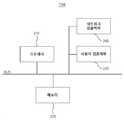
도 1을 참조하면, GIS 기반의 가상화 데이터 서비스 제공 시스템(이하, GIS 데이터 서비스 제공 시스템)(100)은 GIS 기반의 가상화 데이터 서비스 제공 장치(이하, GIS 데이터 서비스 제공 장치)(110), GIS 서비스 운영자 단말(120) 및 관리자 단말(130)을 포함할 수 있다.Referring to FIG. 1, a GIS-based virtualized data
GIS 데이터 서비스 제공 장치(110)는 GIS 서비스 운영자 단말(120) 및 관리자 단말(130)과 네트워크를 통해 연결될 수 있는 컴퓨팅 장치에 해당한다. 일 실시예에서, GIS 데이터 서비스 제공 장치(110)는 GIS 서비스 운영자 단말(120)과 연관된 GIS 서비스 운영자의 요청에 따라 해당 GIS 서비스 운영자 개별의 가상화 데이터베이스와 연계한 GIS 운용환경을 제공할 수 있다.The GIS data
GIS 데이터 서비스 제공 장치(110)는 원본 데이터베이스부(115)를 포함할 수 있다. 원본 데이터베이스부(115)는 지도와 연관된 공간정보객체에 관한 공간정보객체 데이터를 저장하는 데이터베이스(DB: DataBase)로서, 공공기관에서 공개하는 정보의 GIS 기반 가상화 데이터 서비스를 제공하기 위한 시스템의 구성으로 공공정보에 좌표정보를 부여한 공간정보객체 데이터를 저장할 수 있다. 일 실시예에서, 가상화 데이터 서비스는 가상화 데이터베이스 기반의 데이터 제공 서비스를 포함할 수 있따. 일 실시예에서, 원본 데이터베이스부(115)는 공공기관이 제공하는 좌표 또는 좌표를 추정할 수 있는 주소정보를 포함하고 있는 공공정보를 선별하여 개별 공공정보 데이터에 각각 좌표를 부여 또는 추론하여 공간정보화한 다음 공간정보 데이터베이스에 저장 후 GIS 운용환경 제공부(310)에서 데이터를 요청할 때 해당 데이터를 제공할 수 있다. 일 실시예에서, 원본 데이터베이스부(115)는 공간정보에 관한 데이터베이스를 통합, 저장 및 관리하는 지형정보 데이터베이스인 지오 데이터베이스(Geodatabase)로 구현될 수 있다. 일 실시예에서, 공간정보객체는 지도와 연관된 지표 공간에 관한 장소의 위치와 공간 형태를 나타내는 공간 자료, 장소의 특성을 나타내는 속성 자료 및 다른 장소 및 현상들과의 관계를 나타내는 관계 자료를 포함하는 지리정보객체에 해당할 수 있다.The GIS data
일 실시예에서, 원본 데이터베이스부(115)는 GIS 데이터 서비스 제공 장치(110)의 다른 구성 요소들과 물리적으로 분리되지 않고 기능적으로 분리된 컴퓨팅 장치로 구현되어 동일 사업자에 의해 운영될 수도 있다. 다른 일 실시예에서, 원본 데이터베이스부(115)는 GIS 데이터 서비스 제공 장치(110)의 다른 구성 요소들과 물리적으로 분리된 컴퓨팅 장치로 구현되어 서로 다른 사업자에 의해 운영될 수 있다.In one embodiment, the
GIS 서비스 운영자 단말(120)은 GIS 데이터 서비스 제공 장치(110)와 네트워크를 통해 연결될 수 있는 컴퓨팅 장치에 해당하고, 예를 들어, 데스크톱, 노트북, 태블릿 PC 또는 스마트폰으로 구현될 수 있다. GIS 서비스 운영자 단말(120)은 GIS 서비스 운영자와 연관되고, 일 실시예에서, GIS 서비스 운영자는 지도 서비스 개발을 위해 공간정보객체를 필요로 하는 공간정보 수요자에 해당할 수 있다. 일 실시예에서, GIS 서비스 운영자 단말(120)은 GIS 데이터 서비스 제공 장치(110)에 특정 공간정보객체와 연관된 GIS 운용환경의 제공을 요청할 수 있고, GIS 데이터 서비스 제공 장치(110)로부터 해당 사용자(예를 들어, GIS 서비스 운영자) 개별의 가상화 데이터베이스와 연계된 GIS 운용환경을 제공 받아 별도의 추가 절차 없이 해당 GIS 운용환경을 통해 바로 웹 상에서 지도 서비스를 운영할 수 있다.The GIS
관리자 단말(130)은 GIS 데이터 서비스 제공 장치(110)와 네트워크를 통해 연결될 수 있는 컴퓨팅 장치에 해당하고, 예를 들어, 데스크톱, 노트북, 태블릿 PC 또는 스마트폰으로 구현될 수 있다. 관리자 단말(130)은 원본 데이터베이스부(115)를 관리하는 관리자와 연관된다. 일 실시예에서, 관리자 단말(130)은 GIS 서비스 운영자 단말(120)로부터 수신된 원본 데이터베이스부(115)에 있는 특정 공간정보객체와 연관된 GIS 운용환경 제공 요청을 수신할 수 있고, 관리자에 의한 승인 여부에 따라 해당 GIS 운용환경의 제공 여부를 결정할 수 있다.The
GIS 데이터 서비스 제공 장치(110)는 특정 공간정보객체와 연관된 GIS 서비스 운영자의 요청이 관리자 단말(130)에 의해 승인되면 해당 GIS 서비스 운영자 개별의 가상화 데이터베이스와 연계한 GIS 운용환경을 GIS 서비스 운영자 단말(120)에 제공할 수 있고, 거부되면 해당 요청에 대한 거부 상태 및 거부 사유를 포함하는 거부 메시지를 GIS 서비스 운영자 단말(120)에 제공할 수 있다.When the request of the GIS service operator associated with the specific spatial information object is approved by the
도 2는 도 1에 있는 GIS 데이터 서비스 제공 장치를 나타내는 블록도이다.2 is a block diagram showing the GIS data service providing apparatus shown in FIG.
도 2를 참조하면, GIS 데이터 서비스 제공 장치(110)는 프로세서(210), 메모리(220), 사용자 입출력부(230) 및 네트워크 입출력부(240)을 포함할 수 있다.2, the GIS data
프로세서(210)는 도 4에 있는 GIS 데이터 서비스 제공 프로시저를 실행할 수 있고, GIS 데이터 서비스 제공 프로시저의 실행 과정에서 읽혀지거나 또는 작성되는 메모리(220)를 관리할 수 있으며, 메모리(220)에 있는 휘발성 메모리와 비휘발성 메모리 간의 동기화 시간을 스케줄할 수 있다. 프로세서(210)는 GIS 데이터 서비스 제공 장치(110)의 동작 전반을 제어할 수 있고, 메모리(220), 사용자 입출력부(230) 및 네트워크 입출력부(240) 간의 데이터 흐름을 제어할 수 있으며, GIS 데이터 서비스 제공 장치(110)의 CPU로 구현될 수 있다.The
메모리(220)는 SSD(Solid State Disk) 또는 HDD(Hard Disk Drive)와 같은 비휘발성 메모리로 구현되어 GIS 서비스 운영자 단말(120)에 필요한 데이터 전반을 저장하는데 사용되는 보조기억장치를 포함할 수 있고, RAM(Random Access Memory)과 같은 휘발성 메모리로 구현된 주기억장치를 포함할 수 있다. 이처럼, 메모리(220)는 휘발성 또는 비휘발성 메모리로 구현될 수 있고, 만일 비휘발성 메모리로 구현되면 하이퍼링크를 통해 연결되도록 구현될 수 있다.The
메모리(220)는 GIS 서비스 운영자 단말(120)과 연관된 사용자 정보와 연관되는 사용자 메모리 영역을 포함할 수 있고, 일 실시예에서, 사용자 정보는 GIS 서비스 운영자의 이름, 아이디, 비밀번호 및 해당 운영자가 제공하는 지도 서비스에 관한 정보를 포함할 수 있다. 일 실시예에서, 메모리(220)는 각 사용자와 연관된 사용자(예를 들어, GIS 서비스 운영자) 개별의 가상화 데이터베이스 각각과 연관되는 가상화 데이터베이스 메모리 영역을 포함할 수 있고, 가상화 데이터베이스를 생성하기 위해 필요한 응용 프로그램 및 API(Application Programming Interface) 등과 연관된 데이터들을 포함할 수 있다. 여기에서, API는 응용 프로그램에서 사용할 수 있도록 운영 체제나 프로그래밍 언어가 제공하는 기능을 제어할 수 있게 만든 응용 프로그램 프로그래밍 인터페이스를 의미하고, 주로 파일 제어, 창 제어, 화상 처리, 문자 제어 등을 위한 인터페이스를 제공할 수 있다.The
사용자 입출력부(230)은 사용자 입력을 수신하기 위한 환경 및 사용자에게 특정 정보를 출력하기 위한 환경을 포함하고, 예를 들어, 마우스, 트랙볼, 터치 패드, 그래픽 태블릿, 스캐너, 터치 스크린, 키보드 또는 포인팅 장치와 같은 어댑터를 포함하는 입력장치 및 모니터 또는 터치스크린과 같은 어댑터를 포함하는 출력장치를 포함할 수 있다. 일 실시예에서, 사용자 입출력부(230)은 원격 접속을 통해 접속되는 컴퓨팅 장치에 해당할 수 있고, 그러한 경우, GIS 데이터 서비스 제공 장치(110)는 서버로서 수행될 수 있다.The user input and
네트워크 입출력부(240)은 네트워크를 통해 GIS 서비스 운영자 단말(120)과 연결하기 위한 환경을 포함하고, 예를 들어, LAN(Local Area Network) 통신을 위한 어댑터를 포함할 수 있다The network input /
일 실시예에서, GIS 데이터 서비스 제공 장치(110)는 클라우드 운영체제를 제공하는 오픈스택(OpenStack)을 기반으로 GIS 서비스 운영자 단말(120)에 가상화 환경을 제공할 수 있고, 여기에서, 오픈 스택은 IaaS (Infrastructure as a Service) 형태의 클라우드 컴퓨팅 오픈 소스 프로젝트에 해당한다. GIS 데이터 서비스 제공 장치(110)는 오픈스택을 기반으로 가상화 환경을 구현하기 위해 노바(Nova) 모듈, 글랜스(Glance) 모듈, 스위프트(Swift) 모듈, 키스톤(Keystone) 모듈, 퀀텀(Quantum) 모듈, 신더(Cinder) 모듈 및 호리즌(Horizon) 모듈을 포함하여 구성될 수 있다. 여기에서, 노바 모듈은 IaaS 구축에 필요한 컴퓨트 인스턴스들을 제어 및 관리할 수 있고, 글랜스 모듈은 가상 머신 이미지들을 저장, 등록, 관리, 전달할 수 있으며, 스위프트 모듈은 오브젝트 스토리지 환경을 구축 및 관리할 수 있고, 키스톤 모듈은 각 수행 과정에 대한 보안 인증을 수행하며, 퀀텀 모듈은 인터페이스와 오픈스택 기능들 간의 네트워킹을 지원하고, 신더 모듈은 컴퓨팅을 위한 스토리지 볼륨을 제공하며, 호리즌(Horizon) 모듈은 관리자 또는 사용자의 제어를 위한 웹 인터페이스를 제공할 수 있다.In one embodiment, the GIS data
도 3은 도 2에 있는 프로세서의 기능 요소를 나타내는 블록도이다.Figure 3 is a block diagram illustrating the functional elements of the processor in Figure 2;
도 3을 참조하면, 프로세서(210)는 GIS 운용환경 제공부(310), 제어부(320) 및 GIS 운용환경 운영부(330)를 포함할 수 있다.Referring to FIG. 3, the
GIS 운용환경 제공부(310)는 원본 데이터베이스부(115)에 있는 공간정보객체 데이터를 복제하여 사용자 개별의 가상화 데이터베이스를 생성하고 해당 가상화 데이터베이스와 연계한 GIS 운용환경을 제공할 수 있다. 일 실시예에서, GIS 운용환경 제공부(310)는 GIS 서비스 운영자에 의하여 공간참조유형과 연관된 공간정보 리스트에 있는 특정 공간정보객체 데이터가 선택되면 관리자의 승인 하에 해당 특정 공간정보객체 데이터에 관한 복제 및 GIS 운용환경의 제공을 수행할 수 있다. 보다 구체적으로, GIS 운용환경 제공부(310)는 GIS 서비스 운영자 단말(120)로부터 원본 데이터베이스부(115)에 있는 특정 공간정보객체 데이터와 연관된 GIS 운용환경 제공 요청을 수신할 수 있고, 관리자 단말(130)로부터 해당 GIS 운용환경 제공 요청에 관한 승인이 수신되면 원본 데이터베이스부(115)로부터 해당 특정 공간정보객체 데이터를 복제하여 해당 GIS 서비스 운영자 개별의 가상화 데이터베이스를 생성할 수 있으며, 생성된 가상화 데이터베이스와 연계된 GIS 운용환경을 세팅하여 GIS 서비스 운영자 단말(120)에 제공할 수 있다.The GIS operation
GIS 운용환경 제공부(310)는 지도 상에 공간객체정보를 운영하기 위한 네트워크 IP(Internet Protocol), 하드웨어 환경, 소프트웨어 환경 및 좌표를 포함한 공간정보 데이터셋을 GIS 운용환경으로 제공할 수 있다. 일 실시예에서, GIS 운용환경 제공부(310)는 사용자의 요구에 따라 GIS 기반 가상화 데이터 서비스를 제공하기 위하여 가상 시스템에 설치한 Linux 기반 CentOS 환경에 오픈소스 GIS 기술로 공개되어 있는 GeoServer와 PostGIS의 설치하여 맞춤형 공간정보 데이터베이스를 구성하고 사용자가 접근 가능한 네트워크 IP 와 함께 제공할 수 있다. 일 실시예에서, GIS 운용환경 제공부(310)는 가상화 환경 상에서의 CPU(Central Processing Unit), RAM 및 HDD를 포함하는 하드웨어 환경, 지도 상에서의 공간객체정보 운영을 지원하는 서비스 엔진(예를 들어, GeoServer) 및 다중 사용자 관계형 DBMS(Database Management System)(예를 들어, PostgreSQL)를 포함하는 소프트웨어 환경 및 공간객체정보와 연관된 좌표를 보유한 지형정보 데이터 셋을 포함하는 공간객체정보 데이터를 포함하는 GIS 운용환경을 생성하여 GIS 서비스 운영자 단말(120)에 제공할 수 있다.The GIS operational
GIS 운용환경 제공부(310)는 클라우드 운영체제를 제공하는 오픈스택을 기반으로 GIS 서비스 운영자 단말(120)에 가상화 기반의 GIS 운용환경을 제공할 수 있다. 일 실시예에서, GIS 운용환경 제공부(310)는 다음과 같은 과정들을 통해 사용자 개별의 가상화 데이터베이스를 생성하여 해당 가상화 데이터베이스와 연계된 GIS 운용환경을 GIS 서비스 운영자에게 제공할 수 있다.The GIS
GIS 운용환경 제공부(310)는 오픈스택 기반의 인스턴스 생성 API를 통해 가상화 인스턴스를 생성하고, 생성된 가상화 인스턴스를 기초로 해당 GIS 운용환경을 위한 네트워크 IP 및 하드웨어 환경을 세팅할 수 있다.The GIS operational
보다 구체적으로, GIS 운용환경 제공부(310)는 관리자에 의해 사용자 요청이 승인되면 해당 사용자의 GIS 운용환경을 구축하기 위한 스냅샷 이미지를 생성할 수 있다. 일 실시예에서, GIS 운용환경 제공부(310)는 키스톤 모듈을 통해 GIS 서비스 운영자 단말(120)과 연관된 해당 GIS 서비스 운영자에 대한 사용자 인증을 수행할 수 있고, 글랜스 모듈을 통해 준비된 가상화 이미지를 등록할 수 있으며, 노바 모듈을 통해 가상화 데이터베이스의 기초 템플릿이 될 인스턴스를 생성할 수 있으며, 가상화 환경에 필요한 프로그램들의 설치 후에 스냅샷 파일을 생성하고, 글랜스 모듈을 통해 생성된 스냅샷 파일을 스냅샷 이미지로서 등록할 수 있다.More specifically, when the user request is approved by the administrator, the GIS operation
GIS 운용환경 제공부(310)는 등록된 스냅샷 이미지를 기초로 오픈스택 기반의 인스턴스 생성 API를 이용하여 가상화 인스턴스를 생성할 수 있고, 생성된 가상화 인스턴스에 특정 저장공간 및 메모리를 할당할 수 있으며, 보안 설정을 위해 해당 GIS 서비스 운영자와 연관되어 기 등록된 개인키를 해당 가상화 인스턴스에 이식할 수 있다.The GIS
GIS 운용환경 제공부(310)는 가상화 인스턴스에 내부 네트워크에서 사용되는 내부 IP(Inpternet Protocol)을 부여할 수 있고, 가상화 인스턴스가 빌딩(Building) 상태에서 활성화(Active) 상태로 생성 완료되면 외부 IP를 할당할 수 있으며, 일 실시예에서, 특정 시간 구간 동안 특정 횟수 이내로 해당 가상화 인스턴스의 상태를 체크하여 해당 생성 완료 여부를 결정할 수 있다. 예를 들어, GIS 운용환경 제공부(310)는 서드 파티(Third Party)의 라이브러리인 Openstack4J를 사용하여 Rest기반의 서비스를 Java 응용프로램에서 활용하여 이 기종에서 OpenStack 서비스 제어를 수행할 수 있고, 이러한 과정에서 OpenStack 인스턴스 생성, Network 설정 및 Security 설정을 수행하여 가상화 인스턴스를 생성할 수 있다.The GIS operational
GIS 운용환경 제공부(310)는 가상화 인스턴스가 활성화되면 공간정보객체 데이터에 대한 메모리 덤핑을 수행하여 해당 공간정보객체 데이터를 덤프 파일로서 가져와 가상화 데이터베이스를 세팅할 수 있다. 보다 구체적으로, GIS 운용환경 제공부(310)는 관리자의 승인 하에 원본 데이터베이스부(115)에 있는 특정 공간정보객체 데이터에 대한 덤핑을 수행하여 해당 공간정보객체 데이터에 관한 데이터 블록을 복제하여 덤프 파일을 생성할 수 있고, 가상화 인스턴스의 활성화를 통해 가상화 데이터베이스가 생성되면 해당 덤프 파일을 해당 가상화 데이터베이스에 저장할 수 있다. 일 실시예에서, GIS 운용환경 제공부(310)는 포스트그레스큐엘(PostgreSQL)을 통해 데이터베이스 관리 상태를 체크하고 가상화 데이터베이스의 생성을 수행하며, 생성된 가상화 데이터베이스 상에 해당 덤프 파일을 저장하여 해당 데이터 블록의 복제를 완료할 수 있다. 예를 들어, GIS 운용환경 제공부(310)는 서드 파티의 라이브러리인 geoserver-manager 라이브러리를 사용하여 GeoServer에서 제공하는 API를 Java 응용프로그램 기반에서 운영하여 별도의 웹 UI(User Interface) 없이 GIS 기반의 요청자료 등록을 수행할 수 있고, 이러한 과정에서, DBStore 등록, Workspace 등록 및 요청 데이터의 Layer 등록을 수행하여 GIS 레이어 등록을 수행할 수 있다.When the virtualization instance is activated, the GIS
GIS 운용환경 제공부(310)는 오픈소스 기반의 GIS 레이어 관리 API를 통해 해당 GIS 서비스 운영자 요청의 공간정보객체 데이터에 관한 레이어 정보를 등록하여 해당 GIS 운용환경을 위한 소프트웨어 환경을 세팅할 수 있다. 보다 구체적으로, GIS 운용환경 제공부(310)는 덤프 파일의 저장이 완료되면 해당 가상화 데이터베이스에 복제된 공간정보객체 데이터와 연관된 레이어 정보를 세팅할 수 있고, 일 실시예에서, GIS 레이어 관리 API(예를 들어, GeoServer API)를 호출하여 해당 API를 통해 레이어 정보를 세팅할 수 있다.The GIS operational
GIS 운용환경 제공부(310)는 오픈소스 기반의 데이터베이스 관리 API를 통해 해당 가상화 데이터베이스와 연계한 GIS 운용환경에 해당 공간정보객체 데이터와 연관된 좌표를 포함하는 공간정보 데이터셋을 세팅하고, 해당 GIS 운용환경을 해당 사용자 개별의 환경으로 단일화시킬 수 있다. 예를 들어, GIS 운용환경 제공부(310)는 서드 파티의 라이브러리인 common-exec 라이브러리를 활용하여 Database Export, Import등의 CLI 서비스들을 사용하여 해당 GIS 운용환경을 단일화된 운영서비스로 관리할 수 있다. 이러한 과정에서 GIS 운용환경 제공부(310)는 사용자 요청 Data Export 및 생성된 인스턴스에 사용자 요청 Data Import 등을 수행하여 데이터 등록을 수행할 수 있다.The GIS operational
제어부(320)는 프로세서(210)의 동작 전반을 제어할 수 있고, GIS 운용환경 제공부(310) 및 GIS 운용환경 운영부(330) 간의 데이터 흐름을 제어할 수 있다.The
GIS 운용환경 운영부(330)는 GIS 기반 가상화 데이터 서비스 운영자에 의하여 원본 데이터베이스부(115)와 GIS 운용환경 제공부(310)의 전반적인 전산 환경 및 자원 관리를 수행할 수 있다. 일 실시예에서, GIS 운용환경 운영부(330)는 오픈스택(OpenStack) 기술을 이용하여 원본 데이터베이스부(115)와 GIS 운용환경 운영부(330)를 설치 및 운영하기 위한 가상 시스템 및 공간객체정보를 사용자 요구 건수만큼 생성하고 이와 관련된 물리적 전산자원의 할당 및 운영을 수행할 수 있다.The GIS operating
일 실시예에서, GIS 운용환경 운영부(330)는 GIS 서비스 운영자에 의하여 호출될 수 있는 API(Application Programming Interface)를 통해 GIS 운용환경에 대한 접근을 제공하여 해당 GIS 서비스 운영자가 지도 상에 공간객체정보를 운영할 수 있도록 할 수 있다. 일 실시예에서, GIS 운용환경 운영부(330)는 제공하여 GIS 서비스 운영자 단말(120)의 API를 통해 해당 GIS 서비스 운영자 개별의 GIS 운용환경을 제공하여 해당 GIS 서비스 운영자가 해당 GIS 운용환경에 있는 하드웨어 환경 및 소프트웨어 환경을 기반으로 해당 가상화 데이터베이스에 복제된 공간정보객체 데이터에 접근 가능한 URL(Uniform Resource Locator)을 제공 받도록 할 수 있고, 해당 공간정보객체 데이터에 포함된 좌표를 통해 해당 자료에 접근하여 해당 자료를 웹 상에서 시각적으로 디스플레이하도록 지원할 수 있다.In one embodiment, the GIS
일 실시예에서, GIS 운용환경 운영부(330)는 GIS 운용환경에 있는 소프트웨어 환경을 기반으로 사용자 요청 자료의 시각화를 위한 이용 환경을 제공할 수 있다. GIS 운용환경 운영부(330)는 GIS 서비스 운영자 단말(120)의 API를 통해 GIS 운용환경 상에 서비스 엔진을 가동시켜 사용자 요청과 연관된 공간정보객체 데이터를 지도 상에서 시각화시키기 위해 사용자 환경 설정, 사용자 인터페이스 등을 제공할 수 있는 적어도 하나의 응용 프로그램을 제공할 수 있다. 이에 따라, 해당 GIS 서비스 운영자는 요청 자료를 웹 상에서 바로 운영할 수 있고, 해당 운영을 위한 별도의 프로그램의 구비나 데이터 이관절차 없이 요청 자료를 이용할 수 있어 사용자 활용성을 증대시킬 수 있다.In one embodiment, the GIS
일 실시예에서, GIS 운용환경 운영부(330)는 GIS 운용환경에 대한 접근을 제공하는 과정에서 GIS 서비스 운영자 단말(120)에 제공된 하이퍼링크와 연관된 IP 주소를 호스트 파일에 등록하여 호스트 네임으로 접속하도록 할 수 있다. 예를 들어, GIS 운용환경 운영부(330)는 정상적인 지도 표출을 위해 GIS 서비스 운영자 단말(120)이 호스트 파일에 도메인을 등록하도록 할 수 있고, 이에 따라, 지도 제공을 위한 인증키를 매번 발급 받는 번거러움을 해소하여 사용자 편의성을 향상시킬 수 있다.In one embodiment, the GIS operating
일 실시예에서, GIS 운용환경 운영부(330)는 공간객체정보 운영 중에 해당 GIS 서비스 운영자에 의하여 가상화 데이터베이스에 있는 특정 공간정보객체 데이터에 대한 동기화 요청이 수신되면 원본 데이터베이스부(115)에서 해당 특정 공간정보객체 데이터로 부분적인 동기화를 수행할 수 있다. 이에 따라, GIS 운용환경 운영부(330)는 연계된 데이터를 선택적으로 동기화 할 수 있는 서비스를 제공하여 필요 시 최신의 데이터를 별도의 절차 없이 사용자가 바로 활용하도록 지원할 수 있다.In one embodiment, when the GIS operating
일 실시예에서, GIS 운용환경 제공부(310)는 공간객체정보의 운영 중에 해당 GIS 서비스 운영자에 의하여 해당 가상화 데이터베이스에 있는 특정 공간정보객체 데이터에 대한 원본 수정 요청이 수신되면 관리자의 승인 하에 원본 데이터베이스부(115)를 수정할 수 있다.In one embodiment, the GIS operational
일 실시예에서, GIS 운용환경 제공부(310)는 사용자의 접근 제어 권한을 수신하여 해당 사용자 개별의 가상화 데이터베이스의 접근 범위를 결정할 수 있다.In one embodiment, the GIS operational
일 실시예에서, GIS 운용환경 제공부(310)는 해당 사용자 개별의 가상화 데이터베이스에 있는 특정 공간정보객체 데이터가 읽기 전용으로 설정된 경우에는 다른 가상화 데이터베이스와 해당 특정 공간정보객체 데이터를 공유할 수 있다. 예를 들어, GIS 운용환경 제공부(310)는 제1 사용자의 가상화 데이터베이스에 있는 제1 데이터 블록이 읽기 전용으로 설정된 경우에는 원본 데이터베이스부(115)에 있는 원본 데이터 블록에 해당 제1 데이터 블록과 연관된 하이퍼링크를 연관시킬 수 있고, 해당 원본 데이터 블록을 읽기 전용으로서 요청한 제2 사용자의 요청에 따라 제2 사용자의 가상화 데이터베이스를 생성하는 과정에서 제2 사용자의 가상화 데이터베이스에 제1 데이터 블록과 연관된 하이퍼링크를 제공하여 해당 하이퍼링크를 통해 연결되도록 함으로써 제1 사용자의 가상화 데이터베이스에 있는 제1 데이터 블록을 제2 사용자의 가상화 데이터베이스에 공유할 수 있다.In one embodiment, the GIS operational
일 실시예에서, GIS 운용환경 제공부(310)는 제1 사용자의 가상화 데이터베이스에 있는 제1 데이터 블록이 읽기 전용으로 설정된 경우 제1 사용자 또는 제2 사용자에 의해 제1 데이터 블록에 관한 제2 사용자의 가상화 데이터베이스로의 공유 요청이 수신되면 해당 공유 요청에 따라 제1 데이터 블록과 제2 사용자의 가상화 데이터베이스가 하이퍼링크를 통해 연결되도록 하여 제1 데이터 블록을 공유할 수도 있다.In one embodiment, the GIS
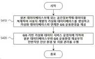
도 4는 도 2에 있는 프로세서에 의하여 수행되는 GIS 기반의 가상화 데이터 서비스 제공 프로시저를 설명하는 흐름도이다.4 is a flowchart illustrating a GIS-based virtualization data service provision procedure performed by the processor in FIG.
도 4에서, GIS 운용환경 제공부(310)는 원본 데이터베이스부(115)에 있는 공간정보객체 데이터를 복제하여 사용자 개별의 가상화 데이터베이스를 생성하고 해당 가상화 데이터베이스와 연계한 GIS 운용환경을 제공한다(단계 S410). GIS 운용환경 운영부(330)는 GIS 기반 가상화 데이터 서비스 운영자에 의하여 원본 데이터베이스부(115)와 GIS 운용환경 제공부(310)의 전반적인 전산 환경 및 자원 관리를 수행할 수 있다(단계 S420)4, the GIS operational
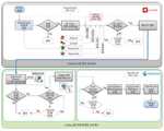
도 5는 도 1에 있는 GIS 기반의 가상화 데이터 서비스 제공 장치가 GIS 서비스 운영자에게 가상화 데이터베이스와 연계된 GIS 운용환경을 제공하는 과정의 일 실시예를 나타내는 흐름도이다.FIG. 5 is a flowchart illustrating an embodiment of a process of providing a GIS operation environment associated with a virtualization database to a GIS service operator in the GIS-based virtualization data service providing apparatus shown in FIG.
도 5에서, GIS 운용환경 제공부(310)는 원본 데이터베이스부(115)에 있는 특정 공간정보객체에 관한 GIS 서비스 운영자의 GIS 운용환경 제공 요청을 수신할 수 있고, 관리자에 의해 해당 요청이 승인되면 오픈스택 API를 이용하여 가상화 데이터베이스를 생성하기 위한 프로세스를 수행할 수 있다.5, the GIS operational
보다 구체적으로, GIS 운용환경 제공부(310)는 오픈스택의 키스톤 모듈을 이용하여 해당 GIS 서비스 운영자에 관한 사용자 인증을 수행할 수 있고, 인증이 성공하면 인스턴스 생성 API를 호출하여 글랜스 모듈을 통해 템플릿 이미지를 기초로 가상화 인스턴스를 생성할 수 있으며, 신더 모듈을 통해 해당 가상화 인스턴스의 저장공간 등을 설정할 수 있고, 키스톤 모듈을 통해 해당 가상화 인스턴스에 사용자와 연관된 인증키를 등록할 수 있으며, 뉴트론 모듈을 통해 해당 가상화 인스턴스에 내부 IP를 등록할 수 있다. GIS 운용환경 운영부(330)는 특정 시간(예를 들어, 10초) 동안 특정 횟수(예를 들어, 50회) 이내로 가상화 인스턴스의 생성을 체크하여 가상화 인스턴스의 생성 완료가 확인되면 해당 가상화 인스턴스에 외부 IP를 할당하고, 확인되지 않으면 프로세스를 종료할 수 있다.More specifically, the GIS operational
GIS 운용환경 제공부(310)는 가상화 인스턴스의 활성화를 통해 해당 사용자의 가상화 데이터베이스를 생성할 수 있고, 원본 데이터베이스부(115)에서 사용자 요청 자료과 연관된 특정 데이터 블록을 덤핑하여 덤프 파일을 생성할 수 있다. GIS 운용환경 제공부(310)는 덤프 파일이 생성되면 해당 가상화 데이터베이스를 가동시킨 후 해당 덤프 파일을 가져와 저장할 수 있고, 덤프 파일이 생성되지 않거나 해당 가동 여부를 특정 시간(예를 들어, 10초) 동안 특정 횟수(예를 들어, 50회) 이내로 체크한 결과 해당 가상화 데이터베이스가 가동되지 않으면 프로세스를 종료할 수 있다.The GIS operational
GIS 운용환경 제공부(310)는 이러한 과정들을 통해 가상화 데이터베이스를 생성하는 동시에 해당 가상화 데이터베이스와 연계 가능하고 지도 상에 해당 공간객체정보를 운영하기 위한 네트워크 IP, 하드웨어 환경, 소프트웨어 환경 및 좌표를 포함한 공간정보 데이터셋을 포함하는 GIS 운용환경을 생성 및 제공할 수 있다.The GIS operational
GIS 운용환경 운영부(330)는 GIS 서비스 운영자 단말(120)에 의하여 호출될 수 있는 API를 통해 상기 과정들에서 필요한 연산을 처리할 수 있고, 해당 GIS 운용환경에 대한 접근을 제공하여 해당 GIS 서비스 운영자가 지도 상에 해당 공간객체정보를 운영할 수 있도록 할 수 있다. 예를 들어, GIS 운용환경 운영부(330)는 지리 공간에 관한 오픈형 GIS 서비스 엔진인 GeoServer를 가동시킬 수 있고, GeoServer의 상태를 60초 간 50회 이내로 체크한 결과 GeoServer가 가동되지 않으면 프로세스를 종료할 수 있으며, GeoServer가 가동되면 워크스테이션에 GeoServer를 등록하는 단계, DB의 판매 및 구매를 중개하는 DB 스토어를 GeoServer에 등록하는 단계 및 가상화 데이터베이스의 해당 레이어 정보를 GeoServer에 등록하는 단계를 순차적으로 수행하여 레이어 정보의 세팅을 완료할 수 있다. GIS 운용환경 운영부(330)는 상기 과정들을 통해 GIS 운용환경의 세팅이 완료되면 해당 GIS 운용환경을 통해 가상화 데이터베이스(예를 들어, SDBaaS, Secure DataBase as a Service)의 사용자 요청 자료를 별도의 절차 없이 GIS 서비스 운영자가 웹 상에서 바로 서비스 개발에 이용 가능하도록 지원할 수 있다.The GIS operating
도 6은 도 1에 있는 GIS 기반의 가상화 데이터 서비스 제공 장치가 GIS 서비스 운영자에 의하여 호출될 수 있는 API(Application Programming Interface)를 통해 GIS 운용환경에 대한 접근을 제공하는 과정의 일 실시예를 나타내는 흐름도이다.6 is a flowchart showing an embodiment of a process of providing an access to a GIS operating environment through an API (Application Programming Interface) which can be called by a GIS service operator, to be.
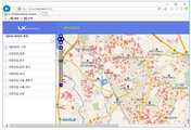
도 6에서, GIS 운용환경 운영부(330)는 GIS 서비스 운영자 단말(120)에 의하여 호출될 수 있는 API를 통해 사용자 요청과 연관된 특정 공간정보객체 데이터에 관한 오픈형 GIS 서비스 엔진인 GeoServer를 가동킬 수 있고, GeoServer를 통해 해당 GIS 서비스 운영자의 가상화 데이터베이스에 있는 특정 공간정보 데이터셋(예를 들어, 어린이집_수원에 관한 데이터셋)에 관해 시각화된 지도 서비스를 제공하고 지도 서비스의 개발 등을 지원할 수 있다.In FIG. 6, the GIS operating
상기에서는 본 출원의 바람직한 실시예를 참조하여 설명하였지만, 해당 기술 분야의 숙련된 통상의 기술자는 하기의 특허 청구의 범위에 기재된 본 발명의 사상 및 영역으로부터 벗어나지 않는 범위 내에서 본 출원을 다양하게 수정 및 변경시킬 수 있음을 이해할 수 있을 것이다.While the present invention has been particularly shown and described with reference to exemplary embodiments thereof, it will be understood by those of ordinary skill in the art that various changes in form and details may be made therein without departing from the spirit and scope of the invention as set forth in the following claims And changes may be made without departing from the spirit and scope of the invention.
100: GIS 기반의 가상화 데이터 서비스 제공 시스템
110: GIS 기반의 가상화 데이터 서비스 제공 장치
115: 원본 데이터베이스부
120: GIS 서비스 운영자 단말130: 관리자 단말
210: 프로세서220: 메모리
230: 사용자 입출력부240: 네트워크 입출력부
310: GIS 운용환경 제공부320: 제어부
330: GIS 운용환경 운영부100: GIS-based virtualization data service delivery system
110: GIS-based virtualization data service provider
115: original database section
120: GIS service operator terminal 130: administrator terminal
210: processor 220: memory
230: user input / output unit 240: network input / output unit
310: GIS operational environment providing unit 320:
330: GIS Operation Environment Department
Claims (4)
Translated fromKorean상기 원본 데이터베이스부에 있는 공간정보객체 데이터를 복제하여 사용자 개별의 가상화 데이터베이스를 생성하고 상기 가상화 데이터베이스와 연계한 GIS 운용환경을 제공하는 GIS 운용환경 제공부; 및
GIS 기반 가상화 데이터 서비스 운영자에 의하여 상기 원본 데이터베이스부와 상기 GIS 운용환경 제공부의 전반적인 전산 환경 및 자원 관리를 수행하는 GIS 운용환경 운영부를 포함하는 GIS 기반의 가상화 데이터 서비스 제공 장치.
An original database unit for storing spatial information object data to which coordinate information is added to public information, in order to provide a virtualized data service based on a geographic information system (GIS) of information disclosed by a public entity;
A GIS operating environment providing unit for creating a virtualization database for each user by replicating spatial information object data in the source database unit and providing a GIS operating environment linked with the virtualization database; And
And a GIS operating environment operating unit for performing overall computing environment and resource management of the original database unit and the GIS operating environment providing unit by the GIS-based virtualization data service operator.
상기 공공기관이 제공하는 좌표 또는 좌표를 추정할 수 있는 주소정보를 포함하고 있는 공공정보를 선별하여 개별 공공정보 데이터에 각각 좌표를 부여 또는 추론하여 공간정보화한 다음 공간정보 데이터베이스에 저장 후 상기 GIS 운용환경 제공부에서 데이터를 요청할 때 해당 데이터를 제공하는 것을 특징으로 하는 GIS 기반의 가상화 데이터 서비스 제공 장치.
The method of claim 1, wherein the source database unit
The public information including address information capable of estimating coordinates or coordinates provided by the public entity is selected, each coordinate is given or inferred to individual public information data, and the information is converted into spatial information, and then the information is stored in a spatial information database. And provides the corresponding data when requesting data from the environment providing unit.
사용자의 요구에 따라 상기 GIS 기반 가상화 데이터 서비스를 제공하기 위하여 가상 시스템에 설치한 Linux 기반 CentOS 환경에 오픈소스 GIS 기술로 공개되어 있는 GeoServer와 PostGIS의 설치하여 맞춤형 공간정보 데이터베이스를 구성하고 사용자가 접근 가능한 네트워크 IP 와 함께 제공하는 것을 특징으로 하는 GIS 기반의 가상화 데이터 서비스 제공 장치.
The method of claim 2, wherein the GIS operating environment providing unit
In order to provide the GIS-based virtualization data service according to the user's request, GeoServer and PostGIS, which are disclosed as open-source GIS technology, are installed in a Linux-based CentOS environment installed in a virtual system to configure a customized spatial information database, And providing the network IP together with the GIS-based virtualized data service.
오픈스택(OpenStack) 기술을 이용하여 상기 원본 데이터베이스부와 GIS 운용환경 운영부를 설치 및 운영하기 위한 가상 시스템 및 공간객체정보를 사용자 요구 건수만큼 생성하고 이와 관련된 물리적 전산자원의 할당 및 운영을 수행하는 것을 특징으로 하는 GIS 기반의 가상화 데이터 서비스 제공 장치.
The system according to claim 1, wherein the GIS operating environment operating unit
A virtual system and spatial object information for installing and operating the original database unit and the GIS operating environment operating unit by using OpenStack technology are generated as many as the number of user requests and the allocation and operation of the physical computer resources related thereto are performed A GIS-based virtualized data service providing apparatus characterized by:
Priority Applications (1)
| Application Number | Priority Date | Filing Date | Title |
|---|---|---|---|
| KR1020170073419AKR101977219B1 (en) | 2017-06-12 | 2017-06-12 | Apparatus and method for providing virtualized data service based on gis |
Applications Claiming Priority (1)
| Application Number | Priority Date | Filing Date | Title |
|---|---|---|---|
| KR1020170073419AKR101977219B1 (en) | 2017-06-12 | 2017-06-12 | Apparatus and method for providing virtualized data service based on gis |
Publications (2)
| Publication Number | Publication Date |
|---|---|
| KR20180135373Atrue KR20180135373A (en) | 2018-12-20 |
| KR101977219B1 KR101977219B1 (en) | 2019-08-28 |
Family
ID=64952608
Family Applications (1)
| Application Number | Title | Priority Date | Filing Date |
|---|---|---|---|
| KR1020170073419AActiveKR101977219B1 (en) | 2017-06-12 | 2017-06-12 | Apparatus and method for providing virtualized data service based on gis |
Country Status (1)
| Country | Link |
|---|---|
| KR (1) | KR101977219B1 (en) |
Cited By (1)
| Publication number | Priority date | Publication date | Assignee | Title |
|---|---|---|---|---|
| HRP20231708A1 (en)* | 2023-12-22 | 2025-07-04 | CADCOM d.o.o. | DIGITAL PLATFORM (GIS SYSTEM) FOR SPATIAL DATA MANAGEMENT ON WETLANDS |
Families Citing this family (1)
| Publication number | Priority date | Publication date | Assignee | Title |
|---|---|---|---|---|
| KR102784199B1 (en) | 2024-06-27 | 2025-03-21 | 주식회사 심투리얼 | GIS information processing system and method for building a virtual environment capable of simulation |
Citations (6)
| Publication number | Priority date | Publication date | Assignee | Title |
|---|---|---|---|---|
| KR20030064323A (en)* | 2002-01-23 | 2003-07-31 | 교또 다이가꾸 | Visualization processing system, visualization processing method, and visualization processing program product |
| KR100783767B1 (en) | 2007-05-29 | 2007-12-07 | 주식회사 선도소프트 | Spatial Geographic Information System |
| KR20090018038A (en) | 2006-05-02 | 2009-02-19 | 텔레 아틀라스 노스 아메리카, 인크. | System and method for providing a virtual database environment and generating digital map information |
| KR20100065628A (en)* | 2008-12-08 | 2010-06-17 | 김진성 | Spatial entity pointing device |
| KR100999323B1 (en)* | 2010-05-04 | 2010-12-08 | 주식회사 지노시스템 | Integrated WiFi Information Generation System and Method |
| KR101602482B1 (en)* | 2015-08-13 | 2016-03-21 | (주)아이넷테크 | Fire protection management system using geographical information and the control method thereof |
- 2017
- 2017-06-12KRKR1020170073419Apatent/KR101977219B1/enactiveActive
Patent Citations (6)
| Publication number | Priority date | Publication date | Assignee | Title |
|---|---|---|---|---|
| KR20030064323A (en)* | 2002-01-23 | 2003-07-31 | 교또 다이가꾸 | Visualization processing system, visualization processing method, and visualization processing program product |
| KR20090018038A (en) | 2006-05-02 | 2009-02-19 | 텔레 아틀라스 노스 아메리카, 인크. | System and method for providing a virtual database environment and generating digital map information |
| KR100783767B1 (en) | 2007-05-29 | 2007-12-07 | 주식회사 선도소프트 | Spatial Geographic Information System |
| KR20100065628A (en)* | 2008-12-08 | 2010-06-17 | 김진성 | Spatial entity pointing device |
| KR100999323B1 (en)* | 2010-05-04 | 2010-12-08 | 주식회사 지노시스템 | Integrated WiFi Information Generation System and Method |
| KR101602482B1 (en)* | 2015-08-13 | 2016-03-21 | (주)아이넷테크 | Fire protection management system using geographical information and the control method thereof |
Cited By (1)
| Publication number | Priority date | Publication date | Assignee | Title |
|---|---|---|---|---|
| HRP20231708A1 (en)* | 2023-12-22 | 2025-07-04 | CADCOM d.o.o. | DIGITAL PLATFORM (GIS SYSTEM) FOR SPATIAL DATA MANAGEMENT ON WETLANDS |
Also Published As
| Publication number | Publication date |
|---|---|
| KR101977219B1 (en) | 2019-08-28 |
Similar Documents
| Publication | Publication Date | Title |
|---|---|---|
| US11126698B2 (en) | Distributed ledger system that facilitates device management | |
| JP5963957B2 (en) | Development environment system, development environment device, development environment providing method and program | |
| CA2978183C (en) | Executing commands within virtual machine instances | |
| US20200067791A1 (en) | Client account versioning metadata manager for cloud computing environments | |
| JP6284617B2 (en) | System and method for calculating resource allocation | |
| CN104067265B (en) | Systems and methods for supporting secure application deployment in the cloud | |
| US9210178B1 (en) | Mixed-mode authorization metadata manager for cloud computing environments | |
| CA2825153C (en) | Strong rights management for computing application functionality | |
| US9462056B1 (en) | Policy-based meta-data driven co-location of computation and datasets in the cloud | |
| US20170140171A1 (en) | System for Managing Personal Data | |
| CN119988029A (en) | Streamlined and secure deployment of cloud services | |
| JP2016521385A (en) | Virtual desktop application market | |
| JP2016517075A (en) | Automated desktop placement | |
| JP2021503118A (en) | Systems and methods for integrating cloud applications into cloud service broker platforms using the automatic universal connector package | |
| CN116566629B (en) | Security testing method and device, computer equipment and storage medium | |
| KR20180135373A (en) | Apparatus and method for providing virtualized data service based on gis | |
| WO2017128964A1 (en) | Method and device for application fusion | |
| US11200253B2 (en) | Providing instant and distributed access to a source blob via copy-on-read blobs and link blobs | |
| KR20130063952A (en) | System for supporting application development in cloud computing environment and method thereof | |
| CN110955558A (en) | System and method for providing backup services to high availability applications | |
| CN116628773A (en) | Data processing method, device, electronic device and storage medium | |
| CN115774661A (en) | Multi-user debugging with user data isolation | |
| CN115694939A (en) | Multi-system access method, device, device, storage medium and program product | |
| US20060059463A1 (en) | Remote build and management for software applications | |
| JP7159136B2 (en) | System execution support method and device |
Legal Events
| Date | Code | Title | Description |
|---|---|---|---|
| A201 | Request for examination | ||
| PA0109 | Patent application | Patent event code:PA01091R01D Comment text:Patent Application Patent event date:20170612 | |
| PA0201 | Request for examination | ||
| E902 | Notification of reason for refusal | ||
| PE0902 | Notice of grounds for rejection | Comment text:Notification of reason for refusal Patent event date:20180713 Patent event code:PE09021S01D | |
| AMND | Amendment | ||
| PG1501 | Laying open of application | ||
| E601 | Decision to refuse application | ||
| PE0601 | Decision on rejection of patent | Patent event date:20190125 Comment text:Decision to Refuse Application Patent event code:PE06012S01D Patent event date:20180713 Comment text:Notification of reason for refusal Patent event code:PE06011S01I | |
| AMND | Amendment | ||
| PX0901 | Re-examination | Patent event code:PX09011S01I Patent event date:20190125 Comment text:Decision to Refuse Application Patent event code:PX09012R01I Patent event date:20180904 Comment text:Amendment to Specification, etc. | |
| PX0701 | Decision of registration after re-examination | Patent event date:20190321 Comment text:Decision to Grant Registration Patent event code:PX07013S01D Patent event date:20190226 Comment text:Amendment to Specification, etc. Patent event code:PX07012R01I Patent event date:20190125 Comment text:Decision to Refuse Application Patent event code:PX07011S01I Patent event date:20180904 Comment text:Amendment to Specification, etc. Patent event code:PX07012R01I | |
| X701 | Decision to grant (after re-examination) | ||
| PR0701 | Registration of establishment | Comment text:Registration of Establishment Patent event date:20190503 Patent event code:PR07011E01D | |
| PR1002 | Payment of registration fee | Payment date:20190507 End annual number:3 Start annual number:1 | |
| PG1601 | Publication of registration | ||
| PR1001 | Payment of annual fee | Payment date:20220518 Start annual number:4 End annual number:4 | |
| PR1001 | Payment of annual fee | Payment date:20230227 Start annual number:5 End annual number:5 |