KR20180109118A - A method for identifying the exact position of robot by combining QR Code Tag, beacon terminal, encoder and inertial sensor - Google Patents
A method for identifying the exact position of robot by combining QR Code Tag, beacon terminal, encoder and inertial sensorDownload PDFInfo
- Publication number
- KR20180109118A KR20180109118AKR1020170038229AKR20170038229AKR20180109118AKR 20180109118 AKR20180109118 AKR 20180109118AKR 1020170038229 AKR1020170038229 AKR 1020170038229AKR 20170038229 AKR20170038229 AKR 20170038229AKR 20180109118 AKR20180109118 AKR 20180109118A
- Authority
- KR
- South Korea
- Prior art keywords
- robot
- code
- value
- current
- information
- Prior art date
- Legal status (The legal status is an assumption and is not a legal conclusion. Google has not performed a legal analysis and makes no representation as to the accuracy of the status listed.)
- Ceased
Links
Images


Classifications
- B—PERFORMING OPERATIONS; TRANSPORTING
- B25—HAND TOOLS; PORTABLE POWER-DRIVEN TOOLS; MANIPULATORS
- B25J—MANIPULATORS; CHAMBERS PROVIDED WITH MANIPULATION DEVICES
- B25J9/00—Programme-controlled manipulators
- B25J9/16—Programme controls
- B25J9/1656—Programme controls characterised by programming, planning systems for manipulators
- B25J9/1664—Programme controls characterised by programming, planning systems for manipulators characterised by motion, path, trajectory planning
- B—PERFORMING OPERATIONS; TRANSPORTING
- B25—HAND TOOLS; PORTABLE POWER-DRIVEN TOOLS; MANIPULATORS
- B25J—MANIPULATORS; CHAMBERS PROVIDED WITH MANIPULATION DEVICES
- B25J19/00—Accessories fitted to manipulators, e.g. for monitoring, for viewing; Safety devices combined with or specially adapted for use in connection with manipulators
- B25J19/02—Sensing devices
- B25J19/021—Optical sensing devices
- B25J19/023—Optical sensing devices including video camera means
- B—PERFORMING OPERATIONS; TRANSPORTING
- B25—HAND TOOLS; PORTABLE POWER-DRIVEN TOOLS; MANIPULATORS
- B25J—MANIPULATORS; CHAMBERS PROVIDED WITH MANIPULATION DEVICES
- B25J9/00—Programme-controlled manipulators
- B25J9/16—Programme controls
- B25J9/1656—Programme controls characterised by programming, planning systems for manipulators
- B25J9/1671—Programme controls characterised by programming, planning systems for manipulators characterised by simulation, either to verify existing program or to create and verify new program, CAD/CAM oriented, graphic oriented programming systems
- B—PERFORMING OPERATIONS; TRANSPORTING
- B25—HAND TOOLS; PORTABLE POWER-DRIVEN TOOLS; MANIPULATORS
- B25J—MANIPULATORS; CHAMBERS PROVIDED WITH MANIPULATION DEVICES
- B25J9/00—Programme-controlled manipulators
- B25J9/16—Programme controls
- B25J9/1679—Programme controls characterised by the tasks executed
- B25J9/1684—Tracking a line or surface by means of sensors
- G—PHYSICS
- G06—COMPUTING OR CALCULATING; COUNTING
- G06K—GRAPHICAL DATA READING; PRESENTATION OF DATA; RECORD CARRIERS; HANDLING RECORD CARRIERS
- G06K19/00—Record carriers for use with machines and with at least a part designed to carry digital markings
- G06K19/06—Record carriers for use with machines and with at least a part designed to carry digital markings characterised by the kind of the digital marking, e.g. shape, nature, code
- G06K19/06009—Record carriers for use with machines and with at least a part designed to carry digital markings characterised by the kind of the digital marking, e.g. shape, nature, code with optically detectable marking
- G06K19/06037—Record carriers for use with machines and with at least a part designed to carry digital markings characterised by the kind of the digital marking, e.g. shape, nature, code with optically detectable marking multi-dimensional coding
Landscapes
- Engineering & Computer Science (AREA)
- Robotics (AREA)
- Mechanical Engineering (AREA)
- Physics & Mathematics (AREA)
- General Physics & Mathematics (AREA)
- Theoretical Computer Science (AREA)
- Multimedia (AREA)
- Manipulator (AREA)
- Control Of Position, Course, Altitude, Or Attitude Of Moving Bodies (AREA)
Abstract
Translated fromKorean
Description
Translated fromKorean모바일 로봇의 기본이자 꽃은 바로 내비게이션이라고 할 수 있다. 로봇 공학에서 내비게이션은 빼놓을 수 없을 만큼 중요하다. The base of mobile robot and flower is navigation. In robotics, navigation is imperative.
내비게이션은 로봇이 정해진 목적지까지 이동하게 한다. The navigation allows the robot to move to a predetermined destination.
로봇 스스로 어디에 있는지, 주어진 환경의 지도를 가지고 있어야 한다는 것, 다양한 경로 중에 최적화된 경로는 어떤 것인지, 그리고 도중에 로봇에게 장애물이 되는 벽, 가구, 물체 등을 피하여 이동하는 등 다양한 형태의 기능을 지원한다. It supports a variety of functions such as where the robot itself is, whether it should have a map of the given environment, which route is optimized among the various paths, and moving away from obstacles such as walls, furniture, and objects .
로봇마다 내비게이션 알고리즘에 따라 다르겠지만, 다음 기능 정도는 필수로 갖추고 있어야 할 것이다. Depending on the navigation algorithm for each robot, the following functions should be required.
로봇의 내비게이션 기능을 구현하기 위해서는 4가지 기능을 지원하는 것으로 분류하였다. In order to implement the navigation function of the robot, it is classified as supporting four functions.
1) 지도1) Map
2) 로봇 위치 계측/추정 기능2) Robot position measurement / estimation function
3) 벽, 물체 등 장애물 계측 기능3) Obstacle measurement function such as wall, object
4) 최적 경로를 계산하고 주행하는 기능4) Ability to calculate the optimal route and travel
내비게이션은 주어진 환경에서 로봇이 현재 위치부터 지정한 목적지까지 이동하는 것이다. Navigation is to move the robot from its current location to a specified destination in a given environment.
이를 위해서는 주어진 환경의 가구, 물체, 벽 등의 기하학적인 정보(Geometry, geo-: 토지, metry: 측정)가 담긴 지도가 필요하다. This requires a map of the geometry, geo- (land, metry) of the furniture, objects, and walls of a given environment.
작성된 지도가 없으면 SLAM 기술을 이용하여 로봇이 자신의 위치 정보와 센서로부터 얻은 거리 정보에서 지도를 얻을 수 있었다. Without the map, the robot could obtain the map from its location information and the distance information from the sensor using SLAM technology.
내비게이션은 이 지도와 로봇의 엔코더, 관성 센서, 거리 센서 등을 이용하여 현재 위치부터 지도상에 지정된 목적지까지 이동하게 된다. 이를 수행하는 순서는 다음과 같다. The navigation is moved from the current position to the designated destination on the map by using the map, the robot's encoder, the inertial sensor, and the distance sensor. The procedure for doing this is as follows.
1) 센싱(Sensing)지도상에서 로봇은 엔코더와 관성 센서(IMU 센서) 등으로 자신의 오도메트리(Odometry) 정보를 갱신하면서, 거리 센서가 장착된 위치부터 장애물(벽, 물체, 가구 등)과의 거리를 계측한다. 1) Sensing On the map, the robot updates its odometry information with the encoder and the inertial sensor (IMU sensor), and the obstacle (wall, object, furniture, etc.) Is measured.
2) 로봇의 위치 추정(Localization / Pose Estimation)은 이동체의 엔코더로부터 바퀴 회전량, 관성 센서로부터 관성 정보, 거리 센서로부터 장애물과의 거리 정보 등을 기반으로 기존에 작성해 둔 지도상에 로봇이 현재 어디에 있는지 위치를 추정(Localization / Pose Estimation)하게 된다. 2) Localization / Pose Estimation of the robot is based on the wheel rotation amount from the moving object encoder, the inertia information from the inertial sensor, and the distance information from the distance sensor to the obstacle. (Localization / Pose Estimation).
3) 모션 계획(Motion Planning)이동 경로 계획(Path Planning)이라고도 불린다. 현재 위치에서부터 지도상에 지정 받은 목표 지점까지 이동 궤적(Trajectory)을 생성한다. 지도 전체상의 전역 이동 경로 계획(Global Path Planning)과 로봇 중심으로 일부 지역을 대상으로 한 국부 이동 경로 계획(Local Path Planning)으로 나누어 로봇의 이동 경로를 만든다. 3) Motion Planning It is also called "Path Planning". Creates a trajectory from the current position to the specified target point on the map. Global path planning on the map as a whole and local path planning for some areas as a robot-centered path are made.
4) 이동/장애물 회피(Move / Collision Avoidance)모션 계획에서 작성된 이동 궤적을 따라서 로봇에 속도 명령을 내리면 로봇은 그 이동 궤적을 따라 목적지까지 이동한다. 4) Move / Collision Avoidance When a speed command is given to the robot along the movement trajectory created in the motion plan, the robot moves to the destination along the movement trajectory.
본 고안은 작성된 디지털 지도상에서 로봇의 현재 위치를 정확하게 인식하기 위한 기술이다. This design is a technique for accurately recognizing the current position of the robot on the created digital map.
본 고안은 위치정보를 가진 QR Code 태그, 비콘을 이용한 위치식별, 바퀴의 회전과 관성센서로 이동방향과 거리로 위치 식별하는 3가지의 위치식별 방법을 융합하여 로봇의 현재 위치를 정확하게 식별하고, 예외 발생시 현재 위치를 재설정 할 수 있도록 하여 신속한 위치 복구를 통한 로봇의 위치식별 능력을 향상하고자 한다. The present invention accurately identifies the current position of the robot by combining QR Code tag with position information, position identification using beacon, wheel rotation and inertia sensor, and three position identification methods, In case of exception, it is possible to reset the current position to improve the robot's position identification ability through quick position restoration.
로봇에 현재 위치 추정(Localization / Pose Estimation)은 이동체의 엔코더로부터 바퀴 회전량, 관성 센서로부터 관성 정보, 거리 센서로부터 장애물과의 거리 정보 등을 기반으로 기존에 작성해 둔 지도상에 로봇이 현재 어디에 있는지 위치를 추정(Localization / Pose Estimation)하게 된다. Localization / Pose Estimation on the robot is based on the wheel rotation amount from the mobile object encoder, the inertia information from the inertia sensor, and the distance information from the distance sensor to the obstacle. (Localization / Pose Estimation).
이때 발생하는 오차를 보정하기 위해서, 다양한 방법과 융합하여 현재의 로봇위치 정확한 위치정보를 추정하기 위한 위치보정 방법에 관한 것이다. The present invention relates to a position correction method for estimating accurate position information of a current robot by fusing with various methods in order to correct an error occurring at this time.
즉 비콘단말기를 사용하여 로봇의 위치를 보정하는 기술과 일정한 높이와 일정한 간격으로 전 지역에 위치를 식별할 수 있는 QR코드를 부착하여, 이동 중에 로봇에 장착된 카메라에서 QR Code를 식별하여 현 위치를 참조하여 로봇의 위치값을 보정하는 기술과 융합하여 정확한 로봇의 위치 값을 구하는 것이다. In other words, by using the beacon terminal to fix the position of the robot and the QR code to identify the position in the whole area at a constant height and a constant interval, the QR code is identified in the camera mounted on the robot while moving, And corrects the position value of the robot to obtain the position value of the accurate robot.
로봇을 제어하는 제어기에 로봇의 현 위치를 식별하는 여러 가지 방법을 융합하여, 최적의 위치보정 기술을 고안하였다. We have devised an optimal position correction technique by fusing various methods to identify the robot 's current position to the controller that controls the robot.
1) 비콘단말기를 사용하여 로봇의 위치를 식별하는 기술은 전파의 오차로 인해서 정확한 위치 값의 오차는 크나, 반면 범위의 위치 값은 정확하다. 1) In the technique of identifying the position of the robot using the beacon terminal, the error of the accurate position value is large due to the propagation error, whereas the position value of the range is accurate.
2) QR코드를 인식하여 보정하는 방법은 로봇의 현재 위치값은 정확하나, 실시간으로 현장의 정보를 영상분석을 하여야 함으로 로봇제어기에는 많은 부하를 준다. 또한 장애물로 인해서 QR Code를 보지 못하는 경우가 많이 발생한다. 2) The method of recognizing and correcting the QR code is that the current position value of the robot is accurate, but it imposes a heavy load on the robot controller because it must analyze the information of the field in real time. In addition, many obstacles prevent you from seeing the QR Code.
3) 이동체의 엔코더로부터 바퀴 회전량, 관성 센서로부터 관성 정보 등을 활용하여 움직이는 동선과 방향을 추정하는 것 역시, 센서들의 오차로 인해서 시간에 비례하여 오차범위가 커진다. 따라서 상기의 3개의 위치식별 방안을 융합하여, 좀 더 정확한 로봇의 위치 값을 보정할 수 있는 방법을 고안하였다. 3) Estimating the moving line and direction by using the wheel rotation amount from the moving object encoder and the inertia information from the inertial sensor also increases the error range in proportion to the time due to the error of the sensors. Therefore, we have devised a method of correcting the position value of a more accurate robot by fusing the above three position identification methods.
단계별 보정으로 최악의 로봇의 위치 값을 방지함으로 로봇의 현 위치 식별오류로 인한 사고예방이 가능하다. It is possible to prevent accidents due to errors in the current position of the robot by preventing the position of the worst robot by the stepwise correction.
정확한 현 위치식별기능은 다양한 응용분야에 로봇을 활용할 수 있게 되었다. Accurate current position identification allows robots to be used in a variety of applications.
[도 1] 로봇의 정확한 현재의 위치보정을 위한 처리 순서도
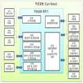
[도 2] 카트로봇 하드웨어 구성과 프로그램 모듈
[도 3] 카트로봇 제어기에서 지원 프로그램모듈 연관도
[도 4] 비콘단말기를 이용하여 Triangulation(삼각측정)
[도 5] QR Code를 이용하여 로봇의 위치식별 개념도[Figure 1] Processing flowchart for correcting the current position of the robot
[Fig. 2] Cart robot hardware configuration and program module
[Fig. 3] Supported program module association diagram in the cart robot controller
[Fig. 4] Triangulation using a beacon terminal [
[Fig. 5] Conceptual diagram of position identification of robot using QR Code
로봇의 정확한 현재의 위치를 식별하기 위해서 기본적으로 로봇이 제공하여야 할 기능은 [도 2] 와 [도 3] 의 기능을 구비한 로봇이 있어야 한다.In order to identify the precise current position of the robot, the robot must basically have a robot having the functions of [Fig. 2] and [Fig. 3].
[도 2] 는 카트로봇 제어기(230)가 제공하는 기능을 제어프로그램 모듈단위로 도식화한 내용이다. 2 is a diagram showing functions provided by the
관리서버연계모듈은 카트로봇관리서버, 매장관리서버간의 상품관련정보, 주문관련정보, 매장과 창고의 상품관리 위치정보 그리고 사용자관련 정보 등을 상호 정보제공 및 처리를 연계하는 모듈이다. The management server linking module is a module for linking and providing mutual information between the cart robot management server and the store management server, product related information, order related information, merchandise management position information of the store and warehouse, and user related information.
로봇간연계모듈(232)는 카트로봇이 매장과 창고를 이동시 상호간에 정보교류를 통해서 충돌을 예방하면서 임무를 수행할 수 있도록 로봇 간의 정보연계 처리를 수행하는 모듈이다. The inter-robot link module 232 is a module for performing information linkage processing between robots so that a cart robot can perform a mission while preventing collision through mutual exchange of information when moving a store and a warehouse.
서비스 제공모듈(233)는 고객이 원하는 상품위치까지 안내해 주는 상품위치안내서비스, 상품구매 후 정산/배송 대행서비스, 상품을 카트에 실시 않고 실시간구매서비스, 온라인고객과 방문고객에게 주문 받은 상품을 자동으로 카트로봇에 실어서, 포장센터 또는 배송센터로 이송하는 서비스 등을 제공한다. The service providing module 233 is a service providing module that provides a product location guidance service that guides the customer to a desired product location, a settlement / delivery service after the purchase of the goods, a real-time purchase service, To the packaging robot or to the shipping center.
음성인식/합성모듈(234)은 카트로봇에 장착된 마이크(320)와 스피커(321)를 활용하여, 상호간에 의사소통을 지원하는 모듈이다. The speech recognition / synthesis module 234 is a module for supporting mutual communication by utilizing the
경비보안모듈(235)은 매장 운영시간이 종료 후, 매장 내에 진입하는 침입자를 열감지카메라와 3D카메라(Depth Camera)를 이용하여 감시하는 모듈이다. The expense security module 235 is a module for monitoring an intruder entering the store through a thermal camera and a 3D camera (Depth Camera) after the store operation time is over.
객체식별모듈(236) 열감지카메라와 3D카메라(Depth Camera)에서 촬상 된 영상을 실시간으로 분석하여 영상 속의 객체를 식별하고, 상품으로 식별된 경우 상품바코드를 인식하여 상품코드를 인식하는 기능을 수행하는 모듈이다. Object Identification Module (236) Identifies the object in the image by analyzing the image captured by the thermal sensing camera and the 3D camera (Depth Camera) in real time, recognizes the product bar code when the product is identified as a product, and recognizes the product code .
Navigation모듈(237) 카트로봇이 원하는 목적지까지 안전하고, 최적의 경로로 이동할 수 있도록 지원하는 기능을 수행하는 모듈이다. Navigation Module (237) It is a module that performs functions to support the cart robot to move to the desired destination safely and to the optimal route.
로봇자세/위치 인식모듈(238)은 카트로봇의 현재 자세를 식별하여야, 진행방향과 진행속도를 참조하여, 현재 지도상에서 카트로봇의 정확한 위치를 식별할 수 있는 기능을 제공하는 모듈이다. The robot attitude / position recognition module 238 is a module for identifying the current position of the cart robot and providing a function of identifying the exact position of the cart robot on the current map with reference to the proceeding direction and the traveling speed.
로봇팔제어모듈(239)은 상품주문 목록의 상품의 위치로 이동하여, 상품을 3D카메라(Depth Camera)에서 촬상된 영상을 처리하여 주문상품과 동일한지를 식별하고, 로봇팔로 상품을 잡고, 다시 상품의 바코드를 식별하여 주문 목록에 기술된 상품과 동일 상품인지를 식별 후 카트로봇에 싣는 기능을 수행하는 모듈이다. The robot arm control module 239 moves to the position of the item on the product order list, processes the image captured by the 3D camera (Depth Camera) to identify whether the product is identical to the order product, holds the product with the robot arm, And identifies the same product as the commodity described in the order list, and loads it on the cart robot.
장애물회피모듈(240)은 목적지까지 이동 시, 이동 경로에 움직이는 물체와 장애물을 회피하는 기능을 수행하는 모듈이다. The obstacle avoidance module 240 is a module that performs a function of avoiding moving objects and obstacles in a moving route when moving to a destination.
지도Mapping모듈(241)은 매장이나 창고 영역의 디지털 지도를 기반으로 이동하는 카트로봇은 이동 중에 고정된 장애물이 있는 경우 지도에 위치를 표시하는 기능(SLAM)을 지원하는 모듈이다. The map mapping module 241 is a module that supports the SLAM function to display a position on a map when there is a fixed obstacle on the move, based on a digital map of a store or a warehouse area.
[도 3] 는 카트로봇제어기에서 카트로봇을 구성하는 구성요소를 제어하는 관점에서 프로그램 모듈을 분류하여 도식화하였다. [Fig. 3] shows a program module in a viewpoint of controlling components constituting a cart robot in the cart robot controller.
카트로봇의 제어기(380)에서 지원하는 다양한 처리모듈들을 지원한다. And supports various processing modules supported by the controller 380 of the cart robot.
UI처리모듈(310)은 카트로봇과 터치스크린으로 상호인터페이스를 지원하는 처리모듈로써 터치스크린(311)과 카메라(312)를 처리하는 모듈이다. The
음성인식 및 합성모듈(320)은 마이크(321)로 입력된 음성을 분석하여 고객이 원하는 명령을 식별하고, 처리된 결과를 스피커(322)로 음성을 합성하여 결과를 고객에게 음성으로 알려준다. 이때 알려줄 내용이 많으면 터치스크린으로 정보를 표시하여 고객이 내용을 확인할 수 있도록 한다. The voice recognition and
데이터베이스 관리모듈(330)은 외부시스템으로부터 상품관련정보, 주문관련정보, 고객관련정보 등을 보관하여 관리하고, 고객이 지시한 명령과 처리된 결과를 데이터베이스에서 관리하는 기능을 수행하는 모듈이다. The
외부시스템 및 카트로봇 간 연동모듈(340)은 카트로봇이 외부시스템과의 정보를 무선통신으로 수집하여 정보처리를 수행할 수 있도록 지원하는 모듈이다. The
로봇 및 고객의 위치식별 모듈(350)은 고객이 보유한 비콘단말기(스마트폰의 블루투스 기능 포함) ID를 식별하고, 고객과 로봇 간에 거리와 방향 등을 식별하여, 고객에게 상품위치까지 안내하기 위해서 일정한 거리를 두고 안내하는 기능을 수행하거나, 고객이 움직이면 일정한 거리를 두고 추종하는 기능을 수행하도록 처리하는 모듈이다. The robot and the customer's
로보팔제어모듈(360)은 주문목록의 상품을 로봇팔(361)과 3D카메라(3D Depth, 362)를 활용하여, 로봇카트에 실을 상품을 식별하고, 상품을 잡고, 상품바코드를 확인하고, 주문목록의 상품과 동일한지를 식별하고, 동일한 상품이면 카트에 싣는 작업을 수행하는 모듈이다. The robot
자율주행제어 및 SLAM지도 작성모듈(370)은 쇼핑카트로봇 자율이동체(371)이 3D카메라(3D Depth, 362), 관성센서(372), 초음파센서(373), 로드셀센서(374), 열감지카메라(375), 타코메터(376)에서 발생되는 신호를 수집하여, 원하는 목적지까지 자율 주행하는 기능을 수행하고, 이동 도중에 장애물을 회피하고, 고정된 장애물인 경우 해당 장애물을 지도에 표시하는 기능을 수행한다. The autonomic drive control and
이상에 기술된 기능을 지원하는 카트로봇은 매장 내 전시상품 또는 창고 내 적재된 상품의 위치를 찾아서, 자동으로 상품을 싣고, 상품을 포장하는 장소로 이동할 수 있는 자율형 카트로봇이다. Cart robots that support the functions described above are autonomous cart robots that can locate merchandise in a store or loaded goods in a warehouse and automatically move to a place where goods are loaded and goods are packed.
카트로봇을 구성하는 요소는 물건을 실을 수 있는 카트를 포함한 복수의 바퀴와 전기모터로 구성된 카트로봇의 이동본체(도면2의 외형도), 카트로봇이 안전하게 원하는 목적지까지 이동하기 위해서 외부환경 정보 즉 장애물, 사람 그리고 위치정보를 포함하는 QR Code와 상품바코드를 인식하기 위한 3D카메라(또는 Depth Camera, 362), 자율 주행 중 장애물과 사람과의 충돌을 예방하는 여러 개의 초음파센서372), 움직이는 사람객체를 식별하기 위한 열감지카메라(375), 매장 내 매대 또는 창고에 전시된 상품을 쇼핑카트에 실을 수 있는 로봇팔 또는 Manipulator(375), 움직이는 로봇의 매장 또는 창고 지도상에서 현 위치를 식별하기 위한 비콘단말기(351), 카트로봇의 움직이는 방향과 속도를 파악할 수 있는 관성센서(372), 바퀴의 회전을 인식하여 로봇이 움직인 거리를 측정할 수 있는 타코메터(Tachometer,376), 카트로봇과 UI(User Interface)가 가능한 터치스크린(311)과 카메라(312)가 장착된 테블릿컴퓨터, 음성을 이용하여 로봇과 UI(User Interface) 하기 위한 스피커(321)와 마이커(322), 카트로봇이 이동하기 위한 동력원인 배터리(390), The elements constituting the cart robot include a moving body (an external view of FIG. 2) of a cart robot composed of a plurality of wheels including electric carts and electric motors, an external environment information A 3D camera (or Depth Camera) 362 for recognizing the barcode of the goods, a plurality of
상기에 모든 구성요소와 결합된 카트로봇으로 모든 구성요소에서 발생하는 정보를 수집하고 제어할 수 있는 카트로봇 제어기(380), A cart robot controller 380 capable of collecting and controlling information generated by all the components with the cart robot combined with all the components,
그리고 혼잡한 매장 내에 방문고객으로 인해서 카트로봇이 이동하지 못할 때 손잡이 부분에 로드셀을 작동시키면 카트로봇을 수동운전이 가능한 구조, And when the cart robot can not move due to a visitor in a crowded store, if the load cell is operated at the handle,
높은 위치에 있는 상품을 잡기 위한 리니어모터를 활용하여 로봇의 상체를 상하로 움직이거나, PAN모터를 이용하여 상체를 좌우로 움직일 수 있는 구조, By using a linear motor to hold a product in a high position, the upper body of the robot can be moved up and down, the structure allowing the upper body to move left and right using the PAN motor,
타 시스템간 또는 카트로봇 간에 상호정보 교환을 위한 무선통신(341)이 가능한 구조의 카트로봇이다. And a
카트로봇의 제어기에 적용할 각 개별적인 위치식별에 대한 기술은 아래와 같다. The description of each individual position identification applied to the controller of the cart robot is as follows.
첫 번째 위치식별 기술은 매장 또는 창고에 로봇이 이동하는 경로에서 쉽게 인지할 수 있는 위치에 일정한 간격으로 위치정보를 가진 QR Code를 일정 높이에 부착한다. The first location identification technique attaches the QR code with the position information at a constant height to the height that can be easily recognized in the path where the robot moves in the store or the warehouse.
이동 중인 로봇의 카메라에서 QR code 태그를 발견하면, QR Code 측위 방식은 카메라로부터 영상을 획득한 후 QR Code Scan으로 인식한다. If the camera of the moving robot finds the QR code tag, the QR Code positioning method acquires the image from the camera and recognizes it as QR code scan.
[그림 5]에서 나타난 QR Code의 Z 축을 보정(QR Code의 회전 보정)을 한 다음 QR code 의 실제 Y 축 길이LR 와 QR code의 영상 픽셀의 Y 축 길이LP 를 영상 전체 픽셀X 축 길이 WP와의 비례식을 이용해 영상에 찍힌 실제 가로축 거리WR 를 구한다. 실제 가로축 거리WR로 삼각함수, 피타고라스 정리를 이용하여 QR Code 와 카메라위치와의 거리 D, QR Code의 평면과 카메라위치와의 이루는 각도를 측정해 현재 위치를 추정한다. QR Code 안의 디지털 값이 절대 좌표값이 있으므로 그 값을 기준으로 촬영 카메라의 위치를 계산한다. After correcting the Z-axis of the QR Code (rotation correction of the QR Code) shown in [Figure 5], the actual Y-axis length LR of the QR code and the Y-axis length LP of the image pixel of the QR code are compared with the total pixel X- Use the proportional formula to find the actual lateral axis distance WR on the image. Using the trigonometric function and Pythagorean theorem with the actual transverse axis distance WR, the distance between the QR Code and the camera position D, and the angle between the plane of the QR Code and the camera position are measured to estimate the current position. Since the digital value in the QR Code is the absolute coordinate value, the position of the camera is calculated based on that value.
두 번째는 매장 내에 일정한 간격으로 비콘단말기를 설치하고, 로봇에 장착된 비콘단말기에서 수신된 RSSI(Received Signal Strength Indicator) 신호 강도의 지표는 보통 -99 ~ -35이고 숫자가 높으면 높을수록 신호의 강도가 높다. Second, the beacon terminal is installed at regular intervals in the store. The indicator of the RSSI (Signal Strength Indicator) signal intensity received from the beacon terminal mounted on the robot is usually -99 to -35, and the higher the number, Is high.
매장 내에 설치된 한 비콘단말기와 로봇의 비콘단말기 간의 거리를 측정할 때에 있어서 가장 기본적이자 유일하게 이용되는 지표값으로 사용된다. It is used as the most basic and unique index value when measuring the distance between a beacon terminal installed in a store and a beacon terminal of the robot.
Bluetooth Beacon 을 활용한 삼각측위 방식은 RSSI 수신신호 전력이 거리에 따라 감소하는 경로 손실을 이용한 방법으로 일반적으로 사용되는 Log-Distance 경로 손실모델 은 다음과 같이 주어진다. The triangular positioning method using the Bluetooth Beacon is a method using path loss in which RSSI received signal power decreases with distance, and a log-distance path loss model generally used is given as follows.

PL(d)은 AP 에서 수신한 RSS 값을 dB 로 표현한 값이고, d 는 단말기와 AP 사이의 거리를 나타내며, d0는 기준거리이며 PL(d0)은 d0에서 측정된 RSS를 미리 저장된 값으로 나타낸다. n 은 경로손실 계수이며 자유공간 경로손실계수인 2로 정해둔다. PL (d) represents the RSS value received from the AP in dB, d represents the distance between the terminal and the AP, d0 is the reference distance, and PL (d0) represents the RSS measured at d0 as a previously stored value . n is the path loss factor and is set to 2, the free space path loss factor.
측정된 3개 이상의 송신기의 RSS 값을 이용해 송신하는 Bluetooth Beacon 과 단말기와의 거리를 계산한다. Calculate the distance between the terminal and the Bluetooth Beacon that transmits using the measured RSS value of three or more transmitters.
아래의 그림같이 계산된 거리를 반지름으로 하는 3개의 원이 맞나는 교점을 이용해 단말기의 위치를 추정한다. As shown in the figure below, the position of the terminal is estimated by using the intersection point where the three circles having the calculated distance as the radius are matched.

엔코더로부터 측정된 우측 및 좌측 바퀴의 회전속도를 각 Wer 및 Wel이라 하면, 식 (1) 에 의하여 로봇 중심의 선속도 Ve 와 회전속도 We를 구할 수 있다. If the rotational speeds of the right and left wheels measured from the encoder are Wer and Wel, respectively, the linear velocity Ve and the rotational speed We of the robot center can be obtained by Equation (1).
자이로센서로부터 측정된 로봇의 회전속도를 ?Wg로 표시한다. 로봇의 선속도는 엔코더로 측정되나, 로봇의 회전속도는 엔코더와 자이로센서에 의하여 모두 측정된다. The rotation speed of the robot measured from the gyro sensor is expressed as? Wg. The linear velocity of the robot is measured by the encoder, but the rotation speed of the robot is measured by both the encoder and the gyro sensor.
따라서 로봇의 회전속도는 엔코더 측정치와 자이로측정치의 가중평균으로 구한다. 즉 내부주행센서로부터 측정되는 로봇의 선속도 VR? 및 회전속도 WR은 다음과 같다 Therefore, the rotation speed of the robot is obtained by a weighted average of the encoder measurement value and the gyro measurement value. That is, the linear velocity VR? Of the robot measured from the internal running sensor? And the rotation speed WR are as follows

단 α ∈[0,1]는 회전속도 대한 엔코더 측정값에 대한 관성센서의 가중치이다. Where α ∈ [0,1] is the weight of the inertial sensor relative to the encoder measurement value for the rotational speed.
이 값은 실험을 통하여 적정한 값으로 결정될 수 있으며, 일반적으로 관성센서가 엔코더보다 각도측정을 보다 정확하게 할 수 있으므로, 1에 가까운 값이 설정된다. This value can be determined as an appropriate value through the experiment, and generally, the inertia sensor is set to a value close to 1 since the angle measurement can be made more accurate than the encoder.
내부주행센서로부터 측정된 로봇의 선속도 및 회전속도를 시간에 따라 적분하여 로봇의 위치 및 회전각을 다음과 같이 구할 수 있다. The position and the rotation angle of the robot can be obtained as follows by integrating the linear velocity and the rotation speed of the robot measured from the internal running sensor with time.

Δt는 샘플링시간이며,υR,k 및ωR,k는 k번째 샘플링시간에서의 로봇의 선속도 및 회전속도이다.Δt is the sampling time and,υ R, R k andω, k is the linear speed and the rotational speed of the robot at the k-th sampling time.
본 고안에서 상기의 3가지 식별방법을 복합적으로 융합한 처리절차를 [도 1]과 같이 도식화하였다. In the present invention, a processing procedure in which the above-described three identification methods are combined is schematically illustrated as in [FIG. 1].
로봇의 실내 위치식별 방법은 비콘무선단말기, QR Code 위치정보, 관성센서와 타코메터를 융합된 로봇의 위치정보 값을, 기존에 작성해 둔 지도상에 로봇이 현재 어디에 있는지 위치를 추정하는 방법으로서, The indoor location identification method of the robot is a method for estimating the position of the robot on the map where the beacon wireless terminal, the QR code position information, the position information value of the robot fused with the inertial sensor and the tachometer,
a) 로봇이 정해진 목적지로 자율 주행 시작단계(111); a) an autonomous running start step (111) of the robot to a predetermined destination;
b) Beacon신호를 받아서 오차범위를 고려한 현재위치정보를 식별하는 단계(112); b) receiving (112) the beacon signal to identify current location information that takes into account the error range;
c) 로봇에 부착된 카메라가 자율주행중에 일정한 높이에 현 위치정보를 가진 QR Code를 판독하는 단계(113); c) reading (113) a QR Code having current position information at a predetermined height during autonomous operation of the camera attached to the robot;
d) 현 위치 값을 기록된 QR Code를 판독한 경우, QR Code로 식별된 값을 보정하여, 현 로봇의 위치 값을 설정하고, ①로 점프하는 단계(114); d) setting the position value of the current robot by correcting the value identified by the QR Code when the current position value is read out of the recorded QR Code;
e) QR Code를 판독하지 못한 경우, 현 로봇의 위치값이 비콘신호에 의해서 얻어진 오차를 고려한 위치값의 범위 내에 있는지를 판단하는 단계(115); e) determining (115) if the QR Code is not read, if the position value of the current robot is within the range of the position value taking into account the error obtained by the beacon signal;
f) 현 식별된 로봇의 위치값이 비콘신호의 위치범위 값 내에 있으면, 현재위치에서 타코메터와 관성센서를 활용하여, 이동거리와 방향을 계산하고, 현재의 위치를 추정하여 현위치 값을 갱신하는 단계(116); f) If the position value of the currently identified robot is within the position range value of the beacon signal, calculate the travel distance and direction using the tachometer and the inertial sensor at the current position, update the current position by estimating the current position (116);
g) 현 식별된 로봇의 위치값이 비콘신호의 위치범위 값 밖에 있으면, 현재 로봇의 위치 값을 비콘신호으로 식별된 위치값을 고려하여, 현 위치값을 보정하고, ② 로 점프하는 단계(117); g) correcting the current position value by considering the position value of the current robot as the beacon signal if the position value of the currently identified robot is outside the position range value of the beacon signal, );
h) 로봇은 목적지로 자율 주행하면서 이동하는 단계(118);를 포함하는 것을 특징으로 하는 카트로봇의 정확한 현재의 위치를 식별한다. and h) moving the robot while autonomously moving to the destination (step 118).
RSSI(Received Signal Streangth Indicator)
QR(Quick Response)Received Signal Strength Indicator (RSSI)
QR (Quick Response)
Claims (3)
Translated fromKoreana) 로봇이 정해진 목적지로 자율 주행 시작단계(111);
b) Beacon신호를 받아서 오차범위를 고려한 현재위치정보를 식별하는 단계(112);
c) 로봇에 부착된 카메라가 자율주행중에 일정한 높이에 현 위치정보를 가진 QR Code를 판독하는 단계(113);
d) 현 위치 값을 기록된 QR Code를 판독한 경우, QR Code로 식별된 값을 보정하여, 현 로봇의 위치 값을 설정하고, ①로 점프하는 단계(114);
e) QR Code를 판독하지 못한 경우, 현 로봇의 위치값이 비콘신호에 의해서 얻어진 오차를 고려한 위치값의 범위 내에 있는지를 판단하는 단계(115);
f) 현 식별된 로봇의 위치값이 비콘신호의 위치범위 값 내에 있으면, 현재위치에서 타코메터와 관성센서를 활용하여, 이동거리와 방향을 계산하고, 현재의 위치를 추정하여 현위치 값을 갱신하는 단계(116);
g) 현 식별된 로봇의 위치값이 비콘신호의 위치범위 값 밖에 있으면, 현재 로봇의 위치 값을 비콘신호으로 식별된 위치값을 고려하여, 현 위치값을 보정하고, ② 로 점프하는 단계(117);
h) 로봇은 목적지로 자율 주행하면서 이동하는 단계(118);를 포함하는 것을 특징으로 하는 카트로봇의 정확한 현재의 위치를 식별하기 위한 방법The method of identifying the indoor location of the robot includes the location information value of the beacon wireless terminal, the QR code position information, the position information of the robot fused with the inertial sensor and the tachometer (or encoder), and the position where the robot is currently located on the map As a method,
a) an autonomous running start step (111) of the robot to a predetermined destination;
b) receiving (112) the beacon signal to identify current location information that takes into account the error range;
c) reading (113) a QR Code having current position information at a predetermined height during autonomous operation of the camera attached to the robot;
d) setting the position value of the current robot by correcting the value identified by the QR Code when the current position value is read out of the recorded QR Code;
e) determining (115) if the QR Code is not read, if the position value of the current robot is within the range of the position value taking into account the error obtained by the beacon signal;
f) If the position value of the currently identified robot is within the position range value of the beacon signal, calculate the travel distance and direction using the tachometer and the inertial sensor at the current position, update the current position by estimating the current position (116);
g) correcting the current position value by considering the position value of the current robot as the beacon signal if the position value of the currently identified robot is outside the position range value of the beacon signal, );
h) moving the robot while autonomously moving to the destination (118). < RTI ID = 0.0 >
비콘신호를 활용한 위치정보신호를 한 점의 위치 값이 아닌, 오차발생 범위 값을 고려한 위치 범위 값으로 활용하는 것을 특징으로 하는 카트로봇의 정확한 현재의 위치를 식별하기 위한 방법The method of claim 1,
A position information signal utilizing a beacon signal is utilized as a position range value in consideration of an error occurrence range value rather than a position value of a point, and a method for identifying an accurate current position of the cart robot
현 위치 값이 기록된 QR Code태그를 로봇이 이동하는 경로에 부착함과 동시에 로봇에 장착된 카메라와 수평 하게 일정한 높이에 부착하도록 함으로써, 로봇이 주행중에 QR Code를 쉽게 인지할 수 있는 것을 특징으로 하는 카트로봇의 정확한 현재의 위치를 식별하기 위한 방법
The method of claim 1,
The QR Code tag in which the current position value is recorded is attached to the path where the robot moves, and at the same time, it is attached at a predetermined height horizontally to the camera mounted on the robot, so that the robot can easily recognize the QR code To identify the exact current location of a cart robot
Priority Applications (1)
| Application Number | Priority Date | Filing Date | Title |
|---|---|---|---|
| KR1020170038229AKR20180109118A (en) | 2017-03-27 | 2017-03-27 | A method for identifying the exact position of robot by combining QR Code Tag, beacon terminal, encoder and inertial sensor |
Applications Claiming Priority (1)
| Application Number | Priority Date | Filing Date | Title |
|---|---|---|---|
| KR1020170038229AKR20180109118A (en) | 2017-03-27 | 2017-03-27 | A method for identifying the exact position of robot by combining QR Code Tag, beacon terminal, encoder and inertial sensor |
Publications (1)
| Publication Number | Publication Date |
|---|---|
| KR20180109118Atrue KR20180109118A (en) | 2018-10-08 |
Family
ID=63864222
Family Applications (1)
| Application Number | Title | Priority Date | Filing Date |
|---|---|---|---|
| KR1020170038229ACeasedKR20180109118A (en) | 2017-03-27 | 2017-03-27 | A method for identifying the exact position of robot by combining QR Code Tag, beacon terminal, encoder and inertial sensor |
Country Status (1)
| Country | Link |
|---|---|
| KR (1) | KR20180109118A (en) |
Cited By (14)
| Publication number | Priority date | Publication date | Assignee | Title |
|---|---|---|---|---|
| KR102039105B1 (en)* | 2019-07-15 | 2019-10-31 | (주) 지오매틱스 | Smart Spatial Information System |
| KR102106858B1 (en)* | 2018-11-27 | 2020-05-06 | 노성우 | Logistic Robot Location Estimation Method of Hybrid Type |
| WO2020101097A1 (en)* | 2018-11-16 | 2020-05-22 | (주) 로탈 | Mobile robot platform system for process and production management |
| KR20200084394A (en) | 2018-12-20 | 2020-07-13 | 경희대학교 산학협력단 | A position marking method of an indoor self-driving vehicle using marker and magnet triggering on Edge Computing environment |
| WO2020158963A1 (en)* | 2019-01-28 | 2020-08-06 | 엘지전자 주식회사 | Cart and movement method which follow transmission module on basis of location information of transmission module |
| KR20200108997A (en)* | 2019-03-12 | 2020-09-22 | (주)와이파이브 | System for correcting vehicle positoin of satellite navigation system |
| KR20210056832A (en)* | 2019-11-11 | 2021-05-20 | 엠투엠글로벌(주) | Self-driving system for gesture recognition carts and how to recognize gestures |
| KR20210091719A (en)* | 2019-12-31 | 2021-07-22 | 칭다오 하이가오 디자인 & 매뉴팩쳐링 컴퍼니 리미티드 | Control methods, devices and refrigerators used in delivery devices |
| CN113485318A (en)* | 2021-05-28 | 2021-10-08 | 北京旷视机器人技术有限公司 | Position correction method, device, equipment and storage medium |
| KR102369341B1 (en) | 2021-10-14 | 2022-03-07 | 동양정보서비스(주) | System for monitoring livestock using mutual imaging and artificial intelligence |
| WO2022239970A1 (en)* | 2021-05-10 | 2022-11-17 | 삼성전자 주식회사 | Electronic device and control method therefor |
| KR20230063161A (en)* | 2021-11-01 | 2023-05-09 | 동명대학교산학협력단 | How to monitor real-time production and material flow information using UWB |
| WO2023113106A1 (en)* | 2021-12-16 | 2023-06-22 | 엘지전자 주식회사 | Autonomous driving robot, cloud apparatus, and location correction method |
| CN119115909A (en)* | 2024-11-11 | 2024-12-13 | 江苏苏鑫装饰(集团)公司 | Auxiliary control method of parallel robot at glass curtain wall construction terminal |
- 2017
- 2017-03-27KRKR1020170038229Apatent/KR20180109118A/ennot_activeCeased
Cited By (16)
| Publication number | Priority date | Publication date | Assignee | Title |
|---|---|---|---|---|
| WO2020101097A1 (en)* | 2018-11-16 | 2020-05-22 | (주) 로탈 | Mobile robot platform system for process and production management |
| KR102106858B1 (en)* | 2018-11-27 | 2020-05-06 | 노성우 | Logistic Robot Location Estimation Method of Hybrid Type |
| KR20200084394A (en) | 2018-12-20 | 2020-07-13 | 경희대학교 산학협력단 | A position marking method of an indoor self-driving vehicle using marker and magnet triggering on Edge Computing environment |
| US11613289B2 (en) | 2019-01-28 | 2023-03-28 | Lg Electronics Inc. | Cart following transmission module based on position information of transmission module and method for moving thereof |
| WO2020158963A1 (en)* | 2019-01-28 | 2020-08-06 | 엘지전자 주식회사 | Cart and movement method which follow transmission module on basis of location information of transmission module |
| KR20200108997A (en)* | 2019-03-12 | 2020-09-22 | (주)와이파이브 | System for correcting vehicle positoin of satellite navigation system |
| KR102039105B1 (en)* | 2019-07-15 | 2019-10-31 | (주) 지오매틱스 | Smart Spatial Information System |
| KR20210056832A (en)* | 2019-11-11 | 2021-05-20 | 엠투엠글로벌(주) | Self-driving system for gesture recognition carts and how to recognize gestures |
| KR20210091719A (en)* | 2019-12-31 | 2021-07-22 | 칭다오 하이가오 디자인 & 매뉴팩쳐링 컴퍼니 리미티드 | Control methods, devices and refrigerators used in delivery devices |
| US12403609B2 (en) | 2021-05-10 | 2025-09-02 | Samsung Electronics Co., Ltd. | Electronic device and control method therefor |
| WO2022239970A1 (en)* | 2021-05-10 | 2022-11-17 | 삼성전자 주식회사 | Electronic device and control method therefor |
| CN113485318A (en)* | 2021-05-28 | 2021-10-08 | 北京旷视机器人技术有限公司 | Position correction method, device, equipment and storage medium |
| KR102369341B1 (en) | 2021-10-14 | 2022-03-07 | 동양정보서비스(주) | System for monitoring livestock using mutual imaging and artificial intelligence |
| KR20230063161A (en)* | 2021-11-01 | 2023-05-09 | 동명대학교산학협력단 | How to monitor real-time production and material flow information using UWB |
| WO2023113106A1 (en)* | 2021-12-16 | 2023-06-22 | 엘지전자 주식회사 | Autonomous driving robot, cloud apparatus, and location correction method |
| CN119115909A (en)* | 2024-11-11 | 2024-12-13 | 江苏苏鑫装饰(集团)公司 | Auxiliary control method of parallel robot at glass curtain wall construction terminal |
Similar Documents
| Publication | Publication Date | Title |
|---|---|---|
| KR20180109118A (en) | A method for identifying the exact position of robot by combining QR Code Tag, beacon terminal, encoder and inertial sensor | |
| US11266067B2 (en) | Moving robot, method for controlling moving robot, and moving robot system | |
| KR102242713B1 (en) | Moving robot and contorlling method and a terminal | |
| Vasiljević et al. | High-accuracy vehicle localization for autonomous warehousing | |
| CN106325270B (en) | Intelligent vehicle air navigation aid based on perception and from host computer location navigation | |
| US7693654B1 (en) | Method for mapping spaces with respect to a universal uniform spatial reference | |
| US20220128998A1 (en) | Navigation method, moving carrier and navigation system | |
| US20140247116A1 (en) | Robotic inventory systems | |
| US7912633B1 (en) | Mobile autonomous updating of GIS maps | |
| US9939816B2 (en) | Automated inventory taking moveable platform | |
| JP2020205044A (en) | Unmanned transportation vehicle and transportation operation method using same | |
| US9417071B2 (en) | Method and system for sensing the position of a vehicle | |
| Hell et al. | Drone systems for factory security and surveillance | |
| KR20180109107A (en) | Intelligent cart robotic devices for use in stores and warehouses | |
| KR20200015880A (en) | Station apparatus and moving robot system | |
| EP2385435A1 (en) | A method and a system for gathering data | |
| CN109144068A (en) | The automatically controlled mode and control device of three-dimensional shift-forward type navigation switching AGV fork truck | |
| EP4141474A1 (en) | System for 3d surveying by an autonomous robotic vehicle using lidar-slam and an estimated point distribution map for path planning | |
| CN107562054A (en) | The independent navigation robot of view-based access control model, RFID, IMU and odometer | |
| CN117130392B (en) | Unmanned aerial vehicle for indoor positioning navigation based on BIM data and control method | |
| WO2022075083A1 (en) | Autonomous movement device, control method, and program | |
| KR101106265B1 (en) | Position measuring device and position measuring method of mobile robot using RDF | |
| JP7366735B2 (en) | Position measurement system and position measurement method | |
| CN116086447B (en) | A fusion navigation method and device for unmanned vehicle | |
| JP7699349B2 (en) | Automated Guided Vehicles and Automated Guided Vehicle Systems |
Legal Events
| Date | Code | Title | Description |
|---|---|---|---|
| A201 | Request for examination | ||
| PA0109 | Patent application | Patent event code:PA01091R01D Comment text:Patent Application Patent event date:20170327 | |
| PA0201 | Request for examination | ||
| E902 | Notification of reason for refusal | ||
| PE0902 | Notice of grounds for rejection | Comment text:Notification of reason for refusal Patent event date:20180713 Patent event code:PE09021S01D | |
| E902 | Notification of reason for refusal | ||
| PE0902 | Notice of grounds for rejection | Comment text:Notification of reason for refusal Patent event date:20180809 Patent event code:PE09021S01D | |
| PG1501 | Laying open of application | ||
| E601 | Decision to refuse application | ||
| PE0601 | Decision on rejection of patent | Patent event date:20181022 Comment text:Decision to Refuse Application Patent event code:PE06012S01D Patent event date:20180809 Comment text:Notification of reason for refusal Patent event code:PE06011S01I Patent event date:20180713 Comment text:Notification of reason for refusal Patent event code:PE06011S01I | |
| E601 | Decision to refuse application | ||
| PE0601 | Decision on rejection of patent | Patent event date:20181113 Comment text:Decision to Refuse Application Patent event code:PE06012S01D Patent event date:20180809 Comment text:Notification of reason for refusal Patent event code:PE06011S01I Patent event date:20180713 Comment text:Notification of reason for refusal Patent event code:PE06011S01I |