KR20180091902A - Interactive telematics system - Google Patents
Interactive telematics systemDownload PDFInfo
- Publication number
- KR20180091902A KR20180091902AKR1020187019653AKR20187019653AKR20180091902AKR 20180091902 AKR20180091902 AKR 20180091902AKR 1020187019653 AKR1020187019653 AKR 1020187019653AKR 20187019653 AKR20187019653 AKR 20187019653AKR 20180091902 AKR20180091902 AKR 20180091902A
- Authority
- KR
- South Korea
- Prior art keywords
- user
- routes
- attributes
- potential
- telematics system
- Prior art date
- Legal status (The legal status is an assumption and is not a legal conclusion. Google has not performed a legal analysis and makes no representation as to the accuracy of the status listed.)
- Granted
Links
Images


Classifications
- G—PHYSICS
- G01—MEASURING; TESTING
- G01C—MEASURING DISTANCES, LEVELS OR BEARINGS; SURVEYING; NAVIGATION; GYROSCOPIC INSTRUMENTS; PHOTOGRAMMETRY OR VIDEOGRAMMETRY
- G01C21/00—Navigation; Navigational instruments not provided for in groups G01C1/00 - G01C19/00
- G01C21/26—Navigation; Navigational instruments not provided for in groups G01C1/00 - G01C19/00 specially adapted for navigation in a road network
- G01C21/34—Route searching; Route guidance
- G01C21/3453—Special cost functions, i.e. other than distance or default speed limit of road segments
- G01C21/3461—Preferred or disfavoured areas, e.g. dangerous zones, toll or emission zones, intersections, manoeuvre types or segments such as motorways, toll roads or ferries
- G—PHYSICS
- G01—MEASURING; TESTING
- G01C—MEASURING DISTANCES, LEVELS OR BEARINGS; SURVEYING; NAVIGATION; GYROSCOPIC INSTRUMENTS; PHOTOGRAMMETRY OR VIDEOGRAMMETRY
- G01C21/00—Navigation; Navigational instruments not provided for in groups G01C1/00 - G01C19/00
- G01C21/26—Navigation; Navigational instruments not provided for in groups G01C1/00 - G01C19/00 specially adapted for navigation in a road network
- G01C21/34—Route searching; Route guidance
- G01C21/3453—Special cost functions, i.e. other than distance or default speed limit of road segments
- G01C21/3484—Personalized, e.g. from learned user behaviour or user-defined profiles
- G—PHYSICS
- G01—MEASURING; TESTING
- G01C—MEASURING DISTANCES, LEVELS OR BEARINGS; SURVEYING; NAVIGATION; GYROSCOPIC INSTRUMENTS; PHOTOGRAMMETRY OR VIDEOGRAMMETRY
- G01C21/00—Navigation; Navigational instruments not provided for in groups G01C1/00 - G01C19/00
- G01C21/26—Navigation; Navigational instruments not provided for in groups G01C1/00 - G01C19/00 specially adapted for navigation in a road network
- G01C21/34—Route searching; Route guidance
- G01C21/3407—Route searching; Route guidance specially adapted for specific applications
- G01C21/3415—Dynamic re-routing, e.g. recalculating the route when the user deviates from calculated route or after detecting real-time traffic data or accidents
- G—PHYSICS
- G01—MEASURING; TESTING
- G01C—MEASURING DISTANCES, LEVELS OR BEARINGS; SURVEYING; NAVIGATION; GYROSCOPIC INSTRUMENTS; PHOTOGRAMMETRY OR VIDEOGRAMMETRY
- G01C21/00—Navigation; Navigational instruments not provided for in groups G01C1/00 - G01C19/00
- G01C21/26—Navigation; Navigational instruments not provided for in groups G01C1/00 - G01C19/00 specially adapted for navigation in a road network
- G01C21/34—Route searching; Route guidance
- G01C21/3407—Route searching; Route guidance specially adapted for specific applications
- G01C21/343—Calculating itineraries
- G—PHYSICS
- G01—MEASURING; TESTING
- G01C—MEASURING DISTANCES, LEVELS OR BEARINGS; SURVEYING; NAVIGATION; GYROSCOPIC INSTRUMENTS; PHOTOGRAMMETRY OR VIDEOGRAMMETRY
- G01C21/00—Navigation; Navigational instruments not provided for in groups G01C1/00 - G01C19/00
- G01C21/26—Navigation; Navigational instruments not provided for in groups G01C1/00 - G01C19/00 specially adapted for navigation in a road network
- G01C21/34—Route searching; Route guidance
- G01C21/3446—Details of route searching algorithms, e.g. Dijkstra, A*, arc-flags or using precalculated routes
- G—PHYSICS
- G01—MEASURING; TESTING
- G01C—MEASURING DISTANCES, LEVELS OR BEARINGS; SURVEYING; NAVIGATION; GYROSCOPIC INSTRUMENTS; PHOTOGRAMMETRY OR VIDEOGRAMMETRY
- G01C21/00—Navigation; Navigational instruments not provided for in groups G01C1/00 - G01C19/00
- G01C21/26—Navigation; Navigational instruments not provided for in groups G01C1/00 - G01C19/00 specially adapted for navigation in a road network
- G01C21/34—Route searching; Route guidance
- G01C21/3453—Special cost functions, i.e. other than distance or default speed limit of road segments
- G01C21/3492—Special cost functions, i.e. other than distance or default speed limit of road segments employing speed data or traffic data, e.g. real-time or historical
- G—PHYSICS
- G01—MEASURING; TESTING
- G01C—MEASURING DISTANCES, LEVELS OR BEARINGS; SURVEYING; NAVIGATION; GYROSCOPIC INSTRUMENTS; PHOTOGRAMMETRY OR VIDEOGRAMMETRY
- G01C21/00—Navigation; Navigational instruments not provided for in groups G01C1/00 - G01C19/00
- G01C21/26—Navigation; Navigational instruments not provided for in groups G01C1/00 - G01C19/00 specially adapted for navigation in a road network
- G01C21/34—Route searching; Route guidance
- G01C21/36—Input/output arrangements for on-board computers
- G01C21/3626—Details of the output of route guidance instructions
- G01C21/3661—Guidance output on an external device, e.g. car radio
- G—PHYSICS
- G01—MEASURING; TESTING
- G01C—MEASURING DISTANCES, LEVELS OR BEARINGS; SURVEYING; NAVIGATION; GYROSCOPIC INSTRUMENTS; PHOTOGRAMMETRY OR VIDEOGRAMMETRY
- G01C21/00—Navigation; Navigational instruments not provided for in groups G01C1/00 - G01C19/00
- G01C21/26—Navigation; Navigational instruments not provided for in groups G01C1/00 - G01C19/00 specially adapted for navigation in a road network
- G01C21/34—Route searching; Route guidance
- G01C21/36—Input/output arrangements for on-board computers
- G01C21/3691—Retrieval, searching and output of information related to real-time traffic, weather, or environmental conditions
- G—PHYSICS
- G06—COMPUTING OR CALCULATING; COUNTING
- G06F—ELECTRIC DIGITAL DATA PROCESSING
- G06F16/00—Information retrieval; Database structures therefor; File system structures therefor
- G06F16/20—Information retrieval; Database structures therefor; File system structures therefor of structured data, e.g. relational data
- G06F16/23—Updating
- G06F16/2379—Updates performed during online database operations; commit processing
- G—PHYSICS
- G06—COMPUTING OR CALCULATING; COUNTING
- G06Q—INFORMATION AND COMMUNICATION TECHNOLOGY [ICT] SPECIALLY ADAPTED FOR ADMINISTRATIVE, COMMERCIAL, FINANCIAL, MANAGERIAL OR SUPERVISORY PURPOSES; SYSTEMS OR METHODS SPECIALLY ADAPTED FOR ADMINISTRATIVE, COMMERCIAL, FINANCIAL, MANAGERIAL OR SUPERVISORY PURPOSES, NOT OTHERWISE PROVIDED FOR
- G06Q10/00—Administration; Management
- G06Q10/04—Forecasting or optimisation specially adapted for administrative or management purposes, e.g. linear programming or "cutting stock problem"
- G06Q10/047—Optimisation of routes or paths, e.g. travelling salesman problem
- G—PHYSICS
- G06—COMPUTING OR CALCULATING; COUNTING
- G06Q—INFORMATION AND COMMUNICATION TECHNOLOGY [ICT] SPECIALLY ADAPTED FOR ADMINISTRATIVE, COMMERCIAL, FINANCIAL, MANAGERIAL OR SUPERVISORY PURPOSES; SYSTEMS OR METHODS SPECIALLY ADAPTED FOR ADMINISTRATIVE, COMMERCIAL, FINANCIAL, MANAGERIAL OR SUPERVISORY PURPOSES, NOT OTHERWISE PROVIDED FOR
- G06Q50/00—Information and communication technology [ICT] specially adapted for implementation of business processes of specific business sectors, e.g. utilities or tourism
- G06Q50/10—Services
- G06Q50/26—Government or public services
- G06Q50/265—Personal security, identity or safety
Landscapes
- Engineering & Computer Science (AREA)
- Radar, Positioning & Navigation (AREA)
- Remote Sensing (AREA)
- Physics & Mathematics (AREA)
- General Physics & Mathematics (AREA)
- Automation & Control Theory (AREA)
- Business, Economics & Management (AREA)
- Human Resources & Organizations (AREA)
- Strategic Management (AREA)
- Economics (AREA)
- Theoretical Computer Science (AREA)
- Tourism & Hospitality (AREA)
- Development Economics (AREA)
- General Business, Economics & Management (AREA)
- Marketing (AREA)
- Health & Medical Sciences (AREA)
- General Health & Medical Sciences (AREA)
- Operations Research (AREA)
- Game Theory and Decision Science (AREA)
- Life Sciences & Earth Sciences (AREA)
- Entrepreneurship & Innovation (AREA)
- Atmospheric Sciences (AREA)
- Biodiversity & Conservation Biology (AREA)
- Quality & Reliability (AREA)
- Environmental Sciences (AREA)
- Environmental & Geological Engineering (AREA)
- Ecology (AREA)
- Databases & Information Systems (AREA)
- Social Psychology (AREA)
- Computer Security & Cryptography (AREA)
- Primary Health Care (AREA)
- Educational Administration (AREA)
- Data Mining & Analysis (AREA)
- General Engineering & Computer Science (AREA)
- Navigation (AREA)
- Traffic Control Systems (AREA)
- Instructional Devices (AREA)
- Information Retrieval, Db Structures And Fs Structures Therefor (AREA)
Abstract
Translated fromKoreanDescription
Translated fromKorean본 출원은 2015년 12월 11일자로 출원된 미국 임시 특허 출원 제62/266,420호의 우선권을 주장하며, 그 전체의 내용은 본 명세서에 참조로서 포함된다.This application claims priority to U.S. Provisional Patent Application No. 62 / 266,420, filed December 11, 2015, the entire contents of which are incorporated herein by reference.
기존 맵핑 시스템은 운전자가 가장 빠르거나 가장 짧은 루트 또는 통행료 또는 고속도로를 피할 수 있는 루트를 선택할 수 있도록 한다. 그러나 기존 매핑 시스템은 사용자의 고유한 특성 및 기본 설정(또는 사용자 차량의 고유한 속성 또는 제한 사항)을 기반으로 최적의 루트를 식별하지 못한다. 일부 개인은 제한적인 운전 경력을 갖는 10대 여성, 교통 위반 단속의 기록이 있는 사용자, 제한된 보험 적용 범위의 사용자, 일반적으로 유아와 함께 주행하는 사용자 등과 같이 속도 제한이 낮은 도로로 주행하는 것을 선호할 수 있다. 다른 사용자는 나이가 많은 남성 운전자, 종종 값 비싼 전(全)륜구동 자동차를 운전하는 숙련된 운전자 등과 같이 더 빠른 속도로 주행할 수 있도록 여러 개의 차선을 갖춘 로드웨이들(roadways)를 찾을 수 있다. 한편, 동적으로 변화하는 도로 상태 및/또는 기상 상태에 따라 각 사용자의 선호 루트들이 변경될 수 있다.The existing mapping system allows the operator to select the route that can avoid the fastest or shortest route or toll or highway. However, the existing mapping system does not identify the optimal route based on the user's unique characteristics and default settings (or the unique attributes or restrictions of the user's vehicle). Some individuals may prefer to travel on low-speed roads, such as a teenage woman with limited driving experience, a user with a record of traffic violation enforcement, a limited coverage user, or a user traveling with an infant in general have. Other users can find road lanes with multiple lanes to drive at higher speeds, such as older male drivers, and more skilled drivers who often drive expensive all-wheel drive cars. On the other hand, the preference routes of the respective users can be changed according to the dynamically changing road conditions and / or weather conditions.
또한, 특정 로드웨이는 특정 차량 유형(예를 들어, 트럭) 또는 특정 중량을 초과하는 차량에 대해 폐쇄되거나 특정 높이 이상의 차량에 대해 너무 낮은 고속도로 육교를 포함할 수 있다.Also, a particular roadway may include a highway overpass that is closed for a particular vehicle type (e.g., a truck) or a vehicle over a certain weight, or too low for a vehicle above a certain height.
따라서, 동적으로 변화하는 도로 상태 및 현재 및/또는 예측된 기상 상태를 고려하면서 사용자의 고유한 선호도에 기초하여 사용자에 대한 최적 루트들을 식별하는 시스템이 필요하다. 또한 시스템이 사용자 차량의 고유 속성 또는 제한 사항을 기반으로 최적의 루트들을 식별해야 할 필요가 있다.Accordingly, what is needed is a system for identifying optimal routes for a user based on a user ' s unique preferences while considering dynamically changing road conditions and current and / or predicted weather conditions. The system also needs to identify optimal routes based on the inherent properties or restrictions of the user vehicle.
종래 기술의 단점 및 단점을 극복하기 위하여, 출발지에서 목적지까지 복수의 잠재적 루트들을 식별하고, 상기 잠재적 루트들의 각각을 상기 사용자와 관련된 사용자 프로파일 내의 사용자 선호도들과 비교하는 단계, 상기 속성들의 비교에 기초하여 잠재적 루트들 중 하나 이상을 선택함으로써 상기 사용자에 대한 하나 이상의 최적화된 루트를 식별하는 단계, 사용자와 관련된 원격 장치로 전송하기 위해 통신 네트워크에 하나 이상의 최적화된 루트들을 출력하는 단계를 포함하는 출발지로부터 목적지까지의 각각의 속성을 계산함으로써 사용자에 대한 하나 이상의 최적 루트들을 식별하는 인터랙티브 텔레매틱스 시스템이 제공된다.Identifying a plurality of potential routes from a source to a destination and comparing each of the potential routes with user preferences in a user profile associated with the user to overcome the disadvantages and disadvantages of the prior art; Identifying one or more optimized roots for the user by selecting one or more of the potential roots, and outputting one or more optimized roots to the communication network for transmission to a remote device associated with the user An interactive telematics system is provided that identifies one or more optimal routes for a user by calculating respective attributes to a destination.
예시적인 실시예의 측면들은 첨부 도면을 참조하여 더 잘 이해될 수 있다. 도면의 구성 요소는 반드시 일정한 비율로만 확장되지는 않고, 대신 예시적인 실시예의 원리를 설명할 때 강조되고, 여기서:
도 1은 본 발명의 일 실시예에 따른 인터랙티브 텔레매틱스 시스템의 구조를 도시한 도면이다.
도 2는 본 발명의 일 실시예에 따른 인터랙티브 텔레매틱스 시스템을 나타낸 블록도이다.
도 3은 출발지에서 목적지까지의 세 개의 잠재적 루트를 나타내는 도면이다.
도 4는 출발지에서 목적지까지의 제4 잠재적 루트를 나타내는 도면이다.
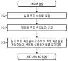
도 5는 본 발명의 실시예에 따른 사용자에게 하나 이상의 최적 루트들을 결정하여 사용자에게 출력하는 과정을 나타내는 흐름도이다.
도 6은 본 발명의 실시예에 따라 사용자 프로파일을 업데이트하는 과정을 나타내는 흐름도이다.
도 7은 본 발명의 예시적인 실시예에 따라 잠재적 루트의 속성을 계산하기 위해 사용된 상관관계를 업데이트하는 과정을 나타내는 흐름도이다.BRIEF DESCRIPTION OF THE DRAWINGS Aspects of the exemplary embodiments can be better understood with reference to the accompanying drawings. The components of the drawings are not necessarily expanded to scale, emphasis instead being placed upon illustrating the principles of the exemplary embodiments, wherein:
1 is a diagram illustrating a structure of an interactive telematics system according to an embodiment of the present invention.
2 is a block diagram illustrating an interactive telematics system in accordance with an embodiment of the present invention.
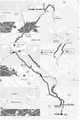
Figure 3 is a diagram showing three potential routes from the origin to the destination.
4 is a diagram showing a fourth potential route from a source to a destination.
5 is a flowchart illustrating a process of determining one or more optimal routes to a user and outputting the determined routes to a user according to an embodiment of the present invention.
6 is a flowchart illustrating a process of updating a user profile according to an embodiment of the present invention.
7 is a flow diagram illustrating a process for updating a correlation used to compute the attributes of a potential root in accordance with an exemplary embodiment of the present invention.
이제 본 발명의 예시적인 실시예의 다양한 측면들을 나타내는 도면을 참조한다. 본원의 도면 및 설명에서, 특정 용어는 단지 편의상 사용되었으며 본 발명의 실시예를 제한하는 것으로 간주되어서는 안 된다. 또한, 도면 및 이하의 설명에서, 동일한 참조 번호는 동일한 요소를 지칭한다.Reference is now made to the drawings illustrating various aspects of an exemplary embodiment of the present invention. In the drawings and description herein, certain terminology is used for convenience only and should not be construed as limiting the embodiments of the present invention. Also, in the drawings and the description below, the same reference numerals refer to the same elements.
도 1은 본 발명의 일 실시예에 따른 인터랙티브 텔레매틱스 시스템의 구조를 도시한 도면이다.1 is a diagram illustrating a structure of an interactive telematics system according to an embodiment of the present invention.
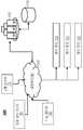
도 1에 도시된 바와 같이, 아키텍처(100)는 하나 이상의 네트워크(130)를 통해 하나 이상의 서버(140) 및 하나 이상의 저장 장치(150)와 통신하는 원격 장치(120)를 포함한다. 아래에서 상세히 설명하는 바와 같이, 시스템은 텔레매틱스 정보를 원격 장치들(120)에 출력하도록 구성된다.As shown in FIG. 1, an
원격 장치(120)는 하나 이상의 네트워크(130)를 통해 하나 이상의 서버(140)로부터 정보를 수신하도록 구성된 임의의 적합한 컴퓨팅 장치를 포함한다. 원격 장치는 예를 들어 스마트 폰, 데스크탑 컴퓨터, 노트북 컴퓨터, 차량 내 내비게이션 장치, 독립형 내비게이션 장치 등을 포함할 수 있다. 각각의 원격 장치(120)는 하나 이상의 프로세서(예를 들어, 중앙 처리 장치, 그래픽 프로세싱부 등), 하나 이상의 저장 장치(예를 들어, 랜덤 액세스 메모리(random access memory), 읽기 전용 메모리(read-only memory), 솔리드 스테이트 메모리(solid state memory), 하드 디스크 등)뿐만 아니라 적어도 하나의 입력 장치(예를 들어, 키보드, 마우스 등) 및 출력 장치(예를 들어, 디스플레이) 또는 입출력 장치(예를 들어, 터치 스크린)에 연결할 수 있다. 원격 장치들(120) 및/또는 네트워크(들)(130)은, 예를 들어, 위성 위치 확인 시스템(GPS), 네트워크 식별, 셀룰러 네트워크 삼각 측량 등을 사용하여 원격 장치들(120) 중 적어도 일부의 실시간 위치를 결정할 수 있다.The remote device 120 includes any suitable computing device configured to receive information from one or
하나 이상의 서버들(140)은 여기에 설명된 기능을 수행하기 위한 명령을 실행하는 임의의 적절한 컴퓨팅 장치를 포함할 수 있다. 하나 이상의 서버들(140)은 내부 저장 장치 및 하나 이상의 컴퓨터 프로세서를 포함할 수 있다. 하나 이상의 저장 장치들(150)은 또한 하드 디스크, 고체형 메모리 등과 같은 일시적이지 않은 컴퓨터 판독 가능 저장 매체를 포함할 수 있다. 네트워크(130)는 하나 이상의 서버들(140)이 원격 장치들(remove devices)(120)로의 전송을 위한 정보를 출력할(또한 원격 장치들(120)로부터 정보를 수신할) 수 있게 하는 하나 이상의 단거리 또는 장거리 데이터 연결을 포함할 수 있다. 데이터 연결은 유선 및/또는 무선 데이터 연결을 포함할 수 있다. 네트워크(130)는 하나 이상의 근거리 통신망들 또는 광역 통신망(예를 들어 셀룰러 네트워크, 인터넷)을 포함할 수 있다.One or more of the
여기에 설명된 기능을 수행하기 위해, 하나 이상의 서버(140)는 제3 자 소스로부터 정보를 수신할 수 있다.In order to perform the functions described herein, one or
하나 이상의 서버들(140)은 과거 및 현재 교통 데이터(170)를 수신할 수 있다. 과거 교통 데이터(170)는 예를 들어(연방, 주 및/또는 지방) 정부 기관, 자동차 협회(예를 들어 미국 자동차 협회) 등으로부터 수신될 수 있다. 현재 교통 데이터(170)는 예를 들어, 정부 기관, 사설 교통 관리 기관 등으로부터 수신될 수 있다.One or
하나 이상의 서버들(140)은 정적 및/또는 동적 도로 상태 데이터(180)를 수신할 수 있다. 도로 상태 데이터는 예를 들어 정부 기관(예를 들어, 연방, 주 및 지방 교통 부서, 미국 지질 조사국의 지형 정보), 개인 교통 관리 단체 등에서 수신할 수 있다.One or
하나 이상의 서버들(140)은 현재, 이력 및 예측된 기상 데이터(190)를 수신할 수 있다. 날씨 데이터(190)는 AccuWeather Enterprise Solutions, Inc., 미국 환경 보호국(U. S. Environmental Protection Agency; EPA), 기상청(National Weather Service; NWS), 국립 허리케인 센터(National Hurricane Center; NHC), 캐나다 환경 캐나다, 영국 기상청, 기상청 등의 정부 기관, 기타 민간 기업(예를 들어, Vaisalia의 미국 내셔널 라이트닝 탐지 네트워크, Weather Decision Technologies, Inc.), 개인(예를 들어, Spotter 네트워크 회원) 등과 같은 제 3 자로부터 수신될 수 있다.One or more of the
도 2는 본 발명의 일 실시예에 따른 인터랙티브 텔레매틱스 시스템(200)을 나타낸 블록도이다.2 is a block diagram illustrating an
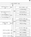
도 2에 도시된 바와 같이, 인터랙티브 텔레매틱스 시스템(200)은 분석부(230) 및 지리 정보 시스템(GIS) (232), 사용자 프로파일 데이터베이스(240), 로드웨이 데이터베이스(250) 및 장치 위치 데이터베이스(260)를 포함한다. 인터랙티브 텔레매틱스 시스템(200)은 또한 교통 데이터베이스(270), 도로 상태 데이터베이스(280) 및 기상 상태 데이터베이스 (290)를 포함할 수 있다. 사용자 프로파일 데이터베이스(240)는 사용자 프로파일들(242)을 포함하고 또한 차량 프로파일들(244)을 포함할 수 있다. 교통 상태 데이터베이스(270)는 과거 교통 상태들(272) 및 현재 교통 상태들(274)을 포함한다. 교통 상태 데이터베이스(270)는 또한 인터랙티브 텔레매틱스 시스템(200)에 의해 결정된 예측된 교통 상태들(276)을 포함할 수 있다. 도로 상태 데이터베이스(280)는 정적 도로 상태(282)를 포함하고 또한 동적 도로 상태(284)를 포함할 수 있다. 기상 상태 데이터베이스(290)는 과거 기상 상태(292), 현재 기상 상태들(294) 및 예측된 기상 상태들(296)를 포함한다.2, the
분석부(230)는 여기에 설명된 기능을 수행하는 임의의 적합한 컴퓨팅 장치 및/또는 컴퓨터 실행 가능 소프트웨어 명령을 포함할 수 있다. 분석부(230)는 하나 이상의 서버들(140)과 같은 하드웨어 요소들 및/또는 하나 이상의 서버들(140)에 의해 액세스 가능하고 이들에 의해 실행되는 소프트웨어 명령들에 의해 실현될 수 있다.The
지리 정보 시스템(Geographic Information System; GIS)(232)은 지리적 데이터를 캡처, 저장, 조작, 분석, 관리 및/또는 제시하도록 설계된 임의의 적합한 컴퓨팅 장치 및/또는 컴퓨터 실행 가능 소프트웨어 명령일 수 있다. (지리 정보 시스템(Geographic information systems)을 지리학 정보 시스템(geographical information systems)이라고도 한다.) GIS(232)는 하나 이상의 서버(140)에 의해 실행되는 특수 목적 하드웨어 및/또는 소프트웨어 명령들에 의해 실현될 수 있다.The Geographic Information System (GIS) 232 may be any suitable computing device and / or computer-executable software instructions designed to capture, store, manipulate, analyze, manage and / or present geographic data. (Geographic information systems are also referred to as geographical information systems.) The GIS 232 may be implemented by special purpose hardware and / or software instructions that are executed by one or
추가적으로 또는 대안적으로, 인터랙티브 텔레매틱스 시스템(200)은 구글 맵, 어시(Ersi) 등과 같은 제3 자 GIS를 사용할 수 있다.Additionally or alternatively, the
사용자 프로파일 데이터베이스(240), 로드웨이 데이터베이스(250), 장치 위치 데이터베이스(260), 교통 상태 데이터베이스(270), 도로 상태 데이터베이스(280) 및 기상 상태 데이터베이스(290)는 임의의 조직화된 정보 수집일 수 있고, 여기서 단일 유형의 장치 또는 여러 유형의 장치에 저장된다. 사용자 프로파일 데이터베이스(240), 로드웨이 데이터베이스(250), 장치 위치 데이터베이스(260), 교통 상태 데이터베이스(270), 도로 상태 데이터베이스(280) 및 기상 상태 데이터베이스(290)는 예를 들어, 저장 장치들(150) 중 하나 이상에 저장될 수 있다. The user profile database 240, the roadway database 250, the
사용자 프로파일 데이터베이스(240)는 복수의 사용자 프로파일들(242)을 저장하며, 각각의 사용자 프로파일(242)은 사용자의 선호하는 주행 거동 및/또는 선호 루트들을 결정하기 위해 인터랙티브 텔레매틱스 시스템(200)에 의해 사용되는 정보를 포함한다. 각각의 사용자 프로파일(242)은 예를 들어, 연령 및 성별, 알려진 의학적 상태, 주행 경험 수준, 행동 유형, 위험 역경, 순항 속도, 다양한 교통 상태에 대한 응답과 같은 경향 및 선호도와 같은 인구 통계학적 정보, 반응역효과 및 잠재적으로 위험한 운전 상태에 대한 반응, 운전자와의 통상적인 공동 거주자(예를 들어, 사용자가 혼자 운전하는 경우, 어린이, 노인, 건강 상태가 알려진 사람들 등), 운전 기록, 현재 유형의 보험 커버리지, 및 사용자의 선호하는 주행 거동 및 바람직한 루트와 관련하여 인터랙티브 텔레매틱스 시스템(200)에 의해 결정되는 다른 인자들을 포함할 수 있다. 각각의 사용자 프로파일(242)은 (예를 들어, 사용자의 원격 장치(120)의 실시간 위치에 의해 추론되는 사용자의 운전 행동에 기초하여) 사용자로부터 직접 수신된 정보 및/또는 인터랙티브 텔레매틱스 시스템(200)에 의해 결정된 정보를 포함할 수 있다.The user profile database 240 stores a plurality of user profiles 242 and each user profile 242 is used by the
사용자 프로파일 데이터베이스(240)는 또한 인터랙티브 텔레매틱스 시스템(200)의 사용자에 의해 사용되는 차량과 관련된 복수의 차량 프로파일들(244)을 저장할 수 있다. 각각의 차량 프로파일(244)은 차량 프로파일(244)과 관련된 차량을 주행할 때 사용자의 선호하는 주행 거동 및/또는 바람직한 루트를 결정하기 위해 인터랙티브 텔레매틱스 시스템(200)에 의해 사용되는 정보를 포함할 수 있다. 각각의 차량 프로파일(244)은, 차량 높이(vehicle height), 차량 유형(예를 들어, 세단 형, 컨버터블 형, 트럭 형 등) 차량 연료 요건(예를 들어, 디젤 및 디젤 등급, 휘발유 및 휘발유 등급, 액화 천연 가스 등), 차량 수명, 차량 중량, 차량 변속 유형(자동, 수동), 차량 구동 트레인(예를 들어, 2 륜 구동, 4륜 구동, 전(全) 륜구동 등), 차량 서비스/유지 보수 내역, 필요한 차량 유지 보수(예를 들어, 차량의 알려진 문제와 관련된 정보) 등과 같은 차량 프로파일(244)과 관련된 차량의 속성을 포함 할 수 있다. 차량 프로파일들(244)은 사용자로부터의 정보에 기초하여 결정될 수 있다. 예를 들어, 사용자는 모바일 폰 애플리케이션, 온라인 양식 등을 통해 인터랙티브 텔레매틱스 시스템(200)에 의해 제기된 질문에 응답함으로써 차량 프로파일(244)에서 사용하기 위한 정보를 제공할 수 있다. 사용자는 동일한 세대에서 다른 사용자(또는 여러 사용자)가 사용하는 하나 이상의 차량에 대한 정보를 입력할 수 있다.The user profile database 240 may also store a plurality of vehicle profiles 244 associated with the vehicle used by the user of the
로드웨이 데이터베이스(250)는 교통 흐름(예를 들어, 평행 접근 도로, 통과 차선, 온- 및 오프-램프 등)을 조정하기 위한 이용 가능한 기회를 포함하여 현재 도로의 데이터 세트를 포함한다. 현재 도로의 데이터 세트는 정부 기관, 사설 교통 관리 단체 등에서 받을 수 있다.The roadway database 250 includes a data set of the current road including available opportunities to adjust traffic flows (e.g., parallel access roads, passing lanes, on-and off-ramps, etc.). The current road data set can be obtained from government agencies, private traffic management organizations, and so on.
장치 위치 데이터베이스(260)는 원격 장치(120) 중 적어도 일부의 실시간 위치를 나타내는 정보를 포함한다. 원격 장치(120)의 실시간 위치는, 예를 들어, 위성 위치 확인 시스템(GPS), 네트워크 식별, 셀룰러 네트워크 조정 등을 이용하여 원격 장치 및/또는 네트워크(들)(130)에 의해 결정될 수 있다. 또한, 장치 위치 데이터베이스(260)는 원격 장치(120) 중 적어도 일부의 실시간(또는 거의 실시간) 동적 위치를 나타내는 정보를 포함하도록 자동 및/또는 반복적으로 업데이트될 수 있다.The
교통 상태 데이터베이스(270)는 과거 교통 상태들(272) 및 현재 교통 상태들(274)에 관한 정보를 포함한다. 교통 상태들(272 및 274)은 예를 들어, 로드웨이 데이터베이스(250)에 포함된 도로들의 포인트들 및/또는 세그먼트들에서의 교통의 속도 및 볼륨, 그 교통의 구성(예를 들어, 장거리 트랙터 트레일러, 승용차, 예고편, 오토바이 등을 당기는 픽업 트럭), 충돌 위치, 충돌의 특성 및 심각도 등을 포함할 수 있다. 교통 상태들(272 및 274)에 관한 각각의 데이터 포인트는 그 데이터 포인트의 날짜 및 시간과 함께 저장된다. 과거 및 현재의 교통 상태들(272 및 274)은 원격 장치들의 실시간 위치에 기초하여 제3자 소스들(예를 들어, 상술된 교통 데이터(170))로부터의 정보에 기초하여 결정되고 또는/추가로 원격 장치(120)의 실시간 위치(예를 들어, 원격 장치(120)의 속도, 원격 장치(120)가 빈번하게 정지하는지 여부 등)에 기초하여 인터랙티브 텔레매틱스 시스템(200)에 의해 결정될 수 있다. 아래에서 상세히 설명되는 바와 같이, 인터랙티브 텔레매틱스 시스템(200)은 또한 충돌의 추정 우도를 포함하는 예측된 교통 상태(276)를 결정 및 저장하기 위해 과거 교통 상태들(272) 및 현재 교통 상태들(274)(뿐만 아니라 추가적 정보)을 사용할 수 있다.The traffic status database 270 includes information on past traffic conditions 272 and current traffic conditions 274. [ Traffic conditions 272 and 274 may include, for example, the speed and volume of traffic at points and / or segments of roads included in roadway database 250, the configuration of the traffic (e.g., A pickup truck pulling a trailer, a passenger car, a trailer, a motorcycle, etc.), a crash location, the nature and severity of the crash, and the like. Each data point for traffic conditions 272 and 274 is stored with the date and time of the data point. Past and present traffic conditions 272 and 274 are determined based on information from third party sources (e.g.,
도로 상태 데이터베이스(280)는 로드웨이 데이터베이스(250)에 포함된 도로의 세그먼트에 대한 정적 도로 상태(282)를 포함한다. 정적 도로 상태들(282)은 예를 들어, 응용 교통 법규들(예를 들어, 속도 제한, 허가된 차량 유형 등), 로드웨이 유형(예를 들어, 다중 차선 주간 고속도로, 2 차선 도로, 1 차선 카운티 로드웨이 등), 고가도로, 위치(예를 들어, 사막, 산, 교외, 도시 등), 표면 구성(예를 들어, 아스팔트, 콘크리트, 자갈 복합체 등), 야간 조명 양 등을 포함할 수 있다. 정적 도로 상태들(282)은 제3자 소스들(예를 들어, 전술한 도로 상태 데이터(180))로부터 수신된 정보 및/또는 사용자들로부터의 피드백에 기초하여 인터랙티브 텔레매틱스 시스템(200)에 의해 결정될 수 있다.The road state database 280 includes a static road state 282 for a segment of a road included in the roadway database 250. Static road conditions 282 may include, for example, application traffic laws (e.g., speed limits, authorized vehicle type, etc.), roadway type (e.g., multiple lane interstate highway, County roadway, etc.), elevated roads, locations (e.g., desert, mountains, suburbs, cities, etc.), surface features (e.g., asphalt, concrete, gravel composites, etc.) Static road conditions 282 may be generated by the
도로 상태 데이터베이스(280)는 또한 로드웨이 데이터베이스(250)에 포함된 도로의 세그먼트에 대한 동적 도로 상태들(284)을 포함할 수 있다. 동적 도로 상태들(284)은 예를 들어, 표면 상태(예를 들어, 습기, 눈 덮힌 곳, 얼음이 많은 곳 등), 표면 온도, 표면 유지 상태(예를 들어, 적절하게 유지 보수 또는 열악한 수리), 건축 활동(예를 들어, 건설 활동의 위치 및 특성), 로드웨이 또는 로드웨이의 구간이 폐쇄되는 기간(예를 들어, 휴양) 등을 포함할 수 있다. 인터랙티브 텔레매틱스 시스템(200)은 센서들(예를 들어, 기상 및/또는 환경 센서들)로부터 수신된 정보, 제3자 소스(예를 들어, 전술한 도로 상태 데이터(180) 및/또는 날씨 데이터(190))로부터 수신된 정보, 사용자 의견 등에 기초하여 동적 도로 상태들(284)을 결정할 수 있다. 동적 도로 상태들(284)에 관한 데이터 포인트들은 그 데이터 포인트의 날짜와 함께 저장될 수 있다. 또한, 동적 도로 상태들(284)에 관한 데이터 포인트들은 그 데이터 포인트의 시간과 함께(예를 들어, 동적 도로 상태(284)가 하루 동안 적용 가능하지 않은 경우)저장될 수 있다.The road state database 280 may also include dynamic road conditions 284 for segments of roads included in the roadway database 250. The dynamic road conditions 284 may include, for example, surface conditions (e. G., Moisture, snow covered, iced, etc.), surface temperatures, surface maintenance conditions ), Construction activities (e.g., location and characteristics of construction activities), periods of roadway or roadway closure (e.g., recreation), and the like. The
기상 상태 데이터베이스(290)는 임의의 대기, 환경, 지리적 및/또는, 과거 기상 상태(292), 현재 기상 상태(294) 및 예측 기상 상태들(296)를 포함하는, 과거 교통 상태들 (272)에 영향을 줄 수 있거나, 현재의 교통 상태 (274)에 영향을 줄 수 있거나, 또는 미래의 교통 상태에 영향을 줄 수 있는 지질 상태에 관한 임의의 정보를 포함한다. 기상 상태는 온도, 강수량, 시정(visibility), 풍속 및 방향 등과 같은 날씨 파라미터를 포함할 수 있다. 예측된 기상 상태들(296)은 인터랙티브 텔레매틱스 시스템(200)에 의해 결정되거나 일기 예보 시스템 또는 제3자로부터 수신될 수 있다. 예측된 기상 상태들(296)은 AccuWeather의 MinuteCast 시스템을 사용하여 생성된 위치 별, 분별 예측일 수 있다(MINUTECAST는 AccuWeather, Inc.의 등록 서비스 마크입니다). 또한, 기상 상태 데이터베이스(290)는 지리적 상태들(예를 들어, 계획된 루트를 따라 눈부신 가능성)을 포함한다. 환경 상태들(예를 들어, 조류와 같은 동물의 알려진 서식지 또는 계획된 주행 경로), 지질학적 상태들(예를 들어, 지진의 과거 위치 및 향후 잠재적 위치) 등을 포함할 수 있다.The weather state database 290 includes historical traffic conditions 272 including any atmospheric, environmental, geographical and / or past weather conditions 292, current weather conditions 294 and forecast weather conditions 296. [ Or any information relating to the geological conditions that may affect the current traffic condition 274 or affect future traffic conditions. The weather conditions can include weather parameters such as temperature, precipitation, visibility, wind speed and direction, and the like. The predicted weather conditions 296 may be determined by the
현재의 교통 상태(274), 동적 도로 상태(284) 및/또는 현재 기상 상태들(294)은 또한 원격 장치들(120), 차량들 및/또는 개인들로부터 수신된 정보에 기초하여 결정될 수 있다. 일 실시 예에서, 인터낼티브 텔레매틱스 시스템(200)은, 현재 교통 상태들(274), 동적 도로 상황들(284), 및/또는 현재의 기상 상태들 (294)을 결정할 때, 이미지 및/또는 설명과 같은 개인으로부터의 포인트 관측을 수신 및 해석 할 수 있고, 포인트 관측(사용자의 위치뿐만 아니라)으로부터의 정보를 통합할 수 있다. 포인트 관측은(예를 들어, 원격 장치(120)의 그래픽 사용자 인터페이스를 사용하여) 인터랙티브 텔레매틱스 시스템(200)으로 전송하기 위해 사용자에 의해 출력될 수 있다. 추가적으로 또는 대안 적으로, 인터랙티브 텔레매틱스 시스템(200)은 소셜 미디어, 다른 공개적으로 이용 가능한 소스 및/또는 전용 제3자 소스로부터 포인트 관측을 수집할 수 있다. 다른 예에서, 대화 형 텔레매틱스 시스템 (200)은 현재 교통 상태들(274), 동적 도로 상태들(284), 및/또는 현재 기상 상태들(294)을 결정할 때, 차량으로부터 정보를 수신하여 해석하고 그 정보(차량의 위치뿐만 아니라)를 통합할 수 있다. 차량으로부터의 정보는 차량 날씨 센서(예를 들어, 외부 온도 및 레인 센서)로부터의 센서 데이터, 차량 기상 도로 상태 센서(예를 들면, 젖은 또는 눈으로 덮인 도로 또는 차량 견인력을 결정하기 위해 차량 안티 록 브레이크 시스템에 의해 사용되는 센서)로부터의 센서 데이터, 다른 차량 센서(예를 들어, 카메라)로부터의 센서 데이터, 차량 표시등이 주간에 켜져 있음을 나타내는 정보(시감도 감소 표시), 차량 앞 유리 와이퍼가 켜져 있다는 정보(비를 나타냄) 등을 포함할 수 있다. 차량으로부터의 정보는 차량과 쌍을 이루는(예를 들어, 블루투스를 통해) 차량 내 원격 장치(120) 등을 통해 인터랙티브 텔레매틱스 시스템(200)에 출력될 수 있다.The current traffic state 274, dynamics road state 284 and / or current weather conditions 294 may also be determined based on information received from remote devices 120, vehicles and / or individuals . In one embodiment, the
인터랙티브 텔레매틱스 시스템(200)은 그 사용자에 대한 사용자 프로파일에 저장된 그 사용자의 특성에 기초하여 사용자에 대한 최적화된 주행 루트를 결정한다. 이 시스템은 도 3에 도시된 세 개의 루트를 참조하여 설명될 것이다.The
도 3은 루트(301), 루트(302) 및 루트(303)을 포함하는 출발지 위치(310)에서 목적지 위치(390)까지의 세 개의 잠재적 루트를 도시한다. 루트(301, 302 및 303)의 각각은 GIS(232)를 사용하는 로드웨이 데이터베이스(250)에 저장된 정보에 기초하여 분석부(230)에 의해 결정된다.Figure 3 shows three potential routes from the originating
도 3에 도시된 바와 같이, 루트(301)는 길이가 24.9 마일이고, 1 시간 9 분의 예측 주행 시간(후술하는 분석부(230)에 의해 결정됨)을 갖는다. 루트(302)의 길이는 22.1 마일이며 예측 소요 시간은 1 시간 2 분이다. 루트(303)의 길이는 22.3 마일이며 예측 소요 시간은 1 시간이다. 인터랙티브 텔레매틱스 시스템(200)은 길이 I 및 추정된 주행 시간 t 이외에, 인터랙티브 텔레매틱스 시스템(200)은, 예를 들어, 각 루트(또는 반대로 안전 s)와 잠재적 혼잡(c), 경치가 좋은지 여부(경치 p), 루트가 밤에 잘 점등되는지 여부(밝기 b) 등과 각각의 잠재적 루트의 다른 속성을 결정한다. 예를 들어, 분석부(230)는 이들 속성 각각을 표 1에 나타낸 수치로 감소시킬 수 있다.As shown in Fig. 3, the

표 1Table 1
특정 루트 n이 특정 사용자에게 호소력을 가지면 다음 수학식 1과 같이 Xn으로 수학적으로 표현될 수 있다.If a particular root n has a appeal to a particular user, it can be expressed mathematically as Xn as: < EMI ID = 1.0 >
Xn = Aln + Btn + Csn + Dbn + Ecn + Fpn ...Xn = Aln + Btn + Csn + Dbn + Ecn + Fpn ...
여기서 A, B, C, D, E, F 등은 다른 속성들에 대하여 각 속성에 대한 사용자 선호를 나타내는 계수이다. 다시 말해, 비율 B : A는 최적의 주행 루트를 결정할 때 사용자가 예측 주행 시간 tn을 거리 ln에 얼마나 가중시킬지를 나타낸다. 유사하게, 비율 B : C는 사용자가 안전 sn(즉, 사용자의 위험 회피)에 대한 예측된 주행 시간 tn의 가중치 나타내고, 비율 B : D는 사용자가 잘 점등된 도로를 주행하는 지에 대한 예측된 주행 시간 tn을 얼마나 많이 비추었는지의 가중치 나타내고(높이 bn을 가진), 비율 B : E는 정체 cn에 대한 사용자가 예측된 주행 시간 tn 의 가중치를 나타내고(예를 들어, 사용자가 더 긴 드라이브를 선호하여 얼마나 짧은 거리로 주행 하는지를 얼마나 많이 바라는지), 비율 B : F는 사용자가 풍경 pn에 대한 예측된 주행 시간 tn 를 얼마나 선호하는지(예를 들어, 사용자가 좋은 뷰로 더 긴 드라이브를 얼마나 선호하는지 여부 및 그 정도) 등을 나타낸다.Where A, B, C, D, E, F, etc. are coefficients representing user preferences for each attribute for other attributes. In other words, the ratio B: A indicates how much the user will add the predicted running time tn to the distance ln when determining the optimal running route. Similarly, the ratio B: C represents the weight of the predicted running time tn for the safety sn (i.e., the user's risk avoidance) by the user, and the ratio B: D represents the predicted running time of the user the travel time tn represents the weight of the shed how much whether the (heights with bn), the ratio B: E denotes a user and the weight of the predicted travel time tn to the congestion cn (for example, users are more How long the user desires the long drive and how far he or she wants to travel), the ratio B: F indicates how much the user prefers the estimated driving time tn for the landscape pn (e.g., How much the drive prefers, and so on).
분석부(230)는 각 후보 루트에 대한 각 속성 ln, cn 등을 결정한다. 속성들의 일부는 시간에 따라 변할 수 있기 때문에, 인터랙티브 텔레매틱스 시스템(200)은 사용자가 원격 장치(120)를 사용하여 그래픽 사용자 인터페이스를 통해 출발 시간(또는 추가적으로 예측된 도착 시간)을 특정하는 기능을 제공할 수 있다. 물론, 인터랙티브 텔레매틱스 시스템(200)은 현재 시간을 출발 출발 시간으로 사용할 수 있다.The
분석부(230)는 각 루트의 거리(ln)를 결정하기 위해 출발 위치(310)에서 목적지 위치(390)까지의 루트를 단순하게 그려서 GIS(232)를 사용하여 루트의 선형 길이를 측정한다.
출발 시간이 현재 시간이면, 분석부(230)는 현재의 교통 상태(274)에 기초하여 잠재적 혼잡(cn)을 결정한다. 그러나 사용자가 루트를 따라 주행하는데 소요되는 시간 동안 정체가 다를 수 있으므로, 분석부(230)는 추가적으로, 과거의 기상 상태들(292)이 현재의 기상 상태들(294) 및/또는 예측된 기상 상태들(294)과 유사할 때(사용자가 루트의 해당 부분을 따라 주행 할 것으로 예측되는시기에 따라), 동적 도로 상태들(284)이 현재의 동적 도로 상태들(284) 등과 유사할 때, 하루 중 유사한 시간대, 주중 유사한 날, 연중 유사한 날(예를 들어, 휴일 또는 비-휴일)의 루트를 따라 과거의 교통 상태들(272)에 기초하여 잠재적 혼잡을 추가적으로 결정할 수 있다. 또한, 분석부(230)는, 과거의 기상 상태들(292)이 현재의 기상 상태들(294) 및/또는 예측된 기상 상태들(294)과 유사할 때(사용자가 루트의 해당 부분을 따라 주행 할 것으로 예측되는시기에 따라), 동적 도로 상태들(284)이 현재의 동적 도로 상태들(284) 등과 유사할 때, 하루 중 유사한 시간, 주중 유사한 날에, 연중 유사한 날(예를 들어, 휴일 또는 비-휴일)의 다른 유사한 도로(즉, 유사한 정적 도로 상태들(282)을 갖는 로드웨이)의 과거의 교통 상태(272)에 기초하여 잠재적 혼잡(cn)을 결정할 수 있다.If the departure time is the current time,
분석부(230)는 상술한 바와 같이 분석부(230)에 의해 결정된 잠재적 혼잡량(cn)에 반비례하는 루트의 길이 및 차량의 예측된 주행 속도에 기초하여 예측된 주행 시간(tn)을 결정한다.The
잠재적 혼잡(cn) 결정과 유사하게, 분석부(230)는 또한 과거 교통 상태들 (272)에 기초하여 각 루트의 안전성(sn)을 결정한다. 하지만, 분석부(230)는 루트 상의 과거 충돌(과거의 교통 상태(272)의 서브 세트)에 기초하여 루트의 안전(sn)을 결정한다.Similar to the determination of potential congestion (cn ),
과거 기상 상태들(292)이 현재 기상 상태들(294) 및/또는 예측된 기상 상태들(294)과 유사할 때(사용자가 그 루트 부분을 따라 주행할 것으로 예상되는 때에 따라), 동적 도로 상태들(284)이 현재의 동적 도로 상태들(284) 등과 유사할 때, 예를 들어 하루 중 유사한 시간대, 주중 유사한 날, 연중 유사한 날(예를 들어, 휴일 또는 비-휴일)일 경우, 과거의 충돌에 더 많은 가중치가 주어질 수 있다.When the past weather conditions 292 are similar to the current weather conditions 294 and / or the predicted weather conditions 294 (as the user is expected to travel along that portion of the route) (E.g., holiday or non-holiday), when the time of day 284 is similar to the current dynamic road conditions 284, etc., for example, a similar time of day, a similar day of the week, More weight can be given to collisions.
또한, 분석부(230)는, 과거 기상 상태들(292)이 현재 기상 상태들(294) 및/또는 예측된 기상 상태들(294)과 유사할 때(사용자가 그 루트 부분을 따라 주행할 것으로 예상되는 때에 따라), 동적 도로 상태들(284)이 현재의 동적 도로 상태들(284) 등과 유사할 때, 하루 중 유사한 시간대, 주중 유사한 날, 연중 유사한 날(예를 들어, 휴일 또는 비-휴일)에, 유사한 로드웨이(즉, 유사한 정적 도로 상태들(282)을 갖는 로드웨이)를 따라 과거의 충돌에 기초하여 루트의 안전(sn)을 더 결정할 수 있다.The
분석부(230)는 잠재적 혼잡도(cn), 예측된 주행 시간(tn) 및 각 루트의 안전(sn)을 결정할 때마다, 이들 계산을 예측된 교통 상태들(276)로서 저장할 수 있다. 이러한 계산을 위한 기간 후, 분석부(230)는 예측된 교통 상태들(276)을 실제 교통 상태들(즉, 비교가 일어날 때에 따라, 현재 교통 상태들(274) 또는 과거 교통 상태들(272)) 및 해당 루트를 따라가는 실제 소요 시간과 비교할 수 있다. 계산의 정확성에 따라, 분석부(230)는 이들 계산을 위해 사용된 상관관계를 더 정제할 수 있다.The
분석부(230)는 루트의 각 부분에 대한 정적 도로 상태들(282)에 기초하여 루트가 어떠한 경치(즉, 풍경 pn) 및/또는 얼마나 밝게(즉, 밝기 bn)에 있는지를 결정할 수 있다. 풍경(pn)은 낮 동안에만 관련될 수 있고 밝기 (bn)은 야간에만 관련되기 때문에, 분석부(230)는 하루 중 시간에 기초하여 이들 요소들을 변화시킬 수 있다.
대안적으로, 분석부(230)는 하루 중 시간에 기초하여 이들 속성(예를 들어, 계수 D 및 E)에 관한 사용자 선호도를 변경할 수 있다.Alternatively,
분석부(230)에 의해 사용자 선호 운동 행동 및/또는 선호 루트(예를 들어, 계수 A, B, C, D, E, F 등을 결정하기 위해 사용되는 정보 및/또는 비율 B : A, B : C, B : D, B : E, B : F 등)는 사용자와 관련된 사용자 프로파일(242)에 저장된다. 분석부(230)는 예를 들어 사용자로부터 직접 수신된 정보에 기초하여 (예를 들어, 원격 장치(120)를 사용하여 그래픽 사용자 인터페이스를 통해 사용자에 의해 제공된 그래픽 사용자 인터페이스를 통해 사용자가 정보를 입력하는 기능을 제공함으로써) 이들 사용자 선호도를 결정할 수 있다. 예를 들어, 그래픽 사용자 인터페이스는 사용자가 밤에 조명이 좋은 도로(즉, 낮은 밝기 bn)를 선호하는지 여부, 비가 올 밤에는 조명이 좋은 도로를 선호하는지 여부 등, 주행 거리 ln에 대한 경치(pn) 및/또는 안전(sn)에 대한 사용자의 선호도에 대한 직접적인 질문을 사용자에게 제기할 수 있다.The information and / or the ratio B: A, B (for example, used to determine the coefficients A, B, C, D, E, F and the like) : C, B: D, B: E, B: F, etc.) are stored in the user profile 242 associated with the user. The
또한, 사용자 프로파일(242)은 특정 루트에 직접 적용 가능한 정보를 저장할 수 있다. 다시 도 3을 참조하면, 예를 들어, 부모는 새로운 운전자가 루트(301)의 일부를 따라 주행하는 것을 허용하지 않을 수 있다. 따라서, 인터랙티브 텔레매틱스 시스템(200)은 특정 로드웨이 또는 로드웨이의 일부가 피해야 함을 특정하기 위해 사용자(예를 들어, 새로운 운전자) 또는 다른 사용자(예를 들어, 부모)를 위한 기능을 제공할 수 있다. 따라서, 분석부(230)는 이러한 로드웨이를 피하는 루트만을 출력할 것이다.In addition, the user profile 242 may store information applicable directly to a particular route. Referring back to FIG. 3, for example, the parent may not allow a new driver to travel along a portion of the
또한, 분석부(230)는 사용자에게 최적화된 루트를 제공하는 과정에서(예를 들어, 도 3에 도시된 바와 같이) 보다 많은 다중 루트 옵션을 사용자에게 제공하고, 사용자가 루트들 중 하나를 선택하게 하고, 사용자가 선택하지 않기로 선택한 루트의 속성과 관련하여 선택된 루트의 속성을 선호하는 사용자 선택에서 유추한다. 또한, 분석 유닛(230)은(장치 위치 데이터베이스(260)에 저장된 바와 같이) 사용자와 관련된 원격 장치(120)의 실시간 위치를 나타내는 정보에 액세스하기 때문에, 분석부(230)는 사용자가 인터랙티브 텔레매틱스 시스템(200)으로부터 최적화된 루트를 요청하지 않고 루트를 따라 주행하도록 선택했다 할지라도, 사용자가 따라 가기로 선택한 루트의 속성을 선호한다고 추론할 수 있으며, 인터랙티브 텔레매틱스 시스템(200) 등에 의해 제안된 루트로부터 벗어나는 것을 선택한다.In addition, the
또한, 분석부(230)는 사용자가, 성별, 건강 상태, 운전 경험, 운전 기록, 보험, 통상적인 공동 거주자(예를 들어, 어린이, 노인, 질병이 있는 사람들 등)과 같은 사용자와 관련된 사용자 프로파일(242)에 저장된 사용자 프로파일 기준과 유사한 사용자 프로파일 기준 및/또는 예컨대 차량 유형(예를 들어, 세단, 컨버터블, 트럭 등), 차량 연료 요건(예를 들어, 디젤 및 디젤 등급, 휘발유 및 가솔린 등급, 액화 천연 가스 등), 차량 연령, 차량 중량, 차량 트랜스미션 유형(자동, 수동), 차량 구동 장치(예를 들어, 2 륜구동, 4 륜구동, 전륜구동 등), 차량 서비스/유지 관리 내역 및/또는 필수 차량 유지 관리(예를 들어, 차량의 알려진 문제점과 관련된 정보)와 같은 사용자의 차량과 관련된 차량 프로파일(242)에 저장된 차량 프로파일 기준과 유사한 차량 프로파일 기준을 갖는 다른 사용자와 유사한 사용자 선호도를 갖는 것을 유추할 수 있다.The
사용자의 선호 운전 행동 및/또는 선호 루트는 주행 유형에 따라 다를 수 있다. 예를 들어, 사용자는 보다 긴 길이(즉, ln)의 주행을 위해 더 많은 풍경(pn)을 갖는 루트를 선호할 수 있다. 다른 예시에서, 사용자가 특정 차량을 운전할 때 더 안전한 루트(즉, 보다 높은 안전 sn), 보다 적은 고속도로를 갖는 루트 및/또는 보다 낮은 속도 한계를 갖는 루트 등이 있다. 따라서, 분석부(230)는 특정 유형의 주행에 대한 특정 사용자 선호도를 결정할 수 있고, -예를 들어, 특정 주행 유형에 대한 사용자 선호도에 대한 사용자 질문을 하고 사용자가 선택한 루트 및/또는 특정 유형의 주행에 대한 사용자 주도 루트를 기반으로 특정 선호도를 추론함으로써- 이러한 특정 선호도에 기초하여 주행 유형에 대한 최적화된 루트를 결정할 수 있다.The user's preferred driving behavior and / or preferred route may vary depending on the driving type. For example, a user may prefer a route with more scenery (pn ) for driving a longer length (i.e., ln ). In another example, there is a safer route (i.e., higher safety sn ), a route with fewer highways, and / or a route with a lower speed limit when the user is driving a particular vehicle. Thus, the
사용자의 선호하는 운전 행동 및/또는 선호하는 루트는 악천후 상태에 따라 다를 수 있다. 예를 들어, 사용자는 보다 안전한 루트(즉, 보다 높은 안전 sn), 보다 적은 고속도로로의 루트, 및/또는 현재의 기상 상태(294) 및/또는 예측된 기상 상태들(296)가 사용자가 악천후 상태에서 주행할 것이라는 것을 나타내는 경우 속도 제한이 낮은 루트를 선택할 수 있다. 사용자의 특정 선호도는 특정 기상 상태에 따라 다를 수도 있다. 예를 들어, 사용자는 현재의 기상 상태(294) 및/또는 예측된 기상 상태들(296)가 사용자가 비가 내릴 것으로 나타낼 때보다 높은 밝기(bn)를 갖는 루트를 선호할 수 있다. 따라서, 분석부(230)는 악천후 상태 동안의 주행에 대한 특정 사용자 선호도를 결정하고, -예를 들어, 악천후 중 사용자 환경 설정에 관한 특정 질문을 제기하고, 악천후 상태 중 사용자가 선택한 루트 및/또는 사용자 중심 루트를 기반으로 특정 환경 설정을 유추함으로써- 악천후 상태 동안의 주행을 위한 최적 루트를 결정할 수 있다.The user's preferred driving behavior and / or preferred route may vary depending on the bad weather conditions. For example, the user may be able to determine whether the user is in a situationwhere a safer route (i.e., higher safety sn ), less route to the highway, and / or a current weather state 294 and / If it indicates that you will drive in bad weather conditions, you can choose a route with a lower speed limit. The user's preference may vary depending on the specific weather conditions. For example, the user may prefer a route having a higher brightness (bn ) than when the current weather state 294 and / or the predicted weather conditions 296 indicate that the user is going to rain. Thus, the
분석부(230)는 또한 사용자와 관련된 원격 장치(120)의 실시간 위치에 기초하여 사용자가 선호하는 새로운 루트를 습득할 수 있다. 예를 들어, 도 4에 도시된 바와 같이, 사용자는 출발지(310)를 떠날 때 루트(301)를 선택하고, 이후 루트(301)로부터 벗어나기로 결정하고 (인터랙티브 텔레매틱스 시스템(200)이 루트(404)를 제시하지 않았음에도 불구하고) 대신 루트(404)를 따르기로 결정할 수 있다. 나중에 사용자가 유사한 주행을 하고 루트(301)이 옵션으로 제공되는 경우, 분석부(230)는 또한 예를 들어 예측된 주행 시간들(t301 및 t404)과 함께 옵션으로서 루트(404)를 제시할 수 있어, 사용자는 루트(301)를 따라 가야 할지 또는 다시 한번 루트(404)를 선택할지에 대한 정보에 근거한 결정을 내릴 수 있다.The
분석부(230)는 또한 사용자의 차량과 관련된 차량 프로파일(242)에 저장된 차량 프로파일 기준으로부터 직접적으로 최적화된 루트를 결정할 수 있다. 도 3 및 도 4에 도시된 바와 같이, 예를 들어, 루트(302)의 일부는 특정 가중치에 대해 특정 차량 유형(예를 들어, 트럭) 및/또는 차량에 대해 폐쇄될 수 있다. 다른 예시에서, 루트(301)는 특정 높이 이상의 차량에 대해 너무 낮은 고속도로 육교를 포함할 수 있다. 따라서, 분석부(230)은 대체 루트를 제안하고 특정 차량 프로파일 기준을 갖는 차량이 접근할 수 없는 도로를 피하도록 구성될 수 있다.The
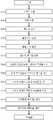
도 5는 본 발명의 예시적인 실시예에 따라 사용자에 대한 하나 이상의 최적화된 루트를 결정하고 이들 루트를 사용자에게 출력하는 프로세스(500)를 나타내는 흐름도이다.5 is a flow diagram illustrating a
사용자(및 연관된 사용자 프로파일(242))는 단계(502)에서 식별된다. 원격 장치(120)가 스마트폰과 같은 개인 장치인 경우, 분석부(230)는 스마트 장치(120)와 연관된 사용자에 기초하여 사용자를 식별한다. 예를 들어, 사용자와 관련된 사용자 프로파일(242)은 원격 장치(120)와 관련된 장치 식별 코드를 포함할 수 있다. 그러나, 일부 예시에서, 원격 장치(120)는 복수의 사용자들(예를 들어, 차량 내 또는 독립형 내비게이션 시스템)에 의해 사용될 수 있다. 이러한 경우에, 인터랙티브 텔레매틱스 시스템(200)은 사용자가 원격 장치(120)의 그래픽 사용자 인터페이스를 사용하여 사용자를 식별하는 기능을 제공할 수 있다.The user (and associated user profile 242) is identified at
일부 실시예에서, 차량(및 연관된 차량 프로파일(244))은 단계(504)에서 식별될 수 있다. 예를 들어, 원격 장치(120)가 차량 내 내비게이션 시스템인 경우, 원격 장치(120)는 차량과 관련된 차량 프로파일(244)과 연관될 수 있다. 다른 예시에서, 인터랙티브 텔레매틱스 시스템(200)은 사용자가 원격 장치(120)의 그래픽 사용자 인터페이스를 사용하여 사용자 차량 중 하나를 선택함으로써 차량을 식별하는 기능을 제공할 수 있다.In some embodiments, the vehicle (and the associated vehicle profile 244) may be identified at
예를 들어, 사용자가 원격 장치(120)의 그래픽 사용자 인터페이스를 사용하여 목적지를 선택하는 기능성을 제공함으로써, 목적지가 단계(506)에서 사용자로부터 수신된다.For example, the destination is received from the user at
출발 위치가 단계(508)에서 결정된다. 사용자가 위치 인식 원격 장치(120)를 사용하는 경우, 인터랙티브 텔레매틱스 시스템(200)은 원격 장치(120)의 현재 위치를 고정 출발 위치로 사용할 수 있다. 그러나, 또한, 인터랙티브 텔레매틱스 시스템(200)은 사용자가 원격 장치(120)의 그래픽 사용자 인터페이스를 사용하여 상이한 출발 위치를 식별하는 기능을 제공할 수 있다.The starting position is determined in
출발 시간은 단계(510)에서 결정된다. 인터랙티브 텔레매틱스 시스템(200)은 현재 시간을 고정 출발 시간으로 사용할 수 있다. 그러나, 또한, 인터랙티브 텔레매틱스 시스템(200)은 사용자가 원격 장치(120)를 사용하여(예를 들어, 그래픽 사용자 인터페이스를 통해 선택함으로써) 상이한 출발 시간 또는 목적지 시간을 식별하는 기능을 제공할 수 있다.The departure time is determined in
출발지에서 목적지까지의 잠재적 루트가 단계(512)에서 결정된다. 인터랙티브 텔레매틱스 시스템(200)은 GIS(232) 및 도로 데이터베이스(250)에 저장된 정보를 사용하여 임의의 수의 잠재적 루트를 결정할 수 있다.A potential route from the origin to the destination is determined at
단계(514)에서 하나 이상의 잠재적 루트가 사용자 프로파일(242)에 저장된 정보에 기초하여 제거될 수 있다. 전술한 바와 같이, 예를 들어, 사용자 프로파일(242)은 특정 로드웨이 또는 로드웨이 일부를 따라 이동하지 않는 것을 (또는 허용되지 않음) 나타낼 수 있다. 따라서, 인터랙티브 텔레매틱스 시스템(200)은 사용자가 선호하거나 또는 피해야 하는 로드웨이 또는 로드웨이 부분을 포함하는 루트를 제거할 수 있다.At step 514 one or more potential roots may be removed based on the information stored in the user profile 242. [ As described above, for example, the user profile 242 may indicate (or not allow) not to move along a particular roadway or roadway portion. Thus, the
단계(516)에서 하나 이상의 잠재적 루트가 차량 프로파일(244)에 저장된 정보에 기초하여 제거될 수 있다. 전술한 바와 같이, 예를 들어, 차량 프로파일(244)은 차량이 특정 로드웨이 또는 로드웨이 일부를 따라 주행하는 것이 금지되어 있음을 나타낼 수 있다. 따라서, 인터랙티브 텔레매틱스 시스템(200)은 로드웨이 또는 로드웨이 일부를 포함하는 루트를 제거할 수 있다.At
전술 한 바와 같이, 단계(518)에서 각 루트의 속성들 (예를 들어, 길이(I), 예측된 주행 시간(t), 안전(s), 잠재적 혼잡도(c), 풍경(p), 밝기(b) 등)이 계산된다.As described above, at
각 루트의 속성들 중 일부(예를 들어, 혼잡도(c), 안전성(s), 예측된 주행 시간(t) 등)는 단계(520)에서 예측된 교통 상태들(276)로서 저장될 수 있다.Some of the attributes of each route (e.g., congestion c, safety s, predicted driving time t, etc.) may be stored as predicted traffic conditions 276 in
인터랙티브 텔레매틱스 시스템(200)은 단계(522)에서 하나 이상의 최적화된 루트를 결정한다. 하나 이상의 최적화된 루트는 단계(518)에서 계산된 각각의 잠재적 루트의 속성을 사용자와 관련된 사용자 프로파일(242)에 저장된 사용자 선호와 비교함으로써 결정된다. 추가적으로 또는 대안적으로, 최적화된 루트(들)는 차량과 관련된 차량 프로파일(244)에 추가로 기초하여 결정될 수 있다.The
하나 이상의 최적화된 루트는 단계(524)에서 사용자에게 출력된다. 예를 들어, 분석부(230)은 사용자와 관련되고 사용자 프로파일(242)에서 식별된 원격 장치(120)로 전송하기 위해 하나 이상의 최적화된 루트를 네트워크(130)에 출력할 수 있다.One or more optimized routes are output to the user at
프로세스(500)는 분석부(230)에 의해 수행될 수 있다. 일부 실시예에서, 분석부(230)는 개별 하드웨어 장치 및/또는 소프트웨어 모듈을 포함할 수 있으며, 각각은 프로세스(400)에서 일부 기능을 수행하도록 구성된다. 예를 들어, 분석부(230)는 단계(512)에서 잠재적 루트를 결정하는 GIS(232), 단계(518)에서 각 잠재적 루트의 속성을 계산하는 교통 분석 유닛, 및 단계(518)에서 하나 이상의 최적화된 루트를 결정하는 최적화된 루트 분석부(524)를 포함할 수 있다. 다른 실시예에서, 분석부(230)는 단일 하드웨어 장치를 포함할 수 있고 및/또는 소프트웨어 모듈은 전술한 기능 중 둘 이상을 수행할 수 있다.The
도 6은 본 발명의 예시적인 실시예에 따라 사용자 프로파일(242)을 업데이트하기 위한 프로세스(600)를 도시한 흐름도이다.6 is a flow diagram illustrating a
단계(524)에서 하나 이상의 루트가 사용자에게 출력되면, 단계(602)에서 루트들 중 하나의 사용자 선택이 수신될 수 있다.If at least one route is output to the user at
사용자의 실제 이동 경로(604)는 단계(604)에서 사용자와 관련된 원격 장치(120)의 실시간 위치에 기초하여 결정될 수 있다.The
단계(606)에서, 사용자 프로파일(606)은 단계(602)에서 사용자에 의해 선택된 루트의 속성 및/또는 단계(604)에서 결정된 바와 같이 사용자에 의해 이동된 실제 루트에 기초하여 업데이트된다.At
도 7은 본 발명의 예시적인 실시예에 따라 루트 속성을 계산하기 위해 사용된 상관관계를 업데이트하는 프로세스(700)를 도시하는 흐름도이다.FIG. 7 is a flow diagram illustrating a
전술한 바와 같이, 단계(518)에서 계산된 각각의 잠재적 루트의 속성들(예를 들면, 혼잡도(c), 안전성(s), 예측된 여행 시간(t) 등)은 단계(520)에서 예측된 교통 상태들(276)로서 저장될 수 있다. 그 시간 동안 그 루트들의 실제 속성들(예를 들어, 혼잡도(c), 안전도(s), 예측된 여행 시간(t) 등)은 단계(702)에서 결정된다.The attributes (e.g., congestion (c), safety (s), predicted travel time (t), etc.) of each potential route calculated at
단계(704)에서, 이들 루트의 실제 속성은 단계(518)에서 계산되고 단계(520)에서 저장된 속성과 비교된다.At
단계(706)에서, 단계(518)에서 루트 속성을 계산하는데 사용된 상관관계는 단계(702)에서 결정된 바와 같은 루트의 실제 속성에 기초하여 업데이트된다.At
바람직한 실시예가 상술되었지만, 본 개시를 검토한 당업자는 다른 실시예가 본 발명의 범위 내에서 실현될 수 있음을 쉽게 이해할 것이다. 하드웨어 구성 요소, 소프트웨어 모듈 등의 특정 개수의 공개는 제한하기보다는 예시적인 것이다. 예를 들어, 각각의 데이터베이스에 포함될 수 있는 정보에 대한 설명과 함께 다섯 개의 데이터베이스들(사용자 프로파일 데이터베이스(240), 도로 데이터베이스(250), 장치 위치 데이터베이스(260), 교통 상태 데이터베이스(270), 도로 상태 데이터베이스(280) 및 기상 상태 데이터베이스(290))이 상술되어있다.Although a preferred embodiment has been described above, those skilled in the art having reviewed the present disclosure will readily appreciate that other embodiments may be practiced within the scope of the present invention. The disclosure of a particular number of hardware components, software modules, etc. is exemplary rather than limiting. For example, five databases (user profile database 240, road database 250,
당업자가 인식할 수 있는 바와 같이, 정보가 하나 이상의 서버(140)에 액세스 가능한 한, 전술한 정보는 임의의 방식으로 저장될 수 있다. 다시 말해, 하나의 데이터베이스에 포함되는 것으로 상술한 정보는 다른 데이터베이스에 저장될 수 있으며, 상술된 모든 정보는 단일 데이터베이스 등에 저장될 수 있다. 따라서, 본 발명은 첨부된 청구 범위에 의해서만 제한되는 것으로 해석되어야 한다.As will be appreciated by those skilled in the art, the information described above may be stored in any manner as long as the information is accessible to one or
Claims (20)
Translated fromKorean복수의 사용자 프로파일들을 저장하는 데이터베이스 - 사용자 프로파일들의 각각은 사용자의 사용자 선호도들을 포함함 -; 및
분석부를 포함하고,
상기 분석부는:
출발지로부터 목적지까지의 복수의 잠재적 루트들을 식별하고;
잠재적 루트들의 각각의 속성들을 계산하고;
상기 잠재적 루트들의 각각의 상기 속성들을 상기 사용자 선호도들과 비교하고;
상기 잠재적 루트들의 각각의 상기 속성들과 상기 사용자와 연관된 상기 사용자 선호도들의 비교에 기초하여 상기 잠재적 루트들 중 하나 이상을 선택함으로써 상기 사용자에 대한 하나 이상의 최적화된 루트들을 식별하고;
상기 하나 이상의 최적화된 루트들을 상기 사용자와 연관된 원격 장치로 전송하기 위해 통신 네트워크에 출력하는
인터랙티브 텔레매틱스 시스템.In an interactive telematics system,
A database storing a plurality of user profiles, each of the user profiles including user preferences of the user; And
An analysis unit,
Wherein the analyzing unit comprises:
Identifying a plurality of potential routes from a source to a destination;
Calculate respective attributes of the potential routes;
Compare the attributes of each of the potential routes with the user preferences;
Identify one or more optimized routes for the user by selecting one or more of the potential routes based on a comparison of the attributes of each of the potential routes with the user preferences associated with the user;
Outputting the one or more optimized routes to a communication network for transmission to a remote device associated with the user
Interactive telematics system.
잠재적 루트들의 각각의 상기 속성들은 잠재적인 혼잡도 또는 안전성을 포함하는
인터랙티브 텔레매틱스 시스템.The method according to claim 1,
The attributes of each of the potential routes include potential congestion or safety
Interactive telematics system.
동적 도로 상태들을 저장하는 도로 상태 데이터베이스를 더 포함하고;
상기 분석부는 상기 동적 도로 상태들에 적어도 부분적으로 기초하여 잠재적 루트들의 각각의 상기 속성들을 계산하는
인터랙티브 텔레매틱스 시스템.The method according to claim 1,
Further comprising: a road state database storing dynamic road conditions;
The analysis unit calculates the attributes of each of the potential routes based at least in part on the dynamic road conditions
Interactive telematics system.
현재 및/또는 예측된 기상 상태들을 저장하는 기상 상태 데이터베이스를 더 포함하고, 상기 분석부는 상기 현재 및/또는 예측된 기상 상태들에 적어도 부분적으로 기초하여 잠재적 루트들의 각각의 상기 속성들을 계산하는
인터랙티브 텔레매틱스 시스템.The method according to claim 1,
Further comprising a weather state database storing current and / or predicted weather conditions, wherein the analysis unit calculates the properties of each of the potential routes based at least in part on the current and / or predicted weather conditions
Interactive telematics system.
상기 사용자 선호도들 중 적어도 하나는 상기 사용자가 안전 대 여행 시간 및/또는 루트 길이에 얼마나 가중치를 두는지를 나타내는
인터랙티브 텔레매틱스 시스템.The method according to claim 1,
At least one of the user preferences indicates how much the user weighs the safety versus travel time and / or the root length
Interactive telematics system.
상기 데이터베이스는 상기 사용자와 연관된 차량의 속성들을 저장하고, 상기 분석부는 상기 사용자와 연관된 상기 차량의 속성들에 더 기초하여 상기 최적 루트들을 식별하는
인터랙티브 텔레매틱스 시스템.The method according to claim 1,
Wherein the database stores attributes of a vehicle associated with the user and the analysis unit identifies the optimal routes based further on attributes of the vehicle associated with the user
Interactive telematics system.
상기 분석부는 상기 사용자가 상기 하나 이상의 최적화된 루트들 중 하나를 선택하는 기능을 제공하고, 상기 선택된 루트의 하나 이상의 속성들에 기초하여 상기 사용자 선호도들을 업데이트하는
인터랙티브 텔레매틱스 시스템.The method according to claim 1,
Wherein the analysis unit provides the function of the user to select one of the one or more optimized routes and updates the user preferences based on one or more attributes of the selected route
Interactive telematics system.
출발지로부터 목적지까지의 복수의 잠재적 루트들을 식별하는 단계;
잠재적 루트들의 각각의 속성들을 계산하는 단계;
잠재적 루트들의 각각의 상기 속성들을 상기 사용자 선호도들과 비교하는 단계;
잠재적 루트들의 각각의 상기 속성들과 상기 사용자와 연관된 상기 사용자 선호도들의 비교에 기초하여 상기 잠재적 루트들 중 하나 이상을 선택함으로써 상기 사용자에 대한 하나 이상의 최적화된 루트들을 식별하는 단계; 및
상기 하나 이상의 최적화된 루트들을 상기 사용자와 연관된 원격 장치로 전송하기 위해 통신 네트워크에 출력하는 단계
를 포함하는 사용자에 대한 하나 이상의 최적 루트들을 식별하는 방법.A method for identifying one or more optimal routes for a user,
Identifying a plurality of potential routes from a source to a destination;
Calculating respective attributes of the potential routes;
Comparing the attributes of each of the potential routes with the user preferences;
Identifying one or more optimized roots for the user by selecting one or more of the potential roots based on a comparison of the attributes of each of the potential roots with the user preferences associated with the user; And
Outputting the one or more optimized routes to a communication network for transmission to a remote device associated with the user
The method comprising the steps of:
잠재적 루트들의 각각의 상기 속성들은 잠재적인 혼잡도 또는 안전성을 포함하는
사용자에 대한 하나 이상의 최적 루트들을 식별하는 방법.9. The method of claim 8,
The attributes of each of the potential routes include potential congestion or safety
A method for identifying one or more optimal routes for a user.
잠재적 루트들의 각각의 상기 속성들은 동적 도로 상태들에 적어도 부분적으로 기초하여 계산되는
사용자에 대한 하나 이상의 최적 루트들을 식별하는 방법.9. The method of claim 8,
The attributes of each of the potential routes are calculated based at least in part on the dynamic road conditions
A method for identifying one or more optimal routes for a user.
잠재적 루트들의 각각의 상기 속성들은 현재 및/또는 예측된 기상 상태들에 적어도 부분적으로 기초하여 계산되는
사용자에 대한 하나 이상의 최적 루트들을 식별하는 방법.9. The method of claim 8,
The attributes of each of the potential routes are calculated based at least in part on current and / or predicted weather conditions
A method for identifying one or more optimal routes for a user.
상기 사용자 선호도들 중 적어도 하나는 상기 사용자가 안전 대 여행 시간 및/또는 루트 길이에 얼마나 가중치를 두는지를 나타내는
사용자에 대한 하나 이상의 최적 루트들을 식별하는 방법.9. The method of claim 8,
At least one of the user preferences indicates how much the user weighs the safety versus travel time and / or the root length
A method for identifying one or more optimal routes for a user.
상기 하나 이상의 최적 루트들은 상기 사용자와 연관된 차량의 속성들에 더 기초하여 식별되는
사용자에 대한 하나 이상의 최적 루트들을 식별하는 방법.9. The method of claim 8,
Wherein the one or more optimal routes are identified based further on attributes of the vehicle associated with the user
A method for identifying one or more optimal routes for a user.
상기 사용자가 상기 하나 이상의 최적화된 루트들 중 하나를 선택하는 기능을 제공하는 단계; 및
상기 선택된 루트의 상기 속성들에 기초하여 상기 사용자 선호도들을 업데이트하는 단계
를 더 포함하는 사용자에 대한 하나 이상의 최적 루트들을 식별하는 방법.9. The method of claim 8,
Providing a function for the user to select one of the one or more optimized routes; And
Updating the user preferences based on the attributes of the selected route
The method further comprising the steps of:
출발지로부터 목적지까지의 복수의 잠재적 루트들을 식별하고;
잠재적 루트들의 각각의 속성들을 계산하고;
잠재적 루트들의 각각의 상기 속성들을 상기 사용자 선호도들과 비교하고;
잠재적 루트들의 각각의 상기 속성들과 상기 사용자와 연관된 상기 사용자 선호도들의 비교에 기초하여 상기 잠재적 루트들 중 하나 이상을 선택함으로써 상기 사용자에 대한 하나 이상의 최적화된 루트들을 식별하고;
상기 하나 이상의 최적화된 루트들을 상기 사용자와 연관된 원격 장치로 전송하기 위해 통신 네트워크에 출력하도록 하는
비-일시적 컴퓨터 판독가능 저장 매체.A computer readable storage medium (CRSM) for storing instructions, said instructions, when executed by a processor, cause the computer to:
Identifying a plurality of potential routes from a source to a destination;
Calculate respective attributes of the potential routes;
Compare the attributes of each of the potential routes with the user preferences;
Identify one or more optimized roots for the user by selecting one or more of the potential roots based on a comparison of the attributes of each of the potential roots with the user preferences associated with the user;
And outputting the one or more optimized routes to a communication network for transmission to a remote device associated with the user
Non-transient computer readable storage medium.
잠재적 루트들의 각각의 상기 속성들은 잠재적인 혼잡도 또는 안전성을 포함하는
비-일시적 컴퓨터 판독가능 저장 매체.16. The method of claim 15,
The attributes of each of the potential routes include potential congestion or safety
Non-transient computer readable storage medium.
잠재적 루트들의 각각의 상기 속성들은 동적 도로 상태들, 현재 기상 상태들, 또는 예측된 기상 상태들에 적어도 부분적으로 기초하여 계산되는
비-일시적 컴퓨터 판독가능 저장 매체.16. The method of claim 15,
The attributes of each of the potential routes are calculated based at least in part on dynamic road conditions, current weather conditions, or predicted weather conditions
Non-transient computer readable storage medium.
상기 사용자 선호도들 중 적어도 하나는 상기 사용자가 안전 대 여행 시간 또는 루트 길이에 얼마나 가중치를 두는지를 나타내는
비-일시적 컴퓨터 판독가능 저장 매체.16. The method of claim 15,
At least one of the user preferences indicates how much the user weighs the safety versus travel time or the root length
Non-transient computer readable storage medium.
상기 하나 이상의 최적 루트들은 상기 사용자와 연관된 차량의 속성들에 더 기초하여 식별되는
비-일시적 컴퓨터 판독가능 저장 매체.16. The method of claim 15,
Wherein the one or more optimal routes are identified based further on attributes of the vehicle associated with the user
Non-transient computer readable storage medium.
상기 명령들은 추가적으로 상기 컴퓨터로 하여금:
상기 사용자가 상기 하나 이상의 최적화된 루트들 중 하나를 선택하는 기능을 제공하고; 상기 선택된 루트의 상기 속성들에 기초하여 상기 사용자 선호도들을 업데이트하도록 하는
비-일시적 컴퓨터 판독가능 저장 매체.16. The method of claim 15,
Wherein the instructions further cause the computer to:
Providing a function for the user to select one of the one or more optimized routes; And to update the user preferences based on the attributes of the selected route
Non-transient computer readable storage medium.
Applications Claiming Priority (3)
| Application Number | Priority Date | Filing Date | Title |
|---|---|---|---|
| US201562266420P | 2015-12-11 | 2015-12-11 | |
| US62/266,420 | 2015-12-11 | ||
| PCT/US2016/066198WO2017100780A1 (en) | 2015-12-11 | 2016-12-12 | Interactive telematics system |
Publications (2)
| Publication Number | Publication Date |
|---|---|
| KR20180091902Atrue KR20180091902A (en) | 2018-08-16 |
| KR102115109B1 KR102115109B1 (en) | 2020-05-25 |
Family
ID=59014362
Family Applications (1)
| Application Number | Title | Priority Date | Filing Date |
|---|---|---|---|
| KR1020187019653AActiveKR102115109B1 (en) | 2015-12-11 | 2016-12-12 | Interactive telematics system |
Country Status (11)
| Country | Link |
|---|---|
| US (1) | US20200284601A1 (en) |
| EP (1) | EP3387384B1 (en) |
| JP (1) | JP2019501385A (en) |
| KR (1) | KR102115109B1 (en) |
| CN (1) | CN108885104A (en) |
| AU (2) | AU2016366835A1 (en) |
| BR (1) | BR112018011772A2 (en) |
| CA (1) | CA3007475C (en) |
| MX (1) | MX2018007057A (en) |
| RU (1) | RU2018121960A (en) |
| WO (1) | WO2017100780A1 (en) |
Families Citing this family (22)
| Publication number | Priority date | Publication date | Assignee | Title |
|---|---|---|---|---|
| US10585440B1 (en) | 2017-01-23 | 2020-03-10 | Clearpath Robotics Inc. | Systems and methods for using human-operated material-transport vehicles with fleet-management systems |
| US11097736B2 (en)* | 2017-02-28 | 2021-08-24 | Clearpath Robotics Inc. | Systems and methods for traction detection and control in a self-driving vehicle |
| CN110462702B (en)* | 2017-03-31 | 2022-08-09 | 本田技研工业株式会社 | Travel route providing system, control method thereof, and medium |
| US10690508B2 (en) | 2018-04-03 | 2020-06-23 | International Business Machines Corporation | Navigational system utilizing local driver based route deviations |
| US10955252B2 (en)* | 2018-04-03 | 2021-03-23 | International Business Machines Corporation | Road-condition based routing system |
| US11030890B2 (en) | 2018-05-03 | 2021-06-08 | International Business Machines Corporation | Local driver pattern based notifications |
| JP7192398B2 (en)* | 2018-10-31 | 2022-12-20 | トヨタ自動車株式会社 | Information processing device, information processing system, program, and information processing method |
| WO2020101474A1 (en)* | 2018-11-14 | 2020-05-22 | Mimos Berhad | A continuous journey scheduling system |
| US11390277B2 (en) | 2018-11-30 | 2022-07-19 | Clearpath Robotics Inc. | Systems and methods for self-driving vehicle collision prevention |
| DE102019112922A1 (en)* | 2019-05-16 | 2020-11-19 | Dr. Ing. H.C. F. Porsche Aktiengesellschaft | Method and device for navigation |
| GB2590591B (en)* | 2019-06-03 | 2021-12-29 | Relish Tech Limited | A method of determining a route |
| US11649147B2 (en) | 2019-09-20 | 2023-05-16 | Clearpath Robotics Inc. | Autonomous material transport vehicles, and systems and methods of operating thereof |
| CN111126909B (en)* | 2019-12-20 | 2023-08-08 | 贵阳货车帮科技有限公司 | Data processing method, device, equipment and storage medium for goods source route |
| US11385648B2 (en)* | 2019-12-27 | 2022-07-12 | Intel Corporation | Inclement weather condition avoidance |
| US11797931B1 (en)* | 2020-02-11 | 2023-10-24 | State Farm Mutual Automobile Insurance Company | Systems and methods for adaptive route optimization for learned task planning |
| CN111489553B (en)* | 2020-04-26 | 2022-02-25 | 百度在线网络技术(北京)有限公司 | Route planning method, device, equipment and computer storage medium |
| US12122367B2 (en) | 2020-09-10 | 2024-10-22 | Rockwell Automation Technologies, Inc. | Systems and methods for operating one or more self-driving vehicles |
| US12123727B2 (en)* | 2020-12-15 | 2024-10-22 | Metropolitan Life Isurance Co. | Systems, methods, and devices for generating a transit route based on a safety preference |
| JP7512912B2 (en)* | 2021-01-21 | 2024-07-09 | トヨタ自動車株式会社 | CONTROL DEVICE, SYSTEM, AND PROPOSED METHOD |
| US12031831B2 (en)* | 2022-04-19 | 2024-07-09 | Ford Global Technologies, Llc | Systems and methods for ranking routes based on driving complexity |
| US20230408266A1 (en)* | 2022-06-09 | 2023-12-21 | GM Global Technology Operations LLC | Road brightness route planning |
| US12264929B2 (en)* | 2022-10-27 | 2025-04-01 | State Farm Mutual Automobile Insurance Company | Systems and methods for identifying frequently traveled routes |
Citations (3)
| Publication number | Priority date | Publication date | Assignee | Title |
|---|---|---|---|---|
| JPH08271275A (en)* | 1995-03-30 | 1996-10-18 | Hitachi Ltd | Route selector |
| US20120173075A1 (en)* | 2010-12-29 | 2012-07-05 | Paccar Inc | Systems and methods for improving the efficiency of a vehicle |
| US20130080055A1 (en)* | 2007-08-13 | 2013-03-28 | Gary J. Speier | System and method for travel route planning using safety metrics |
Family Cites Families (12)
| Publication number | Priority date | Publication date | Assignee | Title |
|---|---|---|---|---|
| JP3985230B2 (en)* | 2001-11-05 | 2007-10-03 | アイシン・エィ・ダブリュ株式会社 | Vehicle navigation apparatus and program |
| JP4170128B2 (en)* | 2003-04-03 | 2008-10-22 | 三菱電機株式会社 | Route guidance learning device |
| US20060129313A1 (en)* | 2004-12-14 | 2006-06-15 | Becker Craig H | System and method for driving directions based on non-map criteria |
| US7680749B1 (en)* | 2006-11-02 | 2010-03-16 | Google Inc. | Generating attribute models for use in adaptive navigation systems |
| JP4554653B2 (en)* | 2007-08-08 | 2010-09-29 | クラリオン株式会社 | Route search method, route search system, and navigation apparatus |
| JP2010117231A (en)* | 2008-11-12 | 2010-05-27 | Sumitomo Electric Ind Ltd | Device and system for searching route, device for providing route information, onboard unit, and method and program for searching route |
| US9037397B2 (en)* | 2009-12-07 | 2015-05-19 | Intel Corporation | System and method for generating alternative routes |
| CN104011763A (en)* | 2011-12-27 | 2014-08-27 | 英特尔公司 | Integration Of Contextual And Historical Data Into Route Determination |
| US9803990B2 (en)* | 2013-05-30 | 2017-10-31 | Oath (Americas) Inc. | Systems and methods for providing mobile mapping services including trip prediction and route recommendation |
| US9389086B2 (en)* | 2014-03-27 | 2016-07-12 | Heba Abdulmohsen HASHEM | Transportation planner and route calculator for alternative travel methods |
| US9778060B2 (en)* | 2015-05-22 | 2017-10-03 | Here Global B.V. | Method and apparatus for providing personalized routing based on user routing behaviors |
| US10453337B2 (en)* | 2015-06-25 | 2019-10-22 | Here Global B.V. | Method and apparatus for providing safety levels estimate for a travel link based on signage information |
- 2016
- 2016-12-12JPJP2018530157Apatent/JP2019501385A/ennot_activeCeased
- 2016-12-12CACA3007475Apatent/CA3007475C/enactiveActive
- 2016-12-12WOPCT/US2016/066198patent/WO2017100780A1/ennot_activeCeased
- 2016-12-12KRKR1020187019653Apatent/KR102115109B1/enactiveActive
- 2016-12-12CNCN201680072418.0Apatent/CN108885104A/enactivePending
- 2016-12-12BRBR112018011772-2Apatent/BR112018011772A2/ennot_activeApplication Discontinuation
- 2016-12-12MXMX2018007057Apatent/MX2018007057A/enunknown
- 2016-12-12USUS16/066,201patent/US20200284601A1/ennot_activeAbandoned
- 2016-12-12EPEP16874059.5Apatent/EP3387384B1/enactiveActive
- 2016-12-12RURU2018121960Apatent/RU2018121960A/enunknown
- 2016-12-12AUAU2016366835Apatent/AU2016366835A1/ennot_activeAbandoned
- 2019
- 2019-12-04AUAU2019275601Apatent/AU2019275601A1/ennot_activeAbandoned
Patent Citations (3)
| Publication number | Priority date | Publication date | Assignee | Title |
|---|---|---|---|---|
| JPH08271275A (en)* | 1995-03-30 | 1996-10-18 | Hitachi Ltd | Route selector |
| US20130080055A1 (en)* | 2007-08-13 | 2013-03-28 | Gary J. Speier | System and method for travel route planning using safety metrics |
| US20120173075A1 (en)* | 2010-12-29 | 2012-07-05 | Paccar Inc | Systems and methods for improving the efficiency of a vehicle |
Also Published As
| Publication number | Publication date |
|---|---|
| MX2018007057A (en) | 2018-11-09 |
| CN108885104A (en) | 2018-11-23 |
| JP2019501385A (en) | 2019-01-17 |
| AU2016366835A1 (en) | 2018-06-21 |
| RU2018121960A (en) | 2020-01-13 |
| EP3387384A4 (en) | 2019-07-10 |
| CA3007475C (en) | 2021-08-24 |
| KR102115109B1 (en) | 2020-05-25 |
| BR112018011772A2 (en) | 2018-12-04 |
| CA3007475A1 (en) | 2017-06-15 |
| WO2017100780A1 (en) | 2017-06-15 |
| US20200284601A1 (en) | 2020-09-10 |
| EP3387384A1 (en) | 2018-10-17 |
| AU2019275601A1 (en) | 2020-01-16 |
| EP3387384B1 (en) | 2022-11-30 |
| RU2018121960A3 (en) | 2020-01-13 |
Similar Documents
| Publication | Publication Date | Title |
|---|---|---|
| KR102115109B1 (en) | Interactive telematics system | |
| US11599948B2 (en) | Determination and display of driving risk | |
| US10989556B1 (en) | Traffic risk a avoidance for a route selection system | |
| US11735046B2 (en) | Designing preferred vehicle routes based on driving scores from other vehicles | |
| US9666072B2 (en) | Dynamic speed limit | |
| US10083606B2 (en) | Glare detection systems and methods for automated vehicular control | |
| US10883850B2 (en) | Additional security information for navigation systems | |
| US10175059B2 (en) | Method, apparatus and computer program product for a navigation system user interface | |
| US20160195406A1 (en) | Systems And Methods For Providing Route Information Using A Mobile Device | |
| US20210270620A1 (en) | Traffic Risk Notification System | |
| US11703337B2 (en) | Method, apparatus, and computer program product for anonymizing trajectories | |
| US20210216076A1 (en) | Method and system to generate machine learning model for evaluating quality of data | |
| US20240199023A1 (en) | System to assist vehicle turns during limited visibility of incoming vehicles based on an intersection turning confidence index | |
| US11879739B2 (en) | Method, apparatus and computer program product for estimating hazard duration | |
| US20220073102A1 (en) | Method, apparatus and computer program product for creating hazard probability boundaries with confidence bands | |
| US20220028267A1 (en) | Method, apparatus, and computer program product for anonymizing trajectories | |
| US11713979B2 (en) | Method, apparatus, and computer program product for generating a transition variability index related to autonomous driving | |
| US20250201123A1 (en) | Method to learn parking restrictions based on parking behaviors of reliable parkers | |
| US20250196866A1 (en) | Method to predict "high gradient" wind effects to increase safety of two-wheeled vehicles | |
| US20240202854A1 (en) | Method to compute pedestrian real-time vulnerability index | |
| US20220063676A1 (en) | Method and apparatus to provide dynamic solutions for autonomous transition regions |
Legal Events
| Date | Code | Title | Description |
|---|---|---|---|
| A201 | Request for examination | ||
| PA0105 | International application | Patent event date:20180710 Patent event code:PA01051R01D Comment text:International Patent Application | |
| PA0201 | Request for examination | ||
| PG1501 | Laying open of application | ||
| E902 | Notification of reason for refusal | ||
| PE0902 | Notice of grounds for rejection | Comment text:Notification of reason for refusal Patent event date:20190515 Patent event code:PE09021S01D | |
| AMND | Amendment | ||
| E601 | Decision to refuse application | ||
| PE0601 | Decision on rejection of patent | Patent event date:20191216 Comment text:Decision to Refuse Application Patent event code:PE06012S01D Patent event date:20190515 Comment text:Notification of reason for refusal Patent event code:PE06011S01I | |
| AMND | Amendment | ||
| PX0901 | Re-examination | Patent event code:PX09011S01I Patent event date:20191216 Comment text:Decision to Refuse Application Patent event code:PX09012R01I Patent event date:20190725 Comment text:Amendment to Specification, etc. | |
| PX0701 | Decision of registration after re-examination | Patent event date:20200221 Comment text:Decision to Grant Registration Patent event code:PX07013S01D Patent event date:20200116 Comment text:Amendment to Specification, etc. Patent event code:PX07012R01I Patent event date:20191216 Comment text:Decision to Refuse Application Patent event code:PX07011S01I Patent event date:20190725 Comment text:Amendment to Specification, etc. Patent event code:PX07012R01I | |
| X701 | Decision to grant (after re-examination) | ||
| GRNT | Written decision to grant | ||
| PR0701 | Registration of establishment | Comment text:Registration of Establishment Patent event date:20200519 Patent event code:PR07011E01D | |
| PR1002 | Payment of registration fee | Payment date:20200519 End annual number:3 Start annual number:1 | |
| PG1601 | Publication of registration | ||
| PR1001 | Payment of annual fee | Payment date:20240507 Start annual number:5 End annual number:5 |