KR20150121596A - System and method for semantic labeling - Google Patents
System and method for semantic labelingDownload PDFInfo
- Publication number
- KR20150121596A KR20150121596AKR1020140047687AKR20140047687AKR20150121596AKR 20150121596 AKR20150121596 AKR 20150121596AKR 1020140047687 AKR1020140047687 AKR 1020140047687AKR 20140047687 AKR20140047687 AKR 20140047687AKR 20150121596 AKR20150121596 AKR 20150121596A
- Authority
- KR
- South Korea
- Prior art keywords
- user
- location
- place
- semantic
- label
- Prior art date
- Legal status (The legal status is an assumption and is not a legal conclusion. Google has not performed a legal analysis and makes no representation as to the accuracy of the status listed.)
- Granted
Links
Images


Classifications
- H—ELECTRICITY
- H04—ELECTRIC COMMUNICATION TECHNIQUE
- H04W—WIRELESS COMMUNICATION NETWORKS
- H04W8/00—Network data management
- H04W8/18—Processing of user or subscriber data, e.g. subscribed services, user preferences or user profiles; Transfer of user or subscriber data
- H04W8/186—Processing of subscriber group data
- G—PHYSICS
- G06—COMPUTING OR CALCULATING; COUNTING
- G06F—ELECTRIC DIGITAL DATA PROCESSING
- G06F16/00—Information retrieval; Database structures therefor; File system structures therefor
- G06F16/30—Information retrieval; Database structures therefor; File system structures therefor of unstructured textual data
- G06F16/35—Clustering; Classification
- G06F16/355—Creation or modification of classes or clusters
- G—PHYSICS
- G06—COMPUTING OR CALCULATING; COUNTING
- G06Q—INFORMATION AND COMMUNICATION TECHNOLOGY [ICT] SPECIALLY ADAPTED FOR ADMINISTRATIVE, COMMERCIAL, FINANCIAL, MANAGERIAL OR SUPERVISORY PURPOSES; SYSTEMS OR METHODS SPECIALLY ADAPTED FOR ADMINISTRATIVE, COMMERCIAL, FINANCIAL, MANAGERIAL OR SUPERVISORY PURPOSES, NOT OTHERWISE PROVIDED FOR
- G06Q10/00—Administration; Management
- G06Q10/10—Office automation; Time management
- G06Q10/109—Time management, e.g. calendars, reminders, meetings or time accounting
- G06Q10/1091—Recording time for administrative or management purposes
- G—PHYSICS
- G06—COMPUTING OR CALCULATING; COUNTING
- G06Q—INFORMATION AND COMMUNICATION TECHNOLOGY [ICT] SPECIALLY ADAPTED FOR ADMINISTRATIVE, COMMERCIAL, FINANCIAL, MANAGERIAL OR SUPERVISORY PURPOSES; SYSTEMS OR METHODS SPECIALLY ADAPTED FOR ADMINISTRATIVE, COMMERCIAL, FINANCIAL, MANAGERIAL OR SUPERVISORY PURPOSES, NOT OTHERWISE PROVIDED FOR
- G06Q30/00—Commerce
- G06Q30/02—Marketing; Price estimation or determination; Fundraising
- G06Q30/0201—Market modelling; Market analysis; Collecting market data
- G—PHYSICS
- G06—COMPUTING OR CALCULATING; COUNTING
- G06Q—INFORMATION AND COMMUNICATION TECHNOLOGY [ICT] SPECIALLY ADAPTED FOR ADMINISTRATIVE, COMMERCIAL, FINANCIAL, MANAGERIAL OR SUPERVISORY PURPOSES; SYSTEMS OR METHODS SPECIALLY ADAPTED FOR ADMINISTRATIVE, COMMERCIAL, FINANCIAL, MANAGERIAL OR SUPERVISORY PURPOSES, NOT OTHERWISE PROVIDED FOR
- G06Q30/00—Commerce
- G06Q30/02—Marketing; Price estimation or determination; Fundraising
- G06Q30/0241—Advertisements
- G06Q30/0251—Targeted advertisements
- G06Q30/0254—Targeted advertisements based on statistics
- G—PHYSICS
- G06—COMPUTING OR CALCULATING; COUNTING
- G06Q—INFORMATION AND COMMUNICATION TECHNOLOGY [ICT] SPECIALLY ADAPTED FOR ADMINISTRATIVE, COMMERCIAL, FINANCIAL, MANAGERIAL OR SUPERVISORY PURPOSES; SYSTEMS OR METHODS SPECIALLY ADAPTED FOR ADMINISTRATIVE, COMMERCIAL, FINANCIAL, MANAGERIAL OR SUPERVISORY PURPOSES, NOT OTHERWISE PROVIDED FOR
- G06Q30/00—Commerce
- G06Q30/02—Marketing; Price estimation or determination; Fundraising
- G06Q30/0241—Advertisements
- G06Q30/0251—Targeted advertisements
- G06Q30/0255—Targeted advertisements based on user history
- G—PHYSICS
- G06—COMPUTING OR CALCULATING; COUNTING
- G06Q—INFORMATION AND COMMUNICATION TECHNOLOGY [ICT] SPECIALLY ADAPTED FOR ADMINISTRATIVE, COMMERCIAL, FINANCIAL, MANAGERIAL OR SUPERVISORY PURPOSES; SYSTEMS OR METHODS SPECIALLY ADAPTED FOR ADMINISTRATIVE, COMMERCIAL, FINANCIAL, MANAGERIAL OR SUPERVISORY PURPOSES, NOT OTHERWISE PROVIDED FOR
- G06Q30/00—Commerce
- G06Q30/02—Marketing; Price estimation or determination; Fundraising
- G06Q30/0241—Advertisements
- G06Q30/0251—Targeted advertisements
- G06Q30/0261—Targeted advertisements based on user location
- G—PHYSICS
- G06—COMPUTING OR CALCULATING; COUNTING
- G06Q—INFORMATION AND COMMUNICATION TECHNOLOGY [ICT] SPECIALLY ADAPTED FOR ADMINISTRATIVE, COMMERCIAL, FINANCIAL, MANAGERIAL OR SUPERVISORY PURPOSES; SYSTEMS OR METHODS SPECIALLY ADAPTED FOR ADMINISTRATIVE, COMMERCIAL, FINANCIAL, MANAGERIAL OR SUPERVISORY PURPOSES, NOT OTHERWISE PROVIDED FOR
- G06Q30/00—Commerce
- G06Q30/02—Marketing; Price estimation or determination; Fundraising
- G06Q30/0241—Advertisements
- G06Q30/0251—Targeted advertisements
- G06Q30/0269—Targeted advertisements based on user profile or attribute
- G—PHYSICS
- G06—COMPUTING OR CALCULATING; COUNTING
- G06Q—INFORMATION AND COMMUNICATION TECHNOLOGY [ICT] SPECIALLY ADAPTED FOR ADMINISTRATIVE, COMMERCIAL, FINANCIAL, MANAGERIAL OR SUPERVISORY PURPOSES; SYSTEMS OR METHODS SPECIALLY ADAPTED FOR ADMINISTRATIVE, COMMERCIAL, FINANCIAL, MANAGERIAL OR SUPERVISORY PURPOSES, NOT OTHERWISE PROVIDED FOR
- G06Q50/00—Information and communication technology [ICT] specially adapted for implementation of business processes of specific business sectors, e.g. utilities or tourism
- G06Q50/01—Social networking
- G—PHYSICS
- G06—COMPUTING OR CALCULATING; COUNTING
- G06Q—INFORMATION AND COMMUNICATION TECHNOLOGY [ICT] SPECIALLY ADAPTED FOR ADMINISTRATIVE, COMMERCIAL, FINANCIAL, MANAGERIAL OR SUPERVISORY PURPOSES; SYSTEMS OR METHODS SPECIALLY ADAPTED FOR ADMINISTRATIVE, COMMERCIAL, FINANCIAL, MANAGERIAL OR SUPERVISORY PURPOSES, NOT OTHERWISE PROVIDED FOR
- G06Q50/00—Information and communication technology [ICT] specially adapted for implementation of business processes of specific business sectors, e.g. utilities or tourism
- G06Q50/10—Services
- H—ELECTRICITY
- H04—ELECTRIC COMMUNICATION TECHNIQUE
- H04W—WIRELESS COMMUNICATION NETWORKS
- H04W4/00—Services specially adapted for wireless communication networks; Facilities therefor
- H04W4/02—Services making use of location information
- H04W4/021—Services related to particular areas, e.g. point of interest [POI] services, venue services or geofences
- H—ELECTRICITY
- H04—ELECTRIC COMMUNICATION TECHNIQUE
- H04W—WIRELESS COMMUNICATION NETWORKS
- H04W4/00—Services specially adapted for wireless communication networks; Facilities therefor
- H04W4/02—Services making use of location information
- H04W4/029—Location-based management or tracking services
- H—ELECTRICITY
- H04—ELECTRIC COMMUNICATION TECHNIQUE
- H04L—TRANSMISSION OF DIGITAL INFORMATION, e.g. TELEGRAPHIC COMMUNICATION
- H04L2101/00—Indexing scheme associated with group H04L61/00
- H04L2101/60—Types of network addresses
- H04L2101/69—Types of network addresses using geographic information, e.g. room number
Landscapes
- Business, Economics & Management (AREA)
- Engineering & Computer Science (AREA)
- Strategic Management (AREA)
- Theoretical Computer Science (AREA)
- Physics & Mathematics (AREA)
- General Physics & Mathematics (AREA)
- Human Resources & Organizations (AREA)
- Economics (AREA)
- General Business, Economics & Management (AREA)
- Marketing (AREA)
- Finance (AREA)
- Accounting & Taxation (AREA)
- Development Economics (AREA)
- Entrepreneurship & Innovation (AREA)
- Tourism & Hospitality (AREA)
- Data Mining & Analysis (AREA)
- Game Theory and Decision Science (AREA)
- Health & Medical Sciences (AREA)
- General Health & Medical Sciences (AREA)
- Primary Health Care (AREA)
- Databases & Information Systems (AREA)
- Computer Networks & Wireless Communication (AREA)
- Signal Processing (AREA)
- Quality & Reliability (AREA)
- Operations Research (AREA)
- Educational Administration (AREA)
- General Engineering & Computer Science (AREA)
- Computing Systems (AREA)
- Probability & Statistics with Applications (AREA)
- Information Retrieval, Db Structures And Fs Structures Therefor (AREA)
- Telephonic Communication Services (AREA)
- Information Transfer Between Computers (AREA)
Abstract
Description
Translated fromKorean시맨틱 라벨링 기술에 관련된다. 보다 상세하게는 사용자 위치의 의미를 결정하는 시맨틱 라벨링 기술에 관련된다.It is related to semantic labeling technology. More particularly, to a semantic labeling technique that determines the meaning of a user location.
근래 모바일 기기인 스마트폰의 대중화와 GPS(Global Positioning System), 셀 식별번호(Cell ID)를 이용한 위치 추적 등과 같은 위치 추적 기술의 발전에 따라, 모바일 기기를 통해 사용자의 물리적인 위치를 파악할 수 있게 되었다. 이러한 위치 추적 기술을 기반으로 하여, 특정 위치에서 사용자가 필요로 할 법한 서비스를 추정하여 제공하는 것과 같은 위치 기반 서비스(LBS, Location-Based Intelligent Service)가 제안되고 있다. 위치 기반 서비스는, 특정 위치에서, 사용자에게 맞춤형 광고, 맞춤형 정보, 맞춤형 장치 컨트롤 등의 개인화된 서비스를 지능적으로 제공할 수 있다는 장점이 있다. 특히, 위치 기반 서비스의 개인화를 달성하기 위해서는 특정 위치에 대한 특정 사용자의 시맨틱 라벨(semantic label)이 미리 정의될 필요가 있다. 여기서 시맨틱 라벨이란, 특정 위치가 사용자에게, 예를 들어, 집, 학교, 직장, 약속 장소 등과 같은 의미가 있음을 나타내는 정보이다. 예컨대, 임의의 지리적 좌표의 위치는 한편으로 한 사용자에게는 학교이면서, 다른 한편으로 다른 한 사용자에게는 직장일 수 있다.[Background Art] [0002] With the recent popularization of smart phones as mobile devices and the development of location tracking technologies such as Global Positioning System (GPS) and location tracking using cell IDs, . Based on this location tracking technology, location-based intelligent services (LBS) such as estimating and providing a service that a user needs in a specific location are proposed. Location-based services have the advantage of being able to intelligently provide personalized services, such as tailored advertisements, customized information, customized device controls, etc., to a user at a particular location. In particular, in order to achieve personalization of location-based services, the semantic label of a particular user for a particular location needs to be defined in advance. Here, the semantic label is information indicating that a specific location has meaning such as home, school, work place, appointment place, etc. to the user. For example, the location of any geographical coordinates may be on the one hand a school for one user, and a job for another user on the other.
종래 기법들에서, 특정 위치의 시맨틱 라벨은 사용자에 의해 지정되거나, 또는 서비스 제공자에 의해 지정되는 방식으로 미리 정의된다. 그러나 서비스 제공자에 의해 특정 위치의 시맨틱 라벨이 지정되는 방식으로는 적절하게 개인화된 위치 기반 서비스를 제공할 수 없다는 단점이 있다. 한편, 일반적으로 사용자가 방문하는 장소들은 매우 많기 때문에, 사용자가 일일이 수동으로 모든 장소의 의미를 정하는 방식의 시맨틱 라벨링 작업은 사용자에게는 매우 성가시고 불편한 작업이다.In conventional techniques, the semantic label of the specific location is predefined in a manner specified by the user or specified by the service provider. However, there is a disadvantage in that it is not possible to provide appropriately personalized location-based services in a manner in which a semantic label of a specific location is specified by a service provider. On the other hand, since there are many places visited by the user in general, the semantic labeling process in which the user manually determines the meaning of all the places is very troublesome and inconvenient to the user.
특정 위치에 대해 사용자 시맨틱 라벨을 결정할 때, 사용자의 개입이 최소로 되도록 하는, 시맨틱 라벨링 시스템 및 방법을 제안한다.A semantic labeling system and method are proposed that minimize user intervention when determining a user semantic label for a particular location.
일 양상에 따라 제공되는 시맨틱 라벨링 시스템은, 시간에 따른 지리적인 사용자의 위치를 나타내는 위치 데이터로부터 상기 사용자의 위치가 일정 시간 동안 일정한 크기의 영역 내에 머물고 있을 때, 이 영역을 장소로서 식별하고, 식별된 장소 각각에 대한 사용자의 방문 정보에 기초하는 장소 속성을 생성하는 장소 식별부와; 상기 장소들을 상기 장소 속성에 기초하여 클러스터링 함으로써 그룹들로 분류하고, 상기 그룹들 각각에 대해 시맨틱 라벨을 사용자에게 요청하여 획득함으로써, 획득된 시맨틱 라벨을 상기 그룹들 각각의 시멘틱 라벨로 지정하는 그룹 식별부와; 상기 그룹들 각각의 시맨틱 라벨을 상기 그룹들 각각의 멤버 장소들의 시맨틱 라벨로 결정하는 라벨 결정부를 포함할 수 있다.According to an aspect, a semantic labeling system identifies a region as a place when the position of the user is staying in a region of a certain size for a certain period of time from positional data indicating a position of a geographical user over time, A place identification unit for generating a place attribute based on the visit information of the user for each of the plurality of places; Classifying the obtained semantic label into a semantic label of each of the groups by classifying the places into groups by clustering based on the place attribute, requesting and obtaining a semantic label for each of the groups, Wealth; And a label determination unit for determining a semantic label of each of the groups as a semantic label of member locations of each of the groups.
일 실시예에 있어서, 상기 위치 데이터는, 모바일 장치에 내장된 센서에 의해 검출될 수 있다.In one embodiment, the location data may be detected by a sensor embedded in the mobile device.
다른 실시예에 있어서, 상기 위치 데이터는, 상기 모바일 장치에서 구동되는 애플리케이션의 타입, 상기 모바일 장치에 의해 수행되는 전화 통화의 착신 또는 발신 횟수, 상기 모바일 장치에 의해 수행되는 문자 메시지(SMS) 수신 또는 발신 횟수, 상기 모바일 장치에 내장된 모션 센서에 의해 검출되는 상기 사용자의 행동 중 적어도 하나를 더 포함할 수 있다.In another embodiment, the location data includes at least one of a type of application running on the mobile device, an incoming or outgoing number of phone calls performed by the mobile device, a text message (SMS) performed by the mobile device, The number of outgoing calls, and the behavior of the user detected by a motion sensor built into the mobile device.
또 다른 실시예에 있어서, 상기 장소 속성은, 상기 장소를 그 외 다른 장소들과 구별되도록 하는 식별정보, 및 상기 장소에 상기 사용자가 방문한 시간정보를 포함할 수 있다.In another embodiment, the location attribute may include identification information for distinguishing the location from other locations, and time information that the user visited at the location.
또 다른 실시예에 있어서, 상기 장소 속성은, 상기 장소에 상기 사용자가 방문한 시간정보로부터 계산될 수 있는 정보를 더 포함할 수 있다.In another embodiment, the location attribute may further include information that can be calculated from the time information visited by the user at the location.
또 다른 실시예에 있어서, 상기 장소 속성은, 상기 장소에서 동작시킨 사용자가 소지하거나 착용한 모바일 장치의 동작 상태를 나타내는 정보를 더 포함할 수 있다.In yet another embodiment, the location attribute may further include information indicating an operating state of a mobile device carried or worn by a user operating in the location.
또 다른 실시예에 있어서, 상기 장소 속성은, 상기 장소에서 이루어진 것으로 상기 모바일 장치에 의해 검출된 상기 사용자의 행동을 나타내는 정보를 더 포함할 수 있다.In yet another embodiment, the location attribute may further comprise information indicating an action of the user detected by the mobile device as being made at the location.
또 다른 실시예에 있어서, 상기 그룹 식별부는, 상기 그룹들 각각의 멤버 장소들 중 하나를 대표 장소로 선정하고, 선정된 대표 장소의 시맨틱 라벨을 사용자에게 요청하여 획득함으로써, 획득된 대표 장소의 시맨틱 라벨을 상기 그룹들 각각의 시맨틱 라벨로 지정할 수 있다.In another embodiment, the group identification unit may select one of the member locations of each of the groups as a representative place, request and obtain a semantic label of the selected representative place, A label may be designated as the semantic label of each of the groups.
또 다른 실시예에 있어서, 상기 그룹 식별부는, 상기 그룹들 각각의 멤버 장소들의 장소 속성들에 기초하여, 상기 그룹들 각각의 멤버 장소들 중 하나의 장소를 대표 장소로 선정할 수 있다.In another embodiment, the group identification unit may select, as a representative place, one of the member places of each of the groups based on the place attributes of the member places of each of the groups.
또 다른 실시예에 있어서, 상기 그룹 식별부는, 상기 그룹들 각각의 멤버 장소들의 장소 속성들 중 사용자 방문과 연관된 정보에 기초하여, 상기 그룹들 각각의 멤버 장소들 중 하나의 장소를 대표 장소로 선정할 수 있다.In another embodiment, the group identification unit may select one of the member places of each of the groups as a representative place based on information associated with a user visit among the place attributes of the member places of the respective groups. can do.
또한 다른 양상에 따라 제공되는 시멘틱 라벨링 방법은, 시간에 따른 지리적인 사용자의 위치를 나타내는 위치 데이터 위치 데이터로부터 상기 사용자의 위치가 일정 시간 동안 일정한 크기의 영역 내에 머물고 있을 때, 이 영역을 장소로서 식별하고, 식별된 장소 각각에 대한 사용자의 방문 정보에 기초하는 장소 속성을 생성하는 장소 식별 단계와; 상기 장소들을 상기 장소 속성에 기초하여 클러스터링 함으로써 그룹들로 분류하고, 상기 그룹들 각각에 대해 시맨틱 라벨을 사용자에게 요청하여 획득함으로써, 획득된 시맨틱 라벨을 상기 그룹들 각각의 시멘틱 라벨로 지정하는 그룹 식별 단계와; 상기 그룹들 각각의 시맨틱 라벨을 상기 그룹들 각각의 멤버 장소들의 시맨틱 라벨로 결정하는 라벨 결정 단계를 포함할 수 있다.According to another aspect of the present invention, there is provided a semantic labeling method for identifying a region from a position data position data indicating a position of a geographical user over time, when the position of the user is staying within a predetermined size region for a predetermined time, And generating a place attribute based on the user's visit information for each of the identified places; Classifying the obtained semantic label into a semantic label of each of the groups by classifying the places into groups by clustering based on the place attribute, requesting and obtaining a semantic label for each of the groups, ; And a label determination step of determining a semantic label of each of the groups as a semantic label of member locations of each of the groups.
위에서 간단히 기술된 양상들 및 실시예들과 그 외 다른 양상들 및 실시예들에 관한 더 상세한 설명이 아래에서 제공될 것이다.A more detailed description of aspects and embodiments and other aspects and embodiments described briefly above will be provided below.
특정 위치에 대해 사용자 시맨틱 라벨을 결정할 때, 해당 위치에서 수집되는 데이터에 기초하여 유사 위치들을 그룹들로 분류하고, 각 그룹에 대해 사용자가 지정한 시맨틱 라벨에 기초하여 그룹 내 개별 위치들의 시맨틱 라벨이 자동 결정될 수 있게 함으로써, 사용자 개입이 최소로 되도록 하는, 시맨틱 라벨링 시스템 및 방법을 구현할 수 있는 효과가 있다.When determining the user semantic label for a particular location, the similar locations are sorted into groups based on the data collected at that location, and based on the semantic label specified by the user for each group, the semantic label of the individual locations in the group is automatically It is possible to implement a semantic labeling system and method that minimizes user intervention.
도 1은 위치 기반 서비스 환경을 설명하기 위한 개략도.
도 2는 시맨틱 라벨링 시스템의 일 실시예의 구성을 보여주는 블록도.
도 3은 시맨틱 라벨링 시스템의 일 실시예에서, 위치 데이터로부터 최종적인 라벨 데이터까지의 과정을 설명하기 위한 개략도.
도 4는 시맨틱 라벨링 시스템의 일 실시예에서, 센서에 의해 감지된 사용자의 위치를 나타내는 위치 데이터의 예를 설명하기 위한 개략도.
도 5는 시맨틱 라벨링 시스템의 일 실시예에서, 사용자가 각 장소를 방문한 누적 횟수 데이터를 예시하는 그래프.
도 6은 시맨틱 라벨링 시스템의 일 실시예에서, 사용자가 각 장소를 방문한 누적 지속시간 데이터를 예시하는 그래프.
도 7은 시맨틱 라벨링 시스템의 일 실시예에서, 사용자가 각 장소를 한번 방문할 때마다 평균 지속시간 데이터를 예시하는 그래프.
도 8은 시맨틱 라벨링 시스템의 일 실시예에서, 하루 중에서 사용자가 각 장소를 방문하는 시간대별 방문 누적 횟수 데이터를 예시하는 그래프.
도 9는 시맨틱 라벨링 시스템의 일 실시예에서, 일주일 중에서 사용자가 각 장소를 방문하는 요일별 방문 누적 횟수 데이터를 예시하는 그래프.
도 10은 시맨틱 라벨링 시스템의 일 실시예에서, 검출 위치의 라벨을 기저장된 유사 장소의 라벨로서 결정하는 예를 설명하기 위한 블록도.
도 11은 시맨틱 라벨링 시스템의 일 실시예에서, 검출 위치의 라벨을 기저장된 유사 그룹의 라벨로서 결정하는 예를 설명하기 위한 블록도.
도 12는 시맨틱 라벨링 시스템의 일 실시예에서, 검출 위치의 라벨을 새로운 라벨로서 결정하는 예를 설명하기 위한 블록도.
도 13은 모바일에서 검출된 데이터에 대해 원격 서버에서 시맨틱 라벨링을 수행하는 실시예를 보여주는 블록도.
도 14는 시맨틱 라벨링 방법의 일 실시예를 예시하는 흐름도.
도 15는 시맨틱 라벨링 방법의 다른 실시예를 예시하는 흐름도.
도 16은 시맨틱 라벨링 방법의 또 다른 실시예를 예시하는 흐름도.
도 17은 시맨틱 라벨링 방법의 또 다른 실시예를 보여주는 흐름도.
도 18은 시맨틱 라벨링 방법의 또 다른 일 실시예를 보여주는 흐름도.1 is a schematic diagram illustrating a location based service environment;
2 is a block diagram showing the configuration of an embodiment of a semantic labeling system;
3 is a schematic diagram for explaining a process from position data to final label data in an embodiment of the semantic labeling system;
4 is a schematic diagram illustrating an example of location data indicating the location of a user detected by a sensor in an embodiment of the semantic labeling system;
Figure 5 is a graph illustrating cumulative count data that a user has visited at each location in an embodiment of the semantic labeling system.
Figure 6 is a graph illustrating cumulative duration data that a user visited at each location in one embodiment of a semantic labeling system.
Figure 7 is a graph illustrating average duration data for each visit to a place by a user in one embodiment of the semantic labeling system.
FIG. 8 is a graph illustrating an example of cumulative number of visited visits by time of day when a user visits each place in a day in one embodiment of the semantic labeling system. FIG.
FIG. 9 is a graph illustrating an example of the cumulative number of visits by day of a week when a user visits each place in a week in one embodiment of the semantic labeling system. FIG.
10 is a block diagram for explaining an example in which, in an embodiment of the semantic labeling system, a label of a detected position is determined as a label of a similar place that is previously stored.
11 is a block diagram for explaining an example in which, in an embodiment of a semantic labeling system, a label of a detected position is determined as a label of a similar group that has been previously stored.
12 is a block diagram for explaining an example of determining a label of a detection position as a new label in an embodiment of the semantic labeling system;
13 is a block diagram illustrating an embodiment of performing semantic labeling on a remote server for data detected in a mobile.
14 is a flow chart illustrating one embodiment of a semantic labeling method.
15 is a flow chart illustrating another embodiment of a semantic labeling method.
16 is a flow chart illustrating another embodiment of a semantic labeling method.
17 is a flow chart showing another embodiment of the semantic labeling method.
18 is a flow chart showing another embodiment of the semantic labeling method;
위치 기반 서비스(LBS) 기술은, 특정 위치에 대해 미리 정의되어 있는 시맨틱 라벨을 기초로 하여, 사용자가 필요로 할 것이라고 추정되는 서비스를 제공하는 기술이다. LBS의 일 예를 들면, 사용자의 모바일 기기에서, 사용자가 수동으로 집(home), 직장(work) 등으로 의미를 지정한 시맨틱 라벨 정보가 미리 저장된다. 이후, 모바일 기기 내 GPS 센서에 의해 사용자가 미리 저장된 직장의 GPS 좌표 근처에 진입하는 것이 검출될 수 있다. 그러면, 사용자가 진입한 장소의 의미, 즉 '직장'과 연관되어 저장되어 있는 스케줄(schedule) 정보가 조회된다. 그런 다음, 조회된 스케줄 정보가 모바일 기기의 디스플레이 상에 표시됨으로써 사용자에게 제공될 수 있다. 이 예에서, 사용자에 의해 사전에 시맨틱 라벨이 지정되어 있는 장소에 대해서는 개인화된 서비스가 제공될 수 있다. 하지만 사전에 지정된 시맨틱 라벨이 없는 장소들에게 대해서는 개인화된 서비스가 제공되기 어렵다.The location based service (LBS) technology is a technique for providing a service that a user is supposed to need based on a semantic label that is predefined for a specific location. In one example of the LBS, in the user's mobile device, the semantic label information in which the user manually designates meaning as home, work, or the like is prestored. Thereafter, it can be detected by the GPS sensor in the mobile device that the user enters near the GPS coordinates of the workplace stored in advance. Then, the meaning of the place where the user enters, that is, the schedule information stored in association with the 'workplace' is inquired. Then, the inquired schedule information can be displayed to the user by being displayed on the display of the mobile device. In this example, a personalized service may be provided for a place where a semantic label is previously designated by the user. However, it is difficult to provide personalized services for places that do not have predefined semantic labels.
예를 들어, 일반적인 직장인의 경우, 집, 집 근처의 다양한 장소들, 집과 직장 사이의 출퇴근 시에 방문하는 장소들, 직장, 직장 근처의 다양한 장소들, 및 친구나 업무상 미팅 장소들 등과 같이, 상당히 많은 장소들을 방문할 수 있다. 이렇게 많은 장소들에 대해 사용자가 일일이 수동으로 의미를 지정하는 시맨틱 라벨링 방식은 매우 성가시고 불편하며, 현실적으로 불가능하다. 뿐만 아니라, 몇몇 장소들의 경우, 사용자는 해당 장소의 시맨틱 라벨로서 어떤 단어를 사용하여야 할 지에 대해 명확한 판단을 내리기 어려울 수 있다.For example, in the case of a general worker, there are various places such as a house, various places near the house, places to visit when commuting between home and work, various places near the workplace and the workplace, You can visit quite a lot of places. The semantic labeling method, in which users manually assign meaning to such a large number of places, is very cumbersome, inconvenient, and practically impossible. In addition, in some places, the user may find it difficult to make a clear decision as to which word to use as the semantic label of the place.
이에 비하여, 실시예들에 따른 시맨틱 라벨링 기법은, 일부 장소에 대해서만 사용자가 시맨틱 라벨을 지정하는 것으로, 사용자에게 의미있는 장소들 의 거의 모두에 대해 적절한 시맨틱 라벨을 정의할 수 있는 기술을 제공할 수 있다. 실시예들에서, 모든 장소에 대해서가 아니라, 단지 일부의 장소에 대해서만 사용자가 정의한 시맨틱 라벨들이 필요하다. 사용자가 정의하지 않은 그 외 다른 장소들의 시맨틱 라벨들은, 사용자가 일부 장소들에 대해 정의한 시맨틱 라벨들에 기초하여, 자동으로 결정될 수 있다. 따라서 실시예들에 따른 시맨틱 라벨링 기법은 부분-수동 방식의 또는 부분-자동 방식의 시맨틱 라벨링 기법이라고 할 수 있다.On the other hand, the semantic labeling technique according to the embodiments allows a user to designate a semantic label for only a part of a place, thereby providing a technique for defining an appropriate semantic label for almost all of meaningful places to the user have. In embodiments, user defined semantic labels are needed only for some places, not for all places. The semantic labels of other places that are not defined by the user can be determined automatically based on the semantic labels defined by the user for some places. Therefore, the semantic labeling technique according to the embodiments may be a partial-passive or partial-automatic semantic labeling technique.
실시예들에서, 사용자가 일부 장소들에 대해 지정한 시맨틱 라벨은 집합적 라벨의 성격을 가질 수 있다. 다시 말해서, 실시예들에 따라, 다수의 서로 다른 장소들은, 미리 정해진 기준에 기초하여 집합들로 분류될 수 있다. 분류된 집합들에 대해 사용자가 각각 시맨틱 라벨을 지정할 수 있고, 특정 그룹의 시맨틱 라벨은 해당 그룹을 구성하는 모든 장소들의 시맨틱 라벨로 간주될 수 있다. 이와 같이, 실시예들에 따른 시맨틱 라벨링 기법은, 사용자가 하나의 집합적 시맨틱 라벨을 수동으로 정의하면 이 집합적 시맨틱 라벨이 다수의 개별 장소들의 개별 시맨틱 라벨로서 자동 결정되는 방식의, 집합적 시맨틱 라벨링 기법이라고 할 수 있다.In embodiments, the semantic label that the user specifies for some locations may have the nature of an aggregate label. In other words, according to embodiments, a plurality of different places may be classified into sets based on predetermined criteria. For each of the sorted sets, the user can specify a semantic label, and the semantic label of a particular group can be regarded as a semantic label of all the places that constitute the group. As described above, the semantic labeling technique according to the embodiments is characterized in that when a user manually defines a collective semantic label, the collective semantic label of the scheme in which the collective semantic label is automatically determined as an individual semantic label of a plurality of individual places Labeling technique.
또한 실시예들에서, 지리적으로 서로 구별되는 장소들은 미리 정해진 기준에 따라 유사성이 판단될 수 있다. 예컨대, 사용자가 특정 장소를 방문한 때에 어떤 행동을 하는 지와 관련한 방문 정보에 기초하여, 장소 각각에 대해 하나 이상의 속성들이 식별될 수 있다. 그런 다음 장소들의 속성들에 기초하여 장소들 사이의 유사성이 판단될 수 있다. 그 결과, 속성들이 유사하다고 판단된 장소들은 하나의 그룹으로 분류될 수 있다. 그런 다음, 각 그룹에 대해 또는 각 그룹의 대표 장소에 대해 사용자가 집합적인 그룹 시맨틱 라벨을 지정할 수 있다. 그러면, 이 그룹 시맨틱 라벨 또는 대표 장소의 시맨틱 라벨은 그룹 내 장소들의 시맨틱 라벨로서 자동 정의될 수 있다. 이와 같이 실시예들에 따른 시맨틱 라벨링 기법은, 장소들 사이의 유사성을 자동으로 판단하여 그룹화하여 라벨링 함으로써, 사용자의 개입을 최소화시킨 시맨틱 라벨링 기법이라고 할 수 있다.Also, in the embodiments, similarities may be determined according to predetermined criteria in places that are geographically distinct from each other. For example, one or more attributes can be identified for each location based on visit information related to what the user does when the user visits a particular place. The similarity between places can then be judged based on the properties of the places. As a result, the places where properties are judged to be similar can be classified into one group. The user can then assign a collective group semantic label to each group or to the representative location of each group. The semantic label of this group semantic label or representative place can then be automatically defined as the semantic label of the places in the group. As described above, the semantic labeling technique according to the embodiments is a semantic labeling technique in which user's intervention is minimized by automatically determining the similarities between places and labeling them by grouping them.
이와 같은 실시예들에 따르면, 사용자의 임의의 위치가 검출되었을 때, 이 검출된 위치의 시맨틱 라벨은, 검출 위치의 속성에 따라, 미리 저장되어 있는 시맨틱 라벨들 중 하나로 자동으로 결정될 수 있다. 만약 검출 위치의 속성이 이미 시맨틱 라벨들이 결정되어 있는 장소들의 속성과 유사하지 않다면, 새로운 시맨틱 라벨이 위에 언급된 실시예들에 따라 반-자동으로 결정될 수 있다.According to these embodiments, when an arbitrary position of the user is detected, the semantic label of the detected position can be automatically determined to be one of the semantic labels previously stored according to the attribute of the detected position. If the attribute of the detected location is not similar to the attributes of the places where the semantic labels have already been determined, a new semantic label may be semi- automatically determined according to the embodiments mentioned above.
본 명세서에서 '장소(place)'는 시맨틱 라벨을 가지는 단위에 대응한다. 실시예에 따라, '장소'는 사용자의 위치로서 파악되는 물리적인 위치들 중에서, 미리 정의된 일정한 지속시간 이상 사용자가 머문 위치이면서 또한 미리 정의된 일정한 크기의 면적을 가지는 영역을 가리킨다고 정의될 수 있다. 검출되는 사용자의 위치들 중에서 사용자가 일정시간 이상 머물지 않은 위치는 사용자에게 별로 의미없는 위치일 가능성이 크고, 검출된 사용자의 위치들 모두가 시맨틱 라벨을 가질 필요도 없다. 그러므로, 사용자가 일정 시간 이상 머문 위치들만을 사용자에게 의미 있는 장소로서 선별하는 것이 합리적이다. 더 나아가, 예컨대 집, 직장, 커피숍, 도서관, 학원, 아르바이트 등과 같은 의미가 붙여지는 장소는 대개 일정한 면적 이상을 가지는 영역이므로, 시맨틱 라벨을 결정하는 단위로서의 '장소'를, 면적을 가지지 않는 포인트로서보다는, 일정한 반경을 가지는 영역으로 정의하는 것이 더 합리적이다.In the present specification, 'place' corresponds to a unit having a semantic label. According to an embodiment, a 'place' can be defined to be an area where the user is staying at a predefined constant duration time, and also has an area of a predefined constant size, among the physical locations that are identified as the user's location have. It is highly probable that the position of the detected user which is not staying for a predetermined time or longer is a meaningless position to the user and it is not necessary that all of the detected user's positions have the semantic label. Therefore, it is reasonable to select only the positions that the user has stayed over a certain period of time as a meaningful place for the user. Furthermore, since places where semantics such as home, workplace, coffee shop, library, school, part-time job, etc. are attached are usually areas having a certain area or more, a 'place' as a unit for determining a semantic label is referred to as a point , It is more reasonable to define it as a region having a certain radius.
장소의 속성에는, 장소ID가 포함될 수 있다. 각각의 장소는 장소ID에 의해 각각 구별될 수 있다. 장소ID는 지리적으로 서로 다른 각 개별 장소를 고유하게 구별하기 위해 생성되는 식별번호일 수 있다.The location attribute may include a location ID. Each place can be distinguished by place ID. The place ID may be an identification number generated to uniquely distinguish each individual location that is geographically different.
또한 장소의 속성에는, 장소를 지리적으로 식별하는 식별정보 포함될 수 있다. 장소의 지리적인 식별정보는 본 명세서에서 '장소 프로파일'이라고 지칭된다. 장소 프로파일에는 장소의 중심 좌표, 장소 반경 등의 지리적인 정보가 포함될 수 있다. 각각의 장소는 하나의 장소 프로파일을 가질 수 있다.The attribute of the place may also include identification information that geographically identifies the place. The geographical identification of the place is referred to herein as a 'location profile'. The location profile may include geographic information such as the location's center coordinates, location radius, and so on. Each location may have a location profile.
이미 언급된 바와 같이, 장소는 지리적으로 미리 결정된 크기의 면적을 가지는 영역이다. 장소의 영역은 장소 프로파일 즉 중심 좌표와 반경에 의해 표현될 수 있다. 각 장소의 중심 좌표는 GPS 좌표, 또는 인근 기지국ID 또는 액세스포인트ID와 같은 셀ID 좌표에 기초할 수 있다. 일반적으로, GPS 좌표는 수 미터 또는 수십 센티미터 반경의 좁은 영역 단위로 사용자의 위치를 정확하게 파악할 수 있다는 장점이 있으나, GPS 위성으로부터의 전파 신호가 도달될 수 없는 지하공간이나 실내에서는 파악이 불가하다는 단점이 있다. 그러므로, 지하공간이나 실내에서의 사용자 위치를 파악하기 위해, 예컨대 Wi-Fi 액세스 포인트 또는 무선 전화 기지국 식별정보와 같은, 셀ID 정보를 부가적으로 이용할 수 있다. 예컨대, 3G 네트워크의 기지국 하나는 약 2~3 km 반경의 영역을 커버하므로, 기지국 ID에 의해 파악되는 사용자 위치는 어느 지하철 역인지, 어느 쇼핑몰인지, 어느 대학교 안에 있는지 정도의 정확성을 가질 수 있다.As already mentioned, the location is an area having an area of a geographically predetermined size. The area of the site can be represented by a location profile, i.e., the center coordinates and the radius. The center coordinates of each location may be based on GPS coordinates, or cell ID coordinates such as neighboring base station IDs or access point IDs. Generally, the GPS coordinates have an advantage in that the position of the user can be accurately grasped in a narrow region of a few meters or a few tens of centimeters, but it is disadvantageous in that it can not be grasped in an underground space or a room where a radio signal from a GPS satellite can not be reached . Therefore, cell ID information, such as a Wi-Fi access point or radio telephone base station identification information, can additionally be used to identify the user's location in the underground space or indoors. For example, one base station in the 3G network covers an area of about 2 to 3 km radius, so that the user location identified by the base station ID can be accurate to the extent of which subway station, which shopping mall, and which university it is in.
또한 선택적으로, 장소의 속성에는, 사용자가 해당 장소를 방문한 것과 연관된 방문 정보가 포함될 수 있다. 이러한 방문 정보는 본 명세서에서 '방문 프로파일'이라고 지칭된다. 방문 프로파일은 특정 장소에 사용자가 방문한 때에 센서에 의해 감지함으로써 및/또는 모바일 기기의 동작 이벤트를 감지함으로써 수집할 수 있는 다양한 관련 정보가 포함될 수 있다. 방문 프로파일에는, 특정 장소에 사용자가 방문한 시간 즉 장소에 진입한 시간과 이 장소로부터 진출한 시간 즉 방문이 종료된 시간이 포함될 수 있다. 또한 방문 프로파일에는, 해당 장소에서 감지된 사용자의 활동량, 해당 장소에서 감지된 사용자 모바일 기기의 동작 상태 등의 관련 정보가 포함될 수 있다.Optionally, the location attribute may also include visit information associated with the user's visit to the location. Such visit information is referred to herein as a " visit profile ". The visit profile may include various pertinent information that can be collected by sensing by a sensor when a user visits a particular place and / or by sensing an action event of the mobile device. The visit profile may include a time that a user visited a specific place, that is, a time when the user entered the place, a time when the user entered the place, or a time when the visit ended. In addition, the visit profile may include related information such as the amount of activity of the user detected at the location, the operation state of the user mobile device detected at the location, and the like.
본 명세서에서 '방문'이라는 용어는, 사용자가 특정 장소에 진입한 때부터 진출한 때까지를 하나의 방문으로 카운트하는 의미의 용어로서 사용된다. 여기서, 특정 장소에 사용자가 진입/진출한 시점(즉, 방문 개시/종료 시점)은, 만약 사용자의 위치가 실시간으로 연속 검출되는 경우가 아니라면, 사용자가 해당 장소에 물리적으로 진입/진출한 시점과는 차이가 발생할 수 있다. 예를 들어, 사용자 위치를 초단위로 검출하는 것과 분단위로 검출하는 것은 시스템 부담이 서로 다를 수 있다. 그러므로, 시스템 부담을 경감시키기 위해 사용자 위치 검출 시간 간격을 상대적으로 길게 구성하는 실시예도 가능하다. 이런 실시예에서, 사용자가 특정 장소를 방문 개시한 시점은, 사용자 위치가 특정 장소에서 최초 검출된 시점에 기반하여 결정될 수 있다. 그리고, 사용자가 특정 장소의 방문을 종료한 시점은, 방문 개시 시점 이후 사용자의 위치가 이 장소에서 마지막으로 검출된 시점에 기반하여 결정될 수 있다.In this specification, the term " visit " is used as a meaningful term for counting from the time when the user enters a specific place to the time when the user enters the site. Here, the time when the user enters / exits the specific place (i.e., the start / end time of the visit) may be different from the time when the user physically enters / May occur. For example, detecting the user location in seconds and detection in minutes may have different system burdens. Therefore, it is also possible to configure the user position detection time interval to be relatively long in order to alleviate the system burden. In this embodiment, the point in time at which the user starts to visit the specific place may be determined based on the point in time at which the user's location was initially detected at the specific place. The time point at which the user ends the visit of the specific place may be determined based on the time point at which the user's position is finally detected at the place after the start of the visit.
사용자는 하나의 장소를 여러 회 방문할 수 있고, 오랜 시간 동안 방문하거나 아주 짧은 시간 동안만 방문할 수 있다. 방문한 시간이 체크되기 때문에, 방문 동안 사용자가 모바일 기기의 어떤 기능을 동작시켰는지가 방문 프로파일에 포함될 수 있다. 예컨대, 사용자의 모바일 기기가 가속도 센서와 같은 모션 센서에 의해 활동량을 기록할 수 있는 스마트폰인 경우, 사용자가 특정 위치에 방문하는 동안, 얼마나 운동을 하였는지가 방문 프로파일에 포함될 수 있다. 다른 예를 들면, 전화 통화를 발신/수신 빈도수, 문자메시지(SMS) 송신/수신 빈도수 등이 방문 프로파일에 포함될 수 있다.Users can visit one place multiple times, visit for a long time, or visit for a very short period of time. Since the visited time is checked, the visit profile may include what function the user has activated the mobile device during the visit. For example, when the user's mobile device is a smartphone capable of recording the activity amount by a motion sensor such as an acceleration sensor, how much exercise the user performed while visiting a specific location may be included in the visit profile. As another example, the frequency of sending / receiving a telephone call, the frequency of sending and receiving SMS messages, and the like may be included in the visited profile.
각각의 1회 방문에 대해 1개의 방문 프로파일이 생성될 수 있다. 1개의 장소에는 서로 다른 시간대에 생성된 복수의 방문 프로파일들이 연관될 수 있다. 그러므로, 각 장소에 대해 복수의 방문 프로파일들을 합산한 파생 정보가 생성될 수 있다. 생성될 수 있는 파생 정보에는, 예컨대, 하루 중 특정 장소를 방문한 누적 횟수/시간, 일주일 중 특정 요일에 특정 장소를 방문한 누적 횟수/시간, 기타 등등이 포함되지만, 이들로만 제한되지 않는다.One visit profile can be created for each visit. A plurality of visit profiles generated in different time zones may be associated with one place. Therefore, derivative information obtained by summing a plurality of visit profiles for each place can be generated. Derivative information that may be generated includes, but is not limited to, cumulative number / time of visits to a particular place of the day, cumulative number / hour of visits to a particular place on a particular day of the week, etc.
지리적으로 서로 다른 좌표를 가지는 서로 다른 장소들은, 서로 다른 장소 프로파일을 가진다. 하지만, 몇몇 장소들은 서로 유사한 방문 프로파일들을 가질 수 있다. 예컨대, 몇몇 장소들은 사용자가 하루 중 낮 시간에만 방문하는 형태의 유사한 방문 프로파일을 가질 수 있다. 몇몇 장소들은 사용자가 하루 중 저녁 시간에만 방문하는 형태의 유사한 방문 프로파일을 가질 수 있다. 몇몇 장소들은 사용자가 낮 시간에 한달 동안 30회 이상 방문하는 형태의 유사한 방문 프로파일을 가질 수 있다. 몇몇 장소들은 사용자가 수요일 저녁에만 방문하는 형태의 유사한 방문 프로파일을 가질 수 있다. 어떤 장소들은 사용자가 주중 오후 6시에서 10시 사이에 방문하고, 방문 동안에, 모바일 기기의 음악 플레이어 애플리케이션을 동작시킨다는 형태의 유사한 방문 프로파일을 가질 수 있다.Different locations with geographically different coordinates have different location profiles. However, some places may have similar visit profiles to each other. For example, some places may have similar visiting profiles in the form of a user visiting only during the day during the day. Some places may have a similar visit profile in the form that the user visits only during the evening of the day. Some places may have similar visit profiles in the form of a user visiting more than 30 times a month during the day. Some places may have a similar visit profile in the form that the user visits only on Wednesday evening. Some places may have a similar visit profile in the form that the user visits between 6 pm and 10 pm on weekdays, and runs the music player application on the mobile device during the visit.
실시예에 따라, 장소들의 방문 프로파일에 기초하여 장소들의 유사성이 판단될 수 있다. 유사하다고 판단된 장소들은 하나의 그룹(group)으로서 분류될 수 있다. 이와 같이 장소들의 유사성을 판단하여 그룹들로 분류하는 과정은 본 명세서에서 '클러스터링(clustering)'이라고 지칭된다. 각각의 그룹에 대해, 장소ID와 유사한 식별번호 형태의 그룹ID가 생성될 수 있다. 각 그룹에 속하는 멤버들 즉 장소ID들은 해당 그룹의 그룹ID와 연관될 수 있다. 이와 같이, 각각의 그룹에는 유사한 방문 프로파일을 가진 하나 이상의 장소들이 멤버들로서 포함될 수 있다.According to an embodiment, the similarity of places can be determined based on the visit profile of the places. The places judged to be similar can be classified as one group. The process of determining similarity of places and classifying them into groups is referred to as 'clustering' in this specification. For each group, a group ID in the form of an identification number similar to the place ID can be generated. The members belonging to each group, i.e., the place IDs, can be associated with the group ID of the group. As such, each group may include one or more places with members having similar visiting profiles.
실시예에 따라, 각각의 그룹에 대해 사용자에게 시맨틱 라벨을 요청하여 입력 받음으로써 각 그룹의 시맨틱 라벨이 결정될 수 있다. 더 나아가, 구체적인 실시예에 따라, 어떤 그룹의 복수의 장소들 중에서 예컨대 "일정기간 동안 총 방문 누적 횟수가 가장 큰" 장소, 또는 "일정기간 동안 총 방문 누적 시간이 긴" 장소를 이 그룹의 대표 장소로서 선택할 수 있다. 그런 다음, 대표 장소에 대한 시맨틱 라벨을 사용자에게 요청할 수 있다. 그 결과 사용자가 수동의 입력한 시맨틱 라벨은 대표 장소의 시맨틱 라벨로서 정해진다. 그런 다음, 대표 장소의 시맨틱 라벨은 그룹의 시맨틱 라벨로서 정의될 수 있다. 이어서 이 그룹의 시맨틱 라벨은, 그룹 내에서 대표 장소를 제외한 나머지 장소들의 시맨틱 라벨로서 정의될 수 있다.According to an embodiment, the semantic label of each group can be determined by requesting and inputting a semantic label to the user for each group. Further, according to a specific embodiment, a place of a group of a plurality of places, for example, a place where the cumulative total number of visits is "a certain period during a certain period of time" or " Can be selected as a place. You can then ask the user for a semantic label for the representative location. As a result, the manually entered semantic label of the user is determined as the semantic label of the representative place. Then, the semantic label of the representative place can be defined as the semantic label of the group. The semantic label of this group can then be defined as the semantic label of the remaining places in the group except for the representative place.
실시예들에서, 사용자의 위치가 검출되면, 이 검출 위치가 기 저장된 장소에 대응하는지 여부가 판단될 수 있다. 검출 위치가 기 저장된 장소에 대응하면, 대응된 기 저장된 장소의 시맨틱 라벨이 검출 위치의 시맨틱 라벨이라고 간주될 수 있다. 만약, 검출 위치가 기 저장된 장소에 대응하지 않는다면 검출 위치는 새로운 장소로서 식별되고, 이 새로운 장소의 속성이 기 저장된 장소들의 속성들과 유사한지 여부가 판단될 수 있다. 만약 유사한 속성을 가진 기 저장된 장소가 발견되면, 유사한 속성을 가진 기 저장된 장소의 시맨틱 라벨이 새로운 장소의 시맨틱 라벨이라고 간주될 수 있다. 만약 유사한 속성을 가진 기 저장된 장소가 발견되었으나, 시맨틱 라벨이 지정되어 있지 않으면, 새로운 장소는 발견된 기 저장된 장소의 그룹에 새로운 멤버로서 추가되도록 결정될 수 있다. 만약 유사한 속성을 가진 기 저장된 장소가 발견되지 않으면, 새로운 장소는 새로운 그룹의 멤버라고 결정될 수 있다. 이후 아직 시맨틱 라벨이 지정되지 않은 그룹의 멤버들이 충분히 증가하게 되면, 사용자에게 이 그룹의 시맨틱 라벨을 요청함으로써 이 그룹 내 장소들의 시맨틱 라벨들을 결정할 수 있다.In the embodiments, when the position of the user is detected, it can be judged whether or not the detected position corresponds to the pre-stored place. If the detected position corresponds to the pre-stored place, the semantic label of the corresponding pre-stored place may be regarded as the semantic label of the detected position. If the detected position does not correspond to the pre-stored place, the detected position is identified as a new place, and it can be judged whether or not the attribute of the new place is similar to the attributes of the pre-stored places. If a pre-stored location with similar properties is found, the semantic label of the pre-stored place with similar properties may be considered the semantic label of the new location. If a pre-stored location with similar properties is found, but the semantic label is not specified, then the new location may be determined to be added as a new member to the group of previously discovered locations stored. If a pre-stored place with similar properties is not found, the new place can be determined to be a member of the new group. If the members of the group to which the semantic label has not yet been assigned yet increase sufficiently, then the semantic labels of the places in this group can be determined by asking the user for the semantic label of this group.
실시예들에 따른 시맨틱 라벨링 기법은 사용자의 위치 데이터가 누적되면 될수록 신뢰도가 증가하게 되지만, 사용자 행동 패턴이 갑자기 변하게 되는 경우에는 해당되지 않는다. 예를 들어, 만약 사용자가 학교를 졸업하였거나, 타 지역으로 거주지를 옮겼거나, 타 지역의 직장으로 이직을 하는 등의 상황이 발생하면, 사용자의 행동 패턴은 급격히 변화될 수 있다. 이러한 경우에는 기존에 저장되어 있는 시맨틱 라벨들을 재설정할 필요가 있게 된다. 이와 같이 사용자의 행동 패턴의 변화가 급격히 발생하는 시점 전후 기간 동안은 실시예들의 적용 범위에서 벗어난다. 실시예들은 사용자의 행동 패턴이 상대적으로 반복적이고 안정적일 때에 잘 적용될 수 있다. 이런 경우, 심지어 아직 시맨틱 라벨이 지정되지 않은 장소를 사용자가 방문하였다고 하더라도, 실시예들에 따라, 기존에 저장되어 있는 시맨틱 라벨들에 기초하여, 자동으로 현재 방문 장소의 시맨틱 라벨이 추정될 수 있다.The semantic labeling technique according to the embodiments increases reliability as the position data of the user accumulates, but does not apply when the user behavior pattern suddenly changes. For example, if a user graduates from school, relocates to another area, or leaves work in another area, the behavior pattern of the user can change drastically. In this case, it is necessary to reset the existing semantic labels. Thus, the application range of the embodiment is out of the range of the time before and after the change of the behavior pattern of the user occurs rapidly. The embodiments can be applied well when the behavior pattern of the user is relatively repetitive and stable. In this case, even if the user has visited a place where the semantic label is not yet designated, the semantic label of the current visit place can be automatically estimated based on the semantic labels already stored according to the embodiments .
아래에서 시맨틱 라벨링 시스템 및 방법이 도면들을 참조하여 예시로서 기술된다. The semantic labeling system and method are described below by way of example with reference to the drawings.
도 1은 실시예들이 적용될 수 있는 위치 기반 서비스 환경의 일 예를 설명하기 위한 개략도이다.1 is a schematic diagram illustrating an example of a location based service environment to which embodiments may be applied.
도 1을 참조하면, 사용자(11)의 위치는 모바일 기기(13)에 의해 파악될 수 있다. 모바일 기기(13)는 이동 전화 기지국(15) 또는 GPS 위성(17)으로부터 셀ID 또는 GPS 좌표를 수신함으로써, 사용자(11)의 위치를 검출할 수 있다. 검출된 사용자의 위치는, 실시예들에 따른 시맨틱 라벨링 기법에 의해 시맨틱 라벨이 정의되어 있는 장소(A, B, C, D) 중 어느 하나에 대응될 수 있다. 도시된 예에서, 사용자의 위치는 장소 B에 대응되며, 장소 B의 시맨틱 라벨이 현재 사용자 위치의 시맨틱 라벨로서 판단될 수 있다. 도시된 예에서, 사용자 위치의 시맨틱 라벨을 실시예에 따라 판단하는 과정이 모바일 기기(13)에서 이루어질 수 있다. 그 결과 시맨틱 라벨이 판단되면, 모바일 기기(13)에 내장된 LBS 모듈에 의해 서비스가 제공될 수 있다. 또는, 사용자 위치의 시맨틱 라벨이 모바일 기기(13)로부터 위치 기반 서비스 서버(19)로 전송되고, 서버(19)로부터 관련 서비스가 모바일 기기(13)로 제공될 수도 있다.Referring to FIG. 1, the location of the
도시된 예는 단지 예시에 불과하며, 실시예들을 한정하는 것으로 의도되지 않는다. 예컨대, 실시예들에 따른 시맨틱 라벨링 기법은, 사용자가 소지한 모바일 기기(13)에서가 아니라 원격의 라벨링 서버에서 수행될 수 있다. 이 경우, 모바일 기기는 사용자의 위치와 관련 수집 정보를 통신망을 통해 라벨링 서버로 제공할 수 있다. 라벨링 서버는 실시예들에 따라 사용자 위치의 시맨틱 라벨을 판단하고, 판단된 시맨틱 라벨을 모바일 기기(13)로 전송할 수 있다. 및/또는 라벨링 서버는, 도시된 예에서 LBS 서버(19)와 통합될 수 있으며, 실시예들에 따라 사용자 위치의 시맨틱 라벨을 판단하고, 판단된 시맨틱 라벨에 따른 LBS 정보를 모바일 기기(13)로 전송할 수 있다.The depicted example is for illustrative purposes only and is not intended to limit the embodiments. For example, the semantic labeling technique according to the embodiments may be performed in a remote labeling server, not in the
이하 도 2 내지 도 13을 참조하여 시맨틱 라벨링 시스템의 실시예들이 기술된다. 도 2 내지 도 13을 참조하여 기술된 시맨틱 라벨링 시스템들은 단지 예시에 불과하다. 해당 기술분야의 통상의 지식을 가진 자는, 청구항들의 범위 내에서 다양한 조합의 다른 시스템들이 가능하다는 것을 쉽게 이해할 것이다. 시맨틱 라벨링 시스템의 컴포넌트들은, 각각의 기능을 구현하는 회로들을 포함하는 하드웨어에 의해 구현될 수 있다. 또한 시맨틱 라벨링 시스템의 컴포넌트들은, 컴퓨팅 장치의 프로세서에 의해 수행되면 특정 태스크를 실행할 수 있도록 하는 컴퓨터-실행가능 인스트럭션, 데이터 구조, 펌웨어 및 하드웨어의 조합에 의해 구현될 수도 있다.Embodiments of the semantic labeling system are described below with reference to FIGS. 2 to 13. FIG. The semantic labeling systems described with reference to Figs. 2 to 13 are merely illustrative. Those of ordinary skill in the art will readily appreciate that various combinations of different systems are possible within the scope of the claims. The components of the semantic labeling system may be implemented by hardware including circuits that implement the respective functions. The components of the semantic labeling system may also be implemented by a combination of computer-executable instructions, data structures, firmware, and hardware that, when executed by a processor of a computing device, enable a particular task to execute.
도 2를 참조하면, 시맨틱 라벨링 시스템의 일 실시예의 구성을 보여주는 블록도가 도시된다. 도시된 실시예에서, 시맨틱 라벨링 시스템(20)은, 사용자의 위치를 검출한 위치 데이터(21)로부터 사용자에 대한 특정 위치의 의미를 나타내는 시맨틱 라벨을 포함하는 라벨데이터(29)를 산출하는 시스템이다. 이를 위하여 시맨틱 라벨링 시스템(20)은, 장소 식별부(22), 그룹 식별부(24), 사용자 인터페이스(26), 및 라벨 결정부(26) 등의 컴포넌트들을 포함할 수 있다.Referring to FIG. 2, a block diagram illustrating the configuration of one embodiment of a semantic labeling system is shown. In the illustrated embodiment, the
장소 식별부(22)는 위치 데이터(21)로부터 장소를 식별하는 컴포넌트이다. 위치 데이터(21)는 사용자의 위치와 관련된 데이터를 포함한다. 위치 데이터(21)는 예컨대, 스마트폰, 스마트워치, 스마트안경 등의 모바일 기기 내에 내장된 센서에 의해 감지되어 생성될 수 있다. 위치 데이터(21)는 모바일 기기의 센서에 의해 일정한 시간 단위로 감지된 지리적인 좌표, 예컨대 GPS좌표, 셀ID 등을 포함할 수 있다. 장소 식별부(22)는 위치 데이터(21)에 의해 알 수 있는 사용자 위치(즉, 지리적인 좌표)의 시간적인 변화를 감시할 수 있다. 만약 사용자의 위치가 일정한 시간 동안 일정한 영역 내에 머물고 있음이 발견되면, 그 영역을 사용자에게 중요한 의미가 있는 위치인 장소(place)로 식별할 수 있다.The
예를 들어, 사용자의 위치가 셀ID로 표시될 때, 사용자의 위치가 특정 셀ID에서 일정 시간 동안 머물고 있다면 장소 식별부(22)는 이 특정 셀ID가 커버하는 영역을 사용자에게 중요한 의미가 있는 장소로서 식별할 수 있다. 다른 예를 들면, 사용자의 위치가 GPS 좌표로 표시될 때, 일정한 반경 내의 특정 영역에서 일정 시간 동안 머물고 있다면, 이 특정 영역을 사용자에게 중요한 의미가 있는 장소로서 식별할 수 있다. 이렇게 식별된 장소에는 장소 식별부(22)에 의해 고유한 식별번호(즉, 장소ID)가 할당될 수 있다. 장소ID는 사용자의 시맨틱 라벨과 달리 단순히 식별용으로 쓰이는 정보이면 충분하므로 숫자들의 조합과 같은 것으로 이루어질 수 있다.For example, when the location of the user is displayed by the cell ID, if the location of the user is staying in the specific cell ID for a certain period of time, the
식별된 장소에는 속성 정보가 연관되는데, 장소 속성에는 사용자가 그 장소를 방문한 것과 관련된 정보가 포함된다. 사용자가 장소를 방문하는 것과 관련하여, 사용자가 그 장소에 진입한 시간 및 그 장소로부터 진출한 시간이 알려질 수 있다. 이러한 진입 및 진출 시간은 사용자의 위치를 검출할 때의 시간에 의해 알려질 수 있다. 이러한 시간 데이터에 의해 특정 장소에 대한 사용자의 진입 시간과 진출 시간 사이의 시간 길이가 알려질 수 있다. 이 시간길이는 방문 지속시간(duration)으로서 저장될 수 있다. 또한 서로 다른 시간대의 방문들의 횟수가 카운트될 수 있다. 이에 따라, 예컨대 하루, 일주일, 또는 한달 동안에 누적된 방문 횟수, 방문 지속시간 등이 계산될 수 있다. 이러한 정보는 장소 식별부(22)에 의해 생성되는 장소 속성(23)에 포함될 수 있다.The identified place is associated with attribute information, which includes information related to the user's visit to the place. With respect to the user visiting the place, the time at which the user entered the place and the time at which the place entered the place can be known. This entry and exit time may be known by the time when the user's location is detected. By this time data, the length of time between the entry time and the advance time of the user for a specific place can be known. This length of time may be stored as a duration of the visit. Also, the number of visits in different time zones can be counted. Accordingly, for example, the accumulated number of visits, the duration of visit, etc. during a day, a week, or a month can be calculated. Such information may be included in the
그룹 식별부(24)는 장소 식별부(22)에 의해 식별된 장소들을 분류하여 클러스터링 하는 컴포넌트이다. 장소들의 분류는 장소의 속성들에 기초할 수 있다. 그룹 식별부(24)는 각각의 장소ID와 연관되어 있는 속성들을 서로 비교하여 유사한 속성들을 가진 장소ID를 하나의 그룹으로 분류할 수 있다. 어떠한 속성들을 유사한 것으로 판단할 것인가에 대한 기준은, 일반적인 개인들의 행동 패턴에 기초할 수 있다. 예를 들어, 대개의 사람들은 "밤에 집에서 잠을 자고 낮에 학교나 직장 등에서 활동한다"는 패턴을 따른다는 사실을 이용하는 경우, 사용자가 밤 또는 낮의 특정 시간대에 머무는 장소들은 서로 유사한 속성들을 가지고 있다고 판단될 수 있다. 더 나아가, 대개의 사람들은 "매일 또는 매주 특정 시간대에 운동 등의 취미 생활을 한다"는 패턴을 따른다는 사실을 이용하는 경우, 아침, 저녁, 점심시간 또는 주말의 특정 시간대에 상대적으로 방문 빈도수가 낮지만 규칙적으로 방문되는 장소들은 유사한 속성들을 가지고 있다고 판단될 수 있다.The
이런 식으로, 그룹 식별부(24)는 장소들을 하나 이상의 그룹들로 클러스터링 할 수 있다. 각각의 그룹에는 그룹 식별부(24)에 의해 각 그룹을 고유하게 식별하기 위한 그룹ID가 할당될 수 있다. 그룹ID도 역시, 장소ID와 마찬가지로, 사용자의 시맨틱 라벨과 달리 단순히 식별용으로 쓰이는 정보이면 충분하므로 숫자들의 조합으로 이루어질 수 있다. 각 그룹에도 속성 정보가 연관될 수 있다. 그룹의 속성 정보는, 각 그룹의 그룹ID 및 그룹 멤버쉽 정보가 포함될 수 있다. 그룹 멤버쉽 정보는 그룹의 멤버 장소들의 장소ID들 및 각 장소ID와 연관되어 있는 장소 프로파일 정보를 포함할 수 있다.In this way, the
그룹 식별부(24)는 클러스터링 된 각 그룹에 대해 사용자에게 시맨틱 라벨을 요청할 수 있다. 이 요청은 사용자 인터페이스(26)를 통해 사용자에게 제공될 수 있고, 사용자는 사용자 인터페이스(26)를 통해 원하는 시맨틱 라벨을 입력함으로써 각 그룹의 시맨틱 라벨을 지정할 수 있다.The
사용자 인터페이스(26)는 예컨대 스마트폰의 디스플레이 상에 시각적으로 제공되는 것일 수 있다. 사용자 인터페이스(26)에는, 예컨대, 요청된 그룹의 멤버 장소들 전부 또는 하나의 대표 장소의 지리적인 위치 정보와 속성 정보가 포함될 수 있다. 이와 함께, 사용자 인터페이스(26)에는 사용자가 선택할 수 있는 시맨틱 라벨들의 리스트가 포함될 수 있다. 사용자는 요청된 그룹에 대해, 자신에게 가장 알맞다고 생각하는 시맨틱 라벨을, 디스플레이 되어 있는 시맨틱 라벨들의 리스트 중에서 선택함으로써 그룹의 시맨틱 라벨을 지정할 수 있다. 대안적으로, 사용자는 원하는 시맨틱 라벨을 단어, 구절, 또는 문장의 형태로 사용자 인터페이스(26) 상에서 자유롭게 기입함으로써 요청에 응답하여 그룹의 시맨틱 라벨을 지정할 수 있다.The
실시예에 따르면, 사용자가 시맨틱 라벨을 구체적으로 어떤 단어를 사용하여 구성하였는지 실제로는 큰 의미가 없다. 왜냐하면 실제로 의미있는 것은 동일 그룹에 속하는 장소들의 속성들이 어떠한 유사성을 가지고 있느냐 하는 것이기 때문이다. 장소 속성의 유사성에 따라, 서로 다른 장소들이 동일 그룹에 속하느냐 서로 다른 그룹으로 나뉘느냐가 결정된다. 따라서, 사용자는 시스템에 의해 결정되는 단어만을 사용하여 시맨틱 라벨을 구성하도록 구속되지 않는다. 오히려 실시예에 따라 사용자가 자유롭게 자신이 원하는 내용으로 시맨틱 라벨을 표현할 수 있다는 편리함이 제공된다.According to the embodiment, the fact that the user constructs the semantic label using specific words is not really meaningful. Because what is really meaning is what similarities are the properties of places belonging to the same group. Depending on the similarity of place attributes, it is determined whether different places belong to the same group or different groups. Thus, the user is not constrained to construct a semantic label using only words determined by the system. Rather, according to the embodiment, it is provided that the user can freely express the semantic label with his / her desired contents.
사용자가 선택하거나 기입함으로써 지정한 시맨틱 라벨은, 사용자 인터페이스(26)를 통해 그룹 식별부(24)로 전달될 수 있다. 그룹 식별부(24)는 사용자에 의해 지정된 시맨틱 라벨을 해당 그룹의 시맨틱 라벨로서 결정할 수 있다. 이에 따라, 그룹 식별부(24)는 각 그룹ID, 그룹 멤버쉽 정보를 포함할 수 있으며, 사용자가 지정한 경우 그룹 라벨 정보를 더 포함할 수 있는, 그룹 속성(25)을 생성할 수 있다.The semantic label designated by the user or selected by the user may be transmitted to the
라벨 결정부(26)는 개별 장소의 시맨틱 라벨을 결정하는 컴포넌트이다. 라벨 결정부(26)는 그룹 속성(25)을 조회하여 개별 장소의 시맨틱 라벨을 결정할 수 있다. 즉, 그룹 속성(25)에서, 사용자가 지정한 시맨틱 라벨을 그룹 라벨로 포함하는 그룹의 경우, 라벨 결정부(26)는 해당 그룹의 현재 멤버 장소들뿐만 아니라 미래에 멤버로 속하게 될 장소들 모두의 시맨틱 라벨이라고 결정할 수 있다. 라벨 결정부(26)는 각각 시맨틱 라벨이 지정된 개별 장소들과 관련된 정보들을 포함하는 라벨데이터(29)를 생성할 수 있다.The
상술한 바와 같이, 도 2에 예시된 시맨틱 라벨링 시스템(20)은 위치 데이터로부터 사용자가 방문한 장소들을 식별한다. 이후 시스템(20)은 식별된 장소들을 유사 여부에 따라 클러스터링 하여 그룹들을 생성하고, 생성된 그룹에 대해 사용자에게 시맨틱 라벨을 요청하여 지정하게 한다. 그런 다음, 시스템(20)은, 그룹에 대해 지정된 시맨틱 라벨을 그룹 내 멤버 장소들의 시맨틱 라벨로 간주함으로써, 개별 장소들의 시맨틱 라벨들을 결정할 수 있다. 이 예에서, 개별 장소들의 중요성은 사용자가 해당 장소에 일정 시간 이상 머물렀다는 사실로부터 유래한다. 그리고, 개별 장소들과 그룹의 연관성은 사용자가 해당 장소들을 방문한 시간대 등의 속성의 유사성에 의해 보장될 수 있다.As described above, the
도 3을 참조하면, 시맨틱 라벨링 시스템의 일 실시예에서, 위치 데이터로부터 생성되는 최종적인 라벨 데이터까지의 과정을 설명하기 위한 개략도가 도시된다. 도시된 예는 시맨틱 라벨링 시스템의 컴포넌트들을 생략하고 데이터들만을 보여준다. 초기의 위치 데이터(31)는 장소 식별부에 의해 장소 속성(33)으로 변환될 수 있다. 장소 속성(33)은 그룹 식별부에 의해 그룹 속성(35)으로 변환될 수 있다. 그리고 그룹 속성(35)은 최종적으로 라벨 결정부에 의해 라벨 데이터(39)로 변환될 수 있다.Referring to FIG. 3, in one embodiment of the semantic labeling system, a schematic diagram for illustrating the process from the position data to the final label data is shown. The illustrated example omits the components of the semantic labeling system and shows only the data. The
위치 데이터(31)는 센서 등에 의해 감지된 감지 데이터이다. 위치 데이터(31)는 시간별 위치 데이터(312) 및/또는 활동량/이벤트 데이터(314)를 포함할 수 있다. 시간별 위치 데이터(312)는, 예컨대, GPS 좌표 감지 센서 또는 셀ID 좌표 감지 센서 등에 의해 획득되는 2차원적인 지리적인 좌표 값일 수 있다. 활동량/이벤트 데이터(314)는 시간별 위치 데이터(312)에 포함되어 있는 각 위치와 연관되어 있는 사용자의 행동을 나타내는 데이터를 포함할 수 있다. 예를 들어, 모션 센서 등에 의해 기록된 사용자의 활동량은 사용자가 걷고 있는지, 정지하고 있는지, 뛰고 있는지, 또는 차량으로 이동 중인지 등의 다양한 활동을 식별할 수 있게 한다. 사용자가, 스마트폰을 사용하고 있다면, 특정한 애플리케이션을 구동 중이거나, 전화 통화를 하는 중이거나, 문자를 주고 받는 중이라는 등의 이벤트가 감지됨으로써 사용자 행동이 식별될 수 있다.The
실시예에서, 원칙적으로 시간별 위치 데이터(312)에 의해 장소가 식별되고 장소의 속성이 생성될 수 있다. 활동량/이벤트 데이터(314)는 특정 장소에서의 사용자 행동을 식별하게 하는 데이터로서 활용될 수 있다. 특정 장소에서의 사용자 행동은 장소의 속성 정보를 풍부하게 만들 수 있다.In an embodiment, in principle, the location may be identified by
위치 데이터(31)로부터 생성되는 장소 속성(33)은 장소ID(332), 장소 프로파일(334), 방문 프로파일(336)을 포함할 수 있다. 장소ID(332)는 각 장소를 고유하게 구별하게 하는 식별정보로서, 숫자 및/또는 문자 등의 조합에 의해 이루어질 수 있다. 사용자의 위치가 일정 시간 기간 동안 일정한 영역 내에 머물고 있는 경우 이 영역을 장소로서 식별할 수 있다. 따라서, 사용자 위치가 검출되지 않는 지역에서는 장소가 식별될 수 없다.The
장소 프로파일(334)은 장소ID에 의해 식별되는 장소들 각각의 지리적인 정보를 나타내는 속성일 수 있다. 예컨대, 장소 프로파일(334)은 임의의 장소ID에 의해 식별된 장소의 중심부 좌표와 반경을 포함할 수 있다. 중심부 좌표는 GPS 좌표, 셀ID, 이동전화 기지국ID, Wi-Fi 액세스포인트 등과 같이 다양한 방식으로 표현될 수 있다. 반경은 cm, m, km 등의 단위를 가질 수 있다.The
방문 프로파일(336)은 장소ID에 의해 식별되는 장소들 각각에 관련된 사용자 방문 이력 정보를 포함할 수 있다. 방문 이력 정보에는, 예를 들어, 방문 시작/종료 시각, 방문 지속시간, 방문한 날짜, 방문한 요일 등이 포함될 수 있다. 방문 이력 정보는 위치 데이터(31)의 시간별 위치 데이터(312)에 기초해서 생성될 수 있다. 또한 방문 프로파일(336)에는 장소ID에 의해 식별되는 장소들 각각에 관련된 사용자 행동 정보가 포함될 수 있다. 사용자 행동 정보에는, 예를 들어, 구동된 모바일 기기의 애플리케이션 종류, 전화 통화 횟수/지속시간, 문자메시지(SMS) 송수신 횟수, 사용자 걷기/정지/차량이동 등의 행동 등등이 포함될 수 있다. 사용자 행동 정보는 위치 데이터(31)의 활동량/이벤트 데이터(314)에 기초하여 생성될 수 있다. 더 나아가 방문 프로파일(336)에는 장소ID에 의해 식별되는 장소들 각각에 관련된 방문 누적 정보가 포함될 수 있다. 방문 누적 정보에는, 예컨대, 하루/일주일/한달 동안의 총 방문 횟수, 총 방문 지속시간, 또는 1회 방문당 평균 지속시간 등이 포함될 수 있다. 방문 누적 정보는 위치 데이터(31)의 방문 이력 정보에 기초하여 생성될 수 있다. 더 나아가 사용자 행동 정보의 누적 데이터도 생성될 수 있다.The
장소 속성(33)으로부터 생성되는 그룹 속성(35)은 그룹ID(352), 그룹 프로파일(354), 그룹 라벨(356)을 포함할 수 있다. 그룹ID(352)는 각 그룹을 고유하게 구별하게 하는 식별정보이며, 숫자 및/또는 문자의 조합에 의해 이루어질 수 있다. 각 그룹은 하나 이상의 장소들을 멤버로서 포함할 수 있다. 각 그룹은 유사한 속성들을 가지는 장소들을 모아놓은 집합이다.The
그룹 프로파일(354)은 그룹ID에 의해 식별되는 그룹들 각각이 포함하는 멤버 장소들의 장소ID들, 멤버 장소들의 유사하거나 공통적인 속성 정보 등을 포함할 수 있다.The
그룹 라벨(356)은 각 그룹에 대해 사용자가 지정한 시맨틱 라벨을 나타낸다. 사용자는 그룹 프로파일(354)에 포함된 그룹 멤버 장소들의 유사한 속성 정보에 기초하여 그룹의 시맨틱 라벨을 지정할 수 있다. 대안적으로, 사용자는 그룹에서 선별된 하나의 대표 장소에 대해서만 시맨틱 라벨을 지정하고, 이 대표 장소의 시맨틱 라벨이 그룹의 시맨틱 라벨로 간주될 수 있다.The
그룹 속성(35)으로부터 생성되는 라벨 데이터(39)는, 장소 속성(33) 및 그룹 속성(35)을 포함하고, 이에 더하여 각각의 장소에 대한 시맨틱 라벨을 정의한 장소 라벨(398)을 더 포함할 수 있다. 도시된 예에서, 라벨 데이터(39)는 장소ID(392), 프로파일 데이터(394), 그룹 라벨(396), 장소 라벨(398)을 포함하고 있다.The
그룹 속성(39)에서, 장소ID(392)는 장소 속성(33)에 포함되어 있는 장소ID(332)와 동일할 수 있다. 프로파일 데이터(394)는 장소 프로파일(334), 방문 프로파일(336), 및 그룹 프로파일(354)를 모두 포함할 수 있다. 그룹 라벨(394)는 그룹 속성(35)의 그룹 라벨(356)과 동일할 수 있다.In the
장소 라벨(398)는 장소ID에 의해 식별되는 각 장소의 시맨틱 라벨 정보를 포함한다. 각 장소의 시맨틱 라벨은, 그룹 속성(35)의 그룹 라벨(356)이 해당 그룹 내 멤버 장소들 각각의 시맨틱 라벨로서 간주됨으로써 결정될 수 있다.The
상술한 바와 같이, 실시예에 따르면, 사용자가 이전에 방문하지 아니한 새로운 장소를 방문하는 경우, 새로운 장소의 시맨틱 라벨은 새로운 장소의 속성(즉, 사용자 방문 이력 및/또는 사용자 행동을 나타내는)에 따라 추정될 수 있다. 즉, 새로운 장소의 속성이 기존에 라벨 데이터(39) 내에 저장되어 있는 장소들의 속성과 비교되고, 유사한 속성의 장소나 그룹이 발견되는 경우, 그 장소나 그룹의 시맨틱 라벨이 새로운 장소의 시맨틱 라벨로 간주될 수 있다.As described above, according to the embodiment, when the user visits a new place which has not visited previously, the semantic label of the new place is changed according to the attribute of the new place (i.e., indicating the user visiting history and / Lt; / RTI > That is, when the attribute of the new place is compared with the attribute of places previously stored in the
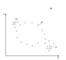
도 4를 참조하면, 시맨틱 라벨링 시스템의 일 실시예에서, 센서에 의해 감지된 사용자의 위치를 나타내는 위치 데이터(40)의 예를 설명하기 위한 개략도가 도시된다. 이 예에서 X축 및 Y축으로 예시된 이차원적인 지리적 좌표계 내에서 검출된 사용자의 위치들(41, 43, 45)의 분포가 나타나 있다. 도시된 위치 데이터(40)는 단순한 위치 좌표만을 나타내지만, 이들 위치가 검출된 시점 데이터와 결합하면, 왼쪽 위의 사용자의 위치(41) 및 그 주변은 사용자가 저녁부터 아침까지 방문한 장소라는 것, 오른쪽 아래의 사용자의 위치(45) 및 그 주변은 아침부터 저녁까지 방문한 장소이며, 중간의 사용자의 위치(43)는 저녁의 짧은 시간대에만 방문한 장소라는 것이 파악될 수 있다.Referring to FIG. 4, in one embodiment of the semantic labeling system, a schematic diagram is illustrated to illustrate an example of
도 5 내지 도 9는, 시맨틱 라벨링 시스템의 일 실시예에서, 장소ID에 의해 구별되는 장소들에 대하여 사용자의 방문 이력을 가공한 방문 이력 정보의 예들이 도시된다.5-9 illustrate examples of visit history information that, in one embodiment of the semantic labeling system, processed the user's visit history for places that are distinguished by place ID.
도 5를 참조하면, 시맨틱 라벨링 시스템의 일 실시예에서, 사용자가 각 장소를 방문한 누적 횟수 데이터(50)를 예시하는 그래프가 도시된다. 도면에서 수직축에 표시된 숫자들 각각은 특정 장소의 장소ID를 표시하며, 수평축에 표시된 숫자는 일정 기간 동안 사용자가 특정 장소를 방문한 횟수를 나타낸다. 도시된 예에서, 그래프의 맨 위에서부터 보면, 제50번 장소에는 사용자가 10회 방문했고, 제8번 장소에는 37회 방문했고, 제25번 장소에는 35회 방문했고, 제7번 장소에는 62회 방문했다는 것을 알 수 있다. 이 그래프에서, 방문횟수가 큰 장소들과 방문횟수가 작은 장소들이 서로 구별될 수 있다는 것과, 유사한 방문횟수를 가진 장소들을 동일 그룹으로 클러스터링 할 수 있다는 것을 쉽게 알 수 있다.Referring to FIG. 5, in one embodiment of the semantic labeling system, a graph illustrating the cumulative number of
도 6을 참조하면, 시맨틱 라벨링 시스템의 일 실시예에서, 사용자가 각 장소를 방문한 누적 지속시간 데이터(60)를 예시하는 그래프가 도시된다. 도면에서 수직축에 표시된 숫자들 각각은 특정 장소의 장소ID를 표시하며, 수평축에 표시된 숫자는 하루 동안 사용자가 특정 장소를 방문한 누적 지속시간을 나타낸다. 도시된 예에서, 그래프의 맨 위에서부터 보면, 제50번 장소에는 사용자가 하루 24시간 중에서 5시간 정도 머물렀고, 제8번 장소에는 2시간 10분 정도 머물렀고, 제25번 장소에는 1시간 50분 정도 머물렀고, 제7번 장소에는 1시간 30분 정도 머물렀다는 것을 알 수 있다. 이 그래프에서, 방문 지속시간이 긴 장소들과 방문 지속시간이 짧은 장소들이 서로 구별될 수 있다는 것과, 유사한 방문 지속시간을 가진 장소들을 동일 그룹으로 클러스터링 할 수 있다는 것을 쉽게 알 수 있다.Referring to FIG. 6, in one embodiment of the semantic labeling system, a graph is illustrated illustrating
도 7을 참조하면, 시맨틱 라벨링 시스템의 일 실시예에서, 사용자가 각 장소를 한번 방문할 때마다 평균 지속시간 데이터(70)를 예시하는 그래프가 도시된다. 도면에서 수직축에 표시된 숫자들 각각은 특정 장소의 장소ID를 표시하며, 수평축에 표시된 숫자는 사용자가 특정 장소를 1회 방문할 때마다 평균 지속시간(일 단위)을 나타낸다. 도시된 예에서, 그래프의 맨 위에서부터 보면, 제50번 장소에는 사용자가 방문할 때마다 평균 0.5일을 머물렀고, 제8번 장소에는 0.06일 정도 머물렀고, 제25번 장소에는 0.05일 정도 머물렀고, 제7번 장소에는 0.001일 정도 머물렀다는 것을 알 수 있다. 이 그래프에서, 평균 방문 지속시간이 긴 장소들과 평균 방문 지속시간이 짧은 장소들이 서로 구별될 수 있다는 것과, 유사한 평균 방문 지속시간을 가진 장소들을 동일 그룹으로 클러스터링 할 수 있다는 것을 쉽게 알 수 있다.Referring to FIG. 7, in one embodiment of the semantic labeling system, a graph is illustrated illustrating
도 8을 참조하면, 시맨틱 라벨링 시스템의 일 실시예에서, 하루 중에서 사용자가 각 장소를 방문하는 시간대별 방문 누적 횟수 데이터(80)를 예시하는 그래프가 도시된다. 도면에서 왼쪽 수직축에 표시된 숫자들 각각은 특정 장소의 장소ID를 표시하며, 수평축에 표시된 숫자는 하루 동안 사용자가 특정 장소를 방문한 시간대를 나타낸다. 그리고 표시된 컬러의 밝기는 누적 방문 횟수를 나타내며, 흰색으로 갈수록 누적 방문 횟수가 크다. 흰색은 최대 방문 횟수를 나타내고 검은색은 최소 방문 횟수 또는 0회를 나타낼 수 있다. 그래프의 맨 위에서부터 보면, 제50번 장소에는 사용자가 하루 중에서 0시 ~ 10시 사이와 20시 ~ 24시 사이에 많이 머물렀다는 것을 알 수 있다. 이 그래프에서, 하루 중 방문하는 시간대가 유사한 장소들이 서로 구별될 수 있다는 것과, 유사한 방문 시간대를 가진 장소들을 동일 그룹으로 클러스터링 할 수 있다는 것을 쉽게 알 수 있다.Referring to FIG. 8, in one embodiment of the semantic labeling system, there is shown a graph illustrating the cumulative number of visited
도 9를 참조하면, 시맨틱 라벨링 시스템의 일 실시예에서, 일주일 중에서 사용자가 각 장소를 방문하는 요일별 방문 누적 횟수 데이터(90)를 예시하는 그래프가 도시된다. 도면에서 왼쪽 수직축에 표시된 숫자들 각각은 특정 장소의 장소ID를 표시하며, 수평축에 표시된 숫자는 사용자가 특정 장소를 방문한 요일을 나타낸다. 그리고 표시된 컬러의 밝기는 누적 방문 횟수를 나타내며, 흰색으로 갈수록 누적 방문 횟수가 크다. 흰색은 최대 방문 횟수를 나타내고 검은색은 최소 방문 횟수 또는 0회를 나타낼 수 있다. 그래프의 맨 위에서부터 보면, 제50번 장소에는 사용자가 일주일 중에서 일요일(Sun)과 토요일(Sat)에 가장 많이 방문했고, 월요일(Mon)과 수요일(Wen)에는 거의 방문하지 않았음을 알 수 있다. 이 그래프에서, 방문하는 요일이 유사한 장소들이 서로 구별될 수 있다는 것과, 유사한 방문 요일을 가진 장소들을 동일 그룹으로 클러스터링 할 수 있다는 것을 쉽게 알 수 있다.Referring to FIG. 9, in one embodiment of the semantic labeling system, there is shown a graph illustrating the cumulative number of visited
위에서 도 5 내지 도 9를 참조하여 설명한 바와 같이, 사용자 방문 장소의 속성들은 단순한 사용자의 시간별 위치를 나타내는 위치 데이터에 기초하여 생성될 수 있다. 그럼에도 불구하고 장소들에 대하여 다양한 속성들이 생성될 수 있고, 이들 다양한 속성들은 서로 다른 장소들이 유사한 속성을 가지는 그룹들로 클러스터링 될 수 있게 한다. 이에 따라, 사용자 방문 장소들 모두에 대해 사용자가 수동으로 시맨틱 라벨을 지정하지 않음에도 불구하고, 사용자 방문 장소들 모두에 대해 적절한 시맨틱 라벨이 정의될 수 있다. 더 나아가, 심지어 기존에 정의되어 있지 않은 새로이 검출된 사용자 방문 장소에 대해서도, 사용자 개입 없이, 자동으로 적절한 시맨틱 라벨이 정의될 수 있다.As described above with reference to Figs. 5 to 9, the attributes of the user visiting place can be generated based on the position data indicating the simple user's time position. Nonetheless, various attributes can be created for places, and these various attributes allow different places to be clustered into groups with similar attributes. Accordingly, an appropriate semantic label can be defined for all of the user's places of visit, even though the user does not specify the semantic label manually for all of the user's places of visit. Furthermore, even for newly discovered user visited places that are not already defined, an appropriate semantic label can be automatically defined without user intervention.
도 10을 참조하면, 시맨틱 라벨링 시스템의 일 실시예에서, 검출 위치의 라벨을 기저장된 유사 장소의 라벨로서 결정하는 예를 설명하기 위한 블록도가 도시된다. 시맨틱 라벨링 시스템(100)에서, 위치 검출부(102)에 의해 사용자의 위치가 검출되면, 이 검출 위치는 장소 식별부(104)로 전송된다. 장소 식별부(104)는 검출 위치에 대응하는 장소를 식별하고, 라벨 데이터(106) 내에 저장되어 있는 장소들과 비교할 수 있다. 비교 결과, 만약 검출 위치가 저장된 장소들 중 어느 하나와 동일하다면, 장소 식별부(104)는 이 동일 장소의 시맨틱 라벨을 현재 검출 위치의 시맨틱 라벨을 나타내는 검출 위치 라벨(108)로서 출력할 수 있다. 그리고, 장소 식별부(104)는 이 장소의 방문 프로파일 등의 관련 정보를 갱신할 수 있다. 반면에, 만약 검출 위치가 저장된 장소들 중 어느 것과도 동일하지 않다면, 장소 식별부(104)는 검출 위치에 대응하는 장소를 새로운 장소로서 등록할 수 있다. 등록된 새로운 장소에는, 예컨대 도 2를 참조하여 기술된 바와 같은 방식으로, 장소ID가 할당되고, 장소 속성이 생성되며, 또한 장소 속성에 기초하여 새로운 시맨틱 라벨이 지정될 수 있다.Referring to FIG. 10, there is shown a block diagram for explaining an example in which, in an embodiment of the semantic labeling system, a label of a detected position is determined as a label of a pre-stored similar location. In the
도 11을 참조하면, 시맨틱 라벨링 시스템의 일 실시예에서, 검출 위치의 라벨을 기저장된 유사 그룹의 라벨로서 결정하는 예를 설명하기 위한 블록도가 도시된다. 시맨틱 라벨링 시스템(110)에서, 위치 검출부(112)에 의해 사용자의 위치가 검출되면, 장소 식별부(114)는 검출 위치에 대응하는 장소를 식별하고, 라벨 데이터(118) 내에 저장되어 있는 장소들과 비교할 수 있다. 비교 결과, 만약 검출 위치가 저장된 장소들 중 어느 하나와 동일하지 않다면, 장소 식별부(114)는 검출 위치에 대응하는 장소에 대해 새로운 장소ID를 할당하고, 그것의 장소 속성 정보를 생성할 수 있다.Referring to FIG. 11, in an embodiment of the semantic labeling system, a block diagram for illustrating an example of determining a label of a detected position as a label of a pre-stored similar group is shown. In the
그런 다음, 그룹 식별부(116)는 새 장소의 장소 속성을, 라벨 데이터(118) 내에 저장되어 있는 장소들의 장소 속성들과 비교할 수 있다. 비교 결과, 만약 새 장소의 속성이 저장된 장소들 중 어느 하나의 속성과 동일하거나 유사하다면, 그룹 식별부(116)는 새 장소를 이 동일하거나 유사한 속성의 장소가 속한 그룹에 소속시킬 수 있다. 그런 다음, 그룹 식별부(116)는 이 그룹의 시맨틱 라벨을 현재 검출 위치의 시맨틱 라벨을 나타내는 검출 위치 라벨(119)로서 출력할 수 있다. 그리고, 그룹 식별부(116)는 이 그룹의 그룹 프로파일 등의 관련 정보를 갱신할 수 있다. 반면에, 만약 새 장소의 속성이 저장된 장소들 중 어느 하나의 속성과 동일하지도 유사하지도 않다면, 그룹 식별부(116)는 새 장소를 멤버로 하는 새로운 그룹을 등록할 수 있다. 등록된 새로운 그룹에는, 예컨대 도 2를 참조하여 기술된 바와 같은 방식으로, 사용자에 의해 새로운 시맨틱 라벨이 지정될 수 있다.The
도 12를 참조하면, 시맨틱 라벨링 시스템의 일 실시예에서, 검출 위치의 라벨을 새로운 라벨로서 결정하는 예를 설명하기 위한 블록도가 도시된다. 시맨틱 라벨링 시스템(120)에서, 위치 검출부(121)에 의해 사용자의 위치가 검출되면, 장소 식별부(122)는 검출 위치에 대응하는 장소를 식별하고, 라벨 데이터(126) 내에 저장되어 있는 장소들과 비교할 수 있다. 비교 결과, 만약 검출 위치가 저장된 장소들 중 어느 하나와 동일하지 않다면, 장소 식별부(122)는 검출 위치에 대응하는 장소에 대해 새로운 장소ID를 할당하고, 그것의 장소 속성 정보를 생성할 수 있다.Referring to FIG. 12, in an embodiment of the semantic labeling system, a block diagram for illustrating an example of determining a label of a detected position as a new label is shown. In the
그런 다음, 그룹 식별부(122)는 새 장소의 장소 속성을, 라벨 데이터(126) 내에 저장되어 있는 장소들의 장소 속성들과 비교할 수 있다. 비교 결과, 만약 새 장소의 속성이 저장된 장소들 중 어느 하나의 속성과 동일하지도 유사하지도 않다면, 그룹 식별부(123)는 새 장소를 멤버로 포함하는 새로운 그룹을 생성하여 새로운 그룹ID를 할당하고, 그것의 그룹 속성 정보를 생성할 수 있다. 그룹 식별부(123)는 새로운 그룹에 대해 시맨틱 라벨을 지정할 것을 사용자 인터페이스(124)를 통해 사용자에게 요청할 수 있다. 사용자에 의해 새 그룹의 시맨틱 라벨이 지정되면, 라벨 결정부(125)는 새 그룹의 시맨틱 라벨을 현재 검출 위치의 시맨틱 라벨을 나타내는 검출 위치 라벨(127)로서 출력할 수 있다.The
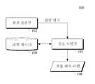
도 13을 참조하면, 모바일에서 검출된 데이터에 대해 원격 서버에서 시맨틱 라벨링을 수행하는 실시예를 보여주는 블록도가 도시된다. 도시된 예에서, 모바일 장치(131)와 라벨링 서버(133)는 예컨대 무선 인터넷과 같은 통신망을 통해 서로 연결될 수 있다. 모바일 장치(131)는 사용자가 소지하거나 착용하고 있는 컴퓨팅 장치로서, 사용자의 위치를 검출하는 역할을 담당할 수 있다. 라벨링 서버(133)는, 위에서 도 2를 참조하여 기술된 시맨틱 라벨링 기법을 수행하기 위한 컴포넌트들을 포함할 수 있다.Referring to FIG. 13, a block diagram illustrating an embodiment of performing semantic labeling on a remote server for data detected in a mobile is illustrated. In the illustrated example, the
모바일 장치(131)는 위치 검출부(1312), 이벤트 검출부(1314), 송신부(1316) 등의 컴포넌트를 구비할 수 있다. 위치 검출부(1312)는 GPS 센서 또는 셀ID 검출기와 같이 일정한 시점에 모바일 장치(131)의 위치를 검출할 수 있다. 모바일 장치(131)의 위치는, 이 모바일 장치(131)를 소지하거나 착용한 사용자의 위치라고 간주될 수 있다. 이벤트 검출부(1314)는 모바일 장치(131)에 의해 실행되는 애플리케이션의 구동/종료, 전화통화 발신/수신, 문자메시지 발신/수신 등의 이벤트를 검출할 수 있는 컴포넌트이다. 그 이외에 모바일 장치(131)에는 모바일 장치(131)의 움직임을 감지함으로써 모바일 장치(131)를 소지하거나 착용한 사용자의 움직임을 감지하는 가속도 센서 등을 더 포함할 수 있다. 위치 검출부(1312)에서 동일한 시점에 검출된 위치 값 및 이벤트 데이터 등은 검출된 위치 데이터로서 송신부(1316)를 통해 무선 신호로 변환된 뒤 라벨링 서버(133)로 전송될 수 있다.The
라벨링 서버(133)의 수신부(1331)는 모바일 장치(131)로부터 위치 데이터를 수신할 수 있다. 수신된 위치 데이터는 장소 식별부(1333), 그룹 식별부(1335), 사용자 인터페이스(1337), 및 라벨 결정부(1339) 등의 컴포넌트에 의해 처리됨으로써, 예컨대 도 10 내지 도 12를 참조하여 기술된 바와 같은 방식으로, 현재 검출된 사용자 위치의 시맨틱 라벨이 출력될 수 있다. 출력된 시맨틱 라벨에 대해서 위치 기반 서비스 서버(도 1의 19 참조)에 의해 적절한 서비스가 연관될 수 있고, 연관된 서비스는 모바일 장치(131)로 제공될 수 있다.The receiving
이하 도 14 내지 도 18을 참조하여, 시맨틱 라벨링 방법의 실시예들이 기술된다. 여기서 기술되는 시맨틱 라벨링 방법들은 단지 예시에 불과하다. 해당 기술분야의 통상의 지식을 가진 자는, 청구항들의 범위 내에서 다양한 조합의 다른 방법들이 가능하다는 것을 쉽게 이해할 것이다. 시맨틱 라벨링 방법의 전부 또는 일부는, 컴퓨팅 장치의 프로세서에 의해 수행되면 특정 태스크를 실행할 수 있도록 하는 컴퓨터-실행가능 인스트럭션, 모듈, 소프트웨어, 데이터, 알고리즘, 프로시저 등으로 코딩될 수 있다. 컴퓨터-실행가능 인스트럭션 등은 소프트웨어 개발자에 의해 예를 들어 베이직, 포트란, C, C++ 등과 같은 프로그래밍 언어에 의해 코딩된 후, 기계언어로 컴파일될 수 있다.14 to 18, embodiments of a semantic labeling method are described. The semantic labeling methods described herein are merely illustrative. Those of ordinary skill in the art will readily appreciate that various other combinations of methods are possible within the scope of the claims. All or part of the semantic labeling method may be coded into computer-executable instructions, modules, software, data, algorithms, procedures, etc. that enable a particular task to be executed when executed by a processor of a computing device. Computer-executable instructions, etc. may be coded by a software developer, for example, by a programming language such as BASIC, FORTRAN, C, C ++, etc., and then compiled into a machine language.
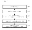
도 14를 참조하면, 시맨틱 라벨링 방법의 일 실시예를 예시하는 흐름도가 도시된다. 도시된 시맨틱 라벨링 방법(140)은, 예컨대 사용자가 소지하거나 착용하고 있는 스마트폰, 스마트워치, 스마트안경 등과 같은 모바일 장치 내에서 실행될 수 있으며, 먼저 사용자의 위치와 관련된 위치 데이터를 획득하는 단계(141)로부터 시작될 수 있다. 위치 데이터는 GPS 좌표 또는 셀ID와 같이 지리적인 위치를 나타내는 위치 값과 이 위치 값이 검출된 시간 값을 포함할 수 있다.Referring to Fig. 14, a flow diagram illustrating an embodiment of a semantic labeling method is shown. The illustrated
이후 획득된 위치 데이터로부터 사용자에게 의미있는 장소가 식별될 수 있다(143). 장소는 사용자의 위치가 일정 시간 이상 머문(즉, 방문한) 일정 크기의 지리적인 영역으로서 미리 정의될 수 있다. 다시 말해서, 사용자가 특정 크기의 영역 내에서 일정 시간 이상 머물고 있음이 검출되면, 이 영역은 사용자에게 어떠한 형태로든 의미가 있는 장소로서 식별될 수 있다. 그런 다음, 식별된 장소에는, 기존에 식별되었던 장소들과 구별되도록 하기 위해 장소ID가 할당되고, 이 장소에 대한 관련 위치 데이터를 기반으로 하여 장소 속성이 생성될 수 있다. 장소 속성에는, 예를 들어, 사용자가 방문한 시간, 방문 지속시간, 방문 요일, 사용한 애플리케이션 타입, 전화 통화 횟수 또는 빈도, SMS 사용 빈도, 사용자의 걷기, 앉기, 뛰기 등의 행동 등이 포함될 수 있다.A meaningful location can then be identified to the user from the acquired location data (143). The location can be predefined as a geographical area of a certain size where the location of the user has stayed (i.e., visited) over a certain period of time. In other words, if it is detected that the user is staying in the area of a certain size for more than a predetermined time, this area can be identified as a place having some form of meaning to the user. The identified place is then assigned a place ID to distinguish it from previously identified places, and a place attribute can be created based on the relevant location data for that place. The location attribute may include, for example, the time the user visited, the duration of the visit, the day of the visit, the type of application used, the number or frequency of phone calls, the frequency of SMS usage, and the user's walking, sitting,
그런 다음, 장소들은 이 장소 속성에 기초하여 유사성이 판단되고, 임의의 유사한 속성을 가지는 장소들은 하나의 동일한 그룹으로 클러스터링 될 수 있다(145).The places are then judged similar based on this place attribute, and places having any similar property can be clustered into one same group (145).
그룹들이 형성되면, 사용자로부터 그룹의 시맨틱 라벨을 획득할 수 있다(147). 예컨대, 모바일 장치의 디스플레이 상에 표현되는 사용자 인터페이스를 통해, 임의의 그룹에 대해 사용자에게 시맨틱 라벨을 지정할 것을 요청할 수 있다. 그러면, 사용자는 모바일 장치의 디스플레이 상의 사용자 인터페이스를 통해 원하는 시맨틱 라벨을 선택하거나 기입함으로써 그룹의 시맨틱 라벨을 수동으로 지정할 수 있다. 이후, 그룹의 시맨틱 라벨은 각 그룹에 속하는 멤버 장소들의 시맨틱 라벨로 간주됨으로써, 각 장소의 시맨틱 라벨이 결정될 수 있다(149).Once the groups are formed, the semantic label of the group may be obtained from the user (147). For example, through a user interface represented on the display of the mobile device, it may be requested to assign a semantic label to the user for any group. The user can then manually specify the semantic label of the group by selecting or writing the desired semantic label through the user interface on the display of the mobile device. Then, the semantic label of the group is regarded as the semantic label of the member places belonging to each group, so that the semantic label of each place can be determined (149).
도 15를 참조하면, 시맨틱 라벨링 방법의 다른 실시예를 예시하는 흐름도가 도시된다. 도시된 시맨틱 라벨링 방법(150)은 먼저 사용자의 위치와 관련된 위치 데이터를 획득하는 단계(151)로부터 시작될 수 있다.Referring to Fig. 15, a flow chart illustrating another embodiment of the semantic labeling method is shown. The illustrated semantic labeling method 150 may begin with step 151 of obtaining location data associated with a user's location first.
이후 획득된 위치 데이터로부터 사용자에게 의미있는 장소가 식별될 수 있다(152). 식별된 장소에는 각 장소를 고유하게 식별하는 장소ID가 할당되며, 장소의 지리적인 특징을 나타내는 장소 프로파일이 생성될 수 있다. 그런 다음, 각 장소에는 사용자가 그 장소를 방문한 시간, 방문 지속시간, 방문 요일, 사용한 애플리케이션 타입, 전화 통화 횟수 또는 빈도, SMS 사용 빈도, 사용자의 걷기, 앉기, 뛰기 등의 행동 등이 포함될 수 있는 방문 프로파일이 생성될 수 있다(154).A meaningful place can then be identified to the user from the acquired location data (152). The identified place is assigned a place ID that uniquely identifies each place, and a place profile that represents the geographical characteristics of the place may be created. Each location can then include activity such as the time the user visited the place, the duration of the visit, the day of the visit, the type of application used, the frequency or frequency of phone calls, the frequency of SMS usage, and the user's walking, A visiting profile may be created 154.
그런 다음, 장소들은 각 장소의 방문 프로파일에 기초하여 유사성이 판단되고, 임의의 유사한 방문 프로파일을 가지는 장소들은 하나의 동일한 그룹으로 클러스터링 될 수 있다(154). 그룹들이 형성되면, 사용자로부터 그룹의 시맨틱 라벨을 획득할 수 있다(155). 이후, 그룹의 시맨틱 라벨은 각 그룹에 속하는 멤버 장소들의 시맨틱 라벨로 간주됨으로써, 각 장소의 시맨틱 라벨이 결정될 수 있다(156).The places may then be judged similar based on the visited profile of each place, and places with any similar visited profile may be clustered into one and the same group (154). Once the groups are formed, the semantic label of the group may be obtained from the user (155). Thereafter, the semantic label of the group is regarded as the semantic label of the member locations belonging to each group, so that the semantic label of each place can be determined (156).
도 16을 참조하면, 시맨틱 라벨링 방법의 또 다른 실시예를 예시하는 흐름도가 도시된다. 도시된 시맨틱 라벨링 방법(160)은, 먼저 사용자의 위치와 관련된 위치 데이터를 획득하는 단계(161)로부터 시작될 수 있다. 이후 획득된 위치 데이터로부터 사용자에게 의미있는 장소가 식별될 수 있다(162). 그런 다음, 식별된 장소에는, 기존에 식별되었던 장소들과 구별되도록 하기 위해 장소ID가 할당되고, 이 장소에 대한 관련 위치 데이터를 기반으로 하여 장소 속성이 생성될 수 있다. 장소 속성에는, 예를 들어, 사용자가 방문한 시간, 방문 지속시간, 방문 요일, 사용한 애플리케이션 타입, 전화 통화 횟수 또는 빈도, SMS 사용 빈도, 사용자의 걷기, 앉기, 뛰기 등의 행동 등이 포함될 수 있다.Referring to Fig. 16, a flow chart illustrating another embodiment of the semantic labeling method is shown. The illustrated
그런 다음, 장소들은 이 장소 속성에 기초하여 유사성이 판단되고, 임의의 유사한 속성을 가지는 장소들은 하나의 동일한 그룹으로 클러스터링 될 수 있다(163).Then, the places are judged based on the place attribute, and the places having any similar property can be clustered into one same group (163).
그룹들이 형성되면, 그룹의 멤버 장소들 중에서 하나의 장소가 대표 장소로 선정될 수 있다(164). 대표 장소는 각 그룹의 속성을 가장 잘 나타내는 속성을 가지고 있는 장소라고 판단되는 장소일 수 있다. 예를 들어, 그룹의 멤버 장소들 중 일정 기간 동안 사용자 방문 횟수가 가장 많은 장소, 또는 일정 기간 동안 사용자 방문 지속시간이 가장 긴 장소 등이 대표 장소로 선정될 수 있다.Once the groups are formed, one of the member locations of the group may be selected as the representative site (164). The representative place may be a place judged to be a place having the attribute that best represents the attribute of each group. For example, a place where the number of user visits is greatest for a certain period of time among members of a group, or a place where a user has a longest duration of visit for a predetermined period may be selected as a representative place.
대표 장소가 선정되면, 대표 장소에 대해 사용자로부터 그룹의 시맨틱 라벨을 획득할 수 있다(165). 이후, 대표 장소의 시맨틱 라벨은 그룹에 속하는 멤버 장소들의 시맨틱 라벨로 간주됨으로써, 각 장소의 시맨틱 라벨이 결정될 수 있다(166).Once the representative place is selected, the semantic label of the group can be obtained from the user for the representative place (165). Thereafter, the semantic label of the representative place is regarded as the semantic label of member places belonging to the group, so that the semantic label of each place can be determined (166).
도 17을 참조하면, 시맨틱 라벨링 방법의 또 다른 실시예를 보여주는 흐름도가 도시된다. 도시된 시맨틱 라벨링 방법(170)은 모바일 장치와 통신망을 통해 서로 연결된 서버가 상호작용함으로써 수행되는 예로서, 예컨대 사용자가 소지하거나 착용하고 있는 스마트폰, 스마트워치, 스마트안경 등과 같은 모바일 장치는 사용자 위치를 검출하는 역할을 담당하고, 원격 서버는 사용자 위치의 시맨틱 라벨을 결정하는 역할을 담당한다. 먼저, 모바일 장치에서 사용자의 위치가 검출되고, 검출 위치는 서버로 전송될 수 있다(171).Referring to FIG. 17, a flowchart illustrating another embodiment of the semantic labeling method is shown. The illustrated
서버에서 수신된 검출 위치에 대해, 위에서 도 10 내지 도 12를 참조하여 기술된 바와 같은 방식으로, 또는 아래에서 도 18을 참조하여 기술할 바와 같은 방식으로, 시맨틱 라벨이 결정될 수 있다(172).For the detected location received at the server, a semantic label may be determined 172, in the manner described above with reference to Figures 10-12, or in the manner described with reference to Figure 18 below.
이후, 서버에서 결정된 시맨틱 라벨에 대하여 연관된 서비스가 서버에서 모바일 장치로 제공될 수 있다(173). 예컨대, 검출 위치의 시맨틱 라벨이 미술관, 학교, 도서관 등의 조용한 환경이 요구되는 장소를 의미한다면, 모바일 장치를 진동모드로 자동 변환하는 서비스가 제공될 수 있다.Thereafter, an associated service for the semantic label determined at the server may be provided to the mobile device at the server (173). For example, if the semantic label at the detection position indicates a place where a quiet environment such as a museum, a school, or a library is required, a service for automatically converting the mobile device into a vibration mode can be provided.
도 18을 참조하면, 시맨틱 라벨링 방법의 또 다른 일 실시예를 보여주는 흐름도가 도시된다. 도시된 시맨틱 라벨링 방법(180)은, 검출 위치의 시맨틱 라벨을 출력하는 과정을 보여주며, 먼저 사용자의 위치가 검출되는 단계(181)로부터 시작될 수 있다. 여기서, 검출 위치는 GPS 좌표 값 또는 셀ID와 같이 지리적인 위치를 나타내는 값을 포함하는 데이터이면 충분하다.Referring to Fig. 18, a flowchart showing another embodiment of the semantic labeling method is shown. The illustrated
이후 검출된 위치에 대응하는 장소가 식별될 수 있다(182). 장소는 사용자의 위치가 일정 시간 이상 머문(즉, 방문한) 일정 크기의 지리적인 영역으로서, 중심부의 GPS 좌표 값과 영역의 크기를 나타내는 값(예컨대, 반경)에 의해 정의될 수 있다. 예를 들어, 검출 위치의 GPS 좌표 값이 중심부이며 일정한 반경을 가지는 영역이 장소로서 식별될 수 있다.A location corresponding to the detected location may then be identified (182). The location may be defined by a GPS coordinate value of a center portion and a value (for example, a radius) indicating a size of the region. For example, a region in which the GPS coordinate value of the detection position is the center portion and has a certain radius can be identified as a place.
이 식별된 장소는 기 저장된 장소들과 비교될 수 있다(183). 기 저장된 장소들도 역시 중심부의 GPS 좌표 값 및 반경을 가질 수 있다. 이 경우, 장소들을 비교할 때, 각 장소의 중심부 GPS 좌표를 서로 비교하고, 반경 범위에서 오차를 가지는지 아닌지를 판단할 수 있다. 그 결과, 중심부 GPS 좌표가 반경 범위 내에서 서로 근접하고 있다면, 서로 유사한 장소라고 판단될 수 있다.This identified location may be compared with pre-stored locations (183). The pre-stored locations may also have a GPS coordinate value and radius in the center. In this case, when comparing places, it is possible to compare GPS coordinates in the center of each place with each other and judge whether or not there is an error in the radius range. As a result, if the central GPS coordinates are close to each other within the radius range, it can be judged that they are similar to each other.
비교 결과, 만약 검출 위치에 대응하는 장소가 기저장된 장소들 중 어느 하나와 동일하거나 유사한 GPS 좌표 값을 가진다면(184의 예), 이 동일하거나 유사한 장소가 검출 위치의 장소라고 볼 수 있다. 그러므로 유사 장소의 시맨틱 라벨을 검출 위치의 라벨로 출력할 수 있다(185). 반면 만약 검출 위치에 대응하는 장소가 기저장된 장소들 중 어느 하나와 동일하거나 유사한 GPS 좌표 값이 없다면(184의 아니오), 식별된 장소는 새 장소이다. 그러므로, 식별된 장소에 대해 새로운 장소ID를 할당하고, 그것의 장소 속성 정보를 생성한 다음, 기 저장 그룹의 장소들과 유사성을 비교할 수 있다(186).As a result of the comparison, if the place corresponding to the detection position has the same or similar GPS coordinate value (any of 184), it can be considered that the same or similar place is the place of the detection position. Therefore, the semantic label of the similar location can be output as the label of the detection location (185). On the other hand, if the location corresponding to the detection location is not the same or similar to any one of the pre-stored locations (NO in 184), the identified location is the new location. Therefore, a new location ID may be assigned to the identified location, its location attribute information may be generated, and then the similarity may be compared 186 with the locations of the pre-stored group.
기 저장 그룹의 장소들은 장소 속성 정보를 가지고 있으므로, 예컨대 사용자 방문 횟수나 방문 시간, 방문 지속시간 등의 속성 중 임의의 것이 유사한 장소가 발견될 수 있다(187의 예). 그러면, 새 장소는 발견된 장소와 동일 그룹에 속할 것이므로, 그룹의 시맨틱 라벨을 검출 위치의 라벨로서 출력할 수 있다(188). 만약 유사한 속성을 가진 장소가 발견되지 않으면(187의 아니오), 도 14 또는 도 15를 참조하여 기술된 방식(140, 150)으로, 새로운 시맨틱 라벨이 지정될 수 있다(189).Since the places of the storage group have place attribute information, a place similar to any one of the attributes such as the number of user visits, the visit time, and the visit duration can be found (example of 187). Then, since the new place will belong to the same group as the found place, the semantic label of the group can be output as a label of the detection location (188). If no place with similar attributes is found (NO in 187), a new semantic label may be assigned 189 to the
20: 시맨틱 라벨링 시스템
21: 위치 데이터
22: 장소 식별부
23: 장소 속성
24: 그룹 식별부
25: 그룹 속성
26: 사용자 인터페이스
28: 라벨 결정부
29: 라벨 데이터20: Semantic labeling system
21: Position data
22:
23: Place Attributes
24: Group identification unit
25: Group Properties
26: User Interface
28: Label determination section
29: Label data
Claims (20)
Translated fromKorean상기 장소들을 상기 장소 속성에 기초하여 클러스터링 함으로써 그룹들로 분류하고, 상기 그룹들 각각에 대해 시맨틱 라벨을 사용자에게 요청하여 획득함으로써, 획득된 시맨틱 라벨을 상기 그룹들 각각의 시멘틱 라벨로 지정하는 그룹 식별부와;
상기 그룹들 각각의 시맨틱 라벨을 상기 그룹들 각각의 멤버 장소들의 시맨틱 라벨로 결정하는 라벨 결정부를
포함하는, 시맨틱 라벨링 시스템.When the position of the user is staying in a region of a predetermined size for a predetermined time from positional data indicating a position of a geographical user according to time, the region is identified as a place, and based on the visit information of the user for each of the identified places A place identification unit for generating a place attribute to be used by the user;
Classifying the obtained semantic label into a semantic label of each of the groups by classifying the places into groups by clustering based on the place attribute, requesting and obtaining a semantic label for each of the groups, Wealth;
A label determination unit that determines a semantic label of each of the groups as a semantic label of member places of each of the groups,
Includes a semantic labeling system.
상기 위치 데이터는, 모바일 장치에 내장된 센서에 의해 검출되는,
시맨틱 라벨링 시스템.The method according to claim 1,
Wherein the location data includes at least one of:
Semantic labeling system.
상기 위치 데이터는,
상기 모바일 장치에서 구동되는 애플리케이션의 타입, 상기 모바일 장치에 의해 수행되는 전화 통화의 착신 또는 발신 횟수, 상기 모바일 장치에 의해 수행되는 문자 메시지(SMS) 수신 또는 발신 횟수, 상기 모바일 장치에 내장된 모션 센서에 의해 검출되는 상기 사용자의 행동 중 적어도 하나를 더 포함하는,
시맨틱 라벨링 시스템.3. The method of claim 2,
The position data may include:
The number of incoming or outgoing telephone calls performed by the mobile device, the number of times a text message (SMS) is received or sent by the mobile device, the type of application being driven by the mobile device, Further comprising at least one of the user's actions detected by the user.
Semantic labeling system.
상기 장소 속성은,
상기 장소를 그 외 다른 장소들과 구별되도록 하는 식별정보, 및 상기 장소에 상기 사용자가 방문한 시간정보를 포함하는,
시맨틱 라벨링 시스템.The method according to claim 1,
The location attribute may include:
The identification information for distinguishing the place from other places, and the time information that the user visited at the place,
Semantic labeling system.
상기 장소 속성은,
상기 장소에 상기 사용자가 방문한 시간정보로부터 계산될 수 있는 정보를 더 포함하는,
시맨틱 라벨링 시스템.5. The method of claim 4,
The location attribute may include:
Further comprising information that can be calculated from the time information the user visited at the location,
Semantic labeling system.
상기 장소 속성은,
상기 장소에서 동작시킨 사용자가 소지하거나 착용한 모바일 장치의 동작 상태를 나타내는 정보를 더 포함하는,
시맨틱 라벨링 시스템.6. The method of claim 5,
The location attribute may include:
Further comprising information indicating an operating state of a mobile device carried or worn by a user operating in the location,
Semantic labeling system.
상기 장소 속성은,
상기 장소에서 이루어진 것으로 상기 모바일 장치에 의해 검출된 상기 사용자의 행동을 나타내는 정보를 더 포함하는,
시맨틱 라벨링 시스템.6. The method of claim 5,
The location attribute may include:
Further comprising information indicating an action of the user detected by the mobile device as being made at the location,
Semantic labeling system.
상기 그룹 식별부는,
상기 그룹들 각각의 멤버 장소들 중 하나를 대표 장소로 선정하고, 선정된 대표 장소의 시맨틱 라벨을 사용자에게 요청하여 획득함으로써, 획득된 대표 장소의 시맨틱 라벨을 상기 그룹들 각각의 시맨틱 라벨로 지정하는,
시맨틱 라벨링 시스템.The method according to claim 1,
The group identification unit,
One of the member locations of the groups is selected as a representative place, and a semantic label of the selected representative place is requested and obtained from the user, thereby designating the semantic label of the acquired representative place as the semantic label of each of the groups ,
Semantic labeling system.
상기 그룹 식별부는,
상기 그룹들 각각의 멤버 장소들의 장소 속성들에 기초하여, 상기 그룹들 각각의 멤버 장소들 중 하나의 장소를 대표 장소로 선정하는,
시맨틱 라벨링 시스템.9. The method of claim 8,
The group identification unit,
Selecting one of the member locations of each of the groups as a representative location based on the location attributes of the member locations of each of the groups;
Semantic labeling system.
상기 그룹 식별부는,
상기 그룹들 각각의 멤버 장소들의 장소 속성들 중 사용자 방문과 연관된 정보에 기초하여, 상기 그룹들 각각의 멤버 장소들 중 하나의 장소를 대표 장소로 선정하는,
시맨틱 라벨링 시스템.9. The method of claim 8,
The group identification unit,
Selecting one of the member locations of each of the groups as a representative location based on information associated with a user visit among location attributes of member locations of each of the groups;
Semantic labeling system.
상기 장소들을 상기 장소 속성에 기초하여 클러스터링 함으로써 그룹들로 분류하고, 상기 그룹들 각각에 대해 시맨틱 라벨을 사용자에게 요청하여 획득함으로써, 획득된 시맨틱 라벨을 상기 그룹들 각각의 시멘틱 라벨로 지정하는 그룹 식별 단계와;
상기 그룹들 각각의 시맨틱 라벨을 상기 그룹들 각각의 멤버 장소들의 시맨틱 라벨로 결정하는 라벨 결정 단계를
포함하는, 시맨틱 라벨링 방법.When the position of the user is staying within a predetermined size area for a certain period of time from the location data location data indicating the location of the geographical user according to time, the area is identified as the location, and the user's visit information A location identification step of generating a location attribute based on the location attribute;
Classifying the obtained semantic label into a semantic label of each of the groups by classifying the places into groups by clustering based on the place attribute, requesting and obtaining a semantic label for each of the groups, ;
A label determination step of determining a semantic label of each of the groups as a semantic label of member locations of each of the groups
Containing semantic labeling methods.
상기 위치 데이터는, 모바일 장치에 내장된 센서에 의해 검출되는,
시맨틱 라벨링 방법.12. The method of claim 11,
Wherein the location data includes at least one of:
Semantic labeling method.
상기 위치 데이터는,
상기 모바일 장치에서 구동되는 애플리케이션의 타입, 상기 모바일 장치에 의해 수행되는 전화 통화의 착신 또는 발신 횟수, 상기 모바일 장치에 의해 수행되는 문자 메시지(SMS) 수신 또는 발신 횟수, 상기 모바일 장치에 내장된 모션 센서에 의해 검출되는 상기 사용자의 행동 중 적어도 하나를 더 포함하는,
시맨틱 라벨링 방법.13. The method of claim 12,
The position data may include:
The number of incoming or outgoing telephone calls performed by the mobile device, the number of times a text message (SMS) is received or sent by the mobile device, the type of application being driven by the mobile device, Further comprising at least one of the user's actions detected by the user.
Semantic labeling method.
상기 장소 속성은,
상기 장소를 그 외 다른 장소들과 구별되도록 하는 식별정보, 및 상기 장소에 상기 사용자가 방문한 시간정보를 포함하는,
시맨틱 라벨링 방법.12. The method of claim 11,
The location attribute may include:
The identification information for distinguishing the place from other places, and the time information that the user visited at the place,
Semantic labeling method.
상기 장소 속성은,
상기 장소에 상기 사용자가 방문한 시간정보로부터 계산될 수 있는 정보를 더 포함하는,
시맨틱 라벨링 방법.15. The method of claim 14,
The location attribute may include:
Further comprising information that can be calculated from the time information the user visited at the location,
Semantic labeling method.
상기 장소 속성은,
상기 장소에서 동작시킨 사용자가 소지하거나 착용한 모바일 장치의 동작 상태를 나타내는 정보, 정보를 더 포함하는,
시맨틱 라벨링 방법.16. The method of claim 15,
The location attribute may include:
Further comprising information indicating information about an operation state of the mobile device held or worn by the user operating in the location,
Semantic labeling method.
상기 장소 속성은,
상기 장소에서 이루어진 것으로 상기 모바일 장치에 의해 검출된 상기 사용자의 행동을 나타내는 정보를 더 포함하는,
시맨틱 라벨링 방법.16. The method of claim 15,
The location attribute may include:
Further comprising information indicating an action of the user detected by the mobile device as being made at the location,
Semantic labeling method.
상기 그룹 식별 단계는,
상기 그룹들 각각의 멤버 장소들 중 하나를 대표 장소로 선정하고, 선정된 대표 장소의 시맨틱 라벨을 사용자에게 요청하여 획득함으로써, 획득된 대표 장소의 시맨틱 라벨을 상기 그룹들 각각의 시맨틱 라벨로 지정하는,
시맨틱 라벨링 방법.12. The method of claim 11,
Wherein the group identification step comprises:
One of the member locations of the groups is selected as a representative place, and a semantic label of the selected representative place is requested and obtained from the user, thereby designating the semantic label of the acquired representative place as the semantic label of each of the groups ,
Semantic labeling method.
상기 그룹 식별 단계는,
상기 그룹들 각각의 멤버 장소들의 장소 속성들에 기초하여, 상기 그룹들 각각의 멤버 장소들 중 하나의 장소를 대표 장소로 선정하는,
시맨틱 라벨링 방법.19. The method of claim 18,
Wherein the group identification step comprises:
Selecting one of the member locations of each of the groups as a representative location based on the location attributes of the member locations of each of the groups;
Semantic labeling method.
상기 그룹 식별 단계는,
상기 그룹들 각각의 멤버 장소들의 장소 속성들 중 사용자 방문과 연관된 정보에 기초하여, 상기 그룹들 각각의 멤버 장소들 중 하나의 장소를 대표 장소로 선정하는,
시맨틱 라벨링 방법.19. The method of claim 18,
Wherein the group identification step comprises:
Selecting one of the member locations of each of the groups as a representative location based on information associated with a user visit among location attributes of member locations of each of the groups;
Semantic labeling method.
Priority Applications (5)
| Application Number | Priority Date | Filing Date | Title |
|---|---|---|---|
| KR1020140047687AKR102216049B1 (en) | 2014-04-21 | 2014-04-21 | System and method for semantic labeling |
| US14/691,876US10762119B2 (en) | 2014-04-21 | 2015-04-21 | Semantic labeling apparatus and method thereof |
| EP15164461.4AEP2950252A1 (en) | 2014-04-21 | 2015-04-21 | Semantic labeling apparatus and method thereof |
| JP2015087130AJP6660098B2 (en) | 2014-04-21 | 2015-04-21 | Semantic labeling apparatus and method |
| CN201510191873.XACN105023020B (en) | 2014-04-21 | 2015-04-21 | Semantic annotation device and method thereof |
Applications Claiming Priority (1)
| Application Number | Priority Date | Filing Date | Title |
|---|---|---|---|
| KR1020140047687AKR102216049B1 (en) | 2014-04-21 | 2014-04-21 | System and method for semantic labeling |
Publications (2)
| Publication Number | Publication Date |
|---|---|
| KR20150121596Atrue KR20150121596A (en) | 2015-10-29 |
| KR102216049B1 KR102216049B1 (en) | 2021-02-15 |
Family
ID=53039724
Family Applications (1)
| Application Number | Title | Priority Date | Filing Date |
|---|---|---|---|
| KR1020140047687AActiveKR102216049B1 (en) | 2014-04-21 | 2014-04-21 | System and method for semantic labeling |
Country Status (5)
| Country | Link |
|---|---|
| US (1) | US10762119B2 (en) |
| EP (1) | EP2950252A1 (en) |
| JP (1) | JP6660098B2 (en) |
| KR (1) | KR102216049B1 (en) |
| CN (1) | CN105023020B (en) |
Families Citing this family (16)
| Publication number | Priority date | Publication date | Assignee | Title |
|---|---|---|---|---|
| EP2891107A4 (en)* | 2012-08-28 | 2016-04-13 | Visa Int Service Ass | Protecting assets on a device |
| JP6100810B2 (en)* | 2015-01-29 | 2017-03-22 | キャンバスマップル株式会社 | Information providing server and information providing program |
| US9565521B1 (en)* | 2015-08-14 | 2017-02-07 | Samsung Electronics Co., Ltd. | Automatic semantic labeling based on activity recognition |
| WO2017071619A1 (en)* | 2015-10-27 | 2017-05-04 | Beijing Didi Infinity Technology And Development Co., Ltd. | Systems and methods for delivering a message |
| US20170116285A1 (en)* | 2015-10-27 | 2017-04-27 | Microsoft Technology Licensing, Llc | Semantic Location Layer For User-Related Activity |
| CN105890600A (en)* | 2016-04-14 | 2016-08-24 | 南京大学 | Subway passenger position inferring method based on mobile phone sensors |
| US9883544B1 (en)* | 2016-09-23 | 2018-01-30 | Dell Products L.P. | Automatic wireless docking system |
| JP7138410B2 (en)* | 2016-11-08 | 2022-09-16 | 株式会社Nttドコモ | Location estimation device |
| CN106534382B (en)* | 2016-12-31 | 2020-02-18 | 中国移动通信集团江苏有限公司 | Method, system and home gateway for determining location information of a home group |
| CN107220856B (en)* | 2017-06-02 | 2020-07-10 | 武汉大学 | System and method for identifying mobile consumption group |
| JP6970553B2 (en)* | 2017-08-17 | 2021-11-24 | キヤノン株式会社 | Image processing device, image processing method |
| WO2021029164A1 (en) | 2019-08-09 | 2021-02-18 | ソニー株式会社 | Image processing device, image processing method, and program |
| US12250609B2 (en)* | 2020-01-21 | 2025-03-11 | Lenovo (Beijing) Limited | Method and apparatus for wireless communication |
| US12164584B2 (en) | 2020-09-08 | 2024-12-10 | Google Llc | System and method for identifying places using contextual information |
| JP7637377B2 (en)* | 2020-12-17 | 2025-02-28 | 国立大学法人東海国立大学機構 | Information processing device, information processing method, and computer program for modeling user and area characteristics based on location information history |
| CN115391683A (en)* | 2021-02-18 | 2022-11-25 | 支付宝(杭州)信息技术有限公司 | Position-based family relation analysis method and device |
Citations (2)
| Publication number | Priority date | Publication date | Assignee | Title |
|---|---|---|---|---|
| US20130346347A1 (en)* | 2012-06-22 | 2013-12-26 | Google Inc. | Method to Predict a Communicative Action that is Most Likely to be Executed Given a Context |
| KR20140000566A (en)* | 2012-06-25 | 2014-01-03 | 엘지전자 주식회사 | Operation method for mobile terminal |
Family Cites Families (69)
| Publication number | Priority date | Publication date | Assignee | Title |
|---|---|---|---|---|
| USRE46310E1 (en)* | 1991-12-23 | 2017-02-14 | Blanding Hovenweep, Llc | Ergonomic man-machine interface incorporating adaptive pattern recognition based control system |
| US7630986B1 (en)* | 1999-10-27 | 2009-12-08 | Pinpoint, Incorporated | Secure data interchange |
| JP2003296782A (en) | 2002-03-29 | 2003-10-17 | Casio Comput Co Ltd | Action recording device and action recording program |
| JP4611069B2 (en)* | 2004-03-24 | 2011-01-12 | 富士フイルム株式会社 | Device for selecting an image of a specific scene, program, and recording medium recording the program |
| EP1820128A1 (en)* | 2004-12-01 | 2007-08-22 | Koninklijke Philips Electronics N.V. | Adaptation of location similarity threshold in associative content retrieval |
| JP2006301884A (en)* | 2005-04-19 | 2006-11-02 | Sony Ericsson Mobilecommunications Japan Inc | Portable communication apparatus |
| US8869200B2 (en)* | 2006-02-14 | 2014-10-21 | At&T Intellectual Property I, L.P. | Selection list of thumbnails |
| US7843454B1 (en)* | 2007-04-25 | 2010-11-30 | Adobe Systems Incorporated | Animated preview of images |
| US9003488B2 (en)* | 2007-06-06 | 2015-04-07 | Datavalet Technologies | System and method for remote device recognition at public hotspots |
| US7792836B2 (en)* | 2007-06-17 | 2010-09-07 | Global Telegenetics, Inc. | Portals and doors for the semantic web and grid |
| US9392074B2 (en)* | 2007-07-07 | 2016-07-12 | Qualcomm Incorporated | User profile generation architecture for mobile content-message targeting |
| KR20090017151A (en) | 2007-08-14 | 2009-02-18 | 주식회사 케이티 | System and method for providing local POI information service based on user-generated content |
| KR101442149B1 (en)* | 2008-01-17 | 2014-09-23 | 삼성전자 주식회사 | Expert knowledge-based image acquisition device and method |
| WO2009090804A1 (en)* | 2008-01-18 | 2009-07-23 | Nikon Corporation | Image group title assigning device, image grouping device, representative image determination device for image group, image display device, camera and image display program |
| US8229911B2 (en)* | 2008-05-13 | 2012-07-24 | Enpulz, Llc | Network search engine utilizing client browser activity information |
| US10163113B2 (en) | 2008-05-27 | 2018-12-25 | Qualcomm Incorporated | Methods and apparatus for generating user profile based on periodic location fixes |
| BRPI0918278A2 (en)* | 2008-09-01 | 2015-12-15 | Google Inc | new tab pages and bookmark toolbars in a browser |
| US7669147B1 (en)* | 2009-01-02 | 2010-02-23 | International Business Machines Corporation | Reorienting navigation trees based on semantic grouping of repeating tree nodes |
| US20100185517A1 (en)* | 2009-01-21 | 2010-07-22 | Yahoo! Inc. | User interface for interest-based targeted marketing |
| US20100185518A1 (en)* | 2009-01-21 | 2010-07-22 | Yahoo! Inc. | Interest-based activity marketing |
| JP4874351B2 (en) | 2009-02-17 | 2012-02-15 | 株式会社デンソーアイティーラボラトリ | Area of interest setting device, area of interest setting method, recommended route determining device, and recommended route determining method |
| KR101578428B1 (en) | 2009-07-06 | 2015-12-17 | 엘지전자 주식회사 | Mobile terminal and method for visualizing life log |
| JP2011019192A (en)* | 2009-07-10 | 2011-01-27 | Toshiba Corp | Image display |
| US9465890B1 (en)* | 2009-08-10 | 2016-10-11 | Donald Jay Wilson | Method and system for managing and sharing geographically-linked content |
| US8558693B2 (en)* | 2009-09-10 | 2013-10-15 | Tribal Technologies, Inc. | System and method for location-based reminders on a mobile device |
| ES2777797T3 (en)* | 2009-09-28 | 2020-08-06 | Ericsson Telefon Ab L M | Method and provision to support analysis of social networks in a communication network |
| US8341196B2 (en)* | 2009-11-23 | 2012-12-25 | Nokia Corporation | Method and apparatus for creating a contextual model based on offline user context data |
| US8571331B2 (en)* | 2009-11-30 | 2013-10-29 | Xerox Corporation | Content based image selection for automatic photo album generation |
| JP5466713B2 (en) | 2009-12-11 | 2014-04-09 | 株式会社日立製作所 | Life pattern classification device and life pattern classification system |
| US8600967B2 (en)* | 2010-02-03 | 2013-12-03 | Apple Inc. | Automatic organization of browsing histories |
| US8773424B2 (en)* | 2010-02-04 | 2014-07-08 | Microsoft Corporation | User interfaces for interacting with top-down maps of reconstructed 3-D scences |
| JP5025782B2 (en)* | 2010-02-17 | 2012-09-12 | キヤノン株式会社 | Image search apparatus and image search method |
| US8321251B2 (en)* | 2010-03-04 | 2012-11-27 | Accenture Global Services Limited | Evolutionary process system |
| US20110279453A1 (en)* | 2010-05-16 | 2011-11-17 | Nokia Corporation | Method and apparatus for rendering a location-based user interface |
| US9798822B2 (en)* | 2010-06-29 | 2017-10-24 | Apple Inc. | Location based grouping of browsing histories |
| US20120075433A1 (en)* | 2010-09-07 | 2012-03-29 | Qualcomm Incorporated | Efficient information presentation for augmented reality |
| US20120109715A1 (en)* | 2010-10-29 | 2012-05-03 | Peng Wu | Visualizing visitation patterns at sites of a commercial facility |
| US9152726B2 (en)* | 2010-12-01 | 2015-10-06 | Microsoft Technology Licensing, Llc | Real-time personalized recommendation of location-related entities |
| US9223461B1 (en)* | 2010-12-08 | 2015-12-29 | Wendell Brown | Graphical user interface |
| US9177381B2 (en)* | 2010-12-22 | 2015-11-03 | Nani Holdings IP, LLC | Depth estimate determination, systems and methods |
| KR101771574B1 (en) | 2011-05-04 | 2017-08-28 | 에스케이플래닛 주식회사 | Apparatus and Method for Customer Propensity Based Information Service |
| US9552334B1 (en)* | 2011-05-10 | 2017-01-24 | Myplanit Inc. | Geotemporal web and mobile service system and methods |
| US8645353B2 (en)* | 2011-06-23 | 2014-02-04 | Microsoft Corporation | Anchor image identification for vertical video search |
| US8645354B2 (en)* | 2011-06-23 | 2014-02-04 | Microsoft Corporation | Scalable metadata extraction for video search |
| KR101242973B1 (en) | 2011-06-27 | 2013-03-12 | (주) 세인 | Method for determining position of mobile device |
| KR20130022919A (en) | 2011-08-26 | 2013-03-07 | 삼성에스디에스 주식회사 | Server and method for providing advertisement |
| US8682345B2 (en)* | 2011-09-28 | 2014-03-25 | Qualcomm Incorporated | Utilizing relationships between places of relevance |
| US9432805B2 (en) | 2011-09-28 | 2016-08-30 | Qualcomm Incorporated | Discovering and automatically sizing a place of relevance |
| US9996626B1 (en)* | 2011-10-26 | 2018-06-12 | Richrelevance, Inc. | Selection of content item recommendations based on user search results |
| US20140236932A1 (en)* | 2011-11-22 | 2014-08-21 | Artashes Valeryevich Ikonomov | Information search device |
| KR101867853B1 (en) | 2012-02-29 | 2018-06-15 | 엘지전자 주식회사 | Mobile phone and network system comprising thereof |
| KR101936605B1 (en)* | 2012-03-13 | 2019-01-09 | 삼성전자주식회사 | Method and apparatus for tagging contents in portable terminal |
| US20140310075A1 (en)* | 2013-04-15 | 2014-10-16 | Flextronics Ap, Llc | Automatic Payment of Fees Based on Vehicle Location and User Detection |
| US20150178321A1 (en)* | 2012-04-10 | 2015-06-25 | Google Inc. | Image-based 3d model search and retrieval |
| US8644596B1 (en)* | 2012-06-19 | 2014-02-04 | Google Inc. | Conversion of monoscopic visual content using image-depth database |
| US8429103B1 (en)* | 2012-06-22 | 2013-04-23 | Google Inc. | Native machine learning service for user adaptation on a mobile platform |
| US8510238B1 (en)* | 2012-06-22 | 2013-08-13 | Google, Inc. | Method to predict session duration on mobile devices using native machine learning |
| CN104520881B (en)* | 2012-06-22 | 2017-12-19 | 谷歌公司 | Rank nearby destinations based on likelihood of visit and predict future visits to places from location history |
| US8886576B1 (en)* | 2012-06-22 | 2014-11-11 | Google Inc. | Automatic label suggestions for albums based on machine learning |
| US9401097B2 (en)* | 2012-06-29 | 2016-07-26 | Jong-Phil Kim | Method and apparatus for providing emotion expression service using emotion expression identifier |
| US9194702B2 (en)* | 2012-06-29 | 2015-11-24 | Symbol Technologies, Llc | Methods and apparatus for adjusting heading direction in a navigation system |
| EP2877935A4 (en)* | 2012-07-25 | 2016-01-20 | Aro Inc | Using mobile device data to create a storyline, model user routine and personality, and create customized recommendation agents |
| US20140068433A1 (en)* | 2012-08-30 | 2014-03-06 | Suresh Chitturi | Rating media fragments and use of rated media fragments |
| US20140180798A1 (en)* | 2012-12-26 | 2014-06-26 | Richrelevance, Inc. | Contextual selection and display of information |
| US9367607B2 (en)* | 2012-12-31 | 2016-06-14 | Facebook, Inc. | Natural-language rendering of structured search queries |
| US9047847B2 (en)* | 2013-02-05 | 2015-06-02 | Facebook, Inc. | Displaying clusters of media items on a map using representative media items |
| US10133444B2 (en)* | 2013-03-27 | 2018-11-20 | Koninklijke Philips N.V. | Preferred view generation on structure level based on user preferences |
| US9654831B2 (en)* | 2013-10-21 | 2017-05-16 | Time Warner Cable Enterprises Llc | Content consumption and management in a network |
| US11228814B2 (en)* | 2013-10-21 | 2022-01-18 | Time Warner Cable Enterprises Llc | Content consumption and notification in a network |
- 2014
- 2014-04-21KRKR1020140047687Apatent/KR102216049B1/enactiveActive
- 2015
- 2015-04-21EPEP15164461.4Apatent/EP2950252A1/ennot_activeCeased
- 2015-04-21CNCN201510191873.XApatent/CN105023020B/enactiveActive
- 2015-04-21JPJP2015087130Apatent/JP6660098B2/enactiveActive
- 2015-04-21USUS14/691,876patent/US10762119B2/enactiveActive
Patent Citations (2)
| Publication number | Priority date | Publication date | Assignee | Title |
|---|---|---|---|---|
| US20130346347A1 (en)* | 2012-06-22 | 2013-12-26 | Google Inc. | Method to Predict a Communicative Action that is Most Likely to be Executed Given a Context |
| KR20140000566A (en)* | 2012-06-25 | 2014-01-03 | 엘지전자 주식회사 | Operation method for mobile terminal |
Also Published As
| Publication number | Publication date |
|---|---|
| EP2950252A1 (en) | 2015-12-02 |
| CN105023020B (en) | 2019-09-13 |
| US10762119B2 (en) | 2020-09-01 |
| CN105023020A (en) | 2015-11-04 |
| KR102216049B1 (en) | 2021-02-15 |
| JP2015207291A (en) | 2015-11-19 |
| JP6660098B2 (en) | 2020-03-04 |
| US20150302013A1 (en) | 2015-10-22 |
Similar Documents
| Publication | Publication Date | Title |
|---|---|---|
| KR20150121596A (en) | System and method for semantic labeling | |
| EP2875655B1 (en) | Inferring user interests | |
| US8948789B2 (en) | Inferring a context from crowd-sourced activity data | |
| US9277362B2 (en) | Method and apparatus for generating and using location information | |
| Montoliu et al. | Discovering places of interest in everyday life from smartphone data | |
| KR101625702B1 (en) | Context-based interaction model for mobile devices | |
| Cardone et al. | Crowdsensing in urban areas for city-scale mass gathering management: Geofencing and activity recognition | |
| Abdulazim et al. | Using smartphones and sensor technologies to automate collection of travel data | |
| US20130210480A1 (en) | State detection | |
| CN110268696A (en) | Method and system for classifying user activity | |
| US20120264446A1 (en) | Identifying Status Based on Heterogeneous Sensors | |
| CN106231539A (en) | Travelling merchants' regional location service system based on low-power consumption Bluetooth beacon | |
| JP2011108245A (en) | Program for generating inference model to determine activity type to user from contextual information | |
| CA2751729C (en) | Method and apparatus for generating and using location information | |
| JP2019028767A (en) | Display control device, display control method and display control program | |
| JP2008538469A (en) | Locally selected communication device based on context | |
| KR20120102256A (en) | System for content pushing based on terminal's location pattern | |
| JP7086785B2 (en) | Calculation device, calculation method and calculation program | |
| KR102081728B1 (en) | User apparatus, service apparatus, system and method for providing schedule service based on vertual fence and computer readable medium having computer program recorded therefor | |
| JP6389301B1 (en) | Determination device, determination method, and determination program | |
| EP3306573A1 (en) | Flow control in a defined location | |
| JP2009245213A (en) | Customer attraction information providing system | |
| JP6664583B2 (en) | Information control device, information control method, and information control program | |
| KR101643548B1 (en) | System and method for providing driver-customized information based on vehicle location information | |
| JPWO2012043300A1 (en) | Information providing server, information providing system, information providing method, and program |
Legal Events
| Date | Code | Title | Description |
|---|---|---|---|
| PA0109 | Patent application | Patent event code:PA01091R01D Comment text:Patent Application Patent event date:20140421 | |
| PG1501 | Laying open of application | ||
| A201 | Request for examination | ||
| PA0201 | Request for examination | Patent event code:PA02012R01D Patent event date:20190417 Comment text:Request for Examination of Application Patent event code:PA02011R01I Patent event date:20140421 Comment text:Patent Application | |
| E902 | Notification of reason for refusal | ||
| PE0902 | Notice of grounds for rejection | Comment text:Notification of reason for refusal Patent event date:20200608 Patent event code:PE09021S01D | |
| E701 | Decision to grant or registration of patent right | ||
| PE0701 | Decision of registration | Patent event code:PE07011S01D Comment text:Decision to Grant Registration Patent event date:20201124 | |
| GRNT | Written decision to grant | ||
| PR0701 | Registration of establishment | Comment text:Registration of Establishment Patent event date:20210208 Patent event code:PR07011E01D | |
| PR1002 | Payment of registration fee | Payment date:20210208 End annual number:3 Start annual number:1 | |
| PG1601 | Publication of registration |