KR20120043446A - Apparatus and method for detecting a location of vehicle and obstacle - Google Patents
Apparatus and method for detecting a location of vehicle and obstacleDownload PDFInfo
- Publication number
- KR20120043446A KR20120043446AKR1020100104755AKR20100104755AKR20120043446AKR 20120043446 AKR20120043446 AKR 20120043446AKR 1020100104755 AKR1020100104755 AKR 1020100104755AKR 20100104755 AKR20100104755 AKR 20100104755AKR 20120043446 AKR20120043446 AKR 20120043446A
- Authority
- KR
- South Korea
- Prior art keywords
- vehicle
- obstacle
- detecting
- distance data
- circle
- Prior art date
- Legal status (The legal status is an assumption and is not a legal conclusion. Google has not performed a legal analysis and makes no representation as to the accuracy of the status listed.)
- Abandoned
Links
- 238000000034methodMethods0.000titleclaimsabstractdescription46
- 238000013507mappingMethods0.000claimsabstractdescription22
- 238000005259measurementMethods0.000claimsabstractdescription9
- 238000001514detection methodMethods0.000claimsdescription41
- 238000012545processingMethods0.000claimsdescription8
- 238000010586diagramMethods0.000description8
- 238000004891communicationMethods0.000description5
- 238000003708edge detectionMethods0.000description5
- 238000012986modificationMethods0.000description1
- 230000004048modificationEffects0.000description1
Images


Classifications
- G—PHYSICS
- G05—CONTROLLING; REGULATING
- G05D—SYSTEMS FOR CONTROLLING OR REGULATING NON-ELECTRIC VARIABLES
- G05D1/00—Control of position, course, altitude or attitude of land, water, air or space vehicles, e.g. using automatic pilots
- G05D1/02—Control of position or course in two dimensions
- G05D1/021—Control of position or course in two dimensions specially adapted to land vehicles
- G05D1/0276—Control of position or course in two dimensions specially adapted to land vehicles using signals provided by a source external to the vehicle
- G05D1/028—Control of position or course in two dimensions specially adapted to land vehicles using signals provided by a source external to the vehicle using a RF signal
- G—PHYSICS
- G05—CONTROLLING; REGULATING
- G05D—SYSTEMS FOR CONTROLLING OR REGULATING NON-ELECTRIC VARIABLES
- G05D1/00—Control of position, course, altitude or attitude of land, water, air or space vehicles, e.g. using automatic pilots
- G05D1/02—Control of position or course in two dimensions
- G05D1/021—Control of position or course in two dimensions specially adapted to land vehicles
- G05D1/0268—Control of position or course in two dimensions specially adapted to land vehicles using internal positioning means
- G05D1/0274—Control of position or course in two dimensions specially adapted to land vehicles using internal positioning means using mapping information stored in a memory device
Landscapes
- Engineering & Computer Science (AREA)
- Radar, Positioning & Navigation (AREA)
- Aviation & Aerospace Engineering (AREA)
- Remote Sensing (AREA)
- Physics & Mathematics (AREA)
- General Physics & Mathematics (AREA)
- Automation & Control Theory (AREA)
- Optical Radar Systems And Details Thereof (AREA)
- Traffic Control Systems (AREA)
Abstract
Translated fromKoreanDescription
Translated fromKorean본 발명은 차량 및 장애물의 위치 검출 장치 및 그 방법에 관한 것이다. 보다 상세하게는 레이저 스캐너를 이용하여 차량 및 장애물의 위치를 검출하는 장치 및 그 방법에 관한 것이다.The present invention relates to an apparatus and a method for detecting a position of a vehicle and an obstacle. More particularly, the present invention relates to an apparatus and a method for detecting the position of a vehicle and an obstacle using a laser scanner.
무인 자율주행차량은 레이더(Radar), 레이저 레이더(Laser Rader, Lidar), 영상센서 등을 차량에 탑재하여 장애물을 검출하고, 고성능 위성항법장치(Global Positioning System, 이하 "GPS"라고 함)를 장착하여 현재위치를 파악하여 무인 자율주행을 수행한다.Unmanned autonomous vehicle equipped with a radar (Radar), a laser radar (LaserRader, Lidar), the image sensor including the mounted on the vehicle detects an obstacle, a high-performance navigation device (hereinafter referred to as the Global Positioning System, "GPS") To understand the current position and perform unmanned autonomous driving.
그러나, 차량에 장착되어 있는 센서는 해당 차량에서만 사용이 가능하므로, 복수개의 무인차량을 운영하기 위해서는 모든 무인차량에 센서를 장착해야 하는 번거로움이 있다.However, since the sensor mounted on the vehicle can be used only in the vehicle, it is troublesome to mount the sensor on all the unmanned vehicles in order to operate a plurality of unmanned vehicles.
고성능 GPS는 건물, 지붕 등에 의해 GPS 신호 방해를 받기 쉬워 그 사용가능 지역이 개방된 공간으로 제한되는 단점이 있다. 또한, 고성능 GPS는 고가의 장비이므로 무인차량 시스템의 전체 가격이 비싸지는 문제점이 있다.
High-performance GPS is susceptible to disturbance of GPS signals by buildings, roofs, etc., and the usable area is limited to open spaces. In addition, since the high performance GPS is expensive equipment, there is a problem that the overall price of the driverless vehicle system is expensive.
본 발명은 상기한 바와 같은 문제점을 해결하기 위하여 제안된 것으로서, 일정 공간을 센싱하는 레이저스캐너를 이용하여 무인 자율차량의 위치와 장애물의 위치를 검출하는 장치 및 그 방법을 제공하는 것이다.
The present invention has been proposed to solve the above problems, and provides an apparatus and method for detecting the position of an unmanned autonomous vehicle and the position of an obstacle using a laser scanner for sensing a predetermined space.
상기 과제를 해결하기 위한 본 발명의 실시예에 따른, 차량 및 장애물의 위치 검출 장치는In accordance with an embodiment of the present invention for solving the above problems, the position detection device of the vehicle and obstacle
측정 영역 내의 차량 및 장애물과의 거리 데이터를 측정하는 적어도 하나의 거리 측정부; 및 상기 거리 데이터를 격자 레이어에 매핑하고, 매핑한 결과를 토대로 상기 차량의 위치를 검출하여, 검출한 차량의 위치를 토대로 상기 장애물의 위치를 검출하고, 검출한 차량의 위치를 상기 거리 데이터를 이용하여 수정하는 데이터 처리부를 포함한다.At least one distance measuring unit measuring distance data between the vehicle and the obstacle in the measurement area; And mapping the distance data to a grid layer, detecting the position of the vehicle based on the mapping result, detecting the position of the obstacle based on the detected position of the vehicle, and using the detected position of the vehicle using the distance data. And a data processing unit to modify the data.
상기 데이터 처리부는 상기 차량의 크기와 동일한 외곽선을 생성하고, 상기 격자 레이어에서 상기 외곽선의 위치를 변경함에 따라 매칭 스코어를 반복적으로 계산하여, 상기 매칭 스코어가 가장 높은 외곽선의 중심점을 상기 차량의 위치로 판단한다.The data processor generates an outline equal to the size of the vehicle, repeatedly calculates a matching score as the position of the outline is changed in the grid layer, and moves the center point of the outline having the highest matching score to the position of the vehicle. To judge.
상기 매칭 스코어는 상기 거리 데이터를 격자 레이어에 매핑한 결과에 해당하는 매핑된 격자셀 중에서 상기 외곽선과 겹쳐지는 셀의 수에 해당하는 것을 특징으로한다.The matching score may correspond to the number of cells overlapping with the outline among the mapped grid cells corresponding to the result of mapping the distance data to the grid layer.
상기 데이터 처리부는 검출한 차량의 위치를 기준으로 상기 차량의 크기에 해당하는 원을 생성하고, 상기 원의 중심을 변경함에 따라 히트 스코어를 계산하여, 상기 히트 스코어가 가장 높은 원의 중심을 상기 차량의 위치로 수정한다.The data processor generates a circle corresponding to the size of the vehicle based on the detected position of the vehicle, calculates a hit score as the center of the circle is changed, and determines the center of the circle having the highest hit score. Modify to the position of.
상기 히트 스코어는 상기 원 안에 포함되는 거리 데이터의 수에 해당하는 것을 특징으로 한다.The hit score corresponds to the number of distance data included in the circle.
상기 데이터 처리부는 상기 격자 레이어에서 상기 거리 데이터와 매핑한 결과 중 상기 차량의 위치에 해당하는 격자셀을 제외한 나머지의 격자셀을 상기 장애물의 위치로 검출한다.The data processor detects the remaining grid cells except the grid cells corresponding to the position of the vehicle among the mapping results with the distance data in the grid layer as the position of the obstacle.
상기 거리 측정부는 레이저 스캐너에 해당하는 것을 특징으로 한다.The distance measuring unit may be a laser scanner.
상기 과제를 해결하기 위한 본 발명의 다른 실시예에 따른, 레이저 스캐너를 이용하여 차량 및 장애물의 위치를 검출하는 방법은According to another embodiment of the present invention for solving the above problems, a method for detecting the position of the vehicle and the obstacle using a laser scanner
상기 레이저 스캐너를 이용하여 상기 레이저 스캐너와 상기 차량 및 장애물과의 거리 데이터를 측정하는 단계; 상기 거리 데이터를 격자 레이어에 매핑하는 단계; 매핑한 결과에 해당하는 매핑된 격자셀을 이용하여 상기 차량의 위치를 검출하는 단계; 상기 차량의 위치를 토대로 상기 장애물의 위치를 검출하는 단계; 및 상기 차량의 위치를 상기 거리 데이터를 이용하여 수정하는 단계를 포함한다.Measuring distance data between the laser scanner, the vehicle, and an obstacle using the laser scanner; Mapping the distance data to a grid layer; Detecting the position of the vehicle using the mapped grid cell corresponding to the mapping result; Detecting the position of the obstacle based on the position of the vehicle; And correcting the position of the vehicle using the distance data.
상기 과제를 해결하기 위한 본 발명의 다른 실시예에 따른, 차량 및 장애물의 위치를 검출하는 방법은According to another embodiment of the present invention for solving the above problems, a method for detecting the position of the vehicle and obstacles
위치 검출 장치에 의해 차량 및 장애물과의 거리 데이터를 측정하는 단계; 상기 거리 데이터를 격자 레이어에 매핑하는 단계; 상기 격자 레이어에서 상기 차량에 해당하는 외곽선의 위치를 변경하여 매칭 스코어를 계산하는 단계; 상기 매칭 스코어를 토대로 상기 차량의 위치를 검출하는 단계; 상기 차량의 위치를 토대로 상기 장애물의 위치를 검출하는 단계 상기 격자 레이어에서 상기 차량의 위치를 기준으로 상기 차량에 해당하는 원을 생성하는 단계; 및 상기 원의 위치를 변경하여, 변경된 원에 해당하는 히트 스코어를 토대로 상기 차량의 위치를 수정하는 단계를 포함한다.Measuring distance data between the vehicle and the obstacle by the position detection device; Mapping the distance data to a grid layer; Calculating a matching score by changing a position of an outline corresponding to the vehicle in the grid layer; Detecting a position of the vehicle based on the matching score; Detecting the position of the obstacle based on the position of the vehicle; generating a circle corresponding to the vehicle based on the position of the vehicle in the grid layer; And modifying the position of the vehicle based on the hit score corresponding to the changed circle by changing the position of the circle.
상기 차량의 위치를 검출하는 단계는 상기 차량의 크기와 동일한 외곽선을 생성하는 단계; 상기 격자 레이어에서 상기 외곽선의 위치를 변경하는 단계; 상기 외곽선과 겹쳐지는 상기 매핑된 격자셀의 수에 해당하는 매칭 스코어를 계산하는 단계; 및 상기 매칭 스코어를 토대로 상기 차량의 위치를 검출하는 단계를 포함한다.Detecting the position of the vehicle may include generating an outline equal to the size of the vehicle; Changing the position of the outline in the lattice layer; Calculating a matching score corresponding to the number of the mapped grid cells overlapping the outline; And detecting the position of the vehicle based on the matching score.
상기 매칭 스코어를 토대로 상기 차량의 위치를 검출하는 단계는 상기 외곽선의 위치를 변경함에 따라 상기 매칭 스코어를 반복적으로 계산하고, 반복적으로 계산한 결과 중 가장 높은 매칭 스코어에 해당하는 외곽선의 중심을 상기 차량의 위치로 검출하는 것을 특징으로 한다.The detecting of the position of the vehicle based on the matching score may be performed by repeatedly calculating the matching score as the position of the outline is changed, and determining the center of the outline corresponding to the highest matching score among the repeated calculation results. It is characterized by detecting at the position of.
상기 차량의 위치를 상기 거리 데이터를 이용하여 수정하는 단계는 상기 차량의 위치를 기준으로 상기 차량의 크기에 해당하는 원을 생성하는 단계; 상기 원의 중심을 변경하여, 변경된 원의 중심에 해당하는 히트 스코어를 계산하는 단계; 및 상기 히트 스코어가 가장 높은 원의 중심을 토대로 상기 차량의 위치를 수정하는 단계를 포함한다.Correcting the position of the vehicle by using the distance data may include generating a circle corresponding to the size of the vehicle based on the position of the vehicle; Changing a center of the circle to calculate a hit score corresponding to the changed center of the circle; And correcting the position of the vehicle based on the center of the circle having the highest hit score.
상기 히트 스코어는 상기 원 안에 포함되는 거리 데이터의 수에 해당한다.The hit score corresponds to the number of distance data included in the circle.
상기 장애물의 위치를 검출하는 단계는 상기 매핑된 격자셀 중 상기 차량의 위치에 해당하는 격자셀을 제외한 나머지의 격자셀을 상기 장애물의 위치로 검출하는 것을 특징으로 한다.The detecting of the position of the obstacle may include detecting the remaining grid cells except the grid cells corresponding to the position of the vehicle among the mapped grid cells as the location of the obstacle.
또한, 상기 과제를 해결하기 위한 본 발명의 다른 실시예에 따른, 차량 및 장애물의 위치를 검출하는 방법은In addition, according to another embodiment of the present invention for solving the above problems, a method for detecting the position of the vehicle and obstacles
위치 검출 장치에 의해 차량 및 장애물과의 거리 데이터를 측정하는 단계; 상기 거리 데이터를 격자 레이어에 매핑하는 단계; 상기 격자 레이어에서 상기 차량에 해당하는 외곽선의 위치를 변경하여 매칭 스코어를 계산하는 단계; 상기 매칭 스코어를 토대로 상기 차량의 위치를 검출하는 단계; 상기 차량의 위치를 토대로 상기 장애물의 위치를 검출하는 단계; 상기 격자 레이어에서 상기 차량의 위치를 기준으로 상기 차량에 해당하는 원을 생성하는 단계; 및 상기 원의 위치를 변경하여, 변경된 원에 해당하는 히트 스코어를 토대로 상기 차량의 위치를 수정하는 단계를 포함한다.Measuring distance data between the vehicle and the obstacle by the position detection device; Mapping the distance data to a grid layer; Calculating a matching score by changing a position of an outline corresponding to the vehicle in the grid layer; Detecting a position of the vehicle based on the matching score; Detecting the position of the obstacle based on the position of the vehicle; Generating a circle corresponding to the vehicle based on the position of the vehicle in the grid layer; And modifying the position of the vehicle based on the hit score corresponding to the changed circle by changing the position of the circle.
상기 매칭 스코어는 상기 거리 데이터를 격자 레이어에 매핑한 결과에 해당하는 매핑된 격자셀 중 상기 외곽선과 겹쳐지는 셀의 수에 해당하는 것을 특징으로 한다.The matching score may correspond to the number of cells overlapping with the outline among the mapped grid cells corresponding to the result of mapping the distance data to the grid layer.
상기 히트 스코어는 상기 원 안에 포함되는 거리 데이터의 수에 해당하는 것을 특징으로 한다.The hit score corresponds to the number of distance data included in the circle.
상기 차량의 위치를 검출하는 단계는 상기 외곽선의 위치를 변경하여 매칭 스코어를 계산한 결과 중에서 상기 매칭 스코어가 가장 높은 외곽선의 중심점을 상기 차량의 위치로 검출한다.In the detecting of the position of the vehicle, the center point of the outline having the highest matching score is detected as the position of the vehicle among the results of calculating the matching score by changing the position of the outline.
상기 장애물의 위치를 검출하는 단계는 상기 거리 데이터를 격자 레이어에 매핑한 결과 중에서 상기 차량의 위치에 해당하는 격자셀을 제외한 나머지의 격자셀을 상기 장애물의 위치로 검출하는 것을 특징으로 한다.The detecting of the position of the obstacle may include detecting the remaining grid cells except the grid cells corresponding to the position of the vehicle as the position of the obstacle among the results of mapping the distance data to the grid layer.
상기 차량의 위치를 수정하는 단계는 상기 원의 위치를 변경함에 따라 히트 스코어를 계산하는 단계; 및 계산한 히트 스코어 중에서 가장 높은 히트 스코어에 해당하는 원의 중심을 상기 차량의 위치로 수정하는 단계를 포함한다.
Modifying the position of the vehicle includes calculating a hit score as the position of the circle is changed; And correcting the center of the circle corresponding to the highest hit score among the calculated hit scores to the position of the vehicle.
본 발명의 실시예에 따르면,차량 및 장애물의 위치 검출 장치 및 그 방법은 레이저 스캐너를 이용하여 일정 구간 내의 장애물의 위치뿐만 아니라 차량의 위치를 검출 할 수 있다. 특히, 위치 검출 장치는 격자 레이어를 기반으로 외곽선 검출 방법 및 원형검출 방법을 이용하여 차량의 위치를 검출함으로써, 위치 검출에 대한 정확도를 높일 수 있다.According to an embodiment of the present invention, the apparatus and method for detecting the position of the vehicle and the obstacle can detect the position of the vehicle as well as the position of the obstacle within a predetermined section using a laser scanner. In particular, the position detection apparatus may increase the accuracy of the position detection by detecting the position of the vehicle using the edge detection method and the circular detection method based on the grid layer.
또한, 본 발명의 실시예에 따르면 차량 및 장애물의 위치 검출 장치는 하나의 장치로 차량 및 장애물의 위치를 검출할 수 있으며, 해당 공간에 존재하는 복수개의 무인차량에서 공통적으로 적용할 수 있다.
In addition, according to an embodiment of the present invention, the vehicle and obstacle position detection apparatus can detect the position of the vehicle and the obstacle with one device, it can be commonly applied to a plurality of unmanned vehicles existing in the space.
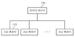
도 1은 본 발명의 실시예에 따른 차량 및 장애물의 위치를 검출하는 서비스 환경을 나타내는 도면이다.
도 2는 본 발명의 실시예에 따른 차량 및 장애물의 위치를 검출하는 장치를 나타내는 구성도이다.
도 3은 본 발명의 실시예에 따른 차량 및 장애물의 위치 검출하는 방법을 나타내는 흐름도이다.
도 4는 본 발명의 실시예에 따른 격자 레이어를 기반으로 차량의 위치를 검출하는 방법을 나타내는 도면이다.
도 5는 본 발명의 실시예에 따른 거리 데이터를 기반으로 차량의 위치를 검출하는 방법을 나타내는 도면이다.1 is a diagram illustrating a service environment for detecting locations of vehicles and obstacles according to an exemplary embodiment of the present invention.
2 is a block diagram illustrating an apparatus for detecting positions of vehicles and obstacles according to an exemplary embodiment of the present invention.
3 is a flowchart illustrating a method of detecting positions of vehicles and obstacles according to an exemplary embodiment of the present invention.
4 is a diagram illustrating a method of detecting a position of a vehicle based on a grating layer according to an exemplary embodiment of the present invention.
5 is a diagram illustrating a method of detecting a position of a vehicle based on distance data according to an embodiment of the present invention.
본 발명을 첨부된 도면을 참조하여 상세히 설명하면 다음과 같다. 여기서, 반복되는 설명, 본 발명의 요지를 불필요하게 흐릴 수 있는 공지 기능, 및 구성에 대한 상세한 설명은 생략한다. 본 발명의 실시형태는 당 업계에서 평균적인 지식을 가진 자에게 본 발명을 보다 완전하게 설명하기 위해서 제공되는 것이다. 따라서, 도면에서의 요소들의 형상 및 크기 등은 보다 명확한 설명을 위해 과장될 수 있다.
Hereinafter, the present invention will be described in detail with reference to the accompanying drawings. Here, the repeated description, well-known functions and configurations that may unnecessarily obscure the subject matter of the present invention, and detailed description of the configuration will be omitted. Embodiments of the present invention are provided to more completely describe the present invention to those skilled in the art. Accordingly, the shape and size of elements in the drawings may be exaggerated for clarity.
이하에서는, 본 발명의 실시예에 따른 차량 및 장애물의 위치 검출 장치 및 그 방법에 대하여 첨부한 도면을 참고로 하여 상세히 설명한다.Hereinafter, an apparatus and a method for detecting a position of a vehicle and an obstacle according to an exemplary embodiment of the present invention will be described in detail with reference to the accompanying drawings.
도 1은 본 발명의 실시예에 따른 차량 및 장애물의 위치를 검출하는 서비스 환경을 나타내는 도면이고, 도 2는 본 발명의 실시예에 따른 차량 및 장애물의 위치를 검출하는 장치를 나타내는 구성도이다.1 is a diagram illustrating a service environment for detecting locations of vehicles and obstacles according to an exemplary embodiment of the present invention, and FIG. 2 is a block diagram illustrating an apparatus for detecting locations of vehicles and obstacles according to an exemplary embodiment of the present invention.
도 1을 참고하면, 본 발명의 실시예에 따른 서비스 환경은 차량 및 장애물의 위치를 검출하는 장치(이하, "위치 검출 장치"라고 함)(100), 무선통신장치(200) 및 무인차량(300)을 포함한다.Referring to Figure 1, the service environment according to an embodiment of the present invention is a device for detecting the position of the vehicle and the obstacle (hereinafter referred to as "position detection device") 100, the
위치 검출 장치(100)는 레이저 스캐너의 출력 결과를 토대로 차량의 위치 및 장애물의 위치를 검출한다. 다음, 위치 검출 장치(100)는 차량의 위치 및 장애물의 위치를 무선통신장치(200)를 통해 무인차량(300)으로 전달한다.The
무인차량(300)은 무선통신장치(200)를 통해 전달받은 자신의 현재 위치와 장애물의 위치를 토대로 차량을 제어한다.The
도 2를 참고하면, 위치 검출 장치(100)는 적어도 하나의 거리 측정부(110) 및 데이터 처리부(120)를 포함한다.Referring to FIG. 2, the
적어도 하나의 거리 측정부(110)는 일정 구간마다 설치되어 해당 측정 영역 내의 물체들과의 거리 데이터를 측정한다. 이때, 측정 영역은 하나의 거리 측정부(110)가 위치하는 지점으로부터 설정 범위에 내에 속하는 영역이다.The at least one
본 발명의 실시예에 따른 적어도 하나의 거리 측정부(110)는 LIDAR(Light detection and ranging)를 기반으로 하는 2차원 또는 3차원 레이저 스캐너에 해당할 수 있으며, 이에 한정되지 않는다.At least one
거리 측정부(110)에서 측정한 거리 데이터는 측정 영역 내의 물체와의 각도에 따른 거리에 해당하는 것으로, 실제 차량 및 장애물의 위치를 검출하기 위해서는 데이터 처리가 필요하다.The distance data measured by the
데이터 처리부(120)는 거리 측정부(110)로부터 전달받은 거리 데이터를 격자 레이어(Grid Layer)에 매핑하고, 매핑한 결과를 기반으로 차량 및 장애물의 위치를 검출한다.The
본 발명의 실시예에 따른 격자 레이어는 예를 들어, 컴퓨터와 같은 특정 장치로 일정 면적을 표현하기 위하여 격자로 나눈 데이터 집합이다.A grid layer according to an embodiment of the present invention is a data set divided by a grid to represent a certain area, for example, with a specific device such as a computer.
구체적으로, 데이터 처리부(120)는 거리 데이터와 격자 레이어를 매핑한 결과를 기반으로 차량의 위치를 검출하고, 검출한 차량의 위치를 토대로 장애물의 위치를 검출한다. 또한, 데이터 처리부(120)는 검출한 차량의 위치를 거리 측정부(110)에서 측정한 거리 데이터를 이용하여 수정함으로써, 차량의 위치를 검출한 결과를 개선할 수 있다.In detail, the
또한, 두 개 이상의 거리 측정부(110)와 연결되어 있는 데이터 처리부(120)는 각각의 거리 측정부(110)로부터 전달받은 거리 데이터들을 취합하고, 취합한 결과를 토대로 차량의 위치 및 장애물의 위치를 검출한다.
In addition, the
다음, 위치 검출 장치(100)가 차량의 위치 및 장애물의 위치를 검출하는 방법을 도 3을 참조하여 상세하게 설명한다.Next, a method of detecting the position of the vehicle and the position of the obstacle by the
도 3은 본 발명의 실시예에 따른 차량 및 장애물의 위치 검출하는 방법을 나타내는 흐름도이다.3 is a flowchart illustrating a method of detecting positions of vehicles and obstacles according to an exemplary embodiment of the present invention.
먼저, 본 발명의 실시예에 따른 위치 검출 장치(100)는 적어도 하나의 거리 측정부(110)에 해당하는 적어도 하나의 레이저 스캐너를 포함한다.First, the
도 3을 참고하면, 위치 검출 장치(100)는 레이저 스캐너를 이용하여 거리 데이터를 획득한다(S310). 이때, 레이저 스캐너는 일정 구간마다 설치되어 해당 측정 영역 내의 물체들과의 거리 데이터를 측정한다. 여기서, 거리 데이터는 일반적으로 1cm 단위로 표현한다.Referring to FIG. 3, the
위치 검출 장치(100)는 획득한 거리 데이터에 해당하는 레이저 스캐너의 갯수가 한 개인지를 판단한다(S320).The
레이저 스캐너의 갯수가 한 개가 아닌 경우, 위치 검출 장치(100)는 획득한 거리 데이터를 격자 레이어에 매핑한다(S330). 여기서, 격자 레이어는 격자로 나눈 데이터 즉, 복수개의 셀을 포함한다. 복수개의 셀 중 하나의 셀의 크기는 거리 데이터의 기본 단위보다 크게 설정하며, 보통 20~50cm 이내로 설정한다.If the number of laser scanners is not one, the
본 발명에서는 격자 레이어 내의 하나의 셀을 격자셀(Grid cell)이라고 한다. 또한, 격자셀과 거리 데이터가 매핑되는 경우, 격자는 거리 데이터를 포함하며, 매핑된 격자셀(matched grid cell)이라고 한다.In the present invention, one cell in the grid layer is called a grid cell. In addition, when the grid cells and the distance data are mapped, the grid includes the distance data and is called a matched grid cell.
위치 검출 장치(100)는 매핑한 결과 즉, 매핑된 격자셀을 이용하여 차량의 위치를 검출한다(S340). 이때, 위치 검출 장치(100)는 격자 레이어를 기반으로 차량의 위치를 검출하므로, 검출한 차량의 위치를 무인주행에 사용하기에 정확도가 떨어진다.The
다음, 위치 검출 장치(100)는 검출한 차량의 위치를 토대로 장애물의 위치를 검출한다(S350). 여기서, 장애물의 위치는 격자 레이어에 매핑된 격자셀 중 검출한 차량의 위치를 기준으로 차량에 해당하는 매핑된 격자셀을 제외한 나머지의 매핑된 격자셀에 해당한다.Next, the
장애물의 위치를 검출하는 동시에, 위치 검출 장치(100)는 매핑된 격자셀을 이용하여 검출한 차량의 위치를 레이저 스캐너의 거리 데이터를 이용하여 수정하여, 다시 한번 검출한다(S360). 또한, 레이저 스캐너의 갯수가 한 개인 경우, 위치 검출 장치(100)는 레이저 스캐너의 거리 데이터를 이용하여 차량의 위치를 검출한다.
At the same time as detecting the position of the obstacle, the
다음, 위치 검출 장치(100)가 격자 레이어를 기반으로 차량의 위치를 검출하는 방법을 도 4를 참조하여 상세하게 설명한다.Next, a method of detecting the position of the vehicle based on the grating layer by the
도 4는 본 발명의 실시예에 따른 격자 레이어를 기반으로 차량의 위치를 검출하는 방법을 나타내는 도면이다.4 is a diagram illustrating a method of detecting a position of a vehicle based on a grating layer according to an exemplary embodiment of the present invention.
본 발명의 실시예에 따른 위치 검출 장치(100)는 격자 레이어를 기반으로 외곽선 검출 방법을 이용하여 차량의 위치를 검출한다.The
외곽선 검출 방법은 차량의 크기를 미리 알고 있는 상황에 적용하는 방법이다. 즉, 본 발명의 실시예에 따른 위치 검출 장치(100)는 차량의 크기를 미리 설정해 두거나, 차량의 위치를 검출하기 이전에 무인차량(300)으로부터 무선통신장치(200)를 통해 전달받는다.The outline detection method is applied to a situation in which the size of the vehicle is known in advance. That is, the
위치 검출 장치(100)는 차량의 크기와 동일한 사각형(이하 "외곽선"이라고 함)을 생성하고, 해당 외곽선과 겹쳐지는 매핑된 격자셀의 수를 계산한다. 여기서, 해당 외곽선과 겹쳐지는 매핑된 격자셀의 수는 매칭 스코어(Matching score)로 설정한다.The
다음, 위치 검출 장치(100)는 외곽선의 위치를 변경함에 따라 매칭 스코어를 반복적으로 계산한 후, 매칭 스코어가 가장 높은 외곽선의 중심점을 차량의 위치로 결정한다.Next, the
도 4에서는 격자 레이어 내의 격자셀과 거리 데이터를 매핑한 결과를 나타내고 있다. 여기서, 격자 레이어의 중간 위치에 무인차량(300)이 존재하고, 우측 하단에 거리 측정부(110)가 존재하는 것으로 가정한다.4 shows a result of mapping grid cells and distance data in the grid layer. Here, it is assumed that the
도 4를 참고하면, 외곽선 A, B, C 및 D는 서로 다른 곳에 위치하는 외곽선이다. 또한, 빈 격자셀은 장애물이 없는 공간이고, 채워진 격자셀은 매핑된 격자셀 즉, 물체가 존재하는 공간이다.Referring to FIG. 4, outlines A, B, C, and D are outlines located at different locations. In addition, an empty grid cell is a space free of obstacles, and a filled grid cell is a mapped grid cell, that is, a space in which an object exists.
이와 같은 형태의 격자 레이어가 존재하는 경우, 위치 검출 장치(100)는 외곽선을 생성하고, 외곽선의 위치를 A -> B -> C -> D 순서로 이동하면서 매칭 스코어를 계산한다. 여기서, 위치 검출 장치(100)는 외곽선의 위치를 일정 방향으로 이동시키고 있으나, 이에 한정되지 않는다.When there is a grid layer of such a shape, the
계산 결과, 외곽선 A 및 C의 매칭 스코어는 "1"이고, B의 매칭 스코어는 "13", D의 매칭 스코어는 "9"이다.As a result of the calculation, the matching scores of the outlines A and C are "1", the matching score of B is "13", and the matching score of D is "9".
위치 검출 장치(100)는 매칭 스코어를 계산한 결과 중 매칭 스코어가 가장 높은 외곽선 B의 중심점을 무인차량(300)의 중심 위치로 결정한다.The
이처럼, 본 발명의 실시에에 따른 외곽선 검출 방법은 격자 레이어를 기반으로 매칭 스코어를 계산하므로, 계산량이 적어 무인차량(300)의 위치를 빠르게 검출하는 장점이 있다.As such, the edge detection method according to the embodiment of the present invention calculates a matching score based on the lattice layer, and thus has a small amount of calculation, so that the position of the
또한, 위치 검출 장치(100)는 격자 레이어를 기반으로 외곽선 검출 방법을 이용하여 차량의 위치를 검출하고, 격자 레이어가 아닌 거리 데이터를 토대로 다시 한번 무인차량(300)의 위치를 검출함으로써, 위치 검출의 정확도를 높일 수 있다.
In addition, the
다음, 위치 검출 장치(100)가 격자 레이어가 아닌 거리 데이터를 토대로 다시 한번 무인차량(300)의 위치를 검출하는 방법을 도 5를 참조하여 상세하게 설명한다.Next, the method of detecting the position of the
도 5는 본 발명의 실시예에 따른 거리 데이터를 기반으로 차량의 위치를 검출하는 방법을 나타내는 도면이다.5 is a diagram illustrating a method of detecting a position of a vehicle based on distance data according to an embodiment of the present invention.
본 발명의 실시예에 따른 위치 검출 장치(100)는 격자 레이어를 기반으로 외곽선 검출 방법을 이용하여 차량의 위치를 검출하고, 거리 측정부(110)를 이용하여 측정한 거리 데이터에 원형검출 방법을 적용하여 검출한 차량의 위치를 수정한다.The
원형검출 방법은 차량의 크기에 해당하는 원을 생성하고, 생성한 원 안에 적어도 하나의 거리 측정부(110)의 측정 결과 즉, 거리 데이터 중 몇 개의 거리 데이터가 존재하는지 체크하여, 거리 데이터의 수를 토대로 차량의 위치를 결정하는 방법이다.The circular detection method generates a circle corresponding to the size of the vehicle, checks how many pieces of distance data exist among the measurement results of at least one
구체적으로, 위치 검출 장치(100)는 차량의 크기에 해당하는 원을 생성하고, 해당 원 안에 거리 데이터 중 몇 개의 거리 데이터가 존재하는지 계산한다. 이때, 해당 원 안에 존재하는 거리 데이터의 수는 히트 스코어(hit score)로 설정한다.In detail, the
다음, 위치 검출 장치(100)는 일정 범위 내에서 원의 중심을 변경함에 따라 히트 스코어를 반복적으로 계산한 후, 히트 스코어가 가장 높은 원의 중심점을 차량의 위치로 결정한다.Next, the
도 5에서는 중앙에 무인차량(300)이 존재하고, 우측 하단에 거리 측정부(110)가 존재하는 것으로 가정한다. 여기서, 점선은 거리 측정부(110)의 측정 결과 즉, 거리 데이터이다. 여기서, 거리 데이터는 격자 레이어에 매핑된 거리 데이터와 다르게 오차를 포함하므로 일직선으로 나타나지 않을 수 있으며, 이에 한정되지 않는다.In FIG. 5, it is assumed that the
위치 검출 장치(100)는 외곽선 검출 방법을 이용하여 검출한 차량의 위치를 중심으로 하는 제1 원(①)을 시작으로, 해당 원 안에 포함되는 거리 데이터의 수 즉, 히트 스코어를 계산한다. 예를 들어, 위치 검출 장치(100)는 원의 중심을 일정 범위 내에서 제2 원(②) 에서 제3 원(③)으로 이동하며, 각 원에 해당하는 히트 스코어를 계산한다.The
위치 검출 장치(100)는 히트 스코어를 계산한 결과 중 히트 스코어가 가장 높은 원의 중심을 차량의 위치로 결정한다.The
원형검출 방법은 원의 중심을 이동 시키고, 각 원에 해당하는 거리 데이터를 이용하여 히트 스코어를 계산하고, 이를 반복하게 되므로 계산량이 큰 단점이 있다. 따라서, 원형검출 방법을 전체지역에 적용하여 무인차량(300)의 위치를 검출하는 경우에는 히트 스코어를 계산하는데 소요되는 시간이 길어지고, 차량의 위치검출까지 지연 시간이 발생하는 문제점이 있다.The circular detection method has a disadvantage in that the amount of calculation is large because the center of the circle is moved, the hit score is calculated using the distance data corresponding to each circle, and it is repeated. Therefore, when detecting the position of the
이를 해결하기 위하여, 본 발명의 실시예에 따른 위치 검출 장치(100)는 원형검출 방법의 시작 위치를 외곽선 검출 방법을 이용하여 검출한 차량의 위치로 하고, 일정 범위 내에서만 원의 중심을 이동하는 것을 특징으로 한다.In order to solve this problem, the
이로써, 본 발명의 실시예에 따른 위치 검출 장치(100)는 격자 레이어를 기반으로 차량의 위치를 대략적으로 검출하고, 대략적으로 검출한 차량의 위치를 원형검출 방법을 이용하여 정밀하게 보정하면서도 계산에 필요한 시간을 줄일 수 있다.
Thus, the
이상에서와 같이 도면과 명세서에서 최적의 실시예가 개시되었다. 여기서 특정한 용어들이 사용되었으나, 이는 단지 본 발명을 설명하기 위한 목적에서 사용된 것이지 의미 한정이나 특허청구범위에 기재된 본 발명의 범위를 제한하기 위하여 사용된 것은 아니다. 그러므로, 본 기술 분야의 통상의 지식을 가진자라면 이로부터 다양한 변형 및 균등한 타 실시예가 가능하다는 점을 이해할 것이다. 따라서, 본 발명의 진정한 기술적 보호범위는 첨부된 특허청구범위의 기술적 사상에 의해 정해져야 할 것이다.
As described above, the best embodiment has been disclosed in the drawings and the specification. Although specific terms have been employed herein, they are used for purposes of illustration only and are not intended to limit the scope of the invention as defined in the claims or the claims. Therefore, those skilled in the art will understand that various modifications and equivalent other embodiments are possible from this. Therefore, the true technical protection scope of the present invention will be defined by the technical spirit of the appended claims.
100; 위치 검출 장치
200; 무선통신장치
300; 무인차량
110; 거리 측정부
120; 데이터 처리부100; Position detection device
200; Wireless communication device
300; Driverless vehicle
110; Distance measuring unit
120; Data processing unit
Claims (19)
Translated fromKorean상기 거리 데이터를 격자 레이어에 매핑하고, 매핑한 결과를 토대로 상기 차량의 위치를 검출하여, 검출한 차량의 위치를 토대로 상기 장애물의 위치를 검출하고, 검출한 차량의 위치를 상기 거리 데이터를 이용하여 수정하는 데이터 처리부
를 포함하는 차량 및 장애물의 위치 검출 장치.At least one distance measuring unit measuring distance data between the vehicle and the obstacle in the measurement area; And
The distance data is mapped to a lattice layer, the position of the vehicle is detected based on the mapping result, the position of the obstacle is detected based on the detected position of the vehicle, and the position of the detected vehicle is determined using the distance data. Data processing unit to modify
Position detection device of a vehicle and obstacle comprising a.
상기 데이터 처리부는
상기 차량의 크기와 동일한 외곽선을 생성하고, 상기 격자 레이어에서 상기 외곽선의 위치를 변경함에 따라 매칭 스코어를 반복적으로 계산하여, 상기 매칭 스코어가 가장 높은 외곽선의 중심점을 상기 차량의 위치로 판단하는 차량 및 장애물의 위치 검출 장치.The method according to claim 1,
The data processing unit
A vehicle which generates an outline equal to the size of the vehicle and repeatedly calculates a matching score as the position of the outline is changed in the grid layer, and determines a center point of the outline having the highest matching score as the position of the vehicle; Obstacle position detection device.
상기 매칭 스코어는
상기 거리 데이터를 격자 레이어에 매핑한 결과에 해당하는 매핑된 격자셀 중에서 상기 외곽선과 겹쳐지는 셀의 수에 해당하는 것을 특징으로 하는 차량 및 장애물의 위치 검출 장치.The method according to claim 2,
The matching score is
And a position corresponding to the number of cells overlapping the outer line among the mapped grid cells corresponding to the result of mapping the distance data to the grid layer.
상기 데이터 처리부는
검출한 차량의 위치를 기준으로 상기 차량의 크기에 해당하는 원을 생성하고, 상기 원의 중심을 변경함에 따라 히트 스코어를 계산하여, 상기 히트 스코어가 가장 높은 원의 중심을 상기 차량의 위치로 수정하는 차량 및 장애물의 위치 검출 장치.The method according to claim 2,
The data processing unit
A circle corresponding to the size of the vehicle is generated based on the detected position of the vehicle, and a heat score is calculated as the center of the circle is changed to correct the center of the circle having the highest hit score to the position of the vehicle. Vehicle and obstacle position detection device.
상기 히트 스코어는
상기 원 안에 포함되는 거리 데이터의 수에 해당하는 것을 특징으로 하는 차량 및 장애물의 위치 검출 장치.The method of claim 4,
The hit score is
And a position detection apparatus for a vehicle and an obstacle corresponding to the number of distance data included in the circle.
상기 데이터 처리부는
상기 격자 레이어에서 상기 거리 데이터와 매핑한 결과 중 상기 차량의 위치에 해당하는 격자셀을 제외한 나머지의 격자셀을 상기 장애물의 위치로 검출하는 차량 및 장애물의 위치 검출 장치.The method according to claim 1,
The data processing unit
An apparatus for detecting a position of a vehicle and an obstacle that detects the remaining grid cells except the grid cells corresponding to the position of the vehicle among the mapping results with the distance data in the grid layer.
상기 거리 측정부는 레이저 스캐너에 해당하는 것을 특징으로 하는 차량 및 장애물의 위치 검출 장치.The method according to claim 1,
And the distance measuring unit corresponds to a laser scanner.
상기 레이저 스캐너를 이용하여 상기 레이저 스캐너와 상기 차량 및 장애물과의 거리 데이터를 측정하는 단계;
상기 거리 데이터를 격자 레이어에 매핑하는 단계;
매핑한 결과에 해당하는 매핑된 격자셀을 이용하여 상기 차량의 위치를 검출하는 단계;
상기 차량의 위치를 토대로 상기 장애물의 위치를 검출하는 단계; 및
상기 차량의 위치를 상기 거리 데이터를 이용하여 수정하는 단계
를 포함하는 차량 및 장애물의 위치 검출 방법.In the method for detecting the position of the vehicle and obstacle using a laser scanner,
Measuring distance data between the laser scanner, the vehicle, and an obstacle using the laser scanner;
Mapping the distance data to a grid layer;
Detecting the position of the vehicle using the mapped grid cell corresponding to the mapping result;
Detecting the position of the obstacle based on the position of the vehicle; And
Modifying the position of the vehicle using the distance data
Position detection method of the vehicle and the obstacle comprising a.
상기 차량의 위치를 검출하는 단계는
상기 차량의 크기와 동일한 외곽선을 생성하는 단계;
상기 격자 레이어에서 상기 외곽선의 위치를 변경하는 단계;
상기 외곽선과 겹쳐지는 상기 매핑된 격자셀의 수에 해당하는 매칭 스코어를 계산하는 단계; 및
상기 매칭 스코어를 토대로 상기 차량의 위치를 검출하는 단계
를 포함하는 차량 및 장애물의 위치 검출 방법.The method according to claim 8,
Detecting the position of the vehicle
Generating an outline equal to the size of the vehicle;
Changing the position of the outline in the lattice layer;
Calculating a matching score corresponding to the number of the mapped grid cells overlapping the outline; And
Detecting the position of the vehicle based on the matching score
Position detection method of the vehicle and the obstacle comprising a.
상기 매칭 스코어를 토대로 상기 차량의 위치를 검출하는 단계는
상기 외곽선의 위치를 변경함에 따라 상기 매칭 스코어를 반복적으로 계산하고, 반복적으로 계산한 결과 중 가장 높은 매칭 스코어에 해당하는 외곽선의 중심을 상기 차량의 위치로 검출하는 것을 특징으로 하는 차량 및 장애물의 위치 검출 방법.The method according to claim 9,
Detecting the position of the vehicle based on the matching score
The matching score is repeatedly calculated as the position of the outline is changed, and the position of the vehicle and the obstacle is characterized in that the center of the outline corresponding to the highest matching score is detected as the position of the vehicle. Detection method.
상기 차량의 위치를 상기 거리 데이터를 이용하여 수정하는 단계는
상기 차량의 위치를 기준으로 상기 차량의 크기에 해당하는 원을 생성하는 단계;
상기 원의 중심을 변경하여, 변경된 원의 중심에 해당하는 히트 스코어를 계산하는 단계; 및
상기 히트 스코어가 가장 높은 원의 중심을 토대로 상기 차량의 위치를 수정하는 단계
를 포함하는 차량 및 장애물의 위치 검출 방법.The method according to claim 8,
Correcting the position of the vehicle using the distance data
Generating a circle corresponding to the size of the vehicle based on the position of the vehicle;
Changing a center of the circle to calculate a hit score corresponding to the changed center of the circle; And
Correcting the position of the vehicle based on the center of the circle having the highest hit score
Position detection method of the vehicle and the obstacle comprising a.
상기 히트 스코어는
상기 원 안에 포함되는 거리 데이터의 수에 해당하는 차량 및 장애물의 위치 검출 방법.The method of claim 11,
The hit score is
And a position detection method of a vehicle and an obstacle corresponding to the number of distance data included in the circle.
상기 장애물의 위치를 검출하는 단계는
상기 매핑된 격자셀 중 상기 차량의 위치에 해당하는 격자셀을 제외한 나머지의 격자셀을 상기 장애물의 위치로 검출하는 것을 특징으로 하는 차량 및 장애물의 위치 검출 방법.The method according to claim 8,
Detecting the position of the obstacle
The method of detecting the position of the vehicle and the obstacle, characterized in that for detecting the remaining grid cells other than the grid cell corresponding to the position of the vehicle among the mapped grid cells.
상기 거리 데이터를 격자 레이어에 매핑하는 단계;
상기 격자 레이어에서 상기 차량에 해당하는 외곽선의 위치를 변경하여 매칭 스코어를 계산하는 단계;
상기 매칭 스코어를 토대로 상기 차량의 위치를 검출하는 단계;
상기 차량의 위치를 토대로 상기 장애물의 위치를 검출하는 단계;
상기 격자 레이어에서 상기 차량의 위치를 기준으로 상기 차량에 해당하는 원을 생성하는 단계; 및
상기 원의 위치를 변경하여, 변경된 원에 해당하는 히트 스코어를 토대로 상기 차량의 위치를 수정하는 단계
를 포함하는 차량 및 장애물의 위치 검출 방법.Measuring distance data between the vehicle and the obstacle by the position detection device;
Mapping the distance data to a grid layer;
Calculating a matching score by changing a position of an outline corresponding to the vehicle in the grid layer;
Detecting a position of the vehicle based on the matching score;
Detecting the position of the obstacle based on the position of the vehicle;
Generating a circle corresponding to the vehicle based on the position of the vehicle in the grid layer; And
Modifying the position of the vehicle based on the heat score corresponding to the changed circle by changing the position of the circle;
Position detection method of the vehicle and the obstacle comprising a.
상기 매칭 스코어는 상기 거리 데이터를 격자 레이어에 매핑한 결과에 해당하는 매핑된 격자셀 중 상기 외곽선과 겹쳐지는 셀의 수에 해당하는 것을 특징으로 하는 차량 및 장애물의 위치 검출 방법.The method according to claim 14,
The matching score corresponds to the number of cells overlapping with the outline of the mapped grid cells corresponding to the result of mapping the distance data to the grid layer.
상기 히트 스코어는 상기 원 안에 포함되는 거리 데이터의 수에 해당하는 것을 특징으로 하는 차량 및 장애물의 위치 검출 방법.The method according to claim 14,
And the hit score corresponds to the number of distance data included in the circle.
상기 차량의 위치를 검출하는 단계는
상기 외곽선의 위치를 변경하여 매칭 스코어를 계산한 결과 중에서 상기 매칭 스코어가 가장 높은 외곽선의 중심점을 상기 차량의 위치로 검출하는 차량 및 장애물의 위치 검출 방법.The method according to claim 14,
Detecting the position of the vehicle
And detecting a center point of the outline having the highest matching score as a position of the vehicle among the results of calculating the matching score by changing the position of the outline.
상기 장애물의 위치를 검출하는 단계는
상기 거리 데이터를 격자 레이어에 매핑한 결과 중에서 상기 차량의 위치에 해당하는 격자셀을 제외한 나머지의 격자셀을 상기 장애물의 위치로 검출하는 것을 특징으로 하는 차량 및 장애물의 위치 검출 방법.The method according to claim 14,
Detecting the position of the obstacle
The method of detecting the position of the vehicle and the obstacle, characterized in that for detecting the remaining grid cells other than the grid cell corresponding to the position of the vehicle from the result of mapping the distance data to the grid layer.
상기 차량의 위치를 수정하는 단계는
상기 원의 위치를 변경함에 따라 히트 스코어를 계산하는 단계; 및
계산한 히트 스코어 중에서 가장 높은 히트 스코어에 해당하는 원의 중심을 상기 차량의 위치로 수정하는 단계
를 포함하는 차량 및 장애물의 위치 검출 방법.
The method according to claim 14,
Correcting the position of the vehicle
Calculating a hit score as the position of the circle changes; And
Correcting the center of the circle corresponding to the highest hit score among the calculated hit scores to the position of the vehicle;
Position detection method of the vehicle and the obstacle comprising a.
Priority Applications (2)
| Application Number | Priority Date | Filing Date | Title |
|---|---|---|---|
| KR1020100104755AKR20120043446A (en) | 2010-10-26 | 2010-10-26 | Apparatus and method for detecting a location of vehicle and obstacle |
| US13/282,109US8744752B2 (en) | 2010-10-26 | 2011-10-26 | Apparatus and method for detecting locations of vehicle and obstacle |
Applications Claiming Priority (1)
| Application Number | Priority Date | Filing Date | Title |
|---|---|---|---|
| KR1020100104755AKR20120043446A (en) | 2010-10-26 | 2010-10-26 | Apparatus and method for detecting a location of vehicle and obstacle |
Publications (1)
| Publication Number | Publication Date |
|---|---|
| KR20120043446Atrue KR20120043446A (en) | 2012-05-04 |
Family
ID=45973669
Family Applications (1)
| Application Number | Title | Priority Date | Filing Date |
|---|---|---|---|
| KR1020100104755AAbandonedKR20120043446A (en) | 2010-10-26 | 2010-10-26 | Apparatus and method for detecting a location of vehicle and obstacle |
Country Status (2)
| Country | Link |
|---|---|
| US (1) | US8744752B2 (en) |
| KR (1) | KR20120043446A (en) |
Cited By (3)
| Publication number | Priority date | Publication date | Assignee | Title |
|---|---|---|---|---|
| CN106840177A (en)* | 2017-01-23 | 2017-06-13 | 斑马信息科技有限公司 | Vehicle synchronous build figure and obstacle identification method |
| CN109992640A (en)* | 2019-04-11 | 2019-07-09 | 北京百度网讯科技有限公司 | Method and device, device and storage medium for determining location grid |
| CN112729320A (en)* | 2020-12-22 | 2021-04-30 | 中国第一汽车股份有限公司 | Method, device and equipment for constructing obstacle map and storage medium |
Families Citing this family (5)
| Publication number | Priority date | Publication date | Assignee | Title |
|---|---|---|---|---|
| KR102096398B1 (en)* | 2013-07-03 | 2020-04-03 | 삼성전자주식회사 | Method for recognizing position of autonomous mobile robot |
| KR101610502B1 (en)* | 2014-09-02 | 2016-04-07 | 현대자동차주식회사 | Apparatus and method for recognizing driving enviroment for autonomous vehicle |
| US10114618B2 (en)* | 2015-06-08 | 2018-10-30 | Cisco Technology, Inc. | Autonomous mobile sensor movement path simulation with an integrated developer environment |
| CN108281040A (en)* | 2017-12-28 | 2018-07-13 | 东南大学 | A kind of more vehicle collaborative obstacle avoidance system and methods |
| CN109987098B (en)* | 2019-04-09 | 2020-09-29 | 莫日华 | Method and device for controlling safe driving based on road surface analysis |
Family Cites Families (13)
| Publication number | Priority date | Publication date | Assignee | Title |
|---|---|---|---|---|
| JPH0990033A (en) | 1995-09-25 | 1997-04-04 | Mazda Motor Corp | Obstacle detecting device for vehicle |
| US7983802B2 (en)* | 1997-10-22 | 2011-07-19 | Intelligent Technologies International, Inc. | Vehicular environment scanning techniques |
| JP4233723B2 (en)* | 2000-02-28 | 2009-03-04 | 本田技研工業株式会社 | Obstacle detection device, obstacle detection method, and recording medium recording an obstacle detection program |
| US7142150B2 (en)* | 2004-12-15 | 2006-11-28 | Deere & Company | Method and system for detecting an object using a composite evidence grid |
| US7266477B2 (en)* | 2005-06-22 | 2007-09-04 | Deere & Company | Method and system for sensor signal fusion |
| US8364366B2 (en)* | 2005-06-24 | 2013-01-29 | Deere & Company | System and method for providing a safety zone associated with a vehicle |
| US7574428B2 (en)* | 2005-10-11 | 2009-08-11 | Telmap Ltd | Geometry-based search engine for navigation systems |
| KR100953731B1 (en) | 2007-12-18 | 2010-04-19 | 주식회사 포스코아이씨티 | Vehicle collision prevention method using real-time tracking information and suitable system |
| JP4788722B2 (en)* | 2008-02-26 | 2011-10-05 | トヨタ自動車株式会社 | Autonomous mobile robot, self-position estimation method, environmental map generation method, environmental map generation device, and environmental map data structure |
| KR101581415B1 (en)* | 2009-02-23 | 2015-12-30 | 삼성전자주식회사 | apparatus and method for building a map |
| US8538675B2 (en)* | 2009-06-01 | 2013-09-17 | Raytheon Company | Non-kinematic behavioral mapping |
| KR101682175B1 (en)* | 2010-01-20 | 2016-12-02 | 삼성전자주식회사 | Apparatus and Method for generating grid map |
| US8861842B2 (en)* | 2010-02-05 | 2014-10-14 | Sri International | Method and apparatus for real-time pedestrian detection for urban driving |
- 2010
- 2010-10-26KRKR1020100104755Apatent/KR20120043446A/ennot_activeAbandoned
- 2011
- 2011-10-26USUS13/282,109patent/US8744752B2/ennot_activeExpired - Fee Related
Cited By (4)
| Publication number | Priority date | Publication date | Assignee | Title |
|---|---|---|---|---|
| CN106840177A (en)* | 2017-01-23 | 2017-06-13 | 斑马信息科技有限公司 | Vehicle synchronous build figure and obstacle identification method |
| CN109992640A (en)* | 2019-04-11 | 2019-07-09 | 北京百度网讯科技有限公司 | Method and device, device and storage medium for determining location grid |
| CN112729320A (en)* | 2020-12-22 | 2021-04-30 | 中国第一汽车股份有限公司 | Method, device and equipment for constructing obstacle map and storage medium |
| CN112729320B (en)* | 2020-12-22 | 2022-05-17 | 中国第一汽车股份有限公司 | Method, device and equipment for constructing obstacle map and storage medium |
Also Published As
| Publication number | Publication date |
|---|---|
| US8744752B2 (en) | 2014-06-03 |
| US20120101719A1 (en) | 2012-04-26 |
Similar Documents
| Publication | Publication Date | Title |
|---|---|---|
| KR20120043446A (en) | Apparatus and method for detecting a location of vehicle and obstacle | |
| EP4033324B1 (en) | Obstacle information sensing method and device for mobile robot | |
| US9659378B2 (en) | Point cloud position data processing device, point cloud position data processing system, point cloud position data processing method, and program therefor | |
| US11486988B2 (en) | Method for calibrating the alignment of a moving object sensor | |
| CN109782258B (en) | Position detection method and device for vehicle laser radar and storage medium | |
| Nienaber et al. | A comparison of low-cost monocular vision techniques for pothole distance estimation | |
| CN110850859B (en) | Robot and obstacle avoidance method and obstacle avoidance system thereof | |
| AU2019210587A1 (en) | Object detection based on lidar intensity | |
| WO2019126950A1 (en) | Positioning method, cloud server, terminal, system, electronic device and computer program product | |
| CN111381586A (en) | Robot and movement control method and device thereof | |
| CN104916216A (en) | Map construction method and system thereof | |
| KR102428765B1 (en) | Autonomous driving vehicle navigation system using the tunnel lighting | |
| JP7405630B2 (en) | Information processing device, detection device, roadside device, and calibration method | |
| Wang et al. | Modeling of binocular stereo vision for remote coordinate measurement and fast calibration | |
| CN113190007A (en) | Map contour correction method, chip and mobile robot | |
| CN111536990A (en) | On-line external reference mis-calibration detection between sensors | |
| KR20210135753A (en) | Method and apparatus for location estimation of lidar-based vehicles | |
| CN114442073A (en) | Laser radar calibration method and device, vehicle and storage medium | |
| JP5720292B2 (en) | Estimated position evaluation system and program | |
| JP6272269B2 (en) | Cross scan data correction apparatus and cross scan data correction program | |
| CN113607154A (en) | Two-dimensional autonomous positioning method, system, equipment and medium for indoor robot | |
| JP2021124377A (en) | Calibration determination result presentation device, calibration determination result presentation method, and program | |
| KR101255024B1 (en) | Relative localization system and method using ultrasonic sensor | |
| US11423576B1 (en) | Infrastructure node localization with respect to alternative frame of reference | |
| CN115932875A (en) | Positioning method, device, system, vehicle and storage medium based on lidar |
Legal Events
| Date | Code | Title | Description |
|---|---|---|---|
| A201 | Request for examination | ||
| PA0109 | Patent application | Patent event code:PA01091R01D Comment text:Patent Application Patent event date:20101026 | |
| PA0201 | Request for examination | ||
| PG1501 | Laying open of application | ||
| E902 | Notification of reason for refusal | ||
| PE0902 | Notice of grounds for rejection | Comment text:Notification of reason for refusal Patent event date:20140107 Patent event code:PE09021S01D | |
| E701 | Decision to grant or registration of patent right | ||
| PE0701 | Decision of registration | Patent event code:PE07011S01D Comment text:Decision to Grant Registration Patent event date:20140619 | |
| PC1904 | Unpaid initial registration fee |