KR20120042253A - Method for providing realty information and system - Google Patents
Method for providing realty information and systemDownload PDFInfo
- Publication number
- KR20120042253A KR20120042253AKR1020100103856AKR20100103856AKR20120042253AKR 20120042253 AKR20120042253 AKR 20120042253AKR 1020100103856 AKR1020100103856 AKR 1020100103856AKR 20100103856 AKR20100103856 AKR 20100103856AKR 20120042253 AKR20120042253 AKR 20120042253A
- Authority
- KR
- South Korea
- Prior art keywords
- real estate
- information
- terminal
- land
- estate information
- Prior art date
- Legal status (The legal status is an assumption and is not a legal conclusion. Google has not performed a legal analysis and makes no representation as to the accuracy of the status listed.)
- Withdrawn
Links
Images


Classifications
- G—PHYSICS
- G06—COMPUTING OR CALCULATING; COUNTING
- G06Q—INFORMATION AND COMMUNICATION TECHNOLOGY [ICT] SPECIALLY ADAPTED FOR ADMINISTRATIVE, COMMERCIAL, FINANCIAL, MANAGERIAL OR SUPERVISORY PURPOSES; SYSTEMS OR METHODS SPECIALLY ADAPTED FOR ADMINISTRATIVE, COMMERCIAL, FINANCIAL, MANAGERIAL OR SUPERVISORY PURPOSES, NOT OTHERWISE PROVIDED FOR
- G06Q50/00—Information and communication technology [ICT] specially adapted for implementation of business processes of specific business sectors, e.g. utilities or tourism
- G06Q50/10—Services
- G06Q50/16—Real estate
- G—PHYSICS
- G06—COMPUTING OR CALCULATING; COUNTING
- G06T—IMAGE DATA PROCESSING OR GENERATION, IN GENERAL
- G06T19/00—Manipulating 3D models or images for computer graphics
- G06T19/006—Mixed reality
Landscapes
- Business, Economics & Management (AREA)
- Tourism & Hospitality (AREA)
- Health & Medical Sciences (AREA)
- Economics (AREA)
- General Health & Medical Sciences (AREA)
- Human Resources & Organizations (AREA)
- Marketing (AREA)
- Primary Health Care (AREA)
- Strategic Management (AREA)
- Physics & Mathematics (AREA)
- General Business, Economics & Management (AREA)
- General Physics & Mathematics (AREA)
- Engineering & Computer Science (AREA)
- Theoretical Computer Science (AREA)
- Processing Or Creating Images (AREA)
Abstract
Translated fromKoreanDescription
Translated fromKorean본 발명은 부동산정보 제공 방법 및 시스템에 관한 것으로, 더욱 상세하게는 나대지와 같은 토지의 부동산 매물 정보에 대한 실제 주변 토지와의 경계선 및 실제 모습에 대한 이미지를 구매자에게 증강 현실을 통해 제공할 수 있는 증강현실을 이용한 부동산정보 제공 방법 및 시스템에 관한 것이다.The present invention relates to a method and system for providing real estate information. More particularly, the present invention provides a buyer with an image of a boundary and a real appearance of a real neighboring land for real estate information of a land such as a bare land. It relates to a method and system for providing real estate information using augmented reality.
급속한 이동통신 기술의 발전과 통신 단말기의 대중적인 보급에 따라 이제는 대부분의 사람들이 다기능을 실행하는 통신 단말기를 소지하여 사용하고 있다. 이러한 다기능 통신 단말기는 전화기 본래의 기능인 음성 통화 기능 외에 디지털 카메라 촬영이나 MP3 음악 파일을 재생할 수 있는 등 멀티미디어 단말기로 그 기능이 확장되고 있을 뿐만 아니라 다양한 부가서비스를 제공하고 있다.With the rapid development of mobile communication technology and the popular dissemination of communication terminals, most people now possess communication terminals that perform multifunction. In addition to the voice call function, which is an inherent function of a telephone, such a multi-functional communication terminal is not only expanded to a multimedia terminal such as digital camera photographing or MP3 music file, but also provides various additional services.
이와 함께, 최근에는 통신 단말기의 기능 및 PDA(Personal Digital Assistant)의 기능을 결합시킨 스마트폰(Smart Phone)이 각광받고 있는 추세이다. 이러한 스마트폰은 휴대전화기에 인터넷 통신과 정보 검색 등의 컴퓨터 지원 기능을 추가한 지능형 단말기로서, 기존의 통신 단말기에 비해 대용량의 메모리와 고성능 CPU(Central Processing Unit)가 탑재되며, 다양한 어플리케이션 실행, 음성/데이터 통신 및 PC(Personal Computer) 연동 등을 지원하기 위한 운영체제(OS, Operating System)가 탑재된다. 이에 따라 사용자는 스마트폰을 통해 기존 통신 단말기와 달리 자유롭게 인터넷을 이용할 수 있다.In addition, in recent years, smart phones, which combine the functions of a communication terminal and a function of a personal digital assistant (PDA), have been in the spotlight. The smart phone is an intelligent terminal that adds computer support functions such as Internet communication and information retrieval to a mobile phone, and is equipped with a large memory and a high-performance central processing unit (CPU), compared to a conventional communication terminal, to execute various applications and voice. An operating system (OS) for supporting data communication and PC (Personal Computer) interworking is mounted. Accordingly, the user can freely use the Internet unlike a conventional communication terminal through a smart phone.
인터넷 이용이 보편화되면서, 인터넷 상의 가상 공간을 통해 제품이나 용역의 매매가 이루어지는 전자 상거래(Electronic commerce)가 등장하였으며, 이러한 전자 상거래는 의류, 생활용품 등과 같은 소비재의 매매뿐만 아니라 부동산 거래에까지 적용되고 있다.As the use of the Internet has become commonplace, electronic commerce, in which goods and services are sold through virtual spaces on the Internet, has emerged. Such electronic commerce has been applied not only to the sale of consumer goods such as clothing and household goods, but also to real estate transactions.
이 중에서, 부동산은 그 특성상 시장 가격 및 거래 비용이 다른 인터넷을 통한 전자 상거래 품목에 비해 월등하게 높아서 소비자들이 쉽게 매매 의사 결정을 할 수 없기 때문에, 현재까지의 인터넷을 이용한 부동산 거래 사업은 웹사이트를 통해서 부동산 매물의 정보를 수집하여 사용자에게 제공하는 방식으로 이루어지고 있다.Among them, the real estate transaction business using the Internet until now has not been able to easily make a buying decision because the market price and transaction cost are much higher than other e-commerce items over the Internet. Through the collection of real estate information is provided in a manner to provide to the user.
그런데, 기존에 제공되는 부동산 매물 정보는, 부동산의 위치, 가격, 면적 정도의 단순한 정보로 이루어지고 있기 때문에, 사용자의 요구 수준을 충족시켜 주지 못하고 있다. 특히, 주택 또는 아파트와 달리 나대지, 논, 밭 등의 토지의 경우, 구매자가 사고자 하는 대상물은 토지대장 상으로는 특정되어 있지만, 실제 모습을 구매자가 파악하기 힘든 경우가 있다. 즉, 구매자 자신이 구매하고자 하는 매물과 주변 토지와의 경계가 명확하지 않을 수 있다. 또한, 토지대장만으로는 실제 나대지가 형성된 모습을 알 수 없으며, 간혹, 실제 토지가 쓸모 있는 땅인지 여부를 확실히 알 수 없다.By the way, since the existing real estate for sale information is composed of simple information such as the location, price, and area of the real estate, it does not meet the user's demand level. In particular, unlike houses or apartments, land, such as bare land, rice fields, fields, etc., the object that the buyer wants to buy is specified on the land register, but it is difficult for the buyer to grasp the actual appearance. That is, the boundary between the property to be purchased by the buyer himself and the surrounding land may not be clear. In addition, the land register alone does not know the actual formation of the bare land, and sometimes, it is not sure whether the actual land is useful land.
이러한 종래의 문제점을 해결하기 위하여, 본 발명의 목적은 단말기를 통해 증강현실로 해당 토지의 경계를 제공하여 구매자에게 구매 목적에 맞는 토지인지 여부를 알 수 있도록 하여 복잡한 절차 없이 부동산정보를 습득할 수 있는 부동산정보 제공 방법 및 시스템을 제공하고자 한다.In order to solve such a conventional problem, an object of the present invention is to provide real estate information without a complicated procedure by providing a border of the land with augmented reality through the terminal so that the buyer knows whether the land is suitable for the purpose of purchase. To provide a real estate information providing method and system.
상술한 바와 같은 목적을 달성하기 위한 본 발명의 부동산정보 제공 시스템은 적어도 하나의 특정 지역에 대한 이미지를 촬영하고, 특정 지역에 대한 위치정보를 확인하고, 확인된 위치정보에 대응하는 토지대장정보 검색하고, 토지대장정보에 근거하여 부동산정보를 생성하고, 생성된 부동산정보를 사용자에게 제공하는 단말기 및 단말기로부터 촬영된 특정 지역에 대한 이미지를 수신하고, 특정 지역에 대한 위치정보를 확인하고, 확인된 위치정보에 대응하는 토지대장정보 검색하고, 토지대장정보에 근거하여 부동산정보 생성하고, 생성된 부동산정보를 단말기로 전송하는 부동산정보 제공장치를 포함하는 것을 특징으로 한다.The real estate information providing system of the present invention for achieving the above object is to take an image of at least one specific area, to check the location information for the specific area, and search the land ledger information corresponding to the identified location information And generate real estate information based on land register information, receive an image of a specific area photographed from a terminal and a terminal providing the generated real estate information to a user, check location information of a specific area, It is characterized in that it comprises a real estate information providing apparatus for retrieving the land register information corresponding to the location information, generating real estate information based on the land register information, and transmitting the generated real estate information to the terminal.
본 발명의 실시 예에 따른 단말기는 통신망을 통해 데이터를 송수신하는 단말통신부와, 적어도 하나의 특정 지역에 대한 이미지를 촬영하는 카메라부 및 특정 지역에 대한 위치정보를 확인하고, 확인된 위치정보에 대응하는 토지대장정보 검색하고, 토지대장정보에 근거하여 부동산정보를 생성하고, 생성된 부동산정보를 사용자에게 제공하도록 제어하는 단말제어부를 포함하는 것을 특징으로 한다.The terminal according to an embodiment of the present invention checks the terminal communication unit for transmitting and receiving data through the communication network, the camera unit for taking images of at least one specific region and the location information for the specific region, and corresponds to the confirmed position information It characterized in that it comprises a terminal control unit for retrieving the land ledger information, generating the real estate information based on the land ledger information, and providing the generated real estate information to the user.
또한, 본 발명에 따른 단말기에 있어서, 다수 지역에 대한 부동산 매물을 저장하는 부동산매물 데이터베이스 및 부동산 매물에 대한 법적 제한정보를 저장하는 관리대장 데이터베이스로 구성되는 단말저장부를 더 포함하는 것을 특징으로 한다.In addition, the terminal according to the present invention, characterized in that it further comprises a terminal storage consisting of a real estate for sale database for storing real estate for a number of regions and a management ledger database for storing legal restrictions on the real estate for sale.
또한, 본 발명에 따른 단말기에 있어서, 단말제어부는 특정 지역에 대한 위치정보를 위치측위를 통해 획득하는 것을 특징으로 한다.In addition, in the terminal according to the present invention, the terminal control unit is characterized in that to obtain the location information for a specific area through the location positioning.
또한, 본 발명에 따른 단말기에 있어서, 부동산정보는 특정 지역에 대한 경계선, 면적, 대지 및 토지정보 중 하나 이상에 해당하는 정보인 것을 특징으로 한다.In addition, in the terminal according to the present invention, the real estate information is characterized in that the information corresponding to one or more of the boundary line, area, land and land information for a particular area.
또한, 본 발명에 따른 단말기에 있어서, 단말제어부는 부동산정보와 특정 지역에 대한 이미지를 결합하여 입체적인 증강현실로 제공하는 것을 특징으로 한다.In addition, in the terminal according to the present invention, the terminal control unit is characterized by providing a three-dimensional augmented reality by combining the image of the real estate information and a specific area.
또한, 본 발명에 따른 단말기에 있어서, 단말제어부는 촬영된 이미지를 부동산정보 제공장치로 전송하고, 부동산정보 제공장치로부터 특정 지역에 대한 부동산정보를 수신하여 제공하는 것을 특징으로 한다.In the terminal according to the present invention, the terminal control unit transmits the captured image to the real estate information providing apparatus, and receives and provides real estate information for a specific region from the real estate information providing apparatus.
본 발명의 실시 예에 따른 부동산정보 제공장치는 통신망을 통해 단말기와 데이터를 송수신하는 통신부 및 단말기로부터 촬영된 적어도 하나의 특정 지역에 대한 이미지를 수신하고, 특정 지역에 대한 위치정보를 확인하고, 확인된 위치정보에 대응하는 토지대장정보 검색하고, 토지대장정보에 근거하여 부동산정보를 생성하고, 생성된 부동산정보를 단말기로 전송하도록 제어하는 제어부를 포함하는 것을 특징으로 한다.An apparatus for providing real estate information according to an embodiment of the present invention receives an image of at least one specific region photographed from a communication unit and a terminal for transmitting and receiving data with a terminal through a communication network, confirms location information for the specific region, and confirms And a control unit for searching the land register information corresponding to the location information, generating the real estate information based on the land register information, and transmitting the generated real estate information to the terminal.
또한, 본 발명에 따른 부동산정보 제공장치에 있어서, 다수 지역에 대한 부동산 매물을 저장하는 부동산매물 데이터베이스 및 부동산 매물에 대한 법적 제한정보를 저장하는 관리대장 데이터베이스로 구성되는 저장부를 더 포함하는 것을 특징으로 한다.In addition, the real estate information providing apparatus according to the present invention, characterized in that it further comprises a storage unit consisting of a real estate for sale database for storing real estate for a number of regions and a management ledger database for storing legal restriction information about the real estate for sale. do.
또한, 본 발명에 따른 부동산정보 제공장치에 있어서, 제어부는 단말기의 위치측위를 통해 특정 지역에 대한 위치정보를 획득하는 것을 특징으로 한다.In addition, in the real estate information providing apparatus according to the present invention, the control unit is characterized in that to obtain the location information for a specific area through the positioning of the terminal.
또한, 본 발명에 따른 부동산정보 제공장치에 있어서, 부동산정보는 특정 지역에 대한 경계선, 면적, 대지 및 토지정보 중 하나 이상에 해당하는 정보인 것을 특징으로 한다.In the real estate information providing apparatus according to the present invention, the real estate information is information corresponding to one or more of a boundary line, an area, a land, and land information for a specific area.
본 발명의 실시 예에 따른 부동산정보 제공 방법은 적어도 하나의 특정 지역에 대한 이미지를 촬영하는 단계와, 특정 지역에 대한 위치정보를 확인하는 단계와, 확인된 위치정보에 대응하는 토지대장정보 검색하는 단계와, 토지대장정보에 근거하여 부동산정보를 생성하는 단계 및 생성된 부동산정보를 사용자에게 제공하는 단계를 포함하는 것을 특징으로 한다.The method for providing real estate information according to an embodiment of the present invention includes the steps of photographing an image of at least one specific area, checking location information of a specific area, and searching land ledger information corresponding to the identified location information. And generating the real estate information based on the land register information and providing the generated real estate information to the user.
또한, 본 발명에 따른 부동산정보 제공 방법에 있어서, 촬영하는 단계 이전에, 부동산정보 서비스를 위한 다수 지역의 부동산 매물을 등록하는 단계를 포함하는 것을 특징으로 한다.In addition, the method for providing real estate information according to the present invention is characterized in that it includes a step of registering real estate for sale in a plurality of areas for real estate information service before the photographing step.
또한, 본 발명에 따른 부동산정보 제공 방법에 있어서, 확인하는 단계는 특정 지역에 대한 위치정보를 위치측위를 통해 획득하는 단계를 포함하는 것을 특징으로 한다.In addition, in the method for providing real estate information according to the present invention, the checking may include obtaining location information on a specific area through location positioning.
또한, 본 발명에 따른 부동산정보 제공 방법에 있어서, 부동산정보는 특정 지역에 대한 경계선, 면적, 대지 및 토지정보 중 하나 이상에 해당하는 정보인 것을 특징으로 한다.In the real estate information providing method according to the present invention, the real estate information is characterized in that the information corresponding to one or more of the boundary line, area, land and land information for a particular area.
또한, 본 발명에 따른 부동산정보 제공 방법에 있어서, 제공하는 단계는 부동산정보와 특정 지역에 대한 이미지를 결합하여 입체적인 증강현실로 제공하는 것을 특징으로 한다.In the real estate information providing method according to the present invention, the providing step is characterized by providing a three-dimensional augmented reality by combining the real estate information and the image for a particular area.
본 발명의 실시 예에 따른 부동산정보 제공 방법은 부동산정보 제공장치가 단말기로부터 촬영된 적어도 하나의 특정 지역에 대한 이미지를 수신하는 단계와, 부동산정보 제공장치가 특정 지역에 대한 위치정보를 확인하는 단계와, 부동산정보 제공장치가 확인된 위치정보에 대응하는 토지대장정보 검색하는 단계와, 부동산정보 제공장치가 토지대장정보에 근거하여 부동산정보를 생성하는 단계 및 부동산 제공장치가 생성된 부동산정보를 단말기로 전송하는 단계를 포함하는 것을 특징으로 한다.In accordance with another aspect of the present invention, there is provided a method of providing real estate information, wherein the real estate information providing apparatus receives an image of at least one specific region photographed from a terminal, and the real estate information providing apparatus confirms location information of a specific region. And retrieving the land ledger information corresponding to the confirmed location information by the real estate information providing device, generating the real estate information based on the land ledger information, and real estate information generated by the real estate providing device. Characterized in that it comprises the step of transmitting to.
또한, 본 발명에 따른 부동산정보 제공 방법에 있어서, 수신하는 단계 이전에, 부동산정보 제공장치는 다수 지역에 대한 부동산 매물을 등록하는 단계를 포함하는 것을 특징으로 한다.In the real estate information providing method according to the present invention, before the receiving step, the real estate information providing apparatus includes a step of registering real estate for a plurality of regions.
또한, 본 발명에 따른 부동산정보 제공 방법에 있어서, 확인하는 단계는 부동산정보 제공장치가 단말기의 위치측위를 통해 특정 지역에 대한 위치정보를 획득하는 단계를 포함하는 것을 특징으로 한다.In addition, in the real estate information providing method according to the present invention, the step of confirming is characterized in that the real estate information providing apparatus comprises the step of obtaining the location information for a specific area through the positioning of the terminal.
본 발명의 실시 예에 따른 부동산정보 제공 방법은 단말기가 적어도 하나의 특정 지역에 대한 이미지를 촬영하는 단계와, 단말기가 촬영된 이미지를 부동산정보 제공장치로 전송하는 단계 및 단말기가 부동산정보 제공장치로부터 특정 지역에 대한 부동산정보를 수신하여 제공하는 단계를 포함하는 것을 특징으로 한다.In accordance with an aspect of the present invention, there is provided a method for providing real estate information, including: photographing, by the terminal, an image of at least one specific region; transmitting, by the terminal, the photographed image to the real estate information providing apparatus; and the terminal from the real estate information providing apparatus. And receiving and providing real estate information for a specific region.
또한, 본 발명에 따른 부동산정보 제공 방법에 있어서, 제공하는 단계는 단말기가 부동산정보와 특정 지역에 대한 이미지를 결합하여 입체적인 증강현실로 표시하는 것을 특징으로 한다.In addition, in the real estate information providing method according to the present invention, the providing step is characterized in that the terminal combines the real estate information and the image for a particular area to display a three-dimensional augmented reality.
본 발명에 따르면, 구매자가 구매하고자 하는 나대지를 포함하는 토지에 대한 매물의 경계선을 증강현실로 제시함으로써, 구매자에게 매물에 대한 정확한 이미지 정보를 제공하여 효과적이다.According to the present invention, by presenting the boundary of the sale for the land including the land to be purchased by the buyer in augmented reality, it is effective to provide the buyer with accurate image information about the sale.
또한, 부동산 중개업자는 부동산 매물에 대한 주변 토지와의 경계선 등에 해당하는 정확한 정보를 구매자에게 제공하여 신뢰성을 향상 시킬 수 있고, 수익 창출에 기여할 수 있다.In addition, the real estate agent can improve the reliability and contribute to the revenue generation by providing the buyer with accurate information corresponding to the boundary with the surrounding land on the real estate for sale.
또한, 해당 부동산 매물에 대한 실제 이미지와 가상의 경계선 등을 결합하여 증강현실로 구매자에게 제공함으로써, 구매자가 보다 쉽고 정확하게 나대지의 주변 환경과의 조화 및 경계선 등을 인식하여 복잡한 조사과정이나 실제 장소의 사전 방문 없이 효과적으로 부동산 매물에 대한 정보를 습득하여 정확한 가치를 측정할 수 있다.In addition, by combining the real image and the virtual boundary of the real estate for sale to the buyer in augmented reality, the buyer can more easily and accurately recognize the harmony and boundary with the surrounding environment of the land, so that the complex survey process or actual place You can effectively learn about real estate listings without prior visits and measure their exact value.
또한, 특정 지역의 토지에 대한 위치나 면적등과 같은 단순 정보뿐만 아니라 해당 부동산 매물에 대한 가상의 정보를 함께 제공함으로써, 온라인을 통해 부동산 거래를 제공하여 사용자가 부동산 매물에 대한 가치를 보다 쉽게 파악할 수 있도록 하며, 온라인을 통한 부동산 거래를 더 활성화시키는데 효과적이다.In addition, by providing not only simple information such as the location and area of land in a specific area, but also virtual information about the property, the real estate transaction is provided online so that users can more easily grasp the value of the property. It is effective in furthering real estate transactions online.
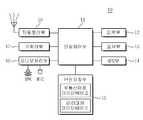
도 1은 본 발명의 실시 예에 따른 부동산정보 제공 시스템을 나타내는 도면이다.
도 2는 본 발명의 실시 예에 따른 단말기의 구성을 나타내는 도면이다.
도 3은 본 발명의 실시 예에 따른 부동산정보 제공장치의 구성을 나타내는 도면이다.
도 4는 본 발명의 실시 예에 따른 부동산정보 제공 방법을 설명하기 위한 흐름도이다.
도 5는 본 발명의 실시 예에 따른 단말기와 부동산정보 제공장치의 연동을 통한 부동산정보 제공 방법을 나타내는 데이터 흐름도이다.
도 6과 도 7은 본 발명의 실시 예에 따른 부동산정보 제공 방법을 설명하기 위한 예시도이다.1 is a view showing a real estate information providing system according to an embodiment of the present invention.
2 is a diagram illustrating a configuration of a terminal according to an exemplary embodiment of the present invention.
3 is a view showing the configuration of a real estate information providing apparatus according to an embodiment of the present invention.
4 is a flowchart illustrating a method for providing real estate information according to an exemplary embodiment of the present invention.
5 is a data flow diagram illustrating a method for providing real estate information through interworking between a terminal and a real estate information providing apparatus according to an exemplary embodiment of the present invention.
6 and 7 are exemplary views for explaining a method for providing real estate information according to an exemplary embodiment of the present invention.
이하 본 발명의 바람직한 실시 예를 첨부한 도면을 참조하여 상세히 설명한다. 다만, 하기의 설명 및 첨부된 도면에서 본 발명의 요지를 흐릴 수 있는 공지 기능 또는 구성에 대한 상세한 설명은 생략한다. 또한, 도면 전체에 걸쳐 동일한 구성 요소들은 가능한 한 동일한 도면 부호로 나타내고 있음에 유의하여야 한다.Hereinafter, preferred embodiments of the present invention will be described in detail with reference to the accompanying drawings. However, in the following description and the accompanying drawings, detailed descriptions of well-known functions or configurations that may obscure the subject matter of the present invention will be omitted. In addition, it should be noted that like elements are denoted by the same reference numerals as much as possible throughout the drawings.
이하에서 설명되는 본 명세서 및 청구범위에 사용된 용어나 단어는 통상적이거나 사전적인 의미로 한정해서 해석되어서는 아니 되며, 발명자는 그 자신의 발명을 가장 최선의 방법으로 설명하기 위해 용어의 개념으로 적절하게 정의할 수 있다는 원칙에 입각하여 본 발명의 기술적 사상에 부합하는 의미와 개념으로 해석되어야만 한다. 따라서 본 명세서에 기재된 실시 예와 도면에 도시된 구성은 본 발명의 가장 바람직한 일 실시 예에 불과할 뿐이고, 본 발명의 기술적 사상을 모두 대변하는 것은 아니므로, 본 출원시점에 있어서 이들을 대체할 수 있는 다양한 균등물과 변형 예들이 있을 수 있음을 이해하여야 한다.The terms or words used in the specification and claims described below should not be construed as being limited to the ordinary or dictionary meanings, and the inventors are appropriate to the concept of terms in order to explain their invention in the best way. It should be interpreted as meanings and concepts in accordance with the technical spirit of the present invention based on the principle that it can be defined. Therefore, the embodiments described in the present specification and the configuration shown in the drawings are only the most preferred embodiments of the present invention, and do not represent all of the technical ideas of the present invention, and various alternatives may be substituted at the time of the present application. It should be understood that there may be equivalents and variations.
설명에 앞서, 이하에서는 본 발명의 실시 예에 따른 단말기는 부동산정보 제공 서비스를 위하여 이동통신망을 이용하는 형태의 이동통신 단말기를 대표적인 예로서 설명하지만 단말기는 이동통신 단말기에 한정된 것이 아니고, 모든 정보통신기기, 멀티미디어 기기, 일반 유선단말기, 근거리 무선통신 단말기, 고정형 단말기 및 IP(Internet Protocol) 단말기 등의 다양한 단말기에 적용될 수 있다.Prior to the description, the terminal according to the embodiment of the present invention will be described as a representative mobile communication terminal using a mobile communication network for real estate information providing service as a representative example, but the terminal is not limited to the mobile communication terminal, all information communication devices The present invention can be applied to various terminals such as multimedia devices, general wired terminals, short range wireless communication terminals, fixed terminals, and IP (Internet Protocol) terminals.
도 1은 본 발명의 실시 예에 따른 부동산정보 제공 시스템을 나타내는 도면이다.1 is a view showing a real estate information providing system according to an embodiment of the present invention.
도 1을 참조하면, 본 발명의 실시 예에 따른 부동산정보 제공 시스템(100)은 단말기(10), 부동산정보 제공장치(20) 및 통신망(30)으로 구성된다.Referring to FIG. 1, a real estate
통신망(30)은 부동산정보 제공 시스템(100)에서 단말기(10) 및 부동산정보 제공장치(20) 간의 데이터 송수신을 위한 통로를 제공하는 기능을 한다. 여기서, 통신망(30)은 단말기(10) 및 부동산정보 제공장치(20) 사이의 데이터 전송 및 정보 교환을 위한 일련의 데이터 송수신 동작을 수행한다. 이와 같은 기능을 수행하는 통신망(30)은 인터넷 프로토콜(IP)을 통하여 대용량 데이터의 송수신 서비스 및 끊기는 현상이 없는 데이터 서비스를 제공하는 아이피망으로, 아이피를 기반으로 서로 다른 망을 통합한 아이피망 구조인 올 아이피(All IP)망 일 수 있다. 또한, 통신망(30)은 유선통신망, 이동통신망, Wibro(Wireless Broadband)망, HSDPA(High Speed Downlink Packet Access)망, 위성통신망 및 와이파이(WI-FI, Wireless Fidelity)망 중 하나일 수 있다. 이중, 통신망(30)이 와이파이 망으로 구성되어 부동산정보 서비스를 제공하는 경우 즉, 현재 위치한 장소 근처에 무선접속장치(AP, Access Point)가 설치되어 일정한 거리 내에서 초고속 인터넷을 할 수 있는 근거리 통신망일 때, 단말기(10)는 사용자의 조작에 따라 와이파이 망을 통해 부동산정보 제공장치(20)로부터 부동산정보를 제공받을 수 있다.The
단말기(10)는 특정 지역에 대한 이미지를 촬영한다. 이때, 단말기(10)는 특정 지역에 대한 위치정보를 확인한다. 즉, 단말기(10)는 위치측위를 통해 특정 지역에 대한 위치정보를 획득할 수 있다. 여기서, 단말기(10)는 부동산정보 제공 서비스를 위하여 특정 지역에 대한 촬영을 실행하기 이전에 다수 지역의 부동산 매물에 대한 데이터를 등록할 수 있다.The terminal 10 captures an image of a specific area. At this time, the terminal 10 checks the location information for the specific area. That is, the terminal 10 may obtain location information about a specific area through location location. Here, the terminal 10 may register data on real estate for sale in a plurality of regions before performing photographing for a specific region for real estate information providing service.
단말기(10)는 확인된 위치정보에 대응하는 토지대장정보 획득한다. 여기서, 토지대장정보는 토지의 현황을 명확하게 하기 위하여 토지의 소재지, 지번, 지목, 지적 및 소유자의 주소와 성명 등이 등록되어 있는 정보이다. 그리고, 단말기(10)는 토지대장정보에 근거하여 부동산정보를 생성한다. 여기서, 부동산정보는 특정 지역에 대한 경계선, 면적, 대지 및 토지정보 등에 해당하는 정보이다.The terminal 10 obtains land accounting information corresponding to the identified location information. Here, the land register information is information in which the land, land, land, land, land, and owner's address and name are registered in order to clarify the current state of the land. Then, the terminal 10 generates real estate information based on the land register information. Here, the real estate information is information corresponding to a boundary line, area, land and land information for a specific area.
단말기(10)는 생성된 부동산정보를 사용자에게 제공한다. 여기서, 단말기(10)는 부동산정보와 특정 지역에 대한 이미지를 결합하여 입체적인 이미지를 증강현실로 제공할 수 있다.The terminal 10 provides the generated real estate information to the user. Here, the terminal 10 may provide a three-dimensional image as augmented reality by combining the real estate information and the image for a specific region.
단말기(10)는 적어도 하나의 특정 지역에 대한 이미지를 촬영한다. 여기서, 단말기(10)는 촬영된 이미지를 부동산정보 제공장치(20)로 전송한다. 이후, 단말기(10)는 부동산정보 제공장치(20)로부터 특정 지역에 대한 부동산정보를 수신하여 사용자에게 제공한다. 이때, 단말기(10)는 부동산정보와 특정 지역에 대한 이미지를 결합하여 입체적인 이미지를 증강현실로 표시한다.The terminal 10 captures an image of at least one specific area. Here, the terminal 10 transmits the photographed image to the real estate
부동산정보 제공장치(20)는 단말기(10)로부터 촬영된 특정 지역에 대한 이미지를 수신한다. 여기서, 부동산정보 제공장치(20)는 특정 지역에 대한 위치정보를 확인한다. 이때, 부동산정보 제공장치(20)는 단말기(10)의 위치측위를 통해 특정 지역에 대한 위치정보를 획득할 수 있다. 한편, 부동산정보 제공장치(20)는 단말기(10)로부터 이미지를 수신하기에 앞서, 부동산정보 제공 서비스를 위하여 다수 지역의 부동산 매물에 대한 데이터를 등록한다.The real estate
부동산정보 제공장치(20)는 확인된 위치정보에 대응하는 토지대장정보 획득한다. 이때, 부동산정보 제공장치(20)는 토지대장정보에 근거하여 부동산정보를 생성한다. 그리고, 부동산정보 제공장치(20)는 생성된 부동산정보를 단말기(10)로 전송할 수 있다.The real estate
또한, 본 발명의 실시 예에 따른 부동산정보 제공 시스템(100)에 있어서, 단말기(10)와 부동산정보 제공장치(20) 간의 데이터 송수신을 보다 효과적으로 수행하기 위하여 위치측위장치(미도시)를 포함할 수 있다. 여기서, 위치측위장치는 부동산정보 제공장치(20)의 요청에 따라 위치정보를 수집하기 위한 위치측위를 단말기(10)와 실행하는 기능을 한다. 즉, 위치측위장치는 특정 지역의 위치정보를 측위하기 위하여 GPS(Global Positioning System) 위성으로부터 GPS 신호를 수신할 수 있다. 이를 위해 위치측위장치는 특정 지역의 위도 및 경도 등을 확인하여 현재 위치정보를 파악할 수 있다.In addition, in the real estate
이를 통해, 구매자가 구매하고자 하는 나대지를 포함하는 토지에 대한 매물의 경계선을 증강현실로 제시함으로써, 구매자에게 매물에 대한 정확한 이미지 정보를 제공하여 효과적이다. 또한, 부동산 중개업자는 부동산 매물에 대한 주변 토지와의 경계선 등에 해당하는 정확한 정보를 구매자에게 제공하여 신뢰성을 향상 시킬 수 있고, 수익 창출에 기여할 수 있다. 또한, 해당 부동산 매물에 대한 실제 이미지와 가상의 경계선 등을 결합하여 증강현실로 구매자에게 제공함으로써, 구매자가 보다 쉽고 정확하게 나대지의 주변 환경과의 조화 및 경계선 등을 인식하여 복잡한 조사과정이나 실제 장소의 사전 방문 없이 효과적으로 부동산 매물에 대한 정보를 습득하여 정확한 가치를 측정할 수 있다. 또한, 특정 지역의 토지에 대한 위치나 면적등과 같은 단순 정보뿐만 아니라 해당 부동산 매물에 대한 가상의 정보를 함께 제공함으로써, 온라인을 통해 부동산 거래를 제공하여 사용자가 부동산 매물에 대한 가치를 보다 쉽게 파악할 수 있도록 하며, 온라인을 통한 부동산 거래를 더 활성화시키는데 효과적이다.Through this, it is effective to provide the buyer with accurate image information about the sale by presenting the boundary of the sale for the land including the land to be purchased by the buyer in augmented reality. In addition, the real estate agent can improve the reliability and contribute to the revenue generation by providing the buyer with accurate information corresponding to the boundary with the surrounding land on the real estate for sale. In addition, by combining the real image and the virtual boundary of the real estate for sale to the buyer in augmented reality, the buyer can more easily and accurately recognize the harmony and boundary with the surrounding environment of the land, so that the complex survey process or actual place You can effectively learn about real estate listings without prior visits and measure their exact value. In addition, by providing not only simple information such as the location and area of land in a specific area, but also virtual information about the property, the real estate transaction is provided online so that users can more easily grasp the value of the property. It is effective in furthering real estate transactions online.
도 2는 본 발명의 실시 예에 따른 단말기의 구성을 나타내는 도면이다.2 is a diagram illustrating a configuration of a terminal according to an exemplary embodiment of the present invention.
도 2를 참조하면, 본 발명의 실시 예에 따른 단말기(10)는 단말제어부(11), 입력부(12), 표시부(13), GPS부(14), 단말저장부(15), 오디오처리부(16), 카메라부(17) 및 단말통신부(18)로 구성된다.Referring to FIG. 2, the terminal 10 according to an exemplary embodiment of the present invention includes a
단말제어부(11)는 단말기(10)의 각 구성을 초기화하고, 필요한 신호 제어를 수행할 수 있다. 특히, 본 발명의 실시 예에 따른 단말제어부(11)는 카메라부(17)를 통해 특정 지역에 대한 이미지를 촬영한다. 이때, 단말제어부(11)는 특정 지역에 대한 위치정보를 확인한다. 즉, 단말제어부(11)는 위치측위를 통해 특정 지역에 대한 위치정보를 획득할 수 있다. 여기서, 단말제어부(11)는 부동산정보 제공 서비스를 위하여 특정 지역에 대한 촬영을 하기 이전에 다수 지역의 부동산 매물에 대한 데이터를 등록할 수 있다.The
단말제어부(11)는 확인된 위치정보에 대응하는 토지대장정보 획득한다. 이때, 토지대장정보는 토지의 현황을 명확하게 하기 위하여 토지의 소재지, 지번, 지목, 지적 및 소유자의 주소와 성명 등이 등록되어 있는 정보이다. 그리고, 단말제어부(11)는 토지대장정보에 근거하여 부동산정보를 생성한다. 여기서, 부동산정보는 특정 지역에 대한 경계선, 면적, 대지 및 토지정보 등에 해당하는 정보이다.The
단말제어부(11)는 생성된 부동산정보를 사용자에게 제공한다. 여기서, 단말제어부(11)는 부동산정보와 특정 지역에 대한 이미지를 결합하여 입체적인 이미지를 증강현실로 제공할 수 있다.The
단말제어부(11)는 특정 지역에 대한 이미지를 촬영한다. 여기서, 단말제어부(11)는 촬영된 이미지를 부동산정보 제공장치(20)로 전송한다. 그리고 나서, 단말제어부(11)는 부동산정보 제공장치(20)로부터 특정 지역에 대한 부동산정보를 수신하여 사용자에게 제공한다. 이때, 단말제어부(11)는 부동산정보와 특정 지역에 대한 이미지를 결합하여 입체적인 증강현실로 표시한다.The
입력부(12)는 숫자 및 문자 정보 등의 다양한 정보를 입력 받고, 각종 기능들의 설정 및 단말기(10)의 기능 제어와 관련하여 입력되는 신호를 단말제어부(11)로 전달한다. 또한, 입력부(12)는 사용자의 터치 또는 조작에 따른 입력 신호를 발생하는 키패드와 터치패드 중 적어도 하나를 포함하여 구성될 수 있다. 이때, 입력부(12)는 표시부(13)와 함께 하나의 터치패널(또는 터치스크린)의 형태로 구성되어 입력과 표시 기능을 동시에 수행할 수 있다. 특히, 입력부(12)는 단말기(10)가 터치스크린 형태로 구성되는 경우 화면에 터치되는 신호를 입력 받거나, 키보드 및 마우스 등의 입력을 받을 수 있다.The
표시부(13)는 단말기(10)에서 기능 수행 중에 발생하는 일련의 동작상태 및 동작결과 등의 정보를 표시한다. 또한, 표시부(13)는 단말기(10)의 메뉴 및 사용자가 입력한 사용자 데이터 등을 표시할 수 있다. 여기서, 표시부(13)는 LCD(Liquid Crystal Display), TFT-LCD(Thin Film Transistor LCD), OLED(Organic Light Emitting Diodes), 발광다이오드(LED), AMOLED(Active Matrix Organic LED), 플렉시블 디스플레이(Flexible display) 및 3차원 디스플레이(3 Dimension) 등으로 구성될 수 있다. 특히, 본 발명의 실시 예에 따른 표시부(13)는 특정 지역에 대한 부동산정보를 화면에 실제 이미지와 결합하여 증강현실을 통해 제공한다.The
GPS부(14)는 단말제어부(11)의 제어에 의해 GPS 위성으로부터 GPS 신호를 수신하여 단말기(10)의 위도, 경도 등의 현재위치정보를 파악하여 단말제어부(11)로 전송한다. 이때, GPS부(14)는 단말기(10)의 위치정보를 파악하기 위하여 삼각법 등을 이용할 수 있다. 특히, GPS부(14)는 현재의 위치 좌표를 검출하여 단말기(10)의 위치정보를 추출할 수 있다. 여기서, GPS부(14)는 특정 지역에 대한 위치정보의 수집을 위하여 통신망(30)을 통해 데이터를 송수신한다.The
단말저장부(15)는 단말기(10)의 기능 동작에 필요한 응용 프로그램을 저장한다. 이러한 단말저장부(15)는 크게 프로그램 영역과 데이터 영역을 포함할 수 있다. 여기서, 단말기(10)는 사용자의 요청에 상응하여 각 기능을 활성화하는 경우, 단말제어부(11)의 제어 하에 해당 응용 프로그램들을 실행하여 각 기능을 제공하게 된다. 특히, 본 발명의 실시 예에 따른 프로그램 영역은 단말기(10)를 부팅시키는 운영체제, 부동산정보를 제공하는 프로그램 및 특정 지역에 대한 부동산정보를 증강현실을 통해 제공하는 프로그램 등이 저장된다. 또한, 데이터 영역은 단말기(10)의 기능 사용에 따라 발생하는 데이터가 저장되는 영역이다. 특히, 데이터 영역은 특정 지역의 부동산 매물에 대한 경계선, 면적, 대지 및 토지정보 등과 같은 부동산정보가 저장된다. 또한, 데이터 영역은 부동산 매물에 대한 법적 제한정보를 관리하기 위한 토지대장정보 등이 저장된다.The
오디오처리부(16)는 오디오 신호를 재생하거나 또는 마이크(MIC)로부터 입력되는 오디오 신호를 단말제어부(11)에 전달하는 기능을 수행한다. 특히, 오디오처리부(16)는 부동산정보 서비스 제공에 따른 알람 신호를 제공한다. 여기서, 알람 신호는 알람소리, 진동, 램프 또는 이들의 조합 등이 출력될 수 있다.The
카메라부(17)는 특정 지역의 부동산에 대한 영상데이터를 수집한다. 이러한 카메라부(17)는 렌즈를 통해 촬상되는 영상을 촬영하며, 촬영된 광 신호를 전기적 신호로 변환하는 카메라 센서(도시되지 않음)와, 카메라 센서로부터 촬영되는 아날로그 영상신호를 디지털 데이터로 변환하는 신호처리부(도시되지 않음)를 구비한다. 여기서 카메라 센서는 CCD(Charge Coupled Device) 센서 또는 CMOS(Complementary Metal Oxide Semiconductor) 이미지 센서가 적용될 수 있고, 신호처리부는 DSP(Digital Signal Processor)로 구현될 수 있으나, 이에 한정되는 것은 아니다. 이러한 카메라부(17)는 카메라 기능을 이용하기 위한 입력 신호가 수신되는 경우에 활성화될 수 있다. 그런 다음, 카메라부(17)는 수집되는 영상 데이터를 단말제어부(11)에 전달한다. 이러한 기능을 효과적으로 수행하기 위하여, 카메라부(17)는 영상 처리부(미도시)를 구비할 수 있다. 이때, 영상 처리부는 카메라 센서에서 출력되는 영상신호를 표시하기 위한 화면데이터를 발생하는 기능을 수행한다. 이때, 영상 처리부는 카메라 센서에서 출력되는 영상신호를 프레임 단위로 처리하며, 프레임 영상데이터를 표시부(13)의 표시 특성 및 크기에 대응하여 출력한다. 또한, 영상 처리부는 영상 코덱(CODEC)을 구비하며, 표시부(13)에 표시되는 프레임 영상데이터를 설정된 방식으로 압축하거나 압축된 프레임 영상데이터를 원래의 프레임 영상데이터로 복원하는 기능을 수행한다. 여기서, 영상 코덱은 JPEG(Joint Photographic coding Experts Group) 코덱 또는 MPEG(Moving Picture Experts Group) 코덱 등이 될 수 있다.The
단말통신부(18)는 단말기(10)의 데이터 통신을 수행하는 기능을 한다. 즉, 단말통신부(18)는 통신망(30)을 통해 부동산정보 제공장치(20)와 데이터를 송수신 한다. 여기서, 단말통신부(18)는 송신되는 신호의 주파수를 상승 변환 및 증폭하는 RF 송신부와 수신되는 신호를 저잡음 증폭하고 주파수를 하강 변환하는 RF 수신부 등을 포함한다. 특히, 본 발명의 실시 예에 따른 단말통신부(18)는 부동산정보 제공장치(20)로부터 특정 지역에 대한 부동산정보를 수신하는 기능을 한다.The
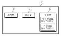
도 3은 본 발명의 실시 예에 따른 부동산정보 제공장치의 구성을 나타내는 도면이다.3 is a view showing the configuration of a real estate information providing apparatus according to an embodiment of the present invention.
도 3을 참조하면, 본 발명의 실시 예에 따른 부동산정보 제공장치(20)는 제어부(21), 저장부(22) 및 통신부(23)로 구성된다.Referring to FIG. 3, the real estate
제어부(21)는 부동산정보 제공장치(20)의 각 구성을 초기화하고, 필요한 신호 제어를 수행할 수 있다. 특히, 본 발명의 실시 예에 따른 제어부(21)는 단말기(10)로부터 촬영된 특정 지역에 대한 이미지를 수신한다. 여기서, 제어부(21)는 특정 지역에 대한 위치정보를 확인한다. 이때, 제어부(21)는 단말기(10)의 위치측위를 통해 특정 지역에 대한 위치정보를 획득할 수 있다. 한편, 제어부(21)는 단말기(10)로부터 이미지를 수신하기 이전에, 부동산정보 서비스를 위한 다수 지역의 부동산 매물에 대한 데이터를 등록한다.The
제어부(21)는 확인된 위치정보에 대응하는 토지대장정보 획득한다. 이때, 제어부(21)는 토지대장정보에 근거하여 부동산정보를 생성한다. 그리고, 제어부(21)는 생성된 부동산정보를 단말기(10)로 전송할 수 있다.The
저장부(22)는 부동산정보 제공장치(20)의 기능 동작에 필요한 응용 프로그램을 저장한다. 이러한 저장부(22)는 부동산정보 제공장치(22)를 부팅시키는 운영체제, 부동산정보를 제공하는 프로그램 및 특정 지역에 대한 부동산정보를 증강현실을 통해 표시하는 프로그램 등이 저장된다. 또한, 저장부(22)는 특정 지역의 부동산 매물에 대한 경계선, 면적, 대지 및 토지정보 등과 같은 부동산정보와 부동산 매물에 대한 법적 제한정보를 관리하기 위한 토지대장정보 등이 저장된다.The
통신부(23)는 단말기(10)와 부동산정보 제공을 위한 데이터를 송수신하는 기능을 한다. 특히, 통신부(23)는 단말기(10)로부터 특정 지역에 대한 이미지를 수신한다. 또한, 통신부(23)는 수신된 이미지를 통해 생성된 부동산정보를 단말기(10)로 전송한다.The
도 4는 본 발명의 실시 예에 따른 부동산정보 제공 방법을 설명하기 위한 흐름도이다.4 is a flowchart illustrating a method for providing real estate information according to an exemplary embodiment of the present invention.
도 4를 참조하면, 본 발명의 실시 예에 따른 부동산정보 제공 방법에 있어서, 단말기(10)는 S11 단계에서 카메라부(17)를 통해 특정 지역에 대한 이미지를 촬영한다. 그리고, 단말기(10)는 S13 단계에서 특정 지역에 대한 위치측위를 실행한다. 이때, 단말기(10)는 S15 단계에서 특정 지역에 대한 위치정보를 확인한다. 여기서, 단말기(10)는 위치측위를 통해 특정 지역에 대한 위치정보를 획득할 수 있다.Referring to FIG. 4, in the real estate information providing method according to an exemplary embodiment of the present invention, the terminal 10 captures an image of a specific area through the
단말기(10)는 S17 단계에서 확인된 위치정보에 대응하는 토지대장정보 획득한다. 그리고, 단말기(10)는 S19 단계에서 토지대장정보에 근거하여 부동산정보를 생성한다. 여기서, 부동산정보는 특정 지역에 대한 경계선, 면적, 대지 및 토지정보 등에 해당하는 정보이다.The terminal 10 acquires land ledger information corresponding to the location information identified in step S17. In addition, the terminal 10 generates real estate information based on the land register information in step S19. Here, the real estate information is information corresponding to a boundary line, area, land and land information for a specific area.
단말기(10)는 S21 단계에서 생성된 부동산정보를 사용자에게 제공한다. 즉, 단말기(10)는 부동산정보와 특정 지역에 대한 이미지를 결합하여 입체적인 증강현실로 제공할 수 있다.The terminal 10 provides the user with real estate information generated in step S21. That is, the terminal 10 may combine the real estate information and the image of a specific region and provide the three-dimensional augmented reality.
이를 통해, 구매자가 구매하고자 하는 나대지를 포함하는 토지에 대한 매물의 경계선을 증강현실로 제시함으로써, 구매자에게 매물에 대한 정확한 이미지 정보를 제공하여 효과적이다. 또한, 부동산 중개업자는 부동산 매물에 대한 주변 토지와의 경계선 등에 해당하는 정확한 정보를 구매자에게 제공하여 신뢰성을 향상 시킬 수 있고, 수익 창출에 기여할 수 있다. 또한, 해당 부동산 매물에 대한 실제 이미지와 가상의 경계선 등을 결합하여 증강현실로 구매자에게 제공함으로써, 구매자가 보다 쉽고 정확하게 나대지의 주변 환경과의 조화 및 경계선 등을 인식하여 복잡한 조사과정이나 실제 장소의 사전 방문 없이 효과적으로 부동산 매물에 대한 정보를 습득하여 정확한 가치를 측정할 수 있다. 또한, 특정 지역의 토지에 대한 위치나 면적등과 같은 단순 정보뿐만 아니라 해당 부동산 매물에 대한 가상의 정보를 함께 제공함으로써, 온라인을 통해 부동산 거래를 제공하여 사용자가 부동산 매물에 대한 가치를 보다 쉽게 파악할 수 있도록 하며, 온라인을 통한 부동산 거래를 더 활성화시키는데 효과적이다.Through this, it is effective to provide the buyer with accurate image information about the sale by presenting the boundary of the sale for the land including the land to be purchased by the buyer in augmented reality. In addition, the real estate agent can improve the reliability and contribute to the revenue generation by providing the buyer with accurate information corresponding to the boundary with the surrounding land on the real estate for sale. In addition, by combining the real image and the virtual boundary of the real estate for sale to the buyer in augmented reality, the buyer can more easily and accurately recognize the harmony and boundary with the surrounding environment of the land, so that the complex survey process or actual place You can effectively learn about real estate listings without prior visits and measure their exact value. In addition, by providing not only simple information such as the location and area of land in a specific area, but also virtual information about the property, the real estate transaction is provided online so that users can more easily grasp the value of the property. It is effective in furthering real estate transactions online.
도 5는 본 발명의 실시 예에 따른 단말기와 부동산정보 제공장치의 연동을 통한 부동산정보 제공 방법을 나타내는 데이터 흐름도이다.5 is a data flow diagram illustrating a method for providing real estate information through interworking between a terminal and a real estate information providing apparatus according to an exemplary embodiment of the present invention.
도 5를 참조하면, 본 발명의 실시 예에 따른 단말기(10)와 부동산정보 제공장치(20)의 연동을 통한 부동산정보 제공 방법에 있어서, 단말기(10)는 S31 단계에서 특정 지역에 대한 이미지를 촬영한다. 그리고 나서, 단말기(10)는 S33 단계에서 촬영된 이미지를 부동산정보 제공장치(20)로 전송한다.Referring to FIG. 5, in the method of providing real estate information by interlocking the terminal 10 and the real estate
이미지가 수신되면, 부동산정보 제공장치(20)는 S35 단계에서 이미지를 확인한다. 그리고, 부동산정보 제공장치(20)는 S37 단계에서 특정 지역에 대한 위치정보를 확인한다. 이때, 부동산정보 제공장치(20)는 단말기(10)의 위치측위를 통해 특정 지역에 대한 위치정보를 획득할 수 있다.When the image is received, the real estate
위치정보가 획득되면, 부동산정보 제공장치(20)는 S39 단계에서 확인된 위치정보에 대응하는 토지대장정보 획득한다. 그리고, 부동산정보 제공장치(20)는 S41 단계에서 토지대장정보에 근거하여 부동산정보를 생성한다.When the location information is obtained, the real estate
부동산정보가 생성되면, 부동산정보 제공장치(20)는 S43 단계에서 생성된 부동산정보를 단말기(10)로 전송할 수 있다.When the real estate information is generated, the real estate
부동산정보가 수신되면, 단말기(10)는 S45 단계에서 부동산정보를 사용자에게 제공한다. 즉, 단말기(10)는 부동산정보와 특정 지역에 대한 이미지를 결합하여 입체적인 증강현실로 제공할 수 있다.When the real estate information is received, the terminal 10 provides the real estate information to the user in step S45. That is, the terminal 10 may combine the real estate information and the image of a specific region and provide the three-dimensional augmented reality.
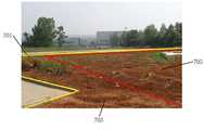
도 6과 도 7은 본 발명의 실시 예에 따른 부동산정보 제공 방법을 설명하기 위한 예시도이다.6 and 7 are exemplary views for explaining a method for providing real estate information according to an exemplary embodiment of the present invention.
도 6과 도 7을 참조하면, 일반적으로 구매자는 노대지에 대하여 자신이 구매하고자 하는 부동산 매물의 경계선(601, 701)이 실제 경계선이라고 생각할 수 있다. 하지만, 토지대상에 따른 부동산 매물의 경계는 경계선(605, 705)이고, 사용불가 영역(603, 703)을 제외하게 된다. 이처럼, 부동산정보는 구매자가 구매하고자 하는 매물의 경계가 다를 수 있기 때문에, 증강현실을 통해 제시하여 구매자에게 매물에 대한 정확한 정보를 제공한다.Referring to FIGS. 6 and 7, in general, a buyer may think that the
본 발명에 따른 부동산정보 제공 방법은 다양한 컴퓨터 수단을 통하여 판독 가능한 소프트웨어 형태로 구현되어 컴퓨터로 판독 가능한 기록매체에 기록될 수 있다. 여기서, 기록매체는 프로그램 명령, 데이터 파일, 데이터 구조 등을 단독으로 또는 조합하여 포함할 수 있다. 기록매체에 기록되는 프로그램 명령은 본 발명을 위하여 특별히 설계되고 구성된 것들이거나 컴퓨터 소프트웨어 당업자에게 공지되어 사용 가능한 것일 수도 있다. 예컨대 기록매체는 하드 디스크, 플로피 디스크 및 자기 테이프와 같은 자기 매체(Magnetic Media), CD-ROM(Compact Disk- Read Only Memory), DVD(Digital Video Disk)와 같은 광 기록 매체(Optical Media), 플롭티컬 디스크(Floptical Disk)와 같은 자기-광 매체(Magneto-Optical Media), 및 롬(ROM), 램(RAM, Random Access Memory), 플래시 메모리 등과 같은 프로그램 명령을 저장하고 수행하도록 특별히 구성된 하드웨어 장치를 포함한다. 프로그램 명령의 예에는 컴파일러에 의해 만들어지는 것과 같은 기계어 코드뿐만 아니라 인터프리터 등을 사용해서 컴퓨터에 의해서 실행될 수 있는 고급 언어 코드를 포함할 수 있다. 이러한 하드웨어 장치는 본 발명의 동작을 수행하기 위해 하나 이상의 소프트웨어 모듈로서 작동하도록 구성될 수 있으며, 그 역도 마찬가지이다.The method for providing real estate information according to the present invention may be implemented in software form readable through various computer means and recorded on a computer readable recording medium. Here, the recording medium may include a program command, a data file, a data structure, etc. alone or in combination. Program instructions recorded on the recording medium may be those specially designed and constructed for the present invention, or they may be of the kind well-known and available to those having skill in the computer software arts. For example, the recording medium may be a magnetic media such as a hard disk, a floppy disk, or a magnetic tape, an optical media such as a compact disk-read only memory (CD-ROM), a digital video disk (DVD), or a flop. Hardware devices specifically configured to store and carry out program instructions such as ROM, random access memory (RAM), flash memory, etc., as well as magnetic-optical media, such as floppy disks. Include. Examples of program instructions may include high-level language code that can be executed by a computer using an interpreter as well as machine code such as produced by a compiler. Such a hardware device may be configured to operate as one or more software modules to perform the operations of the present invention, and vice versa.
한편, 본 명세서와 도면에 개시된 본 발명의 실시 예들은 이해를 돕기 위해 특정 예를 제시한 것에 지나지 않으며, 본 발명의 범위를 한정하고자 하는 것은 아니다. 여기에 개시된 실시 예들 이외에도 본 발명의 기술적 사상에 바탕을 둔 다른 변형 예들이 실시 가능하다는 것은, 본 발명이 속하는 기술분야에서 통상의 지식을 가진 자에게 자명한 것이다.On the other hand, the embodiments of the present invention disclosed in the specification and drawings are merely presented specific examples for clarity and are not intended to limit the scope of the present invention. It is apparent to those skilled in the art that other modifications based on the technical idea of the present invention can be carried out in addition to the embodiments disclosed herein.
본 발명은 이동통신 단말기, PMP, PDA, 노트북 및 MP3 플레이어와 같은 다양한 종류의 사용자 장치에 적용되어, 단말기를 통해 증강현실로 해당 토지의 경계를 제공하여 구매자에게 구매 목적에 맞는 토지인지 여부를 알 수 있도록 하여 복잡한 절차 없이 부동산정보를 습득할 수 있다. 이를 통해, 구매자가 구매하고자 하는 나대지를 포함하는 토지에 대한 매물의 경계선을 증강현실로 제시함으로써, 구매자에게 매물에 대한 정확한 이미지 정보를 제공하여 효과적이다. 또한, 부동산 중개업자는 부동산 매물에 대한 주변 토지와의 경계선 등에 해당하는 정확한 정보를 구매자에게 제공하여 신뢰성을 향상 시킬 수 있고, 수익 창출에 기여할 수 있다. 또한, 해당 부동산 매물에 대한 실제 이미지와 가상의 경계선 등을 결합하여 증강현실로 구매자에게 제공함으로써, 구매자가 보다 쉽고 정확하게 나대지의 주변 환경과의 조화 및 경계선 등을 인식하여 복잡한 조사과정이나 실제 장소의 사전 방문 없이 효과적으로 부동산 매물에 대한 정보를 습득하여 정확한 가치를 측정할 수 있다. 또한, 특정 지역의 토지에 대한 위치나 면적등과 같은 단순 정보뿐만 아니라 해당 부동산 매물에 대한 가상의 정보를 함께 제공함으로써, 온라인을 통해 부동산 거래를 제공하여 사용자가 부동산 매물에 대한 가치를 보다 쉽게 파악할 수 있도록 하며, 온라인을 통한 부동산 거래를 더 활성화시키는데 효과적이다.The present invention is applied to various types of user devices such as mobile communication terminals, PMPs, PDAs, laptops, and MP3 players, and provides the boundary of the lands with augmented reality through the terminals to know whether the land is suitable for the purchase purpose. Real estate information can be obtained without complicated procedures. Through this, it is effective to provide the buyer with accurate image information about the sale by presenting the boundary of the sale for the land including the land to be purchased by the buyer in augmented reality. In addition, the real estate agent can improve the reliability and contribute to the revenue generation by providing the buyer with accurate information corresponding to the boundary with the surrounding land on the real estate for sale. In addition, by combining the real image and the virtual boundary of the real estate for sale to the buyer in augmented reality, the buyer can more easily and accurately recognize the harmony and boundary with the surrounding environment of the land, so that the complex survey process or actual place You can effectively learn about real estate listings without prior visits and measure their exact value. In addition, by providing not only simple information such as the location and area of land in a specific area, but also virtual information about the property, the real estate transaction is provided online so that users can more easily grasp the value of the property. It is effective in furthering real estate transactions online.
10: 단말기
11: 단말제어부
12: 입력부
13: 표시부
14: GPS부
15: 단말저장부
16: 오디오처리부
17: 카메라부
18: 단말통신부
20: 부동산정보 제공장치
21: 제어부
22: 저장부
23: 통신부
30: 통신망
100: 부동산정보 제공 시스템10: terminal
11: terminal control unit
12: input unit
13: display
14: GPS unit
15: terminal storage unit
16: audio processor
17: camera unit
18: terminal communication unit
20: Real estate information providing device
21: control unit
22: storage unit
23: communication unit
30: network
100: real estate information providing system
Claims (21)
Translated fromKorean상기 단말기로부터 촬영된 상기 특정 지역에 대한 이미지를 수신하고, 상기 특정 지역에 대한 위치정보를 확인하고, 상기 확인된 위치정보에 대응하는 토지대장정보 검색하고, 상기 토지대장정보에 근거하여 부동산정보 생성하고, 상기 생성된 부동산정보를 상기 단말기로 전송하는 부동산정보 제공장치;
를 포함하는 것을 특징으로 하는 부동산정보 제공 시스템.Photographing an image of at least one specific area, confirming location information of the specific area, searching land ledger information corresponding to the identified location information, generating real estate information based on the land ledger information, A terminal for providing the generated real estate information to a user; And
Receive an image of the specific area photographed from the terminal, confirm the location information for the specific area, search the land ledger information corresponding to the identified location information, and generate real estate information based on the land ledger information A real estate information providing device for transmitting the generated real estate information to the terminal;
Real estate information providing system comprising a.
적어도 하나의 특정 지역에 대한 이미지를 촬영하는 카메라부; 및
상기 특정 지역에 대한 위치정보를 확인하고, 상기 확인된 위치정보에 대응하는 토지대장정보 검색하고, 상기 토지대장정보에 근거하여 부동산정보를 생성하고, 상기 생성된 부동산정보를 사용자에게 제공하도록 제어하는 단말제어부;
를 포함하는 것을 특징으로 하는 단말기.Terminal communication unit for transmitting and receiving data through a communication network;
A camera unit which captures an image of at least one specific region; And
Checking the location information of the specific area, searching the land ledger information corresponding to the identified location information, generating real estate information based on the land ledger information, and controlling to provide the generated real estate information to the user. Terminal control unit;
And a second terminal.
다수 지역에 대한 부동산 매물을 저장하는 부동산매물 데이터베이스; 및
상기 부동산 매물에 대한 법적 제한정보를 저장하는 관리대장 데이터베이스;
로 구성되는 단말저장부;를 더 포함하는 것을 특징으로 하는 단말기.The method of claim 2,
A real estate listing database that stores real estate listings for multiple regions; And
A management ledger database for storing legal restrictions on the property for sale;
And a terminal storage unit configured to include a terminal.
상기 특정 지역에 대한 위치정보를 위치측위를 통해 획득하는 것을 특징으로 하는 단말기.The method of claim 2, wherein the terminal control unit
Terminals, characterized in that to obtain location information for the specific area through the location positioning.
상기 특정 지역에 대한 경계선, 면적, 대지 및 토지정보 중 하나 이상에 해당하는 정보인 것을 특징으로 하는 단말기.The method of claim 2, wherein the real estate information is
Terminals, characterized in that the information corresponding to one or more of the border line, area, land and land information for the particular area.
상기 부동산정보와 상기 특정 지역에 대한 이미지를 결합하여 입체적인 증강현실로 제공하는 것을 특징으로 하는 단말기.The method of claim 2, wherein the terminal control unit
The terminal characterized in that to provide a three-dimensional augmented reality by combining the real estate information and the image for the particular area.
상기 촬영된 이미지를 상기 부동산정보 제공장치로 전송하고, 상기 부동산정보 제공장치로부터 상기 특정 지역에 대한 부동산정보를 수신하여 제공하는 것을 특징으로 하는 단말기.The method of claim 2, wherein the terminal control unit
And transmitting the photographed image to the real estate information providing apparatus, and receiving and providing real estate information on the specific area from the real estate information providing apparatus.
상기 단말기로부터 촬영된 적어도 하나의 특정 지역에 대한 이미지를 수신하고, 상기 특정 지역에 대한 위치정보를 확인하고, 상기 확인된 위치정보에 대응하는 토지대장정보 검색하고, 상기 토지대장정보에 근거하여 부동산정보를 생성하고, 상기 생성된 부동산정보를 상기 단말기로 전송하도록 제어하는 제어부;
를 포함하는 것을 특징으로 하는 부동산정보 제공장치.Communication unit for transmitting and receiving data with the terminal through a communication network; And
Receive an image of the at least one specific area photographed from the terminal, confirm the location information for the specific area, search the land ledger information corresponding to the identified location information, based on the land ledger information A control unit which generates information and controls to transmit the generated real estate information to the terminal;
Real estate information providing device comprising a.
다수 지역에 대한 부동산 매물을 저장하는 부동산매물 데이터베이스; 및
상기 부동산 매물에 대한 법적 제한정보를 저장하는 관리대장 데이터베이스;
로 구성되는 저장부;를 더 포함하는 것을 특징으로 하는 부동산정보 제공장치.The method of claim 8,
A real estate listing database that stores real estate listings for multiple regions; And
A management ledger database for storing legal restrictions on the property for sale;
Real estate information providing device further comprises a.
상기 단말기의 위치측위를 통해 상기 특정 지역에 대한 위치정보를 획득하는 것을 특징으로 하는 부동산정보 제공장치.The method of claim 8, wherein the control unit
Real estate information providing device, characterized in that to obtain the location information for the specific area through the positioning of the terminal.
상기 특정 지역에 대한 경계선, 면적, 대지 및 토지정보 중 하나 이상에 해당하는 정보인 것을 특징으로 하는 부동산정보 제공장치.The method of claim 8, wherein the real estate information is
Real estate information providing device, characterized in that the information corresponding to one or more of the boundary line, area, land and land information for the particular area.
상기 특정 지역에 대한 위치정보를 확인하는 단계;
상기 확인된 위치정보에 대응하는 토지대장정보 검색하는 단계;
상기 토지대장정보에 근거하여 부동산정보를 생성하는 단계; 및
상기 생성된 부동산정보를 사용자에게 제공하는 단계;
를 포함하는 것을 특징으로 하는 부동산정보 제공 방법.Photographing an image of at least one particular area;
Confirming location information of the specific area;
Retrieving land register information corresponding to the identified location information;
Generating real estate information based on the land ledger information; And
Providing the generated real estate information to a user;
Real estate information providing method comprising a.
부동산정보 서비스를 위한 다수 지역의 부동산 매물을 등록하는 단계;
를 포함하는 것을 특징으로 하는 부동산정보 제공 방법.The method of claim 12, wherein before the photographing step,
Registering real estate for sale in multiple regions for real estate information services;
Real estate information providing method comprising a.
상기 특정 지역에 대한 위치정보를 위치측위를 통해 획득하는 단계;
를 포함하는 것을 특징으로 하는 부동산정보 제공 방법.The method of claim 12, wherein the identifying step
Obtaining location information on the specific area through location positioning;
Real estate information providing method comprising a.
상기 특정 지역에 대한 경계선, 면적, 대지 및 토지정보 중 하나 이상에 해당하는 정보인 것을 특징으로 하는 부동산정보 제공 방법.The method of claim 12, wherein the real estate information is
Real estate information providing method characterized in that the information corresponding to one or more of the boundary line, area, land and land information for the particular area.
상기 부동산정보와 상기 특정 지역에 대한 이미지를 결합하여 입체적인 증강현실로 제공하는 것을 특징으로 하는 부동산정보 제공 방법.The method of claim 12, wherein the providing step
Real estate information providing method characterized in that to provide a three-dimensional augmented reality by combining the real estate information and the image for the particular area.
상기 부동산정보 제공장치가 상기 특정 지역에 대한 위치정보를 확인하는 단계;
상기 부동산정보 제공장치가 상기 확인된 위치정보에 대응하는 토지대장정보 검색하는 단계;
상기 부동산정보 제공장치가 상기 토지대장정보에 근거하여 부동산정보를 생성하는 단계; 및
상기 부동산 제공장치가 상기 생성된 부동산정보를 상기 단말기로 전송하는 단계;
를 포함하는 것을 특징으로 하는 부동산정보 제공 방법.Receiving, by the real estate information providing apparatus, an image of at least one specific area photographed from the terminal;
Confirming, by the real estate information providing apparatus, location information on the specific region;
Searching, by the real estate information providing device, land book information corresponding to the identified location information;
Generating, by the real estate information providing apparatus, real estate information based on the land ledger information; And
Transmitting, by the real estate providing device, the generated real estate information to the terminal;
Real estate information providing method comprising a.
상기 부동산정보 제공장치는 다수 지역에 대한 부동산 매물을 등록하는 단계;
를 포함하는 것을 특징으로 하는 부동산정보 제공 방법.18. The method of claim 17, wherein prior to said receiving,
The real estate information providing apparatus comprises the steps of registering real estate for a plurality of areas;
Real estate information providing method comprising a.
상기 부동산정보 제공장치가 상기 단말기의 위치측위를 통해 상기 특정 지역에 대한 위치정보를 획득하는 단계;
를 포함하는 것을 특징으로 하는 부동산정보 제공 방법.18. The method of claim 17, wherein the checking step
Acquiring, by the real estate information providing device, location information of the specific area through location positioning of the terminal;
Real estate information providing method comprising a.
상기 단말기가 상기 촬영된 이미지를 부동산정보 제공장치로 전송하는 단계; 및
상기 단말기가 상기 부동산정보 제공장치로부터 상기 특정 지역에 대한 부동산정보를 수신하여 제공하는 단계;
를 포함하는 것을 특징으로 하는 부동산정보 제공 방법.Photographing, by the terminal, an image of at least one specific region;
Transmitting, by the terminal, the photographed image to a real estate information providing device; And
Receiving, by the terminal, real estate information on the specific area from the real estate information providing apparatus;
Real estate information providing method comprising a.
상기 단말기가 상기 부동산정보와 상기 특정 지역에 대한 상기 이미지를 결합하여 입체적인 증강현실로 표시하는 것을 특징으로 하는 부동산정보 제공 방법.The method of claim 20, wherein the providing step
And displaying, by the terminal, the real estate information and the image of the specific region by displaying in stereoscopic augmented reality.
Priority Applications (1)
| Application Number | Priority Date | Filing Date | Title |
|---|---|---|---|
| KR1020100103856AKR20120042253A (en) | 2010-10-25 | 2010-10-25 | Method for providing realty information and system |
Applications Claiming Priority (1)
| Application Number | Priority Date | Filing Date | Title |
|---|---|---|---|
| KR1020100103856AKR20120042253A (en) | 2010-10-25 | 2010-10-25 | Method for providing realty information and system |
Publications (1)
| Publication Number | Publication Date |
|---|---|
| KR20120042253Atrue KR20120042253A (en) | 2012-05-03 |
Family
ID=46263051
Family Applications (1)
| Application Number | Title | Priority Date | Filing Date |
|---|---|---|---|
| KR1020100103856AWithdrawnKR20120042253A (en) | 2010-10-25 | 2010-10-25 | Method for providing realty information and system |
Country Status (1)
| Country | Link |
|---|---|
| KR (1) | KR20120042253A (en) |
Cited By (9)
| Publication number | Priority date | Publication date | Assignee | Title |
|---|---|---|---|---|
| KR20170017535A (en) | 2015-08-07 | 2017-02-15 | 정임수 | Property information providing method |
| WO2019028159A1 (en)* | 2017-08-02 | 2019-02-07 | Magical Technologies, Llc | Systems, methods and apparatuses to facilitate trade or exchange of virtual real-estate associated with a physical space |
| KR102066018B1 (en) | 2019-10-21 | 2020-01-14 | 주식회사 한일엔지니어링 | Database construction system for realty information using network |
| US10740804B2 (en) | 2017-07-28 | 2020-08-11 | Magical Technologies, Llc | Systems, methods and apparatuses of seamless integration of augmented, alternate, virtual, and/or mixed realities with physical realities for enhancement of web, mobile and/or other digital experiences |
| KR20220001376A (en) | 2020-06-29 | 2022-01-05 | 주식회사 코아소프트 | Real estate selling promoting apparatus using drone and augmented reality |
| KR20220001375A (en) | 2020-06-29 | 2022-01-05 | 주식회사 코아소프트 | Real estate selling promoting apparatus using augmented reality |
| US11398088B2 (en) | 2018-01-30 | 2022-07-26 | Magical Technologies, Llc | Systems, methods and apparatuses to generate a fingerprint of a physical location for placement of virtual objects |
| US11467656B2 (en) | 2019-03-04 | 2022-10-11 | Magical Technologies, Llc | Virtual object control of a physical device and/or physical device control of a virtual object |
| US11494991B2 (en) | 2017-10-22 | 2022-11-08 | Magical Technologies, Llc | Systems, methods and apparatuses of digital assistants in an augmented reality environment and local determination of virtual object placement and apparatuses of single or multi-directional lens as portals between a physical world and a digital world component of the augmented reality environment |
- 2010
- 2010-10-25KRKR1020100103856Apatent/KR20120042253A/ennot_activeWithdrawn
Cited By (9)
| Publication number | Priority date | Publication date | Assignee | Title |
|---|---|---|---|---|
| KR20170017535A (en) | 2015-08-07 | 2017-02-15 | 정임수 | Property information providing method |
| US10740804B2 (en) | 2017-07-28 | 2020-08-11 | Magical Technologies, Llc | Systems, methods and apparatuses of seamless integration of augmented, alternate, virtual, and/or mixed realities with physical realities for enhancement of web, mobile and/or other digital experiences |
| WO2019028159A1 (en)* | 2017-08-02 | 2019-02-07 | Magical Technologies, Llc | Systems, methods and apparatuses to facilitate trade or exchange of virtual real-estate associated with a physical space |
| US11494991B2 (en) | 2017-10-22 | 2022-11-08 | Magical Technologies, Llc | Systems, methods and apparatuses of digital assistants in an augmented reality environment and local determination of virtual object placement and apparatuses of single or multi-directional lens as portals between a physical world and a digital world component of the augmented reality environment |
| US11398088B2 (en) | 2018-01-30 | 2022-07-26 | Magical Technologies, Llc | Systems, methods and apparatuses to generate a fingerprint of a physical location for placement of virtual objects |
| US11467656B2 (en) | 2019-03-04 | 2022-10-11 | Magical Technologies, Llc | Virtual object control of a physical device and/or physical device control of a virtual object |
| KR102066018B1 (en) | 2019-10-21 | 2020-01-14 | 주식회사 한일엔지니어링 | Database construction system for realty information using network |
| KR20220001376A (en) | 2020-06-29 | 2022-01-05 | 주식회사 코아소프트 | Real estate selling promoting apparatus using drone and augmented reality |
| KR20220001375A (en) | 2020-06-29 | 2022-01-05 | 주식회사 코아소프트 | Real estate selling promoting apparatus using augmented reality |
Similar Documents
| Publication | Publication Date | Title |
|---|---|---|
| JP7537537B2 (en) | Information Search Server | |
| KR20120042253A (en) | Method for providing realty information and system | |
| KR20120042306A (en) | Method for providing realty information and system | |
| US8614753B2 (en) | Method and apparatus for generating image file having object information | |
| KR101899351B1 (en) | Method and apparatus for performing video communication in a mobile terminal | |
| US20100325154A1 (en) | Method and apparatus for a virtual image world | |
| CN105589975A (en) | Information recommendation method and device | |
| CN104966225A (en) | Housing rental method and system based on mobile terminal and 3D panoramic image browsing | |
| CN106412681A (en) | Bullet screen video live broadcasting method and device | |
| CN106713840A (en) | Virtual information display method and device | |
| US20140297672A1 (en) | Content service method and system | |
| WO2021057421A1 (en) | Picture search method and device | |
| JP2004272592A (en) | Information processing system, server device, terminal device, information processing program for server device, information processing program for terminal device | |
| KR20140136088A (en) | Method for providing contents using Augmented Reality, system and apparatus thereof | |
| KR20120022483A (en) | Method for providing advertisement using augmented reality and system | |
| WO2019165610A1 (en) | Terminal searching for vr resource by means of image | |
| EP1921420A1 (en) | Image navigation device | |
| CN115017365B (en) | Item search method, device, server, terminal and storage medium | |
| US20090063039A1 (en) | Image navigation device | |
| JP2007527663A (en) | Broadcasting method and broadcasting apparatus for broadcasting information | |
| KR20230026557A (en) | System for providing restaurant courses and method thereof | |
| JP2005050315A (en) | Portable terminal | |
| KR101404222B1 (en) | System and method of map servece | |
| CN113888291A (en) | Virtual space processing method and device, electronic equipment and storage medium | |
| JP2001318928A (en) | Information retrieving service method, information retrieving system, its method, and recording medium recording information retrieving program |
Legal Events
| Date | Code | Title | Description |
|---|---|---|---|
| PA0109 | Patent application | Patent event code:PA01091R01D Comment text:Patent Application Patent event date:20101025 | |
| PG1501 | Laying open of application | ||
| PC1203 | Withdrawal of no request for examination | ||
| WITN | Application deemed withdrawn, e.g. because no request for examination was filed or no examination fee was paid |