KR20100003619A - Mobile vehicle navigation method and apparatus thereof - Google Patents
Mobile vehicle navigation method and apparatus thereofDownload PDFInfo
- Publication number
- KR20100003619A KR20100003619AKR1020080063607AKR20080063607AKR20100003619AKR 20100003619 AKR20100003619 AKR 20100003619AKR 1020080063607 AKR1020080063607 AKR 1020080063607AKR 20080063607 AKR20080063607 AKR 20080063607AKR 20100003619 AKR20100003619 AKR 20100003619A
- Authority
- KR
- South Korea
- Prior art keywords
- information
- map
- data
- map data
- area
- Prior art date
- Legal status (The legal status is an assumption and is not a legal conclusion. Google has not performed a legal analysis and makes no representation as to the accuracy of the status listed.)
- Granted
Links
- 238000000034methodMethods0.000titleclaimsabstractdescription71
- 238000004891communicationMethods0.000claimsdescription72
- 230000008859changeEffects0.000claimsdescription54
- 238000010586diagramMethods0.000description12
- 230000006870functionEffects0.000description10
- 238000010295mobile communicationMethods0.000description9
- 230000005236sound signalEffects0.000description8
- 230000008569processEffects0.000description4
- 230000000694effectsEffects0.000description3
- 238000010276constructionMethods0.000description2
- 239000004973liquid crystal related substanceSubstances0.000description2
- 230000001133accelerationEffects0.000description1
- 238000003491arrayMethods0.000description1
- 230000005540biological transmissionEffects0.000description1
- 239000003086colorantSubstances0.000description1
- 238000005516engineering processMethods0.000description1
- 238000012986modificationMethods0.000description1
- 230000004048modificationEffects0.000description1
- 230000003287optical effectEffects0.000description1
- 230000009467reductionEffects0.000description1
- 230000004044responseEffects0.000description1
- 230000003068static effectEffects0.000description1
- 239000010409thin filmSubstances0.000description1
Images


Classifications
- G—PHYSICS
- G01—MEASURING; TESTING
- G01C—MEASURING DISTANCES, LEVELS OR BEARINGS; SURVEYING; NAVIGATION; GYROSCOPIC INSTRUMENTS; PHOTOGRAMMETRY OR VIDEOGRAMMETRY
- G01C21/00—Navigation; Navigational instruments not provided for in groups G01C1/00 - G01C19/00
- G01C21/38—Electronic maps specially adapted for navigation; Updating thereof
- G01C21/3885—Transmission of map data to client devices; Reception of map data by client devices
- G01C21/3896—Transmission of map data from central databases
- G—PHYSICS
- G01—MEASURING; TESTING
- G01C—MEASURING DISTANCES, LEVELS OR BEARINGS; SURVEYING; NAVIGATION; GYROSCOPIC INSTRUMENTS; PHOTOGRAMMETRY OR VIDEOGRAMMETRY
- G01C21/00—Navigation; Navigational instruments not provided for in groups G01C1/00 - G01C19/00
- G01C21/38—Electronic maps specially adapted for navigation; Updating thereof
- G01C21/3804—Creation or updating of map data
- G01C21/3859—Differential updating map data
- G—PHYSICS
- G01—MEASURING; TESTING
- G01C—MEASURING DISTANCES, LEVELS OR BEARINGS; SURVEYING; NAVIGATION; GYROSCOPIC INSTRUMENTS; PHOTOGRAMMETRY OR VIDEOGRAMMETRY
- G01C21/00—Navigation; Navigational instruments not provided for in groups G01C1/00 - G01C19/00
- G01C21/26—Navigation; Navigational instruments not provided for in groups G01C1/00 - G01C19/00 specially adapted for navigation in a road network
- G01C21/34—Route searching; Route guidance
- G01C21/36—Input/output arrangements for on-board computers
- G01C21/3667—Display of a road map
- G01C21/367—Details, e.g. road map scale, orientation, zooming, illumination, level of detail, scrolling of road map or positioning of current position marker
- G—PHYSICS
- G01—MEASURING; TESTING
- G01C—MEASURING DISTANCES, LEVELS OR BEARINGS; SURVEYING; NAVIGATION; GYROSCOPIC INSTRUMENTS; PHOTOGRAMMETRY OR VIDEOGRAMMETRY
- G01C21/00—Navigation; Navigational instruments not provided for in groups G01C1/00 - G01C19/00
- G01C21/38—Electronic maps specially adapted for navigation; Updating thereof
- G01C21/3804—Creation or updating of map data
- G01C21/3807—Creation or updating of map data characterised by the type of data
- G01C21/3815—Road data
- G—PHYSICS
- G01—MEASURING; TESTING
- G01C—MEASURING DISTANCES, LEVELS OR BEARINGS; SURVEYING; NAVIGATION; GYROSCOPIC INSTRUMENTS; PHOTOGRAMMETRY OR VIDEOGRAMMETRY
- G01C21/00—Navigation; Navigational instruments not provided for in groups G01C1/00 - G01C19/00
- G01C21/38—Electronic maps specially adapted for navigation; Updating thereof
- G01C21/3885—Transmission of map data to client devices; Reception of map data by client devices
Landscapes
- Engineering & Computer Science (AREA)
- Radar, Positioning & Navigation (AREA)
- Remote Sensing (AREA)
- Automation & Control Theory (AREA)
- Physics & Mathematics (AREA)
- General Physics & Mathematics (AREA)
- Databases & Information Systems (AREA)
- Navigation (AREA)
Abstract
Translated fromKoreanDescription
Translated fromKorean본 발명은 차량 항법 방법 및 그 장치에 관한 것이다.The present invention relates to a vehicle navigation method and apparatus thereof.
일반적으로, 차량 항법 장치는 GPS(global positioning system) 신호 및 지도 정보를 근거로 길 안내 정보를 발생하고, 그 길 안내 정보를 사용자에게 제공하는 장치이다.In general, a vehicle navigation apparatus is a device that generates road guidance information based on a global positioning system (GPS) signal and map information, and provides the road guidance information to a user.
도1은 종래 기술에 따른 차량 항법 시스템을 나타낸 블록도 이다.1 is a block diagram showing a vehicle navigation system according to the prior art.
도1에 도시한 바와 같이, 종래 기술에 따른 차량 항법 시스템은, 교통 정보를 제공하는 정보 제공 센터(3)와; 차량 내에 장착되고, 무선 통신망(2)을 통해 교통 정보를 수신하고, 인공위성(1)을 통해 수신된 GPS 신호 및 상기 교통 정보를 근거로 길 안내 서비스를 제공하는 차량 항법 장치(1)로 구성된다.As shown in Fig. 1, a vehicle navigation system according to the prior art includes an
본 발명의 목적은, 지도 데이터를 갱신(Update)하기 전에 갱신 지역 정보를 통지하는 그래픽 정보 및/또는 음성 정보를 발생함으로써 사용자가 지도 데이터를 갱신할지 여부를 빠르게 결정할 수 있는 차량 항법 방법 및 그 장치를 제공하는데 있다.SUMMARY OF THE INVENTION An object of the present invention is a vehicle navigation method and apparatus capable of quickly determining whether or not to update map data by generating graphic information and / or audio information notifying update area information before updating map data. To provide.
본 발명의 다른 목적은, 지도 데이터를 갱신하기 전에 갱신 지역 정보를 통지하는 그래픽 정보 및/또는 음성 정보를 발생함으로써 사용자가 지도 데이터 중에서 필요한 지역의 지도 데이터만을 갱신할 수 있는 차량 항법 방법 및 그 장치를 제공하는데 있다.Another object of the present invention is a vehicle navigation method and apparatus for generating a graphic information and / or audio information for notifying update area information before updating map data so that a user can update only map data of a required area among the map data. To provide.
본 발명의 또 다른 목적은, 그래픽 정보 내의 지역들 중에서 특정 지역이 선택되었을 때, 그 선택된 특정 지역을 확대/축소시킴으로써 사용자가 갱신할 지도 데이터를 더욱 정확하게 파악 및 선택할 수 있는 차량 항법 방법 및 그 장치를 제공하는데 있다.It is still another object of the present invention to provide a vehicle navigation method and apparatus for accurately identifying and selecting map data to be updated by a user by expanding / reducing a selected specific area when a specific area is selected among the areas in the graphic information. To provide.
상기 목적들을 달성하기 위한 본 발명의 실시예들에 따른 차량 항법 방법은 지도 데이터의 갱신 지역 정보를 수신하는 단계와; 상기 갱신 지역 정보를 통지하는 단계로 이루어진다.A vehicle navigation method according to embodiments of the present invention for achieving the above objects comprises the steps of: receiving updated area information of map data; And notifying the updated area information.
상기 목적들을 달성하기 위한 본 발명의 실시예들에 따른 차량 항법 장치는, 지도 데이터의 갱신 지역 정보를 수신하는 통신부와; 상기 갱신 지역 정보를 통지 하는 제어부로 구성된다.A vehicle navigation apparatus according to embodiments of the present invention for achieving the above objects comprises: a communication unit for receiving update area information of map data; And a control unit for notifying the update area information.
상기 목적들을 달성하기 위한 본 발명의 실시예들에 따른 차량 항법 방법은 지도 데이터를 갱신하기 전에, 갱신 지도 데이터의 갱신 지역 정보만을 수신하는 단계와; 상기 갱신 지역 정보를 근거로, 지도 배경 데이터의 변경 지역을 나타내는 지도 배경 데이터 식별자와, 지도 검색 데이터의 변경 지역을 나타내는 지도 검색 데이터 식별자와, 도로 네트워크의 변경 지역을 나타내는 도로 네트워크 식별자를 포함하는 그래픽 정보를 발생하는 단계와; 상기 그래픽 정보를 화면상에 표시하는 단계로 이루어진다.A vehicle navigation method according to embodiments of the present invention for achieving the above objects comprises the steps of: receiving only updated area information of the updated map data before updating the map data; A graphic including a map background data identifier indicating a change area of the map background data, a map search data identifier indicating a change area of the map search data, and a road network identifier indicating a change area of the road network based on the updated area information; Generating information; And displaying the graphic information on the screen.
상기 목적들을 달성하기 위한 본 발명의 실시예들에 따른 차량 항법 방법은 사용자의 요청에 따라 또는 주기적으로, 미리 저장된 지도 데이터의 최신 버전 정보를 무선 통신망을 통해 정보 제공 센터에 요청하는 단계와; 상기 무선 통신망을 통해 상기 지도 데이터의 최신 버전 정보를 상기 정보 제공 센터로부터 수신하는 단계와; 상기 수신된 지도 데이터의 최신 버전 정보와 저장부에 저장된 지도 데이터의 버전 정보를 비교하는 단계와; 상기 정보 제공 센터로부터 수신된 지도 데이터의 버전이 상기 저장부에 저장된 지도 데이터의 버전보다 최신 버전일 때, 상기 최신 버전의 지도 데이터 중에서 갱신 지역 정보를 상기 통신부를 통해 상기 정보 제공 센터로부터 수신하는 단계와; 상기 갱신 지역 정보를 근거로, 지도 배경 데이터의 변경 지역을 나타내는 지도 배경 데이터 식별자와, 지도 검색 데이터의 변경 지역을 나타내는 지도 검색 데이터 식별자와, 도로 네트워크의 변경 지역을 나타내는 도로 네트워크 식별자를 포함하는 그래픽 정보를 발생하는 단계와; 상기 그래픽 정보를 화면상에 표시하는 단계로 이루어진다.The vehicle navigation method according to the embodiments of the present invention for achieving the above objects comprises the steps of: requesting the information providing center via the wireless communication network the latest version information of the pre-stored map data at the user's request or periodically; Receiving latest version information of the map data from the information providing center via the wireless communication network; Comparing the latest version information of the received map data with version information of the map data stored in a storage unit; When the version of the map data received from the information providing center is newer than the version of the map data stored in the storage unit, receiving update area information from the information providing center from the information providing center through the communication unit; Wow; A graphic including a map background data identifier indicating a change area of the map background data, a map search data identifier indicating a change area of the map search data, and a road network identifier indicating a change area of the road network based on the updated area information; Generating information; And displaying the graphic information on the screen.
상기 목적들을 달성하기 위한 본 발명의 실시예들에 따른 차량 항법 장치는, 지도 데이터를 갱신하기 전에, 갱신 지도 데이터의 갱신 지역 정보만을 수신하는 통신부와; 상기 갱신 지역 정보를 근거로, 지도 배경 데이터의 변경 지역을 나타내는 지도 배경 데이터 식별자와, 지도 검색 데이터의 변경 지역을 나타내는 지도 검색 데이터 식별자와, 도로 네트워크의 변경 지역을 나타내는 도로 네트워크 식별자를 포함하는 그래픽 정보를 발생하는 제어부와; 상기 그래픽 정보를 화면상에 표시하는 표시부로 구성된다.A vehicle navigation apparatus according to embodiments of the present invention for achieving the above objects comprises: a communication unit for receiving only updated area information of updated map data before updating map data; A graphic including a map background data identifier indicating a change area of the map background data, a map search data identifier indicating a change area of the map search data, and a road network identifier indicating a change area of the road network based on the updated area information; A control unit for generating information; And a display unit for displaying the graphic information on the screen.
상기 목적들을 달성하기 위한 본 발명의 실시예들에 따른 차량 항법 장치는, 지도 데이터를 저장하는 저장부와; 사용자의 요청에 따라 또는 주기적으로, 상기 저장된 지도 데이터의 최신 버전 정보를 무선 통신망을 통해 정보 제공 센터에 요청하고, 상기 무선 통신망을 통해 상기 지도 데이터의 최신 버전 정보를 상기 정보 제공 센터로부터 수신하고, 상기 수신된 지도 데이터의 최신 버전 정보와 저장부에 저장된 지도 데이터의 버전 정보를 비교하고, 상기 정보 제공 센터로부터 수신된 지도 데이터의 버전이 상기 저장부에 저장된 지도 데이터의 버전보다 최신 버전일 때 상기 최신 버전의 지도 데이터 중에서 갱신 지역 정보만을 상기 무선 통신망을 통해 상기 정보 제공 센터로부터 수신하고, 상기 갱신 지역 정보를 나타내는 그래픽 정보를 발생하는 제어부와; 상기 그래픽 정보를 화면상에 표시하는 표시부를 포함하며, 여기서, 상기 제어부는 지도 배경 데이터의 변경 지역을 나타내는 지도 배경 데이터 식별자와, 지도 검색 데이터의 변경 지역을 나타내는 지도 검색 데이터 식별자와, 도로 네트워크의 변경 지역을 나타내는 도로 네트워크 식별자를 포함하는 상기 그래픽 정보를 발생하는 것을 특징으로 한다.Vehicle navigation apparatus according to embodiments of the present invention for achieving the above object, the storage unit for storing the map data; At the user's request or periodically, requesting the information providing center for the latest version information of the stored map data through the wireless communication network, receiving the latest version information of the map data from the information providing center through the wireless communication network, Comparing the latest version information of the received map data with the version information of the map data stored in the storage unit, and when the version of the map data received from the information providing center is more recent than the version of the map data stored in the storage unit; A control unit for receiving only updated area information from the latest version of map data from the information providing center through the wireless communication network and generating graphic information indicating the updated area information; And a display unit for displaying the graphic information on a screen, wherein the controller comprises: a map background data identifier indicating a change area of map background data, a map search data identifier indicating a change area of map search data, and a road network; And generating the graphic information including a road network identifier indicating a change area.
본 발명의 실시예들에 따른 차량 항법 방법 및 그 장치는, 지도 데이터를 갱싱하기 전에 갱신 지역 정보를 통지하는 그래픽 정보 및/또는 음성 정보를 발생함으로써 사용자가 지도 데이터를 갱신할지 여부를 빠르게 결정할 수 있는 효과가 있다.The vehicle navigation method and apparatus according to embodiments of the present invention can quickly determine whether the user updates the map data by generating graphic information and / or voice information notifying update area information before gangning the map data. It has an effect.
본 발명의 실시예들에 따른 차량 항법 방법 및 그 장치는, 지도 데이터를 갱신하기 전에 갱신 지역 정보를 통지하는 그래픽 정보 및/또는 음성 정보를 발생함으로써 지도 데이터 중에서 사용자가 필요한 지역의 지도 데이터만을 갱신할 수 있는 효과도 있다.The vehicle navigation method and the apparatus according to the embodiments of the present invention update only the map data of a region required by the user among the map data by generating graphic information and / or voice information notifying update area information before updating the map data. There is also an effect that can be done.
본 발명의 실시예들에 따른 차량 항법 방법 및 그 장치는, 그래픽 정보 내의 지역들 중에서 특정 지역이 선택되었을 때, 그 선택된 특정 지역을 확대/축소시킴으로써 사용자가 갱신할 지도 데이터를 더욱 정확하게 파악 및 선택할 수 있는 효과도 있다.The vehicle navigation method and apparatus according to embodiments of the present invention, when a particular region is selected among the regions in the graphic information, by zooming in / out the selected specific region, the user can more accurately identify and select map data to be updated. There is also an effect.
이하에서는, 지도 데이터를 갱신(Update)하기 전에 갱신 지역 정보를 통지하는 그래픽 정보 및/또는 음성 정보를 발생함으로써 사용자가 지도 데이터를 갱신할지 여부를 빠르게 결정할 수 있고, 지도 데이터 중에서 사용자가 필요한 지역의 지도 데이터만을 갱신할 수 있는 차량 항법 방법 및 그 장치의 실시예를 도2 내지 도 8을 참조하여 상세히 설명한다.Hereinafter, by generating graphic information and / or voice information for notifying the updated area information before updating the map data, it is possible to quickly determine whether the user updates the map data. An embodiment of a vehicle navigation method and an apparatus capable of updating only map data will be described in detail with reference to FIGS. 2 to 8.
도2는 본 발명의 실시예에 따른 차량 항법 장치(300)가 적용된 이동 단말기(100)의 구성을 나타낸 블록도 이다. 이동 단말기(100)는 다양한 형태로 구현될 수 있다. 예를 들면, 이동 단말기(100)는 휴대폰, 스마트 폰(smart phone), 노트북 컴퓨터(notebook computer), 디지털방송용 단말기, PDA(Personal Digital Assistants), PMP(Portable Multimedia Player), 네비게이션(차량 항법 장치), 등이 있다.2 is a block diagram showing the configuration of a
도2에 도시한 바와 같이, 이동 단말기(100)는 무선 통신부(110), A/V(Audio/Video) 입력부(120), 사용자 입력부(130), 센싱부(140), 출력부(150), 메모리(160), 인터페이스부(170), 제어부(180) 및 전원 공급부(190) 등을 포함할 수 있다. 도2의 이동 단말기(100)의 구성요소 모두가 필수 구성요소인 것은 아니며, 도2의 구성요소 보다 많은 구성요소에 의해 이동 단말기(100)가 구현될 수도 있고, 그 보다 적은 구성요소에 의해서도 이동 단말기(100)가 구현될 수도 있다.As shown in FIG. 2, the
상기 무선 통신부(110)는 이동 단말기(100)와 무선 통신 시스템 간의 무선 통신 또는 이동 단말기(100)와 그 이동 단말기(100)가 위치한 네트워크간의 무선 통신을 수행하게 하는 하나 이상의 구성요소를 포함할 수 있다. 예를 들면, 무선 통신부(110)는 방송 수신 모듈(111), 이동 통신 모듈(112), 무선 인터넷 모듈(113), 근거리 통신 모듈(114) 및 위치 정보 모듈(115) 등을 포함할 수 있다.The
상기 방송 수신 모듈(111)은 방송 채널을 통하여 외부의 방송 관리 서버로부터 방송 신호 및/또는 방송 관련된 정보를 수신한다. 상기 방송 채널은 위성 채널, 지상파 채널을 포함할 수 있다. 상기 방송 관리 서버는, 방송 신호 및/또는 방송 관련 정보를 생성하여 송신하는 서버 또는 미리 생성된 방송 신호 및/또는 방송 관련 정보를 제공받아 이동 단말기에 송신하는 서버를 의미할 수 있다. 상기 방송 관련 정보는, 방송 채널, 방송 프로그램 또는 방송 서비스 제공자에 관련한 정보를 의미할 수 있다. 상기 방송 신호는, TV 방송 신호, 라디오 방송 신호, 데이터 방송 신호를 포함할 뿐만 아니라, TV 방송 신호 또는 라디오 방송 신호에 데이터 방송 신호가 결합한 형태의 방송 신호도 포함할 수 있다.The
한편, 상기 방송 관련 정보는, 이동통신망을 통하여도 제공될 수 있으며, 이러한 경우에는 상기 이동 통신 모듈(112)에 의해 수신될 수 있다. 상기 방송 관련 정보는 다양한 형태로 존재할 수 있다. 예를 들면, DMB(Digital Multimedia Broadcasting)의 EPG(Electronic Program Guide) 또는 DVB-H(Digital Video Broadcast-Handheld)의 ESG(Electronic Service Guide) 등의 형태로 존재할 수 있다.Meanwhile, the broadcast related information may be provided through a mobile communication network, and in this case, may be received by the
상기 방송 수신 모듈(111)은, 각종 방송 시스템을 이용하여 방송 신호를 수신하는데, 특히, DMB-T(Digital Multimedia Broadcasting-Terrestrial), DMB-S(Digital Multimedia Broadcasting-Satellite), MediaFLO(Media Forward Link Only), DVB-H(Digital Video Broadcast-Handheld), ISDB-T(Integrated Services Digital Broadcast-Terrestrial) 등의 디지털 방송 시스템을 이용하여 디지털 방송 신호를 수신할 수 있다. 물론, 상기 방송 수신 모듈(111)은, 상술한 디지털 방송 시스템뿐만 아니라 방송 신호를 제공하는 모든 방송 시스템에 적합하도록 구성된 다. 방송 수신 모듈(111)을 통해 수신된 방송 신호 및/또는 방송 관련 정보는 메모리(160)에 저장될 수 있다.The
상기 이동 통신 모듈(112)은, 이동 통신망 상에서 기지국, 외부의 단말, 서버 중 적어도 하나와 무선 신호를 송수신한다. 여기서, 상기 무선 신호는, 음성 호 신호, 화상 통화 호 신호 및/또는 문자/멀티미디어 메시지 송수신에 따른 다양한 형태의 데이터를 포함할 수 있다.The
상기 무선 인터넷 모듈(113)은 무선 인터넷 접속을 위한 모듈을 의미하는 것으로, 상기 무선 인터넷 모듈(113)은 이동 단말기(100)에 내장되거나 외장될 수 있다.The
상기 근거리 통신 모듈(114)은 근거리 통신을 위한 모듈을 의미한다. 근거리 통신 기술로서 블루투스(Bluetooth), RFID(Radio Frequency Identification), 적외선 통신(IrDA, infrared Data Association), UWB(Ultra Wideband), ZigBee 등이 이용될 수 있다.The short
상기 위치 정보 모듈(115)은 이동 단말기의 위치를 확인하거나 얻기 위한 모듈이다. 일례로 GPS(Global Position System) 모듈이 있다. GPS 모듈은 복수 개의 인공위성으로부터 위치 정보를 수신한다. 여기서, 위치 정보는 위도 및 경도로 표시되는 좌표 정보를 포함할 수 있다. 예를 들면, GPS 모듈은, 3개 이상의 위성으로부터 정확한 시간과 거리를 측정하여 3개의 각각 다른 거리를 삼각 방법에 따라서 현 위치를 정확히 계산할 수 있다. 3개의 위성으로부터 거리와 시간 정보를 얻고 1개 위성으로 오차를 수정하는 방법이 사용될 수 있다. 특히, GPS 모듈은 위성으로 부터 수신한 위치 정보로부터, 위도, 경도, 고도의 위치뿐만 아니라 3차원의 속도 정보와 함께 정확한 시간까지 얻을 수 있다.The
상기 A/V(Audio/Video) 입력부(120)는 오디오 신호 또는 비디오 신호를 입력하기 위한 것으로서, 상기 A/V(Audio/Video) 입력부(120)에는 카메라(121)와 마이크(122) 등이 포함될 수 있다. 상기 카메라(121)는 화상 통화모드 또는 촬영 모드에서 이미지 센서에 의해 얻어지는 정지영상 또는 동영상 등의 화상 프레임을 처리한다. 상기 처리된 화상 프레임은 디스플레이부(151)에 표시될 수 있다.The A /
상기 카메라(121)에서 처리된 화상 프레임은 메모리(160)에 저장되거나 무선 통신부(110)를 통하여 외부로 전송될 수 있다. 상기 카메라(121)는 이동 단말기의 구성 형태에 따라 2개 이상이 구비될 수도 있다.The image frame processed by the
상기 마이크(122)는 통화 모드 또는 녹음 모드, 음성인식 모드 등에서 마이크로폰(Microphone)에 의해 외부의 음향 신호를 수신하여 전기적인 음성 데이터로 처리한다. 상기 통화 모드일 때, 상기 처리된 음성 데이터는 이동통신 모듈(112)를 통하여 이동통신 기지국으로 송신 가능한 형태로 변환되어 출력될 수 있다. 상기 마이크(122)는 외부의 음향 신호를 입력 받는 과정에서 발생되는 잡음을 제거하기 위한 다양한 잡음 제거 알고리즘이 구현될 수 있다.The
상기 사용자 입력부(130)는 사용자가 이동 단말기의 동작 제어를 위한 입력 데이터를 발생시킨다. 사용자 입력부(130)는 키 패드(key pad) 돔 스위치 (dome switch), 터치 패드(정압/정전), 조그 휠, 조그 스위치 등으로 구성될 수 있다. 특히, 터치 패드가 상기 디스플레이부(151)와 상호 레이어 구조를 이룰 경우, 이를 터치 스크린이라 부를 수 있다.The
상기 센싱부(140)는 이동 단말기(100)의 개폐 상태, 이동 단말기(100)의 위치, 사용자 접촉 유무, 이동 단말기(100)의 방위, 이동 단말기(100)의 가속/감속 등과 같이 이동 단말기(100)의 현 상태를 감지하여 이동 단말기(100)의 동작을 제어하기 위한 센싱 신호를 발생시킨다. 예를 들면, 이동 단말기(100)가 슬라이드 폰 형태인 경우 슬라이드 폰의 개폐 여부를 센싱할 수 있다. 또한, 상기 센싱부(140)는 전원 공급부(190)의 전원 공급 여부, 인터페이스부(170)의 외부 기기 결합 여부 등과 관련된 센싱 기능을 담당한다.The
상기 인터페이스부(170)는 이동 단말기(100)에 연결되는 모든 외부기기와의 인터페이스 역할을 한다. 예를 들면, 상기 인터페이스부(170)는 유/무선 헤드셋 포트(Headset port), 외부 충전기 포트, 유/무선 데이터 포트, 메모리 카드(memory card) 포트, 식별 모듈이 구비된 장치를 연결하는 포트, 오디오 I/O(Input/Output) 포트, 비디오 I/O(Input/Output) 포트, 이어폰 포트 등으로 구성될 수 있다. 여기서, 식별 모듈은 이동 단말기(100)의 사용 권한을 인증하기 위한 각종 정보를 저장한 칩으로서, 사용자 인증 모듈(User Identify Module; 'UIM'), 가입자 인증 모듈(Subscriber Identify Module; 'SIM'), 범용 사용자 인증 모듈(Universal Subscriber Identity Module; 'USIM') 등을 포함할 수 있다. 또한, 상기 식별 모듈이 구비된 장치(이하 '식별 장치')는, 스마트 카드(smart card) 형식으로 제작될 수 있다. 따라서, 상기 식별 모듈은 포트를 통하여 이동 단말기(100)와 연결될 수 있다. 이와 같은 인터페이스부(170)는 외부 기기로부터 데이터를 수신하거나 전원 을 수신하여 이동 단말기(100) 내부의 각 구성 요소에 전달하거나 이동 단말기(100) 내부의 데이터가 외부 기기로 전송되도록 한다.The
상기 출력부(150)는 오디오 신호 또는 비디오 신호 또는 알람(alarm) 신호의 출력을 위한 것으로서, 상기 출력부(150)에는 디스플레이부(151)과 음향 출력 모듈(152), 알람부(153) 등이 포함될 수 있다.The
상기 디스플레이부(151)는 이동 단말기(100)에서 처리되는 정보를 표시하여 출력한다. 예를 들면, 이동 단말기(100)가 통화 모드인 경우 통화와 관련된 UI(User Interface) 또는 GUI(Graphic User Interface)를 표시한다. 그리고 이동 단말기(100)가 화상 통화 모드 또는 촬영 모드인 경우 촬영 또는/및 수신된 영상 또는 UI, GUI를 표시한다.The
한편, 전술한 바와 같이, 디스플레이부(13)와 터치패드가 상호 레이어 구조를 이루어 터치 스크린으로 구성될 때, 디스플레이부(151)는 출력 장치 이외에 입력 장치로도 사용될 수 있다. 디스플레이부(151)는 액정 디스플레이(liquid crystal display), 박막 트랜지스터 액정 디스플레이(thin film transistor-liquid crystal display), 유기 발광 다이오드(organic light-emitting diode), 플렉시블 디스플레이(flexible display), 3차원 디스플레이(3D display) 중에서 적어도 하나를 포함할 수 있다. 그리고 이동 단말기(100)의 구현 형태에 따라 디스플레이부(151)가 2개 이상 존재할 수도 있다. 예를 들면, 이동 단말기(100)에 외부 디스플레이부(도시하지 않음)와 내부 디스플레이부(도시하지 않음)가 동시에 구비될 수 있다.Meanwhile, as described above, when the display unit 13 and the touch pad form a mutual layer structure to form a touch screen, the
상기 음향 출력 모듈(152)은 호 신호 수신, 통화 모드 또는 녹음 모드, 음성 인식 모드, 방송 수신 모드 등에서 무선 통신부(110)로부터 수신되거나 메모리(160)에 저장된 오디오 데이터를 출력한다. 또한, 음향 출력 모듈(152)은 이동 단말기(100)에서 수행되는 기능(예를 들면, 호신호 수신음, 메시지 수신음 등)과 관련된 음향 신호를 출력한다. 이러한 음향 출력 모듈(152)에는 스피커(speaker), 버저(Buzzer) 등이 포함될 수 있다.The
상기 알람부(153)는 이동 단말기(100)의 이벤트 발생을 알리기 위한 신호를 출력한다. 이동 단말기에서 발생되는 이벤트의 예로는 호 신호 수신, 메시지 수신, 키 신호 입력 등이 있다. 상기 알람부(153)는 오디오 신호나 비디오 신호 이외에 다른 형태로 이벤트 발생을 알리기 위한 신호를 출력할 수도 있다. 예를 들면, 진동 형태로 신호를 출력할 수 있다. 호 신호가 수신되거나 메시지가 수신될 때, 이를 알리기 위해 알람부(153)는 진동 수단을 통해 이동 단말기를 진동시킬 수 있다. 또는, 상기 알람부(153)는, 키 신호가 입력된 경우, 그 키 신호 입력에 대한 피드백으로 진동 수단을 통해 이동 단말기(100)를 진동시킬 수 있다. 상기와 같은 진동을 통해 사용자는 이벤트 발생을 인지할 수 있다. 물론 이벤트 발생 알림을 위한 신호는 디스플레이부(151)이나 음성 출력 모듈(152)을 통해서도 출력될 수 있다.The
상기 메모리(160)는 제어부(180)의 처리 및 제어를 위한 프로그램이 저장될 수도 있고, 입/출력되는 데이터들(예를 들어, 폰북, 메시지, 정지영상, 동영상 등)의 임시 저장을 위한 기능을 수행할 수도 있다.The
상기 메모리(160)는 플래시 메모리 타입(flash memory type), 하드디스크 타 입(hard disk type), 멀티미디어 카드 마이크로 타입(multimedia card micro type), 카드 타입의 메모리(예를 들면, SD 또는 XD 메모리 등), 램(RAM, Random Access Memory) SRAM(Static Random Access Memory), 롬(ROM, Read-Only Memory), EEPROM(Electrically Erasable Programmable Read-Only Memory), PROM(Programmable Read-Only Memory) 자기 메모리, 자기 디스크, 광디스크 중 적어도 하나의 타입의 저장매체를 포함할 수 있다. 또한, 이동 단말기(100)는 인터넷(internet)상에서 메모리(150)의 저장 기능을 수행하는 웹 스토리지(web storage)를 운영할 수도 있다.The
그리고, 상기 제어부(180)는 통상적으로 이동 단말기(100)의 전반적인 동작을 제어한다. 예를 들면, 상기 제어부(180)는 음성 통화, 데이터 통신, 화상 통화 등을 위한 관련된 제어 및 처리를 수행한다. 또한, 상기 제어부(180)는 멀티 미디어 재생을 위한 멀티미디어 모듈(181)을 구비할 수도 있다. 상기 멀티미디어 모듈(181)은 상기 제어부(180) 내에 구현될 수도 있고, 상기 제어부(180)와 별도로 구현될 수도 있다.In addition, the
상기 전원 공급부(190)는 상기 제어부(180)의 제어에 의해 외부의 전원, 내부의 전원을 수신하여 각 구성요소들의 동작에 필요한 전원을 공급한다.The
상기 이동 단말기(100)에 적용된 구성 요소의 기능은 소프트웨어, 하드웨어 또는 이들의 조합된 것을 이용하여 컴퓨터로 읽을 수 있는 기록매체 내에서 구현될 수도 있다. 하드웨어적인 구현에 의하면, ASICs (application specific integrated circuits), DSPs (digital signal processors), DSPDs (digital signal processing devices), PLDs (programmable logic devices), FPGAs (field programmable gate arrays, 프로세서(processors), 제어기(controllers), 마이크로 컨트롤러(micro-controllers), 마이크로 프로세서(microprocessors), 기능 수행을 위한 전기적인 유닛 중 적어도 하나를 이용하여 구현될 수 있다. 일부의 경우에 그러한 실시예들이 제어부(180)에 의해 구현될 수 있다. 소프트웨어적인 구현에 의하면, 절차나 기능과 같은 실시예들은 적어도 하나의 기능 또는 작동을 수행하게 하는 별개의 소프트웨어 모듈과 함께 구현될 수 있다. 소프트웨어 코드는 적절한 프로그램 언어로 쓰여진 소프트웨어 어플리케이션에 의해 구현될 수 있다. 또한, 소프트웨어 코드는 메모리(160)에 저장되고, 제어부(180)에 의해 실행될 수도 있다.The functions of the components applied to the
한편, 본 발명의 실시예에 따른 상기 이동 단말기(100)에 적용된 차량 항법 장치(300)는, 지도 데이터를 갱신하기 전에 갱신 지도 데이터 내의 갱신 지역 정보를 수신하고, 그 수신된 갱신 지역 정보를 그래픽 및/또는 음성으로 사용자에게 통지한다.On the other hand, the
예를 들면, 본 발명의 실시예에 따른 상기 이동 단말기(100)에 적용된 차량 항법 장치(300)는, 출발지부터 목적지까지의 주행 경로 또는 목적지 없는 현재 주행 경로에 대응하는 지도 데이터로부터 추출된 현재 지도 정합 링크와 현재 차량 추정 위치를 정합하고, 상기 정합된 결과를 근거로 길안내 정보를 발생한다. 또한, 본 발명의 실시예에 따른 상기 이동 단말기(100)에 적용된 차량 항법 장치(300)는, 사용자의 요청에 따라 또는 주기적으로 이동 단말기(100)에 설치된 지도 데이터의 최신 버전 정보를 무선 통신망을 통해 정보 제공 센터에 요청하고, 상기 무선 통신 망을 통해 상기 지도 데이터의 최신 버전 정보를 상기 정보 제공 센터로부터 수신하고, 상기 수신된 지도 데이터의 최신 버전 정보와 상기 이동 단말기(100)에 설치된 지도 데이터의 버전 정보를 비교하고, 상기 정보 제공 센터로부터 수신된 지도 데이터의 버전이 상기 이동 단말기(100)에 설치된 지도 데이터의 버전보다 신 버전일 때 상기 신 버전(최신 버전)의 지도 데이터(갱신 지도 데이터로 칭함) 중에서 갱신된 지역 정보를 상기 정보 제공 센터로부터 수신하고, 그 수신된 갱신된 지역 정보를 나타내는 그래픽 정보를 발생하고, 그 그래픽 정보를 화면상에 표시한다.For example, the
여기서, 갱신 지도 데이터는 이전 버전의 지도 데이터와 비교했을 때, 갱신 지역에 해당하는 지도 데이터 및 갱신 지역이 아닌(변경되지 않은) 지역에 해당하는 지도 데이터를 포함할 수 있다. 상기 그래픽 정보는 지도 배경 데이터의 변경 지역을 나타내는 지도 배경 데이터 식별자와, 지도 검색 데이터의 변경 지역을 나타내는 지도 검색 데이터 식별자와, 도로 네트워크의 변경 지역을 나타내는 도로 네트워크 식별자 중에서 하나 이상을 포함한다.Here, the updated map data may include map data corresponding to an updated region and map data corresponding to an area (not changed) that is not an updated region when compared with the previous version of the map data. The graphic information includes at least one of a map background data identifier indicating a change area of the map background data, a map search data identifier indicating a change area of the map search data, and a road network identifier indicating a change area of the road network.
이하에서는, 본 발명의 실시예에 따른 차량 항법 장치가 적용된 텔레매틱스 단말기(200)의 구성을 도3을 참조하여 설명한다.Hereinafter, the configuration of the
도3은 본 발명의 실시예에 따른 차량 항법 장치(300)가 적용된 텔레매틱스 단말기(200)의 구성을 나타낸 블록도 이다.3 is a block diagram showing the configuration of the
도3에 도시한 바와 같이, 본 발명의 실시예에 따른 차량 항법 장치(300)가 적용된 텔레매틱스 단말기(200)는 텔레매틱스 단말기(200)를 전체적으로 제어하는 중앙처리장치(CPU)(212)와, 각종 정보를 저장하는 메모리(213)와, 각종 키 신호를 제어하는 키 제어부(211)와, LCD를 제어하는 LCD 제어부(214)를 내장한 메인 보드(210)로 구성된다.As shown in FIG. 3, the
상기 메모리(213)는 길 안내 정보를 디지털 지도상에 표시하기 위한 지도 정보(지도 데이터)를 저장한다. 또한, 상기 메모리(213)는 차량이 현재 주행하는 도로 상황에 따른 교통 정보를 입력할 수 있도록 하는 교통 정보 수집 제어 알고리즘 및 상기 알고리즘의 제어를 위한 정보를 저장한다.The
상기 메인 보드(210)는 고유의 기기번호가 부여되어 차량에 내장된 이동 통신 단말기인 CDMA 모듈(206), 차량의 위치 안내, 출발지부터 목적지까지의 주행 경로 추적 등을 위한 GPS 신호를 수신하거나 사용자에 의해서 수집된 교통정보를 GPS 신호로 송신하는 GPS 모듈(207), CD(compact disk)에 기록된 신호를 재생하기 위한 CD 데크(208), 자이로 센서(209) 등으로 구성된다. 상기 CDMA 모듈(206), GPS 모듈(207)은 안테나(204, 205)를 통해서 신호를 수신한다.The
또한, TV 모듈(222)은 상기 메인 보드(210)에 연결되고, TV 안테나(223)를 통해서 TV 신호를 수신한다. 상기 메인보드(210)에는 인터페이스 보드(203)를 통해서 상기 LCD 제어부(214)의 제어를 받는 LCD(201)와, 키 제어부(211)의 제어를 받는 프론트 보드(202)가 연결된다. 상기 LCD(201)는, 각종 비디오 신호, 문자 신호를 표시하고, 상기 프론트 보드(202)는 각종 키 신호 입력을 위한 버튼을 구비하고, 사용자 선택이 이루어진 버튼에 해당하는 키 신호를 메인 보드(210)에 제공한다. 상기 프론트 보드(202)는 교통정보를 직접 입력하기 위한 메뉴 키를 구비하며, 상기 메뉴 키는 키 제어부(211)의 제어를 받도록 구성될 수 있다.In addition, the
상기 오디오 보드(217)는 상기 메인 보드(210)와 연결되고, 각종 오디오 신호를 처리한다. 상기 오디오 보드(217)는 오디오 보드(217)의 제어를 위한 마이크로컴퓨터(219), 라디오 신호를 수신하는 튜너(218), 상기 마이크로컴퓨터(219)에 전원을 공급하는 전원부(216), 각종 음성 신호를 처리하는 신호 처리부(215)로 구성된다.The
또한, 상기 오디오 보드(217)는 라디오 신호를 수신하기 위한 라디오 안테나(220)와, 오디오 테이프를 재생하기 위한 테이프 데크(221)로 구성된다. 상기 오디오 보드(217)는 상기 오디오 보드(217)에서 신호 처리된 음성 신호를 출력하기 위한 앰프(226)를 더 구성할 수도 있다.In addition, the
상기 앰프(226)는 차량 인터페이스(224)에 연결된다. 즉, 상기 오디오 보드(217)와 메인 보드(210)는 상기 차량 인터페이스(224)에 연결된다. 상기 차량 인터페이스(224)는 음성 신호를 입력하는 핸즈프리(225a), 탑승자 안전을 위한 에어백(225b), 차량의 속도를 검출하기 위한 속도 센서(225c) 등이 연결될 수도 있다. 상기 속도 센서(225c)는 차량 속도를 산출하고, 그 산출된 차량 속도 정보를 상기 중앙 처리 장치(212)에 제공한다.The
한편, 상기 텔레매틱스 단말기(200)에 적용된 본 발명의 차량 항법 장치(300)는, 갱신 지도 데이터 내의 갱신 지역 정보를 수신하고, 그 수신된 갱신 지역 정보를 그래픽 및/또는 음성으로 사용자에게 통지한다.On the other hand, the
예를 들면, 상기 텔레매틱스 단말기(200)에 적용된 본 발명의 차량 항법 장 치(300)는, 출발지부터 목적지까지의 주행 경로 또는 목적지 없는 현재 주행 경로에 대응하는 지도 데이터로부터 추출된 현재 지도 정합 링크와 현재 차량 추정 위치를 정합하고, 상기 정합된 결과를 근거로 길안내 정보를 발생한다. 또한, 상기 텔레매틱스 단말기(200)에 적용된 본 발명의 차량 항법 장치(300)는, 사용자의 요청에 따라 또는 주기적으로, 이동 단말기(100)에 설치된 지도 데이터의 최신 버전 정보를 무선 통신망을 통해 정보 제공 센터에 요청하고, 상기 무선 통신망을 통해 상기 지도 데이터의 최신 버전 정보를 상기 정보 제공 센터로부터 수신하고, 상기 수신된 지도 데이터의 최신 버전 정보와 상기 이동 단말기(100)에 설치된 지도 데이터의 버전 정보를 비교하고, 상기 정보 제공 센터로부터 수신된 지도 데이터의 버전이 상기 이동 단말기(100)에 설치된 지도 데이터의 버전보다 신 버전일 때 상기 신 버전(최신 버전)의 지도 데이터(갱신 지도 데이터로 칭함) 중에서 갱신된 지역 정보를 상기 정보 제공 센터로부터 수신하고, 그 수신된 갱신 지역 정보를 나타내는 그래픽 정보를 발생하고, 그 그래픽 정보를 화면상에 표시한다. 여기서, 상기 그래픽 정보는, 지도 배경 데이터의 변경 지역을 나타내는 지도 배경 데이터 식별자와, 지도 검색 데이터의 변경 지역을 나타내는 지도 검색 데이터 식별자와, 도로 네트워크의 변경 지역을 나타내는 도로 네트워크 식별자 중에서 하나 이상을 포함한다.For example, the
여기서, 본 발명의 실시예에 따른 차량 항법 장치(300)의 기능은 차량 항법 장치(300) 자체에서 수행될 수도 있으나, 텔레매틱스 단말기(200)의 중앙처리장치(212)에 의해 수행될 수도 있다.Here, the function of the
이하에서는, 본원 발명의 실시예에 따른 차량 항법 장치(300)의 구체적인 구성을 도4를 참조하여 상세히 설명한다.Hereinafter, the specific configuration of the
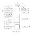
도4는 본 발명의 실시예에 따른 차량 항법 장치의 구성을 나타낸 블록도 이다.4 is a block diagram showing the configuration of a vehicle navigation apparatus according to an embodiment of the present invention.
도4에 도시한 바와 같이, 본 발명의 실시예에 따른 차량 항법 장치(mobile vehicle navigation apparatus)는, 위성으로부터 수신되는 GPS(global positioning system) 신호를 수신하고, 상기 수신된 GPS 신호를 근거로 차량 항법 장치(차량과 동일한 위치인 것으로 간주함)의 제1 차량 위치 데이터를 발생하는 GPS 수신기(301)와; 차량의 주행 방향 및 상기 차량의 속도를 근거로 제2 차량 위치 데이터를 발생하는 DR(Dead-Reckoning) 센서(302)와; 지도 데이터를 저장하는 저장부(304)와; 상기 제1 차량 위치 데이터 및 상기 제2 차량 위치 데이터를 근거로 차량 추정 위치를 발생하고, 상기 발생된 차량 추정 위치와 상기 저장부(304)에 저장된 지도 데이터 내의 링크(지도 정합 링크 또는 지도 정합 도로)를 정합(matching)하고, 상기 정합된 지도 정보(지도 정합 결과)를 출력하는 지도 정합부(303)와; 상기 정합된 지도 정보를 근거로 길 안내 정보를 발생하고, 정보 제공 센터(500)로부터 수신된 지도 데이터의 버전이 상기 저장부(304)에 저장된 지도 데이터의 버전보다 신 버전일 때, 상기 신 버전(최신 버전)의 지도 데이터 중에서 갱신된 지역 정보를 통신부(308)를 통해 수신하고, 그 수신된 갱신 지역 정보를 나타내는 그래픽 정보 및/또는 음성 정보를 발생하는 제어부(307)와; 상기 길 안내 정보에 포함된 길 안내 지도를 표시하거나, 상기 그래픽 정보를 화면상에 표시하는 표시부(305) 와; 상기 길 안내 정보에 포함된 길 안내 음성 정보(길 안내 음성 메시지)를 출력하거나, 상기 음성 정보를 출력하는 음성 출력부(306)로 구성된다.As illustrated in FIG. 4, a mobile vehicle navigation apparatus according to an embodiment of the present invention receives a global positioning system (GPS) signal received from a satellite and based on the received GPS signal. A
본 발명의 실시예에 따른 차량 항법 장치에 적용된 제어부(307)는 정보 제공 센터로부터 수신된 지도 데이터의 버전이 상기 저장부(304)에 저장된 지도 데이터의 버전보다 신 버전일 때, 상기 신 버전(최신 버전)의 지도 데이터 중에서 갱신 지역 정보를 통신부(308)를 통해 수신하고, 그 수신된 갱신 지역 정보를 통지하는 그래픽 정보 및/또는 음성 정보를 발생한다. 따라서, 본 발명의 실시예들에 따른 차량 항법 방법 및 그 장치는, 지도 데이터를 갱신하기 전에 갱신 지역 정보를 통지하는 그래픽 정보 및/또는 음성 정보를 출력함으로써, 사용자가 해당 지역의 지도 데이터를 갱신할지 여부를 빠르게 결정할 수 있고, 지도 데이터 중에서 사용자가 필요한 지역의 지도 데이터만을 갱신할 수도 있다.The
여기서, 상기 GPS 수신기(301)는 텔레매틱스 단말기의 GPS 모듈(207)이 될 수 있으며, 상기 저장부(304)는 텔레매틱스 단말기의 메모리(213)가 될 수 있으며, 상기 표시부(305)는 텔레매틱스 단말기의 LCD(201)가 될 수 있으며, 상기 음성 출력부(306)는 텔레매틱스 단말기의 앰프(226)가 될 수 있다. 또한, 상기 경로 안내부(304), 지도 정합부(303), 제어부(307)의 기능은 텔레매틱스 단말기의 중앙 처리 장치(212)에서 수행할 수도 있다.Here, the
상기 GPS 수신기(301)에 의해 발생된 제1 차량 위치 데이터와 상기 DR 센서(302)에 의해 발생된 제2 차량 위치 데이터를 근거로 상기 차량 추정 위치를 발생하는 기술은 공지된 기술이므로, 이에 대한 구체적인 설명은 생략한다.Since the technique of generating the estimated vehicle position based on the first vehicle position data generated by the
이하에서는, 본 발명의 실시예에 따른 차량 항법 장치의 구성을 도4를 참조하여 상세히 설명한다.Hereinafter, the configuration of the vehicle navigation apparatus according to an embodiment of the present invention will be described in detail with reference to FIG.
먼저, 상기 GPS 수신기(301)는, 상기 길 안내 모드가 선택되었을 때, 위성으로부터 수신되는 GPS(Global Position System) 신호를 수신하고, 상기 수신된 GPS 신호에 포함된 경도 및 위도 좌표를 근거로 제1 차량 위치 데이터를 실시간으로 발생하고, 상기 제1 차량 위치 데이터를 상기 지도 정합부(303)에 출력한다. 여기서, 상기 GPS 수신기(301)뿐만 아니라 와이파이(Wi-Fi) 또는 와이브로(wibro) 통신을 통해 차량의 위치 정보를 수신할 수도 있다.First, when the road guidance mode is selected, the
상기 DR 센서(302)는 차량의 주행 방향 및 상기 차량의 속도를 근거로 제2 차량 위치 데이터를 발생하고, 그 제2 차량 위치 데이터를 상기 지도 정합부(303)에 출력한다.The
상기 지도 정합부(303)는 상기 제1 차량 위치 데이터 및 상기 제2 차량 위치 데이터를 근거로 차량 추정 위치를 발생하고, 그 발생된 차량 추정 위치와 상기 지도 데이터를 정합하고, 그 정합된 지도 정보(지도 정합 결과)를 상기 제어부(307)에 출력한다. 예를 들면, 상기 지도 정합부(303)는 상기 제1 차량 위치 데이터 및 상기 제2 차량 위치 데이터를 근거로 차량 추정 위치를 발생하고, 상기 발생된 차량 추정 위치와 상기 저장부(304)에 저장된 지도 데이터내의 링크들을 링크 순번에 따라 정합하고, 상기 정합된 지도 정보(지도 정합 결과)를 제어부(307)에 출력한다.The
상기 제어부(307)는 상기 정합된 지도 정보를 근거로 길 안내 정보를 발생하 고, 그 발생된 길 안내 정보를 상기 표시부(305) 및 음성 출력부(306)에 출력한다. 여기서, 상기 음성 출력부(306)는 스피커가 될 수도 있다.The
한편, 상기 제어부(307)는 사용자의 요청(선택)에 따라 또는 주기적으로, 상기 저장부(304)에 미리 저장된 지도 데이터의 최신 버전 정보를 무선 통신망(400)을 통해 정보 제공 센터(500)에 요청한다.Meanwhile, the
상기 제어부(307)는 상기 무선 통신망(400)을 통해 상기 지도 데이터의 최신 버전 정보를 상기 정보 제공 센터(500)로부터 수신하고, 상기 수신된 지도 데이터의 최신 버전 정보와 상기 저장부(304)에 미리 저장된 지도 데이터의 버전 정보를 비교한다. 이때, 상기 제어부(307)는 상기 정보 제공 센터(500)로부터 수신된 지도 데이터의 버전이 상기 저장부(304)에 미리 저장된 지도 데이터의 버전보다 신 버전일 때, 상기 신 버전(최신 버전)의 지도 데이터(갱신 지도 데이터로 칭함) 중에서 갱신 지역 정보를 상기 통신부(308)를 통해 상기 정보 제공 센터(500)로부터 수신한다.The
상기 제어부(307)는 상기 갱신 지역 정보를 수신하고, 상기 수신된 갱신 지역 정보를 나타내는 그래픽 정보를 발생하고, 그 발생된 그래픽 정보를 상기 표시부(305)에 출력한다. 상기 제어부(307)는 상기 갱신 지역 정보를 근거로 지도 배경 데이터의 변경 지역을 나타내는 지도 배경 데이터 식별자와, 지도 검색 데이터의 변경 지역을 나타내는 지도 검색 데이터 식별자와, 도로 네트워크의 변경 지역을 나타내는 도로 네트워크 식별자 중에서 하나 이상을 포함하는 그래픽 정보를 발생한다.The
상기 지도 배경 데이터 식별자는 지도 데이터 내에서 배경이 변경된 지역을 나타내는 식별자로서, 건물의 신축 또는 철거 등으로 인해 특정 지역의 배경이 변경되었음을 나타내는 식별자를 의미한다. 상기 지도 검색 데이터 식별자는 지도를 검색하기 위한 식별자로서, 관심지점(Point Of Interest, POI), 주소의 변경, 전화번호의 변경 등으로 인해 특정 지역의 지도 검색 데이터가 변경되었음을 나타내는 식별자를 의미한다. 상기 도로 네트워크 식별자는 새로운 도로의 신설, 도로의 폐쇄, 도로 공사중 등으로 인해 특정 지역의 도로가 변경되었음을 나타내는 식별자를 의미한다.The map background data identifier is an identifier indicating an area where the background is changed in the map data and means an identifier indicating that the background of a specific area is changed due to the construction or demolition of a building. The map search data identifier is an identifier for searching a map, and means an identifier indicating that map search data of a specific region is changed due to a point of interest (POI), a change of address, a change of a phone number, and the like. The road network identifier refers to an identifier indicating that a road in a specific region has been changed due to the establishment of a new road, the closure of a road, a road under construction.
또한, 상기 제어부(307)는 상기 지도 배경 데이터의 변경 지역을 나타내는 지도 배경 데이터 식별자와, 지도 검색 데이터의 변경 지역을 나타내는 지도 검색 데이터 식별자와, 도로 네트워크의 변경 지역을 나타내는 도로 네트워크 식별자 중에서 하나 이상을 색, 아이콘, 아바타, 문양, 기호 중에서 어느 하나 이상으로 상기 화면상에 표시할 수도 있다.The
상기 표시부(305)는 상기 그래픽 정보를 수신하고, 그 수신된 그래픽 정보를 화면상에 표시한다. 여기서, 상기 표시부(305)는 터치스크린(touchscreen) 일수도 있다.The
이후, 상기 제어부(307)는 상기 그래픽 정보 내의 배경 데이터 식별자와, 검색 데이터 식별자와, 도로 네트워크 식별자 중에서 어느 하나 이상이 사용자에 의해 선택되었는지를 판단한다. 여기서, 사용자는 상기 터치스트린을 통해 상기 배경 데이터 식별자와, 상기 검색 데이터 식별자와, 상기 도로 네트워크 식별자 중에서 어느 하나 이상을 선택하거나, 입력부(예를 들면, 도2의 도면 부호 130)를 통해 상기 그래픽 정보 중에서 어느 하나 이상의 식별자를 선택할 수도 있다.Thereafter, the
상기 제어부(307)는 상기 그래픽 정보 내의 배경 데이터 식별자와, 검색 데이터 식별자와, 도로 네트워크 식별자 중에서 어느 하나 이상이 선택되었을 때, 그 선택된 식별자에 대응하는 지도 데이터를 상기 통신부(308)를 통해 상기 정보 제공 센터(500)에 요청한다.The
상기 정보 제공 센터(500)는 상기 제어부(307)에 의해 요청된 갱신 지도 데이터를 상기 무선 통신 망(400)을 통해 전송한다.The information providing center 500 transmits the updated map data requested by the
상기 제어부(307)는 상기 정보 제공 센터(500)로부터 전송된 갱신 지도 데이터를 상기 통신부(308)를 통해 수신하고, 그 수신된 갱신 지도 데이터를 상기 저장부(304)에 저장시킨다. 상기 저장부(304)를 상기 갱신 지도 데이터를 덮어쓰기(overwrite)함으로써 지도 데이터를 갱신한다.The
한편, 상기 제어부(307)는 상기 수신된 갱신 지역 정보를 나타내는 음성 정보를 발생하고, 그 발생된 음성 정보를 상기 음성 출력부(306)에 출력할 수도 있다. 예를 들면, 상기 제어부(307)는 상기 수신된 갱신 지역 정보가 배경 데이터의 변경 지역을 나타낼 때 "특정 지역의 배경이 변경되었습니다."와 같은 음성 정보를 발생하고, 상기 수신된 갱신 지역 정보가 지도 검색 데이터의 변경 지역을 나타낼 때 "특정 지역의 지도 검색 데이터가 변경되었습니다."와 같은 음성 정보를 발생하고, 상기 수신된 갱신 지역 정보가 도로 네트워크의 변경 지역을 나타낼 때 "특정 지역의 도로 네트워크가 변경되었습니다."와 같은 음성 정보를 발생할 수도 있다.The
이하에서는, 본 발명의 실시예에 따른 차량 항법 방법을 도4 내지 도5를 참조하여 상세히 설명한다.Hereinafter, a vehicle navigation method according to an embodiment of the present invention will be described in detail with reference to FIGS. 4 to 5.
도5는 본 발명의 실시예에 따른 차량 항법 방법을 나타낸 흐름도 이다.5 is a flowchart illustrating a vehicle navigation method according to an embodiment of the present invention.
먼저, 상기 지도 정합부(303)는 상기 제1 차량 위치 데이터 및 상기 제2 차량 위치 데이터를 근거로 차량 추정 위치를 발생하고, 상기 저장부(304)로부터 주행 경로에 대응하는 지도 데이터를 독출한다. 여기서, 상기 주행 경로는 출발지부터 목적지까지의 주행 경로이거나, 상기 목적지를 선택하지 않고 주행하는 경로일 수 있다.First, the
상기 지도 정합부(303)는 상기 차량 추정 위치와 상기 지도 데이터에 포함된 링크(도로)를 정합하고, 그 정합된 지도 정보(지도 정합 결과)를 상기 제어부(307)에 출력한다. 예를 들면, 상기 지도 정합부(303)는 상기 제1 차량 위치 데이터 및 상기 제2 차량 위치 데이터를 근거로 차량 추정 위치를 발생하고, 상기 발생된 차량 추정 위치와 상기 저장부(304)에 저장된 지도 데이터 내의 링크들을 링크 순번에 따라 정합하고, 상기 정합된 지도 정보(지도 정합 결과)를 제어부(307)에 출력한다.The
상기 제어부(307)는 상기 정합된 지도 정보를 근거로 길 안내 정보를 발생하고, 그 발생된 길 안내 정보를 상기 표시부(305) 및 음성 출력부(306)에 출력한다. 여기서, 상기 음성 출력부(306)는 상기 길안내 정보를 음성 신호로서 출력한다.The
한편, 상기 제어부(307)는 사용자의 요청에 따라 또는 주기적으로, 상기 저장부(304)에 미리 저장된 지도 데이터의 최신 버전 정보를 무선 통신망(400)을 통 해 정보 제공 센터(500)에 요청한다(S11).Meanwhile, the
상기 제어부(307)는 상기 무선 통신망(400)을 통해 상기 지도 데이터의 최신 버전 정보를 상기 정보 제공 센터(500)로부터 수신하고(S12), 상기 수신된 지도 데이터의 최신 버전 정보와 상기 저장부(304)에 미리 저장된 지도 데이터의 버전 정보를 비교한다(S13). 이때, 상기 제어부(307)는 상기 정보 제공 센터(500)로부터 수신된 지도 데이터의 버전이 상기 저장부(304)에 저장된 지도 데이터의 버전보다 신 버전일 때(S14), 상기 신 버전(최신 버전)의 지도 데이터(갱신 지도 데이터로 칭함) 중에서 갱신 지역 정보를 상기 통신부(308)를 통해 상기 정보 제공 센터(500)로부터 수신한다(S15).The
상기 제어부(307)는 상기 수신된 갱신된 지역 정보를 근거로, 그 갱신된 지역 정보를 나타내는 그래픽 정보를 발생하고(S16), 그 발생된 그래픽 정보를 상기 표시부(305)에 출력한다. 상기 그래픽 정보는 배경 데이터의 변경 지역을 나타내는 배경 데이터 식별자와, 검색 데이터의 변경 지역을 나타내는 검색 데이터 식별자와, 도로 네트워크의 변경 지역을 나타내는 도로 네트워크 식별자를 포함한다.The
상기 표시부(305)는 상기 그래픽 정보를 수신하고, 그 수신된 그래픽 정보를 화면상에 표시한다(S17). 여기서, 상기 표시부(305)는 터치스크린(touchscreen) 일수도 있다. 여기서, 상기 화면상에 표시된 그래픽 정보를 도6을 참조하여 설명한다.The
도6은 본 발명의 실시예에 따른 갱신 지역 정보를 나타내는 그래픽 정보를 표시한 도이다.6 is a diagram showing graphic information indicating updated area information according to an embodiment of the present invention.
도6에 도시한 바와 같이, 상기 제어부(307)는 배경 데이터의 변경 지역을 나타내는 배경 데이터 식별자(identifier)(6-1)를 녹색으로 화면상에 표시하고, 검색 데이터의 변경 지역을 나타내는 검색 데이터 식별자(6-2)를 노랑으로 화면상에 표시하고, 도로 네트워크의 변경 지역을 나타내는 도로 네트워크 식별자(6-3)를 빨강으로 화면상에 표시할 수도 있다. 여기서, 상기 제어부(307)는 배경 데이터 식별자(6-1), 검색 데이터 식별자(6-2), 도로 네트워크 식별자(6-3)를 다양한 색상으로 표시할 뿐만 아니라 아이콘, 아바타, 문양, 기호 중에서 어느 하나 이상으로 상기 화면상에 표시할 수도 있다.As shown in Fig. 6, the
이후, 상기 제어부(307)는 상기 그래픽 정보 내의 배경 데이터 식별자(6-1)와, 검색 데이터 식별자(6-2)와, 도로 네트워크 식별자(6-3) 중에서 어느 하나 이상이 선택되었는지를 판단한다(S18).Thereafter, the
상기 제어부(307)는 상기 그래픽 정보 내의 배경 데이터 식별자와, 검색 데이터 식별자와, 도로 네트워크 식별자 중에서 어느 하나 이상이 선택되었을 때, 그 선택된 식별자에 대응하는 갱신 지도 데이터를 상기 통신부(308)를 통해 상기 정보 제공 센터(500)에 요청한다. 예를 들면, 상기 제어부(307)는 사용자에 의해 상기 배경 데이터 식별자가 선택되었을 때, 그 선택된 배경 데이터 식별자에 해당하는 갱신 배경 데이터를 상기 통신부(308)를 통해 상기 정보 제공 센터(500)에 요청한다. 상기 제어부(307)는 사용자에 의해 상기 검색 데이터 식별자가 선택되었을 때, 그 선택된 검색 데이터 식별자에 해당하는 갱신 검색 데이터를 상기 통신부(308)를 통해 상기 정보 제공 센터(500)에 요청한다. 상기 제어부(307)는 사용자에 의해 상 기 도로 네트워크 식별자가 선택되었을 때, 그 선택된 도로 네트워크 식별자에 해당하는 갱신 도로 네트워크 데이터를 상기 통신부(308)를 통해 상기 정보 제공 센터(500)에 요청한다.When one or more of the background data identifier, the search data identifier, and the road network identifier in the graphic information are selected, the
상기 정보 제공 센터(500)는 상기 제어부(307)에 의해 요청된 갱신 지도 데이터를 상기 무선 통신 망(400)을 통해 상기 제어부(307)에 전송한다. 예를 들면, 상기 정보 제공 센터(500)는 상기 배경 데이터 식별자에 해당하는 갱신 배경 데이터, 상기 검색 데이터 식별자에 해당하는 갱신 검색 데이터, 상기 도로 네트워크 식별자에 해당하는 갱신 도로 네트워크 데이터 중에서 어느 하나 이상을 상기 통신부(308)를 통해 상기 제어부(307)에 전송한다.The information providing center 500 transmits the update map data requested by the
상기 제어부(307)는 상기 정보 제공 센터(500)로부터 전송된 갱신 지도 데이터를 상기 통신부(308)를 통해 수신하고(S19), 그 수신된 갱신 지도 데이터를 상기 저장부(304)에 저장시킨다(S20). 상기 저장부(304)를 상기 갱신 지도 데이터를 덮어쓰기(overwrite)함으로써 지도 데이터를 갱신한다.The
따라서, 본 발명의 실시예들에 따른 차량 항법 방법 및 그 장치는, 지도 데이터를 갱신하기 전에 갱신 정보를 나타내는 그래픽 정보를 화면상에 표시함으로써 사용자가 지도 데이터를 갱신할지 여부를 빠르게 결정할 수 있다. 또한, 본 발명의 실시예들에 따른 차량 항법 방법 및 그 장치는, 그래픽 정보 상에서 원하는 갱신 지역 정보만을 선택함으로써 사용자가 필요한 지도 데이터만을 쉽고, 빠르게 갱신할 수 있다.Accordingly, the vehicle navigation method and the apparatus according to the embodiments of the present invention can quickly determine whether the user updates the map data by displaying graphic information indicating the update information on the screen before updating the map data. In addition, the vehicle navigation method and the apparatus according to the embodiments of the present invention can easily and quickly update only the map data required by the user by selecting only the desired update area information on the graphic information.
이하에서는, 본 발명의 다른 실시예에 따른 차량 항법 방법을 도4 내지 도8 을 참조하여 상세히 설명한다. 즉, 상기 그래픽으로 표시된 갱신 지역 정보 상에서 특정 지역이 선택되었을 때 상기 선택된 특정 지역을 확대 또는 축소하는 방법을 상세히 설명한다.Hereinafter, a vehicle navigation method according to another embodiment of the present invention will be described in detail with reference to FIGS. 4 to 8. That is, a method of enlarging or reducing the selected specific region when a specific region is selected on the updated region information displayed graphically will be described in detail.
도7는 본 발명의 다른 실시예에 따른 차량 항법 방법을 나타낸 흐름도 이다.7 is a flowchart illustrating a vehicle navigation method according to another embodiment of the present invention.
먼저, 상기 제어부(307)는 사용자의 요청에 따라 또는 주기적으로, 상기 저장부(304)에 미리 저장된 지도 데이터의 최신 버전 정보를 무선 통신망(400)을 통해 정보 제공 센터(500)에 요청한다(S21).First, the
상기 제어부(307)는 상기 무선 통신망(400)을 통해 상기 지도 데이터의 최신 버전 정보를 상기 정보 제공 센터(500)로부터 수신하고(S22), 상기 수신된 지도 데이터의 최신 버전 정보와 상기 저장부(304)에 미리 저장된 지도 데이터의 버전 정보를 비교한다(S23). 이때, 상기 제어부(307)는 상기 정보 제공 센터(500)로부터 수신된 지도 데이터의 버전이 상기 저장부(304)에 저장된 지도 데이터의 버전보다 신 버전일 때(S24), 상기 신 버전(최신 버전)의 지도 데이터(갱신 지도 데이터로 칭함) 중에서 갱신 지역 정보를 상기 통신부(308)를 통해 상기 정보 제공 센터(500)로부터 수신한다(S25).The
상기 제어부(307)는 상기 수신된 갱신 지역 정보를 나타내는 그래픽 정보를 발생하고(S26), 그 발생된 그래픽 정보를 상기 표시부(305)에 출력한다. 상기 그래픽 정보는 배경 데이터의 변경 지역을 나타내는 배경 데이터 식별자와, 검색 데이터의 변경 지역을 나타내는 검색 데이터 식별자와, 도로 네트워크의 변경 지역을 나타내는 도로 네트워크 식별자를 포함한다.The
상기 표시부(305)는 상기 그래픽 정보를 수신하고, 그 수신된 그래픽 정보를 화면상에 표시한다(S27). 여기서, 상기 표시부(305)는 터치스크린(touchscreen) 일수도 있다.The
이후, 상기 제어부(307)는 상기 그래픽 정보 내의 지역들(예를 들면, 유럽 내의 스페인, 프랑스, 포르투갈, 룩셈부르크, 스위스) 중에서 어느 하나가 선택되었는지를 판단한다(S28).Thereafter, the
상기 제어부(307)는 상기 그래픽 정보 내의 지역들 중에서 특정 지역(예를 들면, 스페인)이 선택되었을 때, 그 선택된 지역을 확대 또는 축소시킨다(S29). 예를 들면, 상기 제어부(307)는 상기 그래픽 정보 내의 지역들 중에서 특정 지역이 선택되었을 때, 그 선택된 특정 지역을 확대시키고, 상기 특정 지역이 다시 선택될 때 상기 특정 지역을 축소시킨다. 따라서, 사용자는 특정 지역이 확대 또는 축소됨으로써 갱신할 지도 데이터를 더욱 용이하게 파악 및 선택할 수도 있다.When a specific region (for example, Spain) is selected among the regions in the graphic information, the
이하에서는, 상기 화면상에 표시된 그래픽 영상을 확대/축소하는 방법을 도8을 참조하여 상세히 설명한다.Hereinafter, a method of enlarging / reducing a graphic image displayed on the screen will be described in detail with reference to FIG. 8.
도8은 본 발명의 다른 실시예에 따른 갱신 지역 정보를 나타내는 그래픽 정보를 표시한 도이다.8 is a diagram showing graphic information indicating updated area information according to another embodiment of the present invention.
도8에 도시한 바와 같이, 상기 제어부(307)는 상기 그래픽 정보와 함께 화면상에 표시된 확대키(8-1)가 사용자에 의해 선택될 때 상기 갱신 지역 정보를 나타내는 그래픽 영상을 확대하고, 상기 화상에 표시된 축소키(8-2)가 선택될 때 상기 갱신 지역 정보를 나타내는 그래픽 영상을 축소한다. 따라서, 상기 갱신 지역 정보 를 나타내는 그래픽 영상을 확대/축소함으로써 사용자는 더욱 정확하게 변경 지역을 확인할 수 있다.As shown in Fig. 8, the
또한, 상기 제어부(307)는, 상기 화면이 터치스크린일 때, 상기 화면상에 표시된 특정 지역(예를 들면, 스페인)이 사용자에 의해 터치되었을 때, 그 터치된 지역을 확대시키고, 그 확대된 지역에 대한 상세 갱신 지역 정보를 표시한다. 예를 들면, 상기 제어부(307)는 상기 그래픽 정보 상에서 스페인이 사용자에 의해 터치되었을 때, 그 터치된 스페인만을 전체 화면상에 확대하는 동시에 스페인의 상세한 지역에 대한 갱신 지역 정보를 상기 식별자들(배경 데이터 식별자, 검색 데이터 식별자, 도로 네트워크 식별자) 형태로 화면상에 표시한다. 상기 제어부(307)는 상기 특정 지역이 다시 터치되었을 때 상기 특정 지역을 축소시킬수도 있다.In addition, when the screen is a touch screen, the
이상에서 상세히 설명한 바와 같이, 본 발명의 실시예들에 따른 차량 항법 방법 및 그 장치는, 지도 데이터를 갱신하기 전에 갱신 지역 정보를 나타내는 그래픽 정보를 화면상에 표시함으로써 사용자가 지도 데이터를 갱신할지 여부를 빠르게 결정할 수 있다.As described above in detail, the vehicle navigation method and the apparatus according to the embodiments of the present invention display the graphic information indicating the updated area information on the screen before updating the map data, thereby allowing the user to update the map data. You can quickly decide.
본 발명의 실시예들에 따른 차량 항법 방법 및 그 장치는, 지도 데이터를 갱신하기 전에 갱신 지역 정보를 나타내는 그래픽 정보를 화면상에 표시함으로써 지도 데이터 중에서 사용자가 필요한 데이터만을 갱신할 수 있다.The vehicle navigation method and the apparatus according to the embodiments of the present invention can update only the data required by the user among the map data by displaying graphic information indicating the updated area information on the screen before updating the map data.
본 발명의 실시예들에 따른 차량 항법 방법 및 그 장치는, 그래픽 정보 내의 지역들 중에서 특정 지역이 선택되었을 때, 그 선택된 특정 지역을 확대/축소시킴으로써 사용자가 갱신할 지도 데이터를 더욱 정확하게 파악 및 선택할 수도 있다.The vehicle navigation method and apparatus according to embodiments of the present invention, when a particular region is selected among the regions in the graphic information, by zooming in / out the selected specific region, the user can more accurately identify and select map data to be updated. It may be.
본 발명의 실시예들에 따른 차량 항법 방법 및 그 장치는, 텔레매틱스 단말기, 이동 통신 단말기뿐만 아니라 개인 휴대 정보 단말기(personal digital assistant, PDA), 휴대용 멀티미디어 플레이어(Portable Multimedia Player, PMP) 등과 같은 이동 단말기에도 적용될 수 있다.Vehicle navigation method and apparatus according to embodiments of the present invention, a mobile terminal such as a personal digital assistant (PDA), a portable multimedia player (PMP), etc., as well as a telematics terminal, a mobile communication terminal Applicable to
본 발명이 속하는 기술 분야에서 통상의 지식을 가진 자라면 본 발명의 본질적인 특성에서 벗어나지 않는 범위에서 다양한 수정 및 변형이 가능할 것이다. 따라서, 본 발명에 개시된 실시예들은 본 발명의 기술 사상을 한정하기 위한 것이 아니라 설명하기 위한 것이고, 이러한 실시예에 의하여 본 발명의 기술 사상의 범위가 한정되는 것은 아니다. 본 발명의 보호 범위는 아래의 청구범위에 의하여 해석되어야 하며, 그와 동등한 범위 내에 있는 모든 기술 사상은 본 발명의 권리범위에 포함되는 것으로 해석되어야 할 것이다.Those skilled in the art will appreciate that various modifications and variations can be made without departing from the essential features of the present invention. Therefore, the embodiments disclosed in the present invention are not intended to limit the technical idea of the present invention but to describe the present invention, and the scope of the technical idea of the present invention is not limited by these embodiments. The scope of protection of the present invention should be interpreted by the following claims, and all technical ideas within the scope equivalent thereto should be construed as being included in the scope of the present invention.
도1은 종래 기술에 따른 차량 항법 시스템을 나타낸 블록도 이다.1 is a block diagram showing a vehicle navigation system according to the prior art.
도2는 본 발명의 실시예에 따른 차량 항법 장치가 적용된 이동 단말기의 구성을 나타낸 블록도 이다.2 is a block diagram illustrating a configuration of a mobile terminal to which a vehicle navigation apparatus according to an exemplary embodiment of the present invention is applied.
도3은 본 발명의 실시예에 따른 차량 항법 장치가 적용된 텔레매틱스 단말기의 구성을 나타낸 블록도 이다.3 is a block diagram showing a configuration of a telematics terminal to which a vehicle navigation apparatus according to an embodiment of the present invention is applied.
도4는 본 발명의 실시예에 따른 차량 항법 장치의 구성을 나타낸 블록도 이다.4 is a block diagram showing the configuration of a vehicle navigation apparatus according to an embodiment of the present invention.
도5는 본 발명의 실시예에 따른 차량 항법 방법을 나타낸 흐름도 이다.5 is a flowchart illustrating a vehicle navigation method according to an embodiment of the present invention.
도6은 본 발명의 실시예에 따른 갱신 지역 정보를 나타내는 그래픽 정보를 표시한 도이다.6 is a diagram showing graphic information indicating updated area information according to an embodiment of the present invention.
도7는 본 발명의 다른 실시예에 따른 차량 항법 방법을 나타낸 흐름도 이다.7 is a flowchart illustrating a vehicle navigation method according to another embodiment of the present invention.
도8은 본 발명의 다른 실시예에 따른 갱신 지역 정보를 나타내는 그래픽 정보를 표시한 도이다.8 is a diagram showing graphic information indicating updated area information according to another embodiment of the present invention.
*도면의 주요부에 대한 부호의 설명* Explanation of symbols on the main parts of the drawings
301: GPS 수신기 302: DR 센서301: GPS receiver 302: DR sensor
303: 지도 정합부 304: 저장부303: map matching unit 304: storage unit
305: 표시부 306: 음성 출력부305: display unit 306: audio output unit
307: 제어부 308: 통신부307: control unit 308: communication unit
400: 무선 통신망 500: 정보 제공 센터400: wireless network 500: information center
Claims (40)
Translated fromKoreanPriority Applications (2)
| Application Number | Priority Date | Filing Date | Title |
|---|---|---|---|
| KR20080063607AKR101495166B1 (en) | 2008-07-01 | 2008-07-01 | Vehicle navigation methods and devices |
| US12/412,115US8072354B2 (en) | 2008-07-01 | 2009-03-26 | Mobile vehicle navigation method and apparatus thereof |
Applications Claiming Priority (1)
| Application Number | Priority Date | Filing Date | Title |
|---|---|---|---|
| KR20080063607AKR101495166B1 (en) | 2008-07-01 | 2008-07-01 | Vehicle navigation methods and devices |
Publications (2)
| Publication Number | Publication Date |
|---|---|
| KR20100003619Atrue KR20100003619A (en) | 2010-01-11 |
| KR101495166B1 KR101495166B1 (en) | 2015-02-24 |
Family
ID=41465021
Family Applications (1)
| Application Number | Title | Priority Date | Filing Date |
|---|---|---|---|
| KR20080063607AActiveKR101495166B1 (en) | 2008-07-01 | 2008-07-01 | Vehicle navigation methods and devices |
Country Status (2)
| Country | Link |
|---|---|
| US (1) | US8072354B2 (en) |
| KR (1) | KR101495166B1 (en) |
Cited By (1)
| Publication number | Priority date | Publication date | Assignee | Title |
|---|---|---|---|---|
| KR101108615B1 (en)* | 2011-10-12 | 2012-01-31 | (주) 영남플륨 | Slope-mounted sofa block with adjustable height |
Families Citing this family (17)
| Publication number | Priority date | Publication date | Assignee | Title |
|---|---|---|---|---|
| EP1655576B1 (en)* | 2004-10-27 | 2015-04-29 | Harman Becker Automotive Systems GmbH | Navigation system |
| US8510025B2 (en)* | 2009-04-02 | 2013-08-13 | Trafficcast International, Inc. | Method and system for a traffic management network |
| US9154982B2 (en) | 2009-04-02 | 2015-10-06 | Trafficcast International, Inc. | Method and system for a traffic management network |
| US9234760B2 (en)* | 2010-01-29 | 2016-01-12 | Blackberry Limited | Portable mobile transceiver for GPS navigation and vehicle data input for dead reckoning mode |
| CN101799990A (en)* | 2010-02-08 | 2010-08-11 | 深圳市同洲电子股份有限公司 | Warning method and system for unusual aggregation of vehicles |
| US8386589B2 (en)* | 2010-05-21 | 2013-02-26 | Qnx Software Systems Limited | System that provides embedded software to an embedded system |
| US9014632B2 (en)* | 2011-04-29 | 2015-04-21 | Here Global B.V. | Obtaining vehicle traffic information using mobile bluetooth detectors |
| KR20130063605A (en)* | 2011-12-07 | 2013-06-17 | 현대자동차주식회사 | A road guidance display method and system using geo-tagging picture |
| US8965689B1 (en)* | 2012-07-02 | 2015-02-24 | Sprint Communications Company, L.P. | Map display configurations for wireless communication devices |
| US8762059B1 (en) | 2012-12-21 | 2014-06-24 | Nng Kft. | Navigation system application for mobile device |
| KR101459493B1 (en)* | 2013-10-08 | 2014-11-07 | 현대자동차 주식회사 | Apparatus and method for controlliing vehicle |
| US10210753B2 (en) | 2015-11-01 | 2019-02-19 | Eberle Design, Inc. | Traffic monitor and method |
| US10794711B2 (en) | 2016-12-30 | 2020-10-06 | DeepMap Inc. | High definition map updates based on sensor data collected by autonomous vehicles |
| CN109215161A (en)* | 2017-06-30 | 2019-01-15 | 北京四维图新科技股份有限公司 | A kind of drive test evidence taking equipment, method and drive test vehicle |
| FR3089625B1 (en)* | 2018-12-11 | 2021-04-09 | Second Bridge Inc | FIXED ELECTRONIC BEACON WITH CARD |
| JP7552483B2 (en)* | 2021-04-06 | 2024-09-18 | トヨタ自動車株式会社 | Center, distribution control method, and distribution control program |
| CN117275118A (en)* | 2022-06-22 | 2023-12-22 | 丰田自动车株式会社 | Management device, management method, and non-transitory computer-readable storage medium |
Family Cites Families (6)
| Publication number | Priority date | Publication date | Assignee | Title |
|---|---|---|---|---|
| JP4348503B2 (en)* | 2000-12-21 | 2009-10-21 | 三菱電機株式会社 | Navigation device |
| US6850844B1 (en)* | 2002-06-28 | 2005-02-01 | Garmin Ltd. | Portable navigation device with integrated GPS and dead reckoning capabilities |
| US7584049B2 (en)* | 2002-07-17 | 2009-09-01 | Xanavi Informatics Corporation | Navigation method, processing method for navigation system, map data management device, map data management program, and computer program |
| KR100604020B1 (en)* | 2003-12-01 | 2006-07-24 | 엘지전자 주식회사 | Route navigation method and device |
| JP5298417B2 (en)* | 2006-10-03 | 2013-09-25 | 株式会社デンソー | Map data utilization device, navigation device |
| US20090117923A1 (en)* | 2007-11-01 | 2009-05-07 | Robert Edward Berger | On-Demand SMS-Based Traffic Reporting |
- 2008
- 2008-07-01KRKR20080063607Apatent/KR101495166B1/enactiveActive
- 2009
- 2009-03-26USUS12/412,115patent/US8072354B2/enactiveActive
Cited By (1)
| Publication number | Priority date | Publication date | Assignee | Title |
|---|---|---|---|---|
| KR101108615B1 (en)* | 2011-10-12 | 2012-01-31 | (주) 영남플륨 | Slope-mounted sofa block with adjustable height |
Also Published As
| Publication number | Publication date |
|---|---|
| KR101495166B1 (en) | 2015-02-24 |
| US8072354B2 (en) | 2011-12-06 |
| US20100004849A1 (en) | 2010-01-07 |
Similar Documents
| Publication | Publication Date | Title |
|---|---|---|
| KR101495166B1 (en) | Vehicle navigation methods and devices | |
| KR101561913B1 (en) | Method for displaying image for mobile terminal and apparatus thereof | |
| US8751155B2 (en) | Mobile vehicle navigation method and apparatus thereof | |
| US8200427B2 (en) | Method for providing POI information for mobile terminal and apparatus thereof | |
| US9103692B2 (en) | Navigation method of mobile terminal and apparatus thereof | |
| US9026366B2 (en) | Multi-device mapping functionality | |
| KR101542495B1 (en) | Method for displaying information for mobile terminal and apparatus thereof | |
| KR101677615B1 (en) | Method for registering poi for mobile terminal and apparatus thereof | |
| KR101575047B1 (en) | Mobile vehicle navigation method and apparatus thereof | |
| KR101537695B1 (en) | Navigation system and method thereof | |
| KR20100081591A (en) | Mobile vehicle navigation method and apparatus thereof | |
| KR101513633B1 (en) | Method and apparatus for call control of a telramatic terminal | |
| KR20100024791A (en) | Navigation method of mobile terminal and apparatus thereof | |
| KR101553948B1 (en) | Method and apparatus for providing POI information of a mobile terminal | |
| KR101562584B1 (en) | Mobile vehicle navigation method | |
| KR20090107845A (en) | Vehicle navigation method and apparatus | |
| KR101729578B1 (en) | Information providing apparatus and method thereof | |
| KR20110132154A (en) | Information provision device and method | |
| KR20100083649A (en) | Method for providing position information of mobile terminal and apparatus thereof | |
| KR101510696B1 (en) | Mobile vehicle navigation method and apparatus thereof | |
| KR20100022398A (en) | Navigation method of mobile terminal and apparatus thereof | |
| KR20110139030A (en) | Information provision device and method | |
| KR20110044071A (en) | Navigation method of mobile terminal and device therefor | |
| KR20100043657A (en) | Navigation apparatus and method thereof | |
| KR20100068970A (en) | Mobile vehicle navigation method and apparatus thereof |
Legal Events
| Date | Code | Title | Description |
|---|---|---|---|
| PA0109 | Patent application | Patent event code:PA01091R01D Comment text:Patent Application Patent event date:20080701 | |
| PG1501 | Laying open of application | ||
| A201 | Request for examination | ||
| PA0201 | Request for examination | Patent event code:PA02012R01D Patent event date:20130701 Comment text:Request for Examination of Application Patent event code:PA02011R01I Patent event date:20080701 Comment text:Patent Application | |
| E902 | Notification of reason for refusal | ||
| PE0902 | Notice of grounds for rejection | Comment text:Notification of reason for refusal Patent event date:20140625 Patent event code:PE09021S01D | |
| AMND | Amendment | ||
| E601 | Decision to refuse application | ||
| PE0601 | Decision on rejection of patent | Patent event date:20141105 Comment text:Decision to Refuse Application Patent event code:PE06012S01D Patent event date:20140625 Comment text:Notification of reason for refusal Patent event code:PE06011S01I | |
| AMND | Amendment | ||
| J201 | Request for trial against refusal decision | ||
| PJ0201 | Trial against decision of rejection | Appeal kind category:Appeal against decision to decline refusal Appeal identifier:2014101007600 Request date:20141205 Patent event date:20141205 Comment text:Request for Trial against Decision on Refusal Patent event code:PJ02012R01D Patent event date:20141105 Comment text:Decision to Refuse Application Patent event code:PJ02011S01I Appeal kind category:Appeal against decision to decline refusal Decision date:20141212 Appeal identifier:2014101007599 Request date:20141205 | |
| J121 | Written withdrawal of request for trial | ||
| PJ1201 | Withdrawal of trial | Patent event code:PJ12011R01D Patent event date:20141212 Comment text:Written Withdrawal of Request for Trial Appeal identifier:2014101007599 Request date:20141205 Appeal kind category:Appeal against decision to decline refusal Decision date:20141212 | |
| PB0901 | Examination by re-examination before a trial | Comment text:Amendment to Specification, etc. Patent event date:20141205 Patent event code:PB09011R02I Comment text:Request for Trial against Decision on Refusal Patent event date:20141205 Patent event code:PB09011R01I Comment text:Amendment to Specification, etc. Patent event date:20140820 Patent event code:PB09011R02I | |
| B701 | Decision to grant | ||
| PB0701 | Decision of registration after re-examination before a trial | Patent event date:20150119 Comment text:Decision to Grant Registration Patent event code:PB07012S01D Patent event date:20150114 Comment text:Transfer of Trial File for Re-examination before a Trial Patent event code:PB07011S01I | |
| GRNT | Written decision to grant | ||
| PR0701 | Registration of establishment | Comment text:Registration of Establishment Patent event date:20150213 Patent event code:PR07011E01D | |
| PR1002 | Payment of registration fee | Payment date:20150216 End annual number:3 Start annual number:1 | |
| PG1601 | Publication of registration | ||
| FPAY | Annual fee payment | Payment date:20180112 Year of fee payment:4 | |
| PR1001 | Payment of annual fee | Payment date:20180112 Start annual number:4 End annual number:4 | |
| FPAY | Annual fee payment | Payment date:20190114 Year of fee payment:5 | |
| PR1001 | Payment of annual fee | Payment date:20190114 Start annual number:5 End annual number:5 | |
| PR1001 | Payment of annual fee | Payment date:20210114 Start annual number:7 End annual number:7 | |
| PR1001 | Payment of annual fee | Payment date:20230109 Start annual number:9 End annual number:9 | |
| PR1001 | Payment of annual fee | Payment date:20240109 Start annual number:10 End annual number:10 | |
| PR1001 | Payment of annual fee | Payment date:20250109 Start annual number:11 End annual number:11 |