KR20090123227A - Search service provider, method and program - Google Patents
Search service provider, method and programDownload PDFInfo
- Publication number
- KR20090123227A KR20090123227AKR1020080049200AKR20080049200AKR20090123227AKR 20090123227 AKR20090123227 AKR 20090123227AKR 1020080049200 AKR1020080049200 AKR 1020080049200AKR 20080049200 AKR20080049200 AKR 20080049200AKR 20090123227 AKR20090123227 AKR 20090123227A
- Authority
- KR
- South Korea
- Prior art keywords
- image
- photographing
- photographed image
- photographed
- displaying
- Prior art date
- Legal status (The legal status is an assumption and is not a legal conclusion. Google has not performed a legal analysis and makes no representation as to the accuracy of the status listed.)
- Withdrawn
Links
Images


Classifications
- G—PHYSICS
- G06—COMPUTING OR CALCULATING; COUNTING
- G06F—ELECTRIC DIGITAL DATA PROCESSING
- G06F16/00—Information retrieval; Database structures therefor; File system structures therefor
- G06F16/50—Information retrieval; Database structures therefor; File system structures therefor of still image data
- G06F16/58—Retrieval characterised by using metadata, e.g. metadata not derived from the content or metadata generated manually
- G—PHYSICS
- G06—COMPUTING OR CALCULATING; COUNTING
- G06Q—INFORMATION AND COMMUNICATION TECHNOLOGY [ICT] SPECIALLY ADAPTED FOR ADMINISTRATIVE, COMMERCIAL, FINANCIAL, MANAGERIAL OR SUPERVISORY PURPOSES; SYSTEMS OR METHODS SPECIALLY ADAPTED FOR ADMINISTRATIVE, COMMERCIAL, FINANCIAL, MANAGERIAL OR SUPERVISORY PURPOSES, NOT OTHERWISE PROVIDED FOR
- G06Q50/00—Information and communication technology [ICT] specially adapted for implementation of business processes of specific business sectors, e.g. utilities or tourism
- G06Q50/10—Services
- G—PHYSICS
- G08—SIGNALLING
- G08G—TRAFFIC CONTROL SYSTEMS
- G08G1/00—Traffic control systems for road vehicles
- G08G1/09—Arrangements for giving variable traffic instructions
- G08G1/0962—Arrangements for giving variable traffic instructions having an indicator mounted inside the vehicle, e.g. giving voice messages
- G08G1/0968—Systems involving transmission of navigation instructions to the vehicle
- G08G1/0969—Systems involving transmission of navigation instructions to the vehicle having a display in the form of a map
Landscapes
- Engineering & Computer Science (AREA)
- Theoretical Computer Science (AREA)
- Physics & Mathematics (AREA)
- General Physics & Mathematics (AREA)
- Business, Economics & Management (AREA)
- Library & Information Science (AREA)
- Data Mining & Analysis (AREA)
- Databases & Information Systems (AREA)
- General Engineering & Computer Science (AREA)
- Tourism & Hospitality (AREA)
- General Health & Medical Sciences (AREA)
- General Business, Economics & Management (AREA)
- Health & Medical Sciences (AREA)
- Human Resources & Organizations (AREA)
- Marketing (AREA)
- Primary Health Care (AREA)
- Strategic Management (AREA)
- Economics (AREA)
- Radar, Positioning & Navigation (AREA)
- Remote Sensing (AREA)
- Information Retrieval, Db Structures And Fs Structures Therefor (AREA)
- Processing Or Creating Images (AREA)
- Studio Devices (AREA)
- User Interface Of Digital Computer (AREA)
Abstract
Description
Translated fromKorean본 발명은 검색 서비스 제공장치, 방법 및 프로그램에 관한 것으로, 더욱 상세하게는 지도상의 어떤 지점에 관련된 촬영 영상을 사용자에게 제공하는 검색 서비스 제공장치, 방법 및 프로그램에 관한 것이다.The present invention relates to a search service providing apparatus, a method and a program, and more particularly, to a search service providing apparatus, a method and a program for providing a user with a captured image related to a certain point on the map.
일반적으로, 사용자가 온라인이나 오프라인으로 제공되는 지도를 이용하여 원하는 지점을 찾아가는 경우, 해당 지점의 근처에 도착해서도 주변 환경을 파악할 수 없어 종종 길을 잃게 된다. 그래서, 종래에는 각 지점의 주변 환경을 촬영한 영상을 해당 지점에 매핑(mapping)한 후, 사용자가 어떤 지점을 선택하면 선택된 지점에 매핑된 사진을 사용자에게 제공하는 서비스가 이용되고 있다.In general, when a user visits a desired point using a map provided online or offline, even when the user arrives near the point, the user may not know the surrounding environment and is often lost. Therefore, in the related art, after mapping an image photographing a surrounding environment of each point to a corresponding point, a service of providing a user with a picture mapped to the selected point when a user selects a certain point is used.
그러나, 이러한 종래의 서비스를 통해서는 촬영시 촬영장치의 위치 및 방향을 알 수가 없으므로, 사용자는 촬영 영상이 어디를 촬영한 영상인지를 파악하기가 힘들다. 또한, 주변 환경이 변하게 되는 경우에도 마찬가지로 사용자는 촬영 영상이 어디를 촬영한 영상인지 파악할 수가 없다. 결국, 이러한 종래의 서비스를 이용하더라도 사용자는 원하는 지점을 손쉽게 찾아가기가 어렵다.However, through such a conventional service, since the position and direction of the photographing apparatus may not be known at the time of photographing, it is difficult for the user to determine where the photographed image is the photographed image. In addition, even when the surrounding environment changes, the user may not grasp where the captured image is the captured image. After all, even using such a conventional service it is difficult for the user to easily find the desired point.
본 발명의 목적은 지도상에서 사용자가 원하는 지점을 손쉽게 찾아 갈 수 있도록 하기 위해, 사용자가 원하는 지점에 관련된 촬영 영상을 효율적으로 제공하는 검색 서비스 제공장치, 방법, 및 프로그램을 제공함에 있다.SUMMARY OF THE INVENTION An object of the present invention is to provide a search service providing apparatus, a method, and a program for efficiently providing a photographed image related to a desired point of a user so that the user can easily find a desired point on a map.
상기 목적을 달성하기 위한 본 발명에 따른 검색 서비스 제공장치는 지도 영상을 표시하는 표시부, 및 상기 지도 영상에서 특정 지점이 선택되면, 선택된 지점이 촬영범위에 포함된 촬영 영상을 검색하여 상기 표시부에 표시하는 제어부를 포함한다.The search service providing apparatus according to the present invention for achieving the above object is a display unit for displaying a map image, and if a specific point is selected in the map image, the selected point is displayed on the display unit to search for a captured image that is included in the shooting range It includes a control unit.
여기서, 상기 촬영범위는 촬영시 촬영장치의 위치, 촬영방향, 및 화각(view angle) 중 적어도 하나에 의해 결정되는 것을 특징으로 한다.Here, the photographing range is determined by at least one of the position, the photographing direction, and the view angle of the photographing apparatus at the time of photographing.
상기 제어부는 검색된 촬영 영상의 촬영시 위치를 상기 선택된 지점과 함께 상기 지도 영상에 표시하는 것이 가능하다.The controller may display the location of the searched photographed image on the map image together with the selected point.
상기 제어부는 선택된 지점으로부터 소정 반경 내에서 촬영되어 기 저장된 촬영 영상들 중, 수평 촬영방향 및 수직 촬영방향이 상기 선택된 지점을 향하고, 수평 화각 또는 수직 화각에 상기 선택된 지점이 포함되는 촬영 영상을 검색하는 것이 바람직하다.The controller may be configured to search for a captured image in which a horizontal photographing direction and a vertical photographing direction are directed to the selected point among the photographed images photographed within a predetermined radius from the selected point and the selected point is included in a horizontal angle of view or vertical angle of view. It is preferable.
또한, 본 발명의 검색 서비스 제공장치는 외부서버와 통신하는 통신부를 더 포함하며, 상기 제어부는 상기 촬영 영상 및 각 촬영 영상의 촬영범위를 서로 대응 시켜 상기 통신부를 통해 상기 외부서버에 전송하는 것을 특징으로 한다.The apparatus for providing a search service according to the present invention may further include a communication unit communicating with an external server, and the controller transmits the photographed image and the photographing range of each photographed image to the external server through the communication unit. It is done.
그리고, 본 발명의 검색 서비스 제공장치는 저장부를 더 포함하며, 상기 제어부는 상기 촬영 영상 및 각 촬영 영상의 촬영범위를 서로 대응시켜 상기 저장부에 저장하는 것을 특징으로 한다.The apparatus for providing a search service according to the present invention may further include a storage unit, and the controller may store the captured image and the photographing range of each photographed image in correspondence with each other and store the photographed image in the storage unit.
그리고, 본 발명의 검색 서비스 제공장치는 외부 촬영장치로부터 촬영 영상 및 각 촬영 영상의 촬영범위를 수신하는 외부장치연결부를 더 포함하는 것이 바람직하다.The search service providing apparatus of the present invention may further include an external device connection unit for receiving a captured image and a photographing range of each captured image from the external photographing apparatus.
그리고, 본 발명의 검색 서비스 제공장치는 상기 촬영 영상의 촬영범위를 입력받는 명령입력부를 더 포함하는 것이 바람직하다.The search service providing apparatus of the present invention may further include a command input unit for receiving a photographing range of the photographed image.
그리고, 상기 제어부는 촬영 영상의 메타 데이터를 파싱하여 화각을 검출하고, 검출된 화각을 이용하여 각 촬영 영상의 촬영 범위를 확인하며, 확인된 촬영 범위가 상기 선택된 지점을 포함하는 지 여부를 판단하는 것을 특징으로 한다.The controller detects an angle of view by parsing metadata of the captured image, checks a photographing range of each photographed image using the detected angle of view, and determines whether the identified photographing range includes the selected point. It is characterized by.
또한, 상기 제어부는 상기 선택된 지점을 포함하는 촬영 범위를 가지는 촬영 영상의 화각 정보를 검출하여, 상기 지도 영상에 표시하는 것을 특징으로 한다.The controller may detect angle of view information of a captured image having a shooting range including the selected point, and display the angle of view information on the map image.
한편, 본 발명의 검색 서비스 제공방법은 지도 영상을 표시하는 단계, 및 상기 지도 영상에서 특정 지점이 선택되면, 선택된 지점이 촬영범위에 포함된 촬영 영상을 검색하여 표시하는 단계를 포함한다.On the other hand, the search service providing method of the present invention includes displaying a map image, and if a specific point is selected from the map image, searching and displaying a captured image that the selected point is included in the shooting range.
여기서, 상기 촬영범위는 촬영시 촬영장치의 위치, 촬영방향, 및 화각(view angle) 중 적어도 어느 하나에 의해 결정되는 것을 특징으로 한다.Here, the photographing range is determined by at least one of the position, the photographing direction, and the view angle of the photographing apparatus at the time of photographing.
상기 표시하는 단계는 검색된 촬영 영상의 촬영시 위치를 상기 선택된 지점 과 함께 상기 지도 영상에 표시하는 단계를 포함하는 것이 가능하다.The displaying may include displaying the location of the searched photographed image on the map image together with the selected point.
상기 표시하는 단계는 선택된 지점으로부터 소정 반경 내에서 촬영되어 기 저장된 촬영 영상들 중, 수평 촬영방향 및 수직 촬영방향이 상기 선택된 지점을 향하고, 수평 화각 또는 수직 화각에 상기 선택된 지점이 포함되는 촬영 영상을 검색하는 단계를 포함하는 것이 바람직하다.The displaying may include a photographing image in which a horizontal photographing direction and a vertical photographing direction point toward the selected point among the photographed images photographed within a predetermined radius from the selected point and stored in the horizontal or vertical view angle. It is preferable to include the step of searching.
또한, 본 발명의 검색 서비스 제공방법은 상기 지도 영상을 표시하는 단계 이전에, 상기 촬영 영상 및 각 촬영 영상의 촬영범위를 서로 대응시켜 외부서버에 전송하는 단계를 더 포함하는 것을 특징으로 한다.The search service providing method of the present invention may further include transmitting the photographed image and the photographing range of each photographed image to an external server before the displaying of the map image.
그리고, 본 발명의 검색 서비스 제공방법은 상기 지도 영상을 표시하는 단계 이전에, 촬영 영상 및 각 촬영 영상의 촬영범위를 입력받는 단계, 및 상기 입력된 촬영 영상 및 각 촬영 영상의 촬영범위를 서로 대응시켜 저장하는 단계를 더 포함하는 것을 특징으로 한다.In the search service providing method of the present invention, before the displaying of the map image, the receiving of the photographed image and the photographing range of each photographed image, and the photographing range of the photographed image and the photographed image correspond to each other. It characterized in that it further comprises the step of storing.
상기 촬영 영상을 검색하여 표시하는 단계는 촬영 영상의 메타 데이터를 파싱하여 화각을 검출하고, 검출된 화각을 이용하여 각 촬영 영상의 촬영 범위를 확인하며, 확인된 촬영 범위가 상기 선택된 지점을 포함하는 지 여부를 판단하는 단계를 포함한다.The searching and displaying of the photographed image may include parsing metadata of the photographed image to detect an angle of view, confirm a photographing range of each photographed image using the detected angle of view, and the identified photographing range includes the selected point. Determining whether or not.
혹은, 상기 촬영 영상을 검색하여 표시하는 단계는 상기 선택된 지점을 포함하는 촬영 범위를 가지는 촬영 영상의 화각 정보를 검출하여, 상기 지도 영상에 표시하는 단계를 포함한다.Alternatively, the searching and displaying of the captured image may include detecting angle of view information of the captured image having the photographing range including the selected point and displaying the photographed image on the map image.
한편, 본 발명의 검색 서비스를 제공하는 프로그램이 저장된 컴퓨터 판독가 능매체는 지도 영상을 표시하는 단계, 및 상기 지도 영상에서 특정 지점이 선택되면, 선택된 지점이 촬영범위에 포함된 촬영 영상을 검색하여 표시하는 단계를 포함하는 것을 특징으로 하는 검색 서비스를 제공한다.On the other hand, a computer-readable medium storing a program for providing a search service of the present invention displays a map image, and if a specific point is selected in the map image, the selected point is displayed by searching for a captured image that includes the photographing range. It provides a search service comprising the step of doing.
여기서, 상기 촬영범위는 촬영시 촬영장치의 위치, 촬영방향, 및 화각(view angle) 중 적어도 어느 하나에 의해 결정되는 것을 특징으로 한다.Here, the photographing range is determined by at least one of the position, the photographing direction, and the view angle of the photographing apparatus at the time of photographing.
상기 표시하는 단계는 검색된 촬영 영상의 촬영시 위치를 상기 선택된 지점과 함께 상기 지도 영상에 표시하는 단계를 포함하는 것이 가능하다.The displaying may include displaying the location of the searched photographed image on the map image together with the selected point.
상기 표시하는 단계는 선택된 지점으로부터 소정 반경 내에서 촬영되어 기 저장된 촬영 영상들 중, 수평 촬영방향 및 수직 촬영방향이 상기 선택된 지점을 향하고, 수평 화각 또는 수직 화각에 상기 선택된 지점이 포함되는 촬영 영상을 검색하는 단계를 포함하는 것이 바람직하다.The displaying may include a photographing image in which a horizontal photographing direction and a vertical photographing direction point toward the selected point among the photographed images photographed within a predetermined radius from the selected point and stored in the horizontal or vertical view angle. It is preferable to include the step of searching.
또한, 본 발명의 검색 서비스를 제공하는 프로그램이 저장된 컴퓨터 판독가능매체는 상기 지도 영상을 표시하는 단계 이전에, 상기 촬영 영상 및 각 촬영 영상의 촬영범위를 서로 대응시켜 외부서버에 전송하는 단계를 더 포함하는 것을 특징으로 하는 검색 서비스를 제공한다.In addition, the computer-readable medium storing the program providing the search service of the present invention may further include transmitting the captured image and the photographing range of each captured image to an external server prior to displaying the map image. It provides a search service comprising a.
그리고, 본 발명의 검색 서비스를 제공하는 프로그램이 저장된 컴퓨터 판독가능매체는 상기 지도 영상을 표시하는 단계 이전에, 촬영 영상 및 각 촬영 영상의 촬영범위를 입력받는 단계, 및 상기 입력된 촬영 영상 및 각 촬영 영상의 촬영범위를 서로 대응시켜 저장하는 단계를 더 포함하는 것을 특징으로 하는 검색 서비스를 제공한다.The computer readable medium storing the program for providing a search service of the present invention may further include receiving a photographed image and a photographing range of each photographed image before the displaying of the map image, and the photographed image and each input image. And responsively storing the photographing ranges of the photographed images to each other.
본 발명에 따르면, 촬영 영상을 지도 영상에 관련시켜 관리 및 검색함으로써, 사용자가 선택한 지점에 관련된 촬영 영상을 손쉽게 업데이트하거나 다른 사용자에게 제공할 수 있다. 또한, 촬영시 촬영장치의 촬영위치, 촬영방향, 및 화각을 참고하여 사용자가 선택한 지점에 관련된 영상을 검색하여 제공함으로써, 해당 지점의 주변 환경 변화를 알 수 있고, 지리 정보 시스템(Geographic Information System)과 연동하여 사용하게 되면 지형이나 건물에 가려서 보이지 않는 지점의 주변환경까지 판단할 수 있어, 지도 영상을 참고하여 해당 지점을 손쉽게 찾아 갈 수 있게 된다.According to the present invention, by managing and searching the photographed image in relation to the map image, the photographed image related to the point selected by the user can be easily updated or provided to another user. In addition, by retrieving and providing an image related to the point selected by the user by referring to the photographing position, the direction of shooting, and the angle of view of the photographing device, the change in the surrounding environment of the point can be known, and the Geographic Information System (Geographic Information System) When used in conjunction with, it is possible to determine the surrounding environment of the invisible point by covering the terrain or building, so that you can easily find the point by referring to the map image.
이하에서는 첨부된 도면들을 참조하여 본 발명의 일 실시예를 보다 상세하게 설명한다. 다만, 본 발명을 설명함에 있어서, 관련된 공지 기능 혹은 구성에 대한 구체적인 설명이 본 발명의 요지를 불필요하게 흐릴 수 있다고 판단되는 경우, 그에 대한 상세한 설명은 축약하거나 생략한다.Hereinafter, with reference to the accompanying drawings will be described in detail an embodiment of the present invention. However, in describing the present invention, when it is determined that a detailed description of a related known function or configuration may unnecessarily obscure the subject matter of the present invention, the detailed description thereof will be abbreviated or omitted.
도 1은 본 발명의 일 실시예에 따른 검색 서비스 제공장치의 개략적인 구성을 나타낸 블럭도이다.1 is a block diagram showing a schematic configuration of a search service providing apparatus according to an embodiment of the present invention.
도 1을 참조하면, 검색 서비스 제공장치(100)는 외부장치연결부(110), 명령입력부(120), 표시부(130), 통신부(140), 저장부(150), 및 제어부(160)를 포함한다.Referring to FIG. 1, the search
외부장치연결부(110)는 촬영장치(200)와 같은 외부장치가 접속할 수 있는 접 속단자를 구비하고 있으며, 촬영장치(200)로부터 촬영 영상 및 각 촬영 영상에 관련된 메타데이터를 수신한다. 메타데이터에는 촬영 일시, 영상 파일 크기, 인코딩 형식, 촬영시 촬영장치(200)의 각종 파라미터 설정치 등이 일반적으로 포함된다. 또한, 메타데이터에는 촬영시 촬영장치(200)의 위치, 촬영방향, 및 화각 등과 같은 촬영범위가 포함되며, 이러한 촬영범위는 후술되는 제어부(160)에 의해 촬영 영상을 검색하는데 이용된다.The external
명령입력부(120)는 사용자 명령을 입력받는데 사용되며, 여러 가지 형태로 구현될 수 있다. 예를 들면, 명령입력부(120)는 키보드나 마우스, 리모컨, 혹은 터치 스크린의 형태로 구현될 수 있다. 특히, 사용자는 명령입력부(120)를 통해서 촬영시 촬영장치(200)의 촬영범위를 입력할 수 있다. 즉, 촬영장치(200)의 종류에 따라, 촬영시의 촬영범위가 메타데이터에 포함되지 않는 경우가 있다. 이러한 경우, 외부장치연결부(110)를 통해 촬영장치(200)로부터 촬영범위를 수신받지 않고, 사용자가 직접 명령입력부(120)를 통해 촬영시의 촬영장치(200)의 위치, 촬영방향, 및 화각 등을 입력할 수도 있다.The
표시부(130)에는 지도 영상 및 축척, 좌표, 거리 등 지도 영상에 관련된 각종 파라미터가 표시된다. 또한, 사용자의 선택명령에 따라 선택된 지점이 지도 영상에 표시되며, 해당 지점을 촬영한 촬영장치(200)의 위치도 함께 표시된다. 뿐만 아니라, 선택된 지점을 촬영범위에 포함하는 촬영 영상이 텍스트 리스트나 썸네일(thumbnail) 리스트로 표시부(130)에 표시된다. 그리고, 명령입력부(120)를 터치 패널로 구현하는 경우, 표시부(130)에 명령입력부(120)를 결합하여, 사용자가 표시 부(130)에 표시된 영상을 터치하여 명령을 입력할 수도 있다.The
통신부(140)는 통신망(350)을 통해 외부서버(300)와 통신한다. 여기서, 통신망(350)으로는 인터넷이나 LAN(Local Area Network) 등이 대표적으로 이용되지만 이에 한정되지는 않는다. 통신부(140)는 제어부(160)의 제어에 따라 외부서버(300)에 저장된 지도 영상 및 지도 영상에 관련된 각종 파라미터를 수신한다. 또한, 검색 서비스 제공장치(100)에 수신된 촬영 영상 및 촬영 영상의 촬영범위를 외부서버(300)에 전송한다. 외부서버(300)에는 촬영범위가 각 촬영 영상에 대응되도록 저장된다.The
저장부(150)에는 검색 서비스 제공장치(100)에서 실행되는 검색 서비스 제공 프로그램이 저장된다. 또한, 저장부(150)에는 지도 영상 및 지도 영상에 관련된 각종 파라미터가 저장되며, 검색 서비스 제공장치(100)에 수신된 촬영 영상이 저장되고, 촬영 영상의 촬영범위가 각 촬영 영상에 대응되도록 저장될 수도 있다. 즉, 통신부(140)가 구비되지 않은 검색 서비스 제공장치(100)의 경우, 저장부(150)가 외부서버(300)의 기능을 구현할 수도 있다.The
제어부(160)는 검색 서비스 제공기능이 수행되도록 검색 서비스 제공장치(100)에 구비된 구성요소들을 제어한다. 즉, 제어부(160)는 통신부(140)를 통해 외부서버(300)로부터 지도 영상을 수신하여 표시부(130)에 표시하거나, 저장부(150)에 저장된 지도 영상을 표시부(130)에 표시하도록 각 부(130,140,150)를 제어한다. 그리고, 명령입력부(120)를 통해 입력된 사용자의 선택명령에 따라 선택된 지점 및 선택된 지점을 촬영한 촬영위치가 지도 영상에 표시되도록 표시부(130)를 제어한다.The
그리고, 제어부(160)는 촬영 영상 및 촬영 영상의 촬영범위가 외부서버(300)에 업 데이트 되도록 촬영장치(200)로부터 수신되는 촬영 영상 및 촬영 영상의 촬영범위를 통신부(140)를 통해 외부서버(300)로 전송한다. 혹은, 제어부(160)는 촬영 영상 및 촬영 영상의 촬영범위를 저장부(150)에 업 데이트한다. 그리고, 저장된 촬영 영상들 중에서 선택된 지점에 관련된 영상을 촬영범위를 기초로 검색하여 표시부(130)에 표시한다. 이러한 제어부(160)의 검색 기능에 대해서 도 2를 통해 좀더 상세하게 설명하기로 한다.In addition, the
도 2는 본 발명의 일 실시예에 따른 검색 서비스 제공방법을 설명하기 위한 도면이다.2 is a view for explaining a search service providing method according to an embodiment of the present invention.
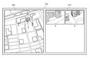
도 2를 참조하면, 표시부(130)의 화면(400)에는 지도 영상(420)과 리스트 영상(440)이 표시된다. 사용자의 선택명령에 따라 선택된 지점 P에 관련된 촬영 영상은 위치 A 및 위치 B에서 촬영된 촬영 영상임을 알 수 있다. 즉, 도면을 보면 알 수 있듯이, 위치 A에서 촬영장치(200)의 수평 촬영방향은 지점 P를 향하고 있으며, 촬영장치(200)의 수평 화각에 지점 P가 모두 포함되어 있음을 알 수 있다. 그리고, 위치 B에서 촬영장치(200)의 수평 촬영방향은 지점 K를 향하고 있으나, 촬영장치(200)의 수평 화각에 지점 P가 포함되어 있다. 이때, 위치 A 및 위치 B에서 촬영장치(200)의 수직 촬영방향이 지점 P를 향하고 있거나, 수직 화각에 지점 P가 포함되어 있다.Referring to FIG. 2, the
이상과 같이, 제어부(160)는 촬영시 촬영장치(200)의 위치, 촬영방향, 및 화 각을 참고하여 선택된 지점 P를 촬영범위에 포함하는 촬영 영상을 검색할 수 있다. 즉, 제어부(160)는 촬영시 촬영장치(200)의 위치, 촬영방향, 및 화각을 참고하여, 선택된 지점 P를 촬영범위에 포함하는 촬영 영상을 외부서버(300)로부터 수신하거나 저장부(150)에서 읽어와서 표시부(130)에 도 2와 같이 리스트 영상(440)으로 표시할 수 있다.As described above, the
한편, 위치 C의 촬영방향은 지점 P에 대해 반대 방향이며, 촬영장치(200)의 수평 화각에도 지점 P가 포함되지 않는다. 즉, 위치 C에서 촬영장치(200)의 촬영범위에 지점 P가 포함되지 않으므로, 제어부(160)는 위치 C에서 촬영된 촬영 영상은 지점 P와 관련된 촬영 영상이 아닌 것으로 판단하다.On the other hand, the photographing direction of the position C is opposite to the point P, and the point P is not included in the horizontal angle of view of the photographing
그리고, 위치 D의 촬영방향은 지점 P를 향하고 있고, 촬영장치(200)의 수평 화각에도 지점 P가 포함되어 있다. 그러나, 수직 화각에 지점 P가 포함되지 않으므로, 제어부(160)는 위치 D에서 촬영된 촬영 영상은 지점 P와 관련된 촬영 영상이 아닌 것으로 판단한다.The photographing direction of the position D faces the point P, and the point P is also included in the horizontal angle of view of the photographing
여기서, 지점 P를 촬영한 위치는 지점 P로부터 반경 수 미터 혹은 수 킬로미터 정도로 한정될 수 있으며, 제어부(160)는 이러한 반경을 벗어나는 위치에서 촬영된 영상은 지점 P와 관련 없다고 판단한다. 즉, 제어부(160)는 선택된 지점 P로부터 소정 반경 내에서 촬영된 영상들에 대해, 촬영방향 및 화각을 고려하여 선택된 지점에 관련된 촬영 영상을 검색하게 된다.Here, the location where the point P is photographed may be limited to a radius of several meters or several kilometers from the point P, and the
도 2에서는 건물을 예로 들었으나, 사용자가 선택할 수 있는 지점은 건물로 한정되지 않는다. 또한, 지점 P 및 위치 A,B,C,D는 독자적인 좌표시스템을 이용할 수도 있고, 위도 및 경도와 같은 기준 좌표계를 이용할 수도 있으며, 위치를 나타낼 수 있는 시스템은 무엇이든지 적용가능하다. 그리고, 수평 화각의 경우 촬영장치(200)의 메타데이터로 제공되는 경우가 많으며, 수직 화각의 경우 수평계 등을 사용하여 사용자가 직접 획득할 수 있다. 그러나, 본 발명에 이용되는 위치, 수평 촬영방향, 수직 촬영방향, 수평 화각, 및 수직 화각 등의 촬영범위를 획득하는 방법은 이에 한정되지 않는다.In FIG. 2, the building is taken as an example, but a user selectable point is not limited to the building. In addition, the point P and positions A, B, C, and D may use their own coordinate systems, reference coordinate systems such as latitude and longitude, and any system capable of indicating a position may be applicable. In addition, the horizontal angle of view is often provided as metadata of the photographing
화각이 촬영장치(200)의 메타데이터로 제공되는 경우, 제어부(160)는 촬영 영상의 메타데이터를 파싱하여 화각을 검출하고, 검출된 화각을 이용하여 각 촬영 영상의 촬영 범위를 확인하며, 확인된 촬영 범위가 지점 P를 포함하는지 판단한다. 그리고, 도 2에 나타낸 바와 같이, 지도 영상(420)에 각 위치에서의 화각을 표시하여 촬영범위를 사용자가 눈으로 확인할 수도 있다.When the angle of view is provided as metadata of the photographing
도 3은 본 발명의 일 실시예에 따른 검색 서비스 제공장치에 촬영 영상을 등록하는 방법을 설명하기 위한 도면이다.3 is a diagram illustrating a method of registering a captured image with a search service providing apparatus according to an exemplary embodiment of the present invention.
도 3을 참조하면, 사진 등록 화면(450)에는 등록할 사진을 선택하기 위한 사진 선택 창(452), 선택된 사진이 표시되는 미리보기 창(454), 및 선택된 사진의 촬영범위를 입력하기 위한 촬영범위 입력 창(456)이 포함된다.Referring to FIG. 3, the
도 3에 예시한 바와 같이, 사용자는 지점 P를 촬영한 촬영 영상을 촬영 범위에 대응시킬 수 있으며, 이렇게 대응된 촬영 영상 및 촬영범위는 외부서버(300)로 전송되거나 저장부(150)에 저장된다.As illustrated in FIG. 3, the user may correspond to a captured image photographing the point P to a photographing range, and the corresponding photographed image and the photographing range are transmitted to the
도 3에서는 촬영 영상을 사진 즉, 정지영상으로 예로 들었으나, 촬영 영상은 정지영상이 아닌 동영상이 될 수도 있다.In FIG. 3, the captured image is taken as a picture, that is, a still image, but the captured image may be a moving image, not a still image.
도 4는 본 발명의 일 실시예에 따른 검색 서비스 제공방법을 설명하기 위한 흐름도이다.4 is a flowchart illustrating a search service providing method according to an embodiment of the present invention.
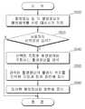
도 4에 따르면, 먼저, 제어부(160)는 촬영 영상 및 각 촬영 영상의 촬영범위를 서로 대응시켜 저장한다(S500). 즉, 촬영장치(200)로부터 수신된 촬영 영상 및 각 촬영 영상의 촬영범위를 저장부(150)에 저장하거나, 통신부(140)를 통해 외부서버(300)로 전송한다.According to FIG. 4, first, the
여기서, 사용자의 선택명령이 입력되면(S520-Y), 제어부(160)는 선택된 지점을 촬영범위에 포함하는 촬영 영상을 검색한다(S540). 예를 들어 설명하면, 제어부(160)는 선택된 지점으로부터 소정 반경 내에서 촬영된 영상들 중, 수평 촬영방향 및 수직 촬영방향이 선택된 지점을 향하는 방향이며, 수평 화각 또는 수직 화각에 선택된 지점이 포함되는 것으로 판단되는 촬영 영상을 검색한다.Here, when a user's selection command is input (S520-Y), the
그리고, 제어부(160)는 검색된 촬영 영상의 촬영시 위치를 선택된 지점과 함께 화면에 표시한다(S560). 다시 말해서, 제어부(160)는 사용자가 선택한 지점이 지도 영상에 표시되고, 단계 S540에서 검색된 촬영 영상이 지도 영상에 표시되도록 표시부(130)를 제어한다.In addition, the
마지막으로, 제어부(160)는 검색된 촬영 영상을 화면에 표시한다(S580). 즉, 제어부(160)는 단계 S540에서 검색된 촬영 영상을 저장부(150)에서 읽어오거나 외부서버(300)로부터 수신하여, 표시부(130)에 표시되도록 제어한다.Finally, the
이상과 같은 과정에 의해, 사용자는 선택된 지점에 관련된 촬영 영상을 손쉽 게 검색하여 확인할 수 있게 된다.By the above process, the user can easily search for and confirm the photographed image related to the selected point.
이상의 일 실시예에서 언급한 촬영 영상은 사진과 같은 정지영상이 될 수도 있고, 동영상이 될 수도 있다.The captured image mentioned in the above embodiment may be a still image such as a photo or a moving image.
도 5는 본 발명의 다른 실시예에 따른 검색 서비스 제공장치의 개략적인 구성을 나타낸 블럭도이다.5 is a block diagram showing a schematic configuration of a search service providing apparatus according to another embodiment of the present invention.
도 5를 참조하면, 검색 서비스 제공장치(600)는 제어부(620) 및 표시부(640)를 포함한다.Referring to FIG. 5, the search
표시부(640)에는 지도 영상이 표시되며, 축척, 좌표, 거리 등 지도 영상에 관련된 각종 파라미터가 표시된다. 또한, 사용자의 선택명령에 따라 선택된 지점이 지도 영상에 표시되며, 해당 지점을 촬영한 촬영 위치도 함께 표시된다. 뿐만 아니라, 선택된 지점을 촬영범위에 포함하는 촬영 영상이 텍스트 리스트나 썸네일(thumbnail) 리스트로 표시부(640)에 표시될 수도 있다.The
제어부(620)는 지도 영상에서 특정 지점이 선택되면, 선택된 지점이 촬영범위에 포함된 촬영 영상을 검색하여 표시부(640)에 표시되도록 제어한다. 또한, 제어부(620)는 입력된 사용자의 선택명령에 따라 선택된 지점 및 선택된 지점을 촬영한 촬영위치가 지도 영상에 표시되도록 표시부(640)를 제어한다. 그리고, 제어부(620)는 촬영 영상 및 촬영 영상의 촬영범위를 서로 대응시켜 촬영 영상을 검색하는데 있어서, 대응되는 촬영범위를 이용한다.When a specific point is selected in the map image, the
도 6은 본 발명의 다른 실시예에 따른 검색 서비스 제공방법을 설명하기 위한 흐름도이다.6 is a flowchart illustrating a search service providing method according to another exemplary embodiment of the present invention.
도 6을 참조하면, 먼저, 제어부(620)는 지도 영상을 표시하도록 표시부(640)를 제어한다(S700). 그리고, 지도 영상에서 특정 지점이 선택되면, 선택된 지점을 촬영범위에 포함하는 촬영 영상을 검색하여 표시부(640)에 표시하도록 제어한다(S750).Referring to FIG. 6, first, the
이상과 같은 과정에 의해, 지도 영상에 관련시켜 촬영 영상을 검색하는 것이 가능하다.By the above process, it is possible to search for the captured image in association with the map image.
이상에서는 본 발명의 바람직한 실시 예에 대하여 도시하고 설명하였지만, 본 발명은 상술한 특정의 실시 예에 한정되지 아니하며, 청구범위에서 청구하는 본 발명의 요지를 벗어남이 없이 당해 발명이 속하는 기술분야에서 통상의 지식을 가진 자라면 누구든지 다양한 변형 실시가 가능한 것은 물론이고, 그와 같은 변경은 청구범위 기재의 범위 내에 있게 된다.While the above has been shown and described with respect to preferred embodiments of the invention, the invention is not limited to the specific embodiments described above, it is usually in the technical field to which the invention belongs without departing from the spirit of the invention claimed in the claims. Anyone skilled in the art can make various modifications, as well as such modifications are within the scope of the claims.
도 1은 본 발명의 일 실시예에 따른 검색 서비스 제공장치의 개략적인 구성을 나타낸 블럭도,1 is a block diagram showing a schematic configuration of a search service providing apparatus according to an embodiment of the present invention;
도 2는 본 발명의 일 실시예에 따른 검색 서비스 제공방법을 설명하기 위한 도면,2 is a view for explaining a search service providing method according to an embodiment of the present invention;
도 3은 본 발명의 일 실시예에 따른 검색 서비스 제공장치에 촬영 영상을 등록하는 방법을 설명하기 위한 도면,3 is a view for explaining a method of registering a captured image in a search service providing apparatus according to an embodiment of the present invention;
도 4는 본 발명의 일 실시예에 따른 검색 서비스 제공장치의 동작을 설명하기 위한 흐름도,4 is a flowchart illustrating an operation of a search service providing apparatus according to an embodiment of the present invention;
도 5는 본 발명의 다른 실시예에 따른 검색 서비스 제공장치의 개략적인 구성을 나타낸 블럭도, 그리고5 is a block diagram showing a schematic configuration of a search service providing apparatus according to another embodiment of the present invention; and
도 6은 본 발명의 다른 실시예에 따른 검색 서비스 제공방법을 설명하기 위한 흐름도이다.6 is a flowchart illustrating a search service providing method according to another exemplary embodiment of the present invention.
* 도면의 주요 부분에 대한 부호의 설명 *Explanation of symbols on the main parts of the drawings
100,600 : 검색 서비스 제공장치 110 : 외부장치연결부100,600: search service provider 110: external device connection
120 : 명령입력부 130,640 : 표시부120: command input unit 130,640: display unit
140 : 통신부 150 : 저장부140: communication unit 150: storage unit
160,620 : 제어부 200 : 촬영장치160,620: control unit 200: recording device
300 : 외부서버 350 : 통신망300: external server 350: communication network
Claims (24)
Translated fromKoreanPriority Applications (3)
| Application Number | Priority Date | Filing Date | Title |
|---|---|---|---|
| KR1020080049200AKR20090123227A (en) | 2008-05-27 | 2008-05-27 | Search service provider, method and program |
| US12/268,624US20090297067A1 (en) | 2008-05-27 | 2008-11-11 | Apparatus providing search service, method and program thereof |
| CNA2008101772954ACN101592494A (en) | 2008-05-27 | 2008-12-11 | Device providing search service, method and program thereof |
Applications Claiming Priority (1)
| Application Number | Priority Date | Filing Date | Title |
|---|---|---|---|
| KR1020080049200AKR20090123227A (en) | 2008-05-27 | 2008-05-27 | Search service provider, method and program |
Publications (1)
| Publication Number | Publication Date |
|---|---|
| KR20090123227Atrue KR20090123227A (en) | 2009-12-02 |
Family
ID=41379914
Family Applications (1)
| Application Number | Title | Priority Date | Filing Date |
|---|---|---|---|
| KR1020080049200AWithdrawnKR20090123227A (en) | 2008-05-27 | 2008-05-27 | Search service provider, method and program |
Country Status (3)
| Country | Link |
|---|---|
| US (1) | US20090297067A1 (en) |
| KR (1) | KR20090123227A (en) |
| CN (1) | CN101592494A (en) |
Cited By (2)
| Publication number | Priority date | Publication date | Assignee | Title |
|---|---|---|---|---|
| WO2014010812A1 (en)* | 2012-07-11 | 2014-01-16 | 포항공과대학교 산학협력단 | Method for generating blocks for video searching and method for processing queries based on blocks generated thereby |
| KR20170011235A (en)* | 2015-07-22 | 2017-02-02 | 주식회사 엘지씨엔에스 | Structure image management method, image processing apparatus, and image inquiry apparatus |
Families Citing this family (9)
| Publication number | Priority date | Publication date | Assignee | Title |
|---|---|---|---|---|
| US20120212606A1 (en)* | 2011-02-20 | 2012-08-23 | Min-Hung Chien | Image processing method and image processing apparatus for dealing with pictures found by location information and angle information |
| US9256961B2 (en) | 2012-06-28 | 2016-02-09 | Here Global B.V. | Alternate viewpoint image enhancement |
| US9256983B2 (en)* | 2012-06-28 | 2016-02-09 | Here Global B.V. | On demand image overlay |
| CN102829788A (en)* | 2012-08-27 | 2012-12-19 | 北京百度网讯科技有限公司 | Live action navigation method and live action navigation device |
| CN102937452A (en)* | 2012-10-26 | 2013-02-20 | 北京百度网讯科技有限公司 | Navigation method, apparatus and system based on image information code |
| US9772281B2 (en) | 2014-10-25 | 2017-09-26 | Isle Management Co. | Air quality analyzing apparatus |
| CN106815237B (en)* | 2015-11-30 | 2020-08-21 | 北京睿创投资管理中心(有限合伙) | Search method, search device, user terminal and search server |
| CN106649604A (en)* | 2016-11-25 | 2017-05-10 | 北京都在哪网讯科技有限公司 | Display method of media file based on electronic photo album, device and electronic photo album |
| CN111881322B (en)* | 2020-09-28 | 2020-12-25 | 成都睿沿科技有限公司 | Target searching method and device, electronic equipment and storage medium |
Family Cites Families (41)
| Publication number | Priority date | Publication date | Assignee | Title |
|---|---|---|---|---|
| US5179652A (en)* | 1989-12-13 | 1993-01-12 | Anthony I. Rozmanith | Method and apparatus for storing, transmitting and retrieving graphical and tabular data |
| US6121966A (en)* | 1992-11-02 | 2000-09-19 | Apple Computer, Inc. | Navigable viewing system |
| DE69426011T2 (en)* | 1993-12-27 | 2001-02-15 | Aisin Aw Co., Ltd. | Vehicle information display system |
| US6321158B1 (en)* | 1994-06-24 | 2001-11-20 | Delorme Publishing Company | Integrated routing/mapping information |
| WO1996024216A1 (en)* | 1995-01-31 | 1996-08-08 | Transcenic, Inc. | Spatial referenced photography |
| US6577714B1 (en)* | 1996-03-11 | 2003-06-10 | At&T Corp. | Map-based directory system |
| JP3876463B2 (en)* | 1996-11-18 | 2007-01-31 | ソニー株式会社 | Map information providing apparatus and method |
| US6388688B1 (en)* | 1999-04-06 | 2002-05-14 | Vergics Corporation | Graph-based visual navigation through spatial environments |
| JP4366801B2 (en)* | 1999-12-28 | 2009-11-18 | ソニー株式会社 | Imaging device |
| AU4148901A (en)* | 2000-02-14 | 2001-08-27 | Virtuacities, Inc. | Methods and systems for presenting a virtual representation of a real city |
| ES2885435T3 (en)* | 2001-04-30 | 2021-12-13 | Activemap Llc | Interactive map submitted electronically |
| JP2003110902A (en)* | 2001-09-27 | 2003-04-11 | Fuji Photo Film Co Ltd | Device, method and program for photographing image |
| US7096428B2 (en)* | 2001-09-28 | 2006-08-22 | Fuji Xerox Co., Ltd. | Systems and methods for providing a spatially indexed panoramic video |
| US6897861B2 (en)* | 2002-01-09 | 2005-05-24 | Nissan Motor Co., Ltd. | Map image display device, map image display method and map image display program |
| US7107285B2 (en)* | 2002-03-16 | 2006-09-12 | Questerra Corporation | Method, system, and program for an improved enterprise spatial system |
| US7334190B2 (en)* | 2002-06-27 | 2008-02-19 | Mjw Corporation Inc. | Interactive video tour system editor |
| JP4225029B2 (en)* | 2002-10-18 | 2009-02-18 | 日産自動車株式会社 | Map image display device and map image display program |
| US6906643B2 (en)* | 2003-04-30 | 2005-06-14 | Hewlett-Packard Development Company, L.P. | Systems and methods of viewing, modifying, and interacting with “path-enhanced” multimedia |
| JP4037790B2 (en)* | 2003-05-02 | 2008-01-23 | アルパイン株式会社 | Navigation device |
| JPWO2005005927A1 (en)* | 2003-07-10 | 2007-09-20 | 株式会社アプリコット | Road guidance system and road guidance method |
| JP2005098732A (en)* | 2003-09-22 | 2005-04-14 | Alpine Electronics Inc | Navigation system and map-display method |
| JP4148084B2 (en)* | 2003-09-25 | 2008-09-10 | 株式会社デンソー | Display operation system |
| US7155336B2 (en)* | 2004-03-24 | 2006-12-26 | A9.Com, Inc. | System and method for automatically collecting images of objects at geographic locations and displaying same in online directories |
| CA2559726C (en)* | 2004-03-24 | 2015-10-20 | A9.Com, Inc. | System and method for displaying images in an online directory |
| JP4470105B2 (en)* | 2004-05-20 | 2010-06-02 | ノーリツ鋼機株式会社 | Navigation system and program |
| US7746376B2 (en)* | 2004-06-16 | 2010-06-29 | Felipe Mendoza | Method and apparatus for accessing multi-dimensional mapping and information |
| US7660441B2 (en)* | 2004-07-09 | 2010-02-09 | Southern California, University | System and method for fusing geospatial data |
| JP2006105640A (en)* | 2004-10-01 | 2006-04-20 | Hitachi Ltd | Navigation device |
| US8150617B2 (en)* | 2004-10-25 | 2012-04-03 | A9.Com, Inc. | System and method for displaying location-specific images on a mobile device |
| US7376510B1 (en)* | 2004-11-05 | 2008-05-20 | Navteq North America, Llc | Map display for a navigation system |
| KR101147748B1 (en)* | 2005-05-26 | 2012-05-25 | 엘지전자 주식회사 | A mobile telecommunication device having a geographic information providing function and the method thereof |
| KR100674805B1 (en)* | 2005-06-14 | 2007-01-29 | 엘지전자 주식회사 | Building Matching Method Between Camera Image and Map Data |
| US7840032B2 (en)* | 2005-10-04 | 2010-11-23 | Microsoft Corporation | Street-side maps and paths |
| US8160400B2 (en)* | 2005-11-17 | 2012-04-17 | Microsoft Corporation | Navigating images using image based geometric alignment and object based controls |
| US7663671B2 (en)* | 2005-11-22 | 2010-02-16 | Eastman Kodak Company | Location based image classification with map segmentation |
| US20070143676A1 (en)* | 2005-12-20 | 2007-06-21 | Taiwan Online Co., Ltd. | Electronic map with a drawing feature |
| US7617246B2 (en)* | 2006-02-21 | 2009-11-10 | Geopeg, Inc. | System and method for geo-coding user generated content |
| US7797019B2 (en)* | 2006-03-29 | 2010-09-14 | Research In Motion Limited | Shared image database with geographic navigation |
| JP2007323544A (en)* | 2006-06-05 | 2007-12-13 | Sony Corp | Information-processing system, information-processing device, method, and computer program |
| KR101423928B1 (en)* | 2007-08-20 | 2014-07-28 | 삼성전자주식회사 | Image reproducing apparatus which uses the image files comprised in the electronic map, image reproducing method for the same, and recording medium which records the program for carrying the same method. |
| CN101109643B (en)* | 2007-08-22 | 2011-06-29 | 广东瑞图万方科技有限公司 | Navigation apparatus |
- 2008
- 2008-05-27KRKR1020080049200Apatent/KR20090123227A/ennot_activeWithdrawn
- 2008-11-11USUS12/268,624patent/US20090297067A1/ennot_activeAbandoned
- 2008-12-11CNCNA2008101772954Apatent/CN101592494A/enactivePending
Cited By (2)
| Publication number | Priority date | Publication date | Assignee | Title |
|---|---|---|---|---|
| WO2014010812A1 (en)* | 2012-07-11 | 2014-01-16 | 포항공과대학교 산학협력단 | Method for generating blocks for video searching and method for processing queries based on blocks generated thereby |
| KR20170011235A (en)* | 2015-07-22 | 2017-02-02 | 주식회사 엘지씨엔에스 | Structure image management method, image processing apparatus, and image inquiry apparatus |
Also Published As
| Publication number | Publication date |
|---|---|
| CN101592494A (en) | 2009-12-02 |
| US20090297067A1 (en) | 2009-12-03 |
Similar Documents
| Publication | Publication Date | Title |
|---|---|---|
| KR20090123227A (en) | Search service provider, method and program | |
| US8676623B2 (en) | Building directory aided navigation | |
| US10025985B2 (en) | Information processing apparatus, information processing method, and non-transitory computer-readable storage medium storing program | |
| JP6208654B2 (en) | Method and system for pushing point of interest information | |
| KR101330805B1 (en) | Apparatus and Method for Providing Augmented Reality | |
| KR101823441B1 (en) | Terminal and Method for Forming Video, Apparatus for Forming Image, Driving Method Thereof, and Computer-Readable Recording Medium | |
| US20120183172A1 (en) | Community-Based Data for Mapping Systems | |
| JP6180647B2 (en) | Indoor map construction apparatus and method using cloud points | |
| KR20220085142A (en) | Intelligent construction site management supporting system and method based extended reality | |
| US10136003B2 (en) | Image forming system, image forming apparatus, and non-transitory computer readable recording medium storing guide program | |
| US20150154851A1 (en) | System and method of filling in gaps in image data | |
| KR101226731B1 (en) | Digital map making method | |
| KR101615504B1 (en) | Apparatus and method for serching and storing contents in portable terminal | |
| US20080244314A1 (en) | Failure information delivery system, failure management server, mobile object communication apparatus, failure information delivery method, and program | |
| JP2019163998A (en) | Information provision system, server device, and information provision method | |
| JP2018036989A (en) | Information display system and image forming apparatus | |
| KR102458559B1 (en) | Construction management system and method using mobile electric device | |
| KR101613355B1 (en) | System for providing information using subject and method thereof | |
| JP6208977B2 (en) | Information processing apparatus, communication terminal, and data acquisition method | |
| KR20110095443A (en) | Method and system for providing subject information | |
| KR20060081068A (en) | Location Information Acquisition System, Method and Mobile Communication Terminal Using Camera Function | |
| KR20220166015A (en) | Apparatus for visualizing the result of detecting pothole in aerial image based on deep-learning and method thereof | |
| KR20200088199A (en) | Electronic business card exchanging system using mobile terminal and method thereof | |
| JP2015146074A (en) | Display system, information processing apparatus, display control method, and display control program | |
| US20230128950A1 (en) | Photography position management device and method, and computer-readable storage medium |
Legal Events
| Date | Code | Title | Description |
|---|---|---|---|
| PA0109 | Patent application | Patent event code:PA01091R01D Comment text:Patent Application Patent event date:20080527 | |
| PG1501 | Laying open of application | ||
| PC1203 | Withdrawal of no request for examination | ||
| WITN | Application deemed withdrawn, e.g. because no request for examination was filed or no examination fee was paid |