KR20090020387A - Method and device for displaying optimal path of moving object in navigation device - Google Patents
Method and device for displaying optimal path of moving object in navigation deviceDownload PDFInfo
- Publication number
- KR20090020387A KR20090020387AKR1020070085121AKR20070085121AKR20090020387AKR 20090020387 AKR20090020387 AKR 20090020387AKR 1020070085121 AKR1020070085121 AKR 1020070085121AKR 20070085121 AKR20070085121 AKR 20070085121AKR 20090020387 AKR20090020387 AKR 20090020387A
- Authority
- KR
- South Korea
- Prior art keywords
- moving object
- path
- displaying
- optimum
- current position
- Prior art date
- Legal status (The legal status is an assumption and is not a legal conclusion. Google has not performed a legal analysis and makes no representation as to the accuracy of the status listed.)
- Ceased
Links
Images


Classifications
- G—PHYSICS
- G01—MEASURING; TESTING
- G01C—MEASURING DISTANCES, LEVELS OR BEARINGS; SURVEYING; NAVIGATION; GYROSCOPIC INSTRUMENTS; PHOTOGRAMMETRY OR VIDEOGRAMMETRY
- G01C21/00—Navigation; Navigational instruments not provided for in groups G01C1/00 - G01C19/00
- G01C21/26—Navigation; Navigational instruments not provided for in groups G01C1/00 - G01C19/00 specially adapted for navigation in a road network
- G01C21/34—Route searching; Route guidance
- G01C21/36—Input/output arrangements for on-board computers
- G01C21/3667—Display of a road map
- G—PHYSICS
- G08—SIGNALLING
- G08G—TRAFFIC CONTROL SYSTEMS
- G08G1/00—Traffic control systems for road vehicles
- G08G1/09—Arrangements for giving variable traffic instructions
- G08G1/0962—Arrangements for giving variable traffic instructions having an indicator mounted inside the vehicle, e.g. giving voice messages
- G08G1/0968—Systems involving transmission of navigation instructions to the vehicle
- G08G1/0969—Systems involving transmission of navigation instructions to the vehicle having a display in the form of a map
Landscapes
- Engineering & Computer Science (AREA)
- Radar, Positioning & Navigation (AREA)
- Remote Sensing (AREA)
- Physics & Mathematics (AREA)
- General Physics & Mathematics (AREA)
- Automation & Control Theory (AREA)
- Navigation (AREA)
Abstract
Translated fromKoreanDescription
Translated fromKorean본 발명은 네비게이션 장치에서 이동체의 최적경로를 표시하는 방법 및 장치에 관한 것으로, 더욱 자세히는 네비게이션에서 교차로 신호 대기 중이나 차량 정지 상태에서 미리 전방의 경로를 안내해줄 수 있는 이동체의 최적경로를 표시하는 방법 및 장치에 관한 것이다.The present invention relates to a method and apparatus for displaying an optimum path of a moving object in a navigation device. More particularly, the present invention relates to a method of displaying an optimum path of a moving object that can guide a path ahead of the vehicle in the state of waiting for an intersection signal or stopping a vehicle. And to an apparatus.
이동통신 단말기의 보급이 일반화되면서 이동통신 단말기의 화면을 통해 운전 중에 도로 상황을 알려줄 수 있는 교통정보 서비스, 나만의 독특한 벨소리를 등록하여 사용할 수 있는 마이벨 서비스, 음성 사서함의 메시지 도착을 문자로 통보해주는 이동전화 호출 서비스 등 다양한 서비스가 제공되고 있다.As the spread of mobile communication terminals becomes more common, a traffic information service that can notify the road situation while driving through the screen of the mobile communication terminal, a MyBell service that can register and use a unique ringtone, and the message arrival of a voice mail message are notified. Various services such as mobile phone calling service are provided.
그 중 하나로, GPS(Global Positioning System) 기능이 구현된 이동통신 단말기는 서비스는 GPS를 이용하여 차량의 현재위치를 구하고, 위치 정보에 따라 네비게이션 서비스를 제공하고 있다. 네비게이션 서비스는 차량의 현재위치를 알려주고, 원하는 목적지까지의 최적경로를 계산하여 차량의 주행 중 계산된 경로를 미리 보여줌으로써 운전자를 안내하는 서비스이다.Among them, a mobile communication terminal in which a Global Positioning System (GPS) function is implemented, the service obtains a current location of a vehicle using GPS, and provides a navigation service according to the location information. The navigation service is a service that guides the driver by informing the current location of the vehicle and calculating the optimum route to the desired destination and showing the calculated route in advance while driving the vehicle.
이러한 네비게이션 장치는 경로 미리보기 기능을 구비하여 사용자에게 출발지에서 목적지까지의 전체경로에 대한 미리보기를 제공할 수 있다. 그러나, 차량 네비게이션 장치의 미리보기 기능은 운전자가 수동으로 명령을 입력해야 하기 때문에 번거롭다. 또한, 운전자의 현재위치와 상관없이 출발지에서 목적지까지의 전체 경로에 대한 미리보기 기능만을 수행한다. 따라서, 운전자가 미리보기 화면에서 차량의 현재위치를 파악하기 어렵고, 사용자가 앞으로 진행하여야 할 방향에 대한 전방의 경로를 알 수 없어 혼란을 느끼게 된다.Such a navigation device may include a route preview function to provide a user with a preview of the entire route from the starting point to the destination. However, the preview function of the vehicle navigation device is cumbersome because the driver must manually enter a command. In addition, regardless of the current position of the driver, only the preview function for the entire route from the starting point to the destination is performed. Therefore, it is difficult for the driver to grasp the current position of the vehicle on the preview screen, and the user may not know the path ahead for the direction in which the user should go forward.
본 발명의 목적은 네비게이션 장치에서 교차로 신호 대기 중이나 차량 정지 상태에서 미리 전방의 경로를 안내해줄 수 있는 이동체의 최적경로를 표시하는 방법 및 장치를 제공함에 있다.An object of the present invention is to provide a method and apparatus for displaying an optimum path of a moving object that can guide a path ahead in advance while a vehicle is stopped at a crossroads signal in a navigation device.
본 발명의 일 실시예에 따른 네비게이션 장치에서 이동체의 최적경로를 표시하는 방법은, 이동체의 목적지에 따른 최적경로를 설정하여 저장하는 과정과, 상기 최적경로를 주행하는 상기 이동체의 현재위치를 검출하는 과정과, 상기 최적경로상에서 이동체가 주행을 정지하면, 상기 이동체의 주행 정지시간이 기 설정된 시간 이상인지 여부를 판단하는 과정과, 상기 이동체의 주행 정지시간이 상기 설정된 시간 이상인 경우, 상기 검출된 이동체의 현재위치에 대한 전방경로를 표시하는 과정을 포함한다.In the navigation device according to an embodiment of the present invention, a method for displaying an optimal path of a moving object includes: setting and storing an optimal path according to a destination of the moving object, and detecting a current position of the moving object driving the optimum path. Determining whether the driving stop time of the moving object is greater than or equal to a preset time when the moving object stops traveling on the optimum path; and if the traveling stopping time of the moving object is greater than or equal to the predetermined time, And displaying a forward path for the current position of the.
본 발명의 다른 실시예에 따른 네비게이션 장치에서 이동체의 최적경로를 표시하는 방법은, 이동체의 목적지에 따른 최적경로를 설정하여 표시하는 과정과, 상기 최적경로상에서 주행하는 이동체의 현재위치를 검출하는 과정과, 상기 최적경로상에서 주행중이던 이동체가 정지하면, 전방경로 표시에 대한 사용자 입력을 수신하였는지 여부를 판단하는 과정과, 상기 전방경로 표시에 대한 사용자 입력을 수신한 경우, 상기 이동체의 현재위치에 대한 전방경로를 표시하는 과정을 포함한다.In the navigation device according to another embodiment of the present invention, a method for displaying an optimum path of a moving object includes: setting and displaying an optimum path according to a destination of the moving object, and detecting a current position of the moving object traveling on the optimum path. Determining whether a user input for forward path display is received when the moving object that is driving on the optimum path is stopped; and when receiving a user input for forward path display, the current position of the moving object is determined. And displaying the forward path.
본 발명의 또 다른 실시예에 따른 네비게이션 장치에서 이동체의 최적경로를 표시하는 방법은, 이동체의 목적지에 따른 최적경로를 설정하여 표시하는 과정과, 상기 최적경로상에서 주행하는 이동체의 현재위치를 검출하는 과정과, 상기 최적경로상에서 주행중이던 이동체가 정지하면, 상기 검출된 이동체의 현재위치에서 기 설정된 제1범위 내에 제1교차로가 위치하는지 여부를 판단하는 과정과, 상기 설정된 제1범위 내에 제1교차로가 위치하는 경우, 기 설정된 제2범위 내에 제2교차로가 위치하는지 여부를 판단하는 과정과, 상기 설정된 제2범위 이내에 제2교차로가 위치하는 경우, 상기 제1교차로 및 제2교차로를 포함하는 상기 이동체의 현재위치에 대한 전방경로를 표시하는 과정을 포함한다.According to another embodiment of the present invention, a method for displaying an optimum path of a moving object in a navigation device includes: setting and displaying an optimum path according to a destination of the moving object, and detecting a current position of the moving object traveling on the optimum path. And determining whether or not the first intersection is located within a preset first range at the current position of the detected moving object when the moving object driving on the optimum path stops, and the first crossing path within the set first range. When is located, the process of determining whether the second intersection is located within the predetermined second range, and, if the second intersection is located within the set second range, the first intersection and the second intersection including the And displaying a forward path with respect to the current position of the moving object.
본 발명의 일 실시예에 따른 네비게이션 장치에서 이동체의 최적경로를 표시하는 장치는, 이동체의 목적지에 따른 최적경로를 제공하기 위한 지도데이터를 저장하는 지도데이터 DB와, 상기 최적경로를 따라 이동체의 현재위치를 검출하는 위치검출부와, 상기 최적경로 및 이동체의 현재위치를 표시하는 표시부와, 상기 지도데이터를 이용하여 상기 최적경로를 설정하고, 상기 설정된 최적경로상에서 이동체가 정지한 경우 상기 정지한 시간이 기 설정된 시간 이상인지 판단하고, 판단 결과 기 설정된 시간 이상인 경우 상기 전방경로를 표시하도록 상기 표시부를 제어하는 제어부를 포함한다.An apparatus for displaying an optimal path of a moving object in a navigation device according to an embodiment of the present invention includes a map data DB for storing map data for providing an optimal path according to a destination of the moving object, and a current of the moving object along the optimum path. A position detecting unit for detecting a position, a display unit displaying the optimal path and the current position of the moving object, the optimal path is set using the map data, and the stopped time is determined when the moving object stops on the set optimal path. And a control unit for controlling the display unit to determine whether it is more than a preset time and to display the forward path when the determination result is greater than or equal to the preset time.
본 발명에 따르면 네비게이션 장치에서 교차로 신호 대기 중이나 차량 정지 상태에서 미리 전방의 경로를 안내해줄 수 있는 이동체의 최적경로를 표시하는 방법 및 장치가 제공된다.According to the present invention, there is provided a method and apparatus for displaying an optimum path of a moving object that can guide a path ahead in advance while the navigation device is waiting for an intersection signal or when the vehicle is stopped.
이하 본 발명의 바람직한 실시 예를 첨부한 도면을 참조하여 상세히 설명한다. 도면들 중 동일한 구성 요소들은 가능한 한 어느 곳에서든지 동일한 부호들로 나타내고 있음에 유의하여야 한다. 하기 설명 및 첨부 도면에서 본 발명의 요지를 불필요하게 흐릴 수 있는 공지 기능 및 구성에 대한 상세한 설명은 생략한다.Hereinafter, exemplary embodiments of the present invention will be described in detail with reference to the accompanying drawings. It should be noted that the same elements in the figures are denoted by the same reference numerals wherever possible. In the following description and the annexed drawings, detailed descriptions of well-known functions and configurations that may unnecessarily obscure the subject matter of the present invention will be omitted.
본 발명에 따른 네비게이션 장치는 이동체의 출발지에서 목적지까지의 최적경로를 표시할 때, 최적경로상에서 주행하는 이동체의 현재위치와, 현재위치에 대응하는 최적경로가 포함된 지도데이터를 표시한다. 최적경로를 포함하여 표시되는 지도데이터는 이동체의 현재위치에서 일정한 범위 이내의 지역에 대한 지도데이터이다. 또한, 현재위치에 대응하여 나타나는 일정 범위 이내의 지역을 "현재주행지역"이라 하기로 한다.When the navigation device according to the present invention displays the optimum route from the starting point to the destination of the moving object, the navigation device displays the current position of the moving object traveling on the optimum path and the map data including the optimum path corresponding to the current position. The map data including the optimal route is map data for a region within a certain range from the current position of the moving object. In addition, an area within a predetermined range corresponding to the current location will be referred to as a "current driving area".
최적경로 중에서 이동체가 현재주행지역을 주행하고 난 이후에 주행하여야 할 최적경로를 포함하는 일정 범위 이내의 지역을 "전방지역"이라 하기로 한다. 예를 들어 현재주행지역이 이동체의 현재위치로부터 원형으로 150미터 이내의 지역이라고 하면, 전방지역은 이동체의 현재위치로부터 원형으로 150미터 이외의 지역으로부터 250미터 이내의 지역이 될 수 있다.Among the optimum paths, an area within a predetermined range including an optimal path to be driven after the vehicle travels in the current driving region is referred to as a "forward zone". For example, if the current running area is an area within 150 meters from the current position of the moving object, the front area may be an area within 250 meters from an area other than 150 meters from the current position of the moving object.
"전방경로"는 최적경로 중 전방지역에 포함된 최적경로를 가리킨다. "전방경로 미리보기"는 이동체가 전방지역에 포함된 전방경로를 디스플레이 화면에 미리 표시함으로써 이동체가 앞으로 주행해야 할 최적경로를 알려주는 것을 말한다."Forward Path" refers to the optimal path included in the front area of the optimal path. "Front path preview" refers to an indication of an optimal path that the moving object must drive forward by displaying the forward path included in the front area on the display screen in advance.
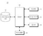
도 1은 본 발명의 일 실시예에 따른 네비게이션 장치에서 이동체의 최적경로 를 표시하는 장치의 개략적인 구성을 도시한 블록도이다.1 is a block diagram illustrating a schematic configuration of an apparatus for displaying an optimum path of a moving object in a navigation device according to an embodiment of the present invention.
네비게이션 장치(10)는 지도데이터 DB(Datebase)(12), 키 입력부(14), 표시부(16), 오디오 처리부(18), 위치검출부(20) 및 제어부(30)를 포함한다.The
지도데이터 DB(12)는 사용자에게 이동체의 최적경로를 제공하기 위한 지도데이터를 저장한다. 본 발명의 일 실시예에 따른 지도데이터 DB(12)는 주행중이던 이동체가 정지한 경우, 후술하는 제어부(30)가 전방경로를 표시하기 위한 지도데이터를 저장한다.The
키 입력부(14)는 숫자 및 문자를 입력받을 수 있는 키 및 각종 기능을 설정하기 위한 키를 구비하여 사용자로부터 입력을 수신하다. 본 발명에 일 실시예에 따른 키 입력부(14)는 사용자로부터 목적지에 대한 입력을 수신한다. 또한, 키 입력부(14)는 사용자로부터 최적경로를 후술하는 표시부(16)에 표시할 것인지 여부에 대한 사용자 입력을 수신한다.The key input unit 14 is provided with keys for receiving numbers and letters and keys for setting various functions to receive input from a user. The key input unit 14 according to an embodiment of the present invention receives an input for a destination from a user. In addition, the key input unit 14 receives a user input as to whether or not to display the optimum path on the
키 입력부(14)는 전방경로 미리보기 기능을 수행할 것인지 여부에 대한 사용자 입력을 수신한다. 바람직하게 키 입력부(14)는 디스플레이 화면에 전방경로를 표시하는 전방경로 미리보기 기능을 바로 실행할 수 있는 단축키를 구비할 수 있다. 또한 키 입력부(14)는 전방지역의 범위에 대한 사용자 입력을 수신할 수 있다. 예를 들어, 사용자는 전방경로 200미터 범위의 지역을 표시하여 줄 것을 키 입력부(14)를 통하여 요청할 수 있다.The key input unit 14 receives a user input regarding whether to perform a forward path preview function. Preferably, the key input unit 14 may include a shortcut key for directly executing the forward path preview function for displaying the forward path on the display screen. In addition, the key input unit 14 may receive a user input for the range of the front area. For example, the user may request through the key input unit 14 to display an area of 200 meters in the forward path.
표시부(16)는 LCD(Liquid Crystal Display) 등으로 이루어질 수 있으며, 네비게이션 장치(10)에서 발생하는 각종 표시 데이터를 출력한다. LCD를 터치스크 린(touch screen) 방식으로 구현하는 경우, 표시부(16)는 입력수단으로 동작할 수 있다. 본 발명에 따른 표시부(16)는 이동체의 출발지에서부터 목적지까지의 최적경로를 표시한다.The
본 발명에 따른 표시부(16)는 키 입력부(14)를 통해 전방경로 미리보기 기능에 대한 사용자 입력을 수신하면, 제어부(30)의 제어하에 전방경로를 표시한다. 또한, 표시부(16)는 디스플레이 화면상에 전방경로상에서 이동체가 어떤 방식으로 주행하는지를 시뮬레이션(Simulation)하는 방식으로 전방경로 미리보기 기능을 수행할 수 있다.When the
오디오 처리부(18)는 네비게이션 장치(10)에서 발생하는 오디오 데이터를 처리한다. 오디오 처리부(18)는 음성 데이터를 출력하여 이동체의 최적경로를 안내한다. 예를 들어, 이동체가 최적경로를 따라 주행하던 중 전방 25미터에 횡단보도가 있는 경우 오디오 처리부(18)는 "전방 25미터에 횡단보도가 있습니다."라고 안내 음성을 출력할 수 있다.The
위치검출부(20)는 네비게이션 장치(10)가 장착된 이동체의 현재위치를 검출한다. 이를 위하여 위치검출부(20)는 GPS 수신기를 포함할 수 있다. GPS 수신기는 복수 개의 GPS 위성으로부터 전송된 GPS 신호를 수신하여 이동체에 탑재된 네비게이션 장치의 현재위치를 계산한다. 또한, 위치검출부(20)는 이동체의 GPS 수신기를 통하여 계산된 현재위치, 이동체의 이동 속도 및 주행방향 등 이동체의 주행에 필요한 정보를 계산한다.The
제어부(30)는 네비게이션 장치(10)의 전반적인 동작을 제어한다. 제어부(30) 는 키 입력부(14)를 통해 입력된 목적지와 지도데이터 DB(12)의 지도데이터들을 이용하여 이동체의 최적경로를 설정한다. 또한, 제어부(30)는 위치검출부(20)를 제어하여 이동체의 현재위치를 검출한다. 제어부(30)는 표시부(16)를 제어하여 이동체의 최적경로뿐만 아니라 최적경로상에서 이동체의 현재위치를 표시한다. 또한, 제어부(30)는 오디오 처리부(18)를 제어하여 오디오 데이터를 출력하도록 한다.The
본 발명의 일 실시예에 따른 제어부(30)는 전방경로 미리보기 기능을 수행하도록 네비게이션 장치(10)를 제어한다. 키 입력부(14)를 통해 전방경로 미리보기에 대한 사용자 입력이 수신되면, 제어부(30)는 표시부(16)를 제어하여 최적경로상에서 이동체의 현재위치에 따른 전방경로를 표시하여 전방경로 미리보기 기능을 수행한다.The
또한, 제어부(30)는 주행중이던 이동체가 정지하면 이동체가 주행을 정지한 시간을 측정한다. 제어부(30)는 주행이 정지된 시간이 기 설정된 시간 이상인지 여부를 판단한다. 기 설정된 시간 이상인 경우 제어부(30)는 표시부(16)를 제어하여 디스플레이 화면에 전방경로를 표시한다. 이때, 설정된 시간은 네비게이션 장치(10)에 기 저장된 값일 수 있다.In addition, the
제어부(30)는 이동체가 기 설정된 시간 이상 주행을 정지한 경우, 위치검출부(18)로부터 검출된 이동체의 현재위치에서 기 설정된 제1범위 이내에 제1교차로가 위치하는지 여부를 판단하다. 제1교차로가 위치하면 제어부(30)는 설정된 제2범위 이내에 제2교차로가 위치하는지 여부를 판단한다. 이는 이동체가 교차로에서 신호 대기 등으로 주행을 정지하였을 경우에, 이동체가 다시 최적경로를 따라 주행하 였을 때 그 최적경로에 교차로가 포함되어 있음을 사용자에게 미리 알려주기 위함이다.When the moving object stops traveling for a predetermined time or more, the
상기 설정된 제2범위 내에 제2교차로가 위치하면 표시부(16)는 제1교차로 및 제2교차로를 포함하여 이동체의 현재위치에 따른 전방경로를 표시한다. 상기 설정된 제2범위 내에 제2교차로가 위치하지 않으면 표시부(16)는 제1교차로만을 포함하여 전방경로를 표시할 수 있다. 이때, 제1범위 및 제2범위는 각기 다를 수 있다. 또한, 제1범위 또는 제2범위는 네비게이션 장치(10)에 기 저장된 값일 수 있다.When the second intersection is located within the set second range, the
도 2는 본 발명의 일 실시예에 따른 네비게이션 장치에서 최적경로를 표시하는 방법을 도시한 순서도이다.2 is a flowchart illustrating a method of displaying an optimal path in a navigation device according to an embodiment of the present invention.
네비게이션 장치(10)는 이동체의 목적지에 따라 최적경로를 설정하여 표시한다(S32). 키 입력부(14)를 통하여 사용자로부터 목적지를 입력받으면, 제어부(30)는 지도데이터 DB(12)에 저장된 지도데이터들을 이용하여 최적경로를 설정한다. 최적경로가 설정되면, 표시부(12)는 디스플레이 화면에 이동체의 현재위치와 최적경로 중 이동체의 현재위치가 포함된 현재주행지역을 표시한다.The
위치검출부(20)는 최적경로를 따라 주행하는 이동체의 현재위치를 검출한다(S34). 이동체의 현재위치가 검출됨에 따라 제어부(30)는 표시부(16)를 제어하여 이동체의 현재위치에 대한 현재주행지역을 표시한다.The
제어부(30)는 최적경로상에서 주행하는 이동체가 정지하였는지 여부를 판단한다(S36). 이동체의 주행정지 여부는 위치검출부(18)에 구비된 센서들을 이용하여 감지할 수 있다. 예를 들어 네비게이션 장치(10)에 구비된 가속도 센서의 값이 0이 고, GPS 수신기로 측정한 이동체의 현재위치가 소정 시간 동일한 값이라면, 제어부(30)는 이동체가 정지한 것으로 판단할 수 있다. 일예로 이동체의 주행 정지시간이 15초라면 제어부(30)는 이동체가 정지한 것으로 판단할 수 있다.The
주행중이던 이동체가 정지하지 않았으면(S36:N), 제어부(30)는 별도의 동작을 수행하지 않는다. 이동체는 제어부(30)에 의하여 설정된 최적경로상에서 주행을 계속한다. 또한, 네비게이션 장치(10)는 목적지까지의 최적경로 및 그에 따른 지도데이터를 이동체의 위치변화에 따라서 표시한다.If the moving object is not stopped (S36: N), the
반면에 이동체가 정지하면(S36:Y), 제어부(30)는 정지한 이동체의 주행 정지시간을 측정한다(S38). 제어부(30)는 측정된 주행 정지시간이 기 설정된 시간 이상인지 여부를 판단한다(S40). 단계 S40에서의 기 설정된 시간은 단계 S36에서 이동체가 정지하였는지 여부를 판단하기 위해 설정된 시간과 다르다. 단계 S36의 이동체의 정지여부를 판단하기 위한 시간과, 단계 S40의 기 설정된 시간은 그 값이 각기 다를 수 있다.On the other hand, when the moving object stops (S36: Y), the
측정된 주행 정지시간이 기 설정된 시간 이상인 경우(S40:Y), 표시부(16)는 전방경로 미리보기 기능을 수행하여 현재위치에 따른 전방경로를 표시한다(S42). 이로써 이동체가 교차로 등에서 장시간 대기하고 있을 경우, 사용자는 네비게이션 장치(10)에 별도의 조작을 가하지 않고서도 이동체의 전방경로를 알아낼 수 있다.If the measured driving stop time is more than the preset time (S40: Y), the
반면에 제어부(30)에 의하여 측정된 주행 정지시간이 기 설정된 시간 이상이 아닌 경우(S40:N), 네비게이션 장치(10)는 별도의 동작을 수행하지 않는다.On the other hand, when the driving stop time measured by the
도 3은 본 발명의 다른 실시예에 따른 네비게이션 장치에서 최적경로를 표시 하는 방법을 도시한 순서도이다.3 is a flowchart illustrating a method of displaying an optimal path in a navigation device according to another embodiment of the present invention.
네비게이션 장치(10)는 이동체의 목적지에 따라 최적경로를 설정하여 표시한다(S52). 키 입력부(14)를 통하여 사용자로부터 목적지를 입력받으면, 제어부(30)는 지도데이터 DB(12)에 저장된 지도데이터들을 이용하여 출발지로부터 목적지까지의 최적경로를 설정한다. 최적경로가 설정되면, 표시부(12)는 디스플레이 화면에 이동체의 현재위치와 최적경로 중 이동체의 현재위치가 포함된 주행지역인 현재주행지역을 표시한다.The
위치검출부(20)는 최적경로상에서 주행하는 이동체의 현재위치를 검출한다(S54). 제어부(30)는 표시부(16)를 제어하여 이동체의 현재위치에 대한 현재주행지역을 표시한다.The
제어부(30)는 최적경로상에서 주행하는 이동체가 정지하였는지 여부를 판단한다(S56). 판단결과 이동체가 정지하지 않았으면(S56:N), 제어부(30)는 별도의 동작을 수행하지 않는다.The
단계 S56의 판단결과 최적경로를 따라 주행중이던 이동체가 정지하였으면(S56:Y), 제어부(30)는 전방경로 미리보기에 대한 사용자 입력이 수신되었는지 여부를 판단한다(S58). 전방경로 미리보기에 대한 사용자 입력이 수신된 경우(S58:Y), 표시부(16)는 이동체의 현재위치에 따른 전방경로를 표시한다(S60). 전방경로 미리보기에 대한 사용자 입력이 수신되지 않은 경우(S58:N), 네비게이션장치(10)는 별도의 동작을 수행하지 않는다.As a result of the determination in step S56, if the moving object driving along the optimum path is stopped (S56: Y), the
도 4는 본 발명의 또 다른 실시예에 따른 네비게이션 장치에서 최적경로를 표시하는 방법을 도시한 순서도이다.4 is a flowchart illustrating a method of displaying an optimal path in a navigation device according to another embodiment of the present invention.
네비게이션 장치(10)는 이동체의 목적지에 따라 최적경로를 설정하여 표시한다(S62). 키 입력부(14)를 통하여 사용자로부터 목적지를 입력받으면, 제어부(30)는 지도데이터 DB(12)에 저장된 지도데이터들을 이용하여 최적경로를 설정한다. 최적경로가 설정되면, 표시부(12)는 디스플레이 화면에 현재주행지역을 표시한다.The
위치검출부(20)는 최적경로상에서 주행하는 이동체의 현재위치를 검출한다(S64). 이동체의 현재위치가 검출됨에 따라 제어부(30)는 표시부(16)를 제어하여 이동체의 현재위치에 대하여 현재주행지역을 표시한다.The
제어부(30)는 최적경로상에서 주행하는 이동체가 정지하였는지 여부를 판단한다(S66). 이동체의 정지 여부는 위치검출부(18)에 구비된 센서들을 이용하여 감지할 수 있다.The
주행중이던 이동체가 정지하지 않았으면(S66:N), 제어부(30)는 별도의 동작을 수행하지 않는다. 이동체는 제어부(30)에 의하여 설정된 최적경로를 따라 주행을 계속한다.If the moving object was not stopped (S66: N), the
단계 S66의 판단결과 이동체가 정지하였으면(S66:Y), 제어부(30)는 전방경로 미리보기 기능에 대한 사용자 입력을 수신하였는지 여부를 판단한다(S70).If the moving object is stopped as a result of the determination of step S66 (S66: Y), the
전방경로 미리보기 기능에 대한 사용자 입력을 수신한 경우(S70:Y), 표시부(16)는 이동체의 현재위치에 따른 전방경로를 표시한다(S74). 반면에 전방경로 미리보기 기능에 대한 사용자 입력이 수신되지 않은 경우(S70:N), 제어부(30)는 이동체의 주행 정지시간이 기 설정된 시간 이상인지 여부를 판단한다(S72). 본 실시 예에서 제어부(30)는 단계 S68에서 이동체가 정지하면, 이동체의 주행 정지시간을 측정한다. 따라서 제어부(30)는 단계 S72에서 측정한 주행 정지시간을, 기 설정된 시간과 비교할 수 있다.When the user input for the forward path preview function is received (S70: Y), the
이동체의 주행 정지시간이 기 설정된 시간 이상인 경우(S72:Y), 표시부(16)는 제어부(30)의 제어하에 이동체의 현재위치에 따른 전방경로를 표시한다(S74). 반면에, 이동체의 주행 정지시간이 기 설정된 시간 이상이 아닌 경우(S72:N), 네비게이션 장치(10)는 별도의 동작을 수행하지 않는다.When the driving stop time of the moving object is greater than or equal to the predetermined time (S72: Y), the
도 5는 본 발명의 또 다른 실시예에 따른 네비게이션 장치에서 최적경로를 표시하는 방법을 도시한 순서도이다.5 is a flowchart illustrating a method of displaying an optimal path in a navigation device according to another embodiment of the present invention.
네비게이션 장치(10)는 이동체의 목적지에 따라 최적경로를 설정하여 표시한다(S36). 키 입력부(14)를 통하여 사용자로부터 목적지를 입력받으면, 제어부(30)는 지도데이터 DB(12)에 저장된 지도데이터들을 이용하여 최적경로를 설정한다. 최적경로가 설정되면, 표시부(12)는 디스플레이 화면에 이동체의 현재위치와 이동체의 현재위치가 포함된 현재주행지역을 표시한다.The
위치검출부(20)는 최적경로를 따라 주행하는 이동체의 현재위치를 검출한다(S64). 이동체의 현재위치가 검출됨에 따라 제어부(30)는 표시부(16)를 제어하여 변경되는 이동체의 현재위치에 대하여 현재주행지역을 표시한다.The
제어부(30)는 최적경로상에서 주행하는 이동체가 정지하였는지 여부를 판단한다(S86). 이동체의 정지 여부는 위치검출부(18)에 구비된 센서들을 이용하여 감지할 수 있다. 주행중이던 이동체가 정지하지 않았으면(S86:N), 제어부(30)는 별도 의 동작을 수행하지 않는다. 이동체는 제어부(30)에 의하여 설정된 최적경로를 따라 주행을 계속한다. 그에 따라 표시부(16)는 최적경로상에서 변경되는 이동체의 현재위치에 따라 현재주행지역을 표시한다.The
단계 S86의 판단결과 이동체가 정지하였으면(S86:Y), 제어부(30)는 이동체의 현재위치에서 기 설정된 제1범위 이내에 제1교차로가 위치하는지 여부를 판단한다(S88). 제1교차로가 위치하지 않는 경우(S88:N), 네비게이션 장치(10)는 별도의 동작을 수행하지 않는다.If the moving object is stopped as a result of the determination in step S86 (S86: Y), the
이동체의 전방지역에 제1교차로가 위치하는 경우(S88:Y), 제어부(30)는 제1교차로에서 기 설정된 제2범위 내에 제2교차로가 위치하는 여부를 판단한다(S90). 단계 S88에서의 기 설정된 제1범위와, 단계 S90에서의 기 설정된 제2범위는 같거나 또는 다를 수 있다. 바람직하게, 제1교차로와 제2교차로는 모두 이동체의 최적경로에 포함되는 것이다.When the first intersection is located in the front region of the moving object (S88: Y), the
기 설정된 제2범위 내에 제2교차로가 위치하는 경우(S90:Y), 표시부(16)는 제1및 제2교차로를 포함하여 이동체의 현재위치에 따른 전방경로를 표시한다. 기 설정된 제2범위 내에 제2교차로가 위치하지 않는 경우(S90:N), 표시부(16)는 제1교차로를 포함하여 이동체의 현재위치에 따른 전방경로를 표시한다.When the second intersection is located within the preset second range (S90: Y), the
도 6은 본 발명의 일 실시예에 따른 네비게이션 장치에서 최적경로를 표시한 디스플레이 화면을 도시한 도면이다.6 is a diagram illustrating a display screen displaying an optimal path in a navigation device according to an embodiment of the present invention.
도 6은 키 입력부(14)를 통하여 전방경로 미리보기 기능에 대한 사용자 입력을 수신하였을 경우의 디스플레이 화면을 도시한 것이다. 도 6에서 표시부(16)는 제어부(30)의 제어하에 전방경로 및 전방지역을 디스플레이 화면에 전체 사이즈로 표시하였다.FIG. 6 illustrates a display screen when a user input for the front path preview function is received through the key input unit 14. In FIG. 6, the
도 6에서 네비게이션 장치(10)는 250미터 범위의 전방경로를 표시하고 있다. 표시부(16)는 제어부(30)의 제어하에 전방경로 미리보기 기능을 수행하고 있음을 알리기 위하여 "Preview"라는 글자를 출력한다.In FIG. 6, the
도 7은 본 발명의 다른 실시예에 따른 네비게이션 장치에서 최적경로를 표시한 디스플레이 화면을 도시한 도면이다.7 is a diagram illustrating a display screen displaying an optimal path in a navigation device according to another embodiment of the present invention.
도 7은 이동체의 주행 정지시간이 기 설정된 시간 이상인 경우, 자동으로 전방경로 미리보기 기능을 수행한 것이다. 디스플레이 화면이 두 개로 분리되어 좌측은 최적경로상에서 이동체의 현재위치를 나타낸 것이고, 우측은 전방경로 미리보기 기능 수행에 따른 전방경로를 표시한 것이다. 도 7의 우측 하단에는 이동체가 기 설정된 시간 이상 정지하였음을 나타내기 위하여 "Stop"이라는 글자를 출력되어 있다.FIG. 7 automatically performs a forward path preview function when the driving stop time of the moving object is greater than or equal to a preset time. The display screen is divided into two, and the left side shows the current position of the moving object on the optimum path, and the right side shows the front path according to the forward path preview function. In the lower right of FIG. 7, the letters “Stop” are output to indicate that the moving object has been stopped for a preset time.
네비게이션 장치(10)의 표시부(16)는 최적경로상에서 이동체의 현재위치를 표시할 때는 전방 250미터까지의 범위를 디스플레이 화면에 표시한다. 이동체가 신호 대기 등으로 기 설정된 시간 이상 주행 정지되면, 전방경로 미리보기 기능을 수행된다. 본 실시예에서 전방경로 및 전방지역은 현재주행지역 이후의 50미터 범위 이내의 지역이다. 도 7을 참조하면, 좌측 화면에서 "W 11th St"까지 나타난 반면에, 우측 화면에서는 W 11th St부터 표시된 것을 알 수 있다. 또한 도 7을 참조하면, 최적경로상에서 이동체가 "Hudson St"까지는 직진하다가, 전방경로 미리보기 기능을 수행함으로써 "8th Ave"로 이동체가 회전해야 함을 사용자가 인식할 수 있다. 또한, 8th Ave로 가는 도중에 Bank St를 지나쳐야 함을 알 수 있어 사용자는 이동체가 해당 지역을 지나가기 전 그 지역에 대한 정보를 상세히 알 수 있게 된다. 따라서, 교차로 중에서도 회전이 필요한 교차로와 그렇지 않은 교차로를 용이하게 구별할 수 있다.The
도 1은 본 발명의 일 실시예에 따른 네비게이션 장치에서 이동체의 최적경로를 표시하는 장치의 개략적인 구성을 도시한 블록도,1 is a block diagram showing a schematic configuration of an apparatus for displaying an optimum path of a moving object in a navigation device according to an embodiment of the present invention;
도 2는 본 발명의 일 실시예에 따른 네비게이션 장치에서 최적경로를 표시하는 방법을 도시한 순서도,2 is a flowchart illustrating a method of displaying an optimal path in a navigation device according to an embodiment of the present invention;
도 3은 본 발명의 다른 실시예에 따른 네비게이션 장치에서 최적경로를 표시하는 방법을 도시한 순서도,3 is a flowchart illustrating a method of displaying an optimal path in a navigation device according to another embodiment of the present invention;
도 4는 본 발명의 또 다른 실시예에 따른 네비게이션 장치에서 최적경로를 표시하는 방법을 도시한 순서도,4 is a flowchart illustrating a method of displaying an optimal path in a navigation device according to another embodiment of the present invention;
도 5는 본 발명의 또 다른 실시예에 따른 네비게이션 장치에서 최적경로를 표시하는 방법을 도시한 순서도,5 is a flowchart illustrating a method of displaying an optimal path in a navigation device according to another embodiment of the present invention;
도 6은 본 발명의 일 실시예에 따른 네비게이션 장치에서 최적경로를 표시한 디스플레이 화면을 도시한 도면, 그리고6 is a diagram illustrating a display screen displaying an optimal path in a navigation device according to an embodiment of the present invention; and
도 7은 본 발명의 다른 실시예에 따른 네비게이션 장치에서 최적경로를 표시한 디스플레이 화면을 도시한 도면이다.7 is a diagram illustrating a display screen displaying an optimal path in a navigation device according to another embodiment of the present invention.
Claims (21)
Translated fromKoreanPriority Applications (4)
| Application Number | Priority Date | Filing Date | Title |
|---|---|---|---|
| KR1020070085121AKR20090020387A (en) | 2007-08-23 | 2007-08-23 | Method and device for displaying optimal path of moving object in navigation device |
| EP08162612.9AEP2028442B1 (en) | 2007-08-23 | 2008-08-19 | Method and apparatus for displaying optimal path of moving objects in a navigation device |
| CN2008101887479ACN101424541B (en) | 2007-08-23 | 2008-08-25 | Method and apparatus for displaying the best path of a moving object in a navigation device |
| US12/197,829US9109920B2 (en) | 2007-08-23 | 2008-08-25 | Method and apparatus for displaying optimal path of moving objects in a navigation device |
Applications Claiming Priority (1)
| Application Number | Priority Date | Filing Date | Title |
|---|---|---|---|
| KR1020070085121AKR20090020387A (en) | 2007-08-23 | 2007-08-23 | Method and device for displaying optimal path of moving object in navigation device |
Related Child Applications (1)
| Application Number | Title | Priority Date | Filing Date |
|---|---|---|---|
| KR1020140018875ADivisionKR20140034883A (en) | 2014-02-19 | 2014-02-19 | Method for displaying optimal navigating path of vehicles and apparatus therefor |
Publications (1)
| Publication Number | Publication Date |
|---|---|
| KR20090020387Atrue KR20090020387A (en) | 2009-02-26 |
Family
ID=40262735
Family Applications (1)
| Application Number | Title | Priority Date | Filing Date |
|---|---|---|---|
| KR1020070085121ACeasedKR20090020387A (en) | 2007-08-23 | 2007-08-23 | Method and device for displaying optimal path of moving object in navigation device |
Country Status (4)
| Country | Link |
|---|---|
| US (1) | US9109920B2 (en) |
| EP (1) | EP2028442B1 (en) |
| KR (1) | KR20090020387A (en) |
| CN (1) | CN101424541B (en) |
Cited By (3)
| Publication number | Priority date | Publication date | Assignee | Title |
|---|---|---|---|---|
| KR20100122195A (en)* | 2009-05-12 | 2010-11-22 | 팅크웨어(주) | Navigation device, navigation system, and operating method thereof |
| KR20140026793A (en)* | 2012-08-23 | 2014-03-06 | 엘지전자 주식회사 | Mobile terminal and controlling method thereof |
| KR20160020466A (en)* | 2016-02-05 | 2016-02-23 | 팅크웨어(주) | Navigation device, navigation system, and operating method thereof |
Families Citing this family (3)
| Publication number | Priority date | Publication date | Assignee | Title |
|---|---|---|---|---|
| US8463537B2 (en)* | 2009-06-03 | 2013-06-11 | Motorola Solutions, Inc. | Navigating to a moving destination |
| US20130018580A1 (en)* | 2011-07-14 | 2013-01-17 | Maria Scileppi | Creating a Graphic Display Based on Movement |
| GB201318049D0 (en)* | 2013-10-11 | 2013-11-27 | Tomtom Int Bv | Apparatus and methods of displaying navigation instructions |
Family Cites Families (23)
| Publication number | Priority date | Publication date | Assignee | Title |
|---|---|---|---|---|
| JP2868393B2 (en) | 1993-07-27 | 1999-03-10 | アイシン・エィ・ダブリュ株式会社 | Navigation device |
| DE69428505T2 (en)* | 1993-12-27 | 2002-06-06 | Aisin Aw Co., Ltd. | Map display system |
| JPH0886660A (en)* | 1994-09-16 | 1996-04-02 | Alpine Electron Inc | Car navigation system |
| DE69729142T2 (en)* | 1996-03-29 | 2005-05-04 | Sanyo Electric Co., Ltd., Moriguchi | navigation device |
| JP3644473B2 (en)* | 1997-08-07 | 2005-04-27 | アイシン・エィ・ダブリュ株式会社 | Map display device and recording medium |
| JP2002107161A (en)* | 2000-10-03 | 2002-04-10 | Matsushita Electric Ind Co Ltd | Route guidance device for moving objects |
| US6801850B1 (en)* | 2000-10-30 | 2004-10-05 | University Of Illionis - Chicago | Method and system for tracking moving objects |
| JP4094246B2 (en)* | 2001-05-10 | 2008-06-04 | アルパイン株式会社 | Car navigation system |
| JP3939564B2 (en) | 2002-02-12 | 2007-07-04 | アルパイン株式会社 | Navigation device |
| EP1502080B1 (en)* | 2002-04-30 | 2013-05-22 | Telmap Ltd. | Navigation system using corridor maps |
| JP4014963B2 (en)* | 2002-08-05 | 2007-11-28 | 三菱電機株式会社 | Navigation device, route search method, and map information guidance method |
| EP1611416B1 (en)* | 2003-02-26 | 2007-05-30 | TomTom International B.V. | Navigation device and method for displaying alternative routes |
| EP1457761B1 (en)* | 2003-03-10 | 2007-05-02 | Matsushita Electric Industrial Co., Ltd. | Navigation device with departure time determination |
| KR20050081492A (en)* | 2004-02-13 | 2005-08-19 | 디브이에스 코리아 주식회사 | Car navigation device using forward real video and control method therefor |
| EP1598638A2 (en)* | 2004-05-20 | 2005-11-23 | Noritsu Koki Co., Ltd. | Image processing system and navigaton system for correlating position data with image data |
| EP1751499B1 (en)* | 2004-06-03 | 2012-04-04 | Making Virtual Solid, L.L.C. | En-route navigation display method and apparatus using head-up display |
| JP3962764B2 (en)* | 2004-06-11 | 2007-08-22 | 松下電器産業株式会社 | Map display device and map display method |
| CN1724976A (en) | 2004-07-22 | 2006-01-25 | 乐金电子(惠州)有限公司 | Information display method of automobile navigation system |
| US7177761B2 (en)* | 2004-10-27 | 2007-02-13 | Navteq North America, Llc | Map display for a navigation system |
| US20060142941A1 (en)* | 2004-12-10 | 2006-06-29 | Pioneer Corporation | Car navigation device and car navigation method for three-dimensional display of route information |
| JP4483798B2 (en)* | 2005-04-06 | 2010-06-16 | 株式会社デンソー | Route guidance apparatus and program |
| US7519470B2 (en)* | 2006-03-15 | 2009-04-14 | Microsoft Corporation | Location-based caching for mobile devices |
| DE102007028401B4 (en)* | 2007-06-15 | 2011-08-25 | Navigon Ag, 20251 | Method for operating a navigation device |
- 2007
- 2007-08-23KRKR1020070085121Apatent/KR20090020387A/ennot_activeCeased
- 2008
- 2008-08-19EPEP08162612.9Apatent/EP2028442B1/ennot_activeCeased
- 2008-08-25CNCN2008101887479Apatent/CN101424541B/ennot_activeExpired - Fee Related
- 2008-08-25USUS12/197,829patent/US9109920B2/enactiveActive
Cited By (12)
| Publication number | Priority date | Publication date | Assignee | Title |
|---|---|---|---|---|
| KR20100122195A (en)* | 2009-05-12 | 2010-11-22 | 팅크웨어(주) | Navigation device, navigation system, and operating method thereof |
| US9208685B2 (en) | 2009-05-12 | 2015-12-08 | Thinkware Corporation | Navigation device, navigation system, and method of operating the same |
| US10866110B2 (en) | 2009-05-12 | 2020-12-15 | Thinkware Corporation | Navigation device, navigation system, and method of operating the same |
| US20210018329A1 (en) | 2009-05-12 | 2021-01-21 | Thinkware Corporation | Navigation device, navigation system, and method of operating the same |
| US11326894B2 (en) | 2009-05-12 | 2022-05-10 | Thinkware Corporation | Navigation device, navigation system, and method of operating the same |
| US11629970B2 (en) | 2009-05-12 | 2023-04-18 | Thinkware Corporation | Navigation device, navigation system, and method of operating the same |
| US11808596B2 (en) | 2009-05-12 | 2023-11-07 | Thinkware Corporation | Navigation device, navigation system, and method of operating the same |
| US11841237B2 (en) | 2009-05-12 | 2023-12-12 | Thinkware Corporation | Navigation device, navigation system, and method of operating the same |
| US11946763B2 (en) | 2009-05-12 | 2024-04-02 | Thinkware Corporation | Navigation device, navigation system, and method of operating the same |
| US12117306B2 (en) | 2009-05-12 | 2024-10-15 | Thinkware Corporation | Navigation device, navigation system, and method of operating the same |
| KR20140026793A (en)* | 2012-08-23 | 2014-03-06 | 엘지전자 주식회사 | Mobile terminal and controlling method thereof |
| KR20160020466A (en)* | 2016-02-05 | 2016-02-23 | 팅크웨어(주) | Navigation device, navigation system, and operating method thereof |
Also Published As
| Publication number | Publication date |
|---|---|
| EP2028442A3 (en) | 2012-01-18 |
| EP2028442B1 (en) | 2019-07-03 |
| CN101424541A (en) | 2009-05-06 |
| US9109920B2 (en) | 2015-08-18 |
| CN101424541B (en) | 2012-07-11 |
| EP2028442A2 (en) | 2009-02-25 |
| US20090063046A1 (en) | 2009-03-05 |
Similar Documents
| Publication | Publication Date | Title |
|---|---|---|
| US20110227948A1 (en) | Map display apparatus, method, and program | |
| KR20090020387A (en) | Method and device for displaying optimal path of moving object in navigation device | |
| JP2005207943A (en) | On-vehicle navigation system, and three-dimensional (3d) map display method therefor | |
| WO2007077829A1 (en) | Navigation device and guidance map display method | |
| JP5279552B2 (en) | Navigation device for mobile phones | |
| JP2004294165A (en) | In-vehicle navigation unit | |
| WO2007119337A1 (en) | Voice guide device, voice guide method, voice guide program, and recording medium | |
| JP4935613B2 (en) | Navigation device and program for navigation device | |
| JP3994858B2 (en) | Navigation device | |
| JP4932902B2 (en) | Navigation device, route guidance method, and route guidance program | |
| KR20140034883A (en) | Method for displaying optimal navigating path of vehicles and apparatus therefor | |
| JP3606447B2 (en) | Navigation device | |
| JP4087140B2 (en) | Car navigation system | |
| JPH09329457A (en) | Navigation system | |
| JP2004246484A (en) | Parking lot guiding device | |
| JP2007071666A (en) | Vehicle-mounted navigation apparatus | |
| KR100791578B1 (en) | How to display the route of the navigation system when entering the intersection | |
| JP4415764B2 (en) | Driving lane guidance device, recommended lane information distribution device, and lane information distribution system | |
| US20080024516A1 (en) | Electronic device and program product | |
| JP3604016B2 (en) | Navigation device and its system | |
| JP2013257269A (en) | Display device, head-up display, control method, program, and storage medium | |
| JP5198133B2 (en) | Car navigation system and map display method | |
| JP2006004223A (en) | Traveling traffic lane recognition apparatus for vehicle | |
| JP2003344058A (en) | Navigation apparatus | |
| JP4064175B2 (en) | Car navigation system |
Legal Events
| Date | Code | Title | Description |
|---|---|---|---|
| PA0109 | Patent application | Patent event code:PA01091R01D Comment text:Patent Application Patent event date:20070823 | |
| PG1501 | Laying open of application | ||
| A201 | Request for examination | ||
| PA0201 | Request for examination | Patent event code:PA02012R01D Patent event date:20120823 Comment text:Request for Examination of Application Patent event code:PA02011R01I Patent event date:20070823 Comment text:Patent Application | |
| E902 | Notification of reason for refusal | ||
| PE0902 | Notice of grounds for rejection | Comment text:Notification of reason for refusal Patent event date:20130926 Patent event code:PE09021S01D | |
| E601 | Decision to refuse application | ||
| PE0601 | Decision on rejection of patent | Patent event date:20140108 Comment text:Decision to Refuse Application Patent event code:PE06012S01D Patent event date:20130926 Comment text:Notification of reason for refusal Patent event code:PE06011S01I | |
| A107 | Divisional application of patent | ||
| PA0107 | Divisional application | Comment text:Divisional Application of Patent Patent event date:20140210 Patent event code:PA01071R01D | |
| A107 | Divisional application of patent | ||
| J201 | Request for trial against refusal decision | ||
| PA0107 | Divisional application | Comment text:Divisional Application of Patent Patent event date:20140219 Patent event code:PA01071R01D | |
| PJ0201 | Trial against decision of rejection | Patent event date:20140219 Comment text:Request for Trial against Decision on Refusal Patent event code:PJ02012R01D Patent event date:20140108 Comment text:Decision to Refuse Application Patent event code:PJ02011S01I Appeal kind category:Appeal against decision to decline refusal Appeal identifier:2014101000925 Request date:20140219 | |
| J501 | Disposition of invalidation of trial | ||
| PJ0501 | Disposition of invalidation of trial | Appeal kind category:Appeal against decision to decline refusal Request date:20140219 Appeal identifier:2014101000925 |