KR102485382B1 - Vehicle, navigation and method for controlling of navigation - Google Patents
Vehicle, navigation and method for controlling of navigationDownload PDFInfo
- Publication number
- KR102485382B1 KR102485382B1KR1020170172812AKR20170172812AKR102485382B1KR 102485382 B1KR102485382 B1KR 102485382B1KR 1020170172812 AKR1020170172812 AKR 1020170172812AKR 20170172812 AKR20170172812 AKR 20170172812AKR 102485382 B1KR102485382 B1KR 102485382B1
- Authority
- KR
- South Korea
- Prior art keywords
- map data
- gateway
- area
- new
- region
- Prior art date
- Legal status (The legal status is an assumption and is not a legal conclusion. Google has not performed a legal analysis and makes no representation as to the accuracy of the status listed.)
- Active
Links
Images


Classifications
- G—PHYSICS
- G01—MEASURING; TESTING
- G01C—MEASURING DISTANCES, LEVELS OR BEARINGS; SURVEYING; NAVIGATION; GYROSCOPIC INSTRUMENTS; PHOTOGRAMMETRY OR VIDEOGRAMMETRY
- G01C21/00—Navigation; Navigational instruments not provided for in groups G01C1/00 - G01C19/00
- G01C21/26—Navigation; Navigational instruments not provided for in groups G01C1/00 - G01C19/00 specially adapted for navigation in a road network
- G01C21/34—Route searching; Route guidance
- G01C21/36—Input/output arrangements for on-board computers
- G01C21/3667—Display of a road map
- G—PHYSICS
- G08—SIGNALLING
- G08G—TRAFFIC CONTROL SYSTEMS
- G08G1/00—Traffic control systems for road vehicles
- G08G1/09—Arrangements for giving variable traffic instructions
- G08G1/0962—Arrangements for giving variable traffic instructions having an indicator mounted inside the vehicle, e.g. giving voice messages
- G08G1/0968—Systems involving transmission of navigation instructions to the vehicle
- G—PHYSICS
- G01—MEASURING; TESTING
- G01C—MEASURING DISTANCES, LEVELS OR BEARINGS; SURVEYING; NAVIGATION; GYROSCOPIC INSTRUMENTS; PHOTOGRAMMETRY OR VIDEOGRAMMETRY
- G01C21/00—Navigation; Navigational instruments not provided for in groups G01C1/00 - G01C19/00
- G01C21/26—Navigation; Navigational instruments not provided for in groups G01C1/00 - G01C19/00 specially adapted for navigation in a road network
- G01C21/34—Route searching; Route guidance
- G01C21/3453—Special cost functions, i.e. other than distance or default speed limit of road segments
- G—PHYSICS
- G01—MEASURING; TESTING
- G01C—MEASURING DISTANCES, LEVELS OR BEARINGS; SURVEYING; NAVIGATION; GYROSCOPIC INSTRUMENTS; PHOTOGRAMMETRY OR VIDEOGRAMMETRY
- G01C21/00—Navigation; Navigational instruments not provided for in groups G01C1/00 - G01C19/00
- G01C21/38—Electronic maps specially adapted for navigation; Updating thereof
- G01C21/3885—Transmission of map data to client devices; Reception of map data by client devices
- G01C21/3889—Transmission of selected map data, e.g. depending on route
- G—PHYSICS
- G06—COMPUTING OR CALCULATING; COUNTING
- G06F—ELECTRIC DIGITAL DATA PROCESSING
- G06F16/00—Information retrieval; Database structures therefor; File system structures therefor
- G06F16/20—Information retrieval; Database structures therefor; File system structures therefor of structured data, e.g. relational data
- G06F16/29—Geographical information databases
Landscapes
- Engineering & Computer Science (AREA)
- Remote Sensing (AREA)
- Radar, Positioning & Navigation (AREA)
- Physics & Mathematics (AREA)
- General Physics & Mathematics (AREA)
- Automation & Control Theory (AREA)
- Databases & Information Systems (AREA)
- Theoretical Computer Science (AREA)
- Data Mining & Analysis (AREA)
- General Engineering & Computer Science (AREA)
- Navigation (AREA)
- Traffic Control Systems (AREA)
Abstract
Translated fromKoreanDescription
Translated fromKorean차량, 내비게이션 및 내비게이션의 제어방법에 관한 것이다.It relates to a vehicle, a navigation system, and a navigation control method.
차량은 운전자의 편의성과 안전성을 고려하여 다양한 차량 부가 서비스 장치를 개발 및 장착하고 있는 추세이다.Vehicles tend to develop and install various vehicle value-added service devices in consideration of driver's convenience and safety.
보다 구체적으로, 차량 부가 서비스 장치는 차량의 도로 주행 시, 운전자의 핸들조작을 보조하여 주행차선으로부터의 이탈을 방지하는 차선이탈 경보 장치 등과 같은 안전 보조 장치를 비롯하여 운전자에 의해서 선택된 목적지까지의 경로 및 경로에 따른 주변 정보를 안내하는 내비게이션과 같은 부가 서비스 제공 장치를 포함할 수 있다.More specifically, the vehicle supplementary service device includes safety assist devices such as a lane departure warning device that prevents departure from the driving lane by assisting the driver's steering wheel operation while driving the vehicle, as well as a route to a destination selected by the driver and It may include an additional service providing device such as a navigation system for guiding surrounding information along a route.
한편, 상술한 길안내를 위해서는 내비게이션에 적용되는 지도 데이터가 정확해야 한다. 이를 위해, 내비게이션의 지도 데이터의 실시간 업데이트가 요구되는데 변경사항이 있을 때마다 방대한 용량의 지도 데이터를 다운로드 해야 하기 때문에, 실질적인 업데이트가 용이하지 않다.Meanwhile, for the above-described route guidance, map data applied to navigation must be accurate. To this end, real-time updating of map data of the navigation system is required, but it is not easy to actually update the map data in a vast amount whenever there is a change.
(특허문헌 1) JP 2002-207423 A(Patent Document 1) JP 2002-207423 A
개시된 실시예는 내비게이션 자체에서 지역 분할 경계 변경을 비롯한 지도 업데이트를 수행할 수 있도록 하기 위한 차량, 내비게이션 및 내비게이션의 제어방법을 제공하고자 한다.Disclosed embodiments are intended to provide a vehicle, a navigation system, and a navigation control method so that a map update including a region division boundary change can be performed in the navigation system itself.
상술한 기술적 과제를 달성하기 위한 기술적 수단으로서, 일 측면에 따른 내비게이션은, 분할 지역간 경계선 정보인 게이트웨이 리스트와 차분 데이터를 포함하는 변경된 지도 데이터를 수신하여 전달하는 데이터 다운로더; 분할 지역별 지도 데이터를 별도로 저장 및 관리하여, 제어부의 제어에 따라 상기 분할 지역별 지도 데이터를 업데이트하는 DB 관리부; 및 상기 데이터 다운로더로부터 전달되는 상기 게이트웨이 리스트를 기초로 상기 분할 지역별 지도 데이터의 업데이트를 제어하는 제어부;를 포함할 수 있다.As a technical means for achieving the above-described technical problem, navigation according to an aspect includes a data downloader for receiving and transmitting changed map data including a gateway list and difference data, which are boundary information between divided regions; a DB management unit that separately stores and manages map data for each divided region and updates the map data for each divided region under the control of the control unit; and a control unit controlling updating of map data for each divided area based on the gateway list transmitted from the data downloader.
또한, 상기 게이트웨이는 좌표, 현재 지역의 링크정보 및 인접 지역의 링크정보를 포함할 수 있다.In addition, the gateway may include coordinates, link information of the current region, and link information of neighboring regions.
또한, 상기 제어부는, 상기 게이트웨이 리스트를 신규 경계선으로 설정하고, 이전 경계선과 상기 신규 경계선 사이의 영역을 나타내는 지도 데이터를 이전 지역에서 신규 지역의 지도 데이터로 복사하고, 상기 이전 경계선과 상기 신규 경계선 사이의 영역을 나타내는 지도 데이터를 이전 지역의 지도 데이터에서 삭제할 수 있다.In addition, the control unit sets the gateway list as a new boundary, copies map data indicating an area between the old boundary and the new boundary from the previous region to map data of the new region, and between the old boundary and the new boundary. Map data representing an area of may be deleted from map data of a previous area.
또한, 상기 제어부는, 상기 게이트웨이 리스트를 신규 경계선으로 설정하고, 이전 경계선과 상기 신규 경계선 사이의 영역을 나타내는 지도 데이터를 이전 지역에서 신규 지역의 지도 데이터로 복사하되, 상기 신규 경계선이 포함된 파셀은 전체를 저장하도록 할 수 있다.In addition, the control unit sets the gateway list as a new boundary, and copies map data indicating an area between the previous boundary and the new boundary from the previous region to the map data of the new region, and the parcel including the new boundary is You can save the whole thing.
또한, 상기 내비게이션은 상기 지도 데이터에 게이트웨이가 정의되어 있는 경우, 상기 데이터 다운로더가 수신하는 상기 게이트웨이 리스트는 게이트웨이 식별정보만을 포함할 수 있다.Also, in the navigation, when a gateway is defined in the map data, the gateway list received by the data downloader may include only gateway identification information.
또한, 상기 내비게이션은 상기 지도 데이터에 게이트웨이가 정의되어 있지 않은 경우, 상기 데이터 다운로더가 수신하는 상기 게이트웨이 리스트는 좌표, 현재 지역의 링크정보 및 인접 지역의 링크정보를 게이트웨이 정보를 포함할 수 있다.In addition, when a gateway is not defined in the map data of the navigation, the gateway list received by the data downloader may include coordinates, link information of a current region, and link information of an adjacent region as gateway information.
또한, 상기 게이트웨이 리스트는 경계가 되는 일측으로부터 타측으로 게이트웨이가 순서대로 나열되도록 구성될 수 있다.In addition, the gateway list may be configured such that gateways are listed in order from one side serving as a boundary to the other side.
일 측면에 따른 차량은, 분할 지역간 경계선 정보인 게이트웨이 리스트와 차분 데이터를 포함하는 변경된 지도 데이터를 수신하여 전달하는 데이터 다운로더; 분할 지역별 지도 데이터를 별도로 저장 및 관리하여, 제어부의 제어에 따라 상기 분할 지역별 지도 데이터를 업데이트하는 DB 관리부; 및 상기 데이터 다운로더로부터 전달되는 상기 게이트웨이 리스트를 기초로 상기 분할 지역별 지도 데이터의 업데이트를 제어하는 제어부;를 포함할 수 있다.A vehicle according to one aspect includes a data downloader for receiving and transmitting changed map data including a gateway list and difference data, which are boundary information between divided regions; a DB management unit that separately stores and manages map data for each divided region and updates the map data for each divided region under the control of the control unit; and a control unit controlling updating of map data for each divided area based on the gateway list transmitted from the data downloader.
또한, 상기 게이트웨이는 좌표, 현재 지역의 링크정보 및 인접 지역의 링크정보를 포함할 수 있다.In addition, the gateway may include coordinates, link information of the current region, and link information of neighboring regions.
또한, 상기 제어부는, 상기 게이트웨이 리스트를 신규 경계선으로 설정하고, 이전 경계선과 상기 신규 경계선 사이의 영역을 나타내는 지도 데이터를 이전 지역에서 신규 지역의 지도 데이터로 복사하고, 상기 이전 경계선과 상기 신규 경계선 사이의 영역을 나타내는 지도 데이터를 이전 지역의 지도 데이터에서 삭제할 수 있다.In addition, the control unit sets the gateway list as a new boundary, copies map data indicating an area between the old boundary and the new boundary from the previous region to map data of the new region, and between the old boundary and the new boundary. Map data representing an area of may be deleted from map data of a previous area.
또한, 상기 제어부는, 상기 게이트웨이 리스트를 신규 경계선으로 설정하고, 이전 경계선과 상기 신규 경계선 사이의 영역을 나타내는 지도 데이터를 이전 지역에서 신규 지역의 지도 데이터로 복사하되, 상기 신규 경계선이 포함된 파셀은 전체를 저장하도록 할 수 있다.In addition, the control unit sets the gateway list as a new boundary, and copies map data indicating an area between the previous boundary and the new boundary from the previous region to the map data of the new region, and the parcel including the new boundary is You can save the whole thing.
또한, 상기 차량은, 상기 지도 데이터에 게이트웨이가 정의되어 있는 경우, 상기 데이터 다운로더가 수신하는 상기 게이트웨이 리스트는 게이트웨이 식별정보만을 포함할 수 있다.Further, in the vehicle, when a gateway is defined in the map data, the gateway list received by the data downloader may include only gateway identification information.
또한, 상기 차량은, 상기 지도 데이터에 게이트웨이가 정의되어 있지 않은 경우, 상기 데이터 다운로더가 수신하는 상기 게이트웨이 리스트는 좌표, 현재 지역의 링크정보 및 인접 지역의 링크정보를 게이트웨이 정보를 포함할 수 있다.In addition, when a gateway is not defined in the map data, the gateway list received by the data downloader may include coordinates, link information of a current region, and link information of an adjacent region as gateway information.
일 측면에 따른 내비게이션의 제어방법은 내비게이션이 변경된 게이트웨이 리스트를 수신하고, 상기 게이트웨이 리스트를 기초로 신규 경계선을 설정하고, 상기 게이트웨이 리스트를 기초로 분할 지역별 지도 데이터를 업데이트하는 것을 포함할 수 있다.A navigation control method according to an aspect may include receiving a list of gateways for which navigation has been changed, setting a new boundary based on the gateway list, and updating map data for each divided area based on the gateway list.
또한, 상기 게이트웨이는 좌표, 현재 지역의 링크정보 및 인접 지역의 링크정보를 포함할 수 있다.In addition, the gateway may include coordinates, link information of the current region, and link information of neighboring regions.
또한, 상기 분할 지역별 지도 데이터를 업데이트하는 것은, 상기 신규 경계선을 기준으로 이전 경계선과 상기 신규 경계선 사이의 영역을 나타내는 지도 데이터를 이전 지역에서 신규 지역의 지도 데이터로 복사하고, 상기 이전 경계선과 상기 신규 경계선 사이의 영역을 나타내는 지도 데이터를 이전 지역의 지도 데이터에서 삭제할 수 있다.In addition, updating the map data for each divided region includes copying map data indicating an area between the previous boundary line and the new boundary line from the previous region to map data of the new region based on the new boundary line, and copying the old boundary line and the new boundary line into map data of the new region. The map data representing the area between the boundary lines can be deleted from the map data of the previous area.
또한, 상기 분할 지역별 지도 데이터를 업데이트하는 것은, 상기 신규 경계선을 기준으로 이전 경계선과 상기 신규 경계선 사이의 영역을 나타내는 지도 데이터를 이전 지역에서 신규 지역의 지도 데이터로 복사하되, 상기 신규 경계선이 포함된 파셀은 전체를 저장할 수 있다.In addition, updating the map data for each divided region copies map data representing an area between a previous boundary line and the new boundary line from the previous region to map data of a new region based on the new boundary line, and includes the new boundary line. A parcel can store the whole.
또한, 상기 내비게이션의 제어방법은 상기 지도 데이터에 게이트웨이가 정의되어 있는 경우, 상기 게이트웨이 리스트는 게이트웨이 식별정보만을 포함할 수 있다.Also, in the navigation control method, when a gateway is defined in the map data, the gateway list may include only gateway identification information.
또한, 상기 내비게이션의 제어방법은 상기 지도 데이터에 게이트웨이가 정의되어 있지 않은 경우, 상기 게이트웨이 리스트는 좌표, 현재 지역의 링크정보 및 인접 지역의 링크정보를 게이트웨이 정보를 포함할 수 있다.Also, in the navigation control method, when a gateway is not defined in the map data, the gateway list may include coordinates, link information of a current region, and link information of an adjacent region as gateway information.
또한, 상기 게이트웨이 리스트는 경계가 되는 일측으로부터 타측으로 게이트웨이가 순서대로 나열되도록 구성될 수 있다.In addition, the gateway list may be configured such that gateways are listed in order from one side serving as a boundary to the other side.
전술한 과제 해결 수단에 의하면, 지역간 경계선을 나타내는 게이트웨이 리스트를 이용하여 내비게이션의 지도 데이터를 업데이트 하기 때문에, 분할 지역별 데이터 전체를 업데이트해야 할 필요성이 생략되어 업데이트가 용이해진다는 효과를 기대할 수 있다.According to the above-described means for solving the problem, since the navigation map data is updated using the gateway list indicating the boundary between regions, the need to update the entire data for each divided region is omitted, so that the update can be easily performed.
또한, 개시된 발명은 변경된 게이트웨이 리스트를 이용하여 지도 데이터의 지역간 경계를 변경하기 때문에, 지도 데이터의 업데이트가 신속하게 이루어질 수 있어 최신 지도 데이터를 길안내에 실시간으로 반영할 수 있다는 것이다.In addition, since the boundaries between regions of the map data are changed using the changed gateway list, the map data can be updated quickly and the latest map data can be reflected in the route guidance in real time.
도 1은 차량의 외관을 나타내는 도면이다.
도 2는 차량의 내부를 나타내는 도면이다.
도 3은 내비게이션의 구성을 상세하게 나타내는 제어 블록도이다.
도 4 내지 도 6은 지도 데이터를 업데이트하는 방법을 설명하기 위한 예시도이다.
도 7은 차량의 구성을 상세하게 나타내는 제어 블록도이다.
도 8은 내비게이션의 제어방법을 설명하기 위한 흐름도이다.1 is a view showing the appearance of a vehicle.
2 is a view showing the interior of a vehicle.
3 is a control block diagram showing the configuration of navigation in detail.
4 to 6 are exemplary diagrams for explaining a method of updating map data.
7 is a control block diagram showing the configuration of the vehicle in detail.
8 is a flowchart for explaining a navigation control method.
명세서 전체에 걸쳐 동일 참조 부호는 동일 구성요소를 지칭한다. 본 명세서가 실시예들의 모든 요소들을 설명하는 것은 아니며, 본 발명이 속하는 기술분야에서 일반적인 내용 또는 실시예들 간에 중복되는 내용은 생략한다. 명세서에서 사용되는 '부, 모듈, 부재, 블록'이라는 용어는 소프트웨어 또는 하드웨어로 구현될 수 있으며, 실시예들에 따라 복수의 '부, 모듈, 부재,블록'이하나의 구성요소로 구현되거나, 하나의 '부, 모듈, 부재,블록'이 복수의 구성요소들을 포함하는 것도 가능하다.Like reference numbers designate like elements throughout the specification. This specification does not describe all elements of the embodiments, and general content or overlapping content between the embodiments in the technical field to which the present invention belongs is omitted. The term 'unit, module, member, block' used in the specification may be implemented as software or hardware, and according to embodiments, a plurality of 'units, modules, members, blocks' may be implemented as a single component, or as a single component. It is also possible that the 'part, module, member, block' of includes a plurality of components.
명세서 전체에서, 어떤 부분이 다른 부분과 "연결"되어 있다고 할 때, 이는 직접적으로 연결되어 있는 경우뿐 아니라, 간접적으로 연결되어 있는 경우를 포함하고, 간접적인 연결은 무선 통신망을 통해 연결되는 것을 포함한다.Throughout the specification, when a part is said to be "connected" to another part, this includes not only the case of being directly connected but also the case of being indirectly connected, and indirect connection includes being connected through a wireless communication network. do.
또한 어떤 부분이 어떤 구성요소를 "포함"한다고 할 때, 이는 특별히 반대되는 기재가 없는 한 다른 구성요소를 제외하는 것이 아니라 다른 구성요소를 더 포함할 수 있는 것을 의미한다.In addition, when a certain component is said to "include", this means that it may further include other components without excluding other components unless otherwise stated.
제 1, 제 2 등의 용어는 하나의 구성요소를 다른 구성요소로부터 구별하기 위해 사용되는 것으로, 구성요소가 전술된 용어들에 의해 제한되는 것은 아니다.Terms such as first and second are used to distinguish one component from another, and the components are not limited by the aforementioned terms.
단수의 표현은 문맥상 명백하게 예외가 있지 않는 한, 복수의 표현을 포함한다.Expressions in the singular number include plural expressions unless the context clearly dictates otherwise.
각 단계들에 있어 식별부호는 설명의 편의를 위하여 사용되는 것으로 식별부호는 각 단계들의 순서를 설명하는 것이 아니며, 각 단계들은 문맥상 명백하게 특정 순서를 기재하지 않는 이상 명기된 순서와 다르게 실시될 수 있다.In each step, the identification code is used for convenience of description, and the identification code does not explain the order of each step, and each step may be performed in a different order from the specified order unless a specific order is clearly described in context. there is.
이하 첨부된 도면들을 참고하여 본 발명의 작용 원리 및 실시예들에 대해 설명한다.Hereinafter, the working principle and embodiments of the present invention will be described with reference to the accompanying drawings.
도 1은 차량의 외관을 나타내는 도면이다.1 is a view showing the appearance of a vehicle.
도 1을 참조하면, 차량(1)의 외관은 차량(1)의 외관을 형성하는 본체(10), 운전자에게 차량(1) 전방의 시야를 제공하는 윈드 스크린(windscreen)(11), 운전자에게 차량(1) 후방의 시야를 제공하는 사이드 미러(12), 차량(1) 내부를 외부로부터 차폐시키는 도어(13) 및 차량의 전방에 위치하는 앞바퀴(21)와 차량의 후방에 위치하는 뒷바퀴(22)를 포함하여 차량(1)을 이동시키기 위한 바퀴(21, 22)를 포함할 수 있다.Referring to FIG. 1, the exterior of a
윈드 스크린(11)은 본체(10)의 전방 상측에 마련되어 차량(1) 내부의 운전자가 차량(1) 전방의 시각 정보를 획득할 수 있도록 한다. 또한, 사이드 미러(12)는 본체(10)의 좌측에 마련되는 좌측 사이드 미러 및 우측에 마련되는 우측 사이드 미러를 포함하며, 차량(1) 내부의 운전자가 차량(1) 측면 및 후방의 시각 정보를 획득할 수 있도록 한다.The
도어(13)는 본체(10)의 좌측 및 우측에 회동 가능하게 마련되어 개방 시에 운전자가 차량(1)의 내부에 탑승할 수 있도록 하며, 폐쇄 시에 차량(1)의 내부를 외부로부터 차폐시킬 수 있다.
차량(1)은 상술한 구성 이외에도 바퀴(21, 22)를 회전시키는 동력 장치(16), 차량(1)의 이동 방향을 변경하는 조향 장치(미도시), 바퀴의 이동을 정지시키는 제동 장치(미도시)를 포함할 수 있다.In addition to the above-described configuration, the
상기 동력 장치(16)는 본체가 전방 또는 후방으로 이동하도록 앞바퀴(21) 또는 뒷바퀴(22)에 회전력을 제공한다. 이와 같은 동력 장치(16)는 화석 연료를 연소시켜 회전력을 생성하는 엔진(engine) 또는 축전기(미도시)로부터 전원을 공급받아 회전력을 생성하는 모터(motor)를 포함할 수 있다.The
조향 장치는 운전자로부터 주행 방향을 입력받는 조향 핸들(도 2의 42), 조향 핸들(42)의 회전 운동을 왕복 운동으로 전환하는 조향 기어(미도시), 조향 기어(미도시)의 왕복 운동을 앞바퀴(21)에 전달하는 조향 링크(미도시)를 포함할 수 있다. 이와 같은 조향 장치는 바퀴의 회전축의 방향을 변경함으로써 차량(1)의 주행 방향을 변경할 수 있다.The steering device includes a steering wheel (42 in FIG. 2) receiving a driving direction from a driver, a steering gear (not shown) that converts rotational motion of the
제동 장치는 운전자로부터 제동 조작을 입력받는 제동 페달(미도시), 바퀴(21, 22)와 결합된 브레이크 드럼(미도시), 마찰력을 이용하여 브레이크 드럼(미도시)의 회전을 제동시키는 브레이크 슈(미도시) 등을 포함할 수 있다. 이와 같은 제동 장치는 바퀴(21, 22)의 회전을 정지시킴으로써 차량(1)의 주행을 제동할 수 있다.The braking device includes a brake pedal (not shown) receiving a braking operation from a driver, a brake drum (not shown) coupled to the
도 2는 차량의 내부를 나타내는 도면이다.2 is a view showing the interior of a vehicle.
차량(1)의 내부는 운전자가 차량(1)을 조작하기 위한 각종 기기가 설치되는 대시 보드(dashboard)(14), 차량(1)의 운전자가 착석하기 위한 운전석(15), 차량(1)의 동작 정보 등을 표시하는 클러스터 표시부(51, 52), 운전자의 조작 명령에 따라 경로 안내 정보를 제공하는 길 안내 기능뿐만 아니라 오디오 및 비디오 기능까지 제공하는 내비게이션(navigation)(70)을 포함할 수 있다.The inside of the
대시 보드(14)는 윈드 스크린(11)의 하부로부터 운전자를 향하여 돌출되게 마련되며, 운전자가 전방을 주시한 상태로 대시 보드(14)에 설치된 각종 기기를 조작할 수 있도록 한다.The
운전석(15)은 대시 보드(14)의 후방에 마련되어 운전자가 안정적인 자세로 차량(1)의 전방과 대시 보드(14)의 각종 기기를 주시하며 차량(1)을 운행할 수 있도록 한다.The driver's
클러스터 표시부(51, 52)는 대시 보드(14)의 운전석(15) 측에 마련되며, 차량(1)의 운행 속도를 표시하는 주행 속도 게이지(51), 동력 장치(미도시)의 회전 속도를 표시하는 rpm 게이지(52)를 포함할 수 있다.The
내비게이션(70)은 차량(1)이 주행하는 도로의 정보 또는 운전자가 도달하고자 하는 목적지까지의 경로를 표시하는 디스플레이 및 운전자의 조작 명령에 따라 음향을 출력하는 스피커(41)를 포함할 수 있다. 최근에는 오디오 장치, 비디오 장치 및 내비게이션 장치가 일체화된 AVN(Audio Video Navigation) 장치가 차량에 설치되고 있는 추세이다.The
상기 내비게이션(70)은 센터페시아(center fascia)에 설치될 수 있다. 이때, 센터페시아는 대시 보드(14) 중에서 운전석과 조수석 사이에 있는 컨트롤 패널 부분을 의미하는 것으로, 대시 보드(14)와 시프트레버가 수직으로 만나는 영역이며, 이곳에는 내비게이션(70)을 비롯하여 에어콘, 히터의 컨트롤러, 송풍구, 시거잭과 재떨이, 컵홀더 등을 설치할 수 있다. 또한, 센터페시아는 센터콘솔과 함께 운전석과 조수석을 구분하는 역할도 할 수 있다.The
또한, 내비게이션(70)을 비롯한 각종 구동 조작을 위한 별도의 조그 다이얼(60)을 구비할 수 있다.In addition, a
개시된 발명의 조그 다이얼(60)은 회전시키거나 압력을 가하여 구동 조작을 수행하는 방법뿐만 아니라, 터치 인식 기능을 구비한 터치 패드를 구비하여 사용자의 손가락 또는 별도의 터치 인식 기능을 구비한 도구를 이용하여 구동 조작을 위한 필기 인식을 수행할 수 있다.The
도 3은 내비게이션의 구성을 상세하게 나타내는 제어 블록도이다.3 is a control block diagram showing the configuration of navigation in detail.
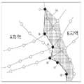
도 4 내지 도 6은 지도 데이터를 업데이트하는 방법을 설명하기 위한 예시도이다. 이하에서는, 도 4 내지 도 6을 참조하여 설명하기로 한다.4 to 6 are exemplary diagrams for explaining a method of updating map data. Hereinafter, it will be described with reference to FIGS. 4 to 6 .
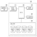
도 3을 참조하면, 내비게이션(100)은 입력부(110), 디스플레이(120), 데이터 다운로더(130), DB 관리부(140) 및 제어부(150)를 포함할 수 있다.Referring to FIG. 3 , the
입력부(110)는 목적지를 비롯하여 내비게이션(100)의 동작을 제어하기 위한 사용자의 제어 정보를 입력하기 위한 구성일 수 있다.The
입력부(110)는 사용자의 입력을 위해 각종 버튼이나 스위치, 페달(pedal), 키보드, 마우스, 트랙볼(track-ball), 각종 레버(lever), 핸들(handle)이나 스틱(stick) 등과 같은 하드웨어적인 장치를 포함할 수 있다.The
또한, 입력부(110)는 사용자 입력을 위해 터치 패드(touch pad) 등과 같은 GUI(Graphical User interface), 즉 소프트웨어인 장치를 포함할 수도 있다. 터치 패드는 터치 스크린 패널(Touch Screen Panel: TSP)로 구현되어 디스플레이(120)와 상호 레이어 구조를 이룰 수 있다.Also, the
디스플레이(120)는 길안내 정보, 입력부(110)를 통해 입력되는 제어정보를 비롯하여 내비게이션(100) 상에서 구현되는 각종 정보를 사용자가 확인할 수 있도록 화면 상에 표시할 수 있다. 도시하지 않았지만, 디스플레이(120)를 통해 출력되는 정보는 출력부를 통해 음성 형태로 출력되는 것 역시 가능하다 할 것이다.The
디스플레이(120)는 음극선관(Cathode Ray Tube: CRT), 디지털 광원 처리(Digital Light Processing: DLP) 패널, 플라즈마 디스플레이 패널(Plasma Display Penal), 액정 디스플레이(Liquid Crystal Display: LCD) 패널, 전기 발광(Electro Luminescence: EL) 패널, 전기영동 디스플레이(Electrophoretic Display: EPD) 패널, 전기변색 디스플레이(Electrochromic Display: ECD) 패널, 발광 다이오드(Light Emitting Diode: LED) 패널 또는 유기 발광 다이오드(Organic Light Emitting Diode: OLED) 패널 등으로 마련될 수 있으나, 이에 한정되지는 않는다.The
데이터 다운로더(130)는 분할 지역간 경계선 정보인 게이트웨이 리스트(gateway list)와 차분 데이터를 포함하는 변경된 지도 데이터를 수신하여 전달할 수 있다. 이때, 데이터 다운로더(130)는 텔레매틱스 서버(200)로부터 지도 데이터를 수신할 수 있다.The data downloader 130 may receive and transmit changed map data including a gateway list, which is boundary information between divided regions, and difference data. At this time, the
한편, DB 관리부(140)에 저장된 지도 데이터에 게이트웨이가 정의되어 있는 경우, 데이터 다운로더(130)가 수신하는 게이트웨이 리스트는 게이트웨이 식별정보만을 포함할 수 있다. 도 5를 참조하면, 게이트웨이 리스트는 ⑦, ⑧, ⑨, ⑩, ⑪ 및 ⑫ 게이트웨이 아이디만을 포함할 수 있는 것이다.Meanwhile, when a gateway is defined in the map data stored in the
이러한 경우, 개시된 발명은 분할 지역별 DB 관리를 단순화할 수 있고, 차분 데이터를 최소화할 수 있다는 효과를 기대할 수 있다.In this case, the disclosed invention can simplify DB management for each divided area and can expect effects of minimizing differential data.
도 4 및 도 5를 참조하면, 게이트웨이는 경계선에 해당하는 활성화 상태의 게이트웨이(①, ②, ③, ④, ⑤, ⑥, ⑦, ⑧, ⑨, ⑩, ⑪ 및 ⑫)와 활성화 상태의 게이트웨이를 제외한 비활성화 상태의 게이트웨이를 포함할 수 있다. DB 관리부(140)에 저장된 지도 데이터에 게이트웨이가 정의되어 있는 경우는 활성화 상태의 게이트웨이와 비활성화 상태의 게이트웨이 정보를 모두 저장하고 있는 상태인 것이다.4 and 5, the gateway includes activated gateways (①, ②, ③, ④, ⑤, ⑥, ⑦, ⑧, ⑨, ⑩, ⑪ and ⑫) corresponding to the boundary line and activated gateways. Excluding gateways in an inactive state may be included. When a gateway is defined in the map data stored in the
다른 한편, DB 관리부(140)에 저장된 지도 데이터에 게이트웨이가 정의되어 있지 않은 경우, 데이터 다운로더(130)가 수신하는 게이트웨이 리스트는 좌표, 현재 지역의 링크정보 및 인접 지역의 링크정보를 게이트웨이 정보로 포함할 수 있다.On the other hand, when the gateway is not defined in the map data stored in the
이러한 경우, 개시된 발명은 비활성 상태의 게이트웨이 정보를 DB 관리부(140)에 저장하지 않기 때문에, 저장되는 지도 데이터의 용량을 최소화할 수 있다는 효과를 기대할 수 있다.In this case, since the disclosed invention does not store gateway information in an inactive state in the
도 4 및 도 5를 참조하면, 게이트웨이는 경계선에 해당하는 활성화 상태의 게이트웨이(①, ②, ③, ④, ⑤, ⑥, ⑦, ⑧, ⑨, ⑩, ⑪ 및 ⑫)와 활성화 상태의 게이트웨이를 제외한 비활성화 상태의 게이트웨이를 포함할 수 있다. DB 관리부(140)에 저장된 지도 데이터에 게이트웨이가 정의되어 있지 않은 경우는 활성화 상태의 게이트웨이 정보만을 저장하고 있는 상태인 것이다.4 and 5, the gateway includes activated gateways (①, ②, ③, ④, ⑤, ⑥, ⑦, ⑧, ⑨, ⑩, ⑪ and ⑫) corresponding to the boundary line and activated gateways. Excluding gateways in an inactive state may be included. If the gateway is not defined in the map data stored in the
데이터 다운로더(130)는 지도 데이터를 제공하는 텔레매틱스 서버(200)와 통신 연결되어 변경된 지도 데이터를 수신할 수 있다. 이때, 차분 데이터는 델타(delta) 데이터를 의미하는 것으로서, 지도 데이터에서 변경된 데이터일 수 있다.The data downloader 130 may communicate with the
데이터 다운로더(130)는 변경된 지도 데이터뿐만 아니라, 필요에 따라 변경되지 않은 지도 데이터를 텔레매틱스 서버(200)로 요청 및 수신할 수 있음은 당연하다 할 것이다.It is natural that the
또한, 데이터 다운로더(130)는 변경된 지도 데이터가 존재하는 경우, 텔레매틱스 서버(200)로부터 전달되는 지도 데이터를 수신하는 것도 가능하지만, 제어부(150)의 요청에 따라 능동적으로 텔레매틱스 서버(200) 측으로 지도 데이터를 요청 및 수신하는 것 역시 가능하다 할 것이다.In addition, the
데이터 다운로더(130)는 텔레매틱스 서버(200)를 비롯하여 외부 장치와의 데이터 송수신을 위해 통신부(미도시)와 연결될 수 있다.The data downloader 130 may be connected to a communication unit (not shown) to transmit/receive data with an external device including the
통신부는 외부 장치와 통신을 가능하게 하는 하나 이상의 구성 요소를 포함할 수 있으며, 예를 들어 근거리 통신 모듈, 유선 통신 모듈 및 무선 통신 모듈 중 적어도 하나를 포함할 수 있다.The communication unit may include one or more components enabling communication with an external device, and may include, for example, at least one of a short-distance communication module, a wired communication module, and a wireless communication module.
근거리 통신 모듈은 블루투스 모듈, 적외선 통신 모듈, RFID(Radio Frequency Identification) 통신 모듈, WLAN(Wireless Local Access Network) 통신 모듈, NFC 통신 모듈, 지그비(Zigbee) 통신 모듈 등 근거리에서 무선 통신망을 이용하여 신호를 송수신하는 다양한 근거리 통신 모듈을 포함할 수 있다.The short-range communication module uses a wireless communication network such as a Bluetooth module, an infrared communication module, a Radio Frequency Identification (RFID) communication module, a Wireless Local Access Network (WLAN) communication module, an NFC communication module, and a Zigbee communication module to transmit signals at a short distance. It may include various short-range communication modules that transmit and receive.
유선 통신 모듈은 캔(Controller Area Network; CAN) 통신 모듈, 지역 통신(Local Area Network; LAN) 모듈, 광역 통신(Wide Area Network; WAN) 모듈 또는 부가가치 통신(Value Added Network; VAN) 모듈등 다양한 유선 통신 모듈뿐만 아니라, USB(Universal Serial Bus), SD 카드, 스마트폼, HDMI(High Definition Multimedia Interface), DVI(Digital Visual Interface), RS-232(recommended standard232), 전력선 통신, 또는 POTS(plain old telephone service)등 다양한 케이블 통신 모듈을 포함할 수 있다.Wired communication modules include various wired communication modules, such as Controller Area Network (CAN) communication modules, Local Area Network (LAN) modules, Wide Area Network (WAN) modules, or Value Added Network (VAN) modules. In addition to communication modules, USB (Universal Serial Bus), SD card, smart form, HDMI (High Definition Multimedia Interface), DVI (Digital Visual Interface), RS-232 (recommended standard232), power line communication, or POTS (plain old telephone) service) and various cable communication modules.
무선 통신 모듈은 라디오 데이터 시스템 교통 메시지 채널(Radio Data System-Traffic Message Channel, RDS-TMC), DMB(Digital Multimedia Broadcasting), 와이파이(Wifi) 모듈, 와이브로(Wireless broadband) 모듈 외에도,GSM(global System for Mobile Communication), CDMA(Code Division Multiple Access), WCDMA(Wideband Code Division Multiple Access),UMTS(universal mobile telecommunications system), TDMA(Time Division Multiple Access), LTE(Long Term Evolution) 등 다양한 무선통신 방식을 지원하는 무선 통신 모듈을 포함할 수 있다.The wireless communication module includes the Radio Data System-Traffic Message Channel (RDS-TMC), DMB (Digital Multimedia Broadcasting), Wi-Fi module, and WiBro (Wireless broadband) module, as well as GSM (global System for Supports various wireless communication methods such as Mobile Communication), CDMA (Code Division Multiple Access), WCDMA (Wideband Code Division Multiple Access), UMTS (universal mobile telecommunications system), TDMA (Time Division Multiple Access), LTE (Long Term Evolution) It may include a wireless communication module that does.
무선 통신 모듈은 교통정보 신호를 수신하는 안테나 및 수신기(Receiver)를 포함하는 무선 통신 인터페이스를 포함할 수 있다. 또한, 무선 통신 모듈은무선 통신 인터페이스를 통하여 수신한 아날로그 형태의 무선 신호를 디지털 제어 신호로 복조하기 위한 교통정보 신호 변환 모듈을 더 포함할 수 있다.The wireless communication module may include a wireless communication interface including an antenna and a receiver for receiving traffic information signals. In addition, the wireless communication module may further include a traffic information signal conversion module for demodulating an analog radio signal received through a wireless communication interface into a digital control signal.
한편, 통신부는 차량(300) 내부의 전자 장치들 사이의 통신을 위한 내부 통신 모듈(미도시)을 더 포함할 수도 있다. 차량(300)의 내부 통신 프로토콜로는 CAN(Controller Area Network), LIN(Local Interconnection Network), 플렉스레이(FlexRay), 이더넷(Ethernet) 등을 사용할 수 있다.Meanwhile, the communication unit may further include an internal communication module (not shown) for communication between electronic devices inside the
DB 관리부(140)는 분할 지역별 지도 데이터를 별도로 저장 및 관리하여, 제어부(150)의 제어에 따라 상기 분할 지역별 지도 데이터를 업데이트할 수 있다.The
도 3과 같이, DB 관리부(140)는 분할 지역별로 각각의 지도 DB(예를 들어, 분할지역 DB #1, 분할지역 DB #2, 분할지역 DB #3, 분할지역 DB #4, ...)를 구비할 수 있다.As shown in FIG. 3 , the
DB 관리부(140)는 분할 지역별 지도 DB를 관리하며, 제어부(150)의 지시에 따라 길안내 시 지도 데이터를 제공하거나 또는 지도 데이터의 삭제, 추가 및 변경과 같은 지도 업데이트를 수행할 수 있다.The
DB 관리부(140)는 캐쉬, ROM(Read Only Memory), PROM(Programmable ROM), EPROM(Erasable Programmable ROM), EEPROM(Electrically Erasable Programmable ROM) 및 플래쉬 메모리(Flash memory)와 같은 비휘발성 메모리 소자 또는 RAM(Random Access Memory)과 같은 휘발성 메모리 소자 또는 하드디스크 드라이브(HDD, Hard Disk Drive), CD-ROM과 같은 저장 매체 중 적어도 하나로 구현될 수 있으나 이에 한정되지는 않는다. DB 관리부(140)는 제어부(150)와 관련하여 전술한 프로세서와 별개의 칩으로 구현된 메모리일 수 있고, 프로세서와 단일 칩으로 구현될 수도 있다.The
제어부(150)는 데이터 다운로더(130)로부터 전달되는 게이트웨이 리스트를 기초로 분할 지역별 지도 데이터의 업데이트를 제어할 수 있다. 상기 게이트웨이는 좌표, 현재 지역의 링크정보 및 인접 지역의 링크정보를 포함할 수 있다.The
상기 게이트웨이 리스트는 두 지역을 분할하는 경계선을 정의한다. 제어부(150)는 두 지역의 경계선 변경 시 차분이 아닌 게이트웨이 리스트를 이용하여 지도 데이터의 경계선을 변경하고, 변경된 경계선에 따라 지도 데이터의 업데이트를 수행하도록 제어하는 것이다.The gateway list defines a boundary dividing the two regions. When the boundary of two regions is changed, the
상기 게이트웨이 리스트는 경계가 되는 일측으로부터 타측으로 게이트웨이가 순서대로 나열되도록 구성될 수 있다. 즉, 게이트웨이 리스트는 ⑦, ⑧, ⑨, ⑩, ⑪ 및 ⑫ 순서로 게이트웨이를 나열하도록 구성되는 것이다.The gateway list may be configured such that gateways are listed in order from one side of the boundary to the other side. That is, the gateway list is configured to list gateways in the order of ⑦, ⑧, ⑨, ⑩, ⑪ and ⑫.
도 4를 참고하면, 게이트웨이(예를 들어, ①, ②, ③, ④, ⑤, ⑥ 등)는 현재 게이트웨이의 좌표(①의 좌표), ① 게이트웨이가 위치하는 A 지역의 링크 정보, 인접 지역인 B 지역의 링크 정보를 포함할 수 있다. 이때, A 지역의 링크 정보와 B 지역의 링크 정보는 ① 게이트웨이와 관련된 링크 정보임은 당연하다 할 것이다.Referring to FIG. 4, gateways (eg, ①, ②, ③, ④, ⑤, ⑥, etc.) are coordinates of the current gateway (coordinates of ①), ① link information of area A where the gateway is located, and neighboring areas Link information of region B may be included. At this time, it is natural that the link information of area A and the link information of area B are link information related to the gateway.
일 예로, 제어부(150)는 게이트웨이 리스트를 신규 경계선으로 설정하고, 이전 경계선과 상기 신규 경계선 사이의 영역을 나타내는 지도 데이터를 이전 지역에서 신규 지역의 지도 데이터로 복사하고, 상기 이전 경계선과 상기 신규 경계선 사이의 영역을 나타내는 지도 데이터를 이전 지역의 지도 데이터에서 삭제하도록 할 수 있다.For example, the
도 4를 참조하면, A 지역과 B 지역의 이전 경계선에 해당하는 게이트웨이 리스트는 ①, ②, ③, ④, ⑤ 및 ⑥ 게이트웨이를 포함할 수 있다.Referring to FIG. 4 , the list of gateways corresponding to the previous boundary between regions A and B may include
A 지역과 B 지역간의 경계선이 도 5와 같이 변경된 경우, 제어부(150)는 ⑦, ⑧, ⑨, ⑩, ⑪ 및 ⑫ 게이트웨이 아이디를 포함하는 게이트웨이 리스트를 데이터 다운로더(130)를 통해 수신할 수 있다.When the boundary between area A and area B is changed as shown in FIG. 5 , the
도 5를 참조하면, 제어부(150)는 수신한 게이트웨이 리스트를 신규 경계선(⑦, ⑧, ⑨, ⑩, ⑪ 및 ⑫)으로 설정하고, 이전 경계선과 신규 경계선 사이의 영역(CA)의 도로, 배경 및 검색 등의 지도 데이터를 A 지역의 분할지역 DB로부터 B 지역의 분할지역 DB로 복사하도록 할 수 있다.Referring to FIG. 5, the
또한, 제어부(150)는 A 지역의 분할지역 DB 로부터 CA 영역의 지도 데이터를 삭제하도록 할 수 있다.In addition, the
예를 들어, A 지역의 분할지역 DB가 분할지역 DB #1이고, B 지역의 분할지역 DB가 분할지역 DB #2인 경우, 제어부(150)는 분할지역 DB #1의 CA 영역에 해당하는 지도 데이터를 분할지역 DB #2로 복사하고, 분할지역 DB #1에서 삭제하는 것이다.For example, when the partition DB of region A is
다른 예로, 제어부(150)는 신규 게이트웨이 리스트로 정의하는 경계선에 따라 지도 데이터 이동 시, 경계선에 대한 지도 데이터를 중복하여 저장하도록 할 수 있다. 경계선은 게이트웨이를 이어주는 직선이 될 것이므로 지도 데이터의 배경 이미지 및 POI를 구분하는데 복잡한 연산이 요구될 수 있다. 이를 단순하기 위해 나뉘는 파셀에 대해서는 중복 저장이 가능하도록 처리할 수 있다.As another example, the
구체적으로, 제어부(150)는 게이트웨이 리스트를 신규 경계선으로 설정하고, 이전 경계선과 상기 신규 경계선 사이의 영역을 나타내는 지도 데이터를 이전 지역에서 신규 지역의 지도 데이터로 복사하되, 상기 신규 경계선이 포함된 파셀은 전체를 저장하도록 할 수 있다.Specifically, the
제어부(150)는 경계선의 인접 지도 데이터도 중복 저장하기 때문에, 경계선 주변의 길안내 시 타 분할지역 DB로부터 인접 지역의 지도 데이터를 억세스(access) 하지 않기 때문에, 길안내 정보 생성이 보다 용이하고, 신속하게 이루어질 수 있다는 효과를 기대할 수 있다.Since the
도 6을 참조하면, 제어부(150)는 경계선에 해당하는 ⑦, ⑧, ⑨, ⑩, ⑪ 및 ⑫ 게이트웨이 및 게이웨이를 이어주는 직선이 포함되는 파셀 전체(P)를 B 지역의 분할지역 DB에 저장하여, 경계선 주변에서는 A 지역의 분할 지역 DB의 억세스를 최소화할 수 있다는 것이다.Referring to FIG. 6, the
상술한 제어부(150)는 내비게이션(100) 내 구성요소들의 동작을 제어하기 위한 알고리즘 또는 알고리즘을 재현한 프로그램에 대한 데이터를 저장하는 메모리(미도시), 및 메모리에 저장된 데이터를 이용하여 전술한 동작을 수행하는 프로세서(미도시)로 구현될 수 있다. 이때, 메모리와 프로세서는 각각 별개의 칩으로 구현될 수 있다. 또는, 메모리와 프로세서는 단일 칩으로 구현될 수도 있다.The above-described
도 7은 차량의 구성을 상세하게 나타내는 제어 블록도이다.7 is a control block diagram showing the configuration of the vehicle in detail.
이하에서 개시하는 구성 중 도 3에서 개시하는 구성과 중복되는 명칭의 구성은 서로 동일한 구성으로 상세 설명을 생략하기로 한다.Among the configurations disclosed below, configurations having overlapping names with those disclosed in FIG. 3 are identical to each other, and detailed descriptions thereof will be omitted.
도 7을 참고하면, 차량(300)은 입력부(310), 디스플레이(320), 데이터 다운로더(330), DB 관리부(140) 및 제어부(150)를 포함할 수 있다.Referring to FIG. 7 , a
입력부(310)는 차량(300)과 관련된 사용자의 입력을 지원하기 위한 구성일 수 있다.The
디스플레이(320)는 차량(100)과 관련된 각종 정보를 사용자가 확인할 수 있도록 화면 상에 출력하기 위한 구성일 수 있다.The
데이터 다운로더(330)는 분할 지역간 경계선 정보인 게이트웨이 리스트와 차분 데이터를 포함하는 변경된 지도 데이터를 수신하여 전달할 수 있다.The data downloader 330 may receive and transmit changed map data including a gateway list and difference data, which are boundary information between divided regions.
DB 관리부(340)에 저장된 지도 데이터에 게이트웨이가 정의되어 있는 경우, 데이터 다운로더(330)가 수신하는 게이트웨이 리스트는 게이트웨이 식별정보만을 포함할 수 있다.When a gateway is defined in the map data stored in the
DB 관리부(340)에 저장된 지도 데이터에 게이트웨이가 정의되어 있지 않은 경우, 데이터 다운로더(330)가 수신하는 게이트웨이 리스트는 좌표, 현재 지역의 링크정보 및 인접 지역의 링크정보를 게이트웨이 정보를 포함할 수 있다.If the gateway is not defined in the map data stored in the
DB 관리부(340)는 분할 지역별 지도 데이터를 별도로 저장 및 관리하여, 제어부의 제어에 따라 상기 분할 지역별 지도 데이터를 업데이트할 수 있다.The
제어부(350) 데이터 다운로더(330)로부터 전달되는 상기 게이트웨이 리스트를 기초로 상기 분할 지역별 지도 데이터의 업데이트를 제어할 수 있다.The
상기 게이트웨이는 좌표, 현재 지역의 링크정보 및 인접 지역의 링크정보를 포함할 수 있다.The gateway may include coordinates, link information of the current region, and link information of neighboring regions.
제어부(350)는 게이트웨이 리스트를 신규 경계선으로 설정하고, 이전 경계선과 상기 신규 경계선 사이의 영역을 나타내는 지도 데이터를 이전 지역에서 신규 지역의 지도 데이터로 복사하고, 상기 이전 경계선과 상기 신규 경계선 사이의 영역을 나타내는 지도 데이터를 이전 지역의 지도 데이터에서 삭제하도록 할 수 있다.The
제어부(350)는 게이트웨이 리스트를 신규 경계선으로 설정하고, 이전 경계선과 상기 신규 경계선 사이의 영역을 나타내는 지도 데이터를 이전 지역에서 신규 지역의 지도 데이터로 복사하되, 상기 신규 경계선이 포함된 파셀은 전체를 저장하도록 할 수 있다.The
도 8은 내비게이션의 제어방법을 설명하기 위한 흐름도이다.8 is a flowchart for explaining a navigation control method.
먼저, 내비게이션(100)은 변경된 게이트웨이 리스트를 수신할 수 있다(410). 이때, 내비게이션(100)은 텔레매틱스 서버(200)와 통신 연결되어, 수동적으로 또는 능동적으로 텔레매틱스 서버(200)로부터 게이트웨이 리스트를 수신할 수 있다.First, the
상기 게이트웨이는 좌표, 현재 지역의 링크정보 및 인접 지역의 링크정보를 포함할 수 있다. 상기 게이트웨이 리스트는 경계가 되는 일측으로부터 타측으로 게이트웨이가 순서대로 나열되도록 구성될 수 있다.The gateway may include coordinates, link information of the current region, and link information of neighboring regions. The gateway list may be configured such that gateways are listed in order from one side of the boundary to the other side.
한편, 기 저장된 지도 데이터에 게이트웨이가 정의되어 있는 경우, 상기 게이트웨이 리스트는 게이트웨이 식별정보만을 포함할 수 있다.Meanwhile, when a gateway is defined in pre-stored map data, the gateway list may include only gateway identification information.
다른 한편, 기 저장된 지도 데이터에 게이트웨이가 정의되어 있지 않은 경우, 상기 게이트웨이 리스트는 좌표, 현재 지역의 링크정보 및 인접 지역의 링크정보를 게이트웨이 정보를 포함할 수 있다.On the other hand, when a gateway is not defined in pre-stored map data, the gateway list may include gateway information such as coordinates, link information of a current region, and link information of an adjacent region.
다음, 내비게이션(100)은 게이트웨이 리스트를 기초로 신규 경계선을 설정할 수 있다(430).Next, the
다음, 내비게이션(100)은 게이트웨이 리스트를 기초로 분할 지역별 지도 데이터를 업데이트할 수 있다(450).Next, the
일 예로, 내비게이션(100)은 신규 경계선을 기준으로 이전 경계선과 상기 신규 경계선 사이의 영역을 나타내는 지도 데이터를 이전 지역에서 신규 지역의 지도 데이터로 복사하고, 상기 이전 경계선과 상기 신규 경계선 사이의 영역을 나타내는 지도 데이터를 이전 지역의 지도 데이터에서 삭제할 수 있다.For example, the
다른 예로, 내비게이션(100)은 신규 경계선을 기준으로 이전 경계선과 상기 신규 경계선 사이의 영역을 나타내는 지도 데이터를 이전 지역에서 신규 지역의 지도 데이터로 복사하되, 상기 신규 경계선이 포함된 파셀은 전체를 저장할 수 있다. 이때, 파셀은 지도 데이터를 구분하는 단위로 정의할 수 있으며, 도 6의 P와 같을 수 있다.As another example, the
도시하지 않았지만, 이후, 내비게이션(100)은 업데이트된 지도 데이터를 이용하여 길 안내 정보를 생성 및 제공할 수 있다.Although not shown, the
한편, 개시된 실시예들은 컴퓨터에 의해 실행 가능한 명령어를 저장하는 기록매체의 형태로 구현될 수 있다. 명령어는 프로그램 코드의 형태로 저장될 수 있으며, 프로세서에 의해 실행되었을 때, 프로그램 모듈을 생성하여 개시된 실시예들의 동작을 수행할 수 있다. 기록매체는 컴퓨터로 읽을 수 있는 기록매체로 구현될 수 있다.Meanwhile, the disclosed embodiments may be implemented in the form of a recording medium storing instructions executable by a computer. Instructions may be stored in the form of program codes, and when executed by a processor, create program modules to perform operations of the disclosed embodiments. The recording medium may be implemented as a computer-readable recording medium.
컴퓨터가 읽을 수 있는 기록매체로는 컴퓨터에 의하여 해독될 수 있는 명령어가 저장된 모든 종류의 기록 매체를 포함한다. 예를 들어, ROM(Read Only Memory), RAM(Random Access Memory), 자기 테이프, 자기 디스크, 플래쉬 메모리, 광 데이터 저장장치 등이 있을 수 있다.Computer-readable recording media include all types of recording media in which instructions that can be decoded by a computer are stored. For example, there may be read only memory (ROM), random access memory (RAM), magnetic tape, magnetic disk, flash memory, optical data storage device, and the like.
이상에서와 같이 첨부된 도면을 참조하여 개시된 실시예들을 설명하였다. 본 발명이 속하는 기술분야에서 통상의 지식을 가진 자는 본 발명의 기술적 사상이나 필수적인 특징을 변경하지 않고도, 개시된 실시예들과 다른 형태로 본 발명이 실시될 수 있음을 이해할 것이다. 개시된 실시예들은 예시적인 것이며, 한정적으로 해석되어서는 안 된다.As above, the disclosed embodiments have been described with reference to the accompanying drawings. Those skilled in the art to which the present invention pertains will understand that the present invention can be implemented in a form different from the disclosed embodiments without changing the technical spirit or essential features of the present invention. The disclosed embodiments are illustrative and should not be construed as limiting.
1, 300 : 차량
200 : 텔레매틱스 서버
110, 310 : 입력부
120, 320 : 디스플레이
130, 330 : 데이터 다운로더
140, 340 : DB 관리부
150, 350 : 제어부1, 300: vehicle
200: telematics server
110, 310: input unit
120, 320: display
130, 330: data downloader
140, 340: DB management unit
150, 350: control unit
Claims (20)
Translated fromKorean분할 지역별 지도 데이터를 별도로 저장 및 관리하여, 제어부의 제어에 따라 상기 분할 지역별 지도 데이터를 업데이트하는 DB 관리부; 및
상기 데이터 다운로더로부터 전달되는 상기 게이트웨이 리스트를 기초로 상기 분할 지역별 지도 데이터의 업데이트를 제어하는 제어부;
를 포함하고,
상기 제어부는,
상기 게이트웨이 리스트를 기초로 두 개의 인접한 지역들을 구분하는 신규 경계선을 설정하고,
이전의 경계선과 상기 신규 경계선 사이의 영역을 나타내는 지도 데이터를 식별하고,
상기 이전 경계선과 상기 신규 경계선 사이의 영역을 나타내는 지도 데이터를 이전 지역에서 신규 지역의 지도 데이터로 복사하고,
상기 이전 경계선과 상기 신규 경계선 사이의 영역을 나타내는 지도 데이터를 이전 지역의 지도 데이터에서 삭제하는 내비게이션.a data downloader that receives and transfers a list of gateways and map data, which are boundary information between divided regions;
a DB management unit that separately stores and manages map data for each divided region and updates the map data for each divided region under the control of the control unit; and
a control unit controlling updating of map data for each divided area based on the gateway list transmitted from the data downloader;
including,
The control unit,
Based on the gateway list, a new boundary dividing two adjacent regions is set;
identify map data representing the area between the old boundary line and the new boundary line;
copying map data indicating an area between the old boundary line and the new boundary line from the old region to map data of a new region;
A navigation device for deleting map data indicating an area between the previous boundary line and the new boundary line from map data of the previous area.
상기 게이트웨이는 좌표, 두 개의 인접한 지역의 링크정보를 포함하는 내비게이션.
According to claim 1,
The gateway includes coordinates and link information of two adjacent regions.
상기 제어부는,
상기 게이트웨이 리스트를 신규 경계선으로 설정하고, 이전 경계선과 상기 신규 경계선 사이의 영역을 나타내는 지도 데이터를 이전 지역에서 신규 지역의 지도 데이터로 복사하되, 상기 신규 경계선이 포함된 파셀은 전체를 저장하도록 하는 내비게이션.According to claim 1,
The control unit,
Navigation for setting the gateway list as a new boundary line, copying map data representing an area between the old boundary line and the new boundary line from the previous region to the map data of the new region, and storing all parcels including the new boundary line .
상기 지도 데이터에 게이트웨이가 정의되어 있는 경우, 상기 데이터 다운로더가 수신하는 상기 게이트웨이 리스트는 게이트웨이 식별정보만을 포함하는 내비게이션.According to claim 1,
When a gateway is defined in the map data, the gateway list received by the data downloader includes only gateway identification information.
상기 지도 데이터에 게이트웨이가 정의되어 있지 않은 경우, 상기 데이터 다운로더가 수신하는 상기 게이트웨이 리스트는 좌표, 두 개의 인접한 지역의 링크정보를 게이트웨이 정보를 포함하는 내비게이션.According to claim 1,
When a gateway is not defined in the map data, the gateway list received by the data downloader includes coordinates and link information of two adjacent regions as gateway information.
상기 게이트웨이 리스트는 경계가 되는 일측으로부터 타측으로 게이트웨이가 순서대로 나열되도록 구성된 내비게이션.According to claim 1,
The gateway list is configured such that gateways are listed in order from one side serving as a boundary to the other side.
분할 지역별 지도 데이터를 별도로 저장 및 관리하여, 제어부의 제어에 따라 상기 분할 지역별 지도 데이터를 업데이트하는 DB 관리부; 및
상기 데이터 다운로더로부터 전달되는 상기 게이트웨이 리스트를 기초로 상기 분할 지역별 지도 데이터의 업데이트를 제어하는 제어부;
를 포함하고,
상기 제어부는,
상기 게이트웨이 리스트를 기초로 두 개의 인접한 지역들을 구분하는 신규 경계선을 설정하고,
이전의 경계선과 상기 신규 경계선 사이의 영역을 나타내는 지도 데이터를 식별하고,
상기 이전 경계선과 상기 신규 경계선 사이의 영역을 나타내는 지도 데이터를 이전 지역에서 신규 지역의 지도 데이터로 복사하고,
상기 이전 경계선과 상기 신규 경계선 사이의 영역을 나타내는 지도 데이터를 이전 지역의 지도 데이터에서 삭제하는 차량.a data downloader that receives and transfers a list of gateways and map data, which are boundary information between divided regions;
a DB management unit that separately stores and manages map data for each divided region and updates the map data for each divided region under the control of the control unit; and
a control unit controlling updating of map data for each divided area based on the gateway list transmitted from the data downloader;
including,
The control unit,
Based on the gateway list, a new boundary dividing two adjacent regions is set;
identify map data representing the area between the old boundary line and the new boundary line;
copying map data indicating an area between the old boundary line and the new boundary line from the old region to map data of a new region;
A vehicle for deleting map data indicating an area between the old boundary line and the new boundary line from map data of the previous area.
상기 게이트웨이는 좌표, 두 개의 인접한 지역의 링크정보를 포함하는 차량.
According to claim 8,
The gateway includes coordinates and link information of two adjacent regions.
상기 제어부는,
상기 게이트웨이 리스트를 신규 경계선으로 설정하고, 이전 경계선과 상기 신규 경계선 사이의 영역을 나타내는 지도 데이터를 이전 지역에서 신규 지역의 지도 데이터로 복사하되, 상기 신규 경계선이 포함된 파셀은 전체를 저장하도록 하는 차량.According to claim 8,
The control unit,
A vehicle for setting the gateway list as a new boundary, copying map data indicating an area between the old boundary and the new boundary from the previous region to map data of the new region, and storing all parcels including the new boundary .
상기 지도 데이터에 게이트웨이가 정의되어 있는 경우, 상기 데이터 다운로더가 수신하는 상기 게이트웨이 리스트는 게이트웨이 식별정보만을 포함하는 차량.According to claim 8,
When a gateway is defined in the map data, the gateway list received by the data downloader includes only gateway identification information.
상기 지도 데이터에 게이트웨이가 정의되어 있지 않은 경우, 상기 데이터 다운로더가 수신하는 상기 게이트웨이 리스트는 좌표, 현재 지역의 링크정보 및 인접 지역의 링크정보를 게이트웨이 정보를 포함하는 차량.According to claim 8,
When no gateway is defined in the map data, the gateway list received by the data downloader includes gateway information including coordinates, link information of the current region, and link information of adjacent regions.
상기 게이트웨이 리스트를 기초로 분할 지역별 지도 데이터를 업데이트하는 것을 포함하고,
상기 분할 지역별 지도 데이터를 업데이트하는 것은,
상기 게이트웨이 리스트를 기초로 두 개의 인접한 지역들을 구분하는 신규 경계선을 설정하고,
이전의 경계선과 상기 신규 경계선 사이의 영역을 나타내는 지도 데이터를 식별하고,
상기 이전 경계선과 상기 신규 경계선 사이의 영역을 나타내는 지도 데이터를 이전 지역에서 신규 지역의 지도 데이터로 복사하고,
상기 이전 경계선과 상기 신규 경계선 사이의 영역을 나타내는 지도 데이터를 이전 지역의 지도 데이터에서 삭제하 것을 포함하는 내비게이션의 제어방법.Receive a list of gateways for which navigation has been changed,
Updating map data for each divided area based on the gateway list;
Updating the map data for each divided area,
Based on the gateway list, a new boundary dividing two adjacent regions is set;
identify map data representing the area between the old boundary line and the new boundary line;
copying map data indicating an area between the old boundary line and the new boundary line from the old region to map data of a new region;
and deleting map data indicating an area between the previous boundary line and the new boundary line from map data of the previous area.
상기 게이트웨이는 좌표, 두 개의 인접한 지역의 링크정보를 포함하는 내비게이션의 제어방법.According to claim 14,
The control method of navigation, wherein the gateway includes coordinates and link information of two adjacent regions.
상기 분할 지역별 지도 데이터를 업데이트하는 것은,
상기 신규 경계선을 기준으로 이전 경계선과 상기 신규 경계선 사이의 영역을 나타내는 지도 데이터를 이전 지역에서 신규 지역의 지도 데이터로 복사하되, 상기 신규 경계선이 포함된 파셀은 전체를 저장하는 내비게이션의 제어방법.According to claim 14,
Updating the map data for each divided area,
Copying map data indicating an area between a previous boundary and the new boundary based on the new boundary from a previous region to map data of a new region, and storing all of the parcels including the new boundary.
상기 지도 데이터에 게이트웨이가 정의되어 있는 경우, 상기 게이트웨이 리스트는 게이트웨이 식별정보만을 포함하는 내비게이션의 제어방법.According to claim 14,
When a gateway is defined in the map data, the gateway list includes only gateway identification information.
상기 지도 데이터에 게이트웨이가 정의되어 있지 않은 경우, 상기 게이트웨이 리스트는 좌표, 두 개의 인접한 지역의 링크정보를 게이트웨이 정보를 포함하는 내비게이션의 제어방법.According to claim 14,
When a gateway is not defined in the map data, the gateway list includes coordinates and link information of two adjacent regions as gateway information.
상기 게이트웨이 리스트는 경계가 되는 일측으로부터 타측으로 게이트웨이가 순서대로 나열되도록 구성된 내비게이션의 제어방법.According to claim 14,
The control method of navigation, wherein the gateway list is configured such that gateways are listed in order from one side serving as a boundary to the other side.
Priority Applications (2)
| Application Number | Priority Date | Filing Date | Title |
|---|---|---|---|
| KR1020170172812AKR102485382B1 (en) | 2017-12-15 | 2017-12-15 | Vehicle, navigation and method for controlling of navigation |
| US15/974,945US11422002B2 (en) | 2017-12-15 | 2018-05-09 | Navigator for updating map data, vehicle having the same and method for controlling the same |
Applications Claiming Priority (1)
| Application Number | Priority Date | Filing Date | Title |
|---|---|---|---|
| KR1020170172812AKR102485382B1 (en) | 2017-12-15 | 2017-12-15 | Vehicle, navigation and method for controlling of navigation |
Publications (2)
| Publication Number | Publication Date |
|---|---|
| KR20190071906A KR20190071906A (en) | 2019-06-25 |
| KR102485382B1true KR102485382B1 (en) | 2023-01-05 |
Family
ID=66815802
Family Applications (1)
| Application Number | Title | Priority Date | Filing Date |
|---|---|---|---|
| KR1020170172812AActiveKR102485382B1 (en) | 2017-12-15 | 2017-12-15 | Vehicle, navigation and method for controlling of navigation |
Country Status (2)
| Country | Link |
|---|---|
| US (1) | US11422002B2 (en) |
| KR (1) | KR102485382B1 (en) |
Citations (3)
| Publication number | Priority date | Publication date | Assignee | Title |
|---|---|---|---|---|
| JP2002207423A (en)* | 2001-01-10 | 2002-07-26 | Mitsubishi Electric Corp | Map information processing apparatus and map information processing method |
| JP2010237256A (en) | 2009-03-30 | 2010-10-21 | Mitsubishi Electric Corp | Map information processing apparatus and map information storage medium |
| JP2012155286A (en) | 2011-01-28 | 2012-08-16 | Hitachi Automotive Systems Ltd | Map data distribution server and map data distribution method |
Family Cites Families (14)
| Publication number | Priority date | Publication date | Assignee | Title |
|---|---|---|---|---|
| US7082443B1 (en)* | 2002-07-23 | 2006-07-25 | Navteq North America, Llc | Method and system for updating geographic databases |
| JP4622822B2 (en)* | 2005-11-16 | 2011-02-02 | 日産自動車株式会社 | Map data update system and map data update method |
| JP4905483B2 (en) | 2009-03-05 | 2012-03-28 | 株式会社デンソー | Map data update device and map data update program |
| KR20110008767A (en)* | 2009-07-21 | 2011-01-27 | (주)진우소프트이노베이션 | System and method for updating maps of navigation terminals |
| KR20120039893A (en)* | 2010-10-18 | 2012-04-26 | 현대모비스 주식회사 | Method for real time map update in navigation system |
| JP6136511B2 (en) | 2013-04-16 | 2017-05-31 | 株式会社デンソー | Map difference data distribution device, vehicle navigation device, and map difference data distribution method |
| JP6117629B2 (en) | 2013-06-17 | 2017-04-19 | 株式会社デンソーアイティーラボラトリ | Map update system, map update method and program |
| US10019446B2 (en)* | 2015-06-19 | 2018-07-10 | International Business Machines Corporation | Geographic space management |
| US10169400B2 (en)* | 2015-06-19 | 2019-01-01 | International Business Machines Corporation | Geographic space management |
| US9646402B2 (en)* | 2015-06-19 | 2017-05-09 | International Business Machines Corporation | Geographic space management |
| US9639537B2 (en)* | 2015-06-19 | 2017-05-02 | International Business Machines Corporation | Geographic space management |
| JP6798779B2 (en) | 2015-11-04 | 2020-12-09 | トヨタ自動車株式会社 | Map update judgment system |
| US9578093B1 (en)* | 2015-12-16 | 2017-02-21 | International Business Machines Corporation | Geographic space management |
| KR101905739B1 (en) | 2016-11-02 | 2018-10-10 | 에스케이플래닛 주식회사 | Apparatus and method for managing real-time map data update |
- 2017
- 2017-12-15KRKR1020170172812Apatent/KR102485382B1/enactiveActive
- 2018
- 2018-05-09USUS15/974,945patent/US11422002B2/enactiveActive
Patent Citations (3)
| Publication number | Priority date | Publication date | Assignee | Title |
|---|---|---|---|---|
| JP2002207423A (en)* | 2001-01-10 | 2002-07-26 | Mitsubishi Electric Corp | Map information processing apparatus and map information processing method |
| JP2010237256A (en) | 2009-03-30 | 2010-10-21 | Mitsubishi Electric Corp | Map information processing apparatus and map information storage medium |
| JP2012155286A (en) | 2011-01-28 | 2012-08-16 | Hitachi Automotive Systems Ltd | Map data distribution server and map data distribution method |
Also Published As
| Publication number | Publication date |
|---|---|
| US11422002B2 (en) | 2022-08-23 |
| KR20190071906A (en) | 2019-06-25 |
| US20190186944A1 (en) | 2019-06-20 |
Similar Documents
| Publication | Publication Date | Title |
|---|---|---|
| KR102416123B1 (en) | Vehicle status monitoring system and vehicle | |
| US10379543B2 (en) | Vehicle and control method thereof and autonomous driving system using the same | |
| KR102215325B1 (en) | Apparatus and method for estimating location of vehicle and vehicle using the same | |
| KR102327195B1 (en) | Remote control method of Vehicle, and Vehicle and Mobile Communication Terminal therefor | |
| US10983691B2 (en) | Terminal, vehicle having the terminal, and method for controlling the vehicle | |
| US20230021459A1 (en) | Vehicle, and unmanned aerial system and method including the same | |
| KR102291308B1 (en) | Method for setting of multi remote control in vehicle and vehicle and mobile communication terminal thereof | |
| KR102287263B1 (en) | Method for providing of remote control service in vehicle and vehicle thereof | |
| CN109952491A (en) | Smooth objects generated from sensor data using map information | |
| KR102361501B1 (en) | Vehicle and controlling method thereof | |
| KR102397344B1 (en) | Vehicle update system and vehicle | |
| KR102485382B1 (en) | Vehicle, navigation and method for controlling of navigation | |
| KR102489963B1 (en) | Vehicle and controlling method thereof | |
| KR102513946B1 (en) | Vehicle and controlling method thereof | |
| KR101973159B1 (en) | Method for setting of multi remote control in vehicle and vehicle thereof | |
| KR101817539B1 (en) | Navigation and controlling method thereof | |
| KR102518226B1 (en) | Vehicle and controlling method thereof | |
| KR20190138950A (en) | Vehicle and movement manage system | |
| KR20190135670A (en) | Navigation apparatus, vehicle comprising the same and control method of the vehicle | |
| KR102486156B1 (en) | Navigation and controlling method thereof | |
| KR102364421B1 (en) | Input apparatus and vehicle using same and controlling method of input apparatus | |
| KR102364419B1 (en) | Vehicle and controlling method thereof | |
| KR20180027135A (en) | Navigation and controlling method thereof |
Legal Events
| Date | Code | Title | Description |
|---|---|---|---|
| PA0109 | Patent application | Patent event code:PA01091R01D Comment text:Patent Application Patent event date:20171215 | |
| PG1501 | Laying open of application | ||
| A201 | Request for examination | ||
| PA0201 | Request for examination | Patent event code:PA02012R01D Patent event date:20201209 Comment text:Request for Examination of Application Patent event code:PA02011R01I Patent event date:20171215 Comment text:Patent Application | |
| E902 | Notification of reason for refusal | ||
| PE0902 | Notice of grounds for rejection | Comment text:Notification of reason for refusal Patent event date:20220518 Patent event code:PE09021S01D | |
| E701 | Decision to grant or registration of patent right | ||
| PE0701 | Decision of registration | Patent event code:PE07011S01D Comment text:Decision to Grant Registration Patent event date:20221128 | |
| GRNT | Written decision to grant | ||
| PR0701 | Registration of establishment | Comment text:Registration of Establishment Patent event date:20230102 Patent event code:PR07011E01D | |
| PR1002 | Payment of registration fee | Payment date:20230103 End annual number:3 Start annual number:1 | |
| PG1601 | Publication of registration |