KR102316654B1 - Driving guidance apparatus and control method thereof - Google Patents
Driving guidance apparatus and control method thereofDownload PDFInfo
- Publication number
- KR102316654B1 KR102316654B1KR1020140151956AKR20140151956AKR102316654B1KR 102316654 B1KR102316654 B1KR 102316654B1KR 1020140151956 AKR1020140151956 AKR 1020140151956AKR 20140151956 AKR20140151956 AKR 20140151956AKR 102316654 B1KR102316654 B1KR 102316654B1
- Authority
- KR
- South Korea
- Prior art keywords
- information
- vehicle
- unit
- control unit
- surrounding
- Prior art date
- Legal status (The legal status is an assumption and is not a legal conclusion. Google has not performed a legal analysis and makes no representation as to the accuracy of the status listed.)
- Active
Links
- 238000000034methodMethods0.000titleclaimsabstractdescription22
- 238000001514detection methodMethods0.000claimsabstractdescription27
- 230000005540biological transmissionEffects0.000claimsabstractdescription10
- 230000004397blinkingEffects0.000claimsdescription28
- 230000008859changeEffects0.000claimsdescription26
- 230000007613environmental effectEffects0.000claimsdescription5
- 238000000556factor analysisMethods0.000claimsdescription4
- 239000000284extractSubstances0.000abstractdescription6
- 238000010586diagramMethods0.000description8
- 208000019901Anxiety diseaseDiseases0.000description4
- 230000036506anxietyEffects0.000description4
- 238000005516engineering processMethods0.000description2
- 230000008520organizationEffects0.000description2
- 238000004891communicationMethods0.000description1
- 238000012986modificationMethods0.000description1
- 230000004048modificationEffects0.000description1
- 230000008569processEffects0.000description1
Images


Classifications
- G—PHYSICS
- G08—SIGNALLING
- G08G—TRAFFIC CONTROL SYSTEMS
- G08G1/00—Traffic control systems for road vehicles
- G08G1/16—Anti-collision systems
- G08G1/166—Anti-collision systems for active traffic, e.g. moving vehicles, pedestrians, bikes
- G—PHYSICS
- G01—MEASURING; TESTING
- G01S—RADIO DIRECTION-FINDING; RADIO NAVIGATION; DETERMINING DISTANCE OR VELOCITY BY USE OF RADIO WAVES; LOCATING OR PRESENCE-DETECTING BY USE OF THE REFLECTION OR RERADIATION OF RADIO WAVES; ANALOGOUS ARRANGEMENTS USING OTHER WAVES
- G01S19/00—Satellite radio beacon positioning systems; Determining position, velocity or attitude using signals transmitted by such systems
- G01S19/01—Satellite radio beacon positioning systems transmitting time-stamped messages, e.g. GPS [Global Positioning System], GLONASS [Global Orbiting Navigation Satellite System] or GALILEO
- G01S19/13—Receivers
- G01S19/14—Receivers specially adapted for specific applications
- G—PHYSICS
- G08—SIGNALLING
- G08G—TRAFFIC CONTROL SYSTEMS
- G08G1/00—Traffic control systems for road vehicles
- G08G1/09—Arrangements for giving variable traffic instructions
- G08G1/0962—Arrangements for giving variable traffic instructions having an indicator mounted inside the vehicle, e.g. giving voice messages
- G08G1/0968—Systems involving transmission of navigation instructions to the vehicle
- G08G1/0969—Systems involving transmission of navigation instructions to the vehicle having a display in the form of a map
- G—PHYSICS
- G08—SIGNALLING
- G08G—TRAFFIC CONTROL SYSTEMS
- G08G1/00—Traffic control systems for road vehicles
- G08G1/16—Anti-collision systems
- G08G1/161—Decentralised systems, e.g. inter-vehicle communication
- G08G1/162—Decentralised systems, e.g. inter-vehicle communication event-triggered
- G—PHYSICS
- G08—SIGNALLING
- G08G—TRAFFIC CONTROL SYSTEMS
- G08G1/00—Traffic control systems for road vehicles
- G08G1/16—Anti-collision systems
- G08G1/161—Decentralised systems, e.g. inter-vehicle communication
- G08G1/163—Decentralised systems, e.g. inter-vehicle communication involving continuous checking
Landscapes
- Physics & Mathematics (AREA)
- General Physics & Mathematics (AREA)
- Engineering & Computer Science (AREA)
- Radar, Positioning & Navigation (AREA)
- Remote Sensing (AREA)
- Computer Networks & Wireless Communication (AREA)
- Traffic Control Systems (AREA)
Abstract
Translated fromKoreanDescription
Translated fromKorean본 발명은 운전 안내 장치 및 그 제어 방법에 관한 것으로서, 보다 상세하게는 시야가 확보되지 않은 교차로에서 신호등의 신호변경을 예측하여 제공하고, 자기 차량 및 주변 차량의 궤적을 통해 분석된 충돌위험 뿐만 아니라 사고다발지역에 대한 위험수치를 제공하는 운전 안내 장치 및 그 제어 방법에 관한 것이다.
The present invention relates to a driving guidance device and a method for controlling the same, and more particularly, predicts and provides a signal change of a traffic light at an intersection where visibility is not secured, and provides not only the collision risk analyzed through the trajectories of the own vehicle and surrounding vehicles, but also It relates to a driving guidance device that provides a risk value for an accident-prone area and a control method therefor.
일반적으로, 자동차는 사람에게 이동 편의성 및 시간 효율성을 제공하나, 운전자 부주의로 인해 운전자는 물론 주변인에게 큰 피해를 끼칠 수 있어, 이용에 주의가 필요하다.In general, a car provides mobility and time efficiency to people, but due to driver negligence, it may cause great damage not only to the driver but also to nearby people, so caution is required in using it.
특히 최근 들어, 자동차와 ICT(Information & Communication Technology)의 기술 융합으로 점차 차량의 지능화, 고도화가 이루어지고 있고, 이에 따라 자동차 내 구현된 안전운전 지원시스템은 위험상황을 인지하고, 이를 운전자에게 알리는 동작을 수행한다.In particular, in recent years, the convergence of technologies between automobiles and ICT (Information & Communication Technology) has gradually made vehicles more intelligent and advanced. Accordingly, the safe driving support system implemented in the vehicle recognizes dangerous situations and informs the driver. carry out
이러한 안전운전 지원시스템은 위험상황을 인지하기 위해 주로 외부센서(레이더, 카메라 등)를 통해 정보를 수집하여 위험 여부(차선이탈, 충돌예상 등)를 판단하는 형태로 이루어진다.In order to recognize a dangerous situation, the safe driving support system mainly collects information through external sensors (radar, camera, etc.) to determine whether there is a danger (lane departure, collision prediction, etc.).
또한, 운전안내 시스템을 대표하는 내비게이션(Navigation) 장치는 GPS(Global Positioning System)로부터 수신한 정보를 이용하여 계산된 이동체의 현재 위치를 표시화면에 표시되는 지도상에 표시할 뿐만 아니라 이동체의 진행 방향, 가고자 하는 목적지까지의 거리, 이동체의 현재 이동속도, 운전자가 주행 전에 설정한 경로, 목적지까지의 최적경로 등을 표시하여 주는 등 주행에 필요한 각종의 정보를 운전자에게 제공한다.In addition, a navigation device representing a driving guidance system not only displays the current location of a moving object calculated using information received from a global positioning system (GPS) on a map displayed on a display screen, but also displays the moving direction of the moving object. , the distance to the desired destination, the current moving speed of the moving object, the route set by the driver before driving, and the optimal route to the destination are displayed.
최근의 내비게이션 장치는 경로 안내와 더불어 도로 상황 등 전반적인 운전환경을 안내해주는 시스템으로 도약하고 있다.Recently, navigation devices are taking off as a system that guides the overall driving environment such as road conditions as well as route guidance.
단순히, 지도상의 도로 정보를 기반으로 운전환경을 안내해 주는 개념에서 벗어나, 현실감 있는 운전안내를 위해 현재 주행 중인 차선이 무엇인지, 운전자의 시야는 어디를 바라보고 있는지 등을 인식하여 보다 세밀한 운전상황을 안내하고자 하는 시도가 이루어지고 있다.Instead of simply guiding the driving environment based on road information on the map, it recognizes which lane is currently driving and where the driver's field of vision is looking to provide realistic driving guidance to provide a more detailed driving situation. Attempts are being made to guide.
즉, 카메라 등의 각종 센싱(sensing) 장비를 이용하여, 차량이 현재 이동하는 차선 정보, 외부 신호등 정보, 도로상에 마킹된 교통표지 정보, 운전자의 시선 정보 등의 운전 환경을 인식하고, 운전자가 그에 적합한 운전을 수행할 수 있도록 안내하는 운전 안내 시스템을 제공하고 있다.That is, by using various sensing devices such as cameras, it recognizes the driving environment such as information on the lane in which the vehicle is currently moving, information on external traffic lights, information on traffic signs marked on the road, information on the driver's gaze, etc. It provides a driving guidance system that guides you to perform a suitable driving.
본 발명의 배경기술로는 대한민국 공개특허공보 제10-2013-0003521호(공개일 : 2013.01.09.)인 "센서를 이용한 운전 안내 시스템"에 개시되어 있다.
As a background art of the present invention, it is disclosed in Korean Patent Publication No. 10-2013-0003521 (published on January 9, 2013), "a driving guidance system using a sensor".
본 발명의 목적은 시야가 확보되지 않은 교차로에서 신호등의 신호변경을 예측하여 제공하고, 자기 차량 및 주변 차량의 궤적을 통해 분석된 충돌위험 뿐만 아니라 사고다발지역에 대한 위험수치를 제공하는 운전 안내 장치 및 그 제어 방법을 제공하는 것이다.
An object of the present invention is to predict and provide a signal change of a traffic light at an intersection where visibility is not secured, and a driving guidance device that provides a risk value for an accident prone area as well as a collision risk analyzed through the trajectories of the own vehicle and surrounding vehicles and to provide a method for controlling the same.
본 발명의 일 측면에 따른 운전 안내 장치는, GPS 신호를 수신하여 차량의 위치정보를 산출하는 GPS 수신부; 위치정보에 매핑된 지도정보를 저장하는 맵저장부; 차량이 주행 중인 도로의 전방영상을 촬영하는 영상촬영부; 차량의 주변영역에 존재하는 주변 차량을 감지하는 주변차량 감지부; 안내정보 제공서버와 접속되어 데이터를 송수신하는 데이터 송수신부; GPS 수신부로부터 파악된 차량의 위치정보, 맵저장부로부터 위치정보에 근거하여 도로정보를 추출하고, 영상촬영부에서 촬영된 전방영상으로부터 신호등 및 도로 표지판 정보를 인식하고, 주변차량 감지부로부터 감지된 주변차량과의 충돌위험에 따라 주위차량 부하량을 산출하여, 위치정보, 도로정보, 신호등 및 도로 표지판 정보와 주위차량 부하량을 데이터 송수신부를 통해 안내정보 제공서버에 전송하고, 안내정보 제공서버로부터 제공되는 운전 안내정보를 출력하는 단말 제어부; 및 단말 제어부에서 출력되는 운전 안내정보 및 단말 제어부의 작동상태를 표시하는 표시부;를 포함하는 것을 특징으로 한다.A driving guidance device according to an aspect of the present invention includes: a GPS receiver configured to receive a GPS signal and calculate vehicle location information; a map storage unit for storing map information mapped to location information; an image photographing unit for photographing a front image of a road on which the vehicle is traveling; a surrounding vehicle detection unit for detecting a surrounding vehicle existing in a surrounding area of the vehicle; a data transceiver connected to the guide information providing server to transmit and receive data; It extracts road information based on the location information of the vehicle identified from the GPS receiver and location information from the map storage unit, recognizes traffic light and road sign information from the front image taken by the image capturing unit, and detects It calculates the load of surrounding vehicles according to the risk of collision with surrounding vehicles, transmits location information, road information, traffic light and road sign information, and the load of surrounding vehicles to the guide information providing server through the data transmission/reception unit, and provides information from the guide information providing server. a terminal control unit for outputting driving guide information; and a display unit for displaying driving guide information output from the terminal control unit and an operating state of the terminal control unit.
본 발명에서 주변차량 감지부는, 차량의 좌우 차선에 존재하는 주변차량을 감지하는 측방 초음파센서; 및 차량의 전후방에 존재하는 주변차량을 감지하는 전후방 레이더와 전방카메라;를 포함하는 것을 특징으로 한다.In the present invention, the surrounding vehicle detection unit includes: a side ultrasonic sensor for detecting surrounding vehicles present in the left and right lanes of the vehicle; and a front and rear radar and a front camera for detecting surrounding vehicles present in the front and rear of the vehicle.
본 발명에서 단말 제어부는, GPS 수신부로부터 수신된 차량의 위치정보와 맵저장부에 저장된 지도정보를 기반으로 차량의 위치정보와 도로정보를 제공하는 위치인식 및 도로정보 제공부; 영상촬영부로부터 촬영된 전방영상으로부터 신호등 및 도로 표지판 정보를 인식하는 신호등 및 표지판 인식부; 및 주변차량 감지부로부터 입력된 주변차량에 대해 차량의 좌우 차선과 전후방 거리를 기반으로 영역을 구분하고, 각 영역에서의 차량의 수와 차선변경 유무로 정량화된 가중치를 부여하여 주위차량 부하량을 산출하는 주위차량 부하 분석부;를 포함하는 것을 특징으로 한다.In the present invention, the terminal control unit includes: a location recognition and road information providing unit for providing vehicle location information and road information based on the vehicle location information received from the GPS receiver and map information stored in the map storage unit; a traffic light and sign recognition unit for recognizing traffic light and road sign information from the front image taken from the image capturing unit; And for the surrounding vehicles input from the surrounding vehicle detection unit, the area is divided based on the left and right lanes and the front and rear distances of the vehicle, and quantified weights are given based on the number of vehicles in each area and the presence or absence of a lane change to calculate the surrounding vehicle load. It characterized in that it comprises a; surrounding vehicle load analysis unit.
본 발명에서 단말 제어부는, 영상촬영부에서 촬영된 전방영상으로부터 신호등 및 도로 표지판 정보가 인식되지 않을 경우 안내정보 서버에 운전 안내정보를 요청하여 수신받는 것을 특징으로 한다.In the present invention, the terminal control unit, when the traffic light and road sign information is not recognized from the front image captured by the image capturing unit, it is characterized in that it requests and receives the driving guide information from the guide information server.
본 발명에서, 안내정보 제공서버는, 운전안내 단말기와 데이터를 송수신하는 센터 데이터 송수신부; 신호등 구동정보, 기상정보 및 사고다발지역 정보를 저장하는 데이터DB; 및 센터 데이터 송수신부로부터 입력되는 운전안내 단말기의 위치정보, 도로정보, 신호등 및 도로 표지판 정보와, 주위차량 부하량에 기초하여 신호등의 점멸 예측시간을 산출하고, 주위차량 부하량과 데이터DB에 저장된 위험요소를 반영하여 주변의 사고 발생위험도를 산출하여 센터 데이터 송수신부를 통해 운전안내 단말기에 제공하는 서버 제어부;를 포함하는 것을 특징으로 한다.In the present invention, the guide information providing server, the center data transmitting and receiving unit for transmitting and receiving data with the driving guide terminal; a data DB for storing traffic light driving information, weather information, and accident-prone area information; And, based on the location information, road information, traffic light and road sign information of the driving guide terminal input from the center data transmission/reception unit, and the amount of surrounding vehicle load, calculate the predicted blinking time of the traffic light, and the surrounding vehicle load and risk factors stored in the data DB It is characterized in that it includes a; server control unit for calculating the accident risk of the surrounding by reflecting the center data transmission and reception unit for providing to the driving guide terminal.
본 발명에서 서버 제어부는, 운전안내 단말기로부터 입력된 위치정보와 신호등 정보를 기반으로 데이터DB에 저장된 신호등 구동정보를 통해 신호등의 변경패턴을 분석하여 점멸 예측시간을 산출하는 신호등 예측부; 및 주위차량 부하량과 데이터DB에 저장된 위험요소를 반영하여 사고 발생위험도를 산출하는 환경요인 분석부;를 포함하는 것을 특징으로 한다.
In the present invention, the server control unit includes: a traffic light prediction unit for calculating a predicted blinking time by analyzing a change pattern of a traffic light through traffic light driving information stored in a data DB based on location information and traffic light information input from the driving guide terminal; and an environmental factor analysis unit that calculates the accident risk by reflecting the surrounding vehicle load and the risk factors stored in the data DB.
본 발명의 다른 측면에 따른 운전 안내 장치의 제어 방법은, 단말 제어부가 GPS 수신부로부터 차량의 위치정보를 입력받는 단계; 단말 제어부가 차량의 위치정보를 기반으로 맵저장부로부터 도로정보를 추출하는 단계; 단말 제어부가 영상촬영부로부터 도로의 전방영상을 입력받는 단계; 단말 제어부가 전방영상으로부터 신호등 및 도로 표지판 정보를 인식하는 단계; 단말 제어부가 주변차량 감지부로부터 주변차량의 감지결과를 입력받는 단계; 단말 제어부가 주변차량의 감지결과로부터 주위차량 부하량을 산출하는 단계; 단말 제어부가 위치정보, 도로정보, 신호등 및 도로 표지판 정보와, 주위차량 부하량을 안내정보 제공서버에 전송하는 단계; 및 단말 제어부가 안내정보 제공서버로부터 운전 안내정보를 수신받아 표시부에 출력하는 단계를 포함하는 것을 특징으로 한다.A method of controlling a driving guidance device according to another aspect of the present invention includes the steps of: receiving, by a terminal control unit, location information of a vehicle from a GPS receiving unit; extracting, by the terminal control unit, road information from a map storage unit based on vehicle location information; receiving, by the terminal control unit, a front image of the road from the image capturing unit; Recognizing, by the terminal control unit, traffic light and road sign information from the front image; receiving, by the terminal control unit, the detection result of the surrounding vehicle from the surrounding vehicle detecting unit; calculating, by the terminal control unit, an amount of surrounding vehicle load from the detection result of the surrounding vehicle; transmitting, by the terminal control unit, location information, road information, traffic light and road sign information, and a load amount of surrounding vehicles to a guide information providing server; and the terminal control unit receiving the driving guide information from the guide information providing server and outputting it to the display unit.
본 발명에서 주위차량 부하량을 산출하는 단계는, 단말 제어부가 주변차량 감지부로부터 입력된 주변차량에 대해 차량의 좌우 차선과 전후방 거리를 기반으로 영역을 구분하고, 각 영역에서의 차량의 수와 차선변경 유무로 정량화된 가중치를 부여하여 주위차량 부하량을 산출하는 것을 특징으로 한다.In the present invention, calculating the load amount of the surrounding vehicle includes the terminal control unit dividing the area based on the left and right lanes and the front and rear distances of the vehicle for the surrounding vehicles input from the surrounding vehicle detection unit, and the number and lanes of vehicles in each area It is characterized in that the load amount of the surrounding vehicle is calculated by giving a weight quantified according to the presence or absence of change.
본 발명에서 안내정보 제공서버에 전송하는 단계는, 단말 제어부가 전방영상으로부터 신호등 및 도로 표지판 정보를 인식하지 못한 경우 위치정보, 도로정보 및 주위차량 부하량을 전송하고, 운전 안내정보의 제공을 요청하는 것을 특징으로 한다.
In the present invention, the step of transmitting to the guide information providing server includes transmitting location information, road information and surrounding vehicle load when the terminal controller does not recognize the traffic light and road sign information from the front image, and requesting the provision of driving guide information. characterized in that
본 발명의 또 다른 측면에 따른 안전 운전 안내 장치의 제어 방법은, 서버 제어부가 운전안내 단말기로부터 위치정보, 도로정보, 신호등 및 도로 표지판 정보와, 주위차량 부하량을 입력받는 단계; 서버 제어부가 운전안내 단말기의 위치에서 각 방향에 대한 신호등 점멸 예측시간을 산출하는 단계; 서버 제어부가 주위차량 부하량과 데이터DB에 저장된 위험요소를 반영하여 사고 발생위험도를 산출하는 단계; 및 서버 제어부가 운전 안내정보를 운전안내 단말기에 전송하는 단계를 포함하는 것을 특징으로 한다.A method for controlling a safe driving guidance device according to another aspect of the present invention includes the steps of: receiving, by a server control unit, location information, road information, traffic light and road sign information, and a load amount of surrounding vehicles from a driving guidance terminal; calculating, by the server control unit, a predicted blinking time of a traffic light for each direction at the location of the driving guide terminal; calculating, by the server control unit, the accident risk by reflecting the load amount of the surrounding vehicle and the risk factors stored in the data DB; and transmitting, by the server control unit, driving guidance information to the driving guidance terminal.
본 발명에서 운전 안내정보를 운전안내 단말기에 전송하는 단계는, 서버 제어부가 운전 안내정보의 요청이 수신된 운전안내 단말기에 운전 안내정보를 전송하는 것을 특징으로 한다.
In the present invention, the step of transmitting the driving guide information to the driving guide terminal is characterized in that the server control unit transmits the driving guide information to the driving guide terminal from which the request for driving guide information is received.
본 발명에 따른 운전 안내 장치 및 그 제어 방법은 시야가 확보되지 않은 교차로에서 신호등의 신호변경을 예측하여 제공하고, 자기 차량 및 주변 차량의 궤적을 통해 분석된 충돌위험 뿐만 아니라 사고다발지역에 대한 위험수치를 제공함으로써 복잡한 교차로나 시야가 확보되지 않은 교차로에서 운전자가 신호등의 점멸 예측시간과 도로 표지판 정보 뿐만 아니라 사고 발생위험도를 인지할 수 있어 운전자의 불안감을 해소하여 보다 안전한 운전이 가능하도록 할 수 있다.
A driving guidance device and a control method thereof according to the present invention predict and provide a signal change of a traffic light at an intersection where visibility is not secured, and a risk to an accident prone area as well as a collision risk analyzed through the trajectories of the own vehicle and surrounding vehicles By providing numerical values, drivers can recognize not only the predicted blinking time of traffic lights and road sign information, but also the risk of accidents at complex intersections or intersections where visibility is not secured, thereby relieving drivers' anxiety and enabling safer driving. .
도 1은 본 발명의 일 실시예에 따른 운전 안내 장치를 나타낸 블록구성도이다.
도 2는 본 발명의 일 실시예에 따른 운전 안내 장치의 운전안내 단말기를 구체적으로 나타낸 블록구성도이다.
도 3은 본 발명의 일 실시예에 따른 운전 안내 장치에서 주위차량 부하량을 산출하기 위한 가중치 영역을 나타낸 예시도이다.
도 4는 본 발명의 일 실시예에 따른 운전 안내 장치에서 주위차량 감지부의 감지영역을 나타낸 예시도이다.
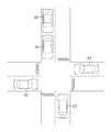
도 5는 본 발명의 일 실시예에 따른 운전 안내 장치에서 신호등 점멸 예측시간을 설명하기 위한 교차로 예시도이다.
도 6은 본 발명의 일 실시예에 따른 운전 안내 장치에서 안내정보 제공서버를 나타낸 블록구성도이다.
도 7은 본 발명의 일 실시예에 따른 운전 안내 장치의 제어 방법을 설명하기 위한 흐름도이다.
도 8은 본 발명의 다른 실시예에 따른 운전 안내 장치의 제어 방법을 설명하기 위한 흐름도이다.1 is a block diagram illustrating a driving guidance device according to an embodiment of the present invention.
2 is a block diagram specifically illustrating a driving guidance terminal of a driving guidance device according to an embodiment of the present invention.
3 is an exemplary diagram illustrating a weight region for calculating a load amount of a surrounding vehicle in the driving guidance device according to an embodiment of the present invention.
4 is an exemplary view illustrating a sensing area of a surrounding vehicle sensing unit in the driving guidance device according to an embodiment of the present invention.
5 is an exemplary diagram illustrating an intersection for explaining a predicted time of blinking of a traffic light in the driving guidance device according to an embodiment of the present invention.
6 is a block diagram illustrating a guide information providing server in the driving guide apparatus according to an embodiment of the present invention.
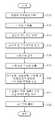
7 is a flowchart illustrating a method of controlling a driving guidance device according to an exemplary embodiment of the present invention.
8 is a flowchart illustrating a method of controlling a driving guidance device according to another exemplary embodiment of the present invention.
이하, 첨부된 도면들을 참조하여 본 발명에 따른 운전 안내 장치 및 그 제어 방법을 설명한다. 이 과정에서 도면에 도시된 선들의 두께나 구성요소의 크기 등은 설명의 명료성과 편의상 과장되게 도시되어 있을 수 있다. 또한, 후술되는 용어들은 본 발명에서의 기능을 고려하여 정의된 용어들로서 이는 사용자, 운용자의 의도 또는 관례에 따라 달라질 수 있다. 그러므로 이러한 용어들에 대한 정의는 본 명세서 전반에 걸친 내용을 토대로 내려져야 할 것이다.Hereinafter, a driving guidance device and a control method thereof according to the present invention will be described with reference to the accompanying drawings. In this process, the thickness of the lines or the size of the components shown in the drawings may be exaggerated for clarity and convenience of explanation. In addition, the terms to be described later are terms defined in consideration of functions in the present invention, which may vary according to the intention or custom of the user or operator. Therefore, definitions of these terms should be made based on the content throughout this specification.
도 1은 본 발명의 일 실시예에 따른 운전 안내 장치를 나타낸 블록구성도이다.1 is a block diagram illustrating a driving guidance device according to an embodiment of the present invention.
도 1에 도시된 바와 같이 본 발명의 일 실시예에 따른 운전 안내 장치는 다수의 운전안내 단말기(10)와 안내정보 제공서버(20)를 포함하여 이루어질 수 있다.As shown in FIG. 1 , the driving guidance device according to an embodiment of the present invention may include a plurality of
다수의 운전안내 단말기(10)는 차량에 탑재되어 차량의 위치정보와 도로정보를 추출하고, 신호등 및 도로 표지판 정보를 인식하며 주변차량과의 주위차량 부하량을 산출하여 안내정보 제공서버(20)에 전송한다. 그러면 안내정보 제공서버(20)는 다수의 운전안내 단말기(10)로부터 차량의 위치정보와 도로정보, 신호등 및 도로 표지판 정보와, 주위차량 부하량을 입력받아 신호등 점멸 예측시간을 산출하여 제공할 뿐만 아니라 실시간으로 산출된 주위차량 부하량과 기 저장된 위험요소를 반영하여 주변의 사고 발생위험도를 산출하여 운전안내 단말기(10)에 전송한다.A plurality of
또한, 안내정보 제공서버(20)는 주변의 사고 발생위험도를 유관기관 서버(30)로 전송하여 구조센터 등에서 사고가 발생할 경우 신속하게 대응할 수 있도록 한다.In addition, the guide
이와 같이 운전안내 단말기(10)는 복잡한 교차로나 시야가 확보되지 않은 교차로에서 안내정보 제공서버(20)로부터 운전 안내정보로써 신호등 점멸 예측시간 및 도로 표지판 정보를 제공받아 전방의 상황을 인지할 수 있을 뿐만 아니라 주변의 사고 발생위험도를 제공받아 안전 운전할 수 있도록 한다.
In this way, the driving
도 2는 본 발명의 일 실시예에 따른 운전 안내 장치의 운전안내 단말기를 구체적으로 나타낸 블록구성도이고, 도 3은 본 발명의 일 실시예에 따른 운전 안내 장치에서 주위차량 부하량을 산출하기 위한 가중치 영역을 나타낸 예시도이며, 도 4는 본 발명의 일 실시예에 따른 운전 안내 장치에서 주위차량 감지부의 감지영역을 나타낸 예시도이고, 도 5는 본 발명의 일 실시예에 따른 운전 안내 장치에서 신호등 점멸 예측시간을 설명하기 위한 교차로 예시도이다.2 is a block diagram specifically illustrating a driving guidance terminal of a driving guidance device according to an embodiment of the present invention, and FIG. 3 is a weight for calculating a load amount of surrounding vehicles in the driving guidance device according to an embodiment of the present invention. It is an exemplary view showing an area, FIG. 4 is an exemplary view showing a sensing area of a surrounding vehicle detection unit in the driving guidance device according to an embodiment of the present invention, and FIG. 5 is a traffic light in the driving guidance device according to an embodiment of the present invention. It is an example of an intersection for explaining the blinking prediction time.
도 2에 도시된 바와 같이 본 발명의 일 실시예에 따른 운전 안내장치의 운전안내 단말기(10)는 GPS 수신부(110), 맵저장부(120), 영상촬영부(130), 주변차량 감지부(140), 단말 제어부(150), 표시부(160) 및 데이터 송수신부(170)를 포함한다.As shown in FIG. 2 , the
GPS 수신부(110)는 GPS 신호를 수신하여 차량 위치정보를 산출하여 단말 제어부(150)에 제공한다.The
맵저장부(120)는 위치정보에 매핑된 지도정보를 저장하여 단말 제어부(150)에서 도로정보를 추출할 수 있도록 제공한다.The
영상촬영부(130)는 차량이 주행 중인 도로의 전방영상을 촬영하여 단말 제어부(150)에 제공함으로써 신호등 및 도로 표지판을 인식할 수 있도록 한다.The
주변차량 감지부(140)는 차량의 주변영역에 존재하는 주변 차량을 감지하기 위해 도 4에 도시된 바와 같이 차량의 좌우 차선에 존재하는 주변차량을 감지하는 측방 초음파센서 및 차량의 전후방에 존재하는 주변차량을 감지하는 전후방 레이더와 전방카메라를 포함할 수 있다.The surrounding
데이터 송수신부(170)는 안내정보 제공서버(20)와 접속되어 운전안내 단말기(10)에서 추출한 정보를 안내정보 제공서버(20)에 전송하고, 안내정보 제공서버(20)에서 산출한 운전 안내정보를 수신받는다.The
단말 제어부(150)는 GPS 수신부(110)로부터 파악된 차량의 위치정보, 맵저장부(120)로부터 위치정보에 근거하여 도로정보를 추출하고, 영상촬영부(130)에서 촬영된 전방영상으로부터 신호등 및 도로 표지판 정보를 인식하고, 주변차량 감지부(140)로부터 감지된 주변차량과의 충돌위험에 따라 주위차량 부하량을 산출하여, 위치정보, 도로정보, 신호등 및 도로 표지판 정보와 주위차량 부하량을 데이터 송수신부(170)를 통해 안내정보 제공서버(20)에 전송하고, 안내정보 제공서버(20)로부터 제공되는 운전 안내정보를 출력한다.The
이를 위해 단말 제어부(150)는 위치인식 및 도로정보 제공부(152), 신호등 및 표지판 인식부(154) 및 주위차량 부하 분석부(156)를 포함한다.To this end, the
위치인식 및 도로정보 제공부(152)는 GPS 수신부(110)로부터 수신된 차량의 위치정보와 맵저장부(120)에 저장된 지도정보를 기반으로 차량의 위치와 도로정보를 제공한다.The location recognition and road
신호등 및 표지판 인식부(154)는 영상촬영부(130)로부터 촬영된 전방영상으로부터 신호등 및 도로 표지판 정보를 인식한다.The traffic light and sign
그리고, 주위차량 부하 분석부(156)는 주변차량 감지부(140)로부터 입력된 주변차량에 대해 차량의 좌우 차선과 전후방 거리를 기반으로 도 3과 같이 가중치 영역을 구분하고, 각 영역에서의 차량의 수와 차선변경 유무로 정량화된 가중치를 부여하여 주위차량 부하량을 산출한다.Then, the surrounding vehicle
이를 보다 구체적으로 설명하면, 주행 중인 차량의 주변에 차량들이 많고, 이 차량들의 궤적 변화가 심하다면 사고가 발생될 위험이 높게 된다. 따라서 주위차량 부하량은 TTC(Time To Collision) 기반으로 도 3와 같이 자기 차량을 중심으로 좌우 차선과 전후방 거리를 기반으로 3개의 영역(section 1,2,3)으로 구분하고, 각 영역에서 감지되는 차량의 수와 차선변경 유무에 따라 산출할 수 있다. 즉, 도 4과 같이 주변차량 감지부(140)의 전후방레이더, 전방카메라 및 측방 초음파센서를 이용하여 전,후방에 대한 정보를 통해 주변차량을 인식하고 TTC 값으로 검지차량과 상대거리에서 상대속도를 나누어 시간을 계산함으로써 위험 영역을 구할 수 있다.More specifically, if there are many vehicles around the driving vehicle and the trajectory change of these vehicles is severe, the risk of an accident occurring is high. Therefore, the surrounding vehicle load is divided into three areas (sections 1, 2, and 3) based on the left and right lanes and the front and rear distances centered on the vehicle as shown in FIG. 3 based on TTC (Time To Collision), and the It can be calculated according to the number of vehicles and whether there is a lane change. That is, as shown in FIG. 4 , using the front and rear radar, the front camera, and the side ultrasonic sensor of the surrounding
예를 들어, 차량에 근접한 영역(section 1)에서 검지된 차량의 수가 많고 차선변경이 많을 경우 주위차량 부하량은 증가하게 되고, 반대로 검지된 차량의 수가 거의 없거나, 차량에서 먼 영역(section 3)에서 검지된 경우, 또한 주변차량의 궤적이 심하지 않은 경우 주위차량 부하량(B)은 감소하게 된다.For example, if the number of vehicles detected in the area close to the vehicle (section 1) is large and there are many lane changes, the surrounding vehicle load increases. When detected, and if the trajectory of the surrounding vehicle is not severe, the surrounding vehicle load amount B is reduced.
이를 수학식으로 정의하면, 수학식 1과 같이 나타낼 수 있다. 즉, S는 검지된 차량의 영역(section 1,2,3)을 나타내고, L은 검지차량의 차선변경 유무를 나타내고, 변경이 있을 경우 '1', 없을 경우 '0'을 반영할 수 있으며, 검지된 차량은 1부터 n까지로 표시할 수 있다.If this is defined as an equation, it can be expressed as in equation (1). That is, S represents the detected vehicle area (sections 1, 2, 3), L represents the presence or absence of a lane change of the detected vehicle, and may reflect '1' if there is a change, and '0' if there is no change, The detected vehicle can be displayed as 1 to n.

또한, 단말 제어부(150)는 영상촬영부(130)에서 촬영된 전방영상으로부터 신호등 및 도로 표지판 정보가 인식되지 않을 경우 안내정보 제공서버(20)에 운전 안내정보를 요청하여 수신받을 수 있다. 운전 안내정보로는 신호등 점멸 예측시간 및 도로 표지판 정보를 비롯하여 주변의 사고 발생위험도가 포함될 수 있다.In addition, when the traffic light and road sign information is not recognized from the front image captured by the
예를 들어 도 5에 도시된 바와 같이 교차로에 대기하고 있는 차량(41~45) 중 2열에 위치한 차량(45)에서는 차량(41)이 전방에 위치하고 있기 때문에 신호등 및 도로 표지판을 인식할 수 없게 된다.For example, as shown in FIG. 5 , in the
이와 같이 전방 시야가 확보되지 않은 경우 단말 제어부(150)는 위치정보, 도로정보 및 주위차량 부하량을 전송하고, 운전 안내정보의 제공을 요청하여 안내정보 제공서버(20)로부터 운전 안내정보를 수신받아 출력할 수 있다.In this way, when the front view is not secured, the
예를 들어 "현재 적색등, 녹색등 예상 점멸시간 약 10초 뒤"와 같이 신호등의 점멸 예측시간을 표시함으로써 복잡한 교차로 및 비보호 지역이나 유턴 지역에서 신호의 점멸 예측시간에 따라 통과 가능여부를 예측할 수 있도록 하여 운전자의 불안감을 해소시킬 수 있다.For example, by displaying the predicted blinking time of the traffic light, such as “about 10 seconds after the current red and green light blinking time,” it is possible to predict whether or not it is possible to pass according to the predicted blinking time of the signal in complex intersections, unprotected areas, or U-turn areas. This can relieve the driver's anxiety.
표시부(160)는 단말 제어부(150)에서 출력되는 운전 안내정보 및 단말 제어부(150)의 작동상태를 표시한다.The
도 6은 본 발명의 일 실시예에 따른 운전 안내 장치에서 안내정보 제공서버를 나타낸 블록구성도이다.6 is a block diagram illustrating a guide information providing server in the driving guide apparatus according to an embodiment of the present invention.
도 6에 도시된 바와 같이 본 발명의 일 실시예에 따른 운전 안내 장치에서의 안내정보 제공서버(20)는 센터 데이터 송수신부(210), 데이터DB(130) 및 서버 제어부(220)를 포함한다.As shown in FIG. 6 , the guide
센터 데이터 송수신부(210)는 운전안내 단말기(10)와 접속되어 운전안내 단말기(10)에서 추출한 정보를 입력받고, 안내정보 제공서버(20)에서 산출한 운전 안내정보를 전송한다. 또한, 유관기관 서버(30)와도 접속되어 기상정보 및 사고 발생정보 등을 입력받을 수도 있다.The
데이터DB(230)는 신호등 구동정보, 기상정보 및 사고다발지역 정보를 저장하여 환경요인을 분석하는 데이터로 사용할 수 있도록 제공한다.The
서버 제어부(220)는 센터 데이터 송수신부(210)로부터 입력되는 운전안내 단말기(10)의 위치정보, 도로정보, 신호등 및 도로 표지판 정보와, 주위차량 부하량에 기초하여 신호등의 점멸 예측시간을 산출하고, 주위차량 부하량과 데이터DB(230)에 저장된 위험요소를 반영하여 주변의 사고 발생위험도를 산출하여 센터 데이터 송수신부(210)를 통해 운전안내 단말기(10)에 제공한다.The
이를 위해 서버 제어부(220)는, 운전안내 단말기(10)로부터 입력된 위치정보와 신호등 정보를 기반으로 데이터DB(230)에 저장된 신호등 구동정보를 통해 신호등의 변경패턴을 분석하여 점멸 예측시간을 산출하는 신호등 예측부(222) 및 주위차량 부하량과 데이터DB(230)에 저장된 위험요소를 반영하여 사고 발생위험도를 산출하는 환경요인 분석부(224)를 포함할 수 있다.To this end, the
신호등 예측부(222)에서는 다수의 운전안내 단말기(10)로부터 입력된 위치정보, 도로정보, 신호등 및 도로 표지판 정보를 기반으로 데이터DB(230)에 저장된 각 차로별로 신호등의 구동순서 및 시간정보를 통해 신호등의 변경패턴을 분석하여 점멸 예측시간을 산출한다.The traffic
따라서, 운전안내 단말기(10)에서 전방영상으로부터 신호등 및 도로 표지판 정보를 인식하지 못하여 운전 안내정보를 요청할 경우, 서버 제어부(220)는 운전안내 단말기(10)의 위치정보를 기반으로 신호등 점멸 예측시간 및 주변의 사고 발생위험도를 제공할 수 있다.Therefore, when the driving
상술한 바와 같이, 본 발명의 실시예에 의한 운전 안내 장치에 따르면, 시야가 확보되지 않은 교차로에서 신호등의 신호변경을 예측하여 제공하고, 자기 차량 및 주변 차량의 궤적을 통해 분석된 충돌위험 뿐만 아니라 사고다발지역에 대한 위험수치를 제공함으로써 복잡한 교차로나 시야가 확보되지 않은 교차로에서 운전자가 신호등의 점멸 예측시간과 도로 표지판 정보 뿐만 아니라 사고 발생위험도를 인지할 수 있어 운전자의 불안감을 해소하여 보다 안전한 운전이 가능하도록 할 수 있다.
As described above, according to the driving guidance device according to the embodiment of the present invention, a signal change of a traffic light is predicted and provided at an intersection where visibility is not secured, and not only the collision risk analyzed through the trajectories of the own vehicle and surrounding vehicles, but also By providing risk values for accident-prone areas, drivers can recognize not only the predicted blinking time of traffic lights and road sign information, but also the risk of accidents at complex intersections or intersections where visibility is not secured, thereby relieving drivers' anxiety and driving safer driving. can make this possible.
도 7은 본 발명의 일 실시예에 따른 운전 안내 장치의 제어 방법을 설명하기 위한 흐름도이다.7 is a flowchart illustrating a method of controlling a driving guidance device according to an exemplary embodiment of the present invention.
도 7에 도시된 바와 같이 본 발명의 일 실시예에 따른 운전 안내 장치의 제어 방법에서는 운전안내 단말기(10)의 동작을 설명한다.As shown in FIG. 7 , the operation of the driving
먼저, 단말 제어부(150)가 GPS 수신부(110)로부터 차량의 위치정보를 입력받는다(S10). 그리고, 차량의 위치정보를 기반으로 단말 제어부(150)는 맵저장부(120)로부터 도로정보를 추출한다(S12). 이를 통해 차선정보 및 주행정보도 파악할 수 있다.First, the
또한, 단말 제어부(150)는 영상촬영부(130)로부터 도로의 전방영상을 입력받는다(S14). 그리고, 입력된 전방영상으로부터 단말 제어부(150)는 신호등 및 도로 표지판 정보를 인식한다(S16).In addition, the
이때 도로 전방에 대형 차량이 서있는 경우 전방영상으로부터 신호등 및 도로 표지판 정보를 인식할 수도 있다. 이와 같이 신호등 및 도로 표지판 정보를 인식할 수 없을 경우, 단말 제어부(150)는 안내정보 제공서버(20)에 운전 안내정보의 제공을 요청할 수 있다.In this case, when a large vehicle is standing in front of the road, traffic light and road sign information may be recognized from the front image. As such, when the traffic light and road sign information cannot be recognized, the
또한, 단말 제어부(150)는 주변차량 감지부(140)로부터 주변차량의 감지결과를 입력받는다(S18). 그리고, 입력된 주변차량의 감지결과로부터 단말 제어부(150)는 주위차량 부하량을 산출한다(S20).In addition, the
주위차량 부하량은 단말 제어부(150)가 주변차량 감지부(140)로부터 입력된 주변차량에 대해 차량의 좌우 차선과 전후방 거리를 기반으로 도 3과 같이 가중치 영역을 구분하고, 각 영역에서의 차량의 수와 차선변경 유무로 정량화된 가중치를 부여하여 산출한다.The load amount of the surrounding vehicle is determined by the
이를 보다 구체적으로 설명하면, 주행 중인 차량의 주변에 차량들이 많고, 이 차량들의 궤적 변화가 심하다면 사고가 발생될 위험이 높게 된다. 따라서 주위차량 부하량은 TTC(Time To Collision) 기반으로 도 3과 같이 자기 차량을 중심으로 좌우 차선과 전후방 거리를 기반으로 3개의 영역(section 1,2,3)으로 구분하고, 각 영역에서 감지되는 차량의 수와 차선변경 유무에 따라 산출할 수 있다. 즉, 도 4와 같이 주변차량 감지부(140)의 전후방레이더, 전방카메라 및 측방 초음파센서를 이용하여 전,후방에 대한 정보를 통해 주변차량을 인식하고 TTC 값으로 검지차량과 상대거리에서 상대속도를 나누어 시간을 계산함으로써 위험 영역을 구할 수 있다.More specifically, if there are many vehicles around the driving vehicle and the trajectory change of these vehicles is severe, the risk of an accident occurring is high. Therefore, the surrounding vehicle load is divided into three areas (sections 1,2,3) based on the left and right lanes and the front and rear distances centered on the vehicle as shown in FIG. 3 based on TTC (Time To Collision), and the It can be calculated according to the number of vehicles and whether there is a lane change. That is, as shown in FIG. 4, using the front and rear radar, front camera, and lateral ultrasonic sensor of the surrounding
예를 들어, 차량에 근접한 영역(section 1)에서 검지된 차량의 수가 많고 차선변경이 많을 경우 주위차량 부하량은 증가하게 되고, 반대로 검지된 차량의 수가 거의 없거나, 차량에서 먼 영역(section 3)에서 검지된 경우, 또한 주변차량의 궤적이 심하지 않은 경우 주위차량 부하량(B)은 감소하게 된다.For example, if the number of vehicles detected in the area close to the vehicle (section 1) is large and there are many lane changes, the surrounding vehicle load increases. When detected, and if the trajectory of the surrounding vehicle is not severe, the surrounding vehicle load amount B is reduced.
이를 수학식으로 정의하면, 수학식 2와 같이 나타낼 수 있다. 즉, S는 검지된 차량의 영역(section 1,2,3)을 나타내고, L은 검지차량의 차선변경 유무를 나타내고, 변경이 있을 경우 '1', 없을 경우 '0'을 반영할 수 있으며, 검지된 차량은 1부터 n까지로 표시할 수 있다.If this is defined as an equation, it can be expressed as in equation (2). That is, S represents the detected vehicle area (sections 1, 2, 3), L represents the presence or absence of a lane change of the detected vehicle, and may reflect '1' if there is a change, and '0' if there is no change, The detected vehicle can be displayed as 1 to n.

이후 단말 제어부(150)는 위치정보, 도로정보, 신호등 및 도로 표지판 정보와, 주위차량 부하량을 안내정보 제공서버(20)에 전송한다(S22).Thereafter, the
이때 단말 제어부(150)가 S16 단계에서 전방영상으로부터 신호등 및 도로 표지판 정보를 인식하지 못한 경우, 단말 제어부(150)는 위치정보, 도로정보 및 주위차량 부하량을 전송하고, 안내정보 제공서버(20)에 운전 안내정보의 제공을 요청할 수도 있다.At this time, when the
이후 단말 제어부(150)는 안내정보 제공서버(20)로부터 운전 안내정보를 수신받고(S24), 표시부(160)에 수신딘 신호등 점멸 예측시간 및 주변의 사고 발생위험도를 표시한다(S26). 이때 단말 제어부(150)가 운전 안내정보의 제공을 요청한 경우에만 운전 안내정보를 수신 받아 표시할 수도 있다.Thereafter, the
예를 들어 "현재 적색등, 녹색등 예상 점멸시간 약 10초 뒤"와 같이 신호등의 점멸 예측시간을 표시함으로써 복잡한 교차로 및 비보호 지역이나 유턴 지역에서 신호의 점멸 예측시간에 따라 통과 가능여부를 예측할 수 있도록 하여 운전자의 불안감을 해소시킬 수 있다.For example, by displaying the predicted blinking time of the traffic light, such as “about 10 seconds after the current red and green light blinking time,” it is possible to predict whether or not it is possible to pass according to the predicted blinking time of the signal in complex intersections, unprotected areas, or U-turn areas. This can relieve the driver's anxiety.
도 8은 본 발명의 다른 실시예에 따른 운전 안내 장치의 제어 방법을 설명하기 위한 흐름도이다.8 is a flowchart illustrating a method of controlling a driving guidance device according to another exemplary embodiment of the present invention.
도 8에 도시된 바와 같이 본 발명의 다른 실시예에 따른 운전 안내 장치의 제어 방법에서는 안내정보 제공서버(20)의 동작을 설명한다.As shown in FIG. 8 , the operation of the guide
먼저, 서버 제어부(220)가 다수의 운전안내 단말기(10)로부터 위치정보, 도로정보, 신호등 및 도로 표지판 정보와, 주위차량 부하량을 입력받는다(S30).First, the
이후 서버 제어부(220)는 운전안내 단말기(10)의 위치에서 각 방향에 대한 신호등 점멸 예측시간을 산출한다(S32).Thereafter, the
즉, 서버 제어부(220)는 다수의 운전안내 단말기(10)로부터 입력된 위치정보, 도로정보, 신호등 및 도로 표지판 정보를 기반으로 데이터DB(230)에 저장된 각 차로별로 신호등의 구동순서 및 시간정보를 통해 신호등의 변경패턴을 분석하여 점멸 예측시간을 산출한다.That is, the
또한, 서버 제어부(220)는 실시간으로 입력되는 주위차량 부하량과 데이터DB(230)에 저장된 위험요소를 반영하여 주변의 사고 발생위험도를 산출한다(S34).In addition, the
이후 서버 제어부(220)는 운전 안내정보로써 신호등 점멸 예측시간과 사고 발생위험도를 운전안내 단말기(10)에 전송한다(S36).Thereafter, the
이때 서버 제어부(220)는 운전안내 단말기(10)로부터 운전 안내정보의 요청이 수신된 경우 요청한 운전안내 단말기(10)에만 운전 안내정보를 전송할 수 있다.In this case, when a request for driving guidance information is received from the driving
상술한 바와 같이, 본 발명의 실시예에 의한 운전 안내 장치의 제어 방법에 따르면, 시야가 확보되지 않은 교차로에서 신호등의 신호변경을 예측하여 제공하고, 자기 차량 및 주변 차량의 궤적을 통해 분석된 충돌위험 뿐만 아니라 사고다발지역에 대한 위험수치를 제공함으로써 복잡한 교차로나 시야가 확보되지 않은 교차로에서 운전자가 신호등의 점멸 예측시간과 도로 표지판 정보 뿐만 아니라 사고 발생위험도를 인지할 수 있어 운전자의 불안감을 해소하여 보다 안전한 운전이 가능하도록 할 수 있다.
As described above, according to the control method of the driving guidance device according to the embodiment of the present invention, a signal change of a traffic light is predicted and provided at an intersection where visibility is not secured, and the collision analyzed through the trajectories of the own vehicle and surrounding vehicles By providing risk values for not only risk but also accident-prone areas, the driver can recognize the risk of accidents as well as the predicted blinking time of traffic lights and road sign information at complex intersections or intersections where visibility is not secured. It can make driving safer.
본 발명은 도면에 도시된 실시예를 참고로 하여 설명되었으나, 이는 예시적인 것에 불과하며, 당해 기술이 속하는 분야에서 통상의 지식을 가진 자라면 이로부터 다양한 변형 및 균등한 타 실시예가 가능하다는 점을 이해할 것이다.Although the present invention has been described with reference to the embodiment shown in the drawings, this is merely exemplary, and it is understood that various modifications and equivalent other embodiments are possible by those of ordinary skill in the art. will understand
따라서 본 발명의 진정한 기술적 보호범위는 아래의 특허청구범위에 의해서 정하여져야 할 것이다.
Therefore, the true technical protection scope of the present invention should be defined by the following claims.
10 : 운전안내 단말기 20 : 안내정보 제공서버
30 : 유관기관 서버 41~45 : 차량
110 : GPS 수신부 120 : 맵저장부
130 : 영상촬영부 140 : 주변차량 감지부
150 : 단말 제어부 152 : 위치인식 및 도로정보 제공부
154 : 신호등 및 표지판 인식부 156 : 주위차량 부하 분석부
160 : 표시부 170 : 데이터 송수신부
210 : 센터 데이터 송수신부 220 : 서버 제어부
222 : 신호등 예측부 224 : 환경요인 분석부
230 : 데이터DB10: driving guide terminal 20: information providing server
30: related organization server 41-45: vehicle
110: GPS receiver 120: map storage unit
130: image capturing unit 140: surrounding vehicle detection unit
150: terminal control unit 152: location recognition and road information providing unit
154: traffic light and sign recognition unit 156: surrounding vehicle load analysis unit
160: display unit 170: data transmitting and receiving unit
210: center data transceiver 220: server control unit
222: traffic light prediction unit 224: environmental factor analysis unit
230: data DB
Claims (11)
Translated fromKorean상기 위치정보에 매핑된 지도정보를 저장하는 맵저장부;
상기 차량이 주행 중인 도로의 전방영상을 촬영하는 영상촬영부;
상기 차량의 주변영역에 존재하는 주변 차량을 감지하는 주변차량 감지부;
안내정보 제공서버와 접속되어 데이터를 송수신하는 데이터 송수신부;
상기 GPS 수신부로부터 파악된 상기 차량의 상기 위치정보, 상기 맵저장부로부터 상기 위치정보에 근거하여 도로정보를 추출하고, 상기 영상촬영부에서 촬영된 상기 전방영상으로부터 신호등 및 도로 표지판 정보를 인식하고, 상기 주변차량 감지부로부터 감지된 주변차량과의 충돌위험에 따라 주위차량 부하량을 산출하여, 상기 위치정보, 상기 도로정보, 상기 신호등 및 도로 표지판 정보와 상기 주위차량 부하량을 상기 데이터 송수신부를 통해 상기 안내정보 제공서버에 전송하고, 상기 안내정보 제공서버로부터 제공되는 운전 안내정보를 출력하는 단말 제어부; 및
상기 단말 제어부에서 출력되는 상기 운전 안내정보 및 상기 단말 제어부의 작동상태를 표시하는 표시부;를 포함하되,
상기 단말 제어부는,
상기 GPS 수신부로부터 수신된 상기 차량의 상기 위치정보와 상기 맵저장부에 저장된 상기 지도정보를 기반으로 상기 차량의 상기 위치정보와 상기 도로정보를 제공하는 위치인식 및 도로정보 제공부;
상기 영상촬영부로부터 촬영된 상기 전방영상으로부터 상기 신호등 및 도로 표지판 정보를 인식하는 신호등 및 표지판 인식부; 및
상기 주변차량 감지부로부터 입력된 상기 주변차량에 대해 상기 차량의 좌우 차선과 전후방 거리를 기반으로 영역을 구분하고, 상기 각 영역에서의 차량의 수와 차선변경 유무로 정량화된 가중치를 부여하여 상기 주위차량 부하량을 산출하는 주위차량 부하 분석부;를 포함하고,
상기 안내정보 제공서버는,
운전안내 단말기와 데이터를 송수신하는 센터 데이터 송수신부;
신호등 구동정보, 기상정보 및 사고다발지역 정보를 저장하는 데이터DB; 및
상기 센터 데이터 송수신부로부터 입력되는 상기 운전안내 단말기의 상기 위치정보, 상기 도로정보, 상기 신호등 및 도로 표지판 정보와, 상기 주위차량 부하량에 기초하여 신호등의 점멸 예측시간을 산출하고, 상기 주위차량 부하량과 상기 데이터DB에 저장된 위험요소를 반영하여 주변의 사고 발생위험도를 산출하여 상기 센터 데이터 송수신부를 통해 상기 운전안내 단말기에 제공하는 서버 제어부;를 포함하는 것을 특징으로 하는 운전 안내 장치.
a GPS receiver for receiving a GPS signal and calculating vehicle location information;
a map storage unit for storing map information mapped to the location information;
an image photographing unit for photographing a front image of the road on which the vehicle is traveling;
a surrounding vehicle detection unit for detecting a surrounding vehicle existing in a surrounding area of the vehicle;
a data transceiver connected to the guide information providing server to transmit and receive data;
Extracting road information based on the location information of the vehicle identified from the GPS receiver and the location information from the map storage unit, and recognizing traffic light and road sign information from the front image captured by the image capturing unit, Calculating the load amount of surrounding vehicles according to the risk of collision with surrounding vehicles detected by the surrounding vehicle detection unit, and guiding the location information, the road information, the traffic light and road sign information, and the surrounding vehicle load amount through the data transmission/reception unit a terminal control unit for transmitting to an information providing server and outputting driving guide information provided from the guide information providing server; and
Including; a display unit for displaying the driving guide information output from the terminal control unit and the operating state of the terminal control unit;
The terminal control unit,
a location recognition and road information providing unit for providing the location information and the road information of the vehicle based on the location information of the vehicle received from the GPS receiver and the map information stored in the map storage unit;
a traffic light and sign recognition unit for recognizing the traffic light and road sign information from the front image taken from the image capturing unit; and
For the surrounding vehicles input from the surrounding vehicle detection unit, the area is divided based on the left and right lanes and the front and rear distances of the vehicle, and quantified weights are given based on the number of vehicles in each area and whether or not there is a lane change in the surrounding area. Including; surrounding vehicle load analysis unit for calculating the vehicle load amount;
The guide information providing server,
a center data transceiver for transmitting and receiving data to and from the driving guide terminal;
a data DB for storing traffic light driving information, weather information, and accident-prone area information; and
Calculate the predicted blinking time of the traffic light based on the location information, the road information, the traffic light and road sign information of the driving guide terminal input from the center data transceiver unit, and the surrounding vehicle load, and the surrounding vehicle load and a server control unit that reflects the risk factors stored in the data DB to calculate the risk of an accident in the vicinity and provides it to the driving guide terminal through the center data transmission/reception unit.
상기 차량의 좌우 차선에 존재하는 주변차량을 감지하는 측방 초음파센서; 및
상기 차량의 전후방에 존재하는 주변차량을 감지하는 전후방 레이더와 전방카메라;를 포함하는 것을 특징으로 하는 운전 안내 장치.
According to claim 1, wherein the surrounding vehicle detection unit,
a lateral ultrasonic sensor for detecting surrounding vehicles present in the left and right lanes of the vehicle; and
and a front and rear radar and a front camera for detecting surrounding vehicles present in the front and rear of the vehicle.
The method according to claim 1, wherein the terminal control unit requests and receives the driving guide information from the guide information providing server when the traffic light and road sign information is not recognized from the front image captured by the image capturing unit. driving guidance device.
상기 운전안내 단말기로부터 입력된 상기 위치정보와 상기 신호등 정보를 기반으로 상기 데이터DB에 저장된 상기 신호등 구동정보를 통해 신호등의 변경패턴을 분석하여 상기 점멸 예측시간을 산출하는 신호등 예측부; 및
상기 주위차량 부하량과 상기 데이터DB에 저장된 위험요소를 반영하여 상기 사고 발생위험도를 산출하는 환경요인 분석부;를 포함하는 것을 특징으로 하는 운전 안내 장치.
According to claim 1, wherein the server control unit,
a traffic light prediction unit for calculating the predicted blinking time by analyzing a change pattern of a traffic light through the traffic light driving information stored in the data DB based on the location information and the traffic light information input from the driving guide terminal; and
and an environmental factor analysis unit that calculates the accident risk by reflecting the load amount of the surrounding vehicle and the risk factors stored in the data DB.
상기 단말 제어부가 상기 차량의 상기 위치정보를 기반으로 맵저장부로부터 도로정보를 추출하는 단계;
상기 단말 제어부가 영상촬영부로부터 도로의 전방영상을 입력받는 단계;
상기 단말 제어부가 상기 전방영상으로부터 신호등 및 도로 표지판 정보를 인식하는 단계;
상기 단말 제어부가 주변차량 감지부로부터 주변차량의 감지결과를 입력받는 단계;
상기 단말 제어부가 상기 주변차량의 감지결과로부터 주위차량 부하량을 산출하는 단계;
상기 단말 제어부가 상기 위치정보, 상기 도로정보, 상기 신호등 및 도로 표지판 정보와, 상기 주위차량 부하량을 안내정보 제공서버에 전송하는 단계; 및
상기 단말 제어부가 상기 안내정보 제공서버로부터 운전 안내정보를 수신받아 표시부에 출력하는 단계를 포함하되,
상기 주위차량 부하량을 산출하는 단계는, 상기 단말 제어부가 상기 주변차량 감지부로부터 입력된 상기 주변차량에 대해 차량의 좌우 차선과 전후방 거리를 기반으로 영역을 구분하고, 상기 각 영역에서의 차량의 수와 차선변경 유무로 정량화된 가중치를 부여하여 상기 주위차량 부하량을 산출하고,
상기 안내정보 제공서버의 서버 제어부가 운전안내 단말기로부터 위치정보, 도로정보, 신호등 및 도로 표지판 정보와, 주위차량 부하량을 입력받는 단계;
상기 서버 제어부가 상기 운전안내 단말기의 위치에서 각 방향에 대한 신호등 점멸 예측시간을 산출하는 단계;
상기 서버 제어부가 상기 주위차량 부하량과 데이터DB에 저장된 위험요소를 반영하여 사고 발생위험도를 산출하는 단계; 및
상기 서버 제어부가 운전 안내정보를 상기 운전안내 단말기에 전송하는 단계;를 더 포함하는 것을 특징으로 하는 운전 안내 장치의 제어 방법.
receiving, by the terminal control unit, the location information of the vehicle from the GPS receiving unit;
extracting, by the terminal control unit, road information from a map storage unit based on the location information of the vehicle;
receiving, by the terminal control unit, a front image of the road from the image capturing unit;
Recognizing, by the terminal control unit, traffic light and road sign information from the front image;
receiving, by the terminal control unit, a detection result of a surrounding vehicle from a surrounding vehicle detecting unit;
calculating, by the terminal control unit, a surrounding vehicle load from a detection result of the surrounding vehicle;
transmitting, by the terminal control unit, the location information, the road information, the traffic light and road sign information, and the load amount of the surrounding vehicle to a guide information providing server; and
Comprising the step of the terminal control unit receiving the driving guide information from the guide information providing server and outputting it to the display unit,
In the calculating of the amount of the surrounding vehicle load, the terminal control unit divides the area based on the left and right lanes and the front and rear distances of the vehicle for the surrounding vehicles input from the surrounding vehicle detection unit, and the number of vehicles in each area. and calculating the load of the surrounding vehicle by giving a quantified weight based on the presence or absence of a lane change,
receiving, by the server control unit of the guide information providing server, location information, road information, traffic light and road sign information, and a load amount of surrounding vehicles from a driving guide terminal;
calculating, by the server control unit, a predicted blinking time of a traffic light for each direction at the location of the driving guide terminal;
calculating, by the server control unit, the accident risk by reflecting the load amount of the surrounding vehicle and the risk factors stored in the data DB; and
The method of controlling a driving guidance device further comprising; transmitting, by the server control unit, driving guidance information to the driving guidance terminal.
The method of claim 7, wherein the transmitting to the guide information providing server comprises transmitting the location information, the road information, and the surrounding vehicle load when the terminal control unit does not recognize the traffic light and road sign information from the front image. and requesting the provision of the driving guidance information.
Priority Applications (1)
| Application Number | Priority Date | Filing Date | Title |
|---|---|---|---|
| KR1020140151956AKR102316654B1 (en) | 2014-11-04 | 2014-11-04 | Driving guidance apparatus and control method thereof |
Applications Claiming Priority (1)
| Application Number | Priority Date | Filing Date | Title |
|---|---|---|---|
| KR1020140151956AKR102316654B1 (en) | 2014-11-04 | 2014-11-04 | Driving guidance apparatus and control method thereof |
Publications (2)
| Publication Number | Publication Date |
|---|---|
| KR20160053385A KR20160053385A (en) | 2016-05-13 |
| KR102316654B1true KR102316654B1 (en) | 2021-10-26 |
Family
ID=56023241
Family Applications (1)
| Application Number | Title | Priority Date | Filing Date |
|---|---|---|---|
| KR1020140151956AActiveKR102316654B1 (en) | 2014-11-04 | 2014-11-04 | Driving guidance apparatus and control method thereof |
Country Status (1)
| Country | Link |
|---|---|
| KR (1) | KR102316654B1 (en) |
Cited By (1)
| Publication number | Priority date | Publication date | Assignee | Title |
|---|---|---|---|---|
| US12441304B2 (en) | 2022-03-18 | 2025-10-14 | Hl Klemove Corp. | Driver assistance system and vehicle including the same |
Families Citing this family (8)
| Publication number | Priority date | Publication date | Assignee | Title |
|---|---|---|---|---|
| KR101927182B1 (en)* | 2016-11-15 | 2018-12-10 | 현대자동차 주식회사 | Apparatus and computer readable recording medium for warning dangerous situation |
| KR102383426B1 (en) | 2016-12-15 | 2022-04-07 | 현대자동차주식회사 | Apparatus and Method for determining toll gate section |
| JP2018195301A (en)* | 2017-05-15 | 2018-12-06 | キヤノン株式会社 | Control device and control method |
| KR101874352B1 (en)* | 2017-12-14 | 2018-07-06 | 최현수 | VMS, In-vehicle terminal and intelligent transport system including the same for efficient transmission of traffic information on the road |
| CN113056778B (en)* | 2018-11-29 | 2023-01-06 | 日立安斯泰莫株式会社 | Vehicle Control System and Server |
| KR102244241B1 (en)* | 2020-10-28 | 2021-04-26 | 주식회사 예향엔지니어링 | Method for preventing road traffic congestion and server performing the same |
| KR102544637B1 (en)* | 2021-05-03 | 2023-06-21 | 한국건설기술연구원 | Apparatus and method for providing traffic information using security CCTV images |
| CN119580229B (en)* | 2025-02-06 | 2025-07-25 | 深圳广联数科科技有限公司 | Vehicle collision recognition method and device, storage medium and electronic equipment |
Citations (1)
| Publication number | Priority date | Publication date | Assignee | Title |
|---|---|---|---|---|
| JP2006048624A (en)* | 2004-07-09 | 2006-02-16 | Aisin Aw Co Ltd | Method of producing traffic signal information, method of providing traffic signal guidance information and navigation apparatus |
Family Cites Families (3)
| Publication number | Priority date | Publication date | Assignee | Title |
|---|---|---|---|---|
| KR20040063517A (en)* | 2003-01-08 | 2004-07-14 | 에스케이 텔레콤주식회사 | Service System and Method for Safety of Drive |
| KR100806721B1 (en)* | 2006-07-05 | 2008-02-27 | 전자부품연구원 | Vehicle surrounding information system |
| KR20100004022A (en)* | 2008-07-02 | 2010-01-12 | 엠텍비젼 주식회사 | Apparatus, system for navigating using road signs and method using the same |
- 2014
- 2014-11-04KRKR1020140151956Apatent/KR102316654B1/enactiveActive
Patent Citations (1)
| Publication number | Priority date | Publication date | Assignee | Title |
|---|---|---|---|---|
| JP2006048624A (en)* | 2004-07-09 | 2006-02-16 | Aisin Aw Co Ltd | Method of producing traffic signal information, method of providing traffic signal guidance information and navigation apparatus |
Cited By (1)
| Publication number | Priority date | Publication date | Assignee | Title |
|---|---|---|---|---|
| US12441304B2 (en) | 2022-03-18 | 2025-10-14 | Hl Klemove Corp. | Driver assistance system and vehicle including the same |
Also Published As
| Publication number | Publication date |
|---|---|
| KR20160053385A (en) | 2016-05-13 |
Similar Documents
| Publication | Publication Date | Title |
|---|---|---|
| KR102316654B1 (en) | Driving guidance apparatus and control method thereof | |
| US11958504B2 (en) | Method and apparatus for controlling a vehicle's driving operation using advance information | |
| US20230311749A1 (en) | Communication between autonomous vehicle and external observers | |
| US11327485B2 (en) | Control device for vehicle, and vehicle | |
| US20200117926A1 (en) | Apparatus, method, and system for controlling parking of vehicle | |
| CN113631448B (en) | Vehicle control method and vehicle control device | |
| US11377025B2 (en) | Blocked information displaying method and system for use in autonomous vehicle | |
| US11361661B2 (en) | In-vehicle infotainment system communicating with unmanned aerial vehicle and method of operating the same | |
| US11472400B2 (en) | Vehicle control device, vehicle management device, vehicle control method, and storage medium | |
| US20180038701A1 (en) | Route search device, control method, program and storage medium | |
| US20150134180A1 (en) | Autonomous driving control apparatus and method using navigation technology | |
| US11600181B2 (en) | Saddle-riding type vehicle | |
| US11390302B2 (en) | Vehicle control device, vehicle control method, and program | |
| KR20090125795A (en) | Safe driving support device | |
| CN111354182A (en) | Driving assisting method and system | |
| JP2008250503A (en) | Operation support device | |
| US10546422B2 (en) | System and method for augmented reality support using a lighting system's sensor data | |
| US20200307558A1 (en) | Vehicle control device, vehicle management device, vehicle control method, vehicle management method, and storage medium | |
| US20140327557A1 (en) | Display method and display system for a vehicle | |
| KR20200068776A (en) | Telecommunication service providing method and system for connected & autonomous vehicles | |
| US11250695B2 (en) | Method and device for providing a position of at least one object | |
| US20200231178A1 (en) | Vehicle control system, vehicle control method, and program | |
| US20240157935A1 (en) | Detection of distracted drivers | |
| JP2023024857A (en) | Road-to-vehicle cooperative information processing method, apparatus, system, electronic device, storage medium, and computer program | |
| JP2019040539A (en) | Travel support system |
Legal Events
| Date | Code | Title | Description |
|---|---|---|---|
| PA0109 | Patent application | Patent event code:PA01091R01D Comment text:Patent Application Patent event date:20141104 | |
| PG1501 | Laying open of application | ||
| A201 | Request for examination | ||
| PA0201 | Request for examination | Patent event code:PA02012R01D Patent event date:20191023 Comment text:Request for Examination of Application Patent event code:PA02011R01I Patent event date:20141104 Comment text:Patent Application | |
| E902 | Notification of reason for refusal | ||
| PE0902 | Notice of grounds for rejection | Comment text:Notification of reason for refusal Patent event date:20210116 Patent event code:PE09021S01D | |
| E701 | Decision to grant or registration of patent right | ||
| PE0701 | Decision of registration | Patent event code:PE07011S01D Comment text:Decision to Grant Registration Patent event date:20210722 | |
| GRNT | Written decision to grant | ||
| PR0701 | Registration of establishment | Comment text:Registration of Establishment Patent event date:20211019 Patent event code:PR07011E01D | |
| PR1002 | Payment of registration fee | Payment date:20211020 End annual number:3 Start annual number:1 | |
| PG1601 | Publication of registration | ||
| PR1001 | Payment of annual fee |