KR102211292B1 - System and method for grid-based geofencing service - Google Patents
System and method for grid-based geofencing serviceDownload PDFInfo
- Publication number
- KR102211292B1 KR102211292B1KR1020150090396AKR20150090396AKR102211292B1KR 102211292 B1KR102211292 B1KR 102211292B1KR 1020150090396 AKR1020150090396 AKR 1020150090396AKR 20150090396 AKR20150090396 AKR 20150090396AKR 102211292 B1KR102211292 B1KR 102211292B1
- Authority
- KR
- South Korea
- Prior art keywords
- coordinates
- grids
- area
- moving object
- grid
- Prior art date
- Legal status (The legal status is an assumption and is not a legal conclusion. Google has not performed a legal analysis and makes no representation as to the accuracy of the status listed.)
- Active
Links
- 238000000034methodMethods0.000titleclaimsabstractdescription27
- 238000006243chemical reactionMethods0.000claimsdescription6
- 238000004590computer programMethods0.000claimsdescription2
- 230000001131transforming effectEffects0.000claimsdescription2
- 238000004364calculation methodMethods0.000abstractdescription4
- 238000010586diagramMethods0.000description5
- 230000006870functionEffects0.000description3
- 230000014509gene expressionEffects0.000description2
- 241001465754MetazoaSpecies0.000description1
- 150000001875compoundsChemical class0.000description1
- 238000012986modificationMethods0.000description1
- 230000004048modificationEffects0.000description1
- 230000003287optical effectEffects0.000description1
Images


Classifications
- H—ELECTRICITY
- H04—ELECTRIC COMMUNICATION TECHNIQUE
- H04W—WIRELESS COMMUNICATION NETWORKS
- H04W4/00—Services specially adapted for wireless communication networks; Facilities therefor
- H04W4/02—Services making use of location information
- H04W4/021—Services related to particular areas, e.g. point of interest [POI] services, venue services or geofences
- G—PHYSICS
- G01—MEASURING; TESTING
- G01C—MEASURING DISTANCES, LEVELS OR BEARINGS; SURVEYING; NAVIGATION; GYROSCOPIC INSTRUMENTS; PHOTOGRAMMETRY OR VIDEOGRAMMETRY
- G01C21/00—Navigation; Navigational instruments not provided for in groups G01C1/00 - G01C19/00
- G01C21/005—Navigation; Navigational instruments not provided for in groups G01C1/00 - G01C19/00 with correlation of navigation data from several sources, e.g. map or contour matching
- H—ELECTRICITY
- H04—ELECTRIC COMMUNICATION TECHNIQUE
- H04W—WIRELESS COMMUNICATION NETWORKS
- H04W4/00—Services specially adapted for wireless communication networks; Facilities therefor
- H04W4/02—Services making use of location information
- H04W4/023—Services making use of location information using mutual or relative location information between multiple location based services [LBS] targets or of distance thresholds
- H—ELECTRICITY
- H04—ELECTRIC COMMUNICATION TECHNIQUE
- H04W—WIRELESS COMMUNICATION NETWORKS
- H04W4/00—Services specially adapted for wireless communication networks; Facilities therefor
- H04W4/02—Services making use of location information
- H04W4/029—Location-based management or tracking services
Landscapes
- Engineering & Computer Science (AREA)
- Computer Networks & Wireless Communication (AREA)
- Signal Processing (AREA)
- Radar, Positioning & Navigation (AREA)
- Remote Sensing (AREA)
- Automation & Control Theory (AREA)
- Physics & Mathematics (AREA)
- General Physics & Mathematics (AREA)
- Alarm Systems (AREA)
- Traffic Control Systems (AREA)
- Information Retrieval, Db Structures And Fs Structures Therefor (AREA)
- Navigation (AREA)
Abstract
Translated fromKoreanDescription
Translated fromKorean본 발명의 실시예들은 선박, 항공기 등의 이동체의 위치 추적 기술과 관련된다.Embodiments of the present invention relate to a technology for tracking the location of a moving object such as a ship or an aircraft.
위치 추적 기술의 발달에 따라, 위치 추적 기술에 기반한 다양한 응용 분야 또한 증가하고 있으며 그 정확도 또한 향상되고 있다. 이러한 위치 추적 기술의 응용 분야 중 하나로 지오펜싱(Geofencing)을 들 수 있다. 지오펜싱은 지오그래픽(Geographic)과 펜싱(Fencing)의 합성어로서 특정 영역에 대한 사용자 출입현황을 알려주는 서비스이다. 예를 들어, 지오펜싱 서비스 시스템은 특정한 영역에 지오펜스(Geofence)라는 가상의 울타리로 둘러 쌓인 영역을 지정해 두고, 해당 영역에 사용자가 진입하거나 또는 이를 벗어나는 경우 이를 알려주게 된다.With the development of location tracking technology, various application fields based on location tracking technology are also increasing, and its accuracy is also improving. One of the application fields of this location tracking technology is geofencing. Geofencing is a compound word of geographic and fencing, and is a service that informs the user access status to a specific area. For example, the geofencing service system designates an area enclosed by a virtual fence called Geofence in a specific area, and informs when a user enters or leaves the area.
종래의 지오펜싱 서비스 시스템은 일반적으로 폴리곤(polygon) (또는 원형) 형태로 영역을 구성하였다. 그러나 이와 같은 방식의 경우 실시간으로 수집되는 위치 추적 데이터가 폴리곤 영역 안에 위치하는 지의 여부를 판정하는 데 많은 계산이 필요하다는 문제가 있었다.In the conventional geofencing service system, the area is generally configured in the form of a polygon (or circle). However, in the case of this method, there is a problem that a lot of calculations are required to determine whether the location tracking data collected in real time is located in the polygon area.
본 발명의 실시예들은 지오펜싱 서비스 시스템에서 위치 추적 데이터가 특정 영역 내에 위치하는 지의 여부를 판정하는 데 필요한 계산량을 감소시키기 위한 기술적인 수단을 제공하기 위한 것이다.Embodiments of the present invention are to provide a technical means for reducing the amount of computation required to determine whether or not location tracking data is located within a specific area in a geofencing service system.
예시적인 실시예에 따르면, 하나 이상의 격자(grid)로 구성되는 영역 정보를 저장하는 저장부; 및 이동체의 위치 좌표를 수신하고, 상기 영역 정보를 참조하여 상기 이동체가 상기 영역 내에 존재하는지의 여부를 판단하는 판단부를 포함하는 그리드 기반 지오펜싱 서비스 시스템이 제공된다.According to an exemplary embodiment, there is provided a storage unit configured to store area information formed of one or more grids; And a determination unit configured to receive the location coordinates of the moving object and determine whether the moving object exists in the area by referring to the area information.
상기 격자는, 상기 영역 내의 좌표에서 기 설정된 유효 자릿수 미만을 절삭한 유효 좌표가 동일한 점들의 집합으로 구성될 수 있다.The grid may consist of a set of points having the same effective coordinates obtained by cutting less than a preset number of significant digits from the coordinates within the area.
상기 영역 정보는, 상기 하나 이상의 격자 각각의 기준 위치 및 상기 유효 자릿수 정보를 포함할 수 있다.The region information may include information on a reference position and the number of significant digits of each of the one or more grids.
상기 기준 위치는, 상기 하나 이상의 격자 각각에 포함된 점들의 유효 좌표에 따라 결정될 수 있다.The reference position may be determined according to effective coordinates of points included in each of the one or more grids.
상기 판단부는, 상기 이동체의 위치 좌표에서 상기 유효 자릿수 미만을 절삭하여 질의 좌표를 생성하고, 상기 하나 이상의 격자 각각의 기준 좌표 중 상기 질의 좌표와 동일한 좌표가 존재하는 경우, 상기 이동체가 상기 영역 내에 존재하는 것으로 판단할 수 있다.The determination unit generates query coordinates by cutting less than the number of significant digits from the location coordinates of the moving object, and if the same coordinates as the query coordinates exist among the reference coordinates of each of the one or more grids, the moving object is present in the area It can be judged by doing.
상기 시스템은, 폴리곤(polygon) 기반 영역을 상기 하나 이상의 격자로 변환하는 변환부를 더 포함할 수 있다.The system may further include a transform unit for converting a polygon-based region into the one or more grids.
상기 변환부는, 상기 유효 자릿수로부터 계산되는 각 격자의 크기 및 상기 폴리곤 기반 영역 내부의 좌표를 참조하여, 상기 폴리곤 기반 영역을 모두 포함하도록 하나 이상의 격자를 선택할 수 있다.The transform unit may select one or more grids to include all of the polygon-based regions by referring to the size of each grid calculated from the number of significant digits and coordinates inside the polygon-based region.
다른 예시적인 실시예에 따르면, 그리드 기반 지오펜싱 서비스 시스템에서의 지오펜싱 서비스 방법으로서, 이동체의 위치 좌표를 수신하는 단계; 하나 이상의 격자(grid)로 구성되는 영역 정보를 참조하여, 상기 이동체가 상기 영역 내에 존재하는지의 여부를 판단하는 단계를 포함하는 지오펜싱 서비스 방법이 제공된다.According to another exemplary embodiment, a geofencing service method in a grid-based geofencing service system, comprising: receiving position coordinates of a moving object; There is provided a geofencing service method including the step of determining whether or not the moving object exists in the area by referring to area information composed of one or more grids.
상기 격자는, 상기 영역 내의 좌표에서 기 설정된 유효 자릿수 미만을 절삭한 유효 좌표가 동일한 점들의 집합으로 구성될 수 있다.The grid may consist of a set of points having the same effective coordinates obtained by cutting less than a preset number of significant digits from the coordinates within the area.
상기 영역 정보는, 상기 하나 이상의 격자 각각의 기준 위치 및 상기 유효 자릿수 정보를 포함할 수 있다.The region information may include information on a reference position and the number of significant digits of each of the one or more grids.
상기 기준 위치는, 상기 하나 이상의 격자 각각에 포함된 점들의 상기 유효 좌표에 따라 결정될 수 있다.The reference position may be determined according to the effective coordinates of points included in each of the one or more grids.
상기 판단하는 단계는, 상기 이동체의 위치 좌표에서 상기 유효 자릿수 미만을 절삭하여 질의 좌표를 생성하고, 상기 하나 이상의 격자 각각의 기준 좌표 중 상기 질의 좌표와 동일한 좌표가 존재하는 경우, 상기 이동체가 상기 영역 내에 존재하는 것으로 판단할 수 있다.The determining may include generating query coordinates by cutting less than the number of significant digits from the location coordinates of the moving object, and when the same coordinates as the query coordinates exist among the reference coordinates of each of the one or more grids, the moving object is the area It can be determined that it exists within.
상기 방법은, 상기 위치 좌표를 수신하는 단계의 수행 전, 폴리곤(polygon) 기반 영역을 상기 하나 이상의 격자로 변환하는 단계를 더 포함할 수 있다.The method may further include converting a polygon-based region into the one or more grids before performing the step of receiving the location coordinates.
상기 변환하는 단계는, 상기 유효 자릿수로부터 계산되는 상기 각 격자의 크기 및 상기 폴리곤 기반 영역 내부의 좌표를 참조하여, 상기 폴리곤 기반 영역을 모두 포함하도록 하나 이상의 격자를 선택하도록 구성될 수 있다.The converting may be configured to select one or more grids to include all of the polygon-based regions by referring to the size of each grid calculated from the number of significant digits and coordinates inside the polygon-based region.
다른 예시적인 실시예에 따르면, 하드웨어와 결합되어, 이동체의 위치 좌표를 수신하는 단계; 하나 이상의 격자(grid)로 구성되는 영역 정보를 참조하여, 상기 이동체가 상기 영역 내에 존재하는지의 여부를 판단하는 단계를 포함하는 단계들을 실행시키기 위하여 기록매체에 저장된 컴퓨터 프로그램이 제공된다.According to another exemplary embodiment, it is combined with hardware, receiving the position coordinates of the moving object; A computer program stored on a recording medium is provided to execute steps including determining whether the moving object exists in the region by referring to region information composed of one or more grids.
본 발명의 실시예들에 따르면, 지오펜싱 서비스 시스템에서 위치 추적 데이터가 특정 영역 내에 위치하는 지의 여부를 판정하는 데 필요한 계산량을 효과적으로 감소시킬 수 있으며, 이에 따라 실시간으로 수집되는 대량의 위치 추적 데이터의 처리에도 효과적으로 대응할 수 있다.According to embodiments of the present invention, it is possible to effectively reduce the amount of calculation required to determine whether or not location tracking data is located within a specific area in a geofencing service system, and accordingly, a large amount of location tracking data collected in real time can be It can also respond effectively to processing.
도 1은 본 발명의 일 실시예에 따른 지오펜싱 서비스 시스템을 설명하기 위한 블록도
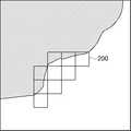
도 2는 본 발명의 일 실시예에 따른 지오펜싱 서비스 시스템에서 하나 이상의 격자로 영역을 구성하는 예를 설명하기 위한 예시도
도 3은 도 2의 예시도에 도시된 격자 중 하나를 확대하여 도시한 부분 확대도
도 4는 본 발명의 일 실시예에 따른 지오펜싱 서비스 시스템에서 각 영역의 격자 크기를 다르게 설정한 예를 설명하기 위한 예시도
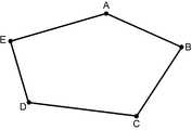
도 5 및 도 6은 본 발명의 일 실시예에 따른 지오펜싱 서비스 시스템에서 폴리곤 형태의 영역을 격자로 변환하는 예를 설명하기 위한 예시도
도 7은 본 발명의 일 실시에에 따른 지오펜싱 서비스 방법을 설명하기 위한 흐름도1 is a block diagram for explaining a geofencing service system according to an embodiment of the present invention
2 is an exemplary view for explaining an example of configuring an area with one or more grids in a geofencing service system according to an embodiment of the present invention
3 is a partially enlarged view showing an enlarged view of one of the gratings shown in the exemplary view of FIG. 2
4 is an exemplary view for explaining an example in which the grid size of each area is set differently in a geofencing service system according to an embodiment of the present invention
5 and 6 are exemplary diagrams for explaining an example of converting a polygonal area into a grid in a geofencing service system according to an embodiment of the present invention
7 is a flowchart illustrating a geofencing service method according to an embodiment of the present invention
이하, 도면을 참조하여 본 발명의 구체적인 실시형태를 설명하기로 한다. 이하의 상세한 설명은 본 명세서에서 기술된 방법, 장치 및/또는 시스템에 대한 포괄적인 이해를 돕기 위해 제공된다. 그러나 이는 예시에 불과하며 본 발명은 이에 제한되지 않는다.Hereinafter, a specific embodiment of the present invention will be described with reference to the drawings. The following detailed description is provided to aid in a comprehensive understanding of the methods, devices, and/or systems described herein. However, this is only an example and the present invention is not limited thereto.
본 발명의 실시예들을 설명함에 있어서, 본 발명과 관련된 공지기술에 대한 구체적인 설명이 본 발명의 요지를 불필요하게 흐릴 수 있다고 판단되는 경우에는 그 상세한 설명을 생략하기로 한다. 그리고, 후술되는 용어들은 본 발명에서의 기능을 고려하여 정의된 용어들로서 이는 사용자, 운용자의 의도 또는 관례 등에 따라 달라질 수 있다. 그러므로 그 정의는 본 명세서 전반에 걸친 내용을 토대로 내려져야 할 것이다. 상세한 설명에서 사용되는 용어는 단지 본 발명의 실시예들을 기술하기 위한 것이며, 결코 제한적이어서는 안 된다. 명확하게 달리 사용되지 않는 한, 단수 형태의 표현은 복수 형태의 의미를 포함한다. 본 설명에서, "포함" 또는 "구비"와 같은 표현은 어떤 특성들, 숫자들, 단계들, 동작들, 요소들, 이들의 일부 또는 조합을 가리키기 위한 것이며, 기술된 것 이외에 하나 또는 그 이상의 다른 특성, 숫자, 단계, 동작, 요소, 이들의 일부 또는 조합의 존재 또는 가능성을 배제하도록 해석되어서는 안 된다.In describing the embodiments of the present invention, when it is determined that a detailed description of a known technology related to the present invention may unnecessarily obscure the subject matter of the present invention, a detailed description thereof will be omitted. In addition, terms to be described later are terms defined in consideration of functions in the present invention and may vary according to the intention or custom of users or operators. Therefore, the definition should be made based on the contents throughout this specification. The terms used in the detailed description are only for describing embodiments of the present invention, and should not be limiting. Unless explicitly used otherwise, expressions in the singular form include the meaning of the plural form. In this description, expressions such as "comprising" or "feature" are intended to refer to certain features, numbers, steps, actions, elements, some or combination thereof, and one or more other than those described. It should not be construed to exclude the presence or possibility of other features, numbers, steps, actions, elements, any part or combination thereof.
도 1은 본 발명의 일 실시예에 따른 지오펜싱 서비스 시스템(100)을 설명하기 위한 블록도이다. 본 발명의 일 실시예에 따른 지오펜싱 서비스 시스템(100)은 이동체의 위치 좌표를 포함하는 질의를 수신하고, 수신된 위치 좌표가 특정 영역 내인지의 여부를 판단하여 이를 회신하기 위한 컴퓨터 장치를 의미한다. 도 1에 도시된 바와 같이, 본 발명의 일 실시예에 따른 지오펜싱 서비스 시스템(100)은 저장부(102) 및 판단부(104)를 포함하며, 필요에 따라 변환부(106)를 더 포함할 수 있다.1 is a block diagram illustrating a
저장부(102)는 하나 이상의 영역 정보를 저장 및 관리한다. 본 발명의 일 실시예에서, 상기 영역 정보는 각각 하나 이상의 격자(grid)로 구성된다. 도 2는 본 발명의 일 실시예에 따라 하나 이상의 격자로 구성되는 영역을 설명하기 위한 예시도이다. 도 2의 예시도는 지도상에서 바다에 인접한 소정 영역에 9개의 격자로 영역을 구성한 예를 나타낸 것이다. 도시된 바와 같이, 영역을 구성하는 각각의 격자는 모두 동일한 크기를 가지며 서로 겹치지 않도록 구성된다.The
도 3은 도 2의 예시도에 도시된 격자 중 하나(200)를 확대하여 도시한 것이다. 본 발명의 실시예에서, 영역을 구성하는 각 격자는 해당 영역 내의 좌표에서 기 설정된 유효 자릿수 미만을 절삭한 유효 좌표가 동일한 점들의 집합으로 구성될 수 있다. 예를 들어, 각 격자의 위치 좌표가 위도, 경도에 따라 결정되고, 위치 좌표의 유효 자릿수가 소수점 이하 3번째 자리일 경우(즉, 소수점 4번째 자리부터는 유효하지 않음)를 가정하자. 이 경우 위도 127.7480 내지 127.7489의 유효 위도는 모두 127.748이 되며, 경도 32.3210 내지 32.3219의 유효 경도는 모두 32.321이 된다. 다시 말해, 위도 127.7480 내지 127.7489, 경도 32.3210 내지 32.3219가 하나의 격자를 구성하게 된다.3 is an enlarged view of one 200 of the gratings shown in the exemplary view of FIG. 2. In an embodiment of the present invention, each grid constituting an area may be composed of a set of points having the same effective coordinates obtained by cutting less than a preset number of significant digits from the coordinates within the corresponding area. For example, assume that the position coordinates of each grid are determined according to latitude and longitude, and the number of significant digits of the position coordinates is the third decimal place (that is, it is not valid from the fourth decimal place). In this case, the effective latitudes of the latitudes 127.7480 to 127.7489 are all 127.748, and the effective longitudes of the longitudes 32.3210 to 32.3219 are all 32.321. In other words, latitudes 127.7480 to 127.7489 and longitudes 32.3210 to 32.3219 constitute one grid.
이와 같이 구성될 경우, 영역을 구성하는 각 격자의 크기는 위치 좌표의 유효 자릿수에 따라 결정된다. 전술한 예와 같이 위치 좌표의 유효 자릿수가 소수점 이하 3번째 자리일 경우, 각 격자의 크기는 0.001x0.001의 직사각형 모양이 된다.In this configuration, the size of each grid constituting the region is determined according to the number of significant digits of the position coordinates. As in the above-described example, when the number of significant digits of the position coordinate is the third digit after the decimal point, the size of each grid becomes a rectangular shape of 0.001x0.001.
한편, 도 3의 확대도에서는 2차원 형태의 격자만을 예시하여 설명하였으나, 본 발명의 실시예들은 이에 한정되는 것은 아니다. 몇몇 실시예들에서, 영역은 2차원 평면이 아닌 3차원 공간으로 구성될 수 있다. 예를 들어, 위도, 경도 및 고도를 포함하는 3개의 좌표로 영역을 구성하고, 해당 영역을 복수 개의 직육면체로 분할함으로써 복수 개의 격자(3차원 격자)를 구성할 수 있다. 이하의 설명에서는 주로 2차원 형태의 영역 및 격자를 기준으로 본 발명의 실시예들을 기술하였으나, 개시되는 실시예들은 본 발명의 기술적 사상을 변경함이 없이 3차원 형태의 영역 및 격자에도 그대로 적용되는 것으로 이해되어야 한다.Meanwhile, in the enlarged view of FIG. 3, only a two-dimensional grid has been described, but embodiments of the present invention are not limited thereto. In some embodiments, the region may consist of a three-dimensional space rather than a two-dimensional plane. For example, a plurality of grids (three-dimensional grids) may be formed by configuring a region with three coordinates including latitude, longitude and altitude, and dividing the region into a plurality of rectangular parallelepipeds. In the following description, embodiments of the present invention are mainly described based on a two-dimensional region and a grid, but the disclosed embodiments are applied to a three-dimensional region and a grid without changing the technical idea of the present invention. It should be understood as.
일 실시예에서, 저장부(102)에서 저장되는 영역 정보는 영역을 구성하는 하나 이상의 격자 각각의 기준 위치 및 각 격자의 크기 정보로 구성될 수 있다. 이때, 상기 기준 위치는, 하나 이상의 격자 각각에 포함된 점들의 유효 좌표에 따라 결정될 수 있다. 예를 들어, 도 3에 도시된 격자(200)의 경우 유효 좌표는 (32.321, 127.748)이 된다.In one embodiment, the region information stored in the
한편, 본 발명의 실시예에서 각 영역 별 격자 사이즈는 각각 다르게 설정할 수도 있다. 예를 들어, 상대적으로 높은 수준의 정밀성이 요구되는 경우에는 유효 자릿수의 범위를 넓혀서 격자의 사이즈를 줄이고, 상대적으로 낮은 수준의 정밀성만이 필요한 경우에는 유효 자릿수의 범위를 좁혀서 격자의 사이즈를 넓힐 수 있다. 도 4는 이를 예시하기 위한 것으로서, 식별번호 400으로 표시된 영역의 경우 402로 표시된 영역과 비교하여 격자 사이즈가 상대적으로 작은 것을 알 수 있다.Meanwhile, in an embodiment of the present invention, the grid size for each area may be set differently. For example, if a relatively high level of precision is required, the size of the grid can be reduced by expanding the range of significant digits, and if only a relatively low level of precision is required, the size of the grid can be increased by narrowing the range of significant digits. have. FIG. 4 is for illustrating this, and it can be seen that in the case of the area indicated by the
다음으로, 판단부(104)는 이동체의 위치 좌표를 수신하고, 상기 영역 정보를 참조하여 상기 이동체가 상기 영역 내에 존재하는지의 여부를 판단한다. 본 발명의 실시예에서, 이동체는 차량, 선박, 항공기, 헬리콥터, 드론 등 일반적으로 여객 또는 화물 운송 등의 용도로 사용되는 모든 종류의 유인/무인 이동 수단 뿐만 아니라, GPS가 포함된 스마트폰, 또는 웨어러블 디바이스 등의 위치 추적 장치를 소지한 상태로 이동하는 보행자, 동물 등을 모두 포함하는 개념으로 사용된다.Next, the
구체적으로, 판단부(104)는 상기 이동체의 위치 좌표에서 상기 유효 자릿수 미만을 절삭하여 질의 좌표를 생성하고, 상기 하나 이상의 격자 각각의 기준 좌표 중 상기 질의 좌표와 동일한 좌표가 존재하는 경우, 상기 이동체가 상기 영역 내에 존재하는 것으로 판단할 수 있다.Specifically, the
예를 들어, 특정 이동체로부터 수신한 위치 좌표가 (32.3217, 127.7483)이라고 가정하자. 전술한 예에서와 같이 유효 자릿수가 소수점 이하 3번째 자리일 경우, 상기 위치 좌표로부터 생성되는 질의 좌표는 (32.321, 127.748)이 된다. 즉, 상기 위치 좌표는 도 3에 도시된 격자(200)의 기준 좌표와 동일하므로, 판단부(104)는 해당 위치 좌표가 격자(200)의 내부에 있는 것으로 판단할 수 있다.For example, assume that the location coordinates received from a specific mobile object are (32.3217, 127.7483). As in the above example, when the number of significant digits is 3 digits after the decimal point, the query coordinates generated from the position coordinates are (32.321, 127.748). That is, since the position coordinates are the same as the reference coordinates of the
종래의 지오펜싱 시스템은 영역을 다각형(polygon)의 형태로 구성하며, 이에 따라 다각형의 꼭짓점(vertex) 정보를 색인 정보로 저장하게 된다. 이와 같은 방식의 경우 특정 좌표가 해당 다각형의 내부에 존재하는지에 대한 질의가 수신되는 경우, 해당 좌표와 다각형과의 관계에 대한 복잡한 함수 계산이 필요하다. 이에 비해, 본 발명의 실시예들에 따른 지오펜싱 서비스 시스템(100)은 영역을 복수 개의 격자로 변환하고, 각 격자의 기준 좌표 정보를 색인 정보로 저장하도록 구성된다. 따라서 본 발명의 실시예들에 따를 경우 복잡한 다각형 함수 계산 없이 수신되는 좌표를 기 저장된 기준 좌표와 비교하는 것 만으로 해당 좌표가 어느 영역에 속하는지의 여부를 알 수 있는 바, 종래의 방식에 비해 계산량을 현저히 줄일 수 있게 된다.In the conventional geofencing system, an area is configured in a polygonal shape, and accordingly, vertex information of a polygon is stored as index information. In the case of this method, when a query about whether a specific coordinate exists inside the polygon is received, a complex function calculation for the relationship between the coordinate and the polygon is required. In contrast, the
한편, 본 발명의 일 실시예에 따른 지오펜싱 서비스 시스템(100)은 폴리곤(polygon) 기반 영역을 상기 하나 이상의 격자로 변환하는 변환부(106)를 더 포함할 수 있다. 일 실시예에서, 변환부(106)는 상기 유효 자릿수로부터 계산되는 각 격자의 크기 및 상기 폴리곤 기반 영역 내부의 좌표를 참조하여, 상기 폴리곤 기반 영역을 모두 포함하도록 하나 이상의 격자를 선택함으로서 폴리곤 기반 영역을 하나 이상의 격자로 변환할 수 있다.Meanwhile, the
도 5 및 도 6은 본 발명의 일 실시예에 따른 지오펜싱 서비스 시스템(100)에서 폴리곤 형태의 영역을 격자로 변환하는 예를 설명하기 위한 예시도이다. 예를 들어, 도 5와 같이 점 A, B, C, D, E로 구성되는 5각형 영역이 존재하는 경우, 변환부는 도 6과 같이 해당 5각형 영역을 온전히 포함하도록 해당 영역을 기 설정된 크기의 격자의 집합으로 변환하게 된다.5 and 6 are exemplary views for explaining an example of converting a polygonal area into a grid in the
일 실시예에서, 저장부(102), 판단부(104) 및 변환부(106)는 하나 이상의 프로세서 및 그 프로세서와 연결된 컴퓨터 판독 가능 기록 매체를 포함하는 컴퓨팅 장치 상에서 구현될 수 있다. 컴퓨터 판독 가능 기록 매체는 프로세서의 내부 또는 외부에 있을 수 있고, 잘 알려진 다양한 수단으로 프로세서와 연결될 수 있다. 컴퓨팅 장치 내의 프로세서는 각 컴퓨팅 장치로 하여금 본 명세서에서 기술되는 예시적인 실시예에 따라 동작하도록 할 수 있다. 예를 들어, 프로세서는 컴퓨터 판독 가능 기록 매체에 저장된 명령어를 실행할 수 있고, 컴퓨터 판독 가능 기록 매체에 저장된 명령어는 프로세서에 의해 실행되는 경우 컴퓨팅 장치로 하여금 본 명세서에 기술되는 예시적인 실시예에 따른 동작들을 수행하도록 구성될 수 있다.In one embodiment, the
도 7은 본 발명의 일 실시예에 따른 지오펜싱 서비스 방법(700)을 설명하기 위한 흐름도이다. 도 7에 도시된 방법은 예를 들어, 전술한 지오펜싱 서비스 시스템(100)에 의해 수행될 수 있다. 도시된 흐름도에서는 상기 방법을 복수 개의 단계로 나누어 기재하였으나, 적어도 일부의 단계들은 순서를 바꾸어 수행되거나, 다른 단계와 결합되어 함께 수행되거나, 생략되거나, 세부 단계들로 나뉘어 수행되거나, 또는 도시되지 않은 하나 이상의 단계가 부가되어 수행될 수 있다.7 is a flowchart illustrating a
단계 702에서, 지오펜싱 서비스 시스템(100)의 판단부(104)는 이동체의 위치 좌표를 수신한다.In
단계 704에서, 판단부(104)는 저장부(102)에 저장된 영역 정보를 참조하여, 상기 이동체의 위치가 상기 영역을 구성하는 하나 이상의 격자(grid) 중 어느 하나와 대응되는지의 여부를 판단한다.In
전술한 바와 같이, 상기 격자는 상기 영역 내의 좌표에서 기 설정된 유효 자릿수 미만을 절삭한 유효 좌표가 동일한 점들의 집합으로 구성될 수 있다. 또한, 상기 영역 정보는, 상기 하나 이상의 격자 각각의 기준 위치 및 상기 유효 자릿수 정보를 포함할 수 있다.As described above, the grid may consist of a set of points having the same effective coordinates obtained by cutting less than a preset number of significant digits from the coordinates within the area. In addition, the region information may include information on a reference position and the number of significant digits of each of the one or more grids.
이에 따라, 판단부(104)는 상기 이동체의 위치 좌표에서 상기 유효 자릿수 미만을 절삭하여 질의 좌표를 생성하고, 상기 하나 이상의 격자 각각의 기준 좌표 중 상기 질의 좌표와 동일한 좌표가 존재하는 경우, 상기 이동체가 상기 영역 내에 존재하는 것으로 판단할 수 있다.Accordingly, the
단계 706에서, 판단부(104)는 상기 704 단계의 판단 결과를 회신한다.In
한편, 본 발명의 실시예는 본 명세서에서 기술한 방법들을 컴퓨터상에서 수행하기 위한 프로그램, 및 상기 프로그램을 포함하는 컴퓨터 판독 가능 기록매체를 포함할 수 있다. 상기 컴퓨터 판독 가능 기록매체는 프로그램 명령, 로컬 데이터 파일, 로컬 데이터 구조 등을 단독으로 또는 조합하여 포함할 수 있다. 상기 매체는 본 발명을 위하여 특별히 설계되고 구성된 것들이거나, 또는 컴퓨터 소프트웨어 분야에서 통상적으로 사용 가능한 것일 수 있다. 컴퓨터 판독 가능 기록매체의 예에는 하드 디스크, 플로피 디스크 및 자기 테이프와 같은 자기 매체, CD-ROM, DVD와 같은 광 기록 매체, 및 롬, 램, 플래시 메모리 등과 같은 프로그램 명령을 저장하고 수행하도록 특별히 구성된 하드웨어 장치가 포함된다. 상기 프로그램의 예에는 컴파일러에 의해 만들어지는 것과 같은 기계어 코드뿐만 아니라 인터프리터 등을 사용해서 컴퓨터에 의해서 실행될 수 있는 고급 언어 코드를 포함할 수 있다.Meanwhile, an embodiment of the present invention may include a program for performing the methods described in the present specification on a computer, and a computer-readable recording medium including the program. The computer-readable recording medium may include a program command, a local data file, a local data structure, or the like alone or in combination. The medium may be specially designed and configured for the present invention, or may be commonly used in the field of computer software. Examples of computer-readable recording media include magnetic media such as hard disks, floppy disks and magnetic tapes, optical recording media such as CD-ROMs and DVDs, and specially configured to store and execute program instructions such as ROM, RAM, and flash memory. Hardware devices are included. Examples of the program may include not only machine language codes created by a compiler, but also high-level language codes that can be executed by a computer using an interpreter or the like.
이상에서 본 발명의 대표적인 실시예들을 상세하게 설명하였으나, 본 발명이 속하는 기술분야에서 통상의 지식을 가진 자는 상술한 실시예에 대하여 본 발명의 범주에서 벗어나지 않는 한도 내에서 다양한 변형이 가능함을 이해할 것이다. 그러므로 본 발명의 권리범위는 설명된 실시예에 국한되어 정해져서는 안 되며, 후술하는 특허청구범위뿐만 아니라 이 특허청구범위와 균등한 것들에 의해 정해져야 한다.Although the exemplary embodiments of the present invention have been described in detail above, those of ordinary skill in the art to which the present invention pertains will understand that various modifications may be made to the above-described embodiments without departing from the scope of the present invention. . Therefore, the scope of the present invention is limited to the described embodiments and should not be determined, and should not be determined by the claims to be described later, but also by those equivalents to the claims.
100: 그리드 기반 지오펜싱 서비스 시스템
102: 저장부
104: 판단부
106: 변환부
200: 격자100: grid-based geofencing service system
102: storage unit
104: judgment unit
106: conversion unit
200: grid
Claims (15)
Translated fromKorean이동체의 위치 좌표를 수신하고, 상기 영역 정보를 참조하여 상기 이동체가 상기 영역 내에 존재하는지의 여부를 판단하는 판단부를 포함하고,
상기 하나 이상의 격자 각각은 상기 영역 내의 좌표에서 기 설정된 유효 자릿수 미만을 절삭한 유효 좌표가 동일한 점들의 집합으로 구성되는, 그리드 기반 지오펜싱 서비스 시스템.
A storage unit for storing area information composed of one or more grids; And
A determination unit that receives the position coordinates of the moving object and determines whether the moving object exists in the area by referring to the area information,
Each of the one or more grids comprises a set of points having the same effective coordinates obtained by cutting less than a preset number of significant digits from the coordinates within the area.
상기 영역 정보는, 상기 하나 이상의 격자 각각의 기준 위치 및 상기 유효 자릿수 정보를 포함하는, 그리드 기반 지오펜싱 서비스 시스템.
The method according to claim 1,
The area information includes information on a reference position and the number of effective digits of each of the one or more grids.
상기 기준 위치는, 상기 하나 이상의 격자 각각에 포함된 점들의 유효 좌표에 따라 결정되는, 그리드 기반 지오펜싱 서비스 시스템.
The method of claim 3,
The reference position is determined according to effective coordinates of points included in each of the one or more grids, a grid-based geofencing service system.
상기 판단부는, 상기 이동체의 위치 좌표에서 상기 유효 자릿수 미만을 절삭하여 질의 좌표를 생성하고,
상기 하나 이상의 격자 각각의 기준 좌표 중 상기 질의 좌표와 동일한 좌표가 존재하는 경우, 상기 이동체가 상기 영역 내에 존재하는 것으로 판단하는, 그리드 기반 지오펜싱 서비스 시스템.
The method of claim 4,
The determination unit generates query coordinates by cutting less than the number of significant digits from the location coordinates of the moving object,
When the same coordinates as the query coordinates exist among the reference coordinates of each of the one or more grids, it is determined that the moving object exists in the area.
폴리곤(polygon) 기반 영역을 상기 하나 이상의 격자로 변환하는 변환부를 더 포함하는, 그리드 기반 지오펜싱 서비스 시스템.
The method according to claim 1,
A grid-based geofencing service system further comprising a conversion unit for converting a polygon-based region into the one or more grids.
상기 변환부는, 상기 유효 자릿수로부터 계산되는 각 격자의 크기 및 상기 폴리곤 기반 영역 내부의 좌표를 참조하여, 상기 폴리곤 기반 영역을 모두 포함하도록 하나 이상의 격자를 선택하는, 그리드 기반 지오펜싱 서비스 시스템.
The method of claim 6,
The conversion unit, by referring to the size of each grid calculated from the number of effective digits and coordinates inside the polygon-based region, to select one or more grids to include all of the polygon-based region, grid-based geofencing service system.
이동체의 위치 좌표를 수신하는 단계;
하나 이상의 격자(grid)로 구성되는 영역 정보를 참조하여, 상기 이동체가 상기 영역 내에 존재하는지의 여부를 판단하는 단계를 포함하고,
상기 하나 이상의 격자 각각은, 상기 영역 내의 좌표에서 기 설정된 유효 자릿수 미만을 절삭한 유효 좌표가 동일한 점들의 집합으로 구성되는, 지오펜싱 서비스 방법.
As a geofencing service method in a grid-based geofencing service system,
Receiving position coordinates of the moving object;
A step of determining whether or not the moving object is present in the area by referring to area information composed of one or more grids,
Each of the one or more grids comprises a set of points having the same effective coordinates obtained by cutting less than a preset number of significant digits from the coordinates within the area.
상기 영역 정보는, 상기 하나 이상의 격자 각각의 기준 위치 및 상기 유효 자릿수 정보를 포함하는, 지오펜싱 서비스 방법.
The method of claim 8,
The area information includes information on a reference position and the number of effective digits of each of the one or more grids.
상기 기준 위치는, 상기 하나 이상의 격자 각각에 포함된 점들의 상기 유효 좌표에 따라 결정되는, 지오펜싱 서비스 방법.
The method of claim 10,
The reference position is determined according to the effective coordinates of points included in each of the one or more grids.
상기 판단하는 단계는,
상기 이동체의 위치 좌표에서 상기 유효 자릿수 미만을 절삭하여 질의 좌표를 생성하고, 상기 하나 이상의 격자 각각의 기준 좌표 중 상기 질의 좌표와 동일한 좌표가 존재하는 경우, 상기 이동체가 상기 영역 내에 존재하는 것으로 판단하는, 지오펜싱 서비스 방법.
The method of claim 11,
The determining step,
Generate query coordinates by cutting less than the number of significant digits from the location coordinates of the moving object, and if the same coordinates as the query coordinates exist among the reference coordinates of each of the one or more grids, determining that the moving object exists in the area , Geo-fencing service method.
상기 위치 좌표를 수신하는 단계의 수행 전,
폴리곤(polygon) 기반 영역을 상기 하나 이상의 격자로 변환하는 단계를 더 포함하는, 지오펜싱 서비스 방법.
The method of claim 8,
Before performing the step of receiving the location coordinates,
The geofencing service method further comprising converting the polygon-based region into the one or more grids.
상기 변환하는 단계는, 상기 유효 자릿수로부터 계산되는 각 격자의 크기 및 상기 폴리곤 기반 영역 내부의 좌표를 참조하여, 상기 폴리곤 기반 영역을 모두 포함하도록 하나 이상의 격자를 선택하도록 구성되는, 지오펜싱 서비스 방법.
The method of claim 13,
The transforming step is configured to select one or more grids to include all of the polygon-based regions by referring to the size of each grid calculated from the number of significant digits and coordinates inside the polygon-based region.
이동체의 위치 좌표를 수신하는 단계; 및
하나 이상의 격자(grid)로 구성되는 영역 정보를 참조하여, 상기 이동체가 상기 영역 내에 존재하는지의 여부를 판단하되, 상기 하나 이상의 격자 각각은, 상기 영역 내의 좌표에서 기 설정된 유효 자릿수 미만을 절삭한 유효 좌표가 동일한 점들의 집합으로 구성되는 단계를 포함하는 단계들을 실행시키기 위하여 기록매체에 저장된 컴퓨터 프로그램.
Combined with the hardware,
Receiving position coordinates of the moving object; And
It is determined whether or not the moving object exists in the area by referring to area information composed of one or more grids, but each of the at least one grid is effective by cutting less than a preset number of effective digits from the coordinates within the area. A computer program stored on a recording medium to perform steps including the step of configuring a set of points having the same coordinates.
Priority Applications (3)
| Application Number | Priority Date | Filing Date | Title |
|---|---|---|---|
| KR1020150090396AKR102211292B1 (en) | 2015-06-25 | 2015-06-25 | System and method for grid-based geofencing service |
| US15/159,951US10257644B2 (en) | 2015-06-25 | 2016-05-20 | System and method for grid-based geo-fencing service |
| CN201610465891.7ACN106303950B (en) | 2015-06-25 | 2016-06-23 | Grid-based geofencing service system and method |
Applications Claiming Priority (1)
| Application Number | Priority Date | Filing Date | Title |
|---|---|---|---|
| KR1020150090396AKR102211292B1 (en) | 2015-06-25 | 2015-06-25 | System and method for grid-based geofencing service |
Publications (2)
| Publication Number | Publication Date |
|---|---|
| KR20170001038A KR20170001038A (en) | 2017-01-04 |
| KR102211292B1true KR102211292B1 (en) | 2021-02-02 |
Family
ID=57601130
Family Applications (1)
| Application Number | Title | Priority Date | Filing Date |
|---|---|---|---|
| KR1020150090396AActiveKR102211292B1 (en) | 2015-06-25 | 2015-06-25 | System and method for grid-based geofencing service |
Country Status (3)
| Country | Link |
|---|---|
| US (1) | US10257644B2 (en) |
| KR (1) | KR102211292B1 (en) |
| CN (1) | CN106303950B (en) |
Cited By (1)
| Publication number | Priority date | Publication date | Assignee | Title |
|---|---|---|---|---|
| KR102434485B1 (en)* | 2021-03-09 | 2022-08-22 | 주식회사 로지스텍 | Apparatus and method for measuring destination entry/exit state of vihicles using gps and geo-fence |
Families Citing this family (12)
| Publication number | Priority date | Publication date | Assignee | Title |
|---|---|---|---|---|
| CN107402955B (en)* | 2017-06-02 | 2020-04-14 | 阿里巴巴集团控股有限公司 | Method and apparatus for determining an index grid for a geofence |
| US10231085B1 (en) | 2017-09-30 | 2019-03-12 | Oracle International Corporation | Scaling out moving objects for geo-fence proximity determination |
| CN108388621A (en)* | 2018-02-11 | 2018-08-10 | 北京旋极伏羲大数据技术有限公司 | Fence method and device |
| CN110246202A (en)* | 2018-03-07 | 2019-09-17 | 苏州猫耳网络科技有限公司 | A kind of grid drawing method based on map area boundary GPS coordinate |
| RU2762785C1 (en)* | 2018-06-06 | 2021-12-22 | Бейджин Диди Инфинити Текнолоджи Энд Девелопмент Ко., Лтд. | System for identifying grids of a geographical area on the map |
| CN111246376B (en)* | 2018-11-28 | 2021-11-16 | 北京嘀嘀无限科技发展有限公司 | System and method for determining whether a target belongs to a target geofence |
| CN110376625A (en)* | 2019-07-29 | 2019-10-25 | 北京新海汇仓储有限公司 | For warehousing system method for rapidly positioning |
| US12014065B2 (en) | 2020-02-11 | 2024-06-18 | Pure Storage, Inc. | Multi-cloud orchestration as-a-service |
| CN113256691A (en)* | 2021-05-11 | 2021-08-13 | 广州织点智能科技有限公司 | Target tracking method, device, equipment and storage medium |
| CN113377094A (en)* | 2021-08-12 | 2021-09-10 | 浙江华睿科技股份有限公司 | Reference point searching method and device for AGV map, electronic equipment and storage medium |
| CN114282617B (en)* | 2021-12-27 | 2025-06-10 | 阿里巴巴创新公司 | Model training and travel scheduling method, electronic device and computer storage medium |
| CN115311840B (en)* | 2022-10-12 | 2023-01-20 | 深圳海星智驾科技有限公司 | Vehicle early warning method and device of electronic fence, electronic equipment and storage medium |
Citations (2)
| Publication number | Priority date | Publication date | Assignee | Title |
|---|---|---|---|---|
| JP2012203408A (en)* | 2011-03-28 | 2012-10-22 | Hisashi Endo | Latitude/longitude coordinate transformation method and positional information code therefor |
| CN104636482A (en)* | 2015-02-16 | 2015-05-20 | 百度在线网络技术(北京)有限公司 | Target address determining method and device |
Family Cites Families (5)
| Publication number | Priority date | Publication date | Assignee | Title |
|---|---|---|---|---|
| US8203451B2 (en) | 2007-09-24 | 2012-06-19 | Savi Technology, Inc. | Method and apparatus for tracking and monitoring containers |
| CN102158530B (en)* | 2011-01-27 | 2014-10-22 | 深圳市美赛达科技股份有限公司 | Method for communicating with GPS (Global Positioning System) terminal in designated area and server |
| US8626187B2 (en)* | 2011-06-03 | 2014-01-07 | Apple Inc. | Monitoring geofence exit |
| CN103888895B (en)* | 2012-12-20 | 2018-12-18 | 腾讯科技(深圳)有限公司 | information processing method, server apparatus and mobile terminal |
| US9497590B1 (en)* | 2015-06-19 | 2016-11-15 | International Business Machines Corporation | Management of moving objects |
- 2015
- 2015-06-25KRKR1020150090396Apatent/KR102211292B1/enactiveActive
- 2016
- 2016-05-20USUS15/159,951patent/US10257644B2/enactiveActive
- 2016-06-23CNCN201610465891.7Apatent/CN106303950B/enactiveActive
Patent Citations (2)
| Publication number | Priority date | Publication date | Assignee | Title |
|---|---|---|---|---|
| JP2012203408A (en)* | 2011-03-28 | 2012-10-22 | Hisashi Endo | Latitude/longitude coordinate transformation method and positional information code therefor |
| CN104636482A (en)* | 2015-02-16 | 2015-05-20 | 百度在线网络技术(北京)有限公司 | Target address determining method and device |
Cited By (1)
| Publication number | Priority date | Publication date | Assignee | Title |
|---|---|---|---|---|
| KR102434485B1 (en)* | 2021-03-09 | 2022-08-22 | 주식회사 로지스텍 | Apparatus and method for measuring destination entry/exit state of vihicles using gps and geo-fence |
Also Published As
| Publication number | Publication date |
|---|---|
| KR20170001038A (en) | 2017-01-04 |
| US10257644B2 (en) | 2019-04-09 |
| CN106303950A (en) | 2017-01-04 |
| CN106303950B (en) | 2020-09-04 |
| US20160377438A1 (en) | 2016-12-29 |
Similar Documents
| Publication | Publication Date | Title |
|---|---|---|
| KR102211292B1 (en) | System and method for grid-based geofencing service | |
| US10467914B2 (en) | Methods and systems for autonomous generation of shortest lateral paths for unmanned aerial systems | |
| US10466058B2 (en) | Navigation for vehicles | |
| EP3690705B1 (en) | Method and device for generating deceivable composite image by using gan including generating neural network and discriminating neural network to allow surveillance system to recognize surroundings and detect rare event more accurately | |
| US11322031B2 (en) | Method of optimized path planning for UAVs for the purpose of ground coverage | |
| US20210110136A1 (en) | Fire detection via remote sensing and mobile sensors | |
| KR102357355B1 (en) | Method and apparatus for generating virtual object | |
| JP2019512668A (en) | Root deviation recognition method, terminal, and storage medium | |
| US10402675B2 (en) | 2D vehicle localizing using geoarcs | |
| CN104041133A (en) | Finding wireless network access points | |
| US10013798B2 (en) | 3D vehicle localizing using geoarcs | |
| US20150199383A1 (en) | Systems and Methods for Indexing and Retrieving Images | |
| KR101965296B1 (en) | Method and Apparatus for Estimating Location of a Moving Object and Generating Maps Sharing a Map between Particles | |
| KR102105105B1 (en) | Method of aiding driving and apparatuses performing the same | |
| Wu et al. | A non-rigid hierarchical discrete grid structure and its application to UAVs conflict detection and path planning | |
| JP2019039875A (en) | Flying route setting device, flying route setting method and program | |
| US10659920B1 (en) | Efficient discovery of survivors in disaster area using robotics and mobile networks | |
| Boychev | Research algorithms to optimize the drone route used for security | |
| CN114241313A (en) | Method, apparatus, medium, and program product for extracting road boundary | |
| JP6243308B2 (en) | Identification device and identification method | |
| US20150127302A1 (en) | Method and apparatus for optimized routing | |
| CN114383621B (en) | Track deviation rectifying method based on grid map, electronic equipment and storage medium | |
| US8818712B2 (en) | Maritime path determination | |
| EP3672206B1 (en) | A method for determining a geofence parameter of a geofence area related to a point of interest and related electronic device | |
| US9888347B1 (en) | Resolving location criteria using user location data |
Legal Events
| Date | Code | Title | Description |
|---|---|---|---|
| PA0109 | Patent application | Patent event code:PA01091R01D Comment text:Patent Application Patent event date:20150625 | |
| PG1501 | Laying open of application | ||
| A201 | Request for examination | ||
| PA0201 | Request for examination | Patent event code:PA02012R01D Patent event date:20191224 Comment text:Request for Examination of Application Patent event code:PA02011R01I Patent event date:20150625 Comment text:Patent Application | |
| E902 | Notification of reason for refusal | ||
| PE0902 | Notice of grounds for rejection | Comment text:Notification of reason for refusal Patent event date:20201105 Patent event code:PE09021S01D | |
| E701 | Decision to grant or registration of patent right | ||
| PE0701 | Decision of registration | Patent event code:PE07011S01D Comment text:Decision to Grant Registration Patent event date:20210115 | |
| GRNT | Written decision to grant | ||
| PR0701 | Registration of establishment | Comment text:Registration of Establishment Patent event date:20210128 Patent event code:PR07011E01D | |
| PR1002 | Payment of registration fee | Payment date:20210128 End annual number:3 Start annual number:1 | |
| PG1601 | Publication of registration | ||
| PR1001 | Payment of annual fee | Payment date:20231218 Start annual number:4 End annual number:4 | |
| PR1001 | Payment of annual fee | Payment date:20241224 Start annual number:5 End annual number:5 |