KR101667875B1 - Automatic matching device and method of building polygon on a plurality of maps - Google Patents
Automatic matching device and method of building polygon on a plurality of mapsDownload PDFInfo
- Publication number
- KR101667875B1 KR101667875B1KR1020150045202AKR20150045202AKR101667875B1KR 101667875 B1KR101667875 B1KR 101667875B1KR 1020150045202 AKR1020150045202 AKR 1020150045202AKR 20150045202 AKR20150045202 AKR 20150045202AKR 101667875 B1KR101667875 B1KR 101667875B1
- Authority
- KR
- South Korea
- Prior art keywords
- building
- map
- polygon
- matching
- unit
- Prior art date
- Legal status (The legal status is an assumption and is not a legal conclusion. Google has not performed a legal analysis and makes no representation as to the accuracy of the status listed.)
- Active
Links
Images


Classifications
- G—PHYSICS
- G06—COMPUTING OR CALCULATING; COUNTING
- G06T—IMAGE DATA PROCESSING OR GENERATION, IN GENERAL
- G06T17/00—Three dimensional [3D] modelling, e.g. data description of 3D objects
- G06T17/05—Geographic models
- G—PHYSICS
- G06—COMPUTING OR CALCULATING; COUNTING
- G06T—IMAGE DATA PROCESSING OR GENERATION, IN GENERAL
- G06T17/00—Three dimensional [3D] modelling, e.g. data description of 3D objects
- G06T17/20—Finite element generation, e.g. wire-frame surface description, tesselation
- G—PHYSICS
- G09—EDUCATION; CRYPTOGRAPHY; DISPLAY; ADVERTISING; SEALS
- G09B—EDUCATIONAL OR DEMONSTRATION APPLIANCES; APPLIANCES FOR TEACHING, OR COMMUNICATING WITH, THE BLIND, DEAF OR MUTE; MODELS; PLANETARIA; GLOBES; MAPS; DIAGRAMS
- G09B29/00—Maps; Plans; Charts; Diagrams, e.g. route diagram
- G09B29/003—Maps
- G09B29/006—Representation of non-cartographic information on maps, e.g. population distribution, wind direction, radiation levels, air and sea routes
- G09B29/007—Representation of non-cartographic information on maps, e.g. population distribution, wind direction, radiation levels, air and sea routes using computer methods
Landscapes
- Engineering & Computer Science (AREA)
- Physics & Mathematics (AREA)
- Theoretical Computer Science (AREA)
- Software Systems (AREA)
- Geometry (AREA)
- General Physics & Mathematics (AREA)
- Computer Graphics (AREA)
- Ecology (AREA)
- Business, Economics & Management (AREA)
- Educational Administration (AREA)
- Educational Technology (AREA)
- Mathematical Physics (AREA)
- Life Sciences & Earth Sciences (AREA)
- General Engineering & Computer Science (AREA)
- Computer Hardware Design (AREA)
- Remote Sensing (AREA)
- Instructional Devices (AREA)
- Processing Or Creating Images (AREA)
- Image Analysis (AREA)
Abstract
Translated fromKoreanDescription
Translated fromKorean본 발명은 복수개의 지도 상에서의 건물 폴리곤 자동정합 장치 및 방법에 관한 것으로, 더욱 상세하게는 제 1지도와 제 2지도 상에서의 건물 폴리곤의 기하학적 불일치를 보정하고, 크기 또는 형상 등이 변경되지 않은 건물과 변경이 된 건물을 자동으로 탐색하여 복수개의 지도 상에서 건물을 자동으로 탐색하기 위한 장치 및 방법에 관한 것이다.
More particularly, the present invention relates to an apparatus and method for automatically matching building polygons on a plurality of maps, and more particularly, to a method and apparatus for automatically correcting geometric inconsistencies of building polygons on a first map and a second map, And a device and a method for automatically searching for buildings that have been changed and automatically searching for buildings on a plurality of maps.
여러 시스템에 분산적으로 구축되어 있던 건물정보를 연계하기 위한 다양한 연구가 진행되어 왔다. 특히 건축물 정보의 기본인 건축물대장이 속한 인터넷 건축행정정보시스템과 수치지도 관리시스템,한국토지정보시스템, 등기나 부동산 관련 시스템,도로명주소 관리시스템 등 서로 다른 건물관련 공간 정보 관리 시스템을 연계하기 방법이 연구되어왔다. 그러나 대표적인 공공분야 공간정보인 국토지리정보원의 수치지도 2.0과 안전행정부의 도로명주소지도의 통합과 연계에 관한 연구는 부족한 실정이다.Various studies have been conducted to link building information distributed in various systems. In particular, a method of linking different building related spatial information management systems, such as internet construction administrative information system, digital map management system, Korea land information system, registration and real estate related system, road name address management system, Has been studied. However, there is a lack of research on integrating and linking the numerical map 2.0 of the National Geographic Information Service, which is a representative public space information, and the road name address map of the security administration.
이에 따라, 도로명주소지도와 수치지형도의 매칭에 관한 유사 연구로 최소경계사각형 비교와 중첩 면적 분석을 통해 매칭하는 방법이 제시되었으나, 이러한 방법은 단순히 중첩 면적만을 이용해 매칭을 수행하므로, 두 지도 상의 건물 폴리곤의 형태적 차이를 고려하지 못하는 문제점이 있었다.Therefore, a similar method for matching the road name address map and the digital topographic map has been proposed by comparing the minimum bounding rectangle comparison and the overlap area analysis. However, since this method performs matching using only the overlapping area, There is a problem that the morphological difference of the polygon can not be considered.
또한, 두 지도 건물 객체의 형상 지수, 형상 방향, 중첩 면적비를 계산하고 다양한 가중조합 기법에 따른 매칭 정확도를 비교하는 방법이 제시되었으나, 객체의 세부적인 형태 특성을 고려하지 못한 대표값 형태의 형상 인자를 이용한다는 것과, 모든 대응 객체의 유사도와 가중 조합 유사도를 계산하여야 하며, 광범위한 지역의 임의 표집 데이터가 아닌 특정 실험 데이터에 대한 검증만이 완료되어 알고리즘의 강건성 측면에서도 추가 검증이 필요하다는 문제점이 있었다.
In addition, a method of calculating the shape index, shape direction, and overlap area ratio of two map building objects and comparing the matching accuracy according to various weighted combination techniques has been proposed. However, , And the similarity and weighted similarity of all corresponding objects must be calculated. Only the verification of specific experiment data is performed, not random sampling data in a wide area, and further verification is required in terms of the robustness of the algorithm .
본 발명은 상기와 같은 문제점을 해결하기 위하여 창안된 것으로, 제 1 지도와 제 2 지도 상에서의 건물 폴리곤의 기하학적 불일치를 보정하고, 크기 또는 형상 등이 변경되지 않은 건물과 변경이 된 건물을 자동으로 탐색하여 복수개의 지도 상에서 건물을 자동으로 탐색하는 데 그 목적이 있다.
SUMMARY OF THE INVENTION The present invention has been made to solve the above-mentioned problems, and it is an object of the present invention to provide a method and apparatus for correcting geometric inconsistency of a building polygon on a first map and a second map, And to automatically search buildings on a plurality of maps.
이와 같은 목적을 달성하기 위한 본 발명의 일 실시예에 따른 복수개의 지도 상에서의 건물 폴리곤 자동정합 장치는, 제 1지도와 제 2지도를 비교하는 비교부, 비교부의 비교결과에 기초하여, 제 1지도와 제 2지도로부터 대응블록을 추출하는 제 1추출부, 제 1추출부에 의하여 추출된 대응블록에 포함된 건물군에 대하여 기하학적 위치 오차를 보정하는 보정부, 보정부에 의하여 보정된 건물군의 위치에 기초하여, 제 1지도와 제 2지도간의 중첩 면적비를 결정하는 중첩도결정부, 중첩도결정부에 의하여 결정된 중첩 면적비에 기초하여, 보정된 건물군 중 매칭 건물과 비매칭 건물을 분류하는 제 1분류부, 제 1분류부의 분류결과에 기초하여, 제 1지도와 제 2지도로부터 오매칭(error-matching) 후보 건물군을 추출하는 제 2추출부, 제 2추출부에 의하여 추출된 오매칭 후보 건물군 내의 각각의 건물에 대하여 기하학적 위치 오차를 보정하고, 오매칭 후보 건물군에 대한 회전각 함수분석을 수행하는 분석부 및 분석부에 의한 회전각 함수분석 결과에 기초하여 오매칭 후보 건물군 내에서 매칭 건물과 비매칭 건물을 분류하는 제 2분류부를 포함할 수 있다.According to an aspect of the present invention, there is provided an automatic building polygon automatic matching apparatus on a plurality of maps, comprising: a comparison unit comparing a first map and a second map; A first extracting unit for extracting a corresponding block from a map and a second map, a correcting unit for correcting a geometrical position error with respect to a building group included in the corresponding block extracted by the first extracting unit, An overlapping degree determining unit for determining an overlapping area ratio between the first map and the second map on the basis of the position of the first map and the second map, A second extraction unit for extracting an error-matching candidate building group from the first map and the second map based on the classification result of the first classification unit and the first classification unit, Five Based on the results of the analysis of the rotation angle function by the analysis unit and the analysis unit for performing the correction of the geometric position error for each building in the candidate building group and for performing the analysis of the rotation angle function for the group of misciting candidate buildings, And a second classifier for classifying the matching buildings and the non-matching buildings in the group.
또한, 제 1지도는 도로명주소지도, 제 2지도는 수치지형도일 수 있다.Also, the first map may be a road name address map, and the second map may be a digital map.
또한, 비교부는 제 1지도의 전체 폴리곤과 도로 폴리곤 간의 차 연산을 통하여 획득된 적어도 하나의 제 1 블록 폴리곤과 제 2지도의 전체 폴리곤과 도로 폴리곤 간의 차 연산을 통하여 획득된 적어도 하나의 제 2 블록 폴리곤을 비교하고, 제 1추출부는 제 1 블록 폴리곤과 제 2 블록 폴리곤 간의 결정된 중첩 면적비에 기초하여 제 1지도의 제 1 블록 폴리곤에 상응하는 제2지도의 블록 폴리곤을 대응블록으로서 추출할 수 있다.Also, the comparison unit compares at least one first block polygon obtained through the difference calculation between the entire polygon of the first map and the road polygon, and at least one second block polygon obtained through the difference calculation between the entire polygon of the second map and the road polygon, The first extracting unit can extract the block polygon of the second map corresponding to the first block polygon of the first map as a corresponding block based on the determined overlap area ratio between the first block polygon and the second block polygon .
또한, 대응블록에 포함된 건물군과, 오매칭 후보 건물군 내의 각각의 건물에 대하여 기하학적 위치 오차를 보정하기 위해, ICP 알고리즘이 적용될 수 있다.Also, the ICP algorithm can be applied to correct the geometric position error for each building in the corresponding block and in the mis-matching candidate building group.
또한, 중첩도결정부는 제 1지도 상의 대응블록 내 건물 폴리곤과 제 2지도 상의 대응블록 내 건물 폴리곤의 중첩 면적비를 계산하고, 계산된 중첩 면적비에 기초하여 대응건물간 면적유사도를 결정할 수 있다.The overlap determining unit may calculate the overlap area ratio of the building polygon in the corresponding block on the first map and the building polygon in the corresponding block on the second map, and determine the similarity degree between the corresponding buildings based on the calculated overlap area ratio.
또한, 제 1분류부 또는 제 2분류부는 매칭 건물과 비매칭 건물을 자동으로 분류하기 위해 오츠(Otsu) 임계화 기법을 이용할 수 있다.Also, the first classifier or the second classifier may use the Otsu thresholding technique to automatically classify matching buildings and non-matching buildings.
또한, 오매칭 후보 건물군에는 중첩 면적비율의 임계 값으로부터 소정범위 내에 포함된 중첩 면적비를 갖는 적어도 하나의 건물이 포함될 수 있다.Also, the mis-matching candidate building group may include at least one building having an overlap area ratio included within a predetermined range from the threshold of the overlap area ratio.
또한, 본 발명의 일 실시예로써 복수개의 지도 상에서의 건물 폴리곤 자동정합 방법이 제공될 수 있다. 본 발명의 일 실시예에 따른 방법은, 제 1지도와 제 2지도를 비교하는 제 1단계, 제 1단계의 비교결과에 기초하여, 제 1지도와 제 2지도로부터 대응블록을 추출하는 제 2단계, 제 2단계에서 추출된 대응블록에 포함된 건물군에 대하여 기하학적 위치 오차를 보정하는 제 3단계, 제 3단계에서 보정된 건물군의 위치에 기초하여, 제 1지도와 제 2지도간의 건물 중첩 면적비를 결정하는 제 4단계, 제 4단계에서 결정된 건물 중첩 면적비에 기초하여, 보정된 건물군 중 매칭 건물과 비매칭 건물을 분류하는 제 5단계, 제 5단계의 분류결과에 기초하여, 제 1지도와 제 2지도로부터 오매칭(error-matching) 후보 건물군을 추출하는 제 6단계, 제 6단계에서 추출된 오매칭 후보 건물군 내의 각각의 건물에 대하여 기하학적 위치 오차를 보정하고, 오매칭 후보 건물군에 대한 회전각 함수분석을 수행하는 제 7단계 및 제 7단계의 회전각 함수분석결과에 기초하여 오매칭 후보 건물군 내에서 매칭 건물과 비매칭 건물을 분류하는 제 8단계를 포함할 수 있다.Also, as an embodiment of the present invention, a method of automatic matching of building polygons on a plurality of maps can be provided. A method according to an embodiment of the present invention includes a first step of comparing a first map and a second map, a second step of extracting a corresponding block from a first map and a second map based on a comparison result of the first step, A third step of correcting the geometric position error of the building group included in the corresponding block extracted in the second step and a third step of correcting the geometric position error of the building between the first map and the second map based on the position of the building group corrected in the third step, Based on the classification result of the fifth step and the fifth step of classifying the matched building and the non-matching building among the corrected building group based on the building overlap area ratio determined in the fourth step, A sixth step of extracting an error-matching candidate building group from the first map and a second map, a geometric position error correction for each building in the mis-matching candidate building group extracted in the sixth step, Rotation for candidate building group And an eighth step of classifying the matching building and the non-matching building in the mis-matching candidate building group based on the results of the analysis of the rotation angle functions of the seventh step and the seventh step of performing each function analysis.
또한, 제 1지도는 도로명주소지도, 제 2지도는 수치지형도일 수 있다.Also, the first map may be a road name address map, and the second map may be a digital map.
또한, 제 1단계에서는 제 1지도의 전체 폴리곤과 도로 폴리곤 간의 차 연산을 통하여 획득된 적어도 하나의 제 1 블록 폴리곤과 제 2지도의 전체 폴리곤과 도로 폴리곤 간의 차 연산을 통하여 획득된 적어도 하나의 제 2 블록 폴리곤이 비교되고, 제 2단계는 블록 간의 계산된 중첩 면적비에 기초하여 제 1지도의 제 1 블록 폴리곤에 상응하는 제2지도의 블록 폴리곤을 대응블록으로서 추출할 수 있다.In the first step, at least one first block polygon obtained through the difference calculation between the entire polygon of the first map and the road polygon and at least one block polygon obtained through the difference calculation between the entire polygon and the road polygon of the second map The second block polygon is compared and the second step can extract the block polygon of the second map corresponding to the first block polygon of the first map as a corresponding block based on the calculated overlapping area ratio between the blocks.
또한, 대응블록에 포함된 건물군과 오매칭 후보 건물군 내의 각각의 건물에 대하여 기하학적 위치 오차를 보정하기 위해, ICP 알고리즘이 적용될 수 있다.Also, the ICP algorithm can be applied to correct the geometric position errors for the buildings in the corresponding block and the buildings in the mis-matching candidate building group.
또한, 제 4단계에서는 제 1지도 상의 대응블록 내 건물 폴리곤과 제 2지도 상의 대응블록 내 건물 폴리곤의 중첩 면적비를 계산하고, 계산된 중첩 면적비에 기초하여 면적 유사도가 가장 큰 건물을 대응건물로 결정할 수 있다.In the fourth step, the overlap area ratio between the building polygon in the corresponding block on the first map and the building polygon in the corresponding block on the second map is calculated, and the building having the largest area similarity degree is determined as the corresponding building based on the calculated overlap area ratio .
또한, 제 5단계 또는 제 8단계에서는 매칭 건물과 비매칭 건물을 자동으로 분류하기 위해 오츠(Otsu) 임계화 기법이 이용될 수 있다.In the fifth or eighth step, an Otsu thresholding technique may be used to automatically classify matching buildings and non-matching buildings.
또한, 오매칭 후보 건물군에는 중첩 면적비율의 임계 값으로부터 소정범위 내에 포함된 중첩 면적비를 갖는 적어도 하나의 건물이 포함될 수 있다.Also, the mis-matching candidate building group may include at least one building having an overlap area ratio included within a predetermined range from the threshold of the overlap area ratio.
한편, 본 발명의 일 실시예로써, 전술한 방법을 컴퓨터에서 실행시키기 위한 프로그램을 기록한 컴퓨터로 읽을 수 있는 기록매체가 제공될 수 있다.
Meanwhile, as an embodiment of the present invention, a computer-readable recording medium on which a program for causing the computer to execute the above-described method may be provided.
이와 같은 본 발명에 따르면, 데이터의 상호 운용성이 강조되는 공공기관 수치지도 데이터의 통합 및 갱신에 효율적으로 사용될 수 있으며, 향후 다원화되는 GIS 자료의 융합에 도움이 될 수 있다.According to the present invention, it is possible to efficiently use the data for integrating and updating public-service digital map data, which emphasizes interoperability of data, and can help convergence of pluralized GIS data in the future.
또한, 각종 다양한 지도들(예컨대, 도로명주소지도와 수치지형도 등)의 위치 기반 통합과 변환을 위한 중요 기술로 활용될 수 있다.In addition, it can be used as an important technology for location-based integration and conversion of various various maps (for example, road name map and digital topographical map).
또한, 비용과 시간 측면에서 공간정보 업무의 효율성을 증가시키고 도로명주소 체계의 확산 및 정착을 위한 국가 정책 기조 등에 큰 도움이 될 수 있다.
Also, it can increase the efficiency of spatial information work in terms of cost and time, and it can be a great help to national policy trend for diffusion and settlement of road name address system.
도 1은 본 발명의 실시예에 따른 건물 폴리곤 자동정합 장치의 구성을 개략적으로 나타낸 블록도이다.
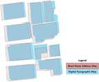
도 2a는 본 발명의 실시예에 따른 대응블록에 포함된 건물군에 대한 기하학적 위치오차 보정 전의 제 1지도와 제 2지도의 비교결과를 나타낸 도면이다.
도 2b는 본 발명의 실시예에 따른 대응블록에 포함된 건물군에 대한 기하학적 위치오차 보정 후의 제 1지도와 제 2지도의 비교결과를 나타낸 도면이다.
도 3은 본 발명의 실시예에 따른 회전각 함수분석 예를 나타낸 도면이다.
도 4는 본 발명의 실시예에 따른 건물 폴리곤 자동정합 방법을 나타낸 순서도이다.
도 5는 본 발명의 실시예에 따른 1차 기하학적 위치오차 보정결과와 2차 기하학적 위치오차 보정결과를 나타내는 도면이다.
도 6은 본 발명의 실시예에 따른 회전각 함수분석을 이용하여 건물 폴리곤 매칭여부를 판단한 일 예시이다.1 is a block diagram schematically showing the configuration of a building polygon automatic matching apparatus according to an embodiment of the present invention.
FIG. 2A is a diagram showing a comparison result between a first map and a second map before geometric position error correction for a building group included in a corresponding block according to an embodiment of the present invention. FIG.
FIG. 2B is a view showing a comparison result between a first map and a second map after correction of a geometric position error for a building group included in a corresponding block according to an embodiment of the present invention.
3 is a view showing an example of analysis of a rotation angle function according to an embodiment of the present invention.
4 is a flowchart illustrating a method of automatic matching of building polygons according to an embodiment of the present invention.
5 is a view showing a result of first-order geometric position error correction and second-order geometric position error correction according to an embodiment of the present invention.
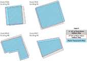
FIG. 6 is an example of determining whether a building polygon is matched using a rotation angle function analysis according to an embodiment of the present invention.
아래에서는 첨부한 도면을 참조하여 본 발명이 속하는 기술 분야에서 통상의 지식을 가진 자가 용이하게 실시할 수 있도록 본 발명의 실시예를 상세히 설명한다. 그러나 본 발명은 여러 가지 상이한 형태로 구현될 수 있으며 여기에서 설명하는 실시예에 한정되지 않는다. 그리고 도면에서 본 발명을 명확하게 설명하기 위해서 설명과 관계없는 부분은 생략하였으며, 명세서 전체를 통하여 유사한 부분에 대해서는 유사한 도면 부호를 붙였다.Hereinafter, embodiments of the present invention will be described in detail with reference to the accompanying drawings, which will be readily apparent to those skilled in the art. The present invention may, however, be embodied in many different forms and should not be construed as limited to the embodiments set forth herein. In order to clearly illustrate the present invention, parts not related to the description are omitted, and similar parts are denoted by like reference characters throughout the specification.
본 명세서에서 사용되는 용어에 대해 간략히 설명하고, 본 발명에 대해 구체적으로 설명하기로 한다.The terms used in this specification will be briefly described and the present invention will be described in detail.
본 발명에서 사용되는 용어는 본 발명에서의 기능을 고려하면서 가능한 현재 널리 사용되는 일반적인 용어들을 선택하였으나, 이는 당 분야에 종사하는 기술자의 의도 또는 판례, 새로운 기술의 출현 등에 따라 달라질 수 있다. 또한, 특정한 경우는 출원인이 임의로 선정한 용어도 있으며, 이 경우 해당되는 발명의 설명 부분에서 상세히 그 의미를 기재할 것이다. 따라서 본 발명에서 사용되는 용어는 단순한 용어의 명칭이 아닌, 그 용어가 가지는 의미와 본 발명의 전반에 걸친 내용을 토대로 정의되어야 한다.While the present invention has been described in connection with what is presently considered to be the most practical and preferred embodiment, it is to be understood that the invention is not limited to the disclosed embodiments. Also, in certain cases, there may be a term selected arbitrarily by the applicant, in which case the meaning thereof will be described in detail in the description of the corresponding invention. Therefore, the term used in the present invention should be defined based on the meaning of the term, not on the name of a simple term, but on the entire contents of the present invention.
명세서 전체에서 어떤 부분이 어떤 구성요소를 "포함"한다고 할 때, 이는 특별히 반대되는 기재가 없는 한 다른 구성요소를 제외하는 것이 아니라 다른 구성요소를 더 포함할 수 있음을 의미한다. 또한, 명세서에 기재된 "...부", "모듈" 등의 용어는 적어도 하나의 기능이나 동작을 처리하는 단위를 의미하며, 이는 하드웨어 또는 소프트웨어로 구현되거나 하드웨어와 소프트웨어의 결합으로 구현될 수 있다. 또한, 명세서 전체에서 어떤 부분이 다른 부분과 "연결"되어 있다고 할 때, 이는 "직접적으로 연결"되어 있는 경우뿐 아니라, "그 중간에 다른 소자를 사이에 두고 연결"되어 있는 경우도 포함한다.When an element is referred to as "including" an element throughout the specification, it is to be understood that the element may include other elements as well, without departing from the spirit or scope of the present invention. Also, the terms "part," " module, "and the like described in the specification mean units for processing at least one function or operation, which may be implemented in hardware or software or a combination of hardware and software . In addition, when a part is referred to as being "connected" to another part throughout the specification, it includes not only "directly connected" but also "interposed between other parts".
이하 첨부된 도면을 참고하여 본 발명을 상세히 설명하기로 한다.DETAILED DESCRIPTION OF THE PREFERRED EMBODIMENTS Hereinafter, the present invention will be described in detail with reference to the accompanying drawings.
도 1은 본 발명의 실시예에 따른 건물 폴리곤 자동정합 장치의 구성을 개략적으로 나타낸 블록도이고, 도 2a는 본 발명의 실시예에 따른 대응블록에 포함된 건물군에 대한 기하학적 위치오차 보정 전의 제 1지도와 제 2지도의 비교결과를 나타낸 도면이며, 도 2b는 본 발명의 실시예에 따른 대응블록에 포함된 건물군에 대한 기하학적 위치오차 보정 후의 제 1지도와 제 2지도의 비교결과를 나타낸 도면이고, 도 3은 본 발명의 실시예에 따른 회전각 함수분석 예를 나타낸 도면이고, 도 4는 본 발명의 실시예에 따른 건물 폴리곤 자동정합 방법을 나타낸 순서도이며, 도 5는 본 발명의 실시예에 따른 1차 기하학적 위치오차 보정결과와 2차 기하학적 위치오차 보정결과를 나타내는 도면이고, 도 6은 본 발명의 실시예에 따른 회전각 함수분석을 이용하여 건물 폴리곤 매칭여부를 판단한 일 예시이다.FIG. 1 is a block diagram schematically showing the configuration of a building polygon automatic matching apparatus according to an embodiment of the present invention. FIG. 2 is a block diagram of a building polygon automatic matching apparatus according to an embodiment of the present invention. FIG. 2B is a graph showing a comparison result between a first map and a second map after correction of a geometric position error of a building group included in a corresponding block according to an embodiment of the present invention FIG. 4 is a flowchart illustrating a method for automatic matching of building polygons according to an embodiment of the present invention, and FIG. 5 is a flowchart illustrating a method of performing automatic polygon matching according to an embodiment of the present invention. FIG. 6 is a diagram illustrating a result of correction of a first geometric position error and an example of a second geometric position error correction according to an exemplary embodiment of the present invention. FIG. Oregon is one example, determines whether the match.
본 발명의 일 실시예에 따르면, 제 1지도와 제 2지도에서 각각 블록을 추출하고, 추출된 블록들의 중첩 면적 유사도를 비교하여 대응 블록을 결정하며, 결정된 대응 블록 내에 존재하는 제 1지도와 제 2지도 상에서의 건물 폴리곤에 대하여 ICP 보정 후 중첩 면적 유사도를 비교하여 대응건물을 결정할 수 있다.According to an embodiment of the present invention, a block is extracted from a first map and a second map, a corresponding block is determined by comparing the similarity degree of overlapping areas of the extracted blocks, 2 Corresponding buildings can be determined by comparing the overlap area similarity after ICP correction on building polygons on the map.
먼저 도 1을 참조하면, 복수개의 지도 상에서의 건물 폴리곤 자동정합 장치(100)는 제 1지도와 제 2지도를 비교하는 비교부(110), 비교부(110)의 비교결과에 기초하여, 제 1지도와 제 2지도로부터 대응블록을 추출하는 제 1추출부(120), 제 1추출부(120)에 의하여 추출된 대응블록에 포함된 건물군에 대하여 기하학적 위치 오차를 보정하는 보정부(130) 및 보정부(130)에 의하여 보정된 건물군의 위치에 기초하여, 제 1지도와 제 2지도간의 중첩 면적비를 결정하는 중첩도결정부(140)를 포함할 수 있다. 또한, 중첩도결정부(140)에 의하여 결정된 중첩 면적비에 기초하여, 보정된 건물군 중 매칭 건물과 비매칭 건물을 분류하는 제 1분류부(150), 분류부의 분류결과에 기초하여, 제 1지도와 제 2지도로부터 오매칭(error-matching) 후보 건물군을 추출하는 제 2추출부(160), 제 2추출부(160)에 의하여 추출된 오매칭 후보 건물군 내의 각각의 건물에 대하여 기하학적 위치 오차를 보정하고, 오매칭 후보 건물군에 대한 회전각 함수분석을 수행하는 분석부(170) 및 분석부(170)에 의한 회전각 함수분석결과에 기초하여 오매칭 후보 건물군 내에서 매칭 건물과 비매칭 건물을 분류하는 제 2분류부(180)를 포함할 수 있다.First, referring to FIG. 1, a building polygon
본 발명의 일 실시예에 따른 제 1지도는 도로명주소지도(Road Name Address Map), 제 2지도는 수치지형도(Digital Topographic Map)가 될 수 있지만, 반드시 이에 제한되는 것은 아니다. 본 발명의 일 실시예에서와 같이 안전행정부의 도로명주소지도와 국토지리정보원의 수치지형도 2.0 등이 각각 제 1지도 및 제 2지도로 이용될 수 있다. 이러한 두 지도는 기준 타원체와 좌표계가 다를 뿐만 아니라 갱신 주기에서 큰 차이를 보인다. 도로명주소지도는 건물의 행정적인 주소 등록 과정을 통해 실시간에 가까운 갱신이 이루어지는 반면 수치지형도는 2년에 한 번씩 항공사진과 현지 측량에 의하여 주기적으로 갱신이 이루어진다. 도로명주소지도의 신속한 갱신성과 수치지형도의 위치 정확성은 상호 보완적인 관계에 있으며 이는 두 수치지도 자료의 통합을 통해 증대될 수 있다. 따라서, 본 발명의 일 실시예에서와 같이 도로명주소지도와 수치지형도가 각각 제 1지도 및 제 2지도로써 이용될 수 있다.The first map according to an embodiment of the present invention may be a road name address map and the second map may be a digital topographic map, but the present invention is not limited thereto. As in the embodiment of the present invention, the road name address map of the safety administration and the digital topographic map 2.0 of the national geographic information resource can be used as the first map and the second map, respectively. These two maps are not only different from the reference ellipsoid and the coordinate system, but also show a large difference in the update cycle. The street address map is updated in real time through the administrative address registration process of the building, while the digital map is updated periodically by aerial photography and field survey every two years. The rapid update of road name address maps and the location accuracy of digital topographic maps are complementary and can be augmented through the integration of both digital map data. Therefore, as in the embodiment of the present invention, the road name address map and the digital topographic map can be used as the first map and the second map, respectively.
또한, 블록은 도로로 둘러싸인 영역으로서 도시 계획에 의해 구획된 가구계를 지칭하며, 이러한 블록 내에는 적어도 하나의 건물이 포함될 수 있다. 다시 말해서, 하나의 블록 내에서는 수개에서 수십 개의 건물이 존재할 수 있다. 이러한 수개에서 수십 개의 건물은 건물 폴리곤을 통하여 식별될 수 있다. 폴리곤은 건물 등의 평면 윤곽 또는 형태를 결정짓는 선으로 구성된 면 또는 그 조합을 지칭할 수 있다.Also, a block refers to a furniture system partitioned by a city plan as an area surrounded by a road, and at least one building may be included in such a block. In other words, there can be several to dozens of buildings in a block. From these to dozens of buildings can be identified through building polygons. A polygon can refer to a plane or a combination of planes, such as a building, that consists of lines that determine the shape or shape.
또한, 비교부(110)에서는 제 1지도의 전체 폴리곤과 도로 폴리곤 간의 차 연산을 통하여 획득된 적어도 하나의 제 1 블록 폴리곤과 제 2지도의 전체 폴리곤과 도로 폴리곤 간의 차 연산을 통하여 획득된 적어도 하나의 제 2 블록 폴리곤을 비교할 수 있다. 또한, 제 1추출부(120)에서는 비교부(110)에서의 블록들 간 중첩 면적비 비교결과에 기초하여 제 1지도의 제 1 블록 폴리곤에 상응하는 제 2지도의 블록 폴리곤을 대응블록으로서 추출할 수 있다.The
예를 들어, 제 1지도와 제 2지도 각각에 대하여 각각의 지도 전체를 포함하는 폴리곤(O)을 생성하였을 때 도로 폴리곤(R)과의 차 연산을 통해 제 1지도와 제 2지도 상에서 적어도 하나의 건물 폴리곤이 포함된 개별 블록(B)을 각각 추출 할 수 있다. 폴리곤 간의 차 연산은 수학식 1과 같이 논리적으로 수행될 수 있다.For example, when a polygon (O) including the entire map is generated for each of the first map and the second map, a difference between the first polygon (R) and the road polygon (R) The individual blocks B including the building polygons of the building polygons can be extracted. The difference operation between the polygons can be logically performed as shown in Equation (1).

여기서, B는 블록 폴리곤 세트, O는 각각의 지도의 전체를 포함하는 폴리곤, R은 도로 폴리곤 세트를 나타낸다.Here, B represents a block polygon set, O represents a polygon including the entire map, and R represents a road polygon set.
또한, 제 1지도 및 제 2지도와 같이 이종 데이터간에 대응 가능한 개별 블록(B)의 중첩면적비를 계산함으로써 면적유사도(Sa)가 가장 높은 대응 블록쌍을 수학식 2를 이용하여 결정할 수 있다.Also, by calculating the overlapping area ratio of the individual blocks B that can be handled between the different types of data such as the first map and the second map, the corresponding block pair having the highest area similarity Sa can be determined using Equation (2).

여기서, Sa는 면적유사도, Br은 제 1지도의 블록 폴리곤 세트, Bd는 제 2지도의 블록 폴리곤 세트를 나타낸다.Here, Sa represents an area similarity, Br represents a block polygon set of the first map, and Bd represents a block polygon set of the second map.
본 발명의 일 실시예에 따르면, 보정부(130)에서는 대응블록에 포함된 건물군 내의 각각의 건물에 대하여 기하학적 위치 오차를 보정할 수 있다. 이러한 위치 오차 보정을 위하여 예를 들면, ICP(Iterative Closest Point) 알고리즘이 적용될 수 있다. 예컨대, 최신 지도의 건물을 타 지도 건물에 맞추어 기하학적 위치 오차를 보정함으로써 동일한 건물 또는 형태가 변경되거나 신규 생성된 건물 등을 보다 정확히 파악할 수 있다. 다시 말해서, 타 지도 건물을 중심으로 기준 지도 건물 폴리곤에 대한 회전,이동 변환을 수행하여 지도 상의 건물 등의 위치 오차를 보정할 수 있다. 기준 지도는 최신 정보로 업데이트된 지도를 지칭할 수 있다. 이러한 ICP 알고리즘을 이용하여 기준 지도와 타 지도 간의 기하학적 불일치를 제거할 수 있다.According to an embodiment of the present invention, the
또한, 보정부(130)에서는 오매칭 후보 건물군 내의 각각의 건물에 대하여도 기하학적 위치 오차를 보정할 수 있다. 본 발명의 일 실시예에 따르면 1차적으로는 대응 블록 내 건물군에 대한 일괄적 기하보정이,2차적으로는 재탐색 후보군인 오매칭 후보 건물군 내의 개별 건물에 대한 기하보정이 이루어질 수 있다.In the
ICP 알고리즘은 점으로 구성된 두 벡터 데이터의 평균제곱근오차(RMSE)가 최소가 되도록 변환량을 반복적으로 추정하는 알고리즘이며, 블록 기반으로 ICP 알고리즘을 적용할 경우, 블록별로 고유한 회전 행렬(RM)과 변환 벡터(T)가 계산되기 때문에 지역적인 왜곡을 최소화 할 수 있으며 연산 부하를 줄일 수 있 다.The ICP algorithm is an algorithm that iteratively estimates the amount of transformation so that the mean square root error (RMSE) of two vector data consisting of points is minimized. When the ICP algorithm is applied on a block basis, a unique rotation matrix Since the transform vector (T) is computed, local distortion can be minimized and the computational load can be reduced.
이에 따라, 수학식 3과 같이 변환 점 벡터에 대해 추정된 회전 행렬과 이동 벡터를 적용하였을 때 기준점 벡터와의 평균제곱근오차가 비용함수(C)로 구성될 수 있으며, 초기 회전 및 이동 변환량은 변환 점과 가장 가까운 기준점을 대응관계로 보아 설정되며, 평균제곱근 오차가 최소가 되도록 반복적으로 회전 행렬과 이동 벡터를 계산할 수 있다.Accordingly, when the rotation matrix and the motion vector estimated for the transformation point vector are applied as shown in Equation (3), the mean square root error between the reference point vector and the rotation vector can be constituted by the cost function (C) The rotation matrix and the motion vector can be calculated repeatedly so that the mean square root error is minimized.

여기서, n은 점 데이터의 수이고, RM은 회전 행렬, T는 이동(translation)벡터, ri는 제 1지도에서의 i번째 점의 벡터이고, di는 제 2지도에서의 i번째 점의 벡터를 나타낸다.Where r is the number of point data, RM is the rotation matrix, T is the translation vector, ri is the vector of the i th point in the first map, and di is the vector of the i th point in the second map Lt; / RTI >
도 2a와 도 2b를 참조하면, 제 1지도를 변환 데이터로 제 2지도를 기준 데이터로 하여 ICP 알고리즘을 적용하면, 도 2a에서와 같은 제 1지도에서 일정한 방향으로 존재하던 계통 위치 편차(또는 오차)는 도 2b에서와 같이 기하학적 위치 오차 보정 후에는 제거될 수 있다.Referring to FIGS. 2A and 2B, when the first map is converted data and the second map is used as a reference data, the ICP algorithm is applied so that the systematic positional deviation (or error) existing in a certain direction May be removed after geometric position error correction as in Figure 2B.
중첩도결정부(140)는 제 1지도 상의 대응블록 내 건물 폴리곤과 제 2 지도 상의 대응블록 내 건물 폴리곤의 중첩 면적비를 계산하고, 계산된 중첩 면적비에 기초하여 대응건물간 면적유사도를 결정할 수 있다. 다시 말해서, 계산된 회전 및 이동 변화량을 제 1지도에 적용한 후 제 2지도와 중첩 면적비를 계산할 수 있다.The overlapping
제 1분류부(150)에서는 대응블록 내 대응 가능한 건물쌍에 대하여 계산된 중첩 면적비에 기초하여 면적유사도가 높은 건물 쌍을 매칭 건물로 분류할 수 있다. 다시 말해서, 중첩 면적비가 높은 제 1지도와 제 2지도 상의 대응 건물은 매칭 건물로 분류될 수 있다. 면적유사도는 0에서 1 사이의 값을 가지며, 0은 중첩되는 건물이 없는 것을 나타내고 1은 두 건물이 완벽히 중첩되는 것을 나타낸다. 건물의 면적유사도가 높을수록 동일 건물일 확률이 높으며 매칭 여부를 보다 정확히 판별하기 위해서는 0에서 1사이의 임계값 설정을 통한 건물 분류를 수행할 수 있다.In the first classifying
제 1분류부(150) 또는 제 2분류부(180)는 매칭 건물과 비매칭 건물을 자동으로 분류하기 위해 오츠(Otsu) 임계화 기법을 이용할 수 있다. 오츠 임계화 기법은 클래스간 분산(


여기서,


임계값에 따라 매칭과 비매칭 건물의 분산이 달라지며 예를 들어, 클래스 내의 분산이 최소, 클래스 간의 분산은 최대가 되는 임계값을 건물 매칭에 대한 기준으로 결정할 수 있다.For example, the criterion for building matching may be a threshold at which the variance within a class is minimized and the variance between classes is maximum, for example, according to a threshold value.
제 2추출부(160)에서는 제 1분류부의 분류결과에 기초하여, 제 1지도와 제 2지도로부터 오매칭(error-matching) 후보 건물군을 추출할 수 있다.The second extracting
또한, 본 발명의 일 실시예에 따르면, 오매칭 후보 건물군에는 중첩 면적비의 임계값으로부터 소정범위 내에 포함된 중첩 면적비를 갖는 적어도 하나의 건물이 포함될 수 있다. 다시 말해서, 본 발명의 일 실시예에 따른 계층적 매칭을 위하여 예컨대, 중첩 면적비가 임계값의 土0.1 범위 안에 들어오는 건물쌍은 오매칭 확률이 높은 오매칭 후보군으로 추출하고, 추출된 오매칭 후보군의 건물에 대하여 2차 매칭을 수행할 수 있다.According to an embodiment of the present invention, the mis-matching candidate building group may include at least one building having an overlapping area ratio included in a predetermined range from a threshold value of the overlapping area ratio. In other words, for hierarchical matching according to an embodiment of the present invention, for example, a building pair in which the overlapping area ratio falls within a range of 0.1 of the threshold value is extracted as an omitting candidate having a high probability of mis-matching, A secondary matching can be performed on the building.
분석부(170)에서는 오매칭 후보 건물군 내의 개별 건물에 대하여 기하학적 위치 오차를 보정하고, 오매칭 후보군에 대한 매칭 정확도 향상을 위하여 중첩 면적비 이외에 형태적 특징을 고려한 회전각 함수분석을 수행할 수 있다. 전술한 바와 같이, 분석부(170)에서는 오매칭 후보 건물군 내의 각각의 건물에 대하여 ICP 알고리즘을 적용한 기하학적 위치 오차 보정을 수행할 수 있다.The
여기서 회전각 함수란, 폴리곤이나 폴리라인 벡터 데이터의 선 성분이 x축과 이루는 각과 길이를 이용하여 두 데이터의 유사도를 결정하는 기법이며, 도 3과 같이 우측 하단 점부터 반시계방향으로 탐색된 선들의 각과 길이를 누적길이-각도 평면에 나타내어 벡터 데이터의 형태적 특징을 나타낼 수 있다. 이러한 회전각 함수 분석 기법은 두 데이터의 평행 이동 변화에 독립적인 유사도 측정이 가능하다는 장점이 있으며, 중첩률은 높지만 형태적으로 상이한 건물의 매칭 여부를 판단하여 중첩 면적비와는 보완적인 유사도 측정을 가능하게 할 수 있다. 또한, 두 폴리곤 데이터의 둘레가 다르므로 변환 폴리곤을 기준 폴리곤의 둘레로 변환 후 두 회전각 함수의 면적차이, 즉 불일치 면적을 측정할 수 있다.Here, the rotation angle function is a technique for determining the degree of similarity between two data using the angle and the length formed by the line component of the polygon or polyline vector data with the x axis. As shown in FIG. 3, And the length and angle of the vector data in the cumulative length-angle plane. This rotation angle function analysis method has the merit that it is possible to measure similarity independent of parallel movement change of two data, and it is possible to measure complementary similarity with the overlap area ratio by judging whether the buildings are different in morphology, . Also, since the circumference of the two polygon data is different, it is possible to convert the converted polygon to the circumference of the reference polygon, and then measure the area difference of the two rotation angle functions, that is, the mismatch area.
회전각 함수분석에 의한 유사도(St)는 1에서 비유사도(dissimilarity) 값을 뺀 것으로 나타낼 수 있고, 다음 수학식 6과 같이 표현될 수 있다. 비유사도 값은 변환 폴리곤의 넓이에 대한 면적 차이의 비로 결정될 수 있다.The similarity (St) by the rotation angle function analysis can be expressed by subtracting the dissimilarity value from 1, and can be expressed as Equation (6). The non-unidirectional value can be determined by the ratio of the area difference to the width of the converted polygon.

여기서, St는 회전각 함수분석에 의한 유사도, D는 비유사도, c' 변환누적길이, Tr은 제 1지도에 대한 회전각 함수, Td는 제 2지도에 대한 회전각 함수를 나타낸다.Here, St represents the similarity by the rotation angle function analysis, D represents the non-yaw rate, c 'cumulative cumulative length, Tr represents the rotation angle function for the first map, and Td represents the rotation angle function for the second map.
제 2분류부(180)에서는 분석부(170)의 회전각 함수분석에 의한 유사도 결과에 기초하여 오매칭 후보 건물군 내에서 매칭 건물과 비매칭 건물을 분류할 수 있다. 다시 말해서, 본 발명의 일 실시예에 따르면, 제 1분류부 및 제 2 분류부에 의하여 계층적으로 건물 폴리곤 매칭을 수행함으로써 종래보다 건물의 매칭 정확도를 향상시킬 수 있다.In the
또한, 본 발명의 일 실시예로써 복수개의 지도 상에서의 건물 폴리곤 자동정합 방법이 제공될 수 있다. 본 발명의 일 실시예에 따른 방법은, 도 4에서와 같이, 제 1지도와 제 2지도를 비교하는 제 1단계(S10), 제 1단계의 비교결과에 기초하여 제 1지도와 제 2지도로부터 대응블록을 추출하는 제 2단계(S20), 제 2단계에서 추출된 대응블록에 포함된 건물군에 대하여 기하학적 위치 오차를 보정하는 제 3단계(S30), 제 3단계에서 보정된 건물군의 위치에 기초하여 제 1지도와 제 2지도간의 건물 중첩 면적비를 결정하는 제 4단계(S40), 제 4단계에서 결정된 건물 중첩 면적비에 기초하여 보정된 건물군 중 매칭 건물과 비매칭 건물을 분류하는 제 5단계(S50), 제 5단계의 분류결과에 기초하여 제 1지도와 제 2지도로부터 오매칭(error-matching) 후보 건물군을 추출하는 제 6단계(S60), 제 6단계에서 추출된 오매칭 후보 건물군 내의 각각의 건물에 대하여 기하학적 위치 오차를 보정하고, 오매칭 후보 건물군에 대한 회전각 함수분석을 수행하는 제 7단계(S70) 및 제 7단계의 회전각 함수분석결과에 기초하여 오매칭 후보 건물군 내에서 매칭 건물과 비매칭 건물을 분류하는 제 8단계(S80)를 포함할 수 있다.Also, as an embodiment of the present invention, a method of automatic matching of building polygons on a plurality of maps can be provided. As shown in FIG. 4, the method according to an embodiment of the present invention includes a first step (S10) of comparing a first map and a second map, a first map and a second map A third step S30 for correcting a geometric position error with respect to the building group included in the corresponding block extracted in the second step, a second step S20 for extracting a corresponding block from the building group corrected in the third step, A fourth step (S40) of determining a building overlapping area ratio between the first map and the second map based on the position, a fourth step (S40) of classifying the matching building and the non-matching building among the buildings corrected based on the building overlap area ratio determined in the fourth step A fifth step (S50), a sixth step (S60) of extracting an error-matching candidate building group from the first map and the second map based on the classification result of the fifth step, Correction of geometric position error for each building in the group of false matching candidates Based on the results of the seventh step (S70) and the seventh step of performing the rotation angle function analysis for the group of high and low matching candidates, the matching building and the non-matching building are classified in the omitting candidate building group (Step S80).
본 발명의 일 실시예에 따른 제 1지도는 도로명주소지도, 제 2지도는 수치지형도일 수 있지만, 반드시 이에 제한되는 것은 아니다.The first map according to an embodiment of the present invention may be a street name address map, and the second map may be a digital map, but the present invention is not limited thereto.
또한, 제 1단계(S10)에서는 제 1지도의 전체 폴리곤과 도로 폴리곤 간의 차 연산을 통하여 획득된 적어도 하나의 제 1 블록 폴리곤과 제 2지도의 전체 폴리곤과 도로 폴리곤 간의 차 연산을 통하여 획득된 적어도 하나의 제 2 블록 폴리곤이 비교되고, 제 2단계(S20)는 비교결과에 기초하여 제 1지도의 제 1 블록 폴리곤에 상응하는 제 2지도의 블록 폴리곤이 대응블록으로서 추출될 수 있다.In addition, in the first step S10, at least one first block polygon obtained through the difference calculation between the entire polygon of the first map and the road polygon and at least the first block polygon obtained through the difference calculation between the entire polygon and the road polygon of the second map One second block polygon is compared and the second step S20 can extract the block polygon of the second map corresponding to the first block polygon of the first map as a corresponding block based on the comparison result.
또한, 대응블록에 포함된 건물군과 오매칭 후보 건물군 내의 각각의 건물에 대하여 기하학적 위치 오차를 보정하기 위해, ICP 알고리즘이 적용될 수 있다.Also, the ICP algorithm can be applied to correct the geometric position errors for the buildings in the corresponding block and the buildings in the mis-matching candidate building group.
또한, 제 4단계(S40)에서는 제 1지도 상의 대응블록 내 건물 폴리곤과 제 2지도 상의 대응블록 내 건물 폴리곤의 중첩 면적비를 계산하고, 계산된 중첩 면적비에 기초하여 대응블록 내 건물 폴리곤간 면적유사도를 결정할 수 있다.In the fourth step S40, the overlap area ratio between the building polygon in the corresponding block on the first map and the building polygon in the corresponding block on the second map is calculated, and based on the calculated overlap area ratio, Can be determined.
또한, 제 5단계(S50) 또는 제 8단계(S80)에서는 매칭 건물과 비매칭 건물을 자동으로 분류하기 위해 오츠(Otsu) 임계화 기법이 이용될 수 있다.In the fifth step (S50) or the eighth step (S80), an Otsu thresholding technique may be used to automatically classify matching buildings and non-matching buildings.
또한, 오매칭 후보 건물군에는 중첩 면적비율의 임계 값으로부터 소정범위 내에 포함된 중첩 면적비를 갖는 적어도 하나의 건물이 포함될 수 있다.Also, the mis-matching candidate building group may include at least one building having an overlap area ratio included within a predetermined range from the threshold of the overlap area ratio.
본 발명의 일 실시예에 따른 계층적 매칭 기법을 통해 전체 건물 중 오매칭 확률이 높은 건물들만을 선택적으로 추가로 매칭 여부를 판단함으로써 지도 상에서의 대응 건물의 매칭 판단을 정확하게 할 수 있고, 매칭 과정에서의 연산 효율성을 높일 수 있다.Through the hierarchical matching technique according to the embodiment of the present invention, it is possible to precisely determine the matching of the corresponding building on the map by judging whether only buildings having high probability of mis-matching among the entire buildings are selectively additionally matched, It is possible to increase the computation efficiency in the case of FIG.
도 5에서와 같이, 초기 기하학적 위치 오차 보정에서 위치 오차가 존재하던 건물들이 2차 위치 오차 보정 등을 통하여 성공적으로 기하 보정될 수 있다. 제 1지도와 제 2지도의 블록 내 건물 중 갱신주기의 차이에 의해 서로 다른 건물이 포함되어 있거나 도화가 다르게 이루어져 형태가 상이한 건물이 존재하는 경우 일부 건물의 매칭 정확도가 떨어지게 되며 이러한 경우에 본 발명의 일 실시예에 따른 계층적 매칭에 따른 건물 식별의 효과가 더욱 크게 나타날 수 있다.As shown in FIG. 5, the buildings in which the position error exists in the initial geometric position error correction can be geometrically corrected successfully through the secondary position error correction and the like. If the buildings in the blocks of the first map and the second map include different buildings due to the difference in the update cycle or buildings having different shapes are present, the matching accuracy of some buildings is lowered. In this case, The effect of the building identification according to the hierarchical matching according to an embodiment of the present invention can be more significantly increased.
또한, 본 발명의 일 실시예에 따르면 중첩 면적 유사도는 크지만 형태적으로 상이한 건물들의 경우 회전각 함수분석을 통해 매칭 정확도가 향상될 수 있다. 예를 들어, 도 6에서와 같이 건물이 두 수치지도(예컨대, 제 1지도 및 제 2지도)에서 형태적으로 상이함에도 불구하고 면적 유사도가 임계값 이상이 므로 제 1분류부(150)에 의하여 매칭 건물로 분류될 수 있다. 그러나 회전각 함수 분석을 함께 적용할 경우, 회전각 유사도가 임계값 이하이기 때문에 최 종적으로 비매칭 건물로 분류될 수 있다.Also, according to an embodiment of the present invention, the matching accuracy can be improved by analyzing the rotation angle function in the case of the buildings having a large overlap similarity but different in shape. For example, as shown in FIG. 6, even though the building is morphologically different in two numerical maps (for example, the first map and the second map), the area similarity is larger than the threshold value, It can be classified as a matching building. However, when the rotational angle function analysis is applied together, the rotation angle similarity is less than the threshold value, and thus can be classified as a non-matching building eventually.
본 발명의 일 실시예에 따르면 1차 및 2차 매칭으로 구성된 계층적 매칭 과정을 통하여 이종 수치지도 건물 데이터의 정합 시, 건물 등의 객체의 매칭 정확도와 연산의 효율성을 높일 수 있다. 다시 말해서, 객체의 중첩 면적 유사도뿐만 아니라 형태적 특성을 고려하기 위한 회전각 함수분석을 통하여 종래 대비 매칭의 정확도를 더욱 향상 시킬 수 있고, 전체 건물이 아닌 오매칭 후보 건물군에만 2차적으로 ICP 기하보정과 회전각 함수 분석을 수행함으로써 연산의 효율성을 높일 수 있다. 또한, 2차 ICP 기하보정을 통해 건물의 정확한 기하보정이 가능하고, 회전각 함수분석을 통해 오매칭 건물의 수를 감소시킬 수 있다.According to the embodiment of the present invention, matching accuracy of objects such as buildings and efficiency of computation can be improved when matching heterogeneous digital map building data through a hierarchical matching process composed of primary and secondary matching. In other words, the accuracy of matching can be further improved through the analysis of the rotation angle function to take into account not only the similarity of overlapping areas of objects but also the morphological characteristics, and it is possible to further improve the accuracy of matching, Calculation efficiency can be improved by performing calibration and rotation angle function analysis. In addition, the second ICP geometric correction enables accurate geometric correction of the building, and the number of mis-matched buildings can be reduced through the analysis of the rotation angle function.
본 발명의 일 실시예에 따른 방법과 관련하여서는 전술한 장치에 대한 내용이 적용될 수 있다. 따라서, 방법과 관련하여, 전술한 장치에 대한 내용과 동일한 내용에 대하여는 설명을 생략하였다.The contents of the above-described apparatus can be applied in connection with the method according to an embodiment of the present invention. Therefore, the description of the same contents as those of the above-mentioned apparatus has been omitted in connection with the method.
본 발명의 일 실시예는 컴퓨터에 의해 실행되는 프로그램 모듈과 같은 컴퓨터에 의해 실행가능한 명령어를 포함하는 기록 매체의 형태로도 구현될 수 있다. 컴퓨터 판독 가능 매체는 컴퓨터에 의해 액세스될 수 있는 임의의 가용 매체일 수 있고, 휘발성 및 비휘발성 매체, 분리형 및 비분리형 매체를 모두 포함한다. 또한, 컴퓨터 판독가능 매체는 컴퓨터 저장 매체 및 통신 매체를 모두 포함할 수 있다. 컴퓨터 저장 매체는 컴퓨터 판독가능 명령어, 데이터 구조, 프로그램 모듈 또는 기타 데이터와 같은 정보의 저장을 위한 임의의 방법 또는 기술로 구현된 휘발성 및 비휘발성, 분리형 및 비분리형 매체를 모두 포함한다. 통신 매체는 전형적으로 컴퓨터 판독가능 명령어, 데이터 구조, 프로그램 모듈, 또는 반송파와 같은 변조된 데이터 신호의 기타 데이터, 또는 기타 전송 메커니즘을 포함하며, 임의의 정보 전달 매체를 포함한다.One embodiment of the present invention may also be embodied in the form of a recording medium including instructions executable by a computer, such as program modules, being executed by a computer. Computer readable media can be any available media that can be accessed by a computer and includes both volatile and nonvolatile media, removable and non-removable media. In addition, the computer-readable medium can include both computer storage media and communication media. Computer storage media includes both volatile and nonvolatile, removable and non-removable media implemented in any method or technology for storage of information such as computer readable instructions, data structures, program modules or other data. Communication media typically includes any information delivery media, including computer readable instructions, data structures, program modules, or other data in a modulated data signal such as a carrier wave, or other transport mechanism.
전술한 본 발명의 설명은 예시를 위한 것이며, 본 발명이 속하는 기술분야의 통상의 지식을 가진 자는 본 발명의 기술적 사상이나 필수적인 특징을 변경하지 않고서 다른 구체적인 형태로 쉽게 변형이 가능하다는 것을 이해할 수 있을 것이다. 그러므로 이상에서 기술한 실시예들은 모든 면에서 예시적인 것이며 한정적이 아닌 것으로 이해해야만 한다. 예를 들어, 단일형으로 설명되어 있는 각 구성 요소는 분산되어 실시될 수도 있으며, 마찬가지로 분산된 것으로 설명되어 있는 구성 요소들도 결합된 형태로 실시될 수 있다.It will be understood by those skilled in the art that the foregoing description of the present invention is for illustrative purposes only and that those of ordinary skill in the art can readily understand that various changes and modifications may be made without departing from the spirit or essential characteristics of the present invention. will be. It is therefore to be understood that the above-described embodiments are illustrative in all aspects and not restrictive. For example, each component described as a single entity may be distributed and implemented, and components described as being distributed may also be implemented in a combined form.
본 발명의 범위는 상기 상세한 설명보다는 후술하는 특허청구범위에 의하여 나타내어지며, 특허청구범위의 의미 및 범위 그리고 그 균등 개념으로부터 도출되는 모든 변경 또는 변형된 형태가 본 발명의 범위에 포함되는 것으로 해석되어야 한다.
The scope of the present invention is defined by the appended claims rather than the detailed description and all changes or modifications derived from the meaning and scope of the claims and their equivalents are to be construed as being included within the scope of the present invention do.
100 : 건물 폴리곤 자동정합 장치
110 : 비교부
120 : 제 1추출부
130 : 보정부
140 : 중첩도결정부
150 : 제 1분류부
160 : 제 2추출부
170 : 분석부
180 : 제 2분류부100: Building polygon automatic matching device
110:
120: first extracting unit
130:
140: superposition degree determination unit
150: first classification section
160:
170: Analysis section
180: second classification section
Claims (15)
Translated fromKorean제 1지도와 제 2지도를 비교하는 비교부;
상기 비교부의 비교결과에 기초하여, 상기 제 1지도와 상기 제 2지도로부터 대응블록을 추출하는 제 1추출부;
상기 제 1추출부에 의하여 추출된 대응블록에 포함된 건물군에 대하여 기하학적 위치 오차를 보정하는 보정부;
상기 보정부에 의하여 보정된 건물군의 위치에 기초하여, 상기 제 1지도와 상기 제 2지도간의 건물 중첩 면적비를 결정하는 중첩도결정부;
상기 중첩도결정부에 의하여 결정된 상기 건물 중첩 면적비에 기초하여, 상기 보정된 건물군 중 매칭 건물과 비매칭 건물을 분류하는 제 1분류부;
상기 제 1분류부의 분류결과에 기초하여, 상기 제 1지도와 상기 제 2지도로부터 오매칭(error-matching) 후보 건물군을 추출하는 제 2추출부;
상기 제 2추출부에 의하여 추출된 상기 오매칭 후보 건물군 내의 각각의 건물에 대하여 기하학적 위치 오차를 보정하고, 상기 오매칭 후보 건물군에 대한 회전각 함수분석을 수행하는 분석부; 및
상기 분석부에 의한 회전각 함수분석결과에 기초하여 상기 오매칭 후보 건물군에 대하여 유사도 결과값을 획득하고, 상기 획득된 유사도 결과값에 기초하여 상기 오매칭 후보 건물군 내에서 매칭 건물과 비매칭 건물을 분류하는 제 2 분류부; 를 포함하고,
상기 유사도 결과값은 상기 오매칭 후보 건물군에 대하여 회전각 함수분석을 수행하여 회전각 함수의 면적차이인 불일치 면적을 측정하고, 상기 측정된 불일치 면적을 이용하여 비유사도 값을 결정하고, 상기 결정된 비유사도 값을 이용하여 획득되는 것을 특징으로 하는 건물 폴리곤 자동정합 장치.
In a building polygon automatic matching apparatus on a plurality of maps,
A comparing unit comparing the first map and the second map;
A first extracting unit for extracting a corresponding block from the first map and the second map based on a comparison result of the comparing unit;
A correcting unit correcting a geometric position error of a building group included in a corresponding block extracted by the first extracting unit;
An overlapping degree determining unit for determining a building overlapping area ratio between the first map and the second map based on the position of the building group corrected by the correcting unit;
A first classifying unit for classifying a matched building and a non-matched building among the corrected building group based on the building overlap area ratio determined by the overlap determination unit;
A second extracting unit for extracting an error-matching candidate building group from the first map and the second map based on the classification result of the first classifying unit;
An analysis unit for correcting a geometric position error of each building in the group of erroneous matching buildings extracted by the second extracting unit and performing a rotation angle function analysis for the erroneous matching building group; And
Acquiring a similarity result value to the mis-matched candidate building group based on the analysis result of the rotation angle function by the analysis unit, and based on the obtained similarity result value, A second classifying section for classifying buildings; Lt; / RTI >
Wherein the similarity degree resultant value is obtained by performing a rotation angle function analysis on the erroneous matching candidate building group to measure an area of inconsistency which is an area difference of a rotation angle function and determining a non-erosion value by using the measured inconsistency area, Wherein the polygon automatic matching device is obtained by using the non-inference value.
상기 제 1지도는 도로명주소지도, 상기 제 2지도는 수치지형도인 것을 특징으로 하는 건물 폴리곤 자동정합 장치.
The method according to claim 1,
Wherein the first map is a street name address map, and the second map is a digital topographic map.
상기 비교부는 상기 제 1지도의 전체 폴리곤과 도로 폴리곤 간의 차 연산을 통하여 획득된 적어도 하나의 제 1 블록 폴리곤과 상기 제 2지도의 전체 폴리곤과 상기 도로 폴리곤 간의 차 연산을 통하여 획득된 적어도 하나의 제 2 블록 폴리곤을 비교하고,
상기 제 1추출부는 상기 비교결과에 기초하여 상기 제 1지도의 상기 제 1 블록 폴리곤에 상응하는 상기 제 2지도의 상기 제 2 블록 폴리곤을 대응블록으로서 추출하는 것을 특징으로 하는 건물 폴리곤 자동정합 장치.
The method according to claim 1,
Wherein the comparison unit compares at least one first block polygon obtained through the difference calculation between the entire polygon of the first map and the road polygon and at least one block polygon obtained through the difference calculation between the entire polygon of the second map and the road polygon, Two-block polygons are compared,
Wherein the first extracting unit extracts, as a corresponding block, the second block polygon of the second map corresponding to the first block polygon of the first map based on the comparison result.
상기 대응블록에 포함된 건물군과, 상기 오매칭 후보 건물군 내의 각각의 건물에 대하여 기하학적 위치 오차를 보정하기 위해, ICP 알고리즘이 적용되는 것을 특징으로 하는 건물 폴리곤 자동정합 장치.
The method according to claim 1,
Wherein an ICP algorithm is applied to correct a geometric position error of a building group included in the corresponding block and each building in the mis-matching candidate building group.
상기 중첩도결정부는 상기 제 1지도 상의 건물 폴리곤과 상기 제 2 지도 상의 건물 폴리곤의 중첩 면적비를 계산하고, 상기 계산된 중첩 면적비에 기초하여 대응건물 폴리곤간 면적유사도를 결정하는 것을 특징으로 하는 건물 폴리곤 자동정합 장치.
The method according to claim 1,
Wherein the overlap degree determination unit calculates an overlap area ratio of a building polygon on the first map and a building polygon on the second map and determines an area similarity degree between the corresponding building polygons based on the calculated overlap area ratio, Automatic matching device.
상기 제 1분류부 또는 상기 제 2분류부는 상기 매칭 건물과 상기 비매칭 건물을 자동으로 분류하기 위해 오츠(Otsu) 임계화 기법을 이용하는 것을 특징으로 하는 건물 폴리곤 자동정합 장치.
The method according to claim 1,
Wherein the first classifying unit or the second classifying unit uses an Otsu thresholding technique to automatically classify the matching building and the non-matching building.
상기 오매칭 후보 건물군에는 상기 중첩 면적비의 임계 값으로부터 소정범위 내에 포함된 중첩 면적비를 갖는 적어도 하나의 건물이 포함되는 것을 특징으로 하는 건물 폴리곤 자동정합 장치.
The method according to claim 1,
Wherein the mis-matching candidate building group includes at least one building having an overlap area ratio included within a predetermined range from the threshold value of the overlap area ratio.
제 1지도와 제 2지도를 비교하는 제 1단계;
상기 제 1단계의 비교결과에 기초하여, 상기 제 1지도와 상기 제 2지도로부터 대응블록을 추출하는 제 2단계;
상기 제 2단계에서 추출된 대응블록에 포함된 건물군에 대하여 기하학적 위치 오차를 보정하는 제 3단계;
상기 제 3단계에서 보정된 건물군의 위치에 기초하여, 상기 제 1지도와 상기 제 2지도간의 건물 중첩 면적비를 결정하는 제 4단계;
상기 제 4단계에서 결정된 상기 건물 중첩 면적비에 기초하여, 상기 보정된 건물군 중 매칭 건물과 비매칭 건물을 분류하는 제 5단계;
상기 제 5단계의 분류결과에 기초하여, 상기 제 1지도와 상기 제 2지도로부터 오매칭(error-matching) 후보 건물군을 추출하는 제 6단계;
상기 제 6단계에서 추출된 상기 오매칭 후보 건물군 내의 각각의 건물에 대하여 기하학적 위치 오차를 보정하고, 상기 오매칭 후보 건물군에 대한 회전각 함수분석을 수행하는 제 7단계; 및
상기 제 7단계의 회전각 함수분석결과에 기초하여 상기 오매칭 후보 건물군에 대하여 유사도 결과값을 획득하고, 상기 획득된 유사도 결과값에 기초하여 상기 오매칭 후보 건물군 내에서 매칭 건물과 비매칭 건물을 분류하는 제 8단계; 를 포함하고,
상기 유사도 결과값은 상기 오매칭 후보 건물군에 대하여 회전각 함수분석을 수행하여 회전각 함수의 면적차이인 불일치 면적을 측정하고, 상기 측정된 불일치 면적을 이용하여 비유사도 값을 결정하고, 상기 결정된 비유사도 값을 이용하여 획득되는 것을 특징으로 하는 건물 폴리곤 자동정합 방법.
A method for automatic matching of building polygons on a plurality of maps,
A first step of comparing the first map with the second map;
A second step of extracting a corresponding block from the first map and the second map based on the comparison result of the first step;
A third step of correcting a geometric position error of a building group included in the corresponding block extracted in the second step;
A fourth step of determining a building overlap area ratio between the first map and the second map based on the position of the building group corrected in the third step;
A fifth step of classifying the matched building and the non-matched building among the corrected building group based on the building overlap area ratio determined in the fourth step;
A sixth step of extracting an error-matching candidate building group from the first map and the second map based on the classification result of the fifth step;
A seventh step of correcting a geometric position error for each building in the erroneous matching candidate building group extracted in the sixth step and performing a rotation angle function analysis for the erroneous matching building group; And
Acquiring a similarity result value to the mis-matched candidate building group based on the result of the rotation angle function analysis in the seventh step, and based on the obtained similarity result value, An eighth step of classifying the building; Lt; / RTI >
Wherein the similarity degree resultant value is obtained by performing a rotation angle function analysis on the erroneous matching candidate building group to measure an area of inconsistency which is an area difference of a rotation angle function and determining a non-erosion value by using the measured inconsistency area, Wherein the polygon automatic matching method is obtained by using the non-canonical value.
상기 제 1지도는 도로명주소지도, 상기 제 2지도는 수치지형도인 것을 특징으로 하는 건물 폴리곤 자동정합 방법.
9. The method of claim 8,
Wherein the first map is a street name address map, and the second map is a digital topographic map.
상기 제 1단계에서는 상기 제 1지도의 전체 폴리곤과 도로 폴리곤 간의 차 연산을 통하여 획득된 적어도 하나의 제 1 블록 폴리곤과 상기 제 2지도의 전체 폴리곤과 상기 도로 폴리곤 간의 차 연산을 통하여 획득된 적어도 하나의 제 2 블록 폴리곤이 비교되고,
상기 제 2단계는 상기 비교결과에 기초하여 상기 제 1지도의 상기 제 1 블록 폴리곤에 상응하는 상기 제 2지도의 상기 제 2 블록 폴리곤이 대응블록으로서 추출되는 것을 특징으로 하는 건물 폴리곤 자동정합 방법.
9. The method of claim 8,
Wherein at least one first block polygon obtained through a difference operation between an entire polygon of the first map and a road polygon and at least one first block polygon obtained through a difference operation between the entire polygon of the second map and the road polygon, The second block polygons of the second block are compared,
And the second step is to extract the second block polygon of the second map corresponding to the first block polygon of the first map as a corresponding block based on the comparison result.
상기 대응블록에 포함된 건물군과, 상기 오매칭 후보 건물군 내의 각각의 건물에 대하여 기하학적 위치 오차를 보정하기 위해, ICP 알고리즘이 적용되는 것을 특징으로 하는 건물 폴리곤 자동정합 방법.
9. The method of claim 8,
Wherein an ICP algorithm is applied to correct a geometric position error of a building group included in the corresponding block and each building in the mis-matching candidate building group.
상기 제 4단계에서는 상기 제 1지도 상의 대응블록 내 건물 폴리곤과 상기 제 2지도 상의 대응블록 내 건물 폴리곤의 중첩 면적비를 계산하고, 상기 계산된 중첩 면적비에 기초하여 대응건물 폴리곤간 면적유사도를 결정하는 것을 특징으로 하는 건물 폴리곤 자동정합 방법.
9. The method of claim 8,
In the fourth step, the overlapping area ratio between the building polygon in the corresponding block on the first map and the building polygon in the corresponding block on the second map is calculated, and the similarity degree between the corresponding building polygons is determined based on the calculated overlapping area ratio Wherein the polygon automatic matching method comprises the steps of:
상기 제 5단계 또는 상기 제 8단계에서는 상기 매칭 건물과 상기 비매칭 건물을 자동으로 분류하기 위해 오츠(Otsu) 임계화 기법이 이용되는 것을 특징으로 하는 건물 폴리곤 자동정합 방법.
9. The method of claim 8,
Wherein the Otsu thresholding technique is used to automatically classify the matching building and the mismatched building in the fifth or eighth step.
상기 오매칭 후보 건물군에는 상기 중첩 면적비의 임계 값으로부터 소정범위 내에 포함된 중첩 면적비를 갖는 적어도 하나의 건물이 포함되는 것을 특징으로 하는 건물 폴리곤 자동정합 방법.
9. The method of claim 8,
Wherein the mis-matching candidate building group includes at least one building having an overlap area ratio included within a predetermined range from the threshold of the overlap area ratio.
A computer-readable recording medium on which a program for implementing the method of any one of claims 8 to 14 is recorded.
Priority Applications (1)
| Application Number | Priority Date | Filing Date | Title |
|---|---|---|---|
| KR1020150045202AKR101667875B1 (en) | 2015-03-31 | 2015-03-31 | Automatic matching device and method of building polygon on a plurality of maps |
Applications Claiming Priority (1)
| Application Number | Priority Date | Filing Date | Title |
|---|---|---|---|
| KR1020150045202AKR101667875B1 (en) | 2015-03-31 | 2015-03-31 | Automatic matching device and method of building polygon on a plurality of maps |
Publications (2)
| Publication Number | Publication Date |
|---|---|
| KR20160116862A KR20160116862A (en) | 2016-10-10 |
| KR101667875B1true KR101667875B1 (en) | 2016-10-19 |
Family
ID=57146430
Family Applications (1)
| Application Number | Title | Priority Date | Filing Date |
|---|---|---|---|
| KR1020150045202AActiveKR101667875B1 (en) | 2015-03-31 | 2015-03-31 | Automatic matching device and method of building polygon on a plurality of maps |
Country Status (1)
| Country | Link |
|---|---|
| KR (1) | KR101667875B1 (en) |
Cited By (4)
| Publication number | Priority date | Publication date | Assignee | Title |
|---|---|---|---|---|
| US11176182B2 (en) | 2020-03-13 | 2021-11-16 | International Business Machines Corporation | Applying approximate measure values from dissimilar maps |
| KR20240037586A (en) | 2022-09-15 | 2024-03-22 | 한국건설기술연구원 | the building outside wall texture mapping system and method |
| KR20240037585A (en) | 2022-09-15 | 2024-03-22 | 한국건설기술연구원 | the building polygon edit system and method for drawings zoning |
| KR102816778B1 (en) | 2024-11-11 | 2025-06-05 | (주)제타럭스시스템 | System for matching and managing spatial information data to build digital national land information |
Families Citing this family (3)
| Publication number | Priority date | Publication date | Assignee | Title |
|---|---|---|---|---|
| KR102185813B1 (en)* | 2018-11-08 | 2020-12-02 | 한국감정원 | Method, system and computer program for automatching adresses between building ledger and energy measuring instrument |
| KR102318522B1 (en)* | 2018-12-31 | 2021-10-29 | 한국전자통신연구원 | System for authoring 3d virtual environment using digital elevation model and operating method thereof |
| JP2023117321A (en)* | 2022-02-10 | 2023-08-23 | 株式会社トヨタマップマスター | Information processing device, map information creation method, map information creation program, and storage medium |
Citations (1)
| Publication number | Priority date | Publication date | Assignee | Title |
|---|---|---|---|---|
| JP2007287145A (en) | 2006-04-12 | 2007-11-01 | Fujitsu Ltd | Shape comparison device and shape comparison method |
Family Cites Families (1)
| Publication number | Priority date | Publication date | Assignee | Title |
|---|---|---|---|---|
| KR101063827B1 (en)* | 2009-04-27 | 2011-09-08 | 건국대학교 산학협력단 | Semi-automated Conjugated Point Pair Extraction Method for Transformation of Geometric Maps between Continuous and Digital Topographic Maps |
- 2015
- 2015-03-31KRKR1020150045202Apatent/KR101667875B1/enactiveActive
Patent Citations (1)
| Publication number | Priority date | Publication date | Assignee | Title |
|---|---|---|---|---|
| JP2007287145A (en) | 2006-04-12 | 2007-11-01 | Fujitsu Ltd | Shape comparison device and shape comparison method |
Non-Patent Citations (2)
| Title |
|---|
| 수치지도와 도로명주소지도의 통합 활용을 위한 건물 매칭 분석과 신규 건물 갱신, 한국측량학회지 Journal of the Korean Society of Surveying, Geodesy, Photogrammetry and Cartography 저널 지식맵, v.32 no.5 (2014)* |
| 필지 객체의 형상 정합을 이용한 건물 설계도면의 좌표 등록, 한국측량학회지 제31권 제3호 (2013)* |
Cited By (4)
| Publication number | Priority date | Publication date | Assignee | Title |
|---|---|---|---|---|
| US11176182B2 (en) | 2020-03-13 | 2021-11-16 | International Business Machines Corporation | Applying approximate measure values from dissimilar maps |
| KR20240037586A (en) | 2022-09-15 | 2024-03-22 | 한국건설기술연구원 | the building outside wall texture mapping system and method |
| KR20240037585A (en) | 2022-09-15 | 2024-03-22 | 한국건설기술연구원 | the building polygon edit system and method for drawings zoning |
| KR102816778B1 (en) | 2024-11-11 | 2025-06-05 | (주)제타럭스시스템 | System for matching and managing spatial information data to build digital national land information |
Also Published As
| Publication number | Publication date |
|---|---|
| KR20160116862A (en) | 2016-10-10 |
Similar Documents
| Publication | Publication Date | Title |
|---|---|---|
| KR101667875B1 (en) | Automatic matching device and method of building polygon on a plurality of maps | |
| CN111028277B (en) | SAR and optical remote sensing image registration method based on pseudo-twin convolution neural network | |
| Bosse et al. | Keypoint design and evaluation for place recognition in 2D lidar maps | |
| Zamir et al. | Accurate image localization based on google maps street view | |
| CN110119438B (en) | Airborne LiDAR point cloud filtering method based on active learning | |
| CN104680542B (en) | Remote sensing image variation detection method based on on-line study | |
| Huh et al. | Detecting conjugate-point pairs for map alignment between two polygon datasets | |
| JP5385105B2 (en) | Image search method and system | |
| KR20200045522A (en) | Methods and systems for use in performing localization | |
| CN106778605A (en) | Remote sensing image road net extraction method under navigation data auxiliary | |
| US10474872B2 (en) | Fingerprint matching using virtual minutiae | |
| Aijazi et al. | Detecting and updating changes in lidar point clouds for automatic 3d urban cartography | |
| US9158992B2 (en) | Acceleration of linear classifiers | |
| Tremblay et al. | Towards operational marker-free registration of terrestrial lidar data in forests | |
| Yang et al. | A pattern‐based approach for matching nodes in heterogeneous urban road networks | |
| Mohammadi et al. | VGI and reference data correspondence based on location‐orientation rotary descriptor and segment matching | |
| CN104978582B (en) | Shelter target recognition methods based on profile angle of chord feature | |
| CN114820738B (en) | A method, device, computer equipment and storage medium for accurate registration of star map | |
| KR101767006B1 (en) | The method and apparatus of updated object detection of the construction layers using uav image | |
| Ding et al. | Efficient vanishing point detection method in complex urban road environments | |
| CN111105435A (en) | Marker matching method and device and terminal equipment | |
| CN112130137B (en) | Method, device and storage medium for determining lane-level track | |
| Filin et al. | A linear conflation approach for the integration of photogrammetric information and GIS data | |
| Lei et al. | Large-scale integration of remotely sensed and GIS road networks: A full image-vector conflation approach based on optimization and deep learning | |
| KR101476172B1 (en) | Method for Automatic Change Detection Based on Areal Feature Matching in Different Network Datasets |
Legal Events
| Date | Code | Title | Description |
|---|---|---|---|
| PA0109 | Patent application | Patent event code:PA01091R01D Comment text:Patent Application Patent event date:20150331 | |
| PA0201 | Request for examination | ||
| PE0902 | Notice of grounds for rejection | Comment text:Notification of reason for refusal Patent event date:20160322 Patent event code:PE09021S01D | |
| E701 | Decision to grant or registration of patent right | ||
| PE0701 | Decision of registration | Patent event code:PE07011S01D Comment text:Decision to Grant Registration Patent event date:20160923 | |
| PG1501 | Laying open of application | ||
| GRNT | Written decision to grant | ||
| PR0701 | Registration of establishment | Comment text:Registration of Establishment Patent event date:20161013 Patent event code:PR07011E01D | |
| PR1002 | Payment of registration fee | Payment date:20161013 End annual number:3 Start annual number:1 | |
| PG1601 | Publication of registration | ||
| PR1001 | Payment of annual fee | Payment date:20201013 Start annual number:5 End annual number:5 | |
| PR1001 | Payment of annual fee | Payment date:20210927 Start annual number:6 End annual number:6 | |
| PR1001 | Payment of annual fee | Payment date:20220921 Start annual number:7 End annual number:7 | |
| PR1001 | Payment of annual fee | Payment date:20231012 Start annual number:8 End annual number:8 | |
| PR1001 | Payment of annual fee | Payment date:20241007 Start annual number:9 End annual number:9 |