KR101609679B1 - Apparatus for map matching of navigation using planar data of road and method thereof - Google Patents
Apparatus for map matching of navigation using planar data of road and method thereofDownload PDFInfo
- Publication number
- KR101609679B1 KR101609679B1KR1020090027409AKR20090027409AKR101609679B1KR 101609679 B1KR101609679 B1KR 101609679B1KR 1020090027409 AKR1020090027409 AKR 1020090027409AKR 20090027409 AKR20090027409 AKR 20090027409AKR 101609679 B1KR101609679 B1KR 101609679B1
- Authority
- KR
- South Korea
- Prior art keywords
- road
- data
- gps
- map matching
- gps reception
- Prior art date
- Legal status (The legal status is an assumption and is not a legal conclusion. Google has not performed a legal analysis and makes no representation as to the accuracy of the status listed.)
- Active
Links
- 238000000034methodMethods0.000titleclaimsabstractdescription36
- 238000010586diagramMethods0.000description12
- 238000013507mappingMethods0.000description3
- 230000006870functionEffects0.000description1
- 238000012986modificationMethods0.000description1
- 230000004048modificationEffects0.000description1
- 230000003287optical effectEffects0.000description1
- 230000002093peripheral effectEffects0.000description1
Images


Classifications
- G—PHYSICS
- G01—MEASURING; TESTING
- G01C—MEASURING DISTANCES, LEVELS OR BEARINGS; SURVEYING; NAVIGATION; GYROSCOPIC INSTRUMENTS; PHOTOGRAMMETRY OR VIDEOGRAMMETRY
- G01C21/00—Navigation; Navigational instruments not provided for in groups G01C1/00 - G01C19/00
- G01C21/26—Navigation; Navigational instruments not provided for in groups G01C1/00 - G01C19/00 specially adapted for navigation in a road network
- G01C21/28—Navigation; Navigational instruments not provided for in groups G01C1/00 - G01C19/00 specially adapted for navigation in a road network with correlation of data from several navigational instruments
- G01C21/30—Map- or contour-matching
- G01C21/32—Structuring or formatting of map data
- G—PHYSICS
- G01—MEASURING; TESTING
- G01C—MEASURING DISTANCES, LEVELS OR BEARINGS; SURVEYING; NAVIGATION; GYROSCOPIC INSTRUMENTS; PHOTOGRAMMETRY OR VIDEOGRAMMETRY
- G01C21/00—Navigation; Navigational instruments not provided for in groups G01C1/00 - G01C19/00
- G01C21/26—Navigation; Navigational instruments not provided for in groups G01C1/00 - G01C19/00 specially adapted for navigation in a road network
- G01C21/34—Route searching; Route guidance
- G01C21/36—Input/output arrangements for on-board computers
- G—PHYSICS
- G08—SIGNALLING
- G08G—TRAFFIC CONTROL SYSTEMS
- G08G1/00—Traffic control systems for road vehicles
- G08G1/09—Arrangements for giving variable traffic instructions
- G08G1/0962—Arrangements for giving variable traffic instructions having an indicator mounted inside the vehicle, e.g. giving voice messages
- G08G1/0968—Systems involving transmission of navigation instructions to the vehicle
- G08G1/0969—Systems involving transmission of navigation instructions to the vehicle having a display in the form of a map
- G—PHYSICS
- G01—MEASURING; TESTING
- G01C—MEASURING DISTANCES, LEVELS OR BEARINGS; SURVEYING; NAVIGATION; GYROSCOPIC INSTRUMENTS; PHOTOGRAMMETRY OR VIDEOGRAMMETRY
- G01C21/00—Navigation; Navigational instruments not provided for in groups G01C1/00 - G01C19/00
- G01C21/26—Navigation; Navigational instruments not provided for in groups G01C1/00 - G01C19/00 specially adapted for navigation in a road network
- G01C21/34—Route searching; Route guidance
- G01C21/3453—Special cost functions, i.e. other than distance or default speed limit of road segments
Landscapes
- Engineering & Computer Science (AREA)
- Radar, Positioning & Navigation (AREA)
- Remote Sensing (AREA)
- Physics & Mathematics (AREA)
- General Physics & Mathematics (AREA)
- Automation & Control Theory (AREA)
- Navigation (AREA)
- Instructional Devices (AREA)
- Position Fixing By Use Of Radio Waves (AREA)
Abstract
Translated fromKoreanDescription
Translated fromKorean본 발명의 실시예들은 내비게이션 시스템에 관한 것으로, 더욱 상세하게는 GPS(global positioning system) 수신 위치의 맵 매칭(map matching)을 수행하기 위한 내비게이션 맵 매칭 장치 및 그 방법에 관한 것이다.BACKGROUND OF THE INVENTION 1. Field of the Invention The present invention relates to a navigation system, and more particularly, to a navigation map matching apparatus and method for performing map matching of global positioning system (GPS) receiving positions.
일반적으로, 내비게이션 시스템(Navigation System)은 인공 위성을 이용하여 차량 등 이동체(vehicle)의 주행을 위한 정보를 제공하는 시스템으로서, 자동 항법 시스템이라고도 한다.In general, a navigation system is a system for providing information for driving a vehicle such as a vehicle using a satellite, and is also referred to as an automatic navigation system.
내비게이션 시스템은 GPS(global positioning system) 모듈을 구비하여 GPS 위성으로부터 GPS 신호를 수신하고 상기 수신된 GPS 신호를 기초로 이동체의 위치인 GPS 수신 위치를 계산할 수 있다.The navigation system includes a global positioning system (GPS) module to receive a GPS signal from a GPS satellite and calculate a GPS receiving position, which is a position of the moving object, based on the received GPS signal.
상기 내비게이션 시스템은 상기 GPS 수신 위치를 도로 상에 맵 매칭한 지도 데이터를 제공하고 상기 지도 데이터를 이용하여 사용자가 요청한 경로를 안내할 수 있다.The navigation system provides map data on which the GPS reception location is map-matched on the road, and can guide the route requested by the user using the map data.
통상, 도로에 해당하는 지도 데이터는 여러 보간점을 갖는 라인 형태의 데 이터(이하, '선형 데이터'라 칭함)로 구성되며, 기존에는 상기 선형 데이터에 GPS 수신 위치를 매칭하는 방식의 맵 매칭 기법을 이용한다.Generally, map data corresponding to a road is composed of line-shaped data (hereinafter, referred to as 'linear data') having a plurality of interpolation points, and a map matching method of matching a GPS reception position with the linear data .
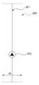
도 1은 GPS 수신 위치를 선형 데이터에 맵 매칭하는 방식을 설명하기 위한 도면이다.1 is a diagram for explaining a method of mapping a GPS reception position to linear data.
도 1을 참조하면, 상기 GPS 수신 위치(101)는 GPS 신호의 특성상 수십 m의 오차가 발생할 수 있기 때문에 상기 GPS 수신 위치(101)가 도로를 벗어나는 현상이 빈번하게 나타난다.Referring to FIG. 1, since the GPS receiving
이때, 상기 내비게이션 시스템은 상기 GPS 수신 위치(101)에서 가장 가까운 도로(103)와 대응되는 위치(105)로 상기 GPS 수신 위치(101)를 강제적으로 매칭하고 상기 GPS 수신 위치(101)가 매칭된 위치(105)에 상기 이동체의 위치를 나타내는 자차 마크를 표시할 수 있다.At this time, the navigation system forcibly matches the
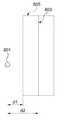
도 2는 선형 데이터에 대한 디스플레이용 데이터를 설명하기 위한 도면이다.2 is a diagram for explaining display data for linear data.
도 2를 참조하면, 상기 선형 데이터(201)를 지도 이미지로 제공하기 위해서는 도로의 폭(width)(W)을 감안하여 상기 선형 데이터(201)를 면형화 한 면형 데이터(202)를 이용할 수 있다. 즉, 상기 선형 데이터(201)에 대하여 상기 면형 데이터(202)를 매핑하여 디스플레이 함으로써 보다 사실감 있는 지도 이미지를 제공할 수 있다.Referring to FIG. 2, in order to provide the
그러나, 상기 선형 데이터에 대한 지도 이미지는 상기 면형 데이터(201)를 이용하는 반면, 상기 GPS 수신 위치는 상기 선형 데이터를 기준으로 맵 매칭이 이 루어진다. 때문에, 상기 자차 마크(203)가 도로의 중심 또는 중앙선 상에 위치하는 형태의 이미지로 표현될 수 있어 맵 매칭 방식에 대한 개선이 요구되고 있다.However, the map image for the linear data uses the
또한, 상기 내비게이션 시스템은 도로의 차선 별로 선형 데이터를 구분하여 구성한 후 각 차선의 선형 데이터를 고려하여 상기 GPS 수신 위치를 매핑할 수 있다.In addition, the navigation system can classify the linear data for each lane of the road, and map the GPS reception position in consideration of the linear data of each lane.
그러나, 상기 선형 데이터를 차선 별로 구분하지 않을 경우에는 폭이 매우 넓은 도로나 톨게이트 등에서 인접한 다른 도로로 매칭되는 오류가 발생할 가능성이 있다.However, if the linear data is not divided into lanes, there is a possibility that an error that is matched to another adjacent road in a very wide road or a tollgate may occur.
도 3는 맵 매칭 오류의 일례를 설명하기 위한 도면이다.3 is a diagram for explaining an example of a map matching error.
도 3에서, 폭(W1)이 큰 고속 도로(301)와 폭(W2)이 작은 일반 도로(302)가 서로 인접하고 이동체가 현재 고속 도로(301)를 주행하고 있다고 가정하자.3, it is assumed that a
상기한 가정 하에, 상기 내비게이션 시스템은 GPS 수신 위치(305)에 대하여 주변에 위치하는 도로 중 거리가 가장 가까운 도로의 선형 데이터에 상기 GPS 수신 위치(305)를 보정한다.Under the above assumption, the navigation system corrects the
그러나, 상기 GPS 수신 위치(305)에서 상기 고속 도로(301)의 선형 데이터(303)까지의 거리(d1)보다 일반 도로(302)의 선형 데이터(304)까지의 거리(d2)가 더 가까울 경우 이동체가 고속 도로(301)를 주행하고 상기 GPS 수신 위치(305)가 고속 도로(301)의 실 폭(W1) 내에 위치함에도 불구하고 상기 GPS 수신 위치(305)를 상기 일반 도로(302)에 매칭하는 오류가 발생할 수 있다.However, if the distance d2 from the GPS receiving
상기한 내비게이션 시스템에서 GPS 수신 위치에 대한 맵 매칭 오류가 발생 할 경우 정상적인 경로 안내를 수행할 수 없으며 시스템에 대한 사용자의 신뢰도가 떨어진다.If a map matching error occurs for the GPS reception position in the navigation system, the normal route guidance can not be performed and the reliability of the system is lowered.
최근 내비게이션 시스템의 GPS 수신 성능 및 디스플레이 성능이 현저히 높아지는 상황에서 맵 매칭 방식의 개선 또한 시급하다.It is urgent to improve the map matching method in a situation where the GPS reception performance and the display performance of the navigation system have remarkably increased recently.
본 발명의 일실시예는 GPS 수신 위치에 대한 맵 매칭 성능을 향상시킬 수 있는 도로의 면형 데이터를 이용한 맵 매칭 장치 및 그 방법을 제공한다.An embodiment of the present invention provides a map matching apparatus and method using road surface data that can improve map matching performance with respect to a GPS reception position.
본 발명의 일실시예에 따른 도로의 면형 데이터를 이용한 맵 매칭 장치는 GPS 신호를 수신한 GPS 수신 위치가 도로의 면형 데이터 내에 위치하는지 여부를 판단하는 위치 판단부; 및, 상기 GPS 수신 위치가 상기 면형 데이터 내에 위치하는지 여부에 따라 상기 GPS 수신 위치에 대한 맵 매칭을 수행하는 맵 매칭부를 포함할 수 있다.A map matching apparatus using road surface data according to an embodiment of the present invention includes a position determination unit for determining whether a GPS reception position, which receives a GPS signal, is located in the surface data of a road; And a map matching unit for performing map matching with respect to the GPS reception position according to whether the GPS reception position is located in the planar data.
본 발명의 일실시예에 따른 도로의 면형 데이터를 이용한 맵 매칭 방법은 위치 판단부와, 맵 매칭부를 포함한 내비게이션 맵 매칭 장치의 내비게이션 맵 매칭 방법에 있어서, 상기 위치 판단부에서, GPS 신호를 수신한 GPS 수신 위치가 도로의 면형 데이터 내에 위치하는지 여부를 판단하는 단계; 및, 상기 맵 매칭부에서, 상기 GPS 수신 위치가 상기 면형 데이터 내에 위치하는지 여부에 따라 상기 GPS 수신 위치에 대한 맵 매칭을 수행하는 단계를 포함할 수 있다.A map matching method using road surface data according to an embodiment of the present invention is a navigation map matching method of a navigation map matching apparatus including a position determination unit and a map matching unit, Determining whether a GPS receiving position is located in the surface data of the road; And performing map matching on the GPS reception position according to whether the GPS reception position is located in the planar data, in the map matching unit.
본 발명의 일실시예에 따르면, 도로의 면형 데이터를 이용하여 GPS 수신 위치에 대한 맵 매칭을 수행함으로써 맵 매칭 성능을 향상시킬 수 있다.According to an embodiment of the present invention, map matching performance can be improved by performing map matching on a GPS reception position using road surface data.
본 발명의 일실시예에 따르면, 도로의 면형 데이터를 이용하여 맵 매칭 기 능을 개선함으로써 내비게이션의 맵 매칭 오류를 최소화하고 시스템 및 서비스 이용에 대한 사용자의 신뢰도를 높일 수 있다.According to an embodiment of the present invention, the map matching error of the navigation can be minimized by improving the map matching function using the road surface data, and the reliability of the user for the system and service utilization can be increased.
이하에서, 본 발명에 따른 실시예들을 첨부된 도면을 참조하여 상세하게 설명한다. 그러나, 본 발명이 실시예들에 의해 제한되거나 한정되는 것은 아니다. 각 도면에 제시된 동일한 참조 부호는 동일한 부재를 나타낸다.Hereinafter, embodiments according to the present invention will be described in detail with reference to the accompanying drawings. However, the present invention is not limited to or limited by the embodiments. Like reference symbols in the drawings denote like elements.
도 4는 본 발명의 일실시예에 따른 도로의 면형 데이터를 이용한 맵 매칭 장치의 내부 구성을 도시한 블록도이다.4 is a block diagram showing an internal configuration of a map matching apparatus using road surface data according to an embodiment of the present invention.
본 발명의 일실시예와 관련된 도로의 면형 데이터를 이용한 맵 매칭 장치는 GPS 수신부(480)와, 저장부(490)와, 맵 매칭부(430)로 구성될 수 있다.The map matching apparatus using the road surface data related to the embodiment of the present invention may include a
상기 GPS 수신부(480)는 GPS 모듈로 구성되어 GPS 위성으로부터 GPS 신호를 수신하는 역할을 수행할 수 있다. 상기 수신된 GPS 신호는 이동체의 위치 정보(이하, 'GPS 수신 위치'라 칭함)를 계산하는데 이용될 수 있다.The
이때, 상기 도로의 면형 데이터를 이용한 맵 매칭 장치는 상기 GPS 수신 위치를 도로 상에 맵 매칭한 지도 데이터를 제공하고 상기 지도 데이터를 통해 이동체의 경로를 안내할 수 있다.At this time, the map matching device using the road surface data may provide map data that map-maps the GPS reception location on the road, and may guide the route of the vehicle through the map data.
상기 저장부(490)는 전국 지도에 대한 지도 데이터(geometry data)를 유지하기 위한 저장수단으로, 특히 도로와 관련된 데이터를 저장할 수 있다.The
상기 저장부(490)는 전국의 도로망을 라인 형태의 선형 데이터로 저장할 수 있으며, 상기 선형 데이터를 이미지로 표현한 면형 데이터를 상기 선형 데이터와 일대일 매칭하여 저장할 수 있다.The
여기서, 상기 선형 데이터는 상기 도로망을 구성하는 노드(node)와 링크(link)를 포함할 수 있으며, 상기 면형 데이터는 도로의 실 폭을 고려하여 일정 폭을 가지는 디스플레이용 데이터로서 평면 형태 또는 입체 형상의 폴리곤(polygon) 데이터로 구성할 있다.Here, the linear data may include a link with a node constituting the road network, and the planar data may be a display data having a predetermined width in consideration of the actual width of the road, Polygon data of the polygon.
또한, 상기 선형 데이터와 면형 데이터는 도로를 구성하는 각 차선 별로 구분하여 구성할 수 있다. 이때, 상기 선형 데이터를 구분하지 않더라도 상기 면형 데이터를 차선 별로 세분하여 구성할 수 있다. 즉, 상기 면형 데이터는 도로의 폭 정보와 차선 정보를 포함하여 구성할 수 있다.In addition, the linear data and the surface data may be classified by each lane constituting the road. At this time, even if the linear data is not distinguished, the surface data may be divided into sub-segments. That is, the surface data may include road width information and lane information.
상기 맵 매칭부(430)는 상기 저장부(490)에 저장된 지도 데이터를 이용하여 상기 GPS 수신 위치에 대한 맵 매칭을 수행할 수 있다.The map matching
상기 위치 계산부(410)는 상기 GPS 수신부(480)로부터 GPS 신호를 입력받고, 상기 입력된 GPS 신호를 기초로 상기 GPS 신호를 수신한 GPS 신호 위치 즉, 이동체의 위치를 계산할 수 있다.The
상기 위치 판단부(420)는 상기 위치 계산부(410)에서 계산된 GPS 신호 위치가 도로의 폭 내에 위치하는지 여부를 판단하는 역할을 수행할 수 있다.The
상기 위치 판단부(420)는 상기 GPS 신호 위치를 판단하는데 이용하기 위하여 상기 GPS 수신 위치를 기준으로 주변에 위치한 도로의 선형 데이터와 면형 데이터를 상기 저장부(490)에서 로딩할 수 있다.The position determiner 420 may load the linear data and the surface data of the road located at the periphery on the basis of the GPS reception position in the
상기 위치 판단부(420)는 상기 GPS 신호 위치가 상기 로딩된 면형 데이터 안에 들어오는지 여부를 확인함으로써 상기 GPS 신호 위치가 도로의 폭 내에 위치하는지 여부를 판단할 수 있다.The
상기 맵 매칭부(430)는 상기 위치 판단부(420)의 판단 결과인, 상기 GPS 신호 위치가 상기 면형 데이터 내에 위치하는지 여부에 따라 상기 GPS 수신 위치에 대한 맵 매칭을 수행할 수 있다.The map matching
도 5는 GPS 수신 위치를 매칭하는 일례를 설명하기 위한 도면이다.5 is a diagram for explaining an example of matching GPS reception positions.
도 5에 도시한 바와 같이, 상기 도로의 면형 데이터를 이용한 맵 매칭 장치는 상기 도로의 선형 데이터(504)를 지도 이미지로 제공하기 위하여 상기 선형 데이터(504)에 상기 면형 데이터(503)를 매핑한다.As shown in FIG. 5, the map matching apparatus using the planar data of the road maps the
이때, 상기 맵 매칭부(430)는 상기 GPS 신호 위치(501)가 상기 면형 데이터(503) 내에 위치할 경우 해당 위치에 상기 GPS 수신 위치(501)를 그대로 맵 매칭할 수 있다. 다시 말해, 상기 맵 매칭부(430)는 상기 GPS 수신 위치(501)가 상기 면형 데이터(503)의 폭 범위 내에 들어오면 상기 GPS 수신 위치(501)를 상기 면형 데이터(503) 상에 그대로 매칭한다.At this time, if the
따라서, 본 발명의 일실시예는 GPS 신호 위치가 도로의 폭 내에 들어올 경우 도로의 선형이 아닌 면형에 직접 맵 매칭을 수행할 수 있다.Therefore, one embodiment of the present invention can perform direct map matching to a non-linear surface shape of the road when the GPS signal position falls within the width of the road.
도 6은 GPS 수신 위치를 매칭하는 다른 일례를 설명하기 위한 도면이다.6 is a diagram for explaining another example of matching GPS reception positions.
도 6에 도시한 바와 같이, 상기 도로의 면형 데이터를 이용한 맵 매칭 장치는 도로의 각 차선(601)(603) 별로 상기 면형 데이터(602)(604)를 각각 구분하여 구성할 수 있다.As shown in FIG. 6, the map matching apparatus using the planar data of the road can be configured by dividing the planar data 602 (604) for each lane 601 (603) of the road.
이때, 상기 맵 매칭부(430)는 상기 GPS 신호 위치(605)가 상기 차선(601)(603) 중 일 차선(603)에 해당하는 면형 데이터(604) 내에 위치할 경우 상기 일 차선(603)의 면형 데이터(604) 상에 상기 GPS 신호 위치(605)를 그대로 매칭한다.When the
따라서, 본 발명의 일실시예는 차선 별로 세분화된 면형 데이터를 이용하여 GPS 신호 위치가 일 차선의 폭 내에 들어올 경우 차선의 면형에 직접 맵 매칭을 수행함으로써 이동체가 실체 차선 위에 위치하는 것처럼 보다 사실적으로 표시할 수 있다.Therefore, in an embodiment of the present invention, when the GPS signal position is within the width of one lane, the map is directly mapped to the lane shape using the area data subdivided by the lane, so that the moving object is positioned more realistically Can be displayed.
도 7은 GPS 수신 위치를 매칭하는 다른 일례를 설명하기 위한 도면이다.Fig. 7 is a view for explaining another example of matching the GPS reception position.
도 7에 도시한 바와 같이, 도로가 교차하거나 다른 도로와 인접하여 두 개 이상의 도로 간에 면형 데이터(701)(702)가 중첩되는 영역(704)이 생길 수 있다.As shown in FIG. 7, an
이때, 상기 맵 매칭부(430)는 상기 GPS 신호 위치(703)가 상기 중첩 영역(704) 내에 위치할 경우 상기 도로 중 상기 GPS 신호 위치(703)와의 거리가 가장 가까운 도로의 선형 데이터 상에 상기 GPS 신호 위치(703)를 맵 매칭할 수 있다.When the
따라서, 본 발명의 일실시예는 교차로 등 면형 데이터가 중첩되거나 면형 데이터를 공유하는 도로에서는 도로의 선형 데이터를 이용하여 GPS 신호 위치에 대한 맵 매칭을 수행할 수 있다.Accordingly, an embodiment of the present invention can perform map matching on GPS signal positions using road linear data on roads where intersection data, etc. are superimposed or plane data is shared.
도 8은 GPS 수신 위치를 매칭하는 다른 일례를 설명하기 위한 도면이다.8 is a view for explaining another example of matching GPS reception positions.
도 8에 도시한 바와 같이, 상기 GPS 신호 위치(801)가 GPS 신호의 오차 등으로 인해 상기 면형 데이터(805)를 벗어나 도로의 폭 밖에 위치할 수 있다.As shown in FIG. 8, the
이때, 상기 맵 매칭부(430)는 상기 GPS 신호 위치(801)가 상기 면형 데이터(805)를 벗어나 위치할 경우 주변 도로의 면형 데이터를 이용하여 상기 GPS 신호 위치(801)의 맵 매칭을 수행한다. 상기 맵 매칭부(430)는 상기 GPS 신호 위치(801)를 기준으로 주변에 위치한 도로의 면형 데이터 중 상기 GPS 신호 위치(801)와의 거리(d1)가 가장 가까운 도로의 면형 데이터(805) 상에 상기 GPS 신호 위치(801)를 매칭할 수 있다.At this time, if the
또한, 도로의 각 차선 별로 면형 데이터가 구분되어 있는 환경에서, 상기 맵 매칭부(430)는 상기 GPS 신호 위치(801)가 상기 면형 데이터(805)를 벗어나 위치할 경우 주변에 위치한 도로의 각 차선 별 면형 데이터 중 상기 GPS 신호 위치(801)와의 거리(d1)가 가장 가까운 차선의 면형 데이터(805) 상에 상기 GPS 신호 위치(801)를 매칭할 수 있다.When the
또한, 상기 맵 매칭부(430)는 상기 GPS 신호 위치(801)가 상기 면형 데이터(805)를 벗어나 위치할 경우 주변 도로의 선형 데이터를 이용하여 상기 GPS 신호 위치(801)의 맵 매칭을 수행한다. 상기 맵 매칭부(430)는 상기 GPS 신호 위치(801)를 기준으로 주변에 위치한 도로의 선형 데이터 중 상기 GPS 신호 위치(801)와의 거리(d2)가 가장 가까운 도로의 선형 데이터(803) 상에 상기 GPS 신호 위치(801)를 매칭할 수 있다.The
따라서, 본 발명의 일실시예는 GPS 수신 위치가 도로의 폭을 벗어나는 경우 도로의 선형 데이터 또는 면형 데이터와의 거리를 측정하여 가장 가까운 도로 상에 GPS 수신 위치의 맵 매칭을 수행할 수 있다.Therefore, in an embodiment of the present invention, if the GPS receiving position is outside the width of the road, the distance between the road data and the linear data or the surface data may be measured to perform map matching of the GPS receiving position on the nearest road.
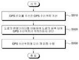
도 9는 본 발명의 일실시예에 따른 도로의 면형 데이터를 이용한 맵 매칭 방법의 전 과정을 도시한 흐름도이다. 여기서, 본 발명의 일실시예에 따른 도로의 면형 데이터를 이용한 맵 매칭 방법은 도 4에 도시한 맵 매칭 장치에 의해 실행될 수 있다.9 is a flowchart illustrating an entire process of a map matching method using road surface data according to an embodiment of the present invention. Here, a map matching method using road surface data according to an embodiment of the present invention can be executed by the map matching apparatus shown in FIG.
도 9를 참조하면, 본 발명의 일실시예에 따른 도로의 면형 데이터를 이용한 맵 매칭 방법은 다음과 같은 과정을 포함할 수 있다.Referring to FIG. 9, a map matching method using road surface data according to an embodiment of the present invention may include the following process.
단계(S910)에서 위치 계산부(410)는 GPS 신호를 기초로 상기 GPS 신호를 수신한 이동체의 위치인 GPS 신호 위치를 계산할 수 있다.In step S910, the
단계(S920)에서 위치 판단부(420)는 상기 GPS 수신 위치를 기준으로 주변에 위치한 도로의 면형 데이터를 이용하여 상기 GPS 신호 위치가 상기 도로의 폭 내에 위치하는지 여부를 판단할 수 있다.In step S920, the
상기 GPS 신호 위치를 판단하는 단계(S920)는 상기 도로의 면형 데이터를 로딩하여 상기 로딩된 면형 데이터 안에 상기 GPS 신호 위치가 들어오는지 여부를 판단할 수 있다.The step of determining the position of the GPS signal (S920) may determine whether the GPS signal position is included in the loaded surface data by loading the surface data of the road.
단계(S930)에서 맵 매칭부(430)는 상기 단계(S920)에서 판단된 GPS 신호 위치가 상기 면형 데이터 내에 위치하는지 여부에 따라 상기 GPS 수신 위치에 대한 맵 매칭을 수행할 수 있다.In step S930, the
상기 맵 매칭을 수행하는 단계(S930)는 상기 GPS 수신 위치가 상기 도로의 면형 데이터 내에 위치할 경우 상기 면형 데이터 상에 상기 GPS 수신 위치를 그대로 매칭한다.In the map matching step S930, when the GPS receiving position is located in the road surface data, the GPS receiving position is directly matched on the surface data.
또한, 상기 맵 매칭을 수행하는 단계(S930)는 상기 GPS 수신 위치가 상기 면형 데이터를 벗어나 위치할 경우 주변 도로의 선형 데이터 중 상기 GPS 수신 위치와의 거리가 가장 가까운 도로의 선형 데이터 상에 상기 GPS 수신 위치를 매칭한다.In addition, if the GPS reception position is located outside the area data, the map matching is performed in step S930. In step S930, the map matching is performed on the linear data of the road closest to the GPS reception position, And matches the reception position.
또한, 상기 맵 매칭을 수행하는 단계(S930)는 상기 GPS 수신 위치가 상기 면형 데이터를 벗어나 위치할 경우 주변 도로의 면형 데이터 중 상기 GPS 수신 위치와의 거리가 가장 가까운 도로의 면형 데이터 상에 상기 GPS 수신 위치를 맵 매칭한다.In addition, if the GPS reception position is located outside the planar data, the map matching is performed in step S930. In this case, the GPS reception is performed on the surface data of the road closest to the GPS reception position, Map the received positions.
또한, 상기 맵 매칭을 수행하는 단계(S930)는 상기 GPS 수신 위치가 두 개 이상의 도로 간 면형 데이터가 중첩되는 영역에 위치할 경우 상기 도로의 선형 데이터 중 상기 GPS 수신 위치와의 거리가 가장 가까운 도로의 선형 데이터 상에 상기 GPS 수신 위치를 맵 매칭한다.If the GPS receiving position is located in a region where two or more road surface data are overlapped, the step of performing map matching (S930) may further include a step And maps the GPS reception position on the linear data of the GPS receiver.
또한, 상기 맵 매칭을 수행하는 단계(S930)는 상기 면형 데이터가 도로의 각 차선 별로 구성되고 상기 GPS 수신 위치가 상기 도로의 차선 중 일 차선에 해당하는 면형 데이터 내에 위치할 경우 상기 일 차선의 면형 데이터 상에 상기 GPS 수신 위치를 그대로 매칭한다.In the map matching step S930, if the planar data is configured for each lane of the road and the GPS reception position is located in the planar data corresponding to one lane of the road, the one- The GPS reception position is directly matched on the data.
또한, 상기 맵 매칭을 수행하는 단계(S930)는 상기 면형 데이터가 도로의 각 차선 별로 구성되고 상기 GPS 수신 위치가 모든 차선의 면형 데이터를 벗어나 위치할 경우 상기 차선의 면형 데이터 중 상기 GPS 수신 위치와의 거리가 가장 가까운 차선의 면형 데이터 상에 상기 GPS 수신 위치를 맵 매칭한다.In the map matching step S930, when the planar data is configured for each lane of the road and the GPS reception position is located out of the lane data of all the lanes, the GPS reception position and the GPS reception position of the lane- The GPS receiving position is mapped on the surface data of the lane having the closest distance from the lane.
따라서, 본 발명의 일실시예는 GPS 수신 위치가 도로의 폭 내에 들어오면 도로의 면형 데이터를 이용하여 GPS 수신 위치에 대한 맵 매칭을 수행함으로써 도로의 선형이 아닌 면형에 직접 매칭할 수 있다. 그리고, GPS 수신 위치가 많이 튀는 도로에서는 도로의 선형 데이터 또는 면형 데이터 중 하나를 이용하여 가까운 도로 상에 맵 매칭을 보정할 수 있다.Therefore, in an embodiment of the present invention, when the GPS receiving position is within the width of the road, map matching with respect to the GPS receiving position is performed using the surface data of the road, thereby directly matching the non-linear surface shape of the road. Map matching can be corrected on a near road using one of the road linear data or the planar road data on the road where the GPS reception position is greatly disturbed.
또한 본 발명의 실시예들은 다양한 컴퓨터로 구현되는 동작을 수행하기 위한 프로그램 명령을 포함하는 컴퓨터 판독 가능 매체를 포함한다. 상기 컴퓨터 판독 가능 매체는 프로그램 명령, 데이터 파일, 데이터 구조 등을 단독으로 또는 조합하여 포함할 수 있다. 상기 매체는 프로그램 명령은 본 발명을 위하여 특별히 설계되고 구성된 것들이거나 컴퓨터 소프트웨어 당업자에게 공지되어 사용 가능한 것일 수도 있다. 컴퓨터 판독 가능 기록 매체의 예에는 하드 디스크, 플로피 디스크 및 자기 테이프와 같은 자기 매체(magnetic media), CD-ROM, DVD와 같은 광기록 매체(optical media), 플롭티컬 디스크(floptical disk)와 같은 자기-광 매체(magneto-optical media), 및 롬(ROM), 램(RAM), 플래시 메모리 등과 같은 프로그램 명령을 저장하고 수행하도록 특별히 구성된 하드웨어 장치가 포함된다. 프로그램 명령의 예에는 컴파일러에 의해 만들어지는 것과 같은 기계어 코드뿐만 아니라 인터프리터 등을 사용해서 컴퓨터에 의해서 실행될 수 있는 고급 언어 코드를 포함한다.Embodiments of the present invention also include a computer readable medium having program instructions for performing various computer implemented operations. The computer-readable medium may include program instructions, data files, data structures, and the like, alone or in combination. The media may be program instructions that are specially designed and constructed for the present invention or may be available to those skilled in the art of computer software. Examples of computer-readable media include magnetic media such as hard disks, floppy disks and magnetic tape; optical media such as CD-ROMs and DVDs; magnetic media such as floppy disks; Magneto-optical media, and hardware devices specifically configured to store and execute program instructions such as ROM, RAM, flash memory, and the like. Examples of program instructions include machine language code such as those produced by a compiler, as well as high-level language code that can be executed by a computer using an interpreter or the like.
이상과 같이 본 발명에서는 구체적인 구성 요소 등과 같은 특정 사항들과 한정된 실시예 및 도면에 의해 설명되었으나 이는 본 발명의 보다 전반적인 이해를 돕기 위해서 제공된 것일 뿐, 본 발명은 상기의 실시예에 한정되는 것은 아니며, 본 발명이 속하는 분야에서 통상적인 지식을 가진 자라면 이러한 기재로부터 다양한 수정 및 변형이 가능하다.As described above, the present invention has been described with reference to particular embodiments, such as specific elements, and specific embodiments and drawings. However, it should be understood that the present invention is not limited to the above- And various modifications and changes may be made thereto by those skilled in the art to which the present invention pertains.
따라서, 본 발명의 사상은 설명된 실시예에 국한되어 정해져서는 아니되며, 후술하는 특허청구범위뿐 아니라 이 특허청구범위와 균등하거나 등가적 변형이 있는 모든 것들은 본 발명 사상의 범주에 속한다고 할 것이다.Accordingly, the spirit of the present invention should not be construed as being limited to the embodiments described, and all of the equivalents or equivalents of the claims, as well as the following claims, belong to the scope of the present invention .
도 1은 GPS 수신 위치를 선형 데이터에 맵 매칭하는 방식을 설명하기 위한 도면이다.1 is a diagram for explaining a method of mapping a GPS reception position to linear data.
도 2는 선형 데이터에 대한 디스플레이 데이터를 설명하기 위한 도면이다.2 is a diagram for explaining display data for linear data.
도 3는 맵 매칭 오류의 일례를 설명하기 위한 도면이다.3 is a diagram for explaining an example of a map matching error.
도 4는 본 발명의 일실시예에 따른 도로의 면형 데이터를 이용한 맵 매칭 장치의 내부 구성을 도시한 블록도이다.4 is a block diagram showing an internal configuration of a map matching apparatus using road surface data according to an embodiment of the present invention.
도 5와 도 6은 도로의 면형 데이터 상에 GPS 수신 위치를 매칭하는 일례를 설명하기 위한 도면이다.5 and 6 are diagrams for explaining an example of matching GPS reception positions on road surface data.
도 7과 도 8은 GPS 수신 위치를 매칭하는 다른 일례를 설명하기 위한 도면이다.FIGS. 7 and 8 are diagrams for explaining another example of matching GPS reception positions.
도 9는 본 발명의 일실시예에 따른 도로의 면형 데이터를 이용한 맵 매칭 방법의 전 과정을 도시한 흐름도이다.9 is a flowchart illustrating an entire process of a map matching method using road surface data according to an embodiment of the present invention.
<도면의 주요 부분에 대한 부호의 설명>Description of the Related Art
410: 위치 계산부410:
420: 위치 판단부420:
430: 맵 매칭부430: Map matching unit
480: GPS 수신부480: GPS receiver
490: 저장부490:
Claims (21)
Translated fromKoreanPriority Applications (5)
| Application Number | Priority Date | Filing Date | Title |
|---|---|---|---|
| KR1020090027409AKR101609679B1 (en) | 2009-03-31 | 2009-03-31 | Apparatus for map matching of navigation using planar data of road and method thereof |
| US13/262,031US8949020B2 (en) | 2009-03-31 | 2010-03-15 | Map-matching apparatus using planar data of road, and method for same |
| CN201080014594.1ACN102378899B (en) | 2009-03-31 | 2010-03-15 | Road plane data are used to carry out the device and method of map match |
| PCT/KR2010/001599WO2010114239A2 (en) | 2009-03-31 | 2010-03-15 | Map-matching apparatus using planar data of road, and method for same |
| EP10758964.0AEP2416118A4 (en) | 2009-03-31 | 2010-03-15 | Map-matching apparatus using planar data of road, and method for same |
Applications Claiming Priority (1)
| Application Number | Priority Date | Filing Date | Title |
|---|---|---|---|
| KR1020090027409AKR101609679B1 (en) | 2009-03-31 | 2009-03-31 | Apparatus for map matching of navigation using planar data of road and method thereof |
Publications (2)
| Publication Number | Publication Date |
|---|---|
| KR20100109032A KR20100109032A (en) | 2010-10-08 |
| KR101609679B1true KR101609679B1 (en) | 2016-04-06 |
Family
ID=42828804
Family Applications (1)
| Application Number | Title | Priority Date | Filing Date |
|---|---|---|---|
| KR1020090027409AActiveKR101609679B1 (en) | 2009-03-31 | 2009-03-31 | Apparatus for map matching of navigation using planar data of road and method thereof |
Country Status (5)
| Country | Link |
|---|---|
| US (1) | US8949020B2 (en) |
| EP (1) | EP2416118A4 (en) |
| KR (1) | KR101609679B1 (en) |
| CN (1) | CN102378899B (en) |
| WO (1) | WO2010114239A2 (en) |
Families Citing this family (12)
| Publication number | Priority date | Publication date | Assignee | Title |
|---|---|---|---|---|
| KR102028637B1 (en)* | 2013-11-29 | 2019-10-04 | 현대엠엔소프트 주식회사 | Navigation apparatus and method for displaying high-level road thereof |
| KR101494826B1 (en)* | 2014-11-04 | 2015-02-23 | 김은경 | Error Checking System for Digital Map |
| KR101765196B1 (en)* | 2015-09-02 | 2017-08-07 | 현대자동차주식회사 | Vehicle and map generating method for the vehicle |
| CN106679680B (en)* | 2015-11-11 | 2021-03-12 | 阿尔派株式会社 | Navigation device and map display method thereof |
| US10145691B2 (en) | 2016-05-18 | 2018-12-04 | Here Global B.V. | Ambiguity map match rating |
| JP6477675B2 (en)* | 2016-12-16 | 2019-03-06 | カシオ計算機株式会社 | Map matching device, map matching method and program |
| KR102338880B1 (en)* | 2017-07-27 | 2021-12-14 | 한국단자공업 주식회사 | Apparatus and method for verifying reliability of mat matching feedback using image processing |
| US11162797B2 (en) | 2018-06-11 | 2021-11-02 | Here Global B.V. | Map matching method and apparatus |
| JP7337617B2 (en)* | 2019-09-17 | 2023-09-04 | 株式会社東芝 | Estimation device, estimation method and program |
| CN113656979B (en)* | 2021-08-26 | 2024-05-14 | 浙江数智交院科技股份有限公司 | Road network data generation method and device, electronic equipment and storage medium |
| US12078738B2 (en) | 2021-11-09 | 2024-09-03 | Msrs Llc | Method, apparatus, and computer readable medium for a multi-source reckoning system |
| US12259246B1 (en) | 2024-05-13 | 2025-03-25 | Msrs Llc | Method, apparatus, and computer readable medium for calculating a handrail influence intensity factor |
Citations (2)
| Publication number | Priority date | Publication date | Assignee | Title |
|---|---|---|---|---|
| JP2008014666A (en)* | 2006-07-03 | 2008-01-24 | Nec Corp | Link setting system suitable for map-matching, its method, and program |
| JP2008165326A (en)* | 2006-12-27 | 2008-07-17 | Aisin Aw Co Ltd | Feature recognition device, own vehicle location recognizing device, navigation device and feature recognition method |
Family Cites Families (53)
| Publication number | Priority date | Publication date | Assignee | Title |
|---|---|---|---|---|
| US5488378A (en)* | 1993-12-28 | 1996-01-30 | Rockwell International Corporation | Method and apparatus for determining positions on the earth corresponding to an observed rate of change of satellite range |
| US5477458A (en)* | 1994-01-03 | 1995-12-19 | Trimble Navigation Limited | Network for carrier phase differential GPS corrections |
| US5751245A (en)* | 1994-03-25 | 1998-05-12 | Trimble Navigation Ltd. | Vehicle route and schedule exception reporting system |
| US5848373A (en)* | 1994-06-24 | 1998-12-08 | Delorme Publishing Company | Computer aided map location system |
| US6321158B1 (en)* | 1994-06-24 | 2001-11-20 | Delorme Publishing Company | Integrated routing/mapping information |
| US7839301B2 (en)* | 1995-06-08 | 2010-11-23 | Western Strategic Products, Llc | Surface condition sensing and treatment systems, and associated methods |
| US5774826A (en)* | 1995-11-30 | 1998-06-30 | Trimble Navigation Limited | Optimization of survey coordinate transformations |
| US5644318A (en)* | 1996-02-02 | 1997-07-01 | Trimble Navigation Limited | SATPS dynamic surveying from a moving platform |
| US6061628A (en)* | 1996-04-24 | 2000-05-09 | Aisin Aw Co., Ltd. | Navigation system for vehicles |
| KR100245267B1 (en)* | 1996-06-03 | 2000-02-15 | 모리 하루오 | Car navigation system |
| KR19980030676A (en)* | 1996-10-30 | 1998-07-25 | 김영귀 | Vehicle Position Display Method of Vehicle Route Guidance System |
| JP3375258B2 (en)* | 1996-11-07 | 2003-02-10 | 株式会社日立製作所 | Map display method and device, and navigation device provided with the device |
| US6047234A (en)* | 1997-10-16 | 2000-04-04 | Navigation Technologies Corporation | System and method for updating, enhancing or refining a geographic database using feedback |
| US6577334B1 (en)* | 1998-02-18 | 2003-06-10 | Kabushikikaisha Equos Research | Vehicle control |
| US6016118A (en)* | 1998-03-05 | 2000-01-18 | Trimble Navigation Limited | Real time integration of a geoid model into surveying activities |
| JP3027574B1 (en)* | 1999-01-13 | 2000-04-04 | 松下電器産業株式会社 | Vehicle road position discrimination method on multi-layer roads |
| EP1182611A4 (en)* | 1999-01-25 | 2003-04-02 | Kabushiki Kaisya Zenrin | Device and method for creating and using data on road map expressed by polygons |
| US6674434B1 (en)* | 1999-10-25 | 2004-01-06 | Navigation Technologies Corp. | Method and system for automatic generation of shape and curvature data for a geographic database |
| US8060389B2 (en)* | 2000-06-07 | 2011-11-15 | Apple Inc. | System and method for anonymous location based services |
| US20020057217A1 (en)* | 2000-06-23 | 2002-05-16 | Milnes Kenneth A. | GPS based tracking system |
| WO2002001244A2 (en)* | 2000-06-23 | 2002-01-03 | Sportvision, Inc. | Track model constraint for gps position |
| US6581005B2 (en)* | 2000-11-30 | 2003-06-17 | Nissan Motor Co., Ltd. | Vehicle position calculation apparatus and method |
| US20020130953A1 (en)* | 2001-03-13 | 2002-09-19 | John Riconda | Enhanced display of environmental navigation features to vehicle operator |
| WO2004021218A2 (en)* | 2002-08-29 | 2004-03-11 | Matsushita Electric Industrial Co., Ltd. | Content processing apparatus and content display apparatus based on location information |
| US7424133B2 (en)* | 2002-11-08 | 2008-09-09 | Pictometry International Corporation | Method and apparatus for capturing, geolocating and measuring oblique images |
| CA2423148C (en)* | 2003-03-24 | 2011-05-31 | Guardian Angel Protection Inc. | Apparatus for recording global positioning system co-ordinates of components of a utility |
| JP3969356B2 (en)* | 2003-06-24 | 2007-09-05 | アイシン・エィ・ダブリュ株式会社 | Navigation system and point search method program |
| GB0314770D0 (en)* | 2003-06-25 | 2003-07-30 | Ibm | Navigation system |
| DE10343683A1 (en)* | 2003-09-20 | 2005-04-21 | Daimler Chrysler Ag | Information system for motor vehicles |
| US7221928B2 (en)* | 2003-10-01 | 2007-05-22 | Laird Mark D | Mobile emergency notification system |
| US7336078B1 (en)* | 2003-10-04 | 2008-02-26 | Seektech, Inc. | Multi-sensor mapping omnidirectional sonde and line locators |
| WO2005076031A2 (en)* | 2003-10-06 | 2005-08-18 | Sirf Technology, Inc. | A system and method for augmenting a satellite-based navigation solution |
| US20050107946A1 (en)* | 2003-11-13 | 2005-05-19 | Takanori Shimizu | Vehicle navigation apparatus |
| US7139651B2 (en)* | 2004-03-05 | 2006-11-21 | Modular Mining Systems, Inc. | Multi-source positioning system for work machines |
| ATE528740T1 (en)* | 2004-06-01 | 2011-10-15 | Persen Technologies Inc | VEHICLE WARNING SYSTEM WITH IMPROVED POWER SUPPLY |
| US7460872B2 (en)* | 2004-07-06 | 2008-12-02 | International Business Machines Corporation | Method and application for automatic tracking of mobile devices for computer network processor systems |
| JP4599932B2 (en)* | 2004-08-06 | 2010-12-15 | アイシン・エィ・ダブリュ株式会社 | Navigation system |
| US8983426B2 (en)* | 2004-11-18 | 2015-03-17 | Verizon Patent And Licensing Inc. | Passive individual locator method |
| WO2007133264A2 (en)* | 2005-12-09 | 2007-11-22 | Automotive Communications Systems, Inc. | Integrated vehicular positioning and communications system |
| JP2007178271A (en)* | 2005-12-28 | 2007-07-12 | Aisin Aw Co Ltd | Own position recognition system |
| US9646415B2 (en)* | 2006-05-16 | 2017-05-09 | Underground Imaging Technologies, Inc. | System and method for visualizing multiple-sensor subsurface imaging data |
| JP2008083918A (en)* | 2006-09-27 | 2008-04-10 | Aisin Aw Co Ltd | Navigation device |
| US20090021367A1 (en)* | 2007-07-19 | 2009-01-22 | Davies Daniel F | Apparatus, system, and method for tracking animals |
| KR100916960B1 (en) | 2007-09-12 | 2009-09-14 | 한국철도기술연구원 | Platform monitoring system |
| JP2009157053A (en)* | 2007-12-26 | 2009-07-16 | Aisin Aw Co Ltd | Three-dimensional map display navigation device, three-dimensional map display system, and three-dimensional map display program |
| JP2009154647A (en)* | 2007-12-26 | 2009-07-16 | Aisin Aw Co Ltd | Multi-screen display device and program thereof |
| US20100332119A1 (en)* | 2008-03-14 | 2010-12-30 | Tom Tom International B.V. | Navigation device and method |
| US8364334B2 (en)* | 2008-10-30 | 2013-01-29 | Honeywell International Inc. | System and method for navigating an autonomous vehicle using laser detection and ranging |
| US7855683B2 (en)* | 2008-11-04 | 2010-12-21 | At&T Intellectual Property I, L.P. | Methods and apparatuses for GPS coordinates extrapolation when GPS signals are not available |
| JP2012511697A (en)* | 2008-12-09 | 2012-05-24 | トムトム ノース アメリカ インコーポレイテッド | How to generate a geodetic reference database |
| WO2010085822A2 (en)* | 2009-01-26 | 2010-07-29 | Shotspotter, Inc. | Systems and methods with improved three-dimensional source location processing including constraint of location solutions to a two-dimensional plane |
| US8340400B2 (en)* | 2009-05-06 | 2012-12-25 | Honeywell International Inc. | Systems and methods for extracting planar features, matching the planar features, and estimating motion from the planar features |
| US9396563B2 (en)* | 2012-06-06 | 2016-07-19 | Apple Inc. | Constructing road geometry |
- 2009
- 2009-03-31KRKR1020090027409Apatent/KR101609679B1/enactiveActive
- 2010
- 2010-03-15EPEP10758964.0Apatent/EP2416118A4/ennot_activeCeased
- 2010-03-15USUS13/262,031patent/US8949020B2/enactiveActive
- 2010-03-15CNCN201080014594.1Apatent/CN102378899B/enactiveActive
- 2010-03-15WOPCT/KR2010/001599patent/WO2010114239A2/enactiveApplication Filing
Patent Citations (2)
| Publication number | Priority date | Publication date | Assignee | Title |
|---|---|---|---|---|
| JP2008014666A (en)* | 2006-07-03 | 2008-01-24 | Nec Corp | Link setting system suitable for map-matching, its method, and program |
| JP2008165326A (en)* | 2006-12-27 | 2008-07-17 | Aisin Aw Co Ltd | Feature recognition device, own vehicle location recognizing device, navigation device and feature recognition method |
Also Published As
| Publication number | Publication date |
|---|---|
| WO2010114239A3 (en) | 2010-11-25 |
| WO2010114239A2 (en) | 2010-10-07 |
| CN102378899B (en) | 2015-12-16 |
| US8949020B2 (en) | 2015-02-03 |
| EP2416118A4 (en) | 2013-08-28 |
| KR20100109032A (en) | 2010-10-08 |
| US20120101718A1 (en) | 2012-04-26 |
| EP2416118A2 (en) | 2012-02-08 |
| CN102378899A (en) | 2012-03-14 |
Similar Documents
| Publication | Publication Date | Title |
|---|---|---|
| KR101609679B1 (en) | Apparatus for map matching of navigation using planar data of road and method thereof | |
| US8594926B2 (en) | Method for guiding crossroad using point of interest and navigation system | |
| US9494694B1 (en) | Method and apparatus of road location inference for moving object | |
| US7698060B2 (en) | Map data product and map data processing device | |
| US9052207B2 (en) | System and method for vehicle navigation using lateral offsets | |
| US20080021638A1 (en) | Navigation system | |
| US20100241355A1 (en) | Method for correcting map matching and navigation system implementing the method | |
| US20100045704A1 (en) | Method for changing dynamic display mode and apparatus thereof in car navigation system | |
| JP4835413B2 (en) | Vehicle navigation device | |
| WO2008056882A1 (en) | Navigation system and method for displaying poi of land mark | |
| CN104081160A (en) | Memory devices and navigation systems | |
| CN101403621B (en) | Instant recording method for electronic map road data | |
| CN101493337A (en) | Road displaying method, apparatus and navigation equipment | |
| KR100620238B1 (en) | Method and system for providing map data using mobile communication terminal | |
| KR20190057502A (en) | Method for map matching position of vehicle and navigation apparatus thereof | |
| KR100475279B1 (en) | Method and Apparatus for Displaying Map for Navigation | |
| JP3966325B2 (en) | Vehicle navigation apparatus and map data reading method in the apparatus | |
| JP2015049208A (en) | Reverse running alarm device | |
| KR101062664B1 (en) | Period display method of linear map data and its device | |
| KR100786023B1 (en) | Method for providing a plurality of lane information and a terminal for performing the method | |
| WO2008136566A1 (en) | Apparatus and method for guide crossroad in navigation system | |
| WO2008153256A1 (en) | Path search method connected with guideboard information and navigation system | |
| JP4808175B2 (en) | Method for arranging road index on map data in navigation device | |
| CN101482422A (en) | Distance measuring and calculating system and method for peripheral object of road | |
| JP2006105863A (en) | Map matching system |
Legal Events
| Date | Code | Title | Description |
|---|---|---|---|
| PA0109 | Patent application | Patent event code:PA01091R01D Comment text:Patent Application Patent event date:20090331 | |
| PG1501 | Laying open of application | ||
| PA0201 | Request for examination | Patent event code:PA02012R01D Patent event date:20140321 Comment text:Request for Examination of Application Patent event code:PA02011R01I Patent event date:20090331 Comment text:Patent Application | |
| E902 | Notification of reason for refusal | ||
| PE0902 | Notice of grounds for rejection | Comment text:Notification of reason for refusal Patent event date:20150515 Patent event code:PE09021S01D | |
| E90F | Notification of reason for final refusal | ||
| PE0902 | Notice of grounds for rejection | Comment text:Final Notice of Reason for Refusal Patent event date:20151104 Patent event code:PE09021S02D | |
| E701 | Decision to grant or registration of patent right | ||
| PE0701 | Decision of registration | Patent event code:PE07011S01D Comment text:Decision to Grant Registration Patent event date:20160104 | |
| PR0701 | Registration of establishment | Comment text:Registration of Establishment Patent event date:20160331 Patent event code:PR07011E01D | |
| PR1002 | Payment of registration fee | Payment date:20160401 End annual number:3 Start annual number:1 | |
| PG1601 | Publication of registration | ||
| FPAY | Annual fee payment | Payment date:20190326 Year of fee payment:4 | |
| PR1001 | Payment of annual fee | Payment date:20190326 Start annual number:4 End annual number:4 | |
| PR1001 | Payment of annual fee | Payment date:20200326 Start annual number:5 End annual number:5 | |
| PR1001 | Payment of annual fee | Payment date:20210329 Start annual number:6 End annual number:6 | |
| PR1001 | Payment of annual fee | Payment date:20220317 Start annual number:7 End annual number:7 | |
| PR1001 | Payment of annual fee | Payment date:20240502 Start annual number:9 End annual number:9 | |
| PR1001 | Payment of annual fee | Payment date:20250310 Start annual number:10 End annual number:10 |