KR101548880B1 - Application for Sharing Service of Mobile Location Based Opening Information in Social Network Service - Google Patents
Application for Sharing Service of Mobile Location Based Opening Information in Social Network ServiceDownload PDFInfo
- Publication number
- KR101548880B1 KR101548880B1KR1020140127612AKR20140127612AKR101548880B1KR 101548880 B1KR101548880 B1KR 101548880B1KR 1020140127612 AKR1020140127612 AKR 1020140127612AKR 20140127612 AKR20140127612 AKR 20140127612AKR 101548880 B1KR101548880 B1KR 101548880B1
- Authority
- KR
- South Korea
- Prior art keywords
- information
- public information
- public
- marker
- user terminal
- Prior art date
- Legal status (The legal status is an assumption and is not a legal conclusion. Google has not performed a legal analysis and makes no representation as to the accuracy of the status listed.)
- Expired - Fee Related
Links
Images


Classifications
- G—PHYSICS
- G06—COMPUTING OR CALCULATING; COUNTING
- G06Q—INFORMATION AND COMMUNICATION TECHNOLOGY [ICT] SPECIALLY ADAPTED FOR ADMINISTRATIVE, COMMERCIAL, FINANCIAL, MANAGERIAL OR SUPERVISORY PURPOSES; SYSTEMS OR METHODS SPECIALLY ADAPTED FOR ADMINISTRATIVE, COMMERCIAL, FINANCIAL, MANAGERIAL OR SUPERVISORY PURPOSES, NOT OTHERWISE PROVIDED FOR
- G06Q50/00—Information and communication technology [ICT] specially adapted for implementation of business processes of specific business sectors, e.g. utilities or tourism
- G06Q50/40—Business processes related to the transportation industry
Landscapes
- Business, Economics & Management (AREA)
- Health & Medical Sciences (AREA)
- Economics (AREA)
- General Health & Medical Sciences (AREA)
- Human Resources & Organizations (AREA)
- Marketing (AREA)
- Primary Health Care (AREA)
- Strategic Management (AREA)
- Tourism & Hospitality (AREA)
- Physics & Mathematics (AREA)
- General Business, Economics & Management (AREA)
- General Physics & Mathematics (AREA)
- Engineering & Computer Science (AREA)
- Theoretical Computer Science (AREA)
- Information Transfer Between Computers (AREA)
Abstract
Description
Translated fromKorean본 발명은 모바일 위치기반의 공개정보를 공유하는 서비스 방법에 관한 것으로, 더욱 상세하게는 지리정보를 포함하는 지도위에 특정의 사용자가 실시간으로 올린 글을 해당 위치와 근접한 사용자가 일정시간 동안 조회할 수 있는 소셜네트워크서비스에서의 공개정보를 공유할 수 있도록 하는 서비스 방법에 관한 것이다.
The present invention relates to a service method for sharing public information based on a mobile location, and more particularly, to a service method for sharing public information based on mobile location, To a service method for allowing public information in a social network service to be shared.
일반적으로 소셜네트워크서비스(Social Network Service, SNS)는 인터넷 기반의 커뮤니티 서비스이다. 온라인의 가상공간을 통해 인맥을 쌓고, 정보를 공유하는 인터넷 기반의 커뮤니티 서비스를 총칭한다. 웹상에서 이용자들이 인적 네트워크를 형성할 수 있게 해주는 서비스로 PC뿐만 아니라 휴대전화로 간단한 글을 올릴 수 있는 단문 SNS가 젊은 층을 중심으로 인기를 끌고 있다. 인터넷에서 개인의 정보를 공유할 수 있게 하고, 의사소통을 도와주는 1인 미디어, 1인 커뮤니티라 할 수 있다. 더욱이 개인의 표현욕구가 강해지면서 사람들 사이의 사회적 관계를 맺게 하고, 친분관계를 유지시키는 소셜네트워크서비스 또한 점점 발달하고 있다. 웹상의 카페, 동호회 등의 커뮤니티 서비스가 특정 주제에 관심을 가진 집단이 그룹화하여 폐쇄적인 서비스를 공유한다면 소셜네트워크서비스는 나 자신 즉 개인이 중심이 되어 자신의 관심사와 개성을 공유한다는 점에서 차이점이 있다. 초기에는 주로 친목도모, 엔터테인먼트 용도로 활용되었으나 이후 비즈니스, 각종 정보공유 등 생산적 용도로 활용하는 경향이 생겨났다. 또 인터넷 검색보다 소셜네트워크서비스를 통하여 최신 정보를 찾고 이를 활용하는 이들도 많다. 대부분 아는 사람의 아는 사람으로 연결되어 있는 특성상 일반 검색을 통해 찾는 정보보다 친구의 추천으로 공유하는 정보가 신뢰성이 높고 또 간결하게 전달되기 때문이다.In general, the Social Network Service (SNS) is an Internet-based community service. Internet-based community services that build up networking and share information through online virtual spaces. As a service that allows users to form a human network on the web, short text SNS that can post simple texts on mobile phones as well as PCs is gaining popularity with young people. It is a one-person, one-person community that helps people share information on the Internet and helps them communicate. In addition, social network services that keep social relations between people and maintain friendship are becoming more and more developed as individuals' desire for expression becomes stronger. If community services such as cafes and clubs on the web are grouped by groups that are interested in a specific topic and share closed services, then social network services are different in that they share their interests and personality have. In the early days, it was mainly used for socializing and entertainment purposes, but thereafter, it tended to be used for productive purposes such as business and various information sharing. In addition, there are many people who find and use the latest information through social network service rather than Internet search. This is because the information shared by the recommendation of a friend is more reliable and concise than the information searched through the general search.
본 발명과 관련된 선행기술로서, 특허문헌 1은 위치와 경로를 파악할 수 있게 하는 패스맵(PathMap)과, GPS의 신호를 공유하여 교통정보로 가공한 후 활용하게 하는 협동 트래픽(Traffic)과, 멤버십을 형성한 그룹의 구성원 사이에서 자신의 위치 정보를 공유하게 하는 마이 팀(Team)과, 현재의 위치를 좌표, 사진 및 동영상, 이름, 설명으로 기록하고, 기록과 관리와 공유를 하게 하는 길 태그(Tag)와, 위치기반의 광고정보를 제공하는 위치기반의 광고(LBA)로 구성되며, 위치기반의 광고를 수행하기 위해 GPS(Global Positioning System)에서 발생되는 값으로 위치 정보를 수집하여 응용부로 전달하여 응용부 내의 위치기반 데이터 DB에 저장하는 기능과, 광고 등록자에 의해 위치기반의 광고가 응용부 내의 위치기반 광고 DB에 등록하는 기능과, 광고 등록자가 응용부 내의 위치기반 데이터 DB로부터 통계정보를 전달받는 기능을 갖는 생성부와, 상기 생성부 내의 패스맵과, 협동 트래픽과, 마이 팀과, 길 태그로부터 축적된 위치정보들 간의 관계를 인식하고, 축적된 위치 정보를 광고주의 의지로 선택되게 하여, 축적된 새로운 위치정보로 저장되는 위치기반 데이터 DB와, 광고주가 원하는 위치에 광고를 노출되게 하고, 상기 노출된 광고의 수행 경과는 모니터링되고, 축적되어 새로운 위치정보로 저장되는 위치기반 광고 DB로 구성되며, 상기 생성부와 출력부와 연동되고, 상기 생성부로부터 수집된 위치 정보를 전달받아 위치기반정보 공개된 응용 프로그램 인터페이스(Open API) 내의 위치기반 데이터 DB에 저장하고, 위치기반 데이터 DB에 저장되어 있는 통계정보를 생성부 내의 광고 등록자에게 전달하며, 위치기반 데이터 DB에 저장되어 있는 통계정보를 위치정보를 활용하는 출력부로 전달하는 기능과, 위치기반의 광고 등록자로부터 위치기반광고 공개된 응용 프로그램 인터페이스(Open API) 내의 위치기반광고 DB에 등록받고, 위치광고를 출력부로 전달하는 기능을 갖는 응용부와, 상기 응용부로부터 위치기반정보와 위치기반광고를 전달받아 활용하는 기능을 갖는 출력부를 포함하는 전자지도 핫스팟의 지형지물을 이용한 광고 수행 시스템이 개시되어 있다.[0004] As a prior art related to the present invention,
또한, 특허문헌 2는 사용자 입력에 따라 장소정보와 테마정보를 송신하는 단말장치, 상기 장소정보를 수신하여 관리하는 POI 관리장치, 상기 테마정보를 수신하여 관리하는 테마정보 관리장치, 상기 장소정보 및 테마정보를 수신하여 상기 장소정보를 포함하는 웹 문서를 수집하고, 수집된 웹 문서에 포함된 단어 중 기준 횟수 이상 노출되는 단어를 포함하는 테마정보를 상기 장소정보와 매핑하여 테마별 장소정보를 생성하는 텍스트 마이닝 장치 및 상기 테마별 장소정보를 저장하고, 상기 단말장치로부터 장소정보 검색을 위한 검색어와 현재 위치정보가 수신된 경우, 상기 단말장치를 중심으로 소정 거리 이내에 위치한 장소정보 중 상기 검색어에 대응되는 테마를 갖는 장소정보를 검색하여 상기 단말장치에 제공하는 테마별 장소정보 제공장치를 포함하는 사용자 위치기반 테마별 장소정보 제공 시스템이 개시되어 있다.
Patent Document 2 discloses a terminal device that transmits place information and theme information according to user input, a POI management device that receives and manages the place information, a theme information management device that receives and manages the theme information, The theme information is collected, the web document including the place information is collected, and the theme information including the words that are exposed by the reference frequency or more among the words included in the collected web document is mapped with the place information to generate theme place information A text mining device, and the theme-specific place information, and when a search word for searching for a place information and current location information are received from the terminal device, a location corresponding to the search word among the place information located within a predetermined distance, And a location information providing device for a theme that provides the location information to the terminal device A location information providing system according to a user location based on a theme.
본 발명은 소셜네트워크서비스에서, 위치정보를 기반으로 지리정보를 포함하는 지도위에 특정의 사용자가 실시간으로 올린 글을 해당 위치와 근접한 모든 사용자가 일정시간 동안 열람할 수 있도록 한 것이 목적이다.
An object of the present invention is to allow a user, who is close to a location, to read a specific article uploaded in real time on a map including geographical information based on location information in a social network service for a predetermined period of time.
본 발명은 상기 목적을 달성하기 위하여, (a) 사용자단말기에 설치된 어플리케이션이 실행되면 어플리케이션의 제어모듈은 GPS기반의 지리정보모듈에 의하여 현재 위치의 지리정보가 단말기 화면에 표출되도록 하는 단계; (b) 상기 제어모듈은 통신망을 통해 메인서버에서 수신된 하나 이상의 공개정보를 지리정보가 표시된 단말기 화면에 각각 마커로 표시하는 단계; (c) 상기 사용자단말기를 통해 공개정보의 게시를 위한 업로드가 선택되면 제어모듈은 사용자단말기의 위치정보, 공개정보의 내용, 공개형태, 공개게시 시간의 설정과 더불어 공개에 따른 비용 결제 또는 무료 등록에 관한 정보를 메인서버로 전송하는 단계, 및 (d) 상기 메인서버는 사용자단말기로부터 입력된 공개정보를 DB서버에 저장하고 DB서버에 저장된 공개정보를 각 사용자단말기에 설치된 어플리케이션의 제어모듈을 통해 단말기 화면에 표시된 지리정보 위에 수신된 공개정보를 포함하는 하나 이상의 마커를 노출시키는 단계의 기능을 수행하는 소셜네트워크서비스에서의 모바일 위치기반 공개정보 공유서비스 어플리케이션을 제공한 것이 특징이다.(A) when the application installed in the user terminal is executed, the control module of the application displays the geographical information of the current location on the screen of the terminal by the GPS-based geographical information module; (b) the control module displays one or more pieces of public information received from a main server through a communication network with a marker on a terminal screen displaying geographical information; (c) If the upload for publishing the public information is selected through the user terminal, the control module sets the location information of the user terminal, the contents of the public information, the public form, and the public posting time, (D) the main server stores the public information input from the user terminal in the DB server and transmits the public information stored in the DB server to the main server via the control module of the application installed in each user terminal Discloses a mobile location based public information sharing service application in a social network service that performs a function of exposing one or more markers including public information received on geographical information displayed on a terminal screen.
또한, 본 발명에서, (e) 상기 사용자단말기 화면에 표시된 지리정보 위에 노출된 마커가 선택되면 제어모듈은 메인서버로부터 해당 마커에 관한 정보를 수신하여 선택된 마커 위에 말풍선 형태로 공개정보를 표시하는 단계, 및 (f) 상기 마커에 포함된 공개정보가 열람되면 사용자단말기를 통해 게시된 공개정보에 관한 댓글 또는 투표가 입력되도록 하여 메인서버를 통해 DB서버에 저장되도록 하고 메인서버는 DB서버에 저장된 댓글이나 투표정보 또는 열람횟수에 관한 정보를 공개정보와 같이 게시하는 단계의 기능을 더 포함할 수 있다.(E) when a marker exposed on the geographical information displayed on the user terminal screen is selected, the control module receives information on the marker from the main server and displays public information on the selected marker in a balloon form And (f) when the public information included in the marker is browsed, a comment or a vote related to the public information posted through the user terminal is inputted and stored in the DB server through the main server, and the main server stores the comment And a step of posting information about the voting information or the number of times of browsing together with the public information.
또한, 본 발명에서, 상기 단계(e)에서, 단말기 화면에서 선택된 마커는 제어모듈에 의하여 불특정 다수가 열람할 수 있도록 하는 공개마커와, 사용자단말기 계정을 팔로우하는 설정된 사용자만 열람할 수 있도록 하는 비공개마커로 구분하여 공개정보를 게시할 수 있다.Also, in the present invention, in the step (e), the markers selected on the terminal screen may include a public marker for allowing an unspecified majority to browse by the control module, and a private marker for allowing only a set user following the user terminal account to browse You can post public information separately by markers.
또한, 본 발명에서, 상기 단계(b)에서, 마커는 공개정보의 종류나 속성에 따른 색상이 구분되고, 마커는 2D 또는 3D 형상으로 표시되며, 마커는 상하진동, 좌우진동 또는 회전하는 움직임을 포함할 수 있다.Also, in the present invention, in the step (b), the marker is classified into colors according to the type and the attribute of the public information, the marker is displayed in the 2D or 3D shape, and the marker is the vertical vibration, .
또한, 본 발명에서, 상기 단계(b)에서, 상기 제어모듈은 사용자단말기의 현재 위치로부터 일정 반경이내에 생성된 마커를 표시할 수 있다.Further, in the present invention, in the step (b), the control module may display a marker generated within a predetermined radius from a current position of the user terminal.
또한, 본 발명에서, 상기 단계(b)에서, 상기 제어모듈은 단말기 화면의 지리정보가 확대 또는 축소될 때마다 메인서버로부터 공개정보를 수신하여 갱신된 공개정보가 표시되도록 하되, 수신된 공개정보의 게시비용에 따른 결제 금액에 따라 우선순위를 두어 표시되도록 할 수 있다.Also, in the present invention, in the step (b), the control module receives the public information from the main server every time the geographical information of the terminal screen is enlarged or reduced so that the updated public information is displayed, It is possible to display a priority according to the payment amount according to the posting cost of the mobile terminal.
또한, 본 발명에서, 상기 제어모듈은 태그를 이용하여 지도위에 표시되는 공개정보를 필터링할 수 있다.Further, in the present invention, the control module may filter the public information displayed on the map using the tag.
또한, 본 발명에서, 상기 사용자단말기가 게시한 공개정보를 복수 팔로우 사용자가 단말기로 열람할 수 있도록 메인서버가 해당 팔로우하는 사용자단말기로 알림서비스를 제공할 수 있다.
Also, in the present invention, the main server may provide a notification service to the following user terminal so that a plurality of followers can browse the public information posted by the user terminal.
본 발명에 따르면, 사용자가 게시한 공개정보를 지도상에 표시하여 해당 위치에 접근하는 모든 사람이 조회할 수 있고, 위치기반 서비스를 위한 정보 수집이 서비스 공급자가 하는 것이 아니라 사용자가 직접 올리는 공개정보를 기반으로 하며, 사용자가 직접 게시하는 공개정보이므로 정보의 실시간 반영이 서비스 공급자가 수집하여 제공하는 정보보다 빠르고 정확하고, 사용자가 올리는 공개정보는 짧은 생명주기(Time to Live, TTL)을 갖기 때문에 해당 정보가 최신 정보임을 보장하며, 사용자가 올리는 지도상에 표시되는 공개정보에 실시간 댓글로 정보 제공자와 공유자와의 양방향 통신이 가능한 이점이 있다.
According to the present invention, public information posted by a user is displayed on a map and can be viewed by anyone accessing the location, and information collection for a location-based service is not performed by a service provider, , Because it is publicly posted by the user, the real-time reflection of information is faster and more accurate than the information provided by the service provider, and the public information that the user uploads has a short time-to-live (TTL) It is ensured that the information is the latest information, and bidirectional communication with the information provider and the sharer is possible in real time by commenting on the public information displayed on the map by the user.
도 1은 본 발명에 따른 실시 예로, 소셜네트워크서비스에서의 모바일 위치기반 공개정보 공유서비스를 위한 시스템을 나타낸 구성도이다.
도 2는 본 발명에 따른 소셜네트워크서비스에서의 모바일 위치기반 공개정보 공유서비스에 관한 흐름도이다.
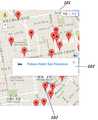
도 3은 본 발명에서 사용자단말기 화면에 표시된 지리정보 위에 복수의 마커의 표시와 더불어 공개정보를 예시적으로 나타낸 것이다.1 is a block diagram illustrating a system for a mobile location-based public information sharing service in a social network service according to an embodiment of the present invention.
2 is a flowchart of a mobile location based public information sharing service in a social network service according to the present invention.
FIG. 3 exemplarily shows public information in addition to the display of a plurality of markers on the geographical information displayed on the screen of the user terminal according to the present invention.
이하 본 발명에 따른 소셜네트워크서비스에서의 모바일 위치기반 공개정보 공유서비스 어플리케이션에 관하여 첨부된 도면을 참조하여 상세하게 설명하면 다음과 같다.Hereinafter, a mobile location based public information sharing service application in a social network service according to the present invention will be described in detail with reference to the accompanying drawings.
도 1에서, 하나 이상의 사용자단말기(100)가 통신망을 통해 모바일 위치기반 공개정보 공유서비스를 제공하는 메인서버(200)에 접속된다. 메인서버(200)는 위치기반의 소셜네트워크서비스(SNS)를 제공하는 것이다. 사용자단말기(100)는 복수의 사용자단말기와 통신망을 통해 소셜네트워크서비스가 가능한 단말기로, 데스크탑, 노트북, 태블릿 또는 스마트폰 등이 포함되고, 바람직하게는 통신망에 모바일 접속이 가능한 단말기가 좋다. 사용자단말기(100)는 GPS수신기를 탑재하여 위치정보를 수신할 수 있어야 한다. 사용자단말기(100)는 자신의 위치를 지도위에 표시할 수 있도록 하는 지리정보가 제공되는 것이 좋다.In FIG. 1, one or
사용자단말기(100)에는 소셜네트워크서비스(SNS)를 통해 모바일 위치기반의 공개정보를 공유할 수 있도록 하는 서비스를 위한 어플리케이션(110)이 설치되어 있다. 어플리케이션은 앱스토어에서 다운로드 받거나 본 발명의 서비스를 제공하는 메인서버에 접속하여 다운로드 받아 설치할 수 있을 것이다.The
어플리케이션(110)은 지리정보를 포함하는 GIS모듈(112)과, 지리정보 위에 게시된 마커의 게시시간을 설정하는 시간정보모듈(113)과, 지도위에 공개정보를 게시하여 업로드 하는 공개정보업로드모듈(144)과, 공개정보의 업로드와 게시시간에 따른 비용을 결제하기 위한 결제정보모듈(115)과, 입출력되는 데이터를 저장하는 저장모듈(116)을 포함한다. 그리고 어플리케이션(110)의 작동과 각 모듈을 제어하는 제어모듈(111)이 포함되어 있다.The
메인서버(200)는 통신망을 통해 복수 사용자단말기(100)가 업로드한 공개정보를 DB서버(210)에 저장하였다가 저장된 공개정보를 각 사용자단말기(100)로 전송하는 것이다. 메인서버(200)에는 복수의 서버가 연결되어 공개정보의 업로드와 다운로드 등을 송수신한다. DB서버(210)는 각종 공개정보를 비롯하여 이와 관련된 데이터를 저장 및 입출력하는 것이다. 사용자인증서버(220)은 사용자단말기(100)를 이용하는 복수의 사용자에 관한 정보를 저장하고 사용자를 인증하는 것이다. 태그필터링서버(230)은 태그를 이용하여 공개정보를 필터링하는 것이다. 위치정보서버(240)는 사용자단말기(100)의 위치에 관한 정보를 제공하는 것이다. 결제정보서버(250)는 사용자가 공개정보를 게시하기 위한 비용을 결제할 수 있도록 하는 것이다. 통계서버(260)는 복수의 사용자단말기(100)가 업로드한 공개정보의 통계를 산출하는 것이다. 캐시서버(270)는 관리하고 있는 데이터를 축적하였다가 사용자단말기(100)가 접속하고 있는 서버에 신속하게 데이터를 제공하는 것이다. 라우팅서버(280)은 라우팅 및 원격 액세스를 위한 실행을 위한 것이다. 더욱이 본 발명에서는 상기 메인서버(200)를 포함하여 복수의 서버들의 구성 및 접속은 소셜네트워크서비스에서의 모바일 위치기반으로 하는 공개정보를 공유하는 서비스를 위한 다양한 서버가 더 포함될 수 있을 것이다.The
본 발명의 소셜네트워크서비스에서의 모바일 위치기반 공개정보 공유서비스 어플리케이션의 기능 및 작용에 관하여 도 2의 흐름도와 도 3을 참조하여 설명한다.The function and operation of the mobile location based public information sharing service application in the social network service of the present invention will be described with reference to the flow chart of FIG. 2 and FIG.
먼저, 사용자에 의하여 사용자단말기(100)에 설치된 어플리케이션이 실행된다(S11). 어플리케이션은 메인서버(200)에 접속하여 다운로드 받거나 앱스토어 등을 통해서 다운로드 받아 설치된다. 어플리케이션이 실행되면, 제어모듈(111)은 GPS기반의 GIS모듈(112)에 의하여 현재 위치의 지리정보가 단말기 화면(101)에 표출되도록 한다(S12).First, the application installed in the
도 3a에서, 제어모듈(111)은 통신망을 통해 메인서버(200)에서 수신된 하나 이상의 공개정보를 지리정보가 표시된 단말기 화면에 각각 마커(102)로 표시한다(S13). 마커(102)는 공개정보의 종류나 속성에 따른 색상이 구분될 수 있고, 마커(102)는 2D 또는 3D 형상으로 표시될 수 있으며, 마커(102)는 상하진동, 좌우진동 또는 회전하는 움직임을 나타낼 수 있다. 예를 들어, 광고나 세일 또는 게시시간에 따라 색상이 변화되거나 2D나 3D로 표시될 수 있고 또는 진동이나 회전 등의 움직임으로 마커(102)를 표현할 수 있도록 하여 공개정보를 쉽게 구분할 수 있을 것이다.In FIG. 3A, the
그리고 제어모듈(111)은 사용자단말기(100)의 현재 위치로부터 일정 반경이내에 생성된 마커(102)를 표시하는 것이지만, 필요에 따라 사용자가 검색한 위치로부터 마커(102)가 표시되도록 할 수 있을 것이다. 또한, 제어모듈(111)은 단말기 화면(101)의 지리정보가 확대 또는 축소될 때마다 메인서버(200)로부터 공개정보를 수신하여 갱신된 공개정보가 표시되도록 한다. 즉 사용자가 단말기 화면(101)에 표시된 지리정보의 확인을 위하여 지리정보가 확대되거나 축소될 때에 제어모듈(111)은 메인서버(200)에서 수신된 데이터로 공개정보가 포함된 마커(102)가 갱신되도록 한다. 그리고 지도상에 공개정보를 게시할 때에 게시시간 이외에 지도가 확대 또는 축소되는 배율에 따라 우선순위를 두고 마커(102)가 노출되도록 한다. 이는 지도상에서 배율을 축소하여 해당 지역, 예를 들어 특정의 행정구역 전체가 단말기 화면(101)에 표시될 때에 마커(102)가 너무 많이 표시되기 때문에 우선순위가 높은 마커(102)만 표시되도록 한다. 더욱이 지도의 확대 또는 축소되는 비율에 따라 표시되는 마커(102)의 개수를 제한할 수도 있을 것이다. 우선순위는 게시기간에 따라 또는 게시비용에 따라 달라질 수 있을 것이다.The
사용자는 사용자단말기(100)를 이용하여 사용자의 현재 위치에 공개정보를 포함하는 마커(102)를 게시하거나 또는 사용자단말기(100)의 화면(101)에 복수로 표시된 마커(102)를 선택하여 공개정보를 열람할 수 있다(S14). 이때, 사용자에 의하여 사용자단말기(100)를 통해 공개정보의 게시를 위한 업로드가 선택되면 어플리케이션(110)의 제어모듈(111)은 메인서버(200)를 통해 사용자인증서버(220)에서 사용자 인증을 거친 후에 공개하려는 정보를 입력한다(S15). 사용자인증서버(220)에는 사용자의 정보가 포함되어 있어야 할 것이다. 따라서 사용자가 공개정보의 게시를 선택하면, 제어모듈(111)의 제어로 공개정보업로드모듈(114)을 통해 문자를 입력할 수 있다. 공개정보의 입력은 예를 들어, 해당하는 위치의 커피전문점에서 오늘의 할인 정보를 입력하거나 해당하는 위치의 음식점에서 오늘의 메뉴정보를 입력하거나 또는 해당하는 위치의 숙박업소에서 현재 남아 있는 방의 개수를 입력하거나 또는 해당하는 위치의 주유소에서 당일의 유가정보를 입력하거나 또는 해당하는 위치의 대형마트에서 당일의 긴급 할인 상품정보를 입력할 수 있다. 입력된 공개정보는 DB서버(210)에 저장된다.A user may use a
또한, 입력한 공개정보의 형태, 즉 불특정 다수가 열람할 수 있는 공개와 해당하는 사용자단말기 계정을 팔로우하는 사용자만 열람할 수 있는 비공개를 선택할 수 있다(S16). 또한, 입력한 공개정보의 공개게시 시간을 설정할 수 있다. 제어모듈(111)은 시간정보모듈(113)로부터 공개게시 시간으로 시간단위나 일일단위 또는 주간단위나 월간단위 등으로 구분하여 설정할 수 있도록 한다(S17). 설정된 공개게시 시간이 경과하면 해당 공개정보가 포함된 마커(102)는 지리정보 위에서 삭제된다. 그리고 제어모듈(111)은 결제정보모듈(115)로부터 공개정보의 게시에 따른 비용을 결제할 수 있도록 하고, 이는 메인서버(200)를 거쳐 결제정보서버(250)와 접속되어 해당 사용자단말기(100)의 사용자의 결제가 이루어지도록 한다(S18). 더욱이 공개정보의 게시시간이 길수록 결제비용은 높아져야 할 것이다. 또한, 공개정보가 포함된 마커(102)는 설정된 노출시간에 따라 별도 게시비용의 부담 없이 무료로 게시할 수도 있을 것이다.In addition, it is possible to select the type of the disclosed public information, that is, the public which can be viewed by the unspecified majority, and the private which can be browsed only by the user who follows the corresponding user terminal account (S16). In addition, the public posting time of the entered public information can be set. The
메인서버(200)는 접속된 사용자단말기(100)로부터 입력된 공개정보의 내용, 공개위치, 공개시간, 공개의 종류 및 비용의 결제 등을 포함하는 공개정보를 DB서버(210)에 저장한다(S19). 메인서버(200)는 DB서버(210)에 저장된 공개정보를 각 사용자단말기(100)에 설치된 어플리케이션(110)의 제어모듈(111)을 통해 단말기 화면(101)에 표시된 지리정보 위에 해당 공개정보를 포함하는 하나 이상의 마커(102)로 노출시킨다(S20).The
한편, 도 3a에서, 사용자에 의하여 사용자단말기(100) 화면(101)에 표시된 지리정보 위에 노출된 복수의 마커(102) 중에서 어느 하나가 선택되면 제어모듈(111)은 메인서버(200)로부터 해당 마커(102)에 관한 정보를 수신하여 선택된 마커(102) 위에 말풍선(103) 형태로 공개정보를 표시한다(S21). 공개정보는 선택된 마커(102)에 해당하는 사용자가 입력한 공개정보의 내용이 노출된다. 또한, 사용자단말기(100) 화면에 표시된 복수의 마커(102)의 내용을 모두 열람할 수 없을 때에는 검색어를 입력하면 제어모듈(111)에 의하여 현재 위치에서 해당하는 공개정보를 포함하고 있는 마커(102)를 찾아낼 수 있도록 하는 것이 좋다.3A, if any one of the plurality of
또한, 단말기 화면(101)에서 선택된 마커(102)는 제어모듈(111)에 의하여 불특정 다수가 열람할 수 있도록 하는 공개마커와, 사용자단말기(100) 계정을 팔로우하는 설정된 사용자만 열람할 수 있도록 하는 비공개마커로 구분하여 공개정보를 게시할 수 있다.The
지도상에 표시된 마커(102)에 포함된 공개정보가 열람되면 사용자단말기(100)를 통해 게시된 공개정보에 관한 댓글을 입력할 수 있다. 또한, 열람한 사용자는 '좋아요' 또는 '싫어요' 와 같은 투표가 입력되도록 하여 메인서버(200)를 통해 DB서버(210)에 저장되도록 한다(S22). 따라서 메인서버(200)는 DB서버(210)에 저장된 해당하는 공개정보에 관한 댓글이나 투표정보 또는 열람횟수에 관한 정보를 공개정보와 같이 게시함으로써, 공개정보에 대한 유용성이나 의견 등이 참조할 수 있도록 한다(S23). 지리정보를 이용하여 공개정보가 포함된 마커(102)의 게시에 의하여 다양한 정보 및 서비스를 공유할 수 있다.When the public information included in the
또한, 어플리케이션(110)의 제어모듈(111)은 태그를 이용하여 지도위에 표시되는 공개정보를 필터링한다. 그리고 사용자단말기(100)가 게시한 공개정보를 복수 팔로우 사용자가 단말기로 열람할 수 있도록 메인서버(200)가 해당 팔로우하는 사용자단말기(100)로 알림서비스를 제공하거나 또는 현재 위치에서 일정 반경 이내에서 다른 사용자가 공개정보를 게시하였을 때에 알림서비스를 제공하여 신속하게 인지할 수 있도록 한다.
In addition, the
이상의 설명에서 본 발명은 특정의 실시 예와 관련하여 도시 및 설명하였지만, 특허청구범위에 의해 나타난 발명의 사상 및 영역으로부터 벗어나지 않는 한도 내에서 다양한 개조 및 변화가 가능하다는 것을 이 기술분야에서 통상의 지식을 가진 자라면 누구나 쉽게 알 수 있을 것이다.
While the invention has been shown and described with respect to the specific embodiments thereof, it will be understood by those skilled in the art that various changes and modifications may be made without departing from the spirit and scope of the invention as defined by the appended claims. Anyone who has it will know it easily.
100: 사용자단말기 101: 화면 102: 마커 103: 말풍선 110: 어플리케이션 111: 제어모듈 112: GIS모듈 113: 시간정보모듈 114: 공개정보업로드모듈 115: 결제정보모듈 116: 저장모듈 200: 메인서버 210: DB서버 220: 사용자인증서버 230: 태그필터링서버 240: 위치정보서버 250: 결제정보서버 260: 통계서버 270: 캐시서버 280: 라우팅서버100: user terminal 101: screen 102: marker 103: speech balloon 110: application 111: control module 112: GIS module 113: time information module 114: public information upload module 115: payment information module 116: storage module 200: main server 210: DB server 220: user authentication server 230: tag filtering server 240: location information server 250: payment information server 260: statistics server 270: cache server 280:
Claims (8)
Translated fromKorean(b) 상기 제어모듈은 통신망을 통해 메인서버에서 수신된 하나 이상의 공개정보를 지리정보가 표시된 단말기 화면에 각각 마커로 표시하되, 마커는 공개정보의 종류나 속성에 따른 색상이 구분되고, 마커는 2D 또는 3D 형상으로 표시되며, 마커는 상하진동, 좌우진동 또는 회전하는 움직임으로 표시하는 단계;
(c) 상기 사용자단말기를 통해 공개정보의 게시를 위한 업로드가 선택되면 제어모듈은 사용자단말기의 위치정보, 공개정보의 내용, 공개형태, 공개게시 시간의 설정과 더불어 공개에 따른 비용 결제 또는 무료 등록에 관한 정보를 메인서버로 전송하는 단계;
(d) 상기 메인서버는 사용자단말기로부터 입력된 공개정보를 DB서버에 저장하고 DB서버에 저장된 공개정보를 각 사용자단말기에 설치된 어플리케이션의 제어모듈을 통해 단말기 화면에 표시된 지리정보 위에 수신된 공개정보를 포함하는 하나 이상의 마커를 노출시키는 단계;
(e) 상기 사용자단말기 화면에 표시된 지리정보 위에 노출된 마커가 선택되면 제어모듈은 메인서버로부터 해당 마커에 관한 정보를 수신하여 선택된 마커 위에 말풍선 형태로 공개정보를 표시하는 단계, 및
(f) 상기 마커에 포함된 공개정보가 열람되면 사용자단말기를 통해 게시된 공개정보에 관한 댓글 또는 투표가 입력되도록 하여 메인서버를 통해 DB서버에 저장되도록 하고 메인서버는 DB서버에 저장된 댓글이나 투표정보 또는 열람횟수에 관한 정보를 공개정보와 같이 게시하는 단계의 기능을 수행하고,
상기 단계(b)에서, 제어모듈은 단말기 화면의 지리정보가 확대 또는 축소될 때마다 메인서버로부터 공개정보를 수신하여 갱신된 공개정보가 표시되도록 하되, 수신된 공개정보의 게시비용에 따른 결제 금액에 따라 우선순위를 두어 표시되도록 하는 것을 더 포함하는 소셜네트워크서비스에서의 모바일 위치기반 공개정보 공유서비스를 수행시키기 위하여 매체에 저장된 어플리케이션.
(a) when the application installed in the user terminal is executed, the control module of the application displays the geographical information of the current position on the terminal screen by the GPS-based geographical information module;
(b) The control module displays one or more pieces of public information received from the main server through a communication network on a screen of the terminal displaying the geographical information, wherein the marker is classified into colors according to the type and attribute of the public information, Displaying the marker in a 2D or 3D shape, and displaying the marker in an up-down vibration, a left-right vibration, or a rotating motion;
(c) If the upload for publishing the public information is selected through the user terminal, the control module sets the location information of the user terminal, the contents of the public information, the public form, and the public posting time, To the main server;
(d) The main server stores the public information inputted from the user terminal in the DB server and transmits the public information stored on the DB server to the public information received on the geographical information displayed on the terminal screen through the control module of the application installed in each user terminal Exposing one or more included markers;
(e) when the marker exposed on the geographical information displayed on the user terminal screen is selected, the control module receives the information on the marker from the main server and displays the public information on the selected marker in a speech balloon form, and
(f) When the public information included in the marker is browsed, a comment or a vote related to the public information posted through the user terminal is inputted and stored in the DB server through the main server, and the main server stores the comment or vote Information about the number of times of browsing, and information about the number of times of browsing, together with the public information,
In the step (b), the control module receives the public information from the main server every time the geographical information on the terminal screen is enlarged or reduced so that the updated public information is displayed, To be displayed in a priority order according to the location information of the mobile communication terminal.
The method of claim 1, wherein in step (e), the marker selected on the terminal screen is a public marker for allowing an unspecified majority to view by the control module, and a private marker for allowing only a set user following the user terminal account to browse Based on the location information of the mobile terminal and the location information of the mobile terminal.
2. The method of claim 1, wherein in step (b), the control module displays the markers generated within a certain radius from the current position of the user terminal, application.
The application of claim 1, wherein the control module is configured to perform a mobile location based public information sharing service in a social network service that filters public information displayed on a map using a tag.
The method as claimed in claim 1, wherein the main server provides a notification service to a user terminal following the public information so that a plurality of followers can browse the public information posted by the user terminal, Lt; RTI ID = 0.0 > media.
Priority Applications (1)
| Application Number | Priority Date | Filing Date | Title |
|---|---|---|---|
| KR1020140127612AKR101548880B1 (en) | 2014-09-24 | 2014-09-24 | Application for Sharing Service of Mobile Location Based Opening Information in Social Network Service |
Applications Claiming Priority (1)
| Application Number | Priority Date | Filing Date | Title |
|---|---|---|---|
| KR1020140127612AKR101548880B1 (en) | 2014-09-24 | 2014-09-24 | Application for Sharing Service of Mobile Location Based Opening Information in Social Network Service |
Publications (1)
| Publication Number | Publication Date |
|---|---|
| KR101548880B1true KR101548880B1 (en) | 2015-09-01 |
Family
ID=54246810
Family Applications (1)
| Application Number | Title | Priority Date | Filing Date |
|---|---|---|---|
| KR1020140127612AExpired - Fee RelatedKR101548880B1 (en) | 2014-09-24 | 2014-09-24 | Application for Sharing Service of Mobile Location Based Opening Information in Social Network Service |
Country Status (1)
| Country | Link |
|---|---|
| KR (1) | KR101548880B1 (en) |
Cited By (13)
| Publication number | Priority date | Publication date | Assignee | Title |
|---|---|---|---|---|
| KR101760478B1 (en)* | 2015-10-26 | 2017-07-31 | 고려대학교 산학협력단 | Method for composing automatically to humanities data |
| KR101823666B1 (en) | 2016-04-22 | 2018-01-31 | 파파야 주식회사 | Upload system of map spatial information with design and operating method thereof |
| KR20180026999A (en)* | 2016-09-05 | 2018-03-14 | 김한울 | Method for browsing a post for place-based sns, terminal, server and system for performing the same |
| KR20180026998A (en)* | 2016-09-05 | 2018-03-14 | 김한울 | Method for creating a post for place-based sns, terminal, server and system for performing the same |
| WO2018101753A1 (en)* | 2016-11-29 | 2018-06-07 | 김강 | Communication terminal capable of managing information containing position information and method for providing information by application for communication terminal |
| KR101874049B1 (en)* | 2017-02-21 | 2018-07-03 | 네이버 주식회사 | Method and system for providing social network service |
| WO2018174474A1 (en)* | 2017-03-21 | 2018-09-27 | 고현승 | Location-based information providing method and recording medium |
| KR20190015976A (en)* | 2017-08-07 | 2019-02-15 | 주식회사 아이티엘 | System and method for providing social network service |
| KR20200002974A (en)* | 2017-04-27 | 2020-01-08 | 스냅 인코포레이티드 | Regional level representation of user location on social media platforms |
| KR20220021935A (en)* | 2020-08-13 | 2022-02-23 | 주식회사 앤더스팟 | System and Method of providing digital footprint based on location |
| US11418906B2 (en) | 2017-04-27 | 2022-08-16 | Snap Inc. | Selective location-based identity communication |
| US11893647B2 (en) | 2017-04-27 | 2024-02-06 | Snap Inc. | Location-based virtual avatars |
| US12316589B2 (en) | 2016-10-24 | 2025-05-27 | Snap Inc. | Generating and displaying customized avatars in media overlays |
Citations (1)
| Publication number | Priority date | Publication date | Assignee | Title |
|---|---|---|---|---|
| KR101166774B1 (en)* | 2010-05-19 | 2012-07-25 | (주)에이비씨솔루션 | The advertising system using the feature of the electronic map hotspot and method thereof |
- 2014
- 2014-09-24KRKR1020140127612Apatent/KR101548880B1/ennot_activeExpired - Fee Related
Patent Citations (1)
| Publication number | Priority date | Publication date | Assignee | Title |
|---|---|---|---|---|
| KR101166774B1 (en)* | 2010-05-19 | 2012-07-25 | (주)에이비씨솔루션 | The advertising system using the feature of the electronic map hotspot and method thereof |
Cited By (37)
| Publication number | Priority date | Publication date | Assignee | Title |
|---|---|---|---|---|
| KR101760478B1 (en)* | 2015-10-26 | 2017-07-31 | 고려대학교 산학협력단 | Method for composing automatically to humanities data |
| KR101823666B1 (en) | 2016-04-22 | 2018-01-31 | 파파야 주식회사 | Upload system of map spatial information with design and operating method thereof |
| KR20180026999A (en)* | 2016-09-05 | 2018-03-14 | 김한울 | Method for browsing a post for place-based sns, terminal, server and system for performing the same |
| KR20180026998A (en)* | 2016-09-05 | 2018-03-14 | 김한울 | Method for creating a post for place-based sns, terminal, server and system for performing the same |
| KR101869397B1 (en)* | 2016-09-05 | 2018-07-25 | 김한울 | Method for browsing a post for place-based sns, terminal, server and system for performing the same |
| KR101869396B1 (en)* | 2016-09-05 | 2018-07-25 | 김한울 | Method for creating a post for place-based sns, terminal, server and system for performing the same |
| US12316589B2 (en) | 2016-10-24 | 2025-05-27 | Snap Inc. | Generating and displaying customized avatars in media overlays |
| WO2018101753A1 (en)* | 2016-11-29 | 2018-06-07 | 김강 | Communication terminal capable of managing information containing position information and method for providing information by application for communication terminal |
| KR101883568B1 (en)* | 2016-11-29 | 2018-08-24 | 김강 | A communcation terminal capable of managing information conataining location information and an information providing method of an application of the communication terminal |
| KR101874049B1 (en)* | 2017-02-21 | 2018-07-03 | 네이버 주식회사 | Method and system for providing social network service |
| WO2018174474A1 (en)* | 2017-03-21 | 2018-09-27 | 고현승 | Location-based information providing method and recording medium |
| KR102664838B1 (en)* | 2017-04-27 | 2024-05-10 | 스냅 인코포레이티드 | Friend location sharing mechanism for social media platforms |
| US12086381B2 (en) | 2017-04-27 | 2024-09-10 | Snap Inc. | Map-based graphical user interface for multi-type social media galleries |
| KR20200002974A (en)* | 2017-04-27 | 2020-01-08 | 스냅 인코포레이티드 | Regional level representation of user location on social media platforms |
| US12393318B2 (en) | 2017-04-27 | 2025-08-19 | Snap Inc. | Map-based graphical user interface for ephemeral social media content |
| US11385763B2 (en) | 2017-04-27 | 2022-07-12 | Snap Inc. | Map-based graphical user interface indicating geospatial activity metrics |
| US11392264B1 (en) | 2017-04-27 | 2022-07-19 | Snap Inc. | Map-based graphical user interface for multi-type social media galleries |
| US11409407B2 (en) | 2017-04-27 | 2022-08-09 | Snap Inc. | Map-based graphical user interface indicating geospatial activity metrics |
| US12340064B2 (en) | 2017-04-27 | 2025-06-24 | Snap Inc. | Map-based graphical user interface indicating geospatial activity metrics |
| US11418906B2 (en) | 2017-04-27 | 2022-08-16 | Snap Inc. | Selective location-based identity communication |
| US11451956B1 (en) | 2017-04-27 | 2022-09-20 | Snap Inc. | Location privacy management on map-based social media platforms |
| KR20220137173A (en)* | 2017-04-27 | 2022-10-11 | 스냅 인코포레이티드 | Friend location sharing mechanism for social media platforms |
| US11474663B2 (en) | 2017-04-27 | 2022-10-18 | Snap Inc. | Location-based search mechanism in a graphical user interface |
| US11556221B2 (en) | 2017-04-27 | 2023-01-17 | Snap Inc. | Friend location sharing mechanism for social media platforms |
| KR102515132B1 (en)* | 2017-04-27 | 2023-03-28 | 스냅 인코포레이티드 | A geographic level representation of a user's location on a social media platform |
| US11782574B2 (en) | 2017-04-27 | 2023-10-10 | Snap Inc. | Map-based graphical user interface indicating geospatial activity metrics |
| US11893647B2 (en) | 2017-04-27 | 2024-02-06 | Snap Inc. | Location-based virtual avatars |
| US12223156B2 (en) | 2017-04-27 | 2025-02-11 | Snap Inc. | Low-latency delivery mechanism for map-based GUI |
| US11995288B2 (en) | 2017-04-27 | 2024-05-28 | Snap Inc. | Location-based search mechanism in a graphical user interface |
| US12058583B2 (en) | 2017-04-27 | 2024-08-06 | Snap Inc. | Selective location-based identity communication |
| US12131003B2 (en) | 2017-04-27 | 2024-10-29 | Snap Inc. | Map-based graphical user interface indicating geospatial activity metrics |
| US12112013B2 (en) | 2017-04-27 | 2024-10-08 | Snap Inc. | Location privacy management on map-based social media platforms |
| KR102060685B1 (en)* | 2017-08-07 | 2019-12-30 | 주식회사 아이티엘 | System and method for providing social network service |
| KR102044810B1 (en)* | 2017-08-07 | 2019-11-15 | 주식회사 아이티엘 | System and method for providing social network service |
| KR20190015976A (en)* | 2017-08-07 | 2019-02-15 | 주식회사 아이티엘 | System and method for providing social network service |
| KR102430932B1 (en)* | 2020-08-13 | 2022-08-11 | 주식회사 앤더스팟 | System and Method of providing digital footprint based on location |
| KR20220021935A (en)* | 2020-08-13 | 2022-02-23 | 주식회사 앤더스팟 | System and Method of providing digital footprint based on location |
Similar Documents
| Publication | Publication Date | Title |
|---|---|---|
| KR101548880B1 (en) | Application for Sharing Service of Mobile Location Based Opening Information in Social Network Service | |
| CN102326176B (en) | System and method for delivering sponsored landmark and location labels | |
| US9076349B2 (en) | Geosocial network system and method for aggregating group members | |
| US11025581B2 (en) | System and method for location and time based social networking | |
| KR101604390B1 (en) | Internet telematics service providing system and internet telematics service providing method for providing personalized and socialized information | |
| TWI519972B (en) | System and method for improved mapping and routing | |
| CN105210392B (en) | Communication means and computer-readable non-transitory storage media | |
| KR101615892B1 (en) | Mobile social network service system for processing big data for travel infomation based on location and method for processing of the same | |
| US20100145947A1 (en) | Method and apparatus for an inventive geo-network | |
| US20130227017A1 (en) | Location associated virtual interaction, virtual networking and virtual data management | |
| WO2018092016A1 (en) | Providing location specific point of interest and guidance to create visual media rich story | |
| TW201011262A (en) | System and method for determination and display of personalized distance | |
| TW201308229A (en) | Location-based service system and method | |
| US20140297617A1 (en) | Method and system for supporting geo-augmentation via virtual tagging | |
| US20210328966A1 (en) | Systems and Methods for Providing an Online Platform for Facilitating a Communication Connection Between an Individual and an Elected Official | |
| KR20120102919A (en) | Method and system for providing advertisement contents based on a location | |
| US10123203B2 (en) | Mechanism for the contextual obscuring of digital data | |
| KR20140122310A (en) | Mobile advertisement method and system using smart device | |
| KR101713221B1 (en) | Method for providing contents of real estate | |
| KR20130010839A (en) | Method and system for location based social networks game ; lbsng | |
| JP2022051923A (en) | Method and system for offering rewards based on point-of-interest list subscription and review information | |
| KR20200070464A (en) | A user-participating travel information system | |
| KR20140021122A (en) | System and method for mobile advertisement linked with messaging service application | |
| CN103139906A (en) | Method and device for correcting the positioning of a mobile terminal | |
| KR20130097456A (en) | System, apparatus and method for providing integrated administrative information of a number of local autonomous entities using single application |
Legal Events
| Date | Code | Title | Description |
|---|---|---|---|
| PA0109 | Patent application | St.27 status event code:A-0-1-A10-A12-nap-PA0109 | |
| PA0201 | Request for examination | St.27 status event code:A-1-2-D10-D11-exm-PA0201 | |
| PA0302 | Request for accelerated examination | St.27 status event code:A-1-2-D10-D16-exm-PA0302 St.27 status event code:A-1-2-D10-D17-exm-PA0302 | |
| D13-X000 | Search requested | St.27 status event code:A-1-2-D10-D13-srh-X000 | |
| D14-X000 | Search report completed | St.27 status event code:A-1-2-D10-D14-srh-X000 | |
| PE0902 | Notice of grounds for rejection | St.27 status event code:A-1-2-D10-D21-exm-PE0902 | |
| E13-X000 | Pre-grant limitation requested | St.27 status event code:A-2-3-E10-E13-lim-X000 | |
| P11-X000 | Amendment of application requested | St.27 status event code:A-2-2-P10-P11-nap-X000 | |
| P13-X000 | Application amended | St.27 status event code:A-2-2-P10-P13-nap-X000 | |
| PE0902 | Notice of grounds for rejection | St.27 status event code:A-1-2-D10-D21-exm-PE0902 | |
| P11-X000 | Amendment of application requested | St.27 status event code:A-2-2-P10-P11-nap-X000 | |
| P13-X000 | Application amended | St.27 status event code:A-2-2-P10-P13-nap-X000 | |
| E701 | Decision to grant or registration of patent right | ||
| PE0701 | Decision of registration | St.27 status event code:A-1-2-D10-D22-exm-PE0701 | |
| GRNT | Written decision to grant | ||
| PR0701 | Registration of establishment | St.27 status event code:A-2-4-F10-F11-exm-PR0701 | |
| PR1002 | Payment of registration fee | Fee payment year number:1 St.27 status event code:A-2-2-U10-U11-oth-PR1002 | |
| PG1601 | Publication of registration | St.27 status event code:A-4-4-Q10-Q13-nap-PG1601 | |
| PN2301 | Change of applicant | St.27 status event code:A-5-5-R10-R11-asn-PN2301 | |
| PN2301 | Change of applicant | St.27 status event code:A-5-5-R10-R14-asn-PN2301 | |
| LAPS | Lapse due to unpaid annual fee | ||
| PC1903 | Unpaid annual fee | Not in force date:20180826 Payment event data comment text:Termination Category : DEFAULT_OF_REGISTRATION_FEE St.27 status event code:A-4-4-U10-U13-oth-PC1903 | |
| PC1903 | Unpaid annual fee | Ip right cessation event data comment text:Termination Category : DEFAULT_OF_REGISTRATION_FEE Not in force date:20180826 St.27 status event code:N-4-6-H10-H13-oth-PC1903 | |
| P22-X000 | Classification modified | St.27 status event code:A-4-4-P10-P22-nap-X000 | |
| P22-X000 | Classification modified | St.27 status event code:A-4-4-P10-P22-nap-X000 |