KR101236990B1 - Cooperative Spatial Query Processing Method between a Server and a Sensor Network and Server thereof - Google Patents
Cooperative Spatial Query Processing Method between a Server and a Sensor Network and Server thereofDownload PDFInfo
- Publication number
- KR101236990B1 KR101236990B1KR1020090128412AKR20090128412AKR101236990B1KR 101236990 B1KR101236990 B1KR 101236990B1KR 1020090128412 AKR1020090128412 AKR 1020090128412AKR 20090128412 AKR20090128412 AKR 20090128412AKR 101236990 B1KR101236990 B1KR 101236990B1
- Authority
- KR
- South Korea
- Prior art keywords
- spatial
- query
- information
- sensor
- sensor nodes
- Prior art date
- Legal status (The legal status is an assumption and is not a legal conclusion. Google has not performed a legal analysis and makes no representation as to the accuracy of the status listed.)
- Expired - Fee Related
Links
Images


Classifications
- H—ELECTRICITY
- H04—ELECTRIC COMMUNICATION TECHNIQUE
- H04L—TRANSMISSION OF DIGITAL INFORMATION, e.g. TELEGRAPHIC COMMUNICATION
- H04L12/00—Data switching networks
- H04L12/28—Data switching networks characterised by path configuration, e.g. LAN [Local Area Networks] or WAN [Wide Area Networks]
- H—ELECTRICITY
- H04—ELECTRIC COMMUNICATION TECHNIQUE
- H04L—TRANSMISSION OF DIGITAL INFORMATION, e.g. TELEGRAPHIC COMMUNICATION
- H04L67/00—Network arrangements or protocols for supporting network services or applications
- H04L67/01—Protocols
- H04L67/12—Protocols specially adapted for proprietary or special-purpose networking environments, e.g. medical networks, sensor networks, networks in vehicles or remote metering networks
- H—ELECTRICITY
- H04—ELECTRIC COMMUNICATION TECHNIQUE
- H04W—WIRELESS COMMUNICATION NETWORKS
- H04W40/00—Communication routing or communication path finding
- H04W40/24—Connectivity information management, e.g. connectivity discovery or connectivity update
- H—ELECTRICITY
- H04—ELECTRIC COMMUNICATION TECHNIQUE
- H04W—WIRELESS COMMUNICATION NETWORKS
- H04W84/00—Network topologies
- H04W84/18—Self-organising networks, e.g. ad-hoc networks or sensor networks
Landscapes
- Engineering & Computer Science (AREA)
- Computer Networks & Wireless Communication (AREA)
- Signal Processing (AREA)
- Health & Medical Sciences (AREA)
- Computing Systems (AREA)
- General Health & Medical Sciences (AREA)
- Medical Informatics (AREA)
- Mobile Radio Communication Systems (AREA)
- Information Retrieval, Db Structures And Fs Structures Therefor (AREA)
Abstract
Translated fromKoreanDescription
Translated fromKorean센서노드의 수명연장을 위한 서버-센서네트워크의 협력 공간질의 처리방법 및 그 서버에 관한 것으로, 구체적으로 센서네트워크 환경에서 공간질의가 주어졌을 때, 센서노드들의 에너지 소모량을 최소화하면서 공간질의 조건을 만족하는 센서노드들을 찾고 이들의 센싱정보들을 서버로 획득하기 위한 서버-센서네트워크의 협력 공간질의 처리방법 및 그 서버에 관한 것이다.The present invention relates to a method of processing a spatial query of a server-sensor network for extending the life of a sensor node and a server thereof. Specifically, when a spatial query is given in a sensor network environment, the conditions of the spatial sensor are satisfied while minimizing the energy consumption of the sensor nodes. The present invention relates to a method for processing cooperative spatial query of a server-sensor network for finding sensor nodes and obtaining sensing information thereof from a server, and a server thereof.
본 발명은 국토해양부의 (첨단도시개발사업)의 일환으로 수행한 연구로부터 도출된 것이다[과제관리번호: (07국토정보C05), 과제명: u-GIS 핵심 융,복합 기술 개발].The present invention is derived from a study conducted as part of the Ministry of Land, Transport and Maritime Affairs (High-tech Urban Development Project) [Task Management No .: (07 National Land Information C05), Task Name: u-GIS Core Fusion, Development of Complex Technology].
일반적으로, 센서네트워크 기반 공간질의처리를 수행하기 위한 가장 간단한 방법에는 Centralized 방법이 있다. Centralized 방법은 모든 센서노드들로부터 센 싱/위치정보를 서버로 획득한 다음에, 서버에서 공간질의를 수행하는 방식을 취하게 된다. 그러나, Centralized 방법은 모든 센싱/위치정보를 서버로 획득하기 위하여 모든 센서노드들을 액세스하게 된다. 즉, Centralized 방법은 모든 센서노드들을 액세스하는 과정에서 무선통신 횟수가 크게 증가하는 단점을 가진다.In general, the simplest method for performing sensor network-based spatial query processing is the centralized method. In the centralized method, sensing / location information is obtained from all sensor nodes to a server, and then a spatial query is performed on the server. However, the centralized method accesses all sensor nodes to obtain all the sensing / location information from the server. That is, the centralized method has a disadvantage in that the number of wireless communication increases greatly in the process of accessing all the sensor nodes.
그래서, 종래에는 Centralized 방법의 단점을 보완하기 위하여 In-network 공간질의처리 방법이 제안되었다. In-network 공간질의처리 방법에서는 공간질의를 서버가 아닌 센서네트워크에서 분산하여 수행하는 방식을 취한다. In-network 공간질의처리 방법에서는 공간질의를 센서노드에서 분산하여 수행하는데 있어서 효율성을 높이기 위하여 대부분 분산 공간색인방법을 이용한다. 구체적으로, In-network 공간질의처리 방법은 분산 공간색인을 이용하여 센서노드들에 대한 공간검색을 수행한다. 그리고, 그 공간검색 결과를 기초로 공간질의 조건에 일치하지 않는 센서노드들에 대한 액세스를 수행하지 않는다. 이처럼 In-network 공간질의처리 방법은 종래에 비해 공간질의 수행에서 요구되는 전체 무선통신 횟수를 감소시키게 되었다.Thus, in order to compensate for the disadvantages of the centralized method, an in-network spatial query processing method has been proposed. In-network spatial query processing method is to distribute spatial query in sensor network instead of server. In-network spatial query processing method mostly uses distributed spatial indexing method to improve the efficiency of spatial query distributed to sensor nodes. Specifically, the in-network spatial query processing method performs spatial search on sensor nodes using a distributed spatial index. And, based on the spatial search result, access to the sensor nodes that do not match the conditions of the spatial query is not performed. As described above, the in-network spatial query processing method reduces the total number of wireless communications required for the performance of spatial query.
그러나, 이러한 In-network 공간질의처리 방법에서도 센서네트워크 환경에서 구축되는 분산 공간색인 내에 필연적으로 존재하는 Dead Space이 발생된다. 불행하게도, 이러한 Dead Space는 분산 공간질의 수행에서 불필요한 무선통신을 야기시키는 문제점을 가지고 있다. 또, Dead Space는 센서네트워크 환경의 분산 공간색인에서 더욱 크게 증가하는 경향이 있다.However, even in this in-network space query processing method, dead space inevitably exists in the distributed spatial index constructed in the sensor network environment. Unfortunately, this dead space has a problem of causing unnecessary wireless communication in the performance of distributed spatial quality. Dead Space also tends to increase significantly in the distributed spatial index of the sensor network environment.
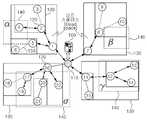
도 1은 기존 R-tree의 공간색인 개념을 센서네트워크에 적용하여 구축된 일 반적인 분산 공간색인과 사각형으로 주어진 공간검색 객체들을 나타낸다. 도 1에서는 서버(100), 베이스스테이션(110), 센서노드들(120), 효율적인 공간질의를 지원하기 위한 분산 공간색인 구조(130), 공간질의를 위한 공간검색 객체(140), 그리고 센서노드들간의 무선통신(150)을 도시하고 있다.FIG. 1 illustrates a general distributed spatial index and a spatial search object given by a rectangle, which are constructed by applying a spatial index concept of an existing R-tree to a sensor network. In FIG. 1, the
도 1을 참조하면, 종래의 In-network 공간질의처리 방법은 센서노드들에서 실제 결과는 없지만 불필요한 액세스를 수행하는 문제점을 가지고 있다. 예를 들어, 공간질의에 {α, β, γ, δ} 로 구성된 4개의 공간검색 객체(140)가 주어진다고 가정하자. 그리고 센서노드들에서 공간검색을 수행할 때, 센서노드들(120) 중 7번 센서노드의 경우 실제 결과는 없지만 {7, 8} 센서노드에 대한 불필요한 액세스를 수행하게 된다. 이는 7번 센서노드의 공간색인 구조인 MBR(Minimum Bounding Rectangle; 130)과 공간검색 객체(140) 중 β 공간검색 개체 간의 겹침이 있기 때문이다. 또한, 종래의 In-network 공간질의처리 방법은 α 공간검색 객체에 대해서도 {5} 센서노드에 대한 불필요한 액세스도 수행하게 된다. 이는 5번 센서노드(120)의 공간색인 구조인 MBR과 겹침이 있기 때문이다.Referring to FIG. 1, the conventional in-network spatial query processing method has a problem of performing unnecessary access in the sensor nodes, although there is no actual result. For example, suppose that a spatial query is given four
따라서, 종래의 In-network 공간질의처리 방법에서는 Centralized 방법이 모든 공간질의를 서버에서 수행하는 것과는 달리 공간질의처리가 서버가 아니라 센서네트워크에서 분산하여 수행된다. 이에 따라 공간질의를 처리하는 과정에서 요구되는 센서노드들간의 무선통신 횟수를 줄이게 된다. 이러한 In-network 공간질의처리 방법은 상술한 바와 같이 무선통신 횟수를 줄일 수 있는 장점을 가지고 있으나, 도 1의 {5, 7, 8} 센서노드에 대하여 수행되는 불필요한 무선통신을 제거할 수 없는 문제점을 여전히 가지고 있다.Therefore, in the conventional In-network spatial query processing method, unlike the centralized method, all spatial queries are performed in the server, the spatial query processing is distributed in the sensor network, not in the server. Accordingly, the number of wireless communication between sensor nodes required in processing a spatial query is reduced. The in-network space query processing method has an advantage of reducing the number of wireless communication as described above, but it is not possible to eliminate unnecessary wireless communication performed for the {5, 7, 8} sensor node of FIG. I still have
다시 말하면, 종래의 In-network 공간질의처리 방법은 실제로 공간검색 결과가 없는 센서노드에 대하여 불필요한 무선통신을 수행하게 되는 문제점을 갖게 된다. 이러한 불필요한 무선통신은 많은 Dead Space가 존재하는 센서네트워크 환경에서 더욱 자주 발생할 수 있다. 여기서, Dead Space는 분산 공간색인 구조에는 포함되지만 실제로는 정보가 존재하지 않는 영역을 의미한다. 이러한 Dead Space는 센서네트워크 환경에서 크게 증가할 수 있는데, 이는 분산 공간색인 구조에 포함되는 센서노드간 무선통신은 센서노드와 달리 실제 정보를 포함하고 있지 않기 때문이다.In other words, the conventional in-network spatial query processing method has a problem in that unnecessary wireless communication is performed for a sensor node that does not actually have a spatial search result. Such unnecessary wireless communication may occur more often in a sensor network environment in which many dead spaces exist. Here, dead space means an area included in the distributed space index structure but without information. Such dead space can be greatly increased in the sensor network environment because wireless communication between sensor nodes included in the distributed spatial index structure does not include actual information unlike the sensor node.
본 발명의 실시예에 따른 서버-센서네트워크의 협력 공간질의 처리방법은 서버가, 복수의 센서노드들과의 공간 질의 개시 이전에 사전 공간 질의를 수행하여 복수의 센서노드들 중 제외될 센서노드를 선별하기 위한 부가정보를 검출하는 단계; 및 서버가, 복수의 센서노드들과의 공간 질의시 부가정보를 기초로 선별된 센서노드들로 공간 질의를 요청하는 단계를 포함하는 것을 특징으로 한다.In the method for processing cooperative spatial query of a server-sensor network according to an embodiment of the present invention, a server performs a pre-spatial query before initiating a spatial query with a plurality of sensor nodes to select a sensor node to be excluded from the plurality of sensor nodes. Detecting additional information for screening; And requesting, by the server, the spatial query to the selected sensor nodes based on the additional information when the spatial query is made with the plurality of sensor nodes.
또, 부가정보는, 사전 공간 질의 결과로 검출된 센서노드들의 위치정보, 사전 공간질의 결과를 하나도 포함하지 않는 공간검색 객체정보 및 사전 공간질의 결과가 없는 센서노드 정보 중 적어도 하나 이상을 포함하는 것이 바람직하다.The additional information may include at least one of position information of sensor nodes detected as a result of a prior spatial query, spatial search object information not including any result of a prior spatial query, and sensor node information having no result of a prior spatial query. desirable.
또, 부가정보를 검출하는 단계는,서버가, 복수의 센서노드들과의 공간질의 개시 이전에 사전 공간 질의를 전송하는 단계; 및 사전 공간 질의에 따른 질의 결과로부터 복수의 센서노드들 중 제외될 센서노드를 선별하기 위한 부가정보를 검출하는 단계를 포함하는 것이 바람직하다.The detecting of the additional information may include: transmitting, by the server, a prior spatial query before initiation of the spatial quality with the plurality of sensor nodes; And detecting additional information for selecting a sensor node to be excluded among the plurality of sensor nodes from the query result according to the pre-spatial query.
또한, 사전 공간 질의는, 복수의 센서노드들의 위치를 포함하는 공간색인정보를 근거로 해당 공간 질의를 만족하는 센서노드들을 찾는 것이 바람직하다.In addition, the pre-spatial query, it is preferable to find the sensor nodes that satisfy the spatial query based on the spatial index information including the position of the plurality of sensor nodes.
또, 질의/여과 정보 제공 단계는, 복수의 센서노드들에게 부가정보를 제공하는 단계; 및 부가정보를 기초로 선별된 센서노드들로 공간 질의를 요청하는 단계를 포함하는 것이 바람직하다.The query / filtering information providing step may include providing additional information to the plurality of sensor nodes; And requesting a spatial query to the sensor nodes selected based on the additional information.
또, 부가정보를 제공하는 단계는, 부가정보로서 공간질의결과인 센서노드들의 위치정보를 이용하는 경우, 서버가, 센서노드들의 위치정보를 센서노드들에게 제공하는 것이 바람직하다.In the providing of the additional information, when the location information of the sensor nodes that are the result of the spatial query is used as the additional information, the server preferably provides the location information of the sensor nodes to the sensor nodes.
또한, 부가정보를 제공하는 단계는, 부가정보로서 공간 질의 결과를 하나도 포함하지 않는 공간검색 객체정보를 이용하는 경우, 서버가, 공간 질의 결과를 하나도 포함하지 않는 공간검색 객체를 제외한 나머지 공간검색 객체정보를 센서노드들에게 제공하는 것이 바람직하다.In the providing of the additional information, when the spatial search object information including no spatial query result is used as the additional information, the server searches for the remaining spatial search object information except for the spatial search object which does not include any spatial query result. It is desirable to provide to the sensor nodes.
또한, 부가정보를 제공하는 단계는, 부가정보로서 공간질의결과를 하나도 포함하지 않는 공간검색 객체정보 및 공간 질의 결과가 없는 센서노드 정보를 동시에 이용하는 경우, 서버가, 공간검색 객체정보와 함께 공간질의 결과가 없는 센서노드 정보를 센서노드들에게 제공하는 것이 바람직하다.In the providing of the additional information, when the spatial search object information including no spatial query result and the sensor node information without the spatial query result are simultaneously used as the additional information, the server may query the spatial query together with the spatial search object information. It is desirable to provide sensor nodes with sensor node information that has no results.
또, 공간 질의를 요청하는 단계는, 서버가, 공간검색 객체를 이용하여 공간질의를 수행시, 공간 질의 결과가 없는 센서노드는 제외시키는 것이 바람직하다.In the requesting of the spatial query, when the server performs the spatial query using the spatial search object, it is preferable to exclude the sensor node having no spatial query result.
한편, 본 발명의 실시예에 따른 서버-센서네트워크의 협력 공간질의 처리를 위한 서버는, 복수의 센서노드들과의 공간 질의 개시 이전에 사전 공간 질의를 수행하여 복수의 센서노드들 중 제외될 센서노드를 선별하기 위한 부가정보를 검출하는 사전 질의 수행부; 및 복수의 센서노드들과의 공간 질의시 부가정보를 기초로 선별된 센서노드들로 공간 질의를 요청하는 질의/여과 정보 제공부; 를 포함하는 것을 특징으로 한다.On the other hand, the server for processing the cooperative spatial query of the server-sensor network according to an embodiment of the present invention, the sensor to be excluded from the plurality of sensor nodes by performing a pre-spatial query before the start of the spatial query with the plurality of sensor nodes A pre-query execution unit that detects additional information for selecting nodes; And a query / filtering information providing unit for requesting a spatial query to the sensor nodes selected based on the additional information when the spatial query with the plurality of sensor nodes is performed. Characterized in that it comprises a.
본 발명에 따르면, In-network 기반 공간질의처리 과정에서 주어진 공간질의를 서버와 센서네트워크 사이에서 상호 협력적으로 처리하도록 함으로써, 불필요한 무선통신을 수행하지 않도록 하는 효과를 갖는다.According to the present invention, in the in-network based spatial query processing process, the given spatial query is cooperatively processed between the server and the sensor network, thereby preventing unnecessary wireless communication.
이러한 무선통신 횟수의 감소는 센서노드들의 에너지 소모를 줄임으로써, 수명을 증가시키는 효과를 가지게 된다.The decrease in the number of wireless communication has an effect of increasing the lifespan by reducing the energy consumption of the sensor nodes.
이하에서는 첨부된 도면들을 참조하여 본 발명의 실시 예에 대하여 상세하게 설명하도록 한다. 본 발명을 설명함에 있어서 본 발명과 관련된 공지 기술에 대한 구체적인 설명이 본 발명의 요지를 불필요하게 흐릴 수 있다고 판단되는 경우에는 그 상세한 설명을 생략하기로 한다.Hereinafter, with reference to the accompanying drawings will be described in detail an embodiment of the present invention. In describing the present invention, when it is determined that the detailed description of the known technology related to the present invention may unnecessarily obscure the gist of the present invention, the detailed description thereof will be omitted.
본 발명에서, "포함"이란 기재는 특별히 반대되는 기재가 없는 한 다른 구성 요소를 제외하는 것이 아니라 다른 구성요소를 더 부가할 수 있는 것을 의미한다. 또한, 명세서에 기재된 "…부", "…수단" 등의 용어는 적어도 하나의 기능이나 동작을 처리하는 단위를 의미하며, 이는 하드웨어나 소프트웨어 또는 하드웨어 및 소프트웨어의 결합으로 구현될 수 있다.In the present invention, the term "comprising" means that other components may be added without further mention, unless specifically stated otherwise. In addition, the terms “… unit”, “… means”, etc. described in the specification mean a unit for processing at least one function or operation, which may be implemented by hardware or software or a combination of hardware and software.
도 2는 본 발명에 따른 서버-센서네트워크의 협력 공간질의 처리방법을 설명하기 위한 센서네트워크에 적용된 분산 공간 색인 구조도이고, 도 3은 본 발명에 따른 서버-센서네트워크의 협력 공간질의 처리방법이 적용된 전체 시스템을 개략적으로 도시한 도면이다. 도 2에서는 도 1과 마찬가지로 R-tree의 공간색인 개념을 센서네트워크에 적용하여 구축된 일반적인 분산 공간색인과 사각형으로 주어진 공간검색 객체들을 함께 표시한다(이하, 미설명부호 130은 효율적인 공간질의를 지원하기 위한 분산 공간색인 구조, 140은 공간질의를 위한 공간검색 객체, 150은 센서노드들 간의 무선통신을 의미한다.)2 is a distributed spatial index structure diagram applied to a sensor network for explaining a cooperative spatial quality processing method of a server-sensor network according to the present invention, and FIG. 3 is a cooperative spatial quality processing method of a server-sensor network according to the present invention. It is a schematic drawing of the whole system. In FIG. 2, as shown in FIG. 1, the spatial index of R-tree is applied to the sensor network, and the spatial search objects given by the rectangle are displayed together with the general distributed spatial index (hereinafter,
도 2 및 도 3을 참조하면, 본 발명에 따른 서버-센서네트워크의 협력 공간질의 처리방법이 적용된 시스템은 서버(100), 센서네트워크를 구성하는 베이스스테이션(110) 및 센서노드들(120)을 포함하여 구성된다.2 and 3, a system to which a cooperative spatial query processing method of a server-sensor network according to the present invention is applied includes a
여기서, 시스템은 상술한 In-network 기반 공간질의처리 과정을 위한 구성을 함께 포함하는 것으로 하며 이에 대한 설명은 생략하도록 한다.In this case, the system is to include the configuration for the above-described In-network-based spatial query processing process, a description thereof will be omitted.
또, 센서노드들에 저장되어 있는 분산 공간색인정보와 같은 색인정보를 서버 가 저장하고 있다고 가정하며, 센서노드들의 위치는 고정되어 있는 시스템에서 동작함을 가정한다. 그러나 이러한 시스템의 구성은 설명의 편의를 위해서 예시한 것인바 이에 한정되는 것은 아니다.In addition, it is assumed that the server stores index information such as distributed spatial index information stored in the sensor nodes, and it is assumed that the positions of the sensor nodes operate in a fixed system. However, the configuration of such a system is illustrated for convenience of description and the present invention is not limited thereto.
또한, 서버와 센서네트워크 간의 공간질의 색인시 서버(100)-베이스스테이션(110)-센서노드들(130) 구조로 진행되는 것으로 하되, 이는 설명의 편의를 위한 것인바 이에 한정되지는 않는다.In addition, the index of the spatial quality between the server and the sensor network is to proceed to the structure of the server 100-base station 110-
도 3a를 참조하면, 일반적인 In-network 공간질의처리 방법을 이용할 경우, 센서노드들에서 실제 결과는 없지만 불필요한 액세스를 수행하여 센서네트워크에서 불필요한 에너지를 소모하게 된다. 그래서, 본 발명에서는 센서네트워크 환경에서 공간질의가 주어졌을 때, 센서노드들의 에너지 소모량을 최소화하면서 공간질의 조건을 만족하는 센서노드들을 찾고 이들의 센싱 정보들을 서버로 획득하는 방식을 채용한다. 본 발명에서 센서노드들의 에너지 소모량 최소화는 공간질의 수행과정에서 발생하는 센서노드들 간의 무선통신 횟수의 최소화를 의미한다.Referring to FIG. 3A, when using the general in-network spatial query processing method, there is no actual result in the sensor nodes, but unnecessary access is performed to consume unnecessary energy in the sensor network. Therefore, in the present invention, when a spatial query is given in a sensor network environment, a method of finding sensor nodes satisfying the conditions of the spatial query while acquiring the energy consumption of the sensor nodes and obtaining their sensing information from the server is adopted. In the present invention, minimizing the energy consumption of the sensor nodes means minimizing the number of wireless communication between the sensor nodes generated in the process of performing spatial quality.
도 3b를 참조하면, 본 발명에 따른 서버-센서네트워크의 협력 공간질의 처리방법은 서버-센서네트워크 간에 분산 공간색인을 수행하기 이전에 서버에서 공간질의를 미리 수행함으로써 센서네트워크의 불필요한 공간검색 객체와 실제로는 방문해서는 안 되는 센서노드의 부가정보를 찾는다.Referring to FIG. 3B, the method for processing cooperative spatial queries in a server-sensor network according to the present invention includes performing unnecessary spatial search objects in a sensor network by performing a spatial query in advance before performing a distributed spatial index between server-sensor networks. Find additional information about sensor nodes that should not be visited in practice.
여기서, 불필요한 공간검색 객체는 도 2에 도시된 공간검색 객체 β를 예로 들 수 있다. 즉, 공간질의에 {α, β, γ, δ} 로 구성된 4개의 공간검색 객체(140)가 주어진다고 가정하자. 그리고 센서노드들에서 공간검색을 수행할 때, 센서노드들(120) 중 7번 센서노드의 경우 실제 결과는 없지만 {7, 8} 센서노드에 대한 불필요한 액세스를 수행하게 된다. 이는 7번 센서노드의 공간색인 구조인 MBR(Minimum Bounding Rectangle; 130)과 공간검색 객체(140) 중 β 공간검색 객체 간의 겹침이 있기 때문이다.Here, the unnecessary spatial search object may be the spatial search object β shown in FIG. 2. That is, suppose that four spatial search objects 140 composed of {α, β, γ, δ} are given to a spatial query. When performing the spatial search in the sensor nodes, the
또, 실제로는 방문해서는 안 되는 센서노드는 도 2에 도시된 공간검색 객체 α를 예로 들 수 있다. 즉, 종래의 In-network 공간질의처리 방법을 적용할 경우, 공간검색 객체(140) 중 α 공간검색 객체에 대해서도 센서노드들(120) 중 {5} 센서노드에 대한 불필요한 액세스를 수행하게 된다. 이는 5번 센서노드의 공간색인 구조인 MBR과 α 공간검색 객체 간에 겹침이 있기 때문이다.In addition, the sensor node that should not actually be visited may be the spatial search object α shown in FIG. 2. That is, when the conventional in-network spatial query processing method is applied, unnecessary access to the {5} sensor node of the
이를 통해, 본 발명에서는 이러한 부가정보들을 서버에서 센서노드들로 전송하고 서버와 센서네트워크 간의 분산 공간색인 과정에서 부가정보들을 이용하여 실제 방문해야 할 센서노드들의 수를 줄이게 된다. 이처럼, 본 발명에서는 전체 무선통신의 횟수를 줄이는 방식으로 동작하게 된다.Through this, in the present invention, the additional information is transmitted from the server to the sensor nodes, and the number of sensor nodes to be actually visited is reduced by using the additional information in the distributed spatial index process between the server and the sensor network. As described above, the present invention operates in a manner of reducing the total number of wireless communication.
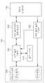
도 4는 도 3에 도시된 서버의 내부 구성을 간략하게 도시한 도면이고, 도 5는 도 3의 베이스스테이션 및 센서노드들의 내부구성을 간략하게 도시한 도면이다.FIG. 4 is a diagram schematically illustrating an internal configuration of the server illustrated in FIG. 3, and FIG. 5 is a diagram schematically illustrating an internal configuration of the base station and sensor nodes of FIG. 3.
도 4를 참조하면, 본 발명에서 서버는 사전 질의 수행부(300), 공간 색인 부(310), 서버 질의/여과 정보 제공부(320), 서버 질의 결과 수집부(330), 서버 처리수단(340)를 포함하여 구성된다.Referring to FIG. 4, in the present invention, the server may include a dictionary
서버 처리수단(340)은 센서네트워크에 공간질의를 발생시키고, 그에 따라 반송되는 질의결과를 수신하여 사용자에게 제공하도록 하게 된다. 공간질의는 사용자에 의해서 입력되거나 사전에 정해진 소프트웨어에 의해서 자동적으로 발생할 수 도 있을 것이다. 그리고 서버 처리수단(340)는 공간질의 및 질의결과 수신처리를 위한 구성이라면 어떠한 구성이라도 가능할 것이다.The server processing means 340 generates a spatial query in the sensor network, and receives the query result that is returned accordingly and provides it to the user. Spatial queries may be entered by the user or automatically generated by predefined software. The server processing means 340 may be any configuration as long as it is a configuration for spatial query and query result reception processing.
사전질의 수행부(300)는 입력된 공간질의에 따른 분산 공간 색인을 수행하기 이전에 미리 사전 공간질의를 수행한다. 여기서, 공간질의 수행은 공간질의 조건을 만족하는 센서노드들을 찾는 과정으로, 이 과정은 공간색인부(310)의 공간색인정보를 이용하여 수행된다. 본 발명은 위치가 고정된 센서노드들에 적용되는 것으로 서버가 센서노드들에 대한 공간색인정보(예컨대, 센서노드 ID, 위치정보 등)를 보유하는 것이 가능하며, 사전 공간질의 수행이 용이하게 처리될 수 있다.The
또, 사전질의 수행부(300)는 사전 공간질의 수행과정에서 향후 센서네트워크에서 분산 공간질의를 수행할 때 효율적으로 이용될 수 있는 부가정보들을 추출한다. 이러한, 부가정보들에는 공간 질의 결과인 센서노드들의 위치정보, 공간 질의 결과를 하나도 포함하지 않는 공간검색 객체정보, 방문해도 실제로 공간질의 결과가 없는 센서노드 정보 등이 있다. 이러한 부가정보들은 서버-센서네트워크 간에 분산 공간질의를 수행할 때, 센서노드에 대한 불필요한 액세스를 줄이기 위하여 이 용된다.In addition, the
서버 질의/여과 정보 제공부(320)는 입력된 공간질의를 분석하고 변환하여 센서네트워크로 전송하는 역할을 수행하며, 서버 질의결과 수집부(330)는 센서네트워크로부터 수집되는 질의결과를 수집하여 전달하는 역할을 수행한다.The server query / filter
또, 서버 질의/여과 정보 제공부(320)는 입력된 공간질의시 상술한 사전질의 수행부(300)를 통해 추출된 부가정보에 따라 공간 질의 방식을 변경하여 수행하게 된다. 즉, 서버 질의/여과 정보 제공부(320)는 부가정보로서 공간질의결과를 하나도 포함하지 않는 공간검색 객체정보를 이용하는 경우, 변환된 공간질의를 센서네트워크에 전송할 때, 위에서 언급된 공간질의 결과를 하나도 포함하지 않는 공간검색 객체를 제외한 나머지 공간검색 객체정보를 센서네트워크에 전송하게 된다. 예를 들어, 도 2에서 보는 바와 같이 원래 공간검색 객체 {α, β, γ, δ}에서 {β} 를 제외한 공간검색 객체 {α, γ, δ} 만 센서네트워크로 전송되어야 한다. 여기서는, 센서노드 {7, 8}에 대한 공간검색을 수행하지 않을 수 있다.In addition, the server query / filter
또, 서버 질의/여과 정보 제공부(320)는 부가정보로서 공간질의결과를 하나도 포함하지 않는 공간검색 객체정보와 방문해도 실제로 공간질의결과가 없는 센서노드 정보를 동시에 이용하는 경우, 공간검색 객체 {α, γ, δ} 정보와 함께 방문해도 실제로 결과가 없는 센서노드 정보를 포함하는 공간질의정보를 센서네트워크부로 전송한다. 그에 따라, 하술된 센서노드의 분산질의 수행부(340)는 공간검색 객체 {α, γ, δ} 를 이용하여 공간질의를 수행함에 있어서, 비록 자식 센서노드의 공간색인정보가 주어진 공간검색 객체{α, γ, δ}와 공간적인 겹침이 발생하여 주어진 공간질의를 자식 센서노드로 전파해야 한다고 하더라도 만약 자식 센서노드가 방문해도 실제 공간질의결과가 없는 센서노드에 포함된다면, 더 이상 자식노드로의 공간질의 수행을 전파하지 않는다(S72). 즉, 사전 공간 질의 수행에서 공간색인을 이용한 공간검색과정에서 공간질의결과가 있는 것처럼 보이나, 실제로는 공간질의 결과를 보유하지 않는 센서노드들에 대한 정보를 이용하게 된다. 여기서는 센서노드 {7, 8}에 대한 공간검색을 수행하지 않을 뿐 아니라, 센서노드 {5}에 대한 공간검색도 수행하지 않는다.In addition, when the server query / filter
이처럼, 본 발명에서 서버는 분산 공간검색을 수행하기 이전에 미리 사전 공간질의를 수행함으로써 불필요한 공간검색 객체와 실제로는 방문해서는 안 되는 센서노드의 부가정보를 찾게 된다. 서버(100)는 이러한 부가정보를 근거로 공간질의를 처리하는 과정에서 센서노드들간의 무선통신 횟수를 줄이게 된다.As described above, in the present invention, the server searches for an unnecessary spatial search object and additional information of a sensor node that should not be visited by performing a prior spatial query before performing a distributed spatial search. The
도 5를 참조하면, 센서네트워크를 구성하는 센서노드들(120)(베이스스테이션(110) 포함) 각각은 분산 질의 수행부(400), 분산 공간 색인부(410), 질의/여과 정보 제공부(420), 질의 결과 수집부(430)를 공통적으로 포함하여 구성된다.Referring to FIG. 5, each of the sensor nodes 120 (including the base station 110) constituting the sensor network includes a distributed
분산 질의 수행부(400)는 현재의 센서노드가 주어진 공간질의 조건을 만족하는지를 수행하는 역할을 수행하는데, 조건을 만족하는 경우에는 현재 센서노드의 센싱/위치정보가 질의 결과 수집부(430)에 저장된다. 또한, 분산 질의 수행부(400)는 현재 센서노드의 자식 센서노드들이 주어진 공간질의 조건을 만족하는지를 미리 수행하는데, 조건을 만족하는 자식 센서노드가 있는 경우에 현재 수행되고 있는 공간질의를 자식 센서노드로 전파하기 위하여 질의/여과 정보 제공부(420)에 저장한다. 여기서, 자식 센서노드들의 공간질의 조건 만족여부를 판단하기 위해서는 분산 공간 색인부(410)의 공간색인정보가 이용된다.The distributed
질의/여과 정보 제공부(420)는 저장되어 있는 공간질의를 자식 센서노드들로 전파하는 역할을 수행하며, 질의 결과 수집부(430)는 자신이 보유하고 있는 결과정보와 자식 센서노드들로부터 수집된 결과정보를 상위 부모 센서노드로 전송하는 역할을 수행한다. 만약 어떤 센서노드 자신이 공간질의 조건을 만족하지 않고 자식 센서노드도 공간질의 조건을 만족하지 않는다면, 그 센서노드에서는 자식 노드로의 공간질의 전파 및 부모 노드로의 질의결과 전송을 수행하지 않는데, 이를 통하여 전체 무선통신의 횟수를 줄이게 된다.The query / filter
한편, 분산 질의 수행부(400)는 공간질의시 서버에서 전송되는 부가정보에 따라 상술한 공간질의 방식을 변경하게 된다. 즉, 분산 질의 수행부(400)는 부가정보로서 공간질의결과인 센서노드들의 위치정보를 이용하는 경우, 공간질의를 수행하고자 할 때, 공간질의에서 주어지는 공간검색 객체들을 이용하는 것이 아니라, 실제 공간질의결과인 센서노드들의 위치정보를 이용하여 공간질의를 수행한다. 이와 같이, 공간질의결과인 센서노드들의 정확한 위치정보를 이용하여 공간검색을 수행하는 경우는 공간검색 객체에 의한 검색과 같이 Dead Space에 대한 공간검색을 수행하지 않는 장점을 가지고 있다. 예를 들어, 도 2에서 공간검색 객체 {α, β, γ, δ} 에 의한 공간검색이 아니라, 공간질의결과인 센서노드 {4, 12, 13, 14, 17, 19, 20, 21, 22}에 의한 공간검색을 이용함으로써, 센서노드 {5, 7, 8}에 대한 공간검색을 수행하지 않을 수 있다. 여기서, 질의/여과정보 제공부(260)는 당연히 질의/여과를 위한 정보로서 공간검색 객체가 아니라, 공간질의결과인 센서노드들의 위치정보들을 자식 센서노드들에게 전송해야 한다. 이 방법은 센서네트워크로 전송되어야 하는 정보의 양이 크게 증가할 위험성을 가지고 있다.Meanwhile, the distributed
또, 분산 질의 수행부(400)는 부가정보로서 공간질의결과를 하나도 포함하지 않는 공간검색 객체정보와 방문해도 실제로 공간질의결과가 없는 센서노드 정보를 동시에 이용하는 경우, 상술한 서버 질의/여과 정보 제공부(320)에서 공간검색 객체 {α, γ, δ} 정보와 함께 방문해도 실제로 결과가 없는 센서노드 정보를 포함하는 공간질의정보를 수신 받는다. 그에 따라, 분산질의 수행부(340)는 공간검색 객체 {α, γ, δ} 를 이용하여 공간질의를 수행함에 있어서, 비록 자식 센서노드의 공간색인정보가 주어진 공간검색 객체{α, γ, δ}와 공간적인 겹침이 발생하여 주어진 공간질의를 자식 센서노드로 전파해야 한다고 하더라도 만약 자식 센서노드가 방문해도 실제 공간질의결과가 없는 센서노드에 포함된다면, 더 이상 자식노드로의 공간질의 수행을 전파하지 않는다(S72). 여기서는 센서노드 {7, 8}에 대한 공간검색을 수행하지 않을 뿐 아니라, 센서노드 {5}에 대한 공간검색도 수행하지 않는다.In addition, when the distributed
이하, 본 발명에 따른 서버-센서네트워크의 협력 공간질의 처리방법을 첨부된 도면을 참조하여 보다 상세히 설명하도록 한다.Hereinafter, a method of processing cooperative spatial quality of a server-sensor network according to the present invention will be described in detail with reference to the accompanying drawings.
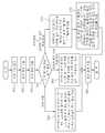
도 6 및 도 7은 본 발명에 따른 서버-센서네트워크의 협력 공간질의 처리방법의 순서를 도시한 도면이다. 설명에 있어서, 센서노드들은 고정된 위치를 갖는 것으로 한다.6 and 7 illustrate a procedure of a method for processing cooperative spatial quality of a server-sensor network according to the present invention. In the description, the sensor nodes are assumed to have a fixed position.
도 6을 참조하면, 우선 서버의 사전질의 수행부(300)는 사전 공간질의를 미리 수행한다(S10). 상술한 바와 같이, 공간질의 수행은 공간질의 조건을 만족하는 센서노드들을 찾는 과정으로, 이 과정은 공간색인부(310)의 공간색인정보를 이용하여 수행된다. 이때, 질의/여과 정보 제공부(200)는 사전질의 수행부(300)에서 발생된 사전 공간질의를 분석하고 변환하여 센서네트워크로 전송하게 된다.Referring to FIG. 6, first, the
이어, 서버의 질의결과 수집부(330)는 사전 공간질의 후 센서노드들로부터 발생되는 질의 결과를 수집한다(S20). 그와 함께, 사전질의 수행부(300)는 공간질의 수행과정에서 향후 센서네트워크에서 분산 공간질의를 수행할 때 효율적으로 이용될 수 있는 부가정보들을 추출한다(S30).Subsequently, the query
다음, 서버 질의/여과 정보 제공부(200)는 부가정보에 따른 공간질의를 수행하게 된다(S40). 즉, 서버와 센서네트워크 간에 추출된 부가정보들을 기초로 분산 공간 색인을 수행하게 된다.Next, the server query / filtration information providing unit 200 performs a spatial query according to the additional information (S40). That is, distributed spatial indexing is performed based on additional information extracted between the server and the sensor network.
상술한 바와 같이, 부가정보들은 공간질의 결과인 센서노드들의 위치정보, 공간질의결과를 하나도 포함하지 않는 공간검색 객체정보, 방문해도 실제로 공간질의결과가 없는 센서노드 정보 등을 포함하게 된다. 이러한 부가정보들은 센서네트 워크에서 분산 공간질의를 수행할 때, 센서노드에 대한 불필요한 액세스를 줄이게 된다.As described above, the additional information may include location information of sensor nodes that are the result of the spatial query, spatial search object information that does not include any of the spatial query results, and sensor node information that does not actually have the spatial query result when visited. These additional informations reduce unnecessary access to sensor nodes when performing distributed spatial query in the sensor network.
여기서, 단계 'S40'에서 부가정보로서 공간질의결과인 센서노드들의 위치정보를 이용하는 경우를 설명한다. 분산질의 수행부(400)는 공간질의를 수행하고자 할 때, 공간질의에서 주어지는 공간검색 객체들을 이용하는 것이 아니라, 실제 공간질의결과인 센서노드들의 위치정보를 이용하여 공간질의를 수행한다(S50). 이와 같이, 공간질의결과인 센서노드들의 정확한 위치정보를 이용하여 공간검색을 수행하는 경우는 공간검색 객체에 의한 검색과 같이 Dead Space에 대한 공간검색을 수행하지 않는 장점을 가지고 있다. 예를 들어, 도 2에서 공간검색 객체 {α, β, γ, δ} 에 의한 공간검색이 아니라, 공간질의결과인 센서노드 {4, 12, 13, 14, 17, 19, 20, 21, 22}에 의한 공간검색을 이용함으로써, 센서노드 {5, 7, 8}에 대한 공간검색을 수행하지 않을 수 있다. 여기서, 질의/여과정보 제공부(260)는 당연히 질의/여과를 위한 정보로서 공간검색 객체가 아니라, 공간질의결과인 센서노드들의 위치정보들을 자식 센서노드들에게 전송해야 한다. 이 방법은 센서네트워크로 전송되어야 하는 정보의 양이 크게 증가할 위험성을 가지고 있다.Here, the case where the position information of the sensor nodes which are the result of the spatial query is used as additional information in step S40 will be described. When performing the spatial query, the
여기서, 단계 'S40'에서 부가정보로서 공간질의결과를 하나도 포함하지 않는 공간검색 객체정보를 이용하는 경우를 설명한다. 서버부의 질의/여과 정보 제공부(320)에서 변환된 공간질의를 센서네트워크에 전송할 때, 위에서 언급된 공간질의 결과를 하나도 포함하지 않는 공간검색 객체를 제외한 나머지 공간검색 객체정 보를 센서네트워크에 전송하게 된다(S60). 예를 들어, 도 2에서 보는 바와 같이 원래 공간검색 객체 {α, β, γ, δ}에서 {β} 를 제외한 공간검색 객체 {α, γ, δ} 만 센서네트워크부로 전송되어야 한다. 여기서는, 센서노드 {7, 8}에 대한 공간검색을 수행하지 않을 수 있다.Here, a case of using spatial search object information that does not include any spatial query results as additional information in step S40 will be described. When the server query's query /
여기서, 단계 'S40'에서 부가정보로서 공간질의결과를 하나도 포함하지 않는 공간검색 객체정보와 방문해도 실제로 공간질의결과가 없는 센서노드 정보를 동시에 이용하는 경우(즉, 사전 공간검색 결과에는 포함되지만 실제로는 공간 질의 결과가 없는 센서노드 정보를 이용하는 경우)를 설명한다. 서버의 서버 질의/여과 정보 제공부(320)는 공간검색 객체 {α, γ, δ} 정보와 함께 방문해도 실제로 결과가 없는 센서노드 정보를 포함하는 공간질의정보를 센서네트워크부로 전송한다(S60). 센서노드의 분산질의 수행부(340)는 공간검색 객체 {α, γ, δ} 를 이용하여 공간질의를 수행함에 있어서, 비록 자식 센서노드의 공간색인정보가 주어진 공간검색 객체{α, γ, δ}와 공간적인 겹침이 발생하여 주어진 공간질의를 자식 센서노드로 전파해야 한다고 하더라도 만약 자식 센서노드가 방문해도 실제 공간질의결과가 없는 센서노드에 포함된다면, 더 이상 자식노드로의 공간질의 수행을 전파하지 않는다(S72). 여기서는 센서노드 {7, 8}에 대한 공간검색을 수행하지 않을 뿐 아니라, 센서노드 {5}에 대한 공간검색도 수행하지 않는다.Here, in the step 'S40' when the spatial search object information that does not include any spatial query results as additional information and sensor node information that does not actually have the spatial query result at the same time are used (that is, included in the prior spatial search result but actually In the case of using sensor node information having no spatial query result). The server query / filter
이와 같이 본 발명에 따른 센서네트워크의 공간질의 처리 방법은 서버에서 공간질의를 미리 수행하고, 상술한 바와 같이 다양한 부가정보들을 추출하고, 이러한 부가정보들을 센서네트워크에서의 분산 공간질의를 수행하는데 이용하여 불필요 한 센서노드들에 대한 액세스를 방지함으로써, 센서노드들간의 전체 무선통신 횟수를 줄일 수 있는 특징을 가지고 있다. As described above, the spatial query processing method of the sensor network according to the present invention performs a spatial query in advance in a server, extracts various additional information as described above, and uses the additional information to perform distributed spatial query in the sensor network. By preventing access to unnecessary sensor nodes, the total number of wireless communication between sensor nodes can be reduced.
본 발명에 따르면, In-network 기반 공간질의처리 과정에서 주어진 공간질의를 서버와 센서네트워크의 센서노드들 사이에서 상호 협력적으로 처리하도록 함으로써, 불필요한 무선통신을 수행하지 않도록 하는 효과를 갖는다.According to the present invention, in the in-network based spatial query processing process, a given spatial query is cooperatively processed between the sensor nodes of the server and the sensor network, thereby preventing unnecessary wireless communication.
이러한 무선통신 횟수의 감소는 센서노드들의 에너지 소모를 줄임으로써, 수명을 증가시키는 효과를 가지게 된다.The decrease in the number of wireless communication has an effect of increasing the lifespan by reducing the energy consumption of the sensor nodes.
이상, 본 발명을 구성 및 동작에 근거하여 구체적으로 설명하였지만, 본 발명은 기술한 예에 한정되는 것이 아니라, 후술하는 특허 청구 범위의 범주 내에서 여러 가지 변형이 가능한 것은 물론이다.As mentioned above, although this invention was demonstrated concretely based on the structure and operation | movement, this invention is not limited to the example described, Of course, various deformation | transformation are possible for it within the scope of the following claim.
도 1은 기존 R-tree의 공간색인 개념을 센서네트워크에 적용하여 구축된 일반적인 분산 공간색인과 사각형으로 주어진 공간검색 객체들을 나타낸 도면.1 is a diagram illustrating spatial search objects given by a general distributed spatial index and a rectangle, which are constructed by applying a spatial index concept of an existing R-tree to a sensor network.
도 2는 본 발명에 따른 서버-센서네트워크의 협력 공간질의 처리방법을 설명하기 위한 센서네트워크에 적용된 분산 공간 색인 구조도.2 is a distributed spatial index structure diagram applied to a sensor network for explaining a method for processing cooperative spatial quality of a server-sensor network according to the present invention.
도 3은 본 발명에 따른 서버-센서네트워크의 협력 공간질의 처리방법이 적용된 전체 시스템을 개략적으로 도시한 도면.3 is a diagram schematically showing an entire system to which a method for processing cooperative spatial quality of a server-sensor network according to the present invention is applied.
도 4는 도 3에 도시된 서버의 내부 구성을 간략하게 도시한 도면.4 is a diagram schematically showing an internal configuration of the server shown in FIG.
도 5는 도 3의 베이스스테이션 및 센서노드들의 내부구성을 간략하게 도시한 도면.FIG. 5 is a schematic diagram illustrating an internal configuration of the base station and sensor nodes of FIG. 3. FIG.
도 6 및 도 7은 본 발명에 따른 서버-센서네트워크의 협력 공간질의 처리방법의 순서를 도시한 도면.6 and 7 illustrate a procedure of a method for processing cooperative spatial quality of a server-sensor network according to the present invention.
* 도면의 주요 부분에 대한 부호의 설명 *Explanation of symbols on the main parts of the drawings
100 : 서버 110 : 베이스스테이션100: server 110: base station
120 : 센서노드 130 : 분산 공간색인 구조(MBR)120: sensor node 130: distributed spatial index structure (MBR)
140 : 공간검색 객체 300 : 사전 질의 수행부140: spatial search object 300: dictionary query execution unit
310 : 공간 색인부 320 : 서버 질의/여과 정보 제공부310: spatial index unit 320: server query / filtration information provider
330 : 서버 질의 결과 수집부 340 : 서버 처리수단330: server query result collection unit 340: server processing means
400 : 분산 질의 수행부 410 : 분산 공간 색인부400: distributed query execution unit 410: distributed spatial index unit
420 : 질의/여과 정보 제공부 430 : 질의 결과 수집부420: query / filter information providing unit 430: query result collection unit
Claims (18)
Translated fromKoreanPriority Applications (2)
| Application Number | Priority Date | Filing Date | Title |
|---|---|---|---|
| KR1020090128412AKR101236990B1 (en) | 2009-12-21 | 2009-12-21 | Cooperative Spatial Query Processing Method between a Server and a Sensor Network and Server thereof |
| US12/973,203US20110153655A1 (en) | 2009-12-21 | 2010-12-20 | Server-sensor network cooperative spatial query processing method and server using the same |
Applications Claiming Priority (1)
| Application Number | Priority Date | Filing Date | Title |
|---|---|---|---|
| KR1020090128412AKR101236990B1 (en) | 2009-12-21 | 2009-12-21 | Cooperative Spatial Query Processing Method between a Server and a Sensor Network and Server thereof |
Publications (2)
| Publication Number | Publication Date |
|---|---|
| KR20110071763A KR20110071763A (en) | 2011-06-29 |
| KR101236990B1true KR101236990B1 (en) | 2013-02-25 |
Family
ID=44152567
Family Applications (1)
| Application Number | Title | Priority Date | Filing Date |
|---|---|---|---|
| KR1020090128412AExpired - Fee RelatedKR101236990B1 (en) | 2009-12-21 | 2009-12-21 | Cooperative Spatial Query Processing Method between a Server and a Sensor Network and Server thereof |
Country Status (2)
| Country | Link |
|---|---|
| US (1) | US20110153655A1 (en) |
| KR (1) | KR101236990B1 (en) |
Families Citing this family (9)
| Publication number | Priority date | Publication date | Assignee | Title |
|---|---|---|---|---|
| KR101363437B1 (en)* | 2013-02-15 | 2014-02-21 | 동서대학교산학협력단 | Method of the node decision for processing queries on sensor network environments |
| US9779183B2 (en) | 2014-05-20 | 2017-10-03 | Allied Telesis Holdings Kabushiki Kaisha | Sensor management and sensor analytics system |
| US20150338447A1 (en) | 2014-05-20 | 2015-11-26 | Allied Telesis Holdings Kabushiki Kaisha | Sensor based detection system |
| PH12013000136A1 (en) | 2013-05-23 | 2015-01-21 | De Antoni Ferdinand Evert Karoly | A domain agnostic method and system for the capture, storage, and analysis of sensor readings |
| US10084871B2 (en) | 2013-05-23 | 2018-09-25 | Allied Telesis Holdings Kabushiki Kaisha | Graphical user interface and video frames for a sensor based detection system |
| US9693386B2 (en) | 2014-05-20 | 2017-06-27 | Allied Telesis Holdings Kabushiki Kaisha | Time chart for sensor based detection system |
| WO2015179560A1 (en)* | 2014-05-20 | 2015-11-26 | Allied Telesis Holdings Kabushiki Kaisha | Sensor grouping for a sensor based detection system |
| CN106569797B (en)* | 2016-10-11 | 2019-07-05 | 东软集团股份有限公司 | The methods, devices and systems of multi-person synergy drafting process |
| US10924369B2 (en)* | 2019-05-13 | 2021-02-16 | Cisco Technology, Inc. | Traffic aware operations, administration, and maintenance (OAM) solutions for internet of things (IoT) networks |
Citations (2)
| Publication number | Priority date | Publication date | Assignee | Title |
|---|---|---|---|---|
| US20060161645A1 (en) | 2005-01-14 | 2006-07-20 | Norihiko Moriwaki | Sensor network system and data retrieval method for sensing data |
| US20070192301A1 (en) | 2006-02-15 | 2007-08-16 | Encirq Corporation | Systems and methods for indexing and searching data records based on distance metrics |
Family Cites Families (10)
| Publication number | Priority date | Publication date | Assignee | Title |
|---|---|---|---|---|
| US5258982A (en)* | 1991-05-07 | 1993-11-02 | International Business Machines Corporation | Method of excluding inactive nodes from two-phase commit operations in a distributed transaction processing system |
| US7003514B2 (en)* | 2001-09-13 | 2006-02-21 | International Business Machines Corporation | Method and apparatus for restricting a fan-out search in a peer-to-peer network based on accessibility of nodes |
| EP1593217A4 (en)* | 2003-02-10 | 2009-04-01 | Nielsen Media Res Inc | Methods and apparatus to adaptively gather audience information data |
| JP4017161B2 (en)* | 2004-01-22 | 2007-12-05 | 日本アイ・ビー・エム株式会社 | Section identification system, distribution system monitoring system, method and program thereof |
| JP4213176B2 (en)* | 2006-11-16 | 2009-01-21 | シャープ株式会社 | Sensor device, server node, sensor network system, communication path construction method, control program, and recording medium |
| US7555412B2 (en)* | 2007-02-09 | 2009-06-30 | Microsoft Corporation | Communication efficient spatial search in a sensor data web portal |
| KR100969963B1 (en)* | 2008-07-10 | 2010-07-15 | 한국전자통신연구원 | Grid-based tree construction for spatial search |
| US9171079B2 (en)* | 2011-01-28 | 2015-10-27 | Cisco Technology, Inc. | Searching sensor data |
| US9225793B2 (en)* | 2011-01-28 | 2015-12-29 | Cisco Technology, Inc. | Aggregating sensor data |
| US9275093B2 (en)* | 2011-01-28 | 2016-03-01 | Cisco Technology, Inc. | Indexing sensor data |
- 2009
- 2009-12-21KRKR1020090128412Apatent/KR101236990B1/ennot_activeExpired - Fee Related
- 2010
- 2010-12-20USUS12/973,203patent/US20110153655A1/ennot_activeAbandoned
Patent Citations (2)
| Publication number | Priority date | Publication date | Assignee | Title |
|---|---|---|---|---|
| US20060161645A1 (en) | 2005-01-14 | 2006-07-20 | Norihiko Moriwaki | Sensor network system and data retrieval method for sensing data |
| US20070192301A1 (en) | 2006-02-15 | 2007-08-16 | Encirq Corporation | Systems and methods for indexing and searching data records based on distance metrics |
Also Published As
| Publication number | Publication date |
|---|---|
| US20110153655A1 (en) | 2011-06-23 |
| KR20110071763A (en) | 2011-06-29 |
Similar Documents
| Publication | Publication Date | Title |
|---|---|---|
| KR101236990B1 (en) | Cooperative Spatial Query Processing Method between a Server and a Sensor Network and Server thereof | |
| JP7037555B2 (en) | Access control policy synchronization for the service tier | |
| US10534771B2 (en) | Database access method and apparatus, and database system | |
| US8903800B2 (en) | System and method for indexing food providers and use of the index in search engines | |
| Wang et al. | Lhd: Optimising linked data query processing using parallelisation | |
| JP4944160B2 (en) | Method and apparatus for searching a plurality of real-time sensors | |
| Kertiou et al. | A dynamic skyline technique for a context-aware selection of the best sensors in an IoT architecture | |
| JP2020502610A (en) | Allow Semantic Mashups on the Internet of Things | |
| EP2746964A2 (en) | Automatic tuning of database queries | |
| JP5527027B2 (en) | Schema definition generation device, schema definition generation method, and schema definition generation program | |
| US20090254527A1 (en) | Multi-Entity-Centric Integrated Search System and Method | |
| US20100306189A1 (en) | Sensor network managing apparatus and method thereof | |
| JP2011238179A (en) | Retrieval method, integrated retrieval server and computer program | |
| US20110035512A1 (en) | Device configuration integration information managing device and device configuration information managing device | |
| CN102395968A (en) | Method and device for generating an rdf database for an rdf database query and a search method and a search device for the rdf database query | |
| JP5782937B2 (en) | Tag management device, tag management system, and tag management program | |
| US8489631B2 (en) | Distributing a query | |
| CN103605848A (en) | Method and device for analyzing paths | |
| CN110502532A (en) | Optimization method, device, equipment and the storage medium of remote data base object | |
| CN102654879B (en) | Search method and device | |
| US20040122812A1 (en) | Service search device and method, and client device using service search device | |
| CN105512226B (en) | A query optimization method and device | |
| US11797458B2 (en) | Terminal management device and terminal device | |
| CN103365966B (en) | Method and device for storing node information in Internet of things | |
| KR101044807B1 (en) | Query Processing Method and System in Sensor Network Environment |
Legal Events
| Date | Code | Title | Description |
|---|---|---|---|
| A201 | Request for examination | ||
| PA0109 | Patent application | St.27 status event code:A-0-1-A10-A12-nap-PA0109 | |
| PA0201 | Request for examination | St.27 status event code:A-1-2-D10-D11-exm-PA0201 | |
| PG1501 | Laying open of application | St.27 status event code:A-1-1-Q10-Q12-nap-PG1501 | |
| D13-X000 | Search requested | St.27 status event code:A-1-2-D10-D13-srh-X000 | |
| D14-X000 | Search report completed | St.27 status event code:A-1-2-D10-D14-srh-X000 | |
| E701 | Decision to grant or registration of patent right | ||
| PE0701 | Decision of registration | St.27 status event code:A-1-2-D10-D22-exm-PE0701 | |
| GRNT | Written decision to grant | ||
| PR0701 | Registration of establishment | St.27 status event code:A-2-4-F10-F11-exm-PR0701 | |
| PR1002 | Payment of registration fee | St.27 status event code:A-2-2-U10-U11-oth-PR1002 Fee payment year number:1 | |
| PG1601 | Publication of registration | St.27 status event code:A-4-4-Q10-Q13-nap-PG1601 | |
| PN2301 | Change of applicant | St.27 status event code:A-5-5-R10-R13-asn-PN2301 St.27 status event code:A-5-5-R10-R11-asn-PN2301 | |
| FPAY | Annual fee payment | Payment date:20160127 Year of fee payment:4 | |
| PR1001 | Payment of annual fee | St.27 status event code:A-4-4-U10-U11-oth-PR1001 Fee payment year number:4 | |
| LAPS | Lapse due to unpaid annual fee | ||
| PC1903 | Unpaid annual fee | St.27 status event code:A-4-4-U10-U13-oth-PC1903 Not in force date:20170220 Payment event data comment text:Termination Category : DEFAULT_OF_REGISTRATION_FEE | |
| PC1903 | Unpaid annual fee | St.27 status event code:N-4-6-H10-H13-oth-PC1903 Ip right cessation event data comment text:Termination Category : DEFAULT_OF_REGISTRATION_FEE Not in force date:20170220 | |
| P22-X000 | Classification modified | St.27 status event code:A-4-4-P10-P22-nap-X000 |