KR100971446B1 - Media measurement system and method enabled by satellite positioning system - Google Patents
Media measurement system and method enabled by satellite positioning systemDownload PDFInfo
- Publication number
- KR100971446B1 KR100971446B1KR1020047010429AKR20047010429AKR100971446B1KR 100971446 B1KR100971446 B1KR 100971446B1KR 1020047010429 AKR1020047010429 AKR 1020047010429AKR 20047010429 AKR20047010429 AKR 20047010429AKR 100971446 B1KR100971446 B1KR 100971446B1
- Authority
- KR
- South Korea
- Prior art keywords
- data
- locations
- monitoring device
- location
- geo
- Prior art date
- Legal status (The legal status is an assumption and is not a legal conclusion. Google has not performed a legal analysis and makes no representation as to the accuracy of the status listed.)
- Expired - Fee Related
Links
Images


Classifications
- G—PHYSICS
- G06—COMPUTING OR CALCULATING; COUNTING
- G06Q—INFORMATION AND COMMUNICATION TECHNOLOGY [ICT] SPECIALLY ADAPTED FOR ADMINISTRATIVE, COMMERCIAL, FINANCIAL, MANAGERIAL OR SUPERVISORY PURPOSES; SYSTEMS OR METHODS SPECIALLY ADAPTED FOR ADMINISTRATIVE, COMMERCIAL, FINANCIAL, MANAGERIAL OR SUPERVISORY PURPOSES, NOT OTHERWISE PROVIDED FOR
- G06Q30/00—Commerce
- G06Q30/02—Marketing; Price estimation or determination; Fundraising
- G06Q30/0201—Market modelling; Market analysis; Collecting market data
- G06Q30/0204—Market segmentation
- G06Q30/0205—Market segmentation based on location or geographical consideration
- G—PHYSICS
- G01—MEASURING; TESTING
- G01S—RADIO DIRECTION-FINDING; RADIO NAVIGATION; DETERMINING DISTANCE OR VELOCITY BY USE OF RADIO WAVES; LOCATING OR PRESENCE-DETECTING BY USE OF THE REFLECTION OR RERADIATION OF RADIO WAVES; ANALOGOUS ARRANGEMENTS USING OTHER WAVES
- G01S1/00—Beacons or beacon systems transmitting signals having a characteristic or characteristics capable of being detected by non-directional receivers and defining directions, positions, or position lines fixed relatively to the beacon transmitters; Receivers co-operating therewith
- G01S1/02—Beacons or beacon systems transmitting signals having a characteristic or characteristics capable of being detected by non-directional receivers and defining directions, positions, or position lines fixed relatively to the beacon transmitters; Receivers co-operating therewith using radio waves
- G—PHYSICS
- G01—MEASURING; TESTING
- G01S—RADIO DIRECTION-FINDING; RADIO NAVIGATION; DETERMINING DISTANCE OR VELOCITY BY USE OF RADIO WAVES; LOCATING OR PRESENCE-DETECTING BY USE OF THE REFLECTION OR RERADIATION OF RADIO WAVES; ANALOGOUS ARRANGEMENTS USING OTHER WAVES
- G01S19/00—Satellite radio beacon positioning systems; Determining position, velocity or attitude using signals transmitted by such systems
- G01S19/01—Satellite radio beacon positioning systems transmitting time-stamped messages, e.g. GPS [Global Positioning System], GLONASS [Global Orbiting Navigation Satellite System] or GALILEO
- G01S19/13—Receivers
- G01S19/14—Receivers specially adapted for specific applications
- G—PHYSICS
- G01—MEASURING; TESTING
- G01S—RADIO DIRECTION-FINDING; RADIO NAVIGATION; DETERMINING DISTANCE OR VELOCITY BY USE OF RADIO WAVES; LOCATING OR PRESENCE-DETECTING BY USE OF THE REFLECTION OR RERADIATION OF RADIO WAVES; ANALOGOUS ARRANGEMENTS USING OTHER WAVES
- G01S19/00—Satellite radio beacon positioning systems; Determining position, velocity or attitude using signals transmitted by such systems
- G01S19/01—Satellite radio beacon positioning systems transmitting time-stamped messages, e.g. GPS [Global Positioning System], GLONASS [Global Orbiting Navigation Satellite System] or GALILEO
- G01S19/13—Receivers
- G01S19/34—Power consumption
- G—PHYSICS
- G01—MEASURING; TESTING
- G01S—RADIO DIRECTION-FINDING; RADIO NAVIGATION; DETERMINING DISTANCE OR VELOCITY BY USE OF RADIO WAVES; LOCATING OR PRESENCE-DETECTING BY USE OF THE REFLECTION OR RERADIATION OF RADIO WAVES; ANALOGOUS ARRANGEMENTS USING OTHER WAVES
- G01S5/00—Position-fixing by co-ordinating two or more direction or position line determinations; Position-fixing by co-ordinating two or more distance determinations
- G01S5/0009—Transmission of position information to remote stations
- G01S5/0018—Transmission from mobile station to base station
- G01S5/0027—Transmission from mobile station to base station of actual mobile position, i.e. position determined on mobile
- G—PHYSICS
- G01—MEASURING; TESTING
- G01S—RADIO DIRECTION-FINDING; RADIO NAVIGATION; DETERMINING DISTANCE OR VELOCITY BY USE OF RADIO WAVES; LOCATING OR PRESENCE-DETECTING BY USE OF THE REFLECTION OR RERADIATION OF RADIO WAVES; ANALOGOUS ARRANGEMENTS USING OTHER WAVES
- G01S5/00—Position-fixing by co-ordinating two or more direction or position line determinations; Position-fixing by co-ordinating two or more distance determinations
- G01S5/02—Position-fixing by co-ordinating two or more direction or position line determinations; Position-fixing by co-ordinating two or more distance determinations using radio waves
- G01S5/0294—Trajectory determination or predictive filtering, e.g. target tracking or Kalman filtering
- G—PHYSICS
- G06—COMPUTING OR CALCULATING; COUNTING
- G06Q—INFORMATION AND COMMUNICATION TECHNOLOGY [ICT] SPECIALLY ADAPTED FOR ADMINISTRATIVE, COMMERCIAL, FINANCIAL, MANAGERIAL OR SUPERVISORY PURPOSES; SYSTEMS OR METHODS SPECIALLY ADAPTED FOR ADMINISTRATIVE, COMMERCIAL, FINANCIAL, MANAGERIAL OR SUPERVISORY PURPOSES, NOT OTHERWISE PROVIDED FOR
- G06Q30/00—Commerce
- G06Q30/02—Marketing; Price estimation or determination; Fundraising
- G06Q30/0201—Market modelling; Market analysis; Collecting market data
- G—PHYSICS
- G06—COMPUTING OR CALCULATING; COUNTING
- G06Q—INFORMATION AND COMMUNICATION TECHNOLOGY [ICT] SPECIALLY ADAPTED FOR ADMINISTRATIVE, COMMERCIAL, FINANCIAL, MANAGERIAL OR SUPERVISORY PURPOSES; SYSTEMS OR METHODS SPECIALLY ADAPTED FOR ADMINISTRATIVE, COMMERCIAL, FINANCIAL, MANAGERIAL OR SUPERVISORY PURPOSES, NOT OTHERWISE PROVIDED FOR
- G06Q30/00—Commerce
- G06Q30/02—Marketing; Price estimation or determination; Fundraising
- G06Q30/0241—Advertisements
- G06Q30/0242—Determining effectiveness of advertisements
- H—ELECTRICITY
- H04—ELECTRIC COMMUNICATION TECHNIQUE
- H04H—BROADCAST COMMUNICATION
- H04H60/00—Arrangements for broadcast applications with a direct linking to broadcast information or broadcast space-time; Broadcast-related systems
- H04H60/35—Arrangements for identifying or recognising characteristics with a direct linkage to broadcast information or to broadcast space-time, e.g. for identifying broadcast stations or for identifying users
- H04H60/49—Arrangements for identifying or recognising characteristics with a direct linkage to broadcast information or to broadcast space-time, e.g. for identifying broadcast stations or for identifying users for identifying locations
- H04H60/52—Arrangements for identifying or recognising characteristics with a direct linkage to broadcast information or to broadcast space-time, e.g. for identifying broadcast stations or for identifying users for identifying locations of users
- H—ELECTRICITY
- H04—ELECTRIC COMMUNICATION TECHNIQUE
- H04H—BROADCAST COMMUNICATION
- H04H60/00—Arrangements for broadcast applications with a direct linking to broadcast information or broadcast space-time; Broadcast-related systems
- H04H60/61—Arrangements for services using the result of monitoring, identification or recognition covered by groups H04H60/29-H04H60/54
- H04H60/66—Arrangements for services using the result of monitoring, identification or recognition covered by groups H04H60/29-H04H60/54 for using the result on distributors' side
- H—ELECTRICITY
- H04—ELECTRIC COMMUNICATION TECHNIQUE
- H04W—WIRELESS COMMUNICATION NETWORKS
- H04W4/00—Services specially adapted for wireless communication networks; Facilities therefor
- H04W4/02—Services making use of location information
- H04W4/023—Services making use of location information using mutual or relative location information between multiple location based services [LBS] targets or of distance thresholds
- G—PHYSICS
- G01—MEASURING; TESTING
- G01S—RADIO DIRECTION-FINDING; RADIO NAVIGATION; DETERMINING DISTANCE OR VELOCITY BY USE OF RADIO WAVES; LOCATING OR PRESENCE-DETECTING BY USE OF THE REFLECTION OR RERADIATION OF RADIO WAVES; ANALOGOUS ARRANGEMENTS USING OTHER WAVES
- G01S2205/00—Position-fixing by co-ordinating two or more direction or position line determinations; Position-fixing by co-ordinating two or more distance determinations
- G01S2205/001—Transmission of position information to remote stations
- G01S2205/002—Transmission of position information to remote stations for traffic control, mobile tracking, guidance, surveillance or anti-collision
Landscapes
- Engineering & Computer Science (AREA)
- Business, Economics & Management (AREA)
- Development Economics (AREA)
- Strategic Management (AREA)
- Finance (AREA)
- Accounting & Taxation (AREA)
- Physics & Mathematics (AREA)
- General Physics & Mathematics (AREA)
- Remote Sensing (AREA)
- Radar, Positioning & Navigation (AREA)
- Entrepreneurship & Innovation (AREA)
- Computer Networks & Wireless Communication (AREA)
- Game Theory and Decision Science (AREA)
- Economics (AREA)
- Marketing (AREA)
- General Business, Economics & Management (AREA)
- Theoretical Computer Science (AREA)
- Signal Processing (AREA)
- Data Mining & Analysis (AREA)
- Management, Administration, Business Operations System, And Electronic Commerce (AREA)
- Position Fixing By Use Of Radio Waves (AREA)
- Navigation (AREA)
- Traffic Control Systems (AREA)
Abstract
Translated fromKoreanDescription
Translated fromKorean본 발명은 미디어 디스플레이의 유효성을 추정하는 것에 관한 것이다. 보다 상세하게는, 본 발명은 위성 포지셔닝 시스템 이네이블 디바이스 및 다른 방법을 사용하여 개인들과 그들의 미디어 디스플레이에의 노출을 추적하는 것에 관한 것이다.The present invention relates to estimating the validity of a media display. More particularly, the present invention relates to tracking individuals and their exposure to media displays using satellite positioning system enable devices and other methods.
미디어 산업(프린트, 텔레비전, 라디오, 온라인, 아웃도어 및 인도어)은 항상 그들이 당사자나 타인에게 제공하는 제품의 값을 보다 잘 산정하도록 그들의 시청자를 결정하는데 관심을 갖고 있다. 미디어 산업의 최근의 발전에서 아웃도어 및 인도어 미디어 디스플레이에 새로운 관심이 있어 왔다. 불행하게도, 이제까지 인도어 및 아웃도어 미디어 디스플레이(예를 들어, 빌보드, 포스터, 키오스크, 비디오 키오스크, 및 다른 공중 시청가능한 미디어 디스플레이)의 값을 산정하는 시스템 및/또는 방법의 컨센스 및 어셉턴스에 부족이 있어왔다. 보다 상세하게는, 최근 몇년에, 공적으로 시청가능한 미디어 디스플레이 산업은 그들의 공적으로 시청가능한 미디어 디스플레이를 전송하는데 상당한 진보를 이루어왔다. 불행하게도, 노출, 프리퀀시 및 리치(reach) 견적을 제공하는 리서치 산업은 이러한 발전에 발맞추지 못하여 왔다. 따라서, 공적으로 시청가능한 미디어 디스플레이 제공자는 미디어 구매 변화의 유익을 누릴 수 없었기에 다른 측정된 미디어(예를 들어, 텔레비전, 라디오, 및 온라인)에 대해 시장 공유가 증가하고 있다. 사실, 많은 잠재적인 고객은 공중에의 노출을 게이징하는 아무런 신뢰할 만한 측정 시스템이 없기 때문에 공중으로 디스플레이된 미디어를 고려조차 하지 않는다.The media industry (print, television, radio, online, outdoor and Indian) is always interested in deciding their viewers to better value the products they offer to the parties or others. Recent developments in the media industry have led to new interest in outdoor and Indian media displays. Unfortunately, so far there is a lack of consensus and acceptance of systems and / or methods for estimating Indian and outdoor media displays (eg, billboards, posters, kiosks, video kiosks, and other publicly viewable media displays). This has been. More specifically, in recent years, the publicly viewable media display industry has made significant progress in delivering their publicly viewable media displays. Unfortunately, the research industry providing exposure, frequency and reach estimates has not kept pace with this development. As a result, publicly viewable media display providers have not been able to benefit from media purchase changes, and market sharing is increasing for other measured media (eg, television, radio, and online). In fact, many potential customers do not even consider the media displayed in the air because there is no reliable measurement system to gauge exposure to the public.
따라서, 이러한 미디어 디스플레이의 값을 합리화할 수 있는 노출, 리치 및 프리퀀시 통계치를 얻기 위해 공중 미디어 디스플레이에의 노출을 정확하게 측정하는 것이 유익하다. 그러나, 미디어 디스플레이만의 유일한 문제가 있다. 라디오, TV, 및 온라인 미디어는 일대일 또는 적어도 일대 제한된 수의 추적 시청자를 확실히 할 수 있는 능력을 가지고 있다. 공중으로 시청가능한 미디어 디스플레이의 바로 이러한 성질때문에 다양한 개인들이 동시에 동일한 디스플레이를 시청할 수 있다. 또한, 라디오 또는 텔레비전에서 유용한 것보다 주어진 지리적인 영역에서 유용한 훨씬 더 많은 "채널"의 공중 시청가능한 미디어 디스플레이가 있을 수 있다.Thus, it is beneficial to accurately measure exposure to public media displays to obtain exposure, rich and frequency statistics that can rationalize the value of such media displays. However, there is a unique problem with media displays. Radio, TV, and online media have the ability to ensure a one-to-one or at least one-to-one limited number of tracking viewers. This very nature of a publicly viewable media display allows multiple individuals to watch the same display simultaneously. In addition, there may be much more "channels" of publicly viewable media displays that are useful in a given geographical area than are useful in radio or television.
시청자 및 공중 시청가능한 미디어 채널 양쪽에서의 이러한 증가는 스켈러비리티 문제를 제공한다. 모든 개인 및 모든 미디어 디스플레이가 추적되어야 한다면, 정확한 리치 및 프리퀀시 통계치를 계산하는 비용은 천문학적 수치가 될 수 있다. 이전의 미디어 디스플레이 솔루션은 이러한 언스케일러블 다대다 솔루션을 제공하려고 하였다. 하나의 이러한 이전 시스템은 미디어 디스플레이상에 라디오를 응답하는 차량에 라디오를 제공하도록 시도되었다. 그러나, 유효화하기 위해 이러한 시스템은 정확한 산정치를 제공하기 위해 주어진 환경내의 모든 미디어 디스플레이상에 라디오를 요구한다. 특정 미디어 디스플레이에서 라디오를 제거하는 것은 미디어 디스플레이가 산정될 아무런 기회도 갖지 않게 되는 것을 의미한다. 또한, 개인의 실질적인 부분집합은 이러한 접근에 대해 마진에서도 유효하기 위해 미디어 디스플레이 라디오에 응답하는 라디오를 휴대해야 한다.This increase in both viewers and publicly viewable media channels presents a scalability problem. If all individuals and all media displays must be tracked, the cost of calculating accurate rich and frequency statistics can be astronomical. Previous media display solutions sought to provide this unscaleable many-to-many solution. One such previous system has been attempted to provide a radio to a vehicle that responds to the radio on a media display. However, to validate, such a system requires a radio on all media displays in a given environment to provide accurate estimates. Removing a radio from a particular media display means that the media display has no chance to be calculated. In addition, a substantial subset of individuals must carry a radio responsive to the media display radio to remain valid for this approach.
또 다른 비효율적인 솔류션은 소비자 서베이를 사용하는 것이었다. 소비자 서베이는 이러한 서베이가 응답자 행위를 변경시키고 응답자가 그들이 노출된 모든 미디어 디스플레이를 기억하는 일은 거의 없기 때문에 본래 부정확함으로 인해 비효율적이다. 많은 미디어 제공자가 잘 알고 있는 바와 같이, 일부 미디어 디스플레이는 미디어 디스플레이에 응답자들이 노출되었다는 것을 응답자가 적극적으로 리콜링함 없이 메시지를 전달하고 응답자의 행위를 변경시킬 수 있다.Another inefficient solution was to use a consumer survey. Consumer surveys are inefficient due to inherent inaccuracies because these surveys change respondent behavior and respondents rarely remember every media display they are exposed to. As many media providers are well aware, some media displays may deliver a message and change the respondent's behavior without the responder actively recalling that the respondent has been exposed to the media display.
다른 이전의 시스템은 다양한 수단을 통해 차량을 추적하는 단계를 포함하였다.Other previous systems included tracking the vehicle through various means.
차량 추적이 마진에서 효율적이지만, 인간통계적 관점에서 덜 입자적이라는 단점이 있다. 확장된 시간 동안 많은 차량들은 상이한 데모그래픽을 갖는 상이한 점유자를 가지게 될 것이다. 불가능한 것은 아니지만, 모든 승객 및/또는 차량의 운전자의 데모그래픽을 정확하게 재구성하는 것은 어렵다. 또한, 정상적인 환경에서, 차량들은 쇼핑몰 및/또는 보행자 보도와 같은 보행자만의 영역에서는 허용되지 않는다.While vehicle tracking is efficient in margins, it has the disadvantage of being less granular in terms of human statistics. For an extended period of time many vehicles will have different occupants with different demographics. Although not impossible, it is difficult to accurately reconstruct demographics of all passengers and / or drivers of vehicles. Also, under normal circumstances, vehicles are not allowed in areas of pedestrians only, such as shopping malls and / or pedestrian walkways.
서비스 및 다른 어셋의 배치에 대하여 보다 잘 계획하기 위해 고객을 결정하는데 관심있어 하는 다른 산업에서 이와 동일한 필요가 발견되었다. 이제까지 서비스 및 다른 어셋의 배치의 비용을 산정하는 시스템 및/또는 방법의 컨센스 및 어셉턴스의 유사한 부족이 있어왔다.This same need is found in other industries interested in determining customers to better plan for the deployment of services and other assets. There has been a similar lack of agreement and acceptance of systems and / or methods for estimating the cost of deploying services and other assets.
따라서, 미디어 디스플레이에 인간통계적으로 식별된 개인들의 노출을 추적하는 정확한 시스템 및/또는 방법이 필요하다. 이러한 추적은 확장된 기간동안 동작가능해야 하고 실내 및 실외 모두에서의 개인들을 추적해야 한다. 이러한 시스템 및/또는 방법을 또한 다른 산업에서 사용가능한 것이 바람직하다.Thus, there is a need for an accurate system and / or method for tracking the exposure of humanistically identified individuals on media displays. Such tracking should be operable for extended periods of time and track individuals both indoors and outdoors. It is desirable that such systems and / or methods also be available in other industries.
본 발명은 의도된 목적을 위한 다양한 로케이션의 유효성을 결정하는 모니터링 디바이스를 사용하는 것에 관한 것이다. 일실시예에서, 모니터링 디바이스는 미디어 디스플레이의 유효성을 결정하는데 사용된다. 이러한 실시예에서, 모니터링 디바이스는 인구통계가 알려져 있는, 응답자의 사람에 의해 운반되는 수많은 스터디 응답자에 분배된다. 모니터링 디바이스는 응답자의 이동을 추적한다. 다양한 기술이 모니터링 디바이스 및 따라서, 응답자의 이동을 추적하는데 사용될 수 있지만, 모니터링 디바이스 로케이션 트래킹은 글로벌 포지셔닝 시스템("GPS") 또는 상이한 글로벌 포지셔닝 시스템("DGPS")와 같은 위성 포지션 시스템("SPS")을 사용하는 것이 바람직하다. 보다 상세하게는, 당업자 및 다른 이들은 본발명이 다양한 위성 및 무선주파수로케이션 트래킹 시스템(예를 들어, GPS, Galileo, DGPS, GLOSNASS, WASS, OMEGA, LORAN, VOR등)을 사용할 수 있다는 것을 이해할 것이다. 집합적으로, 이러한 시스템은 용이한 설명을 위해 포지셔닝 시스템으로 부를 것이다. 로케이션 트래킹 시스템의 성질에 관계없이, 특정 포인트에서의 응답자 및 모니터링 디바이스의 이동은 수많은 미디어 디스플레이의 로케이션과 일치한다. 모니터링 디바이스로부터의 지오 데이터(이동 데이터) 및 미디어 디스플레이의 알려진 로케이션을 수집함으로써 어느 미디어 디스플레이 응답자가 노출되었는지를 결정할 수 있다. 이러한 정보로 리치 및 프리퀀시에 기초하여 미디어 디스플레이의 유효성이 레이팅할 수 있다. 리치는 미디어 디스플레이에 얼마나 많은 응답자가 노출되었는지의 측정치이고, 프리퀀시는 응답자에 대하여 (평균적으로) 노출된 수의 측정치이다.The present invention relates to the use of a monitoring device to determine the validity of various locations for its intended purpose. In one embodiment, the monitoring device is used to determine the validity of the media display. In this embodiment, the monitoring device is distributed to numerous study respondents carried by the respondent's person, whose demographics are known. The monitoring device tracks the respondent's movement. Various techniques may be used to track the movement of the monitoring device and thus the responder, but monitoring device location tracking may be a satellite positioning system (“SPS”) such as a global positioning system (“GPS”) or a different global positioning system (“DGPS”). Is preferably used. More specifically, those skilled in the art and others will appreciate that the present invention may use various satellite and radiofrequency location tracking systems (eg, GPS, Galileo, DGPS, GLOSNASS, WASS, OMEGA, LORAN, VOR, etc.). Collectively, these systems will be referred to as positioning systems for ease of explanation. Regardless of the nature of the location tracking system, the movement of responders and monitoring devices at a particular point coincides with the location of numerous media displays. By collecting geo data (moving data) from the monitoring device and known location of the media display, one can determine which media display responder has been exposed. With this information, the validity of the media display can be rated based on richness and frequency. Rich is a measure of how many respondents are exposed to the media display, and frequency is a measure of (average) number of exposures to the respondent.
필요하다면, 모니터링 디바이스는 스터디 특정 데이터(예를 들어, 연구의 지리적인 영역, 연구의 시간, 디바이스 행위 프로파일, 추적될 특정 실내 존등)으로 초기화될 수 있다. 로케이션을 결정하기 위해 SPS 신호로의 엑세스를 필요로 하는 SPS 트래킹을 사용하는 것과 더불어, 일부 예시의 모니터링 디바이스는 응답자의 로케이션을 결정하는 추가적인 도움수단으로서 무선주파수 식별("RFID") 신호를 사용할 수 있다. 다른 가능한 로케이션 결정 컴포넌트가 이러한 모니터링 디바이스에 사용될 수 있다. 액셀로미터, 자이로스코프, 인클리노미터, 바로미터 및 컴파스가 일부 실시예에서, 모니터링 디바이스의 로케이션 및 이동 트래킹 능력을 오그멘팅할 수 있다.If desired, the monitoring device may be initialized with study specific data (eg, geographic area of study, time of study, device behavior profile, specific indoor zone to be tracked, etc.). In addition to using SPS tracking, which requires access to the SPS signal to determine the location, some example monitoring devices may use radio frequency identification ("RFID") signals as an additional aid in determining the location of the responder. have. Other possible location determination components can be used for this monitoring device. An accelerometer, gyroscope, inclinometer, barometer, and compass may, in some embodiments, augment the location and movement tracking capabilities of the monitoring device.
본 발명의 또 다른 태양에 따라, 응답자로부터 수집된 데이터는 미디어 디스플레이의 유효성의 보다 상세한 이해를 위해 데모그래픽스에 의해 보다 카테고리화 될 수 있다.According to another aspect of the invention, data collected from respondents may be further categorized by demographics for a more detailed understanding of the effectiveness of the media display.
본 발명의 또 다른 태양에 따라, 모니터링 디바이스는 이 모니터링 디바이스를 응답자에게 메일링하거나 일부 방법에서 모니터링 디바이스가 응답자에게 전달되도록 일반적으로 캐리어 및/또는 쿠리어를 사용하는 것과 같은 다양한 상이한 방법중 임의의 한 방법으로 응답자에게 분배될 수 있다According to another aspect of the present invention, a monitoring device may use any one of a variety of different methods, such as mailing the monitoring device to a responder, or in general using a carrier and / or courier such that the monitoring device is delivered to the responder in some manner. Can be distributed to respondents
본 발명의 추가 태양에 따라, 미디어 디스플레이의 유효성은 지오 데이터가 복수의 데이터 소스, 즉, 모니터링 디바이스로부터 취득된 후에 포스트 처리 서버를 사용하여 결정되는 것이 바람직하다. 지오 데이터는 적어도 하나의 응답자의 진행로를 따라 로케이션을 나타낸다. 이 로케이션은 미디어 디스플레이의 로케이션과 매칭된다. 이러한 미디어 디스플레이의 실효도는 지오 데이터 로케이션과 미디어 디스플레이 로케이션 사이의 매칭의 수에 기초하여 결정된다. 필요하다면, 이러한 결정전에, 지오 데이터가 분석되고 임의의 에러 데이터(예를 들어, 아웃오브태블레이션 데이터)가 제거된다. 그후에, 미디어 디스플레이의 실효도는 미디어 디스플레이의 리치 및 프리퀀시를 결정함으로써 레이팅된다.According to a further aspect of the invention, the validity of the media display is preferably determined using a post processing server after the geo data has been obtained from a plurality of data sources, i.e., a monitoring device. Geo-data represents a location along the course of at least one responder. This location matches the location of the media display. The effectiveness of this media display is determined based on the number of matches between the geo data location and the media display location. If necessary, prior to this determination, the geo data is analyzed and any error data (eg, out of tabulation data) is removed. The effectiveness of the media display is then rated by determining the richness and frequency of the media display.
본 발명의 또 다른 태양에 따라, 지오 데이터는 정확도를 개선시키기 위해 다른 데이터로써 개선되는 것이 바람직하다. 완전한 지오 데이터 및 불완전한 지오 데이터 모두가 다른 데이터로써 개선될 수 있다. 다른 데이터의 하나의 소스는 지오그래픽 인포메이션 시스템("GIS") 데이터베이스이다. 지오 데이터 정확도는 지오 데이터가 응답자를 가까이에, 하지만 예를 들어, 인접한 스트리트상이 아닌 곳에 놓았을 때, 응답자를 인접 스트리트상에 위치시킴으로써 GIS에 의해 개선될 수 있다. 또한, 지오 데이터는 정확도를 보다 개선하기 위해 종래 로케이션 데이터 그루밍 방법에 의해 "그루밍"될 수 있다.According to another aspect of the invention, the geo data is preferably improved with other data to improve accuracy. Both complete and incomplete geo data can be improved with other data. One source of other data is a geographic information system ("GIS") database. Geo data accuracy can be improved by GIS by placing the responder on an adjacent street when the geo data is placed nearby, but not on an adjacent street, for example. In addition, the geo data may be “groomed” by conventional location data grooming methods to further improve accuracy.
본 발명의 다른 태양에 따라, 모니터링 디바이스에 의해 트래버싱된 로케이션을 특정하는 지오 데이터를 취득하고 모니터링 디바이스 로케이션을 수많은 미디어 디스플레이 로케이션과 매칭시킴으로써(예를 들어, 미디어 디스플레이 로케이션의 임계 거리내에 모니터링 디바이스가 트래버싱하였는지를 결정함으로써) 미디어 디스플레이 실효도를 결정하는 것이 바람직하다. 모니터링 디바이스와 미디어 디스플레이 로케이션 사이의 매치는 모니터링 디바이스를 운반하는 응답자가 미디어 디스플레이에 노출되었다는 것을 입증한다. 지오 데이터는 모니터링 디바이스로부터 직접 취득될 수 있거나 대안으로 모니터링 디바이스로부터 지오 데이터를 취득하는 다운로드 서버와 같은 중간 디바이스로부터 취득될 수 있다. 로케이션 및 응답자의 이동을 기술하는 지오 데이터를 검색하는 것에 더하여, 본발명의 일실시예에서, 디바이스 데이터가 또한 수집된다. 이 디바이스 데이터는 모니터링 디바이스 자체로부터 직접 또는, 상술된 바와 같이, 다운로드 서버와 같은 중간 디바이스을 통해 수집될 수 있다. 디바이스 데이터는 모니터링 디바이스 진단 데이터, 모니터링 디바이스 상태 정보등을 포함할 수 있다.In accordance with another aspect of the present invention, by acquiring geo data specifying a location traversed by a monitoring device and matching the monitoring device location with a number of media display locations (eg, within a critical distance of the media display location, It is desirable to determine the media display effectiveness by determining whether it has traversed). The match between the monitoring device and the media display location demonstrates that the responder carrying the monitoring device has been exposed to the media display. The geo data may be obtained directly from the monitoring device or alternatively from an intermediate device, such as a download server that obtains the geo data from the monitoring device. In addition to retrieving geo data describing the location and movement of the respondent, in one embodiment of the invention, device data is also collected. This device data may be collected directly from the monitoring device itself or via an intermediate device, such as a download server, as described above. The device data may include monitoring device diagnostic data, monitoring device status information, and the like.
본 발명의 또 다른 태양에 따라, 지오 데이터는 주기적으로 저장된 것이 바람직하다("지오 데이터 포인트"). 비교하기 위해, 이러한 지오 데이터 포인트간의 라인은 계산된다. 본 발명의 일실시예에서, 스트레이트 라인이 계산된다. 대안으로, 지오 데이터 포인트의 진행에 기초된 커브 라인이 계산된다. 또한, 지오 데이 터 포인트는 이동 스피드, 즉, 속도를 계산하는데 사용될 수 있다.According to another aspect of the invention, the geo data is preferably stored periodically ("geo data point"). For comparison, the lines between these geo data points are calculated. In one embodiment of the invention, straight lines are calculated. Alternatively, a curve line based on the progress of the geo data point is calculated. Geodata points can also be used to calculate movement speed, ie speed.
또한, 본 발명의 또 다른 태양에 따라, 지오 데이터는 그 정확도를 증가시키기 위해 그루밍될 수 있다. 잠재적인 그루밍 방법은 DGPS 데이터를 지오 데이터에 더하는 단계, 부분 지오 데이터 로케이션을 공지된 데이터와 머징하는 단계 및/또는 공지된 데이터로부터 추가 지오 데이터 로케이션을 어스크라이빙하는 단계를 포함한다.Also, according to another aspect of the present invention, the geo data can be groomed to increase its accuracy. Potential grooming methods include adding DGPS data to geo data, merging partial geo data locations with known data, and / or activating additional geo data locations from known data.
본 발명의 또 다른 태양에 따라, 지오 데이터는 변칙 데이터(예를 들어, 부정확한 형태의 데이터 및/또는 매우 상이한 로케이션등을 기술하는 데이터)를 위치시키기위해 분석되는 것이 바람직하다. 변칙 지오 데이터는 연속 처리를 위해 저장될 수 있다. 변칙 및 비변칙 지오 데이터의 연속 처리는 모니터링 디바이스 로케이션, 즉, 지오 데이터 포인트에 대한 컨피던스 레이팅을 결정하는데 사용된다.According to another aspect of the invention, the geo data is preferably analyzed to locate anomalous data (eg, data describing incorrectly shaped data and / or very different locations, etc.). Anomalous geodata can be stored for continuous processing. Continuous processing of anomalous and non-anomalous geodata is used to determine the monitoring device location, ie, the rating rating for the geodata point.
본 발명의 또 다른 실시예에서 미디어 디스플레이의 노출, 리치 및 프리퀀시를 결정하는 것에 더하여, 리치 및 프리퀀시 레이팅은 응답자의 데모그래픽스에 따라 카테고리화된다. 또한, 지오 데이터를 처리하는 단계는 각각의 미디어 디스플레이에 대한 그로스 레이팅 포인트("GRP") 및 일별 유효 보급율을 결정하기 위해 처리될 수 있다.In another embodiment of the present invention, in addition to determining exposure, richness and frequency of the media display, the rich and frequency ratings are categorized according to the demographics of the respondent. In addition, processing the geo data may be processed to determine the gross rating point (“GRP”) and daily effective penetration rate for each media display.
본 발명의 또 다른 실시예에서, 미디어 디스플레이의 응답자의 리콜의 서베이가 취득되고 처리된다. 응답자의 리콜이 응답자의 지오 데이터에 대조되도록 처리된다. 리콜에 더하여, 필요하다면, 응답자의 구매 행위의 서베이는 취득되고 처리된다. 다시, 응답자의 구매는 일부 방식으로 응답자의 지오 데이터와 대조되도 록 처리된다. 처리된 리콜 및 구매 서베이는 미디어 디스플레이의 실효도를 레이팅하는데 유용하다.In another embodiment of the present invention, a survey of the respondent's recall of the media display is acquired and processed. The respondent's recall is processed to match the responder's geodata. In addition to the recall, if necessary, a survey of the respondent's purchasing behavior is obtained and processed. Again, the purchaser's purchase is processed to contrast with the respondent's geodata in some way. Processed recall and purchase surveys are useful for rating the effectiveness of media displays.
본 발명의 대안의 태양에 따라, 존재하는 미디어 디스플레이에 대한 미디어 디스플레이 실효도와는 다른 정보가 결정된다. 예를 들어, 미디어 디스플레이를 가질 수도 있는 로케이션의 잠재적인 실효도가 측정된다. 본 발명에 따라, 이러한 결정은 미디어 디스플레이 노출의 타겟 레벨 및 예산에 따라 지리적인 영역에 모니터링 디바이스에 의해 트래버싱된 복수의 로케이션을 한정하는 포스트 처리 지오 데이터에 의해 결정될 수 있다. 그다음, 예산내에 있는 모든 잠재적인 로케이션은 모니터링 디바이스가 잠재적인 로케이션의 각각에서 잠재적인 미디어 디스플레이에 노출되었을 것인지에 대해 잠재적인 로케이션의 각각에 대해 결정하기 위해 지오 데이터 로케이션에 매칭된다. 결과는 어느 로케이션이 가장 큰 노출을 가지고 있었을 것인지를 결정한다. 추가 실시예에서, 리치, 프리퀀시, GRPs 및 데일리 유효 보급이 미디어 디스플레이에 대한 최적 배치를 결정할 때 요인이 될 수 있다.According to an alternative aspect of the present invention, information other than media display effectiveness for existing media displays is determined. For example, the potential effectiveness of a location that may have a media display is measured. In accordance with the present invention, this determination may be determined by post processing geo data defining a plurality of locations traversed by the monitoring device in the geographic area according to the target level and budget of the media display exposure. Then, all potential locations within the budget are matched to the geo data locations to determine for each of the potential locations whether the monitoring device would have been exposed to the potential media display at each of the potential locations. The result determines which location will have the largest exposure. In further embodiments, rich, frequency, GRPs and daily effective dissemination may be a factor in determining the optimal placement for the media display.
본 발명의 다른 대안의 태양에 따라, 지오 데이터가 미디어 디스플레이에 관계없이 로케이션 사용 플래닝을 위해 사용된다. 먼저, 지리적인 영역내에 디바이스를 모니터링함으로써 트래버싱된 로케이션을 한정하는 지오 데이터가 결정된다. 다음으로, 요구되는 로케이션에 대한 요구되는 트래픽(예를 들어, 이동) 특성이 선택된다. 그다음, 지오 데이터 로케이션을 심사하여 이들의 트래픽 특성을 결정한다. 지오 데이터 로케이션의 달성된 트래픽 특성 및 요구된 트래픽 특성이 임의의 지오 데이터 로케이션이 요구된 트래픽 특성과 합치하는지를 결정하기 위해 비교된 다. 일부 실시예에서, 지오 데이터는 지오 데이터 포인트 간의 라인을 따른 로케이션을 포함한다. 이러한 실시예로 소매 로케이션, 서비스등을 계획할 수 있다.According to another alternative aspect of the present invention, geo data is used for location usage planning regardless of the media display. First, the geo data defining the traversed location is determined by monitoring the device within a geographic area. Next, the required traffic (eg, movement) characteristics for the required location are selected. The geo data locations are then examined to determine their traffic characteristics. The achieved traffic characteristic and the required traffic characteristic of the geo data location are compared to determine if any geo data location matches the required traffic characteristic. In some embodiments, the geo data includes a location along a line between geo data points. In this embodiment, retail locations, services, and the like can be planned.
본 발명의 또 다른 태양에 따라, 모니터링 디바이스는 어느 위성이 유용한지를 결정하고, 유용한 위성중 적어도 일부를 식별하고 날짜 및 시간과 함께 위성중 적어도 일부의 데이터를 저장함으로써 SPS 데이터를 취득하기 위해 주기적으로 동작하는 것이 바람직하다. SPS 데이터가 유용하지 않을 때, 본 발명에 따라 형성된 모니터링 디바이스는 전력 사용을 감소시키는 것이 바람직하다.According to another aspect of the present invention, the monitoring device periodically determines to obtain which SPS data by determining which satellites are useful, identifying at least some of the useful satellites and storing the data of at least some of the satellites with date and time. It is desirable to operate. When the SPS data is not useful, it is desirable for the monitoring device formed in accordance with the present invention to reduce power usage.
본 발명의 또 다른 태양에 따라, SPS 로케이션 결정 컴포넌트를 포함하는 것에 더하여, 본 발명에 따라 형성된 대안의 모니터링 디바이스는 RF 로케이팅 컴포넌트와 같은 로케이션 결정 컴포넌트의 다른 타입을 포함한다(예를 들어, 트랜스폰더, 수신기, 전송기, RFID 디바이스등).According to another aspect of the invention, in addition to including an SPS location determination component, an alternative monitoring device formed in accordance with the present invention comprises another type of location determination component, such as an RF locating component (eg, trans Fenders, receivers, transmitters, RFID devices, etc.)
본 발명에 따라 형성된 모니터링 디바이스의 대안의 실시예는 임계 시간이 모니터링 디바이스의 아무런 이동 없이 지났다고 모션 센싱 컴포넌트가 나타낼 때 전력 사용을 감소시킨다. 이러한 모니터링 디바이스는 고정 모니터링 디바이스에 의해 이러한 정보를 연속한 획득할 필요가 없을 때 SPS 및/또는 다른 로케이션 정보를 획득하기를 중지한다. 하나의 적합한 모션 센싱 컴포넌트는 트렘블러 디바이스이다.An alternative embodiment of the monitoring device formed in accordance with the present invention reduces power usage when the motion sensing component indicates that the threshold time has passed without any movement of the monitoring device. Such a monitoring device stops obtaining SPS and / or other location information when there is no need to continuously obtain such information by the fixed monitoring device. One suitable motion sensing component is a trembler device.
본 발명에 따라 형성된 모니터링 디바이스의 또 다른 대안의 실시예는 모니터링 디바이스의 전원의 계획된 수명을 결정하고 전원의 계획된 수명에 기초하여 SPS 및/또는 다른 로케이션 데이터의 획득의 주기를 변경한다. 이러한 실시예로 인해 배터리 전력이 거의 고갈된 디바이스는 (스터디 기간과 같은) 데이터가 요구되는 기간 동안 유용한 정보를 연속적으로 획득할 수 있다.Another alternative embodiment of the monitoring device formed in accordance with the present invention determines the planned life of the power supply of the monitoring device and changes the period of acquisition of the SPS and / or other location data based on the planned life of the power supply. This embodiment allows a device that is almost depleted of battery power to continuously obtain useful information for a period of time during which data is required (such as a study period).
본 발명에 따라 형성된 모니터링 디바이스의 또 다른 실시예는 무선주파수("RF") 로케이션 결정 컴포넌트와 같은 추가 로케이션 결정 컴포넌트를 포함한다. 적합한 RF 로케이션 결정 컴포넌트는 추가 로케이션 정보를 수집하거나, 트랜스미터의 경우에 공지된 로케이션에서 수신기에 식별 정보를 제공하는데 사용될 수 있는 RF 트랜스폰더, 트랜스미터 및/또는 수신기이다. 물론, 추가 논 RF 로케이션 결정 컴포넌트가 또한 이러한 실시예에 포함될 수 있다. 앞의 요약에서 용이하게 이해할 수 있는 바와 같이, 본 발명은 정보에 기초하여 풍성한 로케이션을 제공하고 이러한 정보를 사용하여 미디어 디스플레이, 잠재적인 미디어 디스플레이 로케이션의 유효성을 결정하는 새롭고 향상된 방법, 시스템 및 컴퓨터 판독가능 매체를 제공한다.Another embodiment of a monitoring device formed in accordance with the present invention includes an additional location determination component, such as a radio frequency (“RF”) location determination component. Suitable RF location determination components are RF transponders, transmitters and / or receivers that may be used to collect additional location information or to provide identification information to the receiver at known locations in the case of a transmitter. Of course, additional non-RF location determination components may also be included in this embodiment. As can be readily understood from the foregoing summary, the present invention provides a wealth of locations based on information and uses new information to improve media display, potential media display locations, and new and improved methods, systems and computer readings. Provides possible media.
도 1은 본 발명에 따라 형성된 공중 시청가능한 미디어 디스플레이를 모니터링하기 위한 시스템의 블록도,1 is a block diagram of a system for monitoring a publicly viewable media display formed in accordance with the present invention;
도 2는 본 발명에 따라 형성된 응답자의 이동을 추적하기 위한 모니터링 디바이스의 블록도,2 is a block diagram of a monitoring device for tracking the movement of respondents formed in accordance with the present invention;
도 3은 본 발명에 따라 형성된 모니터링 디바이스로부터 데이터를 수신하기 위한 다운로드 서버의 블록도,3 is a block diagram of a download server for receiving data from a monitoring device formed in accordance with the present invention;
도 4는 본 발명에 따라 형성된 다운로드 서버로부터 수신된 정보를 처리하기 위한 포스트 처리 서버의 블록도,4 is a block diagram of a post processing server for processing information received from a download server formed in accordance with the present invention;
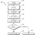
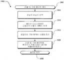
도 5는 본 발명에 따라 형성된 모니터링 디바이스에 상주하는 모니터링 루틴을 설명하는 개요 플로우차트,5 is an overview flowchart illustrating a monitoring routine residing in a monitoring device formed in accordance with the present invention;
도 6은 도 5에서의 사용에 적합한 디바이스 분석 서브루틴을 설명하는 개요 플로우차트,6 is an overview flowchart illustrating a device analysis subroutine suitable for use in FIG. 5, FIG.
도 7은 도 6에서의 사용에 적합한 이동 분석 서브루틴을 설명하는 개요 플로우차트,FIG. 7 is an overview flowchart illustrating a mobility analysis subroutine suitable for use in FIG. 6, FIG.
도 8은 도 6에서의 사용에 적합한 전력 세이빙 서브루틴을 설명하는 개요 플로우차트,8 is an overview flowchart illustrating a power saving subroutine suitable for use in FIG. 6;
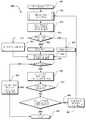
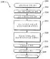
도 9는 도 8에서의 사용에 적합한 배터리-프로세싱 서브루틴을 설명하는 개요 플로우차트,FIG. 9 is a schematic flowchart illustrating a battery-processing subroutine suitable for use in FIG. 8;
도 10은 도 5에서의 사용에 적합한 위치 결정 서브루틴을 설명하는 개요 플로우차트,FIG. 10 is a schematic flowchart illustrating a positioning subroutine suitable for use in FIG. 5;
도 11은 본 발명에 따라 미디어 디스플레이 효과 통계를 결정하기 위하여 모니터링 디바이스, 다운로드 서버, 및 포스트 처리 서버간의 상호작용을 설명하는 도면,11 illustrates an interaction between a monitoring device, a download server, and a post processing server to determine media display effect statistics in accordance with the present invention;
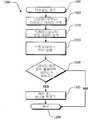
도 12는 본 발명에 따라 형성된 다운로드 서버에 상주하는 초기화 루틴을 설명하는 개략 플로우차트,12 is a schematic flowchart illustrating an initialization routine residing in a download server formed in accordance with the present invention;
도 13은 본 발명에 따라 형성된 다운로드 서버상에 상주하는 모니터링 디바이스 다운로드 루틴을 설명하는 개요 플로우차트,13 is an overview flowchart illustrating a monitoring device download routine residing on a download server formed in accordance with the present invention;
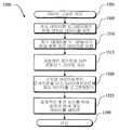
도 14는 본 발명에 따라 형성된 모니터링 디바이스와 다운로드 서버로부터의 정보를 더 처리하기 위한 포스트 처리 서버상에 상주하는 포스트 프로세싱 루틴을 설명하는 개요 플로우차트,14 is an overview flowchart illustrating a post processing routine residing on a post processing server for further processing information from a download server and a monitoring device formed in accordance with the present invention;
도 15는 도 14에서의 사용에 적합한 정확성 개선 지오 데이터 그루밍 서브루틴을 설명하는 개요 플로우차트,FIG. 15 is an overview flowchart illustrating accuracy improvement geo data grooming subroutines suitable for use in FIG. 14;
도 16은 도 14에서의 사용에 적합한 위치 매칭 서브루틴을 설명하는 개요 플로우차트,FIG. 16 is a schematic flowchart illustrating a position matching subroutine suitable for use in FIG. 14;
도 17은 도 14에서의 사용에 적합한 태불레이션 통계 서브루틴을 설명하는 개요 플로우차트,FIG. 17 is an overview flowchart illustrating a tabulation statistics subroutine suitable for use in FIG. 14;
도 18은 도 14에서의 사용에 적합한 미디어 디스플레이 레이팅 서브루틴을 설명하는 개요 플로우차트,FIG. 18 is an overview flowchart illustrating a media display rating subroutine suitable for use in FIG. 14;
도 19는 도 14에서의 사용에 적합한 리콜 및 구매 레이팅 서브루틴을 설명하는 개요 플로우차트,FIG. 19 is an overview flowchart illustrating a recall and purchase rating subroutine suitable for use in FIG. 14;
도 20은 도 14에서의 사용에 적합한 미디어 플래닝 레이팅 서브루틴의 개요 플로우차트,20 is a schematic flowchart of a media planning rating subroutine suitable for use in FIG. 14;
도 21은 도 14에서의 사용에 적합한 논미디어 플래닝 레이팅 서브루틴의 개요 플로우차트, 및21 is a schematic flowchart of a non-media planning rating subroutine suitable for use in FIG. 14, and
도 22는 도 20에서의 사용에 적합한 도달 및 프리퀀시 분석 서브루틴을 설명하는 개요 플로우차트이다.FIG. 22 is a schematic flow chart illustrating arrival and frequency analysis subroutines suitable for use in FIG. 20.
본 발명의 상기 태양 및 많은 부수적인 이점은 첨부 도면과 관련한 이하의 상세한 설명을 참조하여 보다 잘 이해될 때 보다 용이하게 평가받을 것이다. These aspects and many additional advantages of the invention will be more readily appreciated when understood better with reference to the following detailed description in conjunction with the accompanying drawings.
이하의 상세한 설명은 프로세서, 이 프로세서를 위한 메모리 스토리지, 연결 입력 및 출력 디바이스를 포함하는 종래의 연산 구성요소에 의하여, 프로세스 및 상징적 표현의 동작으로 되어 있다. 이러한 기술된 프로세스와 동작은 원격 파일 서버, 컴퓨터 서버, 및 메모리 저장 디바이스를 포함하여, 이종 분산 컴퓨팅 환경에서 보다 전문화된 구성요소뿐만 아니라 종래의 컴퓨팅 환경을 이용할 수 있다. 이러한 종래의 분산 컴퓨팅 구성요소의 각각은 통신망을 거쳐 프로세서에 의해 접속가능할 수 있다.The following detailed description is directed to the operation of processes and symbolic representations by conventional computing components including a processor, memory storage for the processor, connected input and output devices. These described processes and operations can utilize conventional computing environments as well as more specialized components in heterogeneous distributed computing environments, including remote file servers, computer servers, and memory storage devices. Each of these conventional distributed computing components may be accessible by a processor via a communication network.
도 1은 공중 시청가능한 미디어 디스플레이에 응답자의 노출의 리치 및 프리퀀시를 결정하기 위한 시스템(100)의 기능 블록도이다. 시스템(100)은 일반적으로, 그 몇몇이 (인터넷, 공중 교환망등의) 네트워크에 상호연결될 수 있는, 개인 컴퓨터 시스템을 포함하는 컴퓨팅 환경에서 동작하지만, 본 시스템(100)이 하나의 스탠드얼론 컴퓨터 시스템에 의해서 똑같이 기능할 수 있음을 이해할 것이다. 도 1에 도시된 시스템(100)은 모니터링 디바이스(200), 위성 항법 시스템(SPS) 위성(105), 미디어 디스플레이(150), 다운로드 서버(300), 포스트 처리 서버(400), 및 지리 정보 시스템(GIS) 데이터베이스(125)를 포함한다. 종래의 GIS 데이터베이스(125)는 포스트 처리 서버(400) 또는 별개의 디바이스상에 상주할 수 있음을 당업자는 이해할 것이다. 모니터링 디바이스(200), 다운로드 서버(300), 및 포스트 처리 서버(400)는 각각, 도 2, 3, 및 4와 관련하여 이하에서 더 기술될 것이다. 또한, 설명의 용이함을 위해, 단 하나의 모니터링 디바이스(200), 하나의 다운로드 서버(300), 하나의 포스트 처리 서버(400), 및 하나의 미디어 디스플레이(150)만으로 도시되었지만, 많은 이러한 디바이스 및/또는 디스플레이가 본 시스템(100)에 포함될 수 있고 또는 다운로드 서버(300)와 포스트 처리 서버(400)가 동 디바이스상에 상주할 수 있음이 이해될 것이다. 도 2, 3, 및 4는 미디어 디스플레이에 노출 및 미디어 디스플레이의 리치 및 프리퀀시를 결정하기 위해 적합한 전형적인 디바이스를 도시한다. 디바이스는 예일뿐이지 본 발명의 사용이나 기능의 범위에 관한 임의의 제한으로 의도되지는 않는다. 또한 디바이스는 예에서 도시된 구성요소중 어느 하나 또는 조합에 관한 임의의 종속 요건을 갖는 것으로 해석되어서도 안된다.1 is a functional block diagram of a
도 1에 디바이스의 상호작용 및 목적을 보다잘 설명하기 위하여, 이하의 전형적인 실시예가 제공된다. 시스템(100)의 디바이스를 사용하는, 이 전형적인 실시예에서, 다중 미디어 디스플레이(150)의 효과가 다중 모니터링 디바이스(200), 다운로드 서버(300), 및 포스트 처리 서버(400)를 사용하여 평가된다. 모니터링 디바이스(200)는 많은 학습 응답자에게 분산되어 있다. 각각의 응답자는 모니터링 디바이스를 이동시키고, 이러한 모니터링 디바이스가 연계된 응답자의 이동을 추적한다. 몇몇 지점에서 모니터링 디바이스를 이동시키는 응답자의 이동에 의해 응답자가 미디어 디스플레이(150)에 노출되게 되고, 즉, 응답자는 미디어 디스플레이에 의해 제공된 정보를 보거나 들을 수 있게 수신할 수 있는 그들의 이동위치에 도달한다. 응답자가 이동할때, 모니터링 디바이스는 모니터링 디바이스에 의해 결정된 추적 데이터("지오 데이터")를 저장한다. 모니터링 디바이스에 의해 수집된 지오 데이터는 미디어 디스플레이의 위치를 정의하는 위치 데이터와 그 지오 데이터를 비교함으로써 응답자가 어느 미디어 디스플레이에 노출되는지를 결정하는데 사용된다. 보다 상세하게는, 도 1에 도시된 발명의 실시예에서, 모니터링 디바이스(200)는 지오 데이터를 하나 이상의 다운로드 서버(300)에 다운로드한다. 다운로드 서버(300)는 다운로딩된 지오 데이터를 포스트 처리 서버(400)에 전송한다. 포스트 처리 서버(400)는 필요한 GIS 데이터베이스로부터의 데이터를 사용하여 지오 데이터를 프로세싱하고 모니터링 디바이스를 미디어 디스플레이에 이동시키는 응답자의 노출을 결정하기 위하여 미디어 디스플레이(150)의 위치를 정의하는 데이터와 비교한다. 그 다음에 미디어 디스플레이의 효과는 그 미디어 디스플레이의 리치와 프리퀀시를 결정하는 포스트 처리 서버(400)에 의해 평가된다. 리치는 얼마나 많은 응답자가 미디어 디스플레이에 노출되었는지의 정도이고 프리퀀시는 응답자당 (평균적인) 노출의 횟수의 정도이다.To better illustrate the interaction and purpose of the device in FIG. 1, the following exemplary embodiment is provided. In this exemplary embodiment, using the device of the
본 발명은 많은 일반적인 목적 또는 도 1에 도시된 전형적인 예외의 특별한 연산 디바이스 환경 또는 구성에서 동작할 수 있다. 잘알려진 연산 디바이스, 환경, 및/또는 본 발명을 구현하기 위해 적합할 수 있는 구성의 예는, 이것으로 제한되는 것은 아니고, 퍼스널 컴퓨터, 서버 컴퓨터, 랩탑 디바이스, 멀티프로세서 시스템, 마이크로프로세서-기반 시스템, 네트워크 PC, 미니컴퓨터, 메인프레임 컴퓨터, 및 스탠드 얼론 디바이스로서 및 분산 연산 컴퓨팅 환경에서 동작할 수 있는 핸드헬드 컴퓨터를 포함한다.The present invention may operate in many general purposes or in particular computing device environments or configurations with the typical exceptions shown in FIG. Examples of well-known computing devices, environments, and / or configurations that may be suitable for implementing the present invention include, but are not limited to, personal computers, server computers, laptop devices, multiprocessor systems, microprocessor-based systems. , Handheld computers capable of operating as network PCs, minicomputers, mainframe computers, and standalone devices, and in distributed computing environments.
도 2는 전형적인 모니터링 디바이스(200)의 몇몇 핵심 구성요소를 묘사한다. 당업자는 도시된 모니터링 디바이스(200)가 도 2에 도시된것보다 많거나 적은 구성요소를 포함할 수 있음을 이해할 것이다. 그러나, 이러한 일반적으로 종래의 구성요소의 전부가 본 발명을 실행하기 위해 적합한 모니터링 디바이스를 게시하기 위해 도시될 필요는 없다. 또한 본 발명을 실행하기 위해 적합한 모니터링 디바이스(200)는 많은 형태의 요소, 예컨대, 개인에 의해 이동된 작은 디바이스로서, 차량 탑재 디바이스, 또다른 디바이스의 부가 구성요소등을 가질 수 있음을 당업자는 이해할 것이다. 도 2에 도시된 바와 같이, 모니터링 디바이스(200)는 (다운로드 서버(300)와 같은) 기타 디바이스에 연결하기 위한 입/출력(I/O) 인터페이스(230)을 포함한다. 당업자는 I/O 인터페이스(230)가 이러한 연결을 위해 필요한 회로를 포함하고, 본 발명의 특별한 구현에 의해 요구된 프로토콜로써 사용하기 위해 또한 구성됨을 이해할 것이다.2 depicts some key components of a
도시된 모니터링 디바이스(200)는 또한 프로세싱 유닛(210), 클록(225), RF위치 구성요소(240), SPS인터페이스(245), 트렘블러(215), 방향성 유닛(235), 및 메모리(250)를 포함하고 그 모두는 버스(220)를 거쳐 I/O 인터페이스(230)를 따라 상호연결되어 있다. 클록(225)은 모니터링 디바이스(200)에 시간 정보를 제공한다. RF위치 구성요소(240)는 라디오 신호에 응답하는 선택적 구성요소이다. RF위치 구성요소는 또다른 RF디바이스 또는 모니터링 디바이스의 위치를 방송하는 트랜스미터로부터 위치 정보를 수신하기 위한 수신기를 포함할 수 있다. 대안으로, 트랜스미터는 미디어 디스플레이(150)에 근접하여 위치한 RF수신기에 의해 수신을 위 한 모니터링 디바이스 식별 코드를 전송할 수 있다. 더욱이, 전형적인 RF위치 구성요소(240)는 수신기 및 트랜스미터뿐만 아니라 능동 또는 수동 라디오 프리퀀시 식별(RFID) 구성요소 및 RF트랜스폰더를 포함한다.The illustrated
SPS인터페이스(245)는 SPS신호를 수신하고 기록하도록 작동하는 구성요소이다. 보다 상세하게는, SPS인터페이스는 SPS위성, 의사위성 또는 관련 디바이스로부터 신호를 수신하는 당업계에 잘 알려진 SPS엔진을 포함하고 SPS엔진의 위치를 결정하기 위한 신호를 사용하고, 따라서 디바이스가 SPS엔진에 결합된다. SPS는 일반적으로 임의의 위성/의사위성 기반 위치 결정 시스템을 의미한다.The
트렘블러(215)는 그 트렘블러가 연계되는 디바이스, 이 경우에는 모니터링 디바이스,가 처리되었고, 밀렸고, 또는 몇몇 다른 방식으로 이동되었는지를 검출하는 선택적인 이동 감지 구성요소이다. 트렘블러(215)는 파워 세이빙 측정이 가능하게 될 수 있도록 연장된 시한동안 움직이지 않았던때를 결정하는데 유용하다.The
방향성 유닛(235)은 방향의 위치 또는 이동을 결정하기 위하여 외부 방송 또는 신호를 필요로하지 않는 선택적인 비RF 방향성 구성요소이다. 몇몇 전형적인 방향성 유닛은 나침반, 가속도계, 자이로스코프, 바로미터, 고도계, 경사계등을 포함한다.
메모리(250)는 일반적으로 램(RAM), 롬(ROM) 및 플래시 메모리(예컨대, 플래시 램), 기타 비휘발성 고체상태 메모리(즉, EEPROM, FPGA등), 디스크 드라이브, 테이프 드라이브, 광학 드라이브, 플로피 디스크 드라이브, 또는 상기의 몇몇 조합과 같은 영구 저장 디바이스중 적어도 하나를 포함한다. 메모리(250)는 오퍼레이 팅 시스템(255), 모니터링 루틴(500), 그래픽 위치 데이터("지오 데이터")(260), 디바이스 데이터(265), 및 저장된 프로파일 데이터(270)를 저장한다. 프로파일 데이터(270)는 응답 인구 정보, 디바이스 동작 필요조건(위치 샘플링 스피드, 전력 예상, 디바이스의 이동을 지시하기 위한 거리 등) 및 RFID존 위치(SPS데이터를 증가시키기 위하여 RFID통신이 턴온될 장소)를 포함할 수 있다. 응답 인구 정보, RFID존 정보등과 같은, 특히 때때로 변하는, 이러한 소프트웨어 정보는 (도시않된) 퍼스널 컴퓨터 또는 다운로드 서버(300)과 같은, 또다른 디바이스로부터 I/O 인터페이스(230)를 거쳐 모니터링 디바이스(200)의 메모리(250)에 로딩될 수 있다.
일반적으로 종래의 통상의 목적의 컴퓨팅 디바이스와 일치하는 전형적인 모니터링 디바이스(200)가 기술되었지만, 당업자는 모니터링 디바이스(200)가 많은 다른 형태를 취할 수 있음을 이해할 것이다. 또한, 몇몇 실시예 또는 본 발명이 야외 환경에서 동작하는 모니터링 디바이스(200)를 제공하는 한편, 본 모니터링 디바이스(200)는 SPS모니터링에 적합하지 않은 환경을 포함하여, 많은 환경에서 동작할 수 있다. 따라서, 본 발명은 선택적인 구성요소를 가지거나 가지지않거나 또는 상기 환경에서 도 2에 도시된 형태로 제한되는 것으로 해석되어서는 안된다.While a
도 3은 전형적인 다운로드 서버(300)의 몇몇 핵심 구성요소를 도시한다. 당업자는 다운로드 서버(300)는 도 3에 도시된 것보다 훨씬 많은 구성요소를 포함할 수 있음을 이해할 것이다. 도시의 용이를 위하여, 키보드, 온오프 스위치등과 같은, 실제 다운로드 서버(300)에서 포함될것 같은 많은 종래 구성요소가 도시되지 않고 있다. 이러한 일반적인 종래의 구성요소의 전부가 본 발명의 실행을 위한 가 능한 실시예를 게시하기 위하여 도시될 필요는 없다. 도 3에 도시된 다운로드 서버(300)는 (모니터링 디바이스(200) 또는 포스트 처리 서버(400)와 같은) 다른 디바이스에 연결하기 위한 I/O 인터페이스(330)를 포함한다. 당업자는 I/O 인터페이스(330)가 이러한 연결을 위해 필요한 회로를 포함하고, 또한 본 발명의 특정한 실시예에 의해 요구되는 필요한 프로토콜로써 사용하기 위하여 구성됨을 이해할 것이다.3 illustrates some key components of a
다운로드 서버(300)는 또한 프로세싱 유닛(310), 선택적인 디스플레이(340) 및 메모리(350)를 포함하고 그 모두는 버스(320)를 거쳐 I/O 인터페이스(330)를 따라 상호연결되어 있다. 메모리(350)는 일반적으로 램, 롬 및 디스크 드라이브, 테이프 드라이브, 광학 드라이브, 플로피 디스크 드라이브, 플래시 램, 기타의 비휘발성 고체 상태 메모리, 또는 그 조합과 같은, 영구 저장장치를 포함한다. 메모리(350)는 오퍼레이팅 시스템(355), 초기화 루틴(1200), 다운로드 루틴(1300), 응답하는 ID데이터베이스(360), 모니터링 디바이스 데이터베이스(365), 및 모니터링 디바이스("유닛")파일(370)을 저장한다. 이러한 소프트웨어 구성요소는, 플로피, 테이프, 또는 DVD/CD-ROM드라이브와 같은 컴퓨터 판독가능 매체와 연계된 (도시안된) 드라이브 메커니즘을 사용하거나 I/O 인터페이스(330)를 거쳐 다운로드 서버(300)의 메모리(350)에 컴퓨터 판독가능 매체로부터 로딩될 수 있다.
일반적으로 종래의 통상의 목적의 컴퓨팅 디바이스와 일치하는 전형적인 다운로드 서버(300)가 기술되었지만, 당업자는, 이것으로 제한되는 것은 아니지만, 정보 프로세싱을 위해 구성된 데이터베이스 서버를 포함하는 많은 다른 형태를 취 할 수 있음을 이해할 것이다. 따라서, 다운로드 서버는 도 3에 도시된 형태로 제한되는 것으로 해석되어서는 안된다.While a
도 4는 전형적인 포스트 처리 서버(400)의 몇몇 핵심 구성요소를 도시한 것이다. 당업자는 포스트 처리 서버(400)는 도 4에 도시된 것보다 훨씬 많은 구성요소를 포함할 수 있음을 이해할 것이다. 설명의 용이를 위해, 키보드, 온오프 스위치등과 같은, 실제적인 프로세싱 서버(400)에 포함될것 같은 많은 종래 구성요소가 도시되지 않고 있다. 본 발명의 실행을 위하여 가능한 실시예를 게시하기 위해 이러한 일반적인 종래의 구성요소의 전부가 도시될 필요는 없다. 도 4에 도시된 전형적인 포스트 처리 서버(400)는 (다운로드 서버와 같은)다른 디바이스에 연결하기 위한 I/O 인터페이스(430)을 포함한다. 당업자는 I/O 인터페이스(430)가 이러한 연결을 위해 필요한 회로를 포함하고, 또한 본 발명의 특정한 실시예에 의해 요구된 필요한 프로토콜로써 사용을 위해 구성됨을 이해할 것이다.4 illustrates some key components of a typical
포스트 처리 서버(400)는 또한 프로세싱 유닛(410), 선택적인 디스플레이(440) 및 메모리(450)을 포함하고 그 전부는 버스(420)를 거쳐 I/O 인터페이스(430)를 따라 연결되어 상호연결되어 있다. 메모리(450)는 일반적으로 램, 롬, 및 디스크 드라이브, 테이프 드라이브, 광학 드라이브, 플로피 디스크 드라이브, 플래시램, 기타 비휘발성 고체 상태 메모리, 또는 그 조합과 같은 영구 저장장치를 포함한다. 메모리(450)는 오퍼레이팅 시스템(455), 포스트 프로세싱 루틴(1400), 응답하는 지오 데이터베이스(460), 미디어 위치 데이터베이스(465), 및 확대된 DGPS데이터베이스(470)을 저장한다. 이러한 소프트웨어 구성요소는 플 로피, 테이프 또는 DVD/CD-ROM드라이브와 같은, 컴퓨터 판독가능 매체와 연계된 (도시안된) 드라이브 메커니즘을 사용하거나 I/O 인터페이스(430)를 거쳐 포스트 처리 서버(400)의 메모리(450)에 컴퓨터 판독가능 매체로부터 로딩될 수 있음을 이해할 것이다.
일반적으로 종래의 통상 목적의 컴퓨팅 디바이스에 일치하는 전형적인 포스트 처리 서버(400)가 기술되었지만, 당업자는, 포스트 처리 서버(400)가, 이것으로 제한되는 것은 아니지만, 정보 프로세싱을 위하여 구성된 데이터베이스 서버를 포함하여 다양한 형태를 취할 수 있음을 이해할 것이다. 따라서, 포스트 처리 서버는 도 4에 도시된 형태로 제한되는 것으로 해석되어서는 안된다.Although a typical
도 1, 2, 및 (이하에 기술될)11에 기술된 바와 같이, 디스플레이 미디어 평가 시스템(100)의 모니터링 디바이스가 식별된 개인("응답자")을 인구통계적으로 추적하는데 사용된다. 추적 또는 지오 데이터는 다양한 미디어 디스플레이에 응답자의 노출을 결정하는데 사용된다.As described in FIGS. 1, 2, and 11 (to be described below), a monitoring device of the display
모니터링 디바이스(200)에 의해 구현된 전형적인 모니터링 루틴(500)을 설명하는 플로우차트가 도 5에 도시된다. 모니터링을 개시하기에 앞서, 응답자의 인구통계 데이터, RF존 데이터, 프로파일 데이터와 같은 모든 필요한 가변 데이터가 모니터링 디바이스에 다운로드된다.A flowchart describing an
모니터링 루틴(500)이 블록(501)에서 개시되어 모니터링 디바이스가 초기화되는 블록(503)으로 진행한다. 다음에, 블록(505)에서 방금 턴온된것 처럼 모니터링 디바이스의 상태가 로깅된다. 블록(505)에서 로깅될 수 있는 전형적인 정보는 날짜, 시간, 및 (이용할 수 있다면) 모니터링 디바이스(200)의 위치이다. 다음에, 블록(510)에서, 와치도그 타이머가 리셋된다. 본 발명의 모든 실시예에 필요하지는 않지만, 와치도그 타이머는 충돌이나 기타의 에러가 발생한 경우에 디바이스 기능을 복구하는데 사용된다. 와치도그 타이머의 동작은 도 6에 도시된 디바이스 분석 서브루틴(600)과 연계하여 이하에서 보다 상세하게 설명된다. 다음에 프로세싱은, 모니터링 디바이스(200)가 분석되는 디바이스 분석 서브루틴 블록(600)으로 진행한다. 디바이스 분석 서브루틴(600)이 회귀한후에, 프로세싱은 모니터링 디바이스(200)의 현재의 위치를 체크하기 위하여 (현재의 프로파일 데이터(270)에 명기된 바와 같은) 충분한 시간이 경과하였는지 여부를 판정하는 판정 블록(515)으로 진행한다. 위치가 체크되지 않았다고 판정되면, 사이클은 디바이스 분석 서브루틴(600)으로 되돌아가거나, 대안으로, 위치 체크가 원해질때/요구될때까지 대기할 수 있다. 임의의 경우에, 위치 체크가 수행되었다는 판정이 난 후에, 프로세싱은 제오 데이터 수집 서브루틴(1000)을 계속한다. 전형적인 지오 데이터 서브루틴(1000)은 도 10에서 도시되고 이하에 설명된다. 이하의 설명으로부터 보다 잘 이해될 수 있는바와 같이, 지오 데이터 수집 서브루틴은 모니터링 디바이스(200)의 위치에 대한 데이터를 수집한다. 지오 데이터 수집 서브루틴(1000)되돌아온 후에, 프로세싱은, 모니터링 디바이스의 위치가, 지오 데이터 수집 서브루틴(1000)을 통과하는 동안 발견되었는지 여부를 판정하는, 판정 블록(520)에서 계속된다. 위치가 발견되지 않았다면, 프로세싱은 디바이스 분석 서브루틴(600)으로 복귀한다. 그러나, 판정 블록(520)에서, 위치가 발견되었다면, 프로세싱은, 제오 데이터가 압 축되는, 블록(525)에서 계속된다. 당업자는 압축 데이터가 메모리 요구량을 줄이고, 보다 적은 량의 정보를 저장하는데 전력이 덜 소모되기 때문에, 모니터링 디바이스의 전력 수명을 증가시킬 수 있다는 점을 이해할 것이다. 그러나, 지오 데이터를 압축하는 것은 충분한 메모리와 전력이 이용가능하다면 불필요할 수 있는 선택적인 단계이다라는 점을 또한 이해할 것이다. 다음에, 블록(530)에서, 지오 데이터는 나중의 검색을 위해 저장된다. 그 다음에 프로세싱은 리셋 와치도그 타이머 블록(512)로 복귀한다. 모니터링 루틴(500)은 모니터링 디바이스(200)를 턴오프하거나, 모니터링 디바이스(200)가 전력을 소진함으로써 인터럽트될때까지 프로세싱을 계속한다.The
모니터링 디바이스(200)에서 측정의 정확성과 신뢰도를 보증하기 위해, 모니터링 디바이스(200)의 상태를 루틴적으로 액세스하기 위한 모니터링 디바이스 분석(블록(600))이 포함된다. 이러한 분석은 모니터링 디바이스(200)에 의해 발생된 데이터가 정확하다는 보다큰 신뢰를 제공하고, 선택된 디바이스 프로파일 데이터(270)에 의해 결정되는 데이터 수집의 주기를 제어함으로써 전력 공급의 유용한 수명을 연장시키으로써 모니터링 디바이스(200)의 모니터링 시간과 정확도를 개선하는데 사용될 수 있다.Monitoring device analysis (block 600) is included to routinely access the status of the
상기한 바와 같이, 모니터링 유닛(500)은 선택적인 디바이스 분석 서브루틴(600)을 포함할 수 있다. 도 6은 적당한 디바이스 분석 서브루틴(600)의 전형적인 도시예이다. 서브루틴(600)은 블록(601)에서 개시하여 이동 분석 서브루틴 블록(700)으로 진행한다. 적당한 이동 분석 서브루틴(700)이 도 7에 도시되고 이하에 기술된다. 간략하게는, 이동 분석 서브루틴(700)은 모니터링 디바이스가 이전의 위치로부터 특정 거리를 이동하였는지 여부를 판정한다. 모니터링 디바이스의 이동 실패는 응답자가 연장된 시한동안 특정 위치에서 머무르고 있음을 지시한다. 그 다음에 루틴(600)은 전력 세이빙 서브루틴(800)에서 계속한다. 적당한 파워 세이빙 서브루틴(800)이 도 8에서 도시되고 이하에서 기술된다. 일반적으로, 모니터링 디바이스(200)에 요구될 원하는/예상된 모니터링 기능을 고려하는 한편, 파워 세이빙 서브루틴(800)은 모니터링 디바이스(200)가 보다 효율적인 방식으로 동작하게 한다. 다음에, 블록(610)에서, 임의의 변칙의 디바이스 이벤트가 검출되었는지 여부를 판정한다. 변칙의 디바이스 이벤트는 디바이스 데이터에 존재하는 임의의 예기되지 않은/바운드리외의 값이다. 그 다음에 임의의 검출된 변칙의 디바이스 이벤트는 블록(615)에서 저장된다. 다음에, 판정 블록(620)에서, 와치도그 타이머가 종료했는지가 판정된다. 와치도그 타이머는 상기한 모니터링 루틴(도 5: 500)을 통한 사이클동안 적절히 리셋되지 않으면 종료된다. 와치도그 타이머의 종료는 모니터링 디바이스(200)에서 큰 에러의 증거이다. 보다 상세하게는, 상기되고 도 5에서 도시된 바와 같이, 와치도그 타이머가 리셋되는 루프는 항상 사이클링한다. 와치도그 타이머의 종료는 사이클하는 모니터링 루틴(500)의 실패를 나타내고, 따라서, 큰 에러의 발생을 나타낸다. 이러한 경우에, 모니터링 디바이스(200)의 완전한 "리부팅"이 바람직하다. 본 발명의 일 전형적인 예에서, 리부팅은 모니터링 루틴(500)이 블록(501)에서 재개시하도록 디바이스에 전력 사이클링 지시로서 기능한다. 모니터링 루틴(500)의 블록(510)에서, 와치도그 타이머 상태가 로깅됨 을 주목하라. 따라서, 리부팅 지시(블록(630))는 블록(510)에서 로깅될 것이다. 그러나, 판정 블록(620)에서, 와치도그 타이머가 종료되지 않았다고 판정되면, 프로세싱은, 디바이스 분석 서브루틴이 호출 루틴으로 회귀하는, 블록(699)에서 계속된다.As noted above, the
상기한 바와 같이, 모니터링 디바이스(200)의 데이터 수집 동작은 이동 분석 서브루틴(700)을 포함함으로써 강화될 수 있다. 전형적인 분석 서브루틴은 도 7에서 도시된다. 이하에서 보다 완전하게 기술되는 바와 같이, 이동 분석 서브루틴은 모니터링 디바이스(200)가 그 모니터링 디바이스 및 따라서 그 모니터링 디바이스를 사용하는 사람이 새로운 위치로 움직였다는 것을 지시하는 것을 보증하기 위하여 충분한 거리를 이동하였는지 여부를 판정한다. 모니터링 디바이스의 이동을 분석하는 것은, 응답자의 주의를 포착하였을 수 있는 영역에서 임의의 미디어 디스플레이의 평가를 강화하기 위하여 체류시간(특정 위치에서 소비된 시간)을 결정할 수 있게 한다.As noted above, the data collection operation of the
이동 분석 서브루틴(700)이 블록(701)에서 개시되어, 모니터링 디바이스의 기준 위치와 현재의 위치간의 거리를 측정하는, 블록(705)로 진행한다. 기준 위치는 새로운 위치를 기록하는 것을 보증하기 위하여 이전의 기준 위치와는 충분히 다른곳에서 모니터링 디바이스(200)가 있었던 마지막 위치이다. 이하에서 보다 완전하게 설명되는 바와 같이, 충분하다는 결정은 선택된 프로파일 데이터(270)에 따른 상이한 레벨로 세팅될 수 있는 임계치를 기초로한다. 모니터링 디바이스가 처음에 턴온될때는 기준 위치가 없을 수 있음을 주목해야 한다. 따라서, 첫 위치는 항상 기준 위치일뿐 아니라 현재 위치이다. 다음에, 판정 블록(710)에서, 기준 위치로부터의 거리가 임계치를 초과하는지 여부가 판정된다. 이 임계치는 고정된 임계치일 수 있고 또는 적응성 임계치일 수 있다. 고정된 임계치 거리는 프로파일 데이터(270)에서 명기된다.The
적응성 임계치는 응답자의 위치 및/또는 이동 패턴 및/또는 속도와 같은, 거리외의 다른 요인에 좌우된다. 예컨대, 모니터링 디바이스가 응답자가 차량 속도(예컨대, 10mph이상)로 이동한다고 결정하면, 임계치 거리는 (차량 이동을 지시하기 위하여)증가될 수 있다. 대안으로, 응답자가 미디어 디스플레이가 풍부한 보행자 영역에서만 있다면, 임계치 거리는, 응답자의 미디어 디스플레이로의 노출의 보다 그래뉼러한(granular) 결정을 제공하기 위하여, 줄어들 수 있다. 보행자가 미디어 디스플레이가 풍부한 영역에 위치하는지의 여부는 메모리내의 이러한 위치에 대한 정보를 저장하고 이러한 위치에 모니터링 디바이스의 현재의 위치를 비교함으로써 용이하게 결정된다. 고정된 임계치 거리와 마찬가지로, 선택된 프로파일 데이터(270)는 적응 임계치를 설정하기 위한 것을 가진 이동 파라메터를 포함한다.The adaptive threshold depends on factors other than distance, such as the responder's location and / or movement pattern and / or speed. For example, if the monitoring device determines that the responder is moving at vehicle speed (eg, 10 mph or more), the threshold distance may be increased (to indicate vehicle movement). Alternatively, if the responder is only in a pedestrian area rich in media display, the threshold distance may be reduced to provide more granular determination of the responder's exposure to the media display. Whether a pedestrian is located in an area rich in media display is easily determined by storing information about this location in memory and comparing the current location of the monitoring device to this location. As with the fixed threshold distance, the selected
판정 블록(710)으로 돌아가서, 기준 위치로부터의 거리가 임계치를 초과하지 않는다고 판정되면, 프로세싱은, 기준 위치에서 소비된 시간의 종료시간이 현재의 시간으로 업데이트되는, 블록(725)에서 계속한다. 그런, 판정 블록(710)에서, 거리가 임계치를 초과한다고 판정되면, 프로세싱은, 새로운 위치 및 시간이 지오 데이터로서 기록되는 블록(715)에서 계속한다. 또한, 블록(720)에서, 새로운 위치는 새로운 기준 위치로서 저장된다. 블록(720) 또는 블록(725)후의 어느 경우에서나, 이동 분석 서브루틴(700)은 블록(799)으로 진행하고, 호출 루틴으로 돌아간다.Returning to decision block 710, if it is determined that the distance from the reference location does not exceed the threshold, processing continues at
상기한 바와 같이, 바람직하게는, 디바이스 분석 서브루틴(도 6: 600)은 또한 파워 세이빙 서브루틴(800)을 포함한다. 파워 세이빙은 전력원(배터리, 연료 전지, 캐피시터 등)이 모니터링 디바이스(200)의 크기 및/또는 무게에 기여하기 때문에 중요한 값이다. 따라서, 작은 전력원이 바람직하지만 작은 전력원은 보통 전력이 적음을 의미한다. 모니터링 디바이스는 보다 많은 전력을 사용할때와 보다 적은 전력을 사용할때를 보다 효율적으로 판정함으로써 보다 적은 전력원의 사용으로부터 일어나는 보다 적은 전력을 상쇄한다. 이러한 결과를 달성하기에 적합한 파워 세이빙 루틴(800)은 도 8에서 도시되고 이하에서 기술된다.As noted above, preferably, the device analysis subroutine (FIG. 6: 600) also includes a
파워 세이빙 서브루틴(800)은 블록(801)에서 개시하여 (도 9에 도시되고 이하에 기술되는)배터리 프로세싱 서브루틴 블록(900)으로 진행한다. 배터리 프로세싱 서브루틴(900)이 종료한후, 파워 세이빙 서브루틴(800)은, 현재의 위치가 RFID(라디오 프리퀀시 식별)존내에 있는지 여부를 판정하는, 블록(810) 및 그 다음으로 블록(815)으로 진행한다. RFID존은 모니터링 디바이스가 RFID디바이스, 즉 RF신호를 전송하거나 수신하는 디바이스,의 통신 영역내에 있는 존이다. 모니터링 디바이스가 RFID존내에 있는가는 모니터링 디바이스의 메모리내의 이러한 존의 위치를 저장하고 이러한 존의 저장된 위치와 모니터링 디바이스의 현재의 위치를 주기적으로 비교함으로써 결정될 수 있다. 임의의 나열된 RFID존을 위한 디바이스 프로파일 데이터(270)을 주기적으로 체크함으로써 결정된다.The
판정 블록(815)에서, 현재의 위치가 RFID존내에 있다는 것이 발견되면, 모니 터링 디바이스(200)의 선택적인 RFID기능이 블록(820)에서 턴온된다. 그런, 판정 블록(815)에서, 현재의 위치가 RFID존내가 아니라는 것이 발견되면, 모니터링 디바이스(200)의 선택적인 RFID기능은 블록(830)에서 턴오프된다. 판정 블록(815)에서 현재의 위치가 RFID존내외부인지에 관하여 판정될 수 없다면, 상태는 알려지지않고 현재의 RFID상태가 블록(825)에서 유지된다. 모니터링 디바이스가 (프로파일 데이터(270)에서) RFID존으로 지정되었던 존내에 위치될때만 RFID기능을 이네이블링하는 것은 모니터링 디바이스(200)가 전력을 덜 사용하게 한다. RFID위치 구성요소(240)는 필요하지 않을때(즉, 모니터링 디바이스가 RFID존 외부에 있을때)는 이네이블되지 않기 때문에 저전력이 사용된다. 전형적인 RFID존은 미디어 디스플레이를 가지지만, SPS커버리지가 없거나 거의없는(예컨대, 지하철역, 몰, 스타디움등)영역일 것이다. 턴온, 턴오프, 또는 현재의 RFID상태를 유지한후의 임의의 경우에, 프로세싱은, SPS신호가 차단되는지를 판정하는, 블록(835)에서 계속한다.At
당업자는 복수의 SPS신호 방송 디바이스(위성, 의사위성등)가 있지만, 이러한 디바이스로부터의 신호는 때에 따라 차단될 수 있음을 이해할 것이다. 이것은 특히 지하와 대형 빌딩내에서 일반적이다. SPS신호가 차단되면, 유용한 위치(지오) 데이터는 획득될 수 없다. 이러한 신호가 차단되는 영역에 있을때 모니터링 디바이스(200)가 SPS신호를 재획득하려고 계속하여 시도하면 모니터링 디바이스의 전력원에 역효과가 일어날 것이다. 따라서, 판정 블록(840)에서 SPS신호가 차단된다고 판정되면, 블록(850)에서 모니터링 디바이스는 덜 공격적인 SPS신호 획득 프로파일을 사용하도록 지시된다. 덜 공격적인이란 의미는 보다 낮은 신호 획득 방 법을 사용하거나 보다 덜 빈번하게 SPS신호를 획득하는 시도를 하거나, 보다 짧은 시간주기동안 SPS신호를 획득하는 시도를 하는 것을 의미한다. 판정 블록(840)에서 SPS신호가 차단되지 않는다고 알려지면, 블록(845)에서 모니터링 디바이스(200)는 보다 공격적인(예컨대, 보다 많은 강력한 신호 획득 방법 또는 보다 자주 SPS 신호의 체크 또는 체크당 보다 긴 시간 주기의 체크)SPS신호 획득 프로파일을 사용하도록 지시된다. 블록(845)후에, 프로세싱은 전력 세이빙 서브루틴(800)이 호출 루틴으로 되돌아가는 블록(899)에서 계속된다.Those skilled in the art will appreciate that although there are a plurality of SPS signal broadcast devices (satellite, pseudosatellite, etc.), signals from such devices may be blocked at times. This is especially common in underground and large buildings. When the SPS signal is blocked, useful location (geo) data cannot be obtained. If the
모니터링 디바이스(200)가 덜 공격적인 SPS신호 획득 프로파일을 사용하도록 블록(850)에서 지시되면, 프로세싱은 테스트가 임계치 시간 제한이 경과하였는지를 판정하는 판정 블록(855)로 진행한다. 시간 제한은 소정의 호출 횟수에 의해, 파워 세이빙 서브루틴(800)에 또는 소정의 시간 주기가 경과한후에 확립될 수 있다. 임계치 시간 주기가 경과하였다면, 파워 세이빙 서브루틴(800)은 보다 공격적인 SPS신호 획득 루틴이 확립되는 블록(845)으로 진행한다. 이와 관련하여, 당업자는 SPS신호는 일시적으로 차단될 수 있음을 이해할 것이다. 모니터링 디바이스(200)는, 이러한 프로파일이 개시되면 덜 공격적인 SPS신호 획득 프로파일을 영구적으로 채용하도록 요구되면 덜 정확할 것이다.If the
판정 블록(855)에서, 임계치 시간 제한이 지나지 않았다고 판정되면, 판정 블록(860)에서 모니터링 디바이스의 임의의 이동이 소정의 시간 주기내에서 발생하였는지 여부가 더 판정된다. 이 판정은, 트렘블러(도 2: 215)가 소정의 시간 주기내에 이동을 검출하였는지를 판정하기 위하여 트렘블러(도 2: 215)의 출력을 모니 터링함으로써 수행된다. 소정의 시간 주기는 프로파일 데이터에서 계속된다. 전형적인 범위는 2-15분이다. 이 범위는 단순히 예로서 의미있는 것이고 본 발명의 실제 실시예에 의해 채용된 소정의 시간 주기의 범위를 제한하려는 의도는 아니다. 트렘블러는 모니터링 디바이스(200)가 실제로 사용중인지 여부의 지시자로서 기능한다. 예컨대, 모니터링 디바이스가 머리맡 테이블상에 놓여있었다면, 연계된 응답자는 더이상 미디어 디스플레이에 노출되지 않음을 지시하고, 모니터링 디바이스가 보다적은 에너지를 소모하도록 모니터링 디바이스를 조절하는 것이 보다더 전력 효율적이다는 것을 나타낸다. 따라서, 판정 블록(860)에서 이동이 검출되면, 프로세싱은 배터리 세이빙 서브루틴(800)이 그 호출 루틴으로 되돌아가는 블록(899)에서 계속한다. 그러나, 판정 블록(860)에서 임계치 시간내에 트렘블러에 의해 검출된 이동이 없다고 판정되면, 프로세싱은 트렘블러가 이동을 검출할때까지 모니터링 디바이스(200)가 슬립 모드로 위치되는 블록(865)에서 계속한다. 트렘블러가 이동을 검출한후에, 프로세싱은 배터리 프로세싱 서브루틴(900)으로 복귀한다.If it is determined at decision block 855 that the threshold time limit has not passed, then at
당업자에게 용이하게 이해될 수 있는 바와 같이, 모니터링 디바이스(200)는 연장된 시간 주기를 초과하는 응답자에 의해 사용된다. 따라서, 예상된 학습기간동안 모니터링 디바이스(200)가 동작을 유지하게 하는 충분한 배터리(연료 전지, 캐패시터등) 전력이 있는지를 계속하여 평가하는 것이 바람직하다. 이러한 배터리 평가는 전력 사용을 제어하고, 따라서, 모니터링 디바이스의 동작 시간을 연장하는데 사용될 수 있다. 도 9는 이러한 결과를 달성하는데 목표가 맞추어진 적당한 배터리 프로세싱 서브루틴(900)의 전형적인 도시예이다.As will be readily appreciated by those skilled in the art, the
배터리 프로세싱 서브루틴(900)은 블록(901)에서 개시하여 디바이스가 예상된 배터리 사용 요구량을 체크하는 블록(905)으로 진행한다. 다음에 블록(910)에서, 모니터링 디바이스(200)는 이용가능한 배터리 전력을 결정한다. 그후, 판정 블록(915)에서 상이한 디바이스 프로파일이 필요한지 여부가 판정된다. 이러한 판정은 현재의 배터리 전력 이용가능성, 예상된 배터리 사용 요구량과 모니터링 디바이스(200)의 현재의 학습을 위한 지시된 프로파일을 비교한다. 예컨대 배터리 전력 이용가능성의 현재의 레벨이 예상된 사용 요구량미만이면, 현재의 프로파일을 위해 보다 낮은 전력 프로파일이 대체될 수 있다. 역으로, 이용가능한 배터리 전력이 예상된 것보다 크면 보다높은 전력 프로파일로 대체될 수 있다. 예컨대, 모니터링 디바이스의 현재의 학습이 2주간동안의 도시 영역을 모니터링하면, 상이한 디바이스 프로파일이 필요한지 여부의 판정은 배터리 전력 이용가능성 및 모니터링 디바이스(200)의 예상된 배터리 사용 요구량 및 모니터링 주기의 나머지동안 도시 환경내의 위치 정보를 적당히 제공할 수 있을지 여부에 좌우된다.The
판정 블록(915)에서 상이한 디바이스 프로파일이 요구되지 않는다고 판정되면, 배터리 프로세싱 서브루틴(900)은 호출 루틴으로 되돌아가는 블록(999)로 진행한다. 그러나, 상이한 디바이스 프로파일이 필요하다고 판정 블록(915)에서 판정되면, 블록(920)에서 배터리 디바이스 프로파일이 판정된다. 예컨대, 이동 분석 서브루틴(700)을 위해 설정되었던 임계치가 모니터링 디바이스가 기준된 위치로부터 이동되었다는 것을 지시하지 않는 반복된 위치 체크를 발생시켰다면, 모니터링 디바이스가 보다 덜 빈번한 위치 체크를 수행하도록 하는 보다 전력 효율적인 프로 파일이 선택된다. 대안으로, 이동 분석 서브루틴(700)이 임계치 거리가 항상 초과된다는 것을 발견하면, "무분별한(flighty)"응답자를 찾아 포착하기 위하여 임계치 거리를 증가시키는 프로파일이 선택된다. 다음에, 블록(925)에서, 모니터링 디바이스(200)의 프로파일이 변경되고 프로세싱은 서브루틴(900)이 호출 루틴으로 복귀하는 블록(999)으로 진행한다.If it is determined in
모니터링 디바이스(200)의 많은 동작 분석이 바람직하지만, 이러한 분석이 본 발명이 실시예에 필수적인 것은 아니다. 주 목적은 정확하게 응답자를 추적하는 것이다. 일반적으로 상기한 바와 같이, 모니터링 디바이스(200)는 응답자의 위치, 즉 모니터링 디바이스와 연계된 몇몇 방식으로 또는 모니터링 디바이스를 이동시키는 사람의 위치를 연속적으로 결정하고 그 결정의 결과를 주기적으로 저장함으로써 이러한 결과를 달성한다. 모니터링 디바이스 위치는 SPS만으로 또는 RF와 결합한 SPS를 사용하여 결정된다. RF위치는 RF트랜스폰더에 문의하기 위한 모니터링 디바이스(200)에 장착된 RF인테로게이터 및/또는 모니터링 디바이스가 미디어 디스플레이와 연계된 수신기에 충분히 가까이있을때 RF수신기에 의해 수신을 위한 식별 데이터를 전송하기 위한 RF송신기를 포함할 수 있다. 따라서, 구현방법에 따라, RF위치 결정은, 특히 모니터링 디바이스(200)가, 그 모니터링 디바이스가 위성으로부터 정보를 수신하는 방식과 동일한 방식으로 미리위치된 RF트랜스폰더로부터 정보를 수신하면, SPS위성 위치 결정과 다소 비슷하게 고려될 수 있다. 이것과 관련하여, 당업자는 SPS위성, 의사위성(위성이 아닌, SPS위성 타입의 정보를 방송하는 RF디바이스) 및 RF트랜스폰더간의 기술적인 차이가 있다는 것을 이해할 것이다. 동일성 때문에 및 불필요한 중복을 피하기 위하여, 위치 획득 서브루틴(1000)의 목적을 위해, 수신된 모든 위치 신호는 위성 신호로 간주된다. 이것은 본 발명이 위치 결정을 위해 위성만을 이용하는 것으로 제한되는 의도는 아니다.While many operational analyzes of the
위치 획득 서브루틴(도 10: 1000)이 블록(1001)에서 개시하여 위성이 보이는지, 즉 모니터링 디바이스가 위성 신호를 수신하고 있는지 여부가 판정되는 블록(1005)으로 진행한다. 그 다음에, 블록(1010)에서, 신호가 수신되는 위성이 식별된다. 다음에, 판정 블록(1015)에서, 위치를 획득할 충분한 수의 위성이 있는지 여부가 판정된다. 당업자는 본 발명의 구현이 상이하면 적당히 정확한 위치 정보를 제공하기 위하여 상이한 수의 위성을 필요로할 것이라는 것을 이해할 것이다. 일반적으로, 종래의 SPS엔진은 정확한 위치가 결정될려면 4개 이상의 위성으로 부터의 신호를 수신해야할 필요가 있다. 그러나, 보다 정확성이 덜요구되어도 가능하거나, 부가적으로 알려진 정보(예컨대, 고도, 위도 또는 경도)가 있다면 4개 이하의 위성으로부터의 신호가 사용될 수 있다. 이러한 부가적인 정보는 모니터링 디바이스(200)의 다른 방향성 유닛(235)으로부터 나올 수 있다. RFID시스템 및 의사 위성 시스템은 3개 이하의 신호에 의존할 수 있고 적당히 정확한 위치 정보를 제공할 수 있다. 하나의 RFID 및 의사 위성 신호원은 고도 정보가 필요하지 않으면 충분할 수 있다. 마찬가지로, 하나의 위성 신호는 GIS데이터베이스(125)로부터 획득된 GIS정보와 같은, 알려진 데이터와 결합되면 충분할 수 있다.The location acquisition subroutine (FIG. 10: 1000) begins at
판정 블록(1015)에서 충분한 위성(또는 기타 디바이스)로부터의 신호가 수신되고 있다고 판정되면, 블록(1020)에서 모니터링 디바이스(200)의 현재의 위치가 계산되어 저장된다. 다음에, 블록(1025)에서 현재의 위치를 결정하는데 사용되는 위성을 식별하는 정보가 저장된다. 또한, 블록(1030)에서, 현재의 데이터와 시간이 저장된다. 선택적으로, 블록(1035)에서 위성 신호 레벨, 개개의 위성의 의사 범위(로(raw) 신호), 보강 데이터(예컨대, WAAS 또는 Wide Area Augmentation System data) 및 캐리어 위상(위성으로부터의 무선파의 위상)과 같은, 기타의 관련 데이터가 결정, 즉 탐지된다. 블록(1040)에서, 기타 관련 데이터가 저장된다. 최종적으로, 블록(1099)에서, 현재의 위치가 호출 루틴에 복귀한다. 그러나, 판정 블록(1015)에서, 충분하지 않은 위성 신호가 이용가능하다면, 프로세싱은 신호가 수신되는 위성을 식별하는 정보가 저장되는 블록(1045)으로 진행한다. 그 다음에 블록(1050)에서 데이터와 시간이 저장된다. 위치를 계산하는데 불충분한 수의 위성 신호가 이용가능하면, 프로세싱은 어떠한 위치도 발견되지 않는다는 지시가 호출 루틴에 되돌아가는 블록(1098)에서 계속된다. 따르는 경로에 관계없이, 위치 결과 또는 위치가 없다는 결과가 복귀한후에, 위치 획득 서브루틴(1000)은 호출 루틴으로 복귀한다.If at
본 발명의 RF위치 구성요소(240)는 많은 상이한 방식으로 동작할 수 있다. 일 전형적인 실시예에서, RF위치 구성요소(240)는 미디어 디스플레이에서 또는 그 근방에서 하나 이상의 수신 RF디바이스에 의해 식별되는 식별자로써 저 전력 신호를 "쳐핑"(chirp)한다. 신호의 길이는 수신 RF디바이스에 의해 모니터링될 수 있고, 따라서 충분한 길이의 신호만이 미디어 디스플레이에 노출을 지시한다. 대안의 실시예에서, 미디어 디스플레이는 그 위치를 식별하는 저 출력 쳐프를 방송하는 RF디바이스를 가지고 있고, 따라서 모니터링 디바이스(200)는 SPS신호가 없을때에도 위치를 기록할 수 있다. 마찬가지로, 방송의 길이는 모니터링 디바이스(200)에 의하여 모니터링되고, 따라서, 충분한 길이의 신호만이 특정 위치에서 존재함으로 지시한다(또는 전력이 낮기 때문에 임의의 수신은 특정 위치에서의 존재함을 지시한다). 또다른 실시예에서, 미디어 디스플레이는 식별자의 쳐프 또는 비컨을 방송하는 RF디바이스를 가지고 있기 때문에, 모니터링 디바이스(200)는 특정 미디어 디스플레이의 식별자를 기록할 수 있다. 다시, 방송의 길이는 모니터링 디바이스(200)에 의하여 모니터링되고, 따라서, 충분한 길이의 신호만이 특정 위치에서 존재함을 지시한다(또는 전력이 낮기 때문에 임의의 수신은 특정 위치에서 존재함을 지시한다).The
본 발명의 디스플레이 미디어 평가 시스템(도 1: 100)의 동작은, 시스템(100)의 디바이스간의 상호작용의 전형적인 시퀀스를 도시하는 도 11을 참조하여 보다 잘 이해될 것이다. 상기한 바와 같이, 도 1에 도시된 디스플레이 미디어 평가 시스템(100)은 모니터링 디바이스(200), 다운로드 서버(300) 및 포스트 처리 서버(400)를 포함한다.The operation of the display media evaluation system (FIG. 1: 100) of the present invention will be better understood with reference to FIG. 11, which illustrates a typical sequence of interactions between devices in the
도 11로 되돌아가서, 미디어 디스플레이 평가 시퀀스는 모니터링 디바이스(200)가 다운로드 서버(300) 또는 다른 적당한 디바이스로부터 초기화 정보(1105)를 수신할때 개시된다. 상기한 바와 같이, 초기화 정보 또는 데이터는 응답자 인구 데이터, RF존 데이터, 프로파일 데이터등을 포함할 수 있다. 모니터링 디바이스(200)가 초기화된 후에, 모니터링이 개시된다. 모니터링은 시간주기후에 또는 즉시 개시될 수 있다. 임의의 경우에, 모니터링 디바이스가 초기화된 후에, 즉 지오 데이터를 수집할 준비가 된 후에, 모니터링 디바이스는 그자체를 분석하고(1110) 그 다음에 지오 데이터의 수집(1115)을 진행한다. 지오 데이터의 수집은 전원 소모 또는 모니터링 디바이스가 (예컨대, 오프키가 이네이블링됨으로써) 지오 데이터의 수집을 정지하도록 지시되어 지오 데이터 수집이 인터럽트될때까지 계속한다. 지오 데이터의 수집이 완성된후에, 또는 주기적인 간격에서, 수집된 지오 데이터는 모니터링 디바이스(200)로부터 다운로드 서버(300)로 다운로드된다. 보다 상세하게는 모니터링 디바이스(200)가 다운로드할 준비가될때, 디바이스 데이터(1120)는 먼저 모니터링 디바이스(200)로부터 다운로드 서버(300)로 전송된다. 디바이스 데이터는 그 자체에 관하여 모니터링 디바이스(200)에 의해 수집된 데이터(예컨대, 디바이스 진단 데이터, 전력 소비 데이터등)를 포함한다. 다운로드 서버(300)는 다운로드 디바이스 데이터를 이전에 수신된 임의의 디바이스 데이터에 부가한다(1125). 예컨대, 다중 모니터링 디바이스(200)가 디바이스 데이터를 저장하면, 다운로드 서버(300)는 모든 이러한 정보를 함께 모을것이다. 디바이스 데이터(1120)가 서버에 다운로드된 후에, 모니터링 디바이스(200)는 지오 데이터(1130)를 다운로드 서버(300)에 다운로드한다. 다운로드된 지오 데이터는 축적된다(1135). 다음에, 모니터링 디바이스(200)와 다운로드 서버(300)는 진단 데이터(1140)의 양방향 교환에 참여할 수 있다. 즉, 모니터링 디바이스는 다운로드 서버(300)로부터의 특정 진단 요청을 수신하고 답한다. 그 다음에 다운로드 서버(300)는 진단 데이터(1145)를 분석한다.Returning to FIG. 11, the media display evaluation sequence is initiated when monitoring
바람직하게는, 다중 모니터링 디바이스(200)로부터의 데이터는 상기한 방식으로 다운로드 서버(300)에 다운로드된다. 디바이스 및 지오 데이터(1150)는 다운로드 서버(300)로부터 포스트 처리 서버(400)에 다운로드된후에, 포스트 처리 서버(400)복수의 기능을 수행한다. 처음에 포스트 처리 서버는 정확성을 향상시키기 위하여 지오 데이터를 다듬는다(1155). 다음에, 지오 데이터는 쿼리어블한(queryable) 결과로 집합된다. 집합된 지오 데이터는 GIS데이터베이스(125)로부터 유도된 정보를 사용하여 더 프로세싱된다(1165). 그 다음에 프로세싱된 지오 데이터에서의 위치는 공중 시청가능한 미디어 디스플레이의 알려진 위치에 매칭된다(1170). 다음에, 포스트 처리 서버는, 무슨 정보가 정확하고 보존되어야 하는지를 판정하는데 사용되는 태불레이션내("인탭(in-tab)") 및 태불레이션외("아웃오브탭(out-of-tab)") 통계를 발생시킨다. 인탭 데이터는 정확한 소스(예컨대, 잘 기능하는 모니터링 디바이스(200) 및 협동하는 응답자)로부터 온 것이라고 하는 데이터이다. 아웃오브탭은 (오기능하는 모니터링 디바이스(200), 손상된 데이터 및/또는 비협동적인 응답자로부터와 같은) 몇몇 이유로 사용할 수 없다고 한다. 그 다음에 지오 데이터와 매칭된 위치는 제거된 임의의 아웃오브탭을 커버하기 위해 고정된다(1185). 고정된 데이터는 미디어 디스플레이를 위한 리치와 프리퀀시(1190)를 결정하는데 사용된다. 그 다음에 리치와 프리퀀시는 미디어 디스플레이를 위하여 순위와 큰 인상을 주기 위하여 사용된다.Preferably, data from
당업자가 이해할 수 있는 바와 같이, 도 11은 시스템(100)의 디바이스간의 일 전형적인 상호 작용세트를 도시한다. 또한, 부가적인 상호작용 및 선택이 본 발명의 실제적인 실시예에 의해 채용될 수 있음을 당업자는 이해할 것이다. 또한, 도 11에 도시된 기능은 다른 순서로 수행될 수 있고, 또는 결합될 수 있음을 당업자는 이해할 것이다. 예컨대, 지오 데이터는 디바이스 데이터에 앞서 다운로드 서버(300)에 다운로드될 수 있다. 따라서, 도 11 및 이전의 설명은 설명을 위한 것이고 제한으로 간주되어서는 안된다.As will be appreciated by those skilled in the art, FIG. 11 illustrates one typical set of interactions between the devices of
도 1, 3 및 11에 도시된 바와 같이, 본 명세서에 기술된 디스플레이 미디어 평가 시스템(100)의 전형적인 실시예는 모니터링 디바이스(200)로부터 정보를 검색하는데 사용되는 다운로드 서버(300)를 포함한다. 또한, 다운로드 서버는 모니터링 디바이스(200)를 초기화하도록 동작된다. 본 발명에 따라 형성된 전형적인 디바이스 초기화 루틴(1200) 및 데이터 다운로드 루틴(1300)을 설명하는 플로우차트가 도 12 및 13에서 각각 도시되고, 이하에 기술된다.As shown in FIGS. 1, 3 and 11, an exemplary embodiment of the display
블록(1201)에서 모니터링 디바이스 초기화 루틴(1200)이 개시되고 초기화될 디바이스가 새로운 디바이스인지, 이전에 사용된것인지 여부를 판정하는 판정 블록(1205)으로 진행한다. 새로운 모니터링 디바이스(200)가 초기화될 것이라고 판정 블록(1205)에서 판정되면, 프로세싱은 새로운 펌웨어가 모니터링 디바이스(200)에 다운로드되는 블록(1210)에서 계속된다. 그러나 판정 블록(1205)에서 이전에 초기화된 모니터링 디바이스(200)가 초기화된다고 판정되면, 프로세싱은 메모리에 저장된 임의의 디바이스 및/또는 지오 데이터가 제거되는 블록(1220)에서 계속된다. 새로운 디바이스 또는 이전에 초기화된 모니터링 디바이스(200)가 초기화되는지에 관계없이, 프로세싱은 모니터링 디바이스(200)의 동작이 테스트되 는, 즉 본 발명의 일 부분이 아닌 일련의 동작 테스트가 수행되는 블록(1215)에서 계속된다. 다음에, 판정 블록(1225)에서, 모니터링 디바이스(200)의 동작을 테스트할때 에러가 검출되면, 프로세싱은 모니터링 디바이스(200)가 결함이 있는것으로 플래그되는 블록(1235)에서 계속되고, 그 후에 프로세싱은 블록(1299)에서 종료한다. 그러나, 판정 블록(1225)에서 판정 블록(1230)에서 동작 테스트가 되는 동안 어떠한 에러도 검출되지 않았다고 판정되면, 모니터링 디바이스(200)를 위한 전력 공급이 충분한지 여부가 판정된다. 판정 블록(1230)에서 충분하다는 판정이 나면 모니터링 디바이스(200)가 (프로파일 데이터(270)에 저장된 바와 같이)다가오는 학습에 얼마나 많은 전력을 필요로하는지의 알려진 및/또는 계획된 파라메터에 의해 영향을 받을 수 있다. 예컨대, 모니터링 디바이스(200)의 알려진 평균 전력 소비가 주어지면, 배터리 전력원의 전압 및 온도의 측정이 예상 성능 레벨을 결정하는데 사용될 수 있다. 대안으로, 충분한 전력공급을 결정하기 위한 임계치로서 특정온도에서의 고정 전압 레벨, 예컨대, 화씨 70도(실내온도)에서 2.8볼트,이 사용될 수 있다. 이러한 레벨이하의 전압은 불충분한 전력을 지시하는 것으로 간주될 것이다. 판정 블록(1230)에서, 전력 공급이 충분하다고 판정되면, 프로세싱은 디바이스가 충분한 전력을 갖는 것으로 플래그되는 블록(1240)에서 계속된다. 다음에, 블록(1245)에서, 모니터링 디바이스(200)의 프로파일 데이터(270)에 학습 특정 데이터가 부가된다. 본 발명의 일 전형적인 실시예에서, 학습 특정 데이터는 RFID가 측정되는 지정된 존을 포함한다. 다른 타입의 학습 특정 데이터는 이용가능해야만하는 예상된 위성의 목록, 수도권 지역에서의위치를 결정하기 위한 디바이스 프로 파일, 위치 문의 횟수, 학습 지속시간, 내외부 소비된 시간의 예상치, 및/또는 학습의 마지막 날짜 및 시간을 포함할 수 있다. 다음에, 블록(1299)에서, 초기화 루틴(1200)이 종료한다. 판정 블록(1230)에서 전력 공급이 불충분하다고 판정되면, 블록(1250)에서 모니터링 디바이스(200)는 충분한 전력을 가지지 않는 것으로 플래그되고 프로세싱은 다시 블록(1299)에서 종료한다.In
도 11에 도시된 바와 같이, 모니터링 디바이스(200)를 초기화하는것 외에, 다운로드 서버는 또한 학습후에, 모니터링 디바이스(200)로부터 정보를 검색한다. 이 검색은 컴퓨팅 디바이스가 상호 통신하는 종래의 임의의 방식(무선, 유선, 네트워킹, 전화등)에 의해 달성될 수 있다.As shown in FIG. 11, in addition to initializing the
다운로드 서버(300)에 의해 사용하기에 적합한 전형적인 다운로드 루틴(1300)이 도 13에서 도시된다. 도 13은 블록(1301)에서 개시하고 지오 데이터가 모니터링 디바이스(200)로부터 검색되는 블록(1305)에서 계속된다. 다음에, 블록(1310)에서 모니터링 디바이스(200)로부터 디바이스 상태 데이터가 검색된다. 그 다음에 프로세싱은 보충 디바이스 진단이 수행되는 블록(1315)에서 계속된다. 도 11에 관하여 상기한 바와 같이, 보충 디바이스 진단은 모니터링 디바이스의 현재의 진단 상태를결정하기 위하여 모니터링 디바이스(200)와의 통신을 포함한다. 판정 블록(1320)에서 수신된 지오 데이터, 디바이스 상태 데이터 또는 보충 디바이스 진단의 결과중 어느하나가 변칙 데이터, 데이터 에러 또는 불충분한 데이터를 발생시켰는지 여부가 판정된다. 발생시켰다면, 에러 또는 상황이 블록(1325)에서 플래그되고, 변칙 데이터 에러 또는 불충분한 데이터의 지시가 더 프로세싱하기위 한 지정된 위치에 저장된다. 변칙 데이터 또는 데이터 에러가 플래그된 후에, 프로세싱은 블록(1399)에서 종료한다. 판정 블록(1320)에서 데이터 에러 또는 불충분한 데이터가 발견되지 않으면 프로세싱은 블록(1399)으로 진행하여 종료된다.An exemplary download routine 1300 suitable for use by the
도 1, 4 및 11에 도시된 바와 같이, 본 명세서에 기술된 미디어 디스플레이 평가 시스템(100)의 전형적인 실시예는 다운로드 서버(300)에 의해 모니터링 디바이스(200)로부터 검색된 데이터를 프로세싱하고 평가하는데 사용되는 포스트 처리 서버(400)를 포함한다. 포스트 처리 서버(400)에 의하여 구현하기에 적합한 전형적인 포스트 프로세싱 루틴(1400)을 도시하는 플로우차트가 도 14에 도시된다. 포스트 프로세싱 루틴(1400)은 블록(1401)에서 개시되어 데이터가 저장되고 모니터링 디바이스(200)로부터 획득된 다운로드된 정보를 저장하는 임의의 다운로드 서버로부터 저장된 블록(1405)으로 진행한다. 데이터가 저장된 후에, 프로세싱은 지오 데이터가 다듬어지는 서브루틴 블록(1500)에서 계속된다. 지오 데이터를 다듬기위한 전형적인 루틴은 도 15에서 도시되고 이하에 상세히 기술된다. 지오 데이터가 다듬어진후에, 프로세싱은 다중 모니터링 디바이스(200)로부터의 지오 데이터가 집합되는 블록(1410)에서 계속된다. 일 전형적인 실시예에서, 이러한 수집은 영역과 위성 커버리지에 관한 지식을 향상시키는 동일 부근에서 다중 응답자로부터의 지오 데이터를 결합하게 한다.As shown in FIGS. 1, 4 and 11, a typical embodiment of the media
다음에, 블록(1415)에서, 지오 데이터는 GIS데이터베이스(125)로부터 획득된 정보로써 더 프로세싱된다. GIS프로세싱은 다중 패스가 지오 데이터의 정확성을 보다 향상시킨다는 점에서 반복적일 수 있다. 따라서 판정 블록(1420)에서, 지오 데이터가 GIS에 의해 더 개선될 수 있는지 여부가 판정되고 개선된다고 판정되면, 프로세싱은 블록(1415)으로 복귀한다. GIS데이터베이스로부터 획득된 정보에 의한 프로세싱은 표면 고도에서 길/보도상에서 아닌 모든 가능한 모호한 SPS위치 솔루션을 제거하는 것을 포함한다. 예컨대, SPS위성으로부터의 파면이 단 하나의 위치에서만 길을 나눈다면, GIS데이터베이스 정보를 사용하는 프로세싱은 모니터링 디바이스(200)가 GIS데이터베이스(125)로부터 집합된 정보에 의해 지시된 길위의 위치에 있다는 것을 결정한다. 모호한 SPS위치 솔루션은 이전에 알려진 위치로부터 새로운 위치까지 이동하는데 요구되는 속도에 관한 데이터를 사용하여 더 줄어들 수 있다.Next, at
지오 데이터가 GIS데이터베이스(125)를 사용하여 충분히 최적화될때, 프로세싱은 공중 시청가능한 디스플레이 미디어의 위치가 모니터링 디바이스(200)가 있었던 위치에 매칭되는 서브루틴 블록(1600)에서 계속된다. 적당한 위치 매칭 서브루틴(1600)이 도 16에서 도시되고 이하에 상세히 기술된다.When the geo data is sufficiently optimized using the
당업자는 이하에 기술된 위치 매칭 서브루틴(1600)이 모니터링 디바이스의 위치를 공중 시청가능공중 시청가능이의 위치에 매칭하는 것을 설명하고 있지만, 위치 매칭 서브루틴(1600)은 또한 다른 타입의 위치를 매칭하는데 사용될 수 있음을 이해할 것이다. 예컨대, 위치 매칭 서브루틴(1600)은 다른 타입의 위치뿐만 아니라 잠재적인 미디어 디스플레이의 위치에 모니터링 디바이스 위치를 매칭하는데 사용될 수 있다.While those skilled in the art describe the
다음에, 블록(1425)에서 매칭된 미디어 디스플레이의 콘텐츠가 식별된다. 일 전형적인 실시예에서, 미디어 콘텐츠 식별은 어느 미디어 디스플레이가 매칭되고 있는지를 식별하고 그 다음에 모니터링 디바이스와 디스플레이 위치가 매칭되는 시점에 무슨 미디어 콘텐츠가 디스플레이되는지 검색하는 것을 포함한다. 그 다음에 프로세싱은 프로세싱될 데이터에 보충 측정이 부가되는 블록(1430)에서 계속되는데, 보충 측정은, 이것으로 제한되는 것은 아니지만, 크기, 각도, 명암, 시각, 차단 물질, 클러터, 및 위치를 포함한다. 다음에, 판정 블록(1435)에서 기존 위치 매치 및 보충 측정에 관하여 수신된 부가적인 정보가 제공되면 위치 매치가 더 정련되어야하는지가 판정된다. 보충 측정은 미디어 디스플레이의 노출에 대한 임계치를 변화시킬 수 있다. 예컨대, 야간에 빛이없는 광고계시판은 낮동안의 동일한 광고게시판에 보다 훨씬 낮은 노출 임계치를 가지고 있을 것이다. 마찬가지로, 빌딩이 특정 각도로부터 미디어 디스플레이를 부분적으로 차단하면, 이러한 효과를 감지하는 보충 측정이 특정 위치에서 노출의 임계치를 줄일 것이다. 부가된 보충 측정 정보가 위치 매치를 정련하면, 프로세싱은 서브루틴(1600)으로 복귀한다. 한편 판정 블록(1435)에서 위치 매치가 정련될 필요가 없다고 판정되면, 프로세싱은 태불레이션("탭")분석 서브루틴(1700)에서 계속된다. 상기한 바와 같이, 탭 분석은 어느 데이터가 노출 및 리치 및 미디어 디스플레이의 프리퀀시의 정확한 평가의 일부로 남아야하는지에 대한 판정이다. 적당한 탭 분석 서브루틴(1700)이 도 17에 도시되고 이하에 상세히 기술된다. 그후, 처리는 레이팅 서브루틴으로 계속된다. 4개의 예시적인 레이팅 서브루틴(1800, 1900, 2000, 2001)이 도 18, 도 19, 도 20, 및 도 21에 각각 도시되어 있고, 이하 상세하게 설명된다. 레이팅 서브루틴이 완 료된 후에 포스트 처리 루틴(1400)은 블록(1499)에서 종료된다.Next, at
상기된 바와 같이, 모니터링 디바이스(200)로부터 검색된 지오 데이터는 그루밍 서브루틴(1500)에서 세련되는 것이 바람직한데, 그 예는 도 15에 도시되어 있다. 더 특별하게는, 당업자는 지오 데이터 그루밍이 여러 방식으로 성취될 수 있음을 인식할 것이다. 서브루틴(1500)은 지오 데이터 그루밍의 일 형태를 형성하는 예시적인 일련의 단계를 도시할 뿐이다. 서브루틴(1500)은 블록(1501)에서 시작하고 블록(1505)으로 진행하여 DGPS 데이터가 (가능하게는 오드멘팅된(augmented) DGPS 데이터베이스(470)로부터) 더해져서 모니터링 디바이스로부터 수신된 지오 데이터를 개량한다(증보한다). 다음에, 블록(1510)에서는, 임의의 파셜 지오 데이터(예를 들어, 4개 미만의 위성을 사용하여 획득된 SPS 데이터)가 증보된 지오 데이터로부터 결정된 루트내 임의의 잠재적인 홀을 채우는지를 알아보도록 분석된다. 다음에, 블록(1515)에서는, 개개의 지오 데이터 포인트에 대하여 컨피던스 레이팅이 컴퓨팅된다. 모니터링 디바이스(200)가 위성 신호에 노출되었던 시간 길이 및/또는 신호 강도에 따라 다른 컨피던스 레벨이 지오 데이터 포인트에 어스크라이빙(ascribing)될 수 있음을 당업자는 인식할 것이다. 컨피던스 레벨은 지오 데이터 및 지오 데이터가 기록될 수 없었던 중간 포인트를 더 리파이닝하도록 사용된다. 다음에, 블록(1520)에서는, 알려진 데이터로부터 지오 데이터 위치를 어스크라이빙함으로써 지오 데이터가 더 증보된다. 예를 들어, 지오 데이터 위치가 터널의 입구에서 및 터널로부터의 출구에서 상대적으로 짧은 시간동안 발견된다면, (도시 협곡 또는) 터널내 예측된 포인트는 터널내 위치한 미디어 디스플레이에 응답자 노출을 확립하도록 모니터링 디바이스(200)에 어스크라이빙될 수 있다. 블록(1525)에서는, 추가의 잠재적인 처리에 대하여 임의의 변칙(anomalous) 지오 데이터가 저장된다. 최종적으로, 블록(1599)에서는, 서브루틴(1500)이 그 호출 루틴으로 리턴한다.As noted above, the geo data retrieved from the
포스트 처리 서버(400)에 의해 사용하기에 적합한 예시적인 위치 매칭 서브루틴(1600)이 도 16에 도시되어 있고 이하 설명된다. 미디어 디스플레이에 응답자가 노출되었는지(또는 적어도 노출될 기회를 가졌었는지)를 판정하기 위해서, 응답자가 미디어 디스플레이의 근방에 있었는지를 판정하는 것이 필요하다. 따라서, 위치 매칭 서브루틴(1600)은 지오 데이터에 의해 결정된 응답자 위치를 미디어 디스플레이 위치와 비교한다. 위치 매칭은 블록(1601)에서 시작하고 루핑 블록(1605)으로 진행하여 모든 위치 존(예를 들어, 누군가 미디어 디스플레이에 노출될 수 있는 존)에 대해 매칭에 대해서 테스트된다. 블록(1610)에서는, 관심있는 방향(또는 방향들)로부터 다른 시간에 위치 존을 크로싱하는 모든 루트를 검출하도록 지오 데이터가 조사된다. 응답자는 다른 속도로 이동중일 수 있기 때문에, 소정 거리 및 소정 속도에서는 특정 거리에서의 노출에 충분한 시간이 없을 것이다. 따라서, 본 발명의 일실시예에 있어서, 응답자는 디스플레이의 50피트내 도보시에는 소형 미디어 디스플레이에 노출되었지만, 35mph로 미디어 디스플레이에 의한 운전시에는 노출되지 않았다. 이것은 당해 미디어 디스플레이의 위치 및 지오 데이터를 조사함으로써 결정될 수 있다. 다음에, 중복 존 엔트리는 제거된다(블록 1615). 중복 존 엔트리는 존으로부터의 반복된 출입을 나타내어 존 바운더리에 가 까운 위치 응답자를 나타낸다면 제거될 뿐이다. 블록(1615)에 의해 수행되는 중복 엔트리는 응답자의 이동에 의해 도입되는 중복 존 크로싱을 카운팅하도록 히스테리시스를 부가하는 것이다. 그후, 블록(1620)에서는, 존 크로싱의 수 및 이들 크로싱의 속도 등의 부가 정보가 저장된다. 루핑 블록(1625)에서는, 모든 위치 존이 처리되지 않았다면 다시 1605로 처리가 루핑하는데, 이 경우, 위치 매칭 서브루틴(1600)은 블록(1699)에서 그 호출 루틴으로 리턴한다.An exemplary
모니터링 디바이스(200)에 의해 수집된 모든 정보가 항상 유용한 정보로 되는 것은 아니다. 유용하지 않은 정보는 그것이 부정확하게 획득되었다고 판정되면 스터디로부터 제거되어야 한다. 어느 정보가 유용하지 않은지의 판정은 태불레이션 또는 태브 분석으로 알려져 있다.Not all information collected by the
예시적인 태브 분석 서브루틴(1700)이 도 17에 도시되어 있다. 태브 분석 서브루틴(1700)은 블록(1701)에서 시작하고 루핑 블록(1705)으로 진행하여 각각의 모니터링 디바이스의 데이터(또는 하나보다 많은 사람이 동일한 모니터링 디바이스를 사용하였다면 적어도 각각의 모니터링 스터디)에 대해 이하의 것이 수행된다. 판정 블록(1710)에서는, 임의의 디바이스 고장이 있었는지가 판정된다. 이러한 정보는 저장된 변칙 데이터에 포함된다. 디바이스 고장은 모니터링 디바이스가 엉뚱한 결과를 산출하였거나 와치도그 타이머 이벤트가 로깅되었다는 표시에 의해 나타내어질 수 있다. 고장 표시를 갖는 모니터링 디바이스로부터의 임의의 데이터는 블록(1725)에서 집합 데이터 샘플로부터 제거된다. 다음에, 블록(1730)에서 집합 데이터는 제거된 데이터를 커버하도록 확장된다. 집합 데이터가 모든 상황에서 확 장되어야 할 필요는 없음을 당업자는 인식할 것이다.An exemplary
판정 블록(1710)에서 디바이스 고장이 없다고 판정되면, 처리는 판정 블록(1715)으로 계속하여 비협조적인 사람이 디바이스를 사용하였는지가 판정된다. 응답자가 모니터링 디바이스(200)를 가져가서 스터디 기간동안 단지 그것을 나이트스탠드 위에 놓아둔다면 (가망없어 보이지만 전체 스터디 기간동안 그 나이트스탠드 근방을 그 사람이 떠나지 않는 경우를 제외하고) 수집된 임의의 지오 데이터는 공개적으로 볼수있는 미디어 디스플레이로의 응답자의 노출을 나타내지 않을 것임을 당업자는 인식할 것이다. 그러한 응답자는 비협조적이라고 부른다. 또한, 디바이스를 절대로 켜지 않는 응답자 등의 다른 예가 당업자에게 명백할 것이다. 따라서, 판정 블록(1715)에서 비협조적 응답자가 디바이스를 사용하였다고 판정되었다면, 처리는 블록(1720)으로 계속하여 비협조적인 사람의 데이터가 저장된다. 이러한 데이터를 저장하는 것은, 추후 응답자가 실제로는 협조적이라고 판정되면 그리고 다른 이유로 잠재적으로, 비협조적인 응답자가 스터디의 결과에 포함되도록 한다. 그후 처리는 블록(1725)으로 계속하여 이전과 같이 진행한다. 그러나, 판정 블록(1715)에서 협조적인 사람(예를 들어, 디바이스를 켜고 스터디동안 들고 다니는 사람)이 디바이스를 사용하였다고 판정되었다면, 그후 처리는 루핑 블록(1735)으로 계속된다. 또한 처리는 블록(1730) 후에 루핑 블록(1735)으로 진행한다. 루핑 블록(1735)에서는, 모든 디바이스 데이터가 반복되지 않았다면 처리는 다시 루핑 블록(1705)으로 루핑하고, 이 경우, 처리는 블록(1799)으로 계속되어 서브루틴(1700)은 그 호출 루틴으로 리턴한다.If it is determined in
상기한 바와 같이, 많은 다른 레이팅 서브루틴이 본 발명의 실시예에 의해 채용될 수 있다. 모니터링 디바이스(200)로부터 획득될 수 있는 지오 데이터는 공중 시청가능한 미디어 디스플레이의 노출, 도달, 및 프리퀀시를 엄격하게 결정하는 것 이외의 애플리케이션을 가질 수 있음을 인식할 것이다.As noted above, many other rating subroutines may be employed by embodiments of the present invention. It will be appreciated that the geo data that may be obtained from the
제1의 예시적인 레이팅 서브루틴(1800)에 있어서, 공개적으로 볼 수 있는 미디어 디스플레이는 노출, 리치, 및 프리퀀시에 관하여 평가된다. 서브루틴(1800)은 블록(1801)에서 시작하고 리치 및 프리퀀시 처리 서브루틴(2200)으로 진행한다. 예시적인 리치 및 프리퀀시 처리 서브루틴(2200)이 도 22에 도시되어 있고 이하 설명된다. 다음에, 처리는 블록(1810)으로 계속되고 지오 데이터에 기초하여 그로스 레이팅 포인트(GRP)가 또한 계산된다. 다음에, 블록(1815)에서, 매일의 효과적인 서큘레이션 레이팅이 지오 데이터에 기초하여 결정된다. 그후, 레이팅은 블록(1899)에서 호출 루틴으로 리턴된다.In the first
도 19에는 응답자 리콜 및 구입을 레이팅하는 예시적인 레이팅 서브루틴(1900)이 도시되어 있다. 서브루틴(1900)은 블록(1901)에서 시작하고 블록(1905)으로 진행하여 관심있는 응답자가 선택된다. 이들 관심있는 응답자는 임의 또는 랜덤 방식으로 선택된 개개인, 특정 데모그래픽 그룹의 일원인 개개인, 또는 특정 미디어 디스플레이에 노출된 개개인일 수 있다. 다음에, 블록(1910)에서, 어느 미디어가 응답자 리콜을 디스플레이하는지를 판정하기 위해 미디어 디스플레이의 응답자의 리콜의 서베이가 처리된다. 그후, 블록(1915)에서는, 응답자의 구입하는 행동의 서베이가 처리된다. 다음에, 블록(1920)에서는, 매칭되는 공개적으 로 볼 수 있는 미디어 디스플레이에 관하여 리콜 및 구입 레이팅을 형성하기 위해 이들 프로세스 서베이 결과가 태불레이팅된다. 그후, 루틴(1900)은 리콜 및 구입 레이팅에 대해 그 호출 루틴으로 블록(1999)에서 리턴한다.19 illustrates an
상기 논의 및 레이팅은 기존 미디어 디스플레이에 관한 것이다. 대조적으로, 도 20에는 잠재적인 미디어 디스플레이에 대하여 위치를 레이팅하는 예시적인 미디어 디스플레이 플래닝 서브루틴(2000)이 도시되어 있다. 미디어 플래닝 서브루틴(2000)은 블록(2001)에서 시작하고 블록(2005)으로 진행하여 목표 리치, 프리퀀시, 및 예산 정보가 선택된다. 다음에, 블록(2010)에서는, 잠재적인 미디어 디스플레이에 대한 위치의 세트가 선택된다. 그후, 각각의 잠재적인 미디어 디스플레이 위치의 리치 및 프리퀀시를 결정하는 리치 및 프리퀀시 서브루틴(2200)이 실행된다. 예시적인 리치 및 프리퀀시 서브루틴이 도 22에 도시되어 있고 이하 설명된다. 잠재적인 미디어 디스플레이 위치의 각각에 대한 리치 및 프리퀀시가 결정된 후에, 블록(2015)에서는, 각각의 위치의 리치 및 프리퀀시가 이전에 선택된 목표 리치 및 프리퀀시와 비교된다. 다음에, 블록(2020)에서는, 목표 리치 및 프리퀀시와 얼마나 근접하게 매칭하는가에 기초하여 위치의 레이팅이 결정된다. 그후, 미디어 플래닝 레이팅 서블루틴(2000)은 블록(2099)에서 종료하고 최적 위치 또는 그들 위치의 레이팅을 호출 루틴으로 리턴한다.The discussion and rating above relate to existing media displays. In contrast, FIG. 20 shows an example media
도 21에는 예시적인 비-미디어 플래닝(예를 들어, 로드 트래픽 분석, 부동산 개발, 서비스 플레이스먼트 등) 서브루틴(2100)이 도시되어 있다. 예시된 비-미디어 플래닝 서브루틴(2100)은 블록(2101)에서 시작하고 블록(2105)으로 진행하여 소 망 트래픽(차량 또는 보행자) 특성이 선택된다. 다음에, 루핑 블록(2110)에서는, 모든 알려진 위치 및 루트에 대하여 이하의 것이 수행된다. 블록(2115)에서 현재의 위치 및 루트는 소망의 트래픽 특성과 비교되어 레이팅을 형성한다. 다음에 루핑 블록(2120)에서 모든 알려진 위치 및 루트가 이미 반복되지 않았다면 처리는 다시 2110으로 루팅하고 이 경우 처리는 블록(2125)으로 진행한다. 블록(2125)에서는, 소망의 트래픽 특성의 관점에서 최적으로 레이팅된 위치 및/또는 루트의 판정이 이뤄진다. 그후 비-미디어 플래닝 레이팅 서브루틴(2100)은 블록(2199)에서 종료하고 모든 최적의 위치 및/또는 루트를 리턴한다.21 shows an exemplary non-media planning (eg, road traffic analysis, real estate development, service placement, etc.)
도 22에는 예시적인 리치 및 프리퀀시 판정 서브루틴(2200)이 도시되어 있다. 예시된 리치/프리퀀시 판정 서브루틴(2200)은 블록(2201)에서 시작하고 외부 루핑 블록(2205)으로 진행하여 모든 데모그래픽스에 대해 이하의 것이 수행된다. 우선, 내부 루핑 블록(2210)에서는, 모든 위치에 대해 이하의 것이 수행된다. 블록(2215)에서는, 어느 응답자가 관심있는 존에 노출되었는지(리치)가 판정된다. 다음에 블록(2220)에서는, 응답자가 관심있는 존에 노출된 횟수의 평균 수(프리퀀시)의 판정이 이뤄진다. 그후, 처리는 내부 루핑 블록(2225)으로 계속되고 모든 위치 존이 반복되지 않았다면 블록(2210)으로 리턴하는데 이 경우 처리는 루핑 블록(2205)으로 다시 루핑하는 데모그래픽 루핑 블록(2230)으로 계속된다. 모든 데모그래픽스가 루핑되었다면, 그후 처리는 블록(2299)으로 계속되고 리치 및 프리퀀시 판정 서브루틴(2200)은 그 호출 루틴으로 리턴한다.An example rich and
데모그래픽스라는 용어는 여러 유형의 응답자를 설명하도록 사용되었지만, 본 발명에 대하여 소사이어그래픽 및 사이코그래픽 분류도 사용될 수 있음을 당업자는 인식할 것이다. 따라서, 연령, 성별, 경제수준, 및 교육배경에 기초하여 응답자를 분류하는 대신에, 다른 카테고리(예를 들어, 조기에 입양한 사람, 여피족, 베이비 붐 시대의 출생자 등)로 응답자를 분류하는 것도 가능하다. 따라서, 본 발명에 관하여 데모그래픽스는 소사이어그래픽 및 사이코그래픽 분류도 포함하는 것으로 이해되어야 한다.Although the term demographics has been used to describe several types of respondents, those skilled in the art will recognize that societal and psychographic classifications may also be used for the present invention. Thus, instead of categorizing respondents based on age, gender, economic level, and educational background, categorizing respondents into other categories (e.g., early adopters, yuppies, baby boomers, etc.) It is possible. Thus, it should be understood that the demographics in relation to the present invention also include sociographic and psychographic classifications.
본 발명의 바람직한 실시예가 도시되고 설명되었지만, 본 발명의 사상 및 범위로부터 벗어남이 없이 다양한 변형이 가능함을 인식할 것이다.While the preferred embodiments of the invention have been shown and described, it will be appreciated that various modifications are possible without departing from the spirit and scope of the invention.
Claims (103)
Translated fromKoreanApplications Claiming Priority (7)
| Application Number | Priority Date | Filing Date | Title |
|---|---|---|---|
| US34590801P | 2001-12-31 | 2001-12-31 | |
| US60/345,908 | 2001-12-31 | ||
| US42790402P | 2002-11-20 | 2002-11-20 | |
| US60/427,904 | 2002-11-20 | ||
| US10/318,422US7038619B2 (en) | 2001-12-31 | 2002-12-11 | Satellite positioning system enabled media measurement system and method |
| US10/318,422 | 2002-12-11 | ||
| PCT/US2002/041199WO2003058269A2 (en) | 2001-12-31 | 2002-12-20 | Satellite positioning system enabled media measurement system |
Publications (2)
| Publication Number | Publication Date |
|---|---|
| KR20040091617A KR20040091617A (en) | 2004-10-28 |
| KR100971446B1true KR100971446B1 (en) | 2010-07-21 |
Family
ID=27405990
Family Applications (1)
| Application Number | Title | Priority Date | Filing Date |
|---|---|---|---|
| KR1020047010429AExpired - Fee RelatedKR100971446B1 (en) | 2001-12-31 | 2002-12-20 | Media measurement system and method enabled by satellite positioning system |
Country Status (10)
| Country | Link |
|---|---|
| US (8) | US7038619B2 (en) |
| EP (2) | EP2339527A1 (en) |
| JP (2) | JP4234603B2 (en) |
| KR (1) | KR100971446B1 (en) |
| CN (3) | CN101694522B (en) |
| AU (2) | AU2002367365B2 (en) |
| BR (1) | BR0215399A (en) |
| CA (1) | CA2471710A1 (en) |
| WO (1) | WO2003058269A2 (en) |
| ZA (1) | ZA200404878B (en) |
Families Citing this family (161)
| Publication number | Priority date | Publication date | Assignee | Title |
|---|---|---|---|---|
| US6871180B1 (en) | 1999-05-25 | 2005-03-22 | Arbitron Inc. | Decoding of information in audio signals |
| US7139557B2 (en)* | 1999-11-15 | 2006-11-21 | Pango Networks, Inc. | Systems, devices and methods for providing services in a proximity-base environment |
| WO2001045004A1 (en) | 1999-12-17 | 2001-06-21 | Promo Vu | Interactive promotional information communicating system |
| US7092964B1 (en) | 2001-06-22 | 2006-08-15 | Navteq North America, Llc | Method of collecting market research information |
| US7215280B1 (en)* | 2001-12-31 | 2007-05-08 | Rdpa, Llc | Satellite positioning system enabled media exposure |
| US7038619B2 (en)* | 2001-12-31 | 2006-05-02 | Rdp Associates, Incorporated | Satellite positioning system enabled media measurement system and method |
| FI20020964A0 (en)* | 2002-05-22 | 2002-05-22 | Nokia Corp | Method for Controlling a Satellite Communication System, a Timing Unit and a Timing Unit Control Unit |
| US7222071B2 (en)* | 2002-09-27 | 2007-05-22 | Arbitron Inc. | Audio data receipt/exposure measurement with code monitoring and signature extraction |
| US7283047B2 (en)* | 2003-08-01 | 2007-10-16 | Spectrum Tracking Systems, Inc. | Method and system for providing tracking services to locate an asset |
| US7592908B2 (en)* | 2003-08-13 | 2009-09-22 | Arbitron, Inc. | Universal display exposure monitor using personal locator service |
| GB2433816B (en)* | 2003-08-13 | 2008-04-02 | Arbitron Inc | Universal display exposure monitor using personal locator service |
| US7848761B2 (en)* | 2003-09-26 | 2010-12-07 | Siemens Enterprise Communications, Inc. | System and method for global positioning system (GPS) based presence |
| US7848760B2 (en)* | 2003-09-26 | 2010-12-07 | Siemens Enterprise Communications, Inc. | System and method for presence alarming |
| US7885665B2 (en)* | 2003-09-26 | 2011-02-08 | Siemens Enterprise Communications, Inc. | System and method for failsafe presence monitoring |
| TWI377806B (en)* | 2003-10-17 | 2012-11-21 | Nielsen Media Res Inc | Portable multi-purpose audience measurement system |
| US7158800B2 (en)* | 2003-10-31 | 2007-01-02 | Warner Bros. Entertainment Inc. | Method and system for limiting content diffusion to local receivers |
| US8023882B2 (en)* | 2004-01-14 | 2011-09-20 | The Nielsen Company (Us), Llc. | Portable audience measurement architectures and methods for portable audience measurement |
| US8406341B2 (en) | 2004-01-23 | 2013-03-26 | The Nielsen Company (Us), Llc | Variable encoding and detection apparatus and methods |
| US7398151B1 (en) | 2004-02-25 | 2008-07-08 | Garmin Ltd. | Wearable electronic device |
| US7463143B2 (en)* | 2004-03-15 | 2008-12-09 | Arbioran | Methods and systems for gathering market research data within commercial establishments |
| US20050203798A1 (en)* | 2004-03-15 | 2005-09-15 | Jensen James M. | Methods and systems for gathering market research data |
| US7420464B2 (en)* | 2004-03-15 | 2008-09-02 | Arbitron, Inc. | Methods and systems for gathering market research data inside and outside commercial establishments |
| US8229469B2 (en) | 2004-03-15 | 2012-07-24 | Arbitron Inc. | Methods and systems for mapping locations of wireless transmitters for use in gathering market research data |
| KR100901541B1 (en) | 2004-03-19 | 2009-06-08 | 아비트론 인코포레이티드 | Gathering data concerning publication usage |
| US8135606B2 (en)* | 2004-04-15 | 2012-03-13 | Arbitron, Inc. | Gathering data concerning publication usage and exposure to products and/or presence in commercial establishment |
| GB2414354A (en)* | 2004-05-21 | 2005-11-23 | Nokia Corp | Satellite positioning system for synchronising a location signal in a wireless communication system |
| US20050267750A1 (en)* | 2004-05-27 | 2005-12-01 | Anonymous Media, Llc | Media usage monitoring and measurement system and method |
| US20150051967A1 (en) | 2004-05-27 | 2015-02-19 | Anonymous Media Research, Llc | Media usage monitoring and measurment system and method |
| US6977612B1 (en)* | 2004-06-29 | 2005-12-20 | Electronic Data Systems Corporation | System and method for wireless asset tracking |
| EP1779125A4 (en)* | 2004-07-30 | 2009-12-16 | Nielsen Media Res Inc | Methods and apparatus for improving the accuracy and reach of electronic media exposure measurements systems |
| AU2005267688A1 (en)* | 2004-07-30 | 2006-02-09 | Nielson Media Research, Inc. | Methods and apparatus for improving the accuracy and reach of electronic media exposure measurement systems |
| US20060039272A1 (en)* | 2004-08-23 | 2006-02-23 | Divaydeep Sikri | Multi-band wideband transmission methods and apparatus having improved user capacity |
| US7623823B2 (en)* | 2004-08-31 | 2009-11-24 | Integrated Media Measurement, Inc. | Detecting and measuring exposure to media content items |
| WO2006029022A2 (en)* | 2004-09-03 | 2006-03-16 | Arbitron Inc. | Out-of-home advertising inventory ratings methods and systems |
| KR100657899B1 (en)* | 2004-09-13 | 2006-12-14 | 삼성전기주식회사 | Method and device for controlling RDF module operating power in portable terminal |
| EP1805918B1 (en)* | 2004-09-27 | 2019-02-20 | Nielsen Media Research, Inc. | Methods and apparatus for using location information to manage spillover in an audience monitoring system |
| US11283885B2 (en)* | 2004-10-19 | 2022-03-22 | Verizon Patent And Licensing Inc. | System and method for location based matching and promotion |
| US20060111962A1 (en)* | 2004-11-22 | 2006-05-25 | Taylor Holsinger | Survey system and method |
| US20060224798A1 (en)* | 2005-02-22 | 2006-10-05 | Klein Mark D | Personal music preference determination based on listening behavior |
| CA2601879C (en) | 2005-03-17 | 2017-07-04 | Nielsen Media Research, Inc. | Methods and apparatus for using audience member behavior information to determine compliance with audience measurement system usage requirements |
| US7353034B2 (en) | 2005-04-04 | 2008-04-01 | X One, Inc. | Location sharing and tracking using mobile phones or other wireless devices |
| US20070016918A1 (en)* | 2005-05-20 | 2007-01-18 | Alcorn Allan E | Detecting and tracking advertisements |
| US7557736B1 (en)* | 2005-08-31 | 2009-07-07 | Hrl Laboratories, Llc | Handheld virtual overlay system |
| CA2621061A1 (en)* | 2005-09-02 | 2007-03-08 | Nielsen Media Research, Inc. | Methods and apparatus for metering printed media |
| BRPI0619197A2 (en) | 2005-11-29 | 2011-09-20 | Google Inc | detection of repeating content in broadcast media |
| US7599788B1 (en)* | 2005-12-07 | 2009-10-06 | Nextel Communications Inc. | System and method for monitoring the movement of one or more vehicles |
| US7740179B2 (en) | 2005-12-15 | 2010-06-22 | Mediamark Research, Inc. | System and method for RFID-based printed media reading activity data acquisition and analysis |
| US7959086B2 (en)* | 2005-12-15 | 2011-06-14 | Gfk Mediamark Research & Intelligence, Llc | System and method for RFID-based printed media reading activity data acquisition and analysis |
| KR101435531B1 (en) | 2005-12-20 | 2014-10-16 | 아비트론 인코포레이티드 | Methods and systems for conducting research operations |
| MX2007015979A (en) | 2006-03-31 | 2009-04-07 | Nielsen Media Res Inc | Methods, systems, and apparatus for multi-purpose metering. |
| WO2007143394A2 (en) | 2006-06-02 | 2007-12-13 | Nielsen Media Research, Inc. | Digital rights management systems and methods for audience measurement |
| US7610151B2 (en) | 2006-06-27 | 2009-10-27 | Microsoft Corporation | Collaborative route planning for generating personalized and context-sensitive routing recommendations |
| US8793066B2 (en) | 2006-06-27 | 2014-07-29 | Microsoft Corporation | Route monetization |
| US8126641B2 (en) | 2006-06-30 | 2012-02-28 | Microsoft Corporation | Route planning with contingencies |
| US7739040B2 (en)* | 2006-06-30 | 2010-06-15 | Microsoft Corporation | Computation of travel routes, durations, and plans over multiple contexts |
| US7617042B2 (en)* | 2006-06-30 | 2009-11-10 | Microsoft Corporation | Computing and harnessing inferences about the timing, duration, and nature of motion and cessation of motion with applications to mobile computing and communications |
| US7706964B2 (en)* | 2006-06-30 | 2010-04-27 | Microsoft Corporation | Inferring road speeds for context-sensitive routing |
| US8411977B1 (en) | 2006-08-29 | 2013-04-02 | Google Inc. | Audio identification using wavelet-based signatures |
| US7538667B2 (en)* | 2006-10-24 | 2009-05-26 | Webtech Wireless Inc. | Dynamically configurable wireless device |
| US8766791B2 (en)* | 2006-10-24 | 2014-07-01 | Webtech Wireless Inc. | Configurable geofences with inherit aspects and use thereof in configurable wireless devices |
| US8587420B2 (en)* | 2006-10-24 | 2013-11-19 | Webtech Wireless Inc. | Unified vehicle parameters |
| US20080147461A1 (en)* | 2006-12-14 | 2008-06-19 | Morris Lee | Methods and apparatus to monitor consumer activity |
| US20080161072A1 (en)* | 2006-12-29 | 2008-07-03 | David Alson Lide | Methods and apparatus to manage power consumption in wireless devices |
| US10885543B1 (en) | 2006-12-29 | 2021-01-05 | The Nielsen Company (Us), Llc | Systems and methods to pre-scale media content to facilitate audience measurement |
| JP4352182B2 (en)* | 2007-02-19 | 2009-10-28 | 株式会社カシオ日立モバイルコミュニケーションズ | Portable terminal device and program |
| US10489795B2 (en) | 2007-04-23 | 2019-11-26 | The Nielsen Company (Us), Llc | Determining relative effectiveness of media content items |
| US20080288132A1 (en)* | 2007-05-16 | 2008-11-20 | General Electric Company | Method of operating vehicle and associated system |
| US20080294337A1 (en)* | 2007-05-23 | 2008-11-27 | Christopher James Dawson | Travel-related information processing system |
| WO2009046430A1 (en) | 2007-10-06 | 2009-04-09 | Fitzgerald, Joan, G. | Gathering research data |
| US20090150217A1 (en) | 2007-11-02 | 2009-06-11 | Luff Robert A | Methods and apparatus to perform consumer surveys |
| JP5004777B2 (en)* | 2007-12-06 | 2012-08-22 | インターナショナル・ビジネス・マシーンズ・コーポレーション | Efficient action history recording and playback method in virtual space |
| US20090158309A1 (en)* | 2007-12-12 | 2009-06-18 | Hankyu Moon | Method and system for media audience measurement and spatial extrapolation based on site, display, crowd, and viewership characterization |
| US20090171779A1 (en)* | 2007-12-28 | 2009-07-02 | Telenav, Inc. | Mobile Advertisement and Rating System |
| US9576330B2 (en) | 2008-03-07 | 2017-02-21 | Virtually Live (Switzerland) Gmbh | Media system and method |
| GB0804274D0 (en)* | 2008-03-07 | 2008-04-16 | Virtually Live Ltd | A media sysyem and method |
| US8170886B2 (en)* | 2008-03-28 | 2012-05-01 | The Nielsen Company (U.S.), Llc | Systems, methods, and apparatus to generate an energy consumption index |
| US8315456B2 (en)* | 2008-04-10 | 2012-11-20 | The Nielsen Company | Methods and apparatus for auditing signage |
| US20090265215A1 (en)* | 2008-04-22 | 2009-10-22 | Paul Bernhard Lindstrom | Methods and apparatus to monitor audience exposure to media using duration-based data |
| US8032317B2 (en) | 2008-05-15 | 2011-10-04 | The Nielsen Company (Us), Llc | System and methods for metering and analyzing energy consumption of events within a portable device |
| US20090307084A1 (en)* | 2008-06-10 | 2009-12-10 | Integrated Media Measurement, Inc. | Measuring Exposure To Media Across Multiple Media Delivery Mechanisms |
| US20090307061A1 (en)* | 2008-06-10 | 2009-12-10 | Integrated Media Measurement, Inc. | Measuring Exposure To Media |
| US9288268B2 (en) | 2008-06-30 | 2016-03-15 | The Nielsen Company (Us), Llc | Methods and apparatus to monitor shoppers in a retail environment |
| US20100041378A1 (en)* | 2008-08-14 | 2010-02-18 | Ralph Aceves | System and method for automatically generating a user profile from location information |
| US8359205B2 (en) | 2008-10-24 | 2013-01-22 | The Nielsen Company (Us), Llc | Methods and apparatus to perform audio watermarking and watermark detection and extraction |
| US9667365B2 (en) | 2008-10-24 | 2017-05-30 | The Nielsen Company (Us), Llc | Methods and apparatus to perform audio watermarking and watermark detection and extraction |
| US20100114650A1 (en)* | 2008-10-31 | 2010-05-06 | Valassis Communications, Inc. | Computer-implemented, automated media planning method and system |
| US8812012B2 (en)* | 2008-12-16 | 2014-08-19 | The Nielsen Company (Us), Llc | Methods and apparatus for associating media devices with a demographic composition of a geographic area |
| US20100176940A1 (en)* | 2009-01-15 | 2010-07-15 | Motorola, Inc. | Method and apparatus for determining the location of a node in a wireless system |
| DE102009015544A1 (en)* | 2009-03-30 | 2010-10-14 | Econes Gmbh | Device for locating a mobile object and method for operating the device |
| US8239277B2 (en) | 2009-03-31 | 2012-08-07 | The Nielsen Company (Us), Llc | Method, medium, and system to monitor shoppers in a retail or commercial establishment |
| US8675538B2 (en)* | 2009-04-30 | 2014-03-18 | Empire Technology Development Llc | Wireless one-to-one communication using multicast |
| AU2009345651B2 (en) | 2009-05-08 | 2016-05-12 | Arbitron Mobile Oy | System and method for behavioural and contextual data analytics |
| WO2011023242A1 (en) | 2009-08-25 | 2011-03-03 | Tele Atlas B.V. | System and method of identifying potential errors in a digital map database |
| CN101655550B (en)* | 2009-08-31 | 2013-01-16 | 深圳市喜赛科技有限公司 | System and device for tracking positioning and tracking method |
| US9589270B2 (en)* | 2009-10-23 | 2017-03-07 | Service Management Group, Inc. | Electronically capturing consumer location data for analyzing consumer behavior |
| US8549552B2 (en) | 2009-11-03 | 2013-10-01 | The Nielsen Company (Us), Llc | Methods and apparatus to monitor media exposure in vehicles |
| US8855101B2 (en) | 2010-03-09 | 2014-10-07 | The Nielsen Company (Us), Llc | Methods, systems, and apparatus to synchronize actions of audio source monitors |
| CN101813491A (en)* | 2010-04-02 | 2010-08-25 | 深圳市凯立德计算机系统技术有限公司 | Walking navigation path planning method, walking navigation method and navigation equipment |
| US8284061B1 (en)* | 2010-04-12 | 2012-10-09 | Diegane Dione | System and method for exchanging information bi-directionally |
| US8412094B2 (en)* | 2010-06-15 | 2013-04-02 | Intel Mobile Communications GmbH | Position signal receiver |
| US20110320275A1 (en) | 2010-06-23 | 2011-12-29 | International Business Machines Corporation | Advertising proximity route selection |
| CA3020551C (en) | 2010-06-24 | 2022-06-07 | Arbitron Mobile Oy | Network server arrangement for processing non-parametric, multi-dimensional, spatial and temporal human behavior or technical observations measured pervasively, and related method for the same |
| US8340685B2 (en) | 2010-08-25 | 2012-12-25 | The Nielsen Company (Us), Llc | Methods, systems and apparatus to generate market segmentation data with anonymous location data |
| WO2012048267A2 (en) | 2010-10-08 | 2012-04-12 | Lumi Technologies, Inc. | Distribution of content and behavior to disparate platforms |
| US8880095B2 (en)* | 2010-10-13 | 2014-11-04 | Ntt Docomo, Inc. | Position information aggregation device and position information aggregation method |
| US8885842B2 (en) | 2010-12-14 | 2014-11-11 | The Nielsen Company (Us), Llc | Methods and apparatus to determine locations of audience members |
| US9916591B2 (en) | 2011-04-11 | 2018-03-13 | Diegane Dione | Systems and method for exchanging information bi-directionally |
| US8315620B1 (en) | 2011-05-27 | 2012-11-20 | The Nielsen Company (Us), Llc | Methods and apparatus to associate a mobile device with a panelist profile |
| US8909468B2 (en)* | 2011-06-07 | 2014-12-09 | General Motors Llc | Route portals |
| CA2840395A1 (en) | 2011-06-27 | 2013-01-03 | Cadio, Inc. | Triggering collection of information based on location data |
| US9163948B2 (en)* | 2011-11-17 | 2015-10-20 | Speedgauge, Inc. | Position accuracy testing system |
| CN102521895A (en)* | 2011-11-25 | 2012-06-27 | 航天科工深圳(集团)有限公司 | Informationized polling tracking method and system of power equipment |
| JP2015505176A (en)* | 2011-11-30 | 2015-02-16 | トムソン ライセンシングThomson Licensing | Method, apparatus and system for enabling reproduction of content of interest for subsequent review |
| US8977194B2 (en)* | 2011-12-16 | 2015-03-10 | The Nielsen Company (Us), Llc | Media exposure and verification utilizing inductive coupling |
| US8538333B2 (en)* | 2011-12-16 | 2013-09-17 | Arbitron Inc. | Media exposure linking utilizing bluetooth signal characteristics |
| US9219559B2 (en) | 2012-05-16 | 2015-12-22 | The Nielsen Company (Us), Llc | Methods and systems for audience measurement |
| WO2013188834A1 (en)* | 2012-06-14 | 2013-12-19 | Intermap Technologies, Inc. | Systems and methods for assessing exposure value of out of home advertising assets |
| GB201506927D0 (en) | 2012-10-01 | 2015-06-10 | Service Man Group Inc | Consumer analytics system that determines, offers, and monitors use of rewards incentivizing consumers to perform tasks |
| CN104006805A (en)* | 2013-02-27 | 2014-08-27 | 河南省电力勘测设计院 | Electric power engineering field reconnaissance method based on mobile GIS |
| US9021516B2 (en) | 2013-03-01 | 2015-04-28 | The Nielsen Company (Us), Llc | Methods and systems for reducing spillover by measuring a crest factor |
| US9118960B2 (en) | 2013-03-08 | 2015-08-25 | The Nielsen Company (Us), Llc | Methods and systems for reducing spillover by detecting signal distortion |
| US9219969B2 (en) | 2013-03-13 | 2015-12-22 | The Nielsen Company (Us), Llc | Methods and systems for reducing spillover by analyzing sound pressure levels |
| US9191704B2 (en) | 2013-03-14 | 2015-11-17 | The Nielsen Company (Us), Llc | Methods and systems for reducing crediting errors due to spillover using audio codes and/or signatures |
| US9635404B2 (en) | 2013-04-24 | 2017-04-25 | The Nielsen Company (Us), Llc | Methods and apparatus to correlate census measurement data with panel data |
| US9247273B2 (en) | 2013-06-25 | 2016-01-26 | The Nielsen Company (Us), Llc | Methods and apparatus to characterize households with media meter data |
| US20150039389A1 (en) | 2013-08-01 | 2015-02-05 | The Nielsen Company (Us), Llc | Methods and apparatus for metering media feeds in a market |
| US20150222508A1 (en)* | 2013-09-23 | 2015-08-06 | Empire Technology Development, Llc | Ubiquitous computing (ubicomp) service detection by network tomography |
| US9622323B2 (en)* | 2013-11-21 | 2017-04-11 | General Electric Company | Luminaire associate |
| US9210542B2 (en)* | 2013-12-09 | 2015-12-08 | Nec Europe Ltd. | Method and computer system for detecting crowds in a location tracking system |
| US9426525B2 (en) | 2013-12-31 | 2016-08-23 | The Nielsen Company (Us), Llc. | Methods and apparatus to count people in an audience |
| US10083459B2 (en) | 2014-02-11 | 2018-09-25 | The Nielsen Company (Us), Llc | Methods and apparatus to generate a media rank |
| US20150302439A1 (en)* | 2014-04-22 | 2015-10-22 | Optifi Inc. | System and method for monitoring mobile device activity |
| US10510193B2 (en) | 2014-08-12 | 2019-12-17 | SVR Tracking, Inc. | Method and system for geofencing of vehicle impound yards |
| US9551588B2 (en) | 2014-08-29 | 2017-01-24 | The Nielsen Company, LLC | Methods and systems to determine consumer locations based on navigational voice cues |
| CN104267714B (en)* | 2014-09-10 | 2017-06-13 | 航天东方红卫星有限公司 | Orbit satellite attitude control system test and system detection method |
| US9993723B2 (en)* | 2014-09-25 | 2018-06-12 | Intel Corporation | Techniques for low power monitoring of sports game play |
| US9680583B2 (en) | 2015-03-30 | 2017-06-13 | The Nielsen Company (Us), Llc | Methods and apparatus to report reference media data to multiple data collection facilities |
| US9924224B2 (en) | 2015-04-03 | 2018-03-20 | The Nielsen Company (Us), Llc | Methods and apparatus to determine a state of a media presentation device |
| US9826359B2 (en) | 2015-05-01 | 2017-11-21 | The Nielsen Company (Us), Llc | Methods and apparatus to associate geographic locations with user devices |
| US9848222B2 (en) | 2015-07-15 | 2017-12-19 | The Nielsen Company (Us), Llc | Methods and apparatus to detect spillover |
| JP6540351B2 (en)* | 2015-08-07 | 2019-07-10 | セイコーエプソン株式会社 | Electronic clock and control method of electronic clock |
| CN106610498A (en)* | 2015-10-22 | 2017-05-03 | 北京金坤科创技术有限公司 | Embedded intelligent positioning terminal design |
| CN105678355B (en)* | 2015-11-06 | 2018-10-19 | 深圳融合北斗技术有限公司 | Smart card back-stage management method and system |
| US10846610B2 (en) | 2016-02-05 | 2020-11-24 | Nec Corporation | Scalable system and method for real-time predictions and anomaly detection |
| US10796317B2 (en) | 2016-03-09 | 2020-10-06 | Talon Systems Software, Inc. | Method and system for auditing and verifying vehicle identification numbers (VINs) with audit fraud detection |
| US10896429B2 (en) | 2016-03-09 | 2021-01-19 | Talon Systems Software, Inc. | Method and system for auditing and verifying vehicle identification numbers (VINs) with crowdsourcing |
| US11423417B2 (en) | 2016-03-09 | 2022-08-23 | Positioning Universal, Inc. | Method and system for auditing and verifying vehicle identification numbers (VINs) on transport devices with audit fraud detection |
| CN106056962A (en)* | 2016-08-16 | 2016-10-26 | 锐俤(南京)信息科技有限公司 | Vehicle positioning system |
| JP6489144B2 (en)* | 2017-03-23 | 2019-03-27 | 日本電気株式会社 | Information processing device |
| CN107330117B (en)* | 2017-07-13 | 2020-07-10 | 江西师范大学 | A Tourism Integrated Service System Based on LBS and GIS |
| CN108804490B (en)* | 2018-03-06 | 2021-08-10 | 中国空间技术研究院 | Intelligent inquiry system for satellite test historical data |
| CA3051747C (en)* | 2018-03-16 | 2023-10-17 | Intersection Parent, Inc. | Systems, methods and programmed products for electronic bidding on and electronic tracking, delivery and performance of digital advertisements on non-personal digital devices |
| US10650238B2 (en)* | 2018-03-28 | 2020-05-12 | Boohma Technologies Llc | Opportunity to view an object in image processing |
| CA3008563C (en) | 2018-04-06 | 2024-02-27 | HaulerAds Inc. | Management of moving outdoor advertising |
| US10687273B1 (en) | 2019-03-19 | 2020-06-16 | Bank Of America Corporation | Provisioning services based on geolocation data and activity recognition |
| US11037378B2 (en) | 2019-04-18 | 2021-06-15 | IGEN Networks Corp. | Method and system for creating driver telematic signatures |
| JP6738466B1 (en) | 2019-06-28 | 2020-08-12 | Dmg森精機株式会社 | Information processing apparatus, information processing method, and information processing program |
| CN110570791B (en)* | 2019-09-03 | 2021-06-25 | 亳州职业技术学院 | Intelligent tour guide explaining machine |
| CN110542914B (en)* | 2019-09-10 | 2023-03-10 | 江西理工大学 | A 3S seamlessly integrated field dynamic inspection method for land law enforcement |
| US11716413B2 (en)* | 2021-02-02 | 2023-08-01 | T-Mobile Usa, Inc. | System and method of monitoring resilience and safety of electronic devices during testing |
| CN114048346B (en)* | 2021-10-09 | 2022-07-26 | 大庆恒驰电气有限公司 | GIS-based safety production integrated management and control platform and method |
Citations (1)
| Publication number | Priority date | Publication date | Assignee | Title |
|---|---|---|---|---|
| WO2010086613A1 (en)* | 2009-01-30 | 2010-08-05 | Betagenon Ab | Compounds useful as inhibitors as ampk |
Family Cites Families (170)
| Publication number | Priority date | Publication date | Assignee | Title |
|---|---|---|---|---|
| US1318860A (en)* | 1919-10-14 | phillips | ||
| US418574A (en)* | 1889-12-31 | lawrence | ||
| US1865727A (en)* | 1927-08-04 | 1932-07-05 | Western Cartridge Co | Process of making shot |
| US2610429A (en)* | 1946-10-18 | 1952-09-16 | Orel J Thomas | Fish bait |
| US2911753A (en)* | 1954-05-24 | 1959-11-10 | Donald E Beckett | Night crawler harness |
| US3599573A (en)* | 1968-05-31 | 1971-08-17 | Whittaker Corp | Composite preformed penetrators |
| US3604140A (en)* | 1969-02-04 | 1971-09-14 | Maxwell Mfg Co | Fish lure |
| US3750325A (en)* | 1971-12-07 | 1973-08-07 | J Feltman | Fishing lure |
| US4108073A (en)* | 1975-02-27 | 1978-08-22 | The United States Of America As Represented By The Secretary Of The Air Force | Armor piercing projectile |
| US4004042A (en)* | 1975-03-07 | 1977-01-18 | Sirius Corporation | Method for applying a wear and impact resistant coating |
| US4044679A (en)* | 1975-10-06 | 1977-08-30 | The United States Of America As Represented By The Secretary Of The Army | Laminated armor-piercing projectile |
| NL7701244A (en)* | 1976-03-23 | 1977-09-27 | Diehl Fa | SPLINTER SHELL FOR GRANATE COMBAT HEAD AND THE LIKE. |
| US5567908A (en)* | 1980-04-25 | 1996-10-22 | The United Of America As Represented By The Secretary Of The Navy | Advanced anti ship penetrator warhead |
| US4387492A (en)* | 1980-10-02 | 1983-06-14 | Omark Industries, Inc. | Plated jacket soft point bullet |
| US4623230A (en)* | 1983-07-29 | 1986-11-18 | Weinblatt Lee S | Media survey apparatus and method using thermal imagery |
| SE450294B (en)* | 1984-04-02 | 1987-06-15 | Bofors Ab | GRANATHOLE INCLUDING FORMAT SPLITS AND SETS FOR ITS MANUFACTURING |
| US4629516A (en)* | 1985-04-01 | 1986-12-16 | Asarco Incorporated | Process for strengthening lead-antimony alloys |
| US4746360A (en)* | 1985-07-18 | 1988-05-24 | Giw Industries, Inc. | Iron alloys, process and apparatus for introducing highly reactive metals into molten metal and process and product for removing impurities from molten metal |
| US4750427A (en)* | 1987-02-06 | 1988-06-14 | Carter Herman L | Bullet |
| US4793037A (en)* | 1987-02-06 | 1988-12-27 | Carter Herman L | Method of making a bullet |
| US4879953A (en)* | 1987-02-06 | 1989-11-14 | Carter Herman L | Bullet |
| FR2633205B1 (en)* | 1988-06-22 | 1992-04-30 | Cime Bocuze | PROCESS FOR DIRECT SHAPING AND OPTIMIZATION OF THE MECHANICAL CHARACTERISTICS OF HIGH-DENSITY TUNGSTEN ALLOY PERFORMING PROJECTILES |
| US4930011A (en)* | 1988-08-02 | 1990-05-29 | A. C. Nielsen Company | Method and apparatus for identifying individual members of a marketing and viewing audience |
| FR2636134B1 (en)* | 1988-09-02 | 1995-03-10 | Thomson Csf | LAND NAVIGATION SYSTEM REAL-TIME VIEWING THE POSITION OF A VEHICLE |
| SE465843B (en)* | 1989-01-02 | 1991-11-04 | Lars Holmberg | ARM BREAKING PROJECTIL WITH LACE-FORMING CAES |
| US5572653A (en)* | 1989-05-16 | 1996-11-05 | Rest Manufacturing, Inc. | Remote electronic information display system for retail facility |
| US4935200A (en)* | 1989-06-26 | 1990-06-19 | Allied-Signal Inc. | High density, high strength uranium-titanium-hafnium alloys |
| US5105514A (en)* | 1989-07-31 | 1992-04-21 | Olin Corporation | Method of making a low cost penetrator projectile |
| US5406271A (en)* | 1989-12-23 | 1995-04-11 | Systec Ausbausysteme Gmbh | System for supplying various departments of large self-service stores with department-specific information |
| US5048162A (en)* | 1990-11-13 | 1991-09-17 | Alliant Techsystems Inc. | Manufacturing thin wall steel cartridge cases |
| JPH05240651A (en) | 1991-03-01 | 1993-09-17 | Komatsu Ltd | Position correction method in moving body independent position measurement method |
| US5270937A (en)* | 1991-04-26 | 1993-12-14 | Motorola, Inc. | Vehicle map position determining apparatus |
| US5187325A (en)* | 1991-08-15 | 1993-02-16 | Garvison Geary L | Cylindrical bullet |
| US5394333A (en) | 1991-12-23 | 1995-02-28 | Zexel Usa Corp. | Correcting GPS position in a hybrid naviation system |
| US5898384A (en)* | 1992-04-08 | 1999-04-27 | Profile Systems, Llc | Programmable remote control systems for electrical apparatuses |
| US5185495A (en)* | 1992-04-13 | 1993-02-09 | Petrovich Robert M | Projective with improved flowering |
| JPH05303329A (en) | 1992-04-24 | 1993-11-16 | Japan Radio Co Ltd | Current position display of mobile |
| US5359529A (en)* | 1992-05-15 | 1994-10-25 | Zexel Corporation | Route guidance on/off-route state filter |
| US5361768A (en)* | 1992-06-30 | 1994-11-08 | Cardiovascular Imaging Systems, Inc. | Automated longitudinal position translator for ultrasonic imaging probes, and methods of using same |
| US5412416A (en)* | 1992-08-07 | 1995-05-02 | Nbl Communications, Inc. | Video media distribution network apparatus and method |
| US5412901A (en)* | 1992-09-17 | 1995-05-09 | Martinez; Gilbert S. | Flexible body fishing lure |
| JPH06148309A (en) | 1992-11-06 | 1994-05-27 | Sharp Corp | Navigation device for vehicle |
| JPH06147910A (en) | 1992-11-11 | 1994-05-27 | Koji Yamawaki | Total function type navigation device |
| US5550928A (en)* | 1992-12-15 | 1996-08-27 | A.C. Nielsen Company | Audience measurement system and method |
| US5410724A (en)* | 1993-02-10 | 1995-04-25 | Worthy; David G. | System method for identifying radio stations to which tuners are tuned |
| DE4310099C2 (en)* | 1993-03-23 | 1997-09-04 | Mannesmann Ag | Path identification device |
| AU677847B2 (en)* | 1993-05-14 | 1997-05-08 | Rct Systems, Inc. | Video traffic monitor for retail establishments and the like |
| US5327670A (en)* | 1993-06-04 | 1994-07-12 | Tallerico Roy D | Trolling lure |
| US5464487A (en)* | 1993-10-26 | 1995-11-07 | Bull-X, Inc. | Method of making a hardened bullet |
| US5539645A (en)* | 1993-11-19 | 1996-07-23 | Philips Electronics North America Corporation | Traffic monitoring system with reduced communications requirements |
| US5936572A (en)* | 1994-02-04 | 1999-08-10 | Trimble Navigation Limited | Portable hybrid location determination system |
| DE4415993A1 (en) | 1994-05-06 | 1995-11-09 | Bosch Gmbh Robert | Correction method and navigation system for the coupling location of a motor vehicle |
| US5802492A (en)* | 1994-06-24 | 1998-09-01 | Delorme Publishing Company, Inc. | Computer aided routing and positioning system |
| JPH0816928A (en) | 1994-06-30 | 1996-01-19 | Casio Comput Co Ltd | Sales data processing device with receipt issuing function |
| US5566353A (en)* | 1994-09-06 | 1996-10-15 | Bylon Company Limited | Point of purchase video distribution system |
| US5594453A (en) | 1994-11-01 | 1997-01-14 | Trimble Navigation, Ltd | GPS receiver having a rapid acquisition of GPS satellite signals |
| US5535495A (en)* | 1994-11-03 | 1996-07-16 | Gutowski; Donald A. | Die cast bullet manufacturing process |
| US6571279B1 (en)* | 1997-12-05 | 2003-05-27 | Pinpoint Incorporated | Location enhanced information delivery system |
| US5576716A (en)* | 1994-12-07 | 1996-11-19 | Sadler; Kermit M. | Owner oriented system for locating lost or stolen property |
| US5592382A (en) | 1995-03-10 | 1997-01-07 | Rockwell International Corporation | Directional steering and navigation indicator |
| US5638077A (en)* | 1995-05-04 | 1997-06-10 | Rockwell International Corporation | Differential GPS for fleet base stations with vector processing mechanization |
| DE19526148C2 (en)* | 1995-07-07 | 1997-06-05 | Mannesmann Ag | Method and system for forecasting traffic flows |
| US5774824A (en)* | 1995-08-24 | 1998-06-30 | The Penn State Research Foundation | Map-matching navigation system |
| US5621186A (en)* | 1995-09-20 | 1997-04-15 | Trophy Bonded Bullets, Inc. | Bullet |
| US6226622B1 (en)* | 1995-11-27 | 2001-05-01 | Alan James Dabbiere | Methods and devices utilizing a GPS tracking system |
| CN2252903Y (en) | 1996-02-12 | 1997-04-23 | 无锡荣鑫导热油泵制造有限公司 | Heat conducting oil pump having special sealing and radiating structure |
| US5812959A (en)* | 1996-02-27 | 1998-09-22 | Trimble Navigation Limited | Automated vehicle recommendation system |
| US5901171A (en)* | 1996-03-15 | 1999-05-04 | Sirf Technology, Inc. | Triple multiplexing spread spectrum receiver |
| US6125325A (en)* | 1996-04-25 | 2000-09-26 | Sirf Technology, Inc. | GPS receiver with cross-track hold |
| US6393046B1 (en)* | 1996-04-25 | 2002-05-21 | Sirf Technology, Inc. | Spread spectrum receiver with multi-bit correlator |
| US6041280A (en)* | 1996-03-15 | 2000-03-21 | Sirf Technology, Inc. | GPS car navigation system |
| US5815114A (en)* | 1996-04-05 | 1998-09-29 | Discovision Associates | Positioning system and method |
| EP1271102B1 (en) | 1996-04-25 | 2012-09-05 | SiRF Technology, Inc. | Spread spectrum receiver with multi-bit correlator |
| EP0895599B1 (en) | 1996-04-25 | 2002-08-07 | Sirf Technology, Inc. | Spread spectrum receiver with multi-bit correlator |
| EP1209483A3 (en) | 1996-04-25 | 2003-03-05 | Sirf Technology, Inc. | Spread spectrum receiver with multi-bit correlator |
| JPH09297030A (en) | 1996-05-02 | 1997-11-18 | Pioneer Electron Corp | Method and device for calculating moving body position, and method and device for correcting moving body position |
| EP0910666B1 (en) | 1996-05-02 | 2006-08-09 | Applera Corporation | Quantitation of rna transcripts using genomic dna as the internal amplification competitor |
| US5825283A (en)* | 1996-07-03 | 1998-10-20 | Camhi; Elie | System for the security and auditing of persons and property |
| AU699910B2 (en) | 1996-07-12 | 1998-12-17 | Beonic Corporation Pty Ltd | A traffic analysis system |
| JPH1047974A (en) | 1996-08-06 | 1998-02-20 | Sony Corp | System and method for locating object, system and method for collecting information, and on-vehicle communication equipment |
| US5953055A (en)* | 1996-08-08 | 1999-09-14 | Ncr Corporation | System and method for detecting and analyzing a queue |
| US5890068A (en)* | 1996-10-03 | 1999-03-30 | Cell-Loc Inc. | Wireless location system |
| US6958710B2 (en)* | 2002-12-24 | 2005-10-25 | Arbitron Inc. | Universal display media exposure measurement |
| US5973732A (en)* | 1997-02-19 | 1999-10-26 | Guthrie; Thomas C. | Object tracking system for monitoring a controlled space |
| US5835377A (en)* | 1997-03-24 | 1998-11-10 | International Business Machines Corporation | Method and system for optimized material movement within a computer based manufacturing system utilizing global positioning systems |
| US6091956A (en)* | 1997-06-12 | 2000-07-18 | Hollenberg; Dennis D. | Situation information system |
| US6324473B1 (en)* | 1997-08-04 | 2001-11-27 | Trimble Navigation Limited | Method and apparatus for collecting, processing and distributing differential global positioning system information using the internet |
| US6531982B1 (en)* | 1997-09-30 | 2003-03-11 | Sirf Technology, Inc. | Field unit for use in a GPS system |
| US6286005B1 (en)* | 1998-03-11 | 2001-09-04 | Cannon Holdings, L.L.C. | Method and apparatus for analyzing data and advertising optimization |
| JPH11259558A (en) | 1998-03-11 | 1999-09-24 | Nippon Telegr & Teleph Corp <Ntt> | Advertising efficiency evaluation method and evaluation system |
| US6108603A (en) | 1998-04-07 | 2000-08-22 | Magellan Dis, Inc. | Navigation system using position network for map matching |
| US5966696A (en)* | 1998-04-14 | 1999-10-12 | Infovation | System for tracking consumer exposure and for exposing consumers to different advertisements |
| US6104338A (en) | 1998-05-04 | 2000-08-15 | Snaptrack, Inc. | Method and apparatus for operating a satellite positioning system receiver |
| US6252522B1 (en)* | 1998-05-28 | 2001-06-26 | Solana Technology Development Corporation | Billboard consumption measurement system |
| WO1999066290A1 (en)* | 1998-06-18 | 1999-12-23 | Sanyo Electric Co., Ltd. | Navigation device |
| US6313786B1 (en) | 1998-07-02 | 2001-11-06 | Snaptrack, Inc. | Method and apparatus for measurement processing of satellite positioning system (SPS) signals |
| JP3548009B2 (en) | 1998-07-10 | 2004-07-28 | 本田技研工業株式会社 | Travel control device for vehicles |
| JP2000048070A (en) | 1998-07-31 | 2000-02-18 | Topy Ind Ltd | Evaluation system |
| US6098048A (en)* | 1998-08-12 | 2000-08-01 | Vnu Marketing Information Services, Inc. | Automated data collection for consumer driving-activity survey |
| US6266442B1 (en) | 1998-10-23 | 2001-07-24 | Facet Technology Corp. | Method and apparatus for identifying objects depicted in a videostream |
| DE19855400A1 (en)* | 1998-12-01 | 2000-06-15 | Bosch Gmbh Robert | Method and device for determining a future course range of a vehicle |
| US6246948B1 (en)* | 1998-12-10 | 2001-06-12 | Ericsson Inc. | Wireless intelligent vehicle speed control or monitoring system and method |
| US6397208B1 (en)* | 1999-01-19 | 2002-05-28 | Microsoft Corporation | System and method for locating real estate in the context of points-of-interest |
| JP4159159B2 (en) | 1999-01-20 | 2008-10-01 | 株式会社野村総合研究所 | Advertising media evaluation device |
| US6360167B1 (en)* | 1999-01-29 | 2002-03-19 | Magellan Dis, Inc. | Vehicle navigation system with location-based multi-media annotation |
| JP3371226B2 (en) | 1999-03-12 | 2003-01-27 | 信 森下 | Medium effect confirmation simulator, medium effect simulation method, and storage medium |
| JP2000322402A (en) | 1999-05-11 | 2000-11-24 | Hitachi Ltd | Human flow analysis method |
| AUPQ206399A0 (en) | 1999-08-06 | 1999-08-26 | Imr Worldwide Pty Ltd. | Network user measurement system and method |
| JP2001067594A (en)* | 1999-08-31 | 2001-03-16 | Hitachi Ltd | Broadcasting method and device, and traffic information editing device and traffic information presentation system |
| US20030055707A1 (en)* | 1999-09-22 | 2003-03-20 | Frederick D. Busche | Method and system for integrating spatial analysis and data mining analysis to ascertain favorable positioning of products in a retail environment |
| US6301533B1 (en)* | 1999-10-22 | 2001-10-09 | Daimlerchrysler Corporation | Business trip computer |
| US6397041B1 (en)* | 1999-12-22 | 2002-05-28 | Radio Propagation Services, Inc. | Broadcast monitoring and control system |
| US6697104B1 (en)* | 2000-01-13 | 2004-02-24 | Countwise, Llc | Video based system and method for detecting and counting persons traversing an area being monitored |
| GB2365643B (en)* | 2000-01-26 | 2002-04-10 | Origin Technologies Ltd | Speed trap detection and warning system |
| US6546257B1 (en)* | 2000-01-31 | 2003-04-08 | Kavin K. Stewart | Providing promotional material based on repeated travel patterns |
| US6507802B1 (en)* | 2000-02-16 | 2003-01-14 | Hrl Laboratories, Llc | Mobile user collaborator discovery method and apparatus |
| US7457628B2 (en)* | 2000-02-29 | 2008-11-25 | Smarter Agent, Llc | System and method for providing information based on geographic position |
| US20010037232A1 (en)* | 2000-03-13 | 2001-11-01 | Miller Kenneth C. | Method for tracking advertising effectiveness |
| US7421278B2 (en)* | 2000-03-13 | 2008-09-02 | Intellions, Inc. | Method and apparatus for time-aware and location-aware marketing |
| US6480783B1 (en)* | 2000-03-17 | 2002-11-12 | Makor Issues And Rights Ltd. | Real time vehicle guidance and forecasting system under traffic jam conditions |
| US6615130B2 (en)* | 2000-03-17 | 2003-09-02 | Makor Issues And Rights Ltd. | Real time vehicle guidance and traffic forecasting system |
| JP3687954B2 (en)* | 2000-03-23 | 2005-08-24 | 日立ソフトウエアエンジニアリング株式会社 | Wide area advertising system |
| CA2308957A1 (en) | 2000-05-12 | 2001-11-12 | Extenso Tech Inc. | Multimedia tourist guide |
| WO2001090920A2 (en)* | 2000-05-24 | 2001-11-29 | Switchboard Incorporated | Geographical comparison system and method |
| US6647269B2 (en)* | 2000-08-07 | 2003-11-11 | Telcontar | Method and system for analyzing advertisements delivered to a mobile unit |
| US20020077905A1 (en) | 2000-08-11 | 2002-06-20 | Tvx Internet Services, Inc. | Integrated system for differentiation and positioning of a commercial offering |
| JP2004505745A (en) | 2000-08-24 | 2004-02-26 | ジンテーズ アクチエンゲゼルシャフト クール | Device for connecting a bone anchoring element to a longitudinal rod |
| US6583756B2 (en) | 2000-08-25 | 2003-06-24 | Qualcomm Incorporated | Method and apparatus for using satellite status information in satellite positioning systems |
| US8543456B2 (en)* | 2003-12-15 | 2013-09-24 | Ip Mining Corporation | Media targeting system and method |
| US6580916B1 (en)* | 2000-09-15 | 2003-06-17 | Motorola, Inc. | Service framework for evaluating remote services based upon transport characteristics |
| US6904461B1 (en)* | 2000-10-19 | 2005-06-07 | Unitel Technologies, Inc. | Method for making time-sensitive determinations of traffic intensity for a visitable site |
| JP3570372B2 (en)* | 2000-11-08 | 2004-09-29 | 株式会社デンソー | Vehicle current position detection device, vehicle current position display device, navigation device, and recording medium |
| JP2002169914A (en) | 2000-11-30 | 2002-06-14 | Toyota Motor Corp | Route guidance device and method |
| US20020107027A1 (en)* | 2000-12-06 | 2002-08-08 | O'neil Joseph Thomas | Targeted advertising for commuters with mobile IP terminals |
| US20020111847A1 (en)* | 2000-12-08 | 2002-08-15 | Word Of Net, Inc. | System and method for calculating a marketing appearance frequency measurement |
| JP2002214322A (en) | 2001-01-16 | 2002-07-31 | Matsushita Electric Ind Co Ltd | Portable positioning device |
| US20020097193A1 (en)* | 2001-01-23 | 2002-07-25 | Freecar Media | System and method to increase the efficiency of outdoor advertising |
| US7061510B2 (en)* | 2001-03-05 | 2006-06-13 | Digimarc Corporation | Geo-referencing of aerial imagery using embedded image identifiers and cross-referenced data sets |
| US6934508B2 (en)* | 2001-03-19 | 2005-08-23 | Navigaug Inc. | System and method for obtaining comprehensive vehicle radio listener statistics |
| JP4297626B2 (en) | 2001-03-29 | 2009-07-15 | 富士通株式会社 | Map data correction method and map data correction program |
| JP2002304395A (en) | 2001-04-06 | 2002-10-18 | Nec Corp | Map information display device, method and program |
| US6560532B2 (en) | 2001-05-25 | 2003-05-06 | Regents Of The University Of California, The | Method and system for electronically determining dynamic traffic information |
| US7092964B1 (en)* | 2001-06-22 | 2006-08-15 | Navteq North America, Llc | Method of collecting market research information |
| US20030046158A1 (en)* | 2001-09-04 | 2003-03-06 | Kratky Jan Joseph | Method and system for enhancing mobile advertisement targeting with virtual roadside billboards |
| EP1433100A4 (en)* | 2001-09-04 | 2007-05-09 | Alan P Alvarez | System and method for determining the effectiveness and efficiency of advertising media |
| JP3705187B2 (en) | 2001-11-12 | 2005-10-12 | 株式会社デンソー | Navigation device |
| US7215280B1 (en)* | 2001-12-31 | 2007-05-08 | Rdpa, Llc | Satellite positioning system enabled media exposure |
| US7038619B2 (en)* | 2001-12-31 | 2006-05-02 | Rdp Associates, Incorporated | Satellite positioning system enabled media measurement system and method |
| JP4025081B2 (en) | 2002-01-31 | 2007-12-19 | 株式会社日立国際電気 | Mobile advertising display system |
| JP3908576B2 (en) | 2002-03-22 | 2007-04-25 | 株式会社リコー | Electronic advertising system and electronic advertising method |
| JP2003302923A (en) | 2002-04-12 | 2003-10-24 | Matsushita Electric Ind Co Ltd | Information display system and information display method |
| JP2003331288A (en) | 2002-05-16 | 2003-11-21 | Ntt Docomo Inc | Image discriminating apparatus and image discriminating method |
| US20040133480A1 (en)* | 2002-09-26 | 2004-07-08 | Domes Ronald J. | Targeted promotional method & system |
| US6972689B1 (en)* | 2002-10-30 | 2005-12-06 | Daktronics, Inc. | Portable sign system |
| JP2004151523A (en) | 2002-10-31 | 2004-05-27 | Mitsubishi Electric Corp | Map data updating device |
| JP2004157049A (en) | 2002-11-07 | 2004-06-03 | Matsushita Electric Ind Co Ltd | Navigation device |
| US7324666B2 (en)* | 2002-11-15 | 2008-01-29 | Whitegold Solutions, Inc. | Methods for assigning geocodes to street addressable entities |
| JP4074813B2 (en) | 2002-12-09 | 2008-04-16 | 株式会社東芝 | Moving body position detection device |
| GB0305888D0 (en)* | 2003-03-14 | 2003-04-16 | Squared Ltd J | System and method for global positioning system repeater |
| US7636901B2 (en)* | 2003-06-27 | 2009-12-22 | Cds Business Mapping, Llc | System for increasing accuracy of geocode data |
| US7592908B2 (en) | 2003-08-13 | 2009-09-22 | Arbitron, Inc. | Universal display exposure monitor using personal locator service |
| US20050060299A1 (en)* | 2003-09-17 | 2005-03-17 | George Filley | Location-referenced photograph repository |
| US7209831B2 (en)* | 2003-12-29 | 2007-04-24 | United States Of America As Represented By The Secretary Of The Navy | GPS collision avoidance apparatus |
| US7420464B2 (en)* | 2004-03-15 | 2008-09-02 | Arbitron, Inc. | Methods and systems for gathering market research data inside and outside commercial establishments |
| US7155336B2 (en)* | 2004-03-24 | 2006-12-26 | A9.Com, Inc. | System and method for automatically collecting images of objects at geographic locations and displaying same in online directories |
| AU2005267688A1 (en) | 2004-07-30 | 2006-02-09 | Nielson Media Research, Inc. | Methods and apparatus for improving the accuracy and reach of electronic media exposure measurement systems |
| EP1779125A4 (en) | 2004-07-30 | 2009-12-16 | Nielsen Media Res Inc | Methods and apparatus for improving the accuracy and reach of electronic media exposure measurements systems |
| WO2006029022A2 (en)* | 2004-09-03 | 2006-03-16 | Arbitron Inc. | Out-of-home advertising inventory ratings methods and systems |
| WO2006058274A2 (en) | 2004-11-29 | 2006-06-01 | Arbitron Inc. | Systems and processes for use in media and/or market research |
| US7466241B2 (en)* | 2006-04-06 | 2008-12-16 | International Business Machines Corporation | Determining billboard refresh rate based on traffic flow |
- 2002
- 2002-12-11USUS10/318,422patent/US7038619B2/ennot_activeExpired - Lifetime
- 2002-12-20EPEP10183348Apatent/EP2339527A1/ennot_activeWithdrawn
- 2002-12-20WOPCT/US2002/041199patent/WO2003058269A2/enactiveApplication Filing
- 2002-12-20JPJP2003558526Apatent/JP4234603B2/ennot_activeExpired - Fee Related
- 2002-12-20CACA002471710Apatent/CA2471710A1/ennot_activeAbandoned
- 2002-12-20KRKR1020047010429Apatent/KR100971446B1/ennot_activeExpired - Fee Related
- 2002-12-20CNCN200910166670.XApatent/CN101694522B/ennot_activeExpired - Fee Related
- 2002-12-20CNCN200910166671.4Apatent/CN101694393B/ennot_activeExpired - Fee Related
- 2002-12-20AUAU2002367365Apatent/AU2002367365B2/ennot_activeCeased
- 2002-12-20CNCNB028265874Apatent/CN100545670C/ennot_activeExpired - Fee Related
- 2002-12-20BRBR0215399-8Apatent/BR0215399A/ennot_activeApplication Discontinuation
- 2002-12-20EPEP02806207Apatent/EP1470433A4/ennot_activeCeased
- 2003
- 2003-10-16USUS10/686,872patent/US6970131B2/ennot_activeExpired - Lifetime
- 2004
- 2004-06-21ZAZA2004/04878Apatent/ZA200404878B/enunknown
- 2006
- 2006-03-02USUS11/366,349patent/US7176834B2/ennot_activeExpired - Lifetime
- 2007
- 2007-02-12USUS11/705,627patent/US7408502B2/ennot_activeExpired - Fee Related
- 2008
- 2008-06-17USUS12/140,936patent/US7586439B2/ennot_activeExpired - Lifetime
- 2008-10-10JPJP2008264107Apatent/JP2009140474A/enactivePending
- 2008-11-14USUS12/271,789patent/US8462048B2/ennot_activeExpired - Fee Related
- 2009
- 2009-02-25AUAU2009200754Apatent/AU2009200754B2/ennot_activeCeased
- 2013
- 2013-05-09USUS13/890,909patent/US20130314281A1/ennot_activeAbandoned
- 2016
- 2016-11-01USUS15/340,872patent/US20170109766A1/ennot_activeAbandoned
Patent Citations (1)
| Publication number | Priority date | Publication date | Assignee | Title |
|---|---|---|---|---|
| WO2010086613A1 (en)* | 2009-01-30 | 2010-08-05 | Betagenon Ab | Compounds useful as inhibitors as ampk |
Also Published As
Similar Documents
| Publication | Publication Date | Title |
|---|---|---|
| KR100971446B1 (en) | Media measurement system and method enabled by satellite positioning system | |
| US7215280B1 (en) | Satellite positioning system enabled media exposure | |
| Wolf | Using GPS data loggers to replace travel diaries in the collection of travel data | |
| Macarulla Rodriguez et al. | Google timeline accuracy assessment and error prediction | |
| EP3803438B1 (en) | Collecting or triggering collecting positioning data for updating and/or generating a positioning map | |
| HK1142668B (en) | Satellite positioning system enabled media measurement system and method | |
| Sila-Nowicka et al. | Calibrating spatial interaction models from GPS tracking data: An example of retail behaviour. | |
| HK1142683B (en) | Satellite positioning system enabled media measurement system and method | |
| Zhao | Road network and GPS tracking with data processing and quality assessment | |
| Srinivasan et al. | Methodology for converting GPS navigational streams to the travel-diary data format | |
| Vidalakis | Observing travel behaviour from GPS data-A tool comparison survey in the Torino metropolitan area | |
| Hwang et al. | Detecting Outlier Segments in Uncertain Personal Trajectory Data | |
| Hu et al. | enav: Smartphone-based energy efficient location sensing for low-power vehicular navigation |
Legal Events
| Date | Code | Title | Description |
|---|---|---|---|
| PA0105 | International application | St.27 status event code:A-0-1-A10-A15-nap-PA0105 | |
| T11-X000 | Administrative time limit extension requested | St.27 status event code:U-3-3-T10-T11-oth-X000 | |
| P11-X000 | Amendment of application requested | St.27 status event code:A-2-2-P10-P11-nap-X000 | |
| P13-X000 | Application amended | St.27 status event code:A-2-2-P10-P13-nap-X000 | |
| PG1501 | Laying open of application | St.27 status event code:A-1-1-Q10-Q12-nap-PG1501 | |
| R17-X000 | Change to representative recorded | St.27 status event code:A-3-3-R10-R17-oth-X000 | |
| N231 | Notification of change of applicant | ||
| PN2301 | Change of applicant | St.27 status event code:A-3-3-R10-R13-asn-PN2301 St.27 status event code:A-3-3-R10-R11-asn-PN2301 | |
| A201 | Request for examination | ||
| P11-X000 | Amendment of application requested | St.27 status event code:A-2-2-P10-P11-nap-X000 | |
| P13-X000 | Application amended | St.27 status event code:A-2-2-P10-P13-nap-X000 | |
| PA0201 | Request for examination | St.27 status event code:A-1-2-D10-D11-exm-PA0201 | |
| R17-X000 | Change to representative recorded | St.27 status event code:A-3-3-R10-R17-oth-X000 | |
| E902 | Notification of reason for refusal | ||
| PE0902 | Notice of grounds for rejection | St.27 status event code:A-1-2-D10-D21-exm-PE0902 | |
| P11-X000 | Amendment of application requested | St.27 status event code:A-2-2-P10-P11-nap-X000 | |
| P13-X000 | Application amended | St.27 status event code:A-2-2-P10-P13-nap-X000 | |
| E701 | Decision to grant or registration of patent right | ||
| PE0701 | Decision of registration | St.27 status event code:A-1-2-D10-D22-exm-PE0701 | |
| GRNT | Written decision to grant | ||
| PR0701 | Registration of establishment | St.27 status event code:A-2-4-F10-F11-exm-PR0701 | |
| PR1002 | Payment of registration fee | St.27 status event code:A-2-2-U10-U12-oth-PR1002 Fee payment year number:1 | |
| PG1601 | Publication of registration | St.27 status event code:A-4-4-Q10-Q13-nap-PG1601 | |
| FPAY | Annual fee payment | Payment date:20130701 Year of fee payment:4 | |
| PR1001 | Payment of annual fee | St.27 status event code:A-4-4-U10-U11-oth-PR1001 Fee payment year number:4 | |
| FPAY | Annual fee payment | Payment date:20140702 Year of fee payment:5 | |
| PR1001 | Payment of annual fee | St.27 status event code:A-4-4-U10-U11-oth-PR1001 Fee payment year number:5 | |
| FPAY | Annual fee payment | Payment date:20150618 Year of fee payment:6 | |
| PR1001 | Payment of annual fee | St.27 status event code:A-4-4-U10-U11-oth-PR1001 Fee payment year number:6 | |
| FPAY | Annual fee payment | Payment date:20170113 Year of fee payment:7 | |
| PR1001 | Payment of annual fee | St.27 status event code:A-4-4-U10-U11-oth-PR1001 Fee payment year number:7 | |
| LAPS | Lapse due to unpaid annual fee | ||
| PC1903 | Unpaid annual fee | St.27 status event code:A-4-4-U10-U13-oth-PC1903 Not in force date:20170715 Payment event data comment text:Termination Category : DEFAULT_OF_REGISTRATION_FEE | |
| PC1903 | Unpaid annual fee | St.27 status event code:N-4-6-H10-H13-oth-PC1903 Ip right cessation event data comment text:Termination Category : DEFAULT_OF_REGISTRATION_FEE Not in force date:20170715 | |
| P22-X000 | Classification modified | St.27 status event code:A-4-4-P10-P22-nap-X000 |