KR100808439B1 - Position Determination in Wireless Communication System Using Detection and Compensation for Repeater - Google Patents
Position Determination in Wireless Communication System Using Detection and Compensation for RepeaterDownload PDFInfo
- Publication number
- KR100808439B1 KR100808439B1KR1020037006639AKR20037006639AKR100808439B1KR 100808439 B1KR100808439 B1KR 100808439B1KR 1020037006639 AKR1020037006639 AKR 1020037006639AKR 20037006639 AKR20037006639 AKR 20037006639AKR 100808439 B1KR100808439 B1KR 100808439B1
- Authority
- KR
- South Korea
- Prior art keywords
- remote terminal
- repeater
- originating
- source
- transmission
- Prior art date
- Legal status (The legal status is an assumption and is not a legal conclusion. Google has not performed a legal analysis and makes no representation as to the accuracy of the status listed.)
- Expired - Fee Related
Links
Images


Classifications
- H—ELECTRICITY
- H04—ELECTRIC COMMUNICATION TECHNIQUE
- H04W—WIRELESS COMMUNICATION NETWORKS
- H04W64/00—Locating users or terminals or network equipment for network management purposes, e.g. mobility management
- G—PHYSICS
- G01—MEASURING; TESTING
- G01S—RADIO DIRECTION-FINDING; RADIO NAVIGATION; DETERMINING DISTANCE OR VELOCITY BY USE OF RADIO WAVES; LOCATING OR PRESENCE-DETECTING BY USE OF THE REFLECTION OR RERADIATION OF RADIO WAVES; ANALOGOUS ARRANGEMENTS USING OTHER WAVES
- G01S19/00—Satellite radio beacon positioning systems; Determining position, velocity or attitude using signals transmitted by such systems
- G01S19/01—Satellite radio beacon positioning systems transmitting time-stamped messages, e.g. GPS [Global Positioning System], GLONASS [Global Orbiting Navigation Satellite System] or GALILEO
- G01S19/03—Cooperating elements; Interaction or communication between different cooperating elements or between cooperating elements and receivers
- G01S19/05—Cooperating elements; Interaction or communication between different cooperating elements or between cooperating elements and receivers providing aiding data
- G01S19/06—Cooperating elements; Interaction or communication between different cooperating elements or between cooperating elements and receivers providing aiding data employing an initial estimate of the location of the receiver as aiding data or in generating aiding data
- G—PHYSICS
- G01—MEASURING; TESTING
- G01S—RADIO DIRECTION-FINDING; RADIO NAVIGATION; DETERMINING DISTANCE OR VELOCITY BY USE OF RADIO WAVES; LOCATING OR PRESENCE-DETECTING BY USE OF THE REFLECTION OR RERADIATION OF RADIO WAVES; ANALOGOUS ARRANGEMENTS USING OTHER WAVES
- G01S19/00—Satellite radio beacon positioning systems; Determining position, velocity or attitude using signals transmitted by such systems
- G01S19/38—Determining a navigation solution using signals transmitted by a satellite radio beacon positioning system
- G01S19/39—Determining a navigation solution using signals transmitted by a satellite radio beacon positioning system the satellite radio beacon positioning system transmitting time-stamped messages, e.g. GPS [Global Positioning System], GLONASS [Global Orbiting Navigation Satellite System] or GALILEO
- G01S19/42—Determining position
- G01S19/45—Determining position by combining measurements of signals from the satellite radio beacon positioning system with a supplementary measurement
- G01S19/46—Determining position by combining measurements of signals from the satellite radio beacon positioning system with a supplementary measurement the supplementary measurement being of a radio-wave signal type
- G—PHYSICS
- G01—MEASURING; TESTING
- G01S—RADIO DIRECTION-FINDING; RADIO NAVIGATION; DETERMINING DISTANCE OR VELOCITY BY USE OF RADIO WAVES; LOCATING OR PRESENCE-DETECTING BY USE OF THE REFLECTION OR RERADIATION OF RADIO WAVES; ANALOGOUS ARRANGEMENTS USING OTHER WAVES
- G01S5/00—Position-fixing by co-ordinating two or more direction or position line determinations; Position-fixing by co-ordinating two or more distance determinations
- G01S5/02—Position-fixing by co-ordinating two or more direction or position line determinations; Position-fixing by co-ordinating two or more distance determinations using radio waves
- G01S5/0273—Position-fixing by co-ordinating two or more direction or position line determinations; Position-fixing by co-ordinating two or more distance determinations using radio waves using multipath or indirect path propagation signals in position determination
- H—ELECTRICITY
- H04—ELECTRIC COMMUNICATION TECHNIQUE
- H04B—TRANSMISSION
- H04B7/00—Radio transmission systems, i.e. using radiation field
- H04B7/24—Radio transmission systems, i.e. using radiation field for communication between two or more posts
- H04B7/26—Radio transmission systems, i.e. using radiation field for communication between two or more posts at least one of which is mobile
- H04B7/2603—Arrangements for wireless physical layer control
- H04B7/2606—Arrangements for base station coverage control, e.g. by using relays in tunnels
Landscapes
- Engineering & Computer Science (AREA)
- Radar, Positioning & Navigation (AREA)
- Remote Sensing (AREA)
- Computer Networks & Wireless Communication (AREA)
- Physics & Mathematics (AREA)
- General Physics & Mathematics (AREA)
- Signal Processing (AREA)
- Mobile Radio Communication Systems (AREA)
- Position Fixing By Use Of Radio Waves (AREA)
Abstract
Translated fromKoreanDescription
Translated fromKorean발명의 배경Background of the Invention
I. 관련 출원I. Related Applications
본 출원은 2000년 11월 16일자로 출원된 미국 가출원 번호 제60/249,846호의 우선권을 주장한다.This application claims the priority of US Provisional Application No. 60 / 249,846, filed November 16, 2000.
II. 발명의 분야II. Field of invention
본 발명은 통신에 관한 것이다. 보다 구체적으로, 본 발명은 중계기들은 검출하고 보상하는 무선 통신 시스템에서 원격 터미널의 위치를 결정하는 신규하고 개선된 방법 및 장치에 관한 것이다.The present invention relates to communication. More specifically, the present invention relates to a novel and improved method and apparatus for determining the location of a remote terminal in a wireless communication system in which relays detect and compensate.
III. 관련 기술의 설명III. Description of the related technology
무선 통신 시스템은 다수의 사용자들에 대한 통신을 지원하기 위해서 폭넓게 사용되고 있다. 이런 시스템은, CDMA, TDMA (예를 들어, GSM), 및 다른 공동배치 시스템을 포함한다. 무선 통신 시스템에서, 하나의 원격 터미널상의 사용자는 다른 원격 터미널 (또는, 유선 유닛) 상의 다른 사용자와 기지국으로의 무선 링크를 통하여 통신할 수 있다. 각각의 기지국은 그 커버리지 영역 내의 원격 터미널들간의 통신을 조정하고 수용하도록 설계된다.Wireless communication systems are widely used to support communication for multiple users. Such systems include CDMA, TDMA (eg, GSM), and other co-location systems. In a wireless communication system, a user on one remote terminal can communicate with another user on another remote terminal (or wired unit) via a wireless link to a base station. Each base station is designed to coordinate and accept communication between remote terminals within its coverage area.
일부 무선 통신 네트워크는 네트워크내의 지정된 영역에 대한 커버리지를 제공하거나 네트워크의 커버리지를 확장하기 위해서 중계기를 사용한다. 예를들어, 중계기는 페이딩 상태 (즉, 네트워크내의 홀 (hole)) 로 인하여 기지국에 의해 커버되지 않는 네트워크의 특정 영역을 커버하는데 사용될 수 있다. 또한, 중계기들은 기지국의 커버리지 외부에 있는 교외 지역으로 (예를들어, 고속도로를 따라서) 커버리지를 확장하는데 사용될 수도 있다.Some wireless communication networks use repeaters to provide coverage for or extend coverage of a designated area within the network. For example, a repeater can be used to cover certain areas of the network that are not covered by the base station due to fading conditions (ie holes in the network). Repeaters may also be used to extend coverage (eg along a highway) to suburban areas outside of the base station's coverage.
중계기는 변조된 신호를 수신하고, 증폭하고, 재송신하도록 네트워크에 위치한 고이득 양방향 증폭기이다. 순방향 링크상에서, "도너(donor)" 섹터 (또한, 서비스 기지국이라고도 함) 로부터의 신호는 지향성 안테나 또는 케이블 (예를들어, 동축 또는 광섬유 케이블) 을 통하여 중계기에 공급된다. 그후, 중계기는 도너 신호를 필터링하고, 증폭하고, 중계기의 커버리지 영역에 있는 원격 터미널에 도너 신호를 재송신한다. 이에 대해, 역방향 링크상에서는, 중계기가 그 커버리지 영역내에 있는 원격 터미널로부터 신호를 수신하고, 컨디셔닝하여, 그 신호를 기지국에 재송신한다.The repeater is a high gain bidirectional amplifier located in the network to receive, amplify and retransmit the modulated signal. On the forward link, signals from "donor" sectors (also called service base stations) are fed to the repeater via directional antennas or cables (eg, coaxial or fiber optic cables). The repeater then filters, amplifies the donor signal and retransmits the donor signal to a remote terminal in the coverage area of the repeater. In contrast, on the reverse link, a repeater receives a signal from a remote terminal within its coverage area, condition it, and retransmits the signal to the base station.
사용자들 사이의 통신을 조성하는 것 이외에, 무선 통신 시스템은 원격 터미널의 위치를 결정하는 능력을 갖도록 설계될 수도 있다. 실제로, FCC (Federal Communication Commission) 는 911 통화에서 원격 터미널의 위치가 PSAP (Public Safety Answering Point) 로 송신되도록 요구되는 개선된 긴급 911 (E-911) 에 대한 지원을 명령했다.In addition to fostering communication between users, a wireless communication system may be designed with the ability to determine the location of a remote terminal. Indeed, the Federal Communications Commission (FCC) ordered support for an improved emergency 911 (E-911) that required the location of the remote terminal to be transmitted to a PSAP (Public Safety Answering Point) in a 911 call.
위치 결정에 대하여, 일반적으로 무선 통신 시스템내의 원격 터미널은 다수의 기지국으로부터의 송신의 도달 시간을 측정한다. 신호 도달 시간들 사이의 차이가 계산되고 의사 범위로 변환된 후, 원격 터미널의 위치를 결정하는데 사용될 수 있다.For location determination, a remote terminal in a wireless communication system generally measures the arrival time of transmissions from multiple base stations. After the difference between the signal arrival times is calculated and converted into a pseudo range, it can be used to determine the location of the remote terminal.
중계기를 사용하는 네트워크의 신호 도달 시간을 측정하는데 있어서 다양한 문제에 봉착하게 된다. 이들 중계기는 원격 터미널의 시간 측정치에 추가적인 지연을 도입하며, 많은 경우에 있어서 추가적인 지연량은 알려지지 않는다. 일반적으로, 추가적인 지연은, 원격 터미널이 중계기의 커버리지에 있는지 확실하게 알려지지 않을 수도 있기 때문에 네트워크에 의해 정확하게 보상될 수 없다. 시간 측정치에 대한 소스에서의 이런 불확실성은 원격 터미널의 위치의 부정확한 추정, 및/또는 그 위치를 결정하기 위한 원격 터미널에 의해 요구되는 처리의 증가를 유발한다.There are various problems in measuring the signal arrival time of a network using a repeater. These repeaters introduce additional delays into the time measurement of the remote terminal, and in many cases the additional delay amount is unknown. In general, the additional delay may not be accurately compensated by the network because it may not be known for certain whether the remote terminal is in the repeater's coverage. This uncertainty in the source for the time measurement results in an incorrect estimate of the location of the remote terminal and / or the increase in processing required by the remote terminal to determine its location.
따라서, 원격 터미널이 중계기의 커버리지에 있는지 여부를 검출할 수 있는 기술을 개발하고 가능하게는 원격 터미널의 위치를 결정할 때 중계기에 의해 도입된 추가적인 지연을 해결하는 것이 크게 요구된다. 이들 기술은 원격 터미널의 추정된 위치의 개선된 정확성에 이르게 할 수 있으며, 또한 위치 결정에 대하여 요구되는 처리량을 감소시킬 수 있다.Thus, there is a great need to develop a technique that can detect whether a remote terminal is in the repeater's coverage and possibly address the additional delay introduced by the repeater when determining the location of the remote terminal. These techniques can lead to improved accuracy of the estimated position of the remote terminal and can also reduce the throughput required for positioning.
발명의 요약Summary of the Invention
본 발명은 원격 터미널이 네트워크내의 중계기의 커버리지에 있는지를 검출하여 원격 터미널의 위치를 결정하는 처리가 일반적으로 중계기와 연관된 추가적인 불명확성을 해결할 수 있도록 하는 다양한 기술을 제공한다. 본 발명의 다양한 양태에 따르면, 원격 터미널이 중계기의 커버리지에 있는지에 대한 결정은 (1) 중계기의 커버리지에서 수신할 것으로 예상되는 기지들의 리스트 대 원격 터미널에 의해 실제로 수신된 기지국들의 리스트국 (가능성 있는 인접국 리스트), (2) 중계기의 특성화된 환경, (3) 원격 터미널에서 수신한 송신에 대한 전파 지연, (4) 일부 다른 기준, 및 (5) 그들의 조합에 기초하여 달성될 수 있다.The present invention provides various techniques by which the process of detecting the location of a remote terminal by detecting whether the remote terminal is in coverage of a repeater in the network can resolve additional ambiguity generally associated with the repeater. According to various aspects of the invention, the determination as to whether the remote terminal is in the repeater's coverage includes (1) a list of bases expected to receive in the repeater's coverage versus a list station of base stations actually received by the remote terminal (possibly Neighbor station list), (2) the characterized environment of the repeater, (3) propagation delays for transmissions received at the remote terminal, (4) some other criteria, and (5) combinations thereof.
또한, 본 발명은 중계기의 커버리지에 있어서 유발되는 추가적인 불명확성을 해결 및/또는 보상하기 위한 기술을 제공한다. 일 양태에서, 중계된 기지국으로부터의 시간 측정치는 폐기되거나 원격 터미널의 위치를 추정하는데 사용되지 않을 수 있다. 다른 양태에서, 원격 터미널의 위치를 추정하는 처리는 추가적인 불명확성을 해결하기 위해서 조절될 수 있다 (예를들어, 서치 윈도우가 확대될 수 있다). 또 다른 양태에서, 원격 터미널에 의해 동일한 발신 기지국으로부터 수신한 하나 이상의 다중경로는 원격 터미널에 대한 일련의 위치 추정치를 계산하는데 사용될 수도 있으며, 가장 가능성이 있는 추정치가 선택된다.In addition, the present invention provides techniques for resolving and / or compensating for additional ambiguities caused in coverage of repeaters. In one aspect, time measurements from the relay base station may be discarded or not used to estimate the location of the remote terminal. In another aspect, the process of estimating the location of the remote terminal can be adjusted to resolve additional ambiguity (eg, the search window can be enlarged). In another aspect, one or more multipaths received by the remote terminal from the same originating base station may be used to calculate a series of position estimates for the remote terminal, with the most likely estimate being selected.
이하, 본 발명의 다양한 양태, 실시형태, 및 특징을 설명한다.Hereinafter, various aspects, embodiments, and features of the present invention will be described.
도면의 간단한 설명Brief description of the drawings
첨부되는 도면과 관련하여 이하 설명하는 발명의 상세한 설명으로부터 본 발명의 특징, 특성, 및 이점을 보다 명백하게 설명하며, 도면에서 동일한 도면 부호는 명세서 전반에 걸쳐서 동일한 대상을 가리킨다.BRIEF DESCRIPTION OF THE DRAWINGS The features, characteristics, and advantages of the present invention are more clearly described from the following detailed description of the invention, in conjunction with the accompanying drawings, in which like reference characters designate the same objects throughout the specification.
도 1 은 중계기를 사용하고 다수의 사용자를 지원하는 무선 통신 네트워크의 도면이다.1 is a diagram of a wireless communication network using a repeater and supporting multiple users.
도 2a 와 2b 는 기지국으로부터 수신한 송신 및 중계된 기지국에 기초한 원격 터미널의 가능한 위치를 각각 나타내는 도면이다.2A and 2B are diagrams showing possible positions of remote terminals based on transmitted and relayed base stations received from base stations, respectively.
도 3 은 중계기를 일부 포함하는 다수의 (육각형) 셀을 포함하는 네트워크를 나타내는 도면이다.3 is a diagram illustrating a network comprising a plurality of (hexagonal) cells, some of which include repeaters.
도 4 는 원격 터미널이 중계기의 가능성 있는 인접국 리스트를 이용하여 원격 터미널이 중계기의 커버리지에 있는지 여부를 결정하는 프로세스의 일 실시형태의 흐름도이다.4 is a flow diagram of one embodiment of a process for determining whether a remote terminal is in coverage of the repeater using the list of possible neighboring stations of the repeater.
도 5 는 목록 작성된 유형의 중계기들이 원격 터미널이 중계기의 커버리지에 있는지를 결정하는데 사용될 수 있는 예시적인 네트워크를 나타내는 도면이다.5 is a diagram illustrating an example network in which listed types of repeaters may be used to determine whether a remote terminal is in coverage of the repeater.
도 6a 와 6b 는 기지국으로부터 원격 터미널로의 직접적인 송신과 중계기를 통한 송신을 각각 나타내는 도면이다.6A and 6B illustrate direct transmission from a base station to a remote terminal and transmission through a repeater, respectively.
도 7 은 원격 터미널이 전파 지연에 기초한 기지국 또는 중계기의 커버리지에 있는지를 결정하는 프로세스의 일 실시형태의 흐름도이다.7 is a flow diagram of an embodiment of a process for determining whether a remote terminal is in coverage of a base station or repeater based on a propagation delay.
도 8a 와 8b 는 중계된 기지국의 시간 측정치가 폐기되고 고려된 원격 터미널에 대한 추정된 위치를 각각 나타내는 도면이다.8a and 8b show the estimated positions for the remote terminal, where the time measurements of the relayed base station are discarded and considered.
도 9 은 원격 터미널로부터 수신한 선택적인 시간 추정치에 기초하여 위치를 추정하는 프로세스의 일 실시형태의 흐름도이다.9 is a flowchart of an embodiment of a process for estimating a location based on an optional time estimate received from a remote terminal.
도 10a 와 10b 는 기지국과 중계된 기지국에 대하여 수신한 시간 측정치에 기초한 GPS 위성에 대한 서치 윈도우의 결정을 나타내는 2차원 (2-D) 도를 각각 나타낸다.10A and 10B show two-dimensional (2-D) diagrams, respectively, illustrating the determination of a search window for GPS satellites based on time measurements received for base stations and relayed base stations.
도 11 은 중계기로부터 수신한 송신을 고려한 원격 터미널의 위치를 결정하는 프로세스의 일 실시형태의 흐름도이다.11 is a flow diagram of one embodiment of a process for determining the location of a remote terminal taking into account transmissions received from a repeater.
도 12a 와 12b 는 원격 터미널이 기지국과 중계기의 커버리지에 있을 때 기지국과 중계기로부터 각각 수신한 다수의 송신을 나타내는 도면이다.12A and 12B show a number of transmissions received from the base station and repeater, respectively, when the remote terminal is in coverage of the base station and repeater.
도 13 은 중계된 기지국에 대하여 수신된 다수의 시간 측정치에 기초하여 원격 터미널의 위치를 결정하는 프로세스의 일 실시형태를 흐름도이다.13 is a flow diagram of one embodiment of a process for determining a location of a remote terminal based on a number of time measurements received for a relay base station.
도 14 는 도 1 에 나타낸 네트워크 레이아웃의 원격 터미널에 의해 보고된 시간 측정치에 대한 PDE 에 의해 계산된 가능한 위치 결정치의 도면이다.FIG. 14 is a diagram of possible position determination values calculated by the PDE for time measurements reported by the remote terminal of the network layout shown in FIG. 1.
도 15 는 다수의 네트워크 가설과 비용 함수에 기초하여 원격 터미널의 위치를 결정하는 프로세스의 일 실시형태의 흐름도이다.15 is a flow diagram of one embodiment of a process for determining a location of a remote terminal based on multiple network hypotheses and cost functions.
도 16 과 17 은 원격 터미널과 PDE 의 일 실시형태의 블록도를 각각 나타낸다.16 and 17 show block diagrams of one embodiment of a remote terminal and a PDE, respectively.
구체적인 실시형태의 상세한 설명Detailed Description of Specific Embodiments
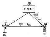
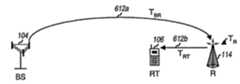
도 1 은 중계기들을 사용하고 다수의 사용자들을 지원하는 무선 통신 네트워크 (100) 의 도면이다. 네트워크 (100) 는 IS-95, W-CDMA, cdma2000, 다른 표준, 또는 그들의 조합 같은 하나 이상의 널리 알려진 CDMA 표준에 부합하도록 설계된다. 네트워크 (100) 는 다수의 기지국 (104) 을 포함하며, 각각의 기지국은 특정 커버리지 영역 (102) 에 서비스한다. 간단하도록, 단지 3 개의 기지국 (104a 내지 104c) 을 도 1 에 나타낸다. 기지국과 그 커버리지 영역을 통틀어서 셀이라고 자주 언급한다.1 is a diagram of a
하나 이상의 중계기 (114) 는 다른 방법으로는 페이딩 상태로 인하여 커버될 수 없는 셀내의 영역들에 대한 커버리지 (도 1 에 나타낸 영역 (112a) 같은) 를 제공하거나 네트워크의 커버리지 (영역 (112b 및 112c) 같은) 를 확장하도록 특정 기지국 (104) 과 함께 사용될 수 있다. 각각의 중계기 (114) 는 직접 또는 다른 중계기를 통하여 해당 기지국 (104) 에 무선 또는 유선 링크 (예를들어, 동축 또는 광섬유 케이블) 을 통해 연결된다. 네트워크내의 임의의 기지국들은 특정 네트워크 설계에 의존하여 중계될 수 있다.One or
일반적으로, 다수의 원격 터미널 (106) 은 네트워크에 걸쳐서 분포되어 있다 (간단하도록, 도 1 에는 단지 하나의 터미널을 나타냄). 각각의 원격 터미널 (106) 은, 원격 터미널이 소프트 핸드오프 상태인지에 따라서, 임의의 시점에 순방향 및 역방향 링크를 통하여 하나 이상의 셀과 통신할 수 있다. 일반적으로, 셀중 하나 (예를들어, 셀 1) 는 서비스셀 (기준셀) 로 지정되고, 다른 셀들은 인접셀이다.In general, a number of
일반적으로, 다수의 기지국 (104) 은 이들 기지국에 대한 통신을 조정하는 기지국 제어기 (BSC; 120) 에 연결된다. 위치 결정을 위해서, 일반적으로, 기지국 제어기 (120) 는, 이하 더욱 상세하게 설명하는 바와 같이, 원격 터미널로부터 시간 측정치를 수신하고 위치 결정에 관련된 제어 및 다른 정보를 제공하는 위치 결정 엔터티 (PDE; 130) 에 연결된다.In general,
위치 결정을 위해서, 원격 터미널 (106) 은 다수의 기지국 (104) 으로부터의 송신의 도달 시간을 측정한다. CDMA 네트워크에 대하여, 이들 도달 시간들은 원격 터미널의 송신 이전에 신호를 확산하기 위해 기지국들에서 사용하는 의사 잡음 (PN) 코드의 위상으로부터 결정될 수 있다. 그후, 원격 터미널에 의해 검출된 PN 위상들은 시그널링 (예를들어, IS-801) 을 통하여 PDE (130) 에 통보된다. 그후, PDE (130) 은 의사 범위를 결정하기 위해서 보고된 PN 위상 측정치를 이용하며, 그후 그 의사범위는 원격 터미널의 위치를 결정하는데 이용된다.For location determination,
원격 터미널 (106) 의 위치는 신호 도달 시간들 (즉, 도달 시간 (TOA)) 가 하나 이상의 기지국 (104) 과 하나 이상의 GPS 위성 (124) 에 대하여 측정되는 하이브리드 방식을 이용하여 결정될 수 있다. GPS 위성에 대한 시간 측정치는 일차 측정치 (primary measurement) 로서 사용되거나 기지국에 대한 시간 측정치를 보충하기 위해서 사용된다. 일반적으로, GPS 위성에 대한 시간 측정치는 기지국으로부터의 측정치보다 더 정확하지만, 위성에 대해 명확한 가시선 (line-of-sight) 을 요구한다. 따라서, GPS 의 사용은 장애 가 존재하지 않을 수 있는 실외 사용에 제한되며, 일반적으로 실내 또는 숲이나 건물 같은 장애물이 있는 애플리케이션에서의 사용가능하지 않다. 그러나, GPS 는 광범위한 커버리지를 가지며, 4개 이상의 GPS 위성은 사실상 모든 곳으로부터 (잠재적으로) 수신될 수 있다.The location of the
반면에, 일반적으로 기지국은 거주 지역에 위치하지만 그들의 신호는 일부 건물과 장애물을 투과할 수 있다. 따라서, 유리하게는, 기지국은 도시와 (잠재적으로는) 건물 내부의 위치를 결정하는데 사용될 수 있다. 그러나, 일반적으로, 기지국들에 대한 시간 측정치는, 다중 경로로 인하여 다중 신호가 특정 기지국으로부터 원격 터미널에서 수신될 수 있기 때문에 덜 정확하다.On the other hand, base stations are generally located in residential areas but their signals can penetrate some buildings and obstacles. Thus, the base station can advantageously be used to determine the location of the city and (potentially) inside the building. In general, however, time measurements for base stations are less accurate because multiple paths may allow multiple signals to be received at a remote terminal from a particular base station.
하이브리드 방식에서, 각각의 기지국과 각각의 GPS 위성은 송신 노드를 나타낸다. 원격 터미널의 위치를 결정하기 위해서, 3개 이상의 비공간적으로 (non-spatially) 정렬된 노드들 (기지국 및/또는 위성) 로부터의 송신이 처리된다. 네 번째 위성은 고도를 제공하기 위해서 사용될 수 있으며, 또한 정확성 (즉, 측정된 도달 시간들에서의 불확실성이 감소됨) 의 향상을 제공할 수 있다. 신호 도달 시간이 송신 노드들에 대하여 결정될 수 있으며, 의사 범위를 계산하는데 사용될 수 있으며, 그후 이 의사범위는 (예를 들어, 삼각 측량 기술을 통하여) 원격 터미널의 위치를 결정하는데 사용될 수 있다. 위치 결정은 상술한 3GPP 25.305, TIA/EIA/IS-801, 및 TIA/EIA/ISA-817 표준 문서와 미국 특허 제6,353,412 호에 기재된 기술에 따라서 달성할 수 있다.In a hybrid scheme, each base station and each GPS satellite represent a transmitting node. To determine the location of the remote terminal, transmissions from three or more non-spatially aligned nodes (base station and / or satellite) are processed. The fourth satellite can be used to provide altitude, and can also provide an improvement in accuracy (ie, uncertainty in measured arrival times is reduced). The signal arrival time can be determined for the transmitting nodes and used to calculate the pseudo range, which can then be used to determine the location of the remote terminal (eg, via triangulation techniques). Location determination can be accomplished according to the techniques described in the 3GPP 25.305, TIA / EIA / IS-801, and TIA / EIA / ISA-817 standard documents described above and US Pat. No. 6,353,412.
본 발명의 양태에 따르면, 원격 터미널 (106) 은 기지국 (104) 에 대한 신호 도달 시간들을 검출하고 시간 측정치를 PDE (130) 에 보고한다. PDE (130) 는 원격 터미널 (106) 의 가능한 위치의 초기 추정치를 결정하기 위해서 측정치를 차례로 사용하며, 또한 GPS 위성 (124) 세트로부터의 송신을 서치하기 위해서 원격 터미널에 시간 윈도우 세트를 사용하도록 지지할 수 있다. 서치 윈도우는 원격 터미널 (106) 로부터 가능하게는 PDE 에 이용가능한 추가적인 정보로부터의 측정치에 기초하여 PDE (130) 에 의해 결정된다. 서치 윈도우의 생성은 아래에서 보다 상세하게 설명한다.According to an aspect of the present invention, the
각각의 GPS 위성 (124) 은 메시지가 송신되는 지점을 포함하는 메시지를 연속적으로 송신한다. 메시지는 GPS 위성에 할당된 특정 길이와 오프셋을 갖는 의사 잡음 (PN) 코드로 확산된다. 원격 터미널은 GPS 송신을 수신하고, 그 수신 신호를 동일한 PN 코드로 확산하지만 서치 윈도우에 의해 정의된 특정 범위내의 다양한 시간 오프셋으로 확산하여 메시지를 복구한다. GPS 송신을 복구하기 위해서 원격 터미널에 의해 사용되는 PN 오프셋은 GPS 위성과 원격 터미널 사이의 시간차를 나타내며, 또한 신호 도달 시간을 나타낸다.Each GPS satellite 124 continuously transmits a message that includes the point at which the message is sent. The message is spread with a pseudo noise (PN) code having a specific length and offset assigned to the GPS satellites. The remote terminal receives the GPS transmission and recovers the message by spreading the received signal with the same PN code but with various time offsets within a specific range defined by the search window. The PN offset used by the remote terminal to recover the GPS transmission indicates the time difference between the GPS satellites and the remote terminal and also indicates the signal arrival time.
일반적으로, 원격 터미널은 GPS 송신을 복구하기 위한 시도로서 특정 서치 윈도우 (즉, PN 오프셋의 특정 범위) 내에서 서치를 행한다. 더 큰 서치 윈도우는 더 긴 서치 시간으로 변환되며, 이는 보다 넓은 범위의 시간 오프셋을 갖는 GPS 송신이 원격 터미널에 의해서 발견될 수 있도록 하기 위해 사용될 수 있다. 다른 방법으로, 더 작은 서치 윈도우는 더 짧은 서치 시간으로 변환되는데, 이는 보다 바람직하지만, GPS 송신이 더 작은 범위의 시간 오프셋 내에서 발견될 수 있다는 것을 나타내는 추가적인 정보를 요구한다.In general, a remote terminal performs a search within a specific search window (ie, a specific range of PN offsets) in an attempt to recover a GPS transmission. Larger search windows are converted to longer search times, which can be used to allow GPS transmissions with a wider range of time offsets to be discovered by the remote terminal. Alternatively, smaller search windows are converted to shorter search times, which is more desirable, but requires additional information indicating that GPS transmissions can be found within a smaller range of time offsets.
도 1 에 나타낸 예에서, 원격 터미널 (106) 은 GPS 위성 (124a 내지 124c), 기지국 (104b 및 104c) (그리고, 가능하게는 기지국 (104a), 및 중계기 (114) 로부터의 송신을 수신할 수 있다. 원격 터미널 (106) 은 위성, 기지국, 및 중계기로부터의 송신의 신호 도달 시간을 측정하며, 이들 신호 측정치를 BSC (120) 을 통하여 PDE (130) 에 보고한다.In the example shown in FIG. 1,
위에서 지적한 바와 같이, 중계기들은 기지국에 의해 커버되지 않는 영역에 대한 커버리지를 제공하는데 사용될 수 있다. 중계기들은 기지국보다 더 비용 효율적이며, 유리하게는 추가적인 용량이 요구되지 않는 곳 (예를들어, 시골 지역) 에 배치될 수 있다. 그러나, 중계기는 (1) 중계기내의 회로, 및 (2) 그 중계기와 연관된 케이블 및/또는 추가적인 송신으로 인한 추가적인 지연과 연관된다. 예로서, 중계기내의 표면 탄성파 (SAW) 필터, 증폭기, 및 다른 부품들은 기지국으로부터 원격 터미널로의 송신 지연과 비교할 수 있는 또는 훨씬 클 수도 있는 추가적인 지연을 도입한다.As pointed out above, the repeaters can be used to provide coverage for an area not covered by the base station. Repeaters are more cost effective than base stations and can advantageously be deployed where no additional capacity is required (eg rural areas). However, the repeater is associated with (1) circuitry in the repeater, and (2) additional delays due to cables and / or additional transmissions associated with the repeater. By way of example, surface acoustic wave (SAW) filters, amplifiers, and other components in repeaters introduce additional delays that may be comparable or even greater than the transmission delay from the base station to the remote terminal.
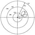
도 2a 는 중계기를 사용하지 않고 기지국으로부터 수신된 송신에 기초하여 터미널의 가능한 위치들을 나타내는 도면이다. 기지국으로부터의 송신의 도달 시간이 측정되고 범위 RBT 로 변환될 수 있으며, 이 범위는 기지국 주변에 원 (212) 으로 나타낸다. 원격 터미널은, 추가적인 정보가 원격 터미널에 대하여 이용가능하지 않은 경우 원 (212) 를 따르는 임의의 장소에 위치될 수 있다.2A is a diagram illustrating possible locations of a terminal based on a transmission received from a base station without using a repeater. The arrival time of the transmission from the base station can be measured and converted into a range RBT , which is represented by
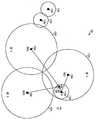
도 2b 는 중계기 (또한, 여기서는 "중계된 셀" 이라고도 함) 를 사용하는 셀에 대한 시간 측정치에 기초한 원격 터미널의 가능한 위치를 나타내는 도면이다. 이런 중계된 셀에서, 원격 터미널의 위치의 추가적인 불확실성은, (1) 셀에서의 중계기의 사용, 및 (2) 그 중계기와 연관된 추가적인 지연에 의해 도입된다. 이들 인자 각각에 기인한 불확실성은 아래에서 설명한다.FIG. 2B is a diagram illustrating possible locations of remote terminals based on time measurements for cells using repeaters (also referred to herein as " relayed cells "). In such relayed cells, additional uncertainty in the location of the remote terminal is introduced by (1) the use of a repeater in the cell, and (2) additional delays associated with that repeater. Uncertainty due to each of these factors is discussed below.
셀에서의 중계기의 사용으로 인한 원격 터미널 위치를 불확실성을 해결하기 위해서, 추가적인 지연이 중계기에 의해 도입되지 않는다고 가정할 수 있다. 원격 터미널에서 측정한 신호 도달 시간은 범위 RBT 로 변환될 수 있다. 이 범위는 기지국으로부터 중계기로의 범위 RBR 플러스 중계기로부터 원격 터미널으로의 범위 RRT (즉, RBT=RBR+RRT) 를 나타낸다. 따라서, 원격 터미널은 기지국으로부터 방사형으로 (RBR-RRT) 내지 (RBR+RRT) 에 위치할 수 있으며, 이는 원 (214a 및 214b) 으로 각각 나타낸다. 또한, 추가적인 정보가 이용가능하지 않은 경우, 원격 터미널은 원 (214a 및 214b) 에 의해 정의된 영역 (216a) 내의 임의의 장소에 위치될 수 있다.To address the uncertainty of remote terminal location due to the use of a repeater in the cell, one may assume that no additional delay is introduced by the repeater. The signal arrival time measured at the remote terminal can be converted to the range RBT . This range represents a range of the remote terminalRT R (i.e., R = RBTBR R +RT) from the R rangeBR plus the repeater to the repeater from the base station. Thus, the remote terminal can be located radially from (RBR -RRT ) to (RBR + RRT ) from the base station, represented by
중계기에 의해 도입된 추가적인 지연은 원격 터미널의 위치의 불확실성을 증대시킨다. 추가적인 중계기 지연은 범위 RR 로 변환될 수 있으며, 이는 범위 RBT 에 추가되어 전체 범위 RBRT (즉, 중계기 지연을 갖는 기지국에서 원격 터미널로의 신호 도달시간에 대응하는 범위)를 획득하도록 RBT 에 더해질 수 있다. 이 전체 범위 RBRT 는 도 2b 에 원 (214c) 로 나타낸다. 도 2b 에 나타낸 바와 같이, 셀에서의 중계기의 사용과, 그 중계기에 의해 도입된 추가적인 지연에 의한 불확실성으로 인하여 (지연이 알려지지 않는 경우), 원격 터미널은 터미널로부터의 시간 측정치에 기초하여 영역 (216a 및 216b) 내의 임의의 장소에 위치될 수 있다.The additional delay introduced by the repeater increases the uncertainty of the location of the remote terminal. Additional repeater delay may be converted to a range RR, which range is added to the RBT full range RBRT R to obtain (i.e., the range that the base station has a repeater delay corresponding to the signal arrival time of the remote terminal)BT Can be added to This full range RBRT is shown by the
본 발명은 원격 터미널이 네트워크내의 중계기의 커버리지에 있는지를 검출하여 원격 터미널의 위치를 추정하는 처리가 일반적으로 중계기와 연관된 추가적인 불확실성을 해결할 수 있도록 하는 다양한 기술을 제공한다. 본 발명의 다양한 양태에 따르면, 원격 터미널이 중계기의 커버리지에 있는지에 대한 결정은, (1) 중계기의 커버리지에서 수신할 것으로 예상되는 기지국의 리스트 (즉, 가능성 있는 인접국 리스트) 대 원격 터미널에 의해 실제로 수신된 기지국의 리스트, (2) 중계기의 특성화된 환경, 및 (3) 원격 터미널에서 수신한 송신에 대한 전파지연, (4) 일부 다른 기준, 또는 (5) 그들의 조합에 기초하여 달성될 수 있다.The present invention provides a variety of techniques by which the process of estimating the location of a remote terminal by detecting whether the remote terminal is in coverage of a repeater in the network can resolve additional uncertainty generally associated with the repeater. According to various aspects of the invention, the determination as to whether the remote terminal is in the repeater's coverage is actually made by (1) the list of base stations (ie, the list of possible neighboring stations) vs. the remote terminal expected to receive in the repeater's coverage. Based on a list of base stations received, (2) the repeater's characterized environment, and (3) propagation delays for transmissions received at remote terminals, (4) some other criteria, or (5) combinations thereof. .
또한, 본 발명은 중계기의 커버리지에 있기 때문에 유발된 추가적인 불확실성을 해결 및/또는 보상하는 기술을 제공한다. 일 양태에서, 중계된 기지국으로부터의 시간 측정치는 폐기되고 원격 터미널의 위치를 추정하는데 사용되지 않을 수 있다. 일 양태에서, 원격 터미널의 위치를 추정하는 처리는 추가적인 불확실성을 해결하기 위해서 조절될 수 있다. (예를 들어, 서치 윈도우가 확대됨). 또 다른 실시형태에서, 동일한 발신 기지국으로부터 수신한 다수의 송신은 원격 터미널에 대한 일련의 위치 추정을 계산하는데 사용될 수 있으며, 가장 가능성 있는 추정치가 선택된다. CDMA 네트워크에 대하여, 발신 기지국에는 특정 PN 오프셋이 할당된다. 또 다른 양태에서, 다수의 발신 기지국으로부터의 다수의 송신은 원격 터미널에 대한 일련의 위치 추정치를 계산하는데 사용될 수 있으며, 역시 가장 가능성 있는 추정치가 선택된다.The present invention also provides a technique for resolving and / or compensating for additional uncertainties caused because of the repeater's coverage. In one aspect, time measurements from the relay base station may be discarded and not used to estimate the location of the remote terminal. In one aspect, the process of estimating the location of the remote terminal can be adjusted to address additional uncertainty. (For example, the search window is enlarged). In another embodiment, multiple transmissions received from the same originating base station may be used to calculate a series of position estimates for the remote terminal, with the most likely estimate selected. For CDMA networks, the originating base station is assigned a specific PN offset. In another aspect, multiple transmissions from multiple originating base stations can be used to calculate a series of position estimates for the remote terminal, again the most likely estimate is selected.
여기 설명한 기술은 시간 측정치에 대한 소스와, 기기국과 중계기에 대하여 이용가능한 임의의 추가적인 정보를 고려하여, 원격 터미널의 위치를 보다 정확하게 결정하는데 사용될 수 있다. 본 발명의 다양한 양태, 실시형태, 및 특징을 아래에서 보다 상세하게 설명한다.The technique described herein can be used to more accurately determine the location of a remote terminal, taking into account the source for time measurements and any additional information available for the equipment station and repeater. Various aspects, embodiments, and features of the invention are described in more detail below.
가능성 있는 인접국 리스트에 기초한 중계기의 검출Detection of repeaters based on a list of possible neighboring stations
본 발명의 일 양태는 네트워크의 중계기들에 대하여 형성된 가능성 있는 인접국 리스트에 기초하여 원격 터미널이 중계기의 커버리지에 있는지를 검출하는 기술을 제공한다. 일반적인 무선 네트워크에서, 커버리지 패턴은 네트워크의 임의의 장소에 위치한 원격 터미널이 다수의 송신 소스 (즉, 기지국 및/또는 중계기) 로부터 신호를 수신할 수 있도록 한다. 이 정보는 목록 작성되어 원격 터미널이 중계기의 커버리지에 있는지를 결정하는데 사용될 수 있다.One aspect of the present invention provides a technique for detecting whether a remote terminal is in coverage of a repeater based on a list of possible neighboring stations formed for repeaters in the network. In a typical wireless network, the coverage pattern allows a remote terminal located anywhere in the network to receive signals from multiple transmission sources (ie, base stations and / or repeaters). This information can be listed and used to determine if the remote terminal is in the repeater's coverage.
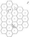
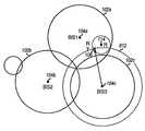
도 3 은 일부가 중계기를 포함하는 다수의 (육각형) 셀을 포함하는 네트워크 (300) 를 나타내는 도면이다. 네트워크 (300) 내의 원격 터미널의 특정 위치에 따라서, 원격 터미널은 다수의 기지국 (예를 들어, 20개 까지의 기지국들) 으로부터의 신호 (예를 들어, 파일럿) 를 검출할 수 있다. 원격 터미널에 의해 수신될 수 있는 기지국은 네트워크 내의 원격 터미널의 특정 위치에 의존한다. 예를 들어, 중계기 (114x) 의 커버리지에 있는 원격 터미널 (106x) 은 기지국 (104y) 의 커버리지에 있는 원격 터미널 (106y) 과는 다른 세트의 기지국으로부터의 신호를 수신할 수 있다. 일 실시형태에서, 특정 중계기의 커버리지에서 수신되는 가능성 있는 기지국은 그 중계기에 대한 가능성 있는 인접국 리스트에 위치될 수 있다.FIG. 3 is a diagram illustrating a
위에서 지적한 바와 같이, 일반적으로, 중계기는 커버리지 문제를 해결하기 위해서 사용된다. 예를들어, 중계기는 "새도우" 아웃될 수 있는 네트워크의 영역 (홀) 을 커버하기 위해서 사용될 수 있다. 예를 들어, 이런 영역은 산악, 터널, 쇼핑몰 등을 포함할 수 있다. 또한, 중계기는 기존의 기지국에 의해 도달할 수 없는 새로운 영역으로 커버리지를 확장하는데 사용될 수 있다. 따라서, 각각의 중계기에 대한 가능성 있는 인접국 리스트는 네트워크의 다른 중계기들의 것과는 다를 수 있으며, 중계된 기지국을 포위하는 기지국들의 서브 세트일 수 있다.As pointed out above, in general, repeaters are used to solve coverage problems. For example, a repeater can be used to cover an area (hole) of the network that can be "shadowed" out. For example, such areas may include mountains, tunnels, shopping malls, and the like. Repeaters can also be used to extend coverage to new areas that cannot be reached by existing base stations. Thus, the list of possible neighboring stations for each repeater may be different from that of other repeaters in the network and may be a subset of the base stations surrounding the relayed base station.
일 실시형태에서, 네트워크내의 기지국과 중계기는 특성화된다. 이 특성화는 네트워크의 레이아웃, 네트워크내의 각각의 기지국과 중계기의 위치 등을 결정하는 것을 수반할 수 있다. 추가적으로, 측정이 전체 네트워크내의 다양한 위치에서 원격 터미널에 의해 행해져서, 그 커버리지 영역에서 기지국이 검출될 수 있도록 하는 정보를 수집할 수 있다. 이 정보는 중계기에 대한 가능성 있는 인접국 리스트를 생성하는데 사용될 수 있다. 프로세스는 네트워크내의 각각의 중계기에 대하여 수행될 수 있다.In one embodiment, the base stations and repeaters in the network are characterized. This characterization may involve determining the layout of the network, the location of each base station and repeater in the network, and the like. In addition, measurements can be made by remote terminals at various locations within the entire network to collect information that allows the base station to be detected in its coverage area. This information can be used to generate a list of possible neighboring stations for the repeater. The process can be performed for each repeater in the network.
중계기에 대한 정보는 중계기가 초기에 배치될 때 행해지는 측정에 의해 수집될 수 있다. 다른 방법으로, 이 정보는, 일반적인 동작 중에 중계기의 커버리지에서 동작할 때, 원격 터미널로부터 "학습" 될 수 있다. PDE 는 네트워크내에 위치하는 모든 중계기들에 대한 가능성 있는 인접국 리스트를 생성 및 유지할 수 있다.Information about the repeater can be collected by measurements made when the repeater is initially deployed. Alternatively, this information can be "learned" from a remote terminal when operating in the repeater's coverage during normal operation. The PDE can create and maintain a list of possible neighboring stations for all repeaters located in the network.
그후, PED 가 특정 원격 터미널이 중계기의 커버리지에 있다고 추정하는 경우, 그것은 중계기에 대하여 유지되는 가능성 있는 인접국 리스트에 대하여 원격 터미널로부터 수신한 시간 측정치의 소스를 비교하여 이를 입증할 수 있다. PDE 는 원격 터미널이 특정 중계기의 커버리지에 있는지에 대한 그의 평가에 특정 등급의 신뢰도를 할당할 수 있다.Then, if the PED assumes that a particular remote terminal is in coverage of the repeater, it can verify this by comparing the source of time measurements received from the remote terminal against a list of possible neighboring stations maintained for the repeater. The PDE may assign a certain degree of reliability to its assessment of whether the remote terminal is in coverage of a particular repeater.
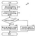
도 4 는 중계기의 가능성 있는 인접국 리스트를 사용하여 원격 터미널이 중계기의 커버리지에 있는지를 결정하는 프로세스 (400) 의 일 실시형태의 흐름도이다. 최초에, 단계 412 에서 PDE 는 원격 터미널로부터 시간 측정치를 수신한다. 단계 414 에서, PDE 는, 다수의 기술 (그중 일부는 아래에서 설명함) 중 임의의 하나에 기초하여, 원격 터미널이 중계기의 커버리지에 있는지를 추정할 수 있다. 예를들어, 이 추정 (suspicion) 은 수신한 시간 측정치에 기초하여 유도될 수 있다 (예를 들어, 과도한 지연이 시간 측정치중 임의의 하나에서 검출되는 경우). 원격 터미널이 중계기의 커버리지에 있다고 추정되지 않는 경우, 단계 416 에서, 원격 터미널에 대한 서치 윈도우는 정상적인 방법으로 (예를 들어, 중계기를 보상하지 않고) 생성된다.4 is a flow diagram of an embodiment of a
그렇지 않고, 원격 터미널이 중계기의 커버리지에 있다고 추정되는 경우, 단계 418 에서는 시간 측정치가 획득된 기지국의 리스트가 결정된다. 또한, 단계 412 에서는 수신한 기지국들의 이 리스트가 원격 터미널로부터 수신한 시간 측정치들에 대하여 PDE 에 의해 생성될 수 있다. 그후, 단계 420 에서는, 수신한 기지국들의 리스트가 원격 터미널이 커버되는 것으로 추정되는 중계기에 대한 가능성 있는 인접국 리스트에 대하여 비교된다.Otherwise, if it is assumed that the remote terminal is in coverage of the repeater, then at step 418 a list of base stations from which time measurements are obtained is determined. Further, in
단계 420 에서의 비교 결과에 기초하여, 단계 422 에서는, 원격 터미널이 중계기의 커버리지에 있는지에 대한 결정이 행해진다. 대답이 "아니오" 인 경우, 단계 416 에서는 원격 터미널에 대한 서치 윈도우가 정상적인 방법으로 생성된다. 그렇지 않고, 원격 터미널이 중계기의 커버리지에 있는 것으로 간주되면, 단계 424 에서는 중계기의 커버리지에 있어서 발생한 추가적인 불명확성을 해결하는 방법으로 서치 윈도우가 생성된다. 예를들어, 서치 윈도우는 검출된 지연에 의존하여 확대 및/또는 시프트될 수 있다. 그후, 프로세스가 종료한다.Based on the comparison result at
환경 정보에 기초한 중계기의 검출Detection of repeater based on environmental information
본 발명의 일 양태는 원격 터미널이 네트워크내의 중계기들에 대하여 수집된 환경 정보에 기초하여 중계기의 커버리지에 있는지를 검출하는 기술을 제공한다. 일 실시형태에서, PDE 는 네트워크의 일부 또는 모든 중계기들에 대한 환경 유형을 "목록 작성" 하며, 이 환경 유형은 중계기의 커버리지를 나타낸다. 그후, 이 목록 작성된 정보는 원격 터미널이 중계기의 커버리지에 있는지를 결정하는데 사용된다.One aspect of the present invention provides a technique for detecting whether a remote terminal is in coverage of a repeater based on environmental information collected for repeaters in the network. In one embodiment, the PDE “lists” the environment type for some or all repeaters in the network, which environment type represents the coverage of the repeater. This cataloged information is then used to determine if the remote terminal is in the repeater's coverage.
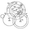
도 5 는 중계기들의 목록 처리된 환경 유형이 원격 터미널이 중계기의 커버리지에 있는지를 결정하는데 사용되는 예시적인 네트워크 (500) 를 나타내는 도면이다. 이 예에서는, 3 개의 기지국 (104a 내지 104c) 이 네트워크의 일부분에 대하여 커버리지를 제공한다. 기지국 (104a) 은 터널 (512) 에 대한 커버리지를 제공하는데 사용되는 2개의 중계기 (114e 및 114f) 에 연결된다. 장애로 인하여, 터널의 일부분내의 원격 터미널 (106a) 는 기지국 (104a) 으로부터만 (중계기 (114e 및/또는 114f) 를 통하여) 신호를 수신할 수 있으며, 기지국 (104b) 및 (넓은 범위까지는) 기지국 (104c) 로부터의 신호는 터미널에 의해 수신될 수 없다. 외부에 위치하고 터널에 의해 방해를 받지 않는 다른 터미널 (106b) 은 도 5 에 나타낸 바와 같이 모든 3개의 기지국으로부터 신호를 수신할 수 있다.FIG. 5 is a diagram illustrating an
일 실시형태에서, PDE 는 중계기에 대한 환경 유형을 알 수 있다. 도 5 에 나타낸 실시예에서, PDE 는 중계기 (114e 및 114f) 가 터널내에 위치하고 터널에 의한 장애가 다른 기지국들로부터의 신호를 막을 수도 있음을 알 수 있다. 따라서, PDE 가 기지국들 (104a, 104b, 및 104c) 사이의 영역에 위치하는 것으로 결정된 원격 터미널로부터 단지 하나의 시간 추정치를 수신하는 경우, PDE 는 시간 측정치가 하나의 중계기 (예를들어, 중계기 (114e 또는 114f)) 로부터 온 것임을 추론할 수 있다. 이에 대해, PDE 가 동일한 영역 근처에 위치하는 것으로 결정된 원격 터미널 (예를들어, 원격 터미널 (106b)) 로부터 다수의 기지국에 대한 다수의 시간 측정치를 수신하는 경우, PDE 는 원격 터미널이 중계기 (114e 또는 114f) 의 커버리지에 있지 않다는 것을 추론할 수 있다. 따라서, 중계기의 커버리지의 목록 작성된 환경 유형은 원격 터미널이 중계기의 커버리지에 있는지 여부를 결정하는데 사용될 수 있다.In one embodiment, the PDE may know the type of environment for the repeater. In the embodiment shown in FIG. 5, the PDE can recognize that the
일 실시형태에서, 중계기의 환경 유형은 중계기에서 겪게 되는 페이딩과 경로 손실의 유형에 의해 목록 작성된다. 예를 들어, 일반적으로, 도시 지역의 신호는 시골 또는 교외 지역에서 그들이 하는 것과 동일한 방식으로 열화되지는 않는다. 이런 정보는 어떤 중계기 솔루션을 진행할 지를 결정하는데 사용될 수 있다. 예로서, 터널에서, 기지국 신호는 매우 약하며, GPS 신호는 거의 검출불가능하다. 따라서, 원격 터미널의 기록으로부터 터널에 있는 것으로 결정되면, 원격 터미널은 원격 터미널의 위치를 결정하기 위해서 일부 정보를 제공한다. 또한, 터널이 중계되는 경우, 적절한 조절이 측정치에 행해져서 원격 터미널의 위치를 결정하게 된다.In one embodiment, the type of environment of the repeater is listed by the type of fading and path loss experienced by the repeater. For example, signals in urban areas generally do not degrade in the same way they do in rural or suburban areas. This information can be used to determine which repeater solution to proceed. As an example, in a tunnel, the base station signal is very weak and the GPS signal is almost undetectable. Thus, if it is determined from the record of the remote terminal that it is in the tunnel, the remote terminal provides some information to determine the location of the remote terminal. In addition, when the tunnel is relayed, appropriate adjustments are made to the measurements to determine the location of the remote terminal.
시골 지역에서, 신호는 상대적으로 양호한 경로 손실을 갖는다 (즉, 그들은 거리에 대하여 그다지 많이 열화하지 않는다). 신호가 전파하는 어떤 매체에서라도 어떻게 신호가 열화되는 지 알려지면, 신호가 여행하는 경로 거리가 결정될 수 있다. 신호가 원격 터미널과 기지국의 분리된 부분보다 더 큰 것으로 간주되는 경우, 차이는 중계기로 인한 것일 수 있으며 위치를 계산할 때 해결될 수 있다.In rural areas, signals have a relatively good path loss (i.e. they do not degrade much over distance). Knowing how the signal degrades in any medium through which the signal propagates, the path distance the signal travels can be determined. If the signal is considered to be larger than the separate portions of the remote terminal and the base station, the difference may be due to the repeater and may be resolved when calculating the position.
일 실시형태에서, 중계기의 환경 유형은 각각의 중계기에 대한 인접국 리스트의 사용으로 정의된다. 도 5 에 나타낸 예에서, 중계기 (114e) 의 커버리지에 있는 터미널은 기지국 (104a) 으로부터의 신호만을 수신할 수 있으며, 기지국 (104b 및 104c) 으로부터의 신호를 수신하지 않을 수 있다. 따라서, 중계기 (114e) 에 대한 인접국 리스트는 비어 있게 된다. 그러나, 중계기 (114f) 의 커버리지에 있는 터미널도 기지국 (104c) 으로부터 신호를 수신할 수 있고, 중계기 (114f) 에 대한 인접국 리스트는 이를 적절히 반영할 수 있다 (예를 들어, 표 1 에 나타낸 바와 같이). 기지국 (104a) 에 대한 인접국 리스트는 기지국 (104b 및 104c) 을 포함할 수 있으며, 기지국 (104b) 에 대한 인접국 리스트는 기지국 (104a 및 104c) 을 포함할 수 있고, 기지국 (104c) 에 대한 인접국 리스트는 기지국 (104a 및 104b) 을 포함할 수 있다.In one embodiment, the environment type of the repeater is defined as the use of the neighbor station list for each repeater. In the example shown in FIG. 5, a terminal in coverage of repeater 114e may only receive signals from
표 1 은 도 5 에 나타낸 예에 대한 송신 소스와 그들의 인접국 리스트를 기 재하고 있다.Table 1 lists the transmission sources and their neighbor stations for the example shown in FIG.
도 5 는 시간 측정치의 송신 소스를 결정하는 환경 유형의 목록 작성의 특정 실시예를 나타낸다. 예를 들어, 다운타운, 시골 지역, 쇼핑몰, 실내 등의 다른 환경에 대해서는 다른 실시예들이 제공될 수 있다. 예를들어, 도 1 을 다시 참조하면, 중계기 (114b) 또는 (114c) 중의 하나의 커버리지에 있는 원격 터미널은 기지국 (104a, 104b, 및 104c) 의 커버리지에 위치하는 원격 터미널의 개수 만큼의 다른 기지국으로부터 신호를 수신하지 않을 수도 있다.5 illustrates a particular embodiment of listing an environment type that determines the source of transmission of time measurements. For example, other embodiments may be provided for other environments, such as downtown, rural areas, shopping malls, indoors, and the like. For example, referring back to FIG. 1, a remote terminal in the coverage of one of the
도달시간 (TOA) 과 왕복 지연 (RTD) 에 기초한 중계기의 검출Detection of repeaters based on arrival time (TOA) and round trip delay (RTD)
본 발명의 일 양태는 원격 터미널로부터의 시간 측정치에 기초하여 원격 터미널이 중계기의 커버리지에 있는지를 검출하는 기술을 제공하는 것이다. 이 기술은, 원격 터미널이 중계기의 커버리지에 있는지를 결정하기 위해서, 중계기로부터 원격 터미널로의 송신과 연관된 알려진 또는 추정된 지연과, 일반적으로 중계기 자체와 연관된 알려진 또는 추정 지연을 이용한다. 이 기술은 다양한 네트워크 구성에 대하여 이용할 수 있으며, 특히 도 1 의 중계기 (114b 및 114c) 같은 중계기가 네트워크의 커버리지를 확장하는데 사용되는 네트워크 구성에 응용가능하다.One aspect of the present invention is to provide a technique for detecting whether a remote terminal is in coverage of a repeater based on a time measurement from the remote terminal. This technique uses a known or estimated delay associated with the transmission from the repeater to the remote terminal and generally a known or estimated delay associated with the repeater itself to determine if the remote terminal is in the repeater's coverage. This technique is available for a variety of network configurations, and is particularly applicable to network configurations where repeaters such as
일 실시형태에서는, 시스템의 타이밍이 교정 (calibrate) 된다. 기지국에 대하여 시스템 시간과 기지국의 송신 타이밍 사이의 시간차가 결정된다. 그리고, 중계기에 대하여, 중계기들의 수신 및 송신 경로 사이에서 측정된 지연도 결정될 수 있다. 아래에서 보다 상세하게 설명하는 바와 같이, 이들 시간 측정치는 원격 터미널이 중계기의 커버리지에 있는지를 검출하는데 사용될 수 있다.In one embodiment, the timing of the system is calibrated. For the base station, the time difference between the system time and the transmission timing of the base station is determined. And, for a repeater, the measured delay between the receive and transmit paths of the repeaters can also be determined. As described in more detail below, these time measurements can be used to detect whether the remote terminal is in coverage of the repeater.
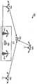
도 6a 는 중계기가 사용되지 않게 되는 기지국 (104) 로부터 원격 터미널 (106) 로의 송신의 도면이다. 도 6a 에 나타낸 바와 같이, 기지국 (104) 으로부터의 신호는 직접 가시선 경로 (610a) 또는 반사 소스 (612) 로부터 튀어나온 후의 반사된 경로 (612b) 를 통하여 원격 터미널 (106) 에 도달할 수 있다. 각각의 송신 경로는 해당 전파 경로와 연관된다 (예를들어, 도 6a 에 나타낸 바와 같은, TBT1 및 TBT2).6A is a diagram of transmission from
도 6b 는 기지국 (104) 으로부터 원격 터미널 (106) 로의 중계기 (114) 를 통한 송신의 도면이다. 이 실시예에서, 원격 터미널 (106) 은 중계기 (114) 의 커버리지에 있으며, 장애나 일부 다른 이유 때문에, 기지국 (104) 으로부터의 직접 송신을 수신할 수 없다 (기지국 (104) 로부터 수신한 송신은 약할 수 있음). 도 6B 에 나타낸 바와 같이, 신호는 먼저 기지국 (104) 로부터 중계기 (114) 로 무선 또는 유선 링크 (612a) 를 통하여 송신되며, 중계기 (114) 에 의해서 컨디셔닝되고, 원격 터미널 (106) 로 송신된다. 중계기 (114) 내의 추가적인 지연 TR 은 신호의 전체 전파 지연을 증가시킨다. 또한, 중계기가 원격 터미널로부터 보다 기지국으로부터 더 멀리 위치하는 경우 (도 6b 에 나타낸 바와 같이), 도 6b 에 나타낸 바와 같이, 신호는 중계기로의 그리고 다시 원격 터미널로의 보다 긴 거리로 인하여 보다 긴 전파 지연을 겪게 된다.6B is a diagram of transmission via
도 6a 에 대하여, 기지국 (104) 으로부터 원격 터미널 (106) 로의 송신에 대한 최악의 경우 전파 지연은 반사 경로와 연관된 지연 TBR2 로서 결정될 수 있다. 도 6b 에 대하여, 기지국 (104) 으로부터 원격 터미널 (106) 으로의 송신에 대한 최선 경우 전파 지연 TBRT 은 기지국으로부터 중계기로의 지연 TBR, 중계기에 의해 도입된 지연 TR, 및 중계기로부터 원격 터미널로의 지연 TRT에 의존한다 (즉, TBRT = TBR + TR + TRT). 기지국으로부터의 송신에 대한 최악의 경우 전파 지연 TBR2 와 중계기로부터의 송신에 대한 최선의 경우 전파 지연 TBRT 사이의 시간차 (즉, 갭) 이 있는 경우, 원격 터미널이 기지국 또는 중계기의 커버리지에 있는지를 결정하기 위해서 문턱치가 선택될 수 있다. 문턱치는,For FIG. 6A, the worst case propagation delay for transmission from
TBase_station < TTH < TRepeater 식 (1)TBase_station <TTH <TRepeater Equation (1)
에 기초하여 선택될 수 있으며, TBase_station 는 기지국 (TBT2) 로부터 수신한 송신에 대한 최악의 경우 전파 지연이고, TTH 는 문턱치이고, TRepeater 는 중계기 (TBRT) 로부터 수신한 송신에 대한 최선의 경우 전파 지연이다.TBase_station is the worst case propagation delay for transmissions received from the base station TBT2 , TTH is the threshold, and TRepeater is the best for transmissions received from the repeater TBRT . Is the propagation delay.
중계된 기지국에 대한 문턱치가 일단 선택되면, PDE 는 그 중계된 기지국에 대한 원격 터미널로부터 수신한 시간 측정치를 문턱치에 비교할 수 있다. 시간 측정치에 의해 지시된 전파 지연이 문턱치보다 큰 경우, PDE 는 시간 측정치가 중계기에 대한 것으로 간주할 수 있다. 그렇지 않고, 시간 측정치에 의해 지시된 전파 지연이 문턱치보다 작은 경우, PDE 는 시간 측정치가 기지국에 대한 것으로 간주할 수 있다.Once the threshold for the relayed base station is selected, the PDE may compare the time measurement received from the remote terminal for the relayed base station to the threshold. If the propagation delay indicated by the time measurement is greater than the threshold, the PDE may assume that the time measurement is for the repeater. Otherwise, if the propagation delay indicated by the time measurement is less than the threshold, the PDE may assume that the time measurement is for the base station.
식 (1) 은 기지국에 대한 최악의 경우 전파 지연이 중계기에 대한 최선의 경우 전파 지연보다 작다고 가정할 수 있다 (즉, TBase_station< TRepeater). 한편, 이들 전파 지연들간에 중첩이 있는 경우에도 (즉, TBase_station > TRepeater), 문턱치는 원격 터미널이 기지국 또는 중계기의 커버리지에 있는지를 정확하게 검출할 높은 가능성을 달성하기 위해서 중첩된 범위내로 선택될 수 있다.Equation (1) can assume that the worst case propagation delay for the base station is less than the best case propagation delay for the repeater (ie, TBase_station < TRepeater ). On the other hand, even when there is overlap between these propagation delays (ie, TBase_station > TRepeater ), the threshold should be selected within the overlapped range to achieve a high probability of accurately detecting whether the remote terminal is in coverage of the base station or repeater. Can be.
도 7 은 전파 지연에 기초하여 원격 터미널이 기지국 또는 중계기의 커버리지에 있는지를 결정하기 위한 프로세스 (700) 의 일 실시형태의 흐름도이다. 최초에, 단계 710 에서 PDE 는 원격 터미널로부터 시간 측정치를 수신한다. 그후, 단계 712 에서, PDE 는 발신 기지국으로부터 원격 터미널으로의 송신의 전파 지연 (즉, 일방향 지연) 을 수신한 시간 측정치에 기초하여 결정한다. 다른 방법으로, PDE 는 기지국으로부터 원격 터미널로, 그리고 다시 기지국으로의 송신의 왕복 지연 (RTD) 추정치를 결정할 수 있다. 이 RTD 추정치는 기지국으로부터 원격 터미널로의 일방향 지연의 대략 2배일 수 있다. 일방향 지연 추정치는 기지국으로부터 원격 터미널로의 (가능하게는 하나 이상의 중계기를 통하여) 송신 지연을 나타낸다.7 is a flowchart of an embodiment of a
단계 714 에서는, 일방향 지연 (또는 RTD) 추정치가 위에서 설명한 인자들에 기초하여 기지국에 대하여 선택된 임계치보다 작은 지에 대한 결정이 행해진다. 일방향 지연 추정치가 임계치보다 작은 경우, 원격 터미널은 기지국의 커버리지에 있는 것으로 간주되며, 원격 터미널의 위치 결정은 중계기들과 연관된 추가적인 불확실성을 고려하지 않고 수행된다. 따라서, 단계 716 에서는 원격 터미널에 대한 서치 윈도우가 생성될 수 있다. 그렇지 않고, 일방향 지연 추정치가 문턱치보다 크거나 동일한 경우, 원격 터미널은 중계기의 커버리지에 있는 것으로 간주되며, 원격 터미널에 대한 위치 결정은 중계기와 연관된 추가적인 불명확성을 고려하여 수행된다. 이 경우, 단계 718 에서는, 중계기를 해결하기 위해서 원격 터미널에 대한 서치 윈도우를 생성할 수 있다. 그후, 프로세스가 종료한다.In
선택적 측정에 기초한 위치 결정Positioning based on selective measurement
본 발명의 양태에 따르면, 원격 터미널에 대한 위치 결정은 원격 터미널로부터 수신한 시간 측정치들중 선택된 하나에 기초하여 수행된다. 도 2a 내지 2b 에 관하여 위에서 설명한 바와 같이, 중계기, 및 그 중계기와 연관된 추가적인 지연의 단순한 사용은 원격 터미널의 위치의 불명확성을 유발한다. 이 추가적인 불확실성 때문에, 중계기를 사용하는 셀에 대한 시간 측정치는 원격 터미널의 위치를 결정하는데 유리하지 않을 수도 있다. 따라서, 본 발명의 이 양태에 따르면, 반복된 기지국에 대한 시간 측정치는 원격 터미널의 위치를 결정하는데 이용되지 않는다.According to an aspect of the present invention, location determination for a remote terminal is performed based on a selected one of time measurements received from the remote terminal. As described above with respect to FIGS. 2A-2B, the simple use of the repeater, and the additional delay associated with the repeater, causes uncertainty in the location of the remote terminal. Because of this additional uncertainty, time measurements for the cell using the repeater may not be advantageous for determining the location of the remote terminal. Thus, according to this aspect of the invention, time measurements for repeated base stations are not used to determine the location of the remote terminal.
도 1 을 다시 참조하면, 원격 터미널 (106) 은 중계기 (114a) 의 커버리지 영역 (112a) 내에 위치하며, 통신 링크, 페이딩 상태 등의 다양한 인자에 의존하여, 기지국 (104a), 중계기 (114a), 또는 양쪽으로부터의 송신을 수신할 수 있다. 따라서, 셀 1 에 대한 원격 터미널 (106) 에 의해 수신된 송신의 실제 소스에 대한 불확실성이 있을 수 있으며, 이는 기지국 (104a) 또는 중계기 (114a) 중의 하나일 수 있다. 송신의 소스가 불명확하기 때문에, 아래에서 보다 상세하게 설명하는 바와 같이, 중계기를 사용하는 셀에 위치하는 원격 터미널의 추정된 위치의 불확실성이 더 커질 수 있다.Referring again to FIG. 1, the
시간 측정치가 위치 결정에 대하여 전혀 이용되지 않는 경우보다, 중계된 기지국에 대한 시간 측정치가 틀린 소스로 잘못 취급되는 경우에 원격 터미널의 추정된 위치가 덜 정확하게 될 수 있다. 예로서, 중계기 (114a) 에 대하여 수신된 시간 측정치가 기지국 (104a) 에 대한 것으로 잘못 취급되는 경우에, 원격 터미널 (106) 은 실제보다는 기지국으로부터 더 멀리 있는 것으로 잘못 추정될 수 있다. 에러의 양은 중계기에 의해 도입된 추가적인 지연의 양과 관련된다. 그렇지 않고, 기지국 (104a) 에 대하여 수신한 시간 측정치가 중계기 (114a) 에 대한 것으로 잘못 취급되는 경우, 원격 터미널 (106) 은 실제보다 기지국에 가깝게 있는 것으로 잘못 추정될 수 있다.The estimated position of the remote terminal may be less accurate if the time measurement for the relayed base station is incorrectly treated as a wrong source than if the time measurement is not used at all for location determination. For example, if the time measurement received for the
일 실시형태에서, PDE 는 그것이 시간 측정치를 수신할 수 있는 기지국의 리스트와, 그 리스트의 각각의 기지국들에 대하여 중계기들이 기지국과 사용되는 지에 대한 지시를 보유한다. 표 2 는 도 1 에 나타낸 네트워크에 대한 PDE 에 의해 유지되는 리스트의 예이다.In one embodiment, the PDE maintains a list of base stations from which it can receive time measurements, and for each of the base stations in that list, as to whether repeaters are used with the base station. Table 2 is an example of a list maintained by the PDE for the network shown in FIG.
원격 터미널에 의해 보고된 각각의 시간 측정치에 대하여, PDE 는 시간 측정치가 연관된 기지국을 결정한다 (즉, 시간 측정치가 유도되는 송신을 발신하는 기지국). 그후, PDE 는 표를 참고하여 시간 측정치가 중계기를 사용하는 기지국 (즉, 중계된 기지국) 과 연관되는 지를 결정한다. 표가 발신 기지국이 중계된 기지국이라고 나타내는 경우, PDE 는 위치 결정 처리에서 고려하는 것에서 이 시간 측정치를 생략하도록 선택할 수 있다. 이 경우, PDE 는 원격 터미널의 위치를 추정, 및/또는 중계기와 연관되지 않는 기지국 (즉, 중계되지 않은 기지국) 에 대 한 시간 측정치에 기초하여 원격 터미널에 대한 서치 윈도우를 계산할 수도 있다.For each time measurement reported by the remote terminal, the PDE determines the base station to which the time measurement is associated (ie, the base station sending the transmission from which the time measurement is derived). The PDE then consults the table to determine if the time measurement is associated with the base station using the repeater (ie the relayed base station). If the table indicates that the originating base station is a relay base station, the PDE may choose to omit this time measurement from what is considered in the location determination process. In this case, the PDE may estimate the location of the remote terminal and / or calculate a search window for the remote terminal based on time measurements for base stations (ie, non-relayed base stations) not associated with the repeater.
다른 방법으로, PDE 는 위치 결정 처리에서 중계된 기지국과 연관된 이 시간 측정치를 고려하도록 선택할 수 있다. 그후, PDE 는 원격 터미널의 위치를 결정, 및/또는 중계기에 의해 도입된 불명확성을 고려하여 원격 터미널에 대한 서치 윈도우를 계산할 수 있다.Alternatively, the PDE may choose to consider this time measurement associated with the base station relayed in the location processing. The PDE may then calculate the search window for the remote terminal, taking into account the location of the remote terminal and / or the uncertainty introduced by the repeater.
도 8a 는 중계된 기지국들에 대한 시간 측정치가 폐기된 원격 터미널에 대하여 추정된 위치를 나타내는 도면이다. 도 8a 는, 일반적으로 도 1 에 나타낸 예시적인 네트워크에 대응한다. 최초에, 원격 터미널 (106) 은 기지국 (104a, 104b, 및 104c) 으로부터 발신되는 송신을 수신하고, 시간 추정치를 PDE (130) 에 보고한다. PDE (130) 은, 표를 참조하여 기지국 (104a 및 104b) 가 중계기를 사용하고 기지국 (104c) 은 중계기를 사용하지 않는다는 것을 나타낸다. 따라서, PDE (130) 는 기지국 (104a 및 104b) 에 대한 측정을 할 수 있고, 기지국 (104c) 에 대한 시간 측정치는 단지 고려만 한다. 그후, 원격 터미널 (106) 에 대하여 추정된 위치는 기지국 (104c) 과 원격 터미널 (106) 사이의 전파 지연에 의해 정의된 반경을 갖는 점선의 원 (812) 일 수 있다. 그후, GPS 위성에 대한 서치 윈도우는 이 초기 위치 추정에 기초하여 PDE (130) 에 의해 생성된다.8A is a diagram illustrating an estimated position for a remote terminal in which time measurements for relayed base stations are discarded. FIG. 8A generally corresponds to the example network shown in FIG. 1. Initially,
도 8b 는 중계된 기지국에 대한 시간 측정치를 고려한 원격 터미널에 대하여 추정된 위치를 나타내는 도면이다. 또한, 도 8b 는 일반적으로 도 1 에 나타낸 예시적인 네트워크에 대응한다. 한편, 기지국 (104a) 에 대한 시간 측정치는 원격 터미널 (106) 의 위치를 추정하는데 사용된다. 이 경우, 원격 터미널의 위치는 기지국 (104a) 과 연관된 음영 영역 (816) 과 기지국 (104c) 와 연관된 점선 원 (812) 의 교차점일 수 있다. 또한, GPS 위성에 대한 서치 윈도우는 원격 터미널의 최초 추정된 위치에 기초하여 PDE (130) 에 의해 생성될 수 있다.8B is a diagram illustrating an estimated position for a remote terminal considering time measurements for relayed base stations. 8B also corresponds generally to the example network shown in FIG. 1. On the other hand, time measurements for
위에서 도 2B에서 설명한 바와 같이, 음영 영역 (816) 은 중계기 (114) 의 배치와 연관된 불확실성에서 유발된다. 중계기 (114) 에 의해 도입된 추가적인 지연에 따라서, 음영 영역 (816) 은 도 8b 에 나타낸 것 보다 더 클 수 있으며 기지국 (104c) 의 전체 커버리지 영역을 둘러쌀 수 있다. 그 경우, 기지국 (104a) 에 대한 시간 측정치의 사용은 단순히 그 시간 측정치를 생략하는 것 보다 큰 불확실성을 유발한다.As described above in FIG. 2B, the shaded
도 9 는 터미널로부터 수신한 선택적 시간 측정치에 기초하여 원격 터미널의 위치를 추정하는 프로세스 (900) 의 일 실시형태의 흐름도이다. 최초에, 단계 912 에서, PDE 는 원격 터미널로부터 시간 측정치를 수신한다. 그후, 단계 914 에서는, PDE 는 수신한 시간 측정치중 임의의 것이 중계된 기지국에 대한 것인지를 결정한다. 이 결정은 기지국이 중계기와 연관되는 지를 결정하기 위해서 각각의 시간 측정치와 연관된 기지국을 확인하고 표 (표 2 와 같은) 를 참조하여 달성될 수 있다. 시간 측정치들 중 어느 것도 중계된 기지국에 대한 것이 아닌 경우, PDE 는 단계 916 에서 모든 수신한 시간 측정치들을 보유하고, 단계 940 으로 진행한다.9 is a flow diagram of an embodiment of a
단계 914 에서, 임의의 수신된 시간 측정치가 중계된 기지국에 대한 것인 경우에는, 단계 918 에서 중계된 기지국들중 임의의 것이 기준 기지국인지 여부에 대한 결정이 행해진다. 중계된 기지국들중 어느 것도 기준 기지국이 아닌 경우, 단계 920 에서 중계된 기지국에 대한 시간 측정치가 폐기된다. 그후, 프로세스는 단계 940 으로 진행한다.In
기준 기지국은 원격 터미널이 그 타이밍을 유도하는 기지국이다. 다른 기지국들로부터의 신호의 도달 시간의 차이 (즉, 기준 기지국과 다른 기지국들로부터의 도달 경로 사이의 시간차) 를 결정하여 위치를 계산한다. 위치 결정 목적에서, 임의의 합당한 강도의 수신된 기지국이 기준 기지국일 수 있다.The reference base station is the base station from which the remote terminal derives its timing. The position is calculated by determining the difference in the arrival time of the signal from the other base stations (ie, the time difference between the reference base station and the arrival path from the other base stations). For location purposes, the received base station of any reasonable strength may be the reference base station.
단계 918 에서 기준 기지국이 중계된 기지국으로 결정되는 경우, 단계 922 에서 중계되지 않은 기지국이 기준 기지국으로서 선택될 지에 대한 결정이 행해진다. 대답이 "예" 인 경우 중계되지 않는 기지국은 단계 924 에서 기준 기지국으로서 선택되고, 중계된 기지국에 대한 시간 측정치는 단계 926 에서 폐기된다. 그후, 단계 940 에서, PDE 는 원격 터미널에 대한 초기 위치 추정치를 결정하고, 또한 보유된 시간 측정치에 기초하여 GPS 위성에 대한 서치 윈도우를 생성한다.If the reference base station is determined to be a relay base station in
단계 922 로 돌아가서, 시간 측정치가 중계된 기지국으로부터 온 것이 아니고 중계되지 않는 기지국이 기준 기지국으로서 선택될 수 없는 경우에는, 중계된 기지국으로부터의 시간 측정치가 단계 928 에서 보유된다. 그후, 단계 930 에서 PDE 는 중계기로 인한 추가적인 불명확성을 해결하도록 서치 윈도우를 적절하게 생성한다.Returning to step 922, if the time measurement is not from the relayed base station and the base station that is not relayed cannot be selected as the reference base station, the time measurement from the relayed base station is retained in
검출된 중계기의 존재를 해결하기 위한 서치 윈도우의 생성Creation of a search window to resolve the presence of the detected repeaters
위에서 지적한 바와 같이, 네트워크내의 중계기들의 단순한 존재는, 송신이 기지국으로부터 수신된 것인지 또는 그 중계기로부터 수신된 것인지 확실하게 알려지지 않기 때문에, 원격 터미널의 추정된 위치에 추가적인 불명확성을 유발한다. 또한, 중계기에 의해 도입된 추가적인 지연은 원격 터미널의 추정된 위치의 추가적인 불명확성을 유발한다. 도 2a 에 나타낸 바와 같이, 중계기와 연관되지 않는 기지국에 대해서는, 원격 터미널이 기지국을 둘러싸는 원에 위치하는 것으로 추정될 수 있으며, 원의 반경은 기지국으로부터의 전파 지연 추정치에 의존한다. 도 2b 에 나타낸 바와 같이, 중계기와 연관되지 않는 기지국에 대해서는, 원격 터미널은 기지국을 둘러싸는 원형 영역에 위치하는 것으로 추정될 수 있으며, 그 영역의 사이즈는 중계기에 의해 도입된 추가적인 지연 뿐만 아니라 중계기의 커버리지 영역에 의존한다. 중계기의 사용으로 인한 원격 터미널의 추정된 위치의 불명확성을 해결하기 위한 GPS 위성에 대한 서치 윈도우의 생성을 아래에서 설명한다.As pointed out above, the simple presence of repeaters in the network introduces additional ambiguity at the estimated location of the remote terminal since it is not known for certain whether the transmission was received from the base station or from the repeater. In addition, the additional delay introduced by the repeater causes additional uncertainty in the estimated position of the remote terminal. As shown in FIG. 2A, for a base station not associated with a repeater, it may be assumed that the remote terminal is located in a circle surrounding the base station, the radius of the circle depending on the propagation delay estimate from the base station. As shown in FIG. 2B, for a base station not associated with a repeater, the remote terminal can be estimated to be located in a circular area surrounding the base station, the size of the area as well as the additional delay introduced by the repeater. Depends on the coverage area. The generation of a search window for GPS satellites to address the uncertainty of the estimated location of the remote terminal due to the use of a repeater is described below.
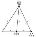
도 10a 는 중계기를 사용하지 않는 기지국에 대하여 수신된 시간 측정치에 기초하여 GPS 위성에 대한 서치 윈도우의 결정을 나타내는 2차원 (2-D) 도면이다. 도 10a 에 나타낸 바와 같이, 시간 측정치는 기지국과 원격 터미널 사이의 전파 지연을 나타내며, 공간 범위 a 로 변환될 수 있다. 추가적인 정보가 원격 터미널의 위치에 대하여 제공되지 않는 경우 (예를들어, 다른 시간 추정치가 다른 기지국에 대하여 수신되지 않는 경우), 그리고 최악의 경우에, 원격 터미널은 거리 a 에 의해 기지국의 한쪽에 위치할 수 있다. GPS 위성과 기지국 사이의 거리 b 는 당업계에 알려진 방식으로 결정될 수 있다.FIG. 10A is a two-dimensional (2-D) diagram illustrating the determination of a search window for a GPS satellite based on time measurements received for a base station not using a repeater. As shown in FIG. 10A, the time measurement represents the propagation delay between the base station and the remote terminal and can be converted to a spatial range a. If no additional information is provided for the location of the remote terminal (eg no other time estimate is received for another base station), and in the worst case, the remote terminal is located on one side of the base station by distance a can do. The distance b between the GPS satellites and the base station can be determined in a manner known in the art.
삼각 측량 계산을 이용하여 원격 터미널과 GPS 위성 사이의 거리는 원격 터 미널이 각각 기지국의 우측 또는 좌측에 위치하는 지에 의존하여 c 또는 d 로서 계산될 수 있다. 이 GPS 위성에 대한 서치 윈도우는 거리 c 와 d 간의 차이에 관련된 시간 윈도우로서 계산될 수 있다 (즉, 서치 윈도우 ∝ (c - d)). 서치 윈도우의 중심에 대한 시간 오프셋은 거리 b 에 관련된다 (즉, 시간 오프셋 ∝ b). 원격 터미널은 소정의 시간 오프셋의 서치 윈도우에 기초하여 GPS 위성으로부터의 송신을 서치하고 획득하도록 지시될 수 있다.Using triangulation calculations, the distance between the remote terminal and the GPS satellites can be calculated as c or d depending on whether the remote terminal is located on the right or left side of the base station, respectively. The search window for this GPS satellite can be calculated as the time window related to the difference between the distances c and d (ie search window 윈도우 (c-d)). The time offset relative to the center of the search window is related to the distance b (ie, time offset ∝ b). The remote terminal may be instructed to search for and obtain a transmission from a GPS satellite based on a search window of a predetermined time offset.
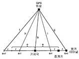
도 10b 는 중계기를 사용하는 기지국에 대하여 수신된 시간 측정치에 기초하여 원격 터미널에 대한 서치 윈도우의 결정을 나타내는 2차원 (2-D) 도이다. 이 단순예에 있어서, 중계기는 추가적인 지연을 도입하지 않는 것이라고 생각된다. 도 10 에 나타낸 바와 같이, 기지국과 중계기 사이의 전파 지연은 공간 범위 e 로 변환되고, 중계기와 원격 터미널간의 전파 지연은 범위 r 로 변환된다. 추가적인 정보가 원격 터미널의 위치에 대하여 제공되지 않는 경우, 최악의 경우에 원격 터미널은 거리 (e-r) 과 (e+r) 에 의해 정의된 범위내의 기지국의 한쪽에 위치되는 것을 가정할 수 있다. GPS 위성과 기지국 사이의 거리 b 는 당업계에 공지된 방법으로 결정될 수 있다.10B is a two-dimensional (2-D) diagram illustrating determination of a search window for a remote terminal based on time measurements received for a base station using a repeater. In this simple example, it is believed that the repeater does not introduce additional delay. As shown in Fig. 10, the propagation delay between the base station and the repeater is converted into the space range e, and the propagation delay between the repeater and the remote terminal is converted into the range r. If no additional information is provided for the location of the remote terminal, in the worst case it may be assumed that the remote terminal is located on one side of the base station within the range defined by the distances (e-r) and (e + r). The distance b between the GPS satellites and the base station can be determined by methods known in the art.
삼각 측량 계산을 이용하여, 원격 터미널과 GPS 위성간의 거리는 기지국의 어느 쪽에 원격 터미널이 위치하는 지에 의존하여, 그리고 원격 터미널이 기지국으로부터 (e+r) 의 거리에 위치하는 것으로 가정하여 f 또는 g 중의 하나로서 계산될 수 있다. 유사하게, 원격 터미널과 GPS 위성 사이의 거리는 다시 기지국의 어느 쪽에 원격 터미널이 위치하는 지에 의존하여 그리고 원격 터미널이 기지국으로 부터 거리 (e-r) 에 위치하는 것으로 가정하여 h 또는 i 중의 하나로서 계산될 수 있다. 이들 거기간의 최악의 경우 차이는 (f-i) 이고, 서치 윈도우는 이 최악의 경우 차이에 비례하는 것으로 계산될 수 있다 (즉, 서치 윈도우 ∝ (f-i)).Using triangulation calculations, the distance between the remote terminal and the GPS satellites depends on which side of the base station the remote terminal is located at, and assuming that the remote terminal is located at a distance of (e + r) from the base station, Can be calculated as one. Similarly, the distance between the remote terminal and the GPS satellite may again be calculated as either h or i depending on which side of the base station the remote terminal is located and assuming that the remote terminal is located at a distance (er) from the base station. have. The worst case difference between them is (f-i) and the search window can be calculated as being proportional to this worst case difference (ie search window ∝ (f-i)).
도 2b 에 나타낸 바와 같이, 중계기에 의해 도입된 추가적인 지연은 원격 터미널의 위치에서 불명확성을 더 증대시킨다. 이 추가적인 불명확성은 중계기에 의해 도입된 추가적인 지연과 연관되는 양으로 GPS 위성에 대한 서치 윈도우를 증대시켜서 해결할 수 있다.As shown in FIG. 2B, the additional delay introduced by the repeater further increases uncertainty at the location of the remote terminal. This additional ambiguity can be solved by increasing the search window for GPS satellites in an amount associated with the additional delay introduced by the repeater.
도 11 은 중계기로부터 수신한 송신을 고려한 원격 터미널의 위치를 결정하는 프로세스 (1100) 의 일 실시형태의 흐름도이다. 최초에, 단계 1112 에서, PDE 는 원격 터미널로부터 시간 추정치를 수신한다. 그후, 단계 1114 에서, PDE 는 수신한 측정치중 임의의 것이 중계된 기지국에 대한 것인지를 결정할 수 있다. 중계기에 대한 검출은 위에서 설명한 기술의 임의의 조합을 이용하여 달성될 수 있다. 단계 1116에서, PDE 는 수신한 시간 측정치에 기초하여 원격 터미널의 위치를 추정한다. 위에서 설명한 바와 같이, 중계된 기지국에 대한 시간 추정치는 원격 터미널의 위치를 추정하는데 고려할 수도 있고 안할 수도 있다.11 is a flow diagram of an embodiment of a
단계 1118 에서, 중계된 기지국에 대한 하나 이상의 시간 측정치가 원격 터미널의 위치를 추정하는데 사용되는 경우, 단계 1120 에서 PDE 는 중계기로 인한 추정된 위치에 추가적인 불명확성을 해결하기 위해서 확대된 사이즈를 갖는 GPS 위성에 대한 서치 윈도우를 생성한다. 서치 윈도우는 위에서 설명한 기술에 기초하여 생성될 수 있다. 그렇지 않고, 원격 터미널의 위치를 추정하는데 사용되는 시간 측정치중 어느 것도 중계된 기지국으로부터 오지 않는 경우, 서치 윈도우는 단계 1122 에서 정상적인 방법으로 생성될 수 있다. 그후, 단계 1124 에서, PDE 는 생성된 서치 윈도우를 이용하여 GPS 위성을 서치하도록 원격 터미널에 지시한다.If at
다수의 시간 측정치를 이용한 위치 결정Positioning using multiple time measurements
일반적인 셀룰러 환경에서, 원격 터미널은 다수의 송신 소스 (즉, 기지국 및/또는 중계기) 로부터 다수의 신호를 수신한다. CDMA 시스템에 대하여, 이들 송신은 수신되어 개별적으로 처리될 수 있다.In a typical cellular environment, remote terminals receive multiple signals from multiple transmission sources (ie, base stations and / or repeaters). For CDMA systems, these transmissions can be received and processed separately.
본 발명의 일 양태에 따르면, 원격 터미널의 위치는 특정 발신 기지국으로부터 터미널에서 수신한 다수의 송신에 기초하여 추정된다. 각각의 송신은 특정 신호 레벨로 수신되며 특정 전파 지연과 연관된다. 원격 터미널은 기지국과 중계기로부터 수신한 송신을 처리하고, 일부 또는 모든 수신한 송신을 보고한다 (예를들어, 특정 임계치 보다 높은 신호 강도를 갖는 보고용 송신). 그후, PDE 는 이들 보고된 송신에 대한 시간 측정치를 이용하여 원격 터미널의 위치를 추정한다. PDE 는 최선의 신뢰성을 갖는 위치 추정치를 유발하는 시간 측정치를 선택하고 이용할 수 있다. PDE 가 원격 터미널이 네트워크의 중계기의 커버리지에 있다고 결정하는 경우, PDE 는 서치 윈도우를 확장 또는 시프트하라고 원격 터미널에 지시한다.According to one aspect of the invention, the location of the remote terminal is estimated based on a number of transmissions received at the terminal from a particular originating base station. Each transmission is received at a specific signal level and is associated with a particular propagation delay. The remote terminal processes the transmissions received from the base station and the repeater and reports some or all of the received transmissions (eg, reporting transmissions with signal strength above a certain threshold). The PDE then uses the time measurements for these reported transmissions to estimate the location of the remote terminal. The PDE can select and use the time measurement that leads to the position estimate with the best reliability. If the PDE determines that the remote terminal is in coverage of the repeaters in the network, the PDE instructs the remote terminal to expand or shift the search window.
도 12a 는 원격 터미널이 기지국의 커버리지에 있을 때 기지국과 중계기로부터 원격 터미널에 의해 수신한 다수의 송신을 나타내는 도면이다. 도 12a 에 나타낸 예에서, 원격 터미널 (106) 은 TBT1 의 전파 지연을 갖는 기지국 (104a) 으로부터 제 1 송신을 수신하고, 또한 TRT1 의 전파 지연을 갖는 중계기 (114a) 로부터 제 2 송신을 수신한다. 수신한 송신에 대한 시간 측정은 PDE 에 보고되며, 이는 보고된 시간 측정치에 기초하여 원격 터미널의 위치를 결정할 수 있다.12A illustrates a number of transmissions received by a remote terminal from a base station and repeater when the remote terminal is in coverage of the base station. In the example shown in FIG. 12A, the
도 12a 에 나타낸 예에 있어서, 원격 터미널 (106) 은 중계기 (114a) 의 커버리지에 있지 않기 때문에, 중계기로부터 수신한 송신에 대한 신호 강도는 약할 수 있다. 원격 터미널 (106) 이 기지국 (104a) 의 커버리지에 있기 때문에, 기지국으로부터 수신한 송신에 대한 신호 강도는 더 강할 수 있다. 일련의 위치 결정치 (즉, 위치 추정치) 는 수신한 시간 측정치에 기초하여 원격 터미널에 대한 PDE 에 의해 생성될 수 있다. 최선의 메트릭 (metric) 을 갖는 위치 결정치는 원격 터미널의 추정된 위치로서 선택될 수 있다.In the example shown in FIG. 12A, since the
동일한 발신 기지국으로부터의 다수의 송신에 대한 다수의 시간 측정치에 기초한 원격 터미널의 위치의 결정은 예를 들어, 발명의 명칭이 "METHOD AND APPARATUS FOR DETERMINING AN ALGEBRAIC SOLUTION TO GPS TERRESTRIAL HYBRID LOCATION SYSTEM EQUATIONS" 이며, 본 발명의 양수인에게 양도되었으며 여기서 참조하는 2001년 9월 11일에 특허된 미국 특허 제 6,289,280 호에 설명된 방법으로 달성될 수 있다. RMSE (Root Mean Square Error) 메트릭은 각각의 도달 시간 (TOA) 추정치와 연관된 신호 강도에 기초하여 각각의 위치 결정치에 대하여 당업계에 공지된 방법으로 계산될 수 있다. 수신한 다중 경로에 대한 보다 약한 신호 강도는 신호가 튀어나갈 더 높은 가능성에 대응한다. 일반적으로, 더 약한 신호를 갖는 송신은 이 송신에 기초하여 계산한 위치 결정치의 더 불명확성과 그에 따른 더 낮은 메트릭에 대응한다. 따라서, 일반적으로, 위치 결정치는 "나머지" 와 연관되며, 이는 추정된 위치 결정치에 대한 불확실성을 나타낸다. 메트릭의 계산은 상술한 미국 특허 제 6,289,280 호에 보다 상세하게 기술되어 있다.The determination of the location of the remote terminal based on multiple time measurements for multiple transmissions from the same originating base station is, for example, the name of the invention: "METHOD AND APPARATUS FOR DETERMINING AN ALGEBRAIC SOLUTION TO GPS TERRESTRIAL HYBRID LOCATION LOCATION SYSTEM EQUATIONS", It can be accomplished by the method described in US Pat. No. 6,289,280, assigned to the assignee of the present invention and patented on September 11, 2001. The root mean square error (RMSE) metric can be calculated by methods known in the art for each position determination based on the signal strength associated with each arrival time (TOA) estimate. Weak signal strength for the received multipath corresponds to a higher likelihood that the signal will pop out. In general, a transmission with a weaker signal corresponds to more uncertainty and hence a lower metric of the position determination calculated based on this transmission. Thus, in general, the position determination is associated with the "rest", which indicates uncertainty about the estimated position determination. The calculation of the metric is described in more detail in US Pat. No. 6,289,280, above.
도 12b 는 원격 터미널이 중계기의 커버리지에 있을 때 기지국과 중계기로부터 원격 터미널에 의해 수신한 송신의 다른 예의 도면이다. 도 12b 에 나타낸 예에서, 원격 터미널 (106) 은 TBT2 의 전파 지연을 갖는 기지국 (104a) 로부터의 제 1 송신을 수신하고, 또한 TRT2 의 전파 지연을 갖는 중계기 (114a) 로부터의 제 2 송신을 수신한다.12B is a diagram of another example of a transmission received by a remote terminal from a base station and a repeater when the remote terminal is in coverage of the repeater. In the example shown in FIG. 12B, the
도 12b 에 나타낸 예에 대해서, 원격 터미널 (106) 은 중계기 (114a) 의 커버리지에 있기 때문에, 중계기로부터 수신한 송신에 대한 신호 강도는 기지국으로부터 수신한 송신 보다 더 강할 수 있다. 또한, 일련의 위치 결정치들은 원격 터미널에 대한 PDE 에 의해 생성될 수 있고, 최선의 메트릭을 갖는 위치 결정치 (position fix) 는 원격 터미널의 추정된 위치로서 선택될 수 있다.For the example shown in FIG. 12B, since the
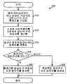
도 13 은 중계된 기지국에 대하여 수신한 다수의 시간 측정치에 기초하여 원격 터미널의 위치를 결정하는 프로세스 (1300) 의 일 실시형태의 흐름도이다. 최초에, 단계 1312 에서, PDE 는 하나 이상의 기지국에 대한 다수의 시간 측정치를 원격 터미널로부터 수신하며, 다수의 시간 측정치가 하나 이상의 기지국에 대하여 수신된다.13 is a flowchart of an embodiment of a
단계 1314 에서 PDE 는 수신한 시간 추정치에 기초하여, 그리고 특정 기지국에 대하여 수신한 다수의 시간 측정치의 다양한 조합에 대하여 일련의 위치 결정치를 계산한다. 각각의 계산된 위치 결정치는 계산한 위치 결정치의 특정 등급의 신뢰도를 확인하는 개별 메트릭과 연관된다.In
그후, 단계 1316 에서는 최선의 메트릭을 갖는 위치 결정치가 원격 터미널의 위치로서 선택된다. 그후, 단계 1318 에서, 선택된 위치 결정치에 대하여, 원격 터미널이 중계기의 커버리지에 있는지 여부에 대하여 결정이 행해진다. 대답이 "아니오" 인 경우, 단계 1320 에서 원격 터미널에 대한 서치 윈도우는 정상적인 방법으로 (즉, 중계기에 대한 보상없이) 생성된다. 그렇지 않고, 원격 터미널이 중계기의 커버리지에 있는 것으로 추정되는 경우, 단계 1322 에서, 서치 윈도우는 중계기와 연관된 추가적인 불명확성을 해결하는 방식으로 생성된다. 이는 위에서 설명한 바와 같이, 지연에 의존하여 서치 윈도우를 확대 및/또는 시프팅하는 것을 수반할 수 있다. 그후, 처리는 종료한다.Then, in step 1316 the position determination with the best metric is selected as the position of the remote terminal. Then, at
비용 함수를 이용한 위치 결정Positioning Using Cost Functions
본 발명의 일 양태에 따르면, 원격 터미널이 중계기의 커버리지에 있는지 여부에 대한 결정이 네트워크의 기지국과 중계기를 교정하여 행해질 수 있다. 일 실시형태에서, 교정의 일부로서, PDE 에는 기지국이 하나 이상의 기지국, 그들의 연관된 중계기들 사이의 전파 지연, 중계기들 사이의 전파 지연, 및 각각의 중계기에 의해 도입된 추가적인 지연과 연관되는 정보가 제공된다. 이 정보는 PDE 에 의해 유지되는 표에 저장될 수 있다.According to one aspect of the present invention, a determination as to whether the remote terminal is in coverage of the repeater may be made by calibrating the base station and repeater in the network. In one embodiment, as part of the calibration, the PDE is provided with information associated with one or more base stations, propagation delays between their associated repeaters, propagation delays between repeaters, and additional delays introduced by each repeater. do. This information can be stored in a table maintained by the PDE.
표 3 은 도 1 에 나타낸 예시적인 네트워크 레이아웃에 대하여 중계된 기지국들과 연관된 지연에 대하여 PDE 에 의해 유지될 수 있는 표의 예이다. 첫 번째 컬럼에는 송신 소스 (즉, 기지국 또는 중계기) 를 기재하고, 두 번째 컬럼에는 기지국이 중계되는 지를 기재한다. 기지국이 중계되는 경우, 세 번째 컬럼에는 기지국으로부터 제 1 중계기로, 또는 하나의 중계기로부터 다음 중계기로의 전파 지연을 기재한다. 그리고, 네 번째 컬럼에는 중계기와 연관된 추가적인 지연을 기재한다.Table 3 is an example of a table that may be maintained by the PDE for delays associated with relayed base stations for the example network layout shown in FIG. 1. The first column lists the transmission source (ie, base station or repeater) and the second column lists whether the base station is relayed. When the base station is relayed, the third column describes the propagation delay from the base station to the first repeater or from one repeater to the next repeater. Then, the fourth column lists the additional delay associated with the repeater.
위치 결정에 대하여, 원격 터미널은 네트워크의 기지국과 중계기들로부터 송 신을 수신하고, PDE 에 수신한 송신에 대한 시간 측정치를 보고한다. 일 실시형태에서, 원격 터미널은 각각의 발신 기지국 (즉, CDMA 네트워크에서 각각의 고유한 PN 오프셋) 에 대한 하나의 시간 측정치를 보고한다. 이 시간 측정치는 기지국으로부터 또는 중계된 기지국의 중계기로부터 올 수 있으며, 일반적으로 송신 소스로부터 가장 이른, 그리고 가장 강한 다중 경로로부터 유도된다.For location determination, the remote terminal receives transmissions from base stations and repeaters in the network and reports time measurements for the received transmissions to the PDE. In one embodiment, the remote terminal reports one time measurement for each originating base station (ie, each unique PN offset in the CDMA network). This time measurement can come from the base station or from the relay of the relayed base station and is generally derived from the earliest and strongest multipath from the transmission source.
PDE는 원격 터미널로부터 다수의 기지국 (또는 그들의 관련 중계기) 에 대한 시간 측정치를 수신한다. 일 실시형태에서, 그후, PDE 는 수신한 시간 측정치에 기초하여 그리고 다수의 가설에 따라서 원격 터미널에 대한 위치를 측정한다. 각각의 가설은 원격 터미널의 위치를 추정하는데 사용되는 각각의 시간 측정치에 대한 특정 송신 소스에 대한 특정한 추측을 나타낸다. 예를 들어, 하나의 가설은 모든 수신한 시간 측정치가 중계기가 아니라 기지국으로부터 온 것이라고 가정한다.The PDE receives time measurements for multiple base stations (or their associated repeaters) from remote terminals. In one embodiment, the PDE then measures position relative to the remote terminal based on the received time measurements and according to a number of hypotheses. Each hypothesis represents a specific conjecture for a particular transmission source for each time measurement used to estimate the location of the remote terminal. For example, one hypothesis assumes that all received time measurements come from the base station, not the repeater.
나머지 가설은 수신한 시간 측정치에 대한 기지국과 중계기의 다양한 조합에 대한 것일 수 있다. 이들 가설 각각에 대하여, 각각의 중계된 기지국에 대한 시간 측정치는 기지국 또는 중계기 중의 하나에 대한 것이라고 가정될 수 있다. 그후, 각각의 가정된 기지국에 대한 시간 측정치는 기지국으로부터 중계기로의 송신과 연관된 지연과 중계기에 의해 도입된 추가적인 지연을 빼서 보상된다. 각각의 가설은 하나의 위치 결정치와 해당 에러 메트릭을 유발하며, 이는 상술한 미국 특허 출원 제 09/460,180 호에 기술된 바와 같이 계산될 수 있다. 그후, PDE 는 최선의 메트릭 (즉, 최소의 에러) 을 갖는 위치 결정치를 선택한다. 이 선택된 위치 결정치로부터, 가설에 기초하여 원격 터미널이 중계기의 커버리지에 있는지 여부에 대한 결정이 행해진다.The remaining hypothesis may be for various combinations of base stations and repeaters for the received time measurements. For each of these hypotheses, it can be assumed that the time measurements for each relay base station are for either the base station or the repeater. The time measurement for each hypothesized base station is then compensated by subtracting the delay associated with the transmission from the base station to the repeater and the additional delay introduced by the repeater. Each hypothesis results in one position determination and the corresponding error metric, which can be calculated as described in US Patent Application Serial No. 09 / 460,180, supra. The PDE then selects the location with the best metric (ie, the least error). From this selected positioning value, a determination is made based on the hypothesis whether the remote terminal is in coverage of the repeater.
도 14 는 도 1 에 나타낸 네트워크 레이아웃의 원격 터미널에 의해 보고된 시간 측정치에 대하여 PDE 에 의해 계산된 가능한 위치 결정치의 도면이다. 이 예에서, 원격 터미널은 중계기 (114a) 와 기지국 (104b 및 104c) 으로부터 수신한 송신에 대한 시간 측정치를 보고한다. 이 예에 대하여, 중계기 (114a) 로부터의 시간 측정치는 기지국 (104a) 으로부터 중계기 (114a) 로의 전파 지연과, 중계기 (114a) 와 연관된 추가적인 지연을 포함한다. 기지국 (104b 및 104c) 으로부터의 시간 측정은 직접 가시선 측정치 (direct line-of-sight measurement) 을 나타낸다. 이들 시간 측정치는 PDE 에 보고된다.14 is a diagram of possible position determination values calculated by the PDE for time measurements reported by the remote terminal of the network layout shown in FIG. In this example, the remote terminal reports time measurements for transmissions received from
표 3 에 나타낸 것 같은 교정 정보에 기초하여, PDE 는 기지국 (104a 및 104b) 는 중계된 기지국이라고 인식한다. 첫 번째 가설에 대하여, PDE 는 모든 수신한 시간 측정치들이 기지국 (즉, 기지국 (104a, 104b, 및 104c) 으로부터 온 것이라고 가정하여 원격 터미널의 위치를 계산한다. 중계기 (114a) 와 연관된 추가적인 지연 때문에, 기지국 (104a) 으로부터의 추정된 범위는 실제보다 더 멀리 있으며, 원격 터미널은 지점 H1 에 위치하는 것을 추정된다.Based on the calibration information as shown in Table 3, the PDE recognizes that the
다음 가설에 대하여, 기지국 (104a) 에 대한 시간 측정치는 중계기 (114a) 로부터 온 것으로 가정되며, 다른 시간 측정치는 기지국 (104b 및 104c) 으로부터 온 것으로 가정된다. 그후, PDE 는 중계기 (114a) 에 대한 시간 측정치를 기지국 (104a) 와 중계기 (114a) 에 대하여 테이블에 저장된 지연으로 보상한다. 특히, PDE 는 기지국 (104a) 으로부터 중계기 (114a) 로의 전파 지연 TBR1 과 중계기 (114a) 에 대한 시간 측정치로부터 중계기 (114a) 에 의해 유도된 추가적인 지연 TR1 을 뺀다. 가정된 시간 추정치의 이 세트에 대한 원격 터미널의 추정된 위치는 지점 H2 이다. 다른 가설은 기지국 (104b) 에 대한 시간 측정치가 중계기 (114a) 로부터 온 것이라고 가정한다. 한편, 기지국 (104b) 으로부터의 측정치는 낮은 신호 레벨과 연관되며, 이 위치 결정치에는 더 나쁜 메트릭이 할당될 수도 있다.For the following hypothesis, the time measurements for
도 15 는 다수의 네트워크 가설과 비용 함수에 기초하여 원격 터미널의 위치를 결정하는 프로세스 (1500) 의 일 실시형태의 흐름도이다. 최초에, 단계 1512에서 PDE 는 원격 터미널로부터 시간 측정치를 수신한다. 그후, 단계 1514 에서, PDE 는 시간 측정치중 임의의 것이 중계된 기지국에 대한 것인지를 결정한다. 시간 측정치중 어느 것도 중계된 기지국에 대한 것이 아닌 경우, PDE 는 단계 1516 에서 수신한 시간 측정치에 기초하여 원격 터미널의 위치 결정치를 계산하고, 단계 1518 에서 정상적인 방법으로 원격 터미널에 대한 서치 윈도우를 생성한다. 그후, 프로세스가 종료한다.15 is a flow diagram of an embodiment of a
그렇지 않고, 단계 1514 에서 시간 측정치중 임의의 것이 중계된 기지국에 대한 것으로 결정되는 경우, 단계 1520 에서 PDE 는 수신한 시간 측정치에 기초하여 그리고 다양한 네트워크 가설에 대하여 일련의 위치 결정치를 계산한다. 각각의 네트워크 가설은 각각의 중계된 기지국에 대한 시간 측정치에 대한 특정 송신 소스를 가정한다 (즉, 송신 소스가 기지국 또는 중계기인 지 여부). 각각의 가설에 대하여 계산된 위치 결정치는 계산한 위치 결정치의 특정 등급의 신뢰도를 확인하는 개별 메트릭과 연관된다. 이 메트릭은 RMSE 에 기초할 수 있다.Otherwise, if any of the time measurements are determined for the relayed base station in
그후, 단계 1522 에서, 최선의 메트릭을 갖는 위치 결정치가 원격 터미널의 추정된 위치로서 선택된다. 그후, 단계 1524에서, 선택된 위치 결정치에 대하여, 원격 터미널이 중계기의 커버리지에 있는지에 대한 결정이 행해진다. 대답이 "아니오" 인 경우, 단계 1518 에서 원격 터미널에 대한 서치 윈도우가 정상적인 방법으로 (즉, 중계기에 대한 보상 없이) 생성된다. 그렇지 않은 경우, 원격 터미널이 중계기의 커버리지에 있는 경우, 단계 1526 에서는 서치 윈도우가 중계기와 연관된 추가적인 불명확성을 해결하는 방식으로 생성된다. 이는 위에서 설명한 바와 같이, 지연에 의존하여 서치 윈도우를 확대 및/또는 시프팅시키는 것을 수반할 수 있다. 그후, 프로세스가 종료한다.Then, at
시스템system
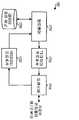
도 16 은 본 발명의 다양한 양태를 구현할 수 있는 원격 터미널 (106) 의 일 실시형태의 블록도이다. 순방향 링크를 통해서, 기지국 및/또는 중계기로부터의 신호는 안테나 (1612)를 통해서 수신되고, 듀플렉서 (1614) 를 통해서 라우팅되고, RF 수신 유닛 (1622) 에 제공된다. RF 수신기 유닛 (1622) 은 그 수신한 신호를 컨디셔닝 (예를들어, 필터링, 증폭, 및 다운컨버팅) 하고 디지털화하여 샘플을 제공한다. 복조기 (1624) 는 그 샘플을 수신하고 처리 (예를들어, 역확산, 디커버링, 및 파일럿 변조) 하여, 복구된 심볼을 제공한다. 복조기 (1624) 는 다수의 경우의 수신한 신호를 처리하여 합성된 복구 심볼을 생성하는 레이크 수신기를 구현할 수 있다. 그후, 수신 데이터 프로세서 (1626) 는 복구된 심볼을 디코딩하고, 그 수신된 심볼을 체크하여, 출력 데이터를 제공한다.16 is a block diagram of one embodiment of a
위치 결정에 대하여, 레이크 수신기는 가장 강한 수신 다중 경로 또는 특정 임계치 레벨을 초과하는 신호 강도를 갖는 다중 경로에 대한 도달 시간을 컨트롤러 (1630) 에 제공하도록 동작할 수 있다. 일부 실시형태에 대하여, RF 수신기 유닛 (1622) 으로부터의 샘플들은 수신한 송신의 품질을 특정하는 RX 신호 품질 측정 유닛 (1628) 에 제공될 수도 있다. 신호 품질 측정은 미국 특허 제5,056,109 호 및 제 5,265,119 호에 개시된 것을 포함하는 다양한 기술을 이용하여 달성될 수 있다.For position determination, the rake receiver may be operable to provide the
컨트롤러 (1630) 는 기지국과 중계기에 대한 시간 측정치, 다중 경로의 측정된 신호 품질 (일부 실시형태에 대하여), 및 PDE 에 의해 송신된 서치 윈도우를 나타내는 메시지를 수신한다. 시간 측정치 및 신호 품질 측정치는 PDE 로의 역송신을 위하여 변조기 (1644) 에 제공되며, 서치 윈도우는 GPS 수신기 (1640) 에 제공된다.The
GPS 수신기 (1640) 은 컨트롤러 (1630) 에 의해 제공된 서치 윈도우에 기초하여 GPS 신호를 수신하고 서치한다. 그후, GPS 위성에 대한 시간 측정치는 GPS 수신기 (1640) 에 의해 컨트롤러 (1630) 에 제공되며, 이는 그후 PDE 에 정보를 포워드한다.The
역방향 링크상에서, 데이터는 송신 (TX) 데이터 프로세서 (1642) 에 의해 처 리 (예를들어, 포맷화, 인코딩) 되고, 변조기 (MOD; 1644) 에 의해서 추가 처리되고, RF TX 유닛 (1646) 에 의해서 컨디셔닝 (예를들어, 아날로그 신호로의 컨버팅, 증폭, 필터링, 쿼드러처 변조 등) 되어, 역방향 링크 신호를 생성한다. 컨트롤러 (1630) 로부터의 정보는 변조기 (1644) 에 의해 처리된 데이터와 다중화될 수 있다. 그후, 역방향 링크 신호는 듀플렉서 (1614) 를 통하여 라우팅되고, 안테나 (1612) 를 통하여 기지국 및/또는 중계기로 송신된다.On the reverse link, the data is processed (e.g., formatted, encoded) by the transmit (TX)
도 17 은 본 발명의 다양한 양태를 구현할 수 있는 PDE (130) 의 일실시형태의 블록도이다. PDE (130) 은 BSC (120) 와 인터페이스하며, 위치 결정과 연관된 정보를 교환한다.17 is a block diagram of one embodiment of a
역방향 링크상에서, 기지국으로부터의 데이터는 트랜시버 (1714) 를 통하여 RX 데이터 프로세서 (1722) 에 제공된다. 이 데이터는 시간 측정치 및 (가능하게는) 원격 터미널에 의해 보고된 신호 품질 표시, 기지국에 의해 보고된 GPS 위성에 대한 시간 측정치, 및 다른 데이터를 포함한다. 데이터 프로세서 (1722) 는 시간 측정치와 신호 품질 표시를 수신 데이터로부터 추출하고, 그 정보를 컨트롤러 (1710) 에 제공한다. 또한, 컨트롤러 (1710) 은 데이터 저장 유닛 (1730) 으로부터 추가적인 데이터 (즉, 기지국이 중계되는 지를 나타내는 정보, 기지국과 중계기와 연관되는 지연 등) 를 수신하여, 원격 터미널에 대한 위치 추정치를 계산한다. 또한, 컨트롤러는 이용가능한 정보에 기초하여 원격 터미널에 대한 서치 윈도우를 계산한다. 서치 윈도우는 TX 데이터 프로세서 (1712) 에 제공되며, 이는 적절하게 데이터를 포맷화하고, 그 데이터를 트랜시버 (1714)를 통하여 BSC 에 송신한다.On the reverse link, data from the base station is provided to the
여기 설명한 프로세싱 유닛 (예를 들어, 레이크 수신기, 데이터 프로세서, 컨트롤러, 및 다른 것) 은 다양한 방식으로 구현될 수 있다. 예를 들어, 이들 프로세싱 유닛 각각은 주문형 집적 회로 (ASIC), 디지털 신호 프로세서, 마이크로 컨트롤러, 마이크로 프로세서, 또는 여기 설명한 기능들을 수행하도록 설계된 다른 전자 회로로 구현될 수 있다. 또한, 처리 유닛은 하나 이상의 집적 회로로 집적화될 수 있다. 또한, 프로세싱 유닛은 여기 설명한 기능을 달성하는 명령 코드를 실행하도록 동작하는 범용 또는 특수 설계된 프로세서로 구현될 수 있다.The processing units described herein (eg, rake receivers, data processors, controllers, and others) can be implemented in a variety of ways. For example, each of these processing units may be implemented in an application specific integrated circuit (ASIC), a digital signal processor, a microcontroller, a microprocessor, or other electronic circuit designed to perform the functions described herein. In addition, the processing unit may be integrated into one or more integrated circuits. In addition, the processing unit may be implemented as a general purpose or specially designed processor operative to execute instruction code to achieve the functions described herein.
또한, 본 발명의 다양한 실시형태는 프로세서상에서 실행되는 소프트웨어 코드로 구현될 수 있다. 예를 들어, 원격 터미널로부터의 시간 측정치에 기초하여 원격 터미널의 위치를 추정하고 원격 터미널의 추정된 위치에 기초하여 서치 윈도우를 생성하는 계산은 하나 이상의 소프트웨어 모듈에 의해 달성될 수 있다. 따라서, 여기 설명한 처리와 계산의 적어도 일부는 하드웨어, 소프트웨어, 또는 그들의 조합을 이용하여 구현될 수 있다.In addition, various embodiments of the present invention may be implemented in software code executing on a processor. For example, a calculation that estimates the location of the remote terminal based on time measurements from the remote terminal and generates a search window based on the estimated location of the remote terminal can be accomplished by one or more software modules. Thus, at least some of the processing and calculations described herein may be implemented using hardware, software, or a combination thereof.
간단하게, 위치 결정은 PDE 에 의해 수행되는 것으로 설명한다. 그러나, 위치를 추정하는 처리는 기지국 또는 원격 터미널에서, 또는 PDE, 기지국, 및 원격 터미널간에 분포되어 수행될 수 있다.For simplicity, the positioning is described as being performed by the PDE. However, the process of estimating location may be performed at a base station or remote terminal, or distributed between PDEs, base stations, and remote terminals.
간단하게, 본 발명의 다양한 양태들을 체계적으로 나타내기 위해서 여기서는 단락 표제 (heading) 를 사용하였다. 이들 다양한 단락 표제에서 설명하는 특징들은 그들이 설명된 단락, 및 2개 또는 그이상의 단락으로부터 조합될 수 있는 기술에 제한하려는 것이 아니다. 예를 들어, 원격 터미널이 중계기의 커버리지에 있는지에 대한 결정은 가능성 있는 인접국 리스트, 중계기의 환경 유형, 시간 측정치의 지연, 비용 함수, 또는 그들이 조합에 기초하여 행해진다.For simplicity, paragraph headings are used herein to systematically represent various aspects of the present invention. The features described in these various paragraph headings are not intended to be limited to the paragraphs in which they are described and the techniques that can be combined from two or more paragraphs. For example, the determination of whether the remote terminal is in the repeater's coverage is made based on the list of possible neighboring stations, the type of repeater's environment, the delay of the time measurement, the cost function, or a combination thereof.
바람직한 실시형태의 상기 설명은 당업자가 본 발명을 제조 또는 이용할 수 있도록 제공된다. 이들 실시형태에 대한 다양한 변경은 당업자들에게 명백하며, 여기 정의한 기본 원리는 창조력 없이도 다른 실시형태들에 응용할 수 있다. 따라서, 본 발명은 여기 나타낸 실시형태들에 제한되지 않으며, 여기 개시한 원리와 신규한 특징에 부합하는 최광의 범위를 부여받는다.The previous description of the preferred embodiments is provided to enable any person skilled in the art to make or use the present invention. Various modifications to these embodiments will be apparent to those skilled in the art, and the basic principles defined herein may be applied to other embodiments without creativity. Accordingly, the invention is not limited to the embodiments shown herein but is given the broadest scope consistent with the principles and novel features disclosed herein.
Claims (45)
Translated fromKoreanApplications Claiming Priority (5)
| Application Number | Priority Date | Filing Date | Title |
|---|---|---|---|
| US24984600P | 2000-11-16 | 2000-11-16 | |
| US60/249,846 | 2000-11-16 | ||
| US09/922,997US7039418B2 (en) | 2000-11-16 | 2001-08-03 | Position determination in a wireless communication system with detection and compensation for repeaters |
| US09/922,997 | 2001-08-03 | ||
| PCT/US2001/045458WO2002059638A2 (en) | 2000-11-16 | 2001-11-14 | Position determination in a wireless communication system with detection and compensation for repeaters |
Publications (2)
| Publication Number | Publication Date |
|---|---|
| KR20040034571A KR20040034571A (en) | 2004-04-28 |
| KR100808439B1true KR100808439B1 (en) | 2008-02-29 |
Family
ID=26940390
Family Applications (1)
| Application Number | Title | Priority Date | Filing Date |
|---|---|---|---|
| KR1020037006639AExpired - Fee RelatedKR100808439B1 (en) | 2000-11-16 | 2001-11-14 | Position Determination in Wireless Communication System Using Detection and Compensation for Repeater |
Country Status (11)
| Country | Link |
|---|---|
| US (1) | US7039418B2 (en) |
| EP (1) | EP1336118A2 (en) |
| JP (2) | JP4619622B2 (en) |
| KR (1) | KR100808439B1 (en) |
| CN (1) | CN100347563C (en) |
| AU (1) | AU2002248154B2 (en) |
| BR (1) | BR0115401A (en) |
| CA (1) | CA2429340C (en) |
| IL (2) | IL155895A0 (en) |
| MX (1) | MXPA03004319A (en) |
| WO (1) | WO2002059638A2 (en) |
Families Citing this family (98)
| Publication number | Priority date | Publication date | Assignee | Title |
|---|---|---|---|---|
| US8255149B2 (en) | 1999-07-12 | 2012-08-28 | Skybitz, Inc. | System and method for dual-mode location determination |
| US20040143392A1 (en)* | 1999-07-12 | 2004-07-22 | Skybitz, Inc. | System and method for fast acquisition reporting using communication satellite range measurement |
| US7016332B2 (en)* | 2000-12-05 | 2006-03-21 | Science Applications International Corporation | Method and system for a remote downlink transmitter for increasing the capacity of a multiple access interference limited spread-spectrum wireless network |
| US7061891B1 (en) | 2001-02-02 | 2006-06-13 | Science Applications International Corporation | Method and system for a remote downlink transmitter for increasing the capacity and downlink capability of a multiple access interference limited spread-spectrum wireless network |
| US7209515B2 (en) | 2001-03-30 | 2007-04-24 | Science Applications International Corporation | Multistage reception of code division multiple access transmissions |
| JP3478283B2 (en)* | 2001-07-31 | 2003-12-15 | 株式会社デンソー | Mobile communication terminal |
| GB2378614B (en)* | 2001-08-08 | 2006-02-01 | Samsung Electronics Co Ltd | Method of locating a mobile terminal |
| JP3449368B2 (en)* | 2001-08-30 | 2003-09-22 | 株式会社デンソー | Positioning system, position information server and computer program |
| US7006461B2 (en) | 2001-09-17 | 2006-02-28 | Science Applications International Corporation | Method and system for a channel selective repeater with capacity enhancement in a spread-spectrum wireless network |
| US7590383B2 (en)* | 2001-10-25 | 2009-09-15 | Qualcomm Incorporated | Determining mobile station position using base station identification and a repeater discriminant |
| US7729412B2 (en)* | 2001-10-29 | 2010-06-01 | Qualcomm Incorporated | Parameter estimator with dynamically variable integration time |
| US7308022B2 (en)* | 2001-11-01 | 2007-12-11 | Rick Roland R | Parameter estimator configured to distinguish between peaks and sidelobes of correlation function |
| US7558534B2 (en) | 2001-11-02 | 2009-07-07 | Qualcomm Incorporated | Reliability metrics for parameter estimates which account for cumulative error |
| CN101222254A (en)* | 2001-11-20 | 2008-07-16 | 高通股份有限公司 | Reverse link power controlled repeater |
| US20030157943A1 (en)* | 2002-01-29 | 2003-08-21 | John Sabat | Method and apparatus for auxiliary pilot signal for mobile phone location |
| JP3733336B2 (en)* | 2002-02-26 | 2006-01-11 | 株式会社日立製作所 | Wireless terminal device |
| DE10221649A1 (en)* | 2002-05-15 | 2003-11-27 | Siemens Ag | Position finding method e.g. for mobile RF systems, requires taking average errors of reference positions into account |
| US7412207B2 (en)* | 2002-06-21 | 2008-08-12 | Nokia Corporation | Signal path detection for wireless networks including repeaters |
| EP1394562B1 (en)* | 2002-08-28 | 2011-01-19 | Cambridge Positioning Systems Limited | Improvements in radio positioning systems |
| US7295808B2 (en)* | 2002-09-05 | 2007-11-13 | Soliman Samir S | Method of and system for calibrating a repeater |
| CN1266976C (en)* | 2002-10-15 | 2006-07-26 | 华为技术有限公司 | Mobile station positioning method and its direct broadcasting station |
| US7831263B2 (en)* | 2002-11-08 | 2010-11-09 | Qualcomm Incorporated | Apparatus and method for determining the location of a repeater |
| WO2004052027A2 (en)* | 2002-11-27 | 2004-06-17 | Cognio, Inc | System and method for locating sources of unknown wireless radio signals |
| US7257411B2 (en)* | 2002-12-27 | 2007-08-14 | Ntt Docomo, Inc. | Selective fusion location estimation (SELFLOC) for wireless access technologies |
| US7016688B2 (en)* | 2003-02-24 | 2006-03-21 | Qualcomm, Incorporated | Forward link repeater delay watermarking system |
| US7130642B2 (en)* | 2003-03-03 | 2006-10-31 | Qualcomm Incorporated | Method and apparatus for performing position determination in a wireless communication network with repeaters |
| KR100598149B1 (en) | 2003-04-28 | 2006-07-07 | (주)에프알텍 | The method and Apparatus for obtaining location of mobile terminal in repeaters coverage areas |
| DE602004025918D1 (en)* | 2003-05-12 | 2010-04-22 | Qualcomm Inc | METHOD AND DEVICE FOR USE IN A COMMUNICATION SYSTEM |
| WO2004105273A1 (en)* | 2003-05-20 | 2004-12-02 | Neo Telecom Co., Ltd. | Method and system for tracking the position of mobile communication terminal |
| US8483717B2 (en) | 2003-06-27 | 2013-07-09 | Qualcomm Incorporated | Local area network assisted positioning |
| US8971913B2 (en) | 2003-06-27 | 2015-03-03 | Qualcomm Incorporated | Method and apparatus for wireless network hybrid positioning |
| US20060058954A1 (en)* | 2003-10-08 | 2006-03-16 | Haney Philip J | Constrained tracking of ground objects using regional measurements |
| KR100539915B1 (en)* | 2003-10-31 | 2005-12-28 | 삼성전자주식회사 | Method for generating acquisition assistant information in assisted global positioning system |
| KR100800738B1 (en)* | 2003-10-31 | 2008-02-01 | 삼성전자주식회사 | How to Determine Repeater Time Delay in Mobile Network |
| JP4728253B2 (en)* | 2003-11-26 | 2011-07-20 | クゥアルコム・インコーポレイテッド | Method and apparatus for calculating position estimates of mobile stations using network information |
| US7440762B2 (en)* | 2003-12-30 | 2008-10-21 | Trueposition, Inc. | TDOA/GPS hybrid wireless location system |
| KR100573203B1 (en)* | 2004-03-17 | 2006-04-24 | 에스케이 텔레콤주식회사 | Method and system for positioning terminal using location navigator in GPS propagation shadow area |
| US9118380B2 (en)* | 2004-04-05 | 2015-08-25 | Qualcomm Incorporated | Repeater with positioning capabilities |
| JP2007532079A (en)* | 2004-04-05 | 2007-11-08 | クゥアルコム・インコーポレイテッド | A repeater that reports detected neighbors |
| US7269387B2 (en)* | 2004-05-28 | 2007-09-11 | Lucent Technologies Inc. | Method and apparatus for determining a distance between a base station and a mobile unit |
| US7412248B2 (en)* | 2004-06-15 | 2008-08-12 | Technocom Corporation | System and method for location determination |
| US7319878B2 (en) | 2004-06-18 | 2008-01-15 | Qualcomm Incorporated | Method and apparatus for determining location of a base station using a plurality of mobile stations in a wireless mobile network |
| JP2006020043A (en) | 2004-07-01 | 2006-01-19 | Nec Corp | Service area deciding method |
| WO2006011718A1 (en)* | 2004-07-26 | 2006-02-02 | Samsung Electronics Co., Ltd. | Location tracking method in coordinator-based wireless network |
| US7778596B2 (en) | 2004-07-29 | 2010-08-17 | Qualcomm Incorporated | Airlink sensing watermarking repeater |
| US20110034122A1 (en)* | 2004-09-17 | 2011-02-10 | Andrew, Llc | System and Method of Operation For Network Overlay Geolocation System With Repeaters |
| KR100536187B1 (en)* | 2004-09-17 | 2005-12-16 | (주)래디안트 | System and method for determining position of mobile communication device |
| US7292188B2 (en)* | 2004-09-29 | 2007-11-06 | Qualcomm Incorporated | Apparatus and method for CDMA time pseudolite for repeater identification |
| CN100455103C (en)* | 2004-09-30 | 2009-01-21 | 中兴通讯股份有限公司 | Direct amplifying station monitoring system and method for providing mobile positioning information using the same |
| KR101042835B1 (en)* | 2005-01-13 | 2011-06-20 | 삼성전자주식회사 | Judgment of the presence of a repeater using a mobile internet signal and a method of measuring the position of the terminal using the same |
| US7519500B2 (en)* | 2005-03-17 | 2009-04-14 | Qualcomm Incorporated | Method for improved location determination accuracy using filtered and unfiltered ranging signals |
| US7577440B2 (en)* | 2005-04-14 | 2009-08-18 | Nokia Corporation | Intelligent intersection apparatus and method for network-based positioning |
| US7353031B2 (en)* | 2005-06-08 | 2008-04-01 | Motorola, Inc. | Method for estimating the location of a wireless device in a communication network |
| US7257413B2 (en)* | 2005-08-24 | 2007-08-14 | Qualcomm Incorporated | Dynamic location almanac for wireless base stations |
| US7257040B2 (en)* | 2005-09-27 | 2007-08-14 | Macronix International Co., Ltd. | Fast pre-charge circuit and method of providing same for memory devices |
| US9042917B2 (en)* | 2005-11-07 | 2015-05-26 | Qualcomm Incorporated | Positioning for WLANS and other wireless networks |
| KR100813966B1 (en)* | 2005-11-22 | 2008-03-14 | 연세대학교 산학협력단 | Unidirectional delay time estimation and clock synchronization method and device using same |
| CA2647772C (en)* | 2006-03-30 | 2014-07-22 | Finmeccanica S.P.A. | System for extending bi-directional satellite radio communications in tunnels |
| JP2009538028A (en)* | 2006-05-16 | 2009-10-29 | ケーティーフリーテル・カンパニー・リミテッド | Location estimation method and system using round-trip delay time information in mobile communication network |
| KR100724644B1 (en) | 2006-06-19 | 2007-06-04 | 삼성전자주식회사 | Digital Multimedia Broadcasting Receiver with Local Information Notification Function and Notification Method |
| KR100724639B1 (en) | 2006-06-19 | 2007-06-04 | 삼성전자주식회사 | Digital multimedia broadcasting receiver with location registration and notification function, registration and notification method thereof |
| CN100455130C (en)* | 2006-08-16 | 2009-01-21 | 华为技术有限公司 | Method and system for enhancing mobile station positioning and radio network controller |
| KR20080027564A (en)* | 2006-09-25 | 2008-03-28 | 삼성전자주식회사 | Mobile communication terminal for providing location information and method |
| US9226257B2 (en) | 2006-11-04 | 2015-12-29 | Qualcomm Incorporated | Positioning for WLANs and other wireless networks |
| KR100956754B1 (en) | 2006-12-29 | 2010-05-12 | 삼성전자주식회사 | Apparatus and method for estimating the position of a terminal in a broadband wireless communication system |
| AU2007343335A1 (en)* | 2007-01-10 | 2008-07-17 | Tomtom International B.V. | Method of indicating traffic delays, computer program and navigation system therefor |
| US8005050B2 (en) | 2007-03-23 | 2011-08-23 | Lgc Wireless, Inc. | Localization of a mobile device in distributed antenna communications system |
| US8625479B2 (en)* | 2007-04-06 | 2014-01-07 | Zte (Usa) Inc. | Data synchronization for multicast/broadcast service in wireless relay network |
| US8897801B2 (en) | 2008-06-13 | 2014-11-25 | Qualcomm Incorporated | Transmission of location information by a transmitter as an aid to location services |
| US9020495B2 (en) | 2008-06-24 | 2015-04-28 | Telefonaktiebolaget L M Ericsson (Publ) | Method and arrangement in a communication system |
| WO2010004771A1 (en)* | 2008-07-11 | 2010-01-14 | パナソニック株式会社 | Wireless communication device |
| US8520646B1 (en)* | 2008-07-25 | 2013-08-27 | Clearwire Ip Holdings Llc | Ranging of wireless communication networks with distant links |
| US8437775B2 (en)* | 2009-03-27 | 2013-05-07 | Telefonaktiebolaget Lm Ericsson (Publ) | Methods and arrangements for enabling estimation of a position of a mobile terminal |
| DE102009020216A1 (en)* | 2009-05-07 | 2010-12-09 | Fraunhofer-Gesellschaft zur Förderung der angewandten Forschung e.V. | Concept for determining an estimate of a location of a receiver |
| US9001811B2 (en) | 2009-05-19 | 2015-04-07 | Adc Telecommunications, Inc. | Method of inserting CDMA beacon pilots in output of distributed remote antenna nodes |
| CN103209433B (en)* | 2009-06-22 | 2015-12-02 | 宏达国际电子股份有限公司 | Methods of Processing Measurements |
| US8270969B1 (en)* | 2010-03-24 | 2012-09-18 | Sprint Spectrum L.P. | Systems and methods for adjusting an access search window based on movement |
| US8750878B2 (en) | 2010-04-13 | 2014-06-10 | Clearwire Ip Holdings Llc | Method and system of determining whether a mobile station is located inside a coverage area of a narrowband repeater and using the determination in a handover procedure |
| US9094927B2 (en) | 2010-04-28 | 2015-07-28 | T-Mobile Usa, Inc. | Location continuity service for locating mobile devices using multiple access networks including wireless telecommunication networks |
| US8472974B2 (en)* | 2010-04-28 | 2013-06-25 | T-Mobile Usa, Inc. | Location continuity service for locating mobile devices using multiple access networks including wireless telecommunication networks |
| US9606219B2 (en)* | 2010-08-02 | 2017-03-28 | Progeny Systems Corporation | Systems and methods for locating a target in a GPS-denied environment |
| WO2012055026A1 (en) | 2010-10-26 | 2012-05-03 | Rx Networks Inc. | Method and apparatus for determining a position of a gnss receiver |
| JP5817909B2 (en)* | 2012-03-01 | 2015-11-18 | 富士通株式会社 | Management device and wireless communication system |
| EP2831626B1 (en)* | 2012-03-29 | 2023-01-11 | Rx Networks Inc. | Method and apparatus for determining a position of a gnss receiver |
| US8630665B1 (en)* | 2012-06-25 | 2014-01-14 | Polaris Wireless, Inc. | Estimating the location of a wireless terminal despite apparently reasonable but misleading or erroneous empirical data |
| EP2876949A4 (en)* | 2012-07-18 | 2015-08-05 | Fujitsu Ltd | POSITION ESTIMATING METHOD, POSITION ESTIMATING SYSTEM AND DEVICE |
| US8838137B2 (en) | 2012-08-30 | 2014-09-16 | Polaris Wireless, Inc. | Estimating the location of a wireless terminal in wireless telecommunications systems that comprise distributed and/or repeater antennas |
| JP5930308B2 (en)* | 2012-10-24 | 2016-06-08 | Kddi株式会社 | Communication equipment apparatus, method, and program for determining whether mobile station is connected via relay station |
| US9253595B1 (en)* | 2014-01-30 | 2016-02-02 | Sprint Spectrum L.P. | Determination of base station location based on other serving locations available to client devices |
| TWI602462B (en)* | 2015-01-30 | 2017-10-11 | 財團法人資訊工業策進會 | User equipment, device to device user equipment, backhaul device and positioning method thereof |
| US10560885B2 (en) | 2015-03-25 | 2020-02-11 | Nec Corporation | Wireless communication device |
| CN104933768B (en)* | 2015-06-30 | 2018-03-20 | 江西方兴科技有限公司 | Freeway path identification visa card and recognition methods based on GSM base station IDs |
| US20170026784A1 (en)* | 2015-07-24 | 2017-01-26 | Qualcomm Incorporated | Mapping multiple antenna systems using crowdsourcing data |
| JP6502883B2 (en)* | 2016-03-14 | 2019-04-17 | Kddi株式会社 | Base station apparatus, communication control method, and computer program |
| ES3034783T3 (en)* | 2018-09-27 | 2025-08-22 | Fraunhofer Ges Forschung | Enhancements for urllc sps to cope with timing drifts between a wireless network and a ue-side application |
| US10966055B1 (en) | 2019-01-02 | 2021-03-30 | Locationdas Inc. | Positioning using distributed antenna system with service and location information availability monitoring and dynamic recovery |
| US12386014B2 (en) | 2022-09-02 | 2025-08-12 | Qualcomm Incorporated | Detecting non-line-of-sight wireless signal paths |
| US12309089B2 (en) | 2022-09-02 | 2025-05-20 | Qualcomm Incorporated | Detecting non-line-of-sight wireless signal paths |
Citations (5)
| Publication number | Priority date | Publication date | Assignee | Title |
|---|---|---|---|---|
| US6081229A (en) | 1998-03-17 | 2000-06-27 | Qualcomm Incorporated | System and method for determining the position of a wireless CDMA transceiver |
| US6108364A (en) | 1995-08-31 | 2000-08-22 | Qualcomm Incorporated | Time division duplex repeater for use in a CDMA system |
| WO2001033302A2 (en)* | 1999-10-29 | 2001-05-10 | Qualcomm Incorporated | Method and apparatus for position determination using reduced number of gps satellites and synchronized and unsynchronized base stations |
| WO2001048506A2 (en)* | 1999-12-10 | 2001-07-05 | Qualcomm Incorporated | Method and apparatus for determining an algebraic solution to gps terrestrial hybrid location system equations |
| WO2002017669A1 (en)* | 2000-08-22 | 2002-02-28 | Nokia Corporation | Method for positioning a mobile station |
Family Cites Families (33)
| Publication number | Priority date | Publication date | Assignee | Title |
|---|---|---|---|---|
| US4740792A (en)* | 1986-08-27 | 1988-04-26 | Hughes Aircraft Company | Vehicle location system |
| US5303393A (en)* | 1990-11-06 | 1994-04-12 | Radio Satellite Corporation | Integrated radio satellite response system and method |
| US5365516A (en)* | 1991-08-16 | 1994-11-15 | Pinpoint Communications, Inc. | Communication system and method for determining the location of a transponder unit |
| JPH06334595A (en)* | 1993-05-20 | 1994-12-02 | Hitachi Ltd | Communication system |
| US5936572A (en)* | 1994-02-04 | 1999-08-10 | Trimble Navigation Limited | Portable hybrid location determination system |
| JPH07226976A (en)* | 1994-02-15 | 1995-08-22 | Toshiba Corp | Wireless communication system |
| US5734977A (en)* | 1994-11-10 | 1998-03-31 | Telefonaktiebolaget Lm Ericsson | Fraud detection in radio communications network |
| CN1134123C (en)* | 1995-09-20 | 2004-01-07 | 英国国防部 | Locating source of unknown signal |
| US6047192A (en)* | 1996-05-13 | 2000-04-04 | Ksi Inc. | Robust, efficient, localization system |
| US6236365B1 (en)* | 1996-09-09 | 2001-05-22 | Tracbeam, Llc | Location of a mobile station using a plurality of commercial wireless infrastructures |
| US6249252B1 (en)* | 1996-09-09 | 2001-06-19 | Tracbeam Llc | Wireless location using multiple location estimators |
| JPH10136436A (en)* | 1996-11-01 | 1998-05-22 | Matsushita Electric Ind Co Ltd | Learning data collection device for wireless mobile station position detection |
| JP3305608B2 (en)* | 1997-02-20 | 2002-07-24 | 松下電器産業株式会社 | Mobile communication device with distance measurement function |
| US6201497B1 (en)* | 1997-09-30 | 2001-03-13 | Dlb Limited | Enhanced global navigation satellite system |
| US6526039B1 (en)* | 1998-02-12 | 2003-02-25 | Telefonaktiebolaget Lm Ericsson | Method and system for facilitating timing of base stations in an asynchronous CDMA mobile communications system |
| JP3447219B2 (en)* | 1998-05-08 | 2003-09-16 | 富士通テン株式会社 | Simple dynamic management system using mobile phone |
| US6496701B1 (en)* | 1998-08-25 | 2002-12-17 | Lucent Technologies Inc. | Pattern-recognition-based geolocation |
| GB9826843D0 (en) | 1998-12-08 | 1999-01-27 | Multiple Access Communications | Communication systems |
| JP2000241523A (en)* | 1999-02-24 | 2000-09-08 | Victor Co Of Japan Ltd | Positioning system by radio wave from moving body |
| JP2000244967A (en)* | 1999-02-24 | 2000-09-08 | Mitsubishi Electric Corp | MOBILE COMMUNICATION SYSTEM, MOBILE MACHINE AND BASE STATION COMPOSING THE SYSTEM, AND METHOD OF DETECTING POSITION OF MOBILE MACHINE IN THE SYSTEM |
| US6408178B1 (en)* | 1999-03-29 | 2002-06-18 | Ericsson Inc. | Systems and methods for resolving GPS pseudo-range ambiguity |
| BR0009346A (en)* | 1999-03-29 | 2002-12-31 | Qualcomm Inc | Method and equipment for determining the position of a cell phone |
| US6453237B1 (en)* | 1999-04-23 | 2002-09-17 | Global Locate, Inc. | Method and apparatus for locating and providing services to mobile devices |
| US6211819B1 (en)* | 1999-08-27 | 2001-04-03 | Motorola, Inc. | Mobile station location determination in a radio communication system |
| US6429808B1 (en)* | 1999-11-12 | 2002-08-06 | Motorola, Inc. | Method and apparatus for assisted GPS integrity maintenance |
| JP3770046B2 (en)* | 2000-04-25 | 2006-04-26 | 松下電工株式会社 | Position detection system |
| US6501955B1 (en)* | 2000-06-19 | 2002-12-31 | Intel Corporation | RF signal repeater, mobile unit position determination system using the RF signal repeater, and method of communication therefor |
| US7062224B2 (en)* | 2002-01-09 | 2006-06-13 | Qualcomm Incorporated | Method and system for identifying and monitoring repeater traffic in a code division multiple access system |
| US7590383B2 (en)* | 2001-10-25 | 2009-09-15 | Qualcomm Incorporated | Determining mobile station position using base station identification and a repeater discriminant |
| US20030157943A1 (en)* | 2002-01-29 | 2003-08-21 | John Sabat | Method and apparatus for auxiliary pilot signal for mobile phone location |
| US7412207B2 (en)* | 2002-06-21 | 2008-08-12 | Nokia Corporation | Signal path detection for wireless networks including repeaters |
| US7831263B2 (en)* | 2002-11-08 | 2010-11-09 | Qualcomm Incorporated | Apparatus and method for determining the location of a repeater |
| US6961367B2 (en)* | 2003-02-24 | 2005-11-01 | Qualcomm, Incorporated | Forward link repeater frequency watermarking scheme |
- 2001
- 2001-08-03USUS09/922,997patent/US7039418B2/ennot_activeExpired - Lifetime
- 2001-11-14AUAU2002248154Apatent/AU2002248154B2/ennot_activeCeased
- 2001-11-14ILIL15589501Apatent/IL155895A0/enunknown
- 2001-11-14WOPCT/US2001/045458patent/WO2002059638A2/enactiveApplication Filing
- 2001-11-14CACA2429340Apatent/CA2429340C/ennot_activeExpired - Fee Related
- 2001-11-14CNCNB018210376Apatent/CN100347563C/ennot_activeExpired - Fee Related
- 2001-11-14MXMXPA03004319Apatent/MXPA03004319A/enactiveIP Right Grant
- 2001-11-14JPJP2002559703Apatent/JP4619622B2/ennot_activeExpired - Fee Related
- 2001-11-14KRKR1020037006639Apatent/KR100808439B1/ennot_activeExpired - Fee Related
- 2001-11-14BRBR0115401-0Apatent/BR0115401A/ennot_activeIP Right Cessation
- 2001-11-14EPEP01997032Apatent/EP1336118A2/ennot_activeWithdrawn
- 2003
- 2003-05-13ILIL155895Apatent/IL155895A/ennot_activeIP Right Cessation
- 2010
- 2010-05-06JPJP2010106706Apatent/JP5080609B2/ennot_activeExpired - Fee Related
Patent Citations (5)
| Publication number | Priority date | Publication date | Assignee | Title |
|---|---|---|---|---|
| US6108364A (en) | 1995-08-31 | 2000-08-22 | Qualcomm Incorporated | Time division duplex repeater for use in a CDMA system |
| US6081229A (en) | 1998-03-17 | 2000-06-27 | Qualcomm Incorporated | System and method for determining the position of a wireless CDMA transceiver |
| WO2001033302A2 (en)* | 1999-10-29 | 2001-05-10 | Qualcomm Incorporated | Method and apparatus for position determination using reduced number of gps satellites and synchronized and unsynchronized base stations |
| WO2001048506A2 (en)* | 1999-12-10 | 2001-07-05 | Qualcomm Incorporated | Method and apparatus for determining an algebraic solution to gps terrestrial hybrid location system equations |
| WO2002017669A1 (en)* | 2000-08-22 | 2002-02-28 | Nokia Corporation | Method for positioning a mobile station |
Also Published As
| Publication number | Publication date |
|---|---|
| WO2002059638A3 (en) | 2002-12-27 |
| CA2429340C (en) | 2011-04-12 |
| KR20040034571A (en) | 2004-04-28 |
| IL155895A0 (en) | 2003-12-23 |
| JP5080609B2 (en) | 2012-11-21 |
| CN1481508A (en) | 2004-03-10 |
| MXPA03004319A (en) | 2004-05-04 |
| IL155895A (en) | 2008-12-29 |
| JP2004518359A (en) | 2004-06-17 |
| BR0115401A (en) | 2005-01-25 |
| CN100347563C (en) | 2007-11-07 |
| US20020115448A1 (en) | 2002-08-22 |
| CA2429340A1 (en) | 2002-08-01 |
| AU2002248154B2 (en) | 2006-06-15 |
| WO2002059638A2 (en) | 2002-08-01 |
| JP2010226741A (en) | 2010-10-07 |
| EP1336118A2 (en) | 2003-08-20 |
| JP4619622B2 (en) | 2011-01-26 |
| HK1061277A1 (en) | 2004-09-10 |
| US7039418B2 (en) | 2006-05-02 |
Similar Documents
| Publication | Publication Date | Title |
|---|---|---|
| KR100808439B1 (en) | Position Determination in Wireless Communication System Using Detection and Compensation for Repeater | |
| AU2002248154A1 (en) | Position determination in a wireless communication system with detection and compensation for repeaters | |
| JP4373096B2 (en) | Method and apparatus for evaluating the position of a terminal based on an identification code of a transmission source | |
| US7130642B2 (en) | Method and apparatus for performing position determination in a wireless communication network with repeaters | |
| JP4482645B2 (en) | Method and apparatus for performing wireless communication system synchronization | |
| US7016688B2 (en) | Forward link repeater delay watermarking system | |
| AU2002305231A1 (en) | Method and apparatus for estimating the position of a terminal based on identification codes for transmission sources | |
| US20030008663A1 (en) | Method and apparatus for estimating the postion of a terminal based on identification codes for transmission sources | |
| US20030008664A1 (en) | Method and apparatus for estimating the postion of a terminal based on identification codes for transmission sources | |
| EP1614238A2 (en) | Method and apparatus for determining repeater use in wireless communications | |
| EP1681891B1 (en) | Method for determining the existence of a repeater for measuring the position of a mobile station | |
| HK1070523B (en) | Method and apparatus for estimating the position of a terminal based on identification codes for transmission sources | |
| HK1061277B (en) | Position determination in a wireless communication system with detection and compensation for repeaters |
Legal Events
| Date | Code | Title | Description |
|---|---|---|---|
| PA0105 | International application | St.27 status event code:A-0-1-A10-A15-nap-PA0105 | |
| PG1501 | Laying open of application | St.27 status event code:A-1-1-Q10-Q12-nap-PG1501 | |
| A201 | Request for examination | ||
| P11-X000 | Amendment of application requested | St.27 status event code:A-2-2-P10-P11-nap-X000 | |
| P13-X000 | Application amended | St.27 status event code:A-2-2-P10-P13-nap-X000 | |
| PA0201 | Request for examination | St.27 status event code:A-1-2-D10-D11-exm-PA0201 | |
| P11-X000 | Amendment of application requested | St.27 status event code:A-2-2-P10-P11-nap-X000 | |
| P13-X000 | Application amended | St.27 status event code:A-2-2-P10-P13-nap-X000 | |
| P11-X000 | Amendment of application requested | St.27 status event code:A-2-2-P10-P11-nap-X000 | |
| P13-X000 | Application amended | St.27 status event code:A-2-2-P10-P13-nap-X000 | |
| E701 | Decision to grant or registration of patent right | ||
| PE0701 | Decision of registration | St.27 status event code:A-1-2-D10-D22-exm-PE0701 | |
| GRNT | Written decision to grant | ||
| PR0701 | Registration of establishment | St.27 status event code:A-2-4-F10-F11-exm-PR0701 | |
| PR1002 | Payment of registration fee | St.27 status event code:A-2-2-U10-U12-oth-PR1002 Fee payment year number:1 | |
| PG1601 | Publication of registration | St.27 status event code:A-4-4-Q10-Q13-nap-PG1601 | |
| PR1001 | Payment of annual fee | St.27 status event code:A-4-4-U10-U11-oth-PR1001 Fee payment year number:4 | |
| PR1001 | Payment of annual fee | St.27 status event code:A-4-4-U10-U11-oth-PR1001 Fee payment year number:5 | |
| FPAY | Annual fee payment | Payment date:20130130 Year of fee payment:6 | |
| PR1001 | Payment of annual fee | St.27 status event code:A-4-4-U10-U11-oth-PR1001 Fee payment year number:6 | |
| FPAY | Annual fee payment | Payment date:20140129 Year of fee payment:7 | |
| PR1001 | Payment of annual fee | St.27 status event code:A-4-4-U10-U11-oth-PR1001 Fee payment year number:7 | |
| FPAY | Annual fee payment | Payment date:20150129 Year of fee payment:8 | |
| PR1001 | Payment of annual fee | St.27 status event code:A-4-4-U10-U11-oth-PR1001 Fee payment year number:8 | |
| FPAY | Annual fee payment | Payment date:20151230 Year of fee payment:9 | |
| PR1001 | Payment of annual fee | St.27 status event code:A-4-4-U10-U11-oth-PR1001 Fee payment year number:9 | |
| FPAY | Annual fee payment | Payment date:20170704 Year of fee payment:10 | |
| PR1001 | Payment of annual fee | St.27 status event code:A-4-4-U10-U11-oth-PR1001 Fee payment year number:10 | |
| LAPS | Lapse due to unpaid annual fee | ||
| PC1903 | Unpaid annual fee | St.27 status event code:A-4-4-U10-U13-oth-PC1903 Not in force date:20180223 Payment event data comment text:Termination Category : DEFAULT_OF_REGISTRATION_FEE | |
| PC1903 | Unpaid annual fee | St.27 status event code:N-4-6-H10-H13-oth-PC1903 Ip right cessation event data comment text:Termination Category : DEFAULT_OF_REGISTRATION_FEE Not in force date:20180223 |