KR100770644B1 - Method and system for efficient operating environment in real time navigation system - Google Patents
Method and system for efficient operating environment in real time navigation systemDownload PDFInfo
- Publication number
- KR100770644B1 KR100770644B1KR1020027010688AKR20027010688AKR100770644B1KR 100770644 B1KR100770644 B1KR 100770644B1KR 1020027010688 AKR1020027010688 AKR 1020027010688AKR 20027010688 AKR20027010688 AKR 20027010688AKR 100770644 B1KR100770644 B1KR 100770644B1
- Authority
- KR
- South Korea
- Prior art keywords
- information
- user
- location
- deterministic
- navigation
- Prior art date
- Legal status (The legal status is an assumption and is not a legal conclusion. Google has not performed a legal analysis and makes no representation as to the accuracy of the status listed.)
- Expired - Fee Related
Links
Images


Classifications
- G—PHYSICS
- G08—SIGNALLING
- G08G—TRAFFIC CONTROL SYSTEMS
- G08G1/00—Traffic control systems for road vehicles
- G08G1/09—Arrangements for giving variable traffic instructions
- G08G1/0962—Arrangements for giving variable traffic instructions having an indicator mounted inside the vehicle, e.g. giving voice messages
- G08G1/0968—Systems involving transmission of navigation instructions to the vehicle
- G—PHYSICS
- G01—MEASURING; TESTING
- G01C—MEASURING DISTANCES, LEVELS OR BEARINGS; SURVEYING; NAVIGATION; GYROSCOPIC INSTRUMENTS; PHOTOGRAMMETRY OR VIDEOGRAMMETRY
- G01C21/00—Navigation; Navigational instruments not provided for in groups G01C1/00 - G01C19/00
- G01C21/26—Navigation; Navigational instruments not provided for in groups G01C1/00 - G01C19/00 specially adapted for navigation in a road network
- G01C21/34—Route searching; Route guidance
- G01C21/3453—Special cost functions, i.e. other than distance or default speed limit of road segments
- G01C21/3484—Personalized, e.g. from learned user behaviour or user-defined profiles
- G—PHYSICS
- G01—MEASURING; TESTING
- G01C—MEASURING DISTANCES, LEVELS OR BEARINGS; SURVEYING; NAVIGATION; GYROSCOPIC INSTRUMENTS; PHOTOGRAMMETRY OR VIDEOGRAMMETRY
- G01C21/00—Navigation; Navigational instruments not provided for in groups G01C1/00 - G01C19/00
- G01C21/26—Navigation; Navigational instruments not provided for in groups G01C1/00 - G01C19/00 specially adapted for navigation in a road network
- G01C21/34—Route searching; Route guidance
- G01C21/36—Input/output arrangements for on-board computers
- G01C21/3605—Destination input or retrieval
- G01C21/3611—Destination input or retrieval using character input or menus, e.g. menus of POIs
- G—PHYSICS
- G01—MEASURING; TESTING
- G01C—MEASURING DISTANCES, LEVELS OR BEARINGS; SURVEYING; NAVIGATION; GYROSCOPIC INSTRUMENTS; PHOTOGRAMMETRY OR VIDEOGRAMMETRY
- G01C21/00—Navigation; Navigational instruments not provided for in groups G01C1/00 - G01C19/00
- G01C21/26—Navigation; Navigational instruments not provided for in groups G01C1/00 - G01C19/00 specially adapted for navigation in a road network
- G01C21/34—Route searching; Route guidance
- G01C21/36—Input/output arrangements for on-board computers
- G01C21/3605—Destination input or retrieval
- G01C21/3617—Destination input or retrieval using user history, behaviour, conditions or preferences, e.g. predicted or inferred from previous use or current movement
- G—PHYSICS
- G06—COMPUTING OR CALCULATING; COUNTING
- G06F—ELECTRIC DIGITAL DATA PROCESSING
- G06F16/00—Information retrieval; Database structures therefor; File system structures therefor
- G06F16/90—Details of database functions independent of the retrieved data types
- G06F16/95—Retrieval from the web
- G06F16/953—Querying, e.g. by the use of web search engines
- G06F16/9537—Spatial or temporal dependent retrieval, e.g. spatiotemporal queries
- G—PHYSICS
- G08—SIGNALLING
- G08G—TRAFFIC CONTROL SYSTEMS
- G08G1/00—Traffic control systems for road vehicles
- G08G1/005—Traffic control systems for road vehicles including pedestrian guidance indicator
- G—PHYSICS
- G08—SIGNALLING
- G08G—TRAFFIC CONTROL SYSTEMS
- G08G1/00—Traffic control systems for road vehicles
- G08G1/09—Arrangements for giving variable traffic instructions
- G08G1/0962—Arrangements for giving variable traffic instructions having an indicator mounted inside the vehicle, e.g. giving voice messages
- G08G1/0968—Systems involving transmission of navigation instructions to the vehicle
- G08G1/096877—Systems involving transmission of navigation instructions to the vehicle where the input to the navigation device is provided by a suitable I/O arrangement
- G08G1/096883—Systems involving transmission of navigation instructions to the vehicle where the input to the navigation device is provided by a suitable I/O arrangement where input information is obtained using a mobile device, e.g. a mobile phone, a PDA
- H—ELECTRICITY
- H04—ELECTRIC COMMUNICATION TECHNIQUE
- H04L—TRANSMISSION OF DIGITAL INFORMATION, e.g. TELEGRAPHIC COMMUNICATION
- H04L63/00—Network architectures or network communication protocols for network security
- H04L63/08—Network architectures or network communication protocols for network security for authentication of entities
- H04L63/083—Network architectures or network communication protocols for network security for authentication of entities using passwords
- H—ELECTRICITY
- H04—ELECTRIC COMMUNICATION TECHNIQUE
- H04L—TRANSMISSION OF DIGITAL INFORMATION, e.g. TELEGRAPHIC COMMUNICATION
- H04L67/00—Network arrangements or protocols for supporting network services or applications
- H04L67/01—Protocols
- H04L67/04—Protocols specially adapted for terminals or networks with limited capabilities; specially adapted for terminal portability
- H—ELECTRICITY
- H04—ELECTRIC COMMUNICATION TECHNIQUE
- H04L—TRANSMISSION OF DIGITAL INFORMATION, e.g. TELEGRAPHIC COMMUNICATION
- H04L67/00—Network arrangements or protocols for supporting network services or applications
- H04L67/50—Network services
- H04L67/52—Network services specially adapted for the location of the user terminal
- H—ELECTRICITY
- H04—ELECTRIC COMMUNICATION TECHNIQUE
- H04L—TRANSMISSION OF DIGITAL INFORMATION, e.g. TELEGRAPHIC COMMUNICATION
- H04L69/00—Network arrangements, protocols or services independent of the application payload and not provided for in the other groups of this subclass
- H04L69/30—Definitions, standards or architectural aspects of layered protocol stacks
- H04L69/32—Architecture of open systems interconnection [OSI] 7-layer type protocol stacks, e.g. the interfaces between the data link level and the physical level
- H04L69/322—Intralayer communication protocols among peer entities or protocol data unit [PDU] definitions
- H04L69/329—Intralayer communication protocols among peer entities or protocol data unit [PDU] definitions in the application layer [OSI layer 7]
- H—ELECTRICITY
- H04—ELECTRIC COMMUNICATION TECHNIQUE
- H04W—WIRELESS COMMUNICATION NETWORKS
- H04W12/00—Security arrangements; Authentication; Protecting privacy or anonymity
- H04W12/06—Authentication
- H04W12/068—Authentication using credential vaults, e.g. password manager applications or one time password [OTP] applications
- G—PHYSICS
- G01—MEASURING; TESTING
- G01C—MEASURING DISTANCES, LEVELS OR BEARINGS; SURVEYING; NAVIGATION; GYROSCOPIC INSTRUMENTS; PHOTOGRAMMETRY OR VIDEOGRAMMETRY
- G01C21/00—Navigation; Navigational instruments not provided for in groups G01C1/00 - G01C19/00
- G01C21/26—Navigation; Navigational instruments not provided for in groups G01C1/00 - G01C19/00 specially adapted for navigation in a road network
- G01C21/34—Route searching; Route guidance
- G01C21/36—Input/output arrangements for on-board computers
- G01C21/3605—Destination input or retrieval
- G01C21/3608—Destination input or retrieval using speech input, e.g. using speech recognition
- H—ELECTRICITY
- H04—ELECTRIC COMMUNICATION TECHNIQUE
- H04W—WIRELESS COMMUNICATION NETWORKS
- H04W28/00—Network traffic management; Network resource management
- H04W28/02—Traffic management, e.g. flow control or congestion control
- H04W28/06—Optimizing the usage of the radio link, e.g. header compression, information sizing, discarding information
- H—ELECTRICITY
- H04—ELECTRIC COMMUNICATION TECHNIQUE
- H04W—WIRELESS COMMUNICATION NETWORKS
- H04W4/00—Services specially adapted for wireless communication networks; Facilities therefor
- H—ELECTRICITY
- H04—ELECTRIC COMMUNICATION TECHNIQUE
- H04W—WIRELESS COMMUNICATION NETWORKS
- H04W74/00—Wireless channel access
- H—ELECTRICITY
- H04—ELECTRIC COMMUNICATION TECHNIQUE
- H04W—WIRELESS COMMUNICATION NETWORKS
- H04W8/00—Network data management
- H04W8/26—Network addressing or numbering for mobility support
Landscapes
- Engineering & Computer Science (AREA)
- Remote Sensing (AREA)
- Radar, Positioning & Navigation (AREA)
- Physics & Mathematics (AREA)
- General Physics & Mathematics (AREA)
- Signal Processing (AREA)
- Computer Networks & Wireless Communication (AREA)
- Computer Security & Cryptography (AREA)
- Automation & Control Theory (AREA)
- Health & Medical Sciences (AREA)
- General Health & Medical Sciences (AREA)
- Social Psychology (AREA)
- Databases & Information Systems (AREA)
- General Engineering & Computer Science (AREA)
- Theoretical Computer Science (AREA)
- Computing Systems (AREA)
- Human Computer Interaction (AREA)
- Computer Hardware Design (AREA)
- Data Mining & Analysis (AREA)
- Navigation (AREA)
- Digital Computer Display Output (AREA)
- Traffic Control Systems (AREA)
Abstract
Translated fromKoreanDescription
Translated fromKorean본 발명은 네비게이션 시스템 및 위치에 근거한 정보 전달(location-based information delivery)에 관한 것이다. 특히, 본 발명은 인터넥티브 및 실시간 네비게이션을 위한 효율적인 운영 환경을 위한 방법 및 시스템에 관한 것이다.
The present invention relates to a navigation system and location-based information delivery. In particular, the present invention relates to methods and systems for an efficient operating environment for interactive and real-time navigation.
많은 상업적 네비게이션 시스템들은 자동차 네비게이션에 적용되고 있는 위성에 기초한 글로벌 포지셔닝 시스템(GPS, global positioning system)에 기초하고 있다 (모두 본 발명의 참조로서 일체화되어 있는 미국특허 제5,938,720; 5,928,307; 5,922,042; 5,912,635; 5,910,177; 5,904,728; 5,902,350호를 참조한다). 그러나, 이와 같은 자동차 네비게이션 시스템들은 값이 비싸고 사용이 불편하다. 더욱이, 많은 이와 같은 시스템들은 사용자가 걷는 동안 네비게이션에는 적합하지 않다. 따라서, 네비게이션 시스템을 퍼스널 휴대용 장치에 일체화시키는 기술의 필요성이 존재한다.Many commercial navigation systems are based on satellite-based global positioning systems (GPS) that are being applied to automotive navigation. 5,904,728; 5,902,350; However, such car navigation systems are expensive and inconvenient to use. Moreover, many such systems are not suitable for navigation while the user is walking. Accordingly, there is a need for a technique for integrating a navigation system into a personal portable device.
턴-바이-턴(turn-by-turn) 실시간 네비게이션 서비스를 제공하기 위해 휴대용 장치에 네비게이션 능력을 일체화시키는 방법에는 몇 가지 장매물이 존재한다.There are several options for integrating navigation capabilities into portable devices to provide turn-by-turn real-time navigation services.
한가지 장매물은 상세한 네비게이션 정보를 적절히 제공하는데 필요한 지정학적 데이터의 양이다. 작은 휴대용 장치는 셀룰러 전화기, PDA 또는 컴퓨터를 포함한다. 이와 같은 장치에 내장된 메모리의 양은 제한되어 있고, 따라서 많은 양의 지정학적 정보(geographic information)를 저장하기에는 불가능하다.One store is the amount of geopolitical data needed to properly provide detailed navigation information. Small handheld devices include cellular telephones, PDAs or computers. The amount of memory embedded in such devices is limited and therefore impossible to store large amounts of geographic information.
기존의 자동차 네비게이션 시스템에서, GPS 장치는 사용자의 위치 및 이동에 대한 정보를 제공하는데 이용되고 있다. 지정학적 정보는 흔히 CD-ROM, 하드디스크 드라이브 장치 또는 다른 대용량 저장 매체에 저장된 지정학적 맵핑 데이터베이스(geographic mapping database)에 저장된다.In existing car navigation systems, GPS devices are used to provide information about a user's location and movement. Geopolitical information is often stored in geographic mapping databases stored on CD-ROMs, hard disk drive devices or other mass storage media.
다른 장매물은, 위에서 설명한 것과 같이 작은 장치에서 정보 처리력의 결여이다. 예를 들어, 셀룰러 전화기의 정보 처리력은 전형적으로 제한된 메모리를 갖는 내장된 마이크로프로세서에 의해 제공된다. 비록 내장된 마이크로프로세서의 정보 처리력이 일반적으로 증가하고 있지만, 이와 같은 프로세서는 프로세서 집중 실시간 네비게이션 작업(processor intensive real-time navigational tasks)에는 여전히 부적합하다.Another store is lack of information processing power in small devices as described above. For example, the information processing power of a cellular telephone is typically provided by an embedded microprocessor with limited memory. Although the information processing power of embedded microprocessors is generally increasing, such processors are still unsuitable for processor intensive real-time navigational tasks.
또 다른 장매물은, 현재의 기술에 의해 제공되는 불충분한 위치 정확도이다. 예를 들어, GPS에 기초한 시스템의 부정확의 근원은, 선택적 이용가능성(S/Am, selective availability)을 통해 미 국방성에 의해 부과될 수 있고, 다른 에러 근원은 하나의 GPS 수신기의 정확도를 +/-50미터에 제한하는 대기 및 타이밍 에러로 인한다. 위치 정확도를 약 +/- 5미터로 증가시키는데 사용될 수 있는 방법이 존재한다.Another buried item is insufficient location accuracy provided by current technology. For example, a source of inaccuracy in a GPS based system may be imposed by the US Department of Defense through selective availability (S / Am), while another source of error may cause +/- accuracy of one GPS receiver. Due to standby and timing errors that limit to 50 meters. There is a method that can be used to increase the position accuracy to about +/- 5 meters.
이와 같은 방법은, 개선된 GPS 시스템(즉, 스냅 트랙(snap track)) 및 네트워크에 기초한 시스템(즉, Truepoint)을 포함한다. 이들 방법은 GPS 위치 에러를 교정하는 기준 점으로서, 조사 제어점(survey control point)과 같은 공지된 위치를 이용한다. GPS 위치를 교정하는 이들 방법은, 차동 GPS 또는 DGPS라고 한다. DGPS 교정은 데이터 원격측정법(무선 모뎀)을 사용하여 실시간으로 GPS 데이터에 적용될 수 있다. DGPS의 확장에 따라, 미국 및 캐나다 해안경비대는 그레이트 레이크, 미시시피 강 및 부속물, 걸프만, 및 북아메리카의 동부 및 서부 해안을 따라 정확한한 네비게이션을 위한 DGPS 교정을 송신하기 위해 일련의 무선 신호소(radio beacons)를 수립하고 있다. 그러나, 이와 같은 무선 신호소는 대부분의 내륙 위치에서 여행하는 소비자가 이용할 수 없다.Such methods include improved GPS systems (ie, snap tracks) and networks based systems (ie, Truepoint). These methods use a known location, such as a survey control point, as a reference point for correcting GPS location errors. These methods of calibrating GPS location are referred to as differential GPS or DGPS. DGPS calibration can be applied to GPS data in real time using data telemetry (wireless modem). As the DGPS expands, the US and Canadian Coast Guard will deploy a series of radio beacons to transmit DGPS corrections for accurate navigation along the Great Lakes, Mississippi River and its attachments, the Gulf, and the east and west coasts of North America. ) Is being established. However, such radio signal stations are not available to consumers traveling in most inland locations.
네비게이션 시스템은, 요구되는 정확도가 특정 어플리케이션에 따르기 때문에 더욱 개발되는 것이 어렵다. 예를 들어, 만일 사용자가 가까이 놓인 거리를 따라 번화가 지역을 운전하면, 정확도가 +/- 50 미터 이내인 GPS 위치는 턴-바이-턴 지시(turn-by-turn direction)를 제시하기에 적합하지 않다. 이와 같은 맥락에서, GPS 위치 정보는 실제의 네비게이션에서 모호하고 부적합한 것으로 간주된다. 그러나, 다른 상황에서, +/-50 미터 내의 GPS 위치를 제공하는 것은 네비게이션 목적에 완벽하게 적합하다. 예를 들어, 만일 사용자가 먼거리 지역의 고속도로를 운전하면, GPS 위치는 다른 네비게이션 지시를 계산하는데 충분하다. 따라서, 이와 같은 상황에서, GPS 위치는 모호하지 않다.Navigation systems are difficult to develop further because the required accuracy depends on the particular application. For example, if you drive a busy street along a nearby street, a GPS location with an accuracy of within +/- 50 meters is not suitable for providing turn-by-turn directions. not. In this context, GPS location information is considered ambiguous and inadequate in actual navigation. However, in other situations, providing GPS location within +/- 50 meters is perfectly suited for navigation purposes. For example, if the user drives a highway in a distant area, the GPS location is sufficient to calculate other navigation instructions. Thus, in such a situation, the GPS position is not ambiguous.
현재의 자동차 GPS 네비게이션 시스템은, 네비게이션 시스템의 정확도를 개선하기 위해 (본 발명의 참조로서 일체화되어 있는 미국특허 제5,912,635호 참조), 가속도계, 속도계 등과 일부 첨단 필터링 기술과 같은 다른 센서를 사용하고 있다. 또한, 자동차에 기초한 많은 네비게이션 시스템은 역시 맵-보조(map-aiding) 기술을 이용한다. 그러나, 셀룰러 전화기와 같은 휴대용 장치를 사용하여 구현된 네비게이션 시스템의 경우, 특히 장치가 걷는 동안 사용될 때 휴대용 장치를 외부 센서에 접속하는 것은 불가능하다.Current automotive GPS navigation systems use other sensors, such as accelerometers, speedometers, and some advanced filtering techniques to improve the accuracy of the navigation system (see US Pat. No. 5,912,635, incorporated herein by reference). In addition, many navigation systems based on automobiles also use map-aiding technology. However, in the case of a navigation system implemented using a portable device such as a cellular telephone, it is not possible to connect the portable device to an external sensor, especially when the device is used while walking.
출원인은 본 발명의 참조로서 일체화된, 발명의 명칭 "Method and System for an Interactive and Real-Time Distributed Navigation System" (attorney file number 010302-003-999, 2000년 3월 14일 출원) 및 발명의 명칭 "Method and System for an Interactive and Real-Time Distributed Navigation System" (attorney file number 010302-0004-999, 2000년 4월 11일 출원)을 지적하고 있다.Applicant discloses the title "Method and System for an Interactive and Real-Time Distributed Navigation System" (attorney file number 010302-003-999, filed Mar. 14, 2000) and the invention, which are incorporated by reference herein. "Method and System for an Interactive and Real-Time Distributed Navigation System" (attorney file number 010302-0004-999, filed April 11, 2000).
따라서, 정확한 네비게이션 지시를 전달하는 네비게이션 시스템(navigation system) 및 서비스를 제공하는 것이 필요할 것이다. 또한 기존의 하부장치를 사용하여 구현될 수 있고 이용가능하게 됨에 따라 새로운 하부장치에 적용가능한 네비게이션 시스템을 제공하는 것이 바람직할 것이다.Thus, it would be necessary to provide a navigation system and services that deliver accurate navigation instructions. It would also be desirable to provide a navigation system that can be implemented and available using existing subsystems and adaptable to new subsystems.
더욱이, 개선된 연산력을 갖는 장치는 물론, 제한된 연산력을 갖는 휴대용 장치를 사용하여 구현될 수 있는 네비게이션 시스템 및 서비스를 제공하는 것이 바람직할 것이다.Moreover, it would be desirable to provide navigation systems and services that can be implemented using devices with improved computing power, as well as portable devices with limited computing power.
또한, 많은 형태의 실시간 정보를 사용하여 최적의 네비게이션 경로는 물론 정확한 위치 계산을 제공할 수 있는 네비게이션 시스템 및 서비스를 제공하는 것이 바람직할 것이다.In addition, it would be desirable to provide navigation systems and services that can provide accurate location calculations as well as optimal navigation routes using many forms of real-time information.
또한, 맵, 지정학적, 퍼스널 및 위치 데이터를 포함하는 정보의 풀(pool)을 이용하여 사용자에게 효율적인 환경을 제공하는 것이 바람직할 것이다.It would also be desirable to provide an efficient environment for the user by using a pool of information including maps, geopolitical, personal and location data.
지금부터, 첨부하는 도면을 참조로 본 발명의 바람직한 실시예를 상세히 설명할 것이다.DESCRIPTION OF THE PREFERRED EMBODIMENTS Hereinafter, preferred embodiments of the present invention will be described in detail with reference to the accompanying drawings.
기술분야의 숙련자에게는 명확한 바와 같이, 본 발명은 방법, 데이터 처리 시스템 또는 프로그램 제품으로 구현될 수 있다. 따라서, 본 발명은 네비게이션 시스템, 네비게이션 방법, 네비게이션 장치, 네비게이션 소프트웨어 등의 형태를 취할 수 있다. 본 발명에 따라 작성된 소프트웨어는 네트워크를 통해 전송되고 프로세서에 의해 처리될, 랜덤 액세스 메모리, 하드디스크 메모리 또는 CD ROM과 같은 컴퓨터-판독가능 매체의 형태로 저장된다.
As will be apparent to those skilled in the art, the present invention may be implemented as a method, data processing system or program product. Accordingly, the present invention may take the form of a navigation system, a navigation method, a navigation device, navigation software, and the like. Software written in accordance with the present invention is stored in the form of computer-readable media, such as random access memory, hard disk memory or CD ROM, to be transmitted over a network and processed by a processor.
이들 및 다른 목적들은 인터렉티브 실시간 분산 네비게이션(interactive real-time distributed navigation)을 위한 시스템 및 방법에 의해 제공된다. 본 발명의 실시예에서, 무선 장치(wireless device)에 대한 위치 정보를 포함하는 텍스트 메시지를 수신하고 네비게이션 시스템에의 입력을 위한 이와 같은 위치 정보를 식별하는 운영 환경(operating environment)이 제공된다. 본 발명의 다른 실시 예에서, 위치 정보는 텍스트 메시지로 선정된 텍스트에 의해 정의된다.These and other objects are provided by the system and method for interactive real-time distributed navigation. In an embodiment of the present invention, an operating environment is provided for receiving a text message including location information for a wireless device and identifying such location information for input to a navigation system. In another embodiment of the present invention, location information is defined by text selected as a text message.
본 발명의 다른 실시예에서, 개선된 운영 환경은 네비게이션 시스템의 사용자가 네비게이션 시스템에 의해 제공되는 정보를 사용하여 위치 및 라우트를 미리 계획할 수 있게 하므로써 제공된다. 이와 같은 미리 계획된 정보는 사용자에 의한 나중의 검색을 위해 네비게이션 시스템에 저장된다. 다른 실시예에서, 네비게이션 시스템에 대한 정보의 개선된 진입을 위해 사용자에 의해 검색될 수 있는 최근 주행된 라우트를 포함하는 네비게이션 시스템의 사용자를 위해 정보가 모아진다.In another embodiment of the present invention, an improved operating environment is provided by allowing a user of a navigation system to plan locations and routes in advance using information provided by the navigation system. This preplanned information is stored in the navigation system for later retrieval by the user. In another embodiment, information is gathered for a user of a navigation system that includes a recently run route that can be retrieved by the user for improved entry of information to the navigation system.
다른 실시예에서, 네비게이션 시스템의 사용자로 하여금 위치를 레이블할 수 있게 하므로써 개선된 운영 환경이 제공된다. 이와 같은 레이블링은 미리 계획된 방법으로 수행된다. 더욱이, 이와 같은 레이블링은 사용자의 존재 위치를 기록하기 위해 수행된다.In another embodiment, an improved operating environment is provided by allowing a user of a navigation system to label a location. Such labeling is performed in a preplanned manner. Moreover, such labeling is performed to record the location of the user's presence.
다른 실시예에서, 네비게이션 시스템에의 사용자의 입력에 응답하여 일정한 방법으로 사용자에게 네비게이션 프롬프트(navigation prompt)를 제공하므로서 개선된 운영 환경이 제공된다. 다른 실시예에서, 네비게이션 프롬프트는 대체 저장장소에 저장된다.In another embodiment, an improved operating environment is provided by presenting a navigation prompt to a user in some manner in response to a user's input to the navigation system. In another embodiment, the navigation prompt is stored in an alternate storage location.
다른 실시예에서, 본 발명은 실시간 트래픽 상태에 기초하여 네비게이션 프롬프트를 제공한다. 트래픽 정보(traffic information)는, 그 속도를 관찰하고 맵 데이터베이스에서 공칭 거리 속도 제한과의 비교를 수행하므로서 네비게이션 서비스 사용자의 그룹으로부터 얻어진다. 이 트래픽 정보는 시스템이 실시간으로 그 사용자를 위한 최적의 라우트를 결정할 수 있게 한다. 각각의 교차점에서, 시스 템은 트래픽 정보에 기초하여 목적지에 도달하기 위해 최적의 라우트를 결정한다. 예를 들어, 최소화될 시간 또는 연료 소비일 수 있는 사용자의 요청에 기초하여 최상의 라우트가 정의될 수 있다.In another embodiment, the present invention provides a navigation prompt based on real time traffic conditions. Traffic information is obtained from a group of navigation service users by observing their speed and performing a comparison with a nominal distance speed limit in the map database. This traffic information allows the system to determine the optimal route for that user in real time. At each intersection, the system determines the best route to reach the destination based on the traffic information. For example, the best route may be defined based on the user's request, which may be time or fuel consumption to be minimized.
다른 실시예에서, 사용자가 네비게이션 시스템에 로그하는 방법을 개선하므로써 개선된 운영 환경이 제공되는데, 여기서 사용자 패스워드 또는 퍼스널 식별 번호는 이와 같은 사용자의 무선 장치와 연관되어 있다. 한 실시예에서, 무선 장치는, 시스템이 네비게이션 시스템에 대한 사용자의 유효 어카운트와 연관시키는 무선 가입자 식별을 송신한다.In another embodiment, an improved operating environment is provided by improving how a user logs into the navigation system, where a user password or personal identification number is associated with such a user's wireless device. In one embodiment, the wireless device transmits a wireless subscriber identification that the system associates with the user's effective account for the navigation system.
다른 실시예에서, 사용자로 하여금 비-결정적인 정보를 입력할 수 있게 하므로써 개선된 운영 환경이 제공된다. 처리시에, 결정적 입력이 네비게이션 시스템에 제공된다. 한 실시예에서, 비-결정적 정보가 키패드를 통해 입력되는데, 여기서 키패드 상의 키는 하나 이상의 문자와 연관되어 있다. 다른 실시예에서, 비-결정적 정보는, 네비게이션 시스템에의 후속하는 입력을 위해 입력되는 키 입력과 일치하는 결정적 정보를 시스템이 제공하도록 인터렉티브한 방법으로 캐패드를 통해 입력된다.In another embodiment, an improved operating environment is provided by allowing a user to enter non-deterministic information. In processing, deterministic input is provided to the navigation system. In one embodiment, non-deterministic information is entered via a keypad, where a key on the keypad is associated with one or more characters. In another embodiment, non-deterministic information is input through the cap in an interactive manner such that the system provides deterministic information consistent with key input entered for subsequent input to the navigation system.
다른 실시예에서, 가청 응답 시스템을 통한 정보를 입력을 허용하므로써 개선된 운영 환경이 제공된다. 한 실시예에서, 가청 응답 시스템의 성능은 시스템에 의해 사용된 가청 문법(voice grammar)을 제한하므로써 개선된다. 한 실시예에서, 거리 문법(street grammar)은 이와 같은 거리의 특정에 의해 제한된다. 다른 실시예에서, 거리 문법은 사용자의 집으로부터의 거리에 의해 제한된다. 다른 실시예 에서, 가청 응답 시스템의 성능은 가청 응답 입력의 일부의 스펠링(spelling)을 제공하므로서 개선된다.
In another embodiment, an improved operating environment is provided by allowing input of information through an audible response system. In one embodiment, the performance of the audible response system is improved by limiting the voice grammar used by the system. In one embodiment, street grammar is limited by the specification of such distances. In another embodiment, the distance grammar is limited by the distance from the user's home. In another embodiment, the performance of the audible response system is improved by providing spelling of some of the audible response inputs.
첨부하는 도면은 본 발명의 다양한 실시예를 예시하고, 상세한 설명과 함께 기초가 되는 원리를 설명하기 위한 것이다. 이들 도면에서,The accompanying drawings illustrate various embodiments of the invention and together with the description serve to explain the underlying principles. In these drawings,
도 1은 본 발명의 한 실시예에서 인터렉티브 실시간 분산 네비게이션 시스템의 시스템 아키텍춰의 블럭도,1 is a block diagram of a system architecture of an interactive real-time distributed navigation system in one embodiment of the invention;
도 2A는 본 발명의 실시예에서 인터넥티브 실시간 분산 네비게이셔 시스템을 위한 대체 시스템 아키텍춰의 블록도,2A is a block diagram of an alternate system architecture for an interactive real time distributed navigator system in an embodiment of the present invention;
도 2B는 본 발명의 실시예에서 파운데이션 클래스(foundation class)를 정의하기 위한 방법의 순서도,2B is a flow chart of a method for defining a foundation class in an embodiment of the present invention;
도 2C는 한 실시예에서 파운데이션 클래스의 사용을 통해 서브렛(servelet) 및 WML 구문간의 상호작용을 도시하는 블록도,FIG. 2C is a block diagram illustrating the interaction between a servlet and WML syntax through the use of a foundation class in one embodiment; FIG.
도 2D는 무선 마크업 언어(wireless markup language) 내의 소자들의 계층을 도시하는 도면,2D is a diagram illustrating a hierarchy of elements in a wireless markup language, FIG.
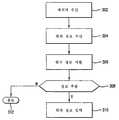
도 3은 한 실시예에서 무선장치(202) 상에 수신된 메시지로부터 위치 정보를 추출하는 방법의 순서도,3 is a flowchart of a method of extracting location information from a message received on a
도 4는 본 발명의 실시예에서 인터넥티브 실시간 분산 네비게이셔 시스템에서 새로운 어카운트(account)를 생성하는 방법의 순서도,4 is a flow chart of a method for creating a new account in an interactive real-time distributed navigator system in an embodiment of the present invention;
도 5는 본 발명의 실시예에서 인터넥티브 실시간 분산 네비게이셔 시스템에 자동적으로 로그 인하는 방법의 순서도,5 is a flow chart of a method for automatically logging in to an interactive real-time distributed navigator system in an embodiment of the present invention;
도 6은 본 발명의 실시예에서 인터넥티브 실시간 분산 네비게이셔 시스템에 미리 계획된 정보를 제공하는 방법의 순서도,6 is a flow chart of a method for providing preplanned information to an interactive real-time distributed navigator system in an embodiment of the present invention;
도 7은 본 발명의 실시예에서 인터넥티브 실시간 분산 네비게이셔 시스템으로부터 미리 계획된 정보를 검색하는 방법의 순서도,7 is a flow chart of a method for retrieving preplanned information from an interactive real-time distributed navigator system in an embodiment of the present invention;
도 8은 본 발명의 실시예에서 인터넥티브 실시간 분산 네비게이셔 시스템으로 퍼지 출발지 또는 목적지를 입력하기 위한 방법의 순서도,8 is a flow chart of a method for entering a fuzzy origin or destination into an interactive real time distributed navigator system in an embodiment of the present invention;
도 9는 본 발명의 실시예에서 인터넥티브 실시간 분산 네비게이셔 시스템에서 대체 저장장소에 정적 네비게이션 정보를 저장하는 방법의 순서도,9 is a flowchart of a method for storing static navigation information in an alternate storage location in an interactive real-time distributed navigator system according to an embodiment of the present invention;
도 10은 본 발명의 실시예에서 인터넥티브 실시간 분산 네비게이셔 시스템으로부터 주행된 많은 대부분의 최근 라우트를 검색하는 방법의 순서도,10 is a flow chart of a method for retrieving many of the most recent routes traveled from an interactive real time distributed navigator system in an embodiment of the present invention;
도 11A는 본 발명의 실시예에서 인터넥티브 실시간 분산 네비게이셔 시스템에 비-결정적 정보(non-deterministic information)를 입력하는 방법의 순서도,11A is a flow chart of a method for inputting non-deterministic information into an interactive real-time distributed navigator system in an embodiment of the present invention;
도 11B는 본 발명의 실시예에서 인터넥티브 실시간 분산 네비게이셔 시스템에의 서버에 기초한 위치 입력을 구현하는 방법의 순서도,11B is a flow diagram of a method for implementing server based location input to an interactive real time distributed navigator system in an embodiment of the present invention;
도 12는 본 발명의 실시예에서 인터넥티브 실시간 분산 네비게이셔 시스템에서 현재 위치를 북마크(bookmarking)하는 방법의 순서도,12 is a flowchart of a method for bookmarking a current location in an interactive real-time distributed navigator system in an embodiment of the present invention;
도 13은 본 발명의 실시예에서 인터넥티브 실시간 분산 네비게이셔 시스템에서 사용자의 지역에 대한 회합 장소로서 "Here"를 송신하는 방법의 순서도, 및13 is a flowchart of a method for transmitting “Here” as a meeting place for a user's region in an interactive real-time distributed navigator system in an embodiment of the invention, and
도 14는 본 발명의 실시예에서 인터넥티브 실시간 분산 네비게이셔 시스템에서 가청 응답 능력을 개선하기 위해 감소된 가청 문법을 질의하는 방법의 순서도.
14 is a flowchart of a method for querying a reduced audible grammar to improve audible response capability in an interactive real-time distributed navigator system in an embodiment of the present invention.
도 1은 본 발명의 한 실시예에 따른 인터렉티브 실시간 분산 네비게이션 시스템(interactive real-time distributed navigation system)의 아키텍춰를 도시한다. 다양한 구성요소 및 그 상호작용이 지금부터 설명될 것이다. 유사한 도면부호가 서로 다른 도면에서 사용되는데 유사한 도면부호가 동일한 구성요소를 가리킨다는 것을 알아야 한다. 무선 장치(202)는 셀룰러 전화기, 위성 전화기, 무선 퍼스널 디지털 어씨스턴트(PDA), 퍼스널 컴퓨터 또는 무서 통신 능력을 갖는 다른 적합한 장치의 형태를 취할 수 있다. 바람직하게, 무선 장치(202)에는, 예를 들어 글로벌 포지셔닝 시스템(global positioning system, GPS), 비상 911(E911) 위치 또는 도면이 이용가능하게 될 수 있는 것을 포함하는 다른 것들의 형태를 취하는 포지셔닝 능력이 구비된다. 현재, 사용자에게 정보를 제시하는 무선 어플리케이션 프로토콜에 따라 인에이블되는 무선 전화기가 다양한 제조업체에 의해 만들어지고 있다. 제조업체는 AT&T, SPRINT PCS, GTE WIRELESS를 포함한다. 특정 실시예에서, 이와 같은 전화기는 무선 장치(202)로서 사용하기에 적합하다. 더욱이, PHONE.COM은 테스트 및 모델링에 적합한 SDK라고 하는 제품을 만들고 있다. 이와 같은 종류의 제품들은 또한 본 발명과 함께 사용하도록 의도되어 있다. 기술분야의 숙련자는 본 발명이 임의의 특정 포지셔닝 기술에 제한되어 있지 않다는 것을 알 것이다. 한 실시예에서, 무선 장치(202)에는 내장된 포지셔닝 능력이 구비된다. 포지셔닝 정보의 현재 이용가능한 제공업체는 RRICSSON, QUALCOMM, MOTOROLA, LUCENT 및 US WIRELESS를 포함한다.1 illustrates the architecture of an interactive real-time distributed navigation system in accordance with one embodiment of the present invention. Various components and their interactions will now be described. It is to be understood that like reference numerals are used in different figures and like reference numerals refer to the same components.
특정 실시예에서, 무선 장치(202)는 맵 정보를(map information)를 운반할 필요가 없거나 또는 무선 장치(202)의 저장 능력에 다라 선정된 양의 맵 정보를 운반할 수 있다. 이와 같은 시스템은 분산 시스템으로서 설명되고 이하에 더 상세히 설명될 것이다.In certain embodiments, the
한 실시예에서, 무선 장치(202)의 능력은 모듈러 부착물과의 인터페이스를 통해 강화된다. 무선 장치(202)의 필수 기능은 본 발명의 네비게이션 시스템 또는 사용자 간에 인터페이스를 제공한다. 특히, 무선 장치(202)는 그래픽, 텍스트 또는 오디오 정보를 디스플레이하기 위한 사용자 인터페이스(205)를 제공한다. 예시적인 시나리오에서, 사용자는 지정학적 마커(geographic marker) 또는 다른 자극을 감지한 다음, 생각 속으로 이와 같은 정보를 처리한다. 다음에 사용자는 사용자 인터페이스(205)를 통해 적당한 입력을 제공하므로써 본 발명의 시스템 및 장치를 이용하여 이와 같은 종류의 처리된 정보를 이용할 수 있다. 사용자 인터페이스(205)는 또한, 예를 들어 전자기계적 구성요소가 개입되어 있는 작업을 완료하기 위한 명령어를 제공할 수 있다. 예를 들어, 본 발명의 네비게이션 시스템이 자동차에 일체화되는 경우, 개선된 동작은 자동차를 임의의 위치 또는 방향으로 이동시킬 필요가 있을 수 있다. 사용자 인터페이스(205)를 통해, 사용자는 자동차를 이동시키고 위치시키는 방법에 대한 특정 명령어를 수신할 수 있다. 이와 같은 상호작용은, 상호작용이 텍스트, 그래픽 또는 가청 신호를 통해 달성되는 본 발명의 시스템의 포지셔닝 정확도를 개선하는데 사용된다. 서로 다른 인간 센서(human sensor)를 이용한 다양한 수정이 명확할 것이고, 본 발명의 범위 내에 있는 것으로 간주된다.In one embodiment, the capability of the
무선 장치(202)가 오디오 신호에 의해 또는 디스플레이된 텍스트를 통해 사용자에게 정보를 중계할 수 있기 때문에, 본 발명의 실시예는 텍스트 디스플레이 장치는 물론, 가청 소리 발생 장치를 사용한다. 텍스트 디스플레이 장치가 사용되면, 텍스트의 몇 개 라인을 디스플레이할 수 있는 무선 장치(202)를 사용하여 개선된 성능이 달성된다. 맵 및 증가된 지시 정보를 디스플레이하는 사용하기 위한 무선 장치(202)를 위해 개선된 비디오 디스플레이가 또한 고려된다. 다른 실시예에서, 무선 장치(202)에는 자이로스코픽(gyroscopic) 또는 지정학적 개선으로 일체화된다. 이와 같은 개선은 실시간 위치 및 방향 정보를 제공하는데 사용될 수 있다. 기술분야의 숙련자는 본 발명의 가르침으로부터 벗어나지 않고 무선 장치(202)에 대해 많은 개선이 가능하다는 것을 알 것이다.Since the
도 1에 자세히 도시된 바와 같이, 무선 캐리어(204)는 무선 장치(202) 및 이하에 설명될 분산 네비게이션 서버(212) 간의 무선 접속을 제공한다. 본 발명의 한 실시예에서, WINDOWS NT 서버는 운영 플랫폼으로서 사용된다. 무선 캐리어(204)의 예는, 셀룰러 전화 캐리어, 위성 통신 캐리어 또는 글로벌 포지셔닝 시스템 캐리어를 포함한다. 무선 접속을 달성하는데 있어서, 무선 캐리어는 무선 장치 및 분산 네비게이션 서버에 대한 기존의 하부구조를 제공한다. 한 실시예에 서, GPS는 정부가 정한 선택적 이용가능성(S/A)과 함께 이용된다. 기술분야의 숙련자는 이와 같은 제한이 없어지면, 본 발명은 더욱 개선될 수 있다는 것을 알 것이다. 사용자와의 적응적 인터페이스로 인해, 일반적인 것에서 매우 특정한 것까지 미치는 정보가 광범위한 네비게이션 어플리케이션을 위해 사용자에 중계된다.As shown in detail in FIG. 1, the
비록 본 발명의 가르침 내에 있지만, 무선 캐리어(204)는 GPS, E911 또는 다른 포지셔닝 시스템과 같은 포지셔닝 정보를 제공한다. 부수적으로, 포지셔닝 정보는 제3자로부터 얻어진 다음에 무선 캐리어(204)에 의해 사용된다. 예를 들어, 다른 것들 중에서도 무선 서비스 재판매업체, 무선 인터넷 서비스 제공자(ISP) 또는 위성 무선 캐리어는 본 발명의 실시예에서 구현될 수 있는 서비스를 제공한다. 중요하게, 무선 수율 및 대역은 디지털 전송의 도래 및 다른 기술을 통해 계속 증가하고 있다. 아날로그(즉, AMPS) 시스템은 일정한 수준의 서비스를 제공한다. 그러나, GSM, TDMA, CDMA를 포함하지만 이에 국한되지 않는 보다 개선된 디지털 전송 기법이 보다 높은 데이터 수율을 제공한다. 본 발명이 개발될 때, CDMA는 정보의 최고 수율을 제공하는 것으로 간주되지만, 무선 기술이 더욱 개발될 것으로 예상된다. 그 대역 어플리케션 때문에, 본 발명은 이들 및 다른 많은 전송 기법에 적합하다. 본 발명의 실시예에서, 무선 캐리어(204)는 무선 장치(202)로부터 아날로그 또는 디지털 정보를 수신하고, 이와 같은 정보를 서버(212)와 같이 본 발명의 시스템의 다른 구성요소에 전달한다. 유사하게, 무선 캐리어(204)는 서버(212)와 같이 본 발명의 구성요소로부터 정보를 수신한 다음, 이 정보를 무선 장치(2040에 전송한다.Although within the teachings of the present invention, the
도 1에 도시된 바와 같이, 무선 캐리어(204)는 네트워크(208)에의 인터페이스를 제공하는 게이트웨이(206)에 접속된다. 일반적으로, 게이트웨이(206)는 다른 네트워크에의 진입으로서 작용하는 네트워크 포인트이고, 다른 것들 중에서도 무선 캐리어, ISP 또는 다른 원거리 통신 제공자에 의해 제공된다. 본 발명의 한 실시예에서, 네트워크(208)는 인터넷이다. 인터넷은, 전세계 많은 지역에 도달하는 광범위하게 분산된 네트워크이기 때문에 장점을 제공한다. 다른 실시예에서, 네트워크(208)는 전용 통신 네트워크로서 구현된다. 예를 들어, 전용 통신 네트워크 접속을 이용하므로써, 네트워크(208)는 최소 지연 및 최적의 성능을 제공하도록 커스텀화될 수 있다(customized).As shown in FIG. 1, the
도 1에 도시된 바와 같이, 바람직한 실시예에 따르면, 하나 이상의 분산 네비게이션 서버(212)는 본 발명의 시스템의 일부를 형성하고, 통신 네트워크(208)를 사용하여 그 다른 구성요소와 통신한다. 바람직한 실시예에서, 분산 네비게이션 서버(212)는 관심있는 정보의 포인트 및 거리 맵 정보를 저장하고, 또한 처리 작업을 수행한다. 이와 같이, 무선 장치(202)는 적절한 네비게이션을 위해 모든 필요한 정보를 운반하지 않아도 된다. 한 실시예에서, 분산 네비게이션 서버(212)는 또한 실시간 트래픽 정보와 같은 위치 특정 정보를 처리한다. 한 실시예에서, 트래픽 정보는 네비게이션 서비스 사용자의 그룹으로부터 얻어진다. 그들 위치, 속도 및 시간을 관찰 및 비교하고, 맵 데이터베이스에서 공칭 거리 속도 제한과의 추가적인 비교를 수행하므로써, 실시간 트래픽 정보가 발생된 다음 본 발명에 의해 사용된다. 적합한 맵 데이터베이스는 그 "DRILL DOWN SERVER"와 함께 TELCONTAR, "GEOSTAN LIBRARY"와 함께 QUALITY MARKETING SOFTWARE, 및 그 디지털 맵 제품과 함께 NAVTECH에 의해 제공될 수 있다. 더욱이, 적합한 트래픽 정보는 ETAK, TRAFFICSTATION.COM 및 METROWORKS를 포함한다. 바람직한 실시예에서, 목적지로 가는 각각의 교차점에서, 시스템은 끊임없이 변하는 조건에 응답해서 특정 사용자에 대한 최적의 라우트를 동적으로 결정한다. 예를 들어, 변경된 조건으로 인해 제1 라우트가 덜 최적이되는 경우, 제2 라우트가 발생되고 사용자에게 제시된다. 최적의 라우트는 사용자의 선호에 따라 몇가지 방법으로 결정된다. 예를 들어, 최적의 라우트는 최소 시간, 최소 거리 또는 연료의 최소 소비에 기초하여 결정된다. 네비게이션 안내 알고리즘과 같은 프로세서 집중 함수들은 무선 장치(202)에 대한 연산 부담을 줄이기 위해 분산 네비게이션 서버(212)에 의해 처리된다. 한 실시예에서, 분산 네비게이션 서버(212)의 처리 기능의 일부로서, 이들 서버들은 HDML 또는 WML에서 HTML 간 그리고 그 역으로의 변환 기능을 제공한다.As shown in FIG. 1, according to a preferred embodiment, one or more distributed
본 발명의 시스템 아키텍춰의 대체 실시예가 도 2A에 도시된다. 도면에 도시된 바와 같이, 무선 장치(202), 무선 캐리어(204), 및 분산 네비게이션 서버(212)는 도 1에 대해 설명된 것과 실질적으로 동일하다. 그러나, 다이렉트 링크(direct link)(210)은 도 1의 게이트웨이(206) 및 네트워크(208)의 기능에 대한 대체 실시예를 제공한다. 다이렉트 링크 아키텍춰는 인터넷 하부구조가 잘 수립되어 있지 않거나 또는 사용자 네비게이션 또는 다른 위치 특정 정보 서비스를 위해 고속 응답이 요구되는 경우에 적용가능하다. 도면에서, LAN 또는 WAN에 의해 링크된 T1 프레임 릴레이(frame relay) 등은 다이렉트 링크(210)에 적합하다. 다 른 실시예에서, 다이렉트 링크(210)는 전용선으로서 구현된다. 선택적으로, 다이렉트 링크(210)는, 무선 캐리어(204)와 분산 네비게이션 서버(212)가 중앙국에 배열되어 있는 무선 캐리어(204)와 분산 네비게이션 서버(212) 간의 하드 와이어(hard wired) 접속으로서 구현된다.An alternative embodiment of the system architecture of the present invention is shown in FIG. 2A. As shown in the figure, the
본 발명의 시스템은, 본 발명의 사용자를 위해 효율적인 환경을 구축하기 위해 맵,지정학적, 개인적 및 위치 정보를 포함하는 정보의 풀(pool)을 이용한다. 본 발명은 이하에 설명되는 바와 같이, 네비게이션 시스템의 운영 환경을 개선하기 위한 기술을 포함한다.The system of the present invention utilizes a pool of information, including map, geopolitical, personal and location information, to establish an efficient environment for the user of the present invention. The present invention includes techniques for improving the operating environment of a navigation system, as described below.
본 발명의 한 실시예에 따르면, 무선 어플리케이션 프로토콜(WAP)에서 무선 마크업 언어(WML)는 본 발명의 시스템 및 방법에 의해 사용된다. WAP에서의 WML은 인터넷 프로토콜(IP)에서 하이퍼텍스트 마크업 언어(HTML)와 유사하다. WML은 WAP 포럼에 의해 유지되는 것으로서 "WAP WML"에 정의되어 있고, www.wapforum.com에서 얻을 수 있다. 이와 같은 문서는 본 발명에 참조로서 일체화되어 있다. WML은 네비게이션 지원, 데이터 입력, 하이퍼링크, 텍스트 및 이미지 프리젠테이션, 및 형태를 제공하는 태그에 기초한(tag-based) 디스플레이 언어이다. WAP 어플리케이션의 사용자 인터페이스(UI)는 하나 이상의 카드로 구성된 덱(deck)의 모델을 사용하여 구성된다. 다른 것들중에서도, WML은 사용자게 입력을 제공하게 하는 엘리먼트를 포함하며, 네비게이션 및 작업 호출 제어를 제공한다. 더욱이, WML은 카드의 덱을 위해 액세스 제어를 구현하는 방법을 포함한다.According to one embodiment of the present invention, wireless markup language (WML) in a wireless application protocol (WAP) is used by the system and method of the present invention. WML in WAP is similar to Hypertext Markup Language (HTML) in the Internet Protocol (IP). WML is maintained by the WAP Forum and is defined in "WAP WML" and can be obtained fromwww.wapforum.com . Such documents are incorporated herein by reference. WML is a tag-based display language that provides navigation support, data entry, hyperlinks, text and image presentation, and forms. The user interface (UI) of a WAP application is constructed using a model of a deck of one or more cards. Among other things, WML includes elements that provide input to the user, and provide navigation and job call control. Moreover, WML includes a method of implementing access control for a deck of cards.
요약해서, WML 엘리먼트는 엘리먼트가 시작 태그, 내용 및 종료 태그를 포함 할 수 있는 WML 덱(deck)에 대한 마크업 및 구조 정보를 지정한다. 또한, WML 속성은 엘리먼트에 대한 부수적인 정보를 명시한다. WML 카드 및 덱(card and deck)은 변수를 사용하여 파라메타화될 수 있다. 또한, WML 정의를 위반하는 WML 덱은 에러이고 플래그된다. WML은 네비게이션 및 이벤트-핸들링 모델(event-handling model)을 포함한다. 연관된 엘리먼트로서 이를 이용하는 사람은 사용자 에이젼트 이벤트의 처리를 명시할 수 있게 된다.In summary, the WML element specifies markup and structure information for the WML deck in which the element may include a start tag, content, and end tag. In addition, the WML attribute specifies additional information about the element. WML cards and decks can be parameterized using variables. Also, WML decks that violate WML definitions are errors and flagged. WML includes navigation and event-handling models. The person using it as an associated element can specify the processing of the user agent event.
마크업 및 프로그래밍 언어에 흔한 바와 같이, WML은 언어를 적절히 사용하기 위하 일단의 정의된 규칙을 엄격히 참조할 것을 필요로 한다. 따라서, 이와 같은 언어를 이용하는 프로그래머는 구문을 이해하고 이를 적절히 적용하여야 한다. 본 발명의 한 실시예에서, WML의 일부를 캡슐화하고 오브젝트 지향 방법으로 WML 어플리케이션의 생성을 훨씬 용이하게 하는 클래스 계층을 생성하는 WML 파운데이션 클래스(foundation class)가 정의된다. 더욱이, 이와 같은 클래스는 현재 이용가능한(버젼 1.0 및 1.1) WML의 버전 모두에 유용하고, 장래에 개발될 버전에 적용가능하다. 파운데이션 글래스의 장점은, 프로그래머가 유용한 WML 덱을 개발할 수 있다는 효율성이다. 더욱이, 파운데이션 클래스는 WML 덱을 생성하기 위해 작성되어야 하는 코드의 양을 감소시킨다.As is common with markup and programming languages, WML requires strict reference to a set of defined rules in order to use the language properly. Therefore, a programmer using such a language must understand the syntax and apply it appropriately. In one embodiment of the invention, a WML foundation class is defined that creates a class hierarchy that encapsulates a portion of the WML and makes the creation of a WML application much easier in an object-oriented manner. Moreover, such classes are useful for all of the currently available versions of WML (versions 1.0 and 1.1), and are applicable to future versions. The advantage of FOUNDATION GLASS is that the programmer can develop useful WML decks. Furthermore, the foundation class reduces the amount of code that must be written to generate the WML deck.
도 2B는 본 발명의 실시예에서 파운데이션 클래스(foundation class)를 개발하는 방법을 도시한다. 단계(272)에서, 클래스 계층이 정의된다. 한 실시예에서, 고(go), 이전(previous), 연산없음 및 리프레시 엘리먼트(refresh element)가 작업 엘리먼트의 서브클래스로서 보이며, 계층이 자연적이다. WML 내의 다른 엘리먼트 도 유사하게 구성된다. 오브젝트의 범용 클래스는, 포함하는 데이터의 종류 및 이를 조작할 수 있는 로직 시퀀스를 포함하는 이와 같은 계층으로부터 단계(274)에서 정의된다. 더욱이, 단계(276)에서, 로직 시퀀스를 구현하는 방법이 정의되고, 단계(278)에서, 변수가 정의된다. 따라서, 이 방법 및 변수는 언어 명령어를 제공한다.2B illustrates a method of developing a foundation class in an embodiment of the invention. In
본 발명의 파운데이션 클래스를 사용하므로써, 프로그래머는 필요한 사용자 인터페이스 및 제어를 생성한다. 더욱이, 프로그래머는 이벤트를 호출한 제어에 덱이 어떻게 응답하는 지를 제어할 수 있다. 본 발명의 파운데이션 클래스는 WML의 적절한 구현에 필요한 모든 코드를 포함하도록 개발되었다. 따라서, 파운데이션 클래스를 사용하여 코딩하므로써, WML만 그러나 모든 그와 같은 기능을 사용하는 것보다 짧은 리스팅을 생성할 수 있다. 본 발명의 한 실시예에서, 파운데이션 클래스는 파운데이션 클래스 및 WML간의 긴밀한 관계로서, 그 사용에 의해 부과되는 성능 패널티는 거의 없다. 따라서, 프로그래밍 용어에서, 파운데이션 클래스의 구현은 큰 오버헤드 비용을 초래하지 않는다.By using the foundation class of the present invention, the programmer creates the necessary user interface and control. Moreover, the programmer can control how the deck responds to the control that invoked the event. The foundation class of the present invention was developed to include all the code necessary for proper implementation of WML. Thus, by coding using a foundation class, you can create listings that are shorter than using WML but all such features. In one embodiment of the present invention, the foundation class is a tight relationship between the foundation class and the WML, with little performance penalty imposed by its use. Thus, in programming terms, the implementation of the foundation class does not incur a large overhead cost.
본 발명에 따라 사용된 WML 파운데이션 클래스의 장점은, 그 계층이 최적 방법으로 필요하고 적절한 구문을 포함하여, 프로그래머는 특정 어플리케이션을 위한 이상적인 구문을 생성할 부담이 없다는 것이다. 본 발명의 실시예가 도 2C에 도시되는데, 도 2C는 자바로 구현된 본 발명의 파운데이션 클래스 및 서버 환경을 도시한다. WML 파운데이션 클래스(252)가 개발된 후, 개발자는 WML 구문(256)에서 직접 자바 서브렛(Java servelet)을 개발할 필요가 없다. 대신에, 개발자는 덱 및 카드(deck and card)를 위한 에러없고 튼튼한 WML 구문(256)을 생성하기 위해 WML 구문(256)을 사용하여 서브렛(252)에 WML 덱 및 카드를 생성한다. 따라서, WML 파운데이션 클래스는 세부사항, 구문 및 언어 버전으로부터 어플리케이션을 격리시키는 층을 부가한다. WML 구문이 변하면, WML 파운데이션 클래스는 변할 필요가 없어, 덱 및 카드를 생성하는 작업 단순화시킨다. 본 발명의 한 실시예에서, WML 파운데이션 클래스 엘리먼트는 헤더, 선택 리스트, 플래인 텍스트(plain text), 본체, 덱(deck), 카드(card), 등을 생성하는 함수을 포함한다. 예시 목적으로, 자바 코드의 샘플링 리스트는 부록 A에 포함되어 있다.The advantage of the WML Foundation class used in accordance with the present invention is that the programmer does not have the burden of generating the ideal syntax for a particular application, including its proper and necessary syntax. An embodiment of the invention is shown in Figure 2C, which illustrates the foundation class and server environment of the invention implemented in Java. After the WML Foundation class 252 is developed, the developer does not need to develop a Java servelet directly in the WML syntax 256. Instead, the developer creates WML decks and cards in servlet 252 using WML syntax 256 to generate error-free and robust WML syntax 256 for decks and cards. Thus, the WML Foundation class adds a layer of isolation of applications from details, syntax, and language versions. If the WML syntax changes, the WML Foundation class does not need to change, simplifying the creation of decks and cards. In one embodiment of the present invention, the WML Foundation class element includes a function for generating a header, a select list, plain text, a body, a deck, a card, and the like. For illustrative purposes, a sampling list of Java code is included in Appendix A.
샘플링 리스트에서, 사용되는 다양한 WML 파운데이션 클래스 엘리먼트는,WmlDeck, WmlCard, WmlDoElement, wmlAction, wmlAction.setTaskElement, WmlGoElement 등을 포함한다. 본 발명의 WML 파운데이션 클래스의 계층 및 구조의 실시예가 도 2D에 도시된다. 도 2D에 도시되고 부록 A의 리스트에서 사용된 엘리먼트에서, WML 구문과 유사한 것이 대응하는 WML 파운데이션 클래스 엘리먼트를 인식하도록 파운데이션 클래스는 WML 구문에 대해 얇은 층이다. 예를 들어, 파운데이션 클래스에서 "WmlGoElement"는 WML 구문 "go"에 긴밀히 대응한다. 도 2D에 도시된 다른 파운데이션 클래스 엘리먼트에 대해 동일한 것이 수행될 수 있다. 그러나, 파운데이션 클래스는, 경험없는 프로그래머가 파운데이션 클래스를 근본적으로 이해하여 튼튼하고 독특한 코드를 생성할 수 있게 하는 보다 직선적이고 튼튼한 방법을 제공한다. 더욱이, WML 구문이 변하고 발전함에 따라, 동일한 프로그래머는 그 코드 및 그 코딩 기법을 변경할 필요가 없다.In the sampling list, the various WML Foundation class elements used include WmlDeck, WmlCard, WmlDoElement, wmlAction, wmlAction.setTaskElement, WmlGoElement, and so on. An embodiment of the hierarchy and structure of the WML Foundation class of the present invention is shown in FIG. 2D. In the elements shown in FIG. 2D and used in the list in Appendix A, the foundation class is a thin layer for the WML syntax so that similar to the WML syntax recognizes the corresponding WML Foundation class element. For example, "WmlGoElement" in the foundation class closely corresponds to the WML syntax "go". The same can be done for the other foundation class elements shown in FIG. 2D. However, foundation classes provide a more straightforward and robust way for inexperienced programmers to fundamentally understand foundation classes to generate robust and unique code. Moreover, as the WML syntax changes and evolves, the same programmer does not need to change its code and its coding technique.
본 발명의 실시예에서, 무선 장치(202)는, 이와 같은 텍스트 메시지가 거리 주소와 같은 위치 정보를 포함할 수 있는 텍스트 메시지를 수신하도록 구성된다. 네비게이션 시스템에 사용하기 위해 텍스트 메시지로부터 이와 같은 위치 정보를 자동적으로 추출하므로써 개선된 네비게이션 환경을 제공하는 것이 바람직하다.In an embodiment of the invention, the
위치 정보(location information)는 흔히 "성 이름, 거리 주소, 도시, 주, 우편번호"의형태로 거리 주소로서 제공된다. 선택적으로, 거리 주소는 "거리 주소, 도시, 주"의 형태를 가질 수 있다. 기술분야에 공지된 바와 같이 위치를 명시하는 다른 형태가 존재하고, 본 발명에 사용하도록 의도된다. 예를 들어, 미국 이외의 국가에서 주소는 일반적으로 알려져 있는 다른 우편 코드 또는 형식의 형태를 가질 수 있다.Location information is often provided as street address in the form of "last name, street address, city, state, zip code". Optionally, the street address may take the form of "street address, city, state". As are known in the art, other forms of specifying locations exist and are intended for use in the present invention. For example, in countries other than the United States, addresses may have the form of other postal codes or formats commonly known.
본 발명의 바람직한 실시예에서, 무선 장치(202)는 전자적 이메일 또는 짧은 메시지 서비스(SMS)를 수신하도록 구성되어 있다. 다른 실시예에서, 무선 장치(202)는 웹 브라우저 능력을 갖도록 구성된다. 모두의 경우에, 이 장치는 다른 것들 중에서도 텍스트를 수신한다. 이와 같은 텍스트에서, 거리의 주소 또는 교차점과 같은 것을 포함하는 위치 정보가 제공될 수 있다.In a preferred embodiment of the present invention, the
상기 또는 다른 이용가능한 서비스에 의해 이용가능하고 무선 장치(202)에 의해 수신되는, 위치 정보를 추출하는 방법이 도 3에 도시된다. 단계(302)에서, 사용자는 텍스트 메시지를 포함할 수 있는 메시지를 수신한다. 메시지에 내장된 위치 정보의 존재는 단계(304)에서 자동적으로 인식되고, 정보는 단계(306)에서 식별된다. 예시적으로 그리고 제한없이, 위치의 식별시, 본 발명의 시스템은 이 위치 정보를 사용자에게 하이라이트(highlights)한다. 다음에 사용자는 단계(310)에서 네비게이션 시스템의 입력을 위해, 단계(308)에서 위치 정보를 추출하는 선택을 한다. 선택적으로, 사용자는 단계(308, 312)에서 식별된 위치 정보를 무시할 수 있다. 본 발명에 따르면, 위치 정보를 네비게이션 시스템에 입력하는 것은 다양한 형태를 취할 수 있다. 한 실시예에서, 위치 정보는 네비게이션 시스템에 직접 입력되고, 사용자를 이와 같은 위치로 즉시 네비게이트하는데 사용된다. 다른 실시예에서, 위치 정보는 나중에 사용하기 위해 네비게이션 시스템에 저장된다. 이와 같은 실시예의 특징은 이하의 미리 계획 환경(preplanning environment)의 문맥에 설명된다. 본 발명으로부터 벗어나지 않고 대체 실시예가 존재한다. 수신된 위치 정보의 사용자 처리를 지시할 디스플레이 루틴은 서로 다른 형태를 취할 수 있지만, 일반적으로 직선적(straightforward)이고 상세히 설명되지 않을 것이다.A method of extracting location information available by the
주소를 포함하는 위치 정보는 전형적으로 위에서 설명된 형태로 이용가능하다. 본 발명에 따르면, 주소와 같은 위치의 특성은 사용자에게 제시하기 위해 식별된다. 본 발명의 한 실시예에서, 시스템은 텍스트 메시지 내의 주 명칭 또는 그 축약(즉, 캘리포니아를 CA, 뉴욕을 NY로 하는 것처럼)의 제시를 식별한다. 상태 명을 식별한 후, 시스템은 도시, 거리 주소, 및/또는 수신자 명을 식별하는 처리를 한다. 본 발명의 다른 실시예에서, 시스템은 우편번호를 식별하고, 다른 중요한 주소 정보를 검색하는 처리를 수행한다. 또 다른 실시예에서, 거리 주소가 먼저 식별되고, 다음에 다른 정보가 추출되어 처리된다. 기술분야의 숙련자는 본 발명 의 가르침 내에서 다양한 변화가 있을 수 있다는 것을 알 것이다.Location information, including the address, is typically available in the form described above. According to the invention, the characteristics of the location, such as the address, are identified for presentation to the user. In one embodiment of the invention, the system identifies the presentation of the state name or abbreviation (ie, California as CA, New York as NY) in the text message. After identifying the status name, the system performs a process to identify the city, street address, and / or recipient name. In another embodiment of the present invention, the system performs processing to identify postal codes and to retrieve other important address information. In another embodiment, street addresses are first identified and then other information is extracted and processed. Those skilled in the art will appreciate that various changes may be made within the teachings of the present invention.
본 발명의 또 다른 실시예에서, 위치는 선정된 구획 문자(delimiter)를 삽입하여 인식되는데, 이로 인해 전자적 메시지 내에 내장된 위치 정보의 인식이 가능하게 된다. 예시적으로 그리고 제한없이, 위치는 다음과 같이 인코드될 수 있다: John Smith, @123 Main Street, @Anytown, @CA 94321 (여기서, 주소의 필드는 구획 문자에 의해 분리된다) 다른 구획 문자가 사용될 수 있으며, 본 발명의 가르침 내에서 주소의 각 부분에 대한 서로 다른 구획 문자가 사용될 수 있다는 것을 알 것이다. 본 실시예에서, 본 발명은 선정된 구획 문자를 검색하고, 구획된 정보를 추출한다. 기술분야의 숙련자는 모든 정보가 모든 목적을 위해 필요하지 않다는 것을 알 것이다. 예를 들어, 특정 환경에서, 특정 주소와 같은 극히 특정한 위치가 필요하다. 다른 상황에서는, 도시 또는 우편번호와 같이, 일반적인 지역 정보만이 충분할 것이다. 어느 경우든, 본 발명의 시스템은 이와 같은 위치 정보를 식별하며 이를 사용자에게 제시한다. 이때 사용자는 필요에 따라 위치 정보를 이용할 수 있다.In another embodiment of the present invention, the location is recognized by inserting a predetermined delimiter, which enables the recognition of the location information embedded in the electronic message. By way of example and without limitation, the location can be encoded as follows: John Smith, @ 123 Main Street, @Anytown, @CA 94321 (where fields of addresses are separated by delimiters). It will be appreciated that different delimiters for each part of the address may be used within the teachings of the present invention. In the present embodiment, the present invention searches for the selected delimiter character and extracts the delimited information. Those skilled in the art will appreciate that not all information is necessary for all purposes. For example, in certain circumstances, very specific locations such as specific addresses are required. In other situations, only general regional information would be sufficient, such as city or postal code. In either case, the system of the present invention identifies such location information and presents it to the user. In this case, the user may use the location information as needed.
본 발명의 다른 실시예에서, 거리의 교차점로서 식별된 위치 정보가 추출되고 이용된다. 선택적으로, 위치는 "University Avenue and Middlefield Road"의 교차점로서 주어질 수 있다. 본 예에서, "Avenue" 및 "Road"라는 용어의 사용은 거리를 식별하는데 사용된다. 다른 주요 용어는 그 연관된 축약은 물론 거리, 블러바드, 도로 등을 포함할 수 있다. 거리 교차점의 형태로의 위치 정보는 이전에 설명된 바와 같이 사용자에게 제시되어 유사하게 이용된다. 다른 실시예에서, 거 리는 독특한 구획 문자로서 식별되어 유사한 방식으로 사용된다.In another embodiment of the present invention, location information identified as the intersection of distances is extracted and used. Optionally, the location may be given as an intersection of "University Avenue and Middlefield Road". In this example, the use of the terms "Avenue" and "Road" is used to identify the distance. Other key terms may include streets, Boulevards, roads, etc., as well as their associated abbreviations. Location information in the form of distance intersections is presented to the user and used similarly as previously described. In another embodiment, distances are identified as unique delimiters and used in a similar manner.
본 발명의 바람직한 실시예에서, 무선 장치(202)는 사용자로부터 입력을 수신하고 사용자에게 출력을 제공하도록 구성되어 있다. 무선 장치(202)는 전형적으로 제한된 입력 능력을 가져서, 무선 장치(202)를 통한 집중적인 사용자 입력은 운영 환경으로서 성가실 수 있다. 따라서, 사용자가 네비게이션 시스템을 사용하면서 감소된 수의 입력을 공급하는데 필요한 개선된 운영 환경을 제공하는 것이 바람직하다. 따라서, 예를 들어, 사용자가 운전하는 경우, 본 발명의 가르침에 따른 개선된 운영 환경은 최소 사용자 입력을 갖는 중요한 네비게이션 출력을 제공한다. 따라서, 사용자로 하여금 시간 이전에 대체 장치를 통해 복잡한 정보를 입력할 수 있게 하는 개선된 운영 환경을 제공하는 것이 바람직하다. 본 발명은, 사용자로 하여금, 예를 들어 커스텀화된 웹 사이트를 통해 시간 이전에 정보를 입력할 수 있게 하는 개선된 운영 환경을 제공한다. 선택적으로, 본 발명은 사용자로 하여금 음성 입력에 의해 정보를 입력할 수 있게 하는 개선된 환경을 제공한다.In a preferred embodiment of the present invention, the
본 발명의 실시예에서, 네비게이션 시스템은, 도 1 및 도 2A에 도시된 바와 같이, 또한 웹 서버를 서비스할 수 있는 서버(212)에 접속된다. 사용자는 무선 장치(202)를 통해 이전에 설명한 바와 같이 시스템과 인터페이스한다. 본 발명의 실시예에서, 사용자는 인터넷에 접속된 컴퓨터(214)를 통해 또는 대체 통신 수단을 통해 시스템과 인터페이스할 수 있다. 대체 실시예에서, 컴퓨터(214)는 웹 브라우저를 사용하므로써 서버(212)에 액세스하여 사용자 및 네비게이션 시스템에 미리 계획된 정보를 제공한다.In an embodiment of the invention, the navigation system is connected to a
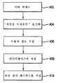
사용자 정보를 제공하는데 있어서, 예를 들어 도 4에 도시된 방법을 사용하여 사용자 어카운트(user account)가 먼저 생성되어야 한다. 적당한 웹 브라우저를 갖는 컴퓨터(214)를 사용하여, 단계(402)에서 사용자는 서버(212)에 액세스한다. 바람직한 실시예에서, 컴퓨터(214)는 무선 장치(202) 보다 많은 연산력 및 메모리를 갖도록 구성된다. 기존의 어카운트 없이 처음에 서버(212)에 액세스시, 사용자는 단계(404)에 도시된 바와 같이 "New Account" 옵션을 선택하므로써 어카운트를 생성하는 것이 필요하다. 이때 서버는 이름, 주소, 지불 정보 및 다른 개인 정보를 포함하는 사용자 정보를 수집하기 위해서는 기술분야에 공지된 숙련자에 공지된 바와 같이, 단계(406)에서 프로세스를 개시한다. 바람직하게, 단계(406)에서 수집된 정보들 중에서, 시스템은 사용자의 로그 인 아이디와 연관된 패스워드를 수집한다. 다음에, 이 정보는 단계(408)에서 기술분야에 공지된 바와 같이, 서버(212)에 놓일 수 있거나 달리 서버(212)에 액세스가능한 데이터베이스에 저장된다. 한 실시예에서, BEA SYSTEM 상에 ORACLE 데이터베이스가 이용된다. "WEB LOGIC SERVER" 동작은 일반적으로 기술분야에 공지되어 있고, 따라서 상세히 설명되지 않을 것이다. 단계(410)에서, 무선 장치(202)를 통한 후속하는 입력을 위해 무선 장치 패스워드가 사용자에 할당될 수 있다. 무선 장치 패스워드는 컴퓨터(214)를 사용하여 사용자에 의해 선택적으로 입력되고 선택되지만, 서버(212)에 의해 인증되고 인식되어야 한다.In providing user information, a user account must first be created using, for example, the method shown in FIG. Using
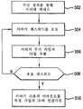
무선 장치 패스워드로서, 사용자는 도 5에 도시된 바와 같은 방법을 사용하여, 무선 장치(202)에 의해 네비게이션 시스템(212)에 로그인하는 처리를 할 수 있 다. 단계(502)에서, 사용자는 무선 장치(202)를 사용하여 네비게이션 서버를 액세스한다. 다음에, 단계(504)에 도시된 바와 같이, 서버는 사용자에 의해 공급되는 무선 장치 패스워드를 요청할 수 있다. 단계(506)에서, 서버(212)는 무선 장치(202)에 의해 발생된 전송 신호로부터 무선 가입자 ID를 추출한다. 이와 같은 무선 가입자 ID는 무선 캐리어(204) 또는 서버(212)에서의 알고리즘에 의해 기술분야에 공지된 방법을 사용하여 추출될 수 있다. 다음에 서버(212)는 단계(508)에서 유효 무선 장치 패스워드의 그 데이터베이스를 질의하는 처리를 한다. 사용자에 의해 입력된 패스워드가 유효 패스워드가 아닌 것으로 판단되면, 이 방법은 단계(504)를 재실행하므로써 유효 패스워드를 입력하기 위해 사용자에게 다시 요청한다. 본 발명의 일부 실시예에서, 전체 프로세스가 중지되기 전에 제한된 수의 재실행이 이용가능하다. 유효 무선 장치 패스워드가 인식되면, 서버(212)는 단계(510)에서 사용자의 어카운트를 특정 무선 가입자 ID와 연관시키므로, 무선 장치(202)를 사용하여 어느 때나 사용자가 서버(212)를 액세스할 수 있고, 사용자는 성가신 로그인 절차를 통해 진행할 필요없이 유효 사용자로서 인증된다.As the wireless device password, the user may process to log in to the
본 발명의 가르침을 벗어나지 않고, 예를 들어 서버(212)에 액세스하기 위해 사용하는 다양한 무선 장치를 특정 사용자가 소유하는 다른 실시예가 가능하다. 이와 같은 상황에서, 무선 가입자 ID를 통한 다양한 무선 장치는 각각 하나의 사용자 어카운트와 연관될 수 있다. 다른 실시예는, 모든 입력을 완전히 제거하지 않고 시스템에 로그 인하기 위해 입력된 입력의 수를 감소시켜, 바람직하게 완전한 자동화 없이 단순화된 로그인 절차를 제공하게 된다. 예를 들어, 완전히 자동화된 절차는, 사용자가 무선 가입자 ID를 전송하는 것은 물론, 짧은 패스워드 또는 개인 ID 번호와 같이 일부 종류의 입력을 제공하게 하므로써 안전하게 균형화될 수 있다. 기술분야의 숙련자는 본 발명을 벗어나지 않고 다른 실시예가 가능하다는 것을 알 것이다.Other embodiments are possible in which a particular user owns the various wireless devices used to access the
본 발명에 따라 사용되는 미리 계획 방법은(method of preplanning)이 도 6에 도시된다. 적당한 웹 브라우저를 갖는 컴퓨터를 사용하여, 단계(602)에서 사용자는 서버(212)에 로그 인한다. 사용자가 기존의 어카운트를 가지고 있으면, 사용자는 단계(604)에서 목적지 정보 또는 단계(606)에서 라우트 정보를 입력할 수 있다. 예시로서, 제한 없이, 목적지는 지정학적 점을 정의하는 거리의 교차점 또는 주소로서 입력된다. 다른 예로서, 제한 없이, 라우트는 중간점이 종점 사이에 존재하는 적어도 두 개의 종점 간의 경로이다. 기술분야에 공지된 바와 같이, 웹 페이지를 통해 정보를 입력하기 위한 많은 기술이 존재한다. 한 실시예에서, 사용자 컴퓨터(214)는 무선 장치(202) 보다 큰 연산력과 메모리를 갖도록 구성된다. 이와 같이, 컴퓨터(214)는 복잡한 네비게이션 정보를 입력하고 이용하는데 이용된다. 예시적으로, 컴퓨터(214)는 맵, 지정학적 트래픽 패턴 및 퍼스널화된 정보를 포함하는 보다 큰 정보의 풀로부터 수집된 이용가능 정보를 사용자에게 디스플레이한다. 다음에, 이와 같은 정보는 무선 장치(202)를 통해 나중에 사용하기 위해 네비게이션 시스템에의 입력을 제공하는데 사용될 수 있다.The method of preplanning used in accordance with the invention is shown in FIG. 6. Using a computer with a suitable web browser, at
예를 들어 그리고 제한 없이, 사용자의 국부적인 이웃의 퍼스널화된 맵(personalized map)이 컴퓨터(214) 상에 디스플레이된다. 연산 검색을 통해, 시 에서 몇 마일 떨어진 Mom 및 Popd's Avenue Shop과 같은 목적지가 식별될 수 있다. Mom 및 Popd's Avenue Shop에이 여행을 미리 계획하는데 있어서, 사용자는 시작에서 끝까지 그 여행을 미리 계획할 수 있다. 본 예에서, 비어 있는 연료 탱크로 오래된 꽃병을 구입하기 위해 일과후 가기를 원하는 사용자는 가장 가까운 주유소에서 정차하는 것과 같이 임의의 중간 목적지를 포함하는 그 여행을 미리 계획할 수 있다.For example and without limitation, a personalized map of a user's local neighborhood is displayed on
수동적으로 입력될 수 있는 임의의 입력의 변형 및 적당한 입력 후 또는 디스플레이된 맵 상의 그래픽 사용자 인터페이스(GUI)를 통해, 정보가 서버(212)에 저장된다. 다음에 사용자는 도 7에 도시된 바와 같이 무선 장치(202)를 통해 미리 계획된 정보를 검색할 수 있다. 무선 장치(202)를 사용하여, 단계(702)에서 사용자는 네비게이션 시스템에 로그 인한다. 다른 옵션 중에서, 사용자는 단계(704)에서 미리 입력된 주소 정보를 검색하거나 또는 단계(706)에서 미리 입력된 라우트 정보를 검색할 수 있다. 다음에, 단계(708)에서 일정 폭으로 네비게이션 정보가 사용자에게 제시된다. 한 실시예에서, 정보를 사용자에게 제시하는 폭은 GPS 또는 다른 서비스에 의해 결정되는 사용자의 순간적인 위치에 의해 결정된다. 다른 실시예에서, 사용자는 추가적인 네비게이션 정보의 필요시 "Next" 버튼을 누름으로써, 단계의 시퀀스를 스크롤 다운하므로써(scrolling down), 또는 다른 수단에 의해 정보를 제시하는 폭을 결정한다.After modification of any input that can be manually entered and appropriate input or via a graphical user interface (GUI) on the displayed map, information is stored in the
이와 같이, 사용자의 미리 계획된 정보가 수집되고 저장되어 개선된 운영 환경을 제공하는데, 여기서 사용자는, 예를 들어 걷거나 또는 운전하면서 네비게이션 에 적합한 폭으로 많은 양의 정보를 수신하면서 무선 장치(202)를 통해 최소 정보를 입력할 필요가 있다.As such, the user's pre-planned information is collected and stored to provide an improved operating environment, where the user, for example, walking or driving, receives the
다른 실시예에서, 경로, 최단 경로가 발생되도록, 출발지 또는 목적지를 위한 "퍼지(fuzzy)" 위치가 입력된다. 퍼지 위치는 비-특정 위치 또는 일단의 당야한 위치를 위한 설명일 수 있지만 이에 한정되지 않는다. 어플리케이션은 특정 위치에의 퍼지 출발지; 퍼지 목적지에의 특정 출발지; 및 퍼지 목적지에의 퍼지 출발지를 포함하지만 이에 한정되지 않는다.In another embodiment, a “fuzzy” location for the origin or destination is entered such that a route, shortest route, occurs. The purge location may be a description for a non-specific location or a group of immediate locations, but is not limited to such. The application may include a purge source to a specific location; Specific origin to a fuzzy destination; And a purge origin to the purge destination.
특정 출발지에서 퍼지 목적지까지의 라우트를 발생하는 방법이 도 8에 도시된다. 단계(802)에서, 특정 출발지가 입력된다. 기술분야에 공지된 바와 같이, 출발 위치와 같은 특정 위치는 거리 주소 또는 거리의 교차점과 같은 다양한 방법으로 입력될 수 있다. 단계(804)에서, 목적지가 입력된다. 한 실시예에서, 퍼지 목적지는 거리 또는 고속도로, 즉 University Avenue 또는 Highway 101이다. 한 실시예에서, 퍼지 위치는 거리 또는 고속도로 상의 임의의 위치, 식별된 거리를 갖는 교차점 또는 식별된 고속도로에의 온램프(onramp)이다. 더욱이, 퍼지 위치는 사용자, 시스템 관리자, 또는 서버에 의해 지정된 일단의 선정된 위치일 수 있다. 이와 같은 실시예에서, 퍼지 위치는, 서버가 일단의 선정된 주유소를 목적지로서 식별하도록, "주유소"와 같은 명칭에 의해 식별될 수 있다. 기술분야의 숙련자에 명확한 바와 같이 본 발명으로부터 벗어나지 않고 퍼지 위치의 다른 실시예가 존재한다.A method of generating a route from a particular origin to a fuzzy destination is shown in FIG. 8. In
특정 출발지를 수신시, 단계(806)에서 기술분야에 공지된 방법을 사용하여 출발지가 지오코드화(geocoded)된다. 또한, 퍼지 목적지에 대해 일단의 지오코드(geocode)가 발생된다. 예를 들어, 거리의 경우, 이와 같은 거리를 갖는 각각의 교차점에 대해 일단의 지오코드가 발생되고, 고속도로의 경우, 각각의 온-램프(on-ramp)에 대해 일단의 지오코드가 발생되고, 일단의 선정된 위치의 경우, 각각의 위치에 대해 일단의 지오코드가 발생된다. 단계(810)에서, 서버는 다음에, 선정된 기준을 통해 바람직한 라우트가 결정되는 바람직한 라우트를 선택한다. 이와 같은 기준은, 기술분야에 공지된 바와 같이, 최단 라우트, 최고빠른 라우트, 많은 차가 다니는 라우트, 적은 차가 다니는 라우트, 또는 다른 기준을 포함하지만 이에 한정되지 않는다. 라우트와 같은 바람직한 라우트의 식별시, 단계(812)에서 이와 같은 라우트가 사용자에게 디스플레이된다.Upon receiving a particular origin, the origin is geocoded using a method known in the art at
기술분야의 숙련자는 본 발명의 가르침으로부터 벗어나지 않고 도 8의 방법은 특정 목적지를 갖는 퍼지 출발지 및 퍼지 목적지를 갖는 퍼지 출발지에 적용 가능하다는 것을 알 것이다. 더욱이, 기술분야의 숙련자는 도 8의 방법은 웹 기반 네비게이션 시스템 또는 무선 기반 네비게이션 시스템에 적용 가능하다는 것을 알 것이다.Those skilled in the art will appreciate that the method of FIG. 8 is applicable to a purge start with a specific destination and a purge start with a purge destination without departing from the teachings of the present invention. Moreover, those skilled in the art will appreciate that the method of FIG. 8 is applicable to a web based navigation system or a wireless based navigation system.
다른 실시예에서, 음성 입력을 사용하여 시스템에 정보가 입력된다. 도 2A는 네비게이션 시스템이 서버(212)에 접속되어 있는 이와 같은 시스템의 아키텍춰를 도시한다. 사용자는 무선 장치(202)를 통해 이전에 설명한 바와 같이 시스템과 인터페이스한다. 본 발명의 한 실시예에서, 사용자는 음성 입력 장치(218)을 통해 시스템과 인터페이스한다. 도 2A에 도시된 바와 같이, 음성 입력 장치(218)는, 서 버(212)에 또한 접속된 PSTN(216)에 접속된다. 음성 입력 장치(218)는 유선 전화기 또는 무선 전화기와 같은 서로 다른 형태를 취할 수 있다. 실제로, 무선 장치(202)는 이 목적을 위해 음성 모드(voice mode)로 사용될 수 있다. 다른 것들 중에서, 서버(212)에는, 네비게이션 시스템에의 입력을 위한 음성 입력을 처리할 수 있는 인터렉티브 음성 응답(interactive voice response, IVR) 유닛이 구비된다. 적당한 음성 입력 시스템의 제조업체는, 음성 인식 엔진 "Speech Object"을 갖는 NAUNCE, 제품 "ACCUVOICE"을 갖는 FONIX, 및 제품 "DIALOGIC"을 갖는 INTEL 등을 포함한다.In another embodiment, information is entered into the system using voice input. 2A shows the architecture of such a system in which a navigation system is connected to the
네비게이션 시스템에서 IVR을 구현하는데 있어서, 도시 명 특히 거리 명은 복잡성을 처리하는 것을 증가시키고 IVR 정확도를 감소시키는 큰 문법을 만든다. 음성 인식 엔진을 사용하여 복잡한 문법을 갖는 입력을 인식할 때, 컴퓨터 시스템은 많은 구성요소 및 그들의 상호작용의 결과로 인한 모호성을 해결하여야 한다. 예를 들어, "298 SUNNYVALE AVENUE, SUNNYVALE, CALIFORNIA"와 같은 주소는 숫자, 거리, 도시 및 주를 인식하기 위한 성분을 포함한다. 숫자와 같이 한 부분에서 인식 에러는 거리와 같은 다른 부분에서의 정확도에 부정적인 영향을 미치고 그 반대도 마찬가지이다. 숫자 및 거리 명에서 많은 가능성으로 인해, 상호작용으로 인해 유사하게 많은 건전한 조합의 결과가 되고, 음성 인식에서 낮은 정확도의 결과가 된다. 예를 들어, San Jose, California와 같은 큰 대도시는 많은 양의 연산 자원 및 메모리를 필요로 한다. 또한, 큰 거리 문법(street grammar)을 처리하는데 필요한 시간은 사용자/시스템 상호작용에 수긍할 수 없는 지연을 초래한다. 더 욱이, 따라서 큰 문법으로부터 네비게이션 시스템용의 감소된 문법을 만드는 것이 바람직하다. 다른 실시예에서, 감소된 도시 문법(city grammar) 또는 숫자 문법(number grammar)은 연관된 큰 문법으로부터 발생된다. 다음 설명에서, 거리 문법을 상세히 참조할 것이지만, 기술분야의 숙련자는 본 발명의 가르침 내에서 다른 어플리케이션이 가능하다는 것을 알 것이다.In implementing IVR in a navigation system, city names, especially street names, create a large grammar that increases handling complexity and reduces IVR accuracy. When using speech recognition engines to recognize inputs with complex grammar, computer systems must resolve the ambiguity that results from many components and their interactions. For example, an address such as "298 SUNNYVALE AVENUE, SUNNYVALE, CALIFORNIA" includes components for recognizing numbers, streets, cities, and states. As in numbers, recognition errors in one part negatively affect accuracy in other parts, such as distance, and vice versa. Due to the many possibilities in numbers and distance names, the interaction results in similarly many sound combinations, resulting in low accuracy in speech recognition. For example, large cities like San Jose, California, require large amounts of computational resources and memory. In addition, the time required to handle large street grammars introduces unacceptable delays in user / system interaction. Furthermore, it is therefore desirable to make a reduced grammar for navigation systems from large grammars. In another embodiment, the reduced city grammar or number grammar is generated from the associated large grammar. In the following description, reference will be made to distance grammars in detail, but those skilled in the art will appreciate that other applications are possible within the teachings of the present invention.
네비게이션 시스템용 감소된 문법을 구현하는 방법이 도 14에 도시된다. 단계(1402)에서, 무선 장치(202)를 사용하여 음성 정보를 입력하기를 원하는 사용자는 "IVR" 또는 유사한 선택을 선택한다. 단계(1404)에서, 사용자는 시스템에 입성 입력을 제공하는 처리를 한다. 본 발명의 한 실시예에서, 사용자는 "298 SUNNYVALE AVENUE, SUNNYVALE, CALIFORNIA"와 같은 완전한 주소를 입력한다. 기술분야의 숙련자는 본 발명의 방법은, 거리의 교차점과 같은 다른 종류의 위치 정보의 입력에 적합하다는 것을 알 것이다. 단계(1406)에서, 서버는 음성 입력을 검색하여 단계(1408)에서 감소된 문법을 질의한다. 본 발명의 한 실시예에서, 숫자, 거리 명, 도시 명 및 주는 개별적인 문법을 사용하여 개별적으로 처리된다. 감소된 문법으로의 처리 후에, 네비게이션 시스템에 사용하기 위해 서버(212)에 의해 완전한 주소가 수신된다. 단계(1412)에서, 사용자가 처리된 위치 정보의 정확도를 확인할 수 있는 후에 수신된 결과가 사용자에 제시된다.A method of implementing the reduced grammar for a navigation system is shown in FIG. 14. In
보통 사람은, 사람의 대부분의 여행이 자기 집의 25마일 이내가 되도록 자기 집에 대한 그 여행에 중심을 두고 있는 것으로 밝혀졌다. 다른 말로 표현하면, 사람은 여행은 흔히 국부적이다. 더욱이, 전형적인 도시 또는 지역 내에서, 작은 비 율의 거리가 대부분의 시간에 사용되는 것으로 밝혀졌다. 이와 같은 현상의 특징은, 시간의 80% 동안 단지 거리의 20%만이 사용된다는 것을 가리키는 "80/20"을 의미한다. 본 발명의 실시예는 이들 관찰을 사용하여 감소된 거리 문법을 도입한다.The average person turns out to be centered on that trip to his home so that most of his trip is within 25 miles of his home. In other words, travel is often local. Moreover, within typical cities or regions, small percentages of distance have been found to be used most of the time. The characteristic of this phenomenon means "80/20" indicating that only 20% of the distance is used during 80% of the time. Embodiments of the present invention use these observations to introduce a reduced distance grammar.
본 발명의 한 실시예에서, 단계(1408)에서 사용되는 감소된 거리 문법이 상기 관측을 사용하여 발생된다. 특히, 감소된 거리 문법은 번화가 또는 집 근처 지역에서 가장 교통량이 많은 거리로 구성된다. 따라서, 선정된 임계치는 교통량이 가장 많은 거리로 구성된 거리 문법을 정의하는 역할을 한다. 거리 명을 결정하기 위해 사용자의 음성 입력을 처리하는데 있어서, 시스템의 정확도 및 속도는 이와 같은 감소된 거리 문법을 사용하므로써 훨씬 개선된다. 다른 실시예에서, 속도 제한, 차선의 수 또는 교통 신호와 같은 다른 기준은 감소된 문법을 정의하는데 사용된다.In one embodiment of the invention, the reduced distance grammar used in
본 발명의 다른 실시예에서, 이력 사용자 정보(historic user information)가 수집되어 자주 사용되는 거리를 기록한다. 다음에 감소된 거리 문법은 사용자 특정 정보를 포함시키도록 수정되어, 각 사용자의 거리 정확도를 개선한다.In another embodiment of the invention, historical user information is collected to record frequently used distances. The reduced distance grammar is then modified to include user specific information, improving the distance accuracy of each user.
사람의 여행은 흔히 국부적이라는 관찰은, 네비게이션 정보를 필요로 하는 사람은 흔히 그 현재의 위치에 관련된 정보를 필요로 한다는 관측으로 확장된다. 예를 들어, 사용자는 그가 길을 잃었을 때 네비게이션 정보를 요청할 가능성이 크다. 따라서, 사용자의 요청은 특정 위치를 향한 그의 현재 "길을 잃은" 위치에 관련되어 있다. 위치 정보는 Phase I E911, Phase II E911 또는 GPS을 포함하는 몇 가지 소스로부터 얻어진다. 부수적으로, 무선 장치(202)는 이와 같은 포지셔닝 시스템을 구현하는데 사용된다. 본 발명의 한 실시예에서, 감소된 거리 문법은 사용자의 현재 위치에 기초하여 동적으로 발생된다.The observation that human travel is often local extends to the observation that people who need navigational information often need information related to their current location. For example, the user is likely to request navigation information when he is lost. Thus, the user's request is related to his current "lost" location towards a particular location. Location information is obtained from several sources, including Phase I E911, Phase II E911 or GPS. Incidentally, the
본 발명의 다른 실시예에서, 단계(1406)에서, 거리 명은 거리 명의 스펠링 또는 부분적인 스펠링과 연관되어 입력된다. 영어에서, 스펠링 문법은 26 글자로 구성되어 스펠링 문법이 정확한 결과를 만들지만 사용하기가 번거롭다. 스펠링될 글자의 숫자는 고려중인 어플리케이션을 고려하므로써 결정된다. 예를 들어, 대도시에서, 완전한 거리명의 대부분을 스펠링하므로써 개선된 정확도가 달성된다. 한 실시예에서, 따라서 음성 인식 시스템은 먼저 이름을 인식하고 다음에 그 스펠링을 인식하도록 튜닝(tuned)된다. 사용자는 "SUNNYVALE AVENUE"이라는 이름을 말한 다음, "S U N"과 같은 이름의 스펠링 부분을 말하므로써 "SUNNYVALE AVE"와 같은 거리 명을 입력한다. 이때 서버(212)는 두 개 입력을 사용하여 문법 크기를 좁혀나가고 거리 명 결과를 개선한다. 설명되는 예에서, SUNNYVALE AVENUE"의 음성 입력은 "SUN"으로 시작하는 거리의 거리 문법에 제한된다. 거리명의 일부를 먼저 스펠링하고 다음에 그것을 만듦으로서와 같이 본 발명을 벗어나지 않고 다른 실시예가 존재한다.In another embodiment of the present invention, at
음성 입력을 사용하여 미리 계획하는 방법이 도 6에 도시된다. 음성 입력 장치(218)를 사용하여, 단계(602)에서 사용자는 서버(212)에 로그인한다. 기술분야의 숙련자는 로그 인하는 몇 가지 방법이 적합하다는 것을 알 것이다. 한 실시예에서, 사용자는 음성 입력 장치(218) 상에 구현되는 키패드의 터치 톤 시스템(touch tone system)을 사용하여 로그인한다. 선택적으로, 서버(212) 상에 구현되는 음성 인식 시스템은 유효 사용자 음성 및/또는 가청 입력을 인식할 것이다. 사용자가 기존의 어카운트를 가지고 있는 경우, 이때 사용자는 단계(604)에서 주소 정보 또는 단계(606)에서 라우트 정보를 입력할 수 있다. 기술분야에 공지된 바와 같이, 음성 및 터치 톤을 포함하는 가정 정보를 서버(212)와 같은 컴퓨터에 입력하기 위한 많은 기술이 존재한다. 적당한 입력 및 임의의 입력의 수정 후에, 단계(608)에서 정보는 서버(212)에 저장된다.A method of planning ahead using voice input is shown in FIG. Using
다음에 사용자는 도 7에 도시된 무선 장치(202)를 통해 미리 계획된 정보를 검색할 수 있다. 무선 장치(202)를 사용하여, 단계(702)에서 사용자는 네비게이션 시스템에 로그인한다. 다른 선택들 중에서, 사용자는 단계(704)에서 미리 입력된 주소 정보를 그리고 단계(706)에서 미리 입력된 라우트 정보를 검색할 수 있다. 다음에 사용자에게는 단계(708)에서 적당한 네비게이션 시스템 프롬프트가 제시된다. 본 발명의 한 실시예에서, 본 발명의 시스템은 사용자의 미리 계획된 정보를 리스트하여, 사용자가 최소 정보를 입력할 필요만이 있지만 운전하거나 걸으면서 네비게이션에 적합한 폭으로 많은 양의 정보를 수신하는 개선된 운영 환경을 제공할 수 있게 된다.The user may then retrieve the preplanned information via the
다른 실시예에서, 사용자는 로그인하고, 가청 방법으로 네비게이션 시스템으로부터 정보를 검색한다. 이와 같은 실시예에서, 서버(212)에는 음성 동기화 능력이 구비된다. 이와 같이 네비게이션 정보는 네비게이션 시스템으로부터 사용자로 보내진다. 이와 같은 네비게이션 정보는, 가청 신호에 동기화 된다는 것을 제외하고는, 텍스트로 또는 그래픽하게 운반되는 정보와 동일하거나 또는 유사하다.In another embodiment, the user logs in and retrieves information from the navigation system in an audible manner. In such an embodiment, the
다른 실시예에서, 사용자는 가청 및 텍스트 방법 모두로 사용자가 적당한 것으로 생각하는 정보를 검색한다. 따라서, 사용자는 거리로부터 그의 시선을 뗄필요 없도록 분주한 거리를 운전하는 동안 네비게이션 정보의 가청 검색을 선택할 수 있다. 사용자는 또한 걸을 때 그리고 안전이 중요하지 않을 때 텍스트 모드를 선택할 수 있다. 더욱이, 사용자는 두 종류 모두의 신호에 적당히 응답할 수 있는 이중 텍스트 및 가청 모드를 선택할 수 있다. 적당할 수 있는 이와 같은 모드는, 사용자가 가청 입력에 신속히 응답한 다음 정지 신호 또는 다른 안전 장소에서 정지한 후에 네비게이션을 검증할 수 있는 거주 네비게이션이다.In another embodiment, the user retrieves information that the user considers appropriate by both audible and textual methods. Thus, the user can select an audible search of the navigation information while driving the busy street so that he does not have to keep his gaze from the street. The user can also select the text mode when walking and when safety is not important. Moreover, the user can select a double text and audible mode that can respond appropriately to both kinds of signals. Such a mode, which may be suitable, is residential navigation where the user can quickly respond to an audible input and then verify the navigation after stopping at a stop signal or other safe place.
다른 실시예에서, 분산 네비게이션 서버(212)는 또한 실시간 교통 정보와 같은 위치에 특정한 정보를 수신하고 처리한다. 한 실시예에서, 교통 정보는 일단의 네비게이션 서비스 사용자로부터 얻어진다. 그 위치, 속도 및 시간을 관찰하고 비교하고 맵 데이터베이스 내의 공칭 거리 속도 제한과 더 비교하므로써, 실시간 교통 정보가 발생되어 본 발명에 의해 사용된다. 목적지를 향한 각각의 교차점에서, 시스템은 끊임없이 변하는 조건에 응답해서 특정 사용자에 대한 최적의 라우트를 판단한다. 예를 들어, 변경된 조건으로 인해 제1 라우트가 덜 최적인 경우, 제2 라우트가 발생되어 사용자에 제시된다. 최적의 라우트는 사용자의 기호에 따라 몇가지 방법으로 결정된다. 예를 들어, 최적의 라우트는 최소 시간, 최소 거리 또는 최소 연료 소비에 기초하여 결정될 수 있다. 본 발명의 한 실시예에서, 교통 정보는 새로운 에이젼시에 의해 사용되는 것과 같은 일반적인 교통 정보로부터 서버(212)에 의해 검색될 수 있거나 또는 속도 및 방향과 같은 훨씬 보다 복잡한 정보를 발생하고 또한 이와 같은 정보를 디지털 형태로 발생하는 교통 모니터링 서비스로부터 보다 복잡한 형태로 수신될 수 있다. 네비게이션 안내 알고리즘과 같은 프로세서 집중 기능은, 무선 장치(202)에 대한 연산 부담을 줄이기 위해 분산 네비게이션 서버(212)에 의해 처리된다. 한 실시예에서, 분산 네비게이션 서버(212)의 처리 기능일 일부로서, 이들 서버는 HDML 또는 WML에서 HTML 사이 그리고 그 역으로의 변환과 같은 기능을 제공한다. 이와 같은 변환은 특히 HTML로 인코드된 웹 페이지를 사용하여 WML로 인코드된 무선 장치(202)로부터 나중에 검색하기 위해 라우트 또는 목적지를 미리 계획하는데 필요하다.In another embodiment, distributed
가청 방법으로 네비게이션 정보를 수신하는데 있어서, 본 발명의 시스템 실시예는, 사용자로 하여금 서로 다른 특징의 네비게이션 정보를 검토하고 재검토할 수 있게 한다. 예를 들어, 중간 목적지(즉, 주요소)를 거쳐 최종 목적지(즉, Mom 및 Pop's Antique Shop)을 향한 시작 목적지(즉, 사람의 일터)로부터의 네비게이션은 많은 단계를 포함할 수 있다. 모든 정보의 수신은 복잡할 수 있고 유용하지 않을 수 있다. 따라서, "University Avenue에서 우회전"을 말하는 네비게이션 명령은 몇 마일 떨어진 것보다 University Avenue에 도달하기 전에 짧은 기간 동안 보다 유용할 수 있다. 따라서, 본 발명의 바람직한 실시예에서 필요할 때마다 네비게이션 정보를 제공하는 것이 마련된다.In receiving navigation information in an audible manner, a system embodiment of the present invention allows a user to review and review navigation information of different features. For example, navigation from a starting destination (i.e. a person's workplace) through an intermediate destination (i.e., a major address) to a final destination (i.e. Mom and Pop's Antique Shop) may include many steps. Receipt of all information can be complex and not useful. Thus, a navigational command that says "turn right on University Avenue" may be more useful for a short period of time before reaching University Avenue than several miles away. Therefore, it is provided in the preferred embodiment of the present invention to provide navigation information whenever necessary.
네비게이션 시스템의 음성 동작 모드는, 위에서 설명한 바와 같이, 무선 캐리어 및 인터넷을 거쳐 분산 서버에 접속된 무선 장치(202)와 연관된다. 이 동작 모드를 개선하기 위해, 사용자는 예시적인 선택의 다음 리스트; rewind/repeat; forward/skip; pause; faster; slower중 어느 것을 선택할 수 있다. 사용자가 제공되는 네비게이션 정보의 일정 부분을 검토하거나 반복하기를 원하면, 사용자는 네비게이션 정보의 소정 위치까지 다시 돌아가기 위해 "rewind/repeat" 옵tus을 선택된다. 네비게이션 정보가 단계들로 구분되면, 특정 실시예에 사용된 'repeat" 기능은 개별적인 단계들의 검토를 위해 제공할 수 있는데, 여기서 "rewind" 기능은 사용자로 하여금 단계의 구분과 상관없이 네비게이션 명령을 검토할 수 있게 한다. 결국, 사용자는 네비게이션 정보의 특정 부분을 리슨할 필요가 없는 경우, 사용자는 "forward/skip" 옵션을 사용할 수 있다. 이와 같은 특징으로, "forward" 옵션은 'rewind" 옵션의 대향이고, 'skip" 옵션은 "repeat" 옵션의 대향이다. 한 실시에에서, 사용자는 또한 "faster" 및 "slower" 옵션을 사용하여 네비게이션 정보의 전송을 가속 또는 감속시키는 옵션을 갖는다. 기술분야의 숙련자는, 본 발명의 가르침을 벗어나지 않고 음성 모드로 네비게이션 정보의 제시를 제어하기 위한 다른 옵션이 존재한다는 것을 알 것이다.The voice mode of operation of the navigation system, as described above, is associated with a
위에서 설명된 실시예에서, 분산 서버(212)에 끊임없이 접속된 무선 장치(202)의 내용에서 시스템은 동작이 설명된다. 다른 실시예에서, 무선 장치(202)는 필요할 때 네트워크의 나머지 부분을 액세스하고, 따라서 접속 비용을 포함한 다양한 절약을 실현할 수 있다.In the embodiment described above, the operation of the system in the context of
도 1에 도시된 바와 같이, 무선 장치(202)는 무선 캐리어(204), 게이트웨이(206) 및 인터넷(208)을 통해 서버(212)와 통신한다. 한 실시예에서, 하나 이상의 이들 접속부는 끊임없이 유지될 필요가 없다. 도 9는 무선 캐리어 및 서버간의 접속이 인터넷을 통해 유지될 때의 시간을 줄이는 방법을 도시한다. 다른 이유들 중에서, 이와 같은 방법은 인터넷을 통해 접속 시간을 줄이는 이점을 제공한다. 이와 같은 방법은 또한 인터넷 접속에서 지연이 존재할 때 또는 인터넷 접속이 돈, 시간 또는 다른 비용 요소로 측정된 연관된 높은 비용을 가질 때 이점을 제공한다.As shown in FIG. 1, the
특히, 이전에 설명된 바와 같이, 사용자는 단계(902)에서 서버(212)와 정상적인 접속을 수립한다. 다음에 인자된 사용자는 예를 들어 단계(904)에서 음성 동작 모드를 사용하여 네비게이션 정보를 요청하는 처리를 수행한다. 또한 사용자는 단계(906)에서 대체 저장장소로 요청된 지시를 재라우트하는 처리를 수행한다. 한 실시예에서, 이 대체 저장장소는 사용자의 무선 음성 메일박스 또는 정보를 저장할 수 있는 다른 적합한 장치의 형태를 취할 수 있다. 한 실시예에서, 무선 장치(202)에는 요청된 네비게이션 정보를 국부적으로 기록할 수 있는 적당한 메모리가 구비된다. 단계(908)에서, 서버(212)는 응답에 따라 사용자에 의해 지시된 바에 따라 요청된 정보를 다시 라우트한다. 정보를 다시 라우트한 후, 단계(901)에 도시된 바와 같이, 인터넷 접속이 단절된다. 이때 사용자는 단계(912)에 도시된 바와 같이 대체 저장장소를 거쳐 네비게이션 정보를 검색하는 처리를 수행한다.In particular, as previously described, the user establishes a normal connection with the
기술분야의 숙련자는 도 9에 도시된 방법은, 무선 장치가 적당한 메모리 능력을 갖는 무선 장치(202)에서 무선 캐리어(204)로의 접속을 제거하는데 사용될 수 있다는 것을 알 것이다. 이와 같은 구현에서, 인터넷 접속 및 무선 접속 모두가 제거되어, 돈, 시간 또는 다른 비용 요소로 측정되는, 무선 캐리어의 사용과 연관 된 비용을 제거할 수 있게 된다.Those skilled in the art will appreciate that the method shown in FIG. 9 can be used to remove a connection from a
기술분야의 숙련자는 도 9의 방법은, 적당한 텍스트 네비게이션 정보가 재배향되고 적당히 저장되는 텍스트 동작 모드로 확장될 수 있다는 것을 알 것이다. 이 경우, 사용자는 대체 텍스트 저장장소로부터 텍스트 네비게이션 정보를 검색하여, 임의의 연관된 비용을 제거할 수 있게 된다.Those skilled in the art will appreciate that the method of FIG. 9 can be extended to a text mode of operation in which the appropriate text navigation information is redirected and properly stored. In this case, the user can retrieve the text navigation information from the alternate text repository, eliminating any associated costs.
본 발명의 한 실시예에서, 네비게이션 시스템은 제한된 입력 능력의 무선 장치(202)를 갖는 이동 환경에 사용된다. 그러나, 네비게이션 시스템의 사용의 관찰은, 사용자가 이전에 여행한 라우트에 대한 네비게이션 정보를 요청한다는 것을 가리킨다. 개선된 운영 환경을 제공하는데 있어서, 본 발명의 실시예는, 사용자가 가장 최근에 여행된 많은 라우트를 검색할 수 있게 한다.In one embodiment of the invention, the navigation system is used in a mobile environment with a
가장 최근에 여행한 많은 라우트를 검색하는 방법이 도 10에 도시된다. 무선 장치(202)를 사용하여, 단계(1002)에서 사용자는 옵션의 리스트 중에서 "최종 라우트"를 선택한다. 이와 같은 선택은 종래 기술에 공지된 방법을 사용하여 음성 동작 모드 또는 텍스트 동작 모드로 이루어질 수 있다. 선택시, 요청이 서버(212)에 송신될 것이다. 서버에서, 데이터베이스, 다른 것들 중에서, 사용자에 대한 정보의 데이터베이스가 질의된다. 특히, 단계(1004)에서, 사용자에 의해 요청된 가장 최근 라우트를 검색하기 위해 데이터베이스가 질의된다. 단계(1006)에서 가장 최근의 라우트의 수 N가 검색된다. 다음에, 저장하는 방법이 서로 다른 방법으로 정의될 수 있고, 지정된 사용자 지정 또는 시스템 관리자일 수 있다. 한 실시예에서, N 가장 최근의 라우트는 연대순으로 또는 역 연대순으로 분류된다. 다 른 실시예에서, N 가장 최근의 라우트는 가장 짧은 거리에서 가장 긴 거리로 또는 그 역으로 거리에 의해 분류된다. 기술분야의 숙련자는 본 발명의 가르침을 벗어나지 않고 다른 옵션이 가능하다는 것을 알 것이다.A method of searching for many of the most recently traveled routes is shown in FIG. Using the
N 라우트를 분류시, 단계(1010)에서 이들 라우트는 사용자에게 제시된다. 텍스트 동작 모드를 사용하는 실시예에서, 무선 마크업 언어(WML)로 코드화된 무선 인식가능 페이지가 무선 장치(202) 상에 존재한다. 음성 동작 모드를 이용하는 실시예에서는, 무선 장치(202)를 통해 가청 옵션 리스트가 사용자에게 제시된다. 많은 N 라우트의 수신시, 단계(1012)에서 사용자는 적당한 라우트를 선택한다. 네비게이션 시스템의 후속하는 동작은 이전에 설명한 바와 같이 동작한다.In classifying N routes, in
이전에 설명한 바와 같이, 사용자가 네비게이션 시스템을 사용하면서 감소된 수의 입력을 제공하는 것이 요구되는 개선된 운영 환경을 제공하는 것이 바람직하다. 따라서, 사용자로 하여금 사용자에 의한 최소 간섭으로 무선 장치(202)를 통해 복잡한 정보를 입력할 수 있게 하는 것이 바람직하다. 본 발명의 한 실시예는 연관된 데이터베이스를 갖는 전형적으로 개선된 서버(212)의 능력을 평준화시키면서 무선 장치(202) 상의 입력의 수를 감소시킨다.As previously described, it is desirable to provide an improved operating environment in which a user is required to provide a reduced number of inputs while using a navigation system. Thus, it is desirable to allow a user to enter complex information through the
전형적인 전화기는 ANSI-TI.703-1995에 의해 정의된 레이블링 변환(labeling conversion)을 이용한다. 레이블링 변환의 일부로서, 다양한 글자는 물론 숫자들은 이하에 도시되는 바와 같이 전화기 키패드상의 키와 연관되어 있다:Typical telephones use a labeling conversion defined by ANSI-TI.703-1995. As part of the labeling transformation, various letters as well as numbers are associated with keys on the telephone keypad as shown below:
키패드 레이블연관된 숫자 및 글자Keypad labels with associated numbers and letters
111 1
2a,b,c,22 a, b, c, 2
3d,e,f,33 d, e, f, 3
4g,h,i,44 g, h, i, 4
5j,k,l55 j, k, l5
6m,n,o,66 m, n, o, 6
7p,q,r,s,77 p, q, r, s, 7
8t,u,v,88 t, u, v, 8
9w,x,y,z,99 w, x, y, z, 9
000 0
**
##
기술분야의 숙련자는, 다른 레이블링 변환이 가능하다는 것을 알 것이다. 따라서, 텍스트 정보를 입력하는 경우, 키 2-9는 하나의 글자를 결정하는 것이 아니다. 예를 들어, 키 "7"의 입력은, 사용자가 글자, p, q, r, s 또는 숫자 7을 입력하기를 원하는 지에 대해 모호성이 존재한다는 점에서 비-결정적(non-deterministic)이다. 그러나, 키를 다수번 누름으로써, 사용자는 전화기 키패드를 사용하여 텍스트 데이터를 입력할 수 있다. 하나 이상의 글자가 임의의 소정의 키와 연관되어 있기 때문에, 동일한 키의 반복하는 입력은 사용자로 하여금 다양한 글자를 스크롤 할 수 있게 한다. 예를 들어, 사용자가 "s" 글지를 입력하기를 원하는 경우, 그는 "7"을 여러 번 눌러야 한다. "7" 키를 한번 누르면, "p"가 입력 될 수 있고, "7" 키를 두 번 누르면 "q"가 입력될 수 있으며, "7" 키를 세 번 누르면 "r"이 입력될 수 있다. 등등. 사용자가 "298 SUNNYVALE AVE"를 입력하기를 원하는 경우, 사용자는 다음 시퀀스" 222 99999 8888 7777 88 66 66 999 888 2 555 33 2 888 3을 입력하여야 한다. 따라서, 복잡한 주소 또는 위치가 입력될 경우, 이와 같은 텍스트 입력 방법은, 특히 차에서 운전하고 걷는 동안 텍스트 정보가 입력되는 경우 번거로울 수 있다. 따라서, 서버(212)의 개선된 능력을 이용하여, 사용자로 하여금 결정적 정보로 다음에 변환되는 비-결정적 정보를 입력할 수 있게 하는 것이 바람직하다.Those skilled in the art will appreciate that other labeling conversions are possible. Thus, when entering text information, keys 2-9 do not determine one letter. For example, the input of key "7" is non-deterministic in that there is ambiguity as to whether the user wants to enter a letter, p, q, r, s or number 7. However, by pressing the key multiple times, the user can enter text data using the telephone keypad. Since more than one letter is associated with any given key, repeated input of the same key allows the user to scroll through various letters. For example, if the user wants to enter the letter "s", he must press "7" several times. Press "7" key once, "p" can be entered, press "7" key twice, "q" can be entered, press "7" key three times, "r" can be entered . etc. If the user wants to enter "298 SUNNYVALE AVE", the user must enter the following sequence: 222 99999 8888 7777 88 66 66 999 888 2 555 33 2 888 3. Therefore, if a complex address or location is entered, Such a text input method can be cumbersome, especially if text information is entered while driving and walking in a car, thus utilizing the improved capabilities of the
서버(212)의 능력을 이용하여 무선 장치(202)를 통해 입력의 수를 감소시키는 방법이 도 11A에 도시된다. 단계(1152)에서, 무선 장치(202) 상의 키패드를 이용하여 비-결정적 정보를 입력하기를 원하는 사용자는 "단순한 키 입력" 또는 유사한 옵션을 선택한다. 단계(1154)에서, 사용자는 비-결정적 위치 정보를 입력하는 처리를 수행할 수 있다. 한 실시예에서, 사용자는 완전한 주소를 입력할 수 있지만, 기술분야의 숙련자는 본 발명의 방법은 다른 텍스트 정보를 입력하는데 적합하다는 것을 알 것이다. 본 발명의 한 실시예에서, 사용자는 동일한 키를 다수 입력할 필요 없이 글자와 연관된 키 입력을 입력하므로서 비-결정적 정보를 입력한다. 예를 들어, 사용자가 "298 SUNNYVALE AVE"를 입력하기를 원하는 경우, 사용자는 다음 시퀀스 2 9 8 7 8 6 9 8 2 5 3 2 8 3을 입력할 필요가 있다. 따라서, 사용자는 종래 기술에서 28 입력에 대향하는 12 입력만을 만들 필요가 있다.A method of reducing the number of inputs via the
다른 실시예에서, 예를 들어, 주소 또는 교차점 정보가 입력되는 지를 식별 하기 위해 전용 구문이 구현된다. 예를 들어, 본 실시예에서, "star" 키(*)는 주소 정보가 구획문자로서 입력되려 한다는 것을 가리킨다. 따라서, "298 SUNNYVALE AVE"는 시퀀스: *298*78698253*283*으로서 입력된다. 다른 실시예에서, "파운드" 키(#)와 같은 서로 다른 구획 문자는, 교차점 정보가 입력되려 한다는 것을 가리킨다. 따라서, 정보 " SUNNYVALE AT WASHINGTON"은 시퀀스 #78698253#9274464866#으로서 입력된다. 다른 실시예에서, 이와 같은 구획 문자는 도시, 주 및 우편 코드 정보의 입력을 구획하는데 사용된다.In another embodiment, dedicated syntax is implemented, for example, to identify whether address or intersection information is entered. For example, in this embodiment, the "star" key (*) indicates that address information is to be entered as a delimiter. Thus, "298 SUNNYVALE AVE" is input as a sequence: * 298 * 78698253 * 283 *. In other embodiments, different delimiters, such as the "pound" key (#), indicate that intersection information is about to be entered. Therefore, the information "SUNNYVALE AT WASHINGTON" is input as the sequence # 78698253 # 9274464866 #. In other embodiments, such delimiters are used to delimit the input of city, state, and postal code information.
서버는 단계(1158)에서 정보의 데이터베이스를 질의하기 위해 비-결정적 정보를 수신한다 (단계 1156). 한 실시예에서, 데이터베이스는 거리 또는 도시와 같은, 수치 시퀀스와 위치 정보간의 인덱스된 정보를 포함한다. 한 실시예에서, 단계(1160)에서 데이터베이스는 사용자의 개인 정보를 고려하곤 이와 같은 디폴트 정보를 사용하여 결과의 수를 제한하기 위해 질의의 수를 줄인다. 예를 들어, 사용자가 특정 도시에 위치된 경우, 데이터베이스는 그 도시의 거리에 우선권을 준다. 더욱이, 이전에 설명된 것과 같은 구획 문자는 디폴트 정보의 결정을 지원한다. 예를 들어, 잃어버린 도시 또는 주 정보가 선정된 디폴트 정보를 사용하는 결과가 되는 경우, 단계(1162)에서, 결과의 리스트가 사용자에게 디스플레이된다. 단계(1164)에서 사용자는 정확한 입력을 선택한다.The server receives non-deterministic information to query the database of information at step 1158 (step 1156). In one embodiment, the database includes indexed information between numerical sequences and location information, such as streets or cities. In one embodiment, in
기술분야의 숙련자는 본 발명을 벗어나지 않고 도 11A에 도시된 방법의 수정이 가능하다는 것을 알 것이다. 예를 들어, 도 11A의 방법은, 각 입력의 입력 시에 가능한 결과의 리스트가 생성되도록 각 입력의 입력 시에 구현될 수 있다. 선 정된 결과의 임계치에 도달하면, 이와 같은 결과의 리스트는 선택을 위해 사용자에게 제시된다.Those skilled in the art will appreciate that modifications to the method shown in FIG. 11A are possible without departing from the invention. For example, the method of FIG. 11A may be implemented upon input of each input such that a list of possible results is generated upon input of each input. When the threshold of the selected result is reached, such a list of results is presented to the user for selection.
도 11A의 방법은, 주소 및 위치 정보의 입력을 위해 설명되었지만, 기술분야의 숙련자는 이 방법은 다른 종류의 텍스트 입력에 적합하다는 것을 알 것이다. 더욱이, 본 발명은, 인덱스된 수치 시퀀스에서 글자 시퀀스의 데이터베이스가 비-결정적 맵핑을 사용자 제시 및 선택에 적합한 수긍할 수 있는 선택의 수에 맵핑하도록 유지될 수 있는 어플리케이션에 적합하다.Although the method of FIG. 11A has been described for entry of address and location information, one skilled in the art will appreciate that this method is suitable for other types of text entry. Moreover, the present invention is suitable for applications in which a database of character sequences in an indexed numerical sequence can be maintained to map non-deterministic mappings to acceptable numbers of choices suitable for user presentation and selection.
서버(212)의 능력을 이용하여 무선 장치(202)를 통해 입력의 수를 줄이는 방법이 도 11B에 도시된다. 단계(1102)에서, 무선 장치(202) 상의 키패드를 이용하여 정보를 입력하기를 원하는 사용자는 "키패드 입력" 또는 유사한 인에이블된 옵션을 선택한다. 단계(1104)에서, 사용자는 식별된 필드에 대한 입력을 제공하도록 프롬프트된다. 식별된 필드는 위치를 결정하는데 사용되며, 거리 주소, 도시, 주, 우편번호, 거리 교차점 또는 기술분야에 공지된 다른 위치 입력을 포함할 수 있다. 제한없이 예시하기 위해, 식별된 필드는 소정의 도시 명이다. 또한 제한 없이 예시하기 위해, 사용자는 ANSI TI.703-1995의 전화기 키패드 인이블링 변환을 이용하여 정보를 입력한다. 입력될 도시가 "Palo Alto"인 경우, 단계(1106)에서 사용자는 1-n 글자를 입력한다. 다음에 단계(1108)에서 서버는 1-n 입력을 반복적으로 수신하고, 단계(1110)에서 이와 같은 정보를 사용하여 정보의 데이터베이스를 질의한다. 본 예에서, 도시의 명칭이 입력될 경우, 도시의 저장된 리스트가 질의될 것이다. 단계(1112)에서 수신된 입력에 대응하여 데이터베이스로부터, 다수의 결과가 검색될 것이다. 특정 상황에서, 단계(1114)에서 작은 수의 결과가 사용자에게 제시되도록 단지 하나의 입력 후에 작은 수의 결과가 검색될 것이다. 그러나, 다른 상황에서, 후보 수를 선정된 관리가능한 수로 줄이기 위해 보다 많은 입력이 필요할 것이다. 충분한 입력이 수신되고 후보 숫자가 감소된 후에, 단계(1114)에서 리스트가 사용자에게 제시된다. 다음에 단계(1116)에서 사용자는 디스플레이된 후보 중에서 선택한다.A method of reducing the number of inputs via the
본 발명의 한 실시예에서, 단계(1112)에서 한 입력 글자에 응답해서 데이터베이스 결과를 수신시, 서버는, 선정된 수의 관리가능한 결과로서 얼마나 많은 수의 글자들이 필드, 이 경우 도시를 결정하는데 필요한지를 결정한다. 본 발명의 다른 실시예에서, 이전에 필드(즉, 도시)의 데이터베이스를 분석하므로써 시스템 성능이 개선된다. 따라서, 시스템은 다른것들 중에서, 모든 필요한 정보를 실시간으로 처리할 필요 없이 미리 처리된 정보를 검색할 수 있다. 더욱이, 사용자 특정 정보를 이용하므로써 시스템 성능이 더욱 개선된다. 예를 들어, 사용자의 식별된 전화번호는 도시 및 주에 의해 식별된 특정 위치와 연관되어 있다. 무선 장치(202) 또는 기술분야에 공지된 다른 입력 방법을 사용하여 다른 사용자 특정 정보가 더욱 미리 입력될 수 있다.In one embodiment of the invention, upon receiving a database result in response to an input character in
다른 실시예에서, 연관된 데이터베이스와 연관된 서버는 공통 도시 접두사(common prefix)를 미리 저장하고 미리 분석하므로써 사용자가 필드 정보를 입력하는 동안 요구되는 실시간 연산 노력의 양을 줄인다. 예를 들어, 공통 접두사는 "Los", "San" 및 "Santa"를 포함하지만 이에 한정되지 않는다. 따라서, 사용 자가 첫 번째 두 개의 입력에서 "S" 및 "A"를 입력하는 경우, 이와 같은 입력은 도 11B에 도시된 방법이 가속되고 개선되도록 미리 처리된다. 기술분야의 숙련자가 알 수 있는 바와 같이 본 발을 벗어나지 않고 다른 방법이 또한 가능하다.In another embodiment, the server associated with the associated database pre-stores and analyzes the common city prefix in advance, thereby reducing the amount of real-time computational effort required while the user enters field information. For example, common prefixes include, but are not limited to, "Los", "San", and "Santa". Thus, when the user enters "S" and "A" in the first two inputs, such inputs are pre-processed so that the method shown in Figure 11B is accelerated and improved. As will be appreciated by those skilled in the art, other methods are also possible without departing from the present invention.
이전에 설명한 바와 같이, 사용자가 네비게이션 시스템을 사용하면서 감소된 수의 입력을 제공하는 것이 요구되는 개선된 네비게이션 환경을 제공하는 것이 바람직하다. 따라서, 사용자로 하여금 최소 사용자 입력으로서 무선 장치(202)를 통해 복잡한 정보를 입력할 수 있게 하는 개선된 운영 환경을 제공하는 것이 바람직하다. 본 발명의 실시예는 나중에 사용하고 검색하기 위해 사용자의 현재 위치를 식별하고 저장한다.As previously described, it is desirable to provide an improved navigation environment where a user is required to provide a reduced number of inputs while using the navigation system. Accordingly, it would be desirable to provide an improved operating environment that allows a user to enter complex information through the
사용자의 현재 위치를 북마크(bookmaking)하는 방법이 도 12에 도시된다. 단계(1202)에서, 그의 현재 위치를 레이블하기를 위하는 사용자는 "현재 위치 북마크" 또는 다른 유사한 옵션을 선택한다. 이와 같은 옵션의 선택시, 단계(1204)에서 서버는 사용자의 위치를 요청한다. 한 실시예에서, 이와 같은 요청은 다른 서비스들 중에서, GPS EH는 유사하게 인에이블된 무선 장치(202)가 구비된 사용자에 대해 지오위치(geo-location)를 제공하는 위치 게이트웨이를 통해 라우트된다. 단계(1206)에서 적당하기 구비된 무선 장치(202)는 다음에 단계(1208)에서 수신되고 지오코드화(geo-coded)되는 위치 신호를 발생한다. 단계(1210)에서, 사용자에게는 그 현재의 위치를 레이블하는 것이 요청된다. 사용자는 음성 동작 모드를 통해 적당히 구성된 무선 장치(202) 상의 키패드를 통해 적당한 입력을 제공할 수 있다. 단계(1212)에서, 다음에 레이블 및 위치가 데이터베이스에 저장된다. 다음에, 레 이블된 위치는 기술분야의 숙련자에게 명확한 방법은 물론 본 발명에 개시된 방법으로 검색되고 사용된다. 더욱이, 기술분야의 숙련자는 본 발명을 벗어나지 않고 도 12에 도시된 방법의 변형이 가능하다는 것을 알 것이다.A method of bookmaking a user's current location is shown in FIG. In
다른 실시예에서, 적당히 구비된 무선 장치(202)는 사용자의 현재 위치의 다른 사용자의 "커뮤니티(community)"의 메시지를 전달한다. 제한없이 특정 어플리케이션에서, 사용자의 커뮤니티는 예를 들어 그의 친구 또는 동료를 포함시키기 위해 사용자에 의해 지정된다. 다른 어플리케이션에서, 커뮤니티는 사용자, 시스템 관리자 또는 서버에 의해 결정되는 다른 기준을 사용하여 식별될 수 있다. 또한, 사용자의 현재 위치가 커뮤니티로 전달되어, 커뮤니티는 사용자의 현재 위치에서 만날 수 있게 한다. 기술분야의 숙련자는 사용자의 현재 위치를 이용하기 위해 본 발명의 네비게이션 시스템 및 방법의 다른 직선적인 어플리케이션이 존재한다는 것을 알 것이다.In another embodiment, a properly equipped
예를 들어, 회합장소로서 사용자의 현재 위치를 운반하는 방법이 도 13에 도시된다. 단계(1302)에서, 그의 현재 위치를 커뮤니티로 전달하기를 바라는 사용자는 "커뮤니티 기능"을 선택한다. 단계(1304)에서 커뮤니티로 회합 장소를 보내기를 원하는 사용자는 또한 "회합 장소"를 선택한다. 다음에, 단계(1306)에서 사용자는 "Here"를 선택하므로써 그의 현재 위치가 회합 장소라는 것을 명시한다. 이와 같은 옵션의 선택 시에, 단계(1308)에서 서버는 사용자의 위치를 요청한다. 한 실시예에서, 이와 같은 요청은, 다른 것들 중에서 적당히 구비된 무선 장치(202)가 구비된 사용자의 지오위치를 제공하는 위치 게이트웨이를 통해 라우트 된다. 적당한 구비된 무선 장치(202)는 다음에 단계(1312)에서 수신되고 지오코드화되는 위치 신호를 발생한다 (단계 1310). 단계(1314)에서, 사용자는 그의 현재 위치를 레이블할 것이 요청된다. 사용자는 무선 장치(202) 상의 키패드를 통해 또는 적당히 구성된 경우 음성 동작 모드를 통해 적당한 입력을 제공할 수 있다. 한 실시예에서, 서버는 디폴트 레이블을 제공한다. 단계(1316)에서, 다음에 레이블 및 위치는 데이터베이스에 저장된다. 다음에, 레이블된 위치는 단계(1318)에서 특정 커뮤니티로 전달된다. 지정된 커뮤니티의 구성원들은 기술분야에 공지된 방법은 물론 본 발명에 개시된 방법을 통해 운반된 정보를 검색하고 사용할 수 있다. 특정 실시예에서, 각각의 커뮤니티 구성원은 운반된 위치를 네비게이션 시스템에 대한 목적지 입력으로서 사용한다. 기술분야의 숙련자는 본 발명을 벗어나지 않고 도 13에 도시된 방법의 변형이 명확하다는 것을 알 것이다.
For example, a method of carrying the user's current location as a meeting place is shown in FIG. In
비록 본 발명이 몇몇 특정 실시예를 참조로 설명되었지만, 이 설명은 본 발명을 이들 실시예에 제한하도록 의도되어 있지 않다는 것을 알아야 한다. 본 발명은 첨부하는 특허청구의 범위에 의해 정의된 본 발명의 정신 및 범위를 일탈하지 않고 대체, 수정, 및 등가물을 포괄하도록 의도되어 있다.Although the present invention has been described with reference to some specific embodiments, it should be understood that this description is not intended to limit the present invention to these embodiments. The present invention is intended to cover alternatives, modifications, and equivalents without departing from the spirit and scope of the invention as defined by the appended claims.


Claims (53)
Translated fromKoreanApplications Claiming Priority (5)
| Application Number | Priority Date | Filing Date | Title |
|---|---|---|---|
| US18307500P | 2000-02-16 | 2000-02-16 | |
| US60/183,075 | 2000-02-16 | ||
| US09/574,555 | 2000-05-17 | ||
| US09/574,555US6405123B1 (en) | 1999-12-21 | 2000-05-17 | Method and system for an efficient operating environment in a real-time navigation system |
| PCT/US2001/005121WO2001061276A2 (en) | 2000-02-16 | 2001-02-16 | Method and system for an efficient operating environment in a real-time navigation system |
Publications (2)
| Publication Number | Publication Date |
|---|---|
| KR20030069789A KR20030069789A (en) | 2003-08-27 |
| KR100770644B1true KR100770644B1 (en) | 2007-10-29 |
Family
ID=26878728
Family Applications (1)
| Application Number | Title | Priority Date | Filing Date |
|---|---|---|---|
| KR1020027010688AExpired - Fee RelatedKR100770644B1 (en) | 2000-02-16 | 2001-02-16 | Method and system for efficient operating environment in real time navigation system |
Country Status (6)
| Country | Link |
|---|---|
| EP (3) | EP1402231B1 (en) |
| KR (1) | KR100770644B1 (en) |
| CN (2) | CN102589556B (en) |
| AU (1) | AU2001239787A1 (en) |
| CA (1) | CA2400279C (en) |
| WO (1) | WO2001061276A2 (en) |
Families Citing this family (27)
| Publication number | Priority date | Publication date | Assignee | Title |
|---|---|---|---|---|
| US6704645B1 (en) | 2001-12-11 | 2004-03-09 | Garmin Ltd. | System and method for estimating impedance time through a road network |
| US7283905B1 (en) | 2001-12-11 | 2007-10-16 | Garmin Ltd. | System and method for estimating impedance time through a road network |
| US6581003B1 (en) | 2001-12-20 | 2003-06-17 | Garmin Ltd. | Systems and methods for a navigational device with forced layer switching based on memory constraints |
| US6545637B1 (en) | 2001-12-20 | 2003-04-08 | Garmin, Ltd. | Systems and methods for a navigational device with improved route calculation capabilities |
| US6892135B1 (en) | 2001-12-21 | 2005-05-10 | Garmin Ltd. | Navigation system, method and device with automatic next turn page |
| US6999873B1 (en) | 2001-12-21 | 2006-02-14 | Garmin Ltd. | Navigation system, method and device with detour algorithm |
| US7184886B1 (en) | 2001-12-21 | 2007-02-27 | Garmin Ltd. | Navigation system, method and device with detour algorithm |
| US6847890B1 (en) | 2001-12-21 | 2005-01-25 | Garmin Ltd. | Guidance with feature accounting for insignificant roads |
| US7277794B1 (en) | 2001-12-21 | 2007-10-02 | Garmin Ltd. | Guidance with feature accounting for insignificant roads |
| GB2389679B (en)* | 2002-06-14 | 2005-09-07 | Yeoman Group Plc | Mobile navigation |
| WO2009046378A1 (en)* | 2007-10-04 | 2009-04-09 | Zos Communications, Llc | Location-based messaging system |
| KR200449787Y1 (en)* | 2007-11-26 | 2010-08-13 | 황대순 | Seat plate rotator of reversible grandstand chair |
| US8331958B2 (en)* | 2007-12-13 | 2012-12-11 | Garmin Switzerland Gmbh | Automatically identifying location information in text data |
| CN101246021B (en)* | 2007-12-18 | 2011-05-11 | 北京捷易联科技有限公司 | Method, equipment and system for implementing intelligent navigation |
| JP5334178B2 (en) | 2009-01-21 | 2013-11-06 | クラリオン株式会社 | Speech recognition apparatus and data update method |
| KR200452108Y1 (en)* | 2009-02-06 | 2011-02-01 | 주식회사 씨.월드 | Seat braking system installed on the seat back |
| US20100312469A1 (en)* | 2009-06-05 | 2010-12-09 | Telenav, Inc. | Navigation system with speech processing mechanism and method of operation thereof |
| CN102543067A (en)* | 2010-12-29 | 2012-07-04 | 上海博泰悦臻电子设备制造有限公司 | Navigation voice generation method and system |
| US8855901B2 (en) | 2012-06-25 | 2014-10-07 | Google Inc. | Providing route recommendations |
| US9404760B2 (en) | 2014-08-04 | 2016-08-02 | Xerox Corporation | Efficient route planning in public transportation networks |
| US10572847B2 (en) | 2014-10-10 | 2020-02-25 | Conduent Business Services, Llc | Dynamic space-time diagram for visualization of transportation schedule adherence |
| US9536210B2 (en) | 2014-12-11 | 2017-01-03 | Xerox Corporation | Origin-destination estimation system for a transportation system |
| US11562300B2 (en) | 2016-06-10 | 2023-01-24 | Conduent Business Services, Llc | System and method for optimal automated booking of on-demand transportation in multi-modal journeys |
| WO2019177785A1 (en)* | 2018-03-15 | 2019-09-19 | Precisionn Location Intelligence, Inc. | System for location naming service |
| WO2019177786A1 (en)* | 2018-03-15 | 2019-09-19 | Precision Location Intelligence, Inc. | System for location naming service |
| US20210389151A1 (en)* | 2020-06-13 | 2021-12-16 | Megan Marie Braley | Micromobility navigation system with integrated responsiveness to user demographic data |
| CN118190003B (en)* | 2024-03-20 | 2025-04-04 | 宁冬桂 | Speech recognition navigation method based on planning path data |
Citations (3)
| Publication number | Priority date | Publication date | Assignee | Title |
|---|---|---|---|---|
| US5608635A (en)* | 1992-04-14 | 1997-03-04 | Zexel Corporation | Navigation system for a vehicle with route recalculation between multiple locations |
| US5760713A (en)* | 1995-05-10 | 1998-06-02 | Kabushiki Equos Research | Navigation system of a vehicle |
| US6133853A (en)* | 1998-07-30 | 2000-10-17 | American Calcar, Inc. | Personal communication and positioning system |
Family Cites Families (20)
| Publication number | Priority date | Publication date | Assignee | Title |
|---|---|---|---|---|
| JP2857490B2 (en)* | 1990-11-21 | 1999-02-17 | 株式会社日立製作所 | Map system with learning function |
| US5845227A (en)* | 1991-02-01 | 1998-12-01 | Peterson; Thomas D. | Method and apparatus for providing shortest elapsed time route and tracking information to users |
| US5543789A (en)* | 1994-06-24 | 1996-08-06 | Shields Enterprises, Inc. | Computerized navigation system |
| DE4429322A1 (en)* | 1994-08-18 | 1996-02-22 | Bayerische Motoren Werke Ag | Navigation procedures for motor vehicles |
| JP3738782B2 (en)* | 1994-10-18 | 2006-01-25 | カシオ計算機株式会社 | Navigation device and navigation system |
| US5938720A (en) | 1995-02-09 | 1999-08-17 | Visteon Technologies, Llc | Route generation in a vehicle navigation system |
| US5774828A (en)* | 1995-04-07 | 1998-06-30 | Delco Electronics Corporation | Mapless GPS navigation system with user modifiable data base |
| US5818437A (en)* | 1995-07-26 | 1998-10-06 | Tegic Communications, Inc. | Reduced keyboard disambiguating computer |
| US5825306A (en)* | 1995-08-25 | 1998-10-20 | Aisin Aw Co., Ltd. | Navigation system for vehicles |
| US5898390A (en) | 1995-09-14 | 1999-04-27 | Zexel Corporation | Method and apparatus for calibration of a distance sensor in a vehicle navigation system |
| US5922042A (en) | 1996-09-30 | 1999-07-13 | Visteon Technologies, Llc | Automatic resumption of route guidance in vehicle navigation system |
| US5904728A (en) | 1996-10-11 | 1999-05-18 | Visteon Technologies, Llc | Voice guidance timing in a vehicle navigation system |
| US5902350A (en) | 1996-10-30 | 1999-05-11 | Visteon Technologies, Llc | Generating a maneuver at the intersection through a turn lane |
| US5910177A (en) | 1996-12-09 | 1999-06-08 | Visteon Technologies, Llc | Navigating close proximity routes with a vehicle navigation system |
| US5928307A (en) | 1997-01-15 | 1999-07-27 | Visteon Technologies, Llc | Method and apparatus for determining an alternate route in a vehicle navigation system |
| FR2761837B1 (en)* | 1997-04-08 | 1999-06-11 | Sophie Sommelet | NAVIGATION AID DEVICE HAVING A DISTRIBUTED INTERNET-BASED ARCHITECTURE |
| JP3769878B2 (en)* | 1997-05-23 | 2006-04-26 | 株式会社エクォス・リサーチ | Navigation device |
| US6151498A (en)* | 1998-03-09 | 2000-11-21 | Ericsson Inc. | System and method for routing positioning requests based on mobile switching center address |
| JPH11304518A (en)* | 1998-04-22 | 1999-11-05 | Sanyo Electric Co Ltd | Navigation device |
| DE19821750A1 (en)* | 1998-05-14 | 1999-12-02 | Nokia Mobile Phones Ltd | Method for entering position data in a road information service system |
- 2001
- 2001-02-16KRKR1020027010688Apatent/KR100770644B1/ennot_activeExpired - Fee Related
- 2001-02-16WOPCT/US2001/005121patent/WO2001061276A2/enactiveSearch and Examination
- 2001-02-16AUAU2001239787Apatent/AU2001239787A1/ennot_activeAbandoned
- 2001-02-16EPEP01914394.0Apatent/EP1402231B1/ennot_activeExpired - Lifetime
- 2001-02-16CACA2400279Apatent/CA2400279C/ennot_activeExpired - Lifetime
- 2001-02-16EPEP10185320.8Apatent/EP2261605A3/ennot_activeWithdrawn
- 2001-02-16EPEP10185330.7Apatent/EP2261607A3/ennot_activeCeased
- 2001-02-16CNCN201110348540.5Apatent/CN102589556B/ennot_activeExpired - Lifetime
- 2001-02-16CNCNA018222528Apatent/CN1524254A/enactivePending
Patent Citations (3)
| Publication number | Priority date | Publication date | Assignee | Title |
|---|---|---|---|---|
| US5608635A (en)* | 1992-04-14 | 1997-03-04 | Zexel Corporation | Navigation system for a vehicle with route recalculation between multiple locations |
| US5760713A (en)* | 1995-05-10 | 1998-06-02 | Kabushiki Equos Research | Navigation system of a vehicle |
| US6133853A (en)* | 1998-07-30 | 2000-10-17 | American Calcar, Inc. | Personal communication and positioning system |
Also Published As
| Publication number | Publication date |
|---|---|
| AU2001239787A1 (en) | 2001-08-27 |
| EP2261605A3 (en) | 2013-08-07 |
| WO2001061276A3 (en) | 2003-12-24 |
| CA2400279C (en) | 2012-01-03 |
| EP1402231A2 (en) | 2004-03-31 |
| EP2261605A2 (en) | 2010-12-15 |
| EP2261607A3 (en) | 2013-08-07 |
| EP2261607A2 (en) | 2010-12-15 |
| WO2001061276A2 (en) | 2001-08-23 |
| CA2400279A1 (en) | 2001-08-23 |
| CN102589556B (en) | 2015-06-17 |
| EP1402231B1 (en) | 2013-10-23 |
| CN1524254A (en) | 2004-08-25 |
| CN102589556A (en) | 2012-07-18 |
| EP1402231A4 (en) | 2007-03-14 |
| KR20030069789A (en) | 2003-08-27 |
Similar Documents
| Publication | Publication Date | Title |
|---|---|---|
| KR100770644B1 (en) | Method and system for efficient operating environment in real time navigation system | |
| US6615131B1 (en) | Method and system for an efficient operating environment in a real-time navigation system | |
| US6405123B1 (en) | Method and system for an efficient operating environment in a real-time navigation system | |
| WO2003063521A2 (en) | Routing framework | |
| US6324467B1 (en) | Information providing system | |
| US6757544B2 (en) | System and method for determining a location relevant to a communication device and/or its associated user | |
| CA2583458C (en) | Method and system for enabling an off board navigation solution | |
| US6850837B2 (en) | Method and system for providing reminders about points of interests while traveling | |
| US6553310B1 (en) | Method of and apparatus for topologically based retrieval of information | |
| US6529826B2 (en) | Navigation apparatus and communication base station, and navigation system and navigation method using same | |
| JP5705303B2 (en) | Method and system for transmitting and receiving navigation data by wireless message service of navigation system | |
| US8688366B2 (en) | Method of operating a navigation system to provide geographic location information | |
| US6735516B1 (en) | Methods and apparatus for telephoning a destination in vehicle navigation | |
| JP2004144531A (en) | Mobile information providing system and information providing device | |
| WO2001013069A1 (en) | Method and apparatus for providing location-dependent services to mobile users | |
| JP2005214779A (en) | Navigation system and method for updating map data | |
| KR20070054266A (en) | Real time navigation system for mobile environment | |
| US20030036844A1 (en) | System and method for bookmarking a route | |
| KR100507233B1 (en) | System and method for providing destination connected information | |
| JP2001133282A (en) | Navigation system | |
| HK1068999A (en) | Method and system for an efficient operating environment in a real-time navigation system | |
| TW201017119A (en) | Data acquisition apparatus, data acquisition system and method of acquiring data |
Legal Events
| Date | Code | Title | Description |
|---|---|---|---|
| PA0105 | International application | St.27 status event code:A-0-1-A10-A15-nap-PA0105 | |
| PG1501 | Laying open of application | St.27 status event code:A-1-1-Q10-Q12-nap-PG1501 | |
| R17-X000 | Change to representative recorded | St.27 status event code:A-3-3-R10-R17-oth-X000 | |
| A201 | Request for examination | ||
| E13-X000 | Pre-grant limitation requested | St.27 status event code:A-2-3-E10-E13-lim-X000 | |
| P11-X000 | Amendment of application requested | St.27 status event code:A-2-2-P10-P11-nap-X000 | |
| P13-X000 | Application amended | St.27 status event code:A-2-2-P10-P13-nap-X000 | |
| PA0201 | Request for examination | St.27 status event code:A-1-2-D10-D11-exm-PA0201 | |
| E902 | Notification of reason for refusal | ||
| PE0902 | Notice of grounds for rejection | St.27 status event code:A-1-2-D10-D21-exm-PE0902 | |
| T11-X000 | Administrative time limit extension requested | St.27 status event code:U-3-3-T10-T11-oth-X000 | |
| T11-X000 | Administrative time limit extension requested | St.27 status event code:U-3-3-T10-T11-oth-X000 | |
| P11-X000 | Amendment of application requested | St.27 status event code:A-2-2-P10-P11-nap-X000 | |
| P13-X000 | Application amended | St.27 status event code:A-2-2-P10-P13-nap-X000 | |
| E701 | Decision to grant or registration of patent right | ||
| PE0701 | Decision of registration | St.27 status event code:A-1-2-D10-D22-exm-PE0701 | |
| GRNT | Written decision to grant | ||
| PR0701 | Registration of establishment | St.27 status event code:A-2-4-F10-F11-exm-PR0701 | |
| PR1002 | Payment of registration fee | St.27 status event code:A-2-2-U10-U12-oth-PR1002 Fee payment year number:1 | |
| PG1601 | Publication of registration | St.27 status event code:A-4-4-Q10-Q13-nap-PG1601 | |
| R18-X000 | Changes to party contact information recorded | St.27 status event code:A-5-5-R10-R18-oth-X000 | |
| PR1001 | Payment of annual fee | St.27 status event code:A-4-4-U10-U11-oth-PR1001 Fee payment year number:4 | |
| PR1001 | Payment of annual fee | St.27 status event code:A-4-4-U10-U11-oth-PR1001 Fee payment year number:5 | |
| FPAY | Annual fee payment | Payment date:20121009 Year of fee payment:6 | |
| PR1001 | Payment of annual fee | St.27 status event code:A-4-4-U10-U11-oth-PR1001 Fee payment year number:6 | |
| FPAY | Annual fee payment | Payment date:20140415 Year of fee payment:7 | |
| PR1001 | Payment of annual fee | St.27 status event code:A-4-4-U10-U11-oth-PR1001 Fee payment year number:7 | |
| PR1001 | Payment of annual fee | St.27 status event code:A-4-4-U10-U11-oth-PR1001 Fee payment year number:8 | |
| FPAY | Annual fee payment | Payment date:20151021 Year of fee payment:9 | |
| PR1001 | Payment of annual fee | St.27 status event code:A-4-4-U10-U11-oth-PR1001 Fee payment year number:9 | |
| FPAY | Annual fee payment | Payment date:20161017 Year of fee payment:10 | |
| PR1001 | Payment of annual fee | St.27 status event code:A-4-4-U10-U11-oth-PR1001 Fee payment year number:10 | |
| FPAY | Annual fee payment | Payment date:20170912 Year of fee payment:11 | |
| PR1001 | Payment of annual fee | St.27 status event code:A-4-4-U10-U11-oth-PR1001 Fee payment year number:11 | |
| FPAY | Annual fee payment | Payment date:20180917 Year of fee payment:12 | |
| PR1001 | Payment of annual fee | St.27 status event code:A-4-4-U10-U11-oth-PR1001 Fee payment year number:12 | |
| FPAY | Annual fee payment | Payment date:20190925 Year of fee payment:13 | |
| PR1001 | Payment of annual fee | St.27 status event code:A-4-4-U10-U11-oth-PR1001 Fee payment year number:13 | |
| PC1903 | Unpaid annual fee | St.27 status event code:A-4-4-U10-U13-oth-PC1903 Not in force date:20201023 Payment event data comment text:Termination Category : DEFAULT_OF_REGISTRATION_FEE | |
| PC1903 | Unpaid annual fee | St.27 status event code:N-4-6-H10-H13-oth-PC1903 Ip right cessation event data comment text:Termination Category : DEFAULT_OF_REGISTRATION_FEE Not in force date:20201023 |