KR100711664B1 - Aided location communication system and device, and method for position determination using the same - Google Patents
Aided location communication system and device, and method for position determination using the sameDownload PDFInfo
- Publication number
- KR100711664B1 KR100711664B1KR1020047018579AKR20047018579AKR100711664B1KR 100711664 B1KR100711664 B1KR 100711664B1KR 1020047018579 AKR1020047018579 AKR 1020047018579AKR 20047018579 AKR20047018579 AKR 20047018579AKR 100711664 B1KR100711664 B1KR 100711664B1
- Authority
- KR
- South Korea
- Prior art keywords
- alcd
- gps
- mode
- alcs
- network
- Prior art date
- Legal status (The legal status is an assumption and is not a legal conclusion. Google has not performed a legal analysis and makes no representation as to the accuracy of the status listed.)
- Expired - Fee Related
Links
Images


Classifications
- G—PHYSICS
- G01—MEASURING; TESTING
- G01S—RADIO DIRECTION-FINDING; RADIO NAVIGATION; DETERMINING DISTANCE OR VELOCITY BY USE OF RADIO WAVES; LOCATING OR PRESENCE-DETECTING BY USE OF THE REFLECTION OR RERADIATION OF RADIO WAVES; ANALOGOUS ARRANGEMENTS USING OTHER WAVES
- G01S19/00—Satellite radio beacon positioning systems; Determining position, velocity or attitude using signals transmitted by such systems
- G01S19/01—Satellite radio beacon positioning systems transmitting time-stamped messages, e.g. GPS [Global Positioning System], GLONASS [Global Orbiting Navigation Satellite System] or GALILEO
- G01S19/03—Cooperating elements; Interaction or communication between different cooperating elements or between cooperating elements and receivers
- G01S19/05—Cooperating elements; Interaction or communication between different cooperating elements or between cooperating elements and receivers providing aiding data
- G—PHYSICS
- G01—MEASURING; TESTING
- G01S—RADIO DIRECTION-FINDING; RADIO NAVIGATION; DETERMINING DISTANCE OR VELOCITY BY USE OF RADIO WAVES; LOCATING OR PRESENCE-DETECTING BY USE OF THE REFLECTION OR RERADIATION OF RADIO WAVES; ANALOGOUS ARRANGEMENTS USING OTHER WAVES
- G01S19/00—Satellite radio beacon positioning systems; Determining position, velocity or attitude using signals transmitted by such systems
- G01S19/01—Satellite radio beacon positioning systems transmitting time-stamped messages, e.g. GPS [Global Positioning System], GLONASS [Global Orbiting Navigation Satellite System] or GALILEO
- G01S19/13—Receivers
- G01S19/24—Acquisition or tracking or demodulation of signals transmitted by the system
- G01S19/25—Acquisition or tracking or demodulation of signals transmitted by the system involving aiding data received from a cooperating element, e.g. assisted GPS
- G—PHYSICS
- G01—MEASURING; TESTING
- G01S—RADIO DIRECTION-FINDING; RADIO NAVIGATION; DETERMINING DISTANCE OR VELOCITY BY USE OF RADIO WAVES; LOCATING OR PRESENCE-DETECTING BY USE OF THE REFLECTION OR RERADIATION OF RADIO WAVES; ANALOGOUS ARRANGEMENTS USING OTHER WAVES
- G01S5/00—Position-fixing by co-ordinating two or more direction or position line determinations; Position-fixing by co-ordinating two or more distance determinations
- G01S5/0009—Transmission of position information to remote stations
- G01S5/0018—Transmission from mobile station to base station
- G01S5/0027—Transmission from mobile station to base station of actual mobile position, i.e. position determined on mobile
- G—PHYSICS
- G01—MEASURING; TESTING
- G01S—RADIO DIRECTION-FINDING; RADIO NAVIGATION; DETERMINING DISTANCE OR VELOCITY BY USE OF RADIO WAVES; LOCATING OR PRESENCE-DETECTING BY USE OF THE REFLECTION OR RERADIATION OF RADIO WAVES; ANALOGOUS ARRANGEMENTS USING OTHER WAVES
- G01S19/00—Satellite radio beacon positioning systems; Determining position, velocity or attitude using signals transmitted by such systems
- G01S19/01—Satellite radio beacon positioning systems transmitting time-stamped messages, e.g. GPS [Global Positioning System], GLONASS [Global Orbiting Navigation Satellite System] or GALILEO
- G01S19/13—Receivers
- G01S19/14—Receivers specially adapted for specific applications
- G01S19/17—Emergency applications
Landscapes
- Engineering & Computer Science (AREA)
- Radar, Positioning & Navigation (AREA)
- Remote Sensing (AREA)
- Physics & Mathematics (AREA)
- General Physics & Mathematics (AREA)
- Computer Networks & Wireless Communication (AREA)
- Mobile Radio Communication Systems (AREA)
- Position Fixing By Use Of Radio Waves (AREA)
Abstract
Translated fromKoreanDescription
Translated fromKorean본 발명은 위성위치확인("GPS") 수신기에 관한 것이며, 특히 무선 네트워크와 함께 이용하기 위한 멀티모드 GPS 수신기에 관한 것이다.The present invention relates to a satellite positioning ("GPS") receiver, and more particularly to a multimode GPS receiver for use with a wireless network.
관련출원에 대한 상호참조Cross Reference to Related Applications
본 출원은 2004년 7월 3일에 출원된 미국특허출원 제10/885,507호에 기초하여 우선권을 주장하며, 이것은 발명의 명칭이 "Search Domain Reducing Frequency Transfer in a Multi-mode Global Positioning System Used With Wireless Networks"인, 2003년 5월 22일자 PCT 출원 PCT/US03/16308의 일부계속출원이며, PCT 출원 PCT/US03/16308는 발명의 명칭이 "Search Domain Reducing Frequency Transfer in a Multi-mode Global Positioning System Used With Wireless Networks"인 2002년 5월 22일자, 미국특허출원 제10/155,614호의 일부계속출원이며, 이것은 현재 미국특허 제6,684,158호로서, 이는 발명의 명칭이 "Information Transfer in a Multi-mode Global Positioning System Used with Wireless Networks"인, 2001년 2월 2월 28일자 미국특허출원 제09/795,871호의 일부계속출원이며, 이것은 현재 미국특허 제6,427,120호로서, 이는 참고로 본 출원에 모두 포함된, 2000년 8월 14일자, 미국 가출원 제60/225,076호에 대하여 섹션 119(e)에 의거 하여 우선권을 주장한다.This application claims priority based on US patent application Ser. No. 10 / 885,507, filed Jul. 3, 2004, which is entitled "Search Domain Reducing Frequency Transfer in a Multi-mode Global Positioning System Used With Wireless". Networks ", filed on May 22, 2003, part of the PCT application PCT / US03 / 16308, the PCT application PCT / US03 / 16308, entitled" Search Domain Reducing Frequency Transfer in a Multi-mode Global Positioning System Used " With Wireless Networks, which is part of US Patent Application No. 10 / 155,614, filed May 22, 2002, which is currently US Patent No. 6,684,158, entitled "Information Transfer in a Multi-mode Global Positioning System." Used with Wireless Networks, "filed part of US patent application Ser. No. 09 / 795,871, filed Feb. 28, 2001, which is currently US Pat. No. 6,427,120, which is incorporated by reference in its entirety. May 14, US Priority is claimed in accordance with Section 119 (e) to National Application No. 60 / 225,076.
본 출원은 또한 발명의 명칭이 "Information Transfer in a Multi-mode GPS Used with Wireless Networks"인, 2003년 3월 10일자, 미국특허출원 제10/385,198호의 일부계속출원이며, 미국특허출원 제10/385,198호는 발명의 명칭이 "Information Transfer in a Multi-mode GPS Used with Wireless Networks"인, 2002년 4월 19일자, 미국특허출원 제10/127,229호의 계속출원이며, 현재는 미국특허 제6,542,823호로서, 이는 발명의 명칭이 "Information Transfer in a Multi-mode Global Positioning System Used with Wireless Networks"인, 2001년 2월 28일자, 미국특허출원 제09/795,871호의 계속출원이며, 현재는 미국특허 제6,427, 120호로서, 이는 참고로 본 출원에 전부 포함된, 2000년 8월 14일자 미국가특허출원 제60/225,076호에 대하여 섹션 119(e)에 의거 우선권을 주장한다.This application is also partly filed in US Patent Application No. 10 / 385,198, filed Mar. 10, 2003, entitled " Information Transfer in a Multi-mode GPS Used with Wireless Networks, " 385,198 is a continuation of US patent application Ser. No. 10 / 127,229, filed April 19, 2002, entitled "Information Transfer in a Multi-mode GPS Used with Wireless Networks," currently US Pat. No. 6,542,823. , Which is a continuing application of US Patent Application Serial No. 09 / 795,871, filed February 28, 2001, entitled " Information Transfer in a Multi-mode Global Positioning System Used with Wireless Networks, " 120, which claims priority under Section 119 (e) to US Provisional Patent Application 60 / 225,076, filed August 14, 2000, which is incorporated herein by reference in its entirety.
본 출원은 또한 발명의 명칭이 "Multi-mode GPS For Use with Wireless Networks"인, 2002년 7월 12일자, 미국특허출원 제10/194,627호의 일부계속출원이며, 미국특허출원 제10/194,627호는 발명의 명칭이 "Multi-mode Global Positioning System For Use with Wireless Networks"인, 2002년, 7월 12일자, 미국특허출원 제10/068,751호의 계속출원이며, 현재는 미국특허 제6,519,466호로서, 이는 발명의 명칭이 "Multi-mode Global Positioning System For Use with Wireless Networks"인, 2001년 2월 8일자, 미국특허출원 제09/781,068호의 계속출원이며, 현재는 미국특허 제6,389,291호로서, 이는 참고로 본 출원에 모드 포함된, 2000년 8월 14일자 미국가특허출원 제60/225,076호에 대하여 섹션 119(e)에 의거하 여 우선권을 주장한다.This application is also part of the application as filed on July 12, 2002, entitled " Multi-mode GPS For Use with Wireless Networks, " US Patent Application No. 10 / 194,627. Continuing application of US patent application Ser. No. 10 / 068,751, filed July 12, 2002, entitled " Multi-mode Global Positioning System For Use with Wireless Networks, " Continuing application of US patent application Ser. No. 09 / 781,068, filed Feb. 8, 2001, entitled " Multi-mode Global Positioning System For Use with Wireless Networks, " Priority is claimed under section 119 (e) to US patent application Ser. No. 60 / 225,076 filed August 14, 2000, which is a mode incorporated in the application.
본 출원은 또한 발명의 명칭이 "Satellite Based Positioning Method and System for Coarse Location Positioning"인, 2003년 11월 11일자 미국특허출원 제10/700,821호의 일부계속출원이며, 미국특허출원 제10/700,821호는 발명의 명칭이 "Method and Apparatus for Determining Global Position Using Almanac Information"인, 2000년, 5월 18일자, 미국특허출원 제09/575,492호의 일부계속출원이며, 현재는 미국특허 제6,671,620호로서, 둘 다 참고로 본 출원에 포함된다.This application is also partly filed in US patent application Ser. No. 10 / 700,821, filed November 11, 2003, entitled " Satellite Based Positioning Method and System for Coarse Location Positioning, " Partial application of US patent application Ser. No. 09 / 575,492, filed May 18, 2000, entitled "Method and Apparatus for Determining Global Position Using Almanac Information", currently US Pat. No. 6,671,620, both of which are It is included in this application by reference.
양방향 라디오, 휴대형 텔레비전, "PDAs"(Personal Digital Assistants) 셀룰러폰(보통 "모바일폰" 및/ 또는 "셀폰"으로도 공지됨), 위성 라디오 수신기 및 "GPS"(Global Positioning Systems)과 같은 무선장치의 전세계적인 이용이 급속도로 증가하고 있다.Wireless devices such as two-way radios, portable televisions, "PDAs" (Personal Digital Assistants) cellular phones (also known as "mobile phones" and / or "cell phones"), satellite radio receivers, and "GPS" (Global Positioning Systems) Worldwide use is growing rapidly.
"PCS"(Personal Communication System) 장치 등의 셀폰은 평범한 것이 되었다. 음성, 데이터, 및 다른 서비스(인터넷 액세스와 같은)를 제공하는 이 무선장치들의 이용은 셀룰러 시스템 사용자들에게 많은 편리함을 제공해왔다. 또한, 많은 무선서비스 제공자들에 의하여 제공된 특성의 수는 종래의 지상통신전화 서비스 제공자들에 의하여 제공된 특성과 점점 더 매칭하고 있다. 콜 대기, 콜 포워딩, "콜러 ID"(caller identification), 3방향 콜링, 데이터 송신 등과 같은 특성들은 지상통신 및 무선 서비스 제공자들 모두에 의하여 공통으로 제공된다. 이 특성들은 무선장치 및 지상통신 모두에서 동일한 방식으로 동작하는 것이 일반적이다.Cell phones, such as "PCS" (Personal Communication System) devices, have become commonplace. The use of these wireless devices to provide voice, data, and other services (such as Internet access) has provided a lot of convenience for cellular system users. In addition, the number of features provided by many wireless service providers is increasingly matched to the features provided by conventional landline telephone service providers. Features such as call waiting, call forwarding, "caller identification", three-way calling, data transmission, and the like are commonly provided by both terrestrial and wireless service providers. These characteristics generally operate in the same way for both wireless and terrestrial communications.
더욱이, 경찰, 소방서, 및 의료부서에 의하여 이용되는 양방향 페이징, 트렁크된(trunked) 라디오, "SMR"(Specialized Mobile Radio)와 같은 다른 무선통신 시스템도 일반적인 모바일 통신이 되었다.Moreover, other wireless communication systems such as two-way paging, trunked radios, and Specialized Mobile Radios (SMRs) used by police, fire, and medical departments have also become common mobile communications.
GPS 시스템("SPS"(Satellite Positioning System) 또는 네비게이션 위성시스템으로도 공지됨)도 평범하게 되었다. 일반적으로, GPS 시스템은 위성("SV"(space vehicle)로도 공지됨) 기반의 네비게이션 시스템인 것이 보통이다. GPS 시스템의 예들은 미국("U.S.") "NNSS"(Navy Navigation Satellite System)(TRANSIT로도 공지됨), LORAN, 쇼란(Shoran), 데카(Decca), TACAN, NAVSTAR, "GLONASS"(GLObal NAvigation Satellite System)로도 공지된 NAVSTAR에 대한 러시아의 대응물 및 제안된 "갈릴레오(Galileo)" 프로그램과 같은 임의의 미래 서구유럽 GPS를 포함한다(그러나, 이에 한정되는 것은 아님). 일 예로서, US NAVSTAR GPS 시스템은 참고로 여기에 포함된, 2001년, 뉴욕 스프링거-버라그 위엔, 호프만-웰렌호프, 리히테니거 및 콜린스에 의한 개정판, 제5판, GPS 이론 및 연습에 개시된다.GPS systems (also known as "SPS" (Satellite Positioning System) or navigation satellite systems) have also become commonplace. In general, the GPS system is typically a satellite (also known as a "space vehicle") based navigation system. Examples of GPS systems are the US ("US") "NNSS" (Navy Navigation Satellite System) (also known as TRANSIT), LORAN, Shoran, Decca, TACAN, NAVSTAR, "GLONASS" (GLObal NAvigation Satellite Russia's counterparts to NAVSTAR, also known as System, and any future Western European GPS, such as the proposed "Galileo" program. As an example, the US NAVSTAR GPS system is disclosed in 2001, New York Springer-Burrag Wien, Hoffman-Wellenhof, Liechtengger and Collins, Edition 5, GPS Theory and Practice, incorporated herein by reference. do.
보통, GPS 수신기는 위성 기반의 라디오 네비게이션 시스템으로부터 라디오 송신을 수신하며 그 수신된 송신을 이용하여 GPS 수신기의 위치를 결정한다. GPS 수신기의 위치는 GPS 수신기로부터 알려진 GPS 위성 위치를 갖는 세 개의 GPS 위성에 이르는 결정된 거리를 이용하는 교차(intersection)의 공지된 개념을 적용함으로써 결정될 수 있음이 당업자에게는 이해된다.Typically, a GPS receiver receives a radio transmission from a satellite based radio navigation system and uses the received transmission to determine the position of the GPS receiver. It is understood by those skilled in the art that the position of the GPS receiver can be determined by applying a known concept of intersection using the determined distance from the GPS receiver to three GPS satellites with known GPS satellite positions.
일반적으로, 하나의 GPS 기반의 라디오 네비게이션 시스템 내의 각각의 GPS 위성은 라디오 송신(그 위치정보, 및 궤도정보를 포함함)을 방송한다. 특히 일 예 로서, 미국 GPS 시스템 내에서의 궤도 GPS 위성들의 각각은 4개의 매우 정밀한 원자시계(2개의 셀시움 및 2개의 루비디움)를 포함한다. 이 시계들은 정밀도 타이밍 펄스를 제공하며, 이들은 GPS 위성으로부터 지구로 송신되는 2개의 고유 바이너리 코드("PRN"(pseudo random noise), 또는 "PN"(pseudo noise) 코드로도 공지됨)를 생성하는데 이용된다. 이 PN 코드들은 GPS 콘스텔레이션(constellation) 내에서 특정 GPS 위성을 식별한다. 각각의 GPS 위성은 또한 GPS 위성의 정확한 궤도를 완전히 정의하는 한 세트의 디지털 코드화된 천문력 데이터를 송신한다. 천문력 데이터는 임의의 주어진 시간에 GPS 위성이 있는 곳을 나타내며, 그 위치는 정확한 위도 및 경도 측정치로 GPS 위성 그라운드 트랙의 관점에서 특정될 수 있다. 천문력 데이터 내의 정보는 코드화되며 임의의 주어진 시간에 지구상에 있는 GPS 위성의 정확한 위치의 정확한 식별을 제공하는 GPS 위성으로부터 송신된다.In general, each GPS satellite in one GPS-based radio navigation system broadcasts radio transmissions (including their location information and orbit information). As an example in particular, each of the orbital GPS satellites in the US GPS system includes four very precise atomic clocks (two Celsium and two rubidium). These clocks provide precision timing pulses that generate two unique binary codes (also known as pseudo random noise (PRN), or pseudo noise (PN) codes) that are transmitted from the GPS satellites to Earth. Is used. These PN codes identify specific GPS satellites within the GPS constellation. Each GPS satellite also transmits a set of digitally coded astronomical data that fully defines the exact orbit of the GPS satellites. Astronomical data indicates where the GPS satellites are at any given time, and their location can be specified in terms of GPS satellite ground tracks with accurate latitude and longitude measurements. The information in the astronomical data is coded and transmitted from a GPS satellite that provides an accurate identification of the exact location of the GPS satellite on Earth at any given time.
이 기술들의 점차로 확대된 사용으로, 현재의 추세는 PDAs, 셀룰러 전화, 휴대형 컴퓨터, 라디오, 위성라디오, 트렁크된 라디오, SMR, 차량, 양방향 페이저 등을 포함하는 광범위한 전자장치 및 시스템으로 GPS 서비스를 통합하는 것을 요구하고 있다. 동시에, 전자장치 제조자들은 지속적으로 비용을 절감하고 소비자에게 가능한 가장 매력적인 비용의 제품을 생산하려고 노력한다.With the increasingly widespread use of these technologies, current trends are to integrate GPS services into a wide range of electronics and systems, including PDAs, cellular phones, portable computers, radios, satellite radios, trunked radios, SMRs, vehicles, two-way pagers, and more. I'm asking to. At the same time, electronics manufacturers continue to strive to reduce costs and produce the most attractive cost products possible for consumers.
셀룰러 전화통신에서, GPS 수신기와 셀룰러 전화를 통합하려는 관심은 주어진 셀룰러 전화에 의하여 "911"콜(또는 "확장 911" 또는 "E911"로 지칭됨)과 같은 비상콜이 발생되면 셀룰러 전화가 50 피트 이내에 위치가능해야 한다는 새로운 "FCC"(Federal Communications Commission) 요건에 기인한다. 비상상황이 발생하 면, 사람들은 지상기반(또는 "지상통신"으로 공지됨) 전화 상의 911(보통은 "911"콜로 지칭됨)을 다이얼링하고 그 콜이 발생한 지상기반 전화의 위치를 자동으로 식별할 수 있는 비상상황 센터와 접촉하려고 한다.In cellular telephony, the interest in integrating a GPS receiver with a cellular telephone is such that a 50-foot cellular telephone is called when an emergency call, such as a "911" call (or "enhanced 911" or "E911"), is made by a given cellular phone. This is due to the new Federal Communications Commission (FCC) requirement to be located within. In the event of an emergency, people can dial 911 (usually referred to as a "911" call) on a land-based (or "terrestrial") phone and automatically identify the location of the land-based phone from which the call originated. Attempt to contact emergency centers where possible.
불행하게도, 셀룰러 전화와 같은 무선장치는 그 위치를 능동적으로 입력 또는 설명하는 사람이 없이는 그 위치를 통신할 수 없다. 이에 응하여, 미국 의회는, FCC를 통하여, 주어진 셀룰러 전화에 의하여 E911과 같은 비상상황 콜이 발생되면 셀룰러 전화가 50피트 이내로 위치 추적 가능하게 하는 요건을 법규화하였다. 이런 종류의 위치 데이터는 경찰, 구급의료진, 및 다른 법률집행 및 공무원, 및 특정한 셀룰러 전화의 위치를 결정할 합법적 권리를 가질 필요가 있을 수 있는 다른 기관들을 보조한다. 그러나, E911 서비스는 911콜이 지상통신 전화에서 하는 것과는 상이하게 무선장치에서 동작한다.Unfortunately, wireless devices, such as cellular telephones, cannot communicate their location without someone actively entering or describing the location. In response, the US Congress, through the FCC, has enacted a requirement to allow a cellular telephone to be tracked within 50 feet of an emergency call, such as E911, by a given cellular telephone. This kind of location data assists police, paramedics, and other law enforcement and public officials, and other agencies that may need to have legal rights to locate a particular cellular phone. However, the E911 service operates on a wireless device differently than the 911 call is made from a landline telephone.
지상통신 전화로부터 911콜이 발생되면, 911 수신센터는 콜을 수신하며 콜의 기점을 결정한다. 콜러(caller)가 그 위치를 식별하는 것을 실패하는 경우, 또는 잊어버린 경우, 911 수신센터는 PSTN(public telephone switching network)로부터 콜이 만들어진 위치를 획득하고 그 콜의 위치로 비상상황 직원을 보낼 수 있다.When a 911 call originates from a landline telephone, the 911 receiving center receives the call and determines the origin of the call. If a caller fails to identify the location or if it is forgotten, the 911 receiving center can obtain the location from which the call was made from the public telephone switching network (PSTN) and send emergency personnel to the location of the call. have.
대신에, E911콜이 셀룰러 전화와 같은 무선장치로부터 발생되면, E911 수신센터는 그 콜을 수신하지만 그 콜의 기점을 결정할 수는 없다. 콜러가 그 위치를 식별하는 것을 실패하거나 그것을 잊은 경우, E911 수신센터는 무선네트워크는 PSTN과 상이하므로 그 콜의 위치를 결정할 수 없다. 현재는, E911 수신센터가 할 수 있는 최선은 콜이 발생된 셀 사이트의 위치를 결정하는 것이다. 불행하게도, 무선 네트워크 시스템 내의 통상적인 셀 사이트는 대략 직경 30마일인 영역을 커버할 수 있다. 위치의 추가적인 상세화는 콜링 무선장치의 전력설정에 의하여 디지털 네트워크 내에서 결정가능할 수 있다. 그러나, 이것은 여전히 많은 마일을 커버하는 영역으로 귀착된다.Instead, if an E911 call originates from a wireless device such as a cellular telephone, the E911 receiving center receives the call but cannot determine the origin of the call. If the caller fails to identify the location or forgets it, the E911 receiving center cannot determine the location of the call because the wireless network is different from the PSTN. Currently, the best the E911 reception center can do is determine the location of the cell site where the call originated. Unfortunately, typical cell sites within a wireless network system may cover an area approximately 30 miles in diameter. Further detail of the location may be determinable within the digital network by the power setting of the calling radio. However, this still results in an area that covers many miles.
이 문제에 대하여 제안된 해법은 GPS 수신기를 셀룰러 전화와 통합하는 것을 포함한다. 이 제안된 해법에 부가된 이점은 통합된 GPS 수신기에 의하여 만들어진 임의의 GPS 데이터는 셀룰러 사용자가 위치를 정하고자 하는 다른 셀룰러 전화들 또는 다른 위치들의 방향, 위도 및 경도 위치(위치 또는 장소), 다른 랜드마크에 대한 셀룰러 사용자의 상대적 위치의 결정, 인터넷맵 또는 다른 GPS 매핑기술을 통한 셀룰러 전화 사용자에 대한 지시 등을 위하여 셀룰러 전화 사용자에 의하여 이용될 수 있다는 것이다. 그런 데이터는 E911 이외의 경우에 유용할 수 있으며, 셀룰러 및 PCS 가입자들에게 매우 유용할 것이다.The proposed solution to this problem involves integrating a GPS receiver with a cellular telephone. The added benefit of this proposed solution is that any GPS data produced by the integrated GPS receiver can be used to determine the orientation, latitude and longitude location (location or place), other cellular phones or other locations that the cellular user wishes to locate. It can be used by a cellular telephone user for determining the relative location of the cellular user relative to a landmark, for directing the cellular telephone user through an internet map or other GPS mapping technology, and the like. Such data may be useful in cases other than E911 and would be very useful for cellular and PCS subscribers.
GPS 수신기와 셀룰러 전화통신을 통합하려는 현재 시도의 일 예로서, 미국특허 제5,874,914호(크라스너에게 부여되고, 여기에 참고로 포함됨)는 기지국(또한 기지국 및/또는 "MTSO"(Mobile Telephone Switching office)로도 공지됨)이, GPS 위성정보(도플러 정보를 포함)를 셀룰러 데이터 링크를 이용하여 원격 유니트(셀룰러 전화와 같은)로 송신하며, GPS 위성 천문력 정보를 수신하거나 이용하지 않고 인뷰(in-view) GPS 위성으로의 가상거리(pseudoranges)를 계산하는 방법을 개시한다.As an example of current attempts to integrate GPS receivers and cellular telephony, US Pat. No. 5,874,914, assigned to Krasner and incorporated herein by reference, includes a base station (also a base station and / or a mobile telephone switching office). Also transmits GPS satellite information (including Doppler information) to a remote unit (such as a cellular telephone) using a cellular data link, and in-view without receiving or using GPS satellite astronomical information. Disclosed is a method for calculating pseudoranges to a GPS satellite.
그러나, 크라스너에서의 접근은 GPS 전용 데이터 공급 웨어하우스로 접속될 수 있는 데이터 링크의 수에 의하여 제한된다. 시스템 웨어하우스는 각각의 셀룰러 또는 GPS 데이터를 요청하는 PCS 사용자로의 GPS 정보 전달의 추가적인 요건을 처리하도록 업그레이드될 필요가 있다. 이 추가적인 요건은 무선시스템에 의하여 처리되고 전달되는 데이터 트래픽 및 정상적인 음성을 처리하는 요건의 최상위에 위치될 것이다.However, access at Krasner is limited by the number of data links that can be connected to the GPS dedicated data supply warehouse. The system warehouse needs to be upgraded to handle the additional requirement of delivering GPS information to the PCS user requesting each cellular or GPS data. This additional requirement will be placed on top of the requirements for handling normal voice and data traffic handled and delivered by the wireless system.
GPS 시스템과 무선네트워크 사이의 보조에 관한 또 다른 특허는 미국특허 제5,365,450호(슈취만 등에게 부여되며, 참고로 여기에 포함)이다. 슈취만의 참고문헌에서, GPS 수신기가 GPS 위성을 포착하고 추적하는데 있어 셀룰러 전화 시스템을 통한 천문력 보조가 요구된다. 그러나, 셀룰러 및 다른 무선네트워크는 모바일 GPS 수신기로 항상 천문력 보조를 제공할 능력이 있는 것은 아니다.Another patent on assistance between a GPS system and a wireless network is US Pat. No. 5,365,450, issued to Schumann et al., Incorporated herein by reference. In Schumann's references, astronomical assistance through cellular telephone systems is required for GPS receivers to capture and track GPS satellites. However, cellular and other wireless networks are not always capable of providing astronomical assistance with mobile GPS receivers.
따라서, 업계에서는 효율적으로, 무선통신 시스템(셀룰러 및 PCS 가입자를 포함)으로 GPS 데이터를 전달할 필요가 있다. 또한, GPS 가능 셀룰러 및 PCS 전화가 필요하다. 더욱이, 셀룰러/PCS 가입자(즉, 사용자)에 의한 이용을 위하여 GPS 위성 데이터를 수신할 수 있는 GPS 가능 셀룰러 및 PCS 전화가 필요하다. 또한, 지리적으로 근접한 기지국을 필요로 하지 않는 E911을 포함하는 다수의 어플리케이션에 대하여 GPS 정보를 이용하거나 GPS 정보를 셀룰러 전화 사용자에게 공급할 수 있는 큰 셀룰러 시스템이 필요하다.Thus, there is a need in the industry to efficiently deliver GPS data to wireless communication systems (including cellular and PCS subscribers). There is also a need for GPS capable cellular and PCS phones. Moreover, there is a need for GPS capable cellular and PCS phones capable of receiving GPS satellite data for use by cellular / PCS subscribers (ie users). There is also a need for a large cellular system that can use GPS information or supply GPS information to cellular telephone users for a number of applications, including E911, that do not require geographically close base stations.
발명의 개요Summary of the Invention
지구위치(geolocation) 서버 및 무선통신장치를 포함할 수 있는 ALCS(Aided Location Communication System)가 개시된다. 지구위치 서버는 하나 이상의 "GPS"(Global Position System) 위성으로부터 하나 이상의 신호를 수신할 수 있고 무선통신장치는 GPS 수신기부를 포함할 수 있다. GPS 수신기부는 독립모드와 무선통신장치의 지구위치를 결정하는 하나 이상의 다른 모드 사이에서 선택적으로 전환될 수 있다. 하나 이상의 다른 모드는 자율모드, 네트워크 보조된 모드, 역방향 보조 모드, 증대된 자율 모드 및 네트워크 중심 모드를 포함할 수 있다. 무선통신장치는 무선통신장치의 결정된 지구위치를 지구위치 서버로 선택적으로 보낼 수 있다.An AIDed Location Communication System (ALCS), which may include a geolocation server and a wireless communication device, is disclosed. The geolocation server may receive one or more signals from one or more "GPS" satellites and the wireless communication device may include a GPS receiver. The GPS receiver unit can be selectively switched between the standalone mode and one or more other modes of determining the geolocation of the wireless communication device. One or more other modes may include autonomous mode, network assisted mode, reverse assisted mode, enhanced autonomous mode and network centric mode. The wireless communication device can selectively send the determined geolocation of the wireless communication device to the geolocation server.
ALCD(Aided Locaton Communication Device)도 개시된다. ALCD는 GPS 수신기를 갖는 위치결정부 및 위치결정부와 신호 통신하는 통신부를 포함한다. 위치결정부는 위치관련 신호를 수신하고 상기 수신된 위치관련 신호로부터 ALCD에 대한 지구위치를 결정할 수 있고 위치결정부는 GPS 독립 모드와 ALCD의 지구위치를 결정하는 하나 이상의 다른 모드 사이에서 선택적으로 전환가능하며, 상기 하나 이상의 다른 모드는 GPS 자율 모드, GPS 네트워크 보조된 모드, GPS 네트워크 중심 모드, 역방향 보조 모드, 네트워크 기반 및 증대된 자율 모드를 포함한다. 통신은 외부 위치보조 소스로부터 위치보조 정보를 수신할 수 있는 한편, 위치보조 소스는 ALCD의 외부에 위치된다.Aided Locaton Communication Device (ALCD) is also disclosed. The ALCD includes a positioning unit having a GPS receiver and a communication unit in signal communication with the positioning unit. The positioning unit may receive a position-related signal and determine the geolocation of the ALCD from the received position-related signal and the positioning unit is selectively switchable between GPS independent mode and one or more other modes of determining the geolocation of the ALCD. The one or more other modes include GPS autonomous mode, GPS network assisted mode, GPS network centered mode, reverse assisted mode, network based and enhanced autonomous mode. The communication may receive positioning information from an external positioning source, while the positioning source is located outside of the ALCD.
본 발명의 다른 시스템, 방법, 특성 및 장점들은 이하의 도면 및 상세한 설명을 통해 당업자에게 자명할 것이다. 모든 그러한 추가적인 시스템, 방법, 특성 및 장점은 본 명세서 내에 포함되고, 본 발명의 범위 내에 포함되며, 첨부된 청구항에 의하여 보호되도록 의도된다.Other systems, methods, features and advantages of the invention will be apparent to those skilled in the art from the following figures and detailed description. All such additional systems, methods, features, and advantages are intended to be included herein within the scope of this invention and protected by the appended claims.
본 발명은 이하의 도면을 참조하여 더 잘 이해될 수 있다. 도면 내의 구성요소들은 척도를 가지고 설계될 필요는 없으며, 대신에 본 발명의 원리를 예시하는데 강조를 둔다. 도면에서, 동일한 참조부호는 상이한 도면들을 통해서 대응하는 부분들을 지시한다.The invention can be better understood with reference to the following figures. The components in the drawings need not be designed to scale, emphasis instead being placed upon illustrating the principles of the invention. In the drawings, like reference numerals designate corresponding parts throughout the different views.
도 1은 ALCD 내에 위치된 GPS 수신기를 구비하는 ALCD(Aided Location Communication Device)를 이용하는 ALCS(Aided Location Communication System)의 일 실시예를 도시한다.1 illustrates one embodiment of an AID (Aided Location Communication System) using an AID (Aided Location Communication Device) having a GPS receiver located within an ALCD.
도 2는 도 1에 도시된 ALCD의 일 실시예의 블럭도이다.FIG. 2 is a block diagram of one embodiment of the ALCD shown in FIG. 1.
도 3은 도 1에 도시된 ALCS를 위한 아키텍쳐의 일 실시예를 도시한다.3 illustrates one embodiment of the architecture for the ALCS shown in FIG. 1.
도 4는 도 1에 도시된 ALCS를 위한 아키텍쳐의 또 다른 실시예를 도시한다.FIG. 4 illustrates another embodiment of the architecture for the ALCS shown in FIG. 1.
도 5는 도 1에 도시된 ALCS를 위한 아키텍쳐의 또 다른 실시예를 도시한다.FIG. 5 shows another embodiment of the architecture for the ALCS shown in FIG. 1.
도 6은 셀룰러 통신 시스템의 일 예의 하나의 셀 내에 위치된 기지국을 도시한다.6 illustrates a base station located within one cell of an example of a cellular communication system.
도 7은 두 개의 예시적인 기지국 및 두 개의 셀 내에서의 방향성 안테나를 이용하고 세 개의 주파수를 이용하는 셀룰러 통신 시스템의 일 실시예를 도시한다.FIG. 7 illustrates an embodiment of a cellular communication system using two exemplary base stations and a directional antenna within two cells and using three frequencies.
도 8은 다수의 셀에 할당된 7채널을 갖는 전형적인 N7 주파수 재사용 플랜의 일 예를 도시한다.8 shows an example of a typical N7 frequency reuse plan with seven channels assigned to multiple cells.
도 9는 역방향 보조 모드를 이용하는 도 1의 ALCS의 일 실시예를 도시한다.9 illustrates one embodiment of the ALCS of FIG. 1 using a reverse assisted mode.
도 10은 역방향 보조 모드를 이용하여 SDM을 통해 하나의 셀 내에서 주파수 용량을 증가시키는 도 1의 ALCS의 일 실시예를 도시한다.FIG. 10 illustrates one embodiment of the ALCS of FIG. 1 to increase frequency capacity in one cell via SDM using reverse assist mode.
도 11은 역방향 보조 모드를 이용하여 SDM을 통해 하나의 셀 내에서 주파수 용량을 증가시키는 ALCS(1100)의 또 다른 실시예를 도시한다.FIG. 11 illustrates another embodiment of an
도 12는 모바일 보조에 대해 역방향 보조 모드 모바일을 이용하는 ALCS(1200)의 일 실시예를 도시한다.12 illustrates one embodiment of an
도 13은 하나의 빌딩 내의 하나의 방에 있는 도 1의 ALCD의 일 실시예를 도시한다.13 illustrates one embodiment of the ALCD of FIG. 1 in one room in one building.
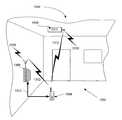
도 14는 다수의 빌딩을 갖는 4개 도시 블럭의 교차점에 위치된 도 1의 ALCD의 일 실시예를 도시한다.FIG. 14 illustrates one embodiment of the ALCD of FIG. 1 located at the intersection of four city blocks with multiple buildings.
도 15는 도 1의 ALCS와 연계되어 이용되는 시간 전송 아키텍쳐의 일 실시예를 도시한다.FIG. 15 illustrates one embodiment of a time transfer architecture used in conjunction with the ALCS of FIG. 1.
도 16은 도 1의 ALCS와 연계되어 이용되는 주파수전송 아키텍쳐의 일 실시예를 도시한다.FIG. 16 illustrates an embodiment of a frequency transmission architecture used in conjunction with the ALCS of FIG. 1.
도 17은 도 1의 ALCS와 연계되어 이용되는 주파수전송 아키텍쳐의 일 실시예의 블럭도를 도시한다.FIG. 17 shows a block diagram of one embodiment of a frequency transmission architecture used in conjunction with the ALCS of FIG. 1.
도 18은 도 1의 ALCS에 의하여 수행되는 프로세스의 일 예를 도시하는 흐름도이다.18 is a flowchart illustrating an example of a process performed by the ALCS of FIG. 1.
바람직한 실시예의 이하의 설명에서는, 여기의 일부를 이루고, 본 발명이 실시될 수 있는 특정 실시예가 예로서 도시되는 첨부된 도면에 대한 참조가 이루어진 다. 본 발명의 범위를 벗어나지 않고 다른 실시예들이 이용될 수 있으며 구조적인 변화가 이루어질 수 있음을 이해해야 한다.In the following description of the preferred embodiments, reference is made to the accompanying drawings, which form a part hereof, and in which is shown by way of illustration specific embodiments in which the invention may be practiced. It is to be understood that other embodiments may be utilized and structural changes may be made without departing from the scope of the present invention.
개요summary
당업자는 GPS 시스템은 "SPS"(Satellite Positioning System) 및/또는 네비게이션 위성시스템을 포함하는 것을 이해한다. 일반적으로 GPS 시스템은 위성("SV(space vehicle)"으로도 공지됨) 기반의 네비게이션 시스템이다. GPS 시스템의 예들은 미국("U.S") "NNSS"(Navy Navigation Satellite System)(TRANSIT으로도 공지됨), LORAN, 쇼란, 데카, TACAN, NAVSTAR, "GLONASS"(Global Navigation Satellite System)으로서 공지된 NAVSTAR에 대한 러시아의 대응물 및 제안된 "Galileo" 프로그램과 같은 임의의 미래 서구유럽의 GPS를 포함한다(그러나 이에 한정되는 것은 아님). 일 예로서, US NAVSTAR GPS 시스템은 참고로 여기에 포함된, 2001년, 뉴욕 스프링거-버라그 위엔, 호프만-웰렌호프, 리히테니거 및 콜린스에 의한 개정판, 제5판, GPS 이론 및 연습에 개시된다.One skilled in the art understands that a GPS system includes a satellite positioning system (SPS) and / or a navigation satellite system. GPS systems are generally satellite-based navigation systems (also known as "space vehicles"). Examples of GPS systems are known as the US ("US") "NNSS" (Navy Navigation Satellite System) (also known as TRANSIT), LORAN, Shoran, Deca, TACAN, NAVSTAR, "GLONASS" (Global Navigation Satellite System). Russia's counterparts to NAVSTAR and any future Western European GPS such as the proposed "Galileo" program. As an example, the US NAVSTAR GPS system is disclosed in 2001, New York Springer-Burrag Wien, Hoffman-Wellenhof, Liechtengger and Collins, Edition 5, GPS Theory and Practice, incorporated herein by reference. do.
GPS 시스템 구성요소들을 무선통신 시스템(셀룰러, 페이징, 양방향 페이징, "PDA"(Personal Data Assistant), 블루투스, Wi-Fi PCS 시스템을 포함할 수 있음)과 통합하는 경우, GPS 시스템은 전형적인 무선통신 시스템 사용자가 조우할 수 있는 조건 하에서 GPS 시스템을 포착하고 추적하는 능력을 가져야 한다. 이 조건들 중 일부는 실내 사용, 하늘을 보는 것이 제한된 밀집된 도시영역(위성 뷰를 차단하는 초고층빌딩들이 있는 다운타운 영역과 같은)에서의 사용을 포함할 수 있다. 이 조건들은 보통은 지상기반 무선통신 시스템에 대하여는 관리가능하지만, GPS 시스 템의 경우에는 어려운 환경이다. 예를 들어, GPS 수신기가 GPS 위성으로부터 신호를 포착하고, 위성을 추적하며, 원하는 경우에는, GPS 시스템으로 어떠한 외부 정보도 전달되지 않고 네비게이션을 수행하는 전통적인 "GPS 독립" 모드에서, 전형적인 GPS 수신기는 긴 "TIFF"(Time-To-First-Fix) 시간과 관련된 문제가 있으며, 또한, 실내 또는 하늘을 보는 것이 제한된 조건하에서는 GPS 위성신호를 포착하는 능력이 제한된다. 일부의 추가적인 정보로도, 천문력 데이터는 GPS 시스템 그 자체로부터 포착되어야 하며, 이는 신뢰성있게 천문력 데이터를 획득하기 위하여 강력한 GPS 신호를 필요로 하는 것이 보통이므로 TIFF 시간은 30초를 초과할 수 있다. 이 조건들은 위치 유용성(position availability)의 신뢰성, 및 예를 들어 셀룰러 전화와 같은 무선통신장치 내에서의 전력소모에 영향을 미치는 것이 보통이다.When integrating GPS system components with a wireless communication system (which may include cellular, paging, two-way paging, "PDA" (Personal Data Assistant), Bluetooth, and Wi-Fi PCS systems), the GPS system is a typical wireless communication system. You must have the ability to capture and track a GPS system under conditions that you may encounter. Some of these conditions may include indoor use, use in dense urban areas where the sky is restricted (such as downtown areas with skyscrapers blocking satellite views). These conditions are usually manageable for land-based wireless communication systems, but are difficult for GPS systems. For example, in a traditional "GPS independent" mode where a GPS receiver picks up a signal from a GPS satellite, tracks the satellite and, if desired, performs navigation without passing any external information to the GPS system, a typical GPS receiver may There are problems associated with long "TIFF" (Time-To-First-Fix) time, and also the ability to capture GPS satellite signals under conditions that limit indoor or sky viewing. Even with some additional information, astronomical data must be captured from the GPS system itself, which can typically exceed 30 seconds since a strong GPS signal is usually required to obtain astronomical data reliably. These conditions usually affect the reliability of position availability and power consumption in wireless communication devices such as, for example, cellular telephones.
이 문제들을 극복하기 위하여 다양한 인자들에 기하여 동작의 복수의 모드를 고려하는 ALCD(Aided Location Communication Device)가 개시된다. ALCD는 셀룰러 전화, 페이징 장치, 양방향 페이져, PDA, 블루투스 인에이블된 장치, Wi-Fi 인에이블 장치, 랩탑 컴퓨터, 데스크탑 컴퓨터, 비-모바일(non-mobile) 장치 및/또는 PCS 시스템일 수 있다. 또한, ALCD는 예를 들어, 셀룰러 전화, 페이징 장치, 양방향 페이져, PDA, 블루투스 인에이블된 장치, Wi-Fi 인에이블 장치, 랩탑 컴퓨터, 데스크탑 컴퓨터, 비-모바일(non-mobile) 장치 및/또는 PCS 시스템과 같은 장치 내의 반도체 집적회로(즉, 하나의 칩 또는 칩세트)일 수 있다.To overcome these problems, an AID (Aided Location Communication Device) is disclosed that considers multiple modes of operation based on various factors. The ALCD may be a cellular telephone, paging device, two-way pager, PDA, Bluetooth enabled device, Wi-Fi enabled device, laptop computer, desktop computer, non-mobile device and / or PCS system. In addition, ALCDs may be, for example, cellular telephones, paging devices, two-way pagers, PDAs, Bluetooth enabled devices, Wi-Fi enabled devices, laptop computers, desktop computers, non-mobile devices, and / or It may be a semiconductor integrated circuit (ie, one chip or chipset) in a device such as a PCS system.
ALCD는 GPS 독립 모드, GPS 자율 모드, GPS 네트워크 보조된 모드, GPS 네트워크 중심 모드, 역방향 보조 모드, 네트워크 기반 및 증대된 보조 모드에서 동작 할 수 있다. 이러한 동작의 복수의 모드는 ALCD가 다양한 환경에서 동작하고 외부 네트워크 또는 외부 보조 장치로 또는 그곳으로부터 "보조(aiding)"정보를 수신 및/또는 송신하도록 해준다.ALCD can operate in GPS independent mode, GPS autonomous mode, GPS network assisted mode, GPS network centered mode, reverse assisted mode, network based and enhanced assisted mode. Multiple modes of this operation allow the ALCD to operate in a variety of environments and to receive and / or transmit "aiding" information to or from an external network or external auxiliary device.
ALCD는 위치결정부(GPS 수신기를 포함), 및/또는 통신부를 포함하며, 일 예로서, 위치결정부의 GPS 수신기가 강한 신호를 수신하고, 최근의 천문력 또는 알마낵(almanac) 데이터를 갖거나, 또는 정확한 위치가 요구되지 않는 경우, ALCD는 "GPS 독립" 모드에서 이용될 수 있다. GPS 독립 모드에서, 위치결정부는 어떠한 보조도 수신하지 않으므로 임의의 이용 가능한 외부의 네트워크 또는 외부의 보조 장치로부터 독립적으로 동작한다. GPS 독립 모드에서, 위치결정부의 GPS 수신기는 GPS 위성신호를 포착하고, 그 신호들을 이용하여 ALCD의 위치를 결정한다. 또한, GPS 수신기는 추적을 위하여 GPS 위성신호를 이용할 수 있으며, 원하는 경우, ALCD의 네비게이션 기능을 이용할 수 있다. ALCD의 결정된 위치는 ALCD 내의 위치결정부에 내부적으로 이용되거나 위치결정부에 외부적으로 그리고 통신부에 내부적으로 이용될 수 있다.The ALCD includes a positioning unit (including a GPS receiver), and / or a communication unit, for example, the GPS receiver of the positioning unit receives a strong signal, has recent astronomical or almanac data, Or if the exact location is not required, the ALCD can be used in the "GPS Independent" mode. In GPS independent mode, the positioning unit receives no assistance and therefore operates independently from any available external network or external assistance device. In the GPS independent mode, the GPS receiver of the positioning unit captures GPS satellite signals and uses the signals to determine the position of the ALCD. In addition, the GPS receiver may use GPS satellite signals for tracking and, if desired, use the navigation function of the ALCD. The determined position of the ALCD may be used internally in the positioning portion within the ALCD or externally to the positioning portion and internally in the communication portion.
또 다른 예에서, ALCD 내의 GPS 수신기가 GPS 위성으로부터 강한 신호를 다시 수신하고, 최근의 천문력 또는 알마낵 데이터를 갖거나, 또는 정확한 위치가 필요하지 않은 경우, ALCD는 "GPS 자율" 모드에서도 이용될 수 있다. GPS 독립 모드와 유사하게, GPS 자율 모드에서는 ALCD 내의 위치결정부는 어떠한 보조도 수신하지 않으므로 임의의 이용 가능한 외부의 네트워크 또는 외부의 보조 장치로부터 독립하여 동작한다. GPS 자율 모드에서, GPS 수신기는 GPS 위성신호를 포착하며, 그 신호들을 이용하여 ALCD의 위치를 결정한다. 또한, GPS 수신기는 추적을 위하여 GPS 위성신호를 이용할 수 있으며, 원하는 경우, 네비게이션 기능들을 이용할 수 있다. 그러나, 상기 결정된 위치를 ALCD에 내부적으로 이용하는 대신, 자율 모드에서는, ALCD는 또한 ALCD의 결정된 위치를 지구위치 서버 또는 다른 유사한 장치들을 포함할 수 있는 외부의 네트워크로 전송한다.In another example, if the GPS receiver in the ALCD receives a strong signal back from the GPS satellites, has recent astronomical or almanac data, or does not require accurate location, the ALCD will also be used in "GPS autonomous" mode. Can be. Similar to the GPS autonomous mode, the GPS autonomous mode operates independently from any available external network or external assist device since the positioning portion in the ALCD does not receive any assistance. In GPS autonomous mode, the GPS receiver captures GPS satellite signals and uses the signals to determine the position of the ALCD. In addition, the GPS receiver may use GPS satellite signals for tracking and may use navigation functions if desired. However, instead of using the determined location internally in the ALCD, in autonomous mode, the ALCD also sends the determined location of the ALCD to an external network that may include a geolocation server or other similar devices.
유사하게, 또 다른 예에서, GPS 수신기가 강한 신호를 다시 수신하고, 최근의 천문력 또는 알마낵 데이터를 가지거나, 또는 정확한 위치가 필요하지 않은 경우, ALCD는 "역방향 보조된" 모드에서도 이용될 수 있다. GPS 자율모드 및 GPS 독립 모드와 유사하게, 역방향 보조된 모드에서 ALCD 내의 위치결정부는 어떠한 보조도 수신하지 않으므로 임의의 이용 가능한 외부의 네트워크 또는 외부의 보조 장치로부터 독립적으로 동작한다. 역방향 보조 모드에서, GPS 수신기는 GPS 위성신호를 포착하며, 그 신호들을 이용하여 ALCD의 위치를 결정한다. 위치결정부 내의 GPS 수신기는 또한 추적을 위하여 GPS 위성신호를 이용하며, 원하는 경우, 네비게이션 기능들을 이용할 수 있다. 그러나, 상기 결정된 위치를 ALCD에 내부적으로 이용하는 것 대신에, 역방향 보조 모드에서, ALCD는 GPS 수신기에서 측정된 정보의 다양한 유형을 외부의 네트워크로 송신한다.Similarly, in another example, if the GPS receiver receives a strong signal again, has recent astronomical or almanac data, or does not need accurate location, the ALCD may be used in "reverse assisted" mode as well. have. Similar to the GPS autonomous mode and the GPS independent mode, in the reverse assisted mode, the positioning unit in the ALCD operates independently from any available external network or external auxiliary device since it does not receive any assistance. In the reverse assist mode, the GPS receiver captures GPS satellite signals and uses the signals to determine the position of the ALCD. The GPS receiver in the positioning unit also uses the GPS satellite signal for tracking and may use navigation functions if desired. However, instead of using the determined location internally in the ALCD, in the reverse assisted mode, the ALCD sends various types of information measured at the GPS receiver to an external network.
또 다른 예에서, ALCD는 ALCD 내의 GPS 수신기가 충분히 강한 GPS 신호를 수신하지 않으면 "GPS 네트워크 보조된" 모드에서 동작할 수 있으며, 예를 들어, ALCD가 실내에서 이용되는 경우, 위치결정부는 동작의 상이한 모드로 전환할 수 있으며 여기서는 무선통신 시스템과 같은 여부의 네트워크는 위치결정부를 도와(즉, "보조하여") 외부의 네트워크 또는 외부의 보조 장치에 의하여 공급된 추가적인 정보와 함께 GPS 수신기에 의하여 수신된 GPS 신호를 이용하여 포착, 추적, 및/또는 네비게이션하도록 할 수 있다. 추가적인 정보는 알마낵 또는 서브알마낵 정보, 하등의 위치정보, 도플러 데이터, 인뷰 위성위치, 시간 및 주파수 보조, 수신된 무선 라디오 신호 강도, 또는 GPS 수신기가 포착, 네비게이트, 또는 추적할 필요가 있는 정보를 획득하는데 있어 GPS 수신기를 보조할 다른 보조들을 포함할 수 있다. GPS 네트워크 보조된 모드 접근은 "GPS 네트워크 중심" 모드(또한 다른 공지된 문헌에서는 "GPS 모바일 기반" 모드 또는 "네트워크 원조된" 모드로서 공지됨)와는 상이하며 그 이유는 GPS 네트워크 보조된 모드 접근에서는, ALCD 내의 GPS 수신기는 결국 위치를 획득하고 스스로 ALCD의 위치를 정하는데 필요한 정보를 추적할 수 있기 때문이다.In another example, the ALCD may operate in a "GPS network assisted" mode if the GPS receiver in the ALCD does not receive a sufficiently strong GPS signal, for example, if the ALCD is used indoors, the positioning unit may It is possible to switch to a different mode where a network, such as a wireless communication system, is assisted by the positioning unit (i.e. "assisted") and received by the GPS receiver with additional information supplied by an external network or external auxiliary device. GPS signals can be used to capture, track, and / or navigate. Additional information may include almanac or subalmanac information, some location information, Doppler data, in-view satellite position, time and frequency assistance, received wireless radio signal strength, or GPS receivers need to capture, navigate, or track Other aids may be included to assist the GPS receiver in obtaining information. The GPS network assisted mode approach differs from the "GPS network centric" mode (also known in other known literature as the "GPS mobile based" mode or the "network assisted" mode) because of the GPS network assisted mode approach. In other words, the GPS receiver in the ALCD can eventually track the information needed to acquire the position and position the ALCD by itself.
추가적으로 또 다른 예에서, ALCD가 더욱 거친 신호수신 환경에서 이용되며 ALCD 내의 GPS 수신기는 어떠한 GPS 신호들도 수신할 수 없는 상황에서 ALCD는 "네트워크 기반" 모드에서 동작할 수 있다. 그와 같이, ALCD 내의 위치결정부는 외부의 네트워크에 완전히 의존하여 임의의 위치결정 정보를 획득할 수 있다. 보통, 네트워크 기반 모드는 GPS 또는 다른 GPS 위성정보 없이 위치를 계산한다. ALCD의 위치는 셀룰러 송신타워, "TDOA"(Time Difference of Arrival) 기술, 비셀룰러 무선네트워크, 등과 같은 네트워크 리소스들로부터 도출된다.In yet another example, the ALCD may operate in a "network based" mode where ALCD is used in a harsher signal receiving environment and the GPS receiver in the ALCD cannot receive any GPS signals. As such, the positioning portion in the ALCD can obtain any positioning information completely dependent on the external network. Normally, network-based mode calculates the location without GPS or other GPS satellite information. The location of the ALCD is derived from network resources such as cellular transmission towers, Time Differential of Arrival (TDOA) technology, non-cellular wireless networks, and the like.
추가적으로 또 다른 예에서, ALCD 내의 GPS 수신기가 성능이 제한되거나 ALCD의 위치가 네트워크에서 계산되는 상황에서 ALCD는 GPS 네트워크 중심 모드에 서 동작할 수 있다. 그와 같이, ALCD는 위치결정부 내에서 신호를 수신하며 최종적인 위치 계산을 위하여 위치관련 데이터를 네트워크로 송신한다. 이 모드는 또한 "모바일 원조된(mobile-assisted)" 모드로서 공지되어 있다.In yet another example, the ALCD may operate in GPS network centric mode in situations where the GPS receiver in the ALCD has limited performance or the location of the ALCD is calculated in the network. As such, the ALCD receives a signal within the positioning unit and transmits position related data to the network for final position calculation. This mode is also known as a "mobile-assisted" mode.
유사하게, 또 다른 예에서, ALCD가 거친 신호수신 환경에서 이용되며 어떠한 GPS 신호도 수신할 수 없는 경우에 ALCD는 "증대된 자율" 모드에서 동작할 수 있다. 증대된 자율 모드에서, ALCD는 다양한 유형의 외부의 위치 보조 소스/장치 또는 외부의 네트워크를 이용하여 임의의 GPS 정보와 전체적으로 독립적일 수 있는 위치정보를 획득할 수 있다. 증대된 자율모드에서, ALCD는 GPS 또는 다른 GPS 위성정보를 이용하지 않고 그 위치를 계산한다. ALCD의 위치는 위치정보를 송신할 수 있는 컴퓨터 네트워크, 통신네트워크, 무선네트워크 또는 외부장치와 같은 네트워크 리소스로부터 도출된다.Similarly, in another example, the ALCD may operate in an "enhanced autonomous" mode if the ALCD is used in a harsh signal receiving environment and cannot receive any GPS signals. In the enhanced autonomous mode, the ALCD can use various types of external location assistance sources / devices or external networks to obtain location information that can be entirely independent of any GPS information. In augmented autonomous mode, the ALCD calculates its location without using GPS or other GPS satellite information. The location of the ALCD is derived from network resources such as computer networks, communication networks, wireless networks or external devices capable of transmitting location information.
ALCD는 몇 가지 변수, 및 사용자가 선택한 기호 또는 요구에 기하여 동작의 이 모드들 사이에서 전환할 수 있으며, 로컬 또는 원격제어를 통하여 또는 ALCD에 주어진 자동 또는 수동의 명령을 통하여 전환할 수 있다.The ALCD can switch between these modes of operation based on several variables and the user's preferences or preferences, and can be switched via local or remote control or through automatic or manual commands given to the ALCD.
GPS 아키텍쳐GPS architecture
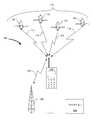
도 1은 ALCD(102)의 위치결정부(도시하지 않음) 내에 위치된 GPS 수신기(도시하지 않음) 및 통신부(도시하지 않음)를 갖는 ALCD(102)를 이용하는 ALCS(Aided Location Communication System)(100)의 일 실시예이다. 도 1에 도시된 바와 같이, 동작동안, ALCD(102)는 기지국(106) 및 무선 송신경로(108)를 통하여 무선네트워크(104)와 신호 통신하고 신호 통신경로(112, 114, 116 및 118)를 통하여 GPS 위 성 콘스텔레이션(110)의 하나 이상의 GPS 위성과 신호 통신한다. 4개의 GPS 위성(120, 122, 124 및 126)만이 도시되지만, GPS 위성(120, 122, 124 및 126)은 ALCD(102)에 가시적인 GPS 콘스텔레이션(110)으로부터의 임의의 수의 GPS 위성일 수 있음이 당업자에게는 이해된다.1 illustrates an
ALCD(102)는 통신부(도시하지 않음) 내의 "콜프로세싱"부로도 알려진 무선프로세싱부(도시하지 않음) 및 위치결정부(도시하지 않음) 내에 GPS 수신기(도시하지 않음)를 포함할 수 있다. ALCD(102) 내의 GPS 수신기는 신호 통신경로(112, 114, 116 및 118)를 통하여 GPS 위성 콘스텔레이션(110)으로부터 GPS 신호를 수신할 수 있고 ALCD(102)의 통신부는 신호 통신경로(108) 및 기지국(106)을 통하여 무선네트워크(104)로부터 무선통신신호를 수신할 수 있다. 일부 실시예들에서, ALCD(102)는 신호 통신경로(108) 및 기지국(106)을 통하여 무선네트워크(104)로 무선통신 신호를 송신할 수도 있다. ALCD(102)는 셀룰러전화(또는 무선 핸드셋, 셀폰, 모바일전화 또는 모바일폰으로 공지됨) 또는 "PDAs"(personal digital assistants), 페이저, 컴퓨터, 양방향 라디오, 트렁크된 라디오, "SMR"(specialized mobile radio) 또는 위치정보를 결정하는 것이 바람직한 임의의 다른 장치를 포함(그러나 이에 한정하지는 않음)하는 임의의 다른 형태의 모바일 장치와 같은 무선장치일 수 있다. 또한, ALCD(102)는 무선장치 내에 위치된 반도체 집적회로(즉, 하나의 칩) 또는 무선장치 내에 위치된 반도체 집적회로의 조합(즉, 칩세트)일 수 있다. 칩, 또는 칩세트의 예들은, "ASIC"(application specific integrated circuit) 또는 ASIC 및 "DSP"(digital signal processor) 또는 DSP를 포함할 수 있는 트랜시버 및 GPS 수 신기를 구비하는 임의의 집적회로를 포함할 수 있다. 셀룰러 전화의 경우에, ALCD(102)는 CDMA, CDMA-2000, W-CDMA, TDMA, FDMA, GSM, UMTS, AMPS, 블루투스, Wi-Fi 및/또는 이 송신 스킴들 또는 유사한 스킴들의 임의의 조합 또는 확장을 포함하는(그러나 이에 한정하지는 않음) 임의의 송신스킴(transmission schemes)을 이용하여 임의의 "RF"(radio frequency) 대역에서 동작하는 통신부 내의 셀룰러 트랜시버를 이용할 수 있다.The
도 2는 도 1에 도시된 ALCD(102)의 일 실시예의 블럭도이다. 도 2의 ALCD(102)는 통신부(200) 및 위치결정부(202) 모두를 포함한다. 무선통신부(200)는 무선어플리케이션을 위한 프로세싱 기능들을 수행하는 "CP"(call processing)부를 포함할 수 있으며 무선 트랜시버를 포함할 수 있다. 예를 들어, 셀룰러 전화의 경우, ALCD(102)는 셀룰러 트랜시버를 구비한 CP부를 포함할 것이다. 위치결정부(202)는 GPS 위성 콘스텔레이션(110)으로부터 위성 송신(206)을 수신하는 GPS 수신기(204)를 포함한다. 또한, 위치결정부(202)는 이하에 개시된 바와 같이 비-GPS(non-GPS) 위치 보조 정보를 수신할 수 있는 비-GPS 수신기를 포함할 수 있다. 위치결정부(202)는 ALCD(102)에 대한 위치계산 기능을 수행한다. 통신부(200)의 기술을 위치결정부(202)의 경우와 통합함으로써, ALCD(102)는 두 개의 주요 서비스 시스템을 제공하며: 그것은 셀룰러 전화 서비스와 같은 무선장치의 경우, 및 ALCD(102)의 위치정보를 제공하는 GPS 수신기의 경우이다. 이러한 통합은 "FCC"(Federal Communication Commission)의 E911 요건 충족을 포함하여 다수의 장점들을 제공하는 것으로 당업자는 이해한다.2 is a block diagram of one embodiment of the
ALCD(102) 내에서, 또는 대안적으로, ALCD(102)와 ALCD(102)로의 외부의 액세서리(도시하지 않음) 사이에서, 통신부(200)와 위치결정부(202) 사이의 통신이 발생한다. 이 통신은 신호가 통신부(200)로부터 위치결정부(202)로 전달되도록 하며, 보통은 시리얼 통신링크(208) 및 하드웨어 라인(210)에서 발생하지만, 다른 접속들도 원하면 이용될 수 있다.Within
일 예로서, 통신부(200) 및 위치결정부(202)는 동일한 디지털 프로세서(도시하지 않음) 및 다른 회로를 공유할 수 있다. 그런 경우, 상기 부분들 사이의 통신은 인터태스크(inter-task) 통신에 의하여 이루어질 수 있으며, 통신부(200)와 위치결정부(202) 사이의 임의의 시간 또는 주파수 전송과 같은 특정의 데이터 전송은 하드웨어 라인(208)을 이용하지 않을 것이지만, 회로에 내부적으로 될 것이거나 또는 잠재적으로는, 회로설계에 따라 전송이 필요하지 않을 것이다.As an example, the
도 3에서는, ALCS(300) 아키텍쳐의 일 예가 도시된다. ALCS(300) 아키텍쳐는 E911 및 지구위치 서버의 실시를 위하여 ALCD(302)의 다양한 실시를 지원하는 GPS 기술을 이용한다. 저비용, 저전력, 고성능 및 고정밀 GPS 수신기 및 무선네트워크 통신서비스를 이용하여, ALCS(300)는 ALCD(302)에 대하여 신뢰성이 높고 경제적인 해법들을 제공한다. ALCS(300)는 GPS 독립 모드, GPS 자율 모드, GPS 네트워크 보조된 모드, GPS 네트워크 중심 모드, 역방향 보조 모드, 네트워크 기반 및 증대된 보조 모드를 포함하는 모든 형태의 지구위치 서비스를 지원한다. 또한, ALCS(300)은 CDMA, TDMA, AMP, 및 심지어는 페이저 시스템을 포함하는 광범위한 무선통신 기술들을 수용한다.In FIG. 3, an example of an
도 3에서, ALCS 시스템(300)의 일 실시예는 GPS 위성(304)(지구궤도에 있는 GPS 위성(304)의 콘스텔레이션의 예시임), GPS 수신기를 포함하는 ALCD(302), 기지국(306), 지구위치(서버) 서비스 센터(308), 지구위치 엔드 어플리케이션(310), 및 "PSAP"(Public Safety Answering Point, 312)를 포함할 수 있다.In FIG. 3, one embodiment of the
동작의 일 예에서, GPS 위성(304)은 지구위치 서버(308) 및 ALCD(302)에서 수신되는 확산스펙트럼 신호(314)를 송신한다. 쉬운 예시를 위하여, 다른 GPS 위성들은 도시되지 않지만, 다른 GPS 위성들도 또한 ALCD(302) 및 지구위치 서버(308)에 의하여 수신되는 신호들을 송신한다. ALCD(302)가 충분히 강한 신호(314)를 수신하면, ALCD(302) 내의 GPS 수신기는 공지된 GPS 시스템의 전형적인 방식으로 ALCD(302)의 위치를 계산할 수 있다.In one example of operation,
그러나, ALCD(302)가 충분히 강한 신호(314)를 수신할 수 없거나, 충분한 GPS 위성들(302)로부터 신호를 수신하여 자율적으로 ALCD(302)의 위치를 계산할 수 없다면, 신호경로(316)를 통하여 기지국(306)과 통신하는 것이 여전히 가능할 것이다. 본 예에서, 기지국(306)은 신호(316)를 통하여 정보를 ALCD(302)로 통신하여 ALCD(302)가 그 위치를 계산하도록 해준다. 대안적으로, 기지국(306)은 ALCD(302)로부터 지구위치 서버(308)로 정보를 통신하여 지구위치 서버(308)가 ALCD(302)의 위치를 계산하도록 해준다. 기지국(306)이 ALCD(302)로 정보를 전송하여 ALCD(302)가 그 위치를 계산하도록 해주는 경우, 그 프로세스는 "무선 보조된 GPS"로 공지된 한편, 기지국(306)이 정보를 ALCD(302)로부터 지구위치 서버(308)로 전송하여 지구위치 서버(308)가 ALCD(302)의 위치를 계산하도록 해주는 경우는, 그것 은 "네트워크 중심 GPS"로 공지되어 있다.However, if the
지구위치 서비스 센터(즉, 지구위치 서버)(308)는 또한 신호(318)를 통하여 지구위치 어플리케이션(310)과 통신하며, 신호(320)를 통하여 PSAP(312)와 통신한다. 이 신호(318 및 320)는 무선링크를 통할 수 있거나 지상통신 전화 네트워크 또는 다른 유선기반 네트워크를 통할 수 있다.Geolocation service center (ie, geolocation server) 308 also communicates with
ALCS(300)는 지구위치 소프트웨어 모듈을 갖는 GPS 수신기 및 지구위치 서버(308)를 구비하는 ALCD(302)를 포함하는 두 개의 주요 서비스 시스템을 포함할 수 있다. 또한, 두 종류의 지원 시스템이 있으며, 그것은 네트워크 정보 전송 메커니즘을 제공하는 기지국("BS")(306) 하부구조, 및 지구위치 네트워크 서비스를 개시할 수 있는 지구위치 엔드 어플리케이션(310) 시스템 또는 PSAP(312)이다.
ALCD(302)는 CP 기능들을 수행하는 전형적인 통신부, 및 ALCD(302)에서 수행되는 위치계산, 가상거리 측정, 및 다른 GPS 기능들을 위한 위치결정부를 포함할 수 있다. 시리얼 통신링크, 또는 다른 통신링크는 통신부와 위치결정부 사이의 통신을 수행하고 하드웨어 라인의 일 콜렉션이 이용되어 두 부분들 사이에서 신호를 송신할 수 있다.The
도 4는 ALCS(400)의 엔드-투-엔드(end-to-end) 시스템의 또 다른 실시예를 도시한다. ALCS(400)는 GPS 위성 콘스텔레이션(406)으로부터 GPS 신호(404)를 수신하는 ALCD(402)를 도시한다. ALCD(402)는 GPS 수신기 클라이언트(도시하지 않음)를 구비하는 위치결정부(408) 및 CP부(도시하지 않음)를 구비하는 통신부(410)를 포함하며, 이들은 예를 들면 RS232 데이터링크(412)에 의하여 접속된다. 통신 부(410)는 기지국(414)과 통신하며, 이는 셀룰러 및/또는 셀룰러/지상기반 전화 네트워크(415)를 통하여 메인서버(416)와 통신한다. 메인서버(416)는 지상기반 또는 무선네트워크를 통하여(보통은 TCP/IP 프로토콜 이용) 지구위치 서버(418) 및 어플리케이션(420)과 통신한다.4 illustrates another embodiment of an end-to-end system of
또한, GPS 신호(404)는 기준수신기(422)의 위치를 계산하고 GPS 신호(404)로부터 데이터를 추출하는 일련의 기준수신기들(422)에 의하여 수신된다. GPS 콘스텔레이션(406) 내의 모든 GPS 위성들에 대하여, 시간, 도플러, 주파수, 등과 같은 추출 데이터는 GPS 데이터 센터(424)로 보내진다. 필요한 경우, 지구위치 서버(418)는 ALCD(402)에 의한 이용을 위하여 GPS 데이터 센터(424)로부터 데이터를 추출하고, 그 데이터를 ALCD(402) 또는 어플리케이션(420)으로 송신한다. 또한, 메인서버(416)는 원하면 PSAP(426)으로 인터페이스할 수 있고, 메인서버(416) 및 지구위치 서버(418)는 원하거나 필요한 경우에는 함께 위치될 수 있다.The
셀룰러, PCS, 양방향 페이징, "SMR"(Specialized Mobile Radio), "SMS"(Short Messaging Service), 등과 같은 이용중인 무선네트워크에 따라, ALCS(400)의 물리적 실시는 도 3 및 4에 도시된 것으로부터 변화할 수 있다. 도 3 및 4는 예시적인 목적일 뿐이며, ALCS(400)의 다른 무선시스템으로의 어플리케이션을 제한하려는 것은 아니다. 또한, ALCS(400)는 본 발명의 범위를 벗어나지 않고, 지상통신 전화 시스템, 로컬영역 네트워크, 등과 같은 하드와이어 시스템과 함께 이용될 수 있다.Depending on the wireless network in use, such as cellular, PCS, two-way paging, Specialized Mobile Radio ("SMR"), Short Messaging Service ("SMS"), etc., the physical implementation of the
도 5는 ALCS(500)의 또 다른 실시에를 도시한다. ALCS(500)는 GPS 콘스텔레 이션(504)로부터 GPS 신호(502)를 수신하나, ALCD(506)는 클라이언트로도 지칭되는 GPS 수신기를 구비하는 위치결정부(508), 서버(510), 및 CP부(512)를 포함할 수 있다. 서버(510) 및 CP(512)는 통신부(514) 내에 포함될 수 있다. ALCS(500) 내에서, 서버(510)는 보통은 "얇은 서버(thin server)"로 알려져 있는데, 그 이유는 도 4에 개시된 서버(즉, 통신부(410))와 동일한 성능을 갖지 않을 것이기 때문이다. ALCS(500)은 GPS 기준 수신기(516)를 이용하여 또한 GPS 콘스텔레이션(504)으로부터 신호(502)를 수신하고, 데이터 센터(518)에 GPS 데이터를 기억시킨다. 이 정보는, 서버(510)를 이용하여 CP부(512)와 클라이언트(508) 사이에서 데이터를 전후로 송신하는 ALCD(506), 또는 어플리케이션(522)에 의하여 요청되는 경우, 메인서버(520)로 송신된다. ALCS(500)는 천문력(ephemeris)과 같은 일부 보조 데이터가 서버(510)의 ALCD(506)에 기억되고 그 후 요구가 있으면 클라이언트(508)로 제공되도록 한다.5 illustrates another embodiment of an
무선 네트워크를 통한 멀티모드 GPS 동작Multimode GPS Operation over Wireless Network
전술된 바와 같이, ALCS는 신호강도, 오퍼레이터 개입, 원하거나 요청되는 서비스의 유형, 성능기대(예를 들면, 수 초 대 수십 초의 TTFF), 등과 같은 다수의 변수에 따라 상이한 모드에서 동작될 수 있다. 각각의 모드의 동작은 이하에 개시된다.As mentioned above, the ALCS can be operated in different modes depending on a number of variables, such as signal strength, operator intervention, type of service desired or requested, performance expectations (e.g., TTFF of seconds versus tens of seconds), and the like. . Operation of each mode is described below.
독립 모드Independent mode
GPS 독립 모드(GPS-standalone mode)에서, ALCD(304)에 위치된 위치결정부의 GPS 수신기는 기지국(306) 및 신호경로(316)를 통하여 ALCD(304)와 신호 통신하는 무선통신 네트워크로부터 독립하여 동작한다. 위치결정부는 GPS 신호(314)를 획득하고, 신호(314)를 이용하여 ALCD(304)의 위치를 결정한다. 또한, 위치결정부는 추적, 및 원하는 경우, 네비게이션 기능들을 위하여 GPS 신호(314)를 이용한다. ALCD(304)의 결정된 위치는 ALCD(304)에 내부적으로 이용된다.In GPS-standalone mode, the GPS receiver of the positioning unit located in the
자율모드Autonomous mode
GPS 자율모드(GPS-autonomous mode)에서, ALCD(304)의 위치는 예를 들면, 셀룰러 또는 다른 통신네트워크로부터의 어떠한 원조도 없이 ALCD(304) 내의 위치결정부에 의하여 GPS 독립 모드와 유사한 방식으로 계산된다. 그러나, ALCD(304)에 내부적인 ALCD(304)의 결정된 위치를 이용하는 대신, GPS 자율 모드에서는, ALCD(304)는 ALCD(304)의 상기 결정된 위치를 무선통신 네트워크를 통하여 다시 통신 네트워크(예를 들면, 지구위치 서버(308), 어플리케이션(310), PSAP(312), 등)로 송신한다.In GPS autonomous mode, the position of the
네트워크 보조된 모드(NETWORK AIDED MODE)NETWORK AIDED MODE
ALCD(302) 내의 위치결정부는 위치정보의 일부를 위치결정부로 보내는 무선통신 네트워크를 이용하여 포착, 추적, 및 네비게이션 기능들에 있어서 GPS 수신기를 "보조"하도록 하는 상이한 모드의 동작이 ALCS(300)에서 실시될 수 있다. 그런 정보는 알마낵 또는 서브 알마낵 정보, 하등의 위치정보, 도플러 데이터, 인뷰(in-view) GPS 위성위치, 시간 및 주파수 보조, 수신된 무선 라디오 신호강도(유추하여 GPS 신호강도에 대하여 예상되는 것의 아이디어를 획득하기 위함), 또는 포착, 네비게이션, 또는 추적에 있어서 GPS 수신기를 보조할 다른 보조들을 포함한다. 그 런 상황들은 ALCD(302)가 차단되거나 아니면 GPS 위성신호들을 포착할 수 없거나 , 또는 다중경로 문제로 인하여 GPS 위성을 추적할 수 없으므로, ALCD(302)가 하늘에 대한 제한적인 뷰를 가지거나, 스스로 충분한 GPS 신호를 포착할 수 없는 경우에 발생할 수 있다. 더욱이, 그런 상황들은 ALCD(302)로부터 E911 콜이 발생된 경우, 사용자가 매우 짧은 TTFF를 원하거나 그 추가적인 네트워크 정보는 정밀도 향상, 또는 다른 이유로 GPS 계산시 포함되는 것과 같은 주어진 상황에 처해진 사용자에 의해서도 개시될 수 있다.A different mode of operation in which the positioning unit in the
GPS 네트워크 보조된 접근은 GPS 네트워크 중심(다른 문헌에서는 네트워크 원조된 모드로도 지칭됨) 접근과는 상이한데 그 이유는 GPS 네트워크 보조된 접근에서, 위치결정부는 결국은 스스로 ALCD(302)의 위치를 정하는데 필요한 위치 및 추적정보를 획득할 수 있기 때문이다. 크라스너에서 설명된 바와 같이, GPS 네트워크 중심 접근은 무선네트워크의 외부로부터 획득된 GPS 정보를 이용하여 모바일 장치의 위치를 결정할 수 없는데, 그 이유는 위치계산은 ALCD(302) 대신, 기지국에서의 무선네트워크의 내부에서 수행되기 때문이다.The GPS network assisted approach is different from the GPS network centered approach (also referred to in other literature as network assisted mode) because the GPS network assisted approach, the positioning unit eventually determines the position of the
또한, ALCS(300)에 대하여 개시된 바와 같이, GPS 네트워크 보조된 접근은, 초기 획득이 이루어졌으면, GPS 독립 모드, GPS 자율 모드, 또는 다른 모드들 사이에서 전환하는 것을 고려한다. ALCS(300)의 아키텍쳐 및 GPS 네트워크 보조된 모드는 약한 신호 환경에서도 추적, 예를 들면, GPS 자율 모드 또는 GPS 독립 모드에서 수행되는 사용자위치의 지속적인 업데이트를 고려한다. 크라스너의 GPS 네트워크 보조된 아키텍쳐는 지속적으로 네트워크 보조에 의존하여 후속하는 위치를 계산 하는 것이 보통이다.In addition, as disclosed for
GPS 네트워크 보조된 모드는 약한 신호 환경에서 GPS 신호의 포착을 위하여만 이용되는 것이 보통이다. GPS 신호가 포착되면, ALCD(302)의 GPS 수신기는 네트워크로부터의 보조없이 GPS 위성(304)을 추적할 수 있다. 크라스너의 GPS 네트워크 원조된 모드는 추적 및 포착을 목적으로 모바일 장치 내의 GPS 수신기를 네트워크가 원조할 것을 요한다.GPS network assisted mode is typically used only for acquisition of GPS signals in weak signal environments. Once the GPS signal is acquired, the GPS receiver of the
네트워크 기반 모드Network-based mode
네트워크 기반 모드는 GPS 수신기가 어떠한 GPS 신호도 수신할 수 없는 상황에도 이용될 수 있다. 그와 같이, ALCD(302)는 완전히 무선통신 네트워크에 의존하여 임의의 위치결정 정보를 획득하며, 그와 같이, 무선통신 네트워크에 의하여 전달된 정보에 "중심"을 둔다. 보통, 네트워크 기반 모드는 GPS 또는 다른 위성정보를 이용하지 않고 위치를 계산한다. ALCD(302)의 위치는 네트워크 리소스(예를 들면, 셀룰러 송신기 타워 및 TDPA 기술)로부터 도출된다. 따라서, 네트워크 기반 모드는 ALCD(302) 위치를 결정하기 위한 GPS 또는 다른 위치결정 시스템 정보를 획득할 수 없는 영역에 ALCD(302)가 있는 경우 유용하다.Network-based mode may be used in situations where the GPS receiver cannot receive any GPS signals. As such,
역방향 보조 모드Reverse assist mode
ALCD(302) 내의 GPS 수신기가 다시 강한 GPS 신호를 수신하고, 최근의 천문력 또는 알마낵 데이터를 갖는 경우, 또는 정확한 위치가 요구되지 않는 경우 역방향 보조 모드가 이용될 수 있다. GPS 자율 모드 및 GPS 독립 모드와 유사하게, 역방향 보조된 모드에서, 위치결정부는 어떠한 보조도 수신하지 않으므로, 임의의 이 용 가능한 외부의 네트워크 또는 외부의 보조 장치로부터 독립적으로 동작한다. 역방향 보조 모드에서, 위치결정부는 GPS 위성신호를 포착하며, 그 GPS 신호를 이용하여 ALCD(302)의 위치를 결정한다. 위치결정부는 추적, 및, 원하는 경우, 네비게이션 기능을 위하여 GPS 신호를 이용할 수도 있다. 그러나, ALCD(302)에 내부적인 상기 결정된 위치를 이용하는 것 대신에, 역방향 보조 모드에서, ALCD(302)는 GPS 수신기에서 측정된 정보의 다양한 유형들을 무선통신 네트워크 내에서 이용하기 위하여 무선통신 네트워크와 같은 외부의 네트워크 및/또는 무선장치의 통신부로 송신한다.The reverse assist mode may be used if the GPS receiver in the
역방향 보조 모드는 위치정보, 정확한 시간, 속도, 헤딩(heading) 및 기준 GPS 클럭을 제공하도록 이용될 수 있으며 그 이유는 위치, 속도 및 헤딩은 셀 플래닝 및 전력관리에 매우 유용하기 때문이다.Reverse assist mode can be used to provide location information, accurate time, speed, heading, and reference GPS clock, because location, speed, and heading are very useful for cell planning and power management.
셀 플래닝 및 주파수 재사용을 위한 역방향 보조Reverse Assistance for Cell Planning and Frequency Reuse
셀룰러 통신 시스템에서, 역방향 보조 모드는 셀 플래닝 및 증가하는 주파수 재사용에 유용하다. 셀룰러 통신 시스템이 성장함에 따라, 더 많은 가입자들을 받으며, 그 결과 하나의 셀 내에 더 많은 라디오 채널들을 부가하거나 하나의 셀룰러 시스템으로 새로운 셀들을 부가한다. 무선통신 시스템은 스마트 안테나(페이즈드 어레이(phased array) 기술을 이용하는 안테나와 같은)를 이용하여 각각의 무선통신장치에 중심을 두는 형상화된 안테나 송신빔을 빔조종(beam-steer) 또는 빔형성(beam-form)할 수 있으므로, 역방향 보조 모드는 하나의 셀 내에서 부가적인 주파수 재사용 또는 코드 재사용을 허용한다.In cellular communication systems, reverse assist mode is useful for cell planning and increasing frequency reuse. As a cellular communication system grows, it receives more subscribers, which results in adding more radio channels within one cell or adding new cells into one cellular system. Wireless communication systems use smart antennas (such as those using phased array technology) to beam-steer or form beams of shaped antenna transmit beams centered on each wireless communication device. As can be beam-formed, the reverse auxiliary mode allows additional frequency reuse or code reuse within one cell.
도 6은 셀룰러 통신 시스템(604)의 일 예의 하나의 셀(602) 내에 위치된 일 기지국(600)을 도시한다. 셀룰러 통신 시스템(604)에서는, 기지국(600)에서의 고전력 송신기(도시하지 않음)가 전체 셀(602)과 같은 큰 지리적 영역을 취급하는 것이 보통이다. 고전력 송신기에 의하여 송신된 각각의 라디오 채널 F1(606)은 특정한 대역폭을 필요로 하는 것이 보통이므로, 결과적으로 제한된 라디오 채널의 수는 셀룰러 통신 시스템(604)의 서빙용량을 낮게 만들어 얼마 안되는 이용가능한 채널들에 대한 소비자의 요구는 높다.6 illustrates one
주파수 스펙트럼 할당이 제한되는 라디오 채널의 수를 증가시키기 위하여, 셀룰러 제공자들은 송신된 주파수들을 재사용하는 것이 보통이다. 라디오 채널 신호강도는 거리에 따라 급격히 감소되므로 이 주파수들의 재사용이 가능하며 충분히 멀리 떨어져 있는 가입자들은 간섭이 없이 동일한 라디오 채널 주파수를 이용할 수 있는 것이 보통이다. 따라서, 이 방식으로 간섭을 최소화하기 위하여, 셀룰러 시스템 플래너들은 서로 멀리 떨어져 있는 동일한 라디오 채널 주파수를 이용하는 셀 사이트들의 위치를 정한 것이 보통이다.In order to increase the number of radio channels for which frequency spectrum allocation is limited, cellular providers typically reuse the transmitted frequencies. Since the radio channel signal strength decreases rapidly with distance, it is possible to reuse these frequencies and subscribers that are far enough away can usually use the same radio channel frequency without interference. Thus, to minimize interference in this way, cellular system planners typically locate cell sites that use the same radio channel frequency that is far from each other.
그러나, 라디오 채널을 더 추가하기 위하여, 셀룰러 시스템은 동일한 주파수를 이용하는 셀 사이트들을 전략적으로 위치결정하는 것 이외에 몇 가지 기술들을 이용하는 것이 보통이다. 방향성 안테나 및 언더레이/오버레이 송신 패턴은 라디오 신호들을 셀의 한 영역내로 집중하고 다른 영역에서의 간섭을 감소시킴으로써 셀 내의 신호품질을 개선하는 것이 보통이다. 감소된 간섭은 더 많은 주파수 재사 용을 허용하므로 방향성 안테나가 이용되어 하나의 셀을 웨지들(wedges)로 분할할 수 있어 셀의 일 부만(예를 들면, 1/3, 또는 120도)이 단일 라디오 채널로 이용된다. 그런 분할은 영역 내에서 다른 셀들과의 간섭을 감소시키는 것이 보통이다.However, to add more radio channels, it is common for cellular systems to use several techniques other than strategically positioning cell sites that use the same frequency. Directional antennas and underlay / overlay transmission patterns typically improve signal quality within a cell by concentrating radio signals into one area of the cell and reducing interference in the other. Reduced interference allows more frequency reuse, so a directional antenna can be used to divide a cell into wedges, so that only a portion of the cell (e.g., 1/3, or 120 degrees) is single Used as a radio channel. Such partitioning typically reduces interference with other cells in the region.
도 7은 두 기지국(702 및 704)이 세 개의 전체 주파수 F1, F2, 및 F3를 이용하는 두 셀(706 및 708) 내의 두 예시적인 기지국(702 및 704)에서 방향성 안테나를 이용하는 셀룰러 시스템(700)의 일 실시예를 도시한다. 셀(706 및 708)은 각각 섹터(710, 712, 714, 716, 718 및 720)으로 분할되며 여기서 섹터(710)는 주파수 F1을 갖고, 712는 주파수 F2를 갖고, 714는 주파수 F3을 갖고, 716은 주파수 F1을 갖고, 718은 주파수 F2를 가지며, 720은 주파수 F3를 갖는다.FIG. 7 illustrates a cellular system using directional antennas at two
섹터 내에서 주파수의 할당은 표준 채널 스페이싱 절차를 이용하여 선택될 수 있다. 보통, 채널 스페이싱은 셀룰러 스펙트럼의 양의 밖에 있는 모든 셀룰러 채널에 대하여 할당되는 실질적인 대역폭 스페이스를 의미한다. 보통, 각각의 셀 기지국은 특정 수의 셀룰러 채널들이 할당된다. 채널들의 이 그룹은 채널 세트로서 공지되어 있다. 주파수 재사용 플랜("N4" 또는 "N7" 플랜과 같은)은 상기 플랜 내에서 다수의 채널 세트들을 이용한다. 일 예로서, N=7 주파수 재사용 플랜(즉, N7 플랜)에서는, 21 채널 세트가 있으며, 세트당 평균적으로 15 내지 20 쌍의 채널들이 할당된다. 채널세트들은 N=7 재사용 포맷을 이용하여, 세 개의 그룹으로 문자숫자 겸용으로 할당되므로 21개의 채널세트가 존재한다.The allocation of frequencies within a sector can be selected using standard channel spacing procedures. Usually, channel spacing refers to the actual bandwidth space allocated for all cellular channels that are outside of the amount of cellular spectrum. Typically, each cell base station is assigned a specific number of cellular channels. This group of channels is known as a channel set. A frequency reuse plan (such as an "N4" or "N7" plan) uses multiple channel sets within that plan. As an example, in the N = 7 frequency reuse plan (ie, N7 plan), there are 21 channel sets, with an average of 15 to 20 pairs of channels allocated per set. Channel sets are assigned alphanumericly into three groups using N = 7 reuse format, so there are 21 channel sets.
도 8은 다수의 셀들에 A, B, C, D, E, F 및 G로서 할당된 7 채널들을 갖는 전형적인 N7 주파수재사용 플랜(800)을 도시한다. 관습에 의해, 채널세트들은 문자숫자 겸용으로 할당되는 것이 보통이다. 다수의 셀들은 각각 중심셀(806 및 808) 주위에 중심을 둔 셀(802 및 804)의 두 클러스터로 배열된다.8 shows a typical N7
증가하는 주파수 용량에 대한 역방향 보조Reverse Assistance for Increasing Frequency Capacitance
주파수 재사용에 대한 장점과 유사하게, 역방향 보조 모드는 또한 셀룰러 통신 시스템 내에서 이용된 주파수 용량을 증가시키는데 유용하다. 페이스 어레이(phase-array) 및 일반적인 빔스티어링 안테나와 같은 "스마터(smarter)" 안테나의 출현으로, 셀룰러 통신 시스템은 모바일 핸드세트로 향할 수 있는 한편 모바일 핸드세트가 이동중에 모바일 핸드세트와 기지국 사이에 통신링크를 유지시키는 방식으로 안테나빔을 조종할 수 있는 안테나를 포함할 수 있다.Similar to the advantages for frequency reuse, reverse assist mode is also useful for increasing the frequency capacity used within a cellular communication system. With the advent of "smarter" antennas, such as phase-arrays and common beamsteering antennas, cellular communication systems can be directed to mobile handsets while the mobile handsets are between mobile handsets and base stations while on the move. It may include an antenna that can steer the antenna beam in a manner to maintain the communication link.
역방향 보조 모드는 ALCD(302) 내의 GPS 수신기가 그 위치, 속도 및 헤딩에 관한 위치정보를 결정하고 그 정보를 ALCD(302)의 통신부로 보내도록 한다. ALCD(302)의 통신부는 그 후 이 정보를 역방향 액세스 제어채널과 같은 통신채널을 통하여 기지국으로 송신할 수 있다.The reverse assist mode causes the GPS receiver in the
ALCD(302)의 위치정보를 알고 있는, 기지국은 그 후, 스마트 안테나를 이용하여 ALCD(302)로 향하는 좁은 빔폭을 가지는 안테나 빔을 이용해서 ALCD(302)로 송신할 수 있다. 이 안테나빔은 그 후 이동중인 ALCD(302)와의 신호 통신을 유지하기 위하여 ALCD(302)의 수신된 속도 및 헤딩정보에 기하여 기지국에 의하여 조종될 수 있다. 페이스드 어레이 기술과 같은 공지된 안테나 기술을 이용하여 안테나빔이 생성되고 조종될 수 있음을 당업자는 이해한다.The base station, which knows the location information of the
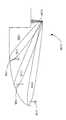
도 9는 역방향 보조 모드를 이용하는 ALCS(900)의 일 실시예를 도시한다. 일 예로서, ALCS(900)는 각각 기지국(906 및 908)을 갖는 두 셀(902 및 904)로 역방향 보조 모드를 이용할 수 있다. 기지국(906)은 안테나빔(912)을 통하여 ALCD(910)와 신호 통신할 수 있으며 기지국(908)은 안테나빔(916)을 통하여 제2 ALCD(914)와 신호 통신한다.9 illustrates one embodiment of an
도 9에서, 제1 ALCD(910) 내에 위치된 제1 위치결정부는 제1 ALCD(910)의 위치를 결정한다. 제1 ALCD(910)의 제1 통신부는 그 후 제1 위치결정부로부터 위치정보를 획득하며 그것을 제1 기지국(906)으로 보낸다. 유사하게, 제2 ALCD(914) 내에 위치된 제2 위치결정부는 제2 ALCD(914)의 위치를 결정한다. 제2 ALCD(914)의 제2 통신부는 그 후 제2 위치결정부로부터 위치정보를 획득하며 그것을 제2 기지국(908)으로 보낸다. 제1 기지국(906)은, 제1 ALCD(910)의 위치정보를 이용하여, 그 후 제1 안테나빔(912)을 조절하여 ALCD(910)를 지향적으로 조준한다. ALCD(910)가 셀(902) 내에서 이동함에 따라, 제1 기지국(906)은, 제1 ALCD(910) 이동의 속도 및 헤딩을 포함하는 제1 ALCD(910)의 위치정보를 이용하여, 제1 안테나빔(912)을 조종하여 제1 ALCD(910)와의 신호 통신을 유지한다.In FIG. 9, the first positioning portion located in the
유사하게, 제2 기지국(908)은, 제2 ALCD(914)의 위치정보를 이용하여, 그 후 제2 안테나빔(916)을 조절하여 제2 ALCD(914)를 지향적으로 조준한다. 제2 ALCD(914)가 셀(904) 내에서 이동함에 따라, 제2 기지국(908)은, 제2 ALCD(914) 이동의 속도 및 헤딩을 포함하는 제2 ALCD(914)의 위치정보를 이용하여, 제2 안테나빔(916)을 조종하여 제2 ALCD(914)와의 신호 통신을 유지한다.Similarly, the
스페이스 도메인 멀티플렉싱을 통한 주파수 용량 증가를 위한 역방향 보조Reverse Assistance for Increasing Frequency Capacity Through Space Domain Multiplexing
역방향 보조 모드는 또한 "SDM"(space-domain multiplexing)을 통하여 하나의 셀 내에서의 주파수용량을 증가시킬 수 있다. 역방향 보조 모드는 복수의 안테나빔을 기지국으로부터 셀 내에 위치된 복수의 ALCD로 송신함으로써 하나의 셀을 분배하도록 한다. 이 복수의 안테나빔은 송신 범위에서 변경할 수 있으며 ALCD의 이동을 따르도록 조종될 수 있다. 이 방식으로, 역방향 보조 모드는 셀 내에서 복수의 ALCD로의 복수의 송신을 분리하는 방법으로서 기지국이 셀 내에서 스페이스 도메인을 이용하도록 한다. 시간, 주파수, 및 코드-도메인 멀티플렉싱과 유사하게, SDM은 셀 내에서 송신되는 주파수의 용량의 증가를 고려한다.The reverse auxiliary mode can also increase the frequency capacity in one cell through space-domain multiplexing (SDM). Reverse assist mode allows one cell to be distributed by transmitting a plurality of antenna beams from a base station to a plurality of ALCDs located within the cell. These multiple antenna beams can be varied in transmission range and can be steered to follow the movement of the ALCD. In this manner, the reverse assist mode allows the base station to use the space domain within the cell as a method of separating multiple transmissions to the plurality of ALCDs within the cell. Similar to time, frequency, and code-domain multiplexing, SDM takes into account an increase in the capacity of the frequency transmitted within a cell.
도 10은 역방향 보조 모드를 이용하여 SDM을 통하여 셀(1002) 내에서 주파수 용량을 증가시키는 ALCS(1000)의 일 실시예를 도시한다. 일 예로서, 셀(1002) 및 기지국(1004)을 구비하는 ALCS(1000)가 도시된다. 기지국(1004)은 안테나빔(1010 및 1012)을 통하여 두 ALCD(1006 및 1008)과 통신할 수 있다. 셀(1002)을 따라서 ALCD(1006 및 1008)이 이동함에 따라 기지국(1004)은 안테나빔(1010 및 1012)의 송신전력 레벨을 조종 및 조절하여 ALCD(1006 및 1008)의 이동을 따른다.FIG. 10 illustrates one embodiment of an
도 11은 역방향 보조 모드를 이용하여 SDM을 통해 하나의 셀(1002) 내에서 주파수 용량을 증가시키는 ALCS(1100)의 또 다른 실시예를 도시한다. 일 예로서, 셀(1102) 및 기지국(1104)을 포함하는 ALCS(1100)이 도시된다. 기지국(1104)은 각각 안테나빔(1112, 1114 및 1116)을 통하여 ALCD(1106, 1108 및 1110)과 통신할 수 있다. 기지국(1104)은 세 ALCD(1106, 1108 및 1110) 보다 더 높이 위치될 수 있 다. 동작의 일 예에서, ALCD(1106, 1108 및 1110)가 셀(1102)을 따라 이동함에 따라, 기지국(1104)은 안테나빔(1112, 1114 및 1116)의 송신전력 레벨을 조종 및 조절하여 ALCD(1106, 1108 및 1110)의 이동을 따른다.11 illustrates another embodiment of an
전술된 바와 같이, 기지국(1104)으로부터 ALCD(1106, 1108 및 1110)의 거리에 기하여, 기지국(1104)은 ALCD(1106, 1108 및 1110)로의 송신에 이용하는 전력의 양을 변경시킬 수 있다. 역방향 보조 모드는 ALCD(1106, 1108 및 1110)의 위치를 이용하여 또 다른 기지국(도시하지 않음)으로 전환(즉, GPS 보조된 기지국 핸드오버)하는 시기를 결정하는 것을 돕도록 이용될 수도 있다.As described above, based on the distances of the
전력관리를 위한 역방향 보조Reverse Assistance for Power Management
역방향 보조 모드는 기지국이 ALCD의 움직임에 기하여 송신전력을 변경하도록 하므로 ALCS에서의 역방향 보조 모드는 전력관리에 대하여도 유용하다. 형성되거나 조종된 안테나빔은 전방향성 빔패턴보다 더 많은 이득(gain)을 가지는 것이 보통이므로, 역방향 보조 모드는 ALCD로부터의 더 낮은 전력뿐만 아니라, 기지국 송신기에 의하여 이용되는 더 낮은 송신전력을 고려한다. 따라서, 역방향 보조 모드 특성은 통신링크를 최적화시키고 무선통신 시스템 기지국의 용량(CDMA 네트워크의 용량은 코드효율에 의해서가 아니라, 네트워크 상에 더 많은 사용자들이 위치됨에 따라서 증가하는 노이즈 플로어(noise floor)에 의하여 제한되는 것이 보통이므로, CDMA 네트워크에서는 매우 중요함)을 증가시키는 것을 돕는다.The reverse auxiliary mode in the ALCS is also useful for power management since the base station allows the base station to change the transmission power based on the movement of the ALCD. Since the formed or steered antenna beam typically has more gain than the omni-directional beam pattern, the reverse auxiliary mode takes into account the lower power from the ALCD as well as the lower transmit power used by the base station transmitter. . Thus, the reverse auxiliary mode feature optimizes the communication link and the capacity of the wireless communication system base station (the capacity of the CDMA network is not due to code efficiency, but rather on the noise floor that increases as more users are located on the network. This is usually limited by, therefore very important for CDMA networks).
다시 도 9로 돌아와서, 기지국(906 및 908)은 ALCD(910 및 914)가 셀(902 및 904)을 따라 이동함에 따라 안테나빔(912 및 916)의 송신전력을 변경시킬 수 있다. ALCD(910 및 914)가 기지국(906 및 908)에 더 근접하게 이동함에 따라, 기지국(906 및 908)은 안테나빔(912 및 916)의 송신전력을 감소시킬 수 있다. ALCD(910 및 914)가 기지국(906및 908))으로부터 더 멀리 이동함에 따라, 기지국(906 및 908)은 안테나빔(912 및 916)의 송신전력을 증가시킬 수 있다.9, the
포착 가속화를 위한 역방향 보조Reverse Assist to Accelerate Acquisition
매우 정확한 절대시간 및 주파수 기준을 제공함으로써 무선네트워크와 같은 외부의 네트워크로의 코드 동기화 및 포착을 가속화하기 위하여 ALCS에서 역방향 보조 모드가 이용될 수도 있다. ALCD 내의 GPS 수신기가 GPS 위성의 GPS 콘스텔레이션으로부터의 GPS 신호를 자동추적하게 되면, GPS 수신기 내의 GPS 클럭은 대략 0.01 내지 0.001 "ppm"(parts-per-million)의 값으로 매우 안정하게 될 것이다. 반대로, 모바일장치(셀룰러 전화와 같은) 내의 전형적인 콜프로세싱부의 CP 클럭은 많아야 대략 0.10 ppm의 값을 가질 것이며, 이것은 많은 기지국 클럭의 경우 전형적인 것이다. 결과적으로, GPS 클럭 주파수 기준이 ALCD의 통신부에 있는 CP 클럭을 보조하도록 함으로써, 역방향 보조 모드를 이용하는 ALCS는 ALCD 내의 CP 클럭이 역방향 보조가 없는 경우보다 더 안정되고 정밀하게 되도록 하며, 이는 ALCD의 위치결정부에 대하여 더 빠른 포착시간을 야기시킨다.Reverse assist mode may be used in the ALCS to provide high accuracy absolute time and frequency reference to accelerate code synchronization and acquisition to external networks such as wireless networks. If the GPS receiver in the ALCD automatically tracks the GPS signal from the GPS constellation of the GPS satellites, the GPS clock in the GPS receiver will be very stable to a value of approximately 0.01 to 0.001 parts-per-million (ppm). . In contrast, the CP clock of a typical call processing unit in a mobile device (such as a cellular telephone) will at most have a value of approximately 0.10 ppm, which is typical for many base station clocks. As a result, by allowing the GPS clock frequency reference to assist the CP clock in the communication section of the ALCD, an ALCS using reverse assist mode ensures that the CP clock in the ALCD is more stable and precise than without the reverse assist, which is the location of the ALCD. It causes a faster acquisition time for the decision part.
모바일 보조에 대한 역방향 모바일 보조Reverse Mobile Aid for Mobile Aid
도 12는 모바일 보조에 대한 역방향 모바일 보조 모드를 이용하는 ALCS(1200)의 또 다른 실시예를 도시한다. 일 예로서, ALCS(1200)는 통신매체로서만 네트워크(1206)를 이용하여(신호경로(1208 및 1210)를 통하여), 제1 ALCD(1202) 가 제2 ALCD(1204)를 보조하도록 할 것이며, 여기서 제1 ALCD(1202)는 절대시간 정보를 수신하고, GPS 콘스텔레이션(1213)으로부터의 GPS 시간(GPS 신호(1212)를 통하여)과 네트워크 시간 사이의 차이를 측정하며, 상기 정보를 신호경로(1208)를 통하여 네트워크(1206)로 보낸다. GPS 보조 정보를 요청하는 제2 ALCD(1204)는 제1 ALCD(1202)로부터 GPS 시간 대 네트워크 시간차를 수신하고(신호경로(1208 및 1210) 및 네트워크(1206)를 통하여), GPS 시간을 획득하기 위한 이 정보의 네트워크 시간을 정정하여 그 자체의 GPS 포착 프로세스에 있어서 도움을 줄 것이다.12 illustrates another embodiment of an
역방향 보조 모드는 주파수 전송을 위하여 제1 ALCD(1202)로부터 제2 ALCD(1204)에 이르기까지 ALCS(1200)에서 이용될 수도 있으며, 여기서, 제1 ALCD(1202) 내의 GPS 주파수와 네트워크 주파수 사이에 측정된 주파수 에러는 네트워크(1206)로 보내지며, 원조 정보(assistance information)의 일부로서 새로운 모바일(즉, 제2 ALCD(1204))로 보내진다. 이 프로세스는 네트워크(1206)의 기지국에 의하여 방송되는 제어 커맨드로서 실시될 수 있다.The reverse assist mode may be used in the
또한, 역방향 보조 모드는 서버(네트워크(1206)에서)를 이용하지 않고 ALCS(1200) 내에서 제1 ALCD(1202)로부터 제2 ALCD(1204)로의 직접 GPS 보조를 고려한다. 직접 GPS 보조는 보조를 요청하는 또 다른 ALCD에 있는 다음 사용자에게 재송신하기 전에 원조 정보를 일시적으로 기억시키면서 서버(네트워크(1206)에서)의 개입없이 이용될 수 있다. 일 예로서, 위치, 유효한 천문력 및 가능한 네트워크-시간 및 주파수-에러-대-GPS를 포착한 제1 ALCD(1202)는 이 정보를 네트워크(1206)의 기지국을 통한 근처 또는 MSC(1214)를 통한 영역에 있는 임의의 다른 ALCD로 전송할 수 있다.In addition, the reverse assist mode allows for direct GPS assistance from the
네트워크 원조를 위한 역방향 보조Reverse Assistance for Network Assistance
ALCS에서의 역방향 보조 모드는 무선네트워크 모니터링을 위하여 이용될 수도 있으며, 여기서 무선신호 강도와 함께 위치정보, 또는 임의의 위치관련 정보가, 네트워크 내의 중심 위치에서, 모든 ALCD 요청 원조로부터 수집되어 셀커버리지 영역, 단일 셀 내의 트래픽량, 트래픽이 집중된 곳, 무선수신이 불량한 영역을 지속적으로 모니터링하여 새로운 기지국의 추가 또는 그들의 재배치의 결정에 도움을 준다. 서비스 품질은 상기 영역 내에서 이용된 모든 ALCD에 의하여 실시간으로 모니터링될 수 있다.Reverse assist mode in ALCS may be used for wireless network monitoring, where location information, or any location-related information along with radio signal strength, is collected from all ALCD request aids, at a central location in the network, to provide cell coverage area. In addition, by continuously monitoring the traffic volume within a single cell, where the traffic is concentrated, and the area where radio reception is poor, it is helpful to determine the addition of new base stations or their relocation. Quality of service can be monitored in real time by all ALCDs used within the area.
또한, ALCS에서의 역방향 보조 모드는 상이한 시점에 동일한 영역 내의 수 개의 ALCD로부터 여분시간(redundant time) 및/또는 주파수 기준 정보를 수신하는 외부의 네트워크가 네트워크 시간 오프셋 및 주파수 드리프트를 모델링하도록 하며, 장래의 그 값을 예측한다. 이 방식으로, 네트워크는 어떠한 ALCD로부터도 정보가 수신되지 않는 주기 이후에도, 타이밍 원조 정보를 새로운 ALCD로 제공할 수 있다.In addition, the reverse auxiliary mode in ALCS allows an external network to receive redundant time and / or frequency reference information from several ALCDs in the same area at different points in time to model network time offsets and frequency drifts. Predict its value. In this way, the network can provide timing assistance information to the new ALCD even after a period in which no information is received from any ALCD.
지상기반 무선통신네트워크는 다중경로의 모델링 시에 원조할 수 있고/거나 모델링툴을 제공하여 ALCD의 초기 위치가 주어진 클라이언트에서의 다중경로 수신문제를 정정하는 것을 도울 수 있으므로, ALCS에서의 역방향 보조 모드는 ALCD 내의 클라이언트에서의 다중경로 문제를 정정하기 위하여 이용될 수도 있다.Terrestrial-based wireless communication networks can assist in modeling multipath and / or provide a modeling tool to assist in correcting multipath reception problems at a given client's initial position given the ALCD, so that it supports reverse mode May be used to correct multipath problems at the client in the ALCD.
더욱이, ALCS 내의 역방향 보조 모드는 ALCD 내의 GPS 수신기로부터의 속도 정보의 이용이 "PLL"(Phase Locked Loop)을 정렬하여 ALCD 움직임과 관련된 문제에 대처하는데 있어서 무선통신 시스템을 원조하도록 한다. 특히, 역방향 보조 모드는 위치결정부로부터의 절대 ALCD 속도정보를 이용하여 무선추적 루프를 안내하여, 더 낮은 라디오신호 강도에서 무선동작을 허용함으로써 유효 무선셀 반경을 증가시킬 수 있다.Moreover, the reverse assist mode in the ALCS allows the use of speed information from the GPS receiver in the ALCD to align the Phase Locked Loop (PLL) to assist the wireless communication system in addressing problems associated with ALCD movement. In particular, the reverse assist mode can guide the radio tracking loop using absolute ALCD velocity information from the positioning unit, thereby increasing the effective radio cell radius by allowing radio operation at lower radio signal strength.
증대된 자율 모드Enhanced autonomous mode
외부의 네트워크가 필요한 신뢰도를 전달할 수 없거나, 네트워크가 보조 능력을 갖지 않으면, ALCS는 다른 모드 또는 다른 정보의 소스를 이용하여 증대된 자율 모드로 지칭되는 동작모드에서, GPS 자율 또는 GPS 독립 모드를 증대시킬 수 있다. 증대된 자율 모드는 블루투스("IEEE"(Institute of Electrical and Electronic Engineers) 802.11(일반적으로 "Wi-Fi"로 공지됨)) 및 /또는 압력, 가속도계, 또는 자이로(gyros)와 같은 다른 센서들과 함께 이용되어 ALCD에 통신을 위하여 이용되는 네트워크의 외부에 보조를 제공할 수 있다. 예를 들어, 증대된 자율 모드는 ALCD로 블루투스 송신기의 위치 및 플로어 정보를 보내는 고층빌딩의 모든 플로어에서 블루투스 송신기를 이용할 수 있으며 이 '증대된 정보'는 위치결정 데이터를 전달하기 위하여 빌딩 내부의 ALCD에 의하여 GPS 신호가 포착될 수 없는 경우에 보내질 것이다.If the external network cannot deliver the required reliability, or if the network does not have the assistance capability, then ALCS will increase the GPS autonomy or GPS independent mode in an operation mode called enhanced autonomous mode using another mode or other source of information. You can. The enhanced autonomous mode can be combined with Bluetooth ("Institute of Electrical and Electronic Engineers" 802.11 (commonly known as "Wi-Fi")) and / or other sensors such as pressure, accelerometers, or gyros. Used together to provide assistance outside of the network used for communication to the ALCD. For example, augmented autonomous mode can use a Bluetooth transmitter on any floor of a high-rise building that sends the location and floor information of the Bluetooth transmitter to ALCD, which is the 'increased information' in the building's ALCD to convey positioning data. If it can't be captured the GPS signal will be sent.
더욱이, 미리 결정된 이벤트가 발생하는 경우, 증대된 자율 모드는 ALCD가 GPS 독립 모드로부터 다른 모드(예를 들면, 보조된 모드, GPS 네트워크 중심 모드, 증)로 전환하도록 한다. 이 미리 결정된 이벤트는 GPS 위성신호가 포착되지 않은 상태에서의 미리 결정된 양의 시간의 경과, 초 또는 분의 미리 결정된 수 등을 포함할 수 있으며, 여기서 ALCD는 GPS 신호, 장치의 전력주기, 등을 수신할 수 없다.Moreover, when a predetermined event occurs, the enhanced autonomous mode causes the ALCD to switch from GPS independent mode to another mode (eg, assisted mode, GPS network centered mode, incremental). This predetermined event may include a predetermined amount of time elapsed, a predetermined number of seconds or minutes, etc., in which a GPS satellite signal is not captured, wherein the ALCD displays the GPS signal, the power cycle of the device, and the like. You cannot receive it.
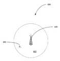
도 13은 하나의 빌딩 내에 있는 하나의 방 내의 ALCS(1300)의 일 실시예를 도시한다. ALCS(1300)는 ALCD(1304) 및 위치모듈을 포함할 수 있다. 위치모듈은 GPS 신호 또는 다른 위치정보 신호의 무선 및/또는 유선 재방사기(re-radiator)를 포함할 수 있다. 일 예로서, 위치모듈은 "EXIT" 표시(1306) 내에 고정된 재방사기 또는 빌딩 내의 방(1302)또는 복도 내의 또 다른 유사한 고정위치 장치(1308)를 포함할 수 있다. 동작의 일 예로서, ALCD(1304)는 위치모듈로부터 무선 보조 신호(각각 EXIT 표시(1306) 또는 고정위치 장치(1308)로부터의 신호(1310 및 1312)와 같은) 또는 고정위치 장치(1308)로부터의 유선 보조 신호(1314)를 수신할 수 있다. 보조 신호는 시간기준, 천문력, 또는 다른 유사한 GPS 보조 데이터를 제공할 수 있다. 보조 신호는 고정위치 장치(1308)의 고정된 위치에 관련된 정보와 같은 비-GPS형 위치 데이터를 제공할 수도 있다. 이 정보는 빌딩의 주소, 빌딩의 플로어, 방(1302) 번호 또는 복도, 및 방(1302) 내의 고정위치 장치(1308)의 위치를 포함할 수 있다.13 shows one embodiment of an
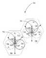
유사하게, 도 14는 다수의 빌딩(1406)을 갖는 4개의 도시 블럭(1404)의 교차점(1402)에 위치된 ALCS(1400) 내의 위치모듈의 일 실시예를 도시한다. 위치모듈(1408)은 GPS 신호 또는 다른 위치정보 신호의 무선 및/또는 유선 재방사기를 포함할 수 있다. 일 예로서, 위치모듈(1408)은 광포스트, 거리표시, 또는 다른 유사한 고정된 위치 장치 내의 고정된 재방사기(1408)를 포함할 수 있다. 동작의 일 예로 서, ALCD(도시하지 않음)는 위치모듈(1408)로부터 무선 보조 신호(1410)를 수신할 수 있다. 보조 신호(1410)는 시간기준, 천문력, 또는 다른 유사한 GPS 보조 데이터를 포함할 수 있다. 보조 신호는 위치모듈(1408)의 고정된 위치에 관련한 정보와 같은 비-GPS형 위치 데이터를 제공할 수도 있다. 이 정보는 교차점(1402)의 주소, 교차점(1402)상의 코너, 또는 다른 유사한 정보를 포함할 수 있다.Similarly, FIG. 14 shows one embodiment of a location module in an
다른 모드Other modes
GPS 독립, GPS 자율, GPS 네트워크 보조된, 또는 네트워크 기반 모드들과 유사한 다른 모드에서, ALCS는 GPS 위성 시스템의 외부뿐만 아니라 셀룰러 무선통신 네트워크의 외부로부터 정보를 수신할 수도 있다. 예를 들어, 다른 모드에서, ALCD의 위치결정부는 셀룰러 무선통신 네트워크를 이용하여 음성이나 데이터를 송신하는 한편, GPS 위성 및 블루투스 네트워크 및/또는 IEEE 802.11 Wi-Fi 네트워크로부터 정보를 수신할 수 있다. GPS 포착, 추적, 및 네비게이션 기능들은 셀룰러 네트워크를 이용하지 않고 블루투스 네트워크 및/또는 IEEE 802.11 Wi-Fi 네트워크로부터의 입력으로 증대될 수 있다.In other modes similar to GPS independence, GPS autonomy, GPS network assisted, or network based modes, the ALCS may receive information from outside of the cellular satellite network as well as outside of the GPS satellite system. For example, in another mode, the positioning portion of the ALCD may receive information from GPS satellite and Bluetooth networks and / or IEEE 802.11 Wi-Fi networks while transmitting voice or data using a cellular wireless communications network. GPS capture, tracking, and navigation functions can be augmented with input from a Bluetooth network and / or an IEEE 802.11 Wi-Fi network without using a cellular network.
더욱이, ALCS의 예시적인 아키텍쳐는 본 발명의 범위를 벗어나지 않고 전화 네트워크 또는 데이터 네트워크와 같은 유선 네트워크로 확장될 수 있다. 예를 들어, 랩탑 또는 PDA에 GPS 능력이 존재하고 장치가 유선 또는 무선 인터넷 링크로 접속되면, GPS 계산이 인터넷을 통하여 보조되어 빌딩 내의 위치를 계산할 수 있다. 상기 위치는 국소적으로 디스플레이되거나 서버로 보내질 수 있다. ALCD의 일 실시예는 보안 또는 다른 전화나 하드와이어 시스템 어플리케이션을 위하여 이 용될 수 있다.Moreover, the exemplary architecture of ALCS can be extended to wired networks such as telephone networks or data networks without departing from the scope of the present invention. For example, if the laptop or PDA has GPS capability and the device is connected by a wired or wireless internet link, GPS calculations may be assisted via the Internet to calculate a location within the building. The location can be displayed locally or sent to a server. One embodiment of ALCD may be used for security or other telephone or hardwired system applications.
동작모드들의 비교Comparison of Operation Modes
본 발명의 동작모드는 GPS 수신기 프레임워크 내에서 유연성을 더 허용한다. GPS 수신기가 짧은 TTFF 요건, 또는 네트워크 대역폭, 또는 다른 신호요구들에 의하여 제한되지 않는 경우, 본 발명의 GPS 수신기는 주어진 포착 모드를 자동으로 선택하도록 프로그램될 수 있다. 예를 들어, 네트워크 트래픽이 상당한(heavy) 경우(무선통신 네트워크에서 적은 대역폭 이용가능성으로 해석), 본 발명은 사용자가 자동으로 또는 수동으로 자율 모드 또는 독립 모드(보조 정보를 위하여 무선통신 네트워크에 의존하지 않음)를 선택하도록 한다. 동일한 방식으로, 지구위치 서버(108) 사용이 중대하고, 보조 정보 대기시간이 요건과 맞지 않는 경우, 사용자는 자율 또는 독립 모드를 자동으로 또는 수동을 선택할 수 있다. 그러나, 무선네트워크 내에 추가적인 대역폭이 이용 가능하거나, 사용자가 E911 콜에 대하여 짧은 TTFF를 필요로 한다면, 본 발명은 동작의 자율 또는 독립모드를 자율 또는 독립(천문력이 존재하고 암시적인 보조 정보가 있는 경우), 네트워크 기반 또는 네트워크 보조된 모드로 수동 또는 자동으로 변경하는 것을 고려한다.The operating mode of the present invention further allows for flexibility within the GPS receiver framework. If the GPS receiver is not limited by short TTFF requirements, or network bandwidth, or other signal requirements, the GPS receiver of the present invention can be programmed to automatically select a given acquisition mode. For example, if the network traffic is heavy (interpreted as low bandwidth availability in a wireless network), the present invention allows the user to automatically or manually rely on autonomous or independent mode (rely on wireless networks for auxiliary information). Don't select). In the same way, if the
ALCS의 멀티모드 아키텍쳐는 이용 가능한 경우 네트워크 원조를 이용함으로써, 자동적인 무결성 및 신뢰성 있는 응답을 고려하며, 원조가 이용가능하지 않거나 시기적절한 방식으로 이용가능하지 않으면 ALCD가 독립적으로 동작하도록 한다. 네트워크 보조된 동작 모드는 GPS 자율 또는 GPS 독립 모드의 스타트업 제한을 극복하며 네트워크 기반 모드와 동일한 성능 레벨을 허용하지만, 스타트업 이후 지속 적인 네트워크 접속성을 요구하지는 않는다. 어떤 통신매체를 통하여 ALCD에 의하여 보조 데이터(천문력, 대략적인 위치, 대략적인 시간 등)가 수신되었으면, 통신링크는 ALCD의 GPS 기능이 개시되는 경우 오프될 수 있다. 이것은 ALCD상에 직접 탑재된 얇은 서버를 갖는 기억 및 포워드 방법이다. ALCS 아키텍쳐의 무결성 성질 및 유연성은 서비스 제공자들이 원하는 서비스의 유형 및 네트워크의 능력에 기한 그들의 요구를 충족하도록 ALCS에 동조시키는 것을 가능하게 한다.ALCS's multimode architecture takes care of automatic integrity and reliable response by using network assistance when available and allows ALCDs to operate independently if assistance is not available or available in a timely manner. The network assisted mode of operation overcomes the startup limitations of GPS autonomous or GPS independent mode and allows the same level of performance as the network-based mode, but does not require continuous network connectivity after startup. If ancillary data (astronomical force, approximate location, approximate time, etc.) has been received by the ALCD via any communication medium, the communication link may be turned off when the ALCD's GPS function is initiated. This is a storage and forward method with a thin server mounted directly on the ALCD. The integrity nature and flexibility of the ALCS architecture allows service providers to tune to ALCS to meet their needs based on the type of service they want and the capabilities of the network.
더욱이, 동작모드의 선택은 ALCD가 ALCS로부터 요청 또는 요구하는 정밀도 또는 서비스의 유형에 의존할 수 있다. 예를 들어, 사용자가 E911 콜을 발생시키면, ALCD 내의 GPS 수신기는 가능한 가장 시기적절한 방식으로 가장 정밀한 위치정보를 제공할 모드에 자동으로 위치될 수 있다. 그 모드는 네트워크 기반일 수 있지만, 네트워크가 완전한 GPS 정보 세트를 제공할 수 없어서 ALCD의 GPS 수신기가 위치계산 정보를 결정할 수 있다면, ALCD 내의 위치결정부는 네트워크 보조된 모드로 전환되어 위치결정부 및 네트워크의 프로세싱 능력은 병행되어 이용될 수 있다. 또 다른 예로서, 사용자가 특정한 위치로의 방향을 요청하면, ALCD는 시기적절한 방식으로 정보를 제공할 GPS 자율 또는 GPS 독립 모드를 자동으로 선택할 수 있지만, ALCD의 프로세싱 능력 및 전원에 대하여는 그런 요구를 두지 않을 수 있다. 더욱이, ALCS는 사용자가 동작 모드의 자동적 선택을 변환하는 것을 허용한다. 또한, ALCD는 미리 결정된 이벤트(예를 들면, 위치결정부의 제1 위치결정 계산)가 획득되면 모드들 사이에서 전환할 수 있다. 예를 들어, E911콜이 발생되면, ALCD는 가능한 빨리 네트워크 보조된 모드를 선택하여 ALCD로의 위치정보를 획득할 수 있 다. 그 정보가 전달되고, 제1 위치가 계산되면, ALCD는 그 후 상이한 모드(GPS 자율 모드 또는 GPS 독립 모드와 같은)로 전환하여 다른 사용자들에게 이용가능한 무선통신 네트워크 내에 추가적인 대역폭을 만들 수 있다. 프라이버시 목적으로, ALCS의 아키텍쳐는 또한 보조 정보의 수신을 고려하며 사용자에게 상기 위치가 네트워크로 보내지거나, 사용자가 ALCD의 위치를 비밀로 유지하기를 바라는 경우에는 사용자에게만 이용가능하게, ALCD에 "로크(locked)"되는 것을 받아들이는 선택을 제공한다.Moreover, the selection of the mode of operation may depend on the type of service or precision that ALCD requests or requests from the ALCS. For example, when a user makes an E911 call, the GPS receiver in the ALCD can be automatically placed in a mode that will provide the most precise location information in the most timely manner possible. The mode may be network based, but if the ALCD's GPS receiver can determine the location information because the network cannot provide a complete set of GPS information, the positioning unit in the ALCD switches to the network assisted mode to locate the positioning unit and the network. The processing power of may be used in parallel. As another example, when a user requests a direction to a particular location, the ALCD can automatically select GPS autonomous or GPS independent mode to provide information in a timely manner, but the ALCD's processing power and power requirements are not met. You can not put it. Moreover, ALCS allows the user to switch the automatic selection of the mode of operation. In addition, the ALCD can switch between modes if a predetermined event (eg, first positioning calculation of the positioning portion) is obtained. For example, when an E911 call occurs, the ALCD can select the network assisted mode as soon as possible to obtain location information to the ALCD. Once that information is communicated and the first location is calculated, the ALCD can then switch to a different mode (such as GPS autonomous mode or GPS independent mode) to make additional bandwidth in the wireless network available to other users. For privacy purposes, the architecture of ALCS also contemplates the receipt of supplemental information and locks the ALCD to "ALCD", which is only available to the user if the location is sent to the network or if the user wishes to keep the ALCD's location private. provide a choice to accept what is "locked".
예를 들어, 퍼유즈(per use) 기초로 네트워크 액세스가 사용자에게 부과되는 상황에서, 사용자의 요건을 만족하기 위하여 네트워크에 도달할 필요가 있는 것으로 ALCD가 결정을 한 경우에도, ALCS의 아키텍쳐는 또한 원조를 위한 네트워크 접속을 방지하는 선택을 사용자에게 허용한다. 본 예에서, 위치결정부는 사용자의 오리지날 성능 요건을 성취하지 않고 잠재적으로 GPS 독립 모드에서 위치를 제공하려는 시도를 할 것이다.For example, in a situation where network access is imposed on a user on a per use basis, even if ALCD determines that the network needs to be reached to meet the user's requirements, the architecture of ALCS also Allow the user the choice to prevent network access for assistance. In this example, the positioning unit will attempt to provide a location in GPS independent mode, potentially without achieving the user's original performance requirements.
ALCS는 대역폭이 더욱 효율적으로 이용될 수 있도록 관리되는 무선통신 네트워크의 대역폭을 고려한다. 더욱이, ALCS는 가능한 많은 정보를 병행하여 프로세스하는, ALCD에서 이용가능한 프로세싱을 포함하는, 네트워크 리소스의 동적 할당을 고려한다. 이것은 복수의 ALCD에 대한 위치를 더욱 효율적으로 계산하기 위하여 GPS 클라이언트 및 네트워크 서버 프로세서의 동적 로딩(dynamic loading)을 고려한다. 이 접근은 무선통신 시스템의 하부구조에 크게 영향을 미치지 않고 ALCD 사용자의 증가된 수를 고려한다.ALCS considers the bandwidth of a managed telecommunications network so that the bandwidth can be used more efficiently. Moreover, the ALCS considers the dynamic allocation of network resources, including the processing available in the ALCD, processing as much information in parallel as possible. This takes into account the dynamic loading of the GPS client and network server processor to more efficiently calculate the position for the plurality of ALCDs. This approach takes into account the increased number of ALCD users without significantly affecting the infrastructure of the wireless communication system.
ALCS를 원조하기 위하여, 복수의 상관기(correlator)들이 이용되어 ALCD에 더 짧은 TTFF, 더 정밀한 위치, 또는 GPS 자율 또는 GPS 독립 모드로부터 네트워크 보조된 모드 또는 네트워크 기반의 모드로의 전환이 거의 없는 더욱 신뢰성 있는 결과를 제공한다.To assist the ALCS, multiple correlators are used to make the ALCD shorter TTFF, more precise location, or more reliable with little switching from GPS autonomous or GPS independent mode to network assisted or network based mode. Provide results.
분산형 스마트 클라이언트/서버 아키텍쳐Distributed Smart Client / Server Architecture
ALCD의 위치결정부(또는 클라이언트로서 공지됨) 및 ALCD의 통신부(또는 서버로서 공지됨) 내의 GPS 수신기가 지능형 방식으로 포착, 추적, 및 네비게이션 태스크의 워크로드(workload)를 분산시키도록 함으로써, ALCS는 더 빠른 포착, 더 빠른 TTFF 시간을 고려하며, 위치결정부의 일부가 전원이 끊기거나 또는 선택적으로 전원이 공급되어 ALCD의 GPS 부분의 전력소모를 감소시키도록 한다.ALCS by allowing the GPS receiver in the positioning unit (or known as a client) of the ALCD and the communication unit (or known as a server) of the ALCD to intelligently distribute the workload of the capture, tracking, and navigation tasks. Allows for faster acquisition, faster TTFF time, and allows a portion of the positioning unit to be powered down or selectively powered to reduce power consumption of the GPS portion of the ALCD.
또한, ALCS의 아키텍쳐는 위치결정부의 GPS 수신기에 기억된 천문력 데이터가 여전히 유효한지 확인하기 위하여 네트워크 보조된 모드를 이용함으로써 천문력 데이터의 진보 품질(예를 들면, 기억된 천문력 데이터 품질의 유효성)을 고려한다. 유사하게, 네트워크 보조된 모드는 하등의 위치포착 시나리오를 위하여 이용될 수 있는 하등의 위치 데이터를 ALCD가 도출하도록 하며, 여기서는 실질적인 위치결정을 위하여 데이터의 포스트 프로세싱 및 공지된 천문력 또는 알마낵에 기한 시간태그(time-tag) 근접 위치가 이용된다. 또한, 하등의 위치 데이터는 가린 등에게 부여된 미국특허 제6,671,620호(참고로 여기에 전부가 포함됨)에 개시된 바와 같이, 현재의 천문력 데이터와 함께 원격 서버에서 이용될 수도 있다.In addition, the architecture of the ALCS takes into account the advanced quality of the astronomical data (e.g. the validity of the stored astronomical data quality) by using a network assisted mode to confirm that the astronomical data stored in the GPS receiver of the positioning unit is still valid. do. Similarly, network assisted mode allows the ALCD to derive lower position data that can be used for lower positioning scenarios, where post processing of data and time based on known astronomical or almanacs for actual positioning. A time-tag proximal location is used. Further, location data may also be used in remote servers with current astronomical data, as disclosed in US Pat. No. 6,671,620, which is incorporated herein by reference in its entirety.
또한, 다른 모드들(증대된 자율 모드와 같은)은 근접 위치로 위치결정부를 보조하기 위하여 저전력 단범위 무선기술을 이용하는 것뿐만 아니라, TTFF 시간을 감소시키는데 있어서 위치결정부를 보조하기 위하여, 블루투스와 같은 저전력 단범위 무선기술의 이용을 고려한다.In addition, other modes (such as an enhanced autonomous mode) use low power short range radio technology to assist the positioning unit in proximity, as well as assist the positioning unit in reducing the TTFF time, such as Bluetooth. Consider using low power short range wireless technology.
또한, 천천히 변하는 에러에 대하여, GPS 자율 또는 GPS 독립과 네트워크 보조된 모드 사이에서 전환하거나, 네트워크 보조된 모드에서 유지함으로써, ALCD는, 무선통신 네트워크를 통해 ALCS로 정정 정보가 보내지도록 하여 정확한 로컬 위치를 획득한다(예를 들면, 이오노(Iono) 정정인자, 새로운 서브알마낵 정보 등). 또한, ALCS는 근접 위치, 시간, 및 주파수 정보를 ALCD에 제공하여 더욱 정밀한 위치결정의 결정 시에 ALCD를 원조하고/거나 각각의 클라이언트에 대한 TTFF 시간을 향상시키는 것 뿐만 아니라, 위치결정의 정밀도에 부가하기 위하여 역시 ALCD에 포함된 다양한 소스들(예를 들면, 가속도계, 압력센서, 틸트미터(tilt meter) 등)로부터의 데이터 "퓨전(fusion)"을 고려한다.In addition, by switching between GPS autonomy or GPS independence and network assisted mode or maintaining network assisted mode for slow changing errors, the ALCD allows correction information to be sent to the ALCS via the wireless communications network to ensure accurate local positioning. (E.g., Iono correction factor, new subalmanac information, etc.). ALCS also provides proximity location, time, and frequency information to the ALCD to assist the ALCD in making more precise positioning decisions and / or to improve the TTFF time for each client, as well as to improve the positioning accuracy. To add, consider data “fusion” from various sources (eg, accelerometer, pressure sensor, tilt meter, etc.) also included in the ALCD.
시간 및 주파수 보조Time and Frequency Assist
무선네트워크 시스템은 고품질 기준 클럭을 가지는 것이 보통이며, 일부 무선네트워크 시스템(CDMA와 같은)은 절대 GPS 시간에 동기화된다. ALCS는 GPS 클럭 주파수 오프셋을 추정하고 주파수 불확실성을 크게 감소시키기 위하여 ALCD의 위치결정부로 전송되는 무선네트워크 주파수 기준을 고려한다. GPS 클럭 시간을 위하여 GPS 시간 기준이 위치결정부로 전송될 수 있다. 시간 및 주파수 전송의 주목적은 ALCD 시간 및 주파수의 불확실성을 감소시켜서, TTFF를 개선하는 것이다. 이 시간 전송은 또한 감도를 개선하는데 기여할 수 있다.Wireless network systems typically have a high quality reference clock, and some wireless network systems (such as CDMA) are synchronized in absolute GPS time. The ALCS considers the radio network frequency reference sent to the positioning unit of the ALCD to estimate the GPS clock frequency offset and greatly reduce the frequency uncertainty. The GPS time reference may be transmitted to the positioning unit for the GPS clock time. The main purpose of time and frequency transmission is to reduce the uncertainty of ALCD time and frequency, thereby improving TTFF. This time transfer can also contribute to improving sensitivity.
시간 전송Time transfer
도 15는 ALCS(1500)과 연계하여 이용되는 시간 전송 메커니즘의 일 실시예의 블럭도를 도시한다. 본 예에서, "LMU"(Location Measurement Units)와 CDMA 또는 GSM을 이용하는 무선네트워크와 같이, ALCS(1500)는 절대 GPS 시간에 동기화된다. 보통, GPS 시간 기준(1502)은 ALCD(도시하지 않음)의 GPS부로 전송되어 GPS 클럭 시간을 GPS 시간과 동기화시킨다. 본 예의 ALCS에서는, 시간 전송이 세 단계로 이루어질 수 있다.15 shows a block diagram of one embodiment of a time transfer mechanism used in conjunction with
제1 단계에서, 기지국("BS") 클럭(1504)은 GPS 시간 기준(1502)으로 동기화될 수 있다. BS 클럭(1504)에서의 시간 정밀도는 시스템 구성에 따르며 100 내지 300 나노초의 범위에 있을 수 있다. 이것은 특정한 유형의 네트워크의 빌트인 특성인 것이 보통이다.In a first step, the base station ("BS") clock 1504 may be synchronized to the
제2 단계에서, BS 클럭(1504)으로부터 CP 클럭(1506)으로 송신된 마스터 프레임 내의 하나의 특정한 이벤트의 수신 시간을 정함으로써 CP 클럭은(1506)은 BS 클럭(1504)으로 동기화된다. BS 클럭(1504)은 300 나노초의 정밀도를 가지고 절대 GPS 시간에서 예측가능한 제1 비트의 송신 시간으로 마스터 프레임을 송신한다. BS 클럭(1504)과 CP 클럭(1506) 사이의 동기화 에러는 BS 클럭(1504) 신호 내의 RF 기준 포인트, BS 클럭(1504) 내의 그룹 지연, ALCD와 기지국 사이의 거리에 기인한 신호송신시간, CP부에서의 그룹 지연, 및 ALCD 아키텍쳐에 의하여 야기된다.In a second step, the CP clock 1506 is synchronized to the BS clock 1504 by determining the reception time of one particular event in the master frame transmitted from the BS clock 1504 to the CP clock 1506. BS clock 1504 transmits the master frame with a transmission time of the first bit predictable in absolute GPS time with a precision of 300 nanoseconds. The synchronization error between BS clock 1504 and CP clock 1506 may be due to RF reference point in BS clock 1504 signal, group delay in BS clock 1504, signal transmission time due to distance between ALCD and base station, CP Caused by group delay in the negative, and the ALCD architecture.
ALCD가 기지국을 추적하는 한, ALCD의 CP부는 절대 GPS 시간을 알고, 실시간이 아니라, 제품 통합 단계동안 측정되고 조절된, ALCD에서의 GPS 시간의 연관된 정밀도를 예측할 수 있다. ALCD가 기지국 또는 BS 클럭(1504)에 대한 추적을 상실한다면, CP 클럭(1506) 정밀도는 손상될 것이다. CP 클럭(1506) 주파수 안정도에 기하여 CP 클럭(1506) 성능 저하가 예측될 수 있으며, 이는 알란 변동(Allan variance), 및 최후 추적의 연령에 의하여 나타내지는 것이 보통이다.As long as the ALCD tracks the base station, the CP portion of the ALCD knows the absolute GPS time and can predict the relative precision of the GPS time in the ALCD, measured and adjusted during the product integration phase, not in real time. If the ALCD loses track of the base station or BS clock 1504, the CP clock 1506 precision will be compromised. Degradation of CP clock 1506 performance can be predicted based on CP clock 1506 frequency stability, which is usually indicated by the Allan variance and the age of the last trace.
ALCS는 무선인터페이스 독립적으로 되도록 설계될 수 있다. 모바일 핸드세트(즉, ALCD) 제조자가 추적 조건, CP 클럭(1504) 주파수 안정도, 및 무선인터페이스 성능에 대한 정보를 가지므로, 모바일 핸드세트 제조자는 모든 불확실성 효과를 포함하는 연관된 정밀도 및 절대 GPS 시간을 전송하기 위하여 GPS 클럭(1508)으로의 인터페이스 및/또는 모델을 제공하는 바람직한 또는 최적의 방법을 결정할 수 있다.The ALCS can be designed to be radio interface independent. Since the mobile handset (ie ALCD) manufacturer has information about the tracking conditions, CP clock 1504 frequency stability, and wireless interface performance, the mobile handset manufacturer has an associated precision and absolute GPS time that includes all uncertainty effects. A preferred or optimal method of providing an interface and / or model to the
제3 단계에서, GPS 클럭(1508)은 ALCD의 위치결정부와 ALCD의 통신부 사이의 통신링크를 통한 시간 전송 메시지를 CP 클럭(1506)에게 요구한다. 보통, 이 시간 전송 요청 메시지는 파라미터를 포함하지 않는다.In a third step, the
ALCD의 통신부는 몇 가지 상이한 방식으로 그런 메시지에 반응할 수 있다. 통신부는 정확한 타이밍 이벤트를 생성하고 시간 전송 응답 메시지를 돌려줄 수 있다. 타이밍 이벤트는 상승에지가 활성이거나 하강에지가 활성인, 단일의 구형펄스인 것이 보통이다. 시간 전송 응답 메시지는 초단위의 시간의 불확실성(time uncertainty in seconds), 위크로의 초(seconds into the week), GPS 위크에서의 타이밍 이벤트의 시간을 포함하는 것이 보통이다. GPS 클럭(1508)을 이용하여 타이밍 이벤트의 시간을 정함으로써, GPS 클럭(1508)은 CP 클럭(1506) 시간으로 동기 화된다.The communication portion of the ALCD can respond to such messages in several different ways. The communication unit may generate an accurate timing event and return a time transfer response message. The timing event is typically a single spherical pulse with the rising edge active or the falling edge active. The time transfer response message typically includes time uncertainty in seconds, seconds into the week, and the time of the timing event in the GPS week. By timing the timing event using the
또한, 통신부는 "델타(delta)" 메시지를 위치결정부로 다시 보낼 수 있다. 예를 들면, 통신부 또는 위치결정부는 CP 클럭(1506) 및 GPS 클럭(1508)을 모니터링할 수 있다. 시간 전송 요청이 이루어지는 경우, 통신부, 또는 위치결정부는(어느 부분이라도 클럭을 모니터링함) GPS 시간(1502)을 수신하며, GPS 클럭(1508)과 GPS 시간(1502) 사이에 차이 계산이 이루어진다. 그 후, 이 델타는 새로운 시간 전송이 요청될 때까지 GPS 계산 및 위치결정을 위하여 이용될 수 있다.In addition, the communication unit may send a "delta" message back to the positioning unit. For example, the communication unit or the positioning unit may monitor the CP clock 1506 and the
위치결정부가 새로운 GPS 위성에서 새로운 검색을 개시하는 경우 타이밍 정보가 요구되는 것이 보통이다. 타이밍 동기화는 위치결정부의 요청 시 주기적으로 이루어질 수 있다. GPS 클럭(1508)의 품질에 기인하여 최종 기준 시간 및/또는 주파수가 송신되었으므로, 상기 검색에 이용 가능한 유효시간 정밀도는 시간에 따라 손상될 수 있지만, ALCS에 관하여 개시된 접근은 BS 클럭(1504)을 통하여 CP 클럭(1506)이 GPS 시간 기준(1502)으로 로킹되도록 하는 것 뿐만 아니라, GPS 클럭(1508)을 CP 클럭(1506)으로 로킹(locking)시킬 필요를 감소 또는 제거한다. GPS 클럭(1508)의 주파수 안정도(온도에 따른 주파수 안정도 뿐만 아니라 Allan 변동에 의하여 나타냄)는 GPS 위성 신호 검색의 개시 시의 시간 불확실성을 예측하는데 이용될 수 있다. GPS 클럭(1508) 선택의 제어 및 다음 검색이 이루어지는 시기는 ALCS의 제어하에 이루어지므로, ALCS는 시간 손상 효과를 정확히 예측하는데 있어 ALCD를 보조하여, 시간 전송 주기성을 선택하며, 시간 전송을 실시한다.Timing information is usually required when the positioning unit initiates a new search on a new GPS satellite. Timing synchronization may be periodically performed at the request of the positioning unit. Since the last reference time and / or frequency has been transmitted due to the quality of the
주파수 전송Frequency transmission
도 16은 ALCS(1600)과 연계하여 이용되는 주파수 전송 아키텍쳐의 일 실시예를 도시한다. 본 예에서, ALCS(1600)는 각각의 기지국("BS")이 높은 품질 기준 클럭을 갖는 미국에서 이용되는 CDMA 시스템과 같은 셀룰러 전화 시스템과 연계하여 동작한다. 시스템 ALCS(1600)는 BS 클럭(1602)(연관된 BS 클럭(1602)주파수로)이 CP 클럭(1604)으로 전송되며 그 후 이하에서와 같이 GPS 클럭(1606)으로 전송되어, 필요한 대로 GPS 클럭(1606) 주파수 오프셋을 추정할 수 있음을 보여준다.16 illustrates one embodiment of a frequency transmission architecture used in conjunction with
보통, ALCD(도시하지 않음)의 통신부는 무선네트워크 신호를 추적하고 BS 클럭(1602)에 관계된 CP 클럭(1604) 주파수 오프셋을 측정한다. 이 측정 이후의 CP 클럭(1604) 주파수 불확실성은 BS 클럭(1602) 주파수 오프셋에 의하여 야기되는 것이 보통이며, 이것은 네트워크 표준, ALCD 추적 루프 성능, CP 클럭(1604) 주파수 안정도, 및 ALCD 움직임에 의하여 특정된다.Usually, the communication unit of the ALCD (not shown) tracks the wireless network signal and measures the CP clock 1604 frequency offset relative to the BS clock 1602. CP clock 1604 frequency uncertainty after this measurement is usually caused by BS clock 1602 frequency offset, which is specified by network standards, ALCD tracking loop performance, CP clock 1604 frequency stability, and ALCD movement. do.
통신부는 그 후 주기적으로 주파수 기준 메시지를 메시지가 CP 클럭(1604)과 BS 클럭(1602) 사이에서 주파수의 에러를 포함하는 것이 보통인 위치결정부로 송신한다. GPS 클럭(1506) 및/또는 CP 클럭(1604) 요건에 기한 업데이트의 필요성뿐만 아니라, ALCD 능력에 의하여 결정된 주기로 주파수 기준 메시지가 송신된다. 예를 들어, GPS 클럭(1606) 및 CP 클럭(1604)이 모두 고품질의 크리스탈이라면, GPS 클럭(1606) 및 CP 클럭(1604)이 모두 저품질의 크리스탈인 경우보다 덜 자주 업데이트 메시지가 송신되거나, 어떤 경우에는 한 번만 송신될 수 있다. 그러나, 주파수 에러 업데이트의 주기성은 ALCD 제조자에 의하여 선택가능하다. 이하에서 개시되는 바와 같이 그 자체의 속도에서 CP 클럭(1604)으로 GPS 클럭(1506)이 비교되므 로, 주파수 기준 메시지들 사이의 CP 클럭(1604) 대 BS 클럭(1602) 드리프트는 GPS 클럭(1606)의 불확실성에 부가될 것이다. CP 클럭(1604)을 설정하는 또 다른 방법은 수신된 신호로 CP 클럭(1604)을 조종하고 BS 클럭(1602)으로 동기화시키는 것이다.The communication section then periodically sends a frequency reference message to the positioning section where the message typically contains an error in frequency between the CP clock 1604 and the BS clock 1602. The frequency reference message is transmitted at a period determined by the ALCD capability, as well as the need for updating based on the GPS clock 1506 and / or CP clock 1604 requirements. For example, if the
크라스너에게 부여된 미국특허 제5,841,396호(참고로 여기에 포함됨)와 같은 다른 접근은 GPS 클럭(1606)을 CP 클럭(1604)으로 로킹시키는 페이스 로크된(phase-locked) 루프 접근을 개시한다. ALCS(1600)는 크라스너 접근에 의하여 개시되는 GPS부 및 CP부 사이의 신호전송 및 추가적인 회로를 피한다. 이것은 기존의 셀룰러, 무선, 또는 유선 전화 시스템을 실행하기에 더 용이하고 덜 비용이 드는 ALCS(1600)를 야기시킨다.Another approach, such as US Pat. No. 5,841,396 (incorporated herein by reference) to Krasner, discloses a phase-locked loop approach that locks the
도 17은 ALCS(1700)과 연계되어 이용된 주파수 전송 아키텍쳐의 일 실시예의 블럭도를 도시한다. ALCD(1701)는 GPS 클럭(1702)을 CP 클럭(1704)으로 로킹시키지 않고 전체 주파수 에러버젯(error budget)에 의하여 부과된 제한 내에서 전체 주파수 에러를 유지할 수 있다. ALCD(1701)는 GPS 클럭(1702) 및 CP 클럭(1704)과 함께 위치결정부(도시하지 않음) 내의 GPS부(1706) 및 통신부(도시하지 않음) 내의 CP부(1708)를 포함할 수 있다. ALCD(1701) 제조자들은 CP 클럭(1704)의 알란변동 특성 및, 기준 메시지를 이용하는 주파수 및/또는 시간 조정 이후의 잔류 버젯된 주파수 에러에 따라 메시지 주기성의 특정한 경계를 설계할 수 있다. GPS부(1706)는 CP 클럭(1704)의 절대 주파수를 알지 못하므로, 송신된 정보는 절대 에러가 아닌, 상대적 주파수 에러이다(헤르쯔 "Hz" 단위). GPS부(1706)가 필요로 하는 메시 지는 명목상 CP 클럭(1704) 주파수로부터 독립적이다.17 shows a block diagram of one embodiment of a frequency transmission architecture used in conjunction with
GPS부(1706), 및 GPS 클럭(1702)은 CP 클럭(1704)의 불확실성 정보를 이용하여 신호포착 성능을 최적화시킨다. 에러버젯 내의 모든 것(ALCD(1701) 움직임을 제외)은 무선 하부구조 및 CP부(1708) 아키텍쳐에 의존한다. CP부(1708)는 GPS부(1706)로 주기적으로 메시지를 보내며, 메시지는 CP 클럭(1704) 명목 주파수(헤르쯔 단위)(예를 들면, 나누어진 CP 클럭(1704)의 주파수는 측정을 위하여 CP부(1708)에 의하여 카운터(1710)로 보내져서 절대 주파수 에러를 상대적 주파수 에러로 변환함), CP 클럭(1704) 상대 주파수 오프셋 대 BS 클럭(도시하지 않음) 주파수, 및 CP 클럭(1704) 주파수 오프셋 불확실성을 포함한다.The
그 후, GPS부(1706)는 카운터(1710)를 이용하여 GPS 클럭(1702)과 CP 클럭(1704) 사이의 상대적 주파수를 측정한다. 카운터 게이팅 신호의 유효폭은 GPS 클럭(1702) 펄스의 미리 결정된 수를 카운트함으로써 결정된다. 이 게이팅 신호동안의 CP 클럭(1704) 펄스의 수가 이용되어 GPS 클럭(1702)과 CP 클럭(1704) 사이의 상대적 주파수 에러를 결정한다.The
주파수 기준 정보의 송신들 사이의 주파수 드리프트는 GPS 클럭(1702)의 알란 변동 및 온도에 따른 그 안정도에 의존한다. 주파수 기준 정보의 송신 주기성은 GPS 클럭(1702)의 품질, 및 GPS 클럭(1702)에 할당된 최대 주파수 에러에 기하여 조절될 수 있다. 대안의 실시예에서, 또는 편리한 실시를 위하여, 주파수 디바이더가 CP 클럭(1704)과 카운터(1710) 사이에 삽입될 수 있으므로, 카운터(1710)에 의하여 측정되는 절대 주파수가 감소된다. 이 프로세스는 참고로 전체가 여기에 포함되며, 발명의 명칭이 "Method for aiding a global positioning system"이고, 가린 등에게 2004년 1월 27일에 부여된 미국특허 제6,684,158호에 개시된다.Frequency drift between transmissions of frequency reference information depends on the Alan fluctuations of the
도 18에는, ALCS에 의하여 수행되는 예시적인 프로세스를 실시하는데 이용되는 단계들을 도시하는 흐름도(1800)가 도시된다. 프로세스는 1802에서 개시하며, 블럭(1802)은 ALCD에서 하나 이상의 GPS 위성으로부터 하나 이상의 신호를 수신하는 단계를 도시하며, 여기에서 ALCD는 GPS 독립 모드와 하나 이상의 다른 모드 사이에서 선택적으로 전환될 수 있다. 블럭(1806)은 ALCD로 주파수 기준 메시지를 주기적으로 송신하는 것을 도시한다. 블럭(1808)은 주파수 기준 메시지 및 하나 이상의 신호를 이용하여 ALCD의 지구위치를 결정하는 단계를 도시한다. 프로세스는 그 후 단계(1810)에서 종료한다.18 is a
도 18에서의 프로세스는 하드웨어 또는 소프트웨어에 의하여 수행될 수 있다. 프로세스는 소프트웨어에 의하여 수행되며, 소프트웨어는 ALCS 내의 소프트웨어 메모리(도시하지 않음)에 존재할 수 있다. 소프트웨어 메모리 내의 소프트웨어는 로직 기능들(즉, 디지털 회로 또는 소스코드와 같은 디지털 형태 또는 아날로그 전기, 사운드 또는 비디오 신호와 같은 아날로그 소스 또는 아날로그 회로와 같은 아날로그 형태로 실시될 수 있는 "로직")을 실시하기 위하여 실행 가능한 명령들의 정렬된 리스팅을 포함할 수 있고, 컴퓨터 기반 시스템, 프로세서 포함 시스템, 또는 명령실행 시스템, 장치, 또는 디바이스로부터 명령을 선택적으로 가져오고 그 명령을 실행할 수 있는 다른 시스템과 같은, 명령실행 시스템, 장치 또는 디바이스에 의하여 또는 그들과 연계하여 사용하기 위한 임의의 컴퓨터 판독가능의(또는 신 호 베어링(signal-bearing)의) 매체에서 선택적으로 구현될 수 있다. 본 서류의 문맥에서, "컴퓨터 판독가능의 매체" 및/또는 "신호 베어링 매체"는 명령실행 시스템, 장치, 또는 디바이스에 의하여 또는 그와 연계하여 이용하기 위한 프로그램을 포함, 기억, 통신, 전파, 또는 전달할 수 있는 임의의 수단이다. 컴퓨터 판독가능 매체는 선택적으로, 예를 들어 전자적, 자기적, 광학적, 전자기적, 적외선, 또는 반도체 시스템, 장치, 디바이스, 또는 전파매체(이에 한정하지는 않음)일 수 있다. 컴퓨터 판독가능 매체의 "망라되지 않은 리스트"가 포함하는 더욱 특정한 예들은 다음과 같다: 하나 이상의 배선을 갖는 전기적 접속 "전자적", 휴대형 컴퓨터 디스켓(자기적), RAM(전자적), "ROM"(read-only-memory)(전자적), EPROM(erasable programmable read-only memory) 또는 플래시 메모리(전자적), 광섬유(광학적), 및 휴대형 "CDROM"(compact disc read-only memory)(광학적). 프로그램은 예를 들면 종이 또는 다른 매체의 광스캐닝을 통하여 전자적으로 포획되고, 그 후 컴파일, 해석 또는 필요한 경우 적절한 방식으로 프로세스되고, 그 후 컴퓨터 메모리에 기억될 수 있으므로, 컴퓨터 판독가능 매체는 종이 또는 프로그램이 프린트되는 다른 적절한 매체일 수 있다.The process in FIG. 18 may be performed by hardware or software. The process is performed by software, which may reside in software memory (not shown) in the ALCS. Software in the software memory performs logic functions (ie, "logic", which may be implemented in digital form, such as digital circuits or source code, or in analog form, such as analog sources or analog circuits, such as analog electrical, sound or video signals). May include an ordered listing of instructions executable to perform, such as a computer-based system, a processor containing system, or another system capable of selectively fetching and executing instructions from an instruction execution system, apparatus, or device, It may optionally be implemented in any computer readable (or signal-bearing) medium for use by or in connection with the instruction execution system, apparatus or device. In the context of this document, "computer-readable medium" and / or "signal bearing medium" includes programs for use by, or in conjunction with, an instruction execution system, apparatus, or device, such as storage, communication, propagation, Or any means that can be delivered. The computer readable medium can optionally be, for example, but not limited to, electronic, magnetic, optical, electromagnetic, infrared, or semiconductor systems, devices, devices, or radio media. More specific examples of what a "unlisted list" of computer readable media may include include: electrical connection "electronic" with one or more wires, portable computer diskette (magnetic), RAM (electronic), "ROM" ( read-only-memory (electronic), erasable programmable read-only memory (EPROM) or flash memory (electronic), optical fiber (optical), and portable disc read-only memory (CDROM) (optical). The program can be captured electronically, for example, via optical scanning of paper or other media, then compiled, interpreted or otherwise processed in an appropriate manner, if necessary, and then stored in computer memory. It may be another suitable medium on which the program is printed.
본 발명의 다양한 실시예들이 개시되었지만, 본 발명의 범위 내에서 더 많은 실시 및 실행이 가능하다는 점은 당업자에게는 자명할 것이다. 따라서, 본 발명은 첨부된 청구범위 및 그 균등물에 의한 경우를 제외하고는 제한되지 않는다.While various embodiments of the invention have been disclosed, it will be apparent to those skilled in the art that many more implementations and implementations are possible within the scope of the invention. Accordingly, the invention is not to be restricted except in light of the attached claims and their equivalents.
Claims (175)
Translated fromKoreanApplications Claiming Priority (2)
| Application Number | Priority Date | Filing Date | Title |
|---|---|---|---|
| US10/885,507US7970411B2 (en) | 2000-05-18 | 2004-07-03 | Aided location communication system |
| US10/885,507 | 2004-07-03 |
Publications (2)
| Publication Number | Publication Date |
|---|---|
| KR20060025111A KR20060025111A (en) | 2006-03-20 |
| KR100711664B1true KR100711664B1 (en) | 2007-04-27 |
Family
ID=34958608
Family Applications (1)
| Application Number | Title | Priority Date | Filing Date |
|---|---|---|---|
| KR1020047018579AExpired - Fee RelatedKR100711664B1 (en) | 2004-07-03 | 2004-07-13 | Aided location communication system and device, and method for position determination using the same |
Country Status (9)
| Country | Link |
|---|---|
| US (1) | US7970411B2 (en) |
| EP (1) | EP1682918A1 (en) |
| JP (1) | JP2008505313A (en) |
| KR (1) | KR100711664B1 (en) |
| CN (1) | CN1715947A (en) |
| AU (1) | AU2004222706B2 (en) |
| SG (1) | SG138620A1 (en) |
| TW (1) | TWI273267B (en) |
| WO (1) | WO2006014170A1 (en) |
Families Citing this family (59)
| Publication number | Priority date | Publication date | Assignee | Title |
|---|---|---|---|---|
| US7970412B2 (en) | 2000-05-18 | 2011-06-28 | Sirf Technology, Inc. | Aided location communication system |
| US8078189B2 (en) | 2000-08-14 | 2011-12-13 | Sirf Technology, Inc. | System and method for providing location based services over a network |
| US7929928B2 (en) | 2000-05-18 | 2011-04-19 | Sirf Technology Inc. | Frequency phase correction system |
| US7949362B2 (en) | 2000-05-18 | 2011-05-24 | Sirf Technology, Inc. | Satellite positioning aided communication system selection |
| US7970411B2 (en) | 2000-05-18 | 2011-06-28 | Sirf Technology, Inc. | Aided location communication system |
| US7236883B2 (en) | 2000-08-14 | 2007-06-26 | Sirf Technology, Inc. | Aiding in a satellite positioning system |
| US7668554B2 (en) | 2001-05-21 | 2010-02-23 | Sirf Technology, Inc. | Network system for aided GPS broadcast positioning |
| US7925210B2 (en)* | 2001-05-21 | 2011-04-12 | Sirf Technology, Inc. | Synchronizing a radio network with end user radio terminals |
| US8483717B2 (en)* | 2003-06-27 | 2013-07-09 | Qualcomm Incorporated | Local area network assisted positioning |
| US8971913B2 (en) | 2003-06-27 | 2015-03-03 | Qualcomm Incorporated | Method and apparatus for wireless network hybrid positioning |
| GB2409376B (en)* | 2003-12-17 | 2006-06-28 | Motorola Inc | A subscriber unit, a cellular communication system and a method for determining a location therefor |
| US7342533B2 (en)* | 2004-10-19 | 2008-03-11 | Global Locate, Inc. | Method and apparatus for obtaining satellite trajectory data at a satellite positioning system receiver |
| GB2414354A (en)* | 2004-05-21 | 2005-11-23 | Nokia Corp | Satellite positioning system for synchronising a location signal in a wireless communication system |
| US7319878B2 (en) | 2004-06-18 | 2008-01-15 | Qualcomm Incorporated | Method and apparatus for determining location of a base station using a plurality of mobile stations in a wireless mobile network |
| ES2445825T3 (en)* | 2004-07-09 | 2014-03-05 | Vodafone Group Plc | Position determination method and mobile communication terminal device |
| JP2006236251A (en)* | 2005-02-28 | 2006-09-07 | Fujitsu Ltd | Time stamp device, time calibration method, and time calibration program |
| US7277049B2 (en)* | 2005-07-29 | 2007-10-02 | Motorola, Inc. | Method for providing location aiding among peers operating in a direct communication mode |
| WO2008002653A2 (en)* | 2006-06-28 | 2008-01-03 | University Of Utah Research Foundation | System and method for precise absolute time event generation and capture |
| US8989763B2 (en)* | 2008-03-27 | 2015-03-24 | Qualcomm Incorporated | Updating position assist data on a mobile computing device |
| US9071701B2 (en)* | 2006-08-31 | 2015-06-30 | Qualcomm Incorporated | Using wireless characteristic to trigger generation of position fix |
| US8026847B2 (en)* | 2006-09-14 | 2011-09-27 | Qualcomm Incorporated | System and/or method for acquisition of GNSS signals |
| EP2085788B1 (en)* | 2006-10-18 | 2012-01-25 | NEC Corporation | Mobile communication terminal with gps function, positioning system, operation control method, and program |
| EP2076787B1 (en)* | 2006-10-27 | 2017-06-14 | Nokia Technologies Oy | Providing and using messages including time related information |
| US9226257B2 (en) | 2006-11-04 | 2015-12-29 | Qualcomm Incorporated | Positioning for WLANs and other wireless networks |
| US8493267B2 (en) | 2006-11-10 | 2013-07-23 | Qualcomm Incorporated | Method and apparatus for position determination with extended SPS orbit information |
| KR100827812B1 (en)* | 2006-11-21 | 2008-05-07 | 에스케이 텔레콤주식회사 | Mobile communication location based system and A-PSP location based system and operation method |
| US20080254810A1 (en)* | 2006-12-05 | 2008-10-16 | Kenny Fok | Methods and Apparatus for Location Determination In A Wireless Communication Device |
| KR20080071732A (en)* | 2007-01-31 | 2008-08-05 | 삼성전자주식회사 | How to reduce the initialization time of the navigator |
| JP4804408B2 (en)* | 2007-04-17 | 2011-11-02 | 株式会社日立製作所 | Log analysis method and apparatus |
| US9366763B2 (en) | 2009-02-04 | 2016-06-14 | Qualcomm Incorporated | Method and apparatus for position determination with hybrid SPS orbit data |
| CN102016618A (en)* | 2008-04-21 | 2011-04-13 | 诺基亚公司 | Providing positioning assistance data |
| EP3086619A1 (en)* | 2008-09-10 | 2016-10-26 | Nextnav, LLC | Wide area positioning system |
| EP2374017B1 (en)* | 2008-12-23 | 2016-04-13 | Telespazio S.p.A. | High-reliability product/activity tracking system |
| TWI394976B (en)* | 2008-12-24 | 2013-05-01 | Mstar Semiconductor Inc | Positioning assistance method and positioning aid using the same |
| KR101320143B1 (en)* | 2009-05-04 | 2013-10-23 | 주식회사 팬택 | Mobile terminal for location management using meltimedia data and method thereof |
| JP5412361B2 (en)* | 2010-04-14 | 2014-02-12 | 株式会社Nttドコモ | Mobile terminal device and positioning method |
| US9094927B2 (en) | 2010-04-28 | 2015-07-28 | T-Mobile Usa, Inc. | Location continuity service for locating mobile devices using multiple access networks including wireless telecommunication networks |
| US8472974B2 (en)* | 2010-04-28 | 2013-06-25 | T-Mobile Usa, Inc. | Location continuity service for locating mobile devices using multiple access networks including wireless telecommunication networks |
| CN102960037B (en)* | 2010-05-19 | 2016-08-10 | 诺基亚技术有限公司 | Physically Constrained Radio Maps |
| US9182493B2 (en)* | 2011-03-11 | 2015-11-10 | Texas Instruments Incorporaed | Fine time assistance for global navigation satellite systems |
| US8981995B2 (en) | 2011-06-03 | 2015-03-17 | Microsoft Technology Licensing, Llc. | Low accuracy positional data by detecting improbable samples |
| US9464903B2 (en) | 2011-07-14 | 2016-10-11 | Microsoft Technology Licensing, Llc | Crowd sourcing based on dead reckoning |
| US9470529B2 (en) | 2011-07-14 | 2016-10-18 | Microsoft Technology Licensing, Llc | Activating and deactivating sensors for dead reckoning |
| US10184798B2 (en)* | 2011-10-28 | 2019-01-22 | Microsoft Technology Licensing, Llc | Multi-stage dead reckoning for crowd sourcing |
| US9429657B2 (en) | 2011-12-14 | 2016-08-30 | Microsoft Technology Licensing, Llc | Power efficient activation of a device movement sensor module |
| US9817125B2 (en) | 2012-09-07 | 2017-11-14 | Microsoft Technology Licensing, Llc | Estimating and predicting structures proximate to a mobile device |
| US20140192793A1 (en)* | 2013-01-04 | 2014-07-10 | Qualcomm Incorporated | Systems and methods for hierarchical time source usage in near-me area network discovery and synchronization |
| US9274226B2 (en)* | 2013-03-08 | 2016-03-01 | Qualcomm, Incorporated | Synchronous network device time transfer for location determination |
| TWI505670B (en)* | 2013-09-17 | 2015-10-21 | Wistron Neweb Corp | Network managing method and device for wireless network system |
| CN103698788B (en)* | 2013-12-06 | 2015-10-14 | 广东欧珀移动通信有限公司 | GPS localization method and device |
| US10313459B2 (en)* | 2014-04-29 | 2019-06-04 | Entit Software Llc | Monitoring application flow of applications using a regular or extended mode |
| US10330790B2 (en)* | 2014-05-12 | 2019-06-25 | Linquest Corporation | Multipath rejection using cooperative GPS receivers |
| US9672734B1 (en)* | 2016-04-08 | 2017-06-06 | Sivalogeswaran Ratnasingam | Traffic aware lane determination for human driver and autonomous vehicle driving system |
| CN106058417A (en)* | 2016-06-15 | 2016-10-26 | 广州尚云在线科技有限公司 | System and method for achieving automatic following based on antenna array |
| US10859595B2 (en)* | 2017-04-04 | 2020-12-08 | Qualcomm Incorporated | Systems and methods for improving location accuracy for a mobile device using sensors |
| CN107277768A (en)* | 2017-06-12 | 2017-10-20 | 广州悦骑信息科技有限公司 | The method that a kind of positioner and broadcast singal with radio communication function are sent |
| US20190079195A1 (en)* | 2017-09-13 | 2019-03-14 | Qualcomm Incorporated | Method and/or system for processing satellite positioning system signals at a mobile device |
| US10601493B2 (en)* | 2018-02-23 | 2020-03-24 | Precision Optical Transceivers Inc. | Disadvantaged node discovery |
| FR3153423A1 (en)* | 2023-09-27 | 2025-03-28 | Psa Automobiles Sa | Improving the geolocation speed of a motor vehicle navigation system |
Citations (1)
| Publication number | Priority date | Publication date | Assignee | Title |
|---|---|---|---|---|
| WO2002015612A1 (en)* | 2000-08-14 | 2002-02-21 | Sirf Technology, Inc. | Multi-mode global positioning system for use with wireless networks |
Family Cites Families (227)
| Publication number | Priority date | Publication date | Assignee | Title |
|---|---|---|---|---|
| US4445118A (en)* | 1981-05-22 | 1984-04-24 | The United States Of America As Represented By The Administrator Of The National Aeronautics And Space Administration | Navigation system and method |
| US4426712A (en)* | 1981-05-22 | 1984-01-17 | Massachusetts Institute Of Technology | Correlation system for global position receiver |
| US4463357A (en)* | 1981-11-17 | 1984-07-31 | The United States Of America As Represented By The Administrator Of The National Aeronautics And Space Administration | Method and apparatus for calibrating the ionosphere and application to surveillance of geophysical events |
| US4449248A (en) | 1982-02-01 | 1984-05-15 | General Electric Company | Battery saving radio circuit and system |
| US4667203A (en)* | 1982-03-01 | 1987-05-19 | Aero Service Div, Western Geophysical | Method and system for determining position using signals from satellites |
| US4894662A (en)* | 1982-03-01 | 1990-01-16 | Western Atlas International, Inc. | Method and system for determining position on a moving platform, such as a ship, using signals from GPS satellites |
| US4809005A (en)* | 1982-03-01 | 1989-02-28 | Western Atlas International, Inc. | Multi-antenna gas receiver for seismic survey vessels |
| US4870422A (en)* | 1982-03-01 | 1989-09-26 | Western Atlas International, Inc. | Method and system for determining position from signals from satellites |
| US4578678A (en)* | 1983-11-14 | 1986-03-25 | The United States Of America As Represented By The United States National Aeronautics And Space Administration | High dynamic global positioning system receiver |
| US4754465A (en)* | 1984-05-07 | 1988-06-28 | Trimble Navigation, Inc. | Global positioning system course acquisition code receiver |
| US4701934A (en) | 1985-09-03 | 1987-10-20 | Motorola, Inc. | Method of doppler searching in a digital GPS receiver |
| US4785463A (en) | 1985-09-03 | 1988-11-15 | Motorola, Inc. | Digital global positioning system receiver |
| US4890233A (en) | 1986-10-27 | 1989-12-26 | Pioneer Electronic Corporation | Vehicle bearing detection and data processing methods applicable to vehicle navigation system |
| US4821294A (en)* | 1987-07-08 | 1989-04-11 | California Institute Of Technology | Digital signal processor and processing method for GPS receivers |
| US5108334A (en)* | 1989-06-01 | 1992-04-28 | Trimble Navigation, Ltd. | Dual down conversion GPS receiver with single local oscillator |
| JPH073463B2 (en)* | 1989-11-22 | 1995-01-18 | パイオニア株式会社 | Satellite radio wave capturing method of GPS receiver |
| US4998111A (en)* | 1989-11-27 | 1991-03-05 | Motorola, Inc. | CPS transform correlation receiver and method |
| US5177490A (en)* | 1989-12-12 | 1993-01-05 | Pioneer Electronic Corporation | Gps satellite signal tracking system for gps receivers |
| US5043736B1 (en) | 1990-07-27 | 1994-09-06 | Cae Link Corp | Cellular position location system |
| KR940009235B1 (en) | 1990-09-12 | 1994-10-01 | 미쯔비시 덴끼 가부시끼가이샤 | On-board vehicle position detector |
| US5347284A (en) | 1991-02-28 | 1994-09-13 | Texas Instruments Incorporated | System and method for a digital navigation satellite receiver |
| US5245628A (en) | 1991-03-29 | 1993-09-14 | Texas Instruments Incorporated | Enhanced l1/l2 code channel for global positioning system receivers |
| US5134407A (en)* | 1991-04-10 | 1992-07-28 | Ashtech Telesis, Inc. | Global positioning system receiver digital processing technique |
| US5225842A (en)* | 1991-05-09 | 1993-07-06 | Navsys Corporation | Vehicle tracking system employing global positioning system (gps) satellites |
| US5202829A (en)* | 1991-06-10 | 1993-04-13 | Trimble Navigation Limited | Exploration system and method for high-accuracy and high-confidence level relative position and velocity determinations |
| RU2108627C1 (en)* | 1991-07-01 | 1998-04-10 | Ланс Хокан | Position indicating system |
| US5311195A (en)* | 1991-08-30 | 1994-05-10 | Etak, Inc. | Combined relative and absolute positioning method and apparatus |
| US5379224A (en)* | 1991-11-29 | 1995-01-03 | Navsys Corporation | GPS tracking system |
| US5546445A (en) | 1991-12-26 | 1996-08-13 | Dennison; Everett | Cellular telephone system that uses position of a mobile unit to make call management decisions |
| US5323164A (en)* | 1992-03-16 | 1994-06-21 | Pioneer Electronic Corporation | Satellite radio wave capturing method for a global positioning system (GPS) receiver |
| US5223844B1 (en)* | 1992-04-17 | 2000-01-25 | Auto Trac Inc | Vehicle tracking and security system |
| US5343209A (en) | 1992-05-07 | 1994-08-30 | Sennott James W | Navigation receiver with coupled signal-tracking channels |
| US5889474A (en)* | 1992-05-18 | 1999-03-30 | Aeris Communications, Inc. | Method and apparatus for transmitting subject status information over a wireless communications network |
| JP3283913B2 (en) | 1992-08-20 | 2002-05-20 | 日本無線株式会社 | GPS receiver |
| US5365450A (en) | 1992-12-17 | 1994-11-15 | Stanford Telecommunications, Inc. | Hybrid GPS/data line unit for rapid, precise, and robust position determination |
| US5422813A (en)* | 1992-12-17 | 1995-06-06 | Stanford Telecommunications, Inc. | No-outage GPS/commercial RF positioning system |
| US5726893A (en)* | 1992-12-17 | 1998-03-10 | Stanford Telecommunications, Inc. | Cellular telephone with voice-in-data modem |
| US5345244A (en) | 1993-01-12 | 1994-09-06 | Trimble Navigation Limited | Cordless SPS smart antenna device |
| US5347536A (en) | 1993-03-17 | 1994-09-13 | The United States Of America As Represented By The Administrator Of The National Aeronautics And Space Administration | Multipath noise reduction for spread spectrum signals |
| US5587715A (en) | 1993-03-19 | 1996-12-24 | Gps Mobile, Inc. | Method and apparatus for tracking a moving object |
| US5420593A (en)* | 1993-04-09 | 1995-05-30 | Trimble Navigation Limited | Method and apparatus for accelerating code correlation searches in initial acquisition and doppler and code phase in re-acquisition of GPS satellite signals |
| US5917444A (en)* | 1995-05-22 | 1999-06-29 | Trimble Navigation Ltd. | Reduction of time to first fix in an SATPS receiver |
| US5440313A (en) | 1993-05-27 | 1995-08-08 | Stellar Gps Corporation | GPS synchronized frequency/time source |
| US5416712A (en)* | 1993-05-28 | 1995-05-16 | Trimble Navigation Limited | Position and velocity estimation system for adaptive weighting of GPS and dead-reckoning information |
| US5402347A (en)* | 1993-07-22 | 1995-03-28 | Trimble Navigation Limited | Satellite search methods for improving time to first fix in a GPS receiver |
| JPH0755912A (en)* | 1993-08-10 | 1995-03-03 | Hitachi Ltd | Positioning system and method |
| JPH0787011A (en)* | 1993-09-14 | 1995-03-31 | Toshiba Corp | Wireless communication system, wireless device, and switch |
| US5504684A (en)* | 1993-12-10 | 1996-04-02 | Trimble Navigation Limited | Single-chip GPS receiver digital signal processing and microcomputer |
| KR960009539B1 (en)* | 1993-12-27 | 1996-07-20 | Hyundai Electronics Ind | Apparatus for synchronizing time using satellite |
| US5907809A (en)* | 1994-01-11 | 1999-05-25 | Ericsson Inc. | Position determination using multiple base station signals |
| US5936572A (en) | 1994-02-04 | 1999-08-10 | Trimble Navigation Limited | Portable hybrid location determination system |
| US5625668A (en)* | 1994-04-12 | 1997-04-29 | Trimble Navigation Limited | Position reporting cellular telephone |
| US5450344A (en) | 1994-04-22 | 1995-09-12 | Trimble Navigation Limited | GPS receivers with data ports for the uploading and downloading of absolute position information |
| US5535278A (en)* | 1994-05-02 | 1996-07-09 | Magnavox Electronic Systems Company | Global positioning system (GPS) receiver for recovery and tracking of signals modulated with P-code |
| US5592173A (en)* | 1994-07-18 | 1997-01-07 | Trimble Navigation, Ltd | GPS receiver having a low power standby mode |
| US5666330A (en) | 1994-07-21 | 1997-09-09 | Telecom Solutions, Inc. | Disciplined time scale generator for primary reference clocks |
| US5535728A (en) | 1994-09-29 | 1996-07-16 | Prodigo; Anthony A. | Overdraw arrow rest device |
| US5594425A (en) | 1994-10-31 | 1997-01-14 | Peoplenet, Inc. | Locator device |
| US5786789A (en)* | 1994-11-14 | 1998-07-28 | Trimble Navigation Limited | GPS and cellphone unit having add-on modules |
| US5701328A (en) | 1994-12-23 | 1997-12-23 | Stanford Telecommunications, Inc. | Chirped spread spectrum positioning system |
| US5748651A (en) | 1995-05-05 | 1998-05-05 | Trumble Navigation Limited | Optimum utilization of pseudorange and range rate corrections by SATPS receiver |
| US6405132B1 (en)* | 1997-10-22 | 2002-06-11 | Intelligent Technologies International, Inc. | Accident avoidance system |
| US6526352B1 (en)* | 2001-07-19 | 2003-02-25 | Intelligent Technologies International, Inc. | Method and arrangement for mapping a road |
| US5724660A (en) | 1995-06-07 | 1998-03-03 | At&T Wireless Services, Inc. | Method and apparatus for locating a mobile station by comparing calculated location area with GPS coordinates |
| US6720920B2 (en)* | 1997-10-22 | 2004-04-13 | Intelligent Technologies International Inc. | Method and arrangement for communicating between vehicles |
| US6633255B2 (en) | 1995-10-09 | 2003-10-14 | Qualcomm Inc. | Method for open loop tracking GPS signals |
| DE69638262D1 (en) | 1995-10-09 | 2010-10-28 | Snaptrack Inc | GPS receiver and method for processing GPS signals |
| US6002363A (en) | 1996-03-08 | 1999-12-14 | Snaptrack, Inc. | Combined GPS positioning system and communications system utilizing shared circuitry |
| US5825327A (en) | 1996-03-08 | 1998-10-20 | Snaptrack, Inc. | GPS receivers and garments containing GPS receivers and methods for using these GPS receivers |
| US5874914A (en)* | 1995-10-09 | 1999-02-23 | Snaptrack, Inc. | GPS receiver utilizing a communication link |
| US5831574A (en) | 1996-03-08 | 1998-11-03 | Snaptrack, Inc. | Method and apparatus for determining the location of an object which may have an obstructed view of the sky |
| US6131067A (en) | 1995-10-09 | 2000-10-10 | Snaptrack, Inc. | Client-server based remote locator device |
| WO1997014055A1 (en)* | 1995-10-09 | 1997-04-17 | Snaptrack, Inc. | Method and apparatus for determining the location of an object which may have an obstructed view of the sky |
| WO1997014053A1 (en) | 1995-10-09 | 1997-04-17 | Snaptrack, Inc. | Improved gps receivers and garments containing gps receivers and methods for using these gps receivers |
| US6208290B1 (en) | 1996-03-08 | 2001-03-27 | Snaptrack, Inc. | GPS receiver utilizing a communication link |
| US5884214A (en)* | 1996-09-06 | 1999-03-16 | Snaptrack, Inc. | GPS receiver and method for processing GPS signals |
| US5841396A (en) | 1996-03-08 | 1998-11-24 | Snaptrack, Inc. | GPS receiver utilizing a communication link |
| GB2339098B (en) | 1995-10-24 | 2000-05-31 | Inmarsat Ltd | Satellite radiodetermination |
| US5845203A (en) | 1996-01-25 | 1998-12-01 | Aertis Cormmunications | Remote access application messaging wireless method |
| US6133874A (en) | 1996-03-08 | 2000-10-17 | Snaptrack, Inc. | Method and apparatus for acquiring satellite positioning system signals |
| US5945944A (en) | 1996-03-08 | 1999-08-31 | Snaptrack, Inc. | Method and apparatus for determining time for GPS receivers |
| JP3180662B2 (en) | 1996-03-29 | 2001-06-25 | 日本電気株式会社 | Power switching circuit |
| US6047017A (en)* | 1996-04-25 | 2000-04-04 | Cahn; Charles R. | Spread spectrum receiver with multi-path cancellation |
| US5907578A (en) | 1996-05-20 | 1999-05-25 | Trimble Navigation | Weighted carrier phase multipath reduction |
| US5663735A (en) | 1996-05-20 | 1997-09-02 | Trimble Navigation Limited | GPS receiver using a radio signal for improving time to first fix |
| US5963601A (en)* | 1996-05-20 | 1999-10-05 | Trimble Navigation Limited | Variable suppression of multipath signal effects |
| US5963582A (en) | 1996-05-24 | 1999-10-05 | Leica Geosystems Inc. | Mitigation of multipath effects in global positioning system receivers |
| US5739786A (en)* | 1996-06-12 | 1998-04-14 | The Charles Stark Draper Laboratory, Inc. | GPS transfer initialization system |
| US5828694A (en) | 1996-07-01 | 1998-10-27 | Trimble Navigation Limited | Determination of multipath tracking error |
| US5854605A (en) | 1996-07-05 | 1998-12-29 | Trimble Navigation Limited | GPS receiver using data bit timing to achieve a fast time to first fix |
| US5943363A (en) | 1996-07-17 | 1999-08-24 | Stanford Telecommunications, Inc. | Digital spread spectrum GPS navigation receiver |
| US5928306A (en)* | 1996-08-22 | 1999-07-27 | Trimble Navigation Limited | Method and apparatus for automated differential GPS processing |
| US6185427B1 (en)* | 1996-09-06 | 2001-02-06 | Snaptrack, Inc. | Distributed satellite position system processing and application network |
| CA2265875C (en) | 1996-09-09 | 2007-01-16 | Dennis Jay Dupray | Location of a mobile station |
| US6236365B1 (en)* | 1996-09-09 | 2001-05-22 | Tracbeam, Llc | Location of a mobile station using a plurality of commercial wireless infrastructures |
| JP3256472B2 (en)* | 1996-09-11 | 2002-02-12 | セイコーインスツルメンツ株式会社 | GPS receiver |
| US5812087A (en)* | 1997-02-03 | 1998-09-22 | Snaptrack, Inc. | Method and apparatus for satellite positioning system based time measurement |
| US6215442B1 (en) | 1997-02-03 | 2001-04-10 | Snaptrack, Inc. | Method and apparatus for determining time in a satellite positioning system |
| US6377209B1 (en)* | 1997-02-03 | 2002-04-23 | Snaptrack, Inc. | Method and apparatus for satellite positioning system (SPS) time measurement |
| US6289041B1 (en) | 1997-02-11 | 2001-09-11 | Snaptrack, Inc. | Fast Acquisition, high sensitivity GPS receiver |
| US5883594A (en)* | 1997-02-20 | 1999-03-16 | Trimble Navigation Limited | GPS receiver using a message system for reducing power consumption |
| DE19707681C1 (en) | 1997-02-26 | 1998-05-07 | Raimund Prof Dr Med Erbel | Mobile telephone for recording ECG signals |
| DK172795B1 (en)* | 1997-02-28 | 1999-07-19 | Slagteriernes Forskningsinst | Reflection measuring equipment to determine the quality properties of workpieces, especially fatty workpieces |
| US5877725A (en)* | 1997-03-06 | 1999-03-02 | Trimble Navigation Limited | Wide augmentation system retrofit receiver |
| US5764184A (en) | 1997-03-10 | 1998-06-09 | Deere & Company | Method and system for post-processing differential global positioning system satellite positional data |
| US5877724A (en)* | 1997-03-25 | 1999-03-02 | Trimble Navigation Limited | Combined position locating and cellular telephone system with a single shared microprocessor |
| US6249542B1 (en) | 1997-03-28 | 2001-06-19 | Sirf Technology, Inc. | Multipath processing for GPS receivers |
| US5917866A (en) | 1997-04-04 | 1999-06-29 | Trimble Navigation Limited | Code multipath estimation for weighted or modified tracking using weighted or modified correlations |
| US5963851A (en) | 1997-04-07 | 1999-10-05 | Motorola, Inc. | Automatic frequency control system using multiple threshold levels and method of using same |
| US6215441B1 (en)* | 1997-04-15 | 2001-04-10 | Snaptrack, Inc. | Satellite positioning reference system and method |
| US6411254B1 (en)* | 1997-04-15 | 2002-06-25 | Snaptrack, Inc. | Satellite positioning reference system and method |
| US5920283A (en)* | 1997-05-09 | 1999-07-06 | Conexant Systems, Inc. | Receiver engine for global positioning system |
| US6111541A (en) | 1997-05-09 | 2000-08-29 | Sony Corporation | Positioning system using packet radio to provide differential global positioning satellite corrections and information relative to a position |
| US6101178A (en) | 1997-07-10 | 2000-08-08 | Ksi Inc. | Pseudolite-augmented GPS for locating wireless telephones |
| US5903654A (en)* | 1997-08-06 | 1999-05-11 | Rockwell Science Center, Inc. | Method and apparatus for eliminating ionospheric delay error in global positioning system signals |
| US6041222A (en) | 1997-09-08 | 2000-03-21 | Ericsson Inc. | Systems and methods for sharing reference frequency signals within a wireless mobile terminal between a wireless transceiver and a global positioning system receiver |
| US5940027A (en) | 1997-09-30 | 1999-08-17 | Rockwell International Corporation | High accuracy low power GPS time source |
| US6085090A (en)* | 1997-10-20 | 2000-07-04 | Motorola, Inc. | Autonomous interrogatable information and position device |
| US5987016A (en) | 1997-11-04 | 1999-11-16 | Motorola, Inc. | Method and apparatus for tracking a communication signal in a wireless communication system |
| US6097974A (en) | 1997-12-12 | 2000-08-01 | Ericsson Inc. | Combined GPS and wide bandwidth radiotelephone terminals and methods |
| US6107960A (en) | 1998-01-20 | 2000-08-22 | Snaptrack, Inc. | Reducing cross-interference in a combined GPS receiver and communication system |
| US7268700B1 (en) | 1998-01-27 | 2007-09-11 | Hoffberg Steven M | Mobile communication device |
| US5977909A (en) | 1998-03-13 | 1999-11-02 | General Electric Company | Method and apparatus for locating an object using reduced number of GPS satellite signals or with improved accuracy |
| US6081229A (en)* | 1998-03-17 | 2000-06-27 | Qualcomm Incorporated | System and method for determining the position of a wireless CDMA transceiver |
| US6433739B1 (en) | 1998-03-17 | 2002-08-13 | Qualcomm, Incorporated | Method and apparatus for synchronizing base stations using remote synchronizing stations |
| US6429815B1 (en) | 1998-03-17 | 2002-08-06 | Qualcomm, Incorporated | Method and apparatus for determining search center and size in searches for GPS transmissions |
| US6353412B1 (en)* | 1998-03-17 | 2002-03-05 | Qualcomm, Incorporated | Method and apparatus for determining position location using reduced number of GPS satellites and synchronized and unsynchronized base stations |
| GB2335554B (en) | 1998-03-18 | 2002-01-16 | Roke Manor Research | Radio synchronisation system |
| US6002362A (en) | 1998-04-20 | 1999-12-14 | Caterpillar Inc. | Apparatus and method for receiving position and control signals by a mobile machine |
| US6411811B2 (en)* | 1998-04-20 | 2002-06-25 | Ericsson Inc. | System and method for provisioning assistance global positioning system information to a mobile station |
| US6871061B1 (en) | 1998-04-21 | 2005-03-22 | Ericsson Inc. | Systems, methods and terminals that obtain coarse position information from satellite radiotelephone systems |
| US5999124A (en) | 1998-04-22 | 1999-12-07 | Snaptrack, Inc, | Satellite positioning system augmentation with wireless communication signals |
| US6122506A (en) | 1998-05-04 | 2000-09-19 | Trimble Navigation Limited | GSM cellular telephone and GPS receiver combination |
| US6104338A (en) | 1998-05-04 | 2000-08-15 | Snaptrack, Inc. | Method and apparatus for operating a satellite positioning system receiver |
| US6061018A (en)* | 1998-05-05 | 2000-05-09 | Snaptrack, Inc. | Method and system for using altitude information in a satellite positioning system |
| US6249245B1 (en)* | 1998-05-14 | 2001-06-19 | Nortel Networks Limited | GPS and cellular system interworking |
| US5982324A (en) | 1998-05-14 | 1999-11-09 | Nortel Networks Corporation | Combining GPS with TOA/TDOA of cellular signals to locate terminal |
| US6178195B1 (en)* | 1998-05-14 | 2001-01-23 | Motorola, Inc. | Method and apparatus for detecting spread spectrum signals using a signal from a secondary source |
| US6252543B1 (en) | 1998-05-28 | 2001-06-26 | Ericsson Inc. | Location system combining ranging measurements from GPS and cellular networks |
| US6208291B1 (en)* | 1998-05-29 | 2001-03-27 | Snaptrack, Inc. | Highly parallel GPS correlator system and method |
| US6133873A (en) | 1998-06-03 | 2000-10-17 | Krasner; Norman F. | Method and apparatus for adaptively processing GPS signals in a GPS receiver |
| GB2338374A (en)* | 1998-06-10 | 1999-12-15 | Motorola Ltd | Locating a mobile telephone using time of arrival measurements |
| US6314308B1 (en) | 1998-07-02 | 2001-11-06 | Snaptrack, Inc. | Method and apparatus for providing reserve power in a cellular telephone |
| US6236354B1 (en)* | 1998-07-02 | 2001-05-22 | Snaptrack, Inc. | Reducing satellite signal interference in a global positioning system receiver |
| US6313786B1 (en) | 1998-07-02 | 2001-11-06 | Snaptrack, Inc. | Method and apparatus for measurement processing of satellite positioning system (SPS) signals |
| JP2000022618A (en)* | 1998-07-03 | 2000-01-21 | Hitachi Ltd | Base station and antenna beam control method |
| US20010012771A1 (en) | 1998-08-07 | 2001-08-09 | Everardo Ruiz | A system of correcting error in received gps signals of a mobile station in a cdma system by transmitting error references to the mobile station |
| US6188351B1 (en)* | 1998-08-13 | 2001-02-13 | Ericsson Inc. | Method for improving signal acquistion in a global positioning system receiver |
| US6327473B1 (en) | 1998-09-08 | 2001-12-04 | Qualcomm Incorporated | Method and apparatus for increasing the sensitivity of a global positioning satellite receiver |
| JP2000102058A (en) | 1998-09-25 | 2000-04-07 | Nippon Telegr & Teleph Corp <Ntt> | Method and apparatus for detecting position of mobile terminal |
| US6222483B1 (en) | 1998-09-29 | 2001-04-24 | Nokia Mobile Phones Limited | GPS location for mobile phones using the internet |
| US6229478B1 (en)* | 1998-11-05 | 2001-05-08 | Trimble Navigation Limited | Near-real time DGPS network and server system |
| US6263280B1 (en) | 1998-11-24 | 2001-07-17 | Ralph J. Stingone, Jr. | Global locating and tracking method and system |
| JP2002532935A (en) | 1998-12-08 | 2002-10-02 | コーニンクレッカ フィリップス エレクトロニクス エヌ ヴィ | Tunable receiver |
| US6559794B1 (en)* | 1998-12-31 | 2003-05-06 | Casio Computer Co., Ltd. | Position determining system, receiving system method of determining the position of a movable object and method of receiving data regarding the position |
| KR100403748B1 (en) | 1999-01-23 | 2003-11-03 | 삼성전자주식회사 | Method for tracking a location of mobile telephone in mobile telecommunication network |
| US6058338A (en) | 1999-02-12 | 2000-05-02 | Qualcomm Incorporated | Method and apparatus for efficient GPS assistance in a communication system |
| US6295024B1 (en) | 1999-02-19 | 2001-09-25 | Motorola, Inc. | Autonomous data aided GPS signal acquisition method and system |
| US6104712A (en) | 1999-02-22 | 2000-08-15 | Robert; Bruno G. | Wireless communication network including plural migratory access nodes |
| US6453237B1 (en)* | 1999-04-23 | 2002-09-17 | Global Locate, Inc. | Method and apparatus for locating and providing services to mobile devices |
| US6829534B2 (en) | 1999-04-23 | 2004-12-07 | Global Locate, Inc. | Method and apparatus for performing timing synchronization |
| US6411892B1 (en)* | 2000-07-13 | 2002-06-25 | Global Locate, Inc. | Method and apparatus for locating mobile receivers using a wide area reference network for propagating ephemeris |
| US6222484B1 (en)* | 1999-06-16 | 2001-04-24 | Ronald L. Seiple | Personal emergency location system |
| US7760137B2 (en) | 1999-06-18 | 2010-07-20 | Pfizer, Inc. | Portable position determining device |
| US6172640B1 (en)* | 1999-06-18 | 2001-01-09 | Jennifer Durst | Pet locator |
| US6236358B1 (en) | 1999-06-18 | 2001-05-22 | Jennifer Durst | Mobile object locator |
| US6477363B1 (en) | 1999-06-29 | 2002-11-05 | Mohamad Ayoub | System and method for communicating the location of an emergency caller through a telephone network to a control station |
| US6211817B1 (en) | 1999-07-27 | 2001-04-03 | Trimble Navigation Limited | Differential global positioning system using almanac data for a fast time to first fix |
| US6559793B1 (en) | 1999-07-27 | 2003-05-06 | Trimble Navigation Limited | Differential global positioning system using coarse GPS data for a fast time to a precise first fix |
| US6727848B2 (en) | 1999-07-27 | 2004-04-27 | Ralph F. Eschenbach | Global positioning system using almanac data for a fast time to first fix |
| JP4326079B2 (en) | 1999-08-10 | 2009-09-02 | 本田技研工業株式会社 | Cylindrical electric double layer capacitor |
| ATE285636T1 (en) | 1999-08-24 | 2005-01-15 | Ericsson Telefon Ab L M | PARALLEL OPERATION OF DEVICES WITH MULTIPLE COMMUNICATION STANDARDS |
| US6211819B1 (en)* | 1999-08-27 | 2001-04-03 | Motorola, Inc. | Mobile station location determination in a radio communication system |
| JP3708382B2 (en) | 1999-10-12 | 2005-10-19 | 日本碍子株式会社 | Antenna device |
| JP2001116821A (en) | 1999-10-15 | 2001-04-27 | Sony Corp | Method of positioning gps, and device for receiving gps |
| US6225944B1 (en)* | 1999-12-11 | 2001-05-01 | Ericsson Inc. | Manual reporting of location data in a mobile communications network |
| US6343290B1 (en) | 1999-12-22 | 2002-01-29 | Celeritas Technologies, L.L.C. | Geographic network management system |
| US6748217B1 (en) | 1999-12-30 | 2004-06-08 | Denso Corporation | Rapid acquisition and system selection of mobile wireless devices using a system map |
| AU2001230955A1 (en)* | 2000-01-18 | 2001-07-31 | Richard Liming | System and method providing a spatial location context |
| US6650694B1 (en) | 2000-02-18 | 2003-11-18 | Texas Instruments Incorporated | Correlator co-processor for CDMA RAKE receiver operations |
| JP4543480B2 (en) | 2000-03-02 | 2010-09-15 | ソニー株式会社 | GPS receiver and GPS positioning method |
| US6505161B1 (en)* | 2000-05-01 | 2003-01-07 | Sprint Communications Company L.P. | Speech recognition that adjusts automatically to input devices |
| FI108580B (en) | 2000-05-08 | 2002-02-15 | Nokia Corp | Procedure for locating an object, location system, receiver and electronic device |
| US7970412B2 (en) | 2000-05-18 | 2011-06-28 | Sirf Technology, Inc. | Aided location communication system |
| US6462708B1 (en) | 2001-04-05 | 2002-10-08 | Sirf Technology, Inc. | GPS-based positioning system for mobile GPS terminals |
| US6427120B1 (en) | 2000-08-14 | 2002-07-30 | Sirf Technology, Inc. | Information transfer in a multi-mode global positioning system used with wireless networks |
| US7970411B2 (en) | 2000-05-18 | 2011-06-28 | Sirf Technology, Inc. | Aided location communication system |
| US6684158B1 (en)* | 2001-02-28 | 2004-01-27 | Sirf Technology, Inc. | Method for aiding a global positioning system |
| US6671620B1 (en) | 2000-05-18 | 2003-12-30 | Sirf Technology, Inc. | Method and apparatus for determining global position using almanac information |
| US20080005275A1 (en) | 2000-06-02 | 2008-01-03 | Econnectix, Llc | Method and apparatus for managing location information in a network separate from the data to which the location information pertains |
| US6456234B1 (en) | 2000-06-07 | 2002-09-24 | William J. Johnson | System and method for proactive content delivery by situation location |
| FI108372B (en)* | 2000-06-30 | 2002-01-15 | Nokia Corp | Method and apparatus for position measurement |
| WO2002004975A1 (en)* | 2000-07-06 | 2002-01-17 | Sirf Technology Inc | Local area beacon system for position determination |
| US6529829B2 (en) | 2000-08-24 | 2003-03-04 | Sirf Technology, Inc. | Dead reckoning system for reducing auto-correlation or cross-correlation in weak signals |
| US6788885B2 (en) | 2000-09-01 | 2004-09-07 | Michael Mitsunaga | System for heating instillation or transfusion liquids |
| WO2002025309A1 (en) | 2000-09-20 | 2002-03-28 | Koninklijke Philips Electronics N.V. | A method of determining the position of a mobile unit |
| US6429814B1 (en) | 2000-11-17 | 2002-08-06 | Global Locate, Inc. | Method and apparatus for enhancing a global positioning system with terrain model |
| US6417801B1 (en) | 2000-11-17 | 2002-07-09 | Global Locate, Inc. | Method and apparatus for time-free processing of GPS signals |
| JP2002181918A (en)* | 2000-12-18 | 2002-06-26 | Matsushita Electric Works Ltd | Terminal for position information |
| US6535815B2 (en)* | 2000-12-22 | 2003-03-18 | Telefonaktiebolaget L. M. Ericsson | Position updating method for a mobile terminal equipped with a positioning receiver |
| JP2002196063A (en)* | 2000-12-25 | 2002-07-10 | Matsushita Electric Works Ltd | Position detector using gps and network assist-ready gps position detecting system using it |
| JP2002196064A (en)* | 2000-12-25 | 2002-07-10 | Matsushita Electric Works Ltd | Position detector using gps and gps position detecting method |
| US6433735B1 (en) | 2000-12-26 | 2002-08-13 | Telefonaktiebolaget (Lme) | Mobile terminal and system and method for determining the geographic location of a mobile terminal |
| US6429809B1 (en) | 2001-01-30 | 2002-08-06 | Qualcomm Incorporated | Method and apparatus for determining location using a coarse position estimate |
| US6865380B2 (en) | 2001-02-05 | 2005-03-08 | Nokia Corporation | Method, apparatus and system for frequency stabilization using cellular signal bursts |
| US6473030B1 (en) | 2001-02-28 | 2002-10-29 | Seiko Epson Corporation | Infrastructure-aiding for satellite navigation receiver and method |
| US6570530B2 (en) | 2001-03-05 | 2003-05-27 | Qualcomm Incorporated | Method and apparatus providing improved position estimate based on an initial coarse position estimate |
| US20020142783A1 (en) | 2001-03-28 | 2002-10-03 | Yoldi Cesar Sanchez | Reduced acquisition time for GPS cold and warm starts |
| US6738630B2 (en)* | 2001-04-10 | 2004-05-18 | Knowtate, Inc. | Combining markers with location information to deliver domain-specific content to mobile devices |
| US6515620B1 (en) | 2001-07-18 | 2003-02-04 | Fast Location.Net, Llc | Method and system for processing positioning signals in a geometric mode |
| JP2005515403A (en) | 2001-07-18 | 2005-05-26 | サーフ テクノロジー インコーポレイテッド | GPS system tracking architecture |
| US6583734B2 (en)* | 2001-07-18 | 2003-06-24 | International Business Machines Corporation | Enhanced vehicle hazard warning and safety features integrated with an onboard navigation system |
| US7154436B1 (en)* | 2001-07-19 | 2006-12-26 | Sire Technology, Inc. | Shared circuitry for GPS and local area network systems |
| JP3823789B2 (en) | 2001-09-18 | 2006-09-20 | 株式会社デンソー | Mobile communication terminal device, program thereof and position search server |
| US7315780B2 (en) | 2001-09-20 | 2008-01-01 | Matsushita Electric Industrial Co., Ltd. | Guide system, guide apparatus, and radio apparatus which communicates with guide apparatus |
| US20030104818A1 (en) | 2001-11-30 | 2003-06-05 | Kotzin Michael D. | Communications handset altitude determination in multi-level environments and methods therefor |
| US6897805B2 (en) | 2001-12-19 | 2005-05-24 | Intel Corporation | Method and apparatus for location based wireless roaming between communication networks |
| US7383049B2 (en) | 2001-12-27 | 2008-06-03 | Qualcomm Incorporated | Automation of maintenance and improvement of location service parameters in a data base of a wireless mobile communication system |
| US7010307B2 (en) | 2002-02-22 | 2006-03-07 | Global Locate, Inc. | Method and apparatus for compensating an oscillator in a location-enabled wireless device |
| US6663255B1 (en) | 2002-06-10 | 2003-12-16 | Domenic Carito | Re-usable self-illuminating sign |
| JP2004040171A (en)* | 2002-06-28 | 2004-02-05 | Seiko Epson Corp | Portable terminal and positioning method switching system for portable terminal |
| JP2004037116A (en)* | 2002-06-28 | 2004-02-05 | Matsushita Electric Works Ltd | Locational information communication terminal and gps positioning system |
| EP1427236A1 (en) | 2002-12-02 | 2004-06-09 | Alcatel | A location map for selecting reception conditions for a mobile station depending on its present actual location |
| US6816111B2 (en) | 2002-12-13 | 2004-11-09 | Qualcomm Incorporated | Calibration and correction system for satellite position location systems |
| US7130646B2 (en) | 2003-02-14 | 2006-10-31 | Atheros Communications, Inc. | Positioning with wireless local area networks and WLAN-aided global positioning systems |
| JP3794413B2 (en) | 2003-02-28 | 2006-07-05 | セイコーエプソン株式会社 | Positioning system and positioning terminal |
| US20040263386A1 (en) | 2003-06-26 | 2004-12-30 | King Thomas M. | Satellite positioning system receivers and methods |
- 2004
- 2004-07-03USUS10/885,507patent/US7970411B2/ennot_activeExpired - Fee Related
- 2004-07-13WOPCT/US2004/022426patent/WO2006014170A1/enactiveIP Right Grant
- 2004-07-13SGSG200719084-6Apatent/SG138620A1/enunknown
- 2004-07-13EPEP04778100Apatent/EP1682918A1/ennot_activeCeased
- 2004-07-13JPJP2007519187Apatent/JP2008505313A/ennot_activeWithdrawn
- 2004-07-13KRKR1020047018579Apatent/KR100711664B1/ennot_activeExpired - Fee Related
- 2004-09-01TWTW093126290Apatent/TWI273267B/ennot_activeIP Right Cessation
- 2004-10-15AUAU2004222706Apatent/AU2004222706B2/ennot_activeCeased
- 2004-10-25CNCNA2004100859115Apatent/CN1715947A/enactivePending
Patent Citations (1)
| Publication number | Priority date | Publication date | Assignee | Title |
|---|---|---|---|---|
| WO2002015612A1 (en)* | 2000-08-14 | 2002-02-21 | Sirf Technology, Inc. | Multi-mode global positioning system for use with wireless networks |
Also Published As
| Publication number | Publication date |
|---|---|
| CN1715947A (en) | 2006-01-04 |
| WO2006014170A1 (en) | 2006-02-09 |
| EP1682918A1 (en) | 2006-07-26 |
| AU2004222706A1 (en) | 2006-01-19 |
| KR20060025111A (en) | 2006-03-20 |
| AU2004222706B2 (en) | 2010-04-22 |
| TWI273267B (en) | 2007-02-11 |
| US20050062643A1 (en) | 2005-03-24 |
| SG138620A1 (en) | 2008-01-28 |
| US7970411B2 (en) | 2011-06-28 |
| JP2008505313A (en) | 2008-02-21 |
| TW200602657A (en) | 2006-01-16 |
Similar Documents
| Publication | Publication Date | Title |
|---|---|---|
| KR100711664B1 (en) | Aided location communication system and device, and method for position determination using the same | |
| US7970412B2 (en) | Aided location communication system | |
| US6519466B2 (en) | Multi-mode global positioning system for use with wireless networks | |
| US6427120B1 (en) | Information transfer in a multi-mode global positioning system used with wireless networks | |
| US6684158B1 (en) | Method for aiding a global positioning system | |
| US6665541B1 (en) | Methods and apparatuses for using mobile GPS receivers to synchronize basestations in cellular networks | |
| US7724186B2 (en) | Enhanced aiding in GPS systems | |
| JP2009523247A (en) | Global satellite navigation system | |
| JP2008522157A (en) | Reference oscillator frequency correction system | |
| AU2001261816B2 (en) | Methods and apparatuses for using mobile GPS stations to synchronize basestations | |
| Jayant et al. | 3G Mobile phones positioning systems | |
| HK1086070A (en) | Aided location communication system |
Legal Events
| Date | Code | Title | Description |
|---|---|---|---|
| A201 | Request for examination | ||
| PA0105 | International application | St.27 status event code:A-0-1-A10-A15-nap-PA0105 | |
| PA0201 | Request for examination | St.27 status event code:A-1-2-D10-D11-exm-PA0201 | |
| A302 | Request for accelerated examination | ||
| PA0302 | Request for accelerated examination | St.27 status event code:A-1-2-D10-D17-exm-PA0302 St.27 status event code:A-1-2-D10-D16-exm-PA0302 | |
| T11-X000 | Administrative time limit extension requested | St.27 status event code:U-3-3-T10-T11-oth-X000 | |
| E902 | Notification of reason for refusal | ||
| PE0902 | Notice of grounds for rejection | St.27 status event code:A-1-2-D10-D21-exm-PE0902 | |
| T11-X000 | Administrative time limit extension requested | St.27 status event code:U-3-3-T10-T11-oth-X000 | |
| P11-X000 | Amendment of application requested | St.27 status event code:A-2-2-P10-P11-nap-X000 | |
| P13-X000 | Application amended | St.27 status event code:A-2-2-P10-P13-nap-X000 | |
| E90F | Notification of reason for final refusal | ||
| PE0902 | Notice of grounds for rejection | St.27 status event code:A-1-2-D10-D21-exm-PE0902 | |
| PG1501 | Laying open of application | St.27 status event code:A-1-1-Q10-Q12-nap-PG1501 | |
| T11-X000 | Administrative time limit extension requested | St.27 status event code:U-3-3-T10-T11-oth-X000 | |
| T11-X000 | Administrative time limit extension requested | St.27 status event code:U-3-3-T10-T11-oth-X000 | |
| T11-X000 | Administrative time limit extension requested | St.27 status event code:U-3-3-T10-T11-oth-X000 | |
| T11-X000 | Administrative time limit extension requested | St.27 status event code:U-3-3-T10-T11-oth-X000 | |
| T11-X000 | Administrative time limit extension requested | St.27 status event code:U-3-3-T10-T11-oth-X000 | |
| T11-X000 | Administrative time limit extension requested | St.27 status event code:U-3-3-T10-T11-oth-X000 | |
| T11-X000 | Administrative time limit extension requested | St.27 status event code:U-3-3-T10-T11-oth-X000 | |
| T11-X000 | Administrative time limit extension requested | St.27 status event code:U-3-3-T10-T11-oth-X000 | |
| E13-X000 | Pre-grant limitation requested | St.27 status event code:A-2-3-E10-E13-lim-X000 | |
| P11-X000 | Amendment of application requested | St.27 status event code:A-2-2-P10-P11-nap-X000 | |
| P13-X000 | Application amended | St.27 status event code:A-2-2-P10-P13-nap-X000 | |
| E701 | Decision to grant or registration of patent right | ||
| PE0701 | Decision of registration | St.27 status event code:A-1-2-D10-D22-exm-PE0701 | |
| GRNT | Written decision to grant | ||
| PR0701 | Registration of establishment | St.27 status event code:A-2-4-F10-F11-exm-PR0701 | |
| PR1002 | Payment of registration fee | St.27 status event code:A-2-2-U10-U12-oth-PR1002 Fee payment year number:1 | |
| PG1601 | Publication of registration | St.27 status event code:A-4-4-Q10-Q13-nap-PG1601 | |
| R18-X000 | Changes to party contact information recorded | St.27 status event code:A-5-5-R10-R18-oth-X000 | |
| P22-X000 | Classification modified | St.27 status event code:A-4-4-P10-P22-nap-X000 | |
| PR1001 | Payment of annual fee | St.27 status event code:A-4-4-U10-U11-oth-PR1001 Fee payment year number:4 | |
| PR1001 | Payment of annual fee | St.27 status event code:A-4-4-U10-U11-oth-PR1001 Fee payment year number:5 | |
| PR1001 | Payment of annual fee | St.27 status event code:A-4-4-U10-U11-oth-PR1001 Fee payment year number:6 | |
| FPAY | Annual fee payment | Payment date:20130408 Year of fee payment:7 | |
| PR1001 | Payment of annual fee | St.27 status event code:A-4-4-U10-U11-oth-PR1001 Fee payment year number:7 | |
| FPAY | Annual fee payment | Payment date:20140407 Year of fee payment:8 | |
| PR1001 | Payment of annual fee | St.27 status event code:A-4-4-U10-U11-oth-PR1001 Fee payment year number:8 | |
| PR1001 | Payment of annual fee | St.27 status event code:A-4-4-U10-U11-oth-PR1001 Fee payment year number:9 | |
| PN2301 | Change of applicant | St.27 status event code:A-5-5-R10-R13-asn-PN2301 St.27 status event code:A-5-5-R10-R11-asn-PN2301 | |
| FPAY | Annual fee payment | Payment date:20160330 Year of fee payment:10 | |
| PR1001 | Payment of annual fee | St.27 status event code:A-4-4-U10-U11-oth-PR1001 Fee payment year number:10 | |
| R18-X000 | Changes to party contact information recorded | St.27 status event code:A-5-5-R10-R18-oth-X000 | |
| R18-X000 | Changes to party contact information recorded | St.27 status event code:A-5-5-R10-R18-oth-X000 | |
| FPAY | Annual fee payment | Payment date:20170330 Year of fee payment:11 | |
| PR1001 | Payment of annual fee | St.27 status event code:A-4-4-U10-U11-oth-PR1001 Fee payment year number:11 | |
| FPAY | Annual fee payment | Payment date:20180329 Year of fee payment:12 | |
| PR1001 | Payment of annual fee | St.27 status event code:A-4-4-U10-U11-oth-PR1001 Fee payment year number:12 | |
| FPAY | Annual fee payment | Payment date:20190327 Year of fee payment:13 | |
| PR1001 | Payment of annual fee | St.27 status event code:A-4-4-U10-U11-oth-PR1001 Fee payment year number:13 | |
| P22-X000 | Classification modified | St.27 status event code:A-4-4-P10-P22-nap-X000 | |
| R18-X000 | Changes to party contact information recorded | St.27 status event code:A-5-5-R10-R18-oth-X000 | |
| PR1001 | Payment of annual fee | St.27 status event code:A-4-4-U10-U11-oth-PR1001 Fee payment year number:14 | |
| PR1001 | Payment of annual fee | St.27 status event code:A-4-4-U10-U11-oth-PR1001 Fee payment year number:15 | |
| PR1001 | Payment of annual fee | St.27 status event code:A-4-4-U10-U11-oth-PR1001 Fee payment year number:16 | |
| PC1903 | Unpaid annual fee | St.27 status event code:A-4-4-U10-U13-oth-PC1903 Not in force date:20230420 Payment event data comment text:Termination Category : DEFAULT_OF_REGISTRATION_FEE | |
| PC1903 | Unpaid annual fee | St.27 status event code:N-4-6-H10-H13-oth-PC1903 Ip right cessation event data comment text:Termination Category : DEFAULT_OF_REGISTRATION_FEE Not in force date:20230420 |