JP7636403B2 - Complex ground profile estimation - Google Patents
Complex ground profile estimationDownload PDFInfo
- Publication number
- JP7636403B2 JP7636403B2JP2022519657AJP2022519657AJP7636403B2JP 7636403 B2JP7636403 B2JP 7636403B2JP 2022519657 AJP2022519657 AJP 2022519657AJP 2022519657 AJP2022519657 AJP 2022519657AJP 7636403 B2JP7636403 B2JP 7636403B2
- Authority
- JP
- Japan
- Prior art keywords
- determining
- sensor data
- curve
- subset
- vehicle
- Prior art date
- Legal status (The legal status is an assumption and is not a legal conclusion. Google has not performed a legal analysis and makes no representation as to the accuracy of the status listed.)
- Active
Links
- 238000013507mappingMethods0.000claimsdescription10
- 238000000638solvent extractionMethods0.000claims2
- 238000000034methodMethods0.000description95
- 230000008447perceptionEffects0.000description50
- 230000008569processEffects0.000description35
- 238000013439planningMethods0.000description30
- 238000004422calculation algorithmMethods0.000description24
- 230000006870functionEffects0.000description18
- 238000010801machine learningMethods0.000description12
- 230000001953sensory effectEffects0.000description11
- 230000001133accelerationEffects0.000description9
- 238000013528artificial neural networkMethods0.000description9
- 238000010200validation analysisMethods0.000description9
- 238000010586diagramMethods0.000description8
- 238000001514detection methodMethods0.000description7
- 230000007613environmental effectEffects0.000description7
- 238000004891communicationMethods0.000description6
- 230000004807localizationEffects0.000description6
- 238000012545processingMethods0.000description6
- 238000004458analytical methodMethods0.000description4
- 238000003491arrayMethods0.000description4
- 238000003066decision treeMethods0.000description3
- 238000006073displacement reactionMethods0.000description3
- 238000013527convolutional neural networkMethods0.000description2
- 238000005516engineering processMethods0.000description2
- 238000005259measurementMethods0.000description2
- 238000012986modificationMethods0.000description2
- 230000004048modificationEffects0.000description2
- 238000012544monitoring processMethods0.000description2
- 238000010238partial least squares regressionMethods0.000description2
- 238000000513principal component analysisMethods0.000description2
- 238000012628principal component regressionMethods0.000description2
- 230000011218segmentationEffects0.000description2
- 230000003068static effectEffects0.000description2
- 238000012706support-vector machineMethods0.000description2
- 230000003746surface roughnessEffects0.000description2
- 238000001931thermographyMethods0.000description2
- 230000003044adaptive effectEffects0.000description1
- 230000002776aggregationEffects0.000description1
- 238000004220aggregationMethods0.000description1
- 230000003190augmentative effectEffects0.000description1
- 230000006399behaviorEffects0.000description1
- 230000010267cellular communicationEffects0.000description1
- 230000008859changeEffects0.000description1
- 239000003795chemical substances by applicationSubstances0.000description1
- 238000001816coolingMethods0.000description1
- 238000013481data captureMethods0.000description1
- 238000013135deep learningMethods0.000description1
- 238000001914filtrationMethods0.000description1
- 238000009499grossingMethods0.000description1
- 230000000977initiatory effectEffects0.000description1
- 230000003993interactionEffects0.000description1
- 238000012417linear regressionMethods0.000description1
- 238000007477logistic regressionMethods0.000description1
- 238000007726management methodMethods0.000description1
- 238000004519manufacturing processMethods0.000description1
- 238000002156mixingMethods0.000description1
- 238000005457optimizationMethods0.000description1
- 238000013488ordinary least square regressionMethods0.000description1
- 238000007637random forest analysisMethods0.000description1
- 230000009467reductionEffects0.000description1
- 230000002441reversible effectEffects0.000description1
- 230000011664signalingEffects0.000description1
- 238000004088simulationMethods0.000description1
- 238000003860storageMethods0.000description1
- 239000013589supplementSubstances0.000description1
- 239000000725suspensionSubstances0.000description1
- 230000001360synchronised effectEffects0.000description1
- 238000012384transportation and deliveryMethods0.000description1
- 230000000007visual effectEffects0.000description1
Images


Classifications
- B—PERFORMING OPERATIONS; TRANSPORTING
- B60—VEHICLES IN GENERAL
- B60W—CONJOINT CONTROL OF VEHICLE SUB-UNITS OF DIFFERENT TYPE OR DIFFERENT FUNCTION; CONTROL SYSTEMS SPECIALLY ADAPTED FOR HYBRID VEHICLES; ROAD VEHICLE DRIVE CONTROL SYSTEMS FOR PURPOSES NOT RELATED TO THE CONTROL OF A PARTICULAR SUB-UNIT
- B60W40/00—Estimation or calculation of non-directly measurable driving parameters for road vehicle drive control systems not related to the control of a particular sub unit, e.g. by using mathematical models
- B60W40/02—Estimation or calculation of non-directly measurable driving parameters for road vehicle drive control systems not related to the control of a particular sub unit, e.g. by using mathematical models related to ambient conditions
- B60W40/06—Road conditions
- B—PERFORMING OPERATIONS; TRANSPORTING
- B60—VEHICLES IN GENERAL
- B60W—CONJOINT CONTROL OF VEHICLE SUB-UNITS OF DIFFERENT TYPE OR DIFFERENT FUNCTION; CONTROL SYSTEMS SPECIALLY ADAPTED FOR HYBRID VEHICLES; ROAD VEHICLE DRIVE CONTROL SYSTEMS FOR PURPOSES NOT RELATED TO THE CONTROL OF A PARTICULAR SUB-UNIT
- B60W60/00—Drive control systems specially adapted for autonomous road vehicles
- B60W60/001—Planning or execution of driving tasks
- B—PERFORMING OPERATIONS; TRANSPORTING
- B60—VEHICLES IN GENERAL
- B60W—CONJOINT CONTROL OF VEHICLE SUB-UNITS OF DIFFERENT TYPE OR DIFFERENT FUNCTION; CONTROL SYSTEMS SPECIALLY ADAPTED FOR HYBRID VEHICLES; ROAD VEHICLE DRIVE CONTROL SYSTEMS FOR PURPOSES NOT RELATED TO THE CONTROL OF A PARTICULAR SUB-UNIT
- B60W30/00—Purposes of road vehicle drive control systems not related to the control of a particular sub-unit, e.g. of systems using conjoint control of vehicle sub-units
- B60W30/08—Active safety systems predicting or avoiding probable or impending collision or attempting to minimise its consequences
- B60W30/095—Predicting travel path or likelihood of collision
- B60W30/0953—Predicting travel path or likelihood of collision the prediction being responsive to vehicle dynamic parameters
- B—PERFORMING OPERATIONS; TRANSPORTING
- B60—VEHICLES IN GENERAL
- B60W—CONJOINT CONTROL OF VEHICLE SUB-UNITS OF DIFFERENT TYPE OR DIFFERENT FUNCTION; CONTROL SYSTEMS SPECIALLY ADAPTED FOR HYBRID VEHICLES; ROAD VEHICLE DRIVE CONTROL SYSTEMS FOR PURPOSES NOT RELATED TO THE CONTROL OF A PARTICULAR SUB-UNIT
- B60W30/00—Purposes of road vehicle drive control systems not related to the control of a particular sub-unit, e.g. of systems using conjoint control of vehicle sub-units
- B60W30/08—Active safety systems predicting or avoiding probable or impending collision or attempting to minimise its consequences
- B60W30/095—Predicting travel path or likelihood of collision
- B60W30/0956—Predicting travel path or likelihood of collision the prediction being responsive to traffic or environmental parameters
- B—PERFORMING OPERATIONS; TRANSPORTING
- B60—VEHICLES IN GENERAL
- B60W—CONJOINT CONTROL OF VEHICLE SUB-UNITS OF DIFFERENT TYPE OR DIFFERENT FUNCTION; CONTROL SYSTEMS SPECIALLY ADAPTED FOR HYBRID VEHICLES; ROAD VEHICLE DRIVE CONTROL SYSTEMS FOR PURPOSES NOT RELATED TO THE CONTROL OF A PARTICULAR SUB-UNIT
- B60W30/00—Purposes of road vehicle drive control systems not related to the control of a particular sub-unit, e.g. of systems using conjoint control of vehicle sub-units
- B60W30/10—Path keeping
- B—PERFORMING OPERATIONS; TRANSPORTING
- B60—VEHICLES IN GENERAL
- B60W—CONJOINT CONTROL OF VEHICLE SUB-UNITS OF DIFFERENT TYPE OR DIFFERENT FUNCTION; CONTROL SYSTEMS SPECIALLY ADAPTED FOR HYBRID VEHICLES; ROAD VEHICLE DRIVE CONTROL SYSTEMS FOR PURPOSES NOT RELATED TO THE CONTROL OF A PARTICULAR SUB-UNIT
- B60W40/00—Estimation or calculation of non-directly measurable driving parameters for road vehicle drive control systems not related to the control of a particular sub unit, e.g. by using mathematical models
- B60W40/02—Estimation or calculation of non-directly measurable driving parameters for road vehicle drive control systems not related to the control of a particular sub unit, e.g. by using mathematical models related to ambient conditions
- B60W40/06—Road conditions
- B60W40/076—Slope angle of the road
- G—PHYSICS
- G01—MEASURING; TESTING
- G01S—RADIO DIRECTION-FINDING; RADIO NAVIGATION; DETERMINING DISTANCE OR VELOCITY BY USE OF RADIO WAVES; LOCATING OR PRESENCE-DETECTING BY USE OF THE REFLECTION OR RERADIATION OF RADIO WAVES; ANALOGOUS ARRANGEMENTS USING OTHER WAVES
- G01S17/00—Systems using the reflection or reradiation of electromagnetic waves other than radio waves, e.g. lidar systems
- G01S17/88—Lidar systems specially adapted for specific applications
- G01S17/93—Lidar systems specially adapted for specific applications for anti-collision purposes
- G01S17/931—Lidar systems specially adapted for specific applications for anti-collision purposes of land vehicles
- G—PHYSICS
- G01—MEASURING; TESTING
- G01S—RADIO DIRECTION-FINDING; RADIO NAVIGATION; DETERMINING DISTANCE OR VELOCITY BY USE OF RADIO WAVES; LOCATING OR PRESENCE-DETECTING BY USE OF THE REFLECTION OR RERADIATION OF RADIO WAVES; ANALOGOUS ARRANGEMENTS USING OTHER WAVES
- G01S7/00—Details of systems according to groups G01S13/00, G01S15/00, G01S17/00
- G01S7/48—Details of systems according to groups G01S13/00, G01S15/00, G01S17/00 of systems according to group G01S17/00
- G01S7/4802—Details of systems according to groups G01S13/00, G01S15/00, G01S17/00 of systems according to group G01S17/00 using analysis of echo signal for target characterisation; Target signature; Target cross-section
- G—PHYSICS
- G01—MEASURING; TESTING
- G01S—RADIO DIRECTION-FINDING; RADIO NAVIGATION; DETERMINING DISTANCE OR VELOCITY BY USE OF RADIO WAVES; LOCATING OR PRESENCE-DETECTING BY USE OF THE REFLECTION OR RERADIATION OF RADIO WAVES; ANALOGOUS ARRANGEMENTS USING OTHER WAVES
- G01S7/00—Details of systems according to groups G01S13/00, G01S15/00, G01S17/00
- G01S7/48—Details of systems according to groups G01S13/00, G01S15/00, G01S17/00 of systems according to group G01S17/00
- G01S7/4808—Evaluating distance, position or velocity data
- G—PHYSICS
- G05—CONTROLLING; REGULATING
- G05D—SYSTEMS FOR CONTROLLING OR REGULATING NON-ELECTRIC VARIABLES
- G05D1/00—Control of position, course, altitude or attitude of land, water, air or space vehicles, e.g. using automatic pilots
- G05D1/0088—Control of position, course, altitude or attitude of land, water, air or space vehicles, e.g. using automatic pilots characterized by the autonomous decision making process, e.g. artificial intelligence, predefined behaviours
- G—PHYSICS
- G05—CONTROLLING; REGULATING
- G05D—SYSTEMS FOR CONTROLLING OR REGULATING NON-ELECTRIC VARIABLES
- G05D1/00—Control of position, course, altitude or attitude of land, water, air or space vehicles, e.g. using automatic pilots
- G05D1/02—Control of position or course in two dimensions
- G05D1/021—Control of position or course in two dimensions specially adapted to land vehicles
- G05D1/0231—Control of position or course in two dimensions specially adapted to land vehicles using optical position detecting means
- B—PERFORMING OPERATIONS; TRANSPORTING
- B60—VEHICLES IN GENERAL
- B60W—CONJOINT CONTROL OF VEHICLE SUB-UNITS OF DIFFERENT TYPE OR DIFFERENT FUNCTION; CONTROL SYSTEMS SPECIALLY ADAPTED FOR HYBRID VEHICLES; ROAD VEHICLE DRIVE CONTROL SYSTEMS FOR PURPOSES NOT RELATED TO THE CONTROL OF A PARTICULAR SUB-UNIT
- B60W2420/00—Indexing codes relating to the type of sensors based on the principle of their operation
- B60W2420/40—Photo, light or radio wave sensitive means, e.g. infrared sensors
- B60W2420/408—Radar; Laser, e.g. lidar
- B—PERFORMING OPERATIONS; TRANSPORTING
- B60—VEHICLES IN GENERAL
- B60W—CONJOINT CONTROL OF VEHICLE SUB-UNITS OF DIFFERENT TYPE OR DIFFERENT FUNCTION; CONTROL SYSTEMS SPECIALLY ADAPTED FOR HYBRID VEHICLES; ROAD VEHICLE DRIVE CONTROL SYSTEMS FOR PURPOSES NOT RELATED TO THE CONTROL OF A PARTICULAR SUB-UNIT
- B60W2556/00—Input parameters relating to data
- B60W2556/45—External transmission of data to or from the vehicle
- G—PHYSICS
- G01—MEASURING; TESTING
- G01S—RADIO DIRECTION-FINDING; RADIO NAVIGATION; DETERMINING DISTANCE OR VELOCITY BY USE OF RADIO WAVES; LOCATING OR PRESENCE-DETECTING BY USE OF THE REFLECTION OR RERADIATION OF RADIO WAVES; ANALOGOUS ARRANGEMENTS USING OTHER WAVES
- G01S13/00—Systems using the reflection or reradiation of radio waves, e.g. radar systems; Analogous systems using reflection or reradiation of waves whose nature or wavelength is irrelevant or unspecified
- G01S13/66—Radar-tracking systems; Analogous systems
- G01S13/72—Radar-tracking systems; Analogous systems for two-dimensional tracking, e.g. combination of angle and range tracking, track-while-scan radar
- G01S13/723—Radar-tracking systems; Analogous systems for two-dimensional tracking, e.g. combination of angle and range tracking, track-while-scan radar by using numerical data
- G01S13/726—Multiple target tracking
- G—PHYSICS
- G01—MEASURING; TESTING
- G01S—RADIO DIRECTION-FINDING; RADIO NAVIGATION; DETERMINING DISTANCE OR VELOCITY BY USE OF RADIO WAVES; LOCATING OR PRESENCE-DETECTING BY USE OF THE REFLECTION OR RERADIATION OF RADIO WAVES; ANALOGOUS ARRANGEMENTS USING OTHER WAVES
- G01S13/00—Systems using the reflection or reradiation of radio waves, e.g. radar systems; Analogous systems using reflection or reradiation of waves whose nature or wavelength is irrelevant or unspecified
- G01S13/86—Combinations of radar systems with non-radar systems, e.g. sonar, direction finder
- G01S13/865—Combination of radar systems with lidar systems
- G—PHYSICS
- G01—MEASURING; TESTING
- G01S—RADIO DIRECTION-FINDING; RADIO NAVIGATION; DETERMINING DISTANCE OR VELOCITY BY USE OF RADIO WAVES; LOCATING OR PRESENCE-DETECTING BY USE OF THE REFLECTION OR RERADIATION OF RADIO WAVES; ANALOGOUS ARRANGEMENTS USING OTHER WAVES
- G01S13/00—Systems using the reflection or reradiation of radio waves, e.g. radar systems; Analogous systems using reflection or reradiation of waves whose nature or wavelength is irrelevant or unspecified
- G01S13/88—Radar or analogous systems specially adapted for specific applications
- G01S13/93—Radar or analogous systems specially adapted for specific applications for anti-collision purposes
- G01S13/931—Radar or analogous systems specially adapted for specific applications for anti-collision purposes of land vehicles
- G01S2013/9323—Alternative operation using light waves
- G—PHYSICS
- G01—MEASURING; TESTING
- G01S—RADIO DIRECTION-FINDING; RADIO NAVIGATION; DETERMINING DISTANCE OR VELOCITY BY USE OF RADIO WAVES; LOCATING OR PRESENCE-DETECTING BY USE OF THE REFLECTION OR RERADIATION OF RADIO WAVES; ANALOGOUS ARRANGEMENTS USING OTHER WAVES
- G01S7/00—Details of systems according to groups G01S13/00, G01S15/00, G01S17/00
- G01S7/02—Details of systems according to groups G01S13/00, G01S15/00, G01S17/00 of systems according to group G01S13/00
- G01S7/41—Details of systems according to groups G01S13/00, G01S15/00, G01S17/00 of systems according to group G01S13/00 using analysis of echo signal for target characterisation; Target signature; Target cross-section
- G01S7/414—Discriminating targets with respect to background clutter
- H—ELECTRICITY
- H04—ELECTRIC COMMUNICATION TECHNIQUE
- H04L—TRANSMISSION OF DIGITAL INFORMATION, e.g. TELEGRAPHIC COMMUNICATION
- H04L67/00—Network arrangements or protocols for supporting network services or applications
- H04L67/01—Protocols
- H04L67/12—Protocols specially adapted for proprietary or special-purpose networking environments, e.g. medical networks, sensor networks, networks in vehicles or remote metering networks
Landscapes
- Engineering & Computer Science (AREA)
- Physics & Mathematics (AREA)
- General Physics & Mathematics (AREA)
- Radar, Positioning & Navigation (AREA)
- Remote Sensing (AREA)
- Automation & Control Theory (AREA)
- Computer Networks & Wireless Communication (AREA)
- Mechanical Engineering (AREA)
- Transportation (AREA)
- Electromagnetism (AREA)
- Aviation & Aerospace Engineering (AREA)
- Mathematical Physics (AREA)
- Evolutionary Computation (AREA)
- Game Theory and Decision Science (AREA)
- Medical Informatics (AREA)
- Artificial Intelligence (AREA)
- Health & Medical Sciences (AREA)
- Business, Economics & Management (AREA)
- Human Computer Interaction (AREA)
- Traffic Control Systems (AREA)
- Length Measuring Devices With Unspecified Measuring Means (AREA)
- Control Of Driving Devices And Active Controlling Of Vehicle (AREA)
Description
Translated fromJapanese 関連出願
本出願は、参照により本明細書に組み込まれる、2019年9月30日に出願された米国特許出願第16/588,717号の優先権を主張する。 RELATED APPLICATIONS This application claims priority to U.S. Patent Application No. 16/588,717, filed Sep. 30, 2019, which is incorporated herein by reference.
車両内の乗客及び車両に近接している他の人またはオブジェクトの安全が最も重要である。そのような安全性は、多くの場合、潜在的な衝突の正確な検出と安全対策のタイムリーな展開に基づいている。安全に動作するために、自律車両は、自律車両を取り巻くイベントを検出し、追跡するための複数のセンサ及び様々なシステムを含み、自律車両を制御するときにこれらのイベントを考慮することができる。例えば、自律車両は、自律車両を安全に制御するために、カメラ、LIDARセンサ、レーダー、及び/または同様のもののセットの360度ビュー内の全てのオブジェクトを検出し、追跡することができる。平坦な環境で目立ったオブジェクトを検出することは、地面を平面としてモデル化することができるため、より簡単であり得るが、勾配が変化する環境では、オブジェクトを地面から区別することはより困難であり得る。The safety of passengers in the vehicle and other people or objects in close proximity to the vehicle is paramount. Such safety is often based on accurate detection of potential collisions and timely deployment of safety measures. To operate safely, an autonomous vehicle may include multiple sensors and various systems to detect and track events surrounding the autonomous vehicle and take these events into account when controlling the autonomous vehicle. For example, an autonomous vehicle may detect and track all objects within a 360-degree view of a set of cameras, LIDAR sensors, radar, and/or the like to safely control the autonomous vehicle. Detecting salient objects in a flat environment may be easier since the ground can be modeled as a plane, but in an environment with varying slopes, it may be more difficult to distinguish objects from the ground.
詳細な説明は、添付図面を参照して説明される。図面において、参照番号の左端の数字は、その参照番号が最初に現れる図を識別する。異なる図面における同一の参照番号は、類似するまたは同一の項目を示している。The detailed description will be described with reference to the accompanying drawings, in which the leftmost digit(s) of a reference number identifies the figure in which the reference number first appears. The same reference numbers in different drawings indicate similar or identical items.
衝突回避のための技術は、車両を制御するために生成された軌道を検証し、拒否し、または置き換える衝突回避システムを含み得る。本明細書に記載される衝突回避システムは、二次知覚コンポーネント及び/または検証コンポーネントを含み得る。例えば、衝突回避システムは、プランニングコンポーネントから軌道を受信し、1つ以上のセンサから、自律車両を取り巻く環境に関連付けられたセンサデータを受信し得る。いくつかの例では、一次知覚コンポーネントは、センサデータの全てまたはほぼ全てに少なくとも部分的に基づいて知覚データを判定することができるが、衝突回避システムの二次知覚コンポーネントは、軌道に関連付けられる回廊を判定し、回廊に関連付けられるセンサデータのサブセットに少なくとも部分的に基づいて、本明細書に記載される動作を実行することができる。衝突回避システムは、車両の幅及び/または長さ、車両の現在の速度及び/または軌道に関連付けられる速度、及び/またはオフセット距離に少なくとも部分的に基づいて回廊を決定することができる。少なくともいくつかの例では、そのような二次知覚システムは、一次システムに関して同様な、及び/または異なったハードウェア及び/またはソフトウェアをさらに使用することができる。Techniques for collision avoidance may include a collision avoidance system that validates, rejects, or replaces a trajectory generated to control the vehicle. The collision avoidance systems described herein may include a secondary perception component and/or a validation component. For example, the collision avoidance system may receive a trajectory from a planning component and sensor data associated with an environment surrounding the autonomous vehicle from one or more sensors. In some examples, the primary perception component may determine perception data based at least in part on all or substantially all of the sensor data, while the secondary perception component of the collision avoidance system may determine a corridor associated with the trajectory and perform the operations described herein based at least in part on a subset of the sensor data associated with the corridor. The collision avoidance system may determine the corridor based at least in part on a width and/or length of the vehicle, a current speed of the vehicle and/or a speed associated with the trajectory, and/or an offset distance. In at least some examples, such a secondary perception system may further use similar and/or different hardware and/or software with respect to the primary system.
いくつかの例では、二次知覚コンポーネントは、(回廊に関連付けられた)センサデータのサブセットを、地面分類またはオブジェクト分類のいずれかに属するものとして分類し得る。地面分類(ground classification)は、センサデータが車道及び/または他の環境表面に関連付けられることを識別することができ、一方、オブジェクト分類は、地面ではない任意の他のオブジェクトを含むことができる。いくつかの例では、本明細書に記載される技術は、どのタイプのオブジェクトかをさらに識別することなく、センサデータを地面またはオブジェクトのいずれかとして単純に分類し得る。In some examples, the secondary perception component may classify a subset of the sensor data (associated with the corridor) as belonging to either a ground classification or an object classification. A ground classification may identify that the sensor data is associated with a roadway and/or other environmental surfaces, while an object classification may include any other object that is not the ground. In some examples, the techniques described herein may simply classify the sensor data as either ground or object without further identifying which type of object it is.
いくつかの例では、本技術は、センサデータを地面またはオブジェクトとして分類することに関連付けられる検出漏れ(false negative)率及び/または誤検出(false positive)率を改善(例えば、減少)し得る地面推定技術を含み得る。いくつかの例では、本技術は、特に、1つ以上の勾配の変化(例えば、車道表面の傾斜)を含み得る複雑な車道についての車道表面のプロファイル(例えば、車道高さのプロファイル)をモデル化するために線及び/または平面を推定することを含み得る。これらの地面フィッティング技術は、有効なリターン値を含むセンサデータの数またはパーセンテージに少なくとも部分的に基づいて、スプラインの制御点及びノットの数を決定することに少なくとも部分的に基づいて、地面に関連付けられるスプライン(例えば、1つまたは複数の多項式、ベジエ曲線)を決定することを含み得る。いくつかの例では、センサデータが環境の一部についてまばらであるとき、決定されたスプラインは不正確であり得る。本技術は、追加的または代替的に、スプラインを生成する前にセンサデータを重み付けすること(例えば、最小二乗回帰を最小及び/または最高(高度)センサデータポイントに向かって重み付けすることによって)、フィッティング後の動作としてセンサデータに少なくとも部分的に基づいて1つ以上の制御点に関連付けられる高さ値(例えば、縦座標)を変更すること、及び/またはフィッティング後の動作としてノットの間隔を変更することを含み得る。いくつかの例では、スプラインを決定することは、回帰アルゴリズム(例えば、最小二乗)に少なくとも部分的に基づいて、制御点及び/またはノットの値を決定することを含み得る。In some examples, the techniques may include ground estimation techniques that may improve (e.g., reduce) false negative and/or false positive rates associated with classifying sensor data as ground or objects. In some examples, the techniques may include estimating lines and/or planes to model the profile of the roadway surface (e.g., roadway elevation profile), particularly for complex roadways that may include one or more gradient changes (e.g., roadway surface slopes). These ground fitting techniques may include determining a spline (e.g., one or more polynomials, Bézier curves) associated with the ground based at least in part on determining the number of control points and knots of the spline based at least in part on the number or percentage of sensor data that include valid return values. In some examples, the determined spline may be inaccurate when sensor data is sparse for a portion of the environment. The techniques may additionally or alternatively include weighting the sensor data prior to generating the spline (e.g., by weighting a least squares regression toward the smallest and/or highest (altitude) sensor data points), modifying height values (e.g., ordinates) associated with one or more control points based at least in part on the sensor data as a post-fitting operation, and/or modifying the spacing of the knots as a post-fitting operation. In some examples, determining the spline may include determining values of the control points and/or knots based at least in part on a regression algorithm (e.g., least squares).
二次知覚コンポーネントは、M推定器を含んでもよいが、例えば、オブジェクトを分類するためのニューラルネットワーク、決定木などのオブジェクト分類子を欠いてもよい。追加または代替の例では、二次知覚システムは、オブジェクトの分類を曖昧にしないように構成された任意のタイプのMLモデルを含み得る。対照的に、一次知覚コンポーネントは、1つ以上の機械学習モデル、ベイズフィルタ(例えば、カルマンフィルタ)、グラフィックス処理ユニット(GPU)、及び/または同様のものを含み得るハードウェア及び/またはソフトウェアコンポーネントのパイプラインを含み得る。いくつかの例では、知覚データは、オブジェクト検出(例えば、自律車両を取り巻く環境内のオブジェクトに関連付けられるセンサデータの識別)、オブジェクト分類(例えば、検出されたオブジェクトに関連付けられるオブジェクトタイプの識別)、オブジェクト追跡(例えば、これまでの、現在の、及び/または予測されるオブジェクトの位置、速度、加速度、及び/または向き)、及び/または同様のものを含み得る。The secondary perception component may include an M-estimator but may lack an object classifier, such as, for example, a neural network, decision tree, etc., for classifying objects. In additional or alternative examples, the secondary perception system may include any type of ML model configured to not ambiguate the classification of objects. In contrast, the primary perception component may include a pipeline of hardware and/or software components that may include one or more machine learning models, Bayesian filters (e.g., Kalman filters), graphics processing units (GPUs), and/or the like. In some examples, the perception data may include object detection (e.g., identification of sensor data associated with objects in the environment surrounding the autonomous vehicle), object classification (e.g., identification of object types associated with detected objects), object tracking (e.g., historical, current, and/or predicted object position, velocity, acceleration, and/or orientation), and/or the like.
本技術は、追加的または代替的に、軌道に関連付けられる速度に少なくとも部分的に基づいて閾値距離を決定することを含み得る。例えば、閾値距離は、環境条件(例えば、勾配、車道及び/または車道条件に関連付けられる静的係数)を考慮すると、車両の現在の速度及び/または軌道によって指定された速度で、車両に関連付けられる停止距離推定値であり得る。衝突回避システムの検証コンポーネントは、オブジェクトとして分類される任意のセンサデータが閾値距離未満にある車両からの距離にあるかどうか、または地面として分類される最遠点が閾値距離未満であるかどうかを判定し得る。いずれの場合も、検証コンポーネントは、オブジェクトまたは最遠の検出地面が車両の閾値距離内にあると判定することに少なくとも部分的に基づいて、車両に代替の操作を実行させ、及び/または軌道を再判定させ得る。検証コンポーネントが、最も近いオブジェクトが閾値距離を超える距離にあり、地面として分類される最遠のセンサデータが閾値距離を超える距離にあると判定する場合、検証コンポーネントは、軌道を検証することができ、これは、車両の駆動コンポーネントを作動させて軌道を追跡するための信号を生成し得るシステムコントローラに軌道を送信することを含み得る。The technique may additionally or alternatively include determining a threshold distance based at least in part on a speed associated with the trajectory. For example, the threshold distance may be a stopping distance estimate associated with the vehicle at the vehicle's current speed and/or a speed specified by the trajectory, taking into account environmental conditions (e.g., slope, roadway, and/or static coefficients associated with the roadway conditions). The validation component of the collision avoidance system may determine whether any sensor data classified as an object is at a distance from the vehicle that is less than a threshold distance, or whether the farthest point classified as ground is less than a threshold distance. In either case, the validation component may cause the vehicle to perform an alternative maneuver and/or re-determine the trajectory based at least in part on determining that the object or the farthest detected ground is within the threshold distance of the vehicle. If the validation component determines that the nearest object is at a distance greater than the threshold distance and the farthest sensor data classified as ground is at a distance greater than the threshold distance, the validation component may validate the trajectory, which may include transmitting the trajectory to a system controller that may generate signals to activate drive components of the vehicle to track the trajectory.
追加的または代替的に、検証コンポーネントは、車両の現在の速度、軌道に関連付けられる速度、オブジェクトに関連付けられる速度、車両の現在のポーズに少なくとも部分的に基づいて、軌道を検証するか、または代替の操作を開始するかを決定することができ、及び/またはオブジェクト分類並びに/または地面分類に関連付けられるセンサデータが有効であるかどうかを決定することができる。例えば、本技術は、軌道によって示される速度、ステアリング角度、ステアリングレート、及び/または向きと共に、車両の現在の速度、ステアリング角度、ステアリングレート、及び/または向きが(それぞれの閾値内にある)かどうかを判定することを含んでよい。Additionally or alternatively, the validation component may determine whether to validate the trajectory or initiate an alternative maneuver based at least in part on the current speed of the vehicle, the speed associated with the trajectory, the speed associated with the object, the current pose of the vehicle, and/or determine whether sensor data associated with the object classification and/or ground classification is valid. For example, the techniques may include determining whether the current speed, steering angle, steering rate, and/or orientation of the vehicle (within respective thresholds) along with the speed, steering angle, steering rate, and/or orientation indicated by the trajectory.
例えば、本明細書に記載される技術に従って軌道を検証すると、衝突回避システムは、軌道が車両によって実装されることを通す、またはそうでなければ許可することができる。しかしながら、軌道が無効であると判定すると、本明細書に記載される技術に従って、衝突回避システムは、車両に偶発的軌道(例えば、安全停止操作、代替操作)を開始させ、及び/または新しい軌道を再決定させることができる。いくつかの例では、車両のプランニングコンポーネントは、センサデータ、地図データ、位置決めデータ(例えば、自律車両がどこにあるか/自律車両が環境内のオブジェクトに対してどのように配向されるか、マッピングされた位置、及び/または同様のもの)、及び/または一次知覚コンポーネントから受信された知覚データ(例えば、環境内にあるもの、環境内のオブジェクトの特性)に少なくとも部分的に基づいて軌道を決定し得る。For example, upon validating the trajectory according to the techniques described herein, the collision avoidance system may pass or otherwise allow the trajectory to be implemented by the vehicle. However, upon determining that the trajectory is invalid, according to the techniques described herein, the collision avoidance system may cause the vehicle to initiate a contingency trajectory (e.g., a safety stop maneuver, an alternative maneuver) and/or re-determine a new trajectory. In some examples, the vehicle's planning component may determine the trajectory based at least in part on sensor data, map data, positioning data (e.g., where the autonomous vehicle is/how the autonomous vehicle is oriented relative to objects in the environment, mapped positions, and/or the like), and/or sensory data received from the primary perception component (e.g., what is in the environment, characteristics of objects in the environment).
本明細書に記載される技術は、無効なまたは危険な軌道が車両によって実装されることを防止することによって、車両の安全性を改善し得る。さらに、本技術は、以前の技術と比較して、衝突回避のために消費されるコンピュータの帯域幅、メモリ、及び/または電力の量を減らし得る。衝突回避システムの精度はまた、一次知覚システムの精度よりも高くなり得、それによって、無効な軌道をフィルタリングすることによって、自律車両によって実装される軌道の全体的な誤差率を低減する。The techniques described herein may improve vehicle safety by preventing invalid or dangerous trajectories from being implemented by the vehicle. Additionally, the techniques may reduce the amount of computational bandwidth, memory, and/or power consumed for collision avoidance compared to previous techniques. The accuracy of the collision avoidance system may also be greater than the accuracy of the primary perception system, thereby reducing the overall error rate of the trajectories implemented by the autonomous vehicle by filtering invalid trajectories.
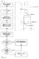
(例示的なシナリオ)
図1は、車両102を含む例示的なシナリオ100を示している。いくつかの例では、車両102は、米国運輸省道路交通安全局が発行したレベル5の分類に従って動作するよう構成される自律車両であってよく、この分類は、運転者(または乗員)の常時車両制御を期待することなく全行程に対する全てのセーフティクリティカルな機能を実行することが可能な車両を説明する。しかしながら、他の例では、車両102は、任意の他のレベルまたは分類を有する完全なまたは部分的な自律車両であってよい。本明細書で説明される技術は、自律車両のようなロボット制御を超えるものに適用され得ることが企図される。例えば、本明細書に記載される技術は、検索、製造、拡張現実などに適用され得る。さらに、車両102は、陸上車両として描写されているが、宇宙船、水上機、及び/または同様のものであってもよい。いくつかの例では、車両102は、シミュレーション車両としてシミュレーションにおいて表されてもよい。簡潔にするために、本明細書での考察は、シミュレーション車両と現実世界の車両とを区別しない。したがって、「車両」への言及は、シミュレーション車両及び/または現実世界の車両を示し得る。 (Example scenario)
FIG. 1 illustrates an
本明細書に記載される技術によれば、車両102は、車両102のセンサ104からセンサデータを受信し得る。例えば、センサ104は、位置センサ(例えば、全地球測位システム(GPS)センサ)、慣性センサ(例えば、加速度センサ、ジャイロスコープセンサ等)、磁場センサ(例えば、コンパス)、位置/速度/加速度センサ(例えば、速度計、駆動システムセンサ)、深度位置センサ(例えば、ライダーセンサ、レーダーセンサ、ソナーセンサ、飛行時間(ToF)カメラ、深度カメラ、超音波並びに/またはソナーセンサ、及び/または他の深度感知センサ)、画像センサ(例えば、カメラ)、音声センサ(例えば、マイクロフォン)、及び/または環境センサ(例えば、気圧計、湿度計等)を含んでよい。According to the techniques described herein, the vehicle 102 may receive sensor data from sensors 104 of the vehicle 102. For example, the sensors 104 may include position sensors (e.g., Global Positioning System (GPS) sensors), inertial sensors (e.g., acceleration sensors, gyroscope sensors, etc.), magnetic field sensors (e.g., compasses), position/speed/acceleration sensors (e.g., speedometers, drive system sensors), depth position sensors (e.g., lidar sensors, radar sensors, sonar sensors, time-of-flight (ToF) cameras, depth cameras, ultrasonic and/or sonar sensors, and/or other depth-sensing sensors), image sensors (e.g., cameras), audio sensors (e.g., microphones), and/or environmental sensors (e.g., barometers, hygrometers, etc.).
センサ104は、センサデータを生成することができ、センサデータは、車両102に関連付けられるコンピューティングデバイス106によって受信され得る。しかしながら、他の例では、センサ104及び/またはコンピューティングデバイス106のうちのいくつかまたは全ては、車両102から離れて別個に、及び/または車両102から遠隔に配置され、データキャプチャ、処理、コマンド、及び/または制御は、有線及び/または無線ネットワークを介して1つまたは複数のリモートコンピューティングデバイスによって車両102との間で通信され得る。The sensors 104 can generate sensor data, which can be received by a computing device 106 associated with the vehicle 102. However, in other examples, some or all of the sensors 104 and/or computing devices 106 can be located separately and/or remotely from the vehicle 102, and data capture, processing, command, and/or control can be communicated to and from the vehicle 102 by one or more remote computing devices over wired and/or wireless networks.
コンピューティングデバイス106は、知覚コンポーネント110、プランニングコンポーネント112、衝突回避コンポーネント114、及び/またはシステムコントローラ116を格納するメモリ108を備え得る。例示的な目的のために図1に描写されるが、衝突回避コンポーネント114は、他のコンポーネントのうちのいずれか1つまたは複数よりも別個のコンピューティングデバイス(またはそれ以外の場合)に存在し得ることを理解されたい。いくつかの例では、知覚コンポーネント110は、衝突回避コンポーネント114の一部であり得る二次知覚コンポーネントなどの他の知覚コンポーネントのうちの一次知覚コンポーネントであり得る。一般に、知覚コンポーネント110は、車両102を取り巻く環境に何があるかを判定してよく、プランニングコンポーネント112は、知覚コンポーネント110から受信した情報に基づいて車両102を操作する方法を判定してよい。例えば、プランニングコンポーネント112は、知覚データ及び/または例えば、1つ以上のマップ、位置情報(例えば、車両102がマップ及び/または知覚コンポーネント110によって検出される特徴に対して環境にある場合)等の他の情報に少なくとも部分的に基づいて軌道118を決定してもよい。軌道118は、車両位置、車両速度、及び/または車両加速度をもたらし得るステアリング角度及び/またはステアリングレートを実現するように車両102の駆動コンポーネントを作動させるためのコントローラ116に対する命令を含んでよい。例えば、軌道118は、コントローラ116が追跡するためのターゲット方向、ターゲットステアリング角度、ターゲットステアリングレート、ターゲット位置、ターゲット速度、及び/またはターゲット加速度を備え得る。知覚コンポーネント110及び/またはプランニングコンポーネント112は、1つ以上の機械学習(ML)モデル及び/または他のコンピュータ実行可能命令を含んでもよい。The computing device 106 may include a memory 108 that stores the perception component 110, the planning component 112, the
いくつかの例では、知覚コンポーネント110は、センサ104からセンサデータを受信し、車両102の近傍のオブジェクトに関連するデータ(例えば、検出されたオブジェクト、インスタンスセグメンテーション、セマンティックセグメンテーション、2次元及び/または3次元バウンディングボックス、トラックに関連付けられた分類)、車両の目的地を指定するルートデータ、車道の特徴を識別するグローバルマップデータ(例えば、自律車両を位置決めするのに有用な異なるセンサモダリティで検出可能な特徴)、車両に近接して検出された特徴を識別するローカルマップデータ(例えば、建物、木、フェンス、消火栓、停止標識の位置及び/または寸法、並びに様々なセンサモダリティで検出可能な任意の他の特徴)などを判定し得る。知覚コンポーネント110によって決定されるオブジェクト分類は、例えば、乗用車、歩行者、自転車運転者、配送用車両、セミトレーラー車両、交通標識等の異なるオブジェクトタイプを区別し得る。トラック(track)は、これまでの、現在の、及び/または予測されるオブジェクトの位置、速度、加速度、及び/または向きを含み得る。知覚コンポーネント110によって生成されたデータは、知覚データと総称され得る。知覚コンポーネント110が知覚データを生成すると、知覚コンポーネント110は、知覚データをプランニングコンポーネント112に提供し得る。In some examples, the perception component 110 may receive sensor data from the sensors 104 and determine data related to objects in the vicinity of the vehicle 102 (e.g., detected objects, instance segmentation, semantic segmentation, two-dimensional and/or three-dimensional bounding boxes, classifications associated with tracks), route data specifying the vehicle's destination, global map data identifying roadway features (e.g., features detectable with different sensor modalities useful for locating an autonomous vehicle), local map data identifying features detected in the vicinity of the vehicle (e.g., locations and/or dimensions of buildings, trees, fences, fire hydrants, stop signs, and any other features detectable with various sensor modalities), and the like. The object classifications determined by the perception component 110 may distinguish between different object types, such as, for example, passenger cars, pedestrians, bicyclists, delivery vehicles, semi-trailer vehicles, traffic signs, and the like. A track may include historical, current, and/or predicted object position, speed, acceleration, and/or orientation. The data generated by the perception component 110 may be collectively referred to as perception data. Once the perception component 110 generates the sensory data, the perception component 110 may provide the sensory data to the planning component 112.
プランニングコンポーネント112は、知覚コンポーネント110から受信された知覚データを使用して、1つまたは複数の軌道を判定し、車両102の運きを制御して経路をトラバースし、及び/またはそれ以外の場合、車両102の動作を制御し得るが、任意のそのような動作は、様々な他のコンポーネントで実行され得る(例えば、位置決め(localization)は、知覚データに少なくとも部分的に基づいてよい位置決めコンポーネントによって実行され得る)。例えば、プランニングコンポーネント112は、第1の位置から第2の位置への車両102の経路を決定し、(そのようなデータ内の検出されたオブジェクトに関する予測をさらに含み得る)知覚データ及び/またはシミュレートされた知覚データに実質的に同時にかつ少なくとも部分的に基づいて、後退する水平線技法(例えば、1マイクロ秒、半秒)に従って車両102の動きを制御するための複数の潜在的な軌道を生成して、(例えば、検出されたオブジェクトのいずれかを回避するために)経路をトラバースするように車両を制御し、車両102の軌道118として潜在的な軌道のうちの1つを選択して、車両102の駆動コンポーネントに送信され得る駆動制御信号を生成し得る。図1は、方向、速度、及び/または加速度を示す矢印として表されるそのような軌道118の例を示すが、軌道自体は、コントローラ116のための命令を含んでもよく、コントローラ116は、車両102の駆動システムを作動させてもよい。The planning component 112 may use the sensory data received from the perception component 110 to determine one or more trajectories, control the movement of the vehicle 102 to traverse a path, and/or otherwise control the operation of the vehicle 102, although any such operations may be performed by various other components (e.g., localization may be performed by a localization component, which may be based at least in part on the sensory data). For example, the planning component 112 may determine a path for the vehicle 102 from a first position to a second position, generate a number of potential trajectories for controlling the movement of the vehicle 102 according to a receding horizon technique (e.g., one microsecond, half a second) substantially simultaneously and at least in part based on the sensory data and/or simulated sensory data (which may further include predictions regarding detected objects in such data), control the vehicle to traverse the path (e.g., to avoid any of the detected objects), select one of the potential trajectories as the trajectory 118 of the vehicle 102, and generate drive control signals that may be transmitted to the drive components of the vehicle 102. FIG. 1 shows an example of such a trajectory 118 represented as an arrow indicating direction, speed, and/or acceleration, but the trajectory itself may include instructions for the
いくつかの例では、知覚コンポーネント110は、1つ以上のGPU、MLモデル、カルマンフィルタ、及び/または同様のものを含んでもよい、ハードウェア及び/またはソフトウェアのパイプラインを含んでもよい。いくつかの例では、知覚コンポーネント110は、センサ能力、オブジェクト並びに/または環境閉塞(例えば、建物、勾配の変化、他のオブジェクトの前方のオブジェクト)、及び/または霧、雪などの環境影響によって制限され得る、自律車両を取り巻く環境のできるだけ多くを監視し得る。例えば、センサデータは、知覚コンポーネント110が入力として受信し得るLIDAR及び/またはレーダーデータを含んでよい。知覚コンポーネント110は、軌道118を決定する際にプランニングコンポーネント112によって考慮されるべきイベントまたはオブジェクトの挙動を考慮に入れないことを回避するために、できるだけ多くのオブジェクト及び環境に関する情報を検出するように構成されてもよい。In some examples, the perception component 110 may include a hardware and/or software pipeline that may include one or more GPUs, ML models, Kalman filters, and/or the like. In some examples, the perception component 110 may monitor as much of the environment surrounding the autonomous vehicle as possible, which may be limited by sensor capabilities, objects and/or environmental occlusions (e.g., buildings, gradient changes, objects ahead of other objects), and/or environmental effects such as fog, snow, etc. For example, sensor data may include LIDAR and/or radar data that the perception component 110 may receive as input. The perception component 110 may be configured to detect as many objects and information about the environment as possible to avoid not taking into account events or object behaviors that should be considered by the planning component 112 in determining the trajectory 118.
対照的に、衝突回避コンポーネント114は、軌道118と関連付けられる回廊120を監視し得る。例えば、衝突回避コンポーネント114は、プランニングコンポーネント112から軌道118を受け取り、軌道に少なくとも部分的に基づいて回廊120を決定し得る。回廊を決定することは、車両102の現在の速度、軌道118によって指定された速度、及び/またはステアリングラックアクチュエータゲイン、タイヤ滑り、ボディロールなどの車両キネマティックなどに少なくとも部分的に基づき得るオフセットに基づいて環境の領域を決定することを含み得る。少なくともいくつかの例では、そのような回廊は、追加的に、または代替的に、車両に対して単純化された幾何学的領域を表すことができる。衝突回避コンポーネント114は、回廊120と関連付けられたセンサデータのサブセットを決定し、サブセットに少なくとも部分的に基づいて本明細書で説明される動作を実行し得る。例えば、例示的なシナリオでは、衝突回避コンポーネント114は、回廊120によって示される環境の一部を含むセンサデータを含むサブセットを決定してよく、これは、センサデータ表現124に示される車道122の一部及び/またはオブジェクト126の一部を含んでよい。知覚コンポーネント110によって決定された知覚データは、オブジェクト128と関連付けられた知覚データを含み得、軌道118は、その知覚データに少なくとも部分的に基づいて生成され得るが、衝突回避コンポーネント114は、軌道118が衝突をもたらさない、またはもたらす可能性がないことを確実にするために、回廊120と関連付けられたセンサデータを単に監視し得る。In contrast, the
衝突回避コンポーネント114は、センサデータのサブセットを2つの分類:地面またはオブジェクトのうちの1つに分類し得る二次知覚コンポーネントを備え得る。いくつかの例では、より多くの分類(例えば、異なるオブジェクト分類)が存在し得る。衝突回避コンポーネント114は、追加的または代替的に、本明細書で論じられる閾値距離を決定することができる、及び/または軌道118を検証するか拒否するかを決定することができる検証コンポーネントを含み得る。軌道118を検証することは、軌道118をコントローラ116に送信することを含み得る(例えば、検証コンポーネントは、マルチプレクサ、検証コンポーネントから信号を受信すると軌道118を通過するスイッチとして構成された1つ以上のトランジスタ、及び/または軌道118信号がコントローラ116に通過することを可能にする信号を提供し得る同様のものを含み得る)。軌道118を拒否することは、メッセージをプランニングコンポーネント112に送信して軌道の再決定を開始すること、及び/または軌道118に加えて、プランニングコンポーネント112から受信され、並びに/またはメモリ108に記憶され得る安全停止作動(例えば、緊急ブレーキ、プルオーバ及び駐車)並びに/または不測の軌道などの代替の作動を開始することを含み得る。いくつかの例では、衝突回避コンポーネント114は、本明細書でより詳細に説明されるように、センサの向き及び/または環境のトポロジー及び/またはセンサデータの有効な部分の下限及び上限に少なくとも部分的に基づいて、センサデータのサブセットの少なくとも一部が有効または無効であると判定し得る。The
いくつかの例では、コントローラ116は、軌道118を追跡するのに十分な車両102の駆動コンポーネントを作動させるためのソフトウェア及び/またはハードウェアを備え得る。例えば、コントローラ116は、1つまたは複数のPID(proportional-integral-derivative)コントローラを備え得る。In some examples, the
図2は、追加のまたは代替の衝突回避システム監視領域200と比較した、衝突回避コンポーネントによって監視される、例示的なシナリオ100及び回廊120のセンサデータ表現124のトップダウンビューを示す。円として表される領域200内のセンサデータは、追加のまたは代替の衝突回避システムによって監視されてもよい。追加または代替の例では、領域200は、知覚コンポーネント110によって監視される車両102からの距離を識別し得る。そのような例では、領域200は、センサ104のうちの1つ以上の最大有効範囲に対応し得る。2 illustrates a top-down view of an
図示の例では、軌道118は直線であり、したがって、回廊120は対応して直線であることに留意されたい。回廊120の形状は、軌道118の形状に少なくとも部分的に基づいてもよく、軌道118及び/または環境のトポロジーに従って、湾曲してもよく、均一でもなく、及び/または直線でもなくてもよいことに留意されたい。いくつかの例では、回廊120は、2次元または3次元またはそれ以上であってもよい。Note that in the illustrated example, trajectory 118 is linear and, therefore, corridor 120 is correspondingly linear. Note that the shape of corridor 120 may be based at least in part on the shape of trajectory 118 and may be curved, non-uniform, and/or non-linear depending on the topology of trajectory 118 and/or the environment. In some examples, corridor 120 may be two-dimensional or three-dimensional or more.
システムの例
図3は、本明細書で論じられる技術を実装する例示的なシステム300のブロック図を示す。いくつかの例では、例示的なシステム300は、図1の車両102を表し得る車両302を含み得る。いくつかの例では、車両302は、米国運輸省道路交通安全局が発行したレベル5の分類に従って動作するように構成された自律走行車であってよく、これは、トリップ全体で全てのセーフティクリティカルな機能を実行することができる車両を記述したものであり、運転者(または乗員)はどんなときでも車両を制御することを期待されていない。しかしながら、他の例では、車両302は、他のレベルまたは分類を有する完全にまたは部分的な自律車両であり得る。さらに、場合によっては、本明細書に記載の技術は、非自律型車両によっても使用可能であり得る。 Example System FIG. 3 illustrates a block diagram of an
車両302は、車両コンピューティングデバイス304、センサ306、エミッタ308、ネットワークインターフェース310、及び/または駆動コンポーネント312を含み得る。車両コンピューティングデバイス304は、コンピューティングデバイス106を表し得、センサ306は、センサ104を表し得る。システム300は、追加的または代替的に、コンピューティングデバイス314を含み得る。The
いくつかの例では、センサ306は、センサ104を表し得、ライダーセンサ、レーダーセンサ、超音波トランスデューサ、ソナーセンサ、位置センサ(例えば、グローバルポジショニングシステム(GPS)、コンパスなど)、慣性センサ(例えば、慣性測定ユニット(IMU)、加速度計、磁力計、ジャイロスコープなど)、画像センサ(例えば、赤緑色(RGB)、赤外線(IR)、強度、深さ、飛行時間カメラなど)、マイク、ホイールエンコーダ、環境センサ(例えば、温度計、湿度計、光センサ、圧力センサなど)などを含み得る。センサ306は、これらまたは他のタイプのセンサのそれぞれの複数のインスタンスを含み得る。例えば、レーダーセンサは、車両302の角部、前部、後部、側部、及び/または上部に位置する個々のレーダーセンサを含んでよい。別の例として、カメラは、車両302の外部及び/または内部に関する様々な場所に配置された複数のカメラを含み得る。センサ306は、車両コンピューティングデバイス304及び/またはコンピューティングデバイス314に入力を提供し得る。In some examples, the sensors 306 may represent sensors 104 and may include lidar sensors, radar sensors, ultrasonic transducers, sonar sensors, position sensors (e.g., Global Positioning System (GPS), compass, etc.), inertial sensors (e.g., Inertial Measurement Units (IMUs), accelerometers, magnetometers, gyroscopes, etc.), image sensors (e.g., Red-Green (RGB), Infrared (IR), intensity, depth, time-of-flight cameras, etc.), microphones, wheel encoders, environmental sensors (e.g., thermometers, hygrometers, light sensors, pressure sensors, etc.), etc. The sensors 306 may include multiple instances of each of these or other types of sensors. For example, the radar sensors may include individual radar sensors located at the corners, front, rear, sides, and/or top of the
車両302はまた、上記のように、光及び/または音を放出するためのエミッタ308を含み得る。この例におけるエミッタ308は、車両302の乗客と通信するための内部オーディオ及びビジュアルエミッタを含み得る。限定ではなく例として、内部エミッタは、スピーカ、ライト、サイン、ディスプレイスクリーン、タッチスクリーン、触覚エミッタ(例えば、振動及び/または力フィードバック)、機械的アクチュエータ(例えば、シートベルトテンショナ、シートポジショナ、ヘッドレストポジショナなど)などを含み得る。この例におけるエミッタ308はまた、外部エミッタを含み得る。限定ではなく例として、この例における外部エミッタは、進行方向を信号で伝えるためのライトまたは車両動作の他のインジケータ(例えば、インジケータライト、サイン、ライトアレイなど)、及び歩行者または他の近くの車両と聴覚的に通信するための1つまたは複数のオーディオエミッタ(例えば、スピーカ、スピーカアレイ、ホーンなど)を含み得、それらの1つまたは複数は、音響ビームステアリング技術を含む。The
車両302はまた、車両302と1つ以上の他のローカルまたはリモートコンピューティングデバイスとの間の通信を可能にするネットワークインターフェース310を含み得る。例えば、ネットワークインターフェース310は、車両302及び/または駆動コンポーネント312上の他のローカルコンピューティングデバイスとの通信を容易にし得る。また、ネットワークインターフェース310は、追加的または代替的に、車両が他の近くのコンピューティングデバイス(例えば、他の近くの車両、交通信号等)と通信することを可能にし得る。ネットワークインターフェース310は、追加的または代替的に、車両302がコンピューティングデバイス314と通信することを可能にし得る。いくつかの例では、コンピューティングデバイス314は、分散コンピューティングシステム(例えば、クラウドコンピューティングアーキテクチャ)の1つまたは複数のノードを含み得る。The
ネットワークインターフェース310は、車両コンピューティングデバイス304を別のコンピューティングデバイスまたはネットワーク316などのネットワークに接続するための物理的及び/または論理的インターフェースを含み得る。例えば、ネットワークインターフェース310は、IEEE300.11規格によって定義された周波数、ブルートゥース(登録商標)などの短距離無線周波数、セルラー通信(例えば、2G、3G、4G、4G LTE、5Gなど)、またはそれぞれのコンピューティングデバイスが他のコンピューティングデバイスとインターフェイスできるようにする適切な有線または無線通信プロトコルを介するなどのWi-Fiベースの通信を可能にし得る。場合によっては、車両コンピューティングデバイス304及び/またはセンサ306は、所定の期間の経過後、ほぼリアルタイムで、など、ネットワーク316を介して、特定の周波数でセンサデータをコンピューティングデバイス314に送信し得る。The network interface 310 may include physical and/or logical interfaces for connecting the vehicle computing device 304 to another computing device or network, such as the
いくつかの例では、車両302は、1つ以上の駆動コンポーネント312を含み得る。いくつかの例では、車両302は、単一の駆動コンポーネント312を有し得る。いくつかの例では、駆動コンポーネント312は、駆動コンポーネント312及び/または車両302の周囲の状態を検出するための1つまたは複数のセンサを含み得る。限定ではなく例として、駆動コンポーネント312のセンサは、駆動コンポーネントの車輪の回転を感知するための1つまたは複数の車輪エンコーダ(例えば、回転エンコーダ)、駆動コンポーネント、カメラまたはその他の画像センサの方向と加速度を測定する慣性センサ(例えば、慣性測定ユニット、加速度計、ジャイロスコープ、磁気計など)、駆動コンポーネントの周囲のオブジェクトを音響的に検出する超音波センサ、LIDARセンサ、レーダーセンサなどを含み得る。ホイールエンコーダのようなあるセンサは、駆動コンポーネント312に特有のものであってよい。場合によっては、駆動コンポーネント312上のセンサは、車両302の対応するシステム(例えば、センサ306)と重複するか、または補足し得る。In some examples, the
駆動コンポーネント312は、高電圧バッテリ、車両を推進するモータ、バッテリからの直流電流を他の車両システムによって利用される交流電流へと変換するインバータ、ステアリングモータ及びステアリングラック(これは、電動であってよい)を含むステアリングシステム、油圧または電気アクチュエータを含むブレーキシステム、油圧及び/または空気圧コンポーネントを含むサスペンションシステム、トラクションの損失を軽減し、且つ制御を維持するよう制動力の分散をする安定制御システム、HVACシステム、照明(例えば、車両の外部周囲を照らすヘッド/テールライトなどの照明)、及び1つまたは複数の他のシステム(例えば、冷却システム、安全システム、車載充電システム、DC/DCコンバータ、高電圧ジャンクション、高電圧ケーブル、充電システム、充電ポートなどのその他の電装コンポーネント)を含む多くの車両システムを含み得る。さらに、駆動コンポーネント312は、センサからデータを受信して前処理をし得る駆動コンポーネントコントローラを含み、様々な車両システムの動作を制御し得る。場合によっては、駆動コンポーネントコントローラは、1つまたは複数のプロセッサと、1つまたは複数のプロセッサと通信可能に結合されたメモリとを含み得る。メモリは、駆動コンポーネント312の様々な機能を実行する1つ以上のコンポーネントを記憶し得る。さらに、駆動コンポーネント312はまた、それぞれの駆動コンポーネントによる、1つまたは複数の他のローカルコンピューティングデバイスまたはリモートコンピューティングデバイスとの通信を可能にする1つまたは複数の通信接続を含むことができる。The drive components 312 may include many vehicle systems, including a high voltage battery, a motor to propel the vehicle, an inverter to convert direct current from the battery to alternating current utilized by other vehicle systems, a steering system including a steering motor and a steering rack (which may be electric), a brake system including hydraulic or electric actuators, a suspension system including hydraulic and/or pneumatic components, a stability control system to distribute braking forces to mitigate loss of traction and maintain control, an HVAC system, lighting (e.g., lighting such as head/tail lights that illuminate the exterior surroundings of the vehicle), and one or more other systems (e.g., cooling systems, safety systems, on-board charging systems, DC/DC converters, high voltage junctions, high voltage cables, charging systems, charging ports, and other electrical components). Additionally, the drive components 312 may include a drive components controller that may receive and pre-process data from sensors and control the operation of various vehicle systems. In some cases, the drive components controller may include one or more processors and a memory communicatively coupled to the one or more processors. The memory may store one or more components that perform various functions of the drive components 312. Additionally, the drive components 312 may also include one or more communication connections that enable each drive component to communicate with one or more other local or remote computing devices.
車両コンピューティングデバイス304は、プロセッサ318と、1つ以上のプロセッサ318と通信可能に結合されたメモリ320とを含み得る。メモリ320は、メモリ108を表し得る。コンピューティングデバイス314はまた、プロセッサ322、及び/またはメモリ324を含んでもよい。プロセッサ318及び/または322は、データを処理し、本明細書に記載されるような動作を実行するための命令を実行できる任意の適切なプロセッサであり得る。限定ではなく例として、プロセッサ318及び/または322は、1つまたは複数の中央処理装置(CPU)、グラフィックス処理装置(GPU)、集積回路(例えば、特定用途向け集積回路(ASIC))、ゲートアレイ(例えば、フィールドプログラマブルゲートアレイ(FPGA))、及び/または電子データを処理してその電子データを、レジスタ及び/またはメモリに格納され得る他の電子データに変換する他のデバイスまたはデバイスの一部を含み得る。The vehicle computing device 304 may include a processor 318 and a memory 320 communicatively coupled to one or more of the processors 318. The memory 320 may represent the memory 108. The computing device 314 may also include a processor 322 and/or a memory 324. The processor 318 and/or 322 may be any suitable processor capable of processing data and executing instructions to perform operations as described herein. By way of example and not limitation, the processor 318 and/or 322 may include one or more central processing units (CPUs), graphics processing units (GPUs), integrated circuits (e.g., application specific integrated circuits (ASICs)), gate arrays (e.g., field programmable gate arrays (FPGAs)), and/or other devices or portions of devices that process electronic data and convert the electronic data to other electronic data that may be stored in registers and/or memory.
メモリ320及び/または324は、非一時的なコンピュータ可読媒体の例であり得る。メモリ320及び/または324は、オペレーティングシステム、及び本明細書で説明される方法及び様々なシステムに起因する機能を実装するための1つ以上のソフトウェアアプリケーション、命令、プログラム、及び/またはデータを格納し得る。様々な実装において、メモリは、スタティックRAM(SRAM)、シンクロナスDRAM(SDRAM)、不揮発性/フラッシュタイプメモリ、または情報を格納可能な任意の他のタイプのメモリのような適切なメモリ技術を用いて実装されてよい。本明細書で説明される、アーキテクチャ、システム、及び個々のエレメントは、多くの他の論理的、プログラム的、及び物理的なコンポーネントを含んでよく、それらのうちの添付図面に示されるものは、単に本明細書での説明に関連する例示に過ぎない。Memory 320 and/or 324 may be examples of non-transitory computer-readable media. Memory 320 and/or 324 may store an operating system and one or more software applications, instructions, programs, and/or data for implementing the functions attributed to the methods and various systems described herein. In various implementations, memory may be implemented using any suitable memory technology, such as static RAM (SRAM), synchronous DRAM (SDRAM), non-volatile/flash type memory, or any other type of memory capable of storing information. The architectures, systems, and individual elements described herein may include many other logical, programmatic, and physical components, of which those shown in the accompanying drawings are merely illustrative in connection with the description herein.
いくつかの例では、メモリ320及び/またはメモリ324は、位置決めコンポーネント326、知覚コンポーネント328、プランニングコンポーネント330、衝突回避コンポーネント332、マップ334、及び/またはシステムコントローラ336を格納し得る。知覚コンポーネント328は、知覚コンポーネント110を表し得、プランニングコンポーネント330は、プランニングコンポーネント112を表し得、及び/または衝突回避コンポーネント332は、衝突回避コンポーネント114を表し得る。In some examples, memory 320 and/or memory 324 may store a positioning component 326, a perception component 328, a planning component 330, a collision avoidance component 332, a map 334, and/or a
少なくとも1つの例において、位置決めコンポーネント326は、車両302の位置、速度及び/または方向(例えば、x位置、y位置、z位置、ロール、ピッチ、またはヨーのうちの1つまたは複数)を決定するためにセンサ306からのデータを受信するハードウェア及び/またはソフトウェアを含んでよい。ある例示において、位置決めコンポーネント326は、SLAM(simultaneous localization and mapping)、CLAMS(calibration, localization and mapping, simultaneously)、相対SLAM、バンドル調整、非線形最小二乗最適化などを利用し、画像データ、ライダーデータ、レーダーデータ、IMUデータ、GPSデータ、ホイールエンコーダデータなどを受信し、自律車両の位置、ポーズ、及び/または速度を正確に決定することができる。いくつかの例では、本明細書で論じるように、位置決めコンポーネント326は、車両302の様々なコンポーネントにデータを提供して、軌道を生成するための、及び/または地図データを生成するための自律車両の初期位置を決定できる。いくつかの例では、位置決めコンポーネント326は、衝突回避コンポーネント332に、それに関連付けられた環境及び/またはセンサデータに対する車両302の位置及び/または向きを提供し得る。In at least one example, the positioning component 326 may include hardware and/or software to receive data from the sensors 306 to determine the position, velocity, and/or orientation (e.g., one or more of x-position, y-position, z-position, roll, pitch, or yaw) of the
いくつかの例では、知覚コンポーネント328は、ハードウェア及び/またはソフトウェアに実装された一次知覚システム及び/または予測システムを含んでもよい。知覚コンポーネント328は、車両302を取り巻く環境内のオブジェクトを検出し(例えば、オブジェクトが存在することを識別する)、オブジェクトを分類し(例えば、検出されたオブジェクトに関連付けられるオブジェクトタイプを決定する)、センサデータ及び/または環境の他の表現をセグメント化し(例えば、検出されたオブジェクト及び/またはオブジェクトタイプに関連付けられるセンサデータの一部及び/または環境の表現を識別する)、オブジェクトに関連付けられた特性(例えば、オブジェクトに関連付けられた現在の、予測された、及び/または以前の位置、向き、速度、及び/または加速度を識別するトラック)及び/または同様のものを決定し得る。知覚コンポーネント328によって決定されるデータは、知覚データと呼ばれる。In some examples, the perception component 328 may include a primary perception system and/or a prediction system implemented in hardware and/or software. The perception component 328 may detect objects in the environment surrounding the vehicle 302 (e.g., identify that an object is present), classify the objects (e.g., determine an object type associated with a detected object), segment sensor data and/or other representations of the environment (e.g., identify a portion of the sensor data and/or a representation of the environment that is associated with a detected object and/or object type), determine characteristics associated with the objects (e.g., tracks that identify a current, predicted, and/or previous position, orientation, speed, and/or acceleration associated with an object), and/or the like. Data determined by the perception component 328 is referred to as perception data.
プランニングコンポーネント330は、位置決めコンポーネント326から車両302の位置並びに/または向き、及び/または知覚コンポーネント328から知覚データを受信してもよく、このデータのいずれかに少なくとも部分的に基づいて車両302の動作を制御するための命令を決定してもよい。いくつかの例では、命令を決定することは、命令が関連付けられたシステムに関連付けられたフォーマットに少なくとも部分的に基づいて命令を決定することを含み得る(例えば、自律車両の動きを制御するための第1の命令は、システムコントローラ336及び/または駆動コンポーネント312が解析する/実行させ得るメッセージ及び/または信号(例えば、アナログ、デジタル、空気力学、キネマティック)の第1のフォーマットでフォーマットされてもよく、エミッタ308のための第2の命令は、それに関連付けられた第2のフォーマットに従ってフォーマットされてもよい)。The planning component 330 may receive the position and/or orientation of the
衝突回避コンポーネント332は、車両302及び/またはコンピューティングデバイス314上で動作してもよい。いくつかの例では、衝突回避コンポーネント332は、パイプライン内のプランニングコンポーネント330から(出力を受信する)下流にあってよい。衝突回避コンポーネント332は、本明細書で論じられる判定に応じて、プランニングコンポーネント330の出力の全部または一部を実装のためにシステムコントローラ336に渡すように構成されてもよいし、その出力を渡さないように構成されてもよい。いくつかの例では、衝突回避コンポーネント332は、軌道の再決定をトリガするフラグまたはメッセージなど、プランニングコンポーネント330に入力を提供するためのフィードバックループを備え得る。The collision avoidance component 332 may operate on the
メモリ320及び/または324は、追加的または代替的に、マッピングシステム(例えば、センサデータに少なくとも部分的に基づいてマップを生成する)、プランニングシステム、ライドマネジメントシステムなどを格納し得る。位置決めコンポーネント326、知覚コンポーネント328、プランニングコンポーネント330、マップ334、及び/またはシステムコントローラ336は、メモリ320に格納されているように図示されるが、これらのコンポーネントのうちのいずれかは、プロセッサ実行可能命令、機械学習モデル(例えば、ニューラルネットワーク)、及び/またはハードウェアを含んでもよく、これらのコンポーネントのいずれかの全てまたは一部は、メモリ324に格納されてもよく、またはコンピューティングデバイス314の一部として構成されてもよい。Memory 320 and/or 324 may additionally or alternatively store a mapping system (e.g., generating a map based at least in part on the sensor data), a planning system, a ride management system, etc. Although positioning component 326, perception component 328, planning component 330, map 334, and/or
本明細書に記載されるように、位置決めコンポーネント326、知覚コンポーネント328、プランニングコンポーネント330、及び/またはシステム300の他のコンポーネントは、1つ以上のMLモデルを含み得る。例えば、位置決めコンポーネント326、知覚コンポーネント328、及び/またはプランニングコンポーネント330は、それぞれ異なるMLモデルパイプラインを含んでよい。いくつかの例では、MLモデルは、ニューラルネットワークを含み得る。例示的なニューラルネットワークは、一連の接続レイヤを通して入力データを渡して出力を生じさせるバイオインスパイアードアルゴリズムである。ニューラルネットワークにおけるそれぞれのレイヤが別のニューラルネットワークを含むことも可能であり、または任意の数のレイヤ(畳み込み層であるか否か)を含むことが可能である。本開示のコンテキストで理解されることが可能である通り、ニューラルネットワークは、機械学習を利用することが可能であり、これは、出力が学習されたパラメータに基づいて生成される幅広いクラスのこのようなアルゴリズムを参照することが可能である。As described herein, the localization component 326, the perception component 328, the planning component 330, and/or other components of the
ニューラルネットワークのコンテキストで説明されるものの、任意のタイプの機械学習が本開示と整合するように用いられることが可能である。例えば、機械学習アルゴリズムは、限定はされないが、回帰アルゴリズム(例えば、通常最小二乗回帰(OLSR)、線形回帰、ロジスティック回帰、段階的回帰、MARS(multivariate adaptive regression splines)、LOESS(locally estimated scatterplot smoothing)、インスタンスベースアルゴリズム(例えば、リッジ回帰、LASSO(least absolute shrinkage and selection operator)、Elastic net、LARS(least-angle regression)、決定木アルゴリズム(例えば、分類及び回帰木(CART)、ID3(iterative dichotomiser 3)、カイ二乗自動相互作用検出(CHAID)、決定切り株、条件付き決定木)、ベイジアンアルゴリズム(例えば、ナイーブベイズ、ガウスナイーブベイズ、多項ナイーブベイズ、AODE(average one-dependence estimators)、ベイジアンビリーフネットワーク(BNN)、ベイジアンネットワーク)、クラスタリングアルゴリズム(例えば、k平均、kメジアン、期待値の最大化(EM)、階層的クラスタリング)、相関ルール学習アルゴリズム(例えば、パーセプトロン、誤差逆伝搬、ホップフィールドネットワーク、RBFN(Radial Basis Function Network))、深層学習アルゴリズム(例えば、深層ボルツマンマシン(DBM)、深層ビリーフネットワーク(DBN)、畳み込みニューラルネットワーク(CNN)、積層オートエンコーダ)、次元縮小アルゴリズム(例えば、主成分分析(PCA)、主成分回帰(PCR)、部分最小二乗回帰(PLSR)、サモンマッピング、多次元尺度構成法(MDS)、射影追跡、線形判別分析(LDA)、混合判別分析(MDA)、二次判別分析(QDA)、柔軟判別分析(FDA))、アンサンブルアルゴリズム(例えば、ブースティング、ブートストラップアグリゲーション(バギング)、アダブースト、積層ジェネラリゼーション(ブレンディング)、勾配ブースティングマシン(GBM)、勾配ブースト回帰木(GBRT)、ランダムフォレスト)、SVM(サポートベクタマシン)、教師あり学習、教師なし学習、半教師あり学習などを含むことができる。アーキテクチャのさらなる例としては、ResNet-50、ResNet-101、VGG、DenseNet、PointNetなどのニューラルネットワークが挙げられる。Although described in the context of neural networks, any type of machine learning can be used consistent with the present disclosure. For example, machine learning algorithms can include, but are not limited to, regression algorithms (e.g., ordinary least squares regression (OLSR), linear regression, logistic regression, stepwise regression, multivariate adaptive regression splines (MARS), locally estimated scatterplot smoothing (LOESS)), instance-based algorithms (e.g., ridge regression, least absolute shrinkage and selection operator (LASSO), elastic net, least-angle regression (LARS), decision tree algorithms (e.g., classification and regression trees (CART), iterative dichotomiser 3 (ID3), chi-squared automated interaction detection (CHAID), decision stump, conditional decision tree), Bayesian algorithms (e.g., naive Bayes, Gaussian naive Bayes, multinomial naive Bayes, average one-dependence estimators), Bayesian belief networks (BNN), Bayesian networks), clustering algorithms (e.g., k-means, k-median, expectation maximization (EM), hierarchical clustering), association rule learning algorithms (e.g., perceptron, backpropagation, Hopfield network, RBFN (Radial Basis Function Network), deep learning algorithms (e.g., Deep Boltzmann Machines (DBM), Deep Belief Networks (DBN), Convolutional Neural Networks (CNN), stacked autoencoders), dimensionality reduction algorithms (e.g., Principal Component Analysis (PCA), Principal Component Regression (PCR), Partial Least Squares Regression (PLSR), Sammon Mapping, Multidimensional Scaling (MDS), Projection Pursuit, Linear Discriminant Analysis (LDA), Mixed Discriminant Analysis (MDA), Quadratic Discriminant Analysis (QDA), Flexible Discriminant Analysis (FDA)), ensemble algorithms (e.g., Boosting, Bootstrap Aggregation (Bagging), AdaBoost, Stacked Generalization (Blending), Gradient Boosting Machines (GBM), Gradient Boosted Regression Trees (GBRT), Random Forests), Support Vector Machines (SVM), supervised learning, unsupervised learning, semi-supervised learning, etc. Further example architectures include neural networks such as ResNet-50, ResNet-101, VGG, DenseNet, and PointNet.
メモリ320は、追加的または代替的に、1つまたは複数のシステムコントローラ336を格納し得、これは、車両302のステアリング、推進、ブレーキ、安全、エミッタ、通信、及び他のシステムを制御するように構成され得る。これらのシステムコントローラ336は、駆動コンポーネント312及び/または車両302の他のコンポーネントの対応するシステムと通信し、及び/または制御し得る。例えば、プランニングコンポーネント330は、知覚コンポーネント328によって生成された知覚データに少なくとも部分的に基づいて命令を生成し得、衝突回避コンポーネント332は、それを検証し、及び/またはシステムコントローラ336に送信し得る。システムコントローラ336は、プランニングコンポーネント330及び/または衝突回避コンポーネント332から受信した命令に少なくとも部分的に基づいて、車両302の動作を制御し得る。いくつかの例では、衝突回避コンポーネント332は、プランニングコンポーネント330によって生成された命令を、例えば、代替の操作を指定し得る代替の軌道等の代替軌道に関連付けられた代替の命令で置き換えることができる。The memory 320 may additionally or alternatively store one or
図3は分散システムとして示されているが、代替の例では、車両302の構成要素は、コンピューティングデバイス314に関連付けられ得、及び/またはコンピューティングデバイス314の構成要素は、車両302に関連付けられ得ることに留意されたい。すなわち、車両302は、コンピューティングデバイス314に関連する1つまたは複数の機能を実行し得、逆もまた同様である。Note that while FIG. 3 is shown as a distributed system, in alternative examples, components of
(例示的な処理)
図4は、自律車両のプランニングコンポーネントによって出力される軌道を検証するための例示的なプロセス400の図解フロー図を示す。いくつかの例では、例示的なプロセス400は、自律車両の動作中に少なくとも衝突回避コンポーネントによって実行され得る。 Exemplary Processing
4 shows an illustrative flow diagram of an
動作402において、例示的なプロセス400は、本明細書で論じられる技術のいずれかに従って、自律車両に関連付けられた現在のポーズ、軌道、及び/または回廊を受信することを含み得る。例えば、現在のポーズは、位置決めコンポーネントから受信されてもよく、軌道は、プランニングコンポーネント及び/または自律車両の1つ以上のセンサ(例えば、ホイールエンコーダ、GPS)から受信されてもよく、及び/または回廊は、プランニングコンポーネントから受信されてもよく、及び/または衝突回避コンポーネントによって決定されてもよい。いくつかの例では、回廊を決定することは、軌道、自律車両の幅及び/または長さ、現在の速度、及び/またはオフセットに少なくとも部分的に基づいてもよい。図4は、自律車両の位置404及び回廊406を示す。少なくともいくつかの例では、そのような回廊の寸法は、例えば、車両に関連付けられたパラメータに基づいてもよい。非限定的な例として、回廊の長さは、車両の速度の関数であってもよく、一方、別の例として、幅は、車両の旋回半径、車両の近傍のオブジェクトに関連付けられる可能性のある速度などに基づいてもよい。図の明確さを高めるために、軌道は図示されていない。いくつかの例では、軌道は、自律車両の現在位置及び/または計画位置及び/または速度を含み得る。At
動作408において、例示的なプロセス400は、本明細書で論じられる技術のいずれかに従って、自律車両に関連付けられたセンサからセンサデータを受信することを含み得る。例えば、センサデータ410は、他の種類のセンサデータのうちのLIDARデータ及び/またはレーダーデータを含んでよい。いくつかの例では、センサデータは、深度データ(例えば、センサ/自律車両から環境内の表面までの距離を示すデータ)、検出された表面に関連付けられたドップラーデータ、及び/または自律車両を取り巻く環境内のオブジェクトの位置を示す任意の他のタイプのセンサデータを含み得る。At
動作412において、例示的なプロセス400は、本明細書で論じられる技術のいずれかに従って、回廊及び地面分類に関連付けられたセンサデータの第1のサブセットを決定することを含み得る。いくつかの例では、例示的なプロセス400は、回廊に関連付けられたセンサデータのサブセットを決定することと、サブセットを2つの分類、すなわち、地面分類(動作412で)及びオブジェクト分類(動作420で)のうちの1つに分類することとを含み得る。図4は、図5の一部を示す。図5は、例示的なシナリオ100及びセンサデータ表現124に関連付けられたセンサデータ500を示す。図5は、回廊406、回廊406の外側のセンサデータをグレーとして、回廊406内のセンサデータのサブセットを黒として示す。図5はまた、地面502として分類される回廊406内のセンサデータの第1のサブセットを点線として示し、オブジェクト504として分類される回廊406内のセンサデータの第2のサブセットを実線として示す。At
センサデータの第1のサブセットが地面分類に関連付けられることを判定することは、センサデータ間の連続性を判定することと、センサデータが連続的であることを判定することとを含み得る。センサデータが連続的であることを判定することは、センサデータ間の間隔が間隔の範囲内にある(例えば、点間の閾値距離以下であり、少なくともいくつかの例では、そのような閾値距離は固定され得る、及び/または点間の範囲の関数であり得る)と判定すること、センサデータ間の角度が角度の範囲内にある(例えば、2つの点間の方位角が方位角の範囲内にある、2つの点間の(垂直方向の)勾配が勾配の範囲内にある)と判定すること、複数のセンサデータポイントの表面粗さが表面粗さ閾値以下であると判定すること、複数のセンサデータポイントが分散閾値以下の分散(例えば、センサデータポイント間の間の間隔(例えば、距離)に関連付けられた分散、センサデータポイント間の角変位に関連付けられた分散)に関連付けられると判定することなどを含み得る。例えば、地面分類416は、トポロジー/LIDARデータの輪郭に滑らかに従うセンサデータに関連付けられる。対照的に、オブジェクト分類418は、地面分類416に関連付けられるセンサデータと同じ連続性/間隔を示さないデータポイントに関連付けられ得る。Determining that the first subset of sensor data is associated with a ground classification may include determining continuity between the sensor data and determining that the sensor data is continuous. Determining that the sensor data is continuous may include determining that the spacing between the sensor data is within a spacing range (e.g., less than or equal to a threshold distance between the points, and in at least some examples, such threshold distance may be fixed and/or may be a function of the range between the points), determining that the angle between the sensor data is within a range of angles (e.g., the azimuth angle between two points is within a range of azimuth angles, the (vertical) gradient between two points is within a range of gradients), determining that the surface roughness of the plurality of sensor data points is less than or equal to a surface roughness threshold, determining that the plurality of sensor data points are associated with a variance less than or equal to a variance threshold (e.g., a variance associated with a spacing (e.g., distance) between the sensor data points, a variance associated with an angular displacement between the sensor data points), etc. For example, the ground classification 416 is associated with sensor data that smoothly follows the contours of the topology/LIDAR data. In contrast, object classification 418 may be associated with data points that do not exhibit the same continuity/spacing as the sensor data associated with ground classification 416.
図7に関してより詳細に論じられるように、地面分類に関連付けられる第1のサブセットを決定することは、追加的または代替的に、回廊に関連付けられたセンサデータのサブセットの少なくとも一部に線(例えば、多項式、スプライン、及び/または同様のものなどの曲線)及び/または平面を適合させることと、第1のサブセットの一部として、線及び/または平面の閾値距離内にあるセンサデータのポイントを識別することとを含み得る。いくつかの例では、閾値距離は、線及び/または平面に垂直(接線)な距離であるように定義され得る。As discussed in more detail with respect to FIG. 7, determining the first subset associated with the ground classification may additionally or alternatively include fitting a line (e.g., a curve such as a polynomial, spline, and/or the like) and/or a plane to at least a portion of the subset of sensor data associated with the corridor and identifying points of the sensor data that are within a threshold distance of the line and/or plane as part of the first subset. In some examples, the threshold distance may be defined to be a distance perpendicular (tangential) to the line and/or plane.
動作420において、例示的なプロセス400は、本明細書で論じられる技術のいずれかに従って、回廊及びオブジェクト分類に関連付けられるセンサデータの第2のサブセットを決定することを含み得る。例えば、動作420は、動作412で判定された線または平面の上に位置する(例えば、それを超える高度値を有する)センサデータポイントを識別することを含んでよい。いくつかの例では、線は、センサデータのプロファイル(例えば、センサデータの高度及び/または長手方向の位置に関連付けられている)と関連付けられて決定されてもよく、動作420は、回廊を横切って線を移動させるさせることを含んでもよい。いくつかの例では、動作412において地面として分類されていないセンサデータは、オブジェクトとして分類され得る(例えば、地面として分類されていない任意のセンサデータは、オブジェクトとして分類され得る)。いくつかの例では、動作420は、第2のサブセットの一部が、クラスタリング、領域成長、及び/または同様の技術に少なくとも部分的に基づいてオブジェクトに関連付けられると判定することを含み得る。In
いくつかの例では、動作412及び/または動作420は、追加的または代替的に、拡張された回廊に関連付けられたセンサデータを地面またはオブジェクトとして分類することを含むことができ、拡張された回廊は、回廊と余白とを含む。例えば、回廊は、乗数(例えば、110%、115%、任意の他の値)及び/または追加の距離(例えば、0.5メートル、15センチメートル、任意の他の値)に従って横方向に拡張されてよい。In some examples,
動作422において、例示的なプロセス400は、本明細書で論じられる技術のいずれかに従って、少なくとも最も近いオブジェクトに関連付けられる位置及び/または速度を決定することを含み得る。例えば、動作422は、時間の経過とともにオブジェクトに関連付けられたセンサデータを蓄積することに少なくとも部分的に基づいて、オブジェクトの速度を決定することを含み得る。追加または代替の例では、オブジェクトの速度を決定することは、レーダー装置、ソナー装置、及び/または同様のものによって示されるドップラー値に少なくとも部分的に基づいてもよい。いくつかの例では、動作422は、動作420で識別された追加のオブジェクトに関連付けられた位置及び/または速度を判定することを含み得る。いくつかの例では、動作422は、追加的または代替的に、オブジェクトに関連付けられた速度に少なくとも部分的に基づいて、少なくとも最も近いオブジェクトの1つまたは複数の予測位置を決定することを含み得る。動作422は、追加的または代替的に、1つ以上のオブジェクトの現在位置及び/または予測位置に少なくとも部分的に基づいて最も近いオブジェクトを判定することと、どのオブジェクトが自律車両の位置404に最も近いか、またはどのオブジェクトが最も近いと予測されるかを判定することとを含んでよい。At
動作424において、例示的なプロセス400は、本明細書で論じられる技術のいずれかに従って、最も近いオブジェクトが位置にあるか、または閾値距離を満たすか、若しくは超える位置にあると予測されるかを判定することを含み得る。動作424は、軌道に少なくとも部分的に基づく閾値距離を含んでよい。例えば、閾値距離は、車両の最大停止距離に対応し得、いくつかの例では、最大停止距離に加えて追加の安全マージンを含み得る。いくつかの例では、閾値距離は、軌道に関連付けられた線または曲線に沿った距離であってもよい。動作424は、オブジェクトが自律車両の閾値距離(または自律車両の予測位置)内にいるか、またはその閾値距離内になるかを判定することを含んでよい。At
オブジェクトが自律車両の閾値距離未満の位置にある、及び/またはそれが予測される場合、例示的なプロセス400は、動作426に進んでもよい。オブジェクトが自律車両の閾値距離内の位置になく、かつ/または自律車両の閾値距離内にないだろうと予測される場合、例示的なプロセス400は、動作428に進んでもよい。If the object is located and/or is predicted to be less than the threshold distance of the autonomous vehicle, the
動作426において、例示的なプロセス400は、本明細書で論じられる技術のいずれかに従って、自律車両に偶発的軌道を実行させ、及び/または軌道を再決定させることを含み得る。例えば、車両に偶発的軌道を実行させることは、減速させる、安全停止操作をさせる、急ブレーキをかけさせる、及び/または同様のものを車両に実行させる命令をシステムコントローラに送信することを含み得る。いくつかの例では、プランナは、偶発的軌道を決定し、偶発的軌道を、軌道と共に及び/または衝突回避コンポーネントによる要求に応じて、衝突回避コンポーネントに送信し得る。追加または代替の例では、動作428は、新しい軌道を決定するためにプランナに要求を送信することを含み得る。At
動作428において、例示的なプロセス400は、本明細書で論じられる技術のいずれかに従って、最も遠い地面データポイントが閾値距離を満たすか、または超える距離にあるかどうかを判定することを含み得る。最も遠い地面データポイントは、自律車両の位置(または予測位置)から最も遠い地面データポイントにある、または最も遠い地面データポイントの1つにある地面にあると分類されるセンサデータポイントであり得る。動作428は、自律車両から十分に離れたセンサデータがあることを確認し、自律車両が任意のオブジェクトに当たる前に停止でき、自律車両の停止距離内の、いくつかの例ではそれに加えて多少の余裕のある距離内の任意のオブジェクトを検出することを確認するためのチェックであってもよい。At
最も遠い地面データポイントが、閾値距離未満である自律車両の現在位置及び/または予測位置からの距離にある場合、例示的なプロセス400は、動作426に進んでもよく、一方、最も遠い地面データポイントが、閾値距離を満たすかまたは超える自律車両からの距離にある場合、例示的なプロセス400は、動作430に進んでもよい。If the farthest ground data point is at a distance from the autonomous vehicle's current and/or predicted location that is less than the threshold distance, the
いくつかの例では、本技術は、最も近いオブジェクトに関連付けられる第1の閾値距離(動作424で)及び最も遠い地面データポイントに関連付けられる第2の閾値距離(動作428で)を決定することを含み得る。いくつかの例では、第2の閾値距離は、第1の閾値距離よりも大きくてもよいが、いくつかの例では等しくてもよい。In some examples, the techniques may include determining a first threshold distance (at operation 424) associated with the closest object and a second threshold distance (at operation 428) associated with the farthest ground data point. In some examples, the second threshold distance may be greater than the first threshold distance, but in some examples may be equal.
動作430において、例示的なプロセス400は、本明細書で論じられる技術のいずれかに従って、軌道を検証し、及び/または伝送することを含み得る。例えば、軌道を検証し、及び/または送信することは、自律車両に(例えば、軌道をシステムコントローラに送信することによって)軌道を実行させることを含み得る。At
難しい地面分類シナリオの例
図6Aは、センサデータを地面またはオブジェクトとして分類することが困難であり得る例示的なシナリオ600を示し、図6Bは、回廊602及びセンサデータの地面分類またはオブジェクト分類としての分類とともに、図6Aの例示的なシナリオに関連付けられる例示的なセンサデータを示す。 Example of a Challenging Ground Classification Scenario FIG. 6A illustrates an
図6Aは、車両604が勾配の2つの変化を含む環境をナビゲートする例示的なシナリオ600を示す。示されるシナリオでは、車道は、少なくとも軌道606に関連付けられる環境の部分について、一定の時間平坦化し(勾配ゼロ)、その後負の勾配を再開する負の勾配を含む。車両604は、車両604が、第1の負の勾配を下り、平坦な勾配の一部を通り、及び第2の負の勾配を下りて環境をトラバースするための軌道606を生成し得る。単一の勾配(例えば、平坦な道路または変化のない連続的に上方または下方に傾斜する道路)を含む環境は、地面が平面または単一の度数線を使用してモデル化され得るため、より単純な地面分類の問題を提示する。平面として車道をモデル化することは、複数の誤検出オブジェクト及び/または地面分類を引き起こし得、単純な多項式を使用して車道をモデル化することは、同様に誤検出オブジェクト及び/または地面分類をもたらし得るため、勾配の変化は、より困難な問題を提示する。6A illustrates an
図6Bは、軌道606及びセンサデータ608と関連付けられた回廊602を示し、灰色のセンサデータは、回廊602の外側にあるセンサデータであり、黒色のセンサデータは回廊602内にあるセンサデータである。本明細書で論じられる技術は、センサデータ608に多角度線及び/または平面を適合させることを含み得る。いくつかの例では、本技術は、回廊602内のセンサデータに適合する線及び/または平面を決定することを含み得る。例えば、ラインフィッティングは、曲線610をセンサデータに適合することを含み得、曲線は、2次(またはそれ以上)の多項式、スプライン、ベジエ曲線、不均一有理基底スプライン(NURBS)等の基底スプライン(Bスプライン)、及び/または同様のものであり得る。いくつかの例では、ラインを決定することは、外れ値除去を含んでもよく、及び/または最低及び/または最高高度(及び/または他のローカルまたはグローバル極値)に関連付けられた1つまたは複数のセンサデータポイントに少なくとも部分的に基づいて決定されたバイアスに少なくとも部分的に基づいてもよい。図6Bの3次元描写を理解することが困難であるため、図8は、軌道606に沿った高度プロファイルに対応する2次元座標フレームに投影されたセンサデータの2次元表現を含む(例えば、順序値は高度に関連付けられ、横断値は軌道に沿った長手方向の位置に関連付けられる)。6B illustrates a corridor 602 associated with a trajectory 606 and sensor data 608, with the grey sensor data being sensor data outside the corridor 602 and the black sensor data being sensor data within the corridor 602. The techniques discussed herein may include fitting a multi-angle line and/or plane to the sensor data 608. In some examples, the techniques may include determining a line and/or plane that fits the sensor data within the corridor 602. For example, the line fitting may include fitting a curve 610 to the sensor data, where the curve may be a quadratic (or higher) polynomial, a spline, a Bezier curve, a basis spline (B-spline), such as a non-uniform rational basis spline (NURBS), and/or the like. In some examples, determining the line may include outlier removal and/or may be based at least in part on a bias determined at least in part based on one or more sensor data points associated with a minimum and/or maximum altitude (and/or other local or global extremes). Because the three-dimensional depiction of FIG. 6B is difficult to understand, FIG. 8 includes a two-dimensional representation of the sensor data projected into a two-dimensional coordinate frame that corresponds to the elevation profile along the trajectory 606 (e.g., ordinal values are associated with elevation and transverse values are associated with longitudinal position along the trajectory).
センサデータを地面として分類するためのプロセスの例
図7は、センサデータに適合させるための曲線を決定することに少なくとも部分的に基づいて、センサデータを地面として分類するための例示的なプロセス700の図解フロー図を示す。いくつかの例では、曲線は、センサデータポイントをオブジェクトとして分類するために使用され得る。例えば、センサデータポイントをオブジェクトとして分類することは、センサデータポイントが線の上に位置することを決定することを含み得る。いくつかの例では、例示的なプロセス700は、動作412及び/または動作420の少なくとも一部であり得る。例示的なプロセス700は、ライダーデータ、レーダーデータ、及び/または同様のものなどの3次元センサデータを、図8に示されるような2次元座標フレームに投影することによって先行されてもよく、ここで、縦座標値は、高度に関連付けられ、横座標値は、自律車両によって生成される軌道に沿った長手方向の位置に関連付けられる。いくつかの例では、例示的なプロセス700は、平面を3次元センサデータに適合させること、または3次元センサデータの一部にラインを適合させること(例えば、同じ座標値を有する3次元センサデータ、すなわち、同じ平面内または同じ平面の(閾値距離内の)近くの3次元センサデータ)に類似して適用されてもよい。いくつかの例では、例示的なプロセス700は、曲線をセンサデータに適合させることに少なくとも部分的に基づいて、地面区分に関連付けられたセンサデータのサブセットを決定することと、曲線より下にあるか、または曲線を満たすセンサデータポイントを、高度において、地面として識別することとを含み得る。 Example Process for Classifying Sensor Data as Ground FIG. 7 shows a diagrammatic flow diagram of an
動作702において、例示的なプロセス700は、本明細書で論じられる技術のいずれかに従って、センサデータの少なくとも一部を低次元空間にマッピングすることを含み得る。例えば、動作702は、3次元センサデータポイントを2次元空間に投影することを含み得る。いくつかの例では、2次元空間は、環境の高度プロファイル及び/または軌道に関連付けられ得る。2次元空間は、いくつかの例では、自律車両の軌道及び/またはポーズに少なくとも部分的に基づいて参照されてもよい。追加または代替の例では、センサデータは、元々、4つ以上の次元など、1つ以上の次元を含み得る。マッピングは、自律車両の軌道の高度/標高及び長手方向成分に関連付けられた1つ以上の次元に次元の数を減らすことを含み得る。例えば、図6Bは、3次元センサデータの画像を示し、図8は、より低次元の空間(すなわち、描写される例では2次元)にマッピングされたセンサデータの代表的な図示を示す。At
動作704において、例示的なプロセス700は、本明細書で論じられる技術のいずれかに従って、回廊内の1つ以上のリターン値を含むセンサデータの第1の数のチャネルを決定することを含み得る。チャネルは、センサに関連付けられた少なくとも検出部分を含み得る。例えば、ライダーデバイスは、光ビームを受信するように構成された検出器を含んでもよく、カメラは、離散的な検出部分(例えば、画素)を含む画像センサを含んでもよい。At
いくつかの例では、検出器が、反射光(例えば、ライダー、レーダー、及び/または深度カメラの場合)、反射音波(例えば、ソナーの場合)、放出熱(例えば、赤外線または他の熱撮像カメラの場合)などのリターン信号を検出するときに、センサは「リターン」を出力し得る。いくつかの例では、チャネルは、リターン信号が回折されるときにリターンを生成しない場合があり、またはリターン信号を引き起こすためにセンサの最大動作距離内に表面がない場合がある。In some examples, a sensor may output a "return" when a detector detects a return signal, such as reflected light (e.g., in the case of a lidar, radar, and/or depth camera), reflected sound waves (e.g., in the case of a sonar), or emitted heat (e.g., in the case of an infrared or other thermal imaging camera). In some examples, a channel may not produce a return when the return signal is diffracted, or there may be no surface within the maximum operating distance of the sensor to cause a return signal.
いくつかの例では、センサデバイスのチャネルは、環境信号エミッタから信号を受信する検出器を含み得ることが企図される。例えば、熱撮像カメラは、熱を生成する環境内のオブジェクトから熱を受け取る検出コンポーネントを備え得る。ともあれ、チャネルは、画素、検出器、及び/またはセンサ検出システムの任意の他の別個の部分と関連付けられ得る。In some examples, it is contemplated that a channel of a sensor device may include a detector that receives a signal from an environmental signal emitter. For example, a thermal imaging camera may include a detection component that receives heat from objects in the environment that generate heat. Regardless, a channel may be associated with a pixel, a detector, and/or any other distinct portion of a sensor detection system.
例えば、図7は、多くの他のチャネルの中で、チャネル706に関連付けられたリターン値、チャネル708に関連付けられたリターン値、及びチャネル710に関連付けられたリターン値を含み得るライダーデータを示す。例えば、描写されるセンサデータの各輪郭は、ライダーセンサの異なるチャネルに対応し得る。For example, FIG. 7 illustrates lidar data that may include return values associated with channel 706, return values associated with channel 708, and return values associated with channel 710, among many other channels. For example, each contour of the depicted sensor data may correspond to a different channel of the lidar sensor.
動作704は、リターンを含む、及び/または回廊712内のリターンの閾値数(例えば、パーセンテージ)を超える第1の数のチャネルを決定することを含んでよい。例えば、動作704は、回廊712に関連付けられたセンサデータのサブセットを決定することと、サブセットのリターンに関連付けられたいくつかのチャネルを決定することとを含み得る。いくつかの例では、いくつかのチャネルを決定することは、リターンなしとは対照的に、チャネル内のリターンの90%超または50%超(または任意の他の数)を含むいくつかのチャネルを決定することを含み得る。いくつかの例では、第1の数は、正の整数であってもよい。
動作714において、例示的なプロセス700は、本明細書で論じられる技術のいずれかに従って、第1の数に少なくとも部分的に基づいて、曲線(例えば、ベジエ曲線)の第2の数の制御点及び/または第3の数のノットを決定することを含み得る。動作714は、曲線に関連付けられるノットベクトル及び/または制御点ベクトルの次元を決定することを含んでよく、これは、ベジエ曲線、Bスプライン、NURBS、及び/または同様のものなどの多項式及び/またはスプラインを含んでよい。いくつかの例では、第2の数の制御点は、第1の数と等しいか、または第1の数未満であってもよい。第2の数(制御点の数)を第1の数(リターン値を有するチャネルの数)未満であるように選択することは、オーバーフィッティングを低減することができ、それによって、オブジェクトを地面として誤って分類することを低減し得る。いくつかの例では、最小の第2の数は2であってもよいが、1または3またはそれ以上などの他の数が企図される。第3の数(ノットの数)は、第2の数の制御点及び曲率(例えば、等しい2つ、または追加のまたは代替の例では3つ以上に設定され得る)に関連し得る。例えば、第3の数のノットは、第2の数の制御点+曲率+1に等しくてもよい。いくつかの例では、第2の数及び/または第3の数は、正の整数であってもよい。At
ノットは、曲線のスパンの端点を定義し得る。曲線のスパンは、多項式(または他の曲線関数)によって定義され得、そのパラメータは、1つ以上の制御点によって定義され得る。Knots may define the endpoints of a span of a curve. The span of a curve may be defined by a polynomial (or other curve function), the parameters of which may be defined by one or more control points.
動作716において、例示的なプロセス700は、本明細書で論じられる技術のいずれかに従って、回廊内のセンサデータの一部に少なくとも部分的に基づいて、第2の数の制御点及び/または第3の数のノットを有する曲線を決定することを含み得る。動作716は、追加的または代替的に、例えば、潜在的に誤ったセンサデータポイントを除去すること(例えば、チャネル内のリターン値をクラスタリングして外れ値を除去することによって)、堅牢な推定技術(例えば、RANSAC)、及び/またはセンサデータを重み付けすることなどの1つ以上の事前フィッティング動作を含んでよい。At
例えば、センサデータに重み付けすることは、リターン値を有する第1の数のチャネルに少なくとも部分的に基づいて第4の数のビンを決定することを含んでもよく、リターン値を含むチャネルが多いほど生成され得るビンは多い。例えば、図7は、例示的なセンサデータ718、ビン720、及びビン722を示す。いくつかの例では、ビンは、均等間隔で置かれてもよく、または同じ数のセンサデータポイントを含むように間隔を置かれてもよい。いくつかの例では、ビン720に関連付けられるセンサデータは、ビン722に関連付けられるセンサデータとは別に重み付けされ得る。センサデータを重み付けすることは、ビンに関連付けられるセンサデータの範囲を決定することを含み得る。例えば、図7は、高さにおける最高センサデータポイントと最低センサデータポイントとの差として追加的または代替的に表され得る範囲724を示す。いくつかの例では、範囲/差が最小オブジェクト高さ(例えば、1メートル、0.5メートル、20センチメートル、任意の他の値)未満である場合、ビンに関連付けられるセンサデータは、同じ重み(例えば、1)を割り当てられ得る。ビン720に関連付けられるセンサデータは、例えば、それに関連付けられるセンサデータが高度の低い変動を示すため、同じ重みで重み付けされ得る。For example, weighting the sensor data may include determining a fourth number of bins based at least in part on the first number of channels having return values, with more bins that may be generated the more channels that include return values. For example, FIG. 7 shows example sensor data 718, bins 720, and bin 722. In some examples, the bins may be evenly spaced or spaced to include the same number of sensor data points. In some examples, the sensor data associated with bin 720 may be weighted differently than the sensor data associated with bin 722. Weighting the sensor data may include determining a range of the sensor data associated with the bin. For example, FIG. 7 shows range 724, which may additionally or alternatively be represented as the difference between the highest and lowest sensor data points in height. In some examples, the sensor data associated with the bin may be assigned the same weight (e.g., 1) if the range/difference is less than a minimum object height (e.g., 1 meter, 0.5 meters, 20 centimeters, any other value). The sensor data associated with bin 720 may be weighted with the same weight, for example, because the sensor data associated therewith exhibits a low degree of variation.
しかしながら、範囲/差が最小オブジェクト高さを満たすか、または超える場合、ビンに関連付けられるセンサデータの重みを決定することは、センサデータをセンサデータの底部(高度)に向かってより重く重み付けすることを含み得る。例えば、底部四分位数または他の百分位数に関連付けられるセンサデータポイント(例えば、30パーセンタイル以下、20パーセンタイル以下、10パーセンタイル以下)は、四分位数または他の百分位数によって画定される高度を上回る高度に関連付けられるセンサデータポイントよりも重く重み付けされ得る。いずれにせよ、低い高度を識別するセンサデータポイントは、そのようなデータポイントがオブジェクトとよりも地面に関連付けられる可能性が高いという推定に基づいて、より重く重み付けされ得る。However, if the range/difference meets or exceeds the minimum object height, determining the weight of the sensor data associated with the bin may include weighting the sensor data more heavily toward the bottom (altitude) of the sensor data. For example, sensor data points associated with the bottom quartile or other percentile (e.g., below the 30th percentile, below the 20th percentile, below the 10th percentile) may be weighted more heavily than sensor data points associated with altitudes above the altitude defined by the quartile or other percentile. In either case, sensor data points identifying a lower altitude may be weighted more heavily based on an inference that such data points are more likely to be associated with the ground than with an object.
動作716は、個々のセンサデータポイントと曲線726との間の差異(誤差)に関連付けられた合計残差(residual)を最小限に抑えるフィッティングアルゴリズムを含んでよい。フィッティングアルゴリズムは、制御点ベクトル及び/またはノットベクトルの値を決定してよく、これは、制御点及び/またはノットの位置を画定し得る。制御点及びノットは、スプラインまたは他の曲線を定義し得る。いくつかの例では、フィッティングアルゴリズムは、制御点及びノットによって定義される推定曲線をセンサデータに適合させるための最小二乗回帰を備え得る。いくつかの例では、フィッティングアルゴリズムは、(例えば、センサデータによって定義される高度に少なくとも部分的に基づいてセンサデータと関連付けて決定された重みを使用して)加重最小二乗法などの加重アルゴリズムであってもよいが、任意の他の適切なフィッティングアルゴリズムは、例えば、ガウス・ニュートンアルゴリズムなどの様々な非線形最小二乗アルゴリズムのいずれか、及び/または同様のものが使用されてもよい。
いくつかの例では、損失関数は、センサデータと推定曲線との間の残差(誤差)を判定することに少なくとも部分的に基づいて損失を判定し得る。いくつかの例では、損失関数は、曲線726とセンサデータポイント730との間の残差728に関連付けられる重みを決定し得る。いくつかの例では、損失関数は、正の残差よりも負の残差をより重く重み付けする歪損失関数であり得る。例えば、残差728は、センサデータポイント730が曲線726の上にあるため正の残差であり、一方、センサデータポイント734に関連付けられる残差732は負の残差である。損失関数は、残差728に関連付けられる第2の重みよりも大きい、残差732に関連付けられる第1の重みを決定し得る。言い換えると、損失関数は、推定曲線の上の第2のセンサデータポイントに関連付けられる第2の残差よりも推定曲線の下の第1のセンサデータポイントに関連付けられる第1の残差の方が大きい損失を判定し得る。機能的には、これは、フィッティングアルゴリズムが、残差728よりも残差732により重く基づく推定曲線を修正することを意味し、これは、図示された残差からの影響だけを考慮し、他のものを考慮せずに、少なくとも部分的に重み付けされた残差に基づいてフィッティングアルゴリズムによって決定された更新された推定曲線をセンサデータポイント734に向かって移動させることを効果的に引き起こす。In some examples, the loss function may determine a loss based at least in part on determining a residual (error) between the sensor data and the estimated curve. In some examples, the loss function may determine a weight associated with a residual 728 between the curve 726 and the sensor data point 730. In some examples, the loss function may be a distortion loss function that weights negative residuals more heavily than positive residuals. For example, the residual 728 is a positive residual because the sensor data point 730 is above the curve 726, while the residual 732 associated with the sensor data point 734 is a negative residual. The loss function may determine a first weight associated with the residual 732 that is greater than a second weight associated with the residual 728. In other words, the loss function may determine a greater loss for a first residual associated with a first sensor data point below the estimated curve than a second residual associated with a second sensor data point above the estimated curve. Functionally, this means that the fitting algorithm modifies the estimated curve based more heavily on residual 732 than on residual 728, which effectively causes the updated estimated curve determined by the fitting algorithm based at least in part on the weighted residuals to move toward sensor data point 734, taking into account only the contributions from the residuals shown and nothing else.
動作736において、例示的なプロセス700は、本明細書で論じられる技術のいずれかに従って、センサデータの部分及び/またはルールセットに少なくとも部分的に基づいて、曲線、制御点、及び/またはノットを変更することを含み得る。ルールセットは、センサデータの部分に少なくとも部分的に基づいて生成され得、センサデータの高度値(例えば、制御点は、センサデータの最大高度値を超える高度を有し得ない)及び/またはノット間隔技術に少なくとも部分的に基づいて制御点の最大高度値を指定し得る。例えば、ノット間隔技術は、図7の「x」で示されるノット間の間隔(例えば、距離)を決定することと、ノットが距離にわたって均等に間隔を置くように、それらの間の間隔を変更することとを含み得る。いくつかのフィッティングアルゴリズムは、センサデータのインデックス番号に少なくとも部分的に基づいてノットの間にスペースを置き得る(例えば、ノットがインデックス番号全体に均等に分布するように)が、これは、いくつかのノットが空間的に過度に離れているか、または互いに近接している可能性がある。At
例えば、図7は、第1のノットと第2のノットとの間の間隔738及び第2のノットと第3のノットとの間の間隔740を示す。間隔738は、より多くのセンサデータが第1のノットと第2のノットとの間にあるため、間隔740よりも小さく、フィッティング技術は、センサデータインデックスに少なくとも部分的に基づいてノットの位置を決定する。ノットの間隔を変更することは、曲線の長さ(例えば、曲線の長さ、曲線によってスパンされた長手方向の距離)及びノットの数に少なくとも部分的に基づいてノットの位置を変更することを含み得る。いくつかの例では、ノットの位置を変更することは、ノットが曲線に沿ってまたは曲線によってスパンされた長手方向の距離に沿って均等に間隔を置かれるようにノットの位置を変更することを含んでもよく、または追加または代替の例では、ノットの位置を変更することは、ノットを均等な間隔に向かって移動させるが、ノットを完全に均等な間隔に厳密に移動させない「おおよその」変更を含んでもよい。例えば、後者の技術は、偶数のノットの配置に関連付けられた位置に関連付けられた範囲を定義し、それが範囲内に入るまでノットの位置を移動させることを含み得る。範囲は、センサデータ密度、曲線の全長、車道勾配、いくつかの勾配変曲点(正から負への変化、またはその逆)、及び/または同様のものに少なくとも部分的に基づいてもよい。For example, FIG. 7 shows a spacing 738 between the first knot and the second knot and a spacing 740 between the second knot and the third knot. The spacing 738 is smaller than the spacing 740 because there is more sensor data between the first knot and the second knot, and the fitting technique determines the location of the knots based at least in part on the sensor data index. Changing the spacing of the knots may include changing the location of the knots based at least in part on the length of the curve (e.g., the length of the curve, the longitudinal distance spanned by the curve) and the number of knots. In some examples, changing the location of the knots may include changing the location of the knots so that the knots are evenly spaced along the curve or along the longitudinal distance spanned by the curve, or in additional or alternative examples, changing the location of the knots may include an "approximate" change that moves the knots toward even spacing but does not strictly move the knots to perfectly even spacing. For example, the latter technique may include defining a range associated with a position associated with an even number of knot placements and moving the knot's position until it falls within the range. The range may be based at least in part on sensor data density, total length of the curve, roadway slope, a number of slope inflection points (changing from positive to negative or vice versa), and/or the like.
図8は、図7の例示的なプロセスに従ってセンサデータに適合する、曲線726を表し得る例示的な曲線800を示す。なお、センサデータはドットで表し、制御点は円で表し、ノットは「x」で表し、曲線800は実線で表す。図8はまた、チャネル802に関連付けられたリターン値、チャネル804に関連付けられたリターン値、ビン806、及びビン808の例を示すことに留意されたい。また、少なくとも描写された例については、曲線800は、2次元座標フレームに投影された3次元センサデータに対して生成され、垂直軸上の高度及び水平軸に沿った軌道の長手方向成分に沿った点を表すことに留意されたい。曲線は、センサデータが地面分類(例えば、曲線以下の高度を有するセンサデータ)またはオブジェクト分類(例えば、曲線上の高度を有するセンサデータ)に関連付けられるかどうかを判定するために、2次元空間内で判定され、元のセンサデータに関連付けられる3次元空間に戻されて投影され得る。そのような判定は、回廊の一部に関連付けられるセンサデータが地面であるかオブジェクトであるかを反復的に判定するために、回廊を横断する曲線を移動させることを含み得る。FIG. 8 illustrates an
例示的な条項
A.自律車両の動作を制御するための軌道を受信することと、自律車両に関連付けられるセンサからセンサデータを受信することと、自律車両が動くことを制約される、自律車両の前の境界領域を示す回廊を決定するまたは受信することと、回廊及び地面分類に関連付けられるセンサデータの第1のサブセットを決定することと、回廊及びオブジェクト分類に関連付けられるセンサデータの第2のサブセットを決定することと、第2のサブセットに少なくとも部分的に基づいて、オブジェクトの少なくとも一部に関連付けられる位置及び速度を決定することと、位置または速度のうちの少なくとも1つに少なくとも部分的に基づいて、自律車両を制御して軌道を実行すること、または自律車両を制御して偶発的な軌道を実行することを決定することと、を備える方法。 Exemplary Clauses A. A method comprising: receiving a trajectory for controlling operation of an autonomous vehicle, receiving sensor data from a sensor associated with the autonomous vehicle, determining or receiving a corridor indicating a boundary area in front of the autonomous vehicle within which the autonomous vehicle is constrained to move, determining a first subset of the sensor data associated with the corridor and a ground classification, determining a second subset of the sensor data associated with the corridor and an object classification, determining a position and velocity associated with at least a portion of an object based at least in part on the second subset, and determining to control the autonomous vehicle to execute a trajectory or to control the autonomous vehicle to execute a contingent trajectory based at least in part on at least one of the position or velocity.
B.前記速度は、第1の速度であり、前記方法は、自律車両に関連付けられる第2の速度に関連付けられる閾値距離を決定することと、自律車両からオブジェクトの位置までの第1の距離を決定すること、または自律車両から、自律車両から最も遠い第1のサブセットの点までの第2の距離を決定することのうちの少なくとも1つとをさらに備える、条項Aの方法。B. The method of clause A, wherein the speed is a first speed, and the method further comprises at least one of determining a threshold distance associated with a second speed associated with the autonomous vehicle, determining a first distance from the autonomous vehicle to a location of the object, or determining a second distance from the autonomous vehicle to a point of the first subset that is furthest from the autonomous vehicle.
C.軌道を実行するために自律車両を制御することは、第1の距離が閾値距離を満たすまたは超えることを決定すること、及び第2の距離が閾値距離を満たすまたは超えることを決定することに少なくとも部分的に基づいている、条項Bの方法。C. The method of clause B, wherein controlling the autonomous vehicle to execute the trajectory is based at least in part on determining that the first distance meets or exceeds a threshold distance and determining that the second distance meets or exceeds a threshold distance.
D.偶発的な軌道を実行するために自律車両を制御することは、第1の距離が閾値距離未満であることを決定すること、または第2の距離が閾値距離未満であることを決定することに少なくとも部分的に基づいている、条項Bまたは条項Cの方法。D. The method of clause B or clause C, wherein controlling the autonomous vehicle to execute the contingent trajectory is based at least in part on determining that the first distance is less than a threshold distance or determining that the second distance is less than a threshold distance.
E.センサデータの第1のサブセットを地面分類として分類することは、線をセンサデータの少なくとも一部に適合させることと、線の閾値距離内にあるセンサデータの第1の地点を第1のサブセットとして決定すること、または分散閾値以下の間隔の分散を有する第1の地点を第1のサブセットとして決定することとのうちの少なくとも1つを備える、条項A乃至Dのいずれか一項に記載の方法。E. The method of any one of clauses A-D, wherein classifying the first subset of the sensor data as a ground classification comprises at least one of fitting a line to at least a portion of the sensor data and determining as the first subset first points of the sensor data that are within a threshold distance of the line or that have a variance of spacing less than or equal to a variance threshold.
F.センサデータの第2のサブセットをオブジェクト分類として分類することは、線をセンサデータの少なくとも一部に適合させることと、線の上にあるセンサデータの第2の地点を第2のサブセットとして決定すること、または第2のサブセットの2つの地点の間の角が角の範囲の外側にあること、若しくは2つの地点の間の間隔が距離の範囲の外側にあることを決定することとのうちの少なくとも1つを備える、条項A乃至Eのいずれか一項に記載の方法。F. The method of any one of clauses A-E, wherein classifying the second subset of the sensor data as an object classification comprises at least one of fitting a line to at least a portion of the sensor data and determining as the second subset second points of the sensor data that lie on the line, or determining that an angle between two points of the second subset is outside an angle range or that a distance between two points is outside a distance range.
G.1つまたは複数のセンサと、1つまたは複数のプロセッサと、プロセッサ実行可能命令を格納するメモリとを備えたシステムであって、前記プロセッサ実行可能命令は、1つまたは複数のプロセッサによって実行されると、前記システムに、車両に関連付けられるセンサからセンサデータを受信することと、前記車両の動作に関連付けられる回廊を受信することまたは決定することの少なくとも1つを行うことと、前記回廊及び地面分類に関連付けられる前記センサデータの第1のサブセットを決定することと、前記回廊及びオブジェクト分類に関連付けられる前記センサデータの第2のサブセットを決定することと、車両の第1の速度に少なくとも部分的に基づいて、閾値距離を決定することと、前記閾値距離と、前記第1のサブセットまたは前記第2のサブセットの少なくとも1つとに少なくとも部分的に基づいて車両を制御することと、を含む動作を実行させる、システム。G. A system comprising one or more sensors, one or more processors, and a memory storing processor-executable instructions that, when executed by one or more processors, cause the system to perform operations including receiving sensor data from a sensor associated with a vehicle, receiving or determining a corridor associated with operation of the vehicle, determining a first subset of the sensor data associated with the corridor and a ground classification, determining a second subset of the sensor data associated with the corridor and an object classification, determining a threshold distance based at least in part on a first speed of the vehicle, and controlling the vehicle based at least in part on the threshold distance and at least one of the first subset or the second subset.
H.車両を制御することは、前記第2のサブセットに少なくとも部分的に基づいて、少なくともオブジェクトの一部に関連付けられる位置及び第2の速度を決定することに少なくとも部分的にさらに基づいている、条項Gのシステム。H. The system of clause G, wherein controlling the vehicle is further based at least in part on determining a position and a second velocity associated with at least a portion of the object based at least in part on the second subset.
I.車両を制御することは、車両から前記位置までの第1の距離、または第1の速度若しくは第2の速度に少なくとも部分的に基づいて、車両からオブジェクトの予測位置までの第2の距離のうちの少なくとも1つを決定することと、前記第1の距離または前記第2の距離のうちの少なくとも1つが前記閾値距離未満であると決定することに少なくとも部分的に基づいて偶発的な軌道を前記車両に実行させることとをさらに備える、条項Hのシステム。I. The system of clause H, wherein controlling the vehicle further comprises determining at least one of a first distance from the vehicle to the location or a second distance from the vehicle to a predicted location of the object based at least in part on the first velocity or the second velocity, and causing the vehicle to execute a contingent trajectory based at least in part on determining that at least one of the first distance or the second distance is less than the threshold distance.
J.車両を制御することは、車両から第1のサブセットの最も遠い地点までの距離を決定することと、前記距離が前記閾値距離未満であると決定することに少なくとも部分的に基づいて前記車両に偶発的な軌道を進ませることとをさらに備える、条項G乃至Iのいずれか一項に記載のシステム。J. The system of any one of clauses G-I, wherein controlling the vehicle further comprises determining a distance from the vehicle to the furthest point of the first subset and directing the vehicle on a contingent trajectory based at least in part on determining that the distance is less than the threshold distance.
K.車両を制御することは、車両から第1のサブセットの最も遠い地点までの第1の距離、または車両から第2のサブセットの最も近い地点までの第2の距離を決定することと、前記第1の距離及び前記第2の距離が前記閾値距離を満たす、または超えることを決定することに少なくとも部分的に基づいて前記車両に軌道を進ませることとをさらに備える、条項G乃至Jのいずれか一項に記載のシステム。K. The system of any one of clauses G-J, wherein controlling the vehicle further comprises determining a first distance from the vehicle to a farthest point of the first subset or a second distance from the vehicle to a nearest point of the second subset, and directing the vehicle to navigate a trajectory based at least in part on determining that the first distance and the second distance meet or exceed the threshold distance.
L.センサデータの第1のサブセットを地面分類として分類することは、線をセンサデータの少なくとも一部に適合させることと、前記線の第2の閾値距離内にあるセンサデータの第1の地点を第1のサブセットとして決定すること、または分散閾値以下の間隔の分散または角変位の分散を有する第1の地点を第1のサブセットとして決定することとのうちの少なくとも1つを備える、条項G乃至Kのいずれか一項に記載のシステム。L. The system of any one of clauses G-K, wherein classifying the first subset of sensor data as a ground classification comprises at least one of fitting a line to at least a portion of the sensor data and determining as the first subset first points of the sensor data that are within a second threshold distance of the line or determining as the first subset first points that have a spacing variance or angular displacement variance less than or equal to a variance threshold.
M.センサデータの第2のサブセットをオブジェクト分類として分類することは、線をセンサデータの少なくとも一部に適合させることと、線の上にあるセンサデータの第2の地点を第2のサブセットとして決定すること、または第2のサブセットの2つの地点の間の角が角の範囲の外側にあること、若しくは2つの地点の間の間隔が距離の範囲の外側にあることを決定することとのうちの少なくとも1つを備える、条項G乃至Lのいずれか一項に記載のシステム。M. The system of any one of clauses G-L, wherein classifying the second subset of the sensor data as an object classification comprises at least one of fitting a line to at least a portion of the sensor data and determining as the second subset second points of the sensor data that lie on the line, or determining that a corner between two points of the second subset is outside a range of angles or that a distance between two points is outside a range of distances.
N.プロセッサ実行可能命令を格納する非一時的コンピュータ可読媒体であって、前記プロセッサ実行可能命令は、1つまたは複数のプロセッサによって実行されると、前記1つまたは複数のプロセッサに、車両に関連付けられるセンサからセンサデータを受信することと、前記車両の動作に関連付けられる回廊を受信することと、前記回廊及び地面分類に関連付けられる前記センサデータの第1のサブセットを決定することと、前記回廊及びオブジェクト分類に関連付けられる前記センサデータの第2のサブセットを決定することと、前記車両の第1の速度に少なくとも部分的に基づいて、閾値距離を決定することと、前記閾値距離と、前記第1のサブセットまたは前記第2のサブセットの少なくとも1つとに少なくとも部分的に基づいて前記車両を制御することと、を含む動作を実行させる、非一時的コンピュータ可読媒体。N. A non-transitory computer-readable medium storing processor-executable instructions that, when executed by one or more processors, cause the one or more processors to perform operations including receiving sensor data from a sensor associated with a vehicle, receiving a corridor associated with operation of the vehicle, determining a first subset of the sensor data associated with the corridor and a ground classification, determining a second subset of the sensor data associated with the corridor and an object classification, determining a threshold distance based at least in part on a first speed of the vehicle, and controlling the vehicle based at least in part on the threshold distance and at least one of the first subset or the second subset.
O.車両を制御することは、前記第2のサブセットに少なくとも部分的に基づいて、少なくともオブジェクトの一部に関連付けられる位置及び第2の速度を決定することに少なくとも部分的にさらに基づいている、条項Nの非一時的コンピュータ可読媒体。O. The non-transitory computer-readable medium of claim N, wherein controlling the vehicle is further based at least in part on determining a position and a second velocity associated with at least a portion of the object based at least in part on the second subset.
P.車両を制御することは、車両から前記位置までの第1の距離、または第1の速度若しくは第2の速度に少なくとも部分的に基づいて、車両からオブジェクトの予測位置までの第2の距離のうちの少なくとも1つを決定することと、前記第1の距離または前記第2の距離のうちの少なくとも1つが前記閾値距離未満であると決定することに少なくとも部分的に基づいて偶発的な軌道を前記車両に実行させることとをさらに備える、条項Oの非一時的コンピュータ可読媒体。P. The non-transitory computer readable medium of clause O, wherein controlling the vehicle further comprises determining at least one of a first distance from the vehicle to the location or a second distance from the vehicle to a predicted location of the object based at least in part on the first velocity or the second velocity, and causing the vehicle to execute a contingent trajectory based at least in part on determining that at least one of the first distance or the second distance is less than the threshold distance.
Q.車両を制御することは、車両から第1のサブセットの最も遠い地点までの距離を決定することと、前記距離が前記閾値距離未満であると決定することに少なくとも部分的に基づいて前記車両に偶発的な軌道を進ませることとをさらに備える、条項N乃至Pのいずれか一項に記載の非一時的コンピュータ可読媒体。Q. The non-transitory computer-readable medium of any one of clauses N-P, wherein controlling the vehicle further comprises determining a distance from the vehicle to the furthest point of the first subset and directing the vehicle on a contingent trajectory based at least in part on determining that the distance is less than the threshold distance.
R.車両を制御することは、車両から第1のサブセットの最も遠い地点までの第1の距離、または車両から第2のサブセットの最も近い地点までの第2の距離を決定することと、前記第1の距離及び前記第2の距離が前記閾値距離を満たす、または超えることを決定することに少なくとも部分的に基づいて前記車両に軌道を進ませることとをさらに備える、条項N乃至Qのいずれか一項に記載の非一時的コンピュータ可読媒体。R. The non-transitory computer-readable medium of any one of clauses N-Q, wherein controlling the vehicle further comprises determining a first distance from the vehicle to a farthest point of a first subset or a second distance from the vehicle to a nearest point of a second subset, and causing the vehicle to navigate a trajectory based at least in part on determining that the first distance and the second distance meet or exceed the threshold distance.
S.センサデータの第1のサブセットを地面分類として分類することは、線をセンサデータの少なくとも一部に適合させることと、前記線の第2の閾値距離内にあるセンサデータの第1の地点を第1のサブセットとして決定すること、または分散閾値以下の間隔の分散または角変位の分散を有する第1の地点を第1のサブセットとして決定することとのうちの少なくとも1つを備える、条項N乃至Rのいずれか一項に記載の非一時的コンピュータ可読媒体。S. The non-transitory computer-readable medium of any one of clauses N-R, wherein classifying the first subset of sensor data as a ground classification comprises at least one of fitting a line to at least a portion of the sensor data and determining as the first subset first points of the sensor data that are within a second threshold distance of the line or determining as the first subset first points that have a spacing variance or angular displacement variance less than or equal to a variance threshold.
T.センサデータの第2のサブセットをオブジェクト分類として分類することは、線をセンサデータの少なくとも一部に適合させることと、線の上にあるセンサデータの第2の地点を第2のサブセットとして決定すること、または第2のサブセットの2つの地点の間の角が角の範囲の外側にあること、若しくは2つの地点の間の間隔が距離の範囲の外側にあることを決定することとのうちの少なくとも1つを備える、条項N乃至Sのいずれか一項に記載の非一時的コンピュータ可読媒体。T. The non-transitory computer-readable medium of any one of clauses N-S, wherein classifying the second subset of the sensor data as an object classification comprises at least one of fitting a line to at least a portion of the sensor data and determining as the second subset a second point of the sensor data that lies on the line, or determining that an angle between two points of the second subset is outside an angle range or that a distance between two points is outside a distance range.
U.自律車両に関連付けられるライダーセンサからライダーデータを受信することと、前記自律車両の軌道に関連付けられる回廊を受信することと、地面分類に関連付けられる前記ライダーデータの第1のサブセットを判定することであって、前記判定することは、前記回廊に関連付けられる前記ライダーデータの一部及び第1の数のチャネルを二次元の表現にマッピングすることと、前記回廊に関連付けられる1つまたは複数のリターン値を含む前記ライダーセンサのいくつかのチャネルを決定することと、いくつかのチャネルに少なくとも部分的に基づいて、いくつかの制御点及びいくつかのノットを決定することと、前記回廊内の前記ライダーデータの一部に少なくとも部分的に基づいて、いくつかの前記制御点及びいくつかの前記ノットを有する曲線を決定することと、前記曲線に少なくとも部分的に基づいて、前記第1のサブセットを決定することと、に少なくとも部分的に基づく、ことと、前記第1のサブセットに少なくとも部分的に基づいて前記自律車両を制御することとを含む方法。U. A method including receiving lidar data from a lidar sensor associated with an autonomous vehicle, receiving a corridor associated with a trajectory of the autonomous vehicle, determining a first subset of the lidar data associated with a ground classification, the determining including at least partially based on: mapping a portion of the lidar data and a first number of channels associated with the corridor to a two-dimensional representation; determining a number of channels of the lidar sensor including one or more return values associated with the corridor; determining a number of control points and a number of knots based at least in part on the number of channels; determining a curve having a number of the control points and a number of the knots based at least in part on a portion of the lidar data in the corridor; and determining the first subset based at least in part on the curve; and controlling the autonomous vehicle based at least in part on the first subset.
V.前記曲線を決定することは、制御点に関連付けられる高度値を前記ライダーデータの平均高度値にバッファ距離を加えたものに制限することをさらに含む、条項Uの方法。V. The method of clause U, wherein determining the curve further includes limiting elevation values associated with control points to an average elevation value of the lidar data plus a buffer distance.
W.前記曲線を決定することは、前記ライダーデータの一部に少なくとも部分的に基づいて、前記いくつかの制御点及び前記いくつかのノットを有する推定された曲線を決定することと、前記推定された曲線の前記いくつかのノット及び長さに少なくとも部分的に基づいて閾値距離を決定することと、前記推定された曲線に関連付けられる第1のノットと第2のノットとの間の距離が前記閾値距離未満であると決定することと、前記第1のノットまたは前記第2のノットの少なくとも1つの位置を変更してそれらの間の距離が前記閾値距離を満たす、または前記閾値距離を超えるようにすることをさらに含む、条項UまたはVの方法。W. The method of clause U or V, wherein determining the curve further comprises: determining an estimated curve having the number of control points and the number of knots based at least in part on a portion of the lidar data; determining a threshold distance based at least in part on the number of knots and a length of the estimated curve; determining that a distance between a first knot and a second knot associated with the estimated curve is less than the threshold distance; and modifying a position of at least one of the first knot or the second knot such that the distance therebetween meets or exceeds the threshold distance.
X.前記曲線を決定することは、ライダーポイント及び推定された曲線の間の残差を決定することと、前記残差に少なくとも部分的に基づいて損失を決定することであって、前記損失は、前記推定された曲線より下の第1のライダーポイントに関連付けられる第1の残差の方が前記推定された曲線より上の第2のライダーポイントに関連付けられる第2の残差よりも大きい、ことと、前記損失に少なくとも部分的に基づいて前記推定された曲線を変更することとをさらに含む、条項U乃至Wのいずれか一項に記載の方法。X. The method of any one of clauses U to W, wherein determining the curve further comprises determining a residual between a lidar point and an estimated curve, determining a loss based at least in part on the residual, the loss being greater for a first residual associated with a first lidar point below the estimated curve than a second residual associated with a second lidar point above the estimated curve, and modifying the estimated curve based at least in part on the loss.
Y.前記曲線を決定することは、前記いくつかのチャネルに少なくとも部分的に基づいて、いくつかのビンを決定することと、前記ビンを横切るライダーデータの一部を分割することであって、前記ビンは、前記ライダーデータの一部の第2のサブセットに関連付けられ、前記第2のサブセットは、ライダーデータポイントを含む、ことと、前記第2のサブセットに関連付けられる重みを決定することであって、前記重みを決定することは、前記ライダーデータポイントに関連付けられる高度に少なくとも部分的に基づいて前記ライダーデータポイントに関連付けられる重みを決定することを含む、ことをさらに含む、条項U乃至Xのいずれか一項に記載の方法。Y. The method of any one of clauses U-X, wherein determining the curve further comprises: determining a number of bins based at least in part on the number of channels; dividing a portion of the lidar data across the bins, the bins being associated with a second subset of the portion of the lidar data, the second subset including lidar data points; and determining weights associated with the second subset, the determining weights comprising determining weights associated with the lidar data points based at least in part on an elevation associated with the lidar data points.
Z.前記第1のサブセットに少なくとも部分的に基づいて、オブジェクト分類に関連付けられるライダーデータの第2のサブセットを決定することと、前記第2のサブセットに少なくとも部分的に基づいて、少なくともオブジェクトの一部に関連付けられる位置及び速度を決定することであって、前記自律車両を制御することは、前記位置または前記速度のうちの少なくとも1つに少なくとも部分的に基づいて、自律車両を制御して軌道を実行すること、または自律車両を制御して偶発的な軌道を実行すること、を決定することを含む、こととをさらに備える、条項U乃至Yのいずれか一項に記載の方法。Z. The method of any one of clauses U-Y, further comprising: determining a second subset of lidar data associated with an object classification based at least in part on the first subset; and determining a position and velocity associated with at least a portion of the object based at least in part on the second subset, wherein controlling the autonomous vehicle includes determining to control the autonomous vehicle to execute a trajectory or to control the autonomous vehicle to execute a contingent trajectory based at least in part on at least one of the position or the velocity.
AA.1つまたは複数のセンサと、1つまたは複数のプロセッサと、プロセッサ実行可能命令を格納するメモリとを備えたシステムであって、前記プロセッサ実行可能命令は、前記1つまたは複数のプロセッサによって実行されると、前記システムに、自律車両に関連付けられるセンサからセンサデータを受信することと、前記自律車両の軌道に関連付けられる回廊を受信することと、地面分類に関連付けられる前記センサデータの第1のサブセットを判定することであって、前記判定することは、前記回廊に関連付けられる前記センサデータの一部及び第1の数のチャネルをより低い次元の表現にマッピングすることと、前記回廊に関連付けられる1つまたは複数のリターン値を含む前記センサのいくつかのチャネルを決定することと、いくつかのチャネルに少なくとも部分的に基づいて、いくつかの制御点及びいくつかのノットを決定することと、前記回廊内の前記センサデータの一部に少なくとも部分的に基づいて、いくつかの前記制御点及びいくつかの前記ノットを有する曲線を決定することと、前記曲線に少なくとも部分的に基づいて、前記第1のサブセットを決定することと、に少なくとも部分的に基づく、ことと、前記第1のサブセットに少なくとも部分的に基づいて前記自律車両を制御することとを含む動作を実行させる、システム。AA. A system comprising one or more sensors, one or more processors, and a memory storing processor-executable instructions, which, when executed by the one or more processors, cause the system to perform operations including receiving sensor data from a sensor associated with an autonomous vehicle, receiving a corridor associated with a trajectory of the autonomous vehicle, determining a first subset of the sensor data associated with a ground classification, wherein the determining includes at least partially based on: mapping a portion of the sensor data and a first number of channels associated with the corridor to a lower dimensional representation; determining a number of channels of the sensor including one or more return values associated with the corridor; determining a number of control points and a number of knots based at least in part on the number of channels; determining a curve having a number of the control points and a number of the knots based at least in part on a portion of the sensor data in the corridor; and determining the first subset based at least in part on the curve; and controlling the autonomous vehicle based at least in part on the first subset.
AB.前記曲線を決定することは、制御点に関連付けられる高度値を前記センサデータの平均高度値にバッファ距離を加えたものに制限することをさらに含む、条項AAのシステム。AB. The system of clause AA, wherein determining the curve further includes limiting elevation values associated with control points to an average elevation value of the sensor data plus a buffer distance.
AC.前記曲線を決定することは、前記センサデータの一部に少なくとも部分的に基づいて、前記いくつかの制御点及び前記いくつかのノットを有する推定された曲線を決定することと、前記推定された曲線の前記いくつかのノット及び長さに少なくとも部分的に基づいて閾値距離を決定することと、前記推定された曲線に関連付けられる第1のノットと第2のノットとの間の距離が前記閾値距離未満であると決定することと、前記第1のノットまたは前記第2のノットの少なくとも1つの位置を変更してそれらの間の距離が前記閾値距離を満たす、または前記閾値距離を超えるようにすることをさらに含む、条項AAまたは条項ABのシステム。AC. The system of clause AA or clause AB, wherein determining the curve further comprises: determining an estimated curve having the number of control points and the number of knots based at least in part on a portion of the sensor data; determining a threshold distance based at least in part on the number of knots and a length of the estimated curve; determining that a distance between a first knot and a second knot associated with the estimated curve is less than the threshold distance; and modifying a position of at least one of the first knot or the second knot such that the distance therebetween meets or exceeds the threshold distance.
AD.前記曲線を決定することは、センサデータポイント及び推定された曲線の間の残差を決定することと、前記残差に少なくとも部分的に基づいて損失を決定することであって、前記損失は、前記推定された曲線より下の第1のセンサデータポイントに関連付けられる第1の残差の方が前記推定された曲線より上の第2のセンサデータポイントに関連付けられる第2の残差よりも大きい、ことと、前記損失に少なくとも部分的に基づいて前記推定された曲線を変更することをさらに含む、条項AA乃至ACのいずれか一項に記載のシステム。AD. The system of any one of clauses AA-AC, wherein determining the curve further includes determining a residual between the sensor data points and the estimated curve, determining a loss based at least in part on the residual, the loss being greater for a first residual associated with a first sensor data point below the estimated curve than a second residual associated with a second sensor data point above the estimated curve, and modifying the estimated curve based at least in part on the loss.
AE.前記曲線を決定することは、前記いくつかのチャネルに少なくとも部分的に基づいて、いくつかのビンを決定することと、前記ビンを横切るセンサデータの一部を分割することであって、前記ビンは、前記センサデータの一部の第2のサブセットに関連付けられ、前記第2のサブセットは、センサデータポイントを含む、ことと、前記第2のサブセットに関連付けられる重みを決定することであって、前記重みを決定することは、前記センサデータポイントに関連付けられる高度に少なくとも部分的に基づいて前記センサデータポイントに関連付けられる重みを決定することを含む、ことをさらに含む、条項AA乃至ADのいずれか一項に記載のシステム。AE. The system of any one of clauses AA-AD, further comprising: determining a number of bins based at least in part on the number of channels; dividing a portion of the sensor data across the bins, the bins being associated with a second subset of the portion of the sensor data, the second subset including sensor data points; and determining weights associated with the second subset, the determining weights including determining weights associated with the sensor data points based at least in part on altitudes associated with the sensor data points.
AF.前記曲線を決定することは、前記センサデータポイント及び推定された曲線の間の残差を決定することと、1つまたは複数の残差及び前記重みに少なくとも部分的に基づいて損失を決定することと、前記損失を減らすために前記制御点及びノットを位置づけることに少なくとも部分的に基づいて前記曲線を決定することとに少なくとも部分的に基づく、条項AA乃至AEのいずれか一項に記載のシステム。AF. The system of any one of clauses AA-AE, wherein determining the curve is based at least in part on determining residuals between the sensor data points and the estimated curve, determining a loss based at least in part on one or more residuals and the weights, and determining the curve based at least in part on positioning the control points and knots to reduce the loss.
AG.前記重みを決定することは、前記第2のサブセットに関連付けられる最大高度及び最低高度を判定することと、前記最大高度及び前記最低高度の間の差が閾値となる障害物の高度よりも小さいと決定することに少なくとも部分的に基づいて前記重みが同じ重みであると決定すること、または前記差が前記閾値となる障害物の高度を満たすまたは超えると決定することに少なくとも部分的に基づいて閾値高度よりも低い高度を有する前記第2のサブセットのセンサデータポイントの前記重みがより大きくなると決定することと
をさらに含む、条項AA乃至AFのいずれか一項に記載のシステム。 AG. The system of any one of clauses AA-AF, wherein determining the weights further includes determining a maximum altitude and a minimum altitude associated with the second subset and determining the weights to be the same weight based at least in part on determining that a difference between the maximum altitude and the minimum altitude is less than a threshold obstacle altitude or determining that the weight for sensor data points of the second subset having altitudes less than a threshold altitude is greater based at least in part on determining that the difference meets or exceeds the threshold obstacle altitude.
AH.プロセッサ実行可能命令を格納する非一時的コンピュータ可読媒体であって、前記プロセッサ実行可能命令は、1つまたは複数のプロセッサによって実行されると、前記1つまたは複数のプロセッサに、自律車両に関連付けられるセンサからセンサデータを受信することと、前記自律車両の軌道に関連付けられる回廊を受信することと、地面分類に関連付けられる前記センサデータの第1のサブセットを判定することであって、前記判定することは、前記回廊に関連付けられる1つまたは複数のリターン値を含む前記センサのいくつかのチャネルを決定することと、いくつかのチャネルに少なくとも部分的に基づいて、いくつかの制御点及びいくつかのノットを決定することと、前記回廊内の前記センサデータの一部に少なくとも部分的に基づいて、いくつかの前記制御点及びいくつかの前記ノットを有する曲線を決定することと、前記曲線に少なくとも部分的に基づいて、前記第1のサブセットを決定することと、に少なくとも部分的に基づく、ことと、前記第1のサブセットに少なくとも部分的に基づいて前記自律車両を制御することを含む動作を実行させる、非一時的コンピュータ可読媒体。AH. A non-transitory computer-readable medium storing processor-executable instructions that, when executed by one or more processors, cause the one or more processors to perform operations including receiving sensor data from a sensor associated with an autonomous vehicle, receiving a corridor associated with a trajectory of the autonomous vehicle, determining a first subset of the sensor data associated with a ground classification, the determining being based at least in part on: determining a number of channels of the sensor including one or more return values associated with the corridor; determining a number of control points and a number of knots based at least in part on the number of channels; determining a curve having a number of the control points and a number of the knots based at least in part on a portion of the sensor data in the corridor; and determining the first subset based at least in part on the curve; and controlling the autonomous vehicle based at least in part on the first subset.
AI.前記曲線を決定することは、制御点に関連付けられる高度値を前記センサデータの平均高度値にバッファ距離を加えたものに制限することをさらに含む、条項AHの非一時的コンピュータ可読媒体。AI. The non-transitory computer-readable medium of clause AH, wherein determining the curve further includes limiting elevation values associated with control points to an average elevation value of the sensor data plus a buffer distance.
AJ.前記曲線を決定することは、前記センサデータの一部に少なくとも部分的に基づいて、前記いくつかの制御点及び前記いくつかのノットを有する推定された曲線を決定することと、前記推定された曲線の前記いくつかのノット及び長さに少なくとも部分的に基づいて閾値距離を決定することと、前記推定された曲線に関連付けられる第1のノットと第2のノットとの間の距離が前記閾値距離未満であると決定することと、前記第1のノットまたは前記第2のノットの少なくとも1つの位置を変更してそれらの間の距離が前記閾値距離を満たす、または前記閾値距離を超えるようにすることをさらに含む、条項AHまたは条項AIの非一時的コンピュータ可読媒体。AJ. The non-transitory computer-readable medium of clause AH or clause AI, wherein determining the curve further comprises: determining an estimated curve having the number of control points and the number of knots based at least in part on a portion of the sensor data; determining a threshold distance based at least in part on the number of knots and a length of the estimated curve; determining that a distance between a first knot and a second knot associated with the estimated curve is less than the threshold distance; and modifying a position of at least one of the first knot or the second knot such that a distance therebetween meets or exceeds the threshold distance.
AK.前記曲線を決定することは、センサデータポイント及び推定された曲線の間の残差を決定することと、前記残差に少なくとも部分的に基づいて損失を決定することであって、前記損失は、前記推定された曲線より下の第1のセンサデータポイントに関連付けられる第1の残差の方が前記推定された曲線より上の第2のセンサデータポイントに関連付けられる第2の残差よりも大きい、ことと、前記損失に少なくとも部分的に基づいて前記推定された曲線を変更することとをさらに含む、条項AHまたは条項AJの非一時的コンピュータ可読媒体。AK. The non-transitory computer readable medium of clause AH or clause AJ, wherein determining the curve further includes determining a residual between sensor data points and an estimated curve, determining a loss based at least in part on the residual, the loss being greater for a first residual associated with a first sensor data point below the estimated curve than a second residual associated with a second sensor data point above the estimated curve, and modifying the estimated curve based at least in part on the loss.
AL.前記曲線を決定することは、前記いくつかに少なくとも部分的に基づいて、いくつかのビンを決定することと、前記ビンを横切るセンサデータの一部を分割することであって、前記ビンは、前記センサデータの一部の第2のサブセットに関連付けられ、前記第2のサブセットは、センサデータポイントを含む、ことと、前記第2のサブセットに関連付けられる重みを決定することであって、前記重みを決定することは、前記センサデータポイントに関連付けられる高度に少なくとも部分的に基づいて前記センサデータポイントに関連付けられる重みを決定することを含む、ことをさらに含む、条項AHまたは条項AKの非一時的コンピュータ可読媒体。AL. The non-transitory computer-readable medium of clause AH or clause AK, further comprising: determining a number of bins based at least in part on the number; dividing a portion of the sensor data across the bins, the bins being associated with a second subset of the portion of the sensor data, the second subset including sensor data points; and determining weights associated with the second subset, the determining weights including determining weights associated with the sensor data points based at least in part on altitudes associated with the sensor data points.
AM.前記曲線を決定することは、前記センサデータポイント及び推定された曲線の間の残差を決定することと、1つまたは複数の残差及び前記重みに少なくとも部分的に基づいて損失を決定することと、前記損失を減らすために前記制御点及びノットを位置づけることに少なくとも部分的に基づいて前記曲線を決定することとに少なくとも部分的に基づく、条項ALの非一時的コンピュータ可読媒体。
AN.前記重みを決定することは、前記第2のサブセットに関連付けられる最大高度及び最低高度を判定することと、前記最大高度及び前記最低高度の間の差が閾値となる障害物の高度よりも小さいと決定することに少なくとも部分的に基づいて前記重みが同じ重みであると決定すること、または前記差が前記閾値となる障害物の高度を満たすまたは超えると決定することに少なくとも部分的に基づいて閾値高度よりも低い高度を有する前記第2のサブセットのセンサデータポイントの前記重みがより大きくなると決定することとをさらに含む、条項AMの非一時的コンピュータ可読媒体。 The non-transitory computer-readable medium of clause AL, wherein determining the curve is based at least in part on determining residuals between the sensor data points and an estimated curve, determining a loss based at least in part on one or more residuals and the weights, and determining the curve based at least in part on positioning the control points and knots to reduce the loss.
The non-transitory computer-readable medium of clause AM, wherein determining the weights further includes determining a maximum altitude and a minimum altitude associated with the second subset and determining the weights to be equal weights based at least in part on determining that a difference between the maximum altitude and the minimum altitude is less than a threshold obstacle altitude or determining that the weights for sensor data points of the second subset having altitudes less than a threshold altitude are greater based at least in part on determining that the difference meets or exceeds the threshold obstacle altitude.
上記で説明される例示的な条項は、1つの特定の実装形態に関して説明される一方で、本明細書のコンテキストにおいて、例示的な条項の内容は、方法、デバイス、システム、コンピュータ可読媒体、及び/または別の実装形態を介して実施されることも可能であることを理解されたい。さらに、例示的な条項A~ANのいずれかは、単独で、または他の1つもしくは複数の例示的な条項A~ANと組み合わせて実装されることができる。While the example clauses described above are described with respect to one particular implementation, it should be understood that in the context of this specification, the contents of the example clauses may also be implemented via a method, device, system, computer-readable medium, and/or another implementation. Furthermore, any of the example clauses A-AN may be implemented alone or in combination with one or more of the other example clauses A-AN.
(結論)
発明の主題は、構造的な特徴及び/または方法的な動作に特有の言語で説明されてきたが、添付の特許請求の範囲の中で画定される発明の主題は、必ずしも説明される特定の特徴、または動作に限定されるものではないことを理解されたい。むしろ、特定の特徴、及び動作は、特許請求の範囲を実施する例示的形態として開示される。 (Conclusion)
Although the subject matter has been described in language specific to structural features and/or methodological acts, it is to be understood that the subject matter defined in the appended claims is not necessarily limited to the specific features or acts described. Rather, the specific features and acts are disclosed as example forms of implementing the claims.
本明細書で説明されるコンポーネントは、任意のタイプのコンピュータ可読媒体に格納し得、且つソフトウェア及び/またはハードウェアにおいて実装され得る命令を表す。上述の方法及びプロセスの全ては、1つもしくは複数のコンピュータまたはプロセッサ、ハードウェア、またはそれらのいくつかの組み合わせによって実行されるソフトウェアコードコンポーネント及び/またはコンピュータ実行可能命令を介して具体化され、及び完全に自動化され得る。あるいは、方法のうちの一部または全ては、専門のコンピュータハードウェアで具現化し得る。The components described herein represent instructions that may be stored on any type of computer-readable medium and implemented in software and/or hardware. All of the methods and processes described above may be embodied and fully automated via software code components and/or computer-executable instructions executed by one or more computers or processors, hardware, or some combination thereof. Alternatively, some or all of the methods may be embodied in specialized computer hardware.
本明細書に記載されるプロセスのうちの少なくともいくつかは、論理フロー図として図示され、それぞれの動作は、ハードウェア、ソフトウェア、またはそれらの組み合わせにおいて実装されることが可能である動作のシーケンスを表す。ソフトウェアのコンテキストにおいて、動作は、1つまたは複数のプロセッサによって実行されるとき、記載される動作をコンピュータまたは自律車両に実行させる、1つまたは複数の非一時的コンピュータ可読記憶媒体上に記憶されたコンピュータ実行可能命令を表す。一般的に、コンピュータ実行可能命令は、具体的な機能を実行するか、または具体的な抽象データ型を実装するルーティン、プログラム、オブジェクト、コンポーネント、データ構造などを含む。動作が説明される順序は、限定として解釈されることが意図されるわけではなく、任意の数の説明される動作が、プロセスを実装する任意の順序で、及び/または並行して組み合わされることが可能である。At least some of the processes described herein are illustrated as logic flow diagrams, with each operation representing a sequence of operations that may be implemented in hardware, software, or a combination thereof. In the context of software, the operations represent computer-executable instructions stored on one or more non-transitory computer-readable storage media that, when executed by one or more processors, cause a computer or autonomous vehicle to perform the described operations. Generally, computer-executable instructions include routines, programs, objects, components, data structures, etc. that perform specific functions or implement specific abstract data types. The order in which the operations are described is not intended to be construed as a limitation, and any number of the described operations may be combined in any order and/or in parallel to implement a process.
そうではないと特に明記されていない限り、特に「可能である」、「得る」、「できる」または「してよい」などの条件付きの用語は、とりわけ、他の例示が含まないある特徴、要素及び/またはステップをある例示が含むことを示すための文脈内で理解される。したがって、そのような条件付きの用語は、概して、ある特徴、要素及び/またはステップが、1つまたは複数の例示に任意の方法で要求されるか、またはその1つまたは複数の例示が、ユーザのインプット、またはプロンプトを用いて、または用いずに、ある特徴、要素及び/またはステップが任意の具体的な例示に含まれるか、または実行されるべきであるかを判断するための論理を必ずしも含むことを暗示することは意図されていない。Unless expressly stated otherwise, conditional terms such as "can," "may," "can," or "may" are understood in the context to indicate, among other things, that an example includes certain features, elements, and/or steps that other examples do not include. Thus, such conditional terms are not intended to imply that a feature, element, and/or step is required in any way in one or more examples in general, or that one or more examples necessarily include logic for determining whether a feature, element, and/or step is included in or should be performed in any particular example, with or without user input or prompting.
「X、YまたはZのうちの少なくとも1つ」という句などの接続詞は、そうではないと特に明記されていない限り、項目、用語などがX、YまたはZのいずれか、またはそれぞれの要素の集合を含む、それらの任意の組み合わせであってよいと理解されるべきである。単数として明示的に説明されていない限り、「ある」は、単数、及び複数を意味する。Conjunctions such as the phrase "at least one of X, Y, or Z" should be understood to mean that the item, term, etc. may be either X, Y, or Z, or any combination thereof, including collections of each of the elements, unless expressly stated otherwise. "A" means singular as well as plural, unless expressly described as singular.
本明細書で説明され、及び/または添付図面に示したフロー図における任意のルーティンの説明、要素またはブロックは、ルーティンにおける特定の論理機能または要素を実装するための1つまたは複数のコンピュータ実行可能命令を含むモジュール、セグメント、またはコードの部分を潜在的に表すものとして理解されるべきである。代替的な実装は、本明細書に説明される例示の範囲内に含まれ、その中で、要素または機能は、当業者によって理解されるように、関係する機能に応じて、追加の動作と実質的に同時、または逆の順序を含む、図示されたもの、または説明されたものと順不同で、削除され、実行されることが可能である。Any routine description, element or block in the flow diagrams described herein and/or shown in the accompanying drawings should be understood as potentially representing a module, segment, or portion of code that includes one or more computer-executable instructions for implementing a particular logical function or element in the routine. Alternative implementations are included within the scope of the examples described herein, in which elements or functions can be omitted or performed out of order from that shown or described, including substantially simultaneously with additional operations or in reverse order, depending on the functionality involved, as understood by those skilled in the art.
上述の例示に対して多くの変形例、及び修正例を作成することが可能であり、それらの要素は、他の容認できる例示の中にあるものとして理解されるべきである。このような変更例及び変形例の全てが本開示の範囲内で本明細書に含まれ、以下の特許請求の範囲によって保護されることが意図される。Numerous variations and modifications to the above-described examples may be made, and those elements should be understood to be among the other acceptable examples. All such modifications and variations are intended to be included herein within the scope of this disclosure and protected by the following claims.
Claims (15)
Translated fromJapanese1つまたは複数のプロセッサと、
プロセッサ実行可能命令を格納するメモリと、
を備えたシステムであって、
前記プロセッサ実行可能命令は、前記1つまたは複数のプロセッサによって実行されると、前記システムに、
自律車両に関連付けられるセンサからセンサデータを受信することと、
前記自律車両の軌道に関連付けられる回廊を受信することと、
地面分類に関連付けられる前記センサデータの第1のサブセットを判定することであって、前記判定することは、
前記回廊に関連付けられる前記センサデータの一部及び第1の数のチャネルをより低い次元の表現にマッピングすることと、
前記回廊に関連付けられる1つまたは複数のリターン値を含む前記センサのいくつかのチャネルを決定することと、
いくつかのチャネルに少なくとも部分的に基づいて、いくつかの制御点及びいくつかのノットを決定することと、
前記回廊内の前記センサデータの一部に少なくとも部分的に基づいて、いくつかの前記制御点及びいくつかの前記ノットを有する曲線を決定することと、
前記曲線に少なくとも部分的に基づいて、前記第1のサブセットを決定することと、
に少なくとも部分的に基づく、ことと、
前記第1のサブセットに少なくとも部分的に基づいて前記自律車両を制御することと、
を含む動作を実行させ、
前記曲線を決定することは、制御点に関連付けられる高度値を前記センサデータの平均高度値にバッファ距離を加えたものに制限することをさらに含む、システム。 One or more sensors;
one or more processors;
a memory for storing processor-executable instructions;
A system comprising:
The processor-executable instructions, when executed by the one or more processors, cause the system to:
Receiving sensor data from a sensor associated with the autonomous vehicle;
receiving a corridor associated with a trajectory of the autonomous vehicle;
determining a first subset of the sensor data associated with a ground classification, the determining including:
mapping a portion of the sensor data associated with the corridor and a first number of channels into a lower dimensional representation;
determining a number of channels of the sensor including one or more return values associated with the corridor;
determining a number of control points and a number of knots based at least in part on the number of channels;
determining a curve having a number of said control points and a number of said knots based at least in part on a portion of said sensor data within said corridor;
determining the first subset based at least in part on the curve;
Based at least in part on
controlling the autonomous vehicle based at least in part on the first subset;
Executing an operation including
The system, wherein determining the curve further includes limiting elevation values associated with control points to an average elevation value of the sensor data plus a buffer distance .
前記センサデータの一部に少なくとも部分的に基づいて、前記いくつかの制御点及び前記いくつかのノットを有する推定された曲線を決定することと、
前記推定された曲線の前記いくつかのノット及び長さに少なくとも部分的に基づいて閾値距離を決定することと、
前記推定された曲線に関連付けられる第1のノットと第2のノットとの間の距離が閾値距離未満であると決定することと、
前記第1のノットまたは前記第2のノットの少なくとも1つの位置を変更してそれらの間の距離が前記閾値距離を満たす、または前記閾値距離を超えるようにすることと
をさらに含む、請求項1に記載のシステム。 Determining the curve comprises:
determining an estimated curve having the number of control points and the number of knots based at least in part on a portion of the sensor data;
determining a threshold distance based at least in part on the number of knots and a length of the estimated curve;
determining that a distance between a first knot and a second knot associated with the estimated curve is less than a threshold distance;
2. The system of claim 1, further comprising: altering a position of at least oneof the first knot or the second knot such that a distance therebetween meets or exceeds the threshold distance.
センサデータポイント及び推定された曲線の間の残差を決定することと、
前記残差に少なくとも部分的に基づいて、前記センサデータポイント及び前記推定された曲線の間の差異としての損失を決定することであって、前記損失は、高度に関連付けられる座標に関して前記推定された曲線より下の第1のセンサデータポイントに関連付けられる第1の残差の方が前記推定された曲線より上の第2のセンサデータポイントに関連付けられる第2の残差よりも大きい、ことと、
前記損失に少なくとも部分的に基づいて前記推定された曲線を変更することと
をさらに含む、請求項1または請求項2に記載のシステム。 Determining the curve comprises:
determining a residual between the sensor data points and the estimated curve;
determining a lossas a difference between the sensor data points and the estimated curve based at least in part on the residuals, the loss being greater for a first residual associated with a first sensor data point below the estimated curve relativeto a highly associated coordinate than a second residual associated with a second sensor data point above the estimated curve;
and modifying the estimated curve based at least in part on the loss.
前記いくつかのチャネルに少なくとも部分的に基づいて、いくつかのビンを決定することと、
前記ビンを横切るセンサデータの一部を分割することであって、前記ビンは、前記センサデータの一部の第2のサブセットに関連付けられ、前記第2のサブセットは、センサデータポイントを含む、ことと、
前記第2のサブセットに関連付けられる重みを決定することであって、前記重みを決定することは、前記センサデータポイントに関連付けられる高度に少なくとも部分的に基づいて前記センサデータポイントに関連付けられる重みを決定することを含む、ことと
をさらに含む、請求項1乃至3のいずれか一項に記載のシステム。 Determining the curve comprises:
determining a number of bins based at least in part on the number of channels;
partitioning the portion of the sensor data across the bins, the bins being associated with a second subset of the portion of the sensor data, the second subset including sensor data points;
and determining weights associated with the second subset, wherein determining the weights comprises determining weights associated with the sensor data points based at least inpart on altitudes associated with the sensor data points.
センサデータポイント及び推定された曲線の間の残差を決定することと、
1つまたは複数の残差及び重みに少なくとも部分的に基づいて、前記センサデータポイント及び前記推定された曲線の間の差異としての損失を決定することと、
前記損失を減らすために前記制御点及びノットを位置づけることに少なくとも部分的に基づいて前記曲線を決定することと、
に少なくとも部分的に基づく、請求項1乃至4のいずれか一項に記載のシステム。 Determining the curve comprises:
determining a residual between the sensor data points and the estimated curve;
determining a lossas a difference between the sensor data points and the estimated curve based at least in part on one or more residuals and weights;
determining the curve based at least in part on positioning the control points and knots to reduce the losses;
The system of claim1 , wherein the system is based at least in part on
前記第2のサブセットに関連付けられる最大高度及び最低高度を判定することと、
前記最大高度及び前記最低高度の間の差が閾値となる障害物の高度よりも小さいと決定することに少なくとも部分的に基づいて前記重みが同じ重みであると決定すること、または
前記差が前記閾値となる障害物の高度を満たすまたは超えると決定することに少なくとも部分的に基づいて閾値高度よりも低い高度を有する前記第2のサブセットのセンサデータポイントの前記重みがより大きくなると決定することと
をさらに含む、請求項4に記載のシステム。Determining the weightsincludes :
determining a maximum altitude and a minimum altitude associated with thesecond subset;
5. The system of claim 4, further comprising: determining that the weights are equal weights based at least in part on determining that a difference between the maximum altitude and the minimum altitude is less than a threshold obstacle altitude; or determining that the weights of the second subset of sensor data points having altitudes less than a threshold altitude are greater based at least in part on determining that the difference meets or exceeds the threshold obstaclealtitude .
前記第1のサブセットに少なくとも部分的に基づいて、オブジェクト分類に関連付けられるライダーデータの第2のサブセットを決定することと、
前記第2のサブセットに少なくとも部分的に基づいて、オブジェクトの少なくとも一部に関連付けられる位置及び速度を決定することと
をさらに含み、
前記自律車両を制御することは、前記位置または前記速度のうちの少なくとも1つに少なくとも部分的に基づいて、
前記軌道を実行するように前記自律車両を制御すること、または
偶発的な軌道を実行するように前記自律車両を制御すること
を決定することを含む、
請求項1に記載のシステム。 The operation includes:
determining a second subset of lidar data associated with an object classification based at least in part on the first subset; and
determining a position and velocity associated with at least a portion of the object based at least in part on the second subset;
Controlling the autonomous vehicle includes controlling the autonomous vehicle based at least in part on at least one of the position or the velocity.
determining whether to control the autonomous vehicle to execute the trajectory or whether to control the autonomous vehicle to execute a contingent trajectory;
The system of claim1 .
前記プロセッサ実行可能命令は、1つまたは複数のプロセッサによって実行されると、前記1つまたは複数のプロセッサに、
自律車両に関連付けられるセンサからセンサデータを受信することと、
前記自律車両の軌道に関連付けられる回廊を受信することと、
地面分類に関連付けられる前記センサデータの第1のサブセットを判定することであって、前記判定することは、
前記回廊に関連付けられる前記センサデータの一部及び第1の数のチャネルをより低い次元の表現にマッピングすることと、
前記回廊に関連付けられる1つまたは複数のリターン値を含む前記センサの第2の数のチャネルを決定することと、
前記第2の数のチャネルに少なくとも部分的に基づいて、いくつかの制御点及びいくつかのノットを決定することと、
前記回廊内の前記センサデータの一部に少なくとも部分的に基づいて、前記より低い次元の表現におけるいくつかの前記制御点及びいくつかの前記ノットを有する曲線を決定することと、
前記曲線に少なくとも部分的に基づいて、前記第1のサブセットを決定することと、
に少なくとも部分的に基づく、ことと、
前記第1のサブセットに少なくとも部分的に基づいて前記自律車両を制御することと、
を含む動作を実行させる、非一時的コンピュータ可読媒体。 A non-transitory computer-readable medium storing processor-executable instructions, comprising:
The processor-executable instructions, when executed by one or more processors, cause the one or more processors to:
Receiving sensor data from a sensor associated with the autonomous vehicle;
receiving a corridor associated with a trajectory of the autonomous vehicle;
determining a first subset of the sensor data associated with a ground classification, the determining including:
mapping a portion of the sensor data associated with the corridor and a first number of channels into a lower dimensional representation;
determininga second number of channels of the sensor including one or more return values associated with the corridor;
determining a number of control points and a number of knots based at least in part onthe second number of channels;
determining a curve having a number of the control points and a number of the knotsin the lower dimensional representation based at least in part on a portion of the sensor data within the corridor;
determining the first subset based at least in part on the curve;
Based at least in part on
controlling the autonomous vehicle based at least in part on the first subset;
A non-transitory computer-readable medium for causing a computer to perform operations including:
前記センサデータの一部に少なくとも部分的に基づいて、前記いくつかの制御点及び前記いくつかのノットを有する推定された曲線を決定することと、
前記推定された曲線の前記いくつかのノット及び長さに少なくとも部分的に基づいて閾値距離を決定することと、
前記推定された曲線に関連付けられる第1のノットと第2のノットとの間の距離が閾値距離未満であると決定することと、
前記第1のノットまたは前記第2のノットの少なくとも1つの位置を変更してそれらの間の距離が前記閾値距離を満たす、または前記閾値距離を超えるようにすることと
をさらに含む、請求項9または請求項10に記載の非一時的コンピュータ可読媒体。 Determining the curve comprises:
determining an estimated curve having the number of control points and the number of knots based at least in part on a portion of the sensor data;
determining a threshold distance based at least in part on the number of knots and a length of the estimated curve;
determining that a distance between a first knot and a second knot associated with the estimated curve is less than a threshold distance;
and altering a position of at least one of the first knot or the second knot such that a distance therebetween meets or exceeds the threshold distance.
センサデータポイント及び推定された曲線の間の残差を決定することと、
前記残差に少なくとも部分的に基づいて、前記センサデータポイント及び前記推定された曲線の間の差異としての損失を決定することであって、前記損失は、高度に関連付けられる座標に関して前記推定された曲線より下の第1のセンサデータポイントに関連付けられる第1の残差の方が前記推定された曲線より上の第2のセンサデータポイントに関連付けられる第2の残差よりも大きい、ことと、
前記損失に少なくとも部分的に基づいて前記推定された曲線を変更することと
をさらに含む、請求項9乃至11のいずれか一項に記載の非一時的コンピュータ可読媒体。 Determining the curve comprises:
determining a residual between the sensor data points and the estimated curve;
determining a lossas a difference between the sensor data points and the estimated curve based at least in part on the residuals, the loss being greater for a first residual associated with a first sensor data point below the estimated curve relativeto a highly associated coordinate than a second residual associated with a second sensor data point above the estimated curve;
and modifying the estimated curve based at least in part on the loss.
前記第2の数のチャネルに少なくとも部分的に基づいて、いくつかのビンを決定することと、
前記ビンを横切るセンサデータの一部を分割することであって、前記ビンは、前記センサデータの一部の第2のサブセットに関連付けられ、前記第2のサブセットは、センサデータポイントを含む、ことと、
前記第2のサブセットに関連付けられる重みを決定することであって、前記重みを決定することは、前記センサデータポイントに関連付けられる高度に少なくとも部分的に基づいて前記センサデータポイントに関連付けられる重みを決定することを含む、ことと
をさらに含む、請求項9乃至12のいずれか一項に記載の非一時的コンピュータ可読媒体。 Determining the curve comprises:
determining a number of bins based at least in part on thesecond number of channels;
partitioning the portion of the sensor data across the bins, the bins being associated with a second subset of the portion of the sensor data, the second subset including sensor data points;
and determining weights associated with the second subset, wherein determining the weights comprises determining weights associated with the sensor data points based at least in part on altitudes associated with the sensor data points.
センサデータポイント及び推定された曲線の間の残差を決定することと、
1つまたは複数の残差及び重みに少なくとも部分的に基づいて、前記センサデータポイント及び前記推定された曲線の間の差異としての損失を決定することと、
前記損失を減らすために前記制御点及びノットを位置づけることに少なくとも部分的に基づいて前記曲線を決定することと
に少なくとも部分的に基づく、請求項9乃至13のいずれか一項に記載の非一時的コンピュータ可読媒体。 Determining the curve comprises:
determining a residual between the sensor data points and the estimated curve;
determining a lossas a difference between the sensor data points and the estimated curve based at least in part on one or more residuals and weights;
and determining the curve based at least in part on positioning the control points and knots to reduce the losses.
前記第2のサブセットに関連付けられる最大高度及び最低高度を判定することと、
前記最大高度及び前記最低高度の間の差が閾値となる障害物の高度よりも小さいと決定することに少なくとも部分的に基づいて前記重みが同じ重みであると決定すること、または
前記差が前記閾値となる障害物の高度を満たすまたは超えると決定することに少なくとも部分的に基づいて閾値高度よりも低い高度を有する前記第2のサブセットのセンサデータポイントの前記重みがより大きくなると決定することと
をさらに含む、請求項13に記載の非一時的コンピュータ可読媒体。Determining the weightsincludes :
determining a maximum altitude and a minimum altitude associated with thesecond subset;
14. The non-transitory computer-readable medium of claim 13, further comprising: determining that the weights are equal weights based at least in part on determining that a difference between the maximum altitude and the minimum altitude is less than a threshold obstacle altitude; or determining that the weights of the second subset of sensor data points having altitudes less than a threshold altitude are greater based at least in part on determining that the difference meets orexceeds the threshold obstacle altitude.
Applications Claiming Priority (3)
| Application Number | Priority Date | Filing Date | Title |
|---|---|---|---|
| US16/588,717US11353592B2 (en) | 2019-09-30 | 2019-09-30 | Complex ground profile estimation |
| US16/588,717 | 2019-09-30 | ||
| PCT/US2020/051135WO2021067039A1 (en) | 2019-09-30 | 2020-09-16 | Complex ground profile estimation |
Publications (2)
| Publication Number | Publication Date |
|---|---|
| JP2022550388A JP2022550388A (en) | 2022-12-01 |
| JP7636403B2true JP7636403B2 (en) | 2025-02-26 |
Family
ID=72670828
Family Applications (1)
| Application Number | Title | Priority Date | Filing Date |
|---|---|---|---|
| JP2022519657AActiveJP7636403B2 (en) | 2019-09-30 | 2020-09-16 | Complex ground profile estimation |
Country Status (5)
| Country | Link |
|---|---|
| US (1) | US11353592B2 (en) |
| EP (1) | EP4037946A1 (en) |
| JP (1) | JP7636403B2 (en) |
| CN (1) | CN114555446A (en) |
| WO (1) | WO2021067039A1 (en) |
Families Citing this family (12)
| Publication number | Priority date | Publication date | Assignee | Title |
|---|---|---|---|---|
| US20220126843A1 (en)* | 2019-02-15 | 2022-04-28 | Eric J. Dean | Proactive vehicular security system |
| US11500385B2 (en) | 2019-09-30 | 2022-11-15 | Zoox, Inc. | Collision avoidance perception system |
| US11651215B2 (en)* | 2019-12-03 | 2023-05-16 | Nvidia Corporation | Landmark detection using curve fitting for autonomous driving applications |
| GB202311795D0 (en)* | 2019-12-19 | 2023-09-13 | Motional Ad Llc | Foreground extraction using surface fitting |
| US20210334629A1 (en)* | 2020-04-25 | 2021-10-28 | Nvidia Corporation | Hybrid neural network architecture within cascading pipelines |
| KR20220038554A (en)* | 2020-09-18 | 2022-03-29 | 현대모비스 주식회사 | Method And Apparatus for Controlling Parking of Vehicle |
| US11960292B2 (en)* | 2021-07-28 | 2024-04-16 | Argo AI, LLC | Method and system for developing autonomous vehicle training simulations |
| US20230195970A1 (en)* | 2021-12-22 | 2023-06-22 | Gm Cruise Holdings Llc | Estimating object kinematics using correlated data pairs |
| US12386057B2 (en)* | 2021-12-22 | 2025-08-12 | Gm Cruise Holdings Llc | Continuous radar calibration check |
| US12172649B1 (en)* | 2022-03-31 | 2024-12-24 | Zoox, Inc. | Ground profile estimation for sensor data |
| US12430236B2 (en) | 2022-07-29 | 2025-09-30 | Volkswagen Group of America Investments, LLC | Systems and methods for monitoring progression of software versions and detection of anomalies |
| DE102023131643A1 (en)* | 2023-11-14 | 2025-05-15 | Valeo Detection Systems GmbH | Representation of a ground surface in an environment of an active optical sensor system |
Citations (5)
| Publication number | Priority date | Publication date | Assignee | Title |
|---|---|---|---|---|
| JP2009294446A (en) | 2008-06-05 | 2009-12-17 | Nec Corp | Travel support system and travel route curve creating method |
| US20100114416A1 (en) | 2008-10-30 | 2010-05-06 | Honeywell International Inc. | System and method for navigating an autonomous vehicle using laser detection and ranging |
| JP2014074665A (en) | 2012-10-04 | 2014-04-24 | Nippon Soken Inc | Object detection device |
| JP2020083308A (en) | 2018-11-30 | 2020-06-04 | バイドゥ ユーエスエー エルエルシーBaidu USA LLC | Real time prediction of object behavior |
| US20200207356A1 (en) | 2018-12-26 | 2020-07-02 | Uatc, Llc | Automated Bump and/or Depression Detection in a Roadway |
Family Cites Families (14)
| Publication number | Priority date | Publication date | Assignee | Title |
|---|---|---|---|---|
| EP2574958B1 (en) | 2011-09-28 | 2017-02-22 | Honda Research Institute Europe GmbH | Road-terrain detection method and system for driver assistance systems |
| GB201116960D0 (en) | 2011-09-30 | 2011-11-16 | Bae Systems Plc | Monocular camera localisation using prior point clouds |
| US9285230B1 (en) | 2013-12-20 | 2016-03-15 | Google Inc. | Methods and systems for detecting road curbs |
| US9632502B1 (en) | 2015-11-04 | 2017-04-25 | Zoox, Inc. | Machine-learning systems and techniques to optimize teleoperation and/or planner decisions |
| US10265856B2 (en) | 2016-07-21 | 2019-04-23 | X Development Llc | Reorienting a distance sensor using an adjustable leveler |
| US10592805B2 (en) | 2016-08-26 | 2020-03-17 | Ford Global Technologies, Llc | Physics modeling for radar and ultrasonic sensors |
| US10377375B2 (en) | 2016-09-29 | 2019-08-13 | The Charles Stark Draper Laboratory, Inc. | Autonomous vehicle: modular architecture |
| CN110023165A (en) | 2016-11-29 | 2019-07-16 | 马自达汽车株式会社 | Controller of vehicle |
| WO2018208591A1 (en) | 2017-05-06 | 2018-11-15 | The Texas A&M University System | Method and system for vehicular communication and safety monitoring of driving environment to provide early warnings in real-time |
| DE102017215844A1 (en) | 2017-09-08 | 2019-03-14 | Robert Bosch Gmbh | Method for operating a vehicle |
| US10823855B2 (en) | 2018-11-19 | 2020-11-03 | Fca Us Llc | Traffic recognition and adaptive ground removal based on LIDAR point cloud statistics |
| US11287523B2 (en)* | 2018-12-03 | 2022-03-29 | CMMB Vision USA Inc. | Method and apparatus for enhanced camera and radar sensor fusion |
| US11500385B2 (en) | 2019-09-30 | 2022-11-15 | Zoox, Inc. | Collision avoidance perception system |
| DE112020006410T5 (en)* | 2019-12-31 | 2022-10-27 | Nvidia Corporation | THREE-DIMENSIONAL INTERSECTION STRUCTURE PREDICTION FOR AUTONOMOUS DRIVING APPLICATIONS |
- 2019
- 2019-09-30USUS16/588,717patent/US11353592B2/enactiveActive
- 2020
- 2020-09-16CNCN202080068435.3Apatent/CN114555446A/enactivePending
- 2020-09-16WOPCT/US2020/051135patent/WO2021067039A1/ennot_activeCeased
- 2020-09-16JPJP2022519657Apatent/JP7636403B2/enactiveActive
- 2020-09-16EPEP20781693.5Apatent/EP4037946A1/enactivePending
Patent Citations (5)
| Publication number | Priority date | Publication date | Assignee | Title |
|---|---|---|---|---|
| JP2009294446A (en) | 2008-06-05 | 2009-12-17 | Nec Corp | Travel support system and travel route curve creating method |
| US20100114416A1 (en) | 2008-10-30 | 2010-05-06 | Honeywell International Inc. | System and method for navigating an autonomous vehicle using laser detection and ranging |
| JP2014074665A (en) | 2012-10-04 | 2014-04-24 | Nippon Soken Inc | Object detection device |
| JP2020083308A (en) | 2018-11-30 | 2020-06-04 | バイドゥ ユーエスエー エルエルシーBaidu USA LLC | Real time prediction of object behavior |
| US20200207356A1 (en) | 2018-12-26 | 2020-07-02 | Uatc, Llc | Automated Bump and/or Depression Detection in a Roadway |
Also Published As
| Publication number | Publication date |
|---|---|
| JP2022550388A (en) | 2022-12-01 |
| US20210096264A1 (en) | 2021-04-01 |
| US11353592B2 (en) | 2022-06-07 |
| EP4037946A1 (en) | 2022-08-10 |
| WO2021067039A1 (en) | 2021-04-08 |
| CN114555446A (en) | 2022-05-27 |
Similar Documents
| Publication | Publication Date | Title |
|---|---|---|
| JP7636403B2 (en) | Complex ground profile estimation | |
| US11500385B2 (en) | Collision avoidance perception system | |
| JP7682190B2 (en) | Object velocity and/or yaw rate detection and tracking | |
| JP7662628B2 (en) | Object detection and tracking | |
| US11625041B2 (en) | Combined track confidence and classification model | |
| JP7640567B2 (en) | Radar tracked object velocity and/or yaw | |
| US11124185B2 (en) | Perception collision avoidance | |
| CN113261006A (en) | Collision avoidance system | |
| US20230221719A1 (en) | Correction of sensor data alignment and environment mapping | |
| EP4065442A1 (en) | Height estimation using sensor data | |
| US12060076B2 (en) | Determining inputs for perception system | |
| US12080074B2 (en) | Center-based detection and tracking | |
| WO2022232708A1 (en) | Velocity regression safety system | |
| WO2023212550A1 (en) | Systems and methods for determining buffer regions | |
| US12172649B1 (en) | Ground profile estimation for sensor data | |
| US20240383482A1 (en) | Ground profile estimation for sensor data | |
| US20250018954A1 (en) | Ground profile estimation for sensor data | |
| US12409863B1 (en) | Vector-based object representation for vehicle planning | |
| US12434740B1 (en) | Determining object orientation based on parameter modes | |
| US11906967B1 (en) | Determining yaw with learned motion model | |
| US20240326791A1 (en) | Collision avoidance with trajectory evaluation | |
| WO2025212139A2 (en) | Probabilistic collision detection system |
Legal Events
| Date | Code | Title | Description |
|---|---|---|---|
| A521 | Request for written amendment filed | Free format text:JAPANESE INTERMEDIATE CODE: A523 Effective date:20220531 | |
| A621 | Written request for application examination | Free format text:JAPANESE INTERMEDIATE CODE: A621 Effective date:20230829 | |
| A977 | Report on retrieval | Free format text:JAPANESE INTERMEDIATE CODE: A971007 Effective date:20240531 | |
| A131 | Notification of reasons for refusal | Free format text:JAPANESE INTERMEDIATE CODE: A131 Effective date:20240702 | |
| A521 | Request for written amendment filed | Free format text:JAPANESE INTERMEDIATE CODE: A523 Effective date:20241001 | |
| TRDD | Decision of grant or rejection written | ||
| A01 | Written decision to grant a patent or to grant a registration (utility model) | Free format text:JAPANESE INTERMEDIATE CODE: A01 Effective date:20250114 | |
| A61 | First payment of annual fees (during grant procedure) | Free format text:JAPANESE INTERMEDIATE CODE: A61 Effective date:20250213 | |
| R150 | Certificate of patent or registration of utility model | Ref document number:7636403 Country of ref document:JP Free format text:JAPANESE INTERMEDIATE CODE: R150 |