JP7572135B2 - Estimation of crop pest and/or disease risk at farm subdivision level - Google Patents
Estimation of crop pest and/or disease risk at farm subdivision levelDownload PDFInfo
- Publication number
- JP7572135B2 JP7572135B2JP2022566299AJP2022566299AJP7572135B2JP 7572135 B2JP7572135 B2JP 7572135B2JP 2022566299 AJP2022566299 AJP 2022566299AJP 2022566299 AJP2022566299 AJP 2022566299AJP 7572135 B2JP7572135 B2JP 7572135B2
- Authority
- JP
- Japan
- Prior art keywords
- farm
- risk
- subdivision
- crop
- subdivisions
- Prior art date
- Legal status (The legal status is an assumption and is not a legal conclusion. Google has not performed a legal analysis and makes no representation as to the accuracy of the status listed.)
- Active
Links
Images


Classifications
- A—HUMAN NECESSITIES
- A01—AGRICULTURE; FORESTRY; ANIMAL HUSBANDRY; HUNTING; TRAPPING; FISHING
- A01B—SOIL WORKING IN AGRICULTURE OR FORESTRY; PARTS, DETAILS, OR ACCESSORIES OF AGRICULTURAL MACHINES OR IMPLEMENTS, IN GENERAL
- A01B79/00—Methods for working soil
- A01B79/005—Precision agriculture
- G—PHYSICS
- G06—COMPUTING OR CALCULATING; COUNTING
- G06N—COMPUTING ARRANGEMENTS BASED ON SPECIFIC COMPUTATIONAL MODELS
- G06N20/00—Machine learning
- G—PHYSICS
- G06—COMPUTING OR CALCULATING; COUNTING
- G06N—COMPUTING ARRANGEMENTS BASED ON SPECIFIC COMPUTATIONAL MODELS
- G06N20/00—Machine learning
- G06N20/10—Machine learning using kernel methods, e.g. support vector machines [SVM]
- G—PHYSICS
- G06—COMPUTING OR CALCULATING; COUNTING
- G06Q—INFORMATION AND COMMUNICATION TECHNOLOGY [ICT] SPECIALLY ADAPTED FOR ADMINISTRATIVE, COMMERCIAL, FINANCIAL, MANAGERIAL OR SUPERVISORY PURPOSES; SYSTEMS OR METHODS SPECIALLY ADAPTED FOR ADMINISTRATIVE, COMMERCIAL, FINANCIAL, MANAGERIAL OR SUPERVISORY PURPOSES, NOT OTHERWISE PROVIDED FOR
- G06Q10/00—Administration; Management
- G06Q10/04—Forecasting or optimisation specially adapted for administrative or management purposes, e.g. linear programming or "cutting stock problem"
- G—PHYSICS
- G06—COMPUTING OR CALCULATING; COUNTING
- G06Q—INFORMATION AND COMMUNICATION TECHNOLOGY [ICT] SPECIALLY ADAPTED FOR ADMINISTRATIVE, COMMERCIAL, FINANCIAL, MANAGERIAL OR SUPERVISORY PURPOSES; SYSTEMS OR METHODS SPECIALLY ADAPTED FOR ADMINISTRATIVE, COMMERCIAL, FINANCIAL, MANAGERIAL OR SUPERVISORY PURPOSES, NOT OTHERWISE PROVIDED FOR
- G06Q10/00—Administration; Management
- G06Q10/06—Resources, workflows, human or project management; Enterprise or organisation planning; Enterprise or organisation modelling
- G06Q10/063—Operations research, analysis or management
- G06Q10/0635—Risk analysis of enterprise or organisation activities
- G—PHYSICS
- G06—COMPUTING OR CALCULATING; COUNTING
- G06Q—INFORMATION AND COMMUNICATION TECHNOLOGY [ICT] SPECIALLY ADAPTED FOR ADMINISTRATIVE, COMMERCIAL, FINANCIAL, MANAGERIAL OR SUPERVISORY PURPOSES; SYSTEMS OR METHODS SPECIALLY ADAPTED FOR ADMINISTRATIVE, COMMERCIAL, FINANCIAL, MANAGERIAL OR SUPERVISORY PURPOSES, NOT OTHERWISE PROVIDED FOR
- G06Q30/00—Commerce
- G06Q30/02—Marketing; Price estimation or determination; Fundraising
- G06Q30/0201—Market modelling; Market analysis; Collecting market data
- G06Q30/0204—Market segmentation
- G06Q30/0205—Market segmentation based on location or geographical consideration
- G—PHYSICS
- G06—COMPUTING OR CALCULATING; COUNTING
- G06Q—INFORMATION AND COMMUNICATION TECHNOLOGY [ICT] SPECIALLY ADAPTED FOR ADMINISTRATIVE, COMMERCIAL, FINANCIAL, MANAGERIAL OR SUPERVISORY PURPOSES; SYSTEMS OR METHODS SPECIALLY ADAPTED FOR ADMINISTRATIVE, COMMERCIAL, FINANCIAL, MANAGERIAL OR SUPERVISORY PURPOSES, NOT OTHERWISE PROVIDED FOR
- G06Q30/00—Commerce
- G06Q30/06—Buying, selling or leasing transactions
- G06Q30/0601—Electronic shopping [e-shopping]
- G06Q30/0631—Recommending goods or services
- G—PHYSICS
- G06—COMPUTING OR CALCULATING; COUNTING
- G06Q—INFORMATION AND COMMUNICATION TECHNOLOGY [ICT] SPECIALLY ADAPTED FOR ADMINISTRATIVE, COMMERCIAL, FINANCIAL, MANAGERIAL OR SUPERVISORY PURPOSES; SYSTEMS OR METHODS SPECIALLY ADAPTED FOR ADMINISTRATIVE, COMMERCIAL, FINANCIAL, MANAGERIAL OR SUPERVISORY PURPOSES, NOT OTHERWISE PROVIDED FOR
- G06Q50/00—Information and communication technology [ICT] specially adapted for implementation of business processes of specific business sectors, e.g. utilities or tourism
- G06Q50/02—Agriculture; Fishing; Forestry; Mining
- G—PHYSICS
- G06—COMPUTING OR CALCULATING; COUNTING
- G06Q—INFORMATION AND COMMUNICATION TECHNOLOGY [ICT] SPECIALLY ADAPTED FOR ADMINISTRATIVE, COMMERCIAL, FINANCIAL, MANAGERIAL OR SUPERVISORY PURPOSES; SYSTEMS OR METHODS SPECIALLY ADAPTED FOR ADMINISTRATIVE, COMMERCIAL, FINANCIAL, MANAGERIAL OR SUPERVISORY PURPOSES, NOT OTHERWISE PROVIDED FOR
- G06Q50/00—Information and communication technology [ICT] specially adapted for implementation of business processes of specific business sectors, e.g. utilities or tourism
- G06Q50/10—Services
- G—PHYSICS
- G06—COMPUTING OR CALCULATING; COUNTING
- G06T—IMAGE DATA PROCESSING OR GENERATION, IN GENERAL
- G06T11/00—2D [Two Dimensional] image generation
- G06T11/001—Texturing; Colouring; Generation of texture or colour
- G—PHYSICS
- G06—COMPUTING OR CALCULATING; COUNTING
- G06T—IMAGE DATA PROCESSING OR GENERATION, IN GENERAL
- G06T11/00—2D [Two Dimensional] image generation
- G06T11/20—Drawing from basic elements, e.g. lines or circles
- G06T11/206—Drawing of charts or graphs
- G—PHYSICS
- G06—COMPUTING OR CALCULATING; COUNTING
- G06T—IMAGE DATA PROCESSING OR GENERATION, IN GENERAL
- G06T3/00—Geometric image transformations in the plane of the image
- G06T3/40—Scaling of whole images or parts thereof, e.g. expanding or contracting
- G—PHYSICS
- G06—COMPUTING OR CALCULATING; COUNTING
- G06V—IMAGE OR VIDEO RECOGNITION OR UNDERSTANDING
- G06V20/00—Scenes; Scene-specific elements
- G06V20/10—Terrestrial scenes
- G06V20/188—Vegetation
- G—PHYSICS
- G06—COMPUTING OR CALCULATING; COUNTING
- G06T—IMAGE DATA PROCESSING OR GENERATION, IN GENERAL
- G06T2200/00—Indexing scheme for image data processing or generation, in general
- G06T2200/24—Indexing scheme for image data processing or generation, in general involving graphical user interfaces [GUIs]
Landscapes
- Engineering & Computer Science (AREA)
- Business, Economics & Management (AREA)
- Theoretical Computer Science (AREA)
- General Physics & Mathematics (AREA)
- Physics & Mathematics (AREA)
- Strategic Management (AREA)
- Human Resources & Organizations (AREA)
- Economics (AREA)
- Entrepreneurship & Innovation (AREA)
- Development Economics (AREA)
- Marketing (AREA)
- General Business, Economics & Management (AREA)
- Finance (AREA)
- Accounting & Taxation (AREA)
- Tourism & Hospitality (AREA)
- Life Sciences & Earth Sciences (AREA)
- Game Theory and Decision Science (AREA)
- Software Systems (AREA)
- Health & Medical Sciences (AREA)
- General Health & Medical Sciences (AREA)
- Data Mining & Analysis (AREA)
- Primary Health Care (AREA)
- Operations Research (AREA)
- Quality & Reliability (AREA)
- Animal Husbandry (AREA)
- Educational Administration (AREA)
- Evolutionary Computation (AREA)
- Artificial Intelligence (AREA)
- Medical Informatics (AREA)
- Computing Systems (AREA)
- Agronomy & Crop Science (AREA)
- General Engineering & Computer Science (AREA)
- Marine Sciences & Fisheries (AREA)
- Mining & Mineral Resources (AREA)
- Computer Vision & Pattern Recognition (AREA)
- Mathematical Physics (AREA)
- Mechanical Engineering (AREA)
- Soil Sciences (AREA)
- Environmental Sciences (AREA)
- Multimedia (AREA)
Description
Translated fromJapanese本発明は、一般に作物監視の分野に関する。より詳細には、本発明は、1つまたは複数の時空間回帰モデルを使用した農場小区分レベルの作物害虫リスクまたは作物病害リスクあるいはその両方の推定に関する。The present invention relates generally to the field of crop monitoring. More particularly, the present invention relates to estimating crop pest and/or disease risk at the farm subdivision level using one or more spatio-temporal regression models.
本開示の実施形態は、農場小区分レベルの作物害虫リスクまたは作物病害リスクあるいはその両方の推定のための方法、装置およびコンピュータ・プログラム製品を含む。実施形態によっては、農場画定データが受け取られ、農場画定データに基づいて農場領域が判定され、農場領域に関連付けられた入力データが複数のデータ・ソースから取り出される。入力データは、複数の画素セットを含むことができる。実施形態によっては、複数の画素セットのそれぞれについて、空間および時間にわたる作物害虫リスクまたは作物病害リスクあるいはその両方をシミュレーションするために、1つまたは複数の時空間回帰モデルを使用して入力データに基づいて作物リスク・データが判定される。作物リスク・データは、複数の画素セットのそれぞれの作物害虫リスクの推定または複数の画素セットのそれぞれの作物病害リスクの推定あるいはその両方を含んでもよい。実施形態によっては、農場領域は、作物リスク・データに基づいて、各農場小区分がその農場小区分のリスク・レベル・カテゴリを画定する複数の農場小区分に分類される。実施形態によっては、複数の農場小区分のうちの1つまたは複数の農場小区分が視覚ヒートマップとして表示される。実施形態によっては、1つまたは複数の推奨対応策選択肢が、各農場小区分に関連付けられたテキストとして視覚ヒートマップ上に表示される。Embodiments of the present disclosure include methods, apparatus, and computer program products for farm subdivision level crop pest and/or crop disease risk estimation. In some embodiments, farm definition data is received, a farm area is determined based on the farm definition data, and input data associated with the farm area is retrieved from a plurality of data sources. The input data may include a plurality of pixel sets. In some embodiments, for each of the plurality of pixel sets, crop risk data is determined based on the input data using one or more spatio-temporal regression models to simulate crop pest and/or crop disease risk over space and time. The crop risk data may include an estimate of crop pest risk for each of the plurality of pixel sets or an estimate of crop disease risk for each of the plurality of pixel sets or both. In some embodiments, the farm area is classified into a plurality of farm subdivisions based on the crop risk data, with each farm subdivision defining a risk level category for that farm subdivision. In some embodiments, one or more of the plurality of farm subdivisions are displayed as a visual heat map. In some embodiments, one or more recommended remediation options are displayed on the visual heatmap as text associated with each farm subdivision.
以下、実施形態について添付図面とともに説明するが、添付図面では同様の名称は同様の要素を示す。The following describes the embodiments with reference to the accompanying drawings, in which like names refer to like elements.
農業従事者および農業関連業者によって、さらに政府によって、作物監視が広く利用されている。たとえば、農産物取引、種子供給、農薬製造、および物流サービスなどの農業関連業者は、それぞれの事業の様々な局面において作物監視を使用している。作物監視は、政策管理を含む多くの政府機能でも使用されている。Crop monitoring is widely used by farmers and agribusinesses, as well as by governments. For example, agricultural traders, seed suppliers, pesticide manufacturers, and logistics services use crop monitoring in various aspects of their businesses. Crop monitoring is also used in many government functions, including policy management.
作物監視は無数の多くの形態で存在する。たとえば衛星作物監視は、高解像度衛星画像のスペクトル分析を使用して対象エリア(たとえば1つまたは複数の田畑)のリアルタイム作物植生指数監視を容易にする。作物監視は、「進行中の作期の播種状況はどうか(すなわち、どれだけの面積にすでに播種が行われているか)」および「異なる作物の作付面積はどのくらいか」など、作物成長に関する質問に答えるために使用されることが多い。Crop monitoring exists in a myriad of many forms. For example, satellite crop monitoring uses spectral analysis of high-resolution satellite imagery to facilitate real-time crop vegetation index monitoring of a target area (e.g., one or more fields). Crop monitoring is often used to answer questions about crop growth, such as "What is the sowing status of the ongoing crop season (i.e., how much area has already been sown)?" and "How much area is planted to different crops?".
作物監視は、作物害虫および病害(P&D)管理の状況でも使用される。作物P&D管理は、害虫および病害観察(すなわち、何がすでに起こっているか)と害虫および病害リスク予測(すなわち何が起こる可能性があるか)の両方を含む。作物害虫および病害リスク予測は、農場規模で行うことができ、すなわち農場が予測のための単一の単位とみなされる。たとえば、害虫および病害リスクは、気象条件(たとえば従来の害虫および病害リスク予測では、温度値を判定するために温度グリッドが一般的に使用され、降水値を判定するために降水量グリッドが一般的に使用される)、害虫および病害ダイナミクス、ならびに1つまたは複数の作物生育シミュレーション・モデルを使用して農場レベルで予測可能である。温度グリッドは、典型的には2.5マイル(4km)×2.5マイル(4km)の、典型的には正方形の物理領域である。降水量グリッドは、温度グリッドと目的と特性が類似している。このような従来の害虫および病害リスク予測で達成可能な最良の分解能は、気象データのグリッドの分解能である。その結果、従来の害虫および病害リスク予測によって判定された予想害虫および病害リスクに対処するための改善措置が農場全体にわたって実施される。Crop monitoring is also used in the context of crop pest and disease (P&D) management. Crop P&D management includes both pest and disease observations (i.e., what has already happened) and pest and disease risk prediction (i.e., what may happen). Crop pest and disease risk prediction can be done at the farm scale, i.e., the farm is considered as the single unit for prediction. For example, pest and disease risk can be predicted at the farm level using weather conditions (e.g., in traditional pest and disease risk prediction, temperature grids are commonly used to determine temperature values and precipitation grids are commonly used to determine precipitation values), pest and disease dynamics, and one or more crop growth simulation models. Temperature grids are typically square physical areas, typically 2.5 miles (4 km) by 2.5 miles (4 km). Precipitation grids are similar in purpose and characteristics to temperature grids. The best resolution achievable in such traditional pest and disease risk prediction is the resolution of the grid of weather data. As a result, remedial actions are implemented across the farm to address predicted pest and disease risks as determined by traditional pest and disease risk prediction.
しかし、害虫および病害リスクは、一般には農場全体で一様ではない。むしろ、害虫および病害リスクは、気象条件(たとえば、風速、気温、露点、湿度など)、土壌水分量および土壌の特性(たとえば、土壌の種類、土壌の健康度、土壌組成など)、灌漑および高度/水流のための勾配、施肥、害虫管理の履歴記録、播種日、使用種子品種、および使用機械/装置の種類およびその殺菌などの、農場小区分要因に左右される。さらに、害虫および病害リスクは、近隣農場のP&Dリスクにも左右される。たとえば、高リスクの近隣農場は、少なくとも隣り合う農場の隣接部に対して高いリスクを生じさせる可能性がある。However, pest and disease risk is generally not uniform across farms. Rather, pest and disease risk depends on farm subdivision factors such as weather conditions (e.g., wind speed, temperature, dew point, humidity, etc.), soil moisture and soil characteristics (e.g., soil type, soil health, soil composition, etc.), irrigation and elevation/gradient for water flow, fertilization, historical records of pest management, sowing date, seed variety used, and type of machinery/equipment used and its sanitization. In addition, pest and disease risk also depends on the P&D risk of neighboring farms. For example, a high-risk neighboring farm may pose high risk to at least the adjacent farms.
本明細書で使用する「農場」または「農場領域」という用語は、任意の形状または規模の任意の広さの土地を指す。たとえば、農場または農場領域は、栽培者の地所全体(またはその1つまたは複数の部分)、1つまたは複数の田畑、1つまたは複数の土地区画、1つまたは複数の作付け領域、1つまたは複数のゾーン、1つまたは複数の管理ゾーンなどを指し得る。As used herein, the term "farm" or "farm area" refers to any area of land of any shape or size. For example, a farm or farm area may refer to a grower's entire estate (or one or more portions thereof), one or more fields, one or more parcels of land, one or more cropping areas, one or more zones, one or more management zones, etc.
本明細書で使用する「農場画定データ」という用語は、田畑識別子、地理的識別子、境界識別子、作物識別子、および農場の土地を識別するために使用可能な任意のその他の適切なデータを指す。たとえば、農場画定データは、コモン・ランド・ユニット(Common Land Unit(CLU))、農場番号、農場シリアル番号(farm serial number(FSN))、田畑番号、地番および番地、区画番号、範囲、区域、町区、地域番号、地理的境界、または地理座標あるいはこれらの組合せを含み得るが、これらには限定されない。米国農務省(USDA)農場サービス局(Farm Service Agency(FSA))によるCLUは、USDA農業計画に関連する農地における、永久的な連続境界と共通土地被覆および土地管理と、共通所有者と、共通生産者とを有する最小土地単位である。CLU境界は、囲い線、道路、または水路あるいはこれらの組合せなどの、比較的永続的な特徴から線引きされる。USDA農場サービス局は、米国における農場のCLUを画定する地理情報システム(GIS)データベースを維持している。CLU GISデータ層は、すべての圃場、管理された森林軌道、放牧地、牧草地、およびその他の管理エリアを含む。As used herein, the term "farm demarcation data" refers to field identifiers, geographic identifiers, boundary identifiers, crop identifiers, and any other suitable data that can be used to identify land on a farm. For example, farm demarcation data may include, but is not limited to, Common Land Units (CLUs), farm numbers, farm serial numbers (FSNs), field numbers, lot and street addresses, parcel numbers, ranges, districts, townships, tract numbers, geographic boundaries, or geographic coordinates, or combinations thereof. A CLU according to the United States Department of Agriculture (USDA) Farm Service Agency (FSA) is the smallest land unit with permanent contiguous boundaries, common land cover and land management, common owners, and common producers on farmland associated with USDA agricultural programs. CLU boundaries are delineated from relatively permanent features, such as fence lines, roads, or waterways, or combinations thereof. The USDA Farm Service Bureau maintains a geographic information system (GIS) database that defines the CLUs of farms in the United States. The CLU GIS data layer includes all fields, managed forest tracks, rangelands, pastures, and other management areas.
本発明の一部の実施形態によると、農場小区分レベルの作物害虫リスクまたは作物病害リスクあるいはその両方を推定するための方法、装置およびコンピュータ・プログラム製品が提供される。実施形態によっては、農場画定データが受け取られ、農場画定データに基づいて農場領域が判定され、農場領域に関連付けられた入力データが複数のデータ・ソースから取り出される。実施形態によっては、入力データは複数の画素セット(すなわち少なくとも1つの画素を含む「画素セット」)を含んでもよく、各画素セットは、意味のあるようにデータを収集することが可能な、農場の最小可能/許容分解能を画定する。農場小区分レベルの作物害虫リスクまたは病害リスクあるいはその両方の推定から得られるいくつかの利点には、農場小区分規模で農薬散布を制御することによる害虫管理のコストの低減と、農薬の過剰使用なしに作物品質を維持することと、農薬の過剰使用に関係する環境問題の軽減とが含まれるが、これらには限定されない。According to some embodiments of the present invention, a method, apparatus and computer program product are provided for estimating crop pest and/or disease risk at a farm subdivision level. In some embodiments, farm definition data is received, a farm area is determined based on the farm definition data, and input data associated with the farm area is retrieved from a plurality of data sources. In some embodiments, the input data may include a plurality of pixel sets (i.e., a "pixel set" including at least one pixel), each pixel set defining a minimum possible/acceptable resolution of the farm from which data can be meaningfully collected. Some advantages derived from estimating crop pest and/or disease risk at a farm subdivision level include, but are not limited to, reduced costs of pest management by controlling pesticide applications at the farm subdivision scale, maintaining crop quality without excessive use of pesticides, and reducing environmental issues related to excessive use of pesticides.
一部の実施形態による作物害虫リスクまたは作物病害リスクあるいはその両方が計算される農場小区分の最小単位は、その農場の任意の画素である。しかし、より実際的には、一部の実施形態により作物害虫リスクまたは作物病害リスクあるいはその両方が計算される農場小区分の最小単位は、データを意味のあるように収集可能な農場の最小可能/許容分解能(すなわち本明細書で「画素セット」と呼ばれる)である。The smallest unit of a farm subdivision for which crop pest risk and/or crop disease risk is calculated in some embodiments is any pixel on the farm. However, more practically, the smallest unit of a farm subdivision for which crop pest risk and/or crop disease risk is calculated in some embodiments is the smallest possible/allowable resolution of the farm for which data can be meaningfully collected (i.e., referred to herein as a "pixel set").
実施形態によっては、農場画定データが受け取られ、農場画定データに基づいて農場領域が判定され、農場領域に関連付けられた入力データが複数のデータ・ソースから取り出される。取り出される入力データは複数の画素セットを含むことができる。実施形態によっては、複数の画素セットのそれぞれについて、空間および時間にわたる作物害虫リスクまたは作物病害リスクあるいはその両方をシミュレーションするために、1つまたは複数の時空間回帰モデル(たとえば、1つまたは複数の所与の作物のそれぞれについて、その所与の作物を冒す可能性のある1つまたは複数の害虫または1つまたは複数の病害あるいはその両方のそれぞれの、少なくとも1つの機械学習(ML)/作物季節学/害虫(病害)伝播モデル)を使用して、入力データに基づいて作物リスク・データが判定される。作物リスク・データは、複数の画素セットのそれぞれについての作物害虫リスクの推定または複数の画素セットのそれぞれについての作物病害リスクの推定あるいはその両方を含むことができる。実施形態によっては、農場領域は、作物リスク・データに基づいて、各農場小区分がその農場小区分のリスク・レベル・カテゴリ(たとえば、高リスク、中リスク、低リスクまたはリスクなし)を画定する複数の農場小区分に分類される。In some embodiments, farm definition data is received, a farm area is determined based on the farm definition data, and input data associated with the farm area is retrieved from a plurality of data sources. The retrieved input data may include a plurality of pixel sets. In some embodiments, crop risk data is determined based on the input data using one or more spatio-temporal regression models (e.g., at least one machine learning (ML)/crop phenology/pest (disease) transmission model for each of one or more given crops for each of one or more pests and/or diseases that may affect the given crop) to simulate crop pest and/or crop disease risk over space and time for each of the plurality of pixel sets. The crop risk data may include an estimate of crop pest risk for each of the plurality of pixel sets and/or an estimate of crop disease risk for each of the plurality of pixel sets. In some embodiments, the farm area is classified into a plurality of farm subdivisions, each farm subdivision defining a risk level category (e.g., high risk, medium risk, low risk, or no risk) for the farm subdivision based on the crop risk data.
農場内の各画素セットについて、その画素セットの作物害虫または作物病害感染あるいはその両方のリスクを計算するための関数が配備されてもよい。この関数への入力には、気象条件(たとえば、風速および風向、気温、露点、湿度、日射、およびその他の関連条件)、土壌水分量および土壌特性のばらつき、施肥、灌漑および高度/水流のための土地の勾配、感染症数、平均感染期間などの害虫管理活動の履歴記録、感染隣接エリア数、および総流入風量の作用と風距離と風が来る方向の最近接感染エリアの強度との関数などの属性が含まれ得るが、これらには限定されない。モデルは上記の特徴の関数として学習可能である。たとえば、特徴値について入手可能な履歴データと、観察された感染強度とを使用して、回帰モデルを(たとえばサポート・ベクタ回帰(SVR)、ロジスティック回帰、またはディープ・ニューラル・リグレッサを使用して)学習することができ、その回帰モデルをテスト・インスタンスに適用することができる。モデルの出力は、任意の時点における感染(リスク)の予測強度を示す値(たとえば0と1の間の小数、0と100の間の整数など)であってもよい。実施形態によっては、モデルの出力は、経時的なリスクの値(予測感染強度)を含むタプルの配列であってもよい。上記のプロセスが異なる一定時間にわたって繰り返されてもよく、それによって、リスク・マップの空間次元とともに完全な時間リスク・マップが作成され、再調整のために有限時間間隔で予想が繰り返されてもよい。For each pixel set in the field, a function may be deployed to calculate the risk of crop pest and/or crop disease infection for that pixel set. Inputs to this function may include, but are not limited to, attributes such as weather conditions (e.g., wind speed and direction, temperature, dew point, humidity, solar radiation, and other relevant conditions), soil moisture content and soil property variability, land slope for fertilization, irrigation, and elevation/flow, historical records of pest management activities such as infection count, average infection duration, number of infected neighbors, and a function of total incoming wind volume, wind distance, and intensity of nearest infected area in the direction of wind. Models can be trained as a function of the above features. For example, a regression model can be trained (e.g., using support vector regression (SVR), logistic regression, or deep neural regressors) using available historical data for feature values and observed infection intensity, and the regression model can be applied to the test instances. The output of the model may be a value (e.g., a decimal between 0 and 1, an integer between 0 and 100, etc.) indicating the predicted strength of infection (risk) at any time. In some embodiments, the output of the model may be an array of tuples containing values of risk (predicted infection strength) over time. The above process may be repeated for different fixed times, thereby creating a complete temporal risk map along with the spatial dimension of the risk map, and the forecasts may be repeated at finite time intervals for recalibration.
実施形態によっては、複数の農場小区分のうちの1つまたは複数の農場小区分が高分解能リスク・マップ(たとえば視覚ヒートマップ)として表示される。実施形態によっては、高分解能リスク・マップは、作物の健康状態の連続監視および維持のために更新されてもよい。In some embodiments, one or more of the farm subdivisions are displayed as a high-resolution risk map (e.g., a visual heat map). In some embodiments, the high-resolution risk map may be updated to continuously monitor and maintain crop health.
実施形態によっては、ユーザによって選択された様々な分解能レベルで、報告エンジンが高分解能P&Dリスク・マップ時系列を報告する。実施形態によっては、報告エンジンが、所与のP&D状況のための分解能の推奨レベルの提供を含む、農場内の分解能(すなわち「農場小区分」の「小区分」レベル)を動的に変化させてもよい。実施形態によっては、ユーザはこの推奨分解能レベルを無効にするか否かを選択することができる。たとえば、報告エンジンは、農場の異なるリスク・レベル・ゾーン(そのそれぞれを「農場小区分」とも呼ぶ)の視覚マップ(たとえば視覚ヒートマップ)として表示可能なデータを生成することができ、農場小区分の大きさは、推奨分解能レベルとユーザの選択との組合せに基づいて選択されてもよい。In some embodiments, the reporting engine reports high-resolution P&D risk map time series at various resolution levels selected by the user. In some embodiments, the reporting engine may dynamically vary the resolution within the farm (i.e., the "subdivision" level of the "farm subdivision"), including providing a recommended level of resolution for a given P&D situation. In some embodiments, the user may choose whether to override the recommended resolution level. For example, the reporting engine may generate data displayable as a visual map (e.g., a visual heat map) of different risk level zones of the farm (each of which may also be referred to as a "farm subdivision"), where the size of the farm subdivision may be selected based on a combination of the recommended resolution level and the user's selection.
実施形態によっては、1つまたは複数の推奨対応策選択肢が、高分解能リスク・マップ上の各農場小区分に関連付けられたテキストとして表示される。たとえば、1つまたは複数の推奨対応策選択肢は、栽培の最良の保護のための、農場内の異なる農場小区分の異なる時刻における対応策の異なる用量の形態(すなわち時間的に計画された対応策)をとってもよく、対応策を微調整するための栽培者の計画栽培タイプを追加で受け入れてもよい(たとえば、栽培者は「有機」栽培タイプを計画していてもよい)。In some embodiments, one or more recommended response options are displayed as text associated with each farm subdivision on the high-resolution risk map. For example, the one or more recommended response options may take the form of different doses of the response at different times for different farm subdivisions within the farm for best protection of the cultivation (i.e., time-planned response), and may additionally accommodate the grower's planned cultivation type for fine-tuning the response (e.g., the grower may be planning an "organic" cultivation type).
実施形態によっては、農場内の農場小区分規模の変化を考慮に入れた、農場小区分規模のリスク・マップを生成するために、1つまたは複数の回帰モデルが使用される。1つまたは複数の回帰モデルによって使用される入力データは、農場レベルと農場小区分レベルの特徴を含むことできる。1つまたは複数の回帰モデルによって使用可能な入力データの例には、高分解能地理空間データ(たとえば高度、土壌水分量(SM)、リモート・センシングなど)と、土壌特性、播種日、灌漑、肥料および殺虫剤散布、機械/装置殺菌などの現場特有の情報と、任意により、気象予報の空間分解能で一般的に利用可能なエリアの粗分解能P&Dリスク・プロファイルが含まれるが、これらには限定されない。たとえば、農場レベルの粗分解能P&Dリスク・プロファイルは、IBM Watson Decision Platform for Agricultureまたは同様のシステムから入手可能である。IBM(R)およびIBM Watson(R)は、米国におけるインターナショナル・ビジネス・マシーンズ・コーポレーション(「IBM」)の登録商標である。In some embodiments, one or more regression models are used to generate a farm subdivision-scale risk map that takes into account variations in farm subdivision size within a farm. Input data used by the one or more regression models can include farm-level and farm subdivision-level characteristics. Examples of input data that can be used by the one or more regression models include, but are not limited to, high-resolution geospatial data (e.g., elevation, soil moisture (SM), remote sensing, etc.), site-specific information such as soil properties, sowing dates, irrigation, fertilizer and pesticide applications, machinery/equipment disinfection, and optionally, coarse-resolution P&D risk profiles for the area that are commonly available at the spatial resolution of weather forecasts. For example, farm-level coarse-resolution P&D risk profiles are available from IBM Watson Decision Platform for Agriculture or similar systems. IBM(R) and IBM Watson(R) are registered trademarks of International Business Machines Corporation ("IBM") in the United States.
そのようなモデル(すなわち1つまたは複数の回帰モデル)をトレーニングするためのデータはますます入手可能になっており、衛星、空中ドローン、航空機、(たとえば種まき機および噴霧器などの農機具に取り付けられた)IoTセンサ、(たとえば現場に設置された)リモート・センサ、ハンドヘルド・デバイスおよび地上ベースのロボットからの現場画像、クラウドソーシングなどを介して収集可能である。Data for training such models (i.e., one or more regression models) is increasingly available and can be collected via satellites, aerial drones, aircraft, IoT sensors (e.g., attached to agricultural equipment such as seeders and sprayers), remote sensors (e.g., installed in the field), field imagery from handheld devices and ground-based robots, crowdsourcing, etc.
新たに出現した情報技術(IT)配信モデルは、共有資源、ソフトウェアおよび情報がインターネットを介してオンデマンドでコンピュータおよびその他のデバイスに提供される、クラウド・コンピューティングである。クラウド・コンピューティングは、ITのコストと複雑さを大幅に低減することができる一方、ワークロードの最適化とサービス配信を向上させる。この手法により、HTTPを介して従来のウェブ・ブラウザによりアクセス可能なインターネット・ベースの資源からアプリケーション・インスタンスをホストすることができ、利用可能にすることができる。アプリケーションの一例としては、eメール、カレンダー機能、連絡先管理およびインスタント・メッセージなどのメッセージング機能の共通のセットを提供するアプリケーションがある。この場合、ユーザは、インターネットを介してサービスに直接アクセスすることになる。このサービスを使用して、企業は自社のeメール、カレンダーまたは共同インフラストラクチャあるいはこれらの組合せをクラウドに配置し、エンド・ユーザは適切なクライアントを使用して自分のeメールにアクセスし、またはカレンダー操作を行うことになる。An emerging information technology (IT) delivery model is cloud computing, where shared resources, software and information are provided on demand to computers and other devices over the Internet. Cloud computing can significantly reduce IT costs and complexity while improving workload optimization and service delivery. This approach allows application instances to be hosted and made available from Internet-based resources accessible by conventional web browsers over HTTP. An example of an application is one that provides a common set of messaging capabilities such as email, calendaring, contact management and instant messaging. In this case, users would access the service directly over the Internet. Using this service, businesses would place their email, calendaring and/or collaboration infrastructure in the cloud, and end users would access their email or perform calendaring operations using an appropriate client.
本開示はクラウド・コンピューティングに関する詳細な説明を含むが、本明細書に記載されている教示の実装はクラウド・コンピューティング環境には限定されないことを了解されたい。むしろ、本発明の実施形態は、現在知られているか、または今後開発される任意の他の種類のコンピューティング環境とともに実装することができる。Although this disclosure includes detailed descriptions of cloud computing, it should be understood that implementation of the teachings described herein is not limited to cloud computing environments. Rather, embodiments of the present invention may be implemented in conjunction with any other type of computing environment now known or later developed.
クラウド・コンピューティングは、最小限の管理労力またはサービス・プロバイダとの相互連絡で迅速にプロビジョニングすることができ、解放することができる、構成可能コンピューティング資源(たとえば、ネットワーク、ネットワーク回線容量、サーバ、処理、メモリ、ストレージ、アプリケーション、仮想マシン、およびサービス)の共用プールへの便利なオンデマンドのネットワーク・アクセスを可能にするためのサービス配布のモデルである。このクラウド・モデルは、少なくとも5つの特徴と、少なくとも3つのサービス・モデルと、少なくとも4つのデプロイメント・モデルとを含み得る。Cloud computing is a model of service delivery for enabling convenient, on-demand network access to a shared pool of configurable computing resources (e.g., networks, network bandwidth, servers, processing, memory, storage, applications, virtual machines, and services) that can be rapidly provisioned and released with minimal administrative effort or interaction with a service provider. The cloud model can include at least five characteristics, at least three service models, and at least four deployment models.
特徴は以下の通りである。
オンデマンド・セルフサービス:クラウド消費者は、サービス・プロバイダとの間で人間の介在を必要とせずに一方的に、必要に応じて自動的に、サーバ時間およびネットワーク・ストレージなどのコンピューティング機能をプロビジョニングすることができる。
広いネットワーク・アクセス:機能は、ネットワークを介して利用可能であり、異種のシン・クライアントまたはシック・クライアント・プラットフォーム(たとえば携帯電話、ラップトップ、およびPDA)による使用を促進する標準機構を介してアクセスすることができる。
資源プール:マルチテナント・モデルを使用して複数の消費者に対応するために、プロバイダのコンピューティング資源がプールされ、需要に応じて、異なる物理資源および仮想資源が動的に割り当てられ、再割り当てされる。消費者は一般に、提供される資源の厳密な場所について管理することができないかまたは知らないが、より高い抽象レベルの場所(たとえば、国、州、またはデータセンター)を指定することが可能な場合があるという点で、位置独立感がある。
迅速な伸縮性:迅速かつ伸縮性をもって、場合によっては自動的に機能をプロビジョニングして、迅速にスケールアウトすることができ、また、迅速に機能を解放して迅速にスケールインすることができる。消費者にとっては、プロビジョニングのために利用可能な機能はしばしば無限であるように見え、いつでも好きなだけ購入することができる。
従量制サービス:クラウド・システムが、サービスの種類(たとえば、ストレージ、処理、帯域幅、およびアクティブ・ユーザ・アカウント)に応じて適切な何らかの抽象化レベルの計量機能を利用することによって、資源利用を自動的に制御し、最適化する。資源使用量を監視、制御および報告することができ、利用されたサービスの透明性をプロバイダと消費者の両方に与えることができる。 Its features are as follows.
On-Demand Self-Service: Cloud consumers can unilaterally provision computing capabilities such as server time and network storage automatically, as needed, without the need for human interaction with the service provider.
Broad network access: Functionality is available over the network and can be accessed through standard mechanisms that facilitate use by heterogeneous thin-client or thick-client platforms (e.g., cell phones, laptops, and PDAs).
Resource Pooling: To accommodate multiple consumers using a multi-tenant model, provider computing resources are pooled, with different physical and virtual resources dynamically allocated and reallocated depending on demand. Consumers generally have no control or knowledge over the exact location of the resources provided, but there is a sense of location independence in that they may be able to specify a higher level of abstraction of the location (e.g., country, state, or data center).
Rapid Elasticity: Rapid, elastic, sometimes automatic provisioning of capabilities to allow rapid scaling out, and rapid release of capabilities to allow rapid scaling in. To the consumer, the capabilities available for provisioning often appear infinite, and they can be purchased at any time, as much as they want.
Metered Services: Cloud systems automatically control and optimize resource utilization by utilizing metering capabilities at some level of abstraction appropriate for the type of service (e.g., storage, processing, bandwidth, and active user accounts). Resource usage can be monitored, controlled, and reported, providing transparency of utilized services to both providers and consumers.
サービス・モデルは以下の通りである。
ソフトウェア・アズ・ア・サービス(Software as a Service(SaaS)):消費者に提供される機能は、クラウド・インフラストラクチャ上で稼働するプロバイダのアプリケーションを使用することである。アプリケーションには、ウェブ・ブラウザなどのシン・クライアント・インターフェースを介して様々なクライアント・デバイスからアクセス可能である(たとえばウェブ・ベースのEメール)。消費者は、限られたユーザ固有アプリケーション構成設定の考えられる例外を除き、ネットワーク、サーバ、オペレーティング・システム、ストレージ、または個別のアプリケーション機能まで含めて、基礎にあるクラウド・インフラストラクチャを管理も制御もしない。
プラットフォーム・アズ・ア・サービス(Platform as a Service(PaaS)):消費者に提供される機能は、クラウド・インフラストラクチャ上に、プロバイダによってサポートされるプログラミング言語およびツールを使用して作成された、消費者作成または取得アプリケーションをデプロイすることである。消費者は、ネットワーク、サーバ、オペレーティング・システム、またはストレージを含む、基礎にあるクラウド・インフラストラクチャを管理も制御もしないが、デプロイされたアプリケーションと、場合によってはアプリケーション・ホスティング環境構成とを制御することができる。
インフラストラクチャ・アズ・ア・サービス(Infrastructure as a Service(IaaS)):消費者に提供される機能は、処理、ストレージ、ネットワークおよびその他の基本的コンピューティング資源をプロビジョニングすることであり、その際、消費者は、オペレーティング・システムとアプリケーションとを含み得る任意のソフトウェアをデプロイし、実行することができる。消費者は、基礎にあるクラウド・インフラストラクチャを管理も制御もしないが、オペレーティング・システムと、ストレージと、デプロイされたアプリケーションとを制御することができ、場合によっては選択されたネットワーク・コンポーネント(たとえばホスト・ファイアウォール)の限定的な制御を行うことができる。 The service model is as follows:
Software as a Service (SaaS): The functionality offered to the consumer is the use of the provider's applications running on a cloud infrastructure. The applications are accessible from a variety of client devices through thin client interfaces such as web browsers (e.g. web-based email). The consumer does not manage or control the underlying cloud infrastructure, including the network, servers, operating systems, storage, or even individual application functionality, with the possible exception of limited user-specific application configuration settings.
Platform as a Service (PaaS): The capability offered to the consumer is to deploy consumer-created or acquired applications, written using programming languages and tools supported by the provider, on a cloud infrastructure. The consumer does not manage or control the underlying cloud infrastructure, including networks, servers, operating systems, or storage, but does have control over the deployed applications and possibly the application hosting environment configuration.
Infrastructure as a Service (IaaS): The functionality offered to the consumer is to provision processing, storage, network and other basic computing resources onto which the consumer can deploy and run any software, which may include operating systems and applications. The consumer does not manage or control the underlying cloud infrastructure, but does have control over the operating systems, storage, deployed applications, and possibly limited control over selected network components (e.g., host firewalls).
デプロイメント・モデルは以下の通りである。
プライベート・クラウド:このクラウド・インフラストラクチャは、組織のためにのみ運用される。組織または第三者によって管理可能であり、オンプレミスまたはオフプレミスに存在可能である。
コミュニティ・クラウド:このクラウド・インフラストラクチャは、いくつかの組織によって共用され、共通の関心事(たとえば、任務、セキュリティ要件、ポリシー、およびコンプライアンス事項)を有する特定のコミュニティをサポートする。組織または第三者が管理することができ、オンプレミスまたはオフプレミスに存在可能である。
パブリック・クラウド:このクラウド・インフラストラクチャは、公衆または大規模業界団体が利用することができ、クラウド・サービスを販売する組織によって所有される。
ハイブリッド・クラウド:このクラウド・インフラストラクチャは、独自の実体のままであるが、データおよびアプリケーション可搬性を可能にする標準化技術または専有技術(たとえば、クラウド間のロード・バランシングのためのクラウド・バースティング)によって結合された、2つ以上のクラウド(プライベート、コミュニティまたはパブリック)の複合体である。 The deployment model is as follows:
Private Cloud: This cloud infrastructure is operated solely for the organization. It can be managed by the organization or a third party and can exist on-premise or off-premise.
Community Cloud: This cloud infrastructure is shared by several organizations to support a specific community with common concerns (e.g., mission, security requirements, policies, and compliance concerns). It can be managed by the organization or a third party and can exist on-premise or off-premise.
Public Cloud: This cloud infrastructure is available to the public or large industry organizations and is owned by organizations that sell cloud services.
Hybrid Cloud: This cloud infrastructure is a composite of two or more clouds (private, community or public) that remain unique entities but are joined by standardized or proprietary technologies that enable data and application portability (e.g., cloud bursting for load balancing between clouds).
クラウド・コンピューティング環境は、ステートレス性、疎結合性、モジュール性、および意味的相互運用性に焦点を合わせたサービス指向型である。クラウド・コンピューティングの核心にあるのは、相互接続されたノードのネットワークを含むインフラストラクチャである。Cloud computing environments are service-oriented with a focus on statelessness, loose coupling, modularity, and semantic interoperability. At the heart of cloud computing is an infrastructure that includes a network of interconnected nodes.
次に図1を参照すると、クラウド・コンピューティング・ノードの一例の概略図が示されている。クラウド・コンピューティング・ノード10は、適切なクラウド・コンピューティングの一例に過ぎず、本明細書に記載の本発明の実施形態の使用または機能の範囲に関していかなる限定も示唆することを意図していない。いずれにしても、クラウド・コンピューティング・ノード10は、上記の機能のいずれでも実装または実行あるいはその両方を行うことができる。Referring now to FIG. 1, a schematic diagram of an example cloud computing node is shown.
クラウド・コンピューティング・ノード10には、多くの他の汎用または専用コンピューティング・システム環境または構成とともに動作可能なコンピュータ・システム/サーバ12がある。コンピュータ・システム/サーバ12とともに使用するのに適する可能性のあるよく知られたコンピューティング・システム、環境または構成あるいはこれらの組合せの例には、パーソナル・コンピュータ・システム、サーバ・コンピュータ・システム、シン・クライアント、シック・クライアント、ハンドヘルドまたはラップトップ・デバイス、マルチプロセッサ・システム、マイクロプロセッサ・ベースのシステム、セット・トップ・ボックス、プログラマブル家庭用電子機器、ネットワークPC、ミニコンピュータ・システム、メインフレーム・コンピュータ・システム、および上記のシステムまたはデバイスのいずれかを含む分散クラウド・コンピューティング環境などが含まれるが、これらには限定されない。
コンピュータ・システム/サーバ12について、コンピュータ・システムによって実行されるプログラム・モジュールなどのコンピュータ・システム実行可能命令の一般的文脈で説明することができる。一般に、プログラム・モジュールは、特定のタスクを行い、または特定の抽象データ・タイプを実装する、ルーチン、プログラム、オブジェクト、コンポーネント、ロジック、データ構造などを含むことができる。コンピュータ・システム/サーバ12は、通信ネットワークを介してリンクされたリモート処理デバイスによってタスクが行われる分散クラウド・コンピューティング環境で実現可能である。分散クラウド・コンピューティング環境では、プログラム・モジュールは、メモリ・ストレージ・デバイスを含むローカルとリモートの両方のコンピュータ・システム記憶媒体に配置可能である。Computer system/server 12 may be described in the general context of computer system executable instructions, such as program modules, executed by a computer system. Generally, program modules may include routines, programs, objects, components, logic, data structures, etc. that perform particular tasks or implement particular abstract data types. Computer system/server 12 may be implemented in a distributed cloud computing environment where tasks are performed by remote processing devices linked through a communications network. In a distributed cloud computing environment, program modules may be located in both local and remote computer system storage media, including memory storage devices.
図1に示すように、クラウド・コンピューティング・ノード10におけるコンピュータ・システム/サーバ12は、汎用コンピューティング・デバイスの形態で示されている。コンピュータ・システム/サーバ12のコンポーネントには、1つまたは複数のプロセッサまたは処理ユニット16と、システム・メモリ28と、システム・メモリ28を含む様々なシステム・コンポーネントをプロセッサ16に結合するバス18とが含まれ得るが、これらには限定されない。As shown in FIG. 1, the computer system/server 12 in the
バス18は、様々なアーキテクチャのいずれかを使用する、メモリ・バスまたはメモリ・コントローラ、ペリフェラル・バス、アクセラレーテッド・グラフィックス・ポート、およびプロセッサ・バスまたはローカル・バスを含む、いくつかの種類のバス・アーキテクチャのいずれかのうちの1つまたは複数を表す。例として、限定ではなく、そのようなアーキテクチャには、業界標準アーキテクチャ(ISA)バス、マイクロ・チャネル・アーキテクチャ(MCA)バス、拡張ISA(EISA)バス、ビデオ・エレクトロニクス・スタンダーズ・アソシエーション(VESA)ローカル・バスおよびペリフェラル・コンポーネント・インターコネクト(PCI)バスがある。
コンピュータ・システム/サーバ12は、典型的には、様々なコンピュータ・システム可読媒体を含む。そのような媒体は、コンピュータ・システム/サーバ12によるアクセスが可能な任意の利用可能な媒体であってよく、揮発性と不揮発性の両方の媒体と、取り外し型と非取り外し型の媒体を含む。Computer system/server 12 typically includes a variety of computer system-readable media. Such media may be any available media accessible by computer system/server 12, including both volatile and non-volatile media, removable and non-removable media.
システム・メモリ28は、ランダム・アクセス・メモリ(RAM)30またはキャッシュ・メモリ32あるいはその両方などの揮発性メモリの形態のコンピュータ・システム可読媒体を含むことができる。コンピュータ・システム/サーバ12は、他の取り外し型/非取り外し型、揮発性/不揮発性コンピュータ・システム記憶媒体をさらに含むことができる。例示に過ぎないが、非取り外し型不揮発性磁気媒体(図示されておらず、一般には「ハード・ドライブ」と呼ばれる)とその他の非取り外し型不揮発性媒体(たとえば「ソリッド・ステート・ドライブ」)の読み書きのために、ストレージ・システム34を設けることができる。図示されていないが、取り外し可能型不揮発性磁気ディスク(たとえば「フロッピィ・ディスク」)の読み書きのための磁気ディスク・ドライブと、CD-ROM、DVD-ROMまたはその他の光媒体などの取り外し型不揮発性光ディスクの読み出しまたは書き込みあるいはその両方のための光ディスク・ドライブを備えることができる。そのような場合、それぞれが1つまたは複数のデータ・メディア・インターフェースによってバス18に接続可能である。以下で詳述するように、メモリ28は、本発明の1つまたは複数の特徴を実施するように構成されたコンピュータ可読命令を含む1組(たとえば少なくとも1つ)のプログラム・モジュール42を記憶するコンピュータ・プログラム製品を含むことができる。The
1組(少なくとも1つ)のプログラム・モジュール42を有するプログラム/ユーティリティ40が、オペレーティング・システム、1つまたは複数のアプリケーション・プログラム、その他のプログラム・モジュール、およびプログラム・データとともに、例として、限定ではなく、メモリ28に記憶されてもよい。オペレーティング・システム、1つまたは複数のアプリケーション・プログラム、その他のプログラム・モジュール、およびプログラム・データまたはこれらの何らかの組合せのそれぞれが、ネットワーキング環境の実装形態を含むことができる。実施形態によっては、プログラム・モジュール42は、1つまたは複数の実施形態の1つまたは複数の機能または方法あるいはその両方を全般的に実施するようになされるA program/
コンピュータ・システム/サーバ12は、キーボード、ポインティング・デバイス、ディスプレイ24などの1つまたは複数の外部デバイス14、ユーザがコンピュータ・システム/サーバ12と対話することを可能にする1つまたは複数のデバイス、または、コンピュータ・システム/サーバ12が1つまたは複数の他のコンピューティング・デバイスと通信することを可能にする任意のデバイス(たとえばネットワーク・カード、モデムなど)、あるいはこれらの組合せと通信することも可能である。このような通信は入力/出力(I/O)インターフェース22を介して行うことができる。さらに、コンピュータ・システム/サーバ12は、ローカル・エリア・ネットワーク(LAN)、汎用ワイド・エリア・ネットワーク(WAN)、またはパブリック・ネットワーク(たとえばインターネット)あるいはこれらの組合せと、ネットワーク・アダプタ20を介して通信することができる。図のように、ネットワーク・アダプタ20は、コンピュータ・システム/サーバ12の他のコンポーネントとバス18を介して通信する。図示されていないが、他のハードウェア・コンポーネントまたはソフトウェア・コンポーネントあるいはその両方が、コンピュータ・システム/サーバ12とともに使用されてもよい。例としては、マイクロコード、デバイス・ドライバ、冗長処理ユニット、外部ディスク・ドライブ・アレイ、RAIDシステム、テープ・ドライブおよびデータ・アーカイブ・ストレージ・システムなどがあるが、これらには限定されない。The computer system/server 12 may also communicate with one or more
次に図2を参照すると、例示のクラウド・コンピューティング環境50が図示されている。図のように、クラウド・コンピューティング環境50は、たとえばパーソナル・デジタル・アシスタント(PDA)または携帯電話54A、デスクトップ・コンピュータ54B、ラップトップ・コンピュータ54Cまたは自動車コンピュータ・システム54Nあるいはこれらの組合せなど、クラウド消費者によって使用されるローカル・コンピューティング・デバイスが通信することができる、1つまたは複数のクラウド・コンピューティング・ノード10を含む。ノード10は互いに通信することができる。ノード10は、上述のプライベート・クラウド、コミュニティ・クラウド、パブリック・クラウドまたはハイブリッド・クラウドなどの1つまたは複数のネットワークにおいて物理的または仮想的にグループ化(図示せず)されてもよい。これによって、クラウド・コンピューティング環境50は、インフラストラクチャ、プラットフォーム、またはソフトウェアあるいはこれらの組合せを、クラウド消費者がそのためにローカル・コンピューティング・デバイス上で資源を維持する必要がないサービスとして提供することができる。なお、図2に示すコンピューティング・デバイス54Aないし54Nの種類は、例示を意図したものに過ぎず、コンピューティング・ノード10およびクラウド・コンピューティング環境50は、(たとえばウェブ・ブラウザを使用して)任意の種類のネットワーク接続またはネットワーク・アドレス指定可能接続あるいはその両方を介して、任意の種類のコンピュータ化デバイスと通信することができるものと理解される。2, an exemplary cloud computing environment 50 is illustrated. As shown, the cloud computing environment 50 includes one or more
次に、図3を参照すると、クラウド・コンピューティング環境50(図2)によって提供される1組の機能抽象化層が示されている。なお、図3に示すコンポーネント、層および機能は、例示のみを意図したものであり、本発明の実施形態はこれらには限定されないことを前もって理解されたい。図のように、以下の層および対応する機能が提供される。Referring now to FIG. 3, a set of functional abstraction layers provided by cloud computing environment 50 (FIG. 2) is shown. It should be understood in advance that the components, layers, and functions shown in FIG. 3 are intended to be illustrative only, and embodiments of the present invention are not limited thereto. As shown, the following layers and corresponding functions are provided:
ハードウェアおよびソフトウェア層60は、ハードウェア・コンポーネントとソフトウェア・コンポーネントとを含む。ハードウェア・コンポーネントの例としては、メインフレーム61、縮小命令セットコンピュータ(RISC)アーキテクチャ・ベースのサーバ62、サーバ63、ブレード・サーバ64、ストレージ・デバイス65、およびネットワークおよびネットワーキング・コンポーネント66がある。実施形態によっては、ソフトウェア・コンポーネントは、ネットワーク・アプリケーション・サーバ・ソフトウェア67およびデータベース・ソフトウェア68を含む。Hardware and
仮想化層70は、以下のような仮想実体の例を与えることができる抽象化層を提供する。すなわち、仮想サーバ71と、仮想ストレージ72と、仮想プライベート・ネットワークを含む仮想ネットワーク73と、仮想アプリケーションおよびオペレーティング・システム74と、仮想クライアント75である。The
一実施例では、管理層80は、以下に記載の機能を提供することができる。資源プロビジョニング81は、クラウド・コンピューティング環境内でタスクを実行するために利用されるコンピューティング資源およびその他の資源の動的調達を行う。メータリングおよびプライシング82は、クラウド・コンピューティング環境内で資源が利用されるときのコスト追跡と、これらの資源の消費に対する対価の請求またはインボイス処理を行う。一実施形態ではこれらの資源にはアプリケーション・ソフトウェア・ライセンスが含まれてもよい。セキュリティは、クラウド消費者およびタスクのための本人検証と、データおよびその他の資源の保護とを行う。ユーザ・ポータル83は、消費者およびシステム管理者にクラウド・コンピューティング環境へのアクセスを提供する。サービス・レベル管理84は、必要なサービス・レベルが満たされるようにクラウド・コンピューティング資源割り当ておよび管理を行う。サービス・レベル・アグリーメント(Service Level Agreement(SLA))計画および履行85は、SLAに従って将来の要求が予想されるクラウド・コンピューティング資源のための事前取り決めおよび調達を行う。In one embodiment, the
ワークロード層90は、クラウド・コンピューティング環境を利用することができる機能の例を提供する。この層から提供することができるワークロードおよび機能の例には、マッピングおよびナビゲーション91、ソフトウェア開発およびライフサイクル管理92、仮想教室教育配信93、データ分析処理94、トランザクション処理95、および作物害虫リスクまたは作物病害リスクあるいはその両方の推定96が含まれる。The
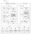
次に図4を参照すると、1つまたは複数の実施形態による、農場小区分レベルの作物害虫リスクまたは作物病害リスクあるいはその両方の推定のための例示のシステム400が図示されている。図4に示す例示のシステム400は、回帰学習器402と、作物リスク・データを含む出力404(たとえば画素レベル)とを含む。回帰学習器402によって判定される作物リスク・データは、それぞれが時点tiにおいて予測されているタプル<タイム・スタンプ,リスク値>の配列aiを構成することができる配列の時系列(a1、a2、...、an)を含むことができる。たとえば、回帰学習器402の出力404は、時点t1において予測されているタプル<タイム・スタンプ=t1,リスク値t1>の配列a1、時点t2において予測されているタプル<タイム・スタンプt2,リスク値t2>の配列a2、...、時点tnにおいて予測されているタプル<タイム・スタンプtn、リスク値tn>の配列anを含んでもよい。各タプルは農場の「画素セット」に対応する。回帰学習器402は、空間および時間にわたる作物害虫リスクまたは作物病害リスクあるいはその両方をシミュレーションすべく、1つまたは複数の時空間回帰モデルを学習するために機械学習を採用することができる。実施形態によっては、1つまたは複数の所与の作物のそれぞれについて、その所与の作物を冒す可能性のある1つまたは複数の害虫または1つまたは複数の病害あるいはその両方のそれぞれのための1組のトレーニング・データについて少なくとも1つの機械学習(ML)/作物季節学/害虫(病害)伝播モデルがトレーニングされてもよい。回帰学習器402は、1つまたは複数の回帰モデルを学習するために、たとえばロジスティック回帰、サポート・ベクタ回帰、またはディープ・ニューラル回帰あるいはこれらの組合せを採用してもよい。1つまたは複数の回帰モデルが学習された後は、回帰学習器402は、回帰学習器402が以前に見たことがないデータ(たとえばテスト・インスタンスからのデータ)にその1つまたは複数の回帰モデルを適用し、それらのデータに関する予測を行ってもよい。 4, an
回帰学習器402の出力404は、「画素レベル」、またはより一般的には「画素セット・レベル」とすることができる。「画素セット」(少なくとも1つの画素)とは、そこからデータを意味があるように収集することができる農場の最小可能/許容分解能を指す。実施形態によっては、出力404は、時点tiにおいて予測されているタプルの配列aiにおける各タプル<タイム・スタンプ,リスク値>が農場の画素に対応するという意味で画素レベルである。そのような実施形態では、農場の各画素についてリスク値が予測される。実施形態によっては、出力404は、時点tiにおいて予測されているタプルの配列aiにおける各タプル<タイム・スタンプ,リスク値>が農場の画素セットに対応するという意味で「画素セット・レベル」である。そのような実施形態では、農場の各画素セットについてリスク値が予測される。 The
データは1つまたは複数のネットワーク406を介して回帰学習器402に提供され、画素レベル、画素セット・レベルまたは、農場レベルなどの1つまたは複数の比較的粗い分解能、あるいはこれらの組合せであってもよい。このようなネットワーク406には、セルラ・ネットワーク、ワイド・エリア・ネットワーク(WAN)(たとえばインターネット)、またはローカル・エリア・ネットワーク(LAN)あるいはこれらの組合せを含む、無線および有線ネットワークが含まれ、その非限定的な例には、セルラ、WAN、ワイヤレス・フィディリティ(Wi-Fi)、Wi-Mal、WLAN、電波通信、マイクロ波通信、衛星通信、光通信、音波通信、電磁誘導通信、量子通信、または任意のその他の適切な通信技術あるいはこれらの組合せが含まれる。Data is provided to the regression learner 402 via one or
図4に示す例示のシステム400において、回帰学習器402は、1つまたは複数の機械学習モデル・モジュール408と、1つまたは複数の作物季節学モデル・モジュール410と、1つまたは複数の害虫(病害)伝播モデル・モジュール412とを含む。1つもしくは複数の機械学習モデル・モジュール408、1つもしくは複数の作物季節学モデル・モジュール410、または1つもしくは複数の害虫(病害)伝播モデル・モジュール412あるいはこれらの組合せは、図4に示す例示のシステム400に示すように別々のコンポーネントであってもよく、または全部もしくは一部が組み合わされてもよい。In the
実施形態によっては、回帰学習器402は、1つもしくは複数のデータ・ソース・インジェスト・モジュールまたは1つもしくは複数のデータ同化モジュールあるいはその両方を含んでもよい。たとえば、入力データを、データ・ソースインジェスト・モジュールを介して1つまたは複数の機械学習モデル・モジュール408、1つまたは複数の作物季節学モデル・モジュール410、1つまたは複数の害虫(病害)伝播モデル・モジュール412、あるいはこれらの組合せにインジェストすることができる。In some embodiments, the regression learner 402 may include one or more data source ingest modules and/or one or more data assimilation modules. For example, input data may be ingested via a data source ingest module into one or more machine learning model modules 408, one or more crop phenology model modules 410, one or more pest (disease) transmission model modules 412, or a combination thereof.
1つまたは複数の機械学習モデル・モジュール408は、1つまたは複数のアルゴリズム(たとえば1つまたは複数の「回帰モデル」)を提供するために、トレーニング・データを推論し、学習することができる。たとえば、1つまたは複数の回帰モデルを学習するために、1つまたは複数の機械学習モデル・モジュール408は、1つまたは複数のネットワーク406を介した農場の履歴データ(たとえば、1つもしくは複数の気象属性420、1つもしくは複数の土壌および土地特性422、1つもしくは複数のリモート・センシング入力424、1つもしくは複数の農場入力426、ならびに/または、害虫および/もしくは病害に関する近隣情報などの1つもしくは複数のその他の入力428)と、1つもしくは複数の作物季節学モデル・モジュール410からの出力データ、または1つもしくは複数の害虫(病害)伝播モデル・モジュール412からの出力データ、あるいはその両方に関して、ロジスティック回帰、サポート・ベクタ回帰、またはディープ・ニューラル回帰を採用してもよい。The one or more machine learning model modules 408 can infer and learn the training data to provide one or more algorithms (e.g., one or more "regression models"). For example, to learn the one or more regression models, the one or more machine learning model modules 408 may employ logistic regression, support vector regression, or deep neural regression on the farm's historical data (e.g., one or more weather attributes 420, one or more soil and
たとえば、ロジスティック回帰モデルは、1つまたは複数の予測変数(たとえば、1つもしくは複数の気象属性420、1つもしくは複数の土壌および土地特性422、1つもしくは複数のリモート・センシング入力424、1つもしくは複数の農場入力426、ならびに/または、害虫および/もしく病害に関する近隣情報などの1つもしくは複数のその他の入力428)と、0=蔓延なし、1=蔓延という2値反応変数、すなわち蔓延の発生の確率との関係を表すアルゴリズムの形態で、作物害虫または作物病害あるいはその両方の挙動をかなり適切に捕捉することができる。この蔓延発生の確率を「リスク」(すなわち、作物害虫リスクまたは作物病害リスクあるいはその両方のリスク)と呼ぶ。For example, a logistic regression model can capture crop pest and/or crop disease behavior quite well in the form of an algorithm that expresses the relationship between one or more predictor variables (e.g., one or more weather attributes 420, one or more soil and
1つまたは複数の回帰モデルが学習された後は、1つまたは複数の機械学習モデル・モジュール408は、その1つまたは複数の回帰モデルを、1つまたは複数の機械学習モデル・モジュール408が以前に見たことがないデータに適用することができる。たとえば、1つまたは複数の機械学習モデル・モジュール408は、1つまたは複数の回帰モデルを、1つまたは複数のネットワーク406を介して受け取った農場の履歴データ、現在のデータまたは予測データあるいはこれらの組合せ(たとえば1つもしくは複数の気象属性420、1つもしくは複数の土壌および土地特性422、1つもしくは複数のリモート・センシング入力424、1つもしくは複数の農場入力426、ならびに/または害虫および/もしくは病害に関する近隣情報などの1つもしくは複数のその他の入力428)と、1つまたは複数の作物季節学モデル・モジュール410からの出力データまたは1つまたは複数の害虫(病害)伝播モデル・モジュール412からの出力データあるいはその両方とに適用してもよい。After the regression model(s) have been learned, the one or more machine learning model modules 408 may apply the one or more regression models to data not previously seen by the one or more machine learning model modules 408. For example, the one or more machine learning model modules 408 may apply the one or more regression models to historical, current, or forecast farm data or combinations thereof (e.g., one or more weather attributes 420, one or more soil and
1つまたは複数の気象属性420は、気温、湿度、露点、風速および風向、降水量などを含み得るが、これらには限定されない。The one or more weather attributes 420 may include, but are not limited to, temperature, humidity, dew point, wind speed and direction, precipitation, etc.
1つまたは複数の土壌および土地特性422は、土壌の種類、土壌組成、土壌の健康度、土壌深度、土壌水分量、灌漑および土地高度/水流のための勾配などを含み得るが、これらには限定されない。The one or more soil and
1つまたは複数のリモート・センシング入力424は、植生指数、後方散乱などを含み得るが、これらには限定されない。実施形態によっては、リモート・センシング入力424は、1つまたは複数のリモート・センサ・データベース(たとえば図11の1126)、またはIBM(R)PAIRS(Physical Analytics Integrated Data Repository and Services)-Geoscopeなどの地理空間データ・プラットフォームによって提供されてもよい。IBM(R)は米国におけるインターナショナル・ビジネス・マシーンズ・コーポレーション(「IBM」)の登録商標である。IBM(R)PAIRS-Geoscopeは、膨大な地理空間時間データ(地図、衛星、気象、ドローン、IoT)、照会および解析サービスのために特別に設計されたプラットフォームである。IBM(R)PAIRS-Geoscopeは、履歴および連続更新リモート・センサ・データへのアクセスを提供する。The one or more
1つまたは複数の農場入力426は、作物の種類、種子品種、播種日などの栽培情報、施肥、灌漑、殺虫剤散布、除草剤散布、殺菌剤散布などの害虫管理の履歴記録などを含み得るが、これらには限定されない。The one or more farm inputs 426 may include, but are not limited to, agronomic information such as crop type, seed variety, sowing date, historical records of fertilization, irrigation, pest management such as insecticide applications, herbicide applications, fungicide applications, etc.
1つまたは複数のその他の入力428は、使用機械/装置の種類およびその殺菌などの農場管理入力、害虫または病害あるいはその両方に関する近隣情報などを含み得るが、これらには限定されない。The one or more
実施形態によっては、1つまたは複数のアルゴリズムを学習するために1つまたは複数の機械学習モデル・モジュール408によって使用されるトレーニング・データの1つまたは複数のセットは、1つもしくは複数の所与の作物とその所与の作物を冒す可能性のある1つもしくは複数の害虫とのそれぞれの組合せに関連付けられたトレーニング・データのセット、または1つもしくは複数の所与の作物とその所与の作物を冒す可能性のある1つもしくは複数の病害との組合せに関連付けられたトレーニング・データのセット、あるいはその両方を含むことができる。たとえば、トレーニング・データの1つまたは複数のセットは、トウモロコシ作物とそのトウモロコシ作物を冒す可能性のある第1の害虫(または病害)との組合せに関連付けられたトレーニング・データの第1のセットと、トウモロコシ作物とトウモロコシ作物を冒す可能性のある第2の害虫(または病害)との組合せに関連付けられたトレーニング・データの第2のセットと、大豆作物と大豆作物を冒す可能性のある第3の害虫(または病害)との組合せに関連付けられたトレーニング・データの第3のセットとを含んでもよい。トレーニング・データの各セットは、農場の履歴データ(たとえば、1つもしくは複数の気象属性420、1つもしくは複数の土壌および土地特性422、1つもしくは複数のリモート・センシング入力424、1つもしくは複数の農場入力426、ならびに/または害虫および/もしくは病害に関する近隣情報などの1つもしくは複数のその他の入力428)と、1つもしくは複数の作物季節学モデル・モジュール410からの出力データまたは1つもしくは複数の害虫(病害)伝播モデル・モジュール412からの出力データ、あるいはその両方とを含んでもよい。In some embodiments, the one or more sets of training data used by the one or more machine learning model modules 408 to train the one or more algorithms may include a set of training data associated with each combination of one or more given crops and one or more pests that may affect the given crops, or a set of training data associated with each combination of one or more given crops and one or more diseases that may affect the given crops, or both. For example, the one or more sets of training data may include a first set of training data associated with a combination of a corn crop and a first pest (or disease) that may affect the corn crop, a second set of training data associated with a combination of a corn crop and a second pest (or disease) that may affect the corn crop, and a third set of training data associated with a combination of a soybean crop and a third pest (or disease) that may affect the soybean crop. Each set of training data may include historical farm data (e.g., one or more weather attributes 420, one or more soil and
実施形態によっては、1つまたは複数の機械学習モデル・モジュール408によって学習される1つまたは複数のアルゴリズムは、1つもしくは複数の所与の作物とその所与の作物を冒す可能性のある1つもしくは複数の害虫との各組合せのための回帰モデル、または1つもしくは複数の所与の作物とその作物を冒す可能性のある1つもしくは複数の病害との各組合せのための回帰モデル、あるいはその両方を含んでもよい。In some embodiments, the one or more algorithms trained by the one or more machine learning model modules 408 may include a regression model for each combination of one or more given crops and one or more pests that may affect the given crops, or a regression model for each combination of one or more given crops and one or more diseases that may affect the crops, or both.
たとえば、蔓延が発生する確率はP(E=1)によって表すことができ、ここで、蔓延の場合はE=1、蔓延でない場合はE=0である。回帰モデルは、
p(E=1)=1/(1+exp(-z)) (式1)
によって与えられ、ここでzは、1つまたは複数の予測変数(たとえば、(所与の作物としての)マンゴと(その所与の作物を冒す可能性のある害虫/病害としての)Oidium mangiferae Berhetに起因するうどん粉病との組合せに関する以下の例では「最高気温」と「相対湿度」)の関数である。回帰モデル(式1)の右辺で付加誤差項eが想定されてもよい。P(E=1)≧0.5である場合、蔓延の確率が高い可能性があり、P(E=1)<0.5である場合、蔓延の確率は低いとみなすことができる。関数zは、
z=β0+β1x1+β2x2+...+βnxn (式2)
によって与えることができ、ここでx1、x2、...およびxnは、n個の予測変数を示し、β0、β1、β2...およびβnは求めるパラメータを示す。たとえば、マンゴとうどん粉病との組合せに関する以下の例では、x1は「最高気温」を示し、x2は「相対湿度」を示し、β0、β1およびβ2は求めるパラメータを示し得る。パラメータβ0、β1、β2...およびβnは、統計分析ソフトウェアを使用してトレーニング・データに基づいて求められる。そのような統計分析ソフトウェアの例としては、IBM SPSS(R)Statistics、KNIME(R)Analytic Platformなどがある。IBM(R)およびSPSS(R)は米国におけるインターナショナル・ビジネス・マシーンズ・コーポレーション(「IBM」)の登録商標である。頭字語「SPSS」は、Statistical Product and Service Solutionを指す。回帰モデル(式1)に関数z(式2)を代入すると、回帰モデルは
P(E=1)=1/(1+exp{-(β0+β1x1+β2x2+…+βnxn)}) (式3)
となる。 For example, the probability of an epidemic occurring can be represented by P(E=1), where E=1 for epidemic and E=0 for no epidemic. The regression model is
p(E=1)=1/(1+exp(-z)) (Formula 1)
where z is a function of one or more predictor variables (e.g. "maximum temperature" and "relative humidity" in the following example for mango (as a given crop) in combination with powdery mildew caused by Oidium mangiferae Behet (as a pest/disease that may affect the given crop)). An additional error term e may be assumed on the right hand side of the regression model (Equation 1). If P(E=1)≧0.5, the probability of infestation may be considered high, and if P(E=1)<0.5, the probability of infestation may be considered low. The function z is
z=β0 +β1 x1 +β2 x2 +. .. .. +βn xn (Formula 2)
The parameterβ0 ,β1 ,β2 ,βn may be given by: β0, β1,β2 , βn=β1, β2, βn=β2, βn=βn, where x1, x2, xn,xn represent n predictor variables, andβ0 ,β1 , β2,βn represent the parameters to be sought. For example, in the following example for mango and powdery mildew combination,x1 may represent "maximum temperature",x2 may represent "relative humidity", and β0,β1 ,β2 may represent the parameters to be sought. The parametersβ0 , β1,β2 ,βn are determined based on the training data using statistical analysis software. Examples of such statistical analysis software include IBM SPSS® Statistics, KNIME® Analytical Platform, etc. IBM® and SPSS® are registered trademarks of International Business Machines Corporation ("IBM") in the United States. The acronym "SPSS" stands for Statistical Product and Service Solution. When the function z (Equation 2) is substituted into the regression model (Equation 1), the regression model is P(E=1)=1/(1+exp{-(β0 +β1 x1 +β2 x2 +...+βn xn )}) (Equation 3)
It becomes.
回帰モデル(式3)におけるパラメータβ0、β1、β2、...およびβnが求められると、1つまたは複数の機械学習モデル・モジュール408は、回帰モデル(式3)を、1つまたは複数の機械学習モデル・モジュール408が以前に見たことがないデータ(たとえば、トレーニング・データ外のテスト・インスタンスからのデータ)に適用することができ、それらのデータに関する予想を行うことができる。 Once the parameters β0 , β1 , β2 , ..., and βn in the regression model (Equation 3) are determined, the one or more machine learning model modules 408 can apply the regression model (Equation 3) to data not previously seen by the one or more machine learning model modules 408 (e.g., data from test instances outside the training data) and make predictions regarding such data.
上記のように、(所与の作物としての)マンゴと(その所与の作物を冒す可能性のある害虫/病害としての)Oidium mangiferae Berhetによって生じるうどん粉病との組合せの場合、1つまたは複数の機械学習モデル・モジュール408によって学習される1つまたは複数のアルゴリズムは、最高気温と相対湿度などの変数を含んでもよい。これらの変数(すなわち最高気温と相対湿度)は、1つまたは複数の気象属性420に含まれるかまたは基づいてもよい。実施形態によっては、これらの変数は、1期間または複数期間にわたって農場小区分規模で、農場における気温および相対湿度を定期的に(たとえば1時間ごと、15分ごとなどに)感知することによって取得することができ、次にそれらの気温および相対湿度からその1期間または複数期間中の平均最高気温と平均相対湿度とを求めることができる。1期間または複数期間のそれぞれの期間の平均最高気温は、たとえば1時間ごとに気温を感知し、その期間にわたる毎日の最高気温を平均することによって求めることができる。1期間または複数期間のそれぞれの期間の平均相対湿度は、たとえば1時間ごとに相対湿度を感知し、その期間にわたる相対湿度を平均することによって求めることができる。1期間または複数期間は、うどん粉病の反復生活環に基づいてもよい。たとえば、蔓延の可能性のある発生の開始が典型的には各年の同じ時期に起こると考えると、また、うどん粉病の反復生活環が約4日から7日であると考えると、複数年のそれぞれの年の蔓延の可能性のある発生の開始直前のそのような4期間(すなわち7日間、6日間、5日間および4日間)を、その複数年のうちの各年の蔓延の可能性のある発生の開始後に観察されるうどん粉病の状況とともにトレーニング・データとして使用してもよい。As mentioned above, for the combination of mango (as a given crop) and powdery mildew caused by Oidium mangiferae Behet (as a pest/disease that may affect the given crop), the algorithm or algorithms trained by the machine learning model module or modules 408 may include variables such as maximum temperature and relative humidity. These variables (i.e., maximum temperature and relative humidity) may be included in or based on one or more weather attributes 420. In some embodiments, these variables may be obtained by sensing the temperature and relative humidity at the farm subdivision scale periodically (e.g., hourly, 15 minutes, etc.) over a period or periods, from which the average maximum temperature and average relative humidity over the period or periods may then be determined. The average maximum temperature for each period or periods may be determined, for example, by sensing the temperature every hour and averaging the daily maximum temperatures over the period. The average relative humidity for each of the time periods or periods can be determined, for example, by sensing the relative humidity every hour and averaging the relative humidity over the time period. The time period or periods can be based on the iterative life cycle of powdery mildew. For example, considering that the onset of potential infestation typically occurs at the same time each year, and considering that the iterative life cycle of powdery mildew is about 4 to 7 days, four such periods (i.e., 7 days, 6 days, 5 days, and 4 days) immediately prior to the onset of potential infestation in each of the multiple years can be used as training data, along with the mildew conditions observed after the onset of potential infestation in each of the multiple years.
上記の気象変数(すなわち最高気温と相対湿度)に加えて、またはそれらに代えて、1つまたは複数の機械学習モデル・モジュール408によって学習される1つまたは複数のアルゴリズムは、1つもしくは複数の気象属性420に含まれるおよび/もしくは基づく1つもしくは複数の他の気象変数(たとえば最低温度、風速、風向など)、1つもしくは複数の土壌および土地特性422に含まれるおよび/もしくは基づく1つもしくは複数の変数、1つもしくは複数のリモート・センシング入力424に含まれるおよび/もしくは基づく1つもしくは複数の変数、1つもしくは複数の農場入力426に含まれるおよび/もしくは基づく1つもしくは複数の変数、1つもしくは複数のその他の入力428(たとえば害虫および/もしくは病害に関する近隣情報)に含まれるおよび/もしくは基づく1つもしくは複数の変数、1つもしくは複数の作物季節学モデル・モジュール410からの出力データに含まれるおよび/もしくは基づく1つもしくは複数の変数、ならびに/または、1つもしくは複数の害虫(病害)伝播モデル・モジュール412からの出力データに含まれるおよび/もしくは基づく1つもしくは複数の変数を含んでもよい。In addition to or in lieu of the above weather variables (i.e., maximum temperature and relative humidity), the algorithm(s) trained by the one or more machine learning model modules 408 may include one or more other weather variables (e.g., minimum temperature, wind speed, wind direction, etc.) contained in and/or based on one or more weather attributes 420, one or more variables contained in and/or based on one or more soil and
所与の作物としてマンゴを含む異なる一実施例では、マンゴとミバエとの組合せについて、1つまたは複数の機械学習モデル・モジュール408によって学習される1つまたは複数のアルゴリズムは、最高気温、最低気温、および相対湿度(朝)などの変数を含んでもよい。これらの変数(すなわち最高気温、最低気温および相対湿度(朝))は、1つまたは複数の気象属性420に含まれるかまたは基づくかあるいはその両方であってもよい。実施形態によっては、これらの変数は、1期間または複数期間にわたって、農場小区分規模で、農場における気温および相対湿度を定期的に(たとえば1時間ごと、15分ごとなど)感知することによって得てもよく、次にそれらの気温および相対湿度からその1期間または複数期間の平均最高気温、平均最低気温および平均相対湿度(朝)を求めてもよい。1期間または複数期間のそれぞれの期間の平均最高気温は、たとえば、1時間ごとに気温を感知し、その期間にわたる毎日の最高気温を平均することによって求めてもよい。1期間または複数期間のそれぞれの期間の平均最低気温は、たとえば、1時間ごとに気温を感知し、その期間にわたる毎日の最低気温を平均することによって求めてもよい。1期間または複数期間のそれぞれの期間の平均相対湿度(朝)は、たとえば1時間ごとに相対湿度を検知し、その期間の毎朝の相対湿度を平均することによって求めてもよい。In a different example involving mango as a given crop, for the combination of mango and fruit fly, the one or more algorithms trained by the one or more machine learning model modules 408 may include variables such as maximum temperature, minimum temperature, and relative humidity (morning). These variables (i.e., maximum temperature, minimum temperature, and relative humidity (morning)) may be included in and/or based on one or more weather attributes 420. In some embodiments, these variables may be obtained by sensing the temperature and relative humidity at the farm at a farm subdivision scale periodically (e.g., hourly, 15 minutes, etc.) over one or more time periods, and then determining the average maximum temperature, average minimum temperature, and average relative humidity (morning) for the one or more time periods from the temperature and relative humidity. The average maximum temperature for each of the one or more time periods may be determined, for example, by sensing the temperature every hour and averaging the daily maximum temperatures over the time period. The average minimum temperature for a period or each of the periods may be determined, for example, by sensing the temperature every hour and averaging the minimum temperatures for each day over the period. The average relative humidity (morning) for a period or each of the periods may be determined, for example, by sensing the relative humidity every hour and averaging the relative humidity for each morning over the period.
上記の気象変数(すなわち最高温度、最低温度、および相対湿度(朝))に加えて、またはこれらに代えて、1つまたは複数の機械学習モデル・モジュール408によって学習される1つまたは複数のアルゴリズムは、1つもしくは複数の気象属性420に含まれるおよび/もしくは基づく1つもしくは複数のその他の気象変数(たとえば風速、風向など)、1つもしくは複数の土壌および土地特性に含まれるおよび/もしくは基づく1つもしくは複数の変数、1つもしくは複数のリモート・センシング入力424に含まれるおよび/もしくは基づく1つもしくは複数の変数、1つもしくは複数の農場入力426に含まれるおよび/もしくは基づく1つもしくは複数の変数、1つもしくは複数のその他の入力428(たとえば害虫および/もしくは病害に関する近隣情報)に含まれるおよび/もしくは基づく1つもしくは複数の変数、1つもしくは複数の作物季節学モデル・モジュール410からの出力データに含まれるおよび/もしくは基づく1つもしくは複数の変数、ならびに/または、1つもしくは複数の害虫(病害)伝播モデル・モジュール412からの出力データに含まれるおよび/もしくは基づく1つもしくは複数の変数を含んでもよい。In addition to or in lieu of the above weather variables (i.e., maximum temperature, minimum temperature, and relative humidity (morning)), one or more algorithms trained by one or more machine learning model modules 408 may also be trained on one or more other weather variables (e.g., wind speed, wind direction, etc.) contained in and/or based on one or more weather attributes 420, one or more variables contained in and/or based on one or more soil and land characteristics, one or more variables contained in and/or based on one or more
別の実施例では、ミカンとPhytophthora citrophthoraによって生じる柑橘樹脂病との組合せについて、1つまたは複数の機械学習モデル・モジュール408によって学習される1つまたは複数のアルゴリズムが、気温、降雨量、葉面積指数、および葉のクロロフィル含有量などの変数を含んでもよい。これらの変数の一部(すなわち気温と降雨量)が1つまたは複数の気象属性420に含まれるかまたは基づくかあるいはその両方であってもよい。実施形態によっては、これらの変数(すなわち気温と降雨量)は、1期間または複数期間にわたり、農場小区分規模で、農場における気温および降雨量を定期的に(たとえば1時間ごと、15分ごとなど)感知することによって得てもよく、次にこれらの気温および降雨量からその1期間または複数期間中の平均気温と累加降雨量とを求めてもよい。1期間または複数期間の各期間の平均気温は、たとえば1時間ごとに気温を感知し、その期間にわたる毎日の気温を平均することによって求めることができる。1期間または複数期間のそれぞれの累加降雨量は、たとえば、毎日の総降雨量を感知し、その期間にわたる毎日の降雨量を合計することによって求めることができる。これらの変数のうちの他の変数(すなわち葉面積指数と葉のクロロフィル含有量)は1つまたは複数のリモート・センシング入力424に含まれるかまたは基づくかあるいはその両方であってもよい。たとえば、これらの他の変数のうちの1つまたは複数の変数(すなわち葉面積指数と葉のクロロフィル含有量)は、1期間または複数期間にわたり定期的に(たとえば1時間ごとに)農場小区分規模で農場の画像データをキャプチャすることによって得られ、次にその画像データからその1期間または複数期間中の葉面積指数および葉のクロロフィル含有量を求めることができる。実施形態によっては、葉面積指数および葉のクロロフィル含有量を抽出するために、葉ベースの逆PROSAIL(PROSPECT+SAIL)モデルなどの従来のモデルが使用されてもよい。あるいは、これらの他の変数のうちの1つまたは複数の変数(すなわち葉面積指数と葉のクロロフィル含有量)は、1つまたは複数の作物季節学モデル・モジュール410からの出力データに含まれるかまたは基づくかあるいはその両方であってもよい。たとえば、これらの他の変数のうちの1つまたは複数(すなわち葉面積指数と葉のクロロフィル含有量)は、農場小区分規模で1期間または複数期間にわたり、その1期間または複数期間中の葉面積指数および葉のクロロフィル含有量を定期的に(たとえば1時間ごとに)シミュレーションするために1つまたは複数の作物季節学モデル・モジュール410を使用することによって得られる。In another example, the one or more algorithms trained by the one or more machine learning model modules 408 for the combination of mandarin orange and citrus resin disease caused by Phytophthora citrophthora may include variables such as temperature, precipitation, leaf area index, and leaf chlorophyll content. Some of these variables (i.e., temperature and precipitation) may be included in and/or based on one or more weather attributes 420. In some embodiments, these variables (i.e., temperature and precipitation) may be obtained by sensing temperature and precipitation on the farm at a farm subdivision scale periodically (e.g., hourly, 15 minutes, etc.) over one or more time periods, and then the average temperature and cumulative precipitation over the one or more time periods may be determined from these temperatures and precipitation. The average temperature for each time period over one or more time periods may be determined, for example, by sensing temperature every hour and averaging the daily temperatures over the time period. The cumulative rainfall for each of the time periods or periods may be determined, for example, by sensing the total rainfall for each day and summing the daily rainfall over the time periods. Others of these variables (i.e., leaf area index and leaf chlorophyll content) may be included in and/or based on one or more
上記の変数(すなわち気温、降雨量、葉面積指数および葉のクロロフィル含有量)に加えて、または上記の変数に代えて、1つまたは複数の機械学習モデル・モジュール408によって学習される1つまたは複数のアルゴリズムは、1つもしくは複数の気象属性420、1つもしくは複数の土壌および土地特性422、1つもしくは複数のリモート・センシング入力424、1つもしくは複数の農場入力426、1つもしくは複数のその他の入力428(たとえば害虫および/もしくは病害に関する近隣情報)、1つもしくは複数の作物季節学モデル・モジュール410からの出力データ、ならびに/または1つもしくは複数の害虫(病害)伝播モデル・モジュール412からの出力データに含まれるかまたは基づくかあるいはその両方である1つまたは複数のその他の変数を含んでもよい。In addition to or instead of the above variables (i.e., temperature, precipitation, leaf area index, and leaf chlorophyll content), the one or more algorithms trained by the one or more machine learning model modules 408 may include one or more weather attributes 420, one or more soil and
さらに別の実施例では、カラシと褐斑病との組合せについて、1つまたは複数の機械学習モデル・モジュール408によって学習される1つまたは複数のアルゴリズムは、最低気温、相対湿度(朝)、および相対湿度(晩)などの変数を含んでもよい。これらの変数(すなわち最低温度、相対湿度(朝)および相対湿度(晩))は、1つまたは複数の気象属性420に含まれるかまたは基づくかあるいはその両方であってもよい。実施形態によっては、これらの変数は1期間または複数期間にわたり、農場小区分規模で農場における気温および相対湿度を定期的に(たとえば1時間ごと、15分ごとなど)感知することによって得てもよく、次に、これらの気温および相対湿度からその1期間または複数期間中の平均最低気温、平均相対湿度(朝)、および平均相対湿度(晩)を求めてもよい。In yet another example, the algorithm or algorithms trained by the one or more machine learning model modules 408 for the combination of mustard and brown spot disease may include variables such as minimum temperature, relative humidity (morning), and relative humidity (evening). These variables (i.e., minimum temperature, relative humidity (morning), and relative humidity (evening)) may be included in and/or based on one or more weather attributes 420. In some embodiments, these variables may be obtained by sensing temperature and relative humidity on the farm at a farm subdivision scale periodically (e.g., hourly, 15 minutes, etc.) over one or more time periods, and then the average minimum temperature, average relative humidity (morning), and average relative humidity (evening) for the one or more time periods may be derived from these temperatures and relative humidity.
上記の変数(すなわち、最低気温、相対湿度(朝)および相対湿度(晩))に加えて、またはこれらに代えて、1つまたは複数の機械学習モデル・モジュール408によって学習される1つまたは複数のアルゴリズムは、1つもしくは複数の気象属性420、1つもしくは複数の土壌および土地特性422、1つもしくは複数のリモート・センシング入力424、1つもしくは複数の農場入力426、1つもしくは複数のその他の入力428(たとえば害虫および/もしくは病害に関する近隣情報)、1つもしくは複数の作物季節学モデル・モジュール410からの出力データ、ならびに/または1つもしくは複数の害虫(病害)伝播モデル・モジュール412からの出力データに含まれるかまたは基づくかあるいはその両方である1つまたは複数のその他の変数を含んでもよい。In addition to or in lieu of the above variables (i.e., minimum temperature, relative humidity (morning) and relative humidity (evening)), the algorithm or algorithms trained by the machine learning model module or modules 408 may include one or more weather attributes 420, one or more soil and
所与の作物としてカラシを含む異なる実施例では、カラシと白さび病との組合せについて、1つまたは複数の機械学習モデル・モジュール408によって学習される1つまたは複数のアルゴリズムは、最高気温、最低気温、および相対湿度(朝)などの変数を含んでもよい。これらの変数(すなわち最高気温、最低気温および相対湿度(朝))は、1つまたは複数の気象属性420に含まれるかまたは基づくかあるいはその両方であってもよい。実施形態によっては、これらの変数は、農場小区分規模で1期間または複数期間にわたり、農場における気温および相対湿度を定期的に(たとえば1時間ごと、15分ごとなど)感知することによって得てもよく、次にそれらの気温および相対湿度からその1期間または複数期間中の平均最高気温、平均最低気温および平均相対湿度(朝)を求めてもよい。In a different example involving mustard as a given crop, for the combination of mustard and white rust, the one or more algorithms trained by the one or more machine learning model modules 408 may include variables such as maximum temperature, minimum temperature, and relative humidity (morning). These variables (i.e., maximum temperature, minimum temperature, and relative humidity (morning)) may be included in and/or based on one or more weather attributes 420. In some embodiments, these variables may be obtained by sensing the temperature and relative humidity at the farm at a farm subdivision scale periodically (e.g., hourly, 15 minutes, etc.) over one or more time periods, and then determining the average maximum temperature, average minimum temperature, and average relative humidity (morning) over the one or more time periods.
上記の変数(すなわち最高気温、最低気温および相対湿度(朝))に加えて、または上記の変数に代えて、1つまたは複数の機械学習モデル・モジュール408によって学習される1つまたは複数のアルゴリズムは、1つもしくは複数の気象属性420、1つもしくは複数の土壌および土地特性422、1つもしくは複数のリモート・センシング入力424、1つもしくは複数の農場入力426、1つもしくは複数のその他の入力428(たとえば害虫および/もしくは病害に関する近隣情報)、1つもしくは複数の作物季節学モデル・モジュール410からの出力データ、ならびに/または、1つもしくは複数の害虫(病害)伝播モデル・モジュール412からの出力データに含まれるかまたは基づくかあるいはその両方である、1つまたは複数のその他の変数を含んでもよい。In addition to or instead of the above variables (i.e., maximum temperature, minimum temperature, and relative humidity (morning)), the one or more algorithms trained by the one or more machine learning model modules 408 may include one or more weather attributes 420, one or more soil and
さらに別の実施例では、綿とコナジラミとの組合せについて、1つまたは複数の機械学習モデル・モジュール408によって学習される1つまたは複数のアルゴリズムは、最高気温、最低気温、相対湿度(朝)および相対湿度(晩)などの変数を含んでもよい。これらの変数(すなわち最高気温、最低気温、相対湿度(朝)および相対湿度(晩))は、1つまたは複数の気象属性420に含まれるかまたは基づくかあるいはその両方であってもよい。実施形態によっては、これらの変数は、1期間または複数期間にわたり農場小区分規模で農場における気温および相対湿度を定期的に(たとえば1時間ごと、15分ごとなど)感知することによって得てもよく、次にそれらの気温および相対湿度からその1期間または複数期間中の平均最高気温、平均最低気温、平均相対湿度(朝)および平均相対湿度(晩)を求めてもよい。In yet another example, the one or more algorithms trained by the one or more machine learning model modules 408 for the cotton-whitefly combination may include variables such as maximum temperature, minimum temperature, relative humidity (morning), and relative humidity (evening). These variables (i.e., maximum temperature, minimum temperature, relative humidity (morning), and relative humidity (evening)) may be included in and/or based on one or more weather attributes 420. In some embodiments, these variables may be obtained by sensing temperature and relative humidity on the farm at a farm subdivision scale periodically (e.g., hourly, 15 minutes, etc.) over one or more time periods, and then determining the average maximum temperature, average minimum temperature, average relative humidity (morning), and average relative humidity (evening) over the one or more time periods.
上記の変数(すなわち最高気温、最低気温、相対湿度(朝)および相対湿度(晩))に加えて、または上記の変数に代えて、1つまたは複数の機械学習モデル・モジュール408によって学習される1つまたは複数のアルゴリズムは、1つもしくは複数の気象属性420、1つもしくは複数の土壌および土地特性422、1つもしくは複数のリモート・センシング入力424、1つもしくは複数の農場入力426、1つもしくは複数のその他の入力428(たとえば害虫および/もしくは病害に関する近隣情報)、1つもしくは複数の作物季節学モデル・モジュール410からの出力データ、ならびに/または、1つもしくは複数の害虫(病害)伝播モデル・モジュール412からの出力データに含まれるかまたは基づくかあるいはその両方である1つまたは複数のその他の変数を含んでもよい。In addition to or instead of the above variables (i.e., maximum temperature, minimum temperature, relative humidity (morning) and relative humidity (evening)), the one or more algorithms trained by the one or more machine learning model modules 408 may include one or more weather attributes 420, one or more soil and
さらに別の実施例では、サトウキビとピリラとの組合せについて、1つまたは複数の機械学習モデル・モジュール408によって学習される1つまたは複数のアルゴリズムは、最高気温および中間相対湿度などの変数を含んでもよい。これらの変数(すなわち最高気温と中間相対湿度)は、1つまたは複数の気象属性420に含まれるかまたは基づくかあるいはその両方であってもよい。実施形態によっては、これらの変数は、1期間または複数期間にわたり、農場小区分規模で農場における温度および相対湿度を定期的に(たとえば1時間ごと、15分ごとなど)感知することによって得てもよく、次にそれらの温度および相対湿度からその1期間または複数期間中の平均最高気温および平均中間相対湿度を求めてもよい。In yet another example, the one or more algorithms trained by the one or more machine learning model modules 408 for the sugarcane-pirilla combination may include variables such as maximum temperature and mean relative humidity. These variables (i.e., maximum temperature and mean relative humidity) may be included in and/or based on one or more weather attributes 420. In some embodiments, these variables may be obtained by sensing temperature and relative humidity on the farm at a farm subdivision scale periodically (e.g., hourly, 15 minutes, etc.) over one or more time periods, and then determining the average maximum temperature and average mean relative humidity over the one or more time periods from the temperatures and relative humidity.
上記の変数(すなわち最高気温と中間相対湿度)に加えて、または上記の変数に代えて、1つまたは複数の機械学習モデル・モジュール408によって学習される1つまたは複数のアルゴリズムは、1つもしくは複数の気象属性420、1つもしくは複数の土壌および土地特性422、1つもしくは複数のリモート・センシング入力424、1つもしくは複数の農場入力426、1つもしくは複数のその他の入力428(たとえば害虫および/もしくは病害に関する近隣情報)、1つもしくは複数の作物季節学モデル・モジュール410からの出力データ、ならびに/または、1つもしくは複数の害虫(病害)伝播モデル・モジュール412からの出力データに含まれるかまたは基づくかあるいはその両方である1つまたは複数のその他の変数を含んでもよい。In addition to or instead of the above variables (i.e., maximum temperature and mean relative humidity), the one or more algorithms trained by the one or more machine learning model modules 408 may include one or more weather attributes 420, one or more soil and
1つまたは複数の作物季節学モデル・モジュール410は、作物の種類ごとに、1つまたは複数のネットワーク406を介して受信した農場の履歴データ、現在のデータまたは予測データあるいはこれらの組合せ(たとえば、1つもしくは複数の気象属性420、1つもしくは複数の土壌および土地特性422、1つもしくは複数のリモート・センシング入力424、1つもしくは複数の農場入力426、ならびに/または、害虫および/もしくは病害に関する近隣データなどの1つもしくは複数のその他の入力428)に基づいて、農場の(たとえば農場規模の)シミュレーション作物生育時系列を判定してもよい。たとえば、1つまたは複数の作物季節学モデル・モジュール410は、播種から種子成熟までの生育時間と、開始登熟段階などの異なる生育段階のタイミングとを推定してもよい。For each crop type, one or more crop phenology model modules 410 may determine a simulated crop growth time series for the farm (e.g., farm-scale) based on historical, current, or forecast farm data or a combination thereof (e.g., one or more weather attributes 420, one or more soil and
たとえば、トウモロコシに関しては、1つまたは複数の作物季節学モデル410によってシミュレーションされる生育段階は、発芽期、出芽期、幼苗終了期、花成誘導期、75%花柱出現期、登熟開始期、成熟期、および収穫期を含むことができる。別の実施例では、小麦に関して、1つまたは複数の作物季節学モデル・モジュール410によってシミュレーションされる生育段階は、発芽期、出芽期、幼穂分化期、穂揃い期、乳熟期、成熟期および収穫期を含んでもよい。さらに別の実施例では、大麦に関して、1つまたは複数の作物季節学モデル・モジュール410によってシミュレーションされる生育段階は、発芽期、出芽期、最大原基期、穂揃い期、乳熟期、成熟期および収穫期を含んでもよい。For example, for corn, the growth stages simulated by one or more crop phenology models 410 may include germination, emergence, seedling completion, flower induction, 75% style emergence, ripening initiation, maturity, and harvest. In another example, for wheat, the growth stages simulated by one or more crop phenology model modules 410 may include germination, emergence, panicle differentiation, full head, milky, maturity, and harvest. In yet another example, for barley, the growth stages simulated by one or more crop phenology model modules 410 may include germination, emergence, maximum primordia, full head, milky, maturity, and harvest.
1つまたは複数の作物季節学モデル・モジュール410は、従来の作物生育シミュレーション・モデルにおける1つまたは複数の季節学モデル・モジュールを含んでもよい。一般的な作物生育シミュレーション・モデルには、Crop Estimation through Resource and Environment Synthesis(CERES)、Decision Support System for Agrotechnology Transfer(DSSAT)およびInfoCropが含まれるが、これらには限定されない。作物生育シミュレーション・モデルによって必要とされる入力データの量はモデルごとに異なるが、作物生育シミュレーション・モデルは、多くの場合、現場、土壌、初期条件、天候および作物管理に関する情報を必要とする。作物成長シミュレーション・モデルは、典型的には、作物成長の履歴プロファイルを提供するために、作物植え付けから現在の日付までに発生した累積気象条件を使用する。全体または一部を作物季節学モデル・モジュール410に含めるのに適した季節学モデル・モジュールを含む従来の作物生育シミュレーション・モデルの例には、DSSAT(たとえばDSSAT作付けシステム・モデル(DSSAT-CSM))、CERES(たとえばCERES-Wheat、CERES-Maize、CERES-Sorghum、CERES-Riceなど)、CROPGRO、SOYGROなどにおける季節学モデルが含まれるが、これらには限定されない。The one or more crop phenology model modules 410 may include one or more phenology model modules in a conventional crop growth simulation model. Common crop growth simulation models include, but are not limited to, Crop Estimation through Resource and Environment Synthesis (CERES), Decision Support System for Agrotechnology Transfer (DSSAT), and InfoCrop. Although the amount of input data required by a crop growth simulation model varies from model to model, crop growth simulation models often require information about the site, soil, initial conditions, weather, and crop management. Crop growth simulation models typically use cumulative weather conditions that occurred from crop planting to the current date to provide a historical profile of crop growth. Examples of conventional crop growth simulation models including phenology model modules suitable for inclusion in whole or in part in crop phenology model module 410 include, but are not limited to, phenology models in DSSAT (e.g., DSSAT Cropping System Model (DSSAT-CSM)), CERES (e.g., CERES-Wheat, CERES-Maize, CERES-Sorghum, CERES-Rice, etc.), CROPGRO, SOYGRO, etc.
実施形態によっては、1つまたは複数の作物季節学モデル・モジュール410によって各作物種類について判定され、1つまたは複数の機械学習モデル・モジュール408に提供される農場のシミュレーション作物生育時系列は、1つまたは複数の従来の作物生育シミュレーション・モデルの植物成長モジュール出力を含んでもよい。たとえば、(たとえばCROPGRO Plant Templateモジュールまたは、CERES-Maize、CERES-Wheat、CERES-Sorghum、CERES-Riceなど個別植物成長モジュールあるいはその両方からの)そのような植物成長モジュール出力は、NSTRES{窒素ストレス因子。1=ストレスなし、0=最大ストレス}、RLV(L){土壌層Lの根長密度(cm[根]/cm3[土壌])}、SENCLN(I,J){日老化植物、表面の場合はI=0、土壌の場合はI=1、Cの場合はJ=1、リグニンの場合はJ=2、Nの場合はJ=3(g[C、Nまたはリグニン]/(m2d))}、STGDOY(I){植物段階Iが発生した日}、UNH4(L){NH4の根吸収速度(kg[N]/ha d)}}、UNO3(L){NO3の根吸収速度(kg[N](ha d)}、XHLAI{健康な葉面積指数}LAI)(m2[葉]/m2[地面])、XLAI{葉面積指数(LAI)(m2[葉]/m2[地面])}、YREMGR(出芽日)、およびYRNR8{収穫成熟日}を含み得るが、これらには限定されない。 In some embodiments, the simulated crop growth time series for the farm determined for each crop type by one or more crop phenology model modules 410 and provided to the one or more machine learning model modules 408 may include plant growth module outputs of one or more conventional crop growth simulation models. For example, such plant growth module outputs (e.g., from a CROPGRO Plant Template module and/or individual plant growth modules such as CERES-Maize, CERES-Wheat, CERES-Sorghum, CERES-Rice, etc.) may include NSTRES {nitrogen stress factors; 1 = no stress, 0 = maximum stress}, RLV(L) {root length density in soil layer L (cm [root]/cm3 [soil])}, SENCLN(I,J) {day-senescent plant, I = 0 for surface, I = 1 for soil, J = 1 for C, J = 2 for lignin, J = 3 for N (g [C, N or lignin]/(m2 d))}, STGDOY(I) {day plant stage I occurred}, UNH4(L) {root uptake rate of NH4 (kg [N]/ha d)}, UNO3(L) {root uptake rate of NO3 (kg [N] (ha d)}, XHLAI{leaf area index (LAI) (m2 [leaf]/m2 [ground]), XLAI{leaf area index (LAI) (m2 [leaf]/m2 [ground])}. [ground]), YREMGR (emergence date), and YRNR8 {harvest maturity date}.
1つまたは複数の害虫(病害)伝播モデル・モジュール412は、作物の種類とその作物の種類を冒す可能性のある害虫(病害)との組合せごとに、1つまたは複数のネットワーク406を介して受信した履歴データ、現在のデータまたは予測データ(たとえば1つもしくは複数の気象属性420、1つもしくは複数の土壌および土地特性422、1つもしくは複数のリモート・センシング入力424、1つもしくは複数の農場入力426、ならびに/または、害虫および/もしくは病害に関する近隣情報などの1つもしくは複数のその他の入力428)に基づいて、農場の(たとえば農場規模の)シミュレーション作物害虫伝播時系列またはシミュレーション作物病害伝播時系列あるいはその両方を判定することができる。1つまたは複数の害虫(病害)伝播モデル・モジュール412は、1つまたは複数の従来の害虫(病害)伝播モデリング・システムを含んでもよい。全体または一部を1つまたは複数の害虫(病害)伝播モデル・モジュール412に含めるのに適した従来の害虫(病害)伝播モデリング・システムの例には、CLIMEX、DYMEX、NAPPFASTなどが含まれるが、これらには限定されない。For each combination of crop type and pest (disease) that may affect the crop type, one or more pest (disease) transmission model modules 412 may determine a farm (e.g., farm-scale) simulated crop pest transmission time series and/or a simulated crop disease transmission time series based on historical, current, or forecast data (e.g., one or more weather attributes 420, one or more soil and
CLIMEXモデリング・システムは、昆虫、植物、病原菌、および脊椎動物の分布を含む、天候が種に与える影響を予測する。CLIMEXは、種の地理的分布を制限する生物学的メカニズムを模倣するためと、それらの種の季節学および相対存在量を判定するために、シミュレーションとモデリング技術を使用する。The CLIMEX modeling system predicts the effects of weather on species, including the distribution of insects, plants, pathogens and vertebrates. CLIMEX uses simulation and modeling techniques to mimic the biological mechanisms that limit the geographic distribution of species and to determine the phenology and relative abundance of those species.
DYMEXモデリング・システムは、ユーザが生物有機体の決定論的集団モデルを迅速に作成し、実行することができるようにするモジュラ・モデリング・パッケージである。集団モデルは、種の個体がその生存期間にたどる成長段階に基づく種の生活環を中心に構築される。The DYMEX modeling system is a modular modeling package that allows users to rapidly create and run deterministic population models of biological organisms. Population models are built around the life cycle of a species, based on the developmental stages that individuals of the species go through during their lifetime.
CLIMEXおよびDYMEXモデリング・システムは市販されている。The CLIMEX and DYMEX modeling systems are commercially available.
NAPPFAST(NCSU-APHIS Plant Pest Forecast)は、ジオリファレンス気候学的気象データ(たとえば日次機構および履歴天候データ)を植物病虫害モデリングのための生物学的モデルとリンクさせるウェブ・ベースのモデリング・システムである。頭字語「NCSU」は、ノースカロライナ州立大学(North Carolina State University)を指す。頭字語「APHIS」は、米国農務省の動植物検疫局(U.S. Department of Agriculture's Animal and Plant Health Inspection Service(USDA-APHIS))を指す。NAPPFASTモデリング・システムは対話型テンプレートを含み、対話型テンプレートは、植物病原菌の感染テンプレート、経験的モデルを作成するための事前プログラムされた式を備えた汎用テンプレート、およびデグリーデー・テンプレートを含む。たとえば、デグリーデー・テンプレートは、デグリーデーに基づいて害虫およびその他の有機体(たとえば、雑草、クモなどのその他の節足動物)または作物の季節学的成長をモデリングするために使用することができる。デグリーデー・テンプレートは、季節学的段階の数と世代数の選択を可能にする。たとえば、ある害虫に関して、デグリーデー・テンプレートは、入力データとして以下の害虫成長パラメータ、すなわち害虫のデグリーデー要件(たとえば、害虫の季節学的段階ごとのデグリーデー要件)と害虫の成長温度閾値(すなわち害虫の成長温度ベースおよび上限閾値)とを必要とする。NAPPFAST (NCSU-APHIS Plant Pest Forecast) is a web-based modeling system that links georeferenced climatological weather data (e.g., daily schedule and historical weather data) with biological models for plant pest modeling. The acronym "NCSU" refers to North Carolina State University. The acronym "APHIS" refers to the U.S. Department of Agriculture's Animal and Plant Health Inspection Service (USDA-APHIS). The NAPPFAST modeling system includes interactive templates, including plant pathogen infection templates, general-purpose templates with preprogrammed formulas for creating empirical models, and degree-day templates. For example, the degree-day templates can be used to model pest and other organisms (e.g., weeds, other arthropods such as spiders) or phenological growth of crops based on degree days. The degree-day template allows for the selection of the number of phenological stages and the number of generations. For example, for a pest, the degree-day template requires as input the following pest growth parameters: pest degree-day requirements (e.g., degree-day requirements per pest phenological stage) and pest growth temperature thresholds (i.e., pest growth temperature base and upper thresholds).
NAPPFASTモデリング・システムおよびその他の従来の害虫(病害)伝播モデリング・システムの入力データとして使用される害虫成長パラメータは、通常、少なくとも重要な害虫種については、科学文献に見られる。また、Centre for Agriculture and Bioscience International(CABI)Crop Protection Compendium(CPC)は、ウェブサイト<http://www.cabi.org/cpc/>で虫の成長についてまとめている。さらに、カリフォルニア大学(UC)のStatewide Integrated Pest Management (IPM) Programは、ウェブサイト<http://ipm.ucanr.edu/MODELS/>で成長データをリストしている。また、NAPPFASTモデリング・システムなどの昆虫季節学モデルをサポートするために開発された500を超える害虫および寄生捕食者の成長要件が記載されたInsect Development Database(IDD)が、<http://ring.ciard.net/nappfast-pest-database-thresholds-and-growing-degree-days>で利用可能である。IDDにおける成長要件データには、可能な場合には、昆虫のライフ・ステージ(卵、幼虫、蛹、成虫)の成長のベース閾値(℃)、上限成長閾値(℃)および成長要件(デグリーデー(DD))が含まれている。NAPPFASTモデリング・システムおよびその他の従来の害虫(病害)伝播モデリング・システムのこのような入力データは図4に示すその他の入力データ428に含まれるかまたは基づくかあるいはその両方であってもよい。Pest growth parameters used as inputs for the NAPPFAST modeling system and other conventional pest (disease) transmission modeling systems are typically found in the scientific literature, at least for important pest species, and the Centre for Agriculture and Bioscience International (CABI) Crop Protection Compendium (CPC) summarizes insect growth at its website: http://www.cabi.org/cpc/. Additionally, the Statewide Integrated Pest Management (IPM) Program at the University of California (UC) lists growth data at its website: http://ipm.ucanr.edu/MODELS/. Also available at <http://ring.ciard.net/nappfast-pest-database-thresholds-and-growing-degree-days> is the Insect Development Database (IDD), which lists the growth requirements of over 500 pests and parasitoids developed to support insect phenology models such as the NAPPFAST modeling system. The growth requirement data in the IDD includes base thresholds (°C), upper growth thresholds (°C) and growth requirements (degree days (DD)) for insect life stages (egg, larva, pupa, adult), where available. Such input data for the NAPPFAST modeling system and other conventional pest (disease) transmission modeling systems may be included in and/or based on
NAPPFASモデリング・システムおよびその他の従来の害虫(病害)伝播モデリング・システムの入力データとして使用可能な追加のパラメータには、毎日の天候および履歴気象データが含まれるがこれらには限定されない。たとえば、そのような追加パラメータには、日次平均気温(℃)、日次最低気温(℃)、日次最高気温(℃)、日次気温範囲(℃)、霜日頻度(1カ月当たり)、雨天頻度(1カ月当たり日数)、1日当たり総葉面濡れ時間(h、派生変数)、平均日次相対湿度(%)、平均日次風速(k/h)、降水量(mm)、5cm深度における平均土壌温度(℃)、蒸気圧(ヘクトパスカル)、雲量(%)、および蒸発量(mm、派生変数)が含まれ得る。NAPPFASTモデリング・システムおよびその他の従来の害虫(病害)伝播・モデリング・システムのこのような入力データは、図4に示す、1つまたは複数の気象属性420、1つまたは複数の土壌および土地特性422、ならびに1つまたは複数のリモート・センシング入力424に含まれるかまたは基づくかあるいはその両方であってもよい。Additional parameters that can be used as input data for the NAPPFAS modeling system and other conventional pest (disease) propagation modeling systems include, but are not limited to, daily weather and historical weather data. For example, such additional parameters may include mean daily temperature (°C), mean daily minimum temperature (°C), mean daily maximum temperature (°C), mean daily temperature range (°C), frost day frequency (per month), rain frequency (days per month), total leaf wetness time per day (h, derived variable), mean daily relative humidity (%), mean daily wind speed (k/h), precipitation (mm), mean soil temperature at 5 cm depth (°C), vapor pressure (hPa), cloud cover (%), and evaporation (mm, derived variable). Such input data for the NAPPFAST modeling system and other conventional pest (disease) propagation modeling systems may be included in and/or based on one or more weather attributes 420, one or more soil and
NAPPFASTモデリング・システムまたはその他の従来の害虫(病害)伝播モデリング・システムあるいはその両方による害虫(病害)伝播モデルの作成に続いて、グラフ、地図または生データあるいはこれらの組合せの形態で数値出力がエクスポートされてもよい。たとえば、NAPPFASTモデリング・システムは、10km2分解能でバーンズ補間を使用してラスタまたはグリッド・ベースの地図を作成することができる。バーンズ補間(スタンリーL.バーンズにちなんで命名)は、2次元における未知の関数の1組の測定値からの構造化されていないデータ点の、2つの変数の解析関数への補間である。バーンズ解析を使用して、不規則に間隔をあけた観測値の重み付き平均からグリッドを作成することができる。NAPPFASTモデリング・システムで作成された地図は、たとえばGeoTiff画像としてエクスポートすることができ、その後、さらに解析するために、1つまたは複数の機械学習モデル・モジュール408に直接(または地理情報システム(GIS)ソフトウェアを介して間接的に)インポートすることができる。NAPPFASTモデリング・システムの空間分解能(10km2)および時間分解能(日数/月数)は、比較的粗いが、NAPPFASTモデリング・システムの数値出力モデル出力は、機械学習モジュール408に害虫の定着の可能性の最初の推定を与えることができる。 Following the creation of a pest (disease) transmission model by the NAPPFAST modeling system and/or other conventional pest (disease) transmission modeling systems, numerical output may be exported in the form of graphs, maps, or raw data, or a combination of these. For example, the NAPPFAST modeling system may create raster or grid-based maps using Barnes interpolation at 10km2 resolution. Barnes interpolation (named after Stanley L. Barnes) is the interpolation of unstructured data points from a set of measurements of an unknown function in two dimensions to an analytical function of two variables. Barnes analysis may be used to create a grid from a weighted average of irregularly spaced observations. Maps created by the NAPPFAST modeling system may be exported, for example, as GeoTiff images, and then imported directly (or indirectly via Geographic Information System (GIS) software) into one or more machine learning model modules 408 for further analysis. Although the spatial resolution (10 km2 ) and temporal resolution (days/months) of the NAPPFAST modeling system are relatively coarse, the numerical model output of the NAPPFAST modeling system can provide the machine learning module 408 with an initial estimate of the likelihood of pest establishment.
実施形態によっては、1つまたは複数の機械学習モジュール408が1つまたは複数の害虫(病害)伝播モデル・モジュール412から農場のシミュレーション作物害虫伝播時系列またはシミュレーション作物病害伝播時系列(たとえばNAPPFASTモデリング・システムもしくはその他の従来の害虫(病害)伝播モデリング・システムまたはその両方によってエクスポートされた数値出力)を受け取ることに加えて、またはそれに代えて、回帰学習器402または1つまたは複数の機械学習モジュール408あるいはその両方が、IBM Watson Decision Plattform for Agricultureまたはその他の同様のシステムから農場の(たとえば農場規模の)粗分解能P&Dリスク・プロファイルを受け取ってもよい。たとえば、農場のそのような粗分解能P&Dリスク・プロファイルは、図4に示すその他の入力428に含まれるかまたは基づくかあるいはその両方であってもよい。In some embodiments, in addition to or instead of the one or more machine learning modules 408 receiving the simulated crop pest or disease transmission time series for the farm from the one or more pest (disease) transmission model modules 412 (e.g., numerical outputs exported by the NAPPFAST modeling system and/or other conventional pest (disease) transmission modeling systems), the regression learner 402 and/or the one or more machine learning modules 408 may receive a coarse-resolution (e.g., farm-scale) P&D risk profile for the farm from the IBM Watson Decision Platform for Agriculture or other similar system. For example, such a coarse-resolution P&D risk profile for the farm may be included in and/or based on
実施形態によっては、回帰学習器402または1つもしくは複数の機械学習モデル・モジュール408あるいはその両方が、害虫または病害あるいはその両方に関する近隣情報を受け取ってもよい。害虫または病害あるいはその両方に関する近隣情報は、IBM Watson Decision Platform for Agricultureまたは同様のシステムからの1つまたは複数の近隣農場(すなわち、その農場の近隣の1つまたは複数の農場)の粗分解能(たとえば農場規模の)P&Dリスク・プロファイル情報を含んでもよい。たとえば、1つまたは複数の近隣農場のそのような粗分解能P&Dリスク・プロファイルは、図4に示すその他の入力428に含まれるかまたは基づくかあるいはその両方であってもよい。実施形態によっては、害虫または病害あるいはその両方に関する近隣情報は、1つまたは複数の近隣学習入力430(すなわち回帰学習器402からのフィードバック・ループ)に基づいて精緻化されてもよい。たとえば、1つまたは複数の近隣学習入力430は、IBM Watson Decision Platform for Agricultureまたはその他の同様のシステムによって循環関係を計算するために使用されてもよい。In some embodiments, the regression learner 402 and/or the one or more machine learning model modules 408 may receive neighborhood information regarding pests and/or diseases. The neighborhood information regarding pests and/or diseases may include coarse-resolution (e.g., farm-wide) P&D risk profile information of one or more neighboring farms (i.e., one or more farms in the farm's neighborhood) from IBM Watson Decision Platform for Agriculture or a similar system. For example, such coarse-resolution P&D risk profiles of one or more neighboring farms may be included in and/or based on
次に図5を参照すると、1つまたは複数の実施形態による、農場小区分レベルでの作物害虫リスクまたは作物病害リスクの推定のための例示のシステム500が図示されており、その出力502(たとえばピクセル・レベル)が高分解能P&Dリスク・マップ時系列504(農場小区分規模)として(たとえば図11のディスプレイ1142または図12の組み込みディスプレイ/タッチ・スクリーン1204あるいはその両方に)表示可能なデータを含む。図5に示す例示のシステム500は、回帰学習器508と報告エンジン510とを含む害虫または病害予測モジュール506を含む。図5の回帰学習器508は、図4に示す回帰学習器402に対応し得る。実施形態によっては、回帰学習器508は、農場領域の複数の画素セットのそれぞれについて作物リスク・データを判定する。実施形態によっては、報告エンジン510は、回帰学習器508によって判定された作物リスク・データに基づいて、農場領域を、各農場小区分がその農場小区分のリスク・レベル・カテゴリ(たとえば高リスク、中リスク、低リスクまたはリスクなし)を画定する複数の農場小区分に分類することができる。5, an exemplary system 500 for estimating crop pest or disease risk at the farm subdivision level according to one or more embodiments is illustrated, the output 502 (e.g., pixel level) of which includes data displayable (e.g., on the
図5に示す実施形態では、回帰学習器508は、農場の(農場規模の)粗分解能P&Dリスク・プロファイル514を含む、粗分解能入力512を受け取ってもよい。たとえば、回帰学習器508は、IBM Watson Decision Platform for Agricultureまたはその他の同様のシステムから粗分解能P&Dリスク・プロファイル514を受け取ってもよい。実施形態によっては、粗分解能P&Dリスク・プロファイル514は、図4に示すその他の入力428に含まれるかまたは基づくかあるいはその両方であってもよい。In the embodiment shown in FIG. 5, the regression learner 508 may receive coarse-resolution inputs 512 that include a farm's (farm-wide) coarse-resolution P&D risk profile 514. For example, the regression learner 508 may receive the coarse-resolution P&D risk profile 514 from the IBM Watson Decision Platform for Agriculture or other similar system. In some embodiments, the coarse-resolution P&D risk profile 514 may be included in and/or based on
図5に示す実施例では、粗分解能P&Dリスク・プロファイル514は、塗り潰しパターン518を含む形状要素516として表示可能な、時点=t0におけるリスク・プロファイルを含む。形状要素516の塗り潰しパターン518は、時点=t0における農場内の(農場規模の)作物害虫リスクまたは作物病害リスクあるいはその両方の推定を反映することができる。図5に示す実施例では、形状要素516は、限定ではなく例示のために、正方形である。形状要素516は、任意の形状をとってもよい。形状要素516の塗り潰しパターン518は、粗分解能P&Dリスク・プロファイル514が農場規模であるため、形状要素516全体で一様である。図5に示す実施例では、形状要素516の塗り潰しパターン518は、農場が(全体として)、リスク凡例520に記載されている4つの可能なリスク・レベル(すなわち、「高リスク」、「中リスク」、「低リスク」および「リスクなし」)のうちの1つである、「高リスク」と推定されていることを示している。しかし、より一般的には、形状要素516の塗り潰しパターン518は、任意の数のリスク・レベルのうちの1つに対応することができる。実施形態によっては、粗分解能P&Dリスク・プロファイル514は、時系列の形態(すなわち、時点=t0、t1、t2、...tnにおける農場内の(農場規模の)作物害虫リスクまたは作物病害リスクあるいはその両方の推定)であってもよい。 In the example shown in FIG. 5, the coarse-resolution P&D risk profile 514 includes a risk profile at time=t0 that can be displayed as a shape element 516 that includes a fill pattern 518. The fill pattern 518 of the shape element 516 can reflect an estimate of crop pest risk and/or crop disease risk in the farm (at the farm scale) at time=t0 . In the example shown in FIG. 5, the shape element 516 is a square by way of example and not limitation. The shape element 516 may take any shape. The fill pattern 518 of the shape element 516 is uniform across the shape element 516 because the coarse-resolution P&D risk profile 514 is at the farm scale. In the example shown in FIG. 5, the fill pattern 518 of the shape element 516 indicates that the farm (as a whole) is estimated to be at “high risk,” which is one of four possible risk levels (i.e., “high risk,” “medium risk,” “low risk,” and “no risk”) as described in the risk legend 520. More generally, however, the fill pattern 518 of the shape elements 516 may correspond to one of any number of risk levels. In some embodiments, the coarse-resolution P&D risk profile 514 may be in the form of a time series (i.e., an estimate of within-farm (farm-scale) crop pest and/or crop disease risk at time points=t0 ,t1 ,t2 ,...tn) .
図5に示す実施例では、回帰学習器508は、(農場規模の)粗分解能P&Dリスク・プロファイル514を含む粗分解能入力512を、1つまたは複数の画素レベル入力513とともに受け取り、1つまたは複数の画素レベル入力513と、任意により粗分解能入力512とに含まれるかまたは基づくデータに、1つまたは複数の回帰モデルを適用してもよい。たとえば、回帰学習器508は、回帰学習器508によってトレーニング・データを使用して事前に学習されたアルゴリズムを、1つまたは複数の画素レベル入力513と、任意により粗分解能入力512とに含まれるかまたは基づくデータに適用してもよい。画素レベル入力513(および任意により粗分解能入力512)は、学習されたアルゴリズムによって使用される1つまたは複数の予測変数を含んでもよい。実施形態によっては、回帰学習器508によって受け取られる1つまたは複数の画素レベル入力513は、1つもしくは複数の気象属性(たとえば図4の420)、1つもしくは複数の土壌および土地特性(たとえば図4の422)、1つもしくは複数のリモート・センシング入力424(図4の424)、1つもしくは複数の農場入力(図4の426)、ならびに/または、害虫および/もしくは病害に関する近隣情報などの1つもしくは複数のその他の入力(たとえば図4の428)を含んでもよい。In the example shown in FIG. 5, the regression learner 508 may receive a coarse-resolution input 512 including a (farm-scale) coarse-resolution P&D risk profile 514 along with one or more pixel-level inputs 513 and apply one or more regression models to data included in or based on the one or more pixel-level inputs 513 and, optionally, the coarse-resolution inputs 512. For example, the regression learner 508 may apply an algorithm previously trained by the regression learner 508 using training data to data included in or based on the one or more pixel-level inputs 513 and, optionally, the coarse-resolution inputs 512. The pixel-level inputs 513 (and, optionally, the coarse-resolution inputs 512) may include one or more predictor variables used by the trained algorithm. In some embodiments, the one or more pixel-level inputs 513 received by the regression learner 508 may include one or more weather attributes (e.g., 420 in FIG. 4), one or more soil and land characteristics (e.g., 422 in FIG. 4), one or more remote sensing inputs 424 (424 in FIG. 4), one or more farm inputs (426 in FIG. 4), and/or one or more other inputs (e.g., 428 in FIG. 4), such as neighborhood information regarding pests and/or diseases.
実施形態によっては、(農場規模の)粗分解能P&Dリスク・プロファイル514は、回帰学習器508によって1つまたは複数の回帰モデルの予測変数として使用されてもよい。実施形態によっては、(農場規模の)粗分解能P&Dリスク・プロファイル514は、回帰学習器508によって、特定の作物害虫または特定の作物病害あるいはその両方がさらなる(すなわちより細分度の高い)解析に値するか否かの閾値決定を与えるために使用されてもよい。実施形態によっては、(農場規模の)粗分解能P&Dリスク・プロファイル514は省かれてもよい。In some embodiments, the coarse-resolution (farm-scale) P&D risk profile 514 may be used by the regression learner 508 as a predictor variable in one or more regression models. In some embodiments, the coarse-resolution (farm-scale) P&D risk profile 514 may be used by the regression learner 508 to provide a threshold decision as to whether a particular crop pest or a particular crop disease or both merit further (i.e., more granular) analysis. In some embodiments, the coarse-resolution (farm-scale) P&D risk profile 514 may be omitted.
回帰学習器508は、配列の時系列(たとえばa0、a1、a2、...、an)を出力(たとえば図4に示す回帰学習器402に関して上述した方式と類似した方式で)してもよく、各配列は時点tiにおいて予測されているタプル<タイム・スタンプ,リスク値>の配列aiであってもよい。たとえば、回帰学習器508の出力522は、時点t0において予測されているタプル<タイム・スタンプ=t0,リスク値t0>の配列、時点t1において予測されているタプル<タイム・スタンプ=t1,リスク値=t1>の配列a1、時点t2において予測されているタプル<タイム・スタンプ=t2,リスク値=t2>の配列a2、...、時点tnにおいて予測されているタプル<タイム・スタンプ=tn,リスク値=tn>の配列anを含むことができる。各タプルは農場の「画素セット」(少なくとも1つの画素)に対応する。 Regression learner 508 may output a time series of arrays (e.g.,a0 ,a1 ,a2 , ...,an ) (e.g., in a manner similar to that described above with respect to regression learner 402 in FIG. 4), where each array may be an arrayai of tuples <time stamp, risk value> being predicted at timeti . For example, output 522 of regression learner 508 may include an array of tuples <time stamp=t0 , risk value =t0 > being predicted at timet0 , an array ai of tuples <time stamp =t1 , risk value =t1 > being predicted at timet1 , an array a2 of tuples <time stamp =t2, risk value =t2 > being predicted at timet2 , ..., an array an of tuples <time stamp =tn , risk value =tn > beingpredicted at timetn . Each tuple corresponds to a "pixel set" (at least one pixel) of a farm.
たとえば、時点t0において予測されているタプル<タイム・スタンプ=t0,リスク値=t0>の配列a0(すなわち、報告エンジン510に入力として供給可能な、回帰学習器508の時系列出力522の最初の配列)は、粗分解能P&Dリスク・プロファイル514と同じ時点(時点=t0)における作物害虫リスクまたは作物病害リスクあるいはその両方の推定を表すことができる。回帰学習器508は、1つまたは複数の画素レベル入力513と、任意により粗分解能入力512とに含まれるかまたは基づくかあるいはその両方の履歴データまたは現在のデータあるいはその両方に、1つまたは複数の回帰モデルを適用することによって、タプルのこの配列(すなわちa0)を出力することができる。 For example, an arraya0 of tuples <time stamp=t0 , risk value=t0 > being forecasted at timet0 (i.e., the first array of time series output 522 of regression learner 508 that can be provided as input to reporting engine 510) can represent an estimate of crop pest risk and/or crop disease risk at the same time (time=t0) as coarse-resolution P&D risk profile 514. Regression learner 508 can output this array of tuples (i.e., a0) by applying one or more regression models to historical and/or current data contained in or based on one or more pixel-level inputs 513 and, optionally, coarse-resolution input 512.
また、時点t1において予測されているタプル<タイム・スタンプ=t1,リスク値=t1>の配列a1、時点t2において予測されているタプル<タイム・スタンプ=t2,リスク値t2>の配列a2、...、および時点tnにおいて予測されているタプル<タイム・スタンプ=tn,リスク値tn>の配列an(すなわち、報告エンジン510への入力として提供可能な、回帰学習器508の時系列出力522の後続の配列)は、粗分解能P&Dリスク・プロファイル514(時点=t0)に続く連続した時点(時点=t1、t2、...、およびtn)における作物害虫リスクまたは作物病害リスクあるいはその両方の推定を表すことができる。回帰学習器508は、(履歴データまたは現在のデータあるいはその両方に代えて、またはそれに加えて)1つまたは複数の画素レベル入力513と任意により粗分解能入力512とに含まれるかまたは基づくかあるいはその両方の予測データに、1つまたは複数の回帰モデルを適用することによって、タプルのこれらの配列(すなわちa1、a2、...、およびan)を出力してもよい。 Additionally, array a1 of tuples <time stamp=t1 , risk value=t1 > predicted at time t1 , array a2 of tuples <time stamp=t2 , risk value t2 > predicted at time t2 , ..., and array a n of tuples <time stamp=tn , risk value tn > predictedat time tn (i.e., subsequent arrays of the time series output 522 of the regression learner 508, which can be provided as input to the reporting engine 510) can represent estimates of crop pest risk and/or crop disease risk at successive time points (time points=t1 , t2 , ..., and tn ) following the coarse-resolution P&D risk profile 514 (time point=t0 ). The regression learner 508 may output these arrays of tuples (i.e., a 1 , a 2 , ..., and a n ) by applying one or more regression models to predicted data containedin or based on one or more pixel-level inputs 513 and optionally coarse-resolution input512 (in place of or in addition to historical and/orcurrent data).
図5に示す実施例では、報告エンジン510は、回帰学習器508の出力に基づいて、(たとえば農場小区分規模の)高分解能P&Dリスク・マップ時系列504として(たとえば図11のディスプレイ1142または図12の組み込みディスプレイ/タッチ・スクリーン1204に)表示可能なデータを含む出力502を提供することができる。たとえば、報告エンジン510によって提供される高分解能P&Dリスク・マップ時系列504は、回帰学習器508から出力される配列の時系列に基づいてもよい。図5に示す実施例では、高分解能P&Dリスク・マップ時系列504は、回帰学習器508から出力される、時点t0において予測されているタプル<タイム・スタンプ=t0,リスク値t0>の配列a0、時点t1において予測されているタプル<タイム・スタンプ=t1,リスク値t1>の配列a1、時点t2において予測されているタプル<タイム・スタンプ=t2,リスク値t2>の配列a2、...、および時点tnにおいて予測されているタプル<タイム・スタンプ=tn,リスク値tn>の配列anにそれぞれ基づく、時点=t0におけるリスク・マップ530、時点=t1におけるリスク・マップ532、時点=t2におけるリスク・マップ534、...、および時点=tnにおけるリスク・マップ536を含むことができる。リスク・マップ530、532、534および536のそれぞれは、視覚ヒートマップの形態で(たとえば図11のディスプレイ1142または図12の組み込みディスプレイ/タッチ・スクリーン1204あるいはその両方に)表示可能である。 5, reporting engine 510 can provide output 502 including data displayable (e.g., on
図5に示す実施例では、リスク・マップ530、532、534および536のそれぞれが、9つの「画素セット」(少なくとも1つの画素)の3×3マトリックスからなり、画素セットのそれぞれが塗り潰しパターン542を含む形状要素540として(たとえば図11のディスプレイ1142または図12の組み込みディスプレイ/タッチ・スクリーン1204あるいはその両方に)表示可能である。図5に示す実施例では、各リスク・マップ530、532、534および536は、限定ではなく例示を目的として、3×3マトリックスとして構成される。各リスク・マップは任意の数の画素セットを、任意の構成で含むことができる。リスク・マップ530、532、534および536のそれぞれは、異なる時点(それぞれ、時点=t0、t1、t2、...、tn)における農場を表すことができる。形状要素540は、農場の画素セットを表すことができる。リスク・マップ530、532、534および536のそれぞれの各形状要素540の塗り潰しパターン542は、異なる時点(それぞれ、時点=t0、t1、t2、...、tn)における農場のその所与の画素セットにおける作物害虫リスクまたは作物病害リスクあるいはその両方の推定を反映することができる。たとえば、(時点=t0における)リスク・マップ530における形状要素540の塗り潰しパターン542は、時点t0において予測されているタプル<タイム・スタンプ=t0、リスク値t0>の配列a0に基づくことができる。図5に示す実施例では、各形状要素540は、限定ではなく例示を目的として、正方形である。形状要素540は任意の形状をとることができる。 In the example shown in FIG. 5, each of the risk maps 530, 532, 534, and 536 is comprised of a 3×3 matrix of nine "pixel sets" (at least one pixel), with each pixel set displayable (e.g., on the
図5に示す実施例では、形状要素540の塗り潰しパターン542は、リスク凡例520に記載されている4つの可能なリスク・レベル(すなわち、「高リスク」、「中リスク」、「低リスク」および「リスクなし」)のうちのいずれか1つとすることができる。しかし、より一般的には、形状要素540の塗り潰しパターン542は、任意の複数の可能なリスク・レベルのうちの1つに対応してもよい。時点tiにおけるリスク・マップ内の所与の画素セットのリスク・レベルは、時点tiにおいて予測されているタプル<タイム・スタンプ=ti,リスク値ti>の配列ai内のその所与の画素セットのリスク値tiに基づくことができる。たとえば、(たとえば1つまたは複数の回帰モデルによって判定された)リスク値が0.00と1.00の間であると仮定すると、リスク・マップ内の所与の画素セットは、以下のように、リスク・レベル閾値に基づくリスク・レベル(すなわちリスク・レベル・カテゴリ)を有するものとして分類可能である。
1.00≧リスク値>0.70の場合、「高リスク」、
0.70≧リスク値>0.50の場合、「中リスク」、
0.50≧リスク値>0.20の場合、「低リスク」、および
0.20≧リスク値≧0.00の場合、「リスクなし」。 In the example shown in FIG. 5 , the fill pattern 542 of the shape element 540 may be any one of four possible risk levels (i.e., “high risk”, “medium risk”, “low risk” and “no risk”) as set forth in the risk legend 520. However, more generally, the fill pattern 542 of the shape element 540 may correspond to any one of a plurality of possible risk levels. The risk level of a given set of pixels in the risk map at time ti may be based on the risk value ti for that given set of pixels in the array ai of tuples <time stamp=ti , risk value ti > predicted at time ti . For example, assuming a risk value (e.g., as determined by one or more regression models) between 0.00 and 1.00, the given set of pixels in the risk map may be classified as having a risk level (i.e., a risk level category) based on a risk level threshold as follows:
If 1.00 ≧ risk value > 0.70, "high risk";
If 0.70 or more risk value > 0.50, "medium risk";
"Low risk" if 0.50 > risk value > 0.20, and "No risk" if 0.20 > risk value > 0.00.
図5に示す実施例では、リスク・マップ時系列(530→532→534→536)内の「高リスク」画素セットの数は時間の経過とともに増加する。たとえば、(それぞれ時点=t0およびt1における)リスク・マップ530および532のそれぞれでは、農場の「高リスク」画素セットは1つである。(時点=t2における)リスク・マップ534では、農場領域の「高リスク」画素セットの数は2に増加すると予想されている。最後に、(時点=tnにおける)農場領域の「高リスク」画素セットの数は、さらに4に増加すると予測されている。 In the example shown in Figure 5, the number of "high risk" pixel sets in the risk map time series (530 -> 532 -> 534 -> 536) increases over time. For example, in each of risk maps 530 and 532 (at time =t0 andt1 , respectively), there is one "high risk" pixel set for the farm. In risk map 534 (at time =t2 ), the number of "high risk" pixel sets for the farm area is predicted to increase to two. Finally, the number of "high risk" pixel sets for the farm area (at time =tn ) is predicted to further increase to four.
実施形態によっては、報告エンジン510は、所与のP&D状況またはユーザからの入力あるいはその両方に基づいて、リスク・レベルの可能な数と、各リスク・レベルのリスク値閾値を調整してもよい。In some embodiments, the reporting engine 510 may adjust the possible number of risk levels and the risk value thresholds for each risk level based on a given P&D situation and/or input from a user.
実施形態によっては、報告エンジン510は、出力502を、様々なレベルの分解能(たとえば、報告エンジン510によって判定された推奨分解能レベルまたはユーザによって選択された分解能レベル)で高分解能P&Dリスク・マップ時系列504として表示可能なデータとして提供してもよい。実施形態によっては、報告エンジン510は、所与のP&D状況の推奨分解能レベルの提供を含む、農場領域内の分解能(すなわち「農場小区分」の「部分」レベル)を動的に変更してもよい。実施形態によっては、ユーザは、この推奨分解能レベルを無効にするか否かを選択してもよい。たとえば、報告エンジン510は、異なるリスク・レベル・ゾーン、または農場領域の「農場小区分」の視覚マップ(たとえば図6の視覚ヒートマップ600などの視覚ヒートマップ)として(たとえば図11のディスプレイ1142または図12の組み込みディスプレイ/タッチ・スクリーン1204あるいはその両方に)表示可能なデータを生成してもよく、農場小区分の大きさは推奨分解能レベルとユーザの選択との組合せに基づいて選択される。In some embodiments, the reporting engine 510 may provide the output 502 as data displayable as a high-resolution P&D risk map time series 504 at various levels of resolution (e.g., a recommended resolution level determined by the reporting engine 510 or a resolution level selected by the user). In some embodiments, the reporting engine 510 may dynamically change the resolution within the farm area (i.e., the "portion" level of a "farm subdivision"), including providing a recommended resolution level for a given P&D situation. In some embodiments, the user may select whether or not to override the recommended resolution level. For example, the reporting engine 510 may generate data displayable (e.g., on the
次に図6を参照すると、1つまたは複数の実施形態による、作物害虫リスクまたは作物病害リスクあるいはその両方の推定を表す例示の視覚ヒートマップ600が図示されている。視覚ヒートマップ600は、農場領域の全体またはその一部を表すことができる。たとえば、視覚ヒートマップ600は、栽培者またはその他のユーザが特に関心または懸念を持つ農場領域の一部内の、農場小区分レベルでの作物害虫リスクまたは作物病害リスクあるいはその両方の推定を表すことができる。1つまたは複数の実施形態によると、栽培者またはその他のユーザは、農場領域の全体内の農場小区分レベルでの作物害虫リスクまたは作物病害リスクあるいはその両方を表す視覚ヒートマップのうちから、農場領域の任意の部分に「ズームイン」する(たとえば、視覚ヒートマップ600は農場領域のその部分に対応してもよい)ように、図12の組み込みディスプレイ/タッチ・スクリーン1204などの組み込みディスプレイ/タッチ・スクリーンを操作することができる。一般に、視覚ヒートマップ600は、特定の時点における農場小区分レベルでの農場領域内またはその一部内の作物害虫リスクまたは作物病害リスクあるいはその両方を表す。実施形態によっては、農場領域または農場領域の一部あるいはその両方は、栽培者またはその他のユーザから受け取った農場画定データに基づいて判定されてもよい。6, an exemplary visual heat map 600 is illustrated depicting an estimate of crop pest and/or crop disease risk according to one or more embodiments. The visual heat map 600 may represent an entire farm area or a portion thereof. For example, the visual heat map 600 may represent an estimate of crop pest and/or crop disease risk at a farm subdivision level within a portion of the farm area of particular interest or concern to a grower or other user. According to one or more embodiments, a grower or other user may operate an embedded display/touch screen, such as the embedded display/touch screen 1204 of FIG. 12, to "zoom in" on any portion of the farm area (e.g., the visual heat map 600 may correspond to that portion of the farm area) from within the visual heat map depicting crop pest and/or crop disease risk at a farm subdivision level within the entire farm area. In general, the visual heat map 600 represents crop pest and/or crop disease risk within the farm area or a portion thereof at the farm subdivision level at a particular point in time. In some embodiments, the farm area or a portion of the farm area, or both, may be determined based on farm definition data received from a grower or other user.
図6に示す実施例では、視覚ヒートマップ600は、各「画素セット」が塗り潰しパターン612を含む形状要素610として(たとえば図11のディスプレイ1142または図12の組み込みディスプレイ/タッチ・スクリーンあるいはその両方に)表示される、484個の「画素セット」(少なくとも1つの画素)の22×22マトリックスからなる。図6に示す実施例では、視覚ヒートマップ600は、限定ではなく例示を目的として、22×22マトリックスとして構成されている。より一般的には、視覚ヒートマップ600は、任意の数の画素セットを任意の構成で含むことができる。図6に示す実施例では、各形状要素610は、限定ではなく例示を目的として、正方形である。形状要素610は任意の形状をとり得る。In the example shown in FIG. 6, the visual heatmap 600 comprises a 22×22 matrix of 484 “pixel sets” (at least one pixel) where each “pixel set” is displayed (e.g., on the
図6に示す実施例では、農場領域は複数の農場小区分(たとえば後述する620、622、624および626)に分類される。たとえば、特定の時点における農場領域の所与の画素セットにおける作物害虫リスクまたは作物病害リスクあるいはその両方の推定に基づいて、分類方法が各形状要素610の塗り潰しパターン612の選択を主導してもよい。分類方法は、たとえば、任意の時点における農場領域の農場小区分を様々なリスク・カテゴリに分類してもよい。実施形態によっては、1組のスコア(たとえば画素セットのうちの各画素セットのリスク値)とそれらのスコアに関連付けられたリスクとが与えられると、報告エンジン(たとえば図5の報告エンジン510)が、その所与の時点について各農場小区分領域をカテゴリに対応付けるカテゴリ・マップを作成することができる。報告エンジンは次に、その所与の時点について、農場小区分エリアの異なるリスク・レベルに異なる「ヒート・レベル」を関連付ける(たとえば、「リスクの高い」農場小区分に「暖」色を関連付け、「リスクの少ない」農場小区分に「寒」色を関連付ける)ことによって、そのカテゴリ・マップから1つまたは複数の色分けされたヒートマップ(たとえばそのうちの1つは視覚ヒートマップ600であってもよい)を生成することができる。実施形態によっては、報告エンジンは、各農場小区分エリアのカテゴリおよびヒート・レベルが時間の経過とともに変化する時間的な図を作成してもよい(たとえば農場小区分エリアが時間の経過とともに結合または分離するかあるいはその両方を生じてもよい)。In the example shown in FIG. 6, the farm area is classified into a number of farm subdivisions (e.g., 620, 622, 624, and 626, described below). For example, a classification method may drive the selection of the fill pattern 612 for each shape element 610 based on an estimate of crop pest risk and/or crop disease risk for a given set of pixels of the farm area at a particular time. The classification method may, for example, classify the farm subdivisions of the farm area at any time into various risk categories. In some embodiments, given a set of scores (e.g., risk values for each set of pixels of the pixel set) and the risks associated with those scores, a reporting engine (e.g., reporting engine 510 of FIG. 5) may create a category map that maps each farm subdivision area to a category for the given time. The reporting engine can then generate one or more color-coded heat maps (e.g., one of which may be visual heat map 600) from the category map by associating different "heat levels" with different risk levels of the farm subdivision areas for that given point in time (e.g., associating "warm" colors with "high risk" farm subdivisions and "cool" colors with "low risk" farm subdivisions). In some embodiments, the reporting engine may create a temporal view in which the categories and heat levels of each farm subdivision area change over time (e.g., farm subdivision areas may merge and/or separate over time).
図6に示す実施例では、視覚ヒートマップ600は、ゾーンA、BおよびCを含む。ゾーンA、BおよびCを互いに分離する境界が、図6では点線として示されている。本明細書で使用される「ゾーン」という用語は、1つまたは複数の田畑、1つまたは複数の土地小区画、1つまたは複数の栽培領域、1つまたは複数の管理ゾーンなどを指し得る。たとえば、ゾーンA、BおよびCは農場の異なる栽培領域であってもよい(たとえば、ゾーンAが小麦栽培領域、ゾーンBが大豆栽培領域、ゾーンCがトウモロコシ栽培領域であってもよい)。In the example shown in FIG. 6, the visual heat map 600 includes zones A, B, and C. Boundaries separating zones A, B, and C from one another are shown as dotted lines in FIG. 6. As used herein, the term "zone" may refer to one or more fields, one or more parcels of land, one or more growing areas, one or more management zones, etc. For example, zones A, B, and C may be different growing areas of a farm (e.g., zone A may be a wheat growing area, zone B may be a soybean growing area, and zone C may be a corn growing area).
実施形態によっては、報告エンジン(たとえば図5の報告エンジン510)が、画素セット・レベルの作物リスク・データに基づいて、農場領域、農場領域の1つもしくは複数の部分、または農場領域の1つもしくは複数のゾーンあるいはこれらの組合せを、各農場小区分がその農場小区分のリスク・レベル・カテゴリ(たとえば高リスク、中リスク、低リスクまたはリスクなし)を画定する複数の農場小区分に分類することができる。図6に示す実施例では、ゾーンCが、4つの農場小区分620、622、624および626に分類され、そのそれぞれがリスク凡例630に記載されているようなその農場小区分のリスク・レベル・カテゴリを画定する。図6に示す実施例では、農場小区分620、622、624および626がそれぞれ、リスク・レベルの4つの可能なカテゴリ(すなわち、「高リスク」、「中リスク」、「低リスク」および「リスクなし」)のうちの1つを有するものとして分類された領域を画定する。たとえば、農場小区分620は「リスクなし」というリスク・レベルを有するものとして分類された領域を画定する。農場小区分622は、「低リスク」というリスク・レベルを有するものとして分類された領域を画定する。農場小区分624は、「中リスク」というリスク・レベルを有するものとして分類された領域を画定する。農場小区分626は、「高リスク」というリスク・レベルを有するものとして分類された領域を画定する。しかし、より一般的には、任意の数の可能なリスク・レベル・カテゴリがあってもよい。また、各リスク・レベル・カテゴリが1つまたは複数の農場小区分を含んでもよい。農場小区分620、622、624および626のそれぞれの構成は、特定の時点の農場の1つまたは複数の基礎にある画素セットのそれぞれにおける作物害虫リスクまたは作物病害リスクあるいはその両方の推定を反映する。In some embodiments, a reporting engine (e.g., reporting engine 510 of FIG. 5) may classify a farm area, one or more portions of a farm area, or one or more zones of a farm area, or a combination thereof, based on pixel set-level crop risk data into a number of farm subdivisions, with each farm subdivision defining a risk level category for that farm subdivision (e.g., high risk, medium risk, low risk, or no risk). In the example shown in FIG. 6, zone C is classified into four farm subdivisions 620, 622, 624, and 626, each of which defines a risk level category for that farm subdivision as set forth in risk legend 630. In the example shown in FIG. 6, farm subdivisions 620, 622, 624, and 626 each define an area classified as having one of four possible categories of risk level (i.e., "high risk," "medium risk," "low risk," and "no risk"). For example, farm subdivision 620 defines an area classified as having a risk level of "no risk." Farm subdivision 622 defines areas classified as having a risk level of "low risk". Farm subdivision 624 defines areas classified as having a risk level of "medium risk". Farm subdivision 626 defines areas classified as having a risk level of "high risk". However, more generally, there may be any number of possible risk level categories. Also, each risk level category may include one or more farm subdivisions. The configuration of each of farm subdivisions 620, 622, 624, and 626 reflects an estimate of crop pest risk and/or crop disease risk in each of one or more underlying pixel sets of the farm at a particular point in time.
次に図7を参照すると、1つまたは複数の実施形態による、農場小区分の拡大を示すために特定の画素セットの基礎にあるリスク値がラベル付けされた、農場小区分レベルの作物害虫リスクまたは作物病害リスクあるいはその両方を表す例示の視覚ヒートマップ700が図示されている。図7の視覚ヒートマップ700は、「低リスク」農場小区分622における画素セットのそれぞれと「リスクなし」農場小区分620における画素セットのうちの1つ(すなわち画素セット702)の基礎にあるリスク値がラベル付けされている以外は、図6に示す視覚ヒートマップ600に対応する。7, an exemplary visual heat map 700 is illustrated depicting crop pest and/or crop disease risk at the farm subdivision level, with the underlying risk values of specific pixel sets labeled to indicate farm subdivision expansion, according to one or more embodiments. The visual heat map 700 of FIG. 7 corresponds to the visual heat map 600 shown in FIG. 6, except that the underlying risk values of each of the pixel sets in the "low risk" farm subdivision 622 and one of the pixel sets in the "no risk" farm subdivision 620 (i.e., pixel set 702) are labeled.
実施形態によっては、報告エンジン(たとえば図5の報告エンジン)が、農場小区分内により大きなリスク・ブロックを形成するように隣接画素セットを結合するか否かを判定するサブブロック拡張プロセスを実装することによって、「理想的分解能」を生成することができる。たとえば、サブブロック拡張プロセスは、以下の制約に従ってもよい。
・ 拡大は、拡張される農場小区分の少なくとも1つの既知の画素セットに隣り合う候補画素セットを結合することによってのみ行うことができ、
・ (拡張に含めることが考慮されている)候補画素セットのリスク要因の値(たとえばリスク値)と(すでに、拡張が考慮されている農場小区分の一部となっている)隣接画素セットのリスク要因の値(たとえばリスク値)との差は、許容閾値Th1未満である必要があり、
・ 候補画素セット間のリスク要因の値(たとえばリスク値)は、すでに(農場小区分の拡張の候補画素セットを評価している)隣接農場小区分の一部であるリスク要因のすべての値(たとえばリスク値)の許容閾値Th2以内である必要がある。 In some embodiments, a reporting engine (e.g., the reporting engine of FIG. 5) may generate an "ideal resolution" by implementing a sub-block expansion process that determines whether to combine adjacent sets of pixels to form larger risk blocks within a farm subdivision. For example, the sub-block expansion process may adhere to the following constraints:
the expansion can only be performed by combining adjacent candidate pixel sets with at least one known pixel set of the farm subdivision to be expanded;
the difference between the value (e.g. risk value) of the risk factor of the candidate pixel set (being considered for inclusion in the extension) and the value (e.g. risk value) of the risk factor of the neighboring pixel set (which are already part of the farm subdivision being considered for extension) must be less than a tolerance threshold Th1;
The values (e.g. risk values) of the risk factors between the candidate pixel sets must be within a tolerance threshold Th2 of all values (e.g. risk values) of the risk factors that are already part of the neighbouring farm subdivisions (for which the candidate pixel sets of the farm subdivision extension are being evaluated).
サブブロック拡張プロセスは、2つの農場小区分を結合してもよい。たとえば、実施形態によっては、2つの画素セットが結合によって同じ農場小区分に含まれる場合、それらの画素が属する2つの農場小区分も結合(拡張)されてもよい。The subblock expansion process may combine two farm subdivisions. For example, in some embodiments, if two sets of pixels fall into the same farm subdivision due to the combination, the two farm subdivisions to which those pixels belong may also be combined (expanded).
実施形態によっては画素セットのいずれもそれ以上拡張することができなくなったらただちにマッピング・プロセスは終了し、農場小区分の数、大きさおよび場所はすでに定まっており、これが「理想的分解能」を含む理想的な分布である。In some embodiments, the mapping process ends as soon as any of the pixel sets cannot be expanded any further; the number, size and location of the farm subdivisions are already determined, and this is the ideal distribution with the "ideal resolution".
実施形態によっては、栽培者またはその他のユーザが、理想的分布に閾値(たとえばTh1およびTh2)を手動で適用し、それによって画素セットの結合または分割あるいはその両方を行い、それに応じて農場領域の図を生成することによって、分解能を変化させてもよい。In some embodiments, the grower or other user may vary the resolution by manually applying thresholds (e.g., Th1 and Th2) to the ideal distribution, thereby combining and/or splitting pixel sets and generating a diagram of the farm area accordingly.
実施形態によっては、閾値(たとえばTh1およびTh2)は、所与のP&D状況のための推奨分解能レベルを生成するために異なるP&D状況(たとえば、作物と害虫/病害の異なる組合せ)について異なる値を有するように調整可能である。たとえば、報告エンジンが、所与のP&D状況のための閾値を調整してもよく、それによって「理想的分解能」がその特定のP&D状況の「推奨分解能」となってもよい。In some embodiments, the thresholds (e.g., Th1 and Th2) are adjustable to have different values for different P&D situations (e.g., different combinations of crops and pests/diseases) to generate a recommended resolution level for a given P&D situation. For example, the reporting engine may adjust the thresholds for a given P&D situation, such that the "ideal resolution" becomes the "recommended resolution" for that particular P&D situation.
実施形態によっては、報告エンジンは、複数の農場小区分のうちの第1の農場小区分(たとえば「低リスク」農場小区分622)を、複数の農場小区分のうちの第2の小区分(たとえば「リスクなし」農場小区分620)内の複数の画素セットのうちの候補画素セット(たとえば画素セット702)を含むように拡大するか否かを、その候補画素セットが少なくとも1つの農場小区分拡大閾値を満たすか否かに基づいて判定してもよく、この場合、複数の農場小区分のうちの第1の農場小区分は複数の農場小区分のうちの第2の農場小区分に隣接し、候補画素セットは、複数の農場小区分のうちの第1の農場小区分における複数の画素セットのうちの隣接画素セット(たとえば画素セット704)に隣り合う。In some embodiments, the reporting engine may determine whether to expand a first farm subdivision of the plurality of farm subdivisions (e.g., "low risk" farm subdivision 622) to include a candidate pixel set (e.g., pixel set 702) of the plurality of pixel sets in a second subdivision of the plurality of farm subdivisions (e.g., "no risk" farm subdivision 620) based on whether the candidate pixel set satisfies at least one farm subdivision expansion threshold, where the first farm subdivision of the plurality of farm subdivisions is adjacent to the second farm subdivision of the plurality of farm subdivisions and the candidate pixel set is adjacent to an adjacent pixel set (e.g., pixel set 704) of the plurality of pixel sets in the first farm subdivision of the plurality of farm subdivisions.
図7で、上記のように、農場小区分拡大を示すために、特定の画素セットの基礎となっているリスク値がラベル付けされる。図7に示す実施例では、「リスクなし」農場小区分620における画素セット702が「低リスク」農場小区分622への拡大の候補画素セットである。候補画素セット702の場合、リスク値=19である。「リスクなし」農場小区分620における画素セット702は、近隣「低リスク」農場小区分622における隣接画素セット704に隣り合う。隣接画素セット704の場合、リスク値=20である。実施形態によっては、報告エンジンは、候補画素セット702(リスク値=19)の作物リスク・データ(たとえばリスク値)と隣接画素セット704(リスク値=20)の作物リスク・データ(たとえばリスク値)との差が第1の農場小区分拡大閾値(たとえばTh1)未満であるか否かを判定することと、候補画素セット702(リスク値=19)の作物リスク・データ(たとえばリスク値)と「低リスク」農場小区分622(リスク値=20から26)における複数の画素セットのそれぞれの作物リスク・データ(たとえばリスク値)との差が第2の農場小区分拡大閾値(たとえばTh2)未満であるか否かを判定することとを含む、農場小区分拡張プロセスを実装してもよい。この実施例では、閾値Th1>1(20-19)であって閾値Th2>7(26-19)である限りこれらの基準の両方が満たされ、したがって、報告エンジンは候補画素セット702を含むように「低リスク」農場小区分622を拡大することを決定してもよい。7, as described above, the underlying risk value of a particular pixel set is labeled to indicate farm subdivision expansion. In the example shown in FIG. 7, pixel set 702 in the "no risk" farm subdivision 620 is a candidate pixel set for expansion to the "low risk" farm subdivision 622. For candidate pixel set 702, the risk value=19. Pixel set 702 in the "no risk" farm subdivision 620 is adjacent to a neighboring pixel set 704 in the nearby "low risk" farm subdivision 622. For neighboring pixel set 704, the risk value=20. In some embodiments, the reporting engine may implement a farm subdivision expansion process that includes determining whether the difference between the crop risk data (e.g., risk value) of the candidate pixel set 702 (risk value=19) and the crop risk data (e.g., risk value) of the neighboring pixel set 704 (risk value=20) is less than a first farm subdivision expansion threshold (e.g., Th1) and determining whether the difference between the crop risk data (e.g., risk value) of the candidate pixel set 702 (risk value=19) and the crop risk data (e.g., risk value) of each of the plurality of pixel sets in the "low risk" farm subdivision 622 (risk values=20 to 26) is less than a second farm subdivision expansion threshold (e.g., Th2). In this example, both of these criteria are met as long as the threshold Th1>1 (20-19) and the threshold Th2>7 (26-19), and therefore the reporting engine may decide to expand the "low risk" farm subdivision 622 to include the candidate pixel set 702.
実施形態によっては、報告エンジンは、栽培者またはその他のユーザから分解能選択データを受け取ってもよく、分解能選択データは第1および第2の農場小区分拡大閾値(たとえばTh1およびTh2)のうちの少なくとも一方を含む。In some embodiments, the reporting engine may receive resolution selection data from a grower or other user, the resolution selection data including at least one of a first and a second farm subdivision expansion threshold (e.g., Th1 and Th2).
次に図8を参照すると、1つまたは複数の実施形態による、1つもしくは複数の作物害虫または1つもしくは複数の作物病害あるいはその両方のそれぞれの、画素セット・レベルの回帰モデルを構築する例示の方法の流れ図800が図示されている。方法800は、ブロックの好ましい順序を記載している。しかし、様々なブロックは互いに対して相対的に任意の時点で行われてもよいことを理解されたい。Referring now to FIG. 8, a flow diagram 800 of an example method for constructing a pixel set level regression model for one or more crop pests and/or one or more crop diseases, respectively, according to one or more embodiments is illustrated. The
方法800は、農場画定データを受け取ることで開始する(ブロック802)。たとえば、ブロック802で、農場画定データがサーバ・デバイス上の1つまたは複数の害虫または病害あるいはその両方の予測モジュールによって受け取られてもよい。実施形態によっては、農場画定データは、栽培者の農場内の農場小区分レベルでの作物害虫リスクまたは作物病害リスクあるいはその両方の推定を要求するために、栽培者によってクライアント・デバイスを使用して送信される、害虫または病害リスクあるいはその両方の予測要求に含まれてもよい。たとえば、クライアント・デバイスは、栽培者の農場を画定するGPS抽出地理位置データの形態の農場画定データを含む要求を送信してもよい。実施形態によっては、クライアント・デバイスは、栽培者の農場を画定するコモン・ランド・ユニット(CLU)の形態の農場画定データを含む要求を送信してもよい。
方法800は、続いて農場画定データに基づいて農場領域を判定する(ブロック804)。たとえば、ブロック804で、サーバ・デバイス上の1つまたは複数の害虫または病害あるいはその両方の予測モジュールが、ブロック802で受け取ったGPS抽出地理位置データまたはCLUあるいはその両方に基づいて農場領域を判定してもよい。
次に、方法800は、続いて農場領域に関連付けられた入力データであって、複数の画素セットを含む入力データを取り出す(ブロック806)。実施形態によっては、ブロック806で、方法800は、農場領域(たとえば、ブロック802で受け取った農場画定データによって画定された農場)に関連付けられた入力データを取り出してもよい。実施形態によっては、ブロック806で、方法800は、農場領域(たとえば、ブロック802で受け取った農場画定データによって画定された農場と1つまたは複数の近隣農場とを包含する「拡張農場」)に直接または間接的に関連付けられた入力データを取り出してもよい。実施形態によっては、入力データは、各画素セットが、データを意味のあるように収集することができる農場の最小可能/許容分解能を画定する、複数の画素セット(少なくとも1つの画素)を含んでもよい。実施形態によっては、ブロック806で取り出される入力データは、入力データ内のノイズおよびひずみ作用を除去する(たとえば入力データにバイアスをかけることになる外れ値を除去する)ために前処理されてもよい。Next, the
実施形態によっては、ブロック806で、入力データは農場の履歴データ(たとえば、1つもしくは複数の気象属性、1つもしくは複数の土壌および土地特性、1つもしくは複数のリモート・センシング入力、1つもしくは複数の農場入力、ならびに/または、害虫および/もしくは病害に関する近隣情報などの1つもしくは複数のその他の入力)と、1つもしくは複数の作物季節学モデル・モジュール(たとえば図4の1つもしくは複数の作物季節学モデル・モジュール410)からの出力データ、または1つもしくは複数の害虫(病害)伝播モデル・モジュール(たとえば図4の1つもしくは複数の害虫(病害)伝播モデル・モジュール412)からの出力データあるいはその両方とを含んでもよい。入力データは、観察された感染強度などの農場のその他の履歴データも含んでもよい。In some embodiments, at
次に方法800は、続いて1つもしくは複数の害虫または1つもしくは複数の病害あるいはその両方のそれぞれについて、画素セット・レベルで1つまたは複数の回帰モデルを学習する(ブロック808)。実施形態によっては、1つまたは複数の所与の作物のそれぞれについて、少なくとも1つの機械学習(ML)/作物季節学/害虫(病害)伝播モデルが、その所与の作物を冒す可能性のある1つもしくは複数の害虫または1つもしくは複数の病害あるいはその両方のそれぞれのための1組のトレーニング・データ(すなわち、ブロック806で受け取った入力データ)によってトレーニングされてもよい。方法800は、ブロック808で、1つまたは複数の回帰モデルを学習するために、ロジスティック回帰、サポート・ベクタ回帰、またはディープ・ニューラル回帰あるいはこれらの組合せを採用する回帰学習器(たとえば図4の回帰学習器402)を使用してもよい。たとえば、ロジスティック回帰、サポート・ベクタ回帰、またはディープ・ニューラル回帰あるいはこれらの組合せが、履歴データ(たとえば、1つもしくは複数の気象属性、1つもしくは複数の土壌および土地特性、1つもしくは複数のリモート・センシング入力、1つもしくは複数の農場入力、ならびに/または、害虫および/もしくは病害に関する近隣情報などの1つもしくは複数のその他の入力)と、1つもしくは複数の作物季節学モデル・モジュールからの出力データまたは1つもしくは複数の害虫(病害)伝播モデル・モジュールからの出力データあるいはその両方に関して採用されてもよい。The
次に方法800は、続いて、画素セット・レベルで、1つもしくは複数の作物害虫または1つもしくは複数の作物病害あるいはその両方のそれぞれのための1つまたは複数の回帰モデルを、1つまたは複数のテスト・インスタンスに適用してもよい(ブロック810)。たとえば、1つまたは複数の回帰モデルが学習された後は、方法800はブロック810で、1つまたは複数の回帰モデルを、以前に見たことがないデータ(たとえば、トレーニング・データ以外の1つまたは複数のテスト・インスタンスからのデータ)に適用し、1つまたは複数の回帰モデルを検証する目的でそれらのデータに関する予測を行ってもよい。
次に図9を参照すると、1つまたは複数の実施形態による、作物害虫リスクまたは作物病害リスクあるいはその両方を推定する例示の方法900の流れ図が示されている。方法900は、ブロックの好ましい順序を記載している。しかし、様々なブロックは互いに対して相対的に任意の時点で行われてもよいことを理解されたい。Referring now to FIG. 9, a flow diagram of an
方法900は、農場画定データを受け取ることで開始する(ブロック902)。たとえば、ブロック902で、農場画定データが、サーバ・デバイス上の1つまたは複数の害虫または病害あるいはその両方の予測モジュールによって受け取られてもよい。実施形態によっては、農場画定データは、栽培者の農場内の農場小区分レベルの作物害虫リスクまたは作物病害リスクあるいはその両方の推定を要求するために栽培者によってクライアント・デバイスを使用して送信される害虫または病害予測要求に含まれてもよい。たとえば、クライアント・デバイスは、栽培者の農場を画定するGPS抽出地理位置データの形態の農場画定データを含む要求を送信してもよい。実施形態によっては、クライアント・デバイスは、栽培者の農場を画定するコモン・ランド・ユニット(CLU)の形態の農場画定データを含む要求を送信してもよい。実施形態によっては、農場画定データは、作物の種類、使用種子品種、播種日などの栽培情報と、栽培者が推定に含めるために選択した1つもしくは複数の作物害虫または1つもしくは複数の病害あるいはその両方などの害虫/病害情報などを追加で含んでもよい。The
方法900は、続いて農場画定データに基づいて農場領域を判定する(ブロック904)。たとえば、ブロック904で、サーバ・デバイス上の1つまたは複数の害虫または病害あるいはその両方の予測モジュールが、ブロック902で受け取ったGPS抽出地理位置データまたはCLUに基づいて農場領域を判定してもよい。The
次に、方法900は、続いて、農場領域に関連付けられた入力データであって、複数の画素セットを含む入力データを取り出す(ブロック906)。実施形態によっては、ブロック906で方法900は、農場領域(たとえば、ブロック902で受け取った農場画定データによって画定された農場)に関連付けられた入力データを取り出してもよい。実施形態によっては、ブロック906で、方法900は、農場領域(たとえば、ブロック902で受け取った農場画定データによって画定された農場と、1つまたは複数の近隣農場とを包含する「拡張農場」)に直接または間接的に関連付けられた入力データを取り出してもよい。実施形態によっては、入力データは、各画素セットが、データを意味のあるように収集することができる農場の最小可能/許容分解能を画定する、複数の画素セット(少なくとも1つの画素)を含んでもよい。実施形態によっては、ブロック906で取り出される入力データは、入力データ内のノイズおよびひずみ作用を除去する(たとえば入力データにバイアスをかけることになる外れ値を除去する)ために前処理されてもよい。Next, the
実施形態によっては、ブロック906で、入力データは、農場の履歴データ、現在のデータまたは予測データあるいはこれらの組合せ(たとえば、1つもしくは複数の気象属性、1つもしくは複数の土壌および土地特性、1つもしくは複数のリモート・センシング入力、1つもしくは複数の農場入力、ならびに/または、害虫および/もしくは病害に関する近隣情報などの1つもしくは複数のその他の入力)と、1つもしくは複数の作物季節学モデル・モジュール(たとえば図4の1つもしくは複数の作物季節学モデル・モジュール410)からの出力データまたは1つもしくは複数の害虫(病害)伝播モデル・モジュール(たとえば図4の1つもしくは複数の害虫(病害)伝播モデル・モジュール412)からの出力データあるいはその両方とを含んでもよい。In some embodiments, at
方法900は、続いて、複数の画素セットのそれぞれについて、1つまたは複数の回帰モデルを使用し、入力データに基づいて作物リスク・データを判定する(ブロック908)。実施形態によっては、作物リスク・データは、複数の画素セットのそれぞれの作物害虫リスクの推定、または複数の画素セットのそれぞれの作物病害リスクの推定あるいはその両方を含んでもよい。ブロック906で農場領域に直接または間接的に関連付けられていると特定された入力データ内の各画素セットについて、方法900は、その画素セットの作物害虫または作物病害あるいはその両方のリスクを計算するために少なくとも1つの関数を採用してもよい。たとえば、ブロック908で、複数の画素セットのそれぞれについて、方法900は図8の方法800によって構築された1つまたは複数の回帰モデルを適用してもよい。実施形態によっては、ブロック908で、方法900は、作物と作物害虫または作物病害あるいはその両方との異なる組合せに異なる回帰モデルを適用してもよい。実施形態によっては、それらの異なる回帰モデルは入力データの異なる部分を使用してもよい。The
実施形態によっては、ブロック908で、作物リスク・データの判定は、複数の画素セットのそれぞれについて、複数の異なる時点のそれぞれにおける時間的作物リスク・データを判定することを含んでもよい。たとえば、時間的作物リスク・データは、各配列が時点tiにおいて予測されているタプル<タイム・スタンプ,リスク値>の配列aiを構成することができる配列の時系列(a1、a2、...、an)を含んでもよい。時間的作物リスク・データは、たとえば、時点t1において予測されているタプル<タイム・スタンプ=t1,リスク値t1>の配列a1、時点t2において予測されているタプル<タイム・スタンプ=t2,リスク値t2>の配列a2、...、および時点tnにおいて予測されているタプル<タイム・スタンプ=tn,リスク値tn>の配列anを含んでもよい。各タプルは農場の「画素セット」に対応する。実施形態によっては、時間的作物リスク・データは、回帰学習器(たとえば図4の回帰学習器402または図5の回帰学習器508)によって出力されてもよい。 In some embodiments, at
次に方法900は、続いて作物リスク・データに基づいて農場領域を各農場小区分がその農場小区分のリスク・レベル・カテゴリ(たとえば高リスク、中リスク、低リスクまたはリスクなし)を画定する複数の農場小区分に分類する(ブロック910)。たとえば、特定の時点における農場領域の所与の画素セットにおける作物害虫リスクまたは作物病害リスクあるいはその両方の推定に基づいて、方法900は、ブロック910で、分類方法を使用して任意の時点における農場領域の農場小区分を様々なリスク・カテゴリに分類してもよい。実施形態によっては、1組のスコア(たとえば画素セットのそれぞれのリスク値)とそれらのスコアに関連付けられたリスクとが与えられると、報告エンジン(たとえば図5の報告エンジン510)がその所与の時点について、各農場小区分領域をカテゴリに対応付けるカテゴリ・マップを作成してもよい。報告エンジンは、次に、その所与の時点について、農場小区分エリアの異なるリスク・レベルに異なる「ヒート・レベル」を関連付ける(たとえば、「リスクの高い」農場小区分に「暖」色を関連付け、「よりリスクの低い」農場小区分に「寒」色を関連付ける)ことによって、カテゴリ・マップから1つまたは複数の色分けヒートマップを作成してもよい。
実施形態によっては、ブロック910で、農場領域を複数の農場小区分に分類することが、農場小区分におけるより大きいリスク・ブロックを形成するように隣接画素セットを結合するか否かを判定するサブブロック拡張プロセスを実施することを含んでもよい。In some embodiments, classifying the farm area into farm subdivisions at
実施形態によっては、ブロック910で、農場領域を複数の農場小区分に分類することが、複数の異なる時点のうちのそれぞれの時点において、複数の異なる時点の各時点における(ブロック908で判定された)時間的作物リスク・データに基づいて、農場領域を、各農場小区分がその時点におけるその農場小区分のリスク・レベル・カテゴリを画定する複数の農場小区分に分類することを含んでもよい。たとえば、報告エンジン(たとえば図5の報告エンジン510)は次に、各農場小区分エリアのカテゴリおよびヒート・レベルが時間の経過とともに変化する(たとえば農場小区分エリアが時間の経過とともに結合または分離あるいはその両方を生じ得る)時間図を作成してもよい。In some embodiments, classifying the farm area into a plurality of farm subdivisions at
方法900は、続いて複数の農場小区分のうちの1つまたは複数の農場小区分を視覚ヒートマップとして表示する(ブロック912)。たとえば、視覚ヒートマップは、栽培者が害虫または病害あるいはその両方の予測要求を送信するために使用するクライアント・デバイスのディスプレイ(たとえば、図11のディスプレイ1142または図12の組み込みディスプレイ/タッチ・スクリーン1204あるいはその両方)上に表示されてもよい。The
実施形態によっては、ブロック912で、栽培者は複数の異なる時点の中から表示のために1つまたは複数の視覚ヒートマップを選択することができる。たとえば、栽培者ユーザは、時点=t0における視覚ヒートマップ、時点=t1における視覚ヒートマップ、時点=t2における視覚ヒートマップ、...、および時点=tnにおける視覚ヒートマップの中から1つまたは複数の視覚ヒートマップを表示のために選択することができる。たとえば、それらの視覚ヒートマップにおける各農場小区分エリアのカテゴリおよびヒート・レベルは時間の経過とともに変化し得る(たとえば、農場小区分エリアが時間の経過とともに結合または分離あるいはその両方を生じ得る)。 In some embodiments, at
P&Dリスクが検出され、そのP&Dに対処する対応策がわかっている場合、その対応策が視覚ヒートマップなどの時空マップに重ね合わせられてもよい。たとえば、P&Dの到達および/もしくは拡散を防止する(または少なくともP&Dの到達を遅らせるおよび/もしくはP&Dの拡散を縮小する)可能性の高い推奨対応策(たとえば薬剤、活動など)が、任意の時点におけるそのような時空マップの所与の農場小区分レベル空間上に対応付けられてもよい。対応策として推奨可能な薬剤には、1つまたは複数の殺虫剤の散布、1つまたは複数の除草剤の散布、1つまたは複数の殺菌剤の散布などが含まれるがこれらには限定されない。対応策として推奨可能な活動には、施肥、灌漑装置の作動などが含まれるがこれらには限定されない。たとえば、図12の凡例/対応策ウィンドウ1210は、視覚ヒートマップ・ウィンドウ1208に表示された農場小区分に関する対応策を対応付けている。When a P&D risk is detected and a countermeasure to address the P&D is known, the countermeasure may be overlaid on a space-time map, such as a visual heat map. For example, recommended countermeasures (e.g., chemicals, activities, etc.) likely to prevent the arrival and/or spread of the P&D (or at least slow the arrival and/or reduce the spread of the P&D) may be mapped onto a given farm subdivision level space of such a space-time map at any time. Chemicals that may be recommended as countermeasures include, but are not limited to, spraying one or more insecticides, spraying one or more herbicides, spraying one or more fungicides, etc. Activities that may be recommended as countermeasures include, but are not limited to, fertilizing, running irrigation equipment, etc. For example, the legend/countermeasures window 1210 of FIG. 12 maps countermeasures for the farm subdivisions displayed in the visual heat map window 1208.
次に図10を参照すると、1つまたは複数の実施形態による、農場小区分レベルの作物害虫リスクまたは作物病害リスクあるいはその両方を推定し、1つまたは複数の対応策を推奨する例示の方法1000の流れ図が示されている。方法1000は、ブロックの好ましい順序を記載している。しかし、様々なブロックは互いに対して相対的に任意の時点で行われてもよいことを理解されたい。Referring now to FIG. 10, a flow diagram of an
方法1000は、農場画定データを受け取ることで開始する(ブロック1002)。図10のブロック1002は、図9に示す方法900のブロック902に対応し得る。The
方法1000は、続けて、農場画定データに基づいて農場領域を判定する(ブロック1004)。図10のブロック1004は、図9の方法900のブロック904に対応し得る。
方法1000は、続いて、農場領域に関連付けられた入力データであって、複数の画素セットを含む入力データを取り出す(ブロック1006)。図10のブロック1006は、図9の方法900のブロック906に対応し得る。The
次に、方法1000は、続けて、複数の画素セットのそれぞれについて、1つまたは複数の回帰モデルを使用し、入力データに基づいて、作物リスク・データを判定する(ブロック1008)。図10のブロック1008は図9の方法900のブロック908に対応し得る。The
次に方法1000は、続いて作物リスク・データに基づいて農場領域を、各農場小区分がその農場小区分のリスク・レベル・カテゴリ(たとえば高リスク、中リスク、低リスクまたはリスクなし)を画定する複数の農場小区分に分類する(ブロック1010)。図10のブロック1010は図9の方法900のブロック910に対応し得る。
次に方法1000は、続いて複数の農場小区分のそれぞれについて、複数の対応策選択肢を特定する(ブロック1012)。たとえば、ブロック1012で、方法1000は、複数の農場小区分のそれぞれについて、異なるP&D状況のための対応策情報を含む1つまたは複数の対応策データベース(たとえば図11の1つまたは複数の対応策データベース1128)にアクセスすることによって、複数の対応策選択肢を特定してもよい。
実施形態によっては、ブロック1012で、方法1000は複数の農場小区分のそれぞれについて、複数の時点におけるその農場小区分のための対応策選択肢を規定する複数の農場小区分時間的対応策選択肢を特定してもよい。In some embodiments, at
次に方法1000は、続いて複数の農場小区分のそれぞれについて、その農場小区分のリスク・レベルに少なくとも部分的に基づいて、複数の対応策選択肢のそれぞれの推奨スコアを判定する(ブロック1014)。たとえば、ブロック1014で、方法1000は複数の農場小区分のそれぞれについて、その所与の農場小区分のリスク・レベルにおける所与の対応策選択肢の有効性をシミュレーションするための1つまたは複数のシミュレーション・モデルを使用して、複数の対応策選択肢のそれぞれの推奨スコアを判定してもよい。
次に方法1000は、続いて複数の農場小区分のそれぞれについて、複数の推奨スコアに基づいて1つまたは複数の対応策選択肢を提供する(ブロック1016)。たとえば、ブロック1016で、方法1000は複数の農場小区分のそれぞれについて、最高推奨スコアを有する対応策選択肢に基づいて単一の推奨対応策選択肢を提供してもよい。例示の一実施例では、図12の凡例/対応策ウィンドウ1210によって複数の農場小区分のそれぞれのための単一の推奨対応策選択肢が示されており、「指示X」は、高リスク農場小区分のための推奨対応策選択肢であり、「指示Y」は中リスク農場小区分のための推奨対応策選択肢であり、「指示Z」は低リスク農場小区分のための推奨対応策選択肢であり、「対策不要」はリスクなし農場小区分のための推奨対応策選択肢である。The
実施形態によっては、栽培者が計画栽培を有する場合、P&Dに対する1つまたは複数の推奨対応策選択肢は、栽培者の計画栽培に関する安全性について調べられてもよい。所与の推奨対応策選択肢が栽培者の計画栽培にとって安全である場合、その推奨対応策選択肢がその場所の詳細な地図とその推奨対応策(たとえば散布される1つまたは複数の薬剤または実施する活動あるいはその両方)を実施すべき時点とともに表示するためにそのまま生成されてもよい。一方、所与の推奨対応策選択肢が栽培者の計画栽培にとって安全ではない場合、(たとえば「次善の」推奨スコアを有する対応策選択肢に基づいて)1つまたは複数の代替推奨対応策選択肢(ある場合)が提案されてもよい。それ以外の場合、1つまたは複数の代替栽培要件(ある場合)が、たとえば所与の1組の条件(たとえば土壌の種類、土壌水分量、気象/気候など)に合った栽培を選択する1つまたは複数の外部推奨システムを使用して提案されてもよい。In some embodiments, if the grower has a planned cultivation, one or more recommended remedial action options for P&D may be examined for safety with respect to the grower's planned cultivation. If a given recommended remedial action option is safe for the grower's planned cultivation, the recommended remedial action option may be generated directly for display along with a detailed map of the location and the time when the recommended remedial action (e.g., one or more chemicals to be applied and/or activities to be performed) should be performed. On the other hand, if a given recommended remedial action option is not safe for the grower's planned cultivation, one or more alternative recommended remedial action options (if any) may be suggested (e.g., based on the remedial action option having the "suboptimal" recommendation score). Otherwise, one or more alternative cultivation requirements (if any) may be suggested, for example, using one or more external recommendation systems that select a cultivation that fits a given set of conditions (e.g., soil type, soil moisture, weather/climate, etc.).
例示の一実施例では、栽培者の計画栽培が有機農業技術のみを使用することを必要とする。この実施例では、ブロック1016で、方法1000は所与の推奨対応策選択肢がすべての必要な有機農業認証要件を満たす限り、その所与の推奨対応策選択肢を表示のためにそのまま生成してもよい。In one exemplary embodiment, the grower's planned cultivation requires the use of only organic farming techniques. In this embodiment, at
次に方法1000は、続いて複数の農場小区分のうちの1つまたは複数の農場小区分を視覚ヒートマップとして表示する(ブロック1018)。図10のブロック1018は図9の方法900のブロック912に対応し得る。
次に方法1000は、続いて複数の農場小区分のうちの1つまたは複数の農場小区分のそれぞれについて、1つまたは複数の推奨対応策選択肢をその農場小区分に関連付けられたテキストとして視覚ヒートマップ上に表示する(ブロック1020)。たとえば、ブロック1020で、方法1000は、複数の農場小区分のうちの1つまたは複数の農場小区分のそれぞれについて、単一の対応策選択肢をその農場小区分に関連付けられたテキストとして視覚ヒートマップに表示してもよい(たとえば「指示X」が高リスク農場小区分のための推奨対応策選択肢であり、「指示Y」が中リスク農場小区分のための推奨対応策選択肢であり、「指示Z」が低リスク農場小区分のための推奨対応策選択肢であり、「対策不要」がリスクなし農場小区分のための推奨対応策選択肢である、図12の凡例/対応策ウィンドウ1210)。The
次に図11を参照すると、1つまたは複数の実施形態による、農場小区分レベルの作物害虫リスクまたは作物病害リスクあるいはその両方の推定と1つまたは複数の対応策の推奨とを容易にする、例示の非限定的システム1100のブロック図が示されている。簡潔にするために、本明細書に記載の他の実施形態で採用されている同様の要素の繰り返しの説明は省く。本開示で説明するシステム(たとえばシステム1100など)、装置またはプロセスの態様は、マシン内で具現化された、たとえば1つまたは複数のマシンに関連付けられた1つまたは複数のコンピュータ可読媒体で具現化された、マシン実行可能プログラム・モジュールを構成することができる。そのようなプログラム・モジュールは、1つまたは複数のマシン、たとえば1つまたは複数のコンピュータ、1つまたは複数のコンピューティング・デバイス、1つまたは複数の仮想マシンなどによって実行されると、その1つまたは複数のマシンに、記載の動作を行わせることができる。Referring now to FIG. 11, a block diagram of an exemplary,
図11に示すように、システム1100は、1つまたは複数のクライアント・システム(たとえばモバイル・デバイス)1102、1112と、1つまたは複数のサーバ・システム1104、1114と、1つまたは複数のネットワーク1106と、1つまたは複数の農場入力データベース1120と、1つまたは複数の地理空間データベース1122と、1つまたは複数の気象データベース1124と、1つまたは複数のリモート・センサ・データベース1126と、1つまたは複数の対応策データベース1128とを含んでもよい。1つまたは複数のクライアント・システム1102、1112と、1つまたは複数のサーバ・システム1104、1114と、1つまたは複数の農場入力データベース1120と、1つまたは複数の地理空間データベース1122と、1つまたは複数の気象データベース1124と、1つまたは複数のリモート・センサ・データベース1126と、1つまたは複数の対応策データベース1128とは、1つまたは複数のネットワーク1106を介した1つまたは複数のクライアント・システム1102、1112、1つまたは複数のサーバ・システム1104、1114、1つまたは複数の農場入力データベース1120、1つまたは複数の地理空間データベース1122、1つまたは複数の気象データベース1124、1つまたは複数のリモート・センサ・データベース1126、および1つまたは複数の対応策データベース1128の間の通信を可能にする、通信デバイス(たとえば、クライアント・システム1102に関連して後述する1つまたは複数の通信コンポーネント1130)を備えてもよい。As shown in FIG. 11, the
クライアント・システム1102、1112は、作物害虫リスクまたは病害リスクあるいはその両方の推定と1つまたは複数の対応策の推奨の要求と、その推定および推奨の結果の表示に関して本明細書で説明されている機能を備えてもよい。1つまたは複数のクライアント・システム1102、1112は、1つまたは複数のサーバ・システム1104、1114に害虫または病害あるいはその両方の予測要求を送信するためと、1つまたは複数のサーバ・システム1104、1114から返された推定の結果を表示するためとに使用されてもよい。たとえば、作物害虫または作物病害あるいはその両方の推定の要求が、農業従事者と、農産物取引、種子供給、農薬製造業、および物流サービスなどの農業関連業者、さらに政府機関から発信されてもよい。クライアント・システム1112は、クライアント・システム1102とは異なる種類のクライアント・システムであってもよい。クライアント・システム1112は、クライアント・システム1102であるか、またはクライアント・システム1102の1つもしくは複数のコンポーネントを含んでもよく、あるいはその両方であってもよい。複数のクライアント・システムが採用される以下の説明では、クライアント・システムは1つもしくは複数のクライアント・システム1102または1つもしくは複数のクライアント・システム1112あるいはその両方を含んでもよいことを理解されたい。The client systems 1102, 1112 may include the functionality described herein for requesting crop pest and/or disease risk estimates and one or more countermeasure recommendations, and displaying the results of the estimates and recommendations. One or more client systems 1102, 1112 may be used to send requests for pest and/or disease predictions to one or more server systems 1104, 1114, and to display the results of the estimates returned by one or more server systems 1104, 1114. For example, requests for crop pest and/or disease estimates may originate from farmers and agricultural related businesses such as agricultural trade, seed supply, agrochemical manufacturing, and logistics services, as well as government agencies. The client system 1112 may be a different type of client system than the client system 1102. The client system 1112 may be the client system 1102 or may include one or more components of the client system 1102, or both. In the following description where multiple client systems are employed, it should be understood that the client systems may include one or more client systems 1102 or one or more client systems 1112, or both.
クライアント・システム1102、1112は、たとえば1つまたは複数の携帯電話(たとえば図12の1202)、タブレット、PDA、ラップトップ、またはその他のモバイル・デバイスを含んでもよい。The client systems 1102, 1112 may include, for example, one or more mobile phones (e.g., 1202 in FIG. 12), tablets, PDAs, laptops, or other mobile devices.
サーバ・システム1104、1114は、作物害虫リスクまたは作物病害リスクあるいはその両方の推定と1つまたは複数の時間空間的対応策の推奨とに関連して本明細書で説明している機能を備えてもよい。サーバ・システム1114は、サーバ・システム1104とは異なるサーバ・システムであってもよい。サーバ・システム1114は、サーバ・システム1104であるか、またはサーバ・システム1104の1つもしくは複数のコンポーネントを含むか、あるいはその両方であってもよい。複数のサーバ・システムが採用される以下の説明では、サーバ・システムは1つもしくは複数のサーバ・システム1104または1つもしくは複数のサーバ・システム1114あるいはその両方を含んでもよいことを理解されたい。The server systems 1104, 1114 may include functionality as described herein with respect to estimating crop pest and/or crop disease risk and recommending one or more spatiotemporal responses. The server system 1114 may be a different server system than the server system 1104. The server system 1114 may be the server system 1104 or include one or more components of the server system 1104, or both. In the following description where multiple server systems are employed, it should be understood that the server system may include one or more server systems 1104 or one or more server systems 1114, or both.
システム1100の様々なコンポーネント(たとえば、クライアント・システム1102、1112、サーバ・システム1104、1114、農場入力データベース1120、地理空間データベース1122、気象データベース1124、リモート・センサ・データベース1126、対応策データベース1128、通信コンポーネント1130、1150、メモリ1132、1152、プロセッサ1138、1158、ディスプレイ1142、キーボード1144、GPS1146、カメラ1148またはその他のコンポーネントあるいはこれらの組合せ)は、直接、または1つもしくは複数のネットワーク1106を介して接続可能である。そのようなネットワーク1106は、セルラ・ネットワーク、ワイド・エリア・ネットワーク(WAN)(たとえばインターネット)、またはローカル・エリア・ネットワーク(LAN)、あるいはこれらの組合せを含むがこれらには限定されない無線または有線ネットワークを含んでもよく、その非限定的な例には、セルラ、WAN無線、ワイヤレス・フィディリティ(Wi-Fi)、Wi-Mal、WLAN、伝播通信、マイクロ波通信、衛星通信、光通信、音波通信、電磁誘導通信、量子通信、または任意のその他の適切な通信技術あるいはこれらの組合せが含まれる。The various components of the system 1100 (e.g., client systems 1102, 1112, server systems 1104, 1114, farm input database 1120, geospatial database 1122, weather database 1124,
クライアント・システム1102は、クライアント・システム1102が1つもしくは複数のサーバ・システム1104、1114、1つもしくは複数のクライアント・デバイス1112、1つもしくは複数の農場入力データベース1120、1つもしくは複数の地理空間データベース1122、1つもしくは複数の気象データベース1124、1つもしくは複数のリモート・センサ・データベース1126、または1つもしくは複数の対応策データベース1128あるいはこれらの組合せと、1つまたは複数のネットワーク1106を介して無線通信または有線通信あるいはその両方により通信することができるようにする、1つまたは複数の通信コンポーネント1130を含んでもよい。たとえば、1つまたは複数の通信コンポーネント1130は、図1のネットワーク・アダプタ20に対応し得る。The client system 1102 may include one or more communication components 1130 that enable the client system 1102 to communicate with one or more server systems 1104, 1114, one or more client devices 1112, one or more farm input databases 1120, one or more geospatial databases 1122, one or more weather databases 1124, one or more
クライアント・システム1102は、コンピュータ実行可能プログラム・モジュール(たとえば、コンピュータ実行可能プログラム・モジュールは害虫または病害あるいはその両方の予測要求/表示モジュール1134および関連プログラム・モジュールを含み得るがこれらには限定されない)を記憶可能な少なくとも1つのメモリ1132を含むか、またはその他の方法で関連付けられてもよい。害虫または病害あるいはその両方の予測要求/表示モジュール1134は、図1のプログラム・モジュール42に対応し得る。クライアント・システム1102は、メモリ1132に記憶されているコンピュータ実行可能プログラム・モジュールを実行する少なくとも1つのプロセッサ1138を含むかまたはその他の方法で関連付けられてもよい。クライアント・システム1102は、通信コンポーネント1130、メモリ1132、プロセッサ1138、ディスプレイ1142、ユーザ入力デバイス1144、GPS1146、カメラ1148、またはその他のコンポーネント(たとえば加速度計、ジャイロスコープ、磁力計)あるいはこれらの組合せを含むがこれらには限定されない、様々なコンポーネントを結合することができるシステム・バス1140をさらに含んでもよい。The client system 1102 may include or be otherwise associated with at least one memory 1132 capable of storing computer-executable program modules (e.g., the computer-executable program modules may include, but are not limited to, a pest and/or disease prediction request/
クライアント・システム1102は図11では害虫または病害あるいはその両方の予測要求/表示モジュール1134を含むものとして示されているが、他の実施形態では、任意の数の異なる種類のデバイスが、害虫または病害あるいはその両方の予測要求/表示モジュール1134の全部または一部と関連付けられ、または含んでもよい。たとえば、1つまたは複数のサーバ・システム1104、1114は、害虫または病害あるいはその両方の要求/表示モジュール1134の全部または一部を含んでもよい。言い換えると、作物害虫リスクまたは作物病害リスクあるいはその両方の推定の要求と推定の結果の表示とに関連するデータ処理がローカルで(たとえばプロセッサ1138を使用して)、またはリモートで(たとえばプロセッサ1158を使用するサーバ・システム1104で)、あるいはその両方で行われてもよい。このようなすべての実施形態が想定される。Although the client system 1102 is shown in FIG. 11 as including the pest and/or disease prediction request/
クライアント・システム1102は、推定結果と、害虫または病害あるいはその両方の予測要求/表示モジュール1134の使用に関する情報(たとえば、農場領域を画定する座標のキー入力、農場領域を画定するコモン・ランド・ユニット(CLU)のキー入力、農場領域を画定するGPS抽出地理位置データの使用、または農場領域を画定する画像データの使用あるいはこれらの組合せなど、それによって農場画定データを入力することができる1つまたは複数の入力選択肢を表す)とを表示可能な、少なくとも1つのディスプレイ1142も含むかまたはその他の方法で関連付けられてもよい。ディスプレイ1142は、任意の適切なディスプレイ・デバイスであってよい。たとえば、ディスプレイ1142は、携帯電話、タブレット、PDAまたはラップトップに組み込まれたディスプレイであってもよい。他の実施形態では、ディスプレイ1142は、携帯電話、タブレット、PDAまたはラップトップに通信可能に結合されたデバイスのコンポーネントであってもよい。実施形態によっては、ディスプレイ1142は、ユーザが指またはスタイラスを使用してクライアント・システム1102と対話することを可能にするタッチ・スクリーンであってもよい。The client system 1102 may also include or be otherwise associated with at least one
クライアント・システム1102は、ユーザがそれを使用して入力データ(たとえば農場領域を画定する入力データ)を提供することができる、キーボードまたはポインティング・デバイス(たとえばグラフィックス・タブレット、マウス、スタイラス、ポインティング・スティック、トラックボールなど)あるいはその両方などの、少なくとも1つのユーザ入力デバイス1144も含むかまたはその他の方法で関連付けられてもよい。ユーザ入力デバイス1144は、任意の適切なユーザ入力デバイスであってよい。たとえば、ユーザ入力デバイス1144は、携帯電話、タブレット、PDAまたはラップトップに組み込まれたキーボードまたはポインティング・デバイスあるいはその両方であってもよい。他の実施形態では、ユーザ入力デバイス1144は、携帯電話、タブレットPDAまたはラップトップに通信可能に結合されたデバイスのコンポーネントであってもよい。The client system 1102 may also include or be otherwise associated with at least one
クライアント・システム1102は、地理位置データ(たとえば農場領域を画定する地理位置データ)を提供可能な少なくとも1つのGPS1146も含むかまたはその他の方法で関連付けられてもよい。GPS1146は、グローバル・ポジショニング・システム(GPS)、グローバル・ナビゲーション衛星システム(GLONASS)、ガリレオ、準天頂衛星システム(QZSS)などの任意の適切な地球規模の衛星ベースの地理位置システムであってよい。たとえば、GPS1146は、携帯電話、タブレット、PDAまたはラップトップに組み込まれた地球規模の衛星ベースの地理位置システムであってもよい。他の実施形態では、GPS1146は、携帯電話、タブレット、PDAまたはラップトップに通信可能に結合されたデバイスのコンポーネントであってもよい。The client system 1102 may also include or be otherwise associated with at least one
クライアント・システム1102は、画像(たとえば農場領域を画定する土地区画地図の画像またはその他の画像)をキャプチャすることができる少なくとも1つのカメラ1148も含むかまたはその他の方法で関連付けられてもよい。カメラ1148は、任意の適切な画像キャプチャ・デバイスであってよい。たとえば、カメラ1148は、携帯電話、タブレット、PDAまたはラップトップに組み込まれたカメラであってもよい。他の実施形態では、カメラ1148は、携帯電話、タブレット、PDAまたはラップトップに通信可能に結合されたデバイスのコンポーネントであってもよい。The client system 1102 may also include or be otherwise associated with at least one
サーバ・システム1104は、サーバ・システム1104が1つまたは複数のネットワーク1106を介して無線または有線通信によって、1つもしくは複数のクライアント・システム1102、1112、1つもしくは複数の他のサーバ・デバイス1114、1つもしくは複数の農場入力データベース1120、1つもしくは複数の地理空間データベース1122,1つもしくは複数の気象データベース1124、1つもしくは複数のリモート・センサ・データベース1126、または1つもしくは複数の対応策データベース1128あるいはこれらの組合せと通信することができるようにする、1つまたは複数の通信コンポーネント1150を含んでもよい。たとえば、1つまたは複数の通信コンポーネント1150は、図1のネットワーク・アダプタ20に対応し得る。The server system 1104 may include one or
サーバ・システム1104は、コンピュータ実行可能プログラム・モジュール(たとえば、コンピュータ実行可能プログラム・モジュールは害虫または病害あるいはその両方の予測モジュール1154、対応策モジュール1156、および関連プログラム・モジュールを含み得るがこれらには限定されない)を記憶することができる、少なくとも1つのメモリ1152を含むかまたはその他の方法で関連付けられてもよい。害虫または病害あるいはその両方の予測モジュール1154および対応策モジュール1156は、図1のプログラム・モジュール42に対応し得る。害虫または病害あるいはその両方の予測モジュール1154は、図5の害虫または病害予測モジュール506にも対応し得る。サーバ・システム1104は、メモリ1152に記憶されたコンピュータ実行可能プログラム・モジュールを実行する少なくとも1つのプロセッサ1158も含むかまたはその他の方法で関連付けられてもよい。サーバ・システム1104は、通信コンポーネント1150、メモリ1152、プロセッサ1158、またはその他のコンポーネントあるいはこれらの組合せなどを含むがこれには限定されない様々なコンポーネントを結合することができるシステム・バス1160をさらに含んでもよい。The server system 1104 may include or be otherwise associated with at least one memory 1152 capable of storing computer-executable program modules (e.g., the computer-executable program modules may include, but are not limited to, a pest and/or disease prediction module 1154, a
サーバ・システム1104は、図11では害虫または病害あるいはその両方の予測モジュール1154と対応策モジュール1156とを含むものとして示されているが、他の実施形態では、任意の数の異なる種類のデバイスが、害虫または病害あるいはその両方の予測モジュール1154または対応策モジュール1156あるいはその両方の全部または一部に関連付けられるかまたはそれらを含んでもよい。たとえば、1つまたは複数のクライアント・システム1102、1112が害虫または病害あるいはその両方の予測モジュール1154または対応策モジュール1156あるいはその両方の全部または一部を含んでもよい。言い換えると、害虫または病害あるいはその両方の予測モジュール1154または対応策モジュール1156あるいはその両方に関連するデータ処理が、ローカルで(たとえばプロセッサ1158を使用して)またはリモートで(たとえばプロセッサ1138を使用するクライアント・システム1102で)あるいはその両方で行われてもよい。このようなすべての実施形態が想定される。Although the server system 1104 is shown in FIG. 11 as including the pest and/or disease prediction module 1154 and the
1つまたは複数の農場入力データベース1120は、任意のデータベースであってよく、その非限定的な例には農場入力データ(たとえば、殺虫剤、除草剤、殺菌剤、肥料、灌漑など)を記憶する1つまたは複数のデータベースが含まれる。1つまたは複数の農場入力データベース1120は、図4の農場入力426に対応する農場入力データを記憶してもよい。The one or more farm input databases 1120 may be any database, non-limiting examples of which include one or more databases that store farm input data (e.g., pesticides, herbicides, fungicides, fertilizers, irrigation, etc.). The one or more farm input databases 1120 may store farm input data that corresponds to the farm inputs 426 of FIG. 4.
1つまたは複数の地理空間データベース1122は、任意のデータベースであってよく、その非限定的な例には、地理空間データ(たとえば、土壌の種類、土壌組成、土壌深度、土壌水分量、土地高度および勾配など)を記憶する1つまたは複数のデータベースが含まれる。1つまたは複数の地理空間データベース1122は、図4の土壌および土地特性422に対応する地理空間データを記憶してもよい。The one or more geospatial databases 1122 may be any database, non-limiting examples of which include one or more databases that store geospatial data (e.g., soil type, soil composition, soil depth, soil moisture content, land elevation and slope, etc.). The one or more geospatial databases 1122 may store geospatial data corresponding to the soil and
1つまたは複数の気象データベース1124は、任意のデータベースであってよく、その非限定的な例には、気象データ(たとえば、気温、湿度、風速、降水量など)を記憶する1つまたは複数のデータベースが含まれる。1つまたは複数の気象データベース1124は、図4の気象属性420に対応する気象データを記憶してもよい。The one or more weather databases 1124 may be any database, non-limiting examples of which include one or more databases that store weather data (e.g., temperature, humidity, wind speed, precipitation, etc.). The one or more weather databases 1124 may store weather data that corresponds to the weather attributes 420 of FIG. 4.
1つまたは複数のリモート・センサ・データベース1126は、任意のデータベースであってよく、その非限定的な例には、リモート・センサ・データ(たとえば植生指数、後方散乱など)を記憶する1つまたは複数のデータベースが含まれる。1つまたは複数のリモート・センサ・データベース1126は、図4のリモート・センサ入力424に対応するリモート・センサ・データを記憶してもよい。The one or more
1つまたは複数の対応策データベース1128は、任意のデータベースであってよく、その非限定的な例には、対応策データ(たとえば、異なるP&D状況のための対応策情報)を記憶する1つまたは複数のデータベースが含まれる。たとえば、1つまたは複数の対応策データベース1128は、異なる作物成長段階における複数の作物のそれぞれに影響を与える、異なるP&D成長段階におけるP&Dリスクに対処するための、スカウティング実践方法、処置方法およびその他の対応策情報を含んでもよい。The one or more countermeasure databases 1128 may be any database, non-limiting examples of which include one or more databases that store countermeasure data (e.g., countermeasure information for different P&D situations). For example, the one or more countermeasure databases 1128 may include scouting practices, treatment methods, and other countermeasure information for addressing P&D risks at different P&D growth stages that affect each of a plurality of crops at different crop growth stages.
次に図12を参照すると、1つまたは複数の実施形態による、農場小区分レベルでの作物害虫リスクまたは作物病害リスクあるいはその両方の推定と、1つまたは複数の対応策の推奨を要求し、推定と推奨の結果を表示するための、例示のクライアント・システム1200が図示されている。例示のクライアント・システム1200は図11のクライアント・システム1102、1112に対応し得る。図12に示す例示のクライアント・システム1200は、組み込みディスプレイ/タッチ・スクリーン1204を備えた携帯電話1202を含む。他の実施形態では、クライアント・システムは、タブレット、PDA、ラップトップまたは、異なる構成を有する携帯電話を含むその他のクライアント・デバイスであってもよい。一部の実施形態によると、組み込みディスプレイ/タッチ・スクリーン1204に表示されるのは、作物害虫リスクまたは作物病害の推定の要求に応答してサーバ・システム(たとえば図11の1104)によって返される、農場小区分レベルの作物害虫リスクまたは作物病害リスクあるいはその両方の推定の結果1206と、1つまたは複数の対応策の推奨である。クライアント・システム1200は、農場領域を画定するGPS抽出地理位置データを含み得る要求を、その前にサーバ・システムに送信していてもよい。たとえば、携帯電話1202は内蔵GPS(図11の1146)を含んでもよく、電話のGPS抽出地理位置データが農場領域を画定してもよい(たとえば、害虫または病害あるいはその両方の予測要求/表示モジュール(図11の1134)が、携帯電話1202が位置するCLUを農場領域として画定してもよい)。12, an exemplary client system 1200 is illustrated for requesting an estimation of crop pest and/or crop disease risk at a farm subdivision level and one or more recommended actions, and displaying the results of the estimation and recommendations, according to one or more embodiments. The exemplary client system 1200 may correspond to the client systems 1102, 1112 of FIG. 11. The exemplary client system 1200 shown in FIG. 12 includes a mobile phone 1202 with an embedded display/touch screen 1204. In other embodiments, the client system may be a tablet, PDA, laptop, or other client device, including a mobile phone with a different configuration. According to some embodiments, the embedded display/touch screen 1204 displays the results of the estimation of crop pest and/or crop disease risk at a farm subdivision level 1206 and one or more recommended actions, returned by the server system (e.g., 1104 of FIG. 11) in response to the request for the crop pest and/or crop disease estimation. The client system 1200 may have previously sent a request to the server system that may include GPS-derived geolocation data defining the farm area. For example, the cell phone 1202 may include a built-in GPS (1146 in FIG. 11) and the phone's GPS-derived geolocation data may define the farm area (e.g., the pest and/or disease forecast request/display module (1134 in FIG. 11) may define the CLU in which the cell phone 1202 is located as the farm area).
図12に示す実施形態では、作物害虫リスクまたは作物病害リスクあるいはその両方の推定の結果1206が、1つまたは複数のウィンドウ(たとえば、視覚ヒートマップ・ウィンドウ1208および凡例/対応策ウィンドウ1210など)、アイコン、または表示された結果とユーザがインタラクトすることができるようにするボタンあるいはこれらの組合せを含む、グラフィカル・ユーザ・インターフェース(GUI)を使用して表示される。たとえば、GUIは、視覚ヒートマップ・ウィンドウ1208内の農場領域全体、または(たとえばズーム機能を使用して)農場領域の一部を表示するように、ユーザが表示された結果とインタラクトすることを可能にしてもよい。図12に示す実施形態では、視覚ヒートマップ・ウィンドウ1208は、図6の視覚ヒートマップ600に対応する視覚ヒートマップを表示する。また、図12に示す実施形態では、凡例/対応策ウィンドウ1210は、農場小区分ごとの視覚ヒートマップの塗り潰しグラフィックの凡例と、農場小区分ごとの推奨対応策とを表示する。図12に示すGUIの構成および機能は例示のみを意図しており、本発明の実施形態はこれには限定されないことを理解されたい。たとえば、作物害虫リスクまたは作物病害リスクあるいはその両方の推定の結果は、テキスト・ベースのユーザ・インターフェースを使用して表示されてもよい。In the embodiment shown in FIG. 12, the results 1206 of the crop pest risk and/or crop disease risk estimation are displayed using a graphical user interface (GUI) that includes one or more windows (e.g., a visual heatmap window 1208 and a legend/action window 1210), icons, and/or buttons that allow a user to interact with the displayed results. For example, the GUI may allow a user to interact with the displayed results to display the entire farm area in the visual heatmap window 1208, or a portion of the farm area (e.g., using a zoom function). In the embodiment shown in FIG. 12, the visual heatmap window 1208 displays a visual heatmap corresponding to the visual heatmap 600 of FIG. 6. Also, in the embodiment shown in FIG. 12, the legend/action window 1210 displays a legend for the visual heatmap fill graphic for each farm subdivision and the recommended action for each farm subdivision. It should be understood that the configuration and functionality of the GUI shown in FIG. 12 is intended to be illustrative only, and that embodiments of the present invention are not limited thereto. For example, the results of the crop pest risk and/or crop disease risk estimation may be displayed using a text-based user interface.
また、図12に示す実施形態では、推奨対応策は凡例/対応策ウィンドウ1210内にテキストとして示される。この構成は限定ではなく例示を目的としている。推奨対応策は、任意の適切な方式で、任意の適切な場所に提示されてもよい。推奨対応策は、空間(たとえば推奨対応策が農場小区分ごとに異なり得る)と時間(たとえば推奨対応策が時間の経過とともに変化し得る)の両方について調整された時間空間的な指示であってもよい。Also, in the embodiment shown in FIG. 12, the recommended actions are shown as text in the legend/actions window 1210. This configuration is for purposes of example and not limitation. The recommended actions may be presented in any suitable manner and in any suitable location. The recommended actions may be spatiotemporal instructions that are coordinated for both space (e.g., the recommended actions may vary by farm subdivision) and time (e.g., the recommended actions may change over time).
本発明は、システム、方法、またはコンピュータ・プログラム製品あるいはこれらの組合せとすることができる。コンピュータ・プログラム製品は、プロセッサに本発明の態様を実施させるためのコンピュータ可読プログラム命令が記憶されたコンピュータ可読記憶媒体(または複数の媒体)を含み得る。The present invention may be a system, a method, or a computer program product, or a combination thereof. The computer program product may include a computer-readable storage medium (or media) having computer-readable program instructions stored thereon for causing a processor to implement aspects of the present invention.
コンピュータ可読記憶媒体は、命令実行デバイスによって使用される命令を保持し、記憶することができる有形デバイスとすることができる。コンピュータ可読記憶媒体は、たとえば、電子ストレージ・デバイス、磁気ストレージ・デバイス、光学式ストレージ・デバイス、電磁ストレージ・デバイス、半導体ストレージ・デバイス、またはこれらの任意の適切な組合せであってよいが、これらには限定されない。コンピュータ可読記憶媒体のより具体的な例の非網羅的なリストには、可搬コンピュータ・ディスケット、ハード・ディスク、ランダム・アクセス・メモリ(RAM)、読み取り専用メモリ(ROM)、消去可能プログラマブル読み取り専用メモリ(EPROMまたはフラッシュ・メモリ)、スタティック・ランダム・アクセス・メモリ(SRAM)、可搬コンパクト・ディスク読み取り専用メモリ(CD-ROM)、デジタル・バーサタイル・ディスク(DVD)、メモリ・スティック、フロッピィ・ディスク、パンチカードまたは命令が記録された溝内の隆起構造などの機械的に符号化されたデバイス、およびこれらの任意の適切な組合せが含まれる。本明細書で使用されるコンピュータ可読記憶媒体とは、電波もしくはその他の自由に伝播する電磁波、導波路もしくはその他の伝送媒体を伝播する電磁波(たとえば光ファイバ・ケーブルを通る光パルス)、またはワイヤを介して伝送される電気信号などの、一過性の信号自体であると解釈すべきではない。A computer-readable storage medium may be a tangible device capable of holding and storing instructions for use by an instruction execution device. A computer-readable storage medium may be, for example, but not limited to, an electronic storage device, a magnetic storage device, an optical storage device, an electromagnetic storage device, a semiconductor storage device, or any suitable combination thereof. A non-exhaustive list of more specific examples of computer-readable storage media includes portable computer diskettes, hard disks, random access memories (RAMs), read-only memories (ROMs), erasable programmable read-only memories (EPROMs or flash memories), static random access memories (SRAMs), portable compact disk read-only memories (CD-ROMs), digital versatile disks (DVDs), memory sticks, floppy disks, punch cards or mechanically encoded devices such as ridge structures in grooves with instructions recorded thereon, and any suitable combination thereof. As used herein, computer-readable storage media should not be construed as ephemeral signals per se, such as radio waves or other freely propagating electromagnetic waves, electromagnetic waves propagating through a waveguide or other transmission medium (e.g., light pulses through a fiber optic cable), or electrical signals transmitted over wires.
本明細書に記載のコンピュータ可読プログラム命令は、コンピュータ可読記憶媒体から、ネットワーク、たとえばインターネット、ローカル・エリア・ネットワーク、ワイド・エリア・ネットワーク、または無線ネットワークあるいはこれらの組合せを介して外部コンピュータまたは外部記憶デバイスにダウンロードすることができる。ネットワークは、銅伝送ケーブル、光伝送ファイバ、無線伝送、ルータ、ファイアウォール、スイッチ、ゲートウェイ・コンピュータ、またはエッジ・サーバあるいはこれらの組合せを含んでもよい。各コンピューティング/処理デバイスにおけるネットワーク・アダプタ・カードまたはネットワーク・インターフェースが、ネットワークからコンピュータ可読プログラム命令を受信し、それらのコンピュータ可読プログラム命令を、それぞれのコンピューティング/処理デバイス内のコンピュータ可読記憶媒体への記憶のために転送する。The computer-readable program instructions described herein can be downloaded from the computer-readable storage medium to an external computer or external storage device via a network, such as the Internet, a local area network, a wide area network, or a wireless network, or a combination thereof. The network may include copper transmission cables, optical transmission fiber, wireless transmission, routers, firewalls, switches, gateway computers, or edge servers, or a combination thereof. A network adapter card or network interface in each computing/processing device receives the computer-readable program instructions from the network and forwards the computer-readable program instructions for storage to a computer-readable storage medium within the respective computing/processing device.
動作を実行するためのコンピュータ可読プログラム命令は、アセンブラ命令、インストラクション・セット・アーキテクチャ(ISA)命令、マシン命令、マシン依存命令、マイクロコード、ファームウェア命令、状態設定データ、または、Smalltalk(R)、C++などのオブジェクト指向プログラミング言語、および「C」プログラミング言語、もしくは同様のプログラム言語などの従来の手続き型プログラミング言語を含む、1つもしくは複数のプログラミング言語の任意の組合せで書かれたソース・コードもしくはオブジェクト・コードとすることができる。コンピュータ可読プログラム命令は、スタンドアロン・ソフトウェア・パッケージとして全体がユーザのコンピュータ上でもしくは一部がユーザのコンピュータ上で、または一部がユーザのコンピュータ上で一部がリモート・コンピュータ上で、または全体がリモート・コンピュータもしくはサーバ上で実行されてもよい。後者の場合、リモート・コンピュータは、ローカル・エリア・ネットワーク(LAN)もしくはワイド・エリア・ネットワーク(WAN)を含む、任意の種類のネットワークを介してユーザのコンピュータに接続することができ、または接続は(たとえば、インターネット・サービス・プロバイダを使用してインターネットを介して)外部コンピュータに対して行ってもよい。1つまたは複数の実施形態では、本発明の態様を実行するために、たとえばプログラマブル論理回路、フィールド・プログラマブル・ゲート・アレイ(FPGA)、またはプログラマブル・ロジック・アレイ(PLA)を含む電子回路が、コンピュータ可読プログラム命令の状態情報を使用して電子回路をパーソナライズすることにより、コンピュータ可読プログラム命令を実行することができる。The computer-readable program instructions for performing the operations may be assembler instructions, instruction set architecture (ISA) instructions, machine instructions, machine-dependent instructions, microcode, firmware instructions, state setting data, or source or object code written in any combination of one or more programming languages, including object-oriented programming languages such as Smalltalk®, C++, and traditional procedural programming languages such as the "C" programming language, or similar programming languages. The computer-readable program instructions may be executed entirely on the user's computer as a standalone software package, partially on the user's computer, partially on the user's computer and partially on a remote computer, or entirely on a remote computer or server. In the latter case, the remote computer may be connected to the user's computer via any type of network, including a local area network (LAN) or wide area network (WAN), or the connection may be made to an external computer (e.g., via the Internet using an Internet Service Provider). In one or more embodiments, to carry out aspects of the present invention, an electronic circuit, including, for example, a programmable logic circuit, a field programmable gate array (FPGA), or a programmable logic array (PLA), may execute computer-readable program instructions by personalizing the electronic circuit using state information of the computer-readable program instructions.
態様について、本明細書では、1つまたは複数の実施形態による方法、装置(システム)、およびコンピュータ・プログラム製品を示すフローチャート図またはブロック図あるいはその両方を参照しながら説明している。フローチャート図またはブロック図あるいはその両方の図の各ブロックおよび、フローチャート図またはブロック図あるいはその両方の図のブロックの組合せは、コンピュータ可読プログラム命令によって実装可能であることを理解されたい。Aspects are described herein with reference to flowchart illustrations and/or block diagrams that illustrate methods, apparatus (systems), and computer program products according to one or more embodiments. It will be understood that each block of the flowchart illustrations and/or block diagrams, and combinations of blocks in the flowchart illustrations and/or block diagrams, can be implemented by computer readable program instructions.
これらのコンピュータ可読プログラム命令は、汎用コンピュータ、専用コンピュータ、またはその他のプログラマブル・データ処理装置のプロセッサにより実行される命令が、フローチャートまたはブロック図あるいはその両方のブロックで指定されている機能/動作を実装する手段を形成するように、汎用コンピュータ、専用コンピュータまたはその他のプログラマブル・データ処理装置のプロセッサに供給されて、マシンを作り出すものであってよい。これらのコンピュータ可読プログラム命令は、命令が記憶されたコンピュータ可読記憶媒体が、フローチャートまたはブロック図あるいはその両方のブロックで指定されている機能/動作の態様を実装する命令を含む製造品を含むように、コンピュータ可読記憶媒体に記憶され、コンピュータ、プログラマブル・データ処理装置、またはその他のデバイスあるいはこれらの組合せに対して特定の方式で機能するように指示することができるものであってもよい。These computer-readable program instructions may be provided to a processor of a general-purpose computer, special-purpose computer, or other programmable data processing device to produce a machine, such that the instructions executed by the processor of the general-purpose computer, special-purpose computer, or other programmable data processing device form means for implementing the functions/operations specified in the blocks of the flowcharts and/or block diagrams. These computer-readable program instructions may be stored on a computer-readable storage medium such that the computer-readable storage medium on which the instructions are stored includes an article of manufacture containing instructions that implement aspects of the functions/operations specified in the blocks of the flowcharts and/or block diagrams, and may instruct a computer, programmable data processing device, or other device, or combination thereof, to function in a particular manner.
コンピュータ可読プログラム命令は、コンピュータ、その他のプログラマブル装置またはその他のデバイス上で実行される命令がフローチャートまたはブロック図あるいはその両方のブロックで指定されている機能/動作を実装するように、コンピュータ実装プロセスを実現するべく、コンピュータ、その他のプログラマブル・データ処理装置、またはその他のデバイスにロードされ、コンピュータ、その他のプログラマブル装置、またはその他のデバイス上で一連の動作ステップを実行させるものであってもよい。The computer readable program instructions may be loaded into a computer, other programmable data processing apparatus, or other device to cause the computer, other programmable apparatus, or other device to perform a series of operational steps to implement a computer-implemented process such that the instructions, which execute on the computer, other programmable apparatus, or other device, implement the functions/operations specified in the blocks of the flowcharts and/or block diagrams.
図面中のフローチャートおよびブロック図は、様々な実施形態によるシステム、方法およびコンピュータ・プログラム製品の可能な実装形態のアーキテクチャ、機能および動作を示す。これに関連して、フローチャートまたはブロック図の各ブロックは、指定されている論理機能を実装するための1つまたは複数の実行可能命令を含む、命令のモジュール、セグメント、または部分を表し得る。一部の別の実装形態では、ブロックに記載されている機能は、図に記載されている順序とは異なる順序で行われてもよい。たとえば、連続して示されている2つのブロックは、関与する機能に応じて、実際には、実質的に並行して実行されてもよく、またはブロックは場合によっては逆の順序で実行されてもよい。また、ブロック図またはフローチャート図あるいはその両方の図の各ブロック、およびブロック図またはフローチャート図あるいはその両方の図のブロックの組合せは、指定されている機能または動作を実行する専用ハードウェア・ベースのシステムによって実装可能であるか、または専用ハードウェアとコンピュータ命令との組合せを実施することができることにも留意されたい。The flowcharts and block diagrams in the drawings illustrate the architecture, functionality, and operation of possible implementations of systems, methods, and computer program products according to various embodiments. In this regard, each block in the flowchart or block diagram may represent a module, segment, or portion of instructions, including one or more executable instructions for implementing the specified logical function. In some alternative implementations, the functions described in the blocks may be performed in a different order than that described in the figures. For example, two blocks shown in succession may in fact be executed substantially in parallel, or the blocks may be executed in reverse order, depending on the functionality involved. It should also be noted that each block of the block diagrams and/or flowchart diagrams, and combinations of blocks in the block diagrams and/or flowchart diagrams, may be implemented by a dedicated hardware-based system that performs the specified functions or operations, or may be implemented by a combination of dedicated hardware and computer instructions.
当業者には、本発明の範囲内で多くの変形が可能であることがわかるであろう。たとえば、本明細書に記載の特定のハードウェアおよびソフトウェア実装の詳細は、例示を目的としたものに過ぎず、記載されている主題の範囲を限定することは意図されていない。したがって、本発明についてその好ましい実施形態に関連して具体的に図示し、説明したが、本発明の思想および範囲から逸脱することなく、それらの実施形態に形態および詳細の変更を加えることができることが、当業者にはわかるであろう。Those skilled in the art will recognize that many variations are possible within the scope of the present invention. For example, the specific hardware and software implementation details described herein are for illustrative purposes only and are not intended to limit the scope of the described subject matter. Thus, while the present invention has been specifically shown and described in connection with preferred embodiments thereof, those skilled in the art will recognize that changes in form and detail can be made therein without departing from the spirit and scope of the present invention.
Claims (17)
Translated fromJapanese農場画定データを受け取ることと、
前記農場画定データに基づいて農場領域を判定することと、
前記農場領域に関連付けられ、複数の画素セットを含む入力データを、複数のデータ・ソースから取り出すことと、
前記複数の画素セットのそれぞれについて、1つまたは複数の回帰モデルを使用して前記入力データに基づいて、前記複数の画素セットのそれぞれの作物害虫リスクの推定または前記複数の画素セットのそれぞれの作物病害リスクの推定あるいはその両方を含む作物リスク・データを判定することと、
前記作物リスク・データに基づいて、前記農場領域を、各農場小区分がその農場小区分のリスク・レベル・カテゴリを画定する複数の農場小区分に分類することと
前記複数の農場小区分のそれぞれについて、複数の対応策選択肢を特定することと、
前記複数の農場小区分のうちの1つまたは複数の農場小区分を視覚ヒートマップとして表示することであって、前記複数の農場小区分のうちの1つまたは複数の農場小区分のそれぞれから栽培の保護の為に識別された1つまたは複数の推奨対応策選択肢がその農場小区分に関連付けられたテキストとして前記視覚ヒートマップ上にさらに表示される、前記表示することと
を含む前記方法。 1. A computer-implemented method for estimating crop pest risk and/or crop disease risk at a farm subdivision level, comprising:
receiving farm demarcation data;
determining a farm area based on said farm definition data;
deriving input data associated with said farm area and including a plurality of pixel sets from a plurality of data sources;
determining, for each of the plurality of pixel sets, crop risk data based on the input data using one or more regression models, the crop risk data including an estimate of a crop pest risk for each of the plurality of pixel sets or an estimate of a crop disease risk for each of the plurality of pixel sets, or both;
classifying the farm area into a plurality of farm subdivisions based on the crop risk data, each farm subdivision defining a risk level category for that farm subdivision;
identifying a plurality of response options for each of the plurality of farm subdivisions;
displaying one or more farm subdivisions of the plurality of farm subdivisions as a visual heat map, wherein one or more recommended action options identified for protection of cultivation from each of the one or more farm subdivisions of the plurality of farm subdivisions are further displayed on the visual heat map as text associated with the farm subdivision;
The methodcomprising :
農場画定データを受け取ることと、
前記農場画定データに基づいて農場領域を判定することと、
前記農場領域に関連付けられ、複数の画素セットを含む入力データを、複数のデータ・ソースから取り出すことと、
前記複数の画素セットのそれぞれについて、1つまたは複数の回帰モデルを使用して前記入力データに基づいて、前記複数の画素セットのそれぞれの作物害虫リスクの推定または前記複数の画素セットのそれぞれの作物病害リスクの推定あるいはその両方を含む作物リスク・データを判定することと、
前記作物リスク・データに基づいて、前記農場領域を、各農場小区分がその農場小区分のリスク・レベル・カテゴリを画定する複数の農場小区分に分類することと
前記複数の農場小区分のそれぞれについて、複数の対応策選択肢を特定することと、
前記複数の農場小区分のそれぞれについて、その農場小区分のリスク・レベルに少なくとも部分的に基づいて、前記複数の対応策選択肢のそれぞれの推奨スコアを判定することと、
前記複数の農場小区分のそれぞれについて、前記複数の推奨スコアに基づいて前記複数の対応策選択肢から1つまたは複数の推奨対応策選択肢を提供することと
を含む前記方法。 1. A computer-implemented method for estimating crop pest risk and/or crop disease risk at a farm subdivision level, comprising:
receiving farm demarcation data;
determining a farm area based on said farm definition data;
deriving input data associated with said farm area and including a plurality of pixel sets from a plurality of data sources;
determining, for each of the plurality of pixel sets, crop risk data based on the input data using one or more regression models, the crop risk data including an estimate of a crop pest risk for each of the plurality of pixel sets or an estimate of a crop disease risk for each of the plurality of pixel sets, or both;
classifying the farm area into a plurality of farm subdivisions based on the crop risk data, each farm subdivision defining a risk level category for that farm subdivision;
identifying a plurality of response options for each of the plurality of farm subdivisions;
determining, for each of the plurality of farm subdivisions, a recommendation score for each of the plurality of response options based at least in part on a risk level for the farm subdivision;
providing, for each of the plurality of farm subdivisions, one or more recommended action options from the plurality of action options based on the plurality of recommendation scores;
The methodcomprising :
農場画定データを受け取ることと、
前記農場画定データに基づいて農場領域を判定することと、
前記農場領域に関連付けられ、複数の画素セットを含む入力データを、複数のデータ・ソースから取り出すことと、
前記複数の画素セットのそれぞれについて、1つまたは複数の回帰モデルを使用して前記入力データに基づいて、前記複数の画素セットのそれぞれの作物害虫リスクの推定または前記複数の画素セットのそれぞれの作物病害リスクの推定あるいはその両方を含む作物リスク・データを判定することと、
前記作物リスク・データに基づいて、前記農場領域を、各農場小区分がその農場小区分のリスク・レベル・カテゴリを画定する複数の農場小区分に分類することと
を含み、
前記作物リスク・データに基づいて前記農場領域を各農場小区分がその農場小区分のリスク・レベル・カテゴリを画定する複数の農場小区分に分類することは、前記複数の農場小区分のうちの第1の農場小区分を前記複数の農場小区分のうちの第2の農場小区分における前記複数の画素セットのうちの候補画素セットを含むように拡張するか否かを、前記候補画素セットが少なくとも1つの農場小区分拡大閾値を満たすか否かに基づいて判定することを含み、前記複数の農場小区分のうちの前記第1の農場小区分は前記複数の農場小区分のうちの前記第2の農場小区分に隣接し、前記候補画素セットは前記複数の農場小区分のうちの前記第1の農場小区分における前記複数の画素セットのうちの隣接画素セットに隣り合う、前記方法。 1. A computer-implemented method for estimating crop pest risk and/or crop disease risk at a farm subdivision level, comprising:
receiving farm demarcation data;
determining a farm area based on said farm definition data;
deriving input data associated with said farm area and including a plurality of pixel sets from a plurality of data sources;
determining, for each of the plurality of pixel sets, crop risk data based on the input data using one or more regression models, the crop risk data including an estimate of a crop pest risk for each of the plurality of pixel sets or an estimate of a crop disease risk for each of the plurality of pixel sets, or both;
classifying the farm area into a plurality of farm subdivisions based on the crop risk data, each farm subdivision defining a risk level category for that farm subdivision;
classifying the farm area into a plurality of farm subdivisions based on the crop risk data, each farm subdivision defining a risk level category for that farm subdivision, comprising determining whether to expand a first farm subdivision of the plurality of farm subdivisions to include a candidate set of pixels of the plurality of sets of pixels in a second farm subdivision of the plurality of farm subdivisions based on whether the candidate set of pixels satisfies at least one farm subdivision expansion threshold, wherein the first farm subdivision of the plurality of farm subdivisions is adjacent to the second farm subdivision of the plurality of farm subdivisions and the candidate set of pixels is adjacent to an adjacent set of pixels of the plurality of sets of pixels in the first farm subdivision of the plurality of farm subdivisions .
前記1つまたは複数の推奨対応策選択肢が、前記複数の農場小区分のそれぞれについて、前記複数の推奨スコアに基づいて前記複数の対応策選択肢から提供される、請求項1に記載の方法。 determining, for each of the plurality of farm subdivisions, a recommendation score for each of the plurality of response options based at least in part on a risk level for that farm subdivision;
The method of claim 1 , wherein the one or more recommended action options are provided from the plurality of action options for each of the plurality of farm subdivisions based on the plurality of recommendation scores.
前記複数の農場小区分のそれぞれについて、その農場小区分のリスク・レベルに少なくとも部分的に基づいて、前記複数の対応策選択肢のそれぞれの推奨スコアを判定することと、
前記複数の農場小区分のそれぞれについて、前記複数の推奨スコアに基づいて前記複数の対応策選択肢から1つまたは複数の推奨対応策選択肢を提供することとをさらに含む、請求項3に記載の方法。 identifying a plurality of response options for each of the plurality of farm subdivisions;
determining, for each of the plurality of farm subdivisions, a recommendation score for each of the plurality of response options based at least in part on a risk level for the farm subdivision;
4. The method of claim3 , further comprising: for each of the plurality of farm subdivisions, providing one or more recommended action options from the plurality of action options based on the plurality of recommendation scores.
前記複数の農場小区分のうちの前記1つまたは複数の農場小区分のそれぞれについて、前記1つまたは複数の推奨対応策選択肢をその農場小区分に関連付けられたテキストとして前記視覚ヒートマップ上に表示することとをさらに含む、請求項2又は9に記載の方法。 displaying one or more farm subdivisions of the plurality of farm subdivisions as a visual heat map;
and for each of the one or more farm subdivisions of the plurality of farm subdivisions, displaying the oneor more recommended action options on the visual heat map as text associated with that farm subdivision.
前記候補画素セットの前記作物リスク・データと前記隣接画素セットの前記作物リスク・データとの差が第1の農場小区分拡大閾値未満であるか否かを判定することと、
前記候補画素セットの前記作物リスク・データと前記複数の農場小区分のうちの前記第1の農場小区分における前記複数の画素セットのそれぞれの前記作物リスク・データとの差が、第2の農場小区分拡大閾値未満であるか否かを判定することとを含む、請求項3又は12に記載の方法。 Determining whether to expand a first farm subdivision of the plurality of farm subdivisions to include a candidate pixel set of the plurality of pixel sets in a second farm subdivision of the plurality of farm subdivisions based on whether the candidate pixel set satisfies at least one farm subdivision expansion threshold,
determining whether a difference between the crop risk data of the candidate pixel set and the crop risk data of the neighboring pixel set is less than a first farm subdivision expansion threshold;
and determining whether a difference between the crop risk data of the candidate pixel set and the crop risk data of each of the plurality of pixel sets in the first farm subdivision of the plurality of farm subdivisions is less than asecond farm subdivision expansion threshold.
プロセッサと、ストレージ・デバイスと、前記プロセッサによる実行のために前記ストレージ・デバイスに記憶されたプログラム命令とを含むサーバ・デバイスを含み、
前記プログラム命令は、
農場画定データを受け取り、
前記農場画定データに基づいて農場領域を判定し、
前記農場領域に関連付けられ、複数の画素セットを含む入力データを、複数のデータ・ソースから取り出し、
前記複数の画素セットのそれぞれについて、1つまたは複数の回帰モデルを使用して前記入力データに基づいて、前記複数の画素セットのそれぞれの作物害虫リスクの推定または前記複数の画素セットのそれぞれの作物病害リスクの推定あるいはその両方を含む作物リスク・データを判定し、
前記作物リスク・データに基づいて、前記農場領域を、各農場小区分がその農場小区分のリスク・レベル・カテゴリを画定する複数の農場小区分に分類し、
前記複数の農場小区分のそれぞれについて、複数の対応策選択肢を特定し、
前記複数の農場小区分のそれぞれについて、その農場小区分の前記リスク・レベルに少なくとも部分的に基づいて、前記複数の対応策選択肢のそれぞれの推奨スコアを判定し、
前記複数の農場小区分のそれぞれについて、前記複数の推奨スコアに基づいて前記複数の対応策選択肢から1つまたは複数の推奨対応策選択肢を提供するように、実行可能である、システム。 1. A system for estimating crop pest risk and/or crop disease risk at a farm subdivision level and recommending at least one countermeasure, comprising:
a server device including a processor, a storage device, and program instructions stored in the storage device for execution by the processor;
The program instructions include:
Receive farm demarcation data,
determining a farm area based on said farm definition data;
Retrieving input data associated with the farm area and including a plurality of pixel sets from a plurality of data sources;
determining, for each of the plurality of pixel sets, crop risk data based on the input data using one or more regression models, the crop risk data including an estimate of a crop pest risk for each of the plurality of pixel sets or an estimate of a crop disease risk for each of the plurality of pixel sets, or both;
classifying the farm area into a plurality of farm subdivisions based on the crop risk data, each farm subdivision defining a risk level category for that farm subdivision;
identifying a plurality of response options for each of the plurality of farm subdivisions;
determining, for each of the plurality of farm subdivisions, a recommendation score for each of the plurality of response options based at least in part on the risk level for that farm subdivision;
The system is executable to provide, for each of the plurality of farm subsections, one or more recommended action options from the plurality of action options based on the plurality of recommendation scores.
Applications Claiming Priority (3)
| Application Number | Priority Date | Filing Date | Title |
|---|---|---|---|
| US16/871,794 | 2020-05-11 | ||
| US16/871,794US12141730B2 (en) | 2020-05-11 | 2020-05-11 | Estimation of crop pest risk and/or crop disease risk at sub-farm level |
| PCT/IB2021/053724WO2021229360A1 (en) | 2020-05-11 | 2021-05-04 | Estimation of crop pest risk and/or crop disease risk at sub-farm level |
Publications (2)
| Publication Number | Publication Date |
|---|---|
| JP2023524716A JP2023524716A (en) | 2023-06-13 |
| JP7572135B2true JP7572135B2 (en) | 2024-10-23 |
Family
ID=78412897
Family Applications (1)
| Application Number | Title | Priority Date | Filing Date |
|---|---|---|---|
| JP2022566299AActiveJP7572135B2 (en) | 2020-05-11 | 2021-05-04 | Estimation of crop pest and/or disease risk at farm subdivision level |
Country Status (7)
| Country | Link |
|---|---|
| US (1) | US12141730B2 (en) |
| JP (1) | JP7572135B2 (en) |
| KR (1) | KR102781753B1 (en) |
| CN (1) | CN115605904A (en) |
| AU (1) | AU2021270888A1 (en) |
| GB (1) | GB2610530A (en) |
| WO (1) | WO2021229360A1 (en) |
Families Citing this family (20)
| Publication number | Priority date | Publication date | Assignee | Title |
|---|---|---|---|---|
| US10241097B2 (en) | 2015-07-30 | 2019-03-26 | Ecoation Innovative Solutions Inc. | Multi-sensor platform for crop health monitoring |
| US11580389B2 (en)* | 2020-01-14 | 2023-02-14 | International Business Machines Corporation | System and method for predicting fall armyworm using weather and spatial dynamics |
| US12141730B2 (en) | 2020-05-11 | 2024-11-12 | International Business Machines Corporation | Estimation of crop pest risk and/or crop disease risk at sub-farm level |
| US11925151B2 (en) | 2020-11-13 | 2024-03-12 | Ecoation Innovative Solutions Inc. | Stereo-spatial-temporal crop condition measurements for plant growth and health optimization |
| US11555690B2 (en) | 2020-11-13 | 2023-01-17 | Ecoation Innovative Solutions Inc. | Generation of stereo-spatio-temporal crop condition measurements based on human observations and height measurements |
| US12067711B2 (en)* | 2020-11-13 | 2024-08-20 | Ecoation Innovative Solutions Inc. | Data processing platform for analyzing stereo-spatio-temporal crop condition measurements to support plant growth and health optimization |
| JP2023084616A (en)* | 2021-12-07 | 2023-06-19 | 明治飼糧株式会社 | Feed accurate moisture estimating system and method for using the same |
| KR102587197B1 (en)* | 2021-12-30 | 2023-10-11 | 한양대학교 산학협력단 | State of plant disease prediction method based on plant phenomics and analysis apparatus |
| KR20230106896A (en)* | 2022-01-07 | 2023-07-14 | 한국전자통신연구원 | Method of training nueral network model, and estimating acoustic event and localization, and electronic device perporming the methods |
| CN114545765B (en)* | 2022-01-24 | 2024-01-12 | 山东峰泰电力设备有限公司 | Transformer parameter determining method and system based on PID control |
| CN114550848A (en)* | 2022-02-21 | 2022-05-27 | 北京京东尚科信息技术有限公司 | Crop disease treatment method, device, electronic device and computer readable medium |
| CN114580178B (en)* | 2022-03-09 | 2022-08-30 | 中国科学院地理科学与资源研究所 | A kind of mosquito distribution prediction method, device, equipment and storage medium |
| US12029147B2 (en)* | 2022-06-23 | 2024-07-09 | Evergreen FS, Inc. | Crop disease prediction and associated methods and systems |
| US20240028957A1 (en)* | 2022-07-20 | 2024-01-25 | Tata Consultancy Services Limited | Methods and systems for high resolution and scalable crop yield forecasting |
| CN115950838B (en)* | 2022-09-20 | 2023-08-01 | 中国水利水电科学研究院 | Summer corn drought unmanned aerial vehicle rapid monitoring and distinguishing method based on chlorophyll content |
| WO2024137332A1 (en)* | 2022-12-19 | 2024-06-27 | Fmc Corporation | Systems and methods for pest pressure heat maps that convey information relating to genetic markers of resistance to pest control products |
| CN115937689B (en)* | 2022-12-30 | 2023-08-11 | 安徽农业大学 | A technology for intelligent identification and monitoring of agricultural pests |
| CN116523866B (en)* | 2023-04-26 | 2023-12-01 | 扬州大学 | Wheat scab resistance identification method, system, electronic equipment and storage medium |
| CN116259078B (en)* | 2023-05-16 | 2023-07-28 | 浙江天演维真网络科技股份有限公司 | A method, device, equipment and storage medium for recommending pesticides |
| WO2024243348A2 (en)* | 2023-05-23 | 2024-11-28 | Climate Llc | Systems and methods for rendering disease data for agricultural fields through improved interfaces |
Citations (7)
| Publication number | Priority date | Publication date | Assignee | Title |
|---|---|---|---|---|
| JP2010009163A (en) | 2008-06-25 | 2010-01-14 | Chinon Corp | Thermal index measuring device, and method of controlling the same |
| US20120237083A1 (en) | 2010-10-25 | 2012-09-20 | Lange Arthur F | Automatic obstacle location mapping |
| JP2015119646A (en) | 2013-12-20 | 2015-07-02 | 大日本印刷株式会社 | Pest occurrence estimation apparatus and program |
| US20160055593A1 (en) | 2014-08-21 | 2016-02-25 | David P. Groeneveld | System and Method to Predict Field Access and the Potential for Prevented Planting Claims for Use by Crop Insurers |
| US20160232621A1 (en) | 2015-02-06 | 2016-08-11 | The Climate Corporation | Methods and systems for recommending agricultural activities |
| US20190050948A1 (en) | 2017-08-08 | 2019-02-14 | Indigo Ag, Inc. | Machine learning in agricultural planting, growing, and harvesting contexts |
| US20200364843A1 (en) | 2019-05-17 | 2020-11-19 | Ceres Imaging, Inc. | Methods and systems for crop pest management utilizing geospatial images and microclimate data |
Family Cites Families (29)
| Publication number | Priority date | Publication date | Assignee | Title |
|---|---|---|---|---|
| US20060282295A1 (en)* | 2005-06-09 | 2006-12-14 | Mccomb Shawn J | Method for providing enhanced risk protection to a grower |
| US20110035246A1 (en)* | 2009-08-10 | 2011-02-10 | Syngenta Participations Ag | Devices, systems, and methods for aiding in pest management decisions |
| US9703275B2 (en)* | 2011-06-23 | 2017-07-11 | Rain Bird Corporation | Methods and systems for irrigation and climate control |
| CN103930919A (en) | 2011-10-24 | 2014-07-16 | 天宝导航有限公司 | Agricultural and soil management |
| CN102523245A (en) | 2011-11-10 | 2012-06-27 | 许春香 | Agricultural pest and growth condition forecasting, prevention and control Internet of things and method |
| US20140058881A1 (en)* | 2012-08-24 | 2014-02-27 | Neucadia, Llc | System and Process for Crop Scouting and Pest Cure Recommendation |
| US10234439B2 (en) | 2012-11-07 | 2019-03-19 | Airscout Inc. | Methods and systems for analyzing a field |
| US11113649B2 (en) | 2014-09-12 | 2021-09-07 | The Climate Corporation | Methods and systems for recommending agricultural activities |
| US11069005B2 (en)* | 2014-09-12 | 2021-07-20 | The Climate Corporation | Methods and systems for determining agricultural revenue |
| US9792557B2 (en) | 2015-01-14 | 2017-10-17 | Accenture Global Services Limited | Precision agriculture system |
| US10176280B2 (en) | 2015-01-23 | 2019-01-08 | Clearag, Inc. | Modeling of crop growth for desired moisture content of bovine feedstuff and determination of harvest windows for corn silage using field-level diagnosis and forecasting of weather conditions and field observations |
| US10185790B2 (en) | 2015-01-23 | 2019-01-22 | Clearag, Inc. | Modeling of crop growth for desired moisture content of targeted livestock feedstuff for determination of harvest windows using field-level diagnosis and forecasting of weather conditions and observations and user input of harvest condition states |
| SG10201506012SA (en) | 2015-07-31 | 2017-02-27 | Accenture Global Services Ltd | Inventory, growth, and risk prediction using image processing |
| US9563852B1 (en)* | 2016-06-21 | 2017-02-07 | Iteris, Inc. | Pest occurrence risk assessment and prediction in neighboring fields, crops and soils using crowd-sourced occurrence data |
| US10154624B2 (en)* | 2016-08-08 | 2018-12-18 | The Climate Corporation | Estimating nitrogen content using hyperspectral and multispectral images |
| WO2018085452A1 (en)* | 2016-11-07 | 2018-05-11 | FarmX Inc. | Systems and Methods for Soil Modeling and Automatic Irrigation Control |
| US20180330435A1 (en)* | 2017-05-11 | 2018-11-15 | Harvesting Inc. | Method for monitoring and supporting agricultural entities |
| US10438302B2 (en) | 2017-08-28 | 2019-10-08 | The Climate Corporation | Crop disease recognition and yield estimation |
| US20190108631A1 (en)* | 2017-10-06 | 2019-04-11 | AgriSight, Inc. | System and method for field pattern analysis |
| US11151500B2 (en)* | 2017-11-21 | 2021-10-19 | The Climate Corporation | Digital modeling of disease on crops on agronomic fields |
| US10705204B2 (en)* | 2017-12-08 | 2020-07-07 | International Business Machines Corporation | Crop classification and growth tracking with synthetic aperture radar |
| US20190179982A1 (en)* | 2017-12-13 | 2019-06-13 | Agreliant Genetics, Llc | Utilizing a subscribed platform and cloud-computing to model disease risk in agronomic crops for management decisions |
| EP3503025B1 (en)* | 2017-12-19 | 2021-11-10 | Accenture Global Solutions Limited | Utilizing artificial intelligence with captured images to detect agricultural failure |
| CN108197794A (en) | 2017-12-27 | 2018-06-22 | 深圳春沐源控股有限公司 | A kind of pest and disease damage risk Prediction System and method |
| US10909368B2 (en)* | 2018-01-23 | 2021-02-02 | X Development Llc | Crop type classification in images |
| WO2020132092A1 (en)* | 2018-12-19 | 2020-06-25 | The Board Of Trustees Of The University Of Illinois | Apparatus and method for crop yield prediction |
| US20200359550A1 (en)* | 2019-05-13 | 2020-11-19 | Bao Tran | Farm ecosystem |
| US11585960B2 (en)* | 2019-12-04 | 2023-02-21 | International Business Machines Corporation | Effective agriculture and environment monitoring |
| US12141730B2 (en) | 2020-05-11 | 2024-11-12 | International Business Machines Corporation | Estimation of crop pest risk and/or crop disease risk at sub-farm level |
- 2020
- 2020-05-11USUS16/871,794patent/US12141730B2/enactiveActive
- 2021
- 2021-05-04AUAU2021270888Apatent/AU2021270888A1/ennot_activeAbandoned
- 2021-05-04JPJP2022566299Apatent/JP7572135B2/enactiveActive
- 2021-05-04KRKR1020227035938Apatent/KR102781753B1/enactiveActive
- 2021-05-04GBGB2218363.6Apatent/GB2610530A/enactivePending
- 2021-05-04WOPCT/IB2021/053724patent/WO2021229360A1/ennot_activeCeased
- 2021-05-04CNCN202180034487.3Apatent/CN115605904A/enactivePending
Patent Citations (7)
| Publication number | Priority date | Publication date | Assignee | Title |
|---|---|---|---|---|
| JP2010009163A (en) | 2008-06-25 | 2010-01-14 | Chinon Corp | Thermal index measuring device, and method of controlling the same |
| US20120237083A1 (en) | 2010-10-25 | 2012-09-20 | Lange Arthur F | Automatic obstacle location mapping |
| JP2015119646A (en) | 2013-12-20 | 2015-07-02 | 大日本印刷株式会社 | Pest occurrence estimation apparatus and program |
| US20160055593A1 (en) | 2014-08-21 | 2016-02-25 | David P. Groeneveld | System and Method to Predict Field Access and the Potential for Prevented Planting Claims for Use by Crop Insurers |
| US20160232621A1 (en) | 2015-02-06 | 2016-08-11 | The Climate Corporation | Methods and systems for recommending agricultural activities |
| US20190050948A1 (en) | 2017-08-08 | 2019-02-14 | Indigo Ag, Inc. | Machine learning in agricultural planting, growing, and harvesting contexts |
| US20200364843A1 (en) | 2019-05-17 | 2020-11-19 | Ceres Imaging, Inc. | Methods and systems for crop pest management utilizing geospatial images and microclimate data |
Also Published As
| Publication number | Publication date |
|---|---|
| KR102781753B1 (en) | 2025-03-13 |
| JP2023524716A (en) | 2023-06-13 |
| AU2021270888A1 (en) | 2022-10-27 |
| WO2021229360A1 (en) | 2021-11-18 |
| GB202218363D0 (en) | 2023-01-18 |
| CN115605904A (en) | 2023-01-13 |
| KR20220159400A (en) | 2022-12-02 |
| US12141730B2 (en) | 2024-11-12 |
| US20210350295A1 (en) | 2021-11-11 |
| GB2610530A (en) | 2023-03-08 |
Similar Documents
| Publication | Publication Date | Title |
|---|---|---|
| JP7572135B2 (en) | Estimation of crop pest and/or disease risk at farm subdivision level | |
| US11361184B2 (en) | Modeling trends in crop yields | |
| CN113196287B (en) | Seasonal field-level yield forecast | |
| KR102738483B1 (en) | Estimate crop type and/or planting date | |
| US20140089045A1 (en) | Methods, apparatus and systems for determining stand population, stand consistency and stand quality in an agricultural crop and alerting users | |
| AU2017208239A1 (en) | Precision agriculture system | |
| WO2017196756A1 (en) | Statistical blending of weather data sets | |
| US11645308B2 (en) | Customizing agricultural practices to maximize crop yield | |
| Cheema et al. | Information technology for sustainable agriculture | |
| WO2019239422A1 (en) | System and method for digital crop lifecycle modeling | |
| KUMAR et al. | Revolutionizing Agriculture with Satellite Technology for Farmers: A Review. | |
| Leena et al. | Sensible approach for soil fertility management using GIS cloud | |
| US12004441B2 (en) | Soil density prediction for subsoil crops | |
| Kamran et al. | Classification of information systems in E-agriculture: A mapping study | |
| US20240119542A1 (en) | Systems And Methods For Assessing Crop Damaging Factors Associated With Agronomic Fields | |
| WO2023165310A1 (en) | Improving operational efficiencies in iot agricultural ecosystems | |
| Nitin et al. | Use of mobile apps and software systems for retrieving and disseminating information on pest and disease management | |
| Kaur et al. | Role of cloud based technologies in agriculture process across countries: a review | |
| Java et al. | Application of digital technology in agriculture: potential support for winegrowers | |
| WO2024151880A1 (en) | Systems and methods for treating crop diseases in growing spaces | |
| Harberts et al. | Intelligent Archive Visionary Use Case: Precision Agriculture Scenario | |
| Kannan | SMART AGRITECH AI, Cloud, and Big Data Solutions for Agriculture and Healthcare | |
| Kogan et al. | Update to Final Project Report to Western Regional IPM Program-Extension (99-E-1) |
Legal Events
| Date | Code | Title | Description |
|---|---|---|---|
| A521 | Request for written amendment filed | Free format text:JAPANESE INTERMEDIATE CODE: A523 Effective date:20221226 | |
| A621 | Written request for application examination | Free format text:JAPANESE INTERMEDIATE CODE: A621 Effective date:20231026 | |
| A977 | Report on retrieval | Free format text:JAPANESE INTERMEDIATE CODE: A971007 Effective date:20240710 | |
| A131 | Notification of reasons for refusal | Free format text:JAPANESE INTERMEDIATE CODE: A131 Effective date:20240716 | |
| A521 | Request for written amendment filed | Free format text:JAPANESE INTERMEDIATE CODE: A523 Effective date:20240806 | |
| RD12 | Notification of acceptance of power of sub attorney | Free format text:JAPANESE INTERMEDIATE CODE: A7432 Effective date:20240807 | |
| A521 | Request for written amendment filed | Free format text:JAPANESE INTERMEDIATE CODE: A523 Effective date:20240828 | |
| TRDD | Decision of grant or rejection written | ||
| A01 | Written decision to grant a patent or to grant a registration (utility model) | Free format text:JAPANESE INTERMEDIATE CODE: A01 Effective date:20240918 | |
| RD14 | Notification of resignation of power of sub attorney | Free format text:JAPANESE INTERMEDIATE CODE: A7434 Effective date:20240920 | |
| A61 | First payment of annual fees (during grant procedure) | Free format text:JAPANESE INTERMEDIATE CODE: A61 Effective date:20241008 | |
| R150 | Certificate of patent or registration of utility model | Ref document number:7572135 Country of ref document:JP Free format text:JAPANESE INTERMEDIATE CODE: R150 |